district of columbia office of planning may 2011 · new york avenue green infrastructure...
TRANSCRIPT

District of Columbia Office of PlanningMay 2011

2 | New York Avenue Green Infrastructure Assessment
Acknowledgements
Prepared by:
District of Columbia Office of Planning HarrietTregoning,DirectorOfficeofPlanning KimberlyDriggins,AssociateDirectorofCitywidePlanning DeborahCrain-Kemp,OfficeofPlanning LaineCidlowski,LEEDAP,AICP,UrbanSustainabilityPlanner
District Department of the Environment SteveSaari,DistrictDepartmentoftheEnvironment
District Department of Transportation AllanFye,formerlyofDistrictDepartmentofTransportation HeatherDeutsch,DistrictDepartmentofTransportation
ConsultantTeam:
Low Impact Development Center, Inc. DougDavies,EnvironmentalPlanner NeilWeinstein,P.E.,R.L.A.,AICP,Executive Director
Toole Design Group, LLC CarrieRainey,LandscapeDesigner RJEldridge,DirectorofPlanning
Gorove/Slade Associates, Inc. ErwinN.Andres,P.E.,Principal
Lee and Associates, Inc. Bret Betnar, Landscape Architect JeffLee,FASLA,Principal
Stratus Consulting JanetClements,SeniorEconomist JohnCromwell,ManagingEconomist JoannaPratt,ManagingPolicyAnalyst

ContentsAcknowledgements 2
Executive Summary 4Project Overview 4Project Goals 4Key Project Recommendations 5Existing Conditions 6
Phase One: Existing Conditions and Criteria 6
Existing Conditions 6Location and Context 7Local Residential Neighborhoods and Residential Land Uses 7Relevant Capital Projects 9Focus Areas 11Existing Conditions for Bus Routes and Stops 12Existing Bicycle and Trail Opportunities 18Green Infrastructure Site Opportunities 21Relevant Studies and Reports 26
Green Infrastructure Site Selection Criteria 29Project Parameters 29Social Benefits Criteria 30Human Health Criteria 30Environmental Function Criteria 32Economic Function Criteria 37
Phase Two: Recommendations 40Introduction 40
General Recommendations 41Public Road and Right-of-Way Options 41Limit Curb Cuts 41
Curb Bump-outs 42Green Alleys 43Green Alleys 44Private Property LID Options 45Pavement and Parking 46Landscape Amenities 47Landscape Identity 48Signage and Branding 49Green Roof Implementation on large roof areas/Big Box Retail 50
Transportation Recommendations 51Bus Stop Recommendations Synopsis 51Bus Stop A 52Bus Stop B 53Bus Stop C 54Bus Stop D 55Bus Stop E 56Bus Stop F 57Bus Stop G 58Multi-Use Trail Recommendations 60
Area Specific Recommendations 76Entrance to Florida Ave Market off New York Avenue NE 76Commercial Gateway Corridor: 78Montana Avenue NE to Bladensburg Road NE 78Montana Circle 79DC Property Yard at Montana Avenue NE 82Mt. Olivet Road and Capitol Avenue NE 84
Potential Funding Sources 86
Project Timeframe 90
Summary of Findings 91
References 92

4 | New York Avenue Green Infrastructure Assessment
Executive Summary
Project Overview
Thefollowingisanassessmentofgreeninfrastructureopportunitiesandmethodsforimprovingmulti-modaltransportation(e.g.trails,sidewalks,busses,trolleys,etc.)alongtheNewYorkAvenueCorridorfromNorthCapitolStreetNEtoBladensburgRoadNE.Thefocusoftheassessmentistodeterminepotentialopportunitiesforimplementationinandalongthepublicright-of-wayofNewYorkAvenue,aswellaskeytransportationandpublicpropertiesinthesurroundingplanningarea.ThisincludestheneighborhoodsoftheIvyCity,Trinidad,GallaudetUniversity,Brentwood,andNorthofMassachusettsAvenue(NoMa).Theassessmentwasperformedintwophases.Phase One provides the basis and criteria fortheselectionofappropriatestrategiesandtechniquesandtheselectionofsitesfortheassessment.PhaseTwooffersspecificrecommendationsandimplementationstrategiesfortheassessment.
GreeninfrastructurecanbedefinedasnaturalandconstructedstormwaterBestManagementPractices(BMPs)thatmimicthenaturalhydrologiccycletocapture,treat,andpotentiallyusestormwaterrunofffrompublicandprivateproperties.Thesepracticesareincorporatedintothe
designandconstructionofstreets,trails,schools,andpublicandprivatepropertiesasnewand/orretrofitprojectsinordertocreateanetworkofgreenpracticesthatcanhelpprotectandrestorewatershedfunctionsandhealth.TheapplicationofthesetechniquesatthesitedevelopmentorprojectleveliscalledLowImpactDevelopment(LID).Practicesinclude,butarenotlimitedto,raingardens,permeablepavements,andgreenroofs.
Greeninfrastructurepracticeshavemultiplebenefitsbesidesstormwatermanagementfunctions.Designelementssuchasgreenroofsonbuildingscanbeusedtoenhancepropertyvalues,(IchiharaandCohen,2010).Treescanprovideshadeandcooling,improveairqualityatthelocallevel,andcreateanimprovedperceptionof a street or neighborhood (Pataki Diane E.,2011).TheeffectandoverallvalueofthemultiplebenefitscanbedeterminedbyusingtheTripleBottomLine(TBL)approach(Elkington,1994).Thisapproachaidesdecisionmakersandstakeholdersbyconsideringthesocial,economic,andenvironmentalbenefitsofprojectsratherthanjusttheconstructionlife-cyclecosts.TheapplicationoftheTBLapproachisimportantintheNewYorkAvenueCorridorbecauseofthepotentialopportunitiesthatexistforintegrationofgreentechnologiesintoplannedandon-goingimprovementstothetransportationinfrastructureaswellas
publicandprivateredevelopmentprojects.ThesegreentechniqueswillhelpprotectandrestoretheAnacostiaandPotomacRiversandtributaries,enhanceandfacilitatetheexperienceofwalking,biking,andusingpublictransportation,andhelpcreateasustainableandattractivegatewaytotheDistrictofColumbia.
ProjectGoals
ThegoalofthisassessmentistodevelopanenvironmentallyprogressiveandsustainablefoundationforinfrastructureanddevelopmenttooccuralongtheNewYorkAvenueCorridorbyprovidingplanners,stakeholders,anddecisionmakerswithrecommendationsonstrategiesfortheintegrationofgreeninfrastructureintoproposedandpotentialprojects.Themainbuildingblocksofthefoundationarestrategiesandtechniquesthatareeffectiveatimprovingwaterqualityfromstormwaterpollution,havehighancillaryeconomic,social,andotherenvironmentalbenefits,andcanhelpcreate,accommodate,orfacilitatemulti-modaltransportationandgreentransportationopportunities.
The green infrastructure assessment evaluatesthepotentialtointegrategreeninfrastructureintotherecommendationsofexistingplanningdocumentsandsignificantpublicandprivateprojectsinthecorridor;developsgreeninfrastructurecriteriathat
New York Avenue Green Infrastructure Assessment | 5
areapplicabletothecorridorandthenranksandprioritizespotentialprojects;providesrecommendationsonhowtoimprovemulti-modalaccessandconnectivitywithinthecorridor;providesconceptualdesigndrawingsthat can demonstrate and showcase the potentialstrategiesandtechniques;providesinformationthatcanbeusedtoimprovepublicperceptionsofthecorridorandmakeitmoreeconomicallyviablefor investment through the use of green strategiesandtechniques;anddevelopsimplementationrecommendationsand scenarios that can be used by the developmentcommunity,residents,propertyowners,stakeholders,anddecisionmakers.
Key Project Recommendations
Thekeyprojectrecommendationsfocusonimplementationstrategiesandtechniquesthatrangefromapplicationthroughoutthecorridortosite-specificprojects.Eachrecommendationprovidedwaschosenbasedonthesiteorarea’sexistingconditionandhowitrankedagainstthegreen infrastructure criteria that were developedthroughthiseffort.Theyhavebeencategorizedintothefollowingfourareas:
• General-Thesearerecommendationsthatcanbeappliedthroughoutthecorridor, such as reducing the number of curbcutsforsiteaccess,reconstructingalleyswithpermeablepavements,andusingraingardencurbbump-outsatresidentialstreetintersectionstotreatstormwaterandhelpcalmtraffic.
• Transportation-Theseareimprovementstobusstoplocationsanddesignthatimproveaccessibility,safety,and incorporate green techniques for cooling,lighting,andappearance.
• Multi-UseTrail-Thesearethepotentialrealignments,connections,andphysicalimprovementsthatfacilitateuse,communityconnectivity,safety,and the appearance of the street or neighborhood.
• Area-SpecificRecommendations-These are strategies and techniques forindividualstreets,landuses,orneighborhoods that have a high potentialtoachieveoneormoreofthekeyassessmentcriteriaandobjectivesandwillhelpestablishtheareaasarecognizablegreeninfrastructureareaorgatewayreducingthevolumeofstormwaterrunoffandredesigningsomeofthetrafficcirclesinthecorridorareexamples.
The purpose of Phase One: Existing Conditions and Criteriaistodevelopthebaselineeconomic,social,and
environmentalcriteriathatwillbeusedtoidentifyandselectgreeninfrastructureandtransportationprojectsforPhase Two: Recommendations.PhaseOneincludesanevaluationoftheexistingconditions,anevaluationofexistingrelevantstudies,andthedevelopmentofprojectandsiteselectioncriteriathatcanbeusedtoachievetheassessmentgoalsandobjectives.

6 | New York Avenue Green Infrastructure Assessment
Phase One: Existing Conditions and Criteria
ExistingConditions
Theexistingconditionsinventoryandevaluationwasusedtodeterminethephysical,landuse,andtransportationfactorsthatinfluencethepotentialforimplementationofgreeninfrastructureandmulti-modaltransportationimprovementsintheassessmentarea.Theinformationwasgatheredthroughreviewsofexistingstudiesandreports,inputfromDCagencystaff,andsiteandfieldinvestigations.Thiseffortincludesinvestigationsinsixareas:
• LocationandContext-Thesearedescriptionsoftheexistinglandsuses,neighborhoods,andplanningareasusedintheassessment.
• RelevantCapitalImprovementProjects-Thesearerecentlyconstructedorplannedimprovementstothetransportationnetwork.
• FocusAreas-Thisistheidentificationofgenerallocationswheretheprojectteamconductedfurtherinvestigationsto determine candidate sites for potentialprojects.
• ExistingBusRoutesandStops-Thisisan
examinationoftheexistingaccessandfunctionofthenetworksandstopsandanidentificationofopportunitiesforpotentialimprovement.
• ExistingTrailandPedestrianCirculation-Thisisanexaminationofpotentialrealignments,geometricimprovements,andconnectivitythroughoutthecorridor.
• GreenInfrastructureSiteOpportunitiesandConstraints-Thisisanevaluationof the stormwater management system, physicalfeatures,andregulatoryconditionsthatareusedtodetermine

New York Avenue Green Infrastructure Assessment | 7
thepotentialofasitetomanagestormwater.
Location and Context
The New York Avenue Green Infrastructure AssessmentisborderedbyNorthCapitolStreetNEtothewest,BladensburgRoadNEtotheeast,IvyCity,Trinidad,andGallaudetUniversitytothesouth,andtheCSXrailyardandLangdontothenorth.Figure1is a map of the assessment area, which is approximately500acresinsize,andthezoningoverlay.
TheareasthatareparalleloradjacenttoNewYorkAvenueareprimarilyzonedforeithercommercialorindustrialuses.Specifically,54percentofthestudyarea(270acres)iszonedforcommerciallanduses,23percent(115acres)iszonedforindustriallanduses,andtheremaining23percent(115acres)isdividedamonggovernment,residential,anduniversitylandusezones.Table1isasummaryofthezoningcategorieslistedinFigure1.
FollowingFigure1arebriefdescriptionsofthelocalneighborhoodsandotherareasthatarethefocusforthestudy.Thesearethelocationswithinthecorridorthatwere considered as candidate areas for furtherinvestigationandrecommendations.The focus areas and their boundaries weredeterminedbyanevaluationofthe
physicalconditionsofthearea,includingphysicalboundaries(e.g.railyards,bridges,slopes,etc.),landuses,andzoningcategories.Thedescriptionsincludekeygreeninfrastructureandtransportationopportunities,majorzoningcategories,andconstraintsfromtheinitialfieldinvestigationsconductedbytheprojectteam.
Local Residential Neighborhoods and Residential Land Uses
Ivy CityIvyCityislocatedtothesouthoftheproject
areaandzonedR-4duetobeingprimarilyresidential.TherearecurrentlynobikelanesalongWestVirginiaAvenueNEorMountOlivetRoadNE.SidewalksinIvyCityaregenerallyingoodcondition,however,busstopsheltersarelocatedwithinthesidewalkareasandlimitpedestrianflow,whileinotherlocationssheltersareabsent.
TrinidadTrinidad is to the south of New York Avenue NEandzonedR-4.Trinidadisoneoftheprimaryresidentialneighborhoodsthatwouldbenefitfromtheimplementationof green infrastructure strategies and techniquesthatfacilitatepedestrian
ZoneC‐2‐A Low density mixed use development (office, retail, and housing)C‐2‐B Medium density mixed use developmentC‐3‐C Medium density mixed use development that is mostly non‐residentialC‐M‐1 Low bulk commercial and light manufacturingC‐M‐2 Medium bulk commercial and light manufacturingC‐M‐3 High bulk commercial and light manufacturing
D/R‐4LO/C‐M‐1 Langdon overlay on low bulk commercial and light manufacturing
M General industrialR‐1‐B Detached single family residential
R‐3R‐4 Single family residential, churches, and public schoolsR‐5‐A Single family residential, detached and semi‐detached dwellings
R‐5‐D
Diplomatic Overlay District on Single family residential, churches, and public schools
Single family residential (including detached, semi‐detached and row dwellings)
Medium to high density general residential uses, single family, flats and apartment buildings
SummaryTable 1: Summary of Zoning Categories in Project Area (District of Columbia Office of Zoning)

8 | New York Avenue Green Infrastructure Assessment
Figure 1: Neighborhood Location Map with Zoning. (Source: LID Center & DCRA)

New York Avenue Green Infrastructure Assessment |9
accessandcirculation.Sidewalksinthisneighborhoodarenarrowornotconnected.Thisresultsinpedestrianshavingtostepintothetravellanes.Figure2showsasidewalkalongWestVirginiaAvenueNEthatisblockedbyutilitiesandatree.Curbbump-outscouldpreserveexistingvegetationwhileallowingadequateaccessibility.
Gallaudet UniversityTheportionofGallaudetUniversitywithintheassessmentareaiszonedD/R-4.Itincludeson-sitehousingandhassignificantareasofgreenspacethatcanberetrofittedfor green infrastructure techniques such assoilamendments,rainbarrels,andreforestation.
BrentwoodThisareaisborderedbyRhodeIslandAvenueNEtothenorth,NewYorkAvenueNEtothesouth,BrentwoodRoadNEandtherailyardtothewest,andMontanaAvenueNEtotheeast.ItiszonedM,R-3,andC-M-1.
TheRhodeIslandAvenue-BrentwoodMetroStationisthecloseststationtothearea.ResidentsfromthePostalCorridor,Warehousearea,andMontanaAvenueareaalsousethisstation,andmusttravelthroughtheBrentwoodareatoaccessit.ThepredominantlandusesinBrentwoodalongNewYorkAvenueNEaredominated
bytheCSXrailnetwork.Thereareonlytwo crossings to the main New York AvenueCorridor:the9thStreetBridgeNEandMontanaAvenueNE.Arevitalizationprojectonthe9thStreetBridgeiscurrentlyunderwayandwillimprovepedestrianconnectionstoBrentwood.
NoMaLocated at the west end of the assessment area,NoMaisatthecornerofNorthCapitolStreetNEandNewYorkAvenueNE.TheNoManeighborhood,whichconsistsofoffice,retail,andresidentialdevelopment,includesadiversemixofzoningcategoriesbutispredominatelyzonedC-3-C.Therearemanyvacantlotsandareaswithpoorpedestrianaccessandcirculation.NoMaiscurrentlyundergoingatransitionfromwarehousetomixed-uselandusesthatwillpresentopportunitiesforthe
implementationofgreeninfrastructure.
Relevant Capital Projects
New York Bridge NE RevitalizationTheNewYorkAvenueNEBridgerevitalizationprojectbegandesignin2009.TheprojectisforthebridgeovertheCSXRailroadatFloridaAvenueNE.TherevitalizationprojectisthelargestAmericanRecoveryandReinvestmentActof2009(ARRA)stimulusprojectwithintheDistrict.The$36.5millionprojectincludesextensiverepair work to preserve the bridge’s underside, deck, and roadway from North CapitolStreetNEtoBladensburgRoadNE.TheprojectbeganconstructioninAprilof2011.
Figure 2: Sidewalk Impediment on West Virginia Avenue NE. (Source: Google Maps Street View)
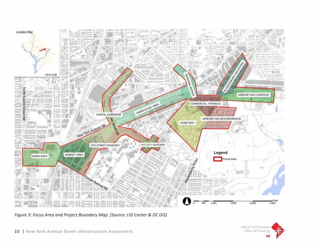
Figure 3: Focus Area and Project Boundary Map. (Source: LID Center & DC GIS)
10 | New York Avenue Green Infrastructure Assessment

New York Avenue Green Infrastructure Assessment | 11
Safety Improvements of 1st Street NE and Florida Avenue NEDDOT has approved a roadway improvementprojectattheintersectionof1stStreetNE,NewYorkAvenueNE,andEckingtonPlaceNE.Theprojectincludesnewcirculationpatterns,trafficsignalizationimprovements,crosswalks,andsidewalks.Theprojectisnearingcompletionatthetimeofthiswriting.
9th Street Bridge NE Over New York Avenue NEThisprojectconsistsofthereplacementofthe9thStreetBridgeNEoverNewYorkAvenueNEandCSXRailroads.Theprojectiscurrentlyunderconstructionandincludesenhancedpedestrianaccessibilityandlightingacrossthebridge.TheprojectisscheduledtobecompletedinDecember2012.
Metropolitan Branch TrailTheMetropolitanBranchTrail(MBT)isaproposed8milemulti-usetrailthatrunsfromtheSilverSpringMetroStationinMarylandtoUnionStationintheDistrictofColumbia.ThetrailgenerallyfollowsthepaththeMetroRedLine.TheMBTwillhelptocompletearegionalnetworkoftrailsbyconnectingtheCapitalCrescentTrailinSilverSpring,theNationalMallnearUnionStation,andtheproposedFortCircleParkstrail.Aportionofthetrailbetween1stStreetNEand3rdStreetNEinthe
assessmentareaisalreadycompleted.
DDOT Green AlleysDDOTiscurrentlydesigningandconstructingaseriesofgreenalleypermeablepavementdemonstrationprojects.TheplanninganddesignoftheseprojectsisbeingfundedbytheMS4StormwaterPermitEnterpriseFund.TheconstructionofthealleysisbeingfundedundertheAmericanResourceRecoveryActthroughtheCleanWaterStateRevolvingFundthatismanagedbyUSEPA.
Focus Areas
Florida Avenue Market AreaTheFloridaAvenueMarketAreaislocatedatthewestendofthecorridor.ItisboundedbyFloridaAvenueNE,NewYorkAvenueNE,6thStreetNE,andPennStreetNE.ItiszonedC-M-1andismostlycomprised of warehouses and food distributioncenters.TheFloridaAvenueMarketAreaplanproposesalandscapedmedian,linearpark,andpromenadeonthenorthsideofNewYorkAvenueNE.ThiswillincludebikelanethathasaconnectiontotheMetropolitanBranchTrail(MBT).TheconnectiontotheMBTwouldbeacriticalelementofprovidingconnectivityforthearea.
Postal CorridorThePostalCorridorrunsalong9thStreet
NEandiszonedM,C-2-B,C-M-1,andR-5-A.The9thStreetNEoverpassisoneofonlythree major crossings at New York Avenue NEthatcanprovideaccessandconnectivityfortheneighborhoodsandlandusesintheassessmentarea.TheexistingpostalfacilitiesandparkinglotshavethepotentialforLIDretrofitssuchaspermeablepavementsandbioretentioncells.
6th Street Parkway NEThis street runs between the northeastern boundaryoftheFloridaAvenueMarketAreaandGallaudetUniversityatPennStreetNEtoFloridaAvenueNE.ThereisaNationalParkServicemaintenancefacilitytothenortheastthatiszonedastheR-4residentialzone.ThestreetcanbeanimportantpedestriancorridorthatlinksFloridaAvenueNEtothe9thStreetNEoverpassandareastotheeast.
Warehouse AreaThisarearunsalongNewYorkAvenueNEbetweenthe9thStreetNEoverpassandMontanaAvenueNE.ItiszonedM,C-M-1,andC-M-2andprimarilyconsistsoflargewarehouseorindustrialuses.Theareaismostlyimperviouswithlittlegreenspacebecause of the high density of roads and largeroofedareas.Theexistingsidewalksare narrow and the high number of trucks andvehiclesblockorimpedewalkingalongthenarrowsidewalks.

12 | New York Avenue Green Infrastructure Assessment
Ivy City GatewayIvyCityisasmallbutcentrallylocatedresidentialneighborhoodthatiszonedR-4,C-M-1,andC-2-A.ItisboundedbyWestVirginiaAvenueNE,MountOlivetRoadNE,andNewYorkAvenueNE.Therearenumerousopportunitiestousegreeninfrastructureelementsfortrafficcalmingandtoestablishtheareaasagreencommunity.AstrongpedestrianlinkageortrailshouldbemadetotheparkattheintersectionofWestVirginiaAvenueNE,MountOlivetRoadNE,andCapitolAvenueNE.
Montana AvenueTheintersectionofMontanaAvenueNE,WestVirginiaAveNE,andNewYorkAvenueNEisamajortransportationfeaturealongthecorridor.ThezoningaroundthecircleattheintersectionisR-1-B,R-3,C-M-1,LO/C-M-1,andC-M-2.Thecircleandthesurroundinglanduseshavesignificantpotentialtoestablishtheareaasagreenfocalpoint,orgreengatewaytothecity.
Commercial TriangleThisareaislocatedonthesouthsideofNewYorkAvenueNEandisborderedbytheMountOlivetCemetery,WestVirginiaAvenue,andBladensburgRoadNE.TheareaiszonedC-M-1.Themajorityofthelanduses have high percentages of impervious surfaces.Thereiscurrentlyaproposaltobuildamajorshoppingcenterwithinthe
area.
CemeteryTheMountOlivetCemeteryareaisborderedbyMontanaAvenueNEtothenorth,BladensburgRoadNEtotheeast,MountOlivetRoadNEtothesouth,andWestVirginiaAvenueNEtothewest.TheareaiszonedR-4.ThereisapolicevehiclestorageandmaintenancelotandsomecommercialorindustrialbusinessesthatarelocatedatthenorthwestcorneroftheareathatarezonedC-M-1.
Bladensburg Industrial TheBladensburgIndustrialarearunsalongBladensburgRoadNEfromNewYorkAvenueNEto28thStreetNE.ItiszonedC-M-1,C-M-2,andR-1-B.Theareasto the west and east of the corridor that arenearNewYorkAvenueNEarehighlyindustrialinnature.Theareatransitionstoresidentiallandusestowardsthenortheast.BladensburgRoadNEisamajorconnectionfromthecitytothesuburbsofMaryland.Thepedestrianconnectionthatcrossesundertherailroadtracksisinpoorcondition,buthassignificantpotentialforenhancement.
Arboretum CorridorThisportionoftheassessmentarearunsalongtheboundaryofNewYorkAvenueNEandtheNationalArboretum.Thearboretumisafederallanduse
andunzoned.Thereareindustrialandwarehouselandusesattheendofthecorridor.Thesidewalkalongthearboretumispoorlymaintained.ThenorthandsouthsidesofNewYorkAvenueNEareconnectedbyanunderpassat36thPlace,whichcanbedevelopedasanimportantconnectionbetweentheNationalArboretumandareastothenorth.
Arboretum NeighborhoodThisisanestablishedsinglefamilyresidentialneighborhoodthatislocateddirectlywestoftheNationalArboretum.ItiszonedR-1-A.Theneighborhoodincludesasmallrecreationcenter.Therearenewlyinstalledsidewalksalongseveralofthestreets.Therearenumerousopportunitiesforcurbbump-outsandperviousalleys.
Existing Conditions for Bus Routes and Stops
Thissectionprovidesanevaluationofbusroutes and stops that serve the New York AvenueCorridorbetweenNorthCapitolStreetNEandtheDistrict-Marylandborder.Thefirstpartofthissectionfocusesontheoverallroutes.Thesecondpartprovidesgeneralrecommendationsonthedesignofthestopsandpotentialrelocationsandimprovementsatspecificlocations.
Bus Routes Theevaluationofthebusroutesfocuseson
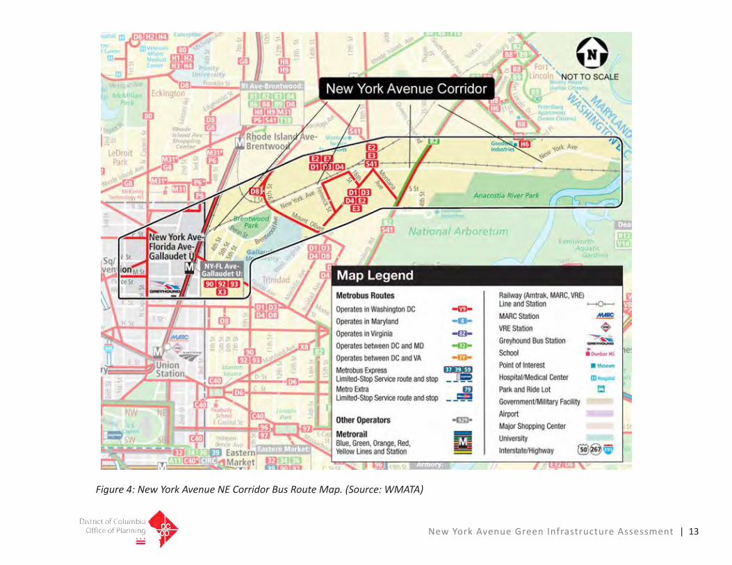
New York Avenue Green Infrastructure Assessment | 13
Figure 4: New York Avenue NE Corridor Bus Route Map. (Source: WMATA)

14 | New York Avenue Green Infrastructure Assessment
Figure 5: New York Avenue NE Corridor Bus Stop Map. (Source: DDOT, WMATA)

New York Avenue Green Infrastructure Assessment | 15
serviceandridershipinformationonbusroutesthatoperatealongNewYorkAvenueNE,busroutesthatcrossNewYorkAvenueNE,busstopsonNewYorkAvenueNE,andbusstopsthatareoneblockoffofNewYorkAvenueNE.Figure4isamapofthebusroutes.Figure5isamapofthelocationofthebusstops.TheareaofbusservicethatrunsalongNewYorkAvenuetotheeastofNorthCapitolStreetNEtotheDistrictborderatNewYorkAvenueNEhaslimitedbusservice.ThereiscurrentlyonlyonebusstopthatisdirectlyonNewYorkAvenueNEintheassessmentarea.Thisstopactsasahubthatservicesseveralcrossingroutes.TheonlyareawherethebusesrunalongNewYorkAveNEisfromFenwickStreetNEto16thStreetNE.SeveralbusroutescrossNewYorkAvenueNEandhavestopsonornearwheretheycross.Theseroutes provide weekday and weekend service with headways between ten and 30 minutes.Table2isasummaryoftheroutes,servicehours,headwaytime,andridershipinformationforbusroutesthatstoponNewYorkAvenueNE.Table3isasummaryoftheroutes,servicehours,headwaytime,andridershipinformationforbusroutesthatcrossNewYorkAvenueNE.
Therearecurrentlylimitedpatrondestinations,populationdensities,andemploymentandretailcentersalongNewYorkAvenueNEwithintheassessmentarea.Therefore,additionaltransitroutes
Table 2: Bus Route Information for Routes that Stop on New York AvenueRoute Number Route Name Service Hours Headway Average Weekday Ridership*
E2 & E3 Military Road‐Crosstown LineWeekdays & Weekends
6AM‐1AM15‐30 Minutes 6,354
D1 & D3 Sibley‐Stadium ArmoryWeekdays & Weekends
4AM‐1AM15‐30 Minutes 6,378
D4 Ivy City‐Union StationWeekdays & Weekends
4AM‐1AM15‐30 Minutes 1,287
*Average daily ridership for entire route for March 2010 (Source: WMATA)
Table 3: Bus Route Information for Routes that Corss New York Avenue NE.Route Number Route Name Service Hours Headway Average Weekday Ridership*
80 North Capitol Street LineWeekdays 4AM‐2AM / Weekends 5AM‐1AM 10‐20 Minutes 8,303
P6 Anacostia‐Eckington LineWeekdays & Weekends
24‐Hour Service 15‐30 Minutes 3,622
B2Bladensburg Road‐Anacostia
LineWeekdays at 3:50PM, 3:55PM &, 4:00PM 5 Mintures 7,245
*Average daily ridership for entire route for March 2010 (Source: WMATA)
Table 2: Bus Route Information for Routes that Stop on New York Avenue NE
Figure 6: New York Avenue NE Corridor Bus Stop Photo A – Southern side of New York Av-enue NE between 16th Street NE and Fenwick Street NE. (Source: Google Maps Street View)
Table 3: Bus Route Information for Routes that Cross New York Avenue NE

16 | New York Avenue Green Infrastructure Assessment
Figure 7: New York Avenue NE Corridor Bus Stop Photos B-E. (Source: Google Maps Street View)
BusStopImageB:NorthCapitolStreetbus stop for routes 80 & P6 on east side ofNorthCapitolStreetsouthofNewYorkAvenueNE(lookingnorth)
BusStopImageD:FenwickStreetbusstopforroutesE2,E3,D1,D3&,D4oneastsideofFenwickStreetsouthofNewYorkAvenueNE(lookingnorth)
BusStopImageC:NorthCapitolStreetbusstop for route 80 on west side of North CapitolStreetnorthofNewYorkAvenueNE(lookingsouth)
BusStopImageE:BladensburgRoadbusstopforroutesB2&S41oneastsideofBladensburgRoadsouthofNewYorkAvenueNE(lookingnorth)

New York Avenue Green Infrastructure Assessment | 17
Figure 8: New York Avenue NE Corridor Bus Stop Photos F-G. (Source: Google Maps Street View)
Bus Stop Image F: West Virginia Avenue Bus Stop for Routes E3, E3 & S41 on west side of West Virginia Avenue south of New York Avenue (looking south)
Bus Stop Image G: West Virginia Avenue Bus Stop for Routes E2, E3 & S41 on east side of West Virginia Avenue south of New York Avenue (looking north)
18 | New York Avenue Green Infrastructure Assessment
arenotcurrentlywarranted.However,theNewYorkAvenueCorridorwilleventuallyberedevelopedwithanadditionalmixofusesanddensitiesalongthecorridor.Thesefuturedevelopmentswoulddrivethepotentialforregularbusservice,aswellaslimitedstopservices,connectingdowntown,theFortLincolnneighborhood,andMaryland.
Bus Stop Locations ThebusstoponNewYorkAvenueNEnearFenwickStreetNEisshownasStopAonFigure5.ApictureofthestopisshownonFigure6.Thestophasashelter,bench,androuteinformation.Thisstopalsoprovidesalay-byareaadjacenttoNewYorkAvenueNEthatallowsbusestopulloverfromtheeastboundNewYorkAvenueNEtrafficstreamtodropoffandpickuppassengers.TheremainingstopslocatedadjacenttoNewYorkAvenueNEareshowninFigures7and8anddepictarangeofamenitiesfromsignstoshelterswithrouteinformationandbenches.
Existing Bicycle and Trail Opportunities
Thefollowingsectionisanevaluationoftheopportunitiestodevelopmulti-usetrailsandimproveexistingpedestrianandbicycleaccess,connectivity,andconditions.Theevaluationincludesareviewoftheexistingstandards,coordinationwithmasstransit
operations,andpotentialusagefromthedifferentlanduseswithintheassessmentarea.
Multi-Use Trail StandardsTheDDOTDesignandEngineeringManual(2009)specifiesthatsharedusepaths,orthose that are designated as a path shared bycyclists,pedestrians,andothernon-motorizedusersbephysicallyseparated,orbuffered,fromtheroadway.Thesesharedpathsaredesignatedasmulti-usetrailsinthisassessment.Thestandardsarethattheyshouldhaveaminimumwidthoftenfeet,withabufferoffivefeetwherepossible.Ifahorizontalbufferisnotpossible,themanualsuggeststheconsiderationofaverticalbarriertoprovideprotectionfortrailusersfromtheroadway.Aminimumbufferoftwofeetisrequiredfromtheedgeofthepathtoverticalobstructionssuchastrees,utilitypoles,andfences.
TheGuidefortheDevelopmentofBicycleFacilitiesalsorecommendsaminimumwidthoftenfeet.Itshouldbenotedthatawidthofeightfeetisacceptableforshortdistanceswhereawiderpathisnotpossible(AASHTO,1999).Theguidealsosuggestsaminimumoftwofeetofbufferspaceoneachsideofthetrail.
Multi-Usetrailrecommendationsdiscussedinthisassessmentshouldbeassumedto
meettheDDOTandAASHTOstandardsandguidelines,exceptwherenotedotherwise.
Overall Corridor EvaluationRoadway, Bicycle and Pedestrian Accommo-dationsNewYorkAvenueNEisentirelycontainedwithintheDistrictofColumbia,fromNorthCapitolStreetNEtotheeasternedgeofthe District, where the roadway becomes JohnHansonHighwaythroughthestateofMaryland.NewYorkAvenueNEisasix-lanehighway that is a signed and numbered route(Route50)ontheUSHighwaysystem.Portionsofthehighwayaredividedbyraisedmedians(concreteandbrick)ortwinyellowstripes.
Generally,thereisacontinuousconcretesidewalkalongthesouthsideofNewYorkAvenueNE,whilethenorthsidehassomesectionsofsidewalk,locatedmostlywithintheeasternportionofthestudyarea.Sidewalksaregenerallynarrow(lessthansixfeetwide)butingoodrepair,however,therearelocationswheresidewalkshavebeendisplacedbytreerootsorothercauses.Thiscreatesachallengingsituationforpersonswithdisabilities,parentspushingstrollers,orotherswithmobilitylimitations.Inaddition,someportionsofNewYorkAvenueNEhaveextensivecommercialandindustrialuse,resultingin many driveways that pedestrians must cross.

New York Avenue Green Infrastructure Assessment |19
Therearecurrentlynodedicatedbicyclefacilitiesalongthecorridor,althoughbicyclistshavebeenobservedridingonthesidewalkandoccasionallyinoneofthetravellanes.TheMetropolitanBranchTrailintersectsthecorridoratitswesternedge,andthereareplannedon-roadbicyclefacilitiesintheNoManeighborhood,alsoonthewesternedgeofthestudyarea.Inaddition,manybicyclistsusetheinternalroadnetworkattheNationalArboretumforrecreationandexercise,butthemajorityofthosepeoplecurrentlydrivetotheArboretumwiththeirbikesloadedonracks.TheplannedAnacostiaRiverfrontTrailwillrun to the east of the study area and is currentlyunderconstruction.
TransitCurrently,transitserviceisprovidedbyWashingtonMetropolitanAreaTransitAgency(WMATA)Metro.TheNewYorkAvenue/FloridaAvenue/GallaudetUMetroStationislocatedclosetothewesternprojectlimitofFloridaAvenueNE.ThereareseveralMetrobusstopsalongthecorridorthataredescribedinmoredetailintheTransitExistingConditionssection.
Land UseMuchofthecorridorisboundedonthenorthbyraillinesandtheUnionStationrailyard.ThisrailactivityessentiallyimpedesaccesstoandfromdestinationstothenorthofNewYorkAvenueNEalongthecorridor,
withtheexceptionofafewconnectionsatBrentwoodParkwayNE,MichiganAvenueNE,andSouthDakotaAvenueNE.MostofthedirectconnectionstoNewYorkAvenueNEarefromtheneighborhoodsandbusinessesonthesouthsideofthecorridor.
Florida Avenue NE to New York Avenue Bridge NERoadway and Pedestrian AccommodationsInthissectionofthecorridor,NewYorkAvenueNEisasix-lanedividedroadwaywithabrickorconcretemedian.TherearecontinuoussidewalksalongbothsidesofNewYorkAvenueNEfromFloridaAvenueNEtotheeasternterminusofthebridge.Bothsidewalksarerelativelynarrow(sixfeetmaximum)andarenotbufferedfromtheroadway,exceptonthebridge,whereaconcretemedianwithrailingprovidesabufferfromtraffic.Inaddition,thesidewalksectionsonthebridgeareprotected on the outmost side with a curving fence to prevent pedestrians from fallingoverthesideofthebridge.Itshouldbe noted that this bridge over the Amtrak raillinesiscurrentlybeingreplacedusingAmericanReinvestmentandRecoveryAct(ARRA)funding,andtheproposeddesignessentiallyreplicatestheexistinglaneandsidewalkconfiguration.Becauseconstructionisunderwaynow,thereisnoopportunitytoalterthecurrentdesignsforthebridge.
Land UseThelanduseinthisareaisprimarilytheAmtrakandWMATArailyardsandtracks.Mostofthesurroundinglandinthissectionisundeveloped.TheMetropolitanBranchTrailrunsparalleltotheWMATAtracksonthewestsideandthenrunsbelowNewYorkAvenueNEandcontinuessouthtowardsdowntown.
New York Avenue Bridge NE to Penn Street NE Roadway and Pedestrian AccommodationsNewYorkAvenueNEisasix-laneroadwayinthissectionofthecorridor.Itisdividedonlybyadoubleyellowline.Thereisaseventhlane(eastbound)totheeastofthebridge,butitonlyexistsforafewhundredyards,endingatPennStreetNE.ThesidewalksonbothsidesofNewYorkAvenueNEterminateattheedgeofthebridge.Thereare worn paths that begin on both sides at theendofthesidewalk,whichindicatespedestrianusagealongthecorridor.
Land UseTheAmtraktracksturneastandrunparalleltoNewYorkAvenueNEnorthofthebridge.MuchofthelandnorthofNewYorkAvenueNEislargelyundeveloped.Apersonalstoragewarehouseislocatedjusteastofthe bridge on the south side of New York AvenueNE.

20 | New York Avenue Green Infrastructure Assessment
Penn Street NE to Brentwood Parkway Roadway and Pedestrian AccommodationsNewYorkAvenueNEisasix-laneroadwaydividedbyadoubleyellowlineinthissectionoftheassessmentarea.ThesidewalkonthesouthsideofNewYorkAvenueNEbeginsagaininthissectionnearthewestsideofPennStreetNE.Thereisasmalllandscapestripwithstreettreesthatprovidesabufferfromtheroadway.Thereislimitedspacebetweenthestreetandtheedgesofadjacentbuildings.Thewornpathobservedintheprevioussectionofthis corridor on the north side of New York AvenueNEendsinthisarea.
Land UseThissectionofNewYorkAvenueNEincludesseveralhotelpropertiesandcommercialbusinesses.Mostarelocatedonthesouthsideofthecorridor.DevelopmentopportunitiesonthenorthsidecontinuetobelimitedduetotheAmtraktrackswhichparallelNewYorkAvenueNE.
Brentwood Parkway NE to West Virginia Avenue NE/Montana Avenue NE Roadway and Pedestrian AccommodationsNewYorkAvenueNEisasix-laneroadwaydividedbyabrickmedianinthissectionofthecorridor.ThesidewalkonthesouthsideofNewYorkAvenueNEcontinuesthroughthissection.Thereisalandscapebufferwithstreettreesandlimitedclearancefrombuildingedges.Astreettreebufferstrip
alsoexistsonthenorthsideofNewYorkAvenueNE,butthereisnoaccompanyingsidewalkuntileastof16thStreetNE.ThesidewalkinthatareacontinuestothetrafficcircleattheintersectionofWestVirginiaAveNEandMontanaAveNE.Thesidewalkisnarrowandisoftenpartiallyblockedwithutilitypoles.
AninactiverailroadbridgecrossesthecorridorjustwestoftheWestVirginiaAvenueNE/MontanaAvenueNEtrafficcirclebutdoesnotconstraintheexistingsidewalksonNewYorkAvenueNE.WhilethereisthepotentialtoutilizethebridgeasatrailconnectiontoneighborhoodsnorthandsouthoftheNewYorkAvenueCorridor,thebridgedoesnotcurrentlyconnectwithanyexistingbicycleorpedestrianfacilitiesthatwouldprovideaccessbeyondthebridge.Thispotentialconnectionshouldbere-evaluatedasnewdevelopmentoccursalongthecorridor.
Land UseThissectionofNewYorkAvenueNEincludesmostlycommercialbusinessesalongthesouthside.Thereareaminimalnumber of driveways for pedestrians tocross,withtheexceptionofalargegasstationatthewesterncornerofthetrafficcirclethathasfourlargedrivewayentrances.Aseriesofparkinglotsrunalongmostofthenorthsideofthissection.Onelotisusedasoverflowparkingfora
nightclub.Theothersappeartobeusedforstorageofequipment,trailers,andsuppliesrelatedtotherailroadtracks.Thesidewalkbegins on the north side of New York AvenueNE,alongsideahotelat16thStreetNE.
West Virginia Avenue NE/Montana Avenue NE to the National Arboretum Property Roadway and Pedestrian AccommodationsNewYorkAvenueNEisasix-laneroadwaydividedbyabrickmedianinthissectionofthecorridor.SidewalksarepresentonbothsidesofthecorridorfromWestVirginiaAvenueNEtoBladensburgRoadNE.Thereareintermittentstreettreeplantingstripsandbuffersfromtheroadway.SidewalkscontinuealonguntileastoftheintersectionwithBladensburgRoadNE,endingatthefirstfewproperties.
EastofBladensburgRoadNE,NewYorkAvenueNEbecomesalimitedaccessfreeway.Thespeedlimitsincreaseto45MPH.Afrontageroadonthesouthsideofthe corridor provides access to the New YorkAvenueNEentrancetotheNationalArboretum.EastoftheArboretum,asliplaneprovidesaccesstotheWashingtonTimesproperty.
Land UseThissectionofNewYorkAvenueNEincludesmostlycommercialbusinessesalongbothsidesofthecorridor.Several

New York Avenue Green Infrastructure Assessment | 21
businesseshavemultipleaccessdriveways.TotheeastofBladensburgRoadNE,alargeportionofthesouthfrontageisoccupiedsolelybytheNationalArboretum.ThereisasmallresidentialneighborhoodonthewesternborderoftheArboretum.ThenorthsideofNewYorkAvenueNEinthisareaisoccupiedbyalargehotelandseveralwarehouses.
Green Infrastructure Site Opportunities
Thelocationofgreeninfrastructureelementsisdependentonmanyfactors,includingthebuiltandthenaturalenvironment.Builtenvironmentconstraintsinclude,butarenotlimitedto,physicalelementssuchasbuildings,structures,parking,utilities,roads,zoning,buildingcodes,politicalandneighborhoodconcerns,constructionandroadstandards,propertyboundaries,andlanduserestrictions(easements).Urbansoilareasaretypicallyhighlydisturbedbecauseofpastandpresentdevelopment.Naturalareasthatare not disturbed in urban areas were oftennotabletobedevelopedbecauseofphysicallimitations,(e.g.groundwater,poorsoils,slopes,etc.)ortheywereprescribedasparklandorotherrestricteduses.Themostconstrainingphysicalfeatures for green infrastructure strategies andtechniquesaretypicallysoilsconditionsandhydrology,ordrainage.Thisisbecause
greeninfrastructureisbasedonreplicatingnaturalhydrologyfunctions,whichisdependentontheabilityofsoilstoabsorbwaterandthedrainagepatternstothefacilities.
SoilsThefollowingisadescriptionofthesoilscharacteristicsandtheirimplicationsfortheimplementationofgreeninfrastructureintheassessmentarea.LIDlandscapepracticescanbeclassifiedasthosethatfilterorinfiltrate,orashybriddevicesthathavebothfunctions.Forasystemsuchasabioretentioncellorpermeablepavementtofunctionasaninfiltrationdevice,thesoilsmusthavethecapabilitytoabsorbtheexcesswaterthatisnotabsorbedbythemediaortheplants.Soilswithhighsandcontentgenerallyhavethecapacitytoabsorbexcessrunoff.Soilswithahighclayorsiltcontent,urbancompactedsoils,highgroundwater,andshallowdepthtobedrockareconditionsthatlimittheabilityforanLIDpracticetobeusedasaninfiltration
device.Someinfiltrationmayoccurintheseareas,especiallyinsmallerandmorefrequentlyoccurringstormevents,butitis important to have underdrains in the LIDfacilitiessothattheydonotbecomeinundatedforlongperiodsoftimeafterstormeventsthathavehighvolumesofrunoff.Long-terminundationwillaffectthehealthoftheplantmaterialsforvegetatedpracticesandwillnotallowotherpracticestomanageorfiltersubsequentrainfallevents.
ThesoilsalongtheNewYorkAvenueCorridorarerepresentativeofmostofthehighlydevelopedareasofthecity.ThesoiltypesinthestudyareaareshowninFigure9.Duetothehighlydisturbednatureofthearea,thesoilsmapshouldbeusedasageneralguideforplanningpurposes.Fieldinvestigationsarerequiredtodeterminethepotentialforinfiltrationpracticesbecauseoftheextremelevelofvariabilityofdisturbanceoneachsite.
Table 2: Soils Group Classifications. (USDA, 1986)HSG Soils Group Soil Texture Infiltration Rate (inches per hour)
A Sand, loamy sand or sandy loam Greater than 0.30
B Silt loam or loam 0.15 to 0.30C Sandy clay loam 0.05 to 0.15
DClay loam, silt clay loam, sandy
clay, silty clay or clayLess than 0.05
Table 4: Soils Group Classifications (USDA, 1986)

22 | New York Avenue Green Infrastructure Assessment
Figure 9: Soils Map. (Source: LID Center, USDA)

New York Avenue Green Infrastructure Assessment | 23
TheabilityofasoiltoinfiltratestormwaterisbasedontheHydraulicSoilsGroup(HSG)classification(USDA,1986).EachsoiltypeintheDistrictiscategorizedasHSGA,B,C,orD.HSGAhasthehighestinfiltrationandrateofwatertransmissionpotentialandHSGDhasthelowest.Factorssuchashighwatertablesalsocontribute.Table4isaclassificationsummaryofthedrainagecharacteristicsofdifferentsoilgroups.ThepredominantsoilstypeisUrbanLand(Ub)orUrbanLandComplex(eg.Uc,Ue,Uf,etc.),whichstillhasrecognizablecharacteristicsofthenaturalsoils.Thissoilstypecomprisesapproximately45percentofthestudyarea.Urbanlandsare areas where there is over 80 percent coverage by impervious areas, such as parking,buildings,androads.Thoroughinvestigationsofthesoilspropertiesarerequired in these areas because of the disturbednatureofthesoils,whichmayincludesignificantcompactionandfill.Generally,theseareashavepoorpotentialforinfiltration.
Approximately20percentofthestudyareaiscomprisedofurbandisturbedsoils.Thesesoilsmayhavesomeofthenaturaldrainageandengineeringpropertiesintact,butduetotheareasbeingdevelopedandgraded,furtherinvestigationisrequired.Approximately10percentofthesoilsinthestudyareaareclassifiedasHSGB.Thesesoilsdohavepotentialforinfiltration,but
moredetailedstudiesarerequiredduethevariabilityinsiteconditions.Approximately10 percent of the area is composed of Udorthents,orurbanfillsoils.Thesesoilscancontainsignificantpercentagesoftrashanddebrisandareoftenhighlycompacted.Detailedstudiesoftheseareasarerequiredtodeterminetheinfiltrationcapacity,buttheyaretypicallyveryrestrictive.
Theremainderofthesoilsintheareaareurbanlandcomplexesthatcontainasignificantpercentage,generallyover15percent,ofundisturbedsoils.Theseareashavebeenhighlydevelopedwithhousing,commercial,office,andwarehouse/industrialuses.Theundisturbedareasaretypicallyopenorgreenspacesthatwerenotdevelopedduetophysicalorlanduserestrictions.Physicalrestrictionsinclude,butarenotlimitedto,steepslopesandhighgroundwater.Landuserestrictionsinclude,butarenotlimitedto,setbacksandgreenspacerequirements.MostofthesesoilsareclassifiedasHSGC.Thesesoilshavemarginalinfiltrationpotentialandwillrequireadetailedsoilsinvestigationduetotheamountofdisturbance.Lessthan10percentofthesoilsareurbanlandcomplexesthatareclassifiedasHSGB.
Thesoilsreportshowsthatthereisonlylimitedpotentialforinfiltrationorreductionofstormwaterrunoffvolumeandrateinthecorridorfromlargerstormeventsthrough
theuseoflandscapepractices.Thereisthepotentialtoinfiltraterunofffromsmallermorefrequentlyoccurringstormevents,butvolumereductionwouldhavetobeachieved through the use of cisterns or otherbuildingtechniques.Thelandscapepracticeswouldprimarilyfunctionaspeakflowreductiondevicesduringlargestormevents.Thereductioninrunoffvolumeandratewouldbeafunctionoftheamountofstorage,orsize,ofthefacilityandtheoutletstructureinthefacility.Therearesomelimitedareasofsoilsthathavethepotentialforinfiltration,butfurtherfieldinvestigationsarerequired.
Drainage and StormwaterThestudyareadrainstoboththeCombinedSewerSystem(CSS)andtheMunicipalSeparateStormSewerSystem(MS4).TheCSSreceivesstormwaterrunoffandsewagefrom streets and private property and conveysthemtotheBluePlainswastewatertreatmentplant.Duringlargerainfalleventstheplantanddrainagesystemmaynotbeabletohandletheamountofrunoffandthesystemoverflowsintothestreets,properties,andtheAnacostiaRiver.Theuntreatedsewageintherunoffcancauseserioushealthandenvironmentalproblemsandeconomicdamage.TheCSSsystemismanagedbyDCWater.TheapproachtoreducethevolumeofrunoffiscontainedintheLongTermControlPlan(LTCP)throughtheuseofundergroundstoragetunnelsand

24 | New York Avenue Green Infrastructure Assessment
Figure 10: Overall Map Showing Combined Sewer Overflows and Separate Sewer Overflow Areas for Stormwater Analysis. (Source: LID Center & DC GIS)
Boundary Line

New York Avenue Green Infrastructure Assessment | 25
LIDandgreeninfrastructuretechniques.
TheMS4systemismanagedbytheDistrictDepartmentoftheEnvironment(DDOE).This system discharges stormwater to theAnacostiaRiverandisregulatedbyaNationalPollutionDischargeEliminationSystem(NPDES)permit.ThepermitrequiresthatnewconstructionforroadsandsitedevelopmentincorporateBestManagementPractices(BMPs)tofilterandreducepollutionfromrunofffromimpervioussurfaces,suchasroads,roofs,sidewalks,andparkinglots.Thisincludestrash,metalsandoilsfromautomobiles,sediment,nitrogenfromairbornedepositionandlawns,andotherpollutantsthataretypicallyfoundinstormwaterrunoff.
ThedivisionbetweentheCSSandtheMS4crossesNewYorkAvenueNEbetweenthe9thStreetNEoverpassandMontanaAvenueNE.Itrunsatapproximatelya30degreeangletothesouthroughlyalongFenwickStreetNEandthenparalleltoMountOlivetRoadNEthroughthemiddleoftheMountOlivetCemetery.Thelinetothenorthrunsthroughtherailyardtoneartheintersectionof17thStreetNEandMontanaAvenueNE.Theareatothesouthoftheline,towardsdowntown,isintheCSSarea.ItincludestheBrentwoodRoadNEportionofthestudyarea.TheareatotheeastandnorthisintheMS4.Figure10isacomposite of maps showing the combined
sewer(CSS)andseparatesewer(MS4)systems.
ThehydrologyandhydraulicsoftheCSShavebeenwell-studiedbyDCWaterandthereissignificantinformationontheperformance and capacity of the system toconveystormwaterflowstoBluePlains.ThereisalargetrunklinethatrunsdownFloridaAvenueNE.Thetrunklineisservedbyseveralsmallerbranches.Thelargestones within the study area come from the railyardtothenorthofNewYorkAvenueNE,fromWestVirginiaAvenueNEnorthofFloridaAvenueNEanduptoBrentwoodRoadNE,andfromBladensburgRoadNEnorthofFloridaAvenueNE.
Thesystemhasbeenpreviouslymodeledandcalibratedthroughmonitoringatkeyintersectionsforthe100-yearandthe15-yearsix-hourstormevents.Thedrainageareasstudiedinthemodelarefairlylargeandthestudypointsaregenerallylocatedatthelargerstreetintersectionsoratthebottomofdrainagesub-shedsforlargerlandusesorclustersofdevelopment.Detailedhydrologyandhydraulicstudieswillberequiredtolookatindividualsitesorblocks.Themodelinginformationcanbeusedtomakegeneralorplanningleveldeterminationsontheeffectivenessofpracticestoreduceflowswiththosesub-sheds(USDA,1986).The100-yearismodeledtopredicttheflowsandoverflows
duringlargeinfrequentstormevents.The15-yearstormwasmodeledfornormalsystemcapacity.ThisareawasevaluatedinTheGreenBuild-outModel(Limnotech,Inc.,2007).Theresultsgenerallyshowedareductionofflowsofapproximately10to15percentwithfullimplementationofgreeninfrastructuretechniques.Theassumptionsincludedifferentlevelsofimplementationforpublicandprivatelands.Theseassumptionswereusedinthefinalanalysisandplanningphasesoftheproject.DCWaterprovidedadditionalmodelingoftheone-yearandthetwo-yearsix-hourstormeventsforthisstudy.Theone-yearandtwo-yearstormvolumesarefrequentlyoccurringstormevents.
ThecurrentMS4regulationsrequirethemanagementofthefirstone-halfinchofrunoffforwaterqualityand,ifthesystemcapacityisadequate,detentionofthe15-year24-hourstormevent.ThecurrentMS4permitletterofagreement,datedAugust1,2008,specifiesthattheDistrictwillincorporategreeninfrastructureandLID into their stormwater programs for retrofitsandnewconstructiononprivateandpubliclands.Forpublicroads,orDDOTconstructionprojects,thewaterqualitystandardofthemanagementofthefirstone-halfinchofrunoffisrequired.Thiscanbeprovidedintheright-of-waythroughtheuseoftheAnacostiaWaterfrontTransportationStandards.Theuseofthese

26 | New York Avenue Green Infrastructure Assessment
techniqueswillbeincorporatedintothefinalplanningdesign.Therearecurrentlynew stormwater standards for the District thatareintheevaluationphase.Thenewlyproposedstandardswillrequiretheretentionofapproximately1.2to1.4inchesofrunoff.Sincetheadoptionoftheseproposedregulationsisunknownatthetimeofthestudy,theywillnotbeexplicitlyincludedinthefinalanalysis.
Relevant Studies and Reports
Relevantreports,plans,andstudieswereidentifiedbyDCagencystaffandtheprojectteam.Thestudieswerereviewedtoevaluateifgreeninfrastructure had been considered or applied.Ifthedocumentdidnotincludespecificgreeninfrastructureormulti-modaltransportationrecommendationstheprojectteamreviewedtheexistinglanguageforopportunitiestoincludegreeninfrastructureandmulti-modaltransportationbenefits.
Florida Avenue Market StudyTheFloridaAvenueMarketSmallAreaPlan(FAM)wascompletedbytheDistrictOfficeofPlanningin2007(OfficeofPlanning,2007).Thepurposeoftheplanwastoexaminetheexistinginfrastructure,economicvitality,andhistoricsignificanceoftheareainordertodeveloppotentialrecommendationsforredevelopment.The
generalguidelinesintheplanincludemanyLIDtechniques.Thereareopportunitieswithinthegeneralrecommendationsto enhance or reinforce the green infrastructurecomponents.Listedbelowaresomeofthespecificareasofthestudythat support green infrastructure and some potentialinterpretationsoftheplanthatwouldreinforcetheimplementationofgreen infrastructure:
The “Sustainability-How environmentally sustainable is the site?”sectionincludesstatementsontheDistrictofColumbia’scommitmenttogreentechnology.Duetothearea’sdensecoverageofbuildingand impervious surfaces, the study suggeststhatattentionbepaidto“highperformancebuildingdesign,energyefficiency,stormwatermanagement,airqualitymanagement,environmentalnoisereductionandthecarefulplacementofsustainable,usableandattractiveopenspace.”
ThestudyrecommendsconnectionsbemadetotheMetropolitanBranchTrailandthedevelopmentofmulti-usetrailsinthecorridor.ThisisconsistentwiththeDistrictofColumbiaBicycleMasterPlan(DistrictDepartmentofTransportation,2005).IntheDevelopmentFrameworksection,underLandUseandDevelopmentRecommendations,thestudyrecommendsthatlargeshadetreesandlargetreeboxes
be used in the area to create a green canopy.ThestudyalsorecommendsthatallstreetscapedesignsrequireLIDbestmanagementpractices.
NoMa Vision Plan and Development StrategyTheNoMaPlanfocusesoninnovativeplanning,highperformancebuildingdesign,andbuildingasustainableneighborhoodasintegralpartsofthevisionforthissmallareaplan(OfficeofPlanning,2006).TheNoMaplanrecommendsusingLIDtechniques to addresses stormwater management,energyefficiency,andtohelpimproveairquality.Thestudyalsorecommends the use of Leadership in EnergyandEnvironmentalDesign(LEED™)asaguidefornewconstructionprojectstohelpdeveloptheareaasa“GreenZone.”ManyLIDtechniques,suchasrainwatercapture and reuse, green roofs, and bioretentioncanbeusedtosatisfyLEED™ratingrequirements.
NoMaStreetscapeMatrixGuidelinesTheNoMaStreetscapeGuidelinesproviderecommendationsonstreetwidths,trees,furniture,andconstructionmethodsforthestreetscapeswithintheNoMaarea(OfficeofPlanning,2009).TheserecommendationsareusedbyDDOT,theOfficeofPlanning,andthedevelopmentcommunitytoinsure consistency in the design and constructionofvehicular,pedestrian,and
New York Avenue Green Infrastructure Assessment | 27
bicyclecirculation.NospecificLIDfeaturesorlocationsarehighlightedwithinthisdocument.Areasfortreeboxes,streetparking,andwalkwayscouldincorporateLIDtechniques.
NoMa Public Space and Water Management Study ThisstudyprovidesgeneralrecommendationsfortheimplementationofBMPs(OfficeofPlanning,2011).TheBMPsarecategorizedbyapplicabilityforspecificlanduses,potentialeffectiveness,potentialareasforincorporation,potentialcosts,communityandenvironmentalbenefits,andtherecommendedscaleofimplementation.
New York Avenue Corridor StudyTheNewYorkAvenueStudy(NYAS)wascompletedin2006(DistrictDepartmentofTransportation,2006).ThestudyproposessixdifferentzoningchangesalongNewYorkAvenueNEfromBladensburgRoadNEtoNorthCapitolStreetNE.Theenvironmentalsectionsofthereportstatethatthetransportationimprovementsandlandusechangeswillpotentiallyincreasethe amount of impervious surfaces in the corridorthroughtheconstructionoflanewidening.Thestudyalsostatesthattreesmay have to be removed to accommodate construction.Thestudydoesnotaddressspecificapproachestomitigatethestormwatereffectsofthesechanges.
DC Green Jobs Final ReportThisreportidentifiesthepotentialforthecreationofgreencollarjobsforconstructionandmaintenanceactivitiesthroughouttheDistrictofColumbia(OfficeofPlanning,2008).Thecriteriainthereportcanbeusedtohelpdeterminetheeconomicimpactoftheconstructionand
maintenanceofLIDtechniques.
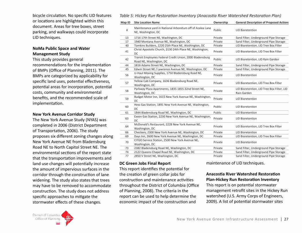
Anacostia River Watershed Restoration Plan-Hickey Run Restoration InventoryThisreportisonpotentialstormwatermanagementretrofitsitesintheHickeyRunwatershed(U.S.ArmyCorpsofEngineers,2009).Alistofpotentialstormwatersites
Map ID Site Location Name Ownership General Description of Proposed Actions
4Maintenance yard in National Arboretum off of Azalea Lane NE, Washington, DC
Public LID Bioretention
13 1716 17th Street NE, Washington, DC Private Sand Filter, Underground Pipe Storage17 1940 Montana Avenue NE, Washington, DC Private Sand Filter, Underground Pipe Storage40 Tomkins Builders, 2220 25th Place NE, Washington, DC Private LID Bioretention, LID Tree Box Filter
41 Christ Apostolic Church, 2130 24th Place NE, Washington, DC
Private LID Bioretention, LID Tree Box Filter
42 Transit Employees Federal Credit Union, 2000 Bladensburg Road NE, Washington, DC
Public LID Bioretention, LID Rain Garden
44 1816 Adams Street NE, Washington, DC Private Sand Filter, Underground Pipe Storage45 Edwin Street NE / Lawrence Avenue NE, Washington, DC Private Sand Filter, Underground Pipe Storage
56 U‐Haul Moving Supplies, 1750 Bladensburg Road NE, Washington, DC
Private LID Bioretention
57 Yellow Cab Company, 1636 Bladensburg Road NE, Washington, DC
Private LID Bioretention, LID Tree Box Filter
58 Parkway Plaza Apartments, 1835‐1855 22nd Street NE, Washington, DC
Private LID Bioretention, LID Tree Box Filter, LID Rain Garden
59 Budget Motor Inn, 1615 New York Avenue NE, Washington, DC
Private LID Bioretention
60 Hess Gas Station, 1891 New York Avenue NE, Washington, DC
Public LID Bioretention
61 1844 Bladensburg Road NE, Washington, DC Public LID Bioretention
63 Exxon Gas Station, 2230 New York Avenue NE, Washington, DC
Private LID Bioretention
64 McDonald's Restaurant, 2228 New York Avenue NE, Washington, DC
Private LID Bioretention, LID Tree Box Filter
66 Checkers, 2300 New York Avenue NE, Washington, DC Private LID Bioretention69 Days Inn, 2600 New York Avenue NE, Washington, DC Private LID Bioretention, LID Tree Box Filter
70 CITGO Service Station, 2500 New York Avenue NE, Washington, DC
Private LID Bioretention
73 2382 Bladensburg Road NE, Washington, DC Private Sand Filter, Underground Pipe Storage74 2122 Queens Chapel Road NE, Washington, DC Private Sand Filter, Underground Pipe Storage77 2850 V Street NE, Washington, DC Private Sand Filter, Underground Pipe Storage
Table 5: Hickey Run Restoration Inventory (Anacostia River Watershed Restoration Plan)

28 | New York Avenue Green Infrastructure Assessment
Figure 11: Relevant Capital Projects and Hickey Run Restoration Sites That Lie Within the Project Boundary. (Source: LID Center, DC GIS, and Anacostia River Watershed Restoration Plan-Hickey Run Restoration Inventory)

New York Avenue Green Infrastructure Assessment |29
thatliewithintheprojectboundaryareshowninFigure11andoutlinedinTable5.TheHickeyRunwatershedisattheeasternboundaryofthestudyarea.Thestudyincludesandevaluationoftheexistingconditionsandthepotentialstormwaterbenefitsandcostsoftheretrofits.
District of Columbia Bicycle Master PlanThisplanincludesoverallrecommendationsonthelocationandconstructionofbicycleroutesintheDistrictofColumbia(DistrictDepartmentofTransportation,2005).TheplanidentifiestheNewYorkAvenueCorridorasapotentialbicycletrailconnectionroutethatcanconnectMt.VernonSquare,whichistothewestoftheassessmentarea,withtheNationalArboretumandtheAnacostiaRiverTrailSystem,whicharetotheeastofthestudyarea.TheplanalsorecommendsbridgeorferryconnectionsbetweentheNationalArboretumandKenilworthPark.ThiswouldcreateadditionalconnectionstoparksandotherfacilitiesintheDeanwoodandKingmanParkneighborhoods,aswellasthestateofMaryland.
District of Columbia Pedestrian Master PlanThisplanidentifiespotentiallocationsforwalkingtrailswithinthecorridor(DistrictDepartmentofTransportation,2009).TheplanidentifiesthesectionofNewYorkAvenuefromPennsylvaniaAvenue
NWindowntowntoPennStreetNEasamajorpedestrianthoroughfare.Theplanrecommends priority improvements, such assidewalkrepairsandwidening,streetcrossingimprovements,andsignalizationimprovements.TheplanproposesfocusingimprovementsonthesouthsidewalkonNewYorkAvenueNEinthesectionofplanoverlap(fromFloridaAvenueNEtoPennStreetNE).
GreenInfrastructureSiteSelectionCriteria
SustainableinfrastructuredevelopmentthatisbasedontheTBLapproachincludestheconsiderationofsocial,aesthetic,economic,humanhealth,andotherenvironmentalbenefits.Theprojectteamdevelopedcriteriaforrankingandprioritizationofprojectsbasedontheseprinciples.Thecriteriaarequantitative,qualitative,oracombinationofboth.Thecriteriaweredevelopedas19metricsthatwerethengrouped into 5 categories:
• ProjectParameters-Thesefactorsevaluatetheimplementationaspublicsector projects and those that can have immediateimpacttoreduceCSOs.
• SocialFunction-Thesefactorspromoteoverallcommunityandsustainableplanninggoals.
• HumanHealth-Thesefactorsfocuson
localizedairqualitybenefitsandthereductionofheatislandeffects.
• EnvironmentalFunction-Thesearefocusedonhydrologicfunctionandotherbenefits,suchascarbonfootprintreduction.
• EconomicFunction-Thesefactorsareconsiderationsforgreenjobs,avoidanceofpotentialstormwatercleanupcosts,andthepotentialimpactonpropertyvalues.
Thefollowingaredetaileddescriptionsofeach category and metric that is used to rankandprioritizepotentialprojects.
Project Parameters
Thiscategoryincludescriteriaontheeaseandtimerequiredforimplementation.TheGISsystemandinformationfromDCWaterwasusedtodevelopthebaselineconditionsfortheevaluation.
CSS Boundary Proposed projects are reviewed to determine whether or not they are based withinoroutsidetheCSSsystem.LocationisimportantnotonlyforthepotentialoffundingthroughtheLongTermControlPlan,butalsoduetotheserioushealthandpropertyimpactsofCSOs.
DC Government OwnershipProjectlocationsonDCgovernment

30 | New York Avenue Green Infrastructure Assessment
property,suchasroadright-of-ways,maintenancefacilities,schools,andparksareimportantbecauseofthelongtimeframesandcoordinationissueswithconstructingprojectsonprivateproperties.
Project TimelineTheprojecttimelineisdeterminedbytheconsiderationofthetypicaltimeframerequiredtoimplementaprojectbasedonthetypeofconstructionactivity,location,andlanduse.
Social Benefits Criteria
Thesecriteriahelpdeterminehowtheprojectcanmeettheobjectivesoftheoverallmasterplan,anylocalareaplansorstudies,orsustainabilitygoals.Thesecriteriaweredevelopedfromthereviewoftheexistingplanningdocumentsandstudies,aswellassitevisits.
Green Reference PointThiscriterionisqualitativeinnatureandrefers to areas that create a reference pointorsignaturethatisidentifiabletothecommunity or the visitor, or areas that act aseitherafoundationordemonstration,thatcanbeamodelforthearea.
Neighborhood ConnectivityNeighborhoodconnectivityisaqualitativebenefitandreferstoaproject’sabilitytopromotewalking,biking,anduseoftransit
andtocreateorlinkspaces.Projectsarerankedintermsoftheirabilitytoprovideconnectivityandtosupportpedestriansandmulti-modaltransportationoptions.Parametersincludethepresence/absenceofbikefacilities,lanes,locationofnearbytrails,thewalkingdistancetobusstops,thepresence/absenceofsheltersatbusstops,andheadway.Projectsarerankedaseitherhavingalow,medium,orhighabilitytoprovideneighborhoodconnectivity.
Plan ConformanceThefinalmetricevaluatedundersocialbenefitsinvolveswhetherornotaprojectconformstoexistingmasterplan/arearecommendationsorhelpswithneighborhoodorareaimprovements.
Human Health Criteria
Greeninfrastructureresultsinpositiveeffectsonhumanhealththroughimprovingairqualityandreducingtheurbanheatisland(UHI)effectatthelocallevel.Thesecriteriaweredevelopedfromliteratureongreeninfrastructurehealthbenefits.
Improved Air QualityTreesandvegetationimproveairqualitybyfilteringairbornepollutantssuchasparticulatematterandozone.Likewise,reducedenergyconsumptionresultsin decreased emissions from power generationfacilities.Theseairquality
improvements can reduce the incidence andseverityofrespiratoryillness.Changesinambientairqualityduetogreen infrastructure techniques that increasethenumberoftreesandsimilarvegetationcanbeevaluatedusingstandardmodels(USForestService’sUFOREmodel)thattakeintoaccountlocalconditions.Basedoninformationfromthesemodels,correspondingavoidedhealtheffectsduetoincreasedvegetationandtheeconomicvalueoftheavoidedhealtheffectscanbedetermined.
Avoidableairpollution-relatedhealtheffectsthatcanbequantifiedinclude
• prematuremortality;• onsetofirreversiblechronicbronchitis;• heartattacks;• hospitaladmissions(non-fatal)
forrespiratoryandcardiovascularconditions;
• emergencyroomvisitsforasthma;• respiratorysymptoms(daysofillness);
and• worklossdaysandschoolabsence.
InPhiladelphia,onaverage,everytreeplantedaspartofPhiladelphia’sgreeninfrastructurestrategywouldresultinavoidedhealtheffectsof$32.32peryear,atfulltreematuration[i.e.,benefitsincreaseto$32.32peryear,onaverage,asthetreematuresovertime](Stratus

New York Avenue Green Infrastructure Assessment | 31
Table 6: Selection Criteria for Assessing Identified New York Avenue Green Infrastructure Projects
Multi-use trail,Florida Avenue NE to New York Avenue Bridge NE Multi-use trail,New York Avenue Bridge NE to Penn Street NE
-low/short-medium-high/long-yes-no
P
V
V V
V
V V
V
V V
V
V V
V
V V
V
V
V
V
V
V
P
PP
P
PP P P PP
P P PPP P PPP P PPP P PP
P P PPP P PP
P P P P
P P P
P P P P
P P P P
P P P P
P P P P
P P P PP
P P
P P P P
P PP
P
P
P
P P P P
P PP
-notapplicableNA
NA
NA
NA NA NA
NA
NA
NA
NA

32 | New York Avenue Green Infrastructure Assessment
Consulting,2009).ThisestimateisbasedonamodelspecifictothemixoftreespeciesinPhiladelphia;however,benefitsareexpectedtoberelativelysimilarfortheDCarea.
Increasedgreenspacehelpslowerambienttemperatures.Greentechniquesthatareincorporatedonandaroundbuildingshelpsshadeandinsulatebuildingsfromwidetemperatureswings.Thismoderatingeffectdecreasestheenergyneededforheatingandcooling.Divertingstormwaterfromwastewatercollection,conveyanceandtreatmentsystemsalsoreducetheamount of energy needed to pump and treatthewater.Thisresultsinreductionofemissions of greenhouse gases and other airpollutants(StratusConsulting,2009).
Heat Stress ReductionTrees,greenroofs,andbioretentionareascreateshade.Thisreducestheamountofheat-absorbingmaterials,suchaspavementsandroofs.Thevegetatedareasalsoemitwatervaporwhichcoolshotairandreducestheurbanheatislandeffect.Thishelpstoreduceheatstress-relatedfatalitiesandmorbidityeventsduringextremeheatwaves.Reductioninheatstress-relatedfatalitiesduetoincreasedurbanvegetationhasbeenmodeledatthecitywidelevelinPhiladelphiabyusingstandardmethodsdevelopedandappliedforrelevantfederalagencies(Stratus
Consulting,2009).InPhiladelphia,itwasfoundthat,overa40-yearanalysisperiod,implementationofgreeninfrastructuretotreatrunofffrom50percentofimperviousareawouldresultinareductionin196heat-relatedfatalities.BasedonEPAestimates,thiswouldresultin$1.1billioninpresentvaluebenefits.Duetomodeluncertainties,therelativelysmallscaleoftheindividualprojects,andinsufficientdata,itisnotfeasibletodirectlyquantifythebenefitsofimprovedairqualityandreduced urban heat stress associated withimplementationoftheNewYorkAvenueGreenInfrastructureAssessment.However, it is evident that, together, these projectswillresultinimprovedhumanhealthconditions.Individualprojectscanberankedintermsofthehumanhealthbenefitstheywillprovidebasedonnumberoftreesplanted,ortotalgreenarea.
Environmental Function Criteria
Sevencriteriaareusedtoevaluateaproject’senvironmentalbenefit.Thefirstsix
evaluateprojectsbasedontheirpotentialstormwaterfunction,whilethelatteronefocusesoncarbonreductions.Thesecriteriaweredevelopedfromtheexistinglocalstudiesandreportsandnationaldataonecosystemfunctionandvalues.
Links ROW to Private Property for Public Road Construction ProjectsMostoftherunofffromprivatepropertiesin the study area drains to the combined or the separate sewer system that runs withinthepublicright-of-way.Theright-of-waytypicallyconsistsofthetravellanes,includingadjacentsidewalkandtreeboxareas,uptothebuildingfrontage.Stormwatermanagementforprivateprojectsistypicallymanagedwithinthepropertyboundaries.FacilitiesmaybelocatedwithintheDDOTright-of-waybehind the curb, if there is a maintenance agreementinplace.Thismustbeevaluatedonanindividualprojectbasis,asthispolicyiscurrentlyunderreview.
Thewidthoftheright-of-wayvaries
TrailApproximate Annual Ridership
Capital Cresent 2,163,000Metropolitan Branch Trail 365,000Arlington Memorial Bridge (near Mt. Vernon Trail) 1,081,000Custis Trail 2,543,000
Table 7: Regional Trail Ridership (DDOT, Arlington County)

New York Avenue Green Infrastructure Assessment | 33
according to the neighborhood or classificationoftheroadway.Inolderneighborhoodsorareas,sidewalksmayor may not be present and there may be maturetreesthatwouldprecludeanysignificantphysicalalterationoftheareabehindthecurbline.Existingundergroundutilitiesalsomayrestricttheabilitytolocatefacilitiesintheseareas.
Site SuitabilitySitesuitabilityreferstothephysicalconditionsthataffectthepotentialofthe site to accommodate the green infrastructurepractices.Thenumerousfactorsthatinfluenceoraffecttheabilityofaprojecttoincludegreeninfrastructureinurbanredevelopmentareasarehighlyvariable.Anextensivechecklistwasdevelopedforeachsiteorproject.Thechecklistwasdevelopedconcurrentlywiththesiteselectionandrankingsothatitreflectsthespecificconditionsinthewatershed.Listedbelowaresomeoftherepresentativekeyfactorsthatinfluencesitesuitability:
• Soilsconditions-Soilswithhighclaycontentgenerallyhavepoorinfiltrationandstructuralcapacity.
• Subsurfaceconditions-Sitesmaybebrownfields,whichwouldrestrictinfiltrationbecauseofcontaminationissues.Infiltrationareasmayneedliningsorbarrierswhentheyarelocated
nearbuildingfoundations.• Surfacedrainage-Drainagepatterns
andthedrainageareawillinfluencethelocationofthepractices.LIDpracticesaredistributedcontrolsthatmanagesmalldrainageareas.Theyshouldnotbelocatedinareaswheretheycanbeoverwhelmedbythevolumeofrunoff.
• Vegetation-Maturestreettreesmayphysicallyrestrictconstructionnearthestreetedgefortreeboxesorbump-outs.Propertyownersmay“claim”ownershipofthem.
• Maintenanceoftraffic-Constructionthat occurs in or adjacent to the right-of-waymaybedisruptivetotheneighborhoodforextensiveperiodsoftime.
• Utilities-Undergroundutilitiesmayrestrictsubsurfaceconstructionorbetooexpensivetorelocate.
• Parkingandaccess-Featuressuchascurbbump-outsmayreduceparkingareas.
StormwaterThesiteselectioncriteriaforstormwatereffectivenessisbasedoncriteriaforvolumereduction,peakflowreduction,andwaterqualityandecologicalbenefits.Pollutionfrom stormwater can be generated from runofffromimperviousareas(e.g.roads,roofs,parkinglots,etc.)andpervioussurfaces(e.g.lawns,landscaping,ballfields).Thepollutioncanbetreatedthrough
theuseoffilteringdevicescalledBestManagementPractices(BMPs)orthroughthereductionofrunoffvolumethroughinfiltrationintothesoilorbythecaptureanduseofrainwater.
Currentregulationsrequirethefilteringofthefirstone-halfinchofrunofffromimperviousareas.Thattranslatestoapproximately1,800cubicfeet(c.f.)peracre,oranarearoughlyonefootdeepandabout42feetsquare.Thisfirstone-halfinchwashesoffasignificantamountofthepollutantload.ThisisrequiredforDDOTprojectsandallotherprivateandpublicsectorconstruction.Inmostcasesdetentionofrunofftoreducethepeakflowsfromstormeventsisalsorequiredonprivateandpublicprojectsoutsideofthestreetright-of-way.Thisisdonetopreserveorrestorethecapacityofthedrainagesystem.The proposed new stormwater standards wouldrequirestorageandinfiltrationofapproximatelythefirst1.2inchesofrunoff,orslightlylessthanthetreatmentof2.2timesthewaterqualityvolume.Ananalysisofdifferentdevelopmentscenarioswithnewregulationsappliedtotheprojectsshowedminimalincreasesincostsforthenewrequirements.Thisispartiallybecausethecurrentregulationsalreadyrequireanextensiveamountofstoragefortheexistingdetentionrequirements(IndustrialEconomics,2010).

34 | New York Avenue Green Infrastructure Assessment
Thisanalysisusedthecurrentstormwatermanagement standard for DDOT projects thatrequiresthetreatmentofone-halfinchofrunofffromimperviousareasasthebasisforsiteselection.Thisisbecausethemajorityoftheprojectsarerelatedtostreetretrofitconstructionorimprovementsthatareassociatedwithredevelopment.Amoredetailedanalysis,onethatwouldincludetheroutingoftheflows,wouldberequiredtosizethefacilitiesbeyondaplanninglevelanalysis.Privateprojects,suchasthepolicevehiclemaintenanceyard,wouldrequireamoreextensivehydrologicanalysisandlargerstoragevolumerequirementsifitwastobebuiltasanewsite.
Prioritywasgiventoareasthatcouldtreatlargeamountsofimpervioussurfacesorwheretechniquescouldbeusedtoreducesomeofthevolumeofrunoff.Someofthemanagementtechniques,suchasbioretention,dohavesomebenefitinreducingpeakstormwaterflowsandstormwaterrunoffvolume,particularlyinsmallfrequentlyoccurringstormevents.Thisisbecausethesoilmediainthebioretentionareascanabsorbwaterandmakeitavailableforplantuptake,slowinfiltrationintothepoorsoilsintheprojectarea,orevaporationcanoccur.
Volume Reduction BenefitTheabilityofspecifictechniquestoreducerunoffwatervolumeisakeyindicationof
theireffectivenessinprotectingstreamhealth.Thismetricevaluateseachproject’sabilitytorespondtorainfallandreturnrainto the ground and to the atmosphere under alowintensitystormevent.
Peak Flow ReductionReducingpeakflows,alongwiththetotalvolumeofrunoff,reducesdownstreamimpactsaswellasinitialcapitalcosts,andtheoperationandmaintenancecostsoffloodcontrolinfrastructure.
Water Quality and Ecological BenefitAcoreobjectiveofgreeninfrastructureprojectsistoimprovewaterqualityandaquaticecosystemsinthelocalarea.Greeninfrastructuretechniquesinfiltraterunoffclosetoitssourceandhelppreventpollutantsfrombeingtransportedtonearbysurfacewaters.Oncerunoffisinfiltratedintosoils,plantsandmicrobescannaturallyfilterandbreakdownmanycommonpollutantsfoundinstormwater.Inaddition,greeninfrastructurelimitsthefrequencyofseweroverfloweventsbyreducingrunoffvolumesandbydelayingstormwaterdischarges.
Studieshaveshownthatpeoplearewillingtopaytoimprovewaterqualityandaquaticecosystems.Theseimprovementsresultinsomelevelof“nonuse”benefitwhich,inthiscase,stemsfromtheinherentvaluethatindividualsplaceonwaterquality
andhabitatimprovements.Afrequentlydiscussedbasisfornonusevalueisthedesiretomaintainthefunctioningofspecificecosystems.ExamplesofthisincludeKingandMazzotta’s2005publication,“EcosystemValuation,”availableatwww.ecosystemvaluation.org, andtheHarpmanetal.1994publicationentitled,“NonuseEconomicValue:EmergingPolicyAnalysisTool.”
Willingnesstopayforgreeninfrastructureand LID programs that improve water qualityandenhanceaquaticecosystemscanbesignificant.Forexample,astudyconductedbyStratusConsultingfortheCityofPhiladelphia,entitled“ATripleBottomLineAssessmentofTraditionalandGreenInfrastructureOptionsforControllingCSOEventsinPhiladelphia’sWatersheds,”estimatedthatPhiladelphiaresidentswouldbewillingtopayabout$10to$16perhouseholdperyearforimprovementsinwaterqualityandaquaticecosystemsthatwouldbeachievedbyusinggreeninfrastructuretechniquestotreatingrunofffrom 50 percent of impervious area in the city.Overthe40-yearanalysisperiodforthisstudy,thetotalestimatedcitywidevalueofthisbenefitamountedto$330million(StratusConsulting,2009).
Duetoinsufficientdataandtherelativelysmallimprovementinoverallwaterqualitythatwillresultfromeachgreen

New York Avenue Green Infrastructure Assessment | 35
infrastructure project in the New York AvenueCorridor,thisbenefitwillnotbequantifiedinmonetaryterms.However,individualprojectscanberankedbasedontheirpotentialforimprovingwaterqualityandaquaticecosystems(e.g.,basedonamountofstormwatertreated,proximitytosensitivewaterbodies,etc.).
Energy Savings and Carbon Footprint ReductionAs noted in the discussion on human health,greenspacehelpslowerambienttemperatures and, when incorporated on andaroundbuildings,helpsshadeandinsulatebuildingsfromwidetemperatureswings, decreasing the energy needed for heatingandcooling.Divertingstormwaterfromwastewatercollection,conveyance,andtreatmentsystemsalsoreducestheamount of energy needed to pump and treatthewater.
Reducedenergyuse,inturn,reducesemissionsofgreenhousegases,includingcarbondioxide(CO2),frompowerplants.Increasedcarbonsequestrationduetoaddedvegetationalsoresultsinalowercarbonfootprint.Inaddition,projectsthatencouragetheuseofalternativetransportation(e.g.,bicycles)orpublictransportationreduceCO2emissionsfromvehiclestotheextentthatindividualsusethetrailsinlieuofusingtheircarstocommutetoplaceswithinthecity.
Variousstudieshaveestimatedtheenergysavingsassociatedwithreducedheatingandcoolingduetoshadingfromtreesandinsulationfromgreenroofs,includingUSDA2007’spublication,“AssessingUrbanForestEffectsandValues”(http://nrs.fs.fed.us/pubs/rb/rb_nrs007.pdf)andDoshi’s2005reportfortheCityofTorontoentitled“EnvironmentalBenefitsandCostsofGreenRoofTechnology”.Findingsfromthesestudiescanbeadaptedtoindividualgreeninfrastructureprojects.Inaddition,engineeringestimatesorwatertreatmentplantdatacanprovideinformationonavoided energy costs associated with reducedstormwatertreatment.Thevalueof these savings can be determined based oncurrentenergyprices.
ChangesinCO2emissionsassociatedwithreduced energy use can be determined basedonaverageCO2emissionfactorsforacity,state,orregion’selectricitysector.Theamount of carbon sequestered by trees, vegetatedbioretentionareas,andothergreeninfrastructuretechniquescanalsobeestimatedbasedonexistingresearch.Forexample,theUSDA’sUFOREmodelestimatestheCO2storagecapacityformanyspeciesoftrees.In2007,theUnitedKingdom’sDepartmentofEnvironment,FoodandRuralAffairs(DEFRA)providedanestimateof4.9metrictons(MT)ofCO2sequestered per 1,000 square meters of greenarea,peryear.
SavingsinCO2emissionscanbevaluedusinga“socialcostofcarbon”calculation.Thesocialcostofcarbonisestimatedastheaggregateneteconomicvalueofdamagesfromclimatechangeacrosstheglobe,andisexpressedintermsoffuturenetbenefitsandcoststhatarediscountedtothepresent.Estimatesonthesocialcostofcarbonrangefrom$3to$95perMTCO2.Theoften-citedSternReviewontheEconomicsofClimateChangeestimatesasocialcostofcarbonat$85perMTCO2(Stern,2006).
AccordingtodatafromtheUSEPA,theDistrictofColumbiaiscurrentlyinnonattainmentforozonepollutionaswellasfineparticlesintheair(http://www.epa.gov/oaqps001/greenbk/ancl.html).Trailsprovideopportunitiesforresidentsandvisitorstotravelbybicycleorfoot,reducingthenumberofmotorvehicletrips.Sinceamotorvehicleusesapproximately500gallonsofgasperyearandproducesanaverageof5.5metrictonsofgreenhousegasemissionsperyear,shiftingevenamodest number of trips from cars to foot orbicyclewouldbebeneficialinreducingbothenergyconsumptionaswellastheDistrict’scarbonfootprint.Inaddition,atrailalongNewYorkAvenueNEmayallowmany community residents to reach their destinationsmorequicklybybicycleduetothechronictrafficcongestionalongtheroadway in the morning and evening rush

36 | New York Avenue Green Infrastructure Assessment
hours.
Projectsthatencouragebikingorwalking,suchasmulti-usetrailprojects,canalsoimproveairqualitytotheextentthatindividualsusethetrailsinlieuofusingtheircarstocommutetoplaceswithinthecity.Manyoftheproposedmulti-usetrailprojectsinvolveimprovinguponexistingtrails,orentailalternatingbetweentheexistingsidewalkandaportionofthecurrentroadway.Thusthenumberofnewcommutertripsonthetrailsisdifficulttodetermine.However,improvedaestheticswilllikelyencouragesomeadditionaluseofthetrailforcommutingandrecreation,resultinginadditionalhumanhealthbenefits.Becausethetrailsarelocatedmostlybesideoralongtheroadway,thenumberofpeopleusingthetrailforpleasurewillnotlikelybesignificant.
Accordingtoa2008trafficstudybytheDistrictofColumbiaDepartmentofTransportation,thissectionoftheNewYorkAvenueCorridorcarriesbetween52and86thousandmotorvehiclesperday.Extrapolatedoverayear,thisequatestobetween19millionand31.4millionvehicletripsperyear.
Buildingatrailalongthecorridorhasthepotentialtoshiftsomeofthosetripsfrommotorvehiclestobicycles.Citywide,theaveragebicyclemodeshareforall
tripsis1.5percent,andtheshareofcommutetrips(tripsto/fromwork)is3.3percent.Therefore,anassumptioncanbemadethatatleast1percentofalltripsalongthecorridorcouldshifttobiking,resultingintrailridershipratesofbetween190,000and314,000peryear.Thistranslatestoapotentialgreenhousegasemissionreductionofbetween87and114metrictonsperyear,assumingatrailofapproximatelyonemile.
TheseridershipfiguresarewellwithintherangeofridershipratesforothertrailsintheDCmetropolitanarea.AsTable7reflects,theMetropolitanBranchTrail,whichisarelativelynewtrail,carriesapproximately365,000bicyclistsperyear.TheCustisTrailinArlingtonCounty,whichparallelsInterstate66,carriesapproximately2.5millionbicyclistsperyear.IfatrailalongNewYorkAvenueNEandUS50wereavailabletoMarylandcommuters,the
Lindsey, Man, Payton, and Dickson (2004)
Estimates the effect that trail vicinity has on home sales. 11%
Table 8. Studies Estimating Property Value Increases Associated with LID/GI

New York Avenue Green Infrastructure Assessment | 37
ridershippotentialissignificant.
Economic Function Criteria
Economic BenefitThreecriteriahavebeenidentifiedtoevaluateeconomicbenefit:theabilityto create green jobs, the impact on stormwater treatment costs, and the impactonpropertyvalues.Thesecriteriaweredevelopedfromtheevaluationoftheexistingstudiesandreportsandnationaldatathatisapplicabletotheproject.
Local Green JobsSpecializedlaborisrequiredforconstructionofconventionalstormwatermanagementsolutions(e.g.,boring,tunneling).Suchskilledlaborersmighttypicallybealreadyemployedintheconstructionfield.Greeninfrastructure creates the opportunity to hirelocallaborers,whomightotherwisebeunemployed,forlandscapingandrestorationactivities.ThisbenefitwillapplytoportionsoftheNewYorkAvenueGreenInfrastructureAssessmentthatwillmakeuseoflocalgreeninfrastructuretrainedworkerswithminimalexperience.Toquantifythisbenefitand/orrankprojectsaccordingly,itisnecessarytoevaluatethenumberofworkers,lengthofemployment,andprojectoperationandmaintenancerequirements.
Inadditiontoprovidingenvironmental
benefits,investmentsinbicycleandpedestrian infrastructure have been shown tohavesignificantemploymentbenefitsaswell.Arecentstudy(http://www.bikeleague.org/resources/reports/pdfs/baltimore_Dec20.pdf)ofinfrastructureinvestmentsinBaltimore,Marylandfoundthat$1millioninvestedinbicycleand pedestrian infrastructure creates approximately11-14jobs,while$1millioninvestedinconventionalroadinfrastructurecreatesjustsevenjobs(Garrett-Peltier,Heidi,2010).
Avoided Stormwater Treatment CostsStormwaterthatwillbeinfiltratedasaresultoftheprojectiscurrentlycollectedand conveyed into the city’s sewer system fortreatment.Projectsassociatedwiththe New York Avenue Green Infrastructure Assessmentwillthereforeprovidebenefitsin terms of avoided stormwater treatment costs.Thisbenefitcanbequantifiedusinginformationontheamountofstormwaterthatwillbeinfiltrated,aswellasthecurrentcostoftreatment.Alternatively,projectswillberankedinthiscategorybasedontheamountofstormwatertreated.
Increased Community Aesthetics, Reflected in Higher Property ValuesTrails,trees,andothervegetationimproveurbanaestheticsandcommunitylivability(e.g.,byprovidingrecreationopportunities,improvedairquality,andotherbenefits),
andstudiesshowthatresidentialpropertyvaluesarehigherwhentheseamenitiesarepresent.Forexample,manystudieshaveindicated that the presence of a bike path ortrailincreasespropertyvalues(RaccaandDhanju2006).
MoreresearchisneededinquantifyingthebenefitsofLIDandtrails;therefore,thepoolofstudiesfromwhichtochooseissomewhatsmall.However,existingrelevantliteraturesuggestsarangeofbenefitsfrom green stormwater infrastructure, or LID,fromzeropercenttosevenpercent.Thisimpliestheaveragepropertyvaluewillalsoincreaseanywherefromzeropercent to seven percent due to LID/green infrastructureadditionstothesurroundinglandscape.Table8providesasummaryofsixstudiesontheeffectofLIDthatwouldbeapplicabletoprojectsimplementedintheDCarea,giventheirsimilarcontexts.Allsixstudiesestimateabundleofbenefitsassociated with trees/LID/green stormwater managementingeneral.AsshowninTable8,thesestudiesgenerallyestimatepropertyvalueincreasesmostlyrangefromtwotofivepercent,withamidpointof3.5percent.
Table8alsoprovidesexamplesofstudiesthatshowtheimpactoftrailsonnearbyresidentialproperties.Researchhasshownthattrailscanprovideeconomicbenefitsinavarietyofways.Forexample,asshowninTable8,a2004paperintheJournalof

38 | New York Avenue Green Infrastructure Assessment
ParkandRecreationAdministration(http://journals.sagamorepub.com/ebooks/jprabackissues/jpra223555/Article5.pdf)foundthathomeswithin½mileofatrailsoldforanaverageof11percentmorethansimilarhomeslocatedmorethan½milefromatrail.A2006studyconductedbyRaccaandDhanjufoundthatthepresenceof a bike path within 50 meters of a propertytendedtoincreasevaluesbyabout4percent.
Inadditiontoincreasesinpropertyvalues,trailscanbenefitlocalbusinesses.AstudyinLodi,Californiafoundthatinvestmentsintrailandstreetscapeimprovementsgeneratedpositivesalesbenefitsfornearbyretailers,aspeopletendtoshopatmorestores,spendmoretimepertrip,andreturntotheareamoreoften.Locally,manyrealtorsarecapitalizingontheproximitytotheMetropolitanBranchTrailanditisfeaturedprominentlyinthesalesliteratureforcommercialandresidentialpropertiesnearthetrail.
WhileitispossibletoassessincreasesinthevalueofresidentialpropertiesaffectedbytheproposedNewYorkAvenueCorridorAssessmentprojectsusingthenumberofresidentialpropertiesaffectedby each project and the average property valuewithintheprojectarea,thistypeofinformationisdifficulttoobtainwithoutextensivespatialanalysisandaccessto
DCAssessor’sdata.Thus,thisbenefitwillnotbequantifiedgiventhescaleofthisresearch.However,qualitativeinformationonthedifferencesinpropertyvaluesbyneighborhoodorplannedprojectcanbeusedtocompareprojects.Projectscanbecomparednotonlybasedonwhichoneswillprovidethelargestbenefit(i.e.,areasthatcurrentlyhavehigherpropertyvalues,andwherea3.5percentincreasewouldyieldthehighestbenefit),butalsobasedonwherepropertyvalueincreasesmightbeneededmost(e.g.,low-incomeneighborhoods).
New York Avenue Green Infrastructure Assessment |39
Thispageisintentionallyleftblank.

40 | New York Avenue Green Infrastructure Assessment
Phase Two: Recommendations
IntroductionPhaseTwoprovidesrecommendationsforimplementation.Theimplementationstrategyisbasedonthesiteselectioncriteria,potentialfunding,andimplementationtimeframesthataredescribedattheendofthissection.Nineteenspecificprojectswereselectedforrankingandprioritization.Generalrecommendationswerenotrankedaccording to the site criteria because these improvements may be more widespread
ordifficulttoquantify.Table6isalistsummaryoftherankingandprioritizationoftheprojects.Table9attheendofthissectionisasummaryofthepotentialtimeframesforimplementationofalloftherecommendations.Eachsectionprovidesabriefdescriptionofthecategoryandthecriteriathatwasappliedtotheselectionoftheprojectorstrategy.Therearefourcategories:
• General Recommendations - Suggestionsthatcanbeappliedthroughoutthecorridor.
• Public Transportation - Improvements to busstoplocationsanddesign.
• Multi-Use Trail - Potentialrelocations,connections,andimprovementstoenhancesafetyandaccess.
• Area-Specific Recommendations - Recommendedgreeninfrastructurestrategies and techniques for recognizablelandmarks(e.g.,intersections,communityentrances,vistas,etc.),largelanduseareas,busstops,trails,andspecificpropertiesandstreets.

New York Avenue Green Infrastructure Assessment | 41
General RecommendationsGeneralrecommendationsarethosethatcanbeappliedalmost“universally”throughouttheassessmentareas.Theseare green infrastructure strategies and techniques that enhance or promote busandmulti-usetrailuse.Thesecanbeappliedasnewconstructionprojects,retrofits,ormaintenanceactivitiesforpublicand/orprivatesectorprojects.
PublicRoadandRight-of-WayOptions
Thefollowingarerecommendationsforthe pavement areas or access driveways to publicstreetsandalleys.Thesecanbedoneasretrofitprojectsortheycanbeassociatedwithnewconstructionanddevelopmentprojects.
LimitCurbCuts
NewYorkAvenueNEhasasignificantnumber of curb cuts and accesses that canbeconsolidatedoreliminated.Whileadequate curb cuts are important for commercialactivity,theappropriatereductionofcurbcutsandvehicularaccesscanalsoenhancetheimageofthecorridor
withoutadetrimentaleffectoneithercommercialactivityortrafficflow.Thiswillalsoincreasepedestrianandcyclistsafetybydecreasingvehicularconflicts.Thereductioninpavementareaforthedriveway access to a site can be used to installbioretentionareastotreatrun-offfromparkingareasandcommercialsites,suchasgasstations.Thisnewopen space can be used to enhance the visualexperienceofdrivingthroughthecorridor and can be used to provide street treesandothergreenelements.Future
developmentsthatconsolidatemultiplepropertiesshouldreducecurbcutsalongthesepropertieswithoutadverselyeffectingtrafficflowsonNewYorkAvenueNE.
Montana CircleNew York Ave NE
West Virg
inia Ave NE
Montana Ave NE
Figure 12: Curb Cuts at Montana Circle. (Source: Google Maps)
BioretentionAreasLegend
ExistingCurbCutsCurbCutstobeRemoved

42 | New York Avenue Green Infrastructure Assessment
CurbBump-outs
Curbbump-outswithbioretentioncellscanbeusedtointerceptwaterthatflowstotheinletsattheintersectionsofthestreet.Theyalsoactastrafficcalmingdevicesandcanbeusedtohelpprovidegreenelementsinthemiddleofblocksorlongstreets.
Sid
ewal
k
LID
Bum
p-ou
tS
torm
wat
er In
let
Bey
ond
LID
Bum
p-ou
t
Sto
rmw
ater
Inle
tB
eyon
d
Sid
ewal
k
LID
Bum
p-ou
tS
torm
wat
er In
let
Bey
ond
LID
Bum
p-ou
t
Sto
rmw
ater
Inle
tB
eyon
d
LIDBump-outs
DirectionofVehicularTraffic
DirectionofWaterFlowStormDrainInlets
Legend
Fig.17
Figure 13: Location Plan for Typical Curb Bump-outs near Low Point of Roadway in Neighborhood. (Source: Google Maps)
Figure 14: Typical Street Section: Curb Bump-out. Figure 15: Bioretention Bump-outs. (Source: Portland Bureau of Environmental Services)

New York Avenue Green Infrastructure Assessment | 43
GreenAlleys
Alleywaysexistbetweenmostoftheresidentialblocksandinbetweenblocksofcommercialproperties.Theseareascanberetrofittedwithpermeablepavementsurfacestocreategreenalleys.Agreenalleycancollectstormwaterrunoffinthealleyforinfiltration,filtration,anddetention.Itcanalsobeusedtotreatrunofffromadjacentproperties,ifthestoragecapacityinthepermeableareaandthesoilsaresufficienttohandletheadditionalflows.Iftherelativetopographicgradeofthestreetandalleyallows,agreenalleycanevenaccommodateaportionofstreetrunoffwhileremovingpollutantsassociatedwithroadways.
NoFlushingintoRoadwayDirectionofWaterFlowGreenAlleyPermeabilityZoneLegend
Figure 16: Typical Green Alley Hydrological Configuration.
Figure 17: Green Alley. (Source: City of Van-couver, Canada)
Figure 18: Pervious Pavers. (Source: DDOE RiverSmart Homes)
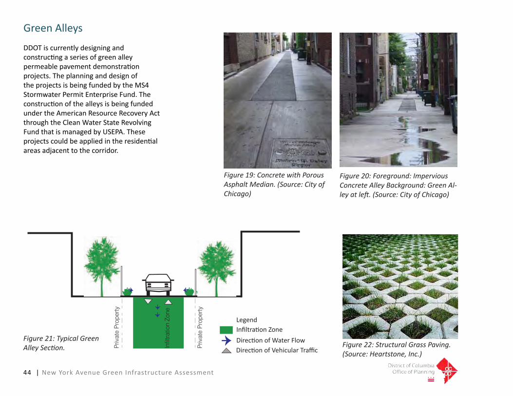
44 | New York Avenue Green Infrastructure Assessment
GreenAlleys
DDOTiscurrentlydesigningandconstructingaseriesofgreenalleypermeablepavementdemonstrationprojects.TheplanninganddesignoftheprojectsisbeingfundedbytheMS4StormwaterPermitEnterpriseFund.TheconstructionofthealleysisbeingfundedundertheAmericanResourceRecoveryActthroughtheCleanWaterStateRevolvingFundthatismanagedbyUSEPA.Theseprojectscouldbeappliedintheresidentialareasadjacenttothecorridor.
Figure 19: Concrete with Porous Asphalt Median. (Source: City of Chicago)
DirectionofVehicularTrafficDirectionofWaterFlowInfiltrationZone
Priv
ate
Pro
perty
Priv
ate
Pro
perty
Infil
tratio
n Zo
ne
Legend
Figure 20: Foreground: Impervious Concrete Alley Background: Green Al-ley at left. (Source: City of Chicago)
Figure 21: Typical Green Alley Section. Figure 22: Structural Grass Paving.
(Source: Heartstone, Inc.)

New York Avenue Green Infrastructure Assessment | 45
Alley Entry Visual Enhancement
Typical alleys drain runoff from interior of the block, collect it in the alley and then flush it out to the street where it enters
the storm sewer system.A Green Alley will collect stormwater in
the alley itself to allow it to percolate
PrivatePropertyLIDOptions
Therearenumerousopportunitiestoimplementgreeninfrastructureonprivateproperty.Itcanbedoneasmaintenanceandrepairactivities,grantsfromtheDistrictand other funding sources, and through redevelopmentactivities.Forexample,theDistrictDepartmentoftheEnvironment’sDistrict-wideRiverSmartHomesProgramoffersincentivestohomeownersandbusinesses that are interested in reducing stormwaterrunofffromtheirpropertiesthroughtheuseofgreentechnologies.Currentandpreviousfundinghasbeenprovidedfortheplantingorconstructionoffourtypesofgreentechnologies:
• ShadeTrees• RainBarrels• Pervious Pavers• RainGardens
Figure 24: Pervious Pavers/Rain Garden. (Source: DDOE RiverSmart Homes)
Figure 23: Potential Areas Outside the Alley Right-of-Way for Rain Harvesting and Infiltra-tion.
Figure 25: Rain Barrels. (Source: Central Minnesota Water Education Alliance)
PotentialRainBarrelLocationsPotentialPermeablePavingPotentialRainGardenLegend

46 | New York Avenue Green Infrastructure Assessment
Pavement and Parking
Parkinglots,medians,andprivatepropertyadjacenttotheright-of-waysofferexcellentpotentialfortheinstallationofbioretentionfacilitiesaroundtheperimeteroftheparkingarea.Atthistime,privatepropertiesshouldmanagetheirownstormwaterwithouttheuseofthepublicright-of-way.Thispolicy,however,isunderreview.Retrofittingexistingparkinglotsandimpervioussurfacesmayprovechallenginginsomecasesintermsofcompleteredesign.
Newdevelopmentshavemoreflexibilityin terms of integrated stormwater management.StormwaterBMPsshouldberequiredfornewdevelopmentsincludingperimeterbioswales,toprovidecontinuitywithintheNewYorkAvenuefocusarea.
Filtered Run-off enters Groundwater
Pav
emen
t
Figure 26: Right-of-way Adjacent Bioreten-tion Area.
Figure 27: Bioretention Section.
DirectionofWaterFlow
Right-of-WayAdjacentBioretentionAreas
ParkingLotBioretentionCollectionAreas
Legend
Figure 28: Parking Lot with Bioretention in Prince George’s County, MD. (Source: LID Center)

New York Avenue Green Infrastructure Assessment | 47
LandscapeAmenities
The character of the New York Avenue NEfocusareacanbeimprovedinmanylocationswiththeinstallationoflandscapeamenities.Bioretentionareashavetheirownlandscapecharacterduetoitslocationinthelandscape,andthetypeanddensityofplantmaterialsused.Thevisualimpactofroadwaysandparkinglotscanbeimprovedbyupdatingorincreasingstreettreeandtreeboxplantingareas.Barrenanderodedslopesthatarenexttoroadwayscanbelandscapedwithnativeshrubs,grasses,andgroundcoverstoreduceerosion.Evasiveandnon-nativeplantingscanbereplacedwithreforestationprojects.Unusedparkinglotsorvacantlotscanlikewisebeplantedwithnativeplantsandtreesasinterimusesthatcanreducerunoffandheatislandeffects.
Figure 29: Capitol Hill Rain Garden. (Source: LID Center)
Figure 31: U.S. EPA Rain Garden. (Source: DDOE)
Figure 30: Constitution Square, Washing-ton, DC (Source: www.sitefocus.com)

48 | New York Avenue Green Infrastructure Assessment
LandscapeIdentity
AsignificantportionoftheNewYorkAvenueNECorridorisboundedbytherollingpastoralandwoodedlandscapesoftheMountOlivetCemeteryandtheNationalArboretumthatarebothlocatedonthenortheastsidesofthecorridor.DriversthatenterfromMarylandandthenorthwestarefunneledintotheNewYorkAvenueNECorridorunderbridgesandthroughtheadjacentwoodedhillsides.Treescanbeplantedinpackedclustersorclumpswithinthebioretentionareasofthecorridor.TheconcentrateddistributionoftreesthroughoutthesitewillserveasalandscapeidentityuniqueforcommercialareasinDC,andwillservetheDistrictinmeetingitstreecanopygoals.
Figure 32: National Arboretum. (Source: http://good-times.webshots.com)
Figure 33: National Arboretum. (Source: http://outdoors.webshots.com)
Figure 34: Bayscape Planting. (Source: DDOE RiverSmart Homes)

New York Avenue Green Infrastructure Assessment |49
SignageandBranding
Commercialbusinessesrelyheavilyonsignagetocreatedistinctbusinessmessagesandtoattractcustomers.Signsonbuildingsand storefronts are the most common way ofreflectingthecommercialmessagetoconsumers.ThebusinesssignsthatwillbeconstructedalongNewYorkAvenueNEwill,toalargedegree,shapethecharacterofthearea.Proposedsignageshouldutilizesustainableenergysourcesandshouldbeconstructedofsustainablematerials.Forexample,signmakersoffer100percentrecyclablealternativestoPVCbannermaterial,offeringsignsthateliminateadhesives,andusewater-basedUVcurableinks.Theenergyusedtopowersignsshouldbeoffseteitherbybuilt-inoron-siterenewablesources.DigitalReflectiveInktechnologycanalsohaveagreatimpactforlessenergyusedthansomeothermethodsoflightingsigns.
Figure 35: Branding: Fresh Kills Park, NYC.(Source: New York City Dept of Parks and Recreation)
Figure 36: Wind and Solar Powered Bill-board, Times Square. (Source: Ricoh Com-pany, Ltd.)
Figure 37: DC USA, Washington, DC. (Source: http://dccondoloft.com)

50 | New York Avenue Green Infrastructure Assessment
GreenRoofImplementationonlargeroofareas/BigBoxRetail
Greenroofsoffermanybenefitsforbuildingsandthelocalenvironment.Inadditiontothestormwaterfunctionsofretainingrainfallfromsmallstormeventsandfilteringairbornepollutantsinlargerevents, there are other energy, economic, social,andenvironmentalbenefits.Thisincludesinsulatingandmoderatingbuildingtemperatures,removingcarbondioxidefromtheatmosphere,andcoolingtheenvironmentthroughevapotranspirtation.Greenroofscanalsoextendthelifecycleoftheroofmembrane.
Reconsiderationsshouldalsobemadeaboutthesprawlingtypologyofbigboxdevelopmentsthemselves.Withtheincreasingcostoflandacquisition,consolidationofmultipleyetautonomousretailstoresintoastackedmega-boxorverticalpowerretailcentercanreducetheamountoflandrequiredbyupto80percent.Withseveraldifferenttypesofthesestoresinthesameplace,greatercross-shoppingcanbeanticipated.Thisincreasesprofitabilityandoffsetstheamountofparkingrequired.Becauseofitssheersizeandpresence,themega-boxhasincreasedadvertisingpotentialbeyondwhatonestorecouldaccomplishalone.
DCUSA—alocalprecedent—isthecity’slargestretailcomplex,andfamedasaprimarycomponentintherevitalizationoftheColumbiaHeightsneighborhood.AdjacenttoColumbiaHeightsMetro,thecomplexismarkedbyverticallystackedconstruction,showingtheretailsiteasanexcellentexampleofwell-consideredbigboxdevelopment.Aonethousandspaceunderground parking garage, paid for by theDistrict,workedasanincentivetothedevelopertomoveapreviouslyplannedabove-groundparkinglotunderground.However,duetotheurbanlocation,andproximitytotransit,the1,000subgrade parking spaces proved to be an unnecessarilylargequantity.
Figure 40: DC USA, Washington, DC. (Source: flickr.com)
Figure 38: Green Roof: Department of Transportation HQ, Washington DC. (Source: DDOT)
Figure 39: Green Roof: ASLA HQ, Washing-ton DC. (Source: ASLA)

New York Avenue Green Infrastructure Assessment | 51
Transportation Recommendations
BusStopRecommendationsSynopsis
The bus stops within the New York Avenue Corridorwerestudiedinordertodeterminehowtheymaybemodifiedorrelocatedtohelpfacilitateuseandtoseewhetherthepotentialexistsforimplementinggreenstrategiesatthesebusstops.
ThedesignguidelinesfromWMATA/DDOTdonotpermitintensivelandscapingwithinthebuszonesinordertoallowforcomfortableandsafeaccesstoandfromthebuses.TheallowanceofspacethatisavailableforLIDinstallationswouldprovetobetoosmall(assumingtherearenoalterationsmadetotrafficlanes)tohaveasignificantimpact,giventhevolumeofrunoffandpollutantsfromtheroadwayandsurroundingimperviousareas.Inordertoaccommodatethisvolume,alarger-scale,morecomprehensivesolutionwillbenecessarytobeconsideredeffective.
Therearephysicalimprovementstothebuszonesandbusstopsthatcanimproveandcomplimentthecharacterofthecorridor.Sustainabletechnologiessuchasgreenroofscouldbeinstalledonthe
sheltersinordertointerceptandmanagetherunoff.Photovoltaicsolarcellscouldbeinstalledonsheltersinordertopowerimprovedvisibilityandaccessibilityatthosebusstopswhichhaveshelters.Furtherrecommendationsforthespecificbusstopsareillustratedinpages52-59.

1:
2:
3:
4:
BusStopA
Addphotovoltaicsolarcellsonshelter.
Replaceandre-gradeexistingconcretelay-byandinstallnewstandardgranitecurb.Painted‘busbox’graphicinlay-by.
Plantlargefourinchcaliperhardyshadetreesandunderstoryshrubsinavailableplanters.
ExpandedplantingofunderstoryshrubscanoccuralongNewYorkAvenueNEexceptwherebuslandingzonesarerequired.WMATArequiresafivebyeight foot unobstructed Americans with DisabilitiesAct(ADA)landingpadforthefrontdoorofthebusanda30-40footclearareaforreardooregress.
20’10m
23
41
Bus Shelter
New York Avenue
Lay-by
Figure 41: A: New York Avenue Bus Stop for Routes E2, E3, D1, D3 & D4 - Looking Southwest. (Source: Google Maps Street View)
Figure 42: Bus Stop Location Plan. (Source: Google Maps)
N
Fig.41
52 | New York Avenue Green Infrastructure Assessment
PhotovoltaicCells
Vegetation
Bus Lane Improvement
Legend

Expandsidewalktoright-of-way,allowingpedestrianstomovesafelybehindLIDbuffer.
InstallnarrowLIDwithbuslandingzonesatcurbnearNorthCapitolStreetNWtofilterrunofffromsidewalk.WMATArequiresafivebyeightfootunobstructedADAlandingpadforthefrontdoorofthebusanda30-40footclearareaforreardooregress.
Applypainted‘busbox’graphicinrightturnlane.
Plantmedium-sizedtwoinchcaliperhardy trees and understory shrubs in existingandnewplantersalongNorthCapitolStreetNW.
Thesidewalkdimensionisnotwideenoughtoaccommodateashelterinthislocation.
1:
2:
3:
4:
*
BusStopB
Figure 44: Bus Stop Location Plan. (Source: Google Maps)
20’10m
23
41
LID Strip
New York Avenue
Expanded SidewalkBus Stop
N C
apito
l Stre
et
Bus Stop Box
*
*20’10m
23
41
LID Strip
New York Avenue
Expanded SidewalkBus Stop
N C
apito
l Stre
et
Bus Stop Box
*
*
Figure 43: B: North Capitol Street NW Bus Stop for Routes 80 & P6 - Looking North. (Source: Google Maps Street View)
N
Fig.43
New York Avenue Green Infrastructure Assessment | 53
*
SidewalkImprovement
Vegetation
Bus Lane Improvement
AdditionalNoteRegardingBusStopsandShelters
Legend

Applypainted‘busbox’graphicinrightlane.
PlantlargefourinchcaliperhardyshadetreesandsmallshrubsinexistingplantersalongNorthCapitolStreetNWadjacenttobuszone.Plantingmustallowspaceforbuslandingzones.WMATArequiresafivebyeightfootunobstructedADAlandingpadforthefrontdoorofthebusanda30-40footclearareaforreardooregress.
Thesidewalkdimensionisnotwideenoughtoaccommodateashelterinthislocation.
1:
2:
BusStopC
*
20’10m
12
Bus Stop/Shelter
New York Avenue
N C
apito
l Stre
etBus Stop Box
*Figure 45: C: North Capitol Street NW Bus Stop for Route 80 - Looking Southwest. (Source: Google Maps Street View)
Figure 46: Bus Stop Location Plan. (Source: Google Maps)
N
Fig.45
54 | New York Avenue Green Infrastructure Assessment
*
Vegetation
Bus Lane Improvement
AdditionalNoteRegardingBusStopsandShelters
Legend

New York Avenue Green Infrastructure Assessment | 55
Constructbump-outintoparkinglanetoallowforshelter.
Plantlargefourinchhardyshadetrees and understory shrubs in new plantersalongFenwickStreetNEadjacenttobuszone.Plantingmustallowspaceforbuslandingzones.WMATArequiresafivebyeightfootunobstructedADAlandingpadforthefrontdoorofthebusanda30-40footclearareaforreardooregress.
Installshelteronlyifbump-outisconstructed.
1:
2:
BusStopD
*
20’10m
21
Fenwick Street
Bus Stop/Shelter
New York Avenue
Bump Out
*
*
20’10m
21
Fenwick Street
Bus Stop/Shelter
New York Avenue
Bump Out
*
*
Figure 47: D: Fenwick Street NE Bus Stop for Routes E2, E3, D1, D3, & D4 - Looking North. (Source: Google Maps Street View)
Figure 48: Bus Stop Location Plan. (Source: Google Maps)
N
Fig.47
*
SidewalkImprovement
Vegetation
AdditionalNoteRegardingBusStopsandShelters
Legend

56 | New York Avenue Green Infrastructure Assessment
Addphotovoltaicsolarcellsonshelterrooftopowershelteramenities(Seepage54forlistofshelteramenities).
Applypainted‘busbox’graphicinrightlane.
PlantlargefourinchhardyshadetreesandsmallshrubsinnewnarrowplantersalongBladensburgRoadadjacenttobuszone.Plantingmustallowspaceforbuslandingzones.WMATArequiresafivebyeightfootunobstructedADAlandingpadforthefrontdoorofthebusanda30-40footclearareaforreardooregress.
1:
2:
3:
BusStopE
20’10m Bl
aden
sbur
g Ro
ad
Bus Stop
New York Avenue
Existing Bus Shelter
2
1
3
Figure 49: E: Bladensburg Road NE Bus Stop for Routes B2 & S41 - Looking North. (Source: Google Maps Street View)
Figure 50: Bus Stop Location Plan. (Source: Google Maps)
N
Fig.49
PhotovoltaicCells
Vegetation
Bus Lane Improvement
Legend

New York Avenue Green Infrastructure Assessment | 57
InstallthreetofourfootsidewalkawayfromWestVirginiaAvenueNE.
InstallLIDwithmedium-sizedtwoinchcaliperhardyornamentaltree(s)atcurbnearWestVirginiaAvenueNEtofilterrunofffromroadway. Relocatebusstoptotheimmediatesouthawayfromservicestationdriveways.
1:
2:
BusStopF
*
20’10m
Wes
t Virg
inia A
ve
Sidewalk LID Strip
Existing Bus Shelter
Potential Relocation
Site
12
*
*
*
Figure 51: F: West Virginia Avenue NE Bus Stop for Routes E2, E3 & S41 - Looking South. (Source: Google Maps Street View)
Figure 52: Bus Stop Location Plan. (Source: Google Maps)
N
Fig.51
*
SidewalkImprovement
Vegetation
AdditionalNoteRegardingBusStopsandShelters
Legend

58 | New York Avenue Green Infrastructure Assessment
20’10m
Wes
t Virg
inia A
ve
Existing Bus Stop
Bus Stop Box
12
*
*
Applypainted‘busbox’graphicinrightlane.
PlantlargefourinchcaliperhardyshadetreesandsmallshrubsinexistingplantersalongWestVirginiaAvenueNEadjacenttobuszone.Plantingmustallowspaceforbuslandingzones.WMATArequiresafivebyeightfootunobstructedADAlandingpadforthefrontdoorofthebusanda30-40footclearareaforreardooregress.
Thesidewalkdimensionisnotwideenoughtoaccommodateshelter.
1:
2:
BusStopG
* Figure 53: G: West Virginia Avenue NE Bus Stop for Routes E2, E3, & S41 - Looking North. (Source: Google Maps Street View)
Figure 54: Bus Stop Location Plan. (Source: Google Maps)
N
Fig.53
*
Vegetation
Bus Lane Improvement
AdditionalNoteRegardingBusStopsandShelters
Legend

New York Avenue Green Infrastructure Assessment |59
BusStopAmenities
Whilethesurfaceareaofbusstopsaresmall,installingtwoinchthickpregrownextensivegreenroofsonthemhelpsinterceptandtreatrunnoffwhilemakingtheprocessaccessibletopeopleutilizingthespace.
Manyamenitiesorinnovationsforbusstopsrequireapowersourceinordertoperform.Photovoltaicsolarcellslocatedontheroofofbusstopsinothercitieshaveprovidedthenecessarypowerforthefollowingamenities.
1 PowerLEDlightsfornightusersand advertisingpanels.
2 PoweranLEDmessageboardthatgives Metrobusscheduleupdates.
3 OperateaWi-Firouter.
4 Power“Push-to-Talk”featureswhich readstheMetrobusinformationaloud forvisuallyimpairedtravelers
SanFrancisco’suseofacurvilinearshapeontheroofofabusshelterallowedsolarcellstoperformwellregardlessofsunangle.Repeatingcurves(Fig.B)werefoundtobemorestructurallysoundthanaflatsurface(Fig.A).
B
A
Figure 55: Conceptual WMATA Standard Bus Shelter Modified for Extensive Green Roof and Photovoltaic Solar Roof Cells. (Source: Google Maps Street View)
Figure 56: Photovoltaic Cells on Bus Shelter - Example from San Francisco.
Figure 57: GreenRoof on Bus Shelter - Example from San Francisco.

60 | New York Avenue Green Infrastructure Assessment
Multi-UseTrailRecommendations
Themulti-usetrailrecommendationsarefortheintegrationandimplementationoftrailsthatcanaccommodatepedestriansandbikeswithintheassessmentarea.Therecommendationsincludespecificgeometricandtrailcrosssectionproposalsforeacharea,strategiesforconnectingtothe surrounding areas, and enhancements andfeaturesalongthetrail.TherecommendationsareprovidedfortheoverallassessmentareaalongNewYorkAvenueandsixsub,orfocusareas.Thesubareasareasfollows:
• FloridaAvenueNEtotheNewYorkAvenueBridgeNEoverAmtraktracks
• NewYorkAvenueBridgeNEtoPennStreetNE
• PennStreetNEtoBrentwoodParkwayNE
• BrentwoodParkwayNEtoWestVirginiaAvenueNE/MontanaAvenueNE
• WestVirginiaAvenueNE/MontanaAvenueNEtoNationalArboretum
Overall Assessment Area Recommendations
Multi-Use Trail DesignThetrailshouldbelocatedonthesouthsideofNewYorkAvenueNE.Locatinga
trailonthesouthsidewillaccommodateshorter trips between neighborhoods anddestinationsalongNewYorkAvenueNE.ThiswillalsominimizetheneedforresidentslivingsouthofthecorridortocrossNewYorkAvenueNEtoreachthetrail.Generally,thetrailwillbedevelopedthroughthewideningofexistingsidewalks.Therearetwolocations(discussedinmoredetaillaterinthischapter)wheretraildevelopmentwillinvolveconvertinglowusedecelerationlanestotrailpurposes.Itshouldbenotedthattherearenorecommendationsforremovingtravellanesthatcarryvehicularthrough-traffic.Generally,theexistingvegetatedbufferalongthecorridorwillbemaintained.Somebufferareaswillbewidenedfurtherorabufferwillbeaddedwherethereisnone.
Itisalsorecommendedthatthetrailbeconstructedwithpermeablematerials,suchasperviousconcreteorperviousasphalt,toimproverunoffinfiltrationandtoshowcasetheuseofthesematerials.
Futurestudiesshouldexplorethefeasibilityofinstallingamulti-usetrailonthenorthsideoftheNewYorkAvenueCorridor.Atraillocatedonthissidecouldreducetraveltimealongthecorridorasitwouldrequirefewerroadanddrivewaycrossings.Inaddition,connectionstotheproposedFortLincolnNewTowndevelopmenttothe northeast of the study area (east of
SouthDakotaAvenueNE)maybeeasiertoaccomplishwithatrailonthenorthside.
Multi-Use Trail ConnectionsAconnectionbetweentheproposedmulti-usetrailonNewYorkAvenueNEandtheMetropolitanBranchTrail(MBT)shouldbecreatedintheundevelopedlandbetweenNewYorkAvenueNEtothenorthandFloridaAvenueNEtothesouth.TheMBTisatahigherelevationthroughthissection(crossingFloridaAvenueNEonabridgeratherthanat-grade)andaconnectioniseasiertoconstruct,whereassouthofFloridaAvenueNEthetrailbeginstotransitiondownbeforeconnectingwiththeNewYorkAvenueMetrorailStationentranceonNStreetNE.
Aconnectionshouldalsobecreatedontheeasternendoftheproposedmulti-usetrailonNewYorkAvenueNEwiththeAnacostiaRiverfronttrailsystem.ThiscouldbelocatedontheeasternbankoftheAnacostiaRiverandcouldeventuallyconnecttopotentialfuturetrailsinMarylandthatwouldbeparalleltoRoute50fromCheverlytoNewCarrollton.AnimprovedcrossingoftheAnacostiacouldbecantileveredoffoftheRoute50bridgeortheAmtrakbridge.Thefeasibilityofthecrossingwouldrequireandextensivestudy.
Pocket Green SpacesPocketgreenspacescouldbecreated

New York Avenue Green Infrastructure Assessment | 61
Figure 59: Cross Section with Cantilevered Trail at New York Avenue NE Bridge over Amtrak Railroad Tracks, Looking East.
Figure 58: Cross Section with Widened Trail at New York Avenue NE Bridge over Amtrak Railroad Tracks, Looking East.
where there is adequate space between themulti-usetrailandbuildings,fences,orotherphysicalstructures.Thesevegetativezonescouldreducestormwaterrunoffandimprovethevisualexperiencefortrailusers.Thesezonesshouldnothinderviewsof signs, business entrances, and other importantfeatures.Propermaintenanceofthesezoneswillbeimperativetomaintaintrailusercomfortandsafety.
Florida Avenue NE to New York Avenue Bridge NE
Multi-Use TrailInthissectionofthetrailthesidewalksaretoonarrowtosafelyaccommodatepedestriansandbicycliststogether.Additionalwidthisnotavailableintheexistingconfigurationonthebridge.Thesidewalkonthesouthsideshouldbe widened to a minimum of 11 feet to
accommodatepedestriansandbicyclistsinbothdirections.Oneoption(seeFigure58)mayrequirecantileveringstructures,dependingontheexistingstructuralsupportsofthebridge.Thefencingontheouteredgeshouldberelocatedtotheouteredgeofthenewtrail.Thesidewalkonthenorthsidewillremainunchangedandwillcontinuetoaccommodatepedestriantraffic.Asecondoptionistoreducethewidthofallsixvehicletravellanesfrom

62 | New York Avenue Green Infrastructure Assessment
12feetto11feetandallocatethe6footgaininwidthtothesidewalkonthesouthsidetocreateatrail,whilemaintainingthesidewalkwidthonthenorthside.Athirdoptioninvolvesreducingthewidthoftheeastboundtravellanesonly,from12feetto11feet,andallocatingtheresulting3feettothesidewalkonthesouthsidetocreateatrail,maintainingthesidewalkonthenorthsideforpedestriantraffic(seeFigure59).
TheNewYorkAvenueBridgeNEovertheAmtraktracksiscurrentlybeingreplaced,andthenewbridgewillhaveessentiallythesameoverallwidthandcrosssectionastheexistingbridge.Thesecondandthirdoptionspresentedabovefornarrowinglanes(lanediets)toaccommodateawidermulti-usetrailonthesouthsideofthebridgeshouldbefeasibleandrelativelystraightforwardtoimplementonthenewbridge.Thecantileveredtrailoptionwould
bemorecostlytoconstructandmaynotbefeasible,dependingonthestructuraldesignofthenewbridge.
New York Avenue Bridge NE to Penn Street NE Recommendations
Multi-Use TrailTheseventhlaneinthissectionappearstobeunnecessaryforvehicularmovement.Itislessthan200yardslonganddoesnotappeartoaccommodatepull-offusessuchasbusesorloading.Itisrecommendedthattheseventhlanebereallocatedforthemulti-usetrail.Inthisscenario,thecurbwouldberelocatedtotheouteredgeofthesixthtravellane,andabuffershouldbeincludedtoseparatethetrailfromtheroadway(seeFigure60).
Penn Street NE to Brentwood Parkway NE Recommendations
Multi-Use TrailTheexistingsidewalkonthesouthsideshouldbereplacedwiththemulti-usetrailuptothevacantparkpropertythatisdirectlyeastoftheNationalParkServicemaintenancefacility.Theexistingstreettreebufferstripshouldbemaintainedbutmay need to be removed or narrowed at certain spots in order to accommodate the necessarywidthforthemulti-usetrail.AretainingwallmayberequiredonthesouthsideofthetrailbecausethelandslopesupawayfromNewYorkAvenueNE.AttheparkpropertythetrailshouldbeseparatedfromthesidewalkthatparallelsNewYorkAvenueNEonthesouthsideoftheexistingtreesothetreescanbesaved(seeFigure61).
Figure 60: Cross Section West of Penn Street NE, Looking East.

New York Avenue Green Infrastructure Assessment | 63
Multi-Use Trail ConnectionsTrailconnectionsintotheparkspaceanduptoBrentwoodParkwayNEshouldbeprovided.WherethetrailpassesundertheBrentwoodParkwayNEbridge,theavailablespacenarrows between the bridge abutment and theroadway.Themulti-usepathmayneedtoreconnectwiththesidewalkatthispoint;itappearsthatthenewlyconstructedBrentwoodParkwayNEbridgewillprovidesufficientspaceforasharedusefacility.
Brentwood Parkway NE to West Virginia Avenue NE/Montana Avenue NE Recommendations
Multi-Use TrailTheexistingsidewalkonthesouthsideshouldbereplacedwiththemulti-usetrail.Theexistingbuffershouldbemaintainedbutitmayneed to be removed or narrowed in certain
spots to accommodate the necessary width for themulti-usetrail.Someofthedrivewaysatthegasstationshouldbeconsolidatedinordertoreduceconflictsbetweenmotoristsandtrailusers.
OnthenorthsideofNewYorkAvenueNE,theparkinglots,whichappeartobeatransitionalortemporaryuse,couldbeusedfortheimplementationoflowcostorinterimLIDstormwater management improvements, such asraingardensorswales.Thesewouldimprovewaterqualityaswellasprovidesignificantaestheticimprovements.Theseareascouldbeconvertedtoalinearparkwithamenitiessuchaslandscaping,benches,publicart,andpossiblystationaryexerciseequipmentsuchaschinupbars.Thisparkcouldincludeatrain-orientedthemeinordertocapitalizeontheproximitytotherailyard.Becauseofthelocation’sproximitytothebusyroadway,soundprotectionsuchastransparentglasswalls
similartothoseusedtoseparatethetrailfromtheroadwayontheWilsonBridge,orwaterfeaturesthatgeneratenoise,couldbeusedtobuffertheroadnoise.
Multi –Use Trail ConnectionsThislinearparkcouldincludeaseparatepathwaythatwouldconnectwiththesidewalkonthenorthsideofNewYorkAvenueNEatthehotelproperty(seeFigure62).
West Virginia Avenue NE/Montana Avenue NE to the National Arboretum Property Recommendations
Multi-Use TrailTheexistingsidewalkonthesouthsidebetweenWestVirginiaAvenueNEandBladensburgRoadNEcanbereplacedwithamulti-usetrail.Theexistingbuffershouldbe
Figure 61: Cross Section West of Brentwood Parkway, Looking East.
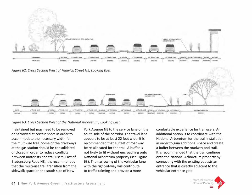
64 | New York Avenue Green Infrastructure Assessment
maintained but may need to be removed or narrowed at certain spots in order to accommodate the necessary width for themulti-usetrail.Someofthedrivewaysatthegasstationshouldbeconsolidatedorclosedinordertoreduceconflictsbetweenmotoristsandtrailusers.EastofBladensburgRoadNE,itisrecommendedthatthemulti-usetrailtransitionfromthesidewalkspaceonthesouthsideofNew
YorkAvenueNEtotheservicelaneonthesouthsideofthecorridor.Thetravellaneappearstobeatleast22feetwide;itisrecommended that 10 feet of roadway bere-allocatedforthetrail.AbufferisnotlikelytofitwithoutencroachingontoNationalArboretumproperty(seeFigure63).Thenarrowingofthevehicularlanewiththeright-of-waywillcontributetotrafficcalmingandprovideamore
comfortableexperiencefortrailusers.AnadditionaloptionistocoordinatewiththeNationalArboretumforthetrailinstallationinordertogainadditionalspaceandcreateabufferbetweentheroadwayandtrail.ItisrecommendedthatthetrailcontinueontotheNationalArboretumpropertybyconnectingwiththeexistingpedestrianentrancethatisdirectlyadjacenttothevehicularentrancegate.
Figure 62: Cross Section West of Fenwick Street NE, Looking East.
Figure 63: Cross Section West of the National Arboretum, Looking East.

New York Avenue Green Infrastructure Assessment | 65
Multi-Use Trail ConnectionsThesegmentofNewYorkAvenueNEeastof the Arboretum is out of the study area forthisproject.However,thereareseveralkeydestinationsinthisstretchincludingtheexistingandproposeddevelopmentsatFortLincoln,theAnacostiaRiverTrail,andaproposedrouteextendingfromCheverly,MDtoNewCarrollton,MDandultimatelytheWashington,BaltimoreandAnnapolis(WB&A)TrailinGlenarden,MDwhichshouldbeconsideredinfuturetrailexpansions.

1 inch equals 150 feet
0 200 400100 Feet
¯
New York Avenue NE
Metropolita
n Branch Trail (
Existing)
Connect with existing trail through development
Florida Avenue NE
Eckin
gton
Plac
e NE
Amtrak Railro
ad Tracks
WMATA Red Line Tracks
Replace Sidewalk with Multi-Use Trail
Replace Sidewalk and Buffer with Multi-Use Trail
Reallocate Roadway Space for Multi-Use Trail
Conflict Point or Pinch Point
Install Multi-Use Trail Separate from SidewalkLegend
Existing Sidewalks
Map Locator
1 2 3 4 5 67 8 9
Map 1
66 | New York Avenue Green Infrastructure Assessment

1 inch equals 150 feet
0 200 400100 Feet
¯
New York Avenue NE
May lose existing trees
4th Street N
E
Penn Street NE
Driveway crossing
Driveway crossing
Future Redevelopment
Amtrak Railroad Tracks
Close driveway
Replace Sidewalk with Multi-Use Trail
Replace Sidewalk and Buffer with Multi-Use Trail
Reallocate Roadway Space for Multi-Use Trail
Conflict Point or Pinch Point
Install Multi-Use Trail Separate from SidewalkLegend
Existing Sidewalks
Map 2
1 2 3 4 5 67 8 9
Map Locator
New York Avenue Green Infrastructure Assessment | 67

1 inch equals 150 feet
0 200 400100 Feet
¯
Driveway crossing
Weave through existing trees
Realign ramp
New York Avenue NE Bren
twoo
d Pa
rkw
ay N
E
Provide connection to neighborhooods to the south and Gallaudet University and sidewalks on Brentwood Parkway
Amtrak Railroad TracksBridge under construction
Replace Sidewalk with Multi-Use Trail
Replace Sidewalk and Buffer with Multi-Use Trail
Reallocate Roadway Space for Multi-Use Trail
Conflict Point or Pinch Point
Install Multi-Use Trail Separate from SidewalkLegend
Existing Sidewalks
Map 3
1 2 3 4 5 67 8 9
Map Locator
68 | New York Avenue Green Infrastructure Assessment

1 inch equals 150 feet
0 200 400100 Feet
¯
New York Avenue NE
Fair
view
Ave
nue
NE
Kend
all S
tree
t NE
Amtrak Railroad Tracks
Guardrail creates pinchpoint:Reduce curb radius to create additional space
Proposed linear park
Okie Street NE
Close drivewayDriveway crossing
Replace Sidewalk with Multi-Use Trail
Replace Sidewalk and Buffer with Multi-Use Trail
Reallocate Roadway Space for Multi-Use Trail
Conflict Point or Pinch Point
Install Multi-Use Trail Separate from SidewalkLegend
Existing Sidewalks
Map 4
1 2 3 4 5 67 8 9
Map Locator
New York Avenue Green Infrastructure Assessment |69

1 inch equals 150 feet
0 200 400100 Feet
¯
Replace Sidewalk with Multi-Use Trail
Replace Sidewalk and Buffer with Multi-Use Trail
Reallocate Roadway Space for Multi-Use Trail
Conflict Point or Pinch Point
Install Multi-Use Trail Separate from SidewalkLegend
Existing Sidewalks
Amtrak Railroad Tracks
Proposed linear park
New York Avenue NE
Fenw
ick
Stre
et N
E
Okie Street NE
Utilize dedicated right turn lane
Map 5
1 2 3 4 5 67 8 9
Map Locator
70 | New York Avenue Green Infrastructure Assessment
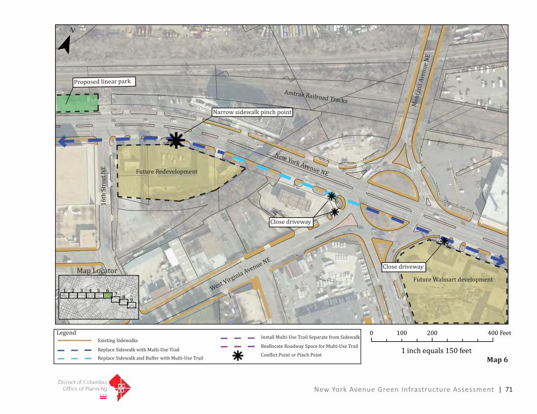
New York Avenue Green Infrastructure Assessment | 71
1 inch equals 150 feet
0 200 400100 Feet
¯
New York Avenue NE
Amtrak Railroad Tracks
West Virginia Avenue NE
16th
Str
eet N
E
Mon
tana
Ave
nue
NE
Close driveway
Future Redevelopment
Proposed linear park
Narrow sidewalk pinch point
Replace Sidewalk with Multi-Use Trail
Replace Sidewalk and Buffer with Multi-Use Trail
Reallocate Roadway Space for Multi-Use Trail
Conflict Point or Pinch Point
Install Multi-Use Trail Separate from SidewalkLegend
Existing Sidewalks
Map 6
1 2 3 4 5 67 8 9
Map Locator Close driveway
Future Walmart development

72 | New York Avenue Green Infrastructure Assessment
� ���� ������ ��� ����
� ��� ������ ����
¯
������������� �
��������
�������� �
�������������������
�������������
�������������
�� ���������������
�����������������������������������������������������������������������������������
�����������������������������������������������������������������
�������������������������������������������������� ���������������
���������������������
Map 7
1 2 3 4 5 67 8 9
���������
�������������������������
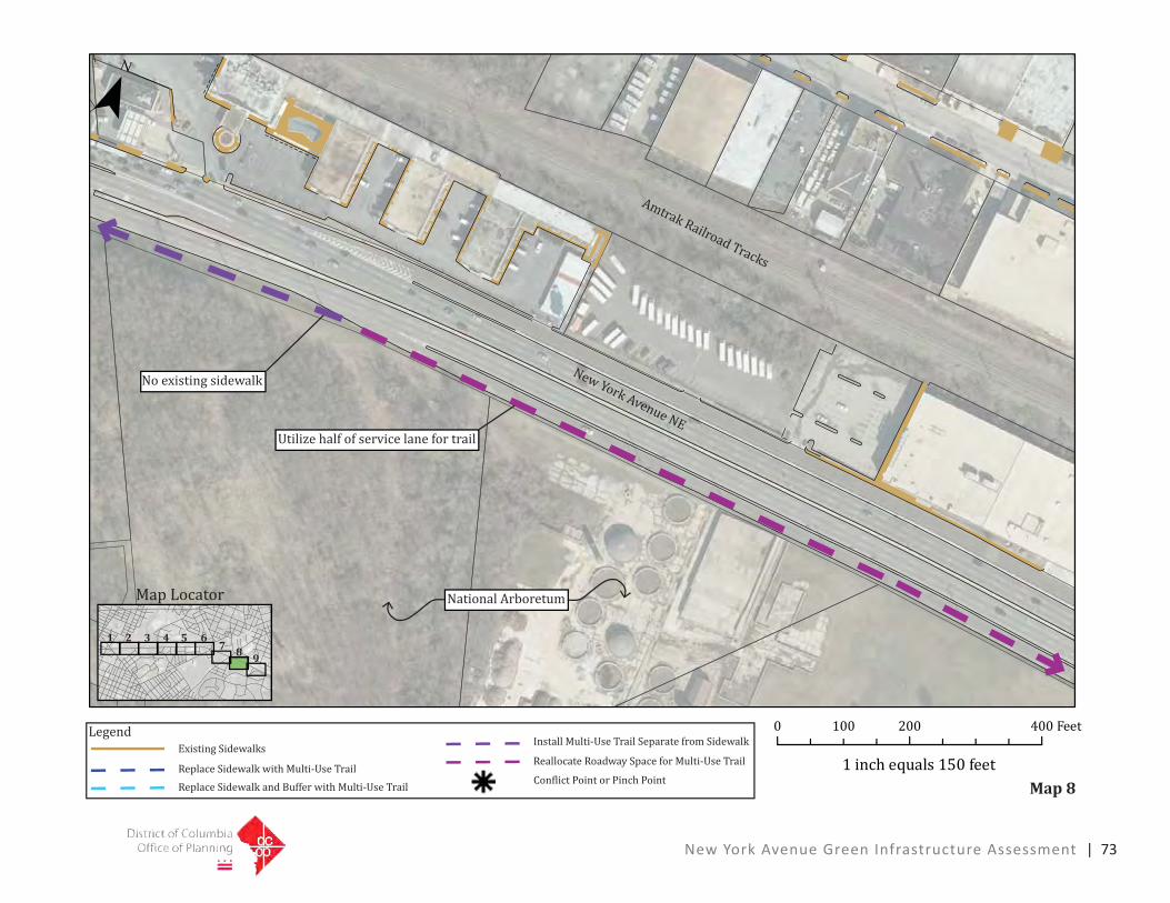
1 inch equals 150 feet
0 200 400100 Feet
¯
New York Avenue NE
National Arboretum
Utilize half of service lane for trail
No existing sidewalk
Replace Sidewalk with Multi-Use Trail
Replace Sidewalk and Buffer with Multi-Use Trail
Reallocate Roadway Space for Multi-Use Trail
Conflict Point or Pinch Point
Install Multi-Use Trail Separate from SidewalkLegend
Existing Sidewalks
Amtrak Railroad Tracks
Map 8
1 2 3 4 5 67 8 9
Map Locator
New York Avenue Green Infrastructure Assessment | 73