district of saanich: rural saanich local area plan vancouver island is changing - cities and towns...
TRANSCRIPT

local area plan2007RURAL SAANICH
References to General Plan, 1993 throughout this document means the
Official Community Plan, 2008 as adopted by Bylaw 8940 on July 8, 2008.

RURAL SAANICHLOCAL AREA PLAN
Appendix J to Bylaw 8940Adopted June 10, 2008
Prepared by the Planning Department,The Corporation of the District of Saanich

THE CORPORATION OF THE DISTRICT OF SAANICH BYLAW NO. 8940
TO ADOPT AN OFFICIAL COMMUNITY PLAN
WHEREAS Section 875 of the Local Government Act provides that an official community plan is a statement of objectives and policies to guide decisions on planning and land use management, within the area covered by the plan, respecting the purposes of local government; AND WHEREAS under Section 876 of the Local Government Act, a local government may adopt an official community plan; AND WHEREAS under Section 876 of the Local Government Act, an official community plan must designate the area covered by the plan; AND WHEREAS an official community plan has been prepared for all areas of the District of Saanich consisting of the General Plan, twelve Local Area Plans, and Development Permit Areas Justifications and Guidelines, attached hereto as Schedule "A" and comprising the following appendices: Appendix "A" - General Plan Appendix "B" - Blenkinsop Local Area Plan Appendix “C” - Cadboro Bay Local Area Plan Appendix “D” - Carey Local Area Plan Appendix “E” - Cordova Bay Local Area Plan Appendix “F” - Gordon Head Local Area Plan Appendix “G” - North Quadra Local Area Plan Appendix “H” - Quadra Local Area Plan Appendix “I” - Royal Oak Local Area Plan Appendix “J” - Rural Saanich Local Area Plan Appendix “K” - Saanich Core Local Area Plan Appendix “L” - Shelbourne Local Area Plan Appendix “M” - Tillicum Local Area Plan Appendix “N” - Development Permit Areas, Justification
and Guidelines NOW THEREFORE the Municipal Council of The Corporation of the District of Saanich in open meeting assembled enacts as follows: 1. The official community plan attached hereto as Schedule "A" comprising appendices "A" to "N" inclusive and made a part of this Bylaw is hereby designated as the Official Community Plan for the District of Saanich.
…/2

Official Community Plan Bylaw, 2008, No. 8940 Page 2
2. Bylaw No. 7044, being the "Official Community Plan Bylaw, 1993" is hereby repealed except insofar as it may repeal any other bylaw. 3. This Bylaw may be cited as the "Official Community Plan Bylaw, 2008, No. 8940". Read a first time this 23rd day of June, 2008. Public Hearing held at the Municipal Hall on the 8th day of July, 2008. Read a second time this 8th day of July, 2008. Read a third time this 8th day of July, 2008. Adopted by Council, signed by the Mayor and Clerk and sealed with the Seal of The Corporation on the 8th day of July, 2008. “CARRIE MacPHEE” “FRANK LEONARD” Municipal Clerk Mayor

Rural Saanich Local Area Plan
Saanich’s official community plan comprises the General Plan, twelve local area plans, action plans, and the development permit areas, justification and guidelines. Rural Saanich is the largest of the local areas encompassing almost half of the land area within Saanich. Located outside the urban containment boundary, the local area comprises rural acreages, small-scale farms, major parks, and institutional and government lands. These lands include a variety of green/blue spaces with high environmental, scenic, renewable resource, outdoor recreation, greenway, and/or social value.
Southern Vancouver Island is changing - cities and towns continue to grow and with urbanization comes increased demands on infrastructure, social and cultural services, and natural resources. Satisfying these demands has resulted in competition for a limited land resource. Many natural habitats supporting a variety of ecosystems, and species have been lost or damaged and many more are threatened in a global sense. The rural areas contribute to a community’s sense of well-being. A healthy community has vibrant neighbourhoods that combine places for living, recreation, social activity, and nature. Maintaining a balance between rural and urban lands is important to maintaining quality of life and sustaining food production.
Rural Saanich is valued by its residents and by those from outside the area for its natural beauty, diverse environments, high biological diversity, agricultural and well-forested lands, and rural lifestyle. The diversity of the natural environment and the variety of environmental features remain primarily as a result of on-going stewardship by local residents and Saanich’s leadership in implementing growth management, environmental protection, and other planning concepts to retain the character of the area and the health of its natural systems. A long standing commitment by successive Councils to a policy of urban containment is supported by official community plan policies to maintain large lot sizes, rural residential and agricultural land uses, and rural servicing standards outside the Urban Containment Boundary.
FOREWARD

Rural Saanich Local Area Plan
The Regional Growth Strategy (2003) supports the Urban Containment Boundary concept by keeping urban areas compact and largely contained within a Regional Urban Containment and Servicing Area. It seeks to protect the character and quality of rural communities, to ensure that they remain strongly rooted in the agricultural and resource land base, and that the rural countryside and natural landscape remain a durable fact of life in the Capital Region.
The Rural Saanich Local Area Plan, developed in consultation with an Advisory Committee, the Prospect Lake Community Association and other stakeholders, provides a policy framework to maintain the character of the rural area, the integrity of its natural systems, and the rural lifestyle. A goal of the plan is to make the area accessible to all Saanich residents to enjoy the natural beauty through a network of open spaces and trails. Safety, minimizing traffic and other impacts, and respecting the rights of its residents, including the farmers are important considerations.
Rural Saanich is valued by its residents and by those from outside the area for its natural beauty, diverse natural environment, high biological diversity, agricultural and well-forested lands, and rural lifestyle.

Rural Saanich Local Area Plan
Table of Contents1.0 ACKNOWLEDGEMENTS ................................................................................................................ 1
Rural Saanich Local Area Plan Review Advisory Committee ......................................................................1
2.0 INTRODUCTION ............................................................................................................................ 2Background .................................................................................................................................................2Public Involvement ......................................................................................................................................2
3.0 RURAL SAANICH PROFILE ..............................................................................................5Demographics .............................................................................................................................................5Land Use Profile ..........................................................................................................................................7
4.0 RURAL SAANICH VISION .................................................................................................9
5.0 HERITAGE CONTEXT AND RESOURCES .....................................................................10Community Feedback ...............................................................................................................................10Objectives ..................................................................................................................................................10History .......................................................................................................................................................10 Heritage Buildings/Structures and Significant Trees ................................................................................. 11West Saanich Road ................................................................................................................................... 11Policies ......................................................................................................................................................13
6.0 SENSE OF COMMUNITY ................................................................................................14Community Feedback ...............................................................................................................................14Objectives ..................................................................................................................................................14Rural Saanich Identity ...............................................................................................................................14Rural Saanich Meeting Places ..................................................................................................................14Communication and Community ...............................................................................................................15Community Services .................................................................................................................................17Policies ......................................................................................................................................................17
7.0 SUSTAINABILITY .............................................................................................................19Community Feedback ...............................................................................................................................19Objective ...................................................................................................................................................19Sustainability Benefits ...............................................................................................................................19Urban Containment Boundary ...................................................................................................................19Policies ......................................................................................................................................................21
8.0 ENVIRONMENT ...............................................................................................................22Community Feedback ...............................................................................................................................22Objectives ..................................................................................................................................................22Terrestrial and Wetland Habitat .................................................................................................................22Aquatic Environment .................................................................................................................................24Groundwater ..............................................................................................................................................26Air Quality ..................................................................................................................................................26Municipal Regulatory Tools .......................................................................................................................26Prospect Lake/Tod Creek Action Plan .......................................................................................................28Environmental Education and Land Stewardship......................................................................................28Policies ......................................................................................................................................................31

Rural Saanich Local Area Plan
9.0 AGRICULTURE ................................................................................................................33Community Feedback ...............................................................................................................................33Objectives ..................................................................................................................................................33Urban Containment Boundary and Minimum Parcel Sizes .......................................................................33Agricultural Land Reserve .........................................................................................................................33Rural Saanich Agricultural Profile ..............................................................................................................35Agriculture and the Environment ..............................................................................................................36Agricultural Opportunities ..........................................................................................................................36Agricultural Development Permit Area ......................................................................................................37Policies ......................................................................................................................................................38
10.0 PARKS, TRAILS, AND OPEN SPACES .........................................................................40Community Feedback ...............................................................................................................................40Objectives ..................................................................................................................................................40Green/Blue Space Network .......................................................................................................................40Existing and Potential Parks ......................................................................................................................42Natural Parks .............................................................................................................................................43Structured Athletic and Unstructured Recreational Parks .........................................................................47Trails Network ...........................................................................................................................................48Lake Access ..............................................................................................................................................52Policies ......................................................................................................................................................53
11.0 MUNICIPAL UTILITIES AND PRIVATE SERVICING ......................................................55Community Feedback ...............................................................................................................................55Objectives ..................................................................................................................................................55Liquid Waste Management ........................................................................................................................55Water Supply .............................................................................................................................................58Stormwater Management ..........................................................................................................................61Policies ......................................................................................................................................................63
12.0 MOBILITY .......................................................................................................................65Community Feedback ...............................................................................................................................65Objectives ..................................................................................................................................................65Road Network and Characteristics ............................................................................................................65Road Classifications and Standards .........................................................................................................67Road Maintenance ....................................................................................................................................68Patricia Bay Highway ................................................................................................................................68Commercial Trucks and Tour Buses ..........................................................................................................69Transit .......................................................................................................................................................69Bicycle, Pedestrian, and Equestrian Mobility ............................................................................................72Mobility Safety Improvement Priorities ......................................................................................................76Policies ......................................................................................................................................................76
13.0 HOUSING .......................................................................................................................80Community Feedback ...............................................................................................................................80Objectives ..................................................................................................................................................80Housing Profile ..........................................................................................................................................80Two Dwellings on One Parcel ...................................................................................................................82Housing For Family Members ...................................................................................................................83Secondary Suite in a Single Family Dwelling ............................................................................................83Residential Building and Site Design ........................................................................................................84Policies ......................................................................................................................................................85

Rural Saanich Local Area Plan
MAPSMap 1.1 Advisory Committee Representation ............................................................................................4Map 3.1 Land Use / Zoning ........................................................................................................................8Map 5.1 Heritage Resources ....................................................................................................................12Map 6.1 Community Associations ............................................................................................................16Map 7.1 Urban Containment Boundary ....................................................................................................20Map 8.1 Dense Forest Cover ...................................................................................................................23Map 8.2 Watercourses .............................................................................................................................25Map 8.3 Topography .................................................................................................................................30Map 9.1 Agriculture ..................................................................................................................................34Map 10.1 Greenways .................................................................................................................................41Map 10.2 Parks ..........................................................................................................................................44Map 10.3 Trail Network ..............................................................................................................................49Map 10.4 Equestrian Routes ......................................................................................................................51Map 11.1 Sewer Service Area and Sewer Infrastructure ...........................................................................56Map 11.2 Water Infrastructure ....................................................................................................................59Map 11.3 Watershed Boundaries ...............................................................................................................62
14.0 COMMERCIAL AND INDUSTRIAL .................................................................................87Community Feedback ...............................................................................................................................87Objectives ..................................................................................................................................................87Established Commercial Areas .................................................................................................................89Home Occupation Uses ............................................................................................................................89Tourist Accommodation .............................................................................................................................90Agri-Tourism and Other Tourist Commercial Uses ....................................................................................90Farm Markets and Accessory Produce Sales ...........................................................................................91Golf Courses .............................................................................................................................................91Vancouver Island Technology Park ...........................................................................................................92Industrial-Type Land Use ..........................................................................................................................92Policies ......................................................................................................................................................94
15.0 INSTITUTIONS................................................................................................................95Community Feedback ...............................................................................................................................95Objectives ..................................................................................................................................................95Schools ......................................................................................................................................................95Churches ...................................................................................................................................................97Prospect Lake Community Hall .................................................................................................................97Camosun College Interurban Campus ......................................................................................................98Glendale Gardens and Woodland .............................................................................................................98Federal Government Properties ................................................................................................................99Policies ....................................................................................................................................................100
16.0 DEVELOPMENT PERMIT AREAS ...............................................................................102Streamside Development Permit Area ....................................................................................................102Rural Saanich Fire Hazard Development Permit Area ............................................................................104Policies ....................................................................................................................................................104
17.0 STRUCTURE MAP .......................................................................................................105

Rural Saanich Local Area Plan
TABLESTable 3.1 Household Characteristics ...........................................................................................................6Table 3.2 Housing Tenure (%) ......................................................................................................................6Table 3.3 Labour Force Participation (%) ...................................................................................................7Table 10.1 Rural Saanich Park Summary ....................................................................................................45Table 10.2 Comparison of Existing Parkland in Rural Saanich ...................................................................46Table 10.3 Potential Natural Parks ..............................................................................................................46Table 10.4 Requested Equestrian Route Improvements .............................................................................50Table 12.1 Road Construction Specifications ..............................................................................................67
Appendix I Heritage Buildings and Structures ...........................................................................................108 Significant Trees ...................................................................................................................... 110
Appendix II Rural Saanich Local Area Plan Update Survey Results, June 2001 ...................................... 111
APPENDICES
FIGURESFigure 3.1 Age Comparison (2001) ...............................................................................................................5Figure 3.2 Age Comparison by Watershed ....................................................................................................6
Map 12.1 Road Network .............................................................................................................................66Map 12.2 Truck Routes ..............................................................................................................................70Map 12.3 Transit Route ..............................................................................................................................71Map 12.4 Bike Routes ................................................................................................................................73Map 12.5 On-Road Pedestrian Facilities ....................................................................................................75Map 12.6 Community’s Mobility Improvement Projects (2001) ..................................................................77Map 13.1 Rural Zoning ...............................................................................................................................81Map 14.1 Commercial and Industrial ..........................................................................................................88Map 15.1 Institutional / Government ..........................................................................................................96Map 16.1 Development Permit Area ........................................................................................................103Map 17.1 Rural Saanich Structure Map ...................................................................................................107
MAPS ..... Continued

Rural Saanich Local Area Plan 1
community vision environment parks
Prospect Lake/Tod Creek• Bernie Bowker• Shelagh Levey• Marshall Rosen• Martyn Ward
Elk Lake• Davin Deelman• Audrey Van Eerden• Joyce Wallbridge• Roger B. Wells
Rural Saanich Local Area Plan Review Advisory Committee
To provide broad representation, an Advisory Committee was established with four representatives from each neighbourhood within Rural Saanich. (See Map 1.1) The neighbourhood boundaries are generally based on the watershed boundaries shown on Map 11.3.
The involvement of many Rural Saanich residents in the review of the Rural Saanich Local Area Plan is gratefully acknowledged. Residents completed a survey, participated in community workshops and an open house, and attended meetings and a Public Hearing. These residents are an important source of community information and opinions about the future of Rural Saanich.
Special thanks is given to the Advisory Committee members who volunteered countless hours of their time over a two year period.
West Burnside• Stephen Fortner• Liane Gustafson• Arlene Perry• Kelly Reid
Layritz• Richard Burton • Ilsa Couto • Don Eastman • Marco Guarnaschelli
ACKNOWLEDGEMENTS1.0

Rural Saanich Local Area Plan 2
sustainabiltiy agriculture heritage housing
BackgroundThe Saanich Official Community Plan comprises the General Plan1993, twelve local area plans, action plans, and the Development Permit Areas - Justification and Guidelines. The General Plan provides a policy framework from an overall municipal perspective, while the local area plans and action plans provide more detailed policies at a community and neighbourhood level.
Local area plans set out comprehensive policies that help guide the future of individual communities. They supplement the General Plan by creating a local context and specific policies and guidelines to which Council can refer when making decisions on development proposals and capital works. A local area plan is also intended to provide residents, property owners, and others with an interest in an area with a reasonable level of certainty about future use and development and the quality of life to be achieved within that area. Council may amend a local area plan, following a public hearing, in response to a specific development proposal or to address situations that may not have been anticipated when the plan was updated.
The first Rural Saanich Local Area Plan was adopted by Council in December, 1981. It was consolidated and re-adopted in 1988 and again in 1993. In November, 1995 Council endorsed a program to update all local area plans. Rural Saanich is the last plan to be updated.
Public InvolvementThe public participation process was extensive for the review of the Rural Saanich Local Area Plan. A community survey was mailed to property owners in June, 2001 and the results were tabulated and made available in August, 2001 (See Appendix II). A project mailing list was compiled from the survey responses. In November, 2001 two community workshops were facilitated by municipal staff and well attended by Rural Saanich residents. The workshops were advertised in the Times Colonist and Saanich News newspapers, and residents on the project mailing list were notified by direct mail. Both the survey and the workshops provided valuable information, and formed the basis for discussions with the Advisory Committee.
2.0 INTRODUCTION

Rural Saanich Local Area Plan 3
Residents were asked on the survey to indicate an interest to serve on an Advisory Committee. Due to an overwhelming response, a selection process was undertaken to ensure broad representation. Sixteen residents were selected; four from each of the neighbourhoods in Rural Saanich (see Map 1.1). Advisory Committee members participated in twice monthly meetings from January to June, 2002 to discuss local issues and provide general direction to Planning staff for the first draft of the local area plan. Weekly advisory committee meetings were held in May and June, 2003 to provide feedback to Planning staff about the first draft. Key municipal departments and committees, and other stakeholders also received copies of the first draft for comment. A second draft incorporating many of the comments received was made available to municipal departments and committees, the advisory committee, other stakeholders, and the general public for comment and review at a community open house. An open house held May 5, 2004 at the Prospect Lake Community Hall was attended by more than 150 residents.

Rural Saanich Local Area Plan 4
LAYRITZPARK
THE
TIS
LA
KE
RE
GIO
NA
L PA
RK
FRANCISKING
REGIONALPARK
QUICK'SBOTTOM
BEAR HILLREGIONAL PARK
MOUNT WORKREGIONAL
PARK
ELK / BEAVER LAKE REGIONAL PARK
PROSPECT LAKE
WESTBURNSIDE
LAYRITZ
ELKLAKE
MUNN RD
WALLACE DR
OL D
FIE
LD R
D
BROOKLEIGH RD
ELK
LAK
E D
R
HO
LLAN
D AV
EO
LD W
EST
SAAN
ICH
RD PATR
ICIA
BAY
HW
Y
WEST
SAANIC
H R
D
SPARTON RD
WILLIS POINT RD
INTE
RU
RB
A N R
D
BURNSIDE RD
W
WIL
KIN
SON
RD
HARTLAND AVE
PRO
SPE
CT
L AK
E R
D
ProspectLake
Killarney LakeElk /
BeaverLake
MaltbyLake
0 1 20.5Kilometers
MAP 1.1 ADVISORY COMMITTEE REPRESENTATION
g:\!P
rote
ct_A
dm\L
ocal
Are
a Pl
ans\
Rur
al S
aani
ch\m
aps\
2006
Rur
alS
aani
ch\
Map
1.1
Adv
isor
yCom
mitt
ee.m
xdR
EV
SOURCE: Saanich Plannning
Committee Representation:Four representatives from each neighbourhood
Neighbourhood Boundary
Highway
Main Roads
Park
Institutional/Government
Rural Saanich Local Area Plan 4

Rural Saanich Local Area Plan 5
community vision environment parks
DemographicsThe following charts and tables provide a demographic profile of Rural Saanich and a comparison with Saanich as a whole. The data was compiled from the 2001 census data provided by Statistics Canada. At the time of publication, data from the 2006 Census was not yet available.
In an effort to better understand the area, Rural Saanich was divided into the four neighbourhoods; Layritz, West Burnside, Prospect Lake/Tod Creek and Elk Lake as indicated on Map 1.1. The neighbourhood boundaries are generally based on the watershed boundaries on Map 11.3.
Rural Saanich had a population in 2001 of about 4,900 people.
RURAL SAANICH PROFILE3.0

Rural Saanich Local Area Plan 6
Table 3.1: Household Characteristics
Characteristic Rural Saanich Saanich
Private households 1,830 41,515
Average household income $74,378 $61,876
Average number of persons per household 3.0 3.0
Source: Statistics Canada 2001
Table 3.2: Housing Tenure (%)
Elk Lake Layritz Prospect Lake
West Burnside
Rural Saanich
Saanich
Owned 89.7 85.6 74.0 82.0 85.0 73.7
Rented 8.8 13.5 15.2 23.6 14.8 26.3
Source: Statistics Canada 2001Note: Due to rounding percentages may not add up to 100%

Rural Saanich Local Area Plan 7
Table 3.3: Labour Force Participation (%)
Elk Lake Layritz Prospect Lake West Burnside Saanich
TotalParticipation Rate 71 70 74 82 64
Male 78 77 76 90 68
Female 66 62 72 76 60
Source: Statistics Canada 2001Note: Due to rounding percentages may not add up to 100%
Land use in Rural Saanich is shown on Map 3.1. There are approximately 2030 properties of which eighty-four percent are zoned A-1 (Rural Zone)* or A-4 (Rural Zone)*. Both zones permit one single family dwelling per parcel and agriculture. Strict adherence to a policy of urban containment, zoning and land use policies to maintain relatively large minimum lot sizes, and rural servicing standards have ensured that the rural character has been maintained. Also, these policies have contributed to the maintenance of environmental features and large areas of open space. This open space includes Agricultural Land Reserve lands and significant municipal and regional park land.
There is limited commercial development. Businesses are concentrated at Hamsterly Road/Patricia Bay Highway, Beaver Lake Road/West Saanich Road, and Prospect Lake Road/Sparton Road/West Saanich Road. There also two golf courses and the Vancouver Island Technology Park. The Capital Regional District=s Hartland Landfill is also located in Rural Saanich.
Large institutional or government uses include Camosun College Interurban Campus, Glendale Gardens and Woodlands (Horticultural Centre of the Pacific), the Dominion Astrophysical Observatory, and Heal=s Rifle Range.
*Saanich Zoning Bylaw 8200 is available on the web site www.saanich.ca/municipal/clerks/bylaws/zone8200.html Hard copies may be purchased from the Planning Department, Saanich Municipal Hall.
Land Use Profile

Rural Saanich Local Area Plan 8
LOGANPARK
CALVERTPARK
LAYRITZPARK
COLQUITZLINEAR PARK
THET
IS L
AK
E R
EG
ION
AL
PAR
K
FRANCIS KING REGIONAL PARK
QUICK'SBOTTOM
STRAWBERRY KNOLL PARK
ESTELLINEPARK
BEAR HILL REGIONAL PARK
PARK
MOUNT WORK REGIONAL PARK
CALDECOTETRAIL PARK
ELK & BEAVER LAKE REGIONAL
PARK
PROSPECTLAKE PARK
WHITEHEADPARK
SOUTHPROSPECTLAKE PARK
»
¼
½
¾
¿
¹
º
¸
MUNN RD
WALLACEDR
OLD
FIE
LDR
D
BROOKLEIGH RD
ELK
LAK
ED
R
HO
LLA
ND
AVE
OLD
WES
TS
AAN
ICH
RD
WATKISS WAY
WES
TSA
ANIC
HR
D
SPARTON RD
WILLIS POINT RD
HELMCKE
NRD
INTE
RU
RB
AN
RD
PATRIC
IAB
AYH
WY
BURNSIDE RD W
WIL
KIN
SON
RD
HARTLAND AVEPR
OSP
ECT
LAKE
RD
ProspectLake
Killarney LakeElk /
BeaverLake
MaltbyLake
0 1 20.5KilometersMAP 3.1 LANDUSE / ZONING
g:\!P
rote
ct_A
dm\L
ocal
Are
a Pl
ans\
Rur
al S
aani
ch\m
aps\
2006
Rur
alS
aani
ch\
Map
3-1
Lan
dUse
.mxd
REV
: SOURCE: Saanich Planning
D
P
B
LEGENDParkCommercial
Industrial
Institutional
Rural Residential/Agriculture
KEY:DOMINION ASTROPHYSICAL OBSERV.GLENDALE GARDENS AND WOODLANDVANCOUVER ISLAND TECH PARKCAMOSUN COLLEGE (INTERURBAN)GOLF COURSEPROSPECT LAKE GOLF COURSEHARTLAND LANDFILL (CRD)HEAL'S RIFLE RANGEPROSPECT LAKE COMMUNITY HALL
¸¹
º
»¼
½
¾¿
À
PROSPECT LAKEDURRANCE (Closed)BEAVER LAKE (Closed)
ELEMENTARY SCHOOLSPDB
Rural Saanich Local Area Plan 8

Rural Saanich Local Area Plan 9
sustainabiltiy agriculture heritage housing
RURAL SAANICH VISION4.0Some participants at the November, 2001 Community Workshop volunteered to prepare a vision statement. The vision is an expression of how the community sees itself in about 25 years. The purpose of this vision is to provide general direction for the Rural Saanich Local Area Plan.
The vision was further refined by the Advisory Committee after much discussion.
Rural Saanich is a peaceful community with rural acreages and small-scale farms, safe roads and trails, and a natural and pastoral landscape.
Residents live responsibly and are committed to sustainable l i festy les and business p rac t i ces tha t suppor t agriculture, and respect the natural environment including habitats, waterways, forests, open spaces, and wildlife.
2026 VISION

Rural Saanich Local Area Plan 10
community vision environment parks
HERITAGE CONTEXT AND RESOURCES5.0Rural Saanich has an important history. Heritage resources include buildings/structures and significant trees (see Map 5.1 and Appendix I) as well as rural streetscapes and views and vistas.
Community FeedbackMuch of the feedback related to preserving the rural and agricultural character which is reflected in many of the heritage buildings and structures, the natural landscape, and country roads, in particular, West Saanich Road.
Objectives• Increase heritage awareness.• Preserve and maintain heritage resources.
HistoryFor thousands of years, the coast Salish people inhabited the Saanich Peninsula. The Songhees and Saanich First Nations used the area for hunting, fishing and gathering plants. In the 1850’s, James Douglas as chief factor of Fort Victoria and governor of the colony of Vancouver Island purchased land around Victoria, Saanich and Sooke from the aborginial peoples.
In 1858, gold discoveries along the Fraser River changed Fort Victoria from an itinerant fur trading post to a colonial settlement. The Colony of Vancouver Island granted settlers 100 acres for single men and 200 acres for married couples. By 1863, the stage coach to Saanich became a daily service, leaving the City in the morning by way of the west road to North Saanich and returning in the evening by the east road. More frequent service encouraged farming, logging and land speculation. Saanich forests supported several small sawmills - at Royal Oak, Prospect Lake, Cordova Bay, and Durrance Lake.
Beginning in 1896, the construction of three railroads through Saanich generated significant changes in land use. The Victoria and Sidney, B.C. Electric Interurban, and Canadian Northern Pacific railroads were built in response to the pre-World War I land boom, but forty years of competition and improved road connections on the peninsula hastened their demise.
As early as 1862, land in the Elk/Beaver Lake area was surveyed with a view to implementing a water supply system for the City of Victoria. The Waterworks Act of 1873 confirmed Elk Lake as the City’s main domestic water source and the project was completed in 1879. Over the next 30 years, the City bought 408 acres around the lake for water reservoir use. After Elk Lake was discontinued as a water reservoir in favour of Sooke Lake, the remaining lands were established as a Regional Park in 1967.

Rural Saanich Local Area Plan 11
Residents of the South Saanich electoral district successfully petitioned for incorporation in 1906. Seven wards were established by the Province of B.C. to ensure representation by geographic areas and to allow farming and rural areas to have a voice in local government. Following abolition of the ward system in 1949, the most northerly and rural ward was granted secession and became the District of Central Saanich.
By 1995, the District of Saanich had expanded its western boundary to include all of Heal’s Rifle Range and the Hartland Landfill areas that were previously part of the Langford Electoral Area.
Heritage Buildings/Structures and Significant TreesThe history of Rural Saanich and its pattern of settlement is still evident in many of the old buildings located throughout the area. Saint Michael and All Angels Church and historic cemetery (ca 1883), “Currie Mission” house (ca 1898), and Prospect Lake General Store (ca 1913) on West Saanich Road; remaining buildings of the Kennedy (ca 1912) and Layritz (ca 1889/1906) farms on Wilkinson Road; and the Gaunt (ca 1911) and Adams (1903) residences on Holland Avenue are only a few of the structures listed on the Community Heritage Register. The Community Heritage Register identifies 32 buildings or structures in Rural Saanich of heritage significance. As of November, 2005, nine of these were designated as municipal heritage sites (See Map 5.1 and Appendix II).
Exterior changes to designated heritage structures require a Heritage Alteration Permit issued by Council. All heritage buildings and structures are monitored to encourage that exterior changes, if requested, respect the heritage significance and character. In addition, the Significant Tree Committee has identified trees that are important to the community for their heritage or landmark value, or as wildlife habitat (See Map 5.1 and Appendix I).
West Saanich RoadThe Saanich Heritage Management Plan (1999) recognizes that West Saanich Road is an important link with Saanich’s past. It retains a significant concentration of heritage resources, indicative of its importance as an historic transportation corridor. The surrounding area retains its rural character and traditional agricultural uses. This charming country road is one of the main routes to Butchart Gardens and is a key part of an integrated regional tourist strategy.

Rural Saanich Local Area Plan 12
^
^̂̂
^
^
^
^
^
^
^
^
º
¸
¼
¹
»
½
¾
À
¿
19
4
6
12
9
2
8
7
22
17
20
11
5
16
3
15
14
21
18
1
13
10
MU
NN
RD
BROOKLEIGH RD
WALLACE DR
OLD
F IE
LD R
D
ELK
L AK
E D
R
HO
LLA
ND
AVE
OLD
WE
ST SAANICH
RD
WATKISS WAY
WIL
KINSO
N RD
WES
T S A
AN
ICH
RD
SPARTON RD
WILLIS POINT RD
HELM
CKEN
RD
INTE
RU
RB
AN
RD
PATR
ICIA
BAY
HW
Y
BURNSIDE RD
W
HARTLAND AVE
PRO
SP
EC
T LA
KE
RD
ProspectLake
KillarneyLake
Elk /Beaver Lake
MaltbyLake
0 1 20.5Kilometers
MAP 5.1 HERITAGE RESOURCES
g:\!P
rote
ct_A
dm\L
ocal
Are
a Pl
ans\
Rur
al S
aani
ch\m
aps\
2006
Rur
alS
aani
ch\
Map
5-1
Her
itage
Res
ourc
e.m
xdR
EV: SOURCE: Saanich Planning
DESIGNATED
155 DURRANCE RD6055 WEST SAANICH RD5640 WEST SAANICH RD5675 OLDFIELD RD595 BROOKLEIGH RD691 DONNINGTON PL260 PROSPECT LAKE RD293 PROSPECT LAKE RD5323 WEST SAANICH RD5303 WEST SAANICH RD5321 OLD WEST SAANICH RD5271 OLD WEST SAANICH RD4808 WEST SAANICH RD4696 WEST SAANICH RD4512 WILKINSON RD4412 WILKINSON RD4420 WILKINSON RD1310 PRILLAMAN AVE4051 GRANVILLE AVE1506 BURNSIDE RD W3906 HOLLAND AVE451 CREED RD
REGISTERED
12345678910111213141516171819202122
5930 PATRICIA BAY HWY5789 BROOKHILL RD5071 WEST SAANICH RD4816 SPRING RD4794 WEST SAANICH RD4733 WEST SAANICH RD4354 WILKINSON RD1318 PRILLAMAN AVE3844 HOLLAND AVE
¸¹º»¼½¾¿À
SignificantTree ^Possible West Saanich Road Corridor Heritage Conservation Area
Heritage Buildings/StructuresRegistered
Designated
Rural Saanich Local Area Plan 12

Rural Saanich Local Area Plan 13
The Saanich General Plan and local area plans contain policies to help maintain the historic character of this corridor. These are supported by rural zoning designations to maintain large lots, and subdivision servicing standards appropriate to the rural area. Nevertheless, there is concern that eventually there could be pressure to widen the road or to undertake other mobility improvements that will compromise its rural character.
Based on the recommendations of the Saanich Heritage Management Plan special consideration should be given to promoting heritage awareness of the road’s historic use as a key north-south transportation route serving the entire peninsula and to encouraging conservation of heritage buildings within the West Saanich Road corridor. Decisions about future road widening or other mobility improvements will be made by Council in the context of the Regional Growth Strategy, the Regional Travel Choices Strategy, and the Official Community Plan. The historic significance and rural character of West Saanich Road and other country roads must be an important consideration in the decision making process.
POLICIES
5.1 Continue to implement the recommendations of the Saanich Heritage Management Plan (1999) to preserve the heritage resources in Rural Saanich including consideration of a West Saanich Road Heritage Conservation Area.
5.2 Consider the historic significance and rural character when considering mobility improvements to West Saanich Road or other country roads.
5.3 Preserve and protect significant and heritage trees in Rural Saanich through application of the Tree Preservation Bylaw.
5.4 Ensure design compatibility when considering rezoning, subdivision, and development permits in the vicinity of heritage structures.
5.5 Support the efforts of the Saanich Heritage Foundation, the Arts, Culture and Heritage Advisory Committee, and the Significant Tree Committee to preserve heritage resources.

Rural Saanich Local Area Plan 14
sustainabiltiy agriculture heritage housing
SENSE OF COMMUNITY6.0Each community defines its own sense of self. While the municipality cannot directly legislate a “sense of community” through municipal bylaws, it can provide the opportunities and support necessary for the community to strengthen itself. A strong identity, a variety of community services and public places, and effective communication with Rural Saanich residents through Community Associations and other means can help to foster or strengthen a sense of community.
Community FeedbackResidents of Rural Saanich have indicated a strong sense of community nurtured by community pride, neighbourly support and caring, a feeling of safety, good access to community recreation centres, and a variety of protective and support services.
Objectives• Maintain a strong “sense of community” in Rural Saanich.• Continue effective communication.• Support Community Associations.• Encourage a variety of accessible public spaces.
Rural Saanich IdentityIdentity exists through common features, similar values, and familiarity. The primary features that identify Rural Saanich are the rural character, which is distinct from the urban area of the municipality, and the rural residential and agricultural lifestyle. A strong identity exists in Rural Saanich. It can be maintained and strengthened if urban encroachment is resisted by maintaining Rural Saanich outside the Urban Containment Boundary. This policy of urban containment must be supported by official community plan policies to maintain rural zoning designations and service levels, to retain lands within the Agricultural Land Reserve, to support farming, and to retain green/blue spaces and values. Public education about the value of, and the need to respect, the rural area is required.
Rural Saanich Meeting PlacesHuman interaction is the foundation for building a sense of community. This interaction can occur along roads and trails, and at meeting places such as stores, schools, parks, and the community hall. All need to be safe, welcoming, and accessible. Safe country roads and trails are part of the vision for Rural Saanich.
Of special note is the Prospect Lake Community Hall at 5358 Sparton Road. This hall, built in 1964, is owned by the Prospect Lake Community Association which had its beginnings in 1955.

Rural Saanich Local Area Plan 15
It was built by the community as a social gathering place for adults and children’s groups such as scouts and girl guides. Today, the hall continues to provide meeting space for children’s groups, and local community organizations and may be rented for weddings, private parties, and other group meetings.
Communication and Community Effective communication contributes to a sense of community. The municipality communicates with residents mostly through
the Saanich web-site and local newspapers. Signs are posted on properties subject to an application for rezoning and/or subdivision. The Municipal Clerk also notifies residents near a proposed rezoning, by direct mail, if the application is referred to a public hearing.
The community has also taken an active communications role. In many areas of Saanich, res idents have formed community associations. These groups or associations monitor proposed changes in zoning and land use that
may impact on their community, provide a liaison role with Council and staff, and represent the neighbourhood interest on a variety of other issues affecting the neighbourhood. The Saanich Community Associations Network (SCAN) is composed of representatives from twenty-one community organizations and provides information on government process. Many of the community associations or other community groups publish their own newsletters.
Community associations may benefit from municipal support. Council has adopted a Community Grants Program to provide financial support to community associations and other community organizations. This financial support is in recognition of these groups as a valuable resource in helping the municipality provide a strong community focus.
www.saanich.ca
“What’s New in your Neighbourhood” www.saanich.ca/business/development/applications/
current.html

Rural Saanich Local Area Plan 16
MU
NN
RD
BROOKLEIGH RD
WALLACE D
R
OLD
FIE
LD R
D
EL K
LAK
E D
R
HO
LLA
ND
AVE
OLD
WES
T SAANICH
RD
PATRIC
IA B
AY H
WY
WATKISS WAY
WIL
KINSO
N RD
WEST SAANIC
H R
D
SPAR
TON RD
WILLIS POINT RD
HELM
CKEN
RD
INTERURBAN
RD
BURNSIDE RD
W
HARTLAND AVE
PROSPEC
T LAK
E R
D
ProspectLake
KillarneyLake
Elk /Beaver Lake
MaltbyLake
0 1 20.5Kilometers
MAP 6.1 COMMUNITY ASSOCIATIONS
g:\!P
rote
ct_A
dm\L
ocal
Are
a Pl
ans\
Rur
al S
aani
ch\m
aps\
2006
Rur
alS
aani
ch\
Map
6_1
Com
mun
ityAs
soc.
mxd
REV
: SOURCE: Saanich Planning
Community Associations:
Prospect Lake
Beaver Lake & Westwood Vale
School District 61/63
Other Community Groups and Organizations (boundariesnot specified):
Bear Hill Elk Lake Community Association
Friends of Tod Creek
SD-63SD-61
Rural Saanich Local Area Plan 16

Rural Saanich Local Area Plan 17
The Community Grants Program consists of three separate elements- Community Association Operating Grants, Community Matching Fund Grants, and The Saanich Community Association Network (SCAN) Grant. The program is administered by the Office of the Municipal Clerk in conjunction with the Healthy Saanich Advisory Committee and the Finance Department.
There are two community associations in Rural Saanich (see Map 6.1), the Prospect Lake Community Association and the Beaver Lake and Westwood Vale Community Association.
Community ServicesCommunity services provided by the municipality include fire and police protection, emergency preparedness, recreation and community programming through community centres, and parks.
Depending on the nature and location of an incident, fire and emergency rescue response in Rural Saanich comes from either Fire Station No. 1 on Vernon Avenue or Fire Station No. 2 on Elk Lake Drive at the intersection with Royal Oak Drive. The provincial emergency preparedness program is coordinated by the Fire Department through the ASaanich Emergency Program.@ All five recreation centres in the District are designated primary reception centres following a major disaster.
The Saanich Police Station is located in the same building as Fire Station No. 1 on Vernon Avenue, next to the Municipal Hall. While the Ambulance Service of British Columbia operates a station at 4528 Viewmont Avenue, response to an emergency could come from anywhere.
The closest recreation centre to Rural Saanich is Saanich Commonwealth Place, which offers programming through Saanich Recreation Services on a regional scale. Facilitated by the mild climate year round, cyclists of national calibre train at the centre and often use Rural Saanich roads. Bruce Hutchison Branch of the Greater Victoria Public Library is also located in Saanich Commonwealth Place.
POLICIES
6.1 Support the efforts of the Prospect Lake Community Association to maintain the Prospect Lake Community Hall as a community resource and meeting place.

Rural Saanich Local Area Plan 18
6.2 Continue to work with School District #61 and School District #63 to improve community access to school facilities.
6.3 Encourage neighbourhood interaction and promote healthy lifestyles by maintaining and enhancing outdoor recreation opportunities through the provision of parks, safe roads, and a network of road-side and off-road trails.
6.4 Work to enhance communication and community access to information and services through municipal web services, Geographic Information Systems, community association and other organization newsletters, and other media.
6.5 Continue to provide support to community associations in Rural Saanich through the Community Grants Program and the Saanich Community Associations Network.
6.6 Continue to work with local schools, parent advisory groups, community associations, established agencies, and local residents, including youth, to determine community service needs and implement needed programs.

Rural Saanich Local Area Plan 19
community vision environment parks
Sustainability refers to development approaches that are fiscally, socially, and environmentally responsible and are designed to contain urban sprawl. Growth management is a principle of sustainability. Growth management in Saanich recognizes the need to establish a balance between the local and regional demand for housing and urban services and the desire to protect the physical and natural environment, and land with agricultural potential.
Community FeedbackResidents of Rural Saanich do not support the urbanization of lands outside of the Urban Containment Boundary or rezoning for new land uses that have the potential to increase traffic on rural roads, or impact on the natural environment, the rural character, and the lifestyle. Survey respondents identified the rural character as well-forested, large lots, full-time and small-scale farming, greenspace, parks and trails, and rural roads.
Objective• Maintain Rural Saanich as a predominantly rural residential and
agricultural community.
Sustainability BenefitsSustainability provides the context for the Saanich Vision and a basis for making decisions about issues and opportunities affecting the rural area. It has the potential to save taxpayers’ dollars by avoiding costly expansion of urban services and by promoting economic development that supports the unique character of the area. It maintains the integrity of a secure and productive resource base, including the Agricultural Land Reserve. Traffic on rural roads is minimized by encouraging the use of alternative transportation modes. Environmentally sensitive areas are protected and rural open space, including parks and recreation areas, is preserved and linked by trails and habitat corridors. Air, land, and water pollution is reduced or prevented, the quality and quantity of ground and surface water is protected, and the risk associated with natural hazards is minimized. There is good stewardship of land, sites, and structures with cultural heritage value.
Urban Containment BoundaryThe concept of urban containment as a means to manage growth in the municipality was adopted by Council in the late 1960’s. The Urban Containment Boundary (UCB) identifies the division between the urban and rural area and is the main tool in the Saanich Growth Management Program.
SUSTAINABILITY7.0
Sustainability refers to d e v e l o p m e n t a p p r o a c h e d that are fiscally, socially, and environmentally responsible. In Saanich key sustainability indicators include:
Environmental: • ecologicalprotection and restoration; • greendesign;Social: • publicconsultation; • housingaffordability; • heritage preservation; • publicspacesand streetscapes; • promotionof transportation alternatives;Economic: • supporttolocal businesses; • employment creation; • impactontaxbase; • infrastructure efficiency; • energy/water savings.For a more comprehens ive checklist of sustainability indicators refer to Sustainability Statement Guidelines For Rezoning and Development Permit Applications available on the Saanich website at: http://www.saanich.ca/business/development/plan/pdfs/sustainabilityguidelines.pdf

Rural Saanich Local Area Plan 20Rural Saanich Local Area Plan 20
INSIDE UCB
INSIDE UCB
OUTSIDE UCB
MU
NN
RD
WALLACE DR
OLD
F IE
LD R
D
BROOKLEIGH RD
ELK
LAK
E D
R
HO
LLAN
D AV
EO
LD W
EST SAAN
ICH
RD
WATKISS WAY
WES
T SA
AN
ICH
RD
SPARTON RD
WILLIS POINT RD
INTE
RU
RBA
N RD
PATRIC
IA B
AY H
WY
BURNSIDE RD W
WIL
KIN
SON
RD
HARTLAND AVE
PRO
SP
EC
T LA
KE R
D
ProspectLake
KillarneyLake
Elk/ Beaver
Lake
MaltbyLake
0 1 20.5Kilometers
MAP 7.1 URBAN CONTAINMENT BOUNDARY
LEGENDUrban Containment Boundary (UCB)
Parcel within UCB
UCB Boundary
g:\!P
rote
ct_A
dm\L
ocal
Are
a Pl
ans\
Rur
al
Saan
ich\
map
s\20
06R
ural
Saan
ich\
Map
7-1
Urb
anC
onta
in.m
xd
SOURCE: Saanich Plannning
INSI
DE
OU
TSID
E

Rural Saanich Local Area Plan 21
It is supported by Official Community Plan policies to maintain large lots, primarily rural residential and agricultural land uses, and rural service levels outside the boundary.
The Urban Containment Boundary, shown on Map 7.1, extends diagonally across the municipality from southwest to northeast and splits the municipality roughly in half. The Urban Containment Boundary generally encompasses the sewered area of the municipality. Rural Saanich remains mostly outside the boundary.
The Regional Growth Strategy (2003) seeks to protect the character and quality of rural communities, to ensure that they remain strongly rooted in the agricultural and resource land base, and that the rural countryside and natural landscape remain a durable fact of life in the Capital Region. It supports sustainability by keeping urban areas compact and largely contained within a Regional Urban Containment and Servicing Area. This Regional Urban Containment and Servicing Area generally reflects the urban area as designated in official community plans at the date of adoption of the Regional Growth Strategy (RGS) Bylaw. The RGS proposes no extension of sewer and water services beyond the Regional Urban Containment and Servicing Area except to address pressing public health and environmental issues, to provide fire suppression, or to service agriculture.
POLICIES
7.1 Continue to use the Saanich Sustainability Statement Guidelines as a basis for making decisions about issues and opportunities affecting Rural Saanich.
7.2 Seek to maintain Rural Saanich generally outside the Urban Containment Boundary.
7.3 Do not support rezoning applications to permit urban- type uses outside the Urban Containment Boundary that would have the potential to significantly increase traffic on rural roads, or adversely impact the natural environment, the rural character, or the lifestyle..0 SMART GROWTH

Rural Saanich Local Area Plan 22
sustainabiltiy agriculture heritage housing
Rural Saanich has a diverse natural environment prized by local residents and visitors. The diversity of the natural environment and the variety of environmental features remain as a result of on-going stewardship by local residents and Saanich’s leadership in implementing growth management, environmental protection and other planning concepts to retain the character of the area and the health of its natural systems.
Community FeedbackCommunity survey respondents and workshop participants clearly support protection of the natural environment. Forested areas were identified by many of the survey respondents as a character defining element in Rural Saanich. Accordingly, tree preservation is considered to be important; as is protecting watercourses, associated riparian areas, water and air quality, and wildlife habitat. Appropriate stewardship by private property owners is considered to be a valuable tool for environmental protection.
Objectives• Protect and restore watercourses.• Protect surface and groundwater quality and quantity.• Protect and restore fish and wildlife habitat.• Protect and restore trees and understory vegetation.• Maintain air quality.• Promote environmental education and land stewardship.
Terrestrial and Wetland HabitatIndigenous vegetation, including trees, shrubs, and understory species, provides habitat for wildlife, minimizes erosion, stabilizes steep slopes, intercepts rainwater, cleans air, builds soils and creates natural viewscapes. The upland areas of Rural Saanich contain Garry oak ecosystems and Douglas-fir forest. These forested areas are home to a variety of plants and animals. Rural Saanich is also known for its riparian and natural hedgerow vegetation. Riparian areas have high bio-diversity and are considered highly vulnerable to alteration.
Map 8.1 shows large areas of primarily natural vegetation which contribute to the character of the area. These areas include municipal and regional parks, institutional open space, unused road rights-of-way, forested areas of large rural residential lots, and hedgerows within the fields. The preservation of vegetation, particularly of trees, is important to residents of Rural Saanich.
8.0 ENVIRONMENT
R i p a r i a n A r e a s a r e loca ted bes ide c reeks , lakes, and wetlands. They are distinguished by their vegetationwhich reflects soilmoisture, slope, microclimate, and other factors. They are a transition area between the watercourse and the upland and have a direct influence on the health of the aquatic environment. Riparian areas are noted for their h igh biodiversity - the variety and combinations of plants and animals - considered highly vulnerable to alteration.

Rural Saanich Local Area Plan 23
MU
NN
RD
WALLACE DR
OLD
F IE
LDR
D
BROOKLEIGH RD
ELK
LAK
ED
R
HO
LLA
ND
AVE
OLD
WES
TS
AAN
ICH
RD
WATKISS WAY
WES
TS
AAN
ICH
RD
SPARTON RD
WILLIS POINT RD
INTE
RU
RB
AN
RD
PATRICIA
BAY
HW
Y
BURNSIDE RD
W
WIL
KIN
SO
NR
D
HARTLAND AVE
PRO
SP
EC
TLA
KE
RD
ProspectLake
KillarneyLake
Elk/ Beaver
Lake
MaltbyLake
0 1 20.5Kilometers
MAP 8.1 DENSE FOREST COVER
Legend
Dense Forest Cover
g:\!P
rote
ct_A
dm\L
ocal
Are
a Pl
ans\
Rur
al S
aani
ch\m
aps\
2006
Rur
alS
aani
ch\
Map
8-1
For
estC
over
.mxd
Source: 1997 Planimetric and 2001 Air Photos
Rural Saanich Local Area Plan 23

Rural Saanich Local Area Plan 24
Aquatic EnvironmentMost of Rural Saanich is within two primary watersheds. The northwest part is within the Tod Creek Watershed. Tod Creek flows north from Prospect Lake to Tod Inlet. The east half of Rural Saanich is within the Colquitz River Watershed. Colquitz River flows south from Elk/Beaver Lake to Portage Inlet. These watercourses, their tributaries, and associated riparian areas provide vital fish and wildlife habitat. They are also important green/blueway and outdoor recreation corridors. These corridors are part of a Saanich green/blue spaces vision contained in Saanich Green/Blue Spaces: A Framework For Action (2000) which is available from the Planning Department.
Development can affect watercourses by changing water quality and quantity, and damaging riparian zones. Water quality problems can occur because pollutants, such as oil, gas, heavy metals, and pesticides run off properties and roads and into receiving streams via the storm drainage system. Water quality is also negatively affected by sediments and excessive amounts of nutrients (nitrogen and phosphorous) from malfunctioning septic fields, fertilizers, composting grass and leaves deposited along banks, and other sources.
Preserving vegetation in a watershed, especially the trees, is important to water quality. Vegetated areas act as sponges for water storage, absorbing moisture during wet periods and slowly releasing it during periods of dryness. Vegetated areas also filter pollutants (preventing them from entering surface or groundwater) and help to minimize erosion and sedimentation. Removing vegetation and creating impervious surfaces increases the speed and volume of surface water moving through a watershed. Excessive flows during storms can result in scouring of the stream bed and erosion of the banks.
Managing water quality and quantity in a watershed can include maintenance of a healthy riparian zone, minimizing impervious surfaces, and educating residents to understand that their actions can directly affect the health of watercourses.
Saanich has been working to identify and map all watercourses in Saanich. The SaanichEnvironmentally SignificantAreasAtlas(2003) includes watercourse and riparian mapping in addition to other environmental features.
A watercourse is a river, stream, creek, waterway, lagoon, lake, spring, swamp, marsh or other natural body of fresh water or a canal, ditch, reservoir or other man made surface feature in which water flowsconstantly,intermittentlyor at any time.

Rural Saanich Local Area Plan 25
LAYRITZPARK
THE
TIS
LA
KE
RE
GIO
NA
L PA
RK
FRANCISKING
REGIONALPARK
QUICK'SBOTTOM
BEAR HILLREGIONAL PARK
MOUNT WORKREGIONALPARK
ELK / BEAVER LAKE REGIONAL PARK
MUNN RD
WALLACE DR
OLD
FIE
LD R
D
BROOKLEIGH RD
ELK
LAK
E D
R
HO
LLAN
D AV
E
OLD
WEST
SAAN
ICH
RD
WATKISS WAY
WES
T S
AAN
ICH
RD
SPARTON RD
WILLIS POINT RD
INTE
RU
RB
AN
RD
PATRIC
IA B
AY H
WY
BURNSIDE RD W
WIL
KIN
SON
RD
HARTLAND AVE
PRO
SP
EC
T LA
KE R
D
ProspectLake
Killarney Lake
Elk/ Beaver
Lake
MaltbyLake
0 1 20.5Kilometers
MAP 8.2 WATERCOURSES
g:\!P
rote
ct_A
dm\L
ocal
Are
a Pl
ans\
Rur
al S
aani
ch\m
aps\
2006
Rur
alS
aani
ch\
Map
8_2
Wat
erco
urse
s.m
xdR
EV: SOURCE: Saanich Planning
For watershed boundariesrefer to Map 11.3
Rural Saanich Local Area Plan 25
Park
LEGEND
Watercourses:
With Field Data
Ponds (with field data)
Flood Plain
Without Field Data
Park

Rural Saanich Local Area Plan 26
GroundwaterMany residential wells and agriculture operations rely upon groundwater. Groundwater also maintains base flows in streams during periods of drought. There is concern about existing and future groundwater quality and quantity in Rural Saanich. Aquifer classification mapping was an important step towards protecting and managing groundwater. Groundwater quality and quantity as a potable water source, and contamination by malfunctioning septic fields and agricultural activity, is discussed in Chapter 11.
Air QualityMaintaining air quality is important to residents of Rural Saanich. A 2005 Capital Regional District report “Investigation of Municipal Burning Bylaws and Air Contaminants Released from Burning Solid Waste” indicates that outdoor burning is a source of air pollution. Wood stoves, fire places, and motor vehicle exhaust emissions are also contributing factors. In Saanich, the Fire Prevention Bylaw regulates the dates, time, and materials which can be burned and there are different regulations for rural areas and urban areas. Some of the concerns about outdoor burning relate to the lack of bylaw enforcement.
While there is an expectation by some residents in Rural Saanich that outdoor burning should be permitted on large rural residential and agricultural properties, other residents feel that the Fire Prevention Bylaw should be reviewed to further restrict outdoor burning outside of the Urban Containment Boundary. Chipping and composting of yard and garden waste should be promoted as an alternative to outdoor burning.
Municipal Regulatory ToolsEnvironmental awareness and tools to protect and restore the natural environment have evolved since the adoption of the last Rural Saanich Local Area Plan over 20 years ago. Municipal bylaws and Development Permit Areas address watercourse protection, water quality, storm drainage, and tree preservation. The following key bylaws are particularly relevant to Rural Saanich.
The Saanich Watercourse and Drainage Regulation Bylaw prohibits activities which might pollute a watercourse or change water flows. Approval from Saanich is required for work on any watercourse.
The Deposit of Fill Bylaw prohibits the deposit of fill on land within 15 metres of the centre line of designated watercourses and the deposit of fill/soil within the designated floodplain. Any damage caused to a watercourse due to filling or grading must be repaired. Permits are required for most filling activities. Consideration should be given to amending the bylaw to prohibit the deposit of fill on rural and agricultural lands that results in the soil’s agricultural capability being diminished.
Photo: toddcarnahan.com

Rural Saanich Local Area Plan 27
The Zoning Bylaw designates properties for a specific range of permitted uses, densities, building siting and forms. It includes many other regulations including minimum setbacks for buildings and structures from designated watercourses.
The Subdivision Bylaw requires all developments to protect downstream habitat and water quality by providing drainage structures, both during and after development, to decrease the speed and volume of stormwater runoff while at the same time improving runoff water quality.
The Tree Preservation Bylaw regulates the cutting of trees in the municipality. All lands in Rural Saanich are designated in the bylaw as “rural land” because they are outside the Urban Containment Boundary. The Tree Preservation Bylaw allows limited tree cutting (three trees per acre annually), by permit, on rural residential parcels. In addition, a permit may be issued for site clearing for a building, driveway, septic field, or utility corridor or for the removal of trees that are dead, diseased, or damaged by natural causes. Clearcut logging is permitted, by permit, on land within the Agricultural Land Reserve (ALR) provided the purpose of the tree removal is to permit agriculture.
Some residents are concerned that the Tree Preservation Bylaw does not provide adequate protection for trees on rural land outside the ALR. To address this concern amendments to the bylaw could be considered including repealing the right to consolidate the annual three-tree-per-acre cut in one area (outside the Agricultural Land Reserve and Forest Land Reserve). A new provision could be considered to permit the annual tree removal allocation across a parcel using a grid system.
The OfficialCommunityPlan designates development permit areas which include justification and guidelines for, among other reasons, the protection of the natural environment, its ecosystems, and biological diversity.
The Streamside Development Permit Area contains guidelines respecting the protection of lands adjacent to streams from new development and restoration of streamside areas so that they support fish life processes and provide biologically diverse wildlife habitat and corridors for wildlife movement. Further information about development permit areas in Rural Saanich is available in Chapter 16.
Zoning Bylaw http://www.saanich.ca/
municipal/clerks/bylaws/zone8200.html
http://www.saanich.ca/municipal/clerks/bylaws/
treepreserve7632.pdf
Official Community Planhttp://www.saanich.ca/
business/development/plan/ocp.html
Preservation BylawSaanich Tree

Rural Saanich Local Area Plan 28
Prospect Lake/Tod Creek Action PlanIn 1995, at the request of the Prospect Lake and District Community Association, Saanich Council endorsed an Action Plan process to provide goals, objectives, and strategies for land use within the watershed to protect and restore water quality in Prospect Lake. The Prospect Lake/Tod Creek Action Plan was adopted by Saanich Council in 2001 and is available under separate cover.
The Action Plan is a working document supported by the community. It provides a comprehensive approach to protecting and restoring water quality in the watershed. It includes specific recommendations for new regulatory bylaws or changes to existing bylaws. Some of these recommendations have been implemented or are being implemented. Consideration is being given to extending the coverage of these bylaws, where appropriate, to other areas of Rural Saanich.
Environmental Education and Land StewardshipIn addition to Municipal regulations and policies, environmental education and land stewardship can help to protect and restore the natural environment. The municipality’s Environmental Education Officer provides and supports environmental education and stewardship opportunities for Rural Saanich residents.
Current programs include the Native Plant Salvage Program and Our Backyard: a newsletter on the natural environment in Saanich. Also, community stewardship education planning is underway as a result of the Prospect Lake/Tod Creek Action Plan. Stewardship initiatives from the Action Plan include “Awareness Zone” education and agricultural stewardship. Members of the Prospect Lake Community Association and Friends of Tod Creek Watershed have undertaken an environmental stewardship role in their community for many years. Community initiatives include: environmental steward programs, nestbox installations, salmonid enhancement and education, and Benthic testing.
The protection and restoration of watercourses, riparian zones and upland areas in Rural Saanich contribute to maintaining habitat for plants, and animals. Much of this land is, and will remain, privately owned. Private land stewardship occurs when landowners manage their land with the intent of protecting, preserving, and enhancing natural systems.

Rural Saanich Local Area Plan 29
One way private landowners can actively participate in land stewardship is to enter into a conservation covenant to protect riparian or environmentally significant areas of their property. The Local Government Act allows for municipalities to provide property tax breaks to those land owners who have registered riparian conservation covenants on their property. A property tax exemption or discount for that part of a property subject to a conservation covenant could be considered by Council.
Covenants may also be requested by Council or by the Approving Officer at the time of rezoning/subdivision to protect trees and natural vegetation. Covenants that prevent agriculture cannot be registered and/or enforced on Agricultural Land Reserve properties without the approval of the Provincial Agricultural Land Commission.
Covenants are legally binding agreements registered on a land title between the land owner and the municipality, government agency, o r conserva t ion organization. Conservation and Restrictive covenants can be used to protect natural vegetationfromalterationand/or removal.
Contact the Planning Department for more
information about private conservation covenants.

Rural Saanich Local Area Plan 30
MU
NN
RD
WALLACE DR
OL D
FIE
LD R
D
BROOKLEIGH RD
ELK
LAK
E D
R
HO
LLA
ND
AVE
OLD
WE
ST
SA
AN
ICH
RD
WATKISS WAY
WILK
INSO
N R
D
WEST SAANIC
H R
D
HA
MS
TER
LY RD
SPARTON RD
WILLIS POINT RD
INT E
RU
RB
AN
RD
PATRIC
IA B
AY H
WY
BURNSIDE RD W
HARTLAND AVE
PRO
SP
EC
T LA
KE
RD
ProspectLake
KillarneyLake Elk / Beaver Lake
MaltbyLake
0 1 20.5Kilometers
MAP 8.3 TOPOGRAPHY
g:\!P
rote
ct_A
dm\L
ocal
Are
a Pl
ans\
Rur
al S
aani
ch\m
aps\
2006
Rur
alS
aani
ch\
Map
8_3
Top
p200
6.m
xdR
EV: SOURCE: Saanich Planning
Rural Saanich Local Area Plan 30
LEGENDContour Intervals (m)
200m Intervals
100m Intervals
20m Intervals

Rural Saanich Local Area Plan 31
POLICIES
8.1 Continue to work with community associations, residents, environmental groups, the Capital Regional District, neighbouring municipalities, and other governments and agencies to preserve green/blue spaces in Rural Saanich, having regard for the vision and actions identified in Saanich Green/Blue Spaces: A Framework for Action (2000).
8.2 Improve the effectiveness of the Tree Preservation Bylaw to limit unnecessary tree removal on rural land.
8.3 Retain an open-channel stormwater drainage system in Rural Saanich consisting of natural watercourses and wetlands, ditches, and flood plains, and other water retention and detention opportunities to enhance water quality and environmental features.
8.4 Minimize run-off into watercourses in Rural Saanich by limiting the amount of impervious cover and maintaining trees and other vegetation within the watersheds.
8.5 Maintain groundwater quality and quantity in Rural Saanich by:a) Working with the Capital Regional District and Province
to monitor groundwater quantity and quality, including recharge rate; and
b) Supporting a public education program about protecting groundwater quality, and about water conservation for private well and municipal water users.
8.6 Protect rural streetscapes, significant ecosystems, and public viewscapes to and from hilltops and steep slopes when considering applications for new development.
8.7 Maintain air quality in Rural Saanich by: a) continuing to promote chipping and composting of yard
and garden waste as an alternative to outdoor burning outside the Urban Containment Boundary; and
b) amending the Fire Prevention Bylaw to further restrict outdoor burning outside the Urban Containment Boundary.

Rural Saanich Local Area Plan 32
8.8 Continue to develop and support environmental education programs and initiatives for the public related to protection of watercourses, groundwater, and vegetation including programs to manage the spread of invasive species. 8.9 Promote private land stewardship by:
a) encouraging the use of conservation covenants on private land; and
b) considering property tax exemptions or discounts for that part of a property subject to a conservation covenant.
c) Supporting a public education program to promote replacement of inefficient wood stoves with more efficient models or with alternative, energy efficient heat sources.
8.10 Encourage the owners of institutional properties to retain native vegetation, including visual buffers along lot boundaries, and to carefully consider environmental features such as watercourses and wildlife habitat as part of their management plans.

Rural Saanich Local Area Plan 33
community vision environment parks
Agriculture and arable land are important to maintaining the character of Rural Saanich and to sustaining local food production. Arable land has been preserved through strict adherence to the urban containment boundary concept, by maintaining the area in large parcels, and through designation by the Province of an Agricultural Land Reserve (ALR).
Community FeedbackSurvey respondents identified small-scale and full-time farming as a defining characteristic of Rural Saanich. One quarter of the respondents perceive their property as “small-scale farm” while only three percent identify their property as “full-time farm”. Most of the respondents support full-time farming, commercial farm markets, value-added farm activities such as bed and breakfasts and farm tours, and preservation of arable land for farming.
Objectives• Retain arable land.• Support agricultural production.• Support the market diversification of agriculture.
Urban Containment Boundary and Minimum Parcel SizesThe establishment of the Urban Containment Boundary, in the late 1960’s, and subsequent increase in subdivision lot minimums outside the boundary from 0.2 hectares to 2.0 hectares and 4.0 hectares, ensured that new subdivision to create small residential lots would not encroach into Rural Saanich. The designation by the Province, of the Agricultural Land Reserve in 1974, further protected identified lands from subdivision without approval of the Land Commission. Council policies to not support exclusion or subdivision of land within the Agricultural Land Reserve in Rural Saanich have maintained the agricultural land base during the last thirty years.
Agricultural Land ReserveMap 9.1 identifies the Agricultural Land Reserve in Rural Saanich. This area represents about 874 parcels and 1,117 hectares. Since its inception, only 8.6 hectares of land in Rural Saanich, in four parcels, have been excluded from the Agricultural Land Reserve. These exclusions were based on evidence that the lands in question were primarily rocky in nature and did not have agricultural potential, and that exclusion would not impact large areas of good agricultural land.
9.0 AGRICULTURE

Rural Saanich Local Area Plan 34
ALR
ALR ALR
ALR
ALR
ALR
ALR
ALR
ALR
ALR
ALR
ALR
ALR
MU
NN
RD
WALLACE DR
OL D
FIEL
D R
D
BROOKLEIGH RD
ELK
LAK
E D
R
HO
LLA
ND
AVE
OLD
WE
ST
SAANICH
RD
WATKISS WAY
WIL
KINSO
N RD
WEST SAANIC
H R
D
HA
MS
TER
LY R
D
SPARTON RD
WILLIS POINT RD
HELM
CKEN
RDIN
TER
UR
BA
N R
D
PATRIC
IA B
AY
BURNSIDE RD W
HARTLAND AVE
PRO
SP
EC
T LA
KE RD
ProspectLake
KillarneyLake Elk / Beaver Lake
MaltbyLake
0 1 20.5Kilometers
MAP 9.1 AGRICULTURE
Legend
Agriculture Land Reserve (ALR)
Parcels assessed as "Farm" (2005)
g:\!P
rote
ct_A
dm\L
ocal
Are
a Pl
ans\
Rur
al S
aani
ch\m
aps\
2006
Rur
alS
aani
ch\
Map
9-1
Agr
icul
ture
.mxd
SOURCE: SAANICH GIS
Rural Saanich Local Area Plan 34

Rural Saanich Local Area Plan 35
A new Agricultural Land Commission Act and Regulation came into effect November 1, 2002. The new act continues to provide protection to ALR land by recognizing agriculture and rural residential as the priority by prohibiting subdivision except as specifically allowed.
As part of its mandate to “encourage farming on agricultural land in collaboration with other communities of interest” the regulation identifies activities that are considered to be farm activities and provides for some to be regulated and allows others to be prohibited by local government. Retail sales of produce, agritourism, riding stables, and wineries are examples of uses that can be regulated. Uses that are permitted unless specifically prohibited include agritourism accommodation, kennels, and trunk utility lines. The ALR Regulation should be consulted if any use other than farming and/or one single family dwelling on a parcel is being considered.
Rural Saanich Agricultural ProfileThe 2001 Agricultural Census reports 246 farms in Saanich comprising 3,052 hectares of land. Just over one third of this land is used for crops and another one third is reported as natural pasture. While farming provides local agricultural products, it can also play a role in economic activity. In 2001, the average total operating expenses ($41,499) for farms in Rural Saanich were almost the same as average total gross farm receipts ($41,983). Farms with total gross receipts of less than $10,000.00 have operating expenses that are greater than receipts. Farms with the least sales value had the most days of off-farm work. These statistics indicate that farming for some land owners in Rural Saanich is more a life style choice than the means of family support.
Another measure of farming in Saanich is the number of parcels classified as farm for property tax purposes. In 2001, there were 308 parcels assessed as farm for property tax purposes with a total area of 1056 hectares. Parcels assessed as farm are shown on Map 9.1 (Note: not all farms assessed as farm for property tax purposes are captured in Statistics Canada Farm Census data).
The impact of the horse industry in Saanich is significant both economically and from a land use perspective. In 2001, there were 400 horses and ponies in Saanich. There is a need to accommodate horses and riders safely on roads and trails and to provide awareness and information on best practices for activities such as riding ring construction and manure storage.
Farm classification for taxationpurposes is based on the size of parcel and the produce sold at the farm gate.
• If the parcel is less than 0.8 hectares sales must equal $10,000.• Iftheparcelis0.8to4.0 hectares sales must equal $2,500.• Forparcelslargerthan4 hectares sales must equal $2,500 plus 5% of actual valueoflandinexcessof4 hectares.
Refer to BC Assessment Authority for detailed criteria.

Rural Saanich Local Area Plan 36
Existing and possible future equestrian routes in Rural Saanich are indicated on Map 10.4.
Agriculture and the Environment There is strong support within the community for farming and farm activities, particularly those that do not adversely impact on the environment. Also, there is concern about drainage issues and how the lack of adequate drainage impacts the ability of farmers to work their land. Environmental concerns related to agricultural activities in Rural Saanich include:
• too many farm animals can impact ground water; • misuse of agricultural land for top soil removal, industrial
activity, placement of hog fuel, deposit of fill; • filling of wetlands;• livestock damage to watercourses, native vegetation, and
trees; and• light pollution caused by greenhouse lights.
Most of these issues are related to implementation of good agricultural practices and land stewardship. The BC Ministry responsible for agriculture in association with the BC Agriculture Council has developed the BC Environmental Farm Program to promote environmentally sound agricultural practices. These agencies are working with the farm community throughout BC to help farmers develop individual Environmental Farm Plans for their farms on a voluntary basis. Workbook and reference materials have been developed. Professional agrologists have been trained by the provincial ministry to deliver the program.
Increased seasonal flooding of agricultural land is a concern to farmers because it can affect spring planting and fall harvesting and may limit the types of crops that can be grown. In some low areas drainage issues require engineering works to allow for agricultural activities. Recent improvements at Durrell Creek and O’Donnell Creek are examples of municipal attempts to help correct problems. Drainage of agricultural land is addressed in more detail in Chapter 11. Consideration should be given to amending the Deposit of Fill Bylaw to prohibit filling on agricultural lands that results in the soil’s agricultural capability being diminished.
Agricultural OpportunitiesThe provincial ministry responsible for agriculture provides support for agriculture through a variety of approaches. High-value crops and value-added activities are promoted to farmers as a way to increase their income while retaining farming and the production of food as the basic land use.

Rural Saanich Local Area Plan 37
Organic farming, which generally has a higher sales value, is growing in importance, particularly in close proximity to urban areas.
Municipalities, generally, are not directly involved in farming. They can however provide support for agricultural production in a variety of ways including installation of directional signs and participating in promotional information. Support for farmers markets and other direct farm marketing in suitable locations on public and private land may also be possible.
Agritourism is promoted as a way to expand farm income. Recent changes to the Agricultural Land Reserve regulations clearly indicate provincial support for this approach. Two commercial farms within Saanich have entered this area of commerce with a fall corn maze and pumpkin festivals. While it is clear that these activities are popular with families it may be necessary to establish regulations to protect rural values, while still permitting the activity. Noise, parking, duration of the event, and hours of operation are all areas that may need to be regulated.
Residences for farm help has been an ongoing issue for some property owners. While this may be a valid concern for large or intensive commercial farms in some rural areas, the same issues have not generally applied to agriculture in Saanich. The Saanich General Plan (1993) provides criteria for considering a second dwelling for farm help.
Some residents are concerned about the potential for intensive livestock or greenhouse operations in Rural Saanich. While current economic conditions may not be appropriate for large operations to locate in the area at the present time, changes in world economics may impact future food production decisions. Further research is required in order to develop zoning regulations, appropriate to Rural Saanich, for this type of farm use.
Agricultural Development Permit AreaThe Local Government Act provides the authority to designate a development permit area for the “protection of farming”. The guidelines may include requirements for screening, landscaping, fencing and siting of buildings or structures, and for buffering and separation from adjacent land uses.
Rural Saanich is a farming area and there is an expectation through the land use designation and the permitted uses that farming can reasonably take place. The definition of “agriculture” in the Zoning Bylaw specifies the types of agriculture that can take place and the Animal Bylaw includes regulations governing the siting of accessory buildings to house farm animals. The existing regulations appear to meet the needs of the community at this time.
DefinitionAgriculture • means a use providing for the production, keeping, or maintenance of plants and animals, including, but not limited to: forages and sod crops, grains and seed crops, dairy animals and dairy products, poultry and poultry products, livestock including beef cattle, sheep, swine, horses, ponies, mules, or goats, or any mutations or hybrids thereof, including the breeding, boarding, and grazing of any or all of such animals, and the operation of a riding stable, bees and apiary products, fur animals, trees and forest products, fruits of all kinds,vegetables,nursery,floral,ornamental, and greenhouse products; or land devoted to a soil conservation or forestry management program; includes the storage, repair, and use of machinery and equipment used in conjunction with the agricultural activitycarriedthereon;excludesfeedlots, manufacturing, and livestock processing.

Rural Saanich Local Area Plan 38
POLICIES
9.1 Do not support applications to exclude land from the Agricultural Land Reserve unless:a) a qualified professional agrologist provides evidence that
the property is incorrectly designated, andb) exclusion would not adversely affect the long term
agricultural value of the adjoining land within the reserve.
9.2 Do not forward applications to the Agricultural Land Commission to subdivide land within the Agricultural Land Reserve unless:a) the owner has continuously owned and occupied the
property as a principal residence since December 21, 1972 and no subdivision has occurred since that date; or
b) there are already two dwellings on the parcel; orc) it would facilitate changes to an existing public institution; ord) it would increase the agricultural capability of an existing
farm as defined by the BC Assessment Authority and there is on-site evidence of keeping animals or land cultivation at a commercial level.
9.3 Support zoning applications for two dwellings on one parcel within the Agricultural Land Reserve only if the parcel is:a) classified as farmland for assessment purposes; andb) has an area of at least twice the minimum parcel size of the
zone in which the parcel is situated; andc) the owner/operator provides proof of need for a second
dwelling based on the economic operation of the farm.
9.4 Develop appropriate regulations and guidelines for agritourism activities in consultation with farmers and other stakeholders to minimize the impact of agritourism activities on rural residential neighbours.
9.5 Develop appropriate regulations for intensive agriculture as necessary to ensure that this type of agriculture will be environmentally sound and sustainable.
9.6 Encourage environmentally sound agricultural practices by promoting the BC Environmental Farm Program developed by the Ministry responsible for Agriculture in association with the BC Agriculture Council.

Rural Saanich Local Area Plan 39
9.7 Support the use of the dispute resolution process established in the Farm Practices Protection Act to resolve concerns and complaints about agricultural practices that may be inconsistent with normal farm practice as defined in the Act.
9.8 Support the development of innovative farming and marketing techniques which help improve the economic viability of farming while maintaining the rural values of the municipality.
9.9 Consider undertaking comprehensive drainage projects to improve opportunities for farming on agricultural lands experiencing drainage problems, while balancing other values.
9.10 Support direct marketing on small farms.

Rural Saanich Local Area Plan 40
sustainabiltiy agriculture heritage housing
Rural Saanich contains a variety of parks and other open spaces that are enjoyed by local residents as well as visitors. The open space network which comprises public, private, and institutional lands provides opportunities for formal and informal outdoor recreation and can preserve natural features and habitat. Large open space areas may be connected by greenways. These relatively long, narrow spaces, which may include trails, can be valuable wildlife and biodiversity corridors.
Community FeedbackParks, trails, and other green spaces help to define the character of Rural Saanich. Many survey respondents indicated general satisfaction with the amount of existing parks and trails. Those who wanted more indicated that walking/hiking/cycling trails, and natural and waterfront parks should be the priority. Participants at the community workshops identified a goal to improve existing trails and parks, and create more linkages to the existing trunk trail network, including roadside trails.
Objectives• Expand the network of major and local greenways as part of the
municipal and regional green/blue spaces system.• Maintain and improve existing parks and trails.• Acquire natural parks to preserve and restore watercourses,
wildlife habitat, rural landscapes, and viewscapes.• Complete a trail system to provide community connections for
pedestrians, cyclists, and equestrians.• Maintain private open space.
Green/Blue Space NetworkSaanich Green/Blue Spaces: A Framework for Action (2000) provides a vision for a Saanich green/blue spaces network. In Rural Saanich, this network comprise rural landscapes, agricultural lands, institutional land holdings, watercourses, flood plains, parks, natural vegetation areas, and hilltops. It includes both public and private lands. The environmental value of green/blue spaces is discussed in Chapter 8.
Greenways are an important component of the green/blue spaces vision. They link major activity nodes and other special places within Rural Saanich and the greater community and can provide biodiversity and wildlife corridors. Map 10.1 identifies a potential network of major and local greenways.
10.0 PARKS, TRAILS, AND OPEN SPACES
Greenways are linear green corridors that link natural areas, scenic view points, coastal areas, parks, and important destinations.
Greenways can be on both public and private lands and may include remnant natural areas, beaches, pathways, streets, and bikeways. They provide opportunitiesforfishandwildlifehabitat and outdoor recreation, andcanenhancetheexperienceof nature in urban areas.

Rural Saanich Local Area Plan 41
East WestConnector
East WestConnector
Elk/Beaver LakeTrail System
InterurbanRail Trail
InterurbanRail Trail
Colquitz RiverLinear Trail
MUNN RD
WALLACEDR
OLD
F IE
LDR
D
BROOKLEIGH RD
ELK
LAK
ED
R
HO
LLA
ND
AVE
OLD
WEST
SAANICHRD
WATKISS WAY
WEST SAANIC
HR
D
SPARTON RD
WILLIS POINT RD
INTE
RU
RBA
NRD
PATRIC
IAB
AYH
WY
BURNSIDE RD W
WIL
KIN
SON
RD
HARTLAND AVE
PROSPECT
LAKERD
ProspectLake
KillarneyLake
Elk /BeaverLake
MaltbyLake
LAYRITZPARK
THETISLAKE REGIONAL
PARK
FRANCIS KINGREGIONAL
PARK
QUICK'SBOTTOM
BEAR HILLREGIONAL PARK
MOUNT WORKREGIONAL
PARK
ELK &BEAVER LAKE
REGIONAL PARK
0 1 20.5Kilometers
:
MAP 10.1 GREENWAYS CONCEPTSOURCE: Saanich Plannning
g:\!P
rote
ct_A
dm\L
ocal
Are
aPl
ans\
Rur
alS
aani
ch\m
aps\
2006
Rur
alS
aani
ch\
Map
10-1
Gre
enw
ays.
mxd
HEAL'S RIFLERANGE
HARTLANDLANDFILL
DOMINIONASTROPHYSICALOBSERVATORY
Rural Saanich Local Area Plan 41
NOTE: Map is intended to indicate a general greenway concept(desire lines) only. Specific trail locations are shown on Map 10.3.
LEGENDLocal Greenway
Major Greenway
Major Parks
Institutional/Government

Rural Saanich Local Area Plan 42
Implementing greenways is a long term process and is best supported at both municipal and regional levels. The greenways concept is the foundation for the Rural Saanich trail network shown on Map 10.3.
View corridors to, from, and through a location, are also an important element of the Saanich green/blue spaces vision and they help to define the rural character. Viewscapes of importance in Rural Saanich include natural vegetation, hilltops, and lake vistas. Although viewscapes cannot be specifically regulated, are subjective and therefore difficult to define, they should be carefully considered as part of the development review process.
Existing and Potential ParksRural Saanich has almost 80 hectares of Saanich parkland and 890 hectares of Regional parks. Existing park land is summarized in Table 10.1.
The Parks Priority Study (1994) provides a parks classification system and minimum standards to be used by staff and Council when considering and prioritizing potential park acquisitions. Saanich owned parks are classified into three categories; municipal, community, and neighbourhood. Municipal Parks serve the entire municipality and are the largest and most diverse in terms of amenities and attractions offered. Community Parks may serve a number of neighbourhoods. Neighbourhood Parks serve a small catchment zone, usually within walking distance of the people they serve. Parks can also be described qualitatively in terms of their nature and function. Regional Parks, although beyond the jurisdiction of the municipality, also provide a wide variety of amenities and attractions and are a major contributor to the open space network in Rural Saanich. Half of the area of public school sites is also considered to have a park function.
Table 10.2 provides a comparison of the amount of parkland in Rural Saanich with the adopted standards, excluding Regional Parks. Standards are not considered to be absolute requirements, but rather a guide to inform acquisition priorities and decisions. Other factors to be considered include the preservation of unique natural areas, acquisitions to enhance the configuration and use of an existing park, banking land for future needs of the Municipality, and providing a base level of service to a neighbourhood. These other factors should be considered even if the quantitative standard is exceeded.

Rural Saanich Local Area Plan 43
The community is generally satisfied with parks in Rural Saanich including the number and location of playgrounds and sports fields. There is some interest, however, in acquiring more natural parks to preserve important environmental features. The community priority is to maintain existing parks and trails, and to complete important trail connections. Also, the Parks and Recreation Master Plan (2000) identifies a deficiency in the number of sports fields in Saanich and recommends that consideration should be given to acquiring a new sports field site in Rural Saanich close to the urban area.
Natural ParksNatural parks account for more than one-half of the Saanich owned parks in Rural Saanich. Natural parks can preserve and protect watercourses, wildlife habitat, rare plant sites, and endangered species while still allowing limited access for the enjoyment of the general public.
In 2003, the District of Saanich and the Capital Regional District agreed to a 40 hectare expansion of Mount Work Regional Park that extended the park boundaries around Killarney Lake. The Capital Regional District purchased three parcels of land on the southeast side of the park and Saanich donated a parcel. This expansion provided much needed passive recreational opportunities and a larger parkland buffer for the Hartland Landfill.
In 2004 approval was granted to a subdivision of an 8.83 ha parcel on the west side of Prospect Lake. The subdivision created four bareland strata building lots on 1.97 ha and a 6.86 ha parcel for a natural park. This park was amalgamated with two existing parks, South Prospect and Estelline, increasing the total natural park area on the southwest side of Prospect Lake to 9.67 ha. The Parks Priority Study identifies two potential natural park sites in Rural Saanich as indicated on Map 10.2 and in Table 10.3. Future acquisition of all, or part, of these sites is dependent upon a source of funding, a willing seller, and the cost of each property. It is unlikely that these sites will be acquired within the plan period. Acquisition of trail corridors should be the priority. In the meantime, natural state covenants should be negotiated with the owners to provide protection for the significant environmental features.

Rural Saanich Local Area Plan 44
LAYRITZPARK
COLQUITZLINEAR PARK
FRANCIS KINGREGIONALPARK
QUICK'SBOTTOM
SOUTHPROSPECTLAKE PARK
BEAR HILLREGIONAL PARK
PARK
MOUNT WORKREGIONAL
PARK
CALDECOTETRAILPARK
THETISLAKE
REGIONALPARK
PROSPECTLAKEPARK
WHITEHEADPARK
LOGANPARK
CALVERTPARK
ELK & BEAVERLAKE REGIONAL
PARK
ESTELLINEPARK
STRAWBERRYKNOLL PARK
¸
¹
º
MUNN
RD
BROOKLEIGH RD
PATR
ICIA
BAY
HW
Y
WALLACE DR
OLD
FIE
LDR
D
HO
LLA
ND
AVE
OLD
WEST
SAANIC
HR
D
WATKISS WAY
WEST SAANIC
HR
D
HAM
STERLY
RD
SPARTON RD
WILLIS POINT RD
HELMCKE
NRD
INTE
RU
RB
A NR
D
BURNSIDE RD W
HARTLAND AVE
PRO
SPEC
TLA
KE RD
HARTLANDLANDFILL
HEAL'SRIFLE
RANGE (DND)
ProspectLake
Elk /BeaverLake
MaltbyLake
0 1 20.5Kilometers
MAP 10.2 PARKS
LEGEND
CRD Parks
Municipal Parks
Potential Natural Park
g:\!P
rote
ct_A
dm\L
ocal
Are
a Pl
ans\
Rur
al S
aani
ch\m
aps\
2006
Rur
alS
aani
ch\
Map
10-
2 P
arks
.mxd
REV
:
SOURCE: Saanich Parks
POSSIBLE FUTURE SPORTS FIELD LOCATION
COLQUITZ LINEAR PKMALTBY LAKE
¸¹º
POTENTIAL NATURAL PARK
Rural Saanich Local Area Plan 44

Rural Saanich Local Area Plan 45
Table 10.1: Rural Saanich Park Summary
Park Category Park Size (Ha) Park Function
Neighbourhood Estelline 0.49 Natural
Caldecote Trail 0.23 Natural
Prospect Lake Elementary* 1.3 Structured Athletic, Unstructured Recreation
South Prospect Lake 2.32 Natural
Strawberry Knoll 2.27 Natural
TOTAL Neighbourhood Parks 6.61
Calvert 10.08 Natural
Community Layritz 29.1 Natural, Structured Athletic, Unstructured Recreation
Logan 6.01 Natural
Prospect Lake 2.41 Structured Athletic
Whitehead 1.21 Unstructured Recreation
TOTAL Community Parks 48.81
Colquitz - Rural 0.65 Natural
Municipal Quick=s Bottom 19.34 Natural
TOTAL Municipal Parks 19.99
TOTAL SAANICH PARKS 75.41
Bear Hill 48.55 Regional Natural Area**
Regional Elk/Beaver Lake 442.77 Regional Recreation Area**
Francis/King 108.55 Regional Conservation Area**
Mount Work 248.67 Regional Natural Area**
Thetis Lake 38.23 Regional Conservation Area**
TOTAL REGIONAL PARKS 886.77
TOTAL ALL PARKS 962.18 * 50% of an elementary school site is considered to have a neighbourhood park function * CRD Regional Parks Master Plan classification

Rural Saanich Local Area Plan 46
Table 10.2: Comparison of Existing Parkland in Rural Saanich With Recommended Standards
Park Category Recommended Standard (Ha/1000 Persons)
Rural Saanich* (Ha/1000 Persons)
Neighbourhood 1.2 1.35
Community 1.4 9.96
Municipal 2.4 4.08
TOTAL 5 15.39
*Based on 2001 Rural Saanich Local Area Census population (4,900 persons)
Table 10.3: Potential Natural Parks (See Map 10.2)
Site Location Area (ha) Park Type Justification
1 & 2
Colquitz Linear Park
1.43 Natural will complete Colquitz River Linear Park in Rural Saanich.$ will enable trail connection to Quick$ =s Bottom Park which is a major activity node. could contain amenities such as parking and washrooms.$ riparian zone acquisition will assist in protecting the Colquitz $ River and allow restoration.given the high cost to acquire entire parcels, the priority is a $ 20 m wide corridor along the east side of the river for a trail corridor and riparian zone protection.
3 Maltby Lake 15.05 Natural lake and surrounding parcel are in good environmental health.$ one of only four lakes in Rural Saanich.$ acquisition will assist in protection of a wetland and provide $ potential for public access to the lakean east-west trail corridor between Prospect Lake Road and $ municipal boundary is a priority.
TOTAL 16.48

Rural Saanich Local Area Plan 47
Structured Athletic and Unstructured Recreational ParksStructured athletic parks are open spaces designed for relatively formalized activities. They can include sports fields, tennis courts, and other amenities where the type of activity is largely determined by the facilities provided. Unstructured recreational parks are open spaces providing for relatively unstructured, spontaneous use by all age groups and commonly include open turf areas, play environments, picnic and seating areas, less formal play fields, and flower gardens.
Most survey respondents are satisfied with the amount of playgrounds and playing fields in Rural Saanich. The elementary schools provide some structured athletic and unstructured recreation in the form of playing fields, open space, and playground equipment. Whitehead Park provides unstructured recreation space and playground equipment. Layritz and Prospect Lake Parks provide structured recreation and sports fields.
The Parks and Recreation Master Plan (2000) concludes that Saanich is deficient in sports fields. This deficiency is expected to become more acute as the population in Saanich increases. In the future, it is anticipated that there will be demand for another playing field in Rural Saanich, close to the urban area. A site of 2 to 4 hectares is recommended. Future acquisition is dependent upon a source of funds, a willing seller, and the cost of the property.
A possible location for additional sports fields would be in or adjacent to Layritz Park subject to Agricultural Land Commission Approval. This location is close to the urban area and much of the infrastructure required to support additional sports fields is in place. Additional sports fields within, or adjacent to Layritz Park, may also complement the planned Pacific Sport Institute under construction at Camosun College’s Interurban Campus. The Pacific Sport Institute development is discussed in Chapter 15.

Rural Saanich Local Area Plan 48
Trails NetworkExisting and proposed trails in Rural Saanich are shown on Map 10.3. These trails are mostly located in municipal and regional parks, and within road rights-of-way. There are other trails, however, some of them on private land, that are used by local residents.
Trails can provide on and off-road mobility and recreation opportunities as well as safe walking and cycling routes to elementary schools and other destinations. Also, horses are an important industry in Rural Saanich and horse riding is a recreational pursuit for many residents. Wide road shoulders, roadside trails, and off-road trails are part of the trails network used by equestrians.
The trails through Rural Saanich are intended to provide circular routes and connections between activity nodes and the regional trail, and where appropriate, will be designed to accommodate a variety of trail users. Completion of the Centennial Trails Network which includes the Interurban Rail Trail, the East-West Trail, and the Colquitz River Trail is the priority. The Centennial Trails build on existing trails to provide a municipal framework.
New trail corridors can be secured by the municipality through purchase or dedication as park or road right-of-way at the time of subdivision or by an easement over private land with the agreement of the land owner. Trails through agricultural land need to be carefully planned and managed to prevent impact on the economic viability of farms. More detailed study is required, in consultation with Saanich staff, trail user groups, and rural residents, to develop appropriate trail standards. Trails should be designed to minimize conflicts between trail users, and to preserve vegetation and the rural character. Appropriate trail maps and signs should be a component of the trail design.

Rural Saanich Local Area Plan 49
PRO
SPEC
T LA
KE R
D
OLD
WE
ST SAANICH RD
PATRIC
IA BAY
HW
Y
WALLACE DR
INTE
RU
RB
AN R
D
OLD
FIE
LD R
D
MU
NN
RD
WILLIS POINT RD
HARTLAND AVE
WIL
KIN
SON
RD
BURNSIDE RD W
SPARTON RD
ELK
LAK
E D
R
HO
LLA
ND
AV
E
WATKISS WAY
WEST SAAN
ICH RD
BROOKLEIGH RD
HAM
STERLY R
D
Elk / Beaver Lake
Prospect Lake
Maltby Lake
Killarney Lake
0 1 20.5KilometersMAP 10.3 TRAIL NETWORK
g:\!P
rote
ct_A
dm\L
ocal
Are
a Pl
ans\
Rur
al S
aani
ch\m
aps\
2006
Rur
alS
aani
ch\
Map
10_
3 Tr
ailN
etw
ork.
mxd
REV
:
SOURCE: Saanich Planning
º
¸
¹
Rural Saanich Local Area Plan 49
TRAIL ROUTES:Existing
Future
CENTENNIAL TRAILS:Centennial Trails
Interurban Rail TrailColquitz River TrailEast West Trail
¸¹º
LAND USE:Park
Institutional / Government

Rural Saanich Local Area Plan 50
Equestrians in Rural Saanich have identified commonly used routes and have requested specific route improvements. The requested improvements are indicated on Table 10.5 and on Map 10.4. These improvements have not been endorsed by the municipality and further consultation with Municipal and/or CRD Parks staff and the community will be required to determine feasibility and a funding source. An awareness program and improved road signage to identify areas with high equestrian activity would improve safety for equestrians and help to minimize conflicts with motor vehicles, cyclists, and pedestrians.
Table 10.4: Requested Equestrian Route Improvements*
Location Comments
1 East-West trail connection north Rural Saanich
trail connections between Bear Hill Regional Park and $ Gowlland/Tod Provincial Park via Durrance Road
2 Bear Hill Regional Parkupgrade north-south equestrian trail between Elk Lake/$ Beaver Lake Regional Park and Central Saanich Road to accommodate equestrians.
3 Brookleigh Road construct roadside trail between Oldfield Road and Bear Hill $ Regional Park access trail
4 Elk/Beaver Lake Regional Park permit equestrian access on the lakeside trail between the $ boat launch and rowing club. Trail upgrading as required.
5 Markham Road and West Saanich Road
road widening on West Saanich Road for safe equestrian $ crossing to north side of road.
6 Interurban Road/Viaduct Flats Connection
construct 50 m multi-use trail identified in the$ Viaduct Flats Management Plan.
7 Hector Road and Charlton Road trail connection between Hector Road and Charlton Road $ to provide a route to Francis/King and Thetis Lake Regional Parks.
8 Calvert Park consider removing rock outcrop from trail.$
9 East-West trail connection south Prospect Lake
trail connection north of Maltby Lake between Prospect $ Lake Road and the District of Highlands.
* These improvements were requested by equestrians in Rural Saanich. They have not been endorsed by the municipality and may require further consultation with Engineering and Parks staff and/or CRD Parks.

Rural Saanich Local Area Plan 51
LAYRITZPARK
THE
TIS
LA
KE
RE
GIO
NA
L PA
RK
FRANCISKING
REGIONALPARK
QUICK'SBOTTOM
BEAR HILLREGIONAL PARK
MOUNT WORKREGIONAL
PARK
ELK / BEAVER LAKE REGIONAL PARK
MUNN RD
BROOKLEIGH RD
WALLACE DR
OLD
FIE
LDR
D
ELK
LAK
ED
R
HO
LLAN
DAV
E
OLD
WEST
SAANICH
RD
WATKISS WAY
WEST
SAAN
ICH
RD HA
MS
TERLY
RD
SPARTON RD
WILLIS POINT RD
HELMCKEN
RD
INTERUR
BANR
D
PATRICIA
BAY
HW
Y
BURNSIDE RD
W
WIL
KIN
SON
RD
HARTLANDAVE
PROSPECT
LAKERD
ProspectLake
Killarney LakeElk /
BeaverLake
MaltbyLake
HEAL'SRIFLE
RANGE (DND)
HARTLANDLANDFILL
0 1 20.5Kilometers
MAP 10.4 EQUESTRIAN ROUTES
LEGENDExisting Route
Future Route (TBD)Possible Future Route
g:\!P
rote
ct_A
dm\L
ocal
Are
a Pl
ans\
Rur
al S
aani
ch\m
aps\
2006
Rur
alS
aani
ch\
Map
10-
4 E
ques
trian
.mxd
SOURCE: Saanich Plannning
»
½¿
º
¼
¹
¾
¸
À
¸¹º»¼½¾¿À
East-West Trail ConnectionBear Hill Regional PkBrookleighElk/Beaver Lk Regional PkMarkham /W. SaanichInterurban/Viaduct FlatsHector/CharltonCalvert ParkEast-West Trail (south Prospect Lk)
Rural Saanich Local Area Plan 51
Requested route improvements have been identified by equestrians. These improvements have not been endorsed by the Municipality. Further consultation is required.

Rural Saanich Local Area Plan 52
Lake AccessPublic access to Prospect Lake is available from several road rights-of-way and on trails through the waterfront parks. There is a beach at Whitehead Park. Elk/Beaver Lake Regional Park has an extensive trails network, public beaches, two boat ramps, and a fishing wharf. The recent expansion of Mount Work Regional Park to include Killarney Lake will provide the possibility for public access to this lake.
The majority of survey respondents are satisfied with current public access to these lakes. If in the future, a park is acquired at Maltby Lake, careful planning and trail design will be necessary in order to provide public access to the lake shore and preserve the ecological integrity of the lake and outlet watercourse.

Rural Saanich Local Area Plan 53
POLICIES
10.1 Endorse the major and local greenways network as shown on Map 10.1.
10.2 Work to maintain private open space by:a) encouraging and promoting land stewardship by private
and institutional landowners;b) considering natural state covenants as a condition of
development approval; and c) considering property tax exemptions or discounts for
lands subject to a conservation covenant.
10.3 Work with land owners, community associations, the Arts, Culture and Heritage Advisory Committee, the Saanich Heritage Foundation, the Provincial Capital Commission, and other government agencies to identify and develop appropriate policies and guidelines to preserve important viewscapes and vistas.
10.4 Consider acquiring land for a natural park as shown on Map 10.2, should the opportunity arise, and having regard for other priorities indicated in the Parks Priority Study.
10.5 a) Retain unused road rights-of-way, identified on Map 12.1, as informal open spaces and trail linkages as part of an overall greenway system;
b) Where road rights-of-way are to be retained for park, prepare a road closure bylaw and rezone to an appropriate park zone.
10.6 Consider opportunities to provide new sports fields in addition to those already planned, within, or adjacent to, Layritz Park having regard for other priorities as indicated in the Parks Priority Study.
10.7 a) Endorse the conceptual trails network as shown on Map
10.3;b) Work with land owners to acquire trail rights-of-way or
easements as necessary to complete the trails network having regard for the potential impacts on farming of trails through agricultural land;
c) Work with CRD Parks and other stakeholders to develop appropriate standards for trails in Rural Saanich including buffering standards for trails through agricultural land and recognizing the needs of all potential users including equestrians;

Rural Saanich Local Area Plan 54
d) Establish priorities for trail construction or upgrading through the Five-Year Financial Plan.
10.8 Work with equestrians to implement an educational awareness campaign and road signage improvements to reduce conflicts between horse riders and other road and trail users.
10.9 Ensure that Park Management Plans and trail corridor designs for the rural area include appropriate measures to reduce the risk of hazard to persons and property as a result of wildfire.

Rural Saanich Local Area Plan 55
community vision environment parks
The rural area has a low level of municipal service infrastructure. About half of the properties in Rural Saanich receive municipal water service. There is limited sanitary sewer service, and stormwater management is mostly through a system of watercourses, flood plains, and open ditches. Most properties have on-site sewage disposal systems. Those properties without municipal water service have private wells.
Community FeedbackSurvey respondents have mixed opinions about extending sanitary sewers into Rural Saanich. Most respondents recognize that there are problems with some malfunctioning septic systems which can cause health risks, including the contamination of groundwater. Some believe that the Municipality should provide sewers to ensure the safe disposal of liquid waste and protect groundwater. Others believe that healthy septic systems are more sustainable than sanitary sewers and are an appropriate rural solution because sewers are expensive to install and could lead to urban development. Some believe that alternative technology should be explored before sanitary sewers are considered.
Potable ground water quality and quantity is a concern to some residents of Rural Saanich. About 20% of survey respondents have experienced water supply problems.
Stormwater, particularly as it relates to the health of watercourses and the seasonal flooding of agricultural areas, is also of interest to residents.
Objectives• Maintain potable groundwater.• Maintain healthy septic systems.• Retain effective open channel stormwater management.
Liquid Waste Management Liquid waste management is the treatment of human waste and grey water. In Rural Saanich most properties are serviced by on-site sewage disposal systems. The Glendale Lands and a few private properties, mostly located close to the Wilkinson Road/West Saanich Road intersection, are within the Sewer Service Area Boundary and serviced to the sanitary sewerage system. A leachate line, not a sanitary sewer line, extends to Hartland Landfill.
11.0 MUNICIPAL UTILITIES AND PRIVATE SERVICING

Rural Saanich Local Area Plan 56
LAYRITZPARK
THE
TIS
LA
KE
RE
GIO
NA
L PA
RK
FRANCISKING
REGIONALPARK
QUICK'SBOTTOM
BEAR HILLREGIONAL PARK
MOUNT WORKREGIONAL
PARK
ELK / BEAVER LAKE REGIONAL PARK
MUNN
RD
WA
LLA
CE
DR
OLD
FIE
L DR
D
BROOKLEIGH RD
ELK
LAK
ED
R
HO
LLA
ND
AVE
OLD
WE
ST
SA
AN
ICH
RD
WATKISS WAY
WEST SAANIC
HR
D
HA
MS
TER
LYRD
SPARTON RD
WILLIS POINT RD
HELMCKE
NRD
INTE
RU
RB
AN
RD
PATRIC
IAB
AY
BURNSIDE RD W
WIL
KIN
SO
NR
D
HARTLAND AVE
PROSPECT
LAKE
RD
ProspectLake
Killarney LakeElk /
BeaverLake
MaltbyLake
0 1 20.5Kilometers
MAP 11.1 SEWER SERVICE AREA AND SEWER INFRASTRUCTURE
g:\!P
rote
ct_A
dm\L
ocal
Are
a Pl
ans\
Rur
al S
aani
ch\m
aps\
2006
Rur
alS
aani
ch\
Map
11_
1 S
ewer
Are
a.m
xdR
EV: SOURCE: Saanich Planning
LEGEND:Colquitz Trunk Sewer
Sewer Service Area
Institutional Land Use
Park
WEST SAANICH RD
WIL
KIN
SON
RD
INTE
RU
RB
AN
RD
LAYRITZPARK
QUICK'SBOTTOM
See service area inset (top left)
DETAIL VIEW
Rural Saanich Local Area Plan 56

Rural Saanich Local Area Plan 57
The primary method of sewage disposal in Rural Saanich is a septic tank and field. These systems are regulated and must be approved by the Vancouver Island Health Authority. The ability of an on-site system to work effectively is determined by the combination of soil percolation and structure, slope, lot size, land use, volume of wastewater; and proximity to buildings, watercourses, adjacent lot lines, and roads. These criteria are considered by the Medical Health Officer of the Vancouver Island Health Authority when approving design and installation of on-site sewage disposal systems.
Some areas of Rural Saanich have experienced problems with on-site sewage disposal. Problems range from individual properties where systems cannot be remedied to entire neighbourhoods. Failing or poorly maintained systems can create public health concerns, including the contamination of ground and surface water.
Council policy is to consider extending sanitary sewer service beyond the Urban Containment Boundary only as a means to resolve a current health problem if no reasonable alternative is feasible. These extensions are not intended to provide opportunities for urban development outside the Urban Containment Boundary.
The Prospect Lake/Tod Creek Action Plan (2000) includes a number of recommendations to address malfunctioning on-site sewage disposal systems within the watershed. Most of these recommendations are appropriate for the rest of Rural Saanich. The Action Plan recommends amendments to the Saanich Watercourse and Drainage Regulation Bylaw to: include “excess nutrients” from a malfunctioning septic system as a pollutant, a CRD maintenance bylaw and testing program for on-site disposal systems, a public information campaign about septic system maintenance, higher minimum design standards for systems, and consideration of communal disposal systems.
Saanich recently funded a study to provide an understanding of the near surface water quality of Prospect Lake and its feeder streams. In particular, this study was intended to determine if septic systems in the Prospect Lake watershed were significantly increasing the nutrient and bacterial levels of the lake. The study, published in Summer 2002, concluded that sewage effluent was a contributor to contamination of the lake and feeder streams, but that waterfowl were also a contributor.
Prospect Lake Photo: www.golfprospect.com

Rural Saanich Local Area Plan 58
Starting in May 2005, the Province introduced the new sewage system regulation. The new regulation applies to site assessments and installation and maintenance of all types of onsite wastewater systems, including septic systems for single family homes.
The amendments enable improved operation and maintenance requirements, training and certification of persons installing and maintaining wastewater systems and development of technically sound performance standards. They also require ongoing systems records be kept, ensuring industry and owner accountability. The regional health authorities will retain ultimate authority over the filing process for small wastewater systems and provide enforcement where necessary. Practitioners providing onsite wastewater/septic system services are required to file site plans, installation reports and a maintenance plan with health authorities.
Water SupplyAbout half of Rural Saanich properties receive water from private wells. Within the water service area, water is supplied from the Capital Regional District’s Sooke Lake Reservoir and distributed through the CRD supply mains and the municipal water system (see Map 11.2). Many households within the water service area also have private wells.
Households that receive water from private wells are dependent upon the quality and quantity of groundwater in local aquifers. An aquifer is a natural underground reservoir that holds and provides groundwater to wells and springs.
On November 1, 2005, a new regulation that affects all private well owners in B.C. came into force to improve the safety and quality of British Columbia’s ground water resources.
The Ground Water Protection Regulation establishes standards to protect ground water supplies by requiring all water wells in British Columbia to be properly constructed, maintained, and, at the end of service, properly deactivated and ultimately closed.
By following the regulation, well owners can protect their own water supply and that of their neighbours, and help to keep ground water resources healthy and clean for future generations.
Sooke Lake ReservoirPhoto: www.crd.bc.ca

Rural Saanich Local Area Plan 59
LAYRITZPARK
THE
TIS
LA
KE
RE
GIO
NA
L PA
RK
FRANCISKING
REGIONALPARK
QUICK'SBOTTOM
BEAR HILLREGIONAL PARK
MOUNT WORKREGIONAL
PARK
ELK / BEAVER LAKE REGIONAL PARK
MUNN RD
WALLACEDR
OLD
FIE
L DR
D
BROOKLEIGH RD
ELK
LAK
ED
R
HO
LLA
ND
AVE
OLD
WE
STSA
ANIC
HR
D
WATKISS WAY
WES
TS
AAN
ICH
RD
HA
MS
TER
LYRD
SPARTON RD
WILLIS POINT RD
HELMCKEN
RDIN
TER
UR
BA
NR
D
PATRIC
IAB
AY
BURNSIDE RD W
WIL
KIN
SON
RD
HARTLAND AVE
PRO
SP
EC
TLA
KER
D
ProspectLake
Killarney LakeElk
/ BeaverLake
MaltbyLake
0 1 20.5KilometersMAP 11.2 WATER INFRASTRUCTURE
g:\!P
rote
ct_A
dm\L
ocal
Are
a Pl
ans\
Rur
al S
aani
ch\m
aps\
2006
Rur
alS
aani
ch\
Map
11_
2 W
ater
Infra
stru
ctur
e.m
xdR
EV: SOURCE: Saanich Planning
LEGEND:Saanich Water LinesCRD Trunk Mains
Institutional Land Use
Parks > 1 ha
Rural Saanich Local Area Plan 59

Rural Saanich Local Area Plan 60
Ongoing monitoring of the status or trends of local groundwater quality and quantity in Rural Saanich is necessary to determine the volume of aquifers, and to identify water quality risks and demand.
In 2004, the Capital Regional District completed an aquifer classification mapping project through a partnership with the province.
Groundwater quality can be impacted by point source and non-point sources of contamination. Point source pollution in Rural Saanich may include malfunctioning septic systems, concentrations of agricultural animal waste, and leachate from the Hartland Landfill. Leachate flow at the landfill is restricted and captured through a complex combination of landfill liners, monitoring wells, pipes, pumps and capping of the landfill. Non-point source pollution in Rural Saanich may include herbicides, pesticides, and fertilizers from farms and residential and institutional properties.
Municipal water lines in Rural Saanich are identified on Map 11.2. Extensions to the water service area are controlled by bylaw and must be approved by Council. Each application to extend water service is reviewed on a site-by-site basis. Extensions are typically done through a local improvement paid for by the benefiting owners. Site specific considerations related to topography and distance from existing service can increase the cost of providing the service.
Some residents of Rural Saanich outside the water service area would like municipal water service in order to replace private wells where water quantity and/or quality is a concern, or to improve water pressure for fire protection and/or agricultural irrigation. Adequate water is an issue for farmers. Potential crop varieties can be impacted by the amount of available water.
Generally, water quality and quantity concerns are anecdotal and have not been substantiated on a broad scale at this time. The groundwater mapping and monitoring project, undertaken by the Capital Regional District and the province provided important aquifier mapping that will enable establishment of information to identify and evaluate mitigation options.
Rural Saanich Local Area Plan 61
A watercourse is a river, stream, creek, waterway, lagoon, lake, spring, swamp, marsh or other natural body of fresh water or a canal, ditch, reservoir or other man-made surface feature in which water flows constantly, intermittently or at any time.
Source: Watercourse and Drainage Regulation Bylaw No. 7501
Stormwater ManagementStormwater drainage in Rural Saanich is an open system primarily consisting of watercourses, ditches, and flood plains. Watersheds and watercourses are shown on Map 11.3.
Maintaining surface drainage is important for watercourses such as creeks and wetlands and water detention is important for recharging aquifers and wetlands. The Saanich Watercourse and Drainage Regulation Bylaw restricts fouling, obstructing, or impeding the flow in watercourses in order to maintain the quality of water and the rate of flow.
Flood plains perform an important hydrological function by providing capacity for flood water. The Saanich Deposit of Fill Bylaw is intended to restrict the addition of fill that would compromise the storm water storage capacity of flood plains.
Unlike piped systems, grassy open ditches provide an environmental benefit by filtering and improving the quality of storm water before it enters watercourses. Grassy open ditches also reduce sedimentation and erosion by slowing stormwater runoff. The Subdivision Bylaw requires open channel stormwater servicing in Rural Saanich using a combination of ditches and/or watercourses.
Increased seasonal flooding of agricultural land is a concern to farmers because it can affect spring planting and fall harvesting and water-saturated soils may limit the types of crops that can be grown. The Durrell Creek Integrated Watershed Management Plan (1997) was initiated by watershed stakeholders to address the seasonal flooding of agricultural land. The watershed is shown on Map 11.3.
The plan’s recommendations address water management, agriculture, environment, and recreation. Implementation of the water management recommendations is complete. The first phase which included replacement of the culverts at Interurban Road, Hastings Street, and Granville Avenue and riparian enhancements upstream from Interurban Road, was completed in 2001. The second phase, the channel improvements and riparian enhancements from Interurban Road to Wilkinson Road, was completed in 2002.

Rural Saanich Local Area Plan 62
TOD CREEK
COLQUITZ RIVER
CHARLTON CREEK
NOBLE CREEK
SANDWELLCREEK
GRAHAMCREEK
CRAIGFLOWERCREEK
»
¼
½
¹
¸
º
ProspectLake
Killarney LakeElk / Beaver Lake
MaltbyLake
0 1 20.5Kilometers
MAP 11.3 WATERSHED BOUNDARIES
WATERSHEDS:
Primary WatershedSecondary WatershedTertiary WatershedWatercourses
g:\!P
rote
ct_A
dm\L
ocal
Are
a Pl
ans\
Rur
al S
aani
ch\m
aps\
2006
Rur
alS
aani
ch\
Map
11_
3 W
ater
shed
.mxd
REV SOURCE: Saanich Plannning
SECONDARYWATERSHEDS
¸¹º»¼½
CENTRAL CKO'DONNELL CKELK / BEAVER LKGOWARD SPRINGS CKDURRELL CKPROSPECT LK
Rural Saanich Local Area Plan 62

Rural Saanich Local Area Plan 63
POLICIES
11.1 Do not consider extending the Sewer Service Area outside the Urban Containment Boundary except to resolve a current health problem if no reasonable alternative is feasible or, for public facilities or parks, where there would be a significant community benefit
11.2 Support the efforts of the Vancouver Island Health Authority and the Capital Regional District, to:a) enforce regulations respecting the correct operation,
maintenance, and inspection of on-site sewage disposal systems; and
b) provide ongoing public education program about the correct operation, maintenance, and inspection of on-site sewage disposal systems.
11.3 Maintain potable groundwater in Rural Saanich by:a) working with the Capital Regional District and the
Province to monitor groundwater quality and quantity;b) supporting/undertaking a public education program
about protecting groundwater quality, including the promotion of agricultural best practices; and
c) supporting/undertaking a public education program about water conservation for private well and municipal water users.

Rural Saanich Local Area Plan 64
11.4 Review municipal water service in Rural Saanich to:a) determine future demand for service and system
capacity;b) identify and evaluate alternative potable water sources
and delivery systems; andc) explore funding options for service extensions in
addition to local improvements to address pressing public health or environmental concerns, to provide fire suppression or to service agriculture.
11.5 Request the Capital Regional District to continue to monitor for possible groundwater contamination from the Hartland Landfill.
11.6 Retain an open-channel stormwater drainage system comprising watercourses, ditches, flood plains and other water retention and detention opportunities to enhance water quality and environmental features.
11.7 Support drainage projects to improve opportunities for farming on agriculture lands experiencing drainage problems, while balancing other values.

Rural Saanich Local Area Plan 65
sustainabiltiy agriculture heritage housing
Mobility refers to movement of people and goods within and through Saanich. It includes private automobile, commercial truck, public transit, bicycle, pedestrian, and equestrian trips. Within the context of this chapter mobility is within the municipal road rights-of-way. The overall network includes both local and regionally significant roads.
Community FeedbackIn keeping with the character of Rural Saanich, most survey respondents agree that maintaining the character of local roads should be a priority. Three-quarters agree that roads in Rural Saanich, generally, are safe to drive on. There are, however, various locations where improvements are considered to be necessary to increase safety for pedestrians. Almost half of the respondents expressed concern that public transit service to Rural Saanich may be inadequate.
Objectives• Maintain a balanced regional transportation network.• Maintain the character of rural roads.• Maintain safe equestrian, pedestrian, and cycling networks.• Designate safe walking routes to elementary schools.• Improve unsafe intersections and road sections.
Road Network and CharacteristicsThe road network in Rural Saanich is identified on Map 12.1. It primarily consists of north-south orientated roads with few orientated east-west. Road orientation reflects historic travel patterns and the restrictions of local topography. Typically, these roads have narrow pavement widths, tree canopies, curves, and rough road surface compared with urban roads. Also, in agricultural areas these rural roads are often used to move farm equipment. The road characteristics help to define the character of Rural Saanich and care should be taken that this character is not compromised. Appropriate signage may be required in agricultural areas to ensure safe and efficient movement of farm equipment.
West Saanich Road and to a lesser degree Oldfield, Willis Point, Munns and Burnside West Roads are used by through traffic travelling to areas outside Rural Saanich. While through traffic occurs in all communities, it is expected to do so safely and within the posted speed limits.
MOBILITY12.0

Rural Saanich Local Area Plan 66
MUNN RD
BROOKLEIGH RD
WALLACE DR
OLD
F IE
LD R
D
ELK
LAKE
DR
HO
LLA
ND
AVE
OLD
WEST
SAAN
ICH
RD
WATKISS WAY
HA
MSTE
RLY
RD
WEST SAANICH RD
SPARTON RD
WILLIS POINT RD
INTE
RU
RBA
N R
D
PATRIC
IAB
AYHW
Y
BURNSIDE
RDW
WIL
KINS
ON
RD
HARTLAND AVE
PRO
SP
EC
T LA
KE
RD
ProspectLake
Killarney LakeElk
/ BeaverLake
MaltbyLake
0 1 20.5Kilometers
MAP 12.1 ROAD NETWORK
g:\!P
rote
ct_A
dm\L
ocal
Are
a Pl
ans\
Rur
al S
aani
ch\m
aps\
2006
Rur
alS
aani
ch\
Map
12-
1 R
oadN
etw
ork.
mxd
SOURCE: Saanich Plannning
Traffic Signal
LAND USE:
Institutional
Park
Proposed Reclassification:
Major Road to Collector
Rural Saanich Local Area Plan 66
ROADS:
Major Roads and HighwayCollector RoadResidential or Private RoadUnused Road R/W's

Rural Saanich Local Area Plan 67
Safety for all road users is paramount, however, there is also an awareness by Rural Saanich residents that road upgrading and traffic control measures to improve safety can negatively affect the rural character. Road upgrading and new infrastructure such as streetlights, sidewalks, and bicycle lanes, if required, need to be carefully planned and constructed to minimize changes to rural streetscapes.
Road Classifications and StandardsRoads are classified based on their function. Construction specifications and road standards may be different for different types of roads. These standards are summarized in Table 12.1. Road construction and maintenance is the jurisdiction of the Municipality, except that Patricia Bay Highway is an arterial highway under the jurisdiction of the Provincial Ministry of Transportation.
Table 12.1 - Road Construction Specifications
RoadClassification
PavementWidth
DesignSpeed
Minimum Right-of-Way
Width
WaterControl
Shoulders and
Boulevard
Residential-Rural 5.0 metres 50 km/hr 20 metres n/a 1.0 metre
Residential-Urban 8.5 metres 50 km/hr 18 metres concrete curb
and gutter 2.5 metres
Collector 11.0 metres 50 km/hr 20 metres concrete curb and gutter 2.5 metres
Major Special Design
In Rural Saanich, few roads are constructed to a standard consistent with the road classification. Generally, these standards are only implemented when road upgrading occurs. There is some concern that upgrading, particularly of collector and major roads, can result in a more urban-type streetscape as was the case with Interurban Road and Willis Point Road. To address this issue consideration should be given to a new “rural collector” classification with design standards applicable to the rural area.
The subdivision standards for Rural Saanich require street lighting at intersections and turning areas as a condition of subdivision approval. Streetlights can improve safety, but can negatively affect the character of rural streetscapes. The need for streetlights should be carefully considered through the subdivision process. Generally, streetlights should only be required in the rural area where safety is a particular concern. This could include streetlights at community mailboxes, crosswalks, and other locations where there may be high pedestrian activity.

Rural Saanich Local Area Plan 68
Consideration should be given to re-classifying Burnside Road West between Helmcken Road and the municipal boundary with the Town of View Royal from a major road to a collector road classification to reflect its location in Rural Saanich and its role as a secondary transportation corridor parallel to Helmcken Road and Watkiss Way.
Road MaintenanceSaanich Heritage Management Plan (1999) includes a recommendation to designate West Saanich Road as a heritage conservation area in recognition of its significance as a scenic roadway and an historic transportation corridor. Saanich Green/Blue Spaces: A Framework for Action (2000) identifies West Saanich Road and other roads in Rural Saanich for special consideration as scenic country roads with greenway value. The Municipality has developed maintenance guidelines for rural roads to manage vegetation in road rights-of-way and to control road and shoulder widening while maintaining road safety and the traffic capacity of the roadway.
Unused road rights-of-way in Rural Saanich are identified on Map 12.1. In many cases, these rights-of-way were acquired at the time of subdivision in anticipation of future needs. Some of them may no longer be needed to provide road connections in the community or access to lots. Nevertheless, consideration should be given to retaining these rights-of-way to provide informal open spaces and trail linkages by closing the roads and zoning them as park. Council is required to provide public notice of a proposed road closure and to allow people who consider that they may be affected by the closure to make representation to Council. Rights-of-way that may be needed for road construction in the future should not be closed.
Patricia Bay HighwayPatricia Bay Highway #17, is the primary highway corridor serving the Saanich Peninsula and Swartz Bay ferry terminal. The Ministry of Transportation developed a Vision for Highway 17 - McKenzie Avenue to Swartz Bay in October, 2001 to serve as input into the Capital Regional District’s Regional Growth Strategy process. The document outlines a potential long term vision for the highway and recommends a preferred option: a four lane highway with above grade interchanges, frontage roads, no direct access to adjacent properties except at isolated locations, and a posted speed of 90 km/hr. While efficiency and safety improvements, particularly at the Sayward Road intersection, are supported by most Rural Saanich residents, there is concern that a proposed road connection between Sayward Road and Central Saanich Road would bisect a number of rural and Agricultural Land Reserve properties.17

Rural Saanich Local Area Plan 69
The Scenic Access Corridor Study (1984) identifies important scenic and streetscape elements along Patricia Bay and Trans Canada Highway corridors. These corridors have been designated by the Provincial Capital Commission as “Capital Ways” in recognition of their importance as scenic entryways into the Capital city.
Commercial Trucks and Tour BusesTruck routes provide for the movement of goods and services within the community while protecting residential areas from unwarranted truck traffic. The Saanich Truck Route Bylaw allows trucks only on designated roads, unless the destination or departure point is not along the designated truck route. In this case, the driver must use the shortest and most direct route possible to get between the truck route road and the destination or departure point. Transit and tour buses are exempt from the Truck Route Bylaw. Rural Saanich truck routes are shown on Map 12.2.
In Rural Saanich, West Saanich Road is the primary truck route, with extensions along Hartland Avenue and Willis Point Road. Patricia Bay Highway is a parallel north-south truck route. There is a concern by some residents that truckers may be using West Saanich Road as an alternative to the highway. There is also community concern about the truck traffic generated by the Hartland Landfill. Safety is the primary concern, especially along Hartland Avenue and through the Hartland Avenue/West Saanich Road intersection.
Trucks can be a source of excessive noise and air pollution. Future operations at the landfill, which may include a composting facility, could result in increased truck traffic along West Saanich Road, Hartland Avenue, and Willis Point Road. If changes at the landfill result in more truck traffic on Rural Saanich roads, the impact of this additional traffic should be mitigated, possibly through road design, safety and maintenance improvements, and construction of roadside trails to separate cyclists, pedestrians, and equestrians from motor vehicle traffic. In recognition of the increased repair and maintenance to Hartland Avenue due to heavy trucks accessing the landfill, the Capital Regional District has agreed to provide annual compensation to the Municipality.
TransitBC Transit provides limited transit service to Rural Saanich. This service includes transit routes and bus stops along Patricia Bay Highway, Wilkinson Road, Holland Avenue, and Markam Road; and Interurban Road to Camosun College Interurban Campus and the Vancouver Island Technology Park. Transit routes are indicated on Map 12.3.

Rural Saanich Local Area Plan 70
WILLIS POINT RD
HARTLAND AVE
WEST
SAANICH RD
PATRIC
IA B
AY H
WY
LAYRITZPARK
THE
TIS
LA
KE
RE
GIO
NA
L PA
RK
FRANCISKING
REGIONALPARK
QUICK'SBOTTOM
BEAR HILLREGIONAL PARK
MOUNT WORKREGIONAL
PARK
ELK / BEAVER LAKE REGIONAL PARK
MU
NN
RD
WEST SAANIC
HR
D
BROOKLEIGH RD
OLD
FIE
L DR
D
ELK
LAK
ED
R
HO
LLA
ND
AVE
OLD
WE
ST
SAANICHRD
WATKISS WAY
HA
MS
TER
LYR
D
SPARTON RD
HARTLANDAVE
HELMCKE
NRD
INT E
RU
RB
AN
RD
HOSPITAL WAY
BURNSIDE RD
W
WALLACE
DR
WIL
KIN
SO
NR
D
PRO
SP
EC
TL A
KE
RD
ProspectLake
KillarneyLake
Elk /BeaverLake
MaltbyLake
0 1 20.5Kilometers
MAP 12.2 TRUCK ROUTES
g:\!P
rote
ct_A
dm\L
ocal
Are
a P
lans
\Rur
al S
aani
ch\m
aps\
2006
Rur
alS
aani
ch\
Map
10-
4 T
ruck
Rou
tes.
mxd
SOURCE: Saanich Plannning
LEGENDTruck RoutesMajor & Collector Roads
LANDUSE:Park
Residential Roads
Institutional/Industrial
Rural Saanich Local Area Plan 70

Rural Saanich Local Area Plan 71
LAYRITZPARK
THE
TIS
LA
KE
RE
GIO
NA
L PA
RK
FRANCISKING
REGIONALPARK
QUICK'SBOTTOM
BEAR HILLREGIONAL PARK
MOUNT WORKREGIONAL
PARK
ELK / BEAVER LAKE REGIONAL PARK
ELK
LAK
E D
R
PR
OS
PEC
TLA
KER
D
MUNN RD
MAR
KHAM
ST
WALLACEDR
OLD
FIE
L DR
D
BROOKLEIGH RD
ELK
LAK
ED
R
HO
LLA
ND
AVE
OLD
WE
ST
SAA
NIC
HR
D
VIADUCT AVE W
WATKISS WAY
WESTSAAN
ICH
RD
SPARTON RD
WILLIS POINT RD
INTE
RU
RBA
NRD
PATRICIA
BAY
HW
Y
BURNSIDE RD W
WIL
KIN
SON
RD
HASTINGS ST
HARTLANDAVE
IVOR RD
ProspectLake
Killarney LakeElk
/ BeaverLake
MaltbyLake
0 1 20.5Kilometers
MAP 12.3 TRANSIT ROUTESOURCE: Saanich Plannning
LEGENDTransit Routes (2006)
g:\!P
rote
ct_A
dm\L
ocal
Are
a P
lans
\Rur
al S
aani
ch\m
aps\
2006
Rur
alS
aani
ch\
Map
12-
3 T
rani
stR
oute
.mxd
LAND USE:Park
Institutional/Industrial
Rural Saanich Local Area Plan 71

Rural Saanich Local Area Plan 72
Some residents of Rural Saanich, particularly, adolescents, pre-teens, teenagers, and the elderly, could benefit from increased transit service. Large areas with low population densities, however, are difficult to service by transit because of limited ridership and low cost recovery. Also, most rural roads are not constructed to accommodate buses.
Transit service improvements and new bus routes are implemented by BC Transit based on demand. West Saanich Road remains a potential future bus route. Due to low population density, it is unlikely that conventional transit service would be extended to service additional areas in Rural Saanich. However, BC Transit is evaluating Dial-a-Ride or other paratransit service that is available in North Saanich and the Highlands as a means to provide transit service in rural areas. BC Transit is interested in working with the municipality in developing park and ride and bike and ride facilities. These facilities are generally located on land provided by the municipality or the Province, or are developed in conjunction with private partners.
Bicycle, Pedestrian, and Equestrian MobilityCycling, walking, and horse riding are non-motorized mobility options. In Rural Saanich, cyclists, pedestrians, and equestrians often share the road with motor vehicles. While many of the roads have relatively low traffic volumes, the rural road characteristics can result in conflicts between motorized and non-motorized transportation which make the roads unsafe. One option to improve safety for all users is to provide roadside trails separate from the paved road surface, where practicable. Completion of the trail network, as discussed in Chapter 10.0 will offer an off-road alternative for non-motorized travel.
Over the past five years many cycling initiatives have been undertaken throughout the Capital Region in response to a growing trend toward the use of bicycles for commuting and recreation. The initiatives include establishing over 180 km of bikeways in the Region. Saanich supports and encourages the use of bicycles for recreation and for commuting as a healthy alternative to the automobile. It has established a Bicycle Advisory Committee and has implemented regulations for end-of-trip facilities in new developments, depending on size. The Saanich General Plan designates all major roads and most collector streets as commuter bikeways, however, at present, many major roads do not provide adequately for cyclists.

Rural Saanich Local Area Plan 73
LAYRITZPARK
THE
TIS
LA
KE
RE
GIO
NA
L PA
RK
FRANCISKING
REGIONALPARK
QUICK'SBOTTOM
BEAR HILLREGIONAL PARK
MOUNT WORKREGIONAL
PARK
ELK / BEAVER LAKE REGIONAL PARK
MUNNRD
WALLACEDR
OL D
FIE
L DR
D
BROOKLEIGH RD
ELK
LAK
ED
R
HO
LLA
ND
AVE
OLD
WES
TS
AAN
ICH
RD
WATKISS WAY
WES
TS
AA
NIC
HR
D
HA
MS
TER
LYR
D
SPARTON RD
WILLIS POINT RD
HELMCKE
NRD
INTE
RU
RB
AN
RD
PATRICIA
BAY
HW
Y
BURNSIDE RD W
WIL
KIN
SON
RD
HARTLAND AVE
PRO
SP
EC
TL A
KE
RD
ProspectLake
Killarney LakeElk /
BeaverLake
MaltbyLake
0 1 20.5KilometersMAP 12.4 BIKE ROUTES
g:\!P
rote
ct_A
dm\L
ocal
Are
a Pl
ans\
Rur
al S
aani
ch\m
aps\
2006
Rur
alS
aani
ch\
Map
12-
4 B
ikeR
oute
s.m
xdR
EV SOURCE: Saanich Plannning
LAND USE:Park
Institutional/Industrial
Rural Saanich Local Area Plan 73
BIKEWAY ROUTES:
Recreation Route/Local Connector
Existing Commuter
Designated Commuter Route

Rural Saanich Local Area Plan 74
Saanich Safer CityMaking road safety a priority
In Rural Saanich, paved road shoulders accommodate cyclists on West Saanich Road, Interurban Road, and Willis Point Road.
Off-road bicycle facilities are provided between Camosun College and Wilkinson Road, along the Mann Avenue right-of-way, and on the former Interurban rail corridor between Goward Road and Wallace Drive. Preferred bicycle touring routes through Rural Saanich are identified by special bicycle symbols on utility poles and street signs. Only minor improvements have been implemented on these routes to improve bicycle safety. Existing and potential bicycle facilities are shown on Map 12.4.
Walking as a mobility alternative is influenced by a resident’s perception of safety, and by the walking distance to destinations. Pedestrian facilities, in Rural Saanich, are consistent with the location outside the Urban Containment Boundary and, primarily, are paved road shoulders along the major transportation corridors. Due to the low housing and population densities in the rural area and the desire to maintain the character of rural roads, pedestrian safety improvements generally are undertaken only in high risk areas. The priority is safe routes to school.
Based on the policy adopted by Council, new safe routes to school plans, or changes to existing plans, are to be initiated by school principals and parent groups. Plans are then forwarded to the Engineering Department, where they will be assessed based on proposed facility warrants, capital budget priorities, the crosswalk “Hazard Rating System” evaluation, and possible impact on local residents. The Engineering Department has been working with elementary school officials and parents to address safe routes to school issues.
Safer City is a joint program between the District of Saanich, Saanich Police and ICBC, aimed at improving road safety for all users. The success of the Safer City Project depends on the community. The community is encouraged to play an active role by participating in community programs. One of these programs is Safer School Travel which assists Parent Advisory Councils to identify road safety issues, develop measures, and implement a School Road Safety Plan at their individual schools.

Rural Saanich Local Area Plan 75
LAYRITZPARK
THE
TIS
LA
KE
RE
GIO
NA
L PA
RK
FRANCISKING
REGIONALPARK
QUICK'SBOTTOM
BEAR HILLREGIONAL PARK
MOUNT WORKREGIONAL
PARK
ELK / BEAVER LAKE REGIONAL PARK
MUNNRD
BROOKLEIGH RD
WALLACEDR
OLD
F IE
LDR
D
ELK
LAK
ED
R
HO
LLA
ND
AVE
OLD
WE
ST
SA
AN
ICH
RD
WATKISS WAY
WE
ST
SA
AN
ICH
RD
SPARTON RD
WILLIS POINT RD
INTE
RU
RBA
NR
D
PATRIC
IAB
AYH
WY
BURNSIDE RD W
WIL
KIN
SON
RD
HARTLANDAVE
PR
OS
PE
CT
LAKE
RD
ProspectLake
Killarney Lake
Elk/ Beaver
Lake
MaltbyLake
0 1 20.5Kilometers
MAP 12.5 ON-ROAD PEDESTRIAN FACILITIES
g:\!P
rote
ct_A
dm\L
ocal
Are
a P
lans
\Rur
al S
aani
ch\m
aps\
2006
Rur
alS
aani
ch\
Map
12-
5 P
edes
tria
n.m
xd
SOURCE: Saanich Plannning
GO
WAR
D R
D
MEADOWBROOKRD
WIL
DV
IEW
CR
ESPR
OS
PEC
TAV
E
LAKEAVE
PR
OS
PEC
TLA
KE
RD
ProspectLake
WHITEHEADPARK
BEACHACCESS
Prospect Lake Detail
Rural Saanich Local Area Plan 75
LEGEND
Paved Shoulder
Asphalt
Concrete
For off-road pedestrian facilities / trails refer to Map 10.3

Rural Saanich Local Area Plan 76
The horse industry is important in Rural Saanich and horse riding is a recreational pursuit for many residents. The equestrian network in Rural Saanich is discussed in Chapter 10. The special needs of equestrians should be carefully considered when undertaking any mobility improvements. Road signs should be considered to alert motorists in areas with high equestrian activity.
Mobility Safety Improvement PrioritiesThe mapping exercise undertaken at the community workshops identified several intersections that are perceived to be unsafe and several road locations where traffic speed is a concern for residents. The major areas of concern are shown on Map 12.6.
School zones and other areas where traffic speed is an issue are monitored by the Saanich Police Department and enforcement is undertaken, as necessary. Intersection improvement priorities are established by Council and implemented through the Five-Year Financial Plan.
POLICIES
12.1 Reclassify Burnside Road West between the municipal boundary and Helmcken Road from a major road to a collector road.
12.2 Amend Saanich Subdivision and Off-site Engineering Specifications (Schedule H) to:a) include a new “rural collector” classification; andb) include engineering specifications for rural collectors
that are in keeping with the character of these roads
12.3 Balance safety and aesthetic considerations when reviewing requests for the installation of street lights in Rural Saanich.
12.4 Undertake vegetation management and/or road and shoulder widening on rural roads only in accordance with municipal roadside vegetation management guidelines and having regard for maintaining road safety and the traffic capacity of the roadway.
12.5 a) Retain unused road rights-of-way, identified on Map 12.1, as informal open spaces and trail linkages as part of an overall greenway system.

Rural Saanich Local Area Plan 77
LAYRITZPARK
THE
TIS
LA
KE
RE
GIO
NA
L PA
RK
FRANCISKING
REGIONALPARK
QUICK'SBOTTOM
BEAR HILLREGIONAL PARK
MOUNT WORKREGIONAL
PARK
ELK / BEAVER LAKE REGIONAL PARK
MUNNRD
WALLACEDR
OLD
FIE
LDR
D
BROOKLEIGH RD
ELK
LAK
ED
R
HO
LLA
ND
AVE
OLD
WE
ST
SAA
NIC
HR
D
WATKISS WAY
WES
TS
AA
NIC
HR
D
SPARTON RD
WILLIS POINT RD
HELMCKE
NRD
INTE
RU
RB
AN
RD
PATRICIA
BAY
HW
Y
HOSPITAL WAY
BURNSIDE RD W
WIL
KIN
SO
NR
D
HARTLAND AVE
PR
OS
PE
CT
L AK
ER
D
ProspectLake
Killarney LakeElk /
BeaverLake
MaltbyLake
0 1 20.5Kilometers
MAP 12.6 COMMUNITY'S MOBILITY IMPROVEMENT PRIORITIES (2001)
g:\!P
rote
ct_A
dm\L
ocal
Are
a P
lans
\Rur
al S
aani
ch\m
aps\
2006
Rur
alS
aani
ch\
Map
12_
6 C
omm
unity
Mob
ility
.mxd
SOURCE: Saanich Plannning. Priorities were identified at three community workshops held in November 2001.
LEGEND
Reduce Speed
Improve Intersection Safety
Rural Saanich Local Area Plan 77

Rural Saanich Local Area Plan 78
b) Where road rights-of-way are to be retained for park, prepare a road closure bylaw and rezone to an appropriate park zone.
12.6 a) Continue to work with the Ministry of Transportation to develop a vision and financial plan for future improvements to Highway 17 (Patricia Bay Highway), including the Haliburton Road and Sayward Road intersections and possible frontage roads, in consultation with local residents and other stakeholders.
b) Carefully consider the potential impact of any highway improvements that may require construction of a new road adjacent to or through rural residential and Agricultural Land Reserve properties.
12.7 Continue to use the Scenic Access Corridor Study (1984) as a guide when considering design changes to Patricia Bay Highway or applications for new development adjacent to the highway.
12.8 Work with the Capital Regional District to mitigate the impacts of truck traffic to and from the Hartland Landfill.
12.9 Work with BC Transit to maximize access to transit in Rural Saanich by considering new routes, frequency and timing of service improvements, non-conventional transit service options, and/or park and ride facilities if there is sufficient demand from residents.

Rural Saanich Local Area Plan 79
12.10 Endorse the commuter and recreational bikeway network shown on Map 12.4 and establish priorities for bikeway improvements through the Five-Year Financial Plan.
12.11 Continue to work with School District No. 61 and School District No. 63, elementary school principals, and Parent Advisory Committees to develop safe walking/cycling routes to school plans and to address issues related to student drop-off/pick-up.
12.12 a) Work with equestrians in Rural Saanich to develop design criteria for road-side and off-road equestrian trails.
b) Consider the special needs of equestrians when budgeting for or undertaking any mobility improvements.
12.13 Work with the farming community to provide appropriate signage to ensure safe and efficient movement of farm equipment in agricultural areas.
12.14 Assign a high priority to addressing the mobility improvement priorities identified on Map 12.6.

Rural Saanich Local Area Plan 80
community vision environment parks
Large agricultural and rural residential properties are a character defining element in Rural Saanich. Single family dwellings are the predominant house type. The commitment of successive Councils to maintain large lot sizes and rural service standards outside the Urban Containment Boundary has contributed to maintaining the rural character and ambiance.
Community FeedbackResidents define the character of Rural Saanich as being rural, country living ambiance, large lots, open space, privacy, and quiet. Most survey respondents support maintaining current subdivision minimums to limit opportunities for subdivision outside the Urban Containment Boundary. There is a minority of survey respondents, however, that would support reducing the subdivision minimums to provide limited opportunities for new lots, particularly to accommodate family members, provided that the rural character and environmental integrity of the area can be maintained.
Objectives• Limit residential development• Maintain housing opportunities for family members• Encourage appropriate residential site and building design.
Housing ProfileThere are about 1800 rural residential or agricultural properties in Rural Saanich accommodating a population of 4,900 people. The majority of these properties are zoned A-1 (Rural Zone) which requires a minimum lot area for subdivision of 2 ha. Properties in the Prospect Lake Watershed are mostly zoned A-4 (Rural Zone) which requires a minimum lot area for subdivision of 4 ha. Both zones permit only one single family dwelling on a parcel. Sixteen properties in Rural Saanich are zoned A-2 (Rural Zone) which permits two dwellings to be constructed on a parcel.
There are many properties in Rural Saanich that have a lot area less than the minimum for the zone in which they are situated - most were created prior to 1969. Approximately 800 properties have an area less than 0.8 ha - about 350 of these have an area less than 0.2 ha.
The current subdivision minimums in Rural Saanich were adopted in1969 following the establishment of the Urban Containment Boundary as a means of limiting the need for urban services, preserving open space and agricultural land, and maintaining the rural character.
HOUSING13.0

Rural Saanich Local Area Plan 81
LAYRITZPARK
THE
TIS
LA
KE
RE
GIO
NA
L PA
RK
FRANCISKING
REGIONALPARK
QUICK'SBOTTOM
BEAR HILLREGIONAL PARK
MOUNT WORKREGIONAL
PARK
ELK / BEAVER LAKE REGIONAL PARK
MUNNRD
WALLACEDR
OLD
FIE
LDR
D
BROOKLEIGH RD
ELK
LAK
ED
R
HO
LLA
ND
AVE
OLD
WE
ST
SAA
NIC
HR
D
WATKISS WAY
WES
TS
AA
NIC
HR
D
HA
MS
T ER
LYR
D
SPARTON RD
WILLIS POINT RD
HELMCKE
NRD
INTE
RU
RB
AN
RD
PATRIC
IAB
AYH
WY
HOSPITAL WAY
BURNSIDE RD W
WIL
KIN
SO
NR
D
HARTLAND AVE
PR
OS
PE
CT
L AK
ER
D
ProspectLake
Killarney LakeElk
/ BeaverLake
MaltbyLake
0 1 20.5Kilometers
MAP 13.1 RURAL ZONING
g:\!P
rote
ct_A
dm\L
ocal
Are
a P
lans
\Rur
al S
aani
ch\m
aps\
2006
Rur
alS
aani
ch\
Map
13_
1 R
ural
Zoni
ng.m
xdR
EV
:
SOURCE: Saanich Planning, January 2006
Property Zoned:
A1 (2 ha min lot area)
A2 (Two Dwellings)
A4 (4 ha min lot area)
Rural Saanich Local Area Plan 81

Rural Saanich Local Area Plan 82
The 4 ha lot area minimum around Prospect Lake was established to help maintain water quality by limiting the potential for subdivision within the watershed.
There are limited opportunities for subdivision in Rural Saanich under the existing zoning. Based only on lot area, there is a theoretical potential for about 230 new lots outside of the Agricultural Land Reserve. Over the five year period from 2001 - 2006, only 19 new lots were created or an average of 3.8 new lots per year.
Subdivision within the Agricultural Land Reserve requires approval of the Agricultural Land Commission. Based on Saanich General Plan (1993) Policy 5.2, Council will not forward applications to the Land Commission to subdivide within the Agricultural Land Reserve except under very specific conditions outlined in the Plan. The intent of the policy is to discourage fragmentation of farmland and to reduce the potential for nuisance complaints from non-farm residents about agricultural activities within the Reserve.
The Regional Growth Strategy (2003) supports limiting the potential for further subdivision in Rural Saanich. It proposes a number of initiatives aimed at maintaining green/blue spaces and preserving renewable resource and rural residential lands outside of the Urban Containment Boundary.
Two Dwellings on One ParcelThe Saanich General Plan (1993) provides for consideration of a rezoning application to permit two dwellings on one parcel outside the Urban Containment Boundary only if the parcel has an area of at least twice the minimum parcel size of the zone in which the parcel is situated. Within the Agricultural Land Reserve an owner must also prove need based on the economic operation of a bonafide farm and approval of the Agricultural Land Commission is required.
Some residents have expressed concern that a parcel in the A-4 zone (4.0 ha minimum lot area) with an area of at least 8 ha could be rezoned to A-2 to permit two dwellings on the parcel. Subsequently, it could be subdivided, without reference to Council, into two or more 2 ha parcels and each parcel would be permitted to have two dwellings subject to approval by the Vancouver Island Health Authority of an on-site sewage disposal system. To address this anomaly rezoning to an appropriate rural residential zone that permits only one dwelling per parcel or a covenant to restrict the number of dwellings on a parcel to one should be required prior to subdivision approval. This has been the practice of the Planning Department in the past.

Rural Saanich Local Area Plan 83
Housing For Family MembersThere is some demand by property owners in Rural Saanich to provide separate accommodation for family members. Families may wish to have multiple generations living in the same house, or on the same property, to provide care for children, seniors, or the disabled. Others may wish to provide housing for a child or other family member who would not otherwise be able to purchase a home.
Family members may occupy a second living area within a single family dwelling provided that the owner submits to Saanich a notarized affidavit agreeing to the following conditions: common access will be maintained between the living areas; the living area is constructed according to the British Columbia Building Code; and, if the dwelling is offered for sale, prospective purchasers will be informed that the rooms cannot be occupied by other than family members.
LocalGovernmentActs.946 provides requirements under which an Approving Officer may approve the subdivision of a parcel of land that would otherwise be prevented from subdivision based on the minimum parcel size established in the Zoning Bylaw. The person making the application must have owned the property for a minimum of 5 years and the purpose of the subdivision must be to provide a separate parcel and residence for the owner’s mother, father, mother-in-law, father-in-law, daughter, son, daughter-in-law, or son-in-law or grandchild. A covenant must be registered as a condition of subdivision approval which restricts future subdivision of the subject properties under Section 946. The Zoning Bylaw requires that no parcel in the A-2, A-4 or A-7 zones shall be subdivided pursuant to Section 946 unless it exceeds 4.5 ha in area. No parcel in any zone other than A-2, A-4, or A-7 shall be subdivided pursuant to Section 946 unless it exceeds 2.5 ha in area. Any parcel created under this section must be at least 1.0 ha unless a smaller area, in no case less than 2,500 m2, is approved by the Medical Health Officer. The minimum parcel size requirements of the Zoning Bylaw do not apply to properties in the Agricultural Land Reserve, however, the Agricultural Land Reserve Commission must also approve the subdivision.
Secondary Suite in a Single Family DwellingA secondary suite is a self-contained unit, typically in a single family dwelling. These rental units include basement apartments, apartments in houses, accessory apartments, in-law suites, “illegal” suites, and studios.
Zoning Bylawwww.saanich.ca/
municipal/clerks/bylaws/zone8200.html

Rural Saanich Local Area Plan 84
In Saanich, most secondary suites, except rooms for family members, are illegal. Bylaw enforcement occurs in response to a written complaint.
The issue of secondary suites in both rural and urban Saanich is controversial. Secondary suites address a need within the community for more affordable housing and can have benefits for the property owner as a mortgage helper. The issues generally relate to safety if the suite is not constructed to building code standards, traffic and parking, increased demand on municipal services, adequacy of on-site sewage disposal, and lost tax revenues.
Saanich General Plan (1993) Policy 6.18 states: “Continue to monitor the issue of secondary suites in conjunction with ongoing review of overall housing policies within the Capital Regional District.”
Residential Building and Site DesignSimilar to other parts of Saanich, some residents of Rural Saanich have expressed concern about the size and design of some new single family dwellings which they perceive are not in keeping with the character of the neighbourhood.
The Zoning Bylaw includes regulations in each zone for the size of buildings and structures on a parcel. These regulations include minimum building setbacks, maximum height, and maximum floor space for a single family dwelling. For the most part, the regulations of the Zoning Bylaw work well, especially in rural areas, because most houses are set well-back from property lines and the street and are screened from adjacent properties and the road by trees and other vegetation.
Design refers to the exterior of a single family dwelling. Design elements may include architectural style and details, colour, and building materials. Design is subjective and, often, it evolves over time based on demographics, construction techniques, and popular style. Unlike commercial, industrial and multi-family housing developments, building and site design for single family dwellings cannot be controlled through a development permit.
Site planning issues in Rural Saanich are primarily environmental and relate to watercourses, trees, and impervious surfaces. Tree retention, especially along road frontages, is important to screen houses from adjacent properties and the road.
Single family dwellings should be sited carefully to protect watercourses and riparian areas and restoration of damaged riparian areas should be considered as part of the overall site design. New development adjacent to or near streams is subject to the Streamside Development Permit Area Guidelines as discussed in Chapter 16.

Rural Saanich Local Area Plan 85
One option to preserve rural character and environmental features in new subdivisions is to consider clustering of dwellings using a bare land strata subdivision. Site planning for environmental features is discussed in more detail in Chapter 8.
A particular land use and public safety issue in rural areas is the risk of wildfire. Minimizing this risk requires cooperation among various jurisdictions and agencies and special consideration for site development, access, utilities, and the environment. Saanich has adopted a Fire Hazard Development Permit Area applicable to new construction in high risk areas.
POLICIES
13.1 Maintain a minimum parcel area of 2.0 ha for the A-1 (Rural) zone and 4.0 ha for the A-4 (Rural) zone.
13.2 a) Do not support a rezoning application to provide for new lots having an area less than 4.0 ha in the Prospect Lake Watershed as identified on Map 13.1.
b) Consider rezoning lakefront properties around Prospect Lake to a new Rural Lakefront Zone as recommended by the Prospect Lake/Tod Creek Action Plan.
13.3 Do not forward applications to subdivide within the Agricultural Land Reserve to the Agricultural Land Commission except as provided for by Policy 9.2.
13.4 Consider zoning for two dwellings on one parcel outside the Urban Containment Boundary and outside the Agricultural Land Reserve only if the parcel has an area of at least twice the minimum parcel size of the zone in which the parcel is situated.
13.5 Consider a zoning application for two dwellings on one parcel within the Agricultural Land Reserve only if the parcel:
a) is classified as farmland for assessment purposes, and
b) has an area of at least twice the minimum parcel size of the zone in which the parcel is situated, and
c) the owner/operator provides proof of need for a second dwelling, based on the economic operation of the farm.

Rural Saanich Local Area Plan 86
13.5 Consider a zoning application for two dwellings on one parcel within the Agricultural Land Reserve only if the parcel:
a) is classified as farmland for assessment purposes, and
b) has an area of at least twice the minimum parcel size of the zone in which the parcel is situated, and
c) the owner/operator provides proof of need for a second dwelling, based on the economic operation of the farm.
13.6 Do not consider an application to subdivide a parcel that is zoned to permit two dwellings on one parcel unless the parcel is first rezoned to an appropriate rural zone that permits only one dwelling on a parcel or a covenant is registered prior to final reading to permit only one dwelling on a parcel.
13.7 Consider subdivision to provide a residence for a relative, only if it meets the requirements of Local Government Act s.946 and Section 5.17 of the Zoning Bylaw.
13.8 Encourage residential site and building design that acknowledges and contributes to the rural character and minimizes the risk of wildfires.
13.9 Consider cluster development in Rural Saanich only where it would help to preserve rural character and/or environmental features.

Rural Saanich Local Area Plan 87
sustainabiltiy agriculture heritage housing
Commercial activity in Rural Saanich is concentrated in three areas: Hamsterly Road at Pat Bay Highway, Beaver Lake Road at West Saanich Road, and Prospect Lake/Sparton Roads at West Saanich Road. In addition, there are scattered commercial properties and activities throughout Rural Saanich (see Map 14.1). Some are established businesses with specific zoning and land use designations, such as the Prospect Lake Golf Course and the Red Barn Market. Others are home occupations that operate less visibly based on regulations contained in the Zoning Bylaw.
Saanich Growth Management policies limit industrial, commercial, institutional, and residential growth outside the Urban Containment Boundary in Rural Saanich. While these policies do not support significant commercial development within the rural area, it is recognized that commercial activity is a vital part of the economic health of the Municipality, including Rural Saanich. Saanich General Plan (1993) Policy 4.8 states:
Consider rezoning for rural businesses, such as equestrian activities, kennels, and cottage industries which are in keeping with the scale and character of the area.
Community FeedbackMore than half of survey respondents do not support the expansion of the existing commercial areas in Rural Saanich and even more would be opposed to new commercial development outside of these areas. Nevertheless, some residents are cautious about closing the door to future commercial development or redevelopment that may provide local services and complement the character of Rural Saanich. There is a mixed response from survey respondents about support for tourist attractions and services and little support for expanding industrial-type home occupation uses in Rural Saanich.
Objectives• Limit new commercial/industrial development.• Consider new regulations for rural home-based businesses.• Consider tourist accommodation opportunities.• Support the marketing of local agriculture and sale of
agricultural products.• Establish rural design criteria for commercial buildings.• Resolve land use and operation issues at the Hartland Landfill
site.
14.0 COMMERCIAL AND INDUSTRIAL
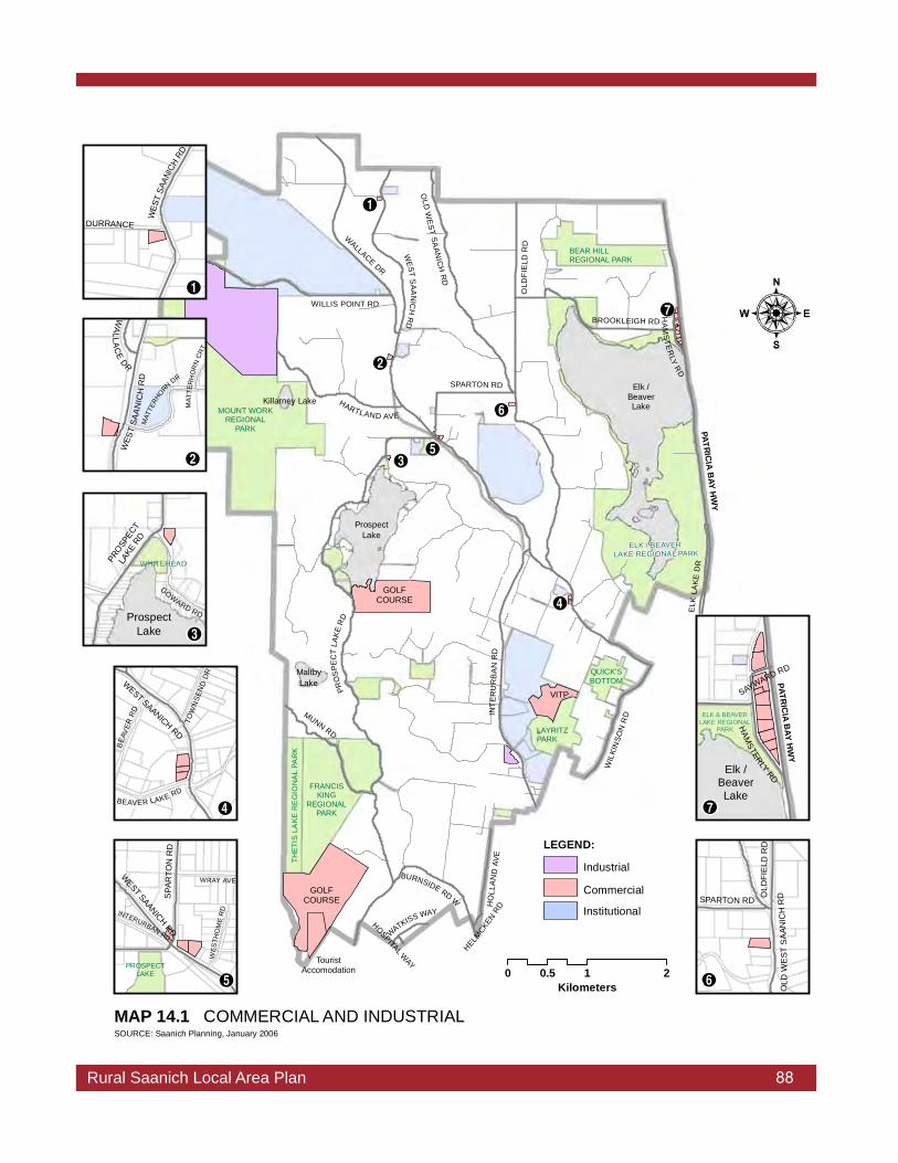
Rural Saanich Local Area Plan 88
LAYRITZPARK
THE
TIS
LA
KE
RE
GIO
NA
L PA
RK
FRANCISKING
REGIONALPARK
QUICK'SBOTTOM
BEAR HILLREGIONAL PARK
MOUNT WORKREGIONAL
PARK
ELK / BEAVER LAKE REGIONAL PARK
º
¾
¹
¼
»
½
¸
MUNN RD
WALLACE DR
OLD
FIE
LDR
D
BROOKLEIGH RD
ELK
LAKE
DR
HO
LLA
ND
AVE
OLD
WE
STSA
ANIC
HR
D
WATKISS WAY
WEST
SAA
NIC
HR
D
HA
MS
TER
LYR
D
SPARTON RD
WILLIS POINT RD
HELMCKEN
RDIN
TER
UR
BA
NR
D
PATRICIA
BAY
HW
Y
HOSPITAL WAY
BURNSIDE RD W
WIL
KIN
SON
RD
HARTLAND AVE
PRO
SPE
CT
LAKE
RD
ProspectLake
Killarney LakeElk /
BeaverLake
MaltbyLake
TouristAccomodation
GOLFCOURSE
VITP
GOLFCOURSE
0 1 20.5Kilometers
MAP 14.1 COMMERCIAL AND INDUSTRIAL
g:\!P
rote
ct_A
dm\L
ocal
Are
a P
lans
\Rur
al S
aani
ch\m
aps\
2006
Rur
alS
aani
ch\
Map
14_
1 C
omm
Indu
stria
l.mxd
RE
V:
SOURCE: Saanich Planning, January 2006
LEGEND:
Industrial
Commercial
Institutional
MAT
TERH
ORN DR
WES
TSA
AN
ICH
RD
WA
LLAC
EDR
MAT
TER
HO
RN
CRT
DURRANCE
WES
TSA
ANIC
HRD
¸
¹
GOWARD RD
PROSP
ECT
LAKE
RD
WHITEHEAD
ProspectLake º
BEA
VER
RD
BEAVER LAKE RD
TOW
NSE
ND
DR
WEST SAANICH RD
»
WEST SAANICH
RD
INTERURBAN RD
WRAY AVE
WES
THO
ME
RD
SPA
RTO
NR
D
PROSPECTLAKE
¼
SPARTON RD OLD
FIE
L DR
D
OLD
WE
STS
AAN
ICH
RD
½
PATRIC
IAB
AYH
WY
HAM
STERLYRD
SAYWARD RD
ELK & BEAVERLAKE REGIONAL
PARK
Elk /BeaverLake
¾
Rural Saanich Local Area Plan 88

Rural Saanich Local Area Plan 89
Established Commercial AreasThe three established commercial areas in Rural Saanich are a product of history. Two of them, along the West Saanich Road, serviced rural residents and tourists destined for Butchart Gardens and the Saanich Peninsula. Today they provide a range of commercial services at a neighbourhood scale. The other, located along Hamsterly Road, historically serviced summer activities at Elk Lake but has evolved to include highway commercial uses.
Rezoning to expand the Beaver Lake Road/West Saanich Road and Elk Lake commercial nodes is not supported by rural residents. It is recognized, however, that some existing commercial sites may be underdeveloped based on current zoning. Redevelopment of these sites to the extent permitted by the current zoning can be expected over time. Council approval of a development permit is required.
The 1980 Local Area Plan designated the Prospect Lake Road/Sparton Road/West Saanich Road commercial node as a neighbourhood centre and a potential location for additional commercial development primarily to serve the rural area. The area is a destination in Rural Saanich because it has a school, park, commercial services, and the community hall. As well, it is centrally located within the rural area. A range of local commercial services in this location may help to reduce overall vehicle trips for daily needs by providing the opportunity to combine trips. Rezoning to permit limited commercial expansion, consistent with the rural character, should be considered having regard for the visual, environmental, and traffic impacts. Development Permit Guidelines respecting rural commercial uses should be reviewed to ensure that the guidelines are appropriate to the rural area.
Home Occupation UsesThe home occupation use provisions of the Zoning Bylaw provide for the operation of small home-based businesses based on performance criteria established in the bylaw. These performance criteria are intended to limit the potential impact of these businesses on adjacent properties and the neighbourhood. Examples of home occupation businesses in the rural area include professional offices, bed and breakfast accommodation, artisan studios, personal services, community care for children, and excavating contractors. A business license is required, but a rezoning application is not. There is no distinction for home occupation uses between urban and rural Saanich, except that a home occupation-excavation contractor use is only permitted in the A-1 and A-4 zones.

Rural Saanich Local Area Plan 90
Survey respondents indicated little support for expanding the home occupation provisions to include other industrial-type uses. They did, however, indicate some support for expanding the requirements for home occupation uses in the rural area to increase the permitted floor area and to permit at least one non-resident employee. Changes to the home occupation regulations as they pertain to Rural Saanich should be considered in conjunction with a proposed review of the home occupation regulations of the Zoning Bylaw.
Tourist AccommodationA home occupation Bed and Breakfast use is limited to not more than 40 m2 or 20 percent of the combined Gross Floor Area of all structures on a lot, whichever is less, and it must be undertaken, only by residents living in the dwelling. Based on the permitted floor area, most bed and breakfasts have only two sleeping units.
In support of agricultural operations the Agricultural Land Commission Act provides for “bed and breakfast use of not more than four bedrooms for short term tourist accommodation” on ALR properties. The intent is to offer farmers the opportunity to diversify their business through value-added activities. The most stringent of the municipal and ALR regulations take precedence.
There is interest by some bed and breakfast operators and other property owners in Rural Saanich for what might be called “Country Inn” accommodation. A country inn, likely, would include more sleeping units than are currently permitted in a home occupation use and may include dining and other facilities. Given that Greater Victoria is a major tourist destination, and there is demand for alternative accommodation to the downtown hotels, this concept has merit provided that the scale and design respects the rural character. Other considerations might include the size of parcel, parking, servicing, impact on neighbours, whether dining or other facilities would be available to guests not staying at the inn, and whether or not the site is within the Agricultural Land Reserve. Site specific zoning would be required.
Agri-Tourism and Other Tourist Commercial UsesThe community has indicated general support for agri-tourism, but little support for tourist commercial uses that are not related to agriculture. Recent changes to the Agricultural Land Commission Act provide for activities that are temporary and seasonal and intended to promote or market farm products grown, raised or processed on the farm.

Rural Saanich Local Area Plan 91
Corn mazes, fall festivals, direct sales from a farm, and bed and breakfast accommodation are examples of the type of agri-tourism activities that may be conducted on ALR properties. These activities can be important to the economic viability of farming, but it is necessary to ensure that agriculture remains the primary use. New regulations may be required to restrict undesirable uses, where possible, and to minimize the impacts of appropriate uses on adjacent properties.
Farm Markets and Accessory Produce SalesThe Red Barn Market on West Saanich Road is the only farm market within Rural Saanich. The Ploughshare Farm Market along West Saanich Road in the Royal Oak Local Area and a farm market on Oldfield Road in Central Saanich also serve the rural area as well as urban residents and tourists.
Rezoning for new farm markets outside of the existing commercial sites is not supported by most rural residents. Accessory produce sales from farm stands could be promoted as an alternative to new farm markets. Only produce grown on the farm can be marketed at a farm stand. Also, there is some interest from Saanich residents for a public farm market to provide another outlet for local farmers to sell their produce.
Golf CoursesThere are two golf courses located within Rural Saanich. The Prospect Lake Golf Course located at 4633 Prospect Lake Road is a 9-hole course that was established in 1966. Another course is under construction in the south-west corner of the municipality at 450 Creed Road adjacent to the boundary with the Town of View Royal. This 18-hole golf course will include a clubhouse and 42 tourist accommodation units. A golf course development and maintenance plan, an environmental protection plan, comprehensive on-site stormwater management plan, and trail design plan were required as a condition of zoning approval. Access to this course is through the Town of View Royal.
Golf courses can provide private open space and may preserve natural areas, but may also require considerable site grading, tree removal, and alteration of drainage patterns. Golf courses also generate motor vehicle traffic on local roads and can negatively affect water quality. An integrated plan for the use of pesticides and fertilizers is encouraged. It is anticipated that there will be little interest in developing new golf courses in Rural Saanich because there are few properties of sufficient size outside of the Agricultural Land Reserve. Rezoning for new golf courses or golf driving ranges in Rural Saanich should not be supported.
Photo: www.golfprospect.com

Rural Saanich Local Area Plan 92
Vancouver Island Technology ParkThe Vancouver Island Technology Park (VITP) occupies the former Glendale Hospital site. It was developed by the Province to address the needs of high technology businesses in Greater Victoria. The site was originally zoned to P-11 (Public Institution Zone) to allow for technology park use in 1997, following an extensive planning process undertaken by the former owners, British Columbia Buildings Corporation (BCBC). Shortly thereafter, BCBC applied for a zoning change to ensure that the buildings could be used as a high technology incubation facility with the majority of tenants representing private sector research and manufacturing firms.
In 2001, the rezoning of the site was again amended to P-12 (Institutional/Technology Park Zone), in order to accommodate food services, daycare and a minor amount of retail commercial. The current zoning provides for construction of an additional 23,226m2
of gross floor area on the site to a maximum gross floor area for all buildings and structures of 38,555m2, subject to Council approval of a Development Permit.
VITP was designed and built to a high environmental standard and was the first in Canada to be awarded Gold L.E.E.D. (Leadership in Energy and Environmental Design) certification. The development of VITP has created a number of positive economic impacts, ranging from increased employment, consumer spending, municipal tax payments and an opportunity to offer research linkages with the University of Victoria, Camosun College, and Royal Roads University.

Rural Saanich Local Area Plan 93
Industrial-Type Land UseThere are no properties specifically zoned for industrial use in Rural Saanich, but there are a number of properties where industrial-type uses occur. These include the Hartland Landfill, operated by the Capital Regional District, a landscape contractor business, and several excavation and soil contractor businesses. A storage facility for unoccupied recreation vehicles and boats is permitted under a Temporary Commercial Use Permit.
The Hartland Landfill provides solid waste disposal for all of the Capital Region. It is operated in accordance with the Solid Waste Management Plan (SWMP) developed under provincial legislation and approved by the Minister of Land, Air and Water. The impact of the landfill on the community is of considerable interest to local residents and Saanich. Issues are related to possible new activities, operation and management, and public information processes.
In 1994, in response to concerns expressed by local residents that there was little opportunity to influence landfill operations, Saanich undertook a boundary extension bringing the landfill, Heal’s Rifle Range, and Mt. Work Regional Park within the municipality.
Appropriate zoning for the landfill and other annexed lands was adopted by Council in 2005 following Capital Regional District Board approval of amendments to the Solid Waste Management Plan to address buffering for the Hartland site, a public review process for amendments to the SWMP, and dispute mechanisms for the site.

Rural Saanich Local Area Plan 94
POLICIES
14.1 Do not support rezoning to expand the Beaver Lake Road/West Saanich Road or Elk Lake/Hamsterly Road commercial nodes.
14.2 Limit opportunities for expansion of the Prospect Lake Road/Sparton Road/West Saanich Road commercial node by supporting rezoning only for uses that are consistent with the rural character, having regard for the visual, environmental, and traffic impacts.
14.3 Consider changes to the home occupation regulations as they pertain to the rural area in conjunction with a proposed review of the home occupation regulations of the Zoning Bylaw.
14.4 Ensure that the zoning and regulatory controls respecting Vancouver Island Technology Park continue to encourage and support the economic viability of VITP as a primarily private-sector based technology research centre.
14.5 Consider the provision of Country Inn-type tourist accommodation in Rural Saanich based on site-specific zoning, provision of services, and having regard for the potential impacts on adjacent properties and maintenance of the rural character.
14.6 a) Support agri-tourism activities on bonafide commercial farms. b) Develop appropriate regulations and guidelines for
agri-tourism activities in consultation with peninsula municipalities and other stakeholders.
14.7 Do not support rezoning for new farm markets in Rural Saanich except as may be permitted by Policy 14.2.
14.8 Do not support rezoning for a new golf course and/or golf driving range in Rural Saanich.
14.9 Review Development Permit Area Guidelines respecting rural commercial uses to ensure that they are appropriate to the rural area.

Rural Saanich Local Area Plan 95
sustainabiltiy agriculture heritage housing
The term “institutional” generally refers to schools, churches, community residential facilities, daycare centres, nursing homes, and government facilities. These uses are important to the social fabric of the community. Through a variety of programs they meet many of society’s needs including education, health, religion, and culture. They can improve the quality of life in a community if they are well integrated. On the other hand, they can have negative impacts, particularly, as a result of increased traffic. Institutional uses in Rural Saanich are shown on Map 15.1.
Community FeedbackComments received as part of the community survey indicate that, in general, residents do not support new institutional uses outside of the Urban Containment Boundary. Existing institutional uses, however, including the elementary schools, are considered to be community assets by most residents. Large institutional uses, including Heal’s Rifle Range and the Dominion Astrophysical Observatory, are valued for their open space. Concerns about the operation and activities of some institutional uses, primarily relate to traffic generation.
Objectives• Maintain local institutional uses as community assets to be
retained.• Restrict new institutional uses that are not consistent with the
rural character.
SchoolsSchools can provide community activity space, open space, playgrounds, and sports fields. They are meeting places for students, as well as other members of the community. Prospect Lake School is located within Saanich School District No. 63. It feeds to Royal Oak Middle School (grades 6 to 8), in the Royal Oak local area and to Claremont Secondary School (grades 9 to 12) in the Cordova Bay local area. A small area north of Elk Lake around Bear Hill Road is served by Keating Elementary School (kindergarten to grade 5) located within Central Saanich. It feeds to Bayside Middle School and Stelly’s Secondary School, also in Central Saanich.
The West Burnside Road area is within Greater Victoria School District No. 61. All of the schools are located outside of Rural Saanich.
INSTITUTIONS15.0

Rural Saanich Local Area Plan 96
LAYRITZPARK
THE
TIS
LA
KE
RE
GIO
NA
L PA
RK
FRANCISKING
REGIONALPARK
QUICK'SBOTTOM
BEAR HILLREGIONAL PARK
MOUNT WORKREGIONAL
PARK
ELK / BEAVER LAKE REGIONAL PARK
»
¼
½
¾
À
¿
SD-63SD-61
¹
º
¸
MUNN RD
BROOKLEIGH RD
WALLACE DR
OLD
F IE
LD R
D
ELK
LAK
E D
R
HO
LLAN
D AV
E
OLD
WE
ST SAANICH
RD
WATKISS WAY
WEST
SAANIC
H R
D
SPARTON RD
WILLIS POINT RD
INTE
RU
RBA
N R
D
PATRIC
IAB
AYHW
Y
BURNSIDE RD W
WIL
KIN
SON
RD
HARTLAND AVE
PROSPECT
LAKE RD
ProspectLake
Killarney LakeElk /
BeaverLake
MaltbyLake
0 1 20.5KilometersMAP 15.1 INSTITUTIONAL / GOVERNMENT
g:\!P
rote
ct_A
dm\L
ocal
Are
a P
lans
\Rur
al S
aani
ch\m
aps\
2006
Rur
alS
aani
ch\
Map
15_
1 In
stitu
tiona
lGov
.mxd
RE
V:
SOURCE: Saanich Planning
D
P
B
LEGENDSchool District 61/63
Institutional Land Use
Main Roads
Parks >1 ha
Rural Saanich Local Area Plan 96
BROOK MANOR LODGE REST HOMEGROUP HOMEDOMINION ASTROPHYSICAL OBSERV.ANGLICAN CHURCHGLENDALE GARDENS AND WOODLANDCAMOSUN COLLEGE (INTERURBAN)PROSPECT LAKE COMMUNITY HALLUNITARIAN CHURCHHEAL'S RIFLE RANGE
¸¹º»¼½¾¿À
KEY:
PROSPECT LAKEDURRANCE (Closed)BEAVER LAKE (Closed)
ELEMENTARY SCHOOLS
PDB

Rural Saanich Local Area Plan 97
Students in this catchment area attend Eagle View and Strawberry Vale Elementary Schools (kindergarten to grade 5), Colquitz Middle School (grades 6 to 8), and Spectrum Community School (grades 9 to 12). School district boundaries are shown on Map 15.1. The elementary schools in Saanich School District No. 63 are currently under capacity and are expected to remain so into the foreseeable future. Due to declining enrollment, the School District Board closed Durrance Elementary School in 2004 and Beaver Lake Elementary School in 2005.
The Greater Victoria School District is also experiencing declining enrollment. This can be attributed to a net migration out of the province and to a larger percentage of the population beyond child-bearing years.
ChurchesSt. Michael and All Angels Anglican Church, located at 4733 West Saanich Road, was constructed in 1883. The church and associated cemetery are a designated heritage site. The cemetery is still in use for cremation plots only. There is a small memorial garden for scattering ashes.
The First Unitarian Church of Victoria, located at 5575 West Saanich Road, was built in 1999. The sanctuary holds approximately 250 worshippers. A preschool on the property is not associated with the church. While there is no cemetery at this church, there is a Memorial Garden and Path of Remembrance for scattering ashes.
The former Durrance Elementary School has been leased from the Saanich School District Board for a church use.
Prospect Lake Community HallThe Community Hall, built in 1964 at 5358 Sparton Road, is owned by the Prospect Lake Community Association and is an important social gathering place for adults and children’s groups, including scouts and girl guides. The community association donates the meeting space and, in return, these groups often will perform assistance to the hall. The hall can also be rented for weddings, private parties, and other group activities.

Rural Saanich Local Area Plan 98
Camosun College Interurban Campus occupies about 25 hectares. It serves about 3,330 students and employs approximately 255 staff. The campus, which was established in 1971, provides learning facilities in business, trades, technologies, international education, and continuing and access education. The college continues to grow with building additions made as recently as 1991.
In 2004, Camosun College entered into a partnership with Pacific Sport to develop the Pacific Sport Institute at the Interurban Campus. When complete in 2008, the Institute will be home to a number of highly-integrated programs – sports, recreation, health, wellness, education and sport-related research. The Institute will be owned by the College and operated by Pacific Sport Victoria through a new not-for-profit organization. The Institute will accommodate the “Centre for Camosun Sport Education” that will offer a sport leadership and coaching diploma, degree programs and continuing education courses. The Institute will provide a range of new facilities including a gymnasium, a lit outdoor artificial all-weather turf field. New and upgraded trails through the campus will link the new facilities with Layritz Park and the Centennial Trail.
Glendale Gardens and Woodland, which includes The Pacific Horticultural College, leases 42 hectares of land north of Camosun College from the Province in accordance with a land use plan. Founded in 1979 as the Horticultural Centre of the Pacific, this nonprofit organization cultivates public interest in sound gardening practices, preserves natural plant and animal habitat, and offers preparation for careers in horticulture, as well as continuing education courses through its accredited post-secondary institution. There are 22 demonstration gardens on site, including recent additions of a drought tolerant garden and a children’s garden. A Provincial Capital Commission grant in 2002 provided for the construction of a “Look But Don’t Touch” trail system and wildlife viewing stations. Every year, more than 20,000 volunteer hours support the centres activities. The centre relies on public funding, local businesses, and its own fundraising endeavours to support these activities. Over time, the centre hopes to expand their post-secondary education program and replace aging facilities.
Takata Japanese Garden at Glendale Gardens and Woodland Photo: www.hcp.bc.ca

Rural Saanich Local Area Plan 99
Viaduct Flats is part of the centre’s lease area and comprises 16 hectares. Once farming had ceased on the property, a beaver dammed the creek at the downstream end of the flats. This allowed water to remain on the land during the summer and fall. The area provides habitat for a variety of wildlife. Birding observations from June1994 through May1995 showed a greater diversity and abundance of water-based birds on a year-round basis than any other site on southern Vancouver Island.
The Viaduct Flats Management Plan (2002) was jointly developed by the Horticulture Centre of the Pacific, Victoria Natural History Society, and the municipality.
To ensure that the Flats will be left in a natural state, and that any alterations are in accordance with a formal management plan, the Province and the District of Saanich entered into a covenant agreement in 1997. Projects to be completed as part of the management plan include establishing trails, installing fish-passable water level controls at the outlet of the flats, ensuring views and water access in appropriate areas, including a wheel-chair accessible viewing station off Interurban Road, and establishing an education program.
Federal Government PropertiesThe Dominion Astrophysical Observatory is a major institutional facility located on Little Saanich Mountain. The 65.8 hectare site is maintained largely in its natural state. The observatory and other buildings which accommodate a variety of support functions are mostly located near the top of the mountain. A new feature is the Centre of the Universe interpretive centre. It maintains an active public outreach and education program.
The Observatory was established in 1918 to house the world’s then largest telescope, the 1.8 m optical/near infrared Plaskett Telescope. The site on Little Saanich Mountain was chosen for its low annual rainfall and smallest daily range in temperature. Due to technological advances over the years, the Plaskett Telescope is 10,000 times more sensitive today than when it was completed in 1918. It, along with a 1.2 m telescope, are actively used for research. The dome which houses the telescope is a designated heritage site worthy of National recognition. To reduce light pollution to protect the research capabilities of the observatory, the municipality has adopted regulations for the control of outdoor lighting.
Photo: www.hia-iha.nrc-cnrc.gc.ca

Rural Saanich Local Area Plan 100
Generally, much of the site is not accessible to the public. The municipality has expressed an interest in securing public access along the south boundary of the site to accommodate an east-west trail link as shown on Map 10.3.
The Heal’s Rifle Range occupies 96 hectares to the north of Willis Point Road. It has two small administration buildings, a firing range, and an associated safety template. Access to the safety template is restricted. Use of the range is governed by Range Standing Orders under the Department of National Defence, through Canadian Forces Base Esquimalt. Principal users include Regular Force units, Reserve Force units, Cadet units, and the BC Rifle Association. While the range was originally designed for training to firing distances of 1,000 yards, it is now classified as a 300 yard range. The Department’s long term plan is to maintain the range as a training facility.
The low level of development on this site is compatible with the ALR designation and with surrounding rural and agricultural land uses. New residents in the area should be aware of the periodic noise when the shooting range is in use. Map 10.3 identifies a potential trail along the east boundary of the site.
POLICIES
15.1 Carefully consider rezoning applications for new institutional uses on the basis of use, access, provision of services, traffic generation, transit routes, lot size, scale, neighbourhood context, and environmental considerations.
15.2 Continue to work with Saanich School District No.63 to improve community access to school facilities.
15.3 Recognize and support the importance of the Prospect Lake Community Hall as a community asset.
15.4 Continue to work with the Glendale Gardens and Woodland (Horticultural Centre of the Pacific) to implement the recommendations of the Viaduct Flats Management Plan (2002).
15.5 Work with the Federal Government to assess the opportunities for trail linkages through the Dominion Astrophysical Observatory site as shown on Map 10.3.

Rural Saanich Local Area Plan 101
15.6 Explore with the Federal Government the possibility of acquiring or leasing a portion of the Heal’s Rifle Range site for a trail corridor adjacent to Tod Creek.
15.7 Work with Camosun College and Pacific Sport Victoria to realize their vision for the Pacific Sport Institute at Camosun College.
15.8 Work with institutional landowners to educate them about the potential environmental and aesthetic benefits of retaining natural vegetation, including visual buffers along lot boundaries, and protecting environmental features such as watercourses and wildlife habitat through careful site management.

Rural Saanich Local Area Plan 102
community vision environment parks
The Local Government Act permits Council, in an Official Community Plan, to designate development permit areas. The Official Community Plan may contain objectives and guidelines affecting the form and character of commercial, industrial, or multi-family development within a designated development permit area. Development permit guidelines may also specify the means of protecting the natural environment, its ecosystems and biological diversity, for protecting development from hazardous conditions, and protecting farming.
Within a development permit area an owner must obtain a development permit before subdividing land or constructing, adding to, or altering a building unless specifically exempted by the plan. In areas designated for protection of the natural environment, its ecosystems and biological diversity or for protection of development from hazardous conditions, land must not be altered without first obtaining a development permit. Council may issue a development permit which may vary or supplement a regulation of the Subdivision or Zoning Bylaw. A development permit cannot vary use, density, or flood plain specification.
In Rural Saanich, the Hamsterly Road commercial area, the flood plains and stream corridors and areas with a high risk for wildfires are specific development permit areas. Scattered commercial, industrial, and multi-family residential development which is not located within a specific development permit area is subject to the guidelines of the Saanich General Development Permit Area. Justification and guidelines for the development permit areas are included in Appendix “N” to the Official Community Plan.
Streamside Development Permit AreaProperties within 30 m of a designated stream are within the Streamside Development Permit Area. This development permit area has two main purposes:
• To protect the land adjacent to the stream from new development. This land includes the moist riparian zone on the stream edge of the adjacent upland area that exerts an influence on the stream; and• To direct the restoration of streamside areas so that they support fish processes and provide biologically diverse wildlife habitat and corridors for wildlife movement.
16.0 DEVELOPMENT PERMIT AREAS

Rural Saanich Local Area Plan 103
LAYRITZPARK
THE
TIS
LA
KE
RE
GIO
NA
L PA
RK
FRANCISKING
REGIONALPARK
QUICK'SBOTTOM
BEAR HILLREGIONAL PARK
MOUNT WORKREGIONAL
PARK
ELK / BEAVER LAKE REGIONAL PARK
MUNN RD
BROOKLEIGH RD
WALLACED
R
OLD
FIE
LDR
D
ELK
LAK
ED
R
HO
LLA
ND
AVE
OLD
WES
TSA
AN
ICH
RD
WATKISS WAY
WES
TS
AA
NICH
RD
HA
MS
TER
LYRD
SPAR
TON RD
WILLIS POINT RD
INTE
RU
RBA
NR
D
PATRIC
IAB
AYH
WY
BURNSIDE RD W
WIL
KIN
SO
NR
D
HARTLANDAVE
PR
OSP
ECT
LAKE RD
ProspectLake
Killarney LakeElk
/ BeaverLake
MaltbyLake
0 1 20.5Kilometers
MAP 16.1 DEVELOPMENT PERMIT AREA
g:\!P
rote
ct_A
dm\L
ocal
Are
a P
lans
\Rur
al S
aani
ch\m
aps\
2006
Rur
alS
aani
ch\
Map
16_
1 D
PA
.mxd
RE
V:
SOURCE: Saanich Planning
PATRIC
IAB
AYH
WY
BROOKLEIGH RD HA
MS
TERLY
RDElk
/ BeaverLake
Rural Saanich Local Area Plan 103
DEVELOPMENT PERMIT AREAS (DPA)
Saanich General DPA
Fire Hazard DPA
Flood Plain DPA
Hamsterly DPA
Streamside DPA
Main Roads
Detail of Hamsterly DPA

Rural Saanich Local Area Plan 104
The distance that development must be set back from a stream is called the Streamside Protection and Enhancement Area (SPEA). The width of the SPEA ranges from 10 m to 30 m measure from the high water mark of the stream. The development permit area guidelines prescribe measures to protect the integrity of the SPEA from development outside the SPEA, but within the Development Permit Area
Rural Saanich Fire Hazard Development Permit AreaRural Saanich includes large rural residential land holdings that are located in areas that are topographically steep, heavily forested, and have limited or no municipal water supply. Using criteria adopted by the Provincial risk assessment methodology, these properties have been determined to be at high risk for interface wildfires. As a result, in October 2006, Council adopted a Rural Saanich Fire Hazard Development Permit Area in order to establish guidelines that are intended to reduce the risk of hazard to persons and property as a result of wildfire.
POLICIES
16.1 Where applicable, require that new development conforms with the Development Permit Guidelines contained in Appendix “N” to the Official Community Plan.
16.2 Review the Development Permit Areas as they pertain to Rural Saanich to ensure that the justification and guidelines, with respect to building form and character, are appropriate to the rural area.

Rural Saanich Local Area Plan 105
17.0 STRUCTURE MAPThe Local Area Plan includes policies which address specific issues in more detail than the Saanich General Plan. The Structure Map (Map 17.1) illustrates the comprehensive application of these policies within the local area. It shows general land use, the transportation network, and major open space areas. It is not a zoning map and does not indicate density.
The Structure Map is only one part of the local area plan and both must be considered in association with the General Plan.
The following definitions clarify the intent and content of each of the major components of the Structure Map as well as other terms used throughout the plan. The General Plan contains a more comprehensive list of definitions.
Collector Street - means a street which provides services to secondary traffic generators (ie. neighbourhood commercial centre and parks) and distributes traffic between neighbourhoods, as well as providing direct access to residential properties. Transit service is permitted.
Commercial - means an area developed or zoned for a variety of economic activities including retail, service station, office, medical, and assembly type uses.
Community Park - means a park that serves several neighbourhoods and attracts users from up to three kilometres away. Typically, it contains high quality play fields and courts or special natural or horticultural features.
Designated Heritage Structure - means a building or structure on the Community Heritage Register that has been protected by a heritage designation bylaw and would require a Heritage Alteration Permit issued by Council.
Development Permit Area - means an area designated under the Local Government Act, requiring special consideration for the natural environment, hazardous conditions, commercial/industrial, multi-family residential development, or protection of farming.
Greenway - means a linear corridor which provides opportunities for human, animal and plant communities to relate more closely to each other and to the natural and historic environment of their local and regional territories.

Rural Saanich Local Area Plan 106
Heritage Alteration Permit - means a permit issued by Council to allow changes to be made to designated heritage property.
Heritage Conservation Area - means an area designated for heritage purposes in an Official Community Plan.
Institutional - means public and private establishments including educational, research, health, correctional, administrative, and cultural facilities and services.
Major Road - means a highway, other than an arterial, where direct access from abutting properties is limited to safeguard the flow of traffic and where major intersections are controlled by traffic lights.
Multi-Family Housing - means a complex containing three or more dwelling units on a lot; includes townhouses and apartments.
Municipal Park - means a park that serves the entire municipality and is large enough or contains unique or special amenities that will attract individuals from throughout the municipality.
Neighbourhood Park - means a park that focuses on local use and attracts people within a walking distance of up to 800 m. Typically, it provides play environments, unstructured open spaces, and play fields for local use.
Registered Heritage Structure - means a building or structure on the Community Heritage Register that has not been protected by a heritage designation bylaw and would require referral to the Saanich Heritage Foundation and possibly approval by Council for alterations and Council approval for removal from the register.
Rural Road - means a road, designed to permit low speed travel within a neighbourhood and provides access to rural parcels.

Rural Saanich Local Area Plan 107
LOGANPARK
CALVERTPARK
LAYRITZPARK
COLQUITZLINEAR PARK
THET
IS L
AK
E R
EG
ION
AL
PAR
K
FRANCIS KING REGIONAL PARK
QUICK'SBOTTOM
STRAWBERRY KNOLL PARK
ESTELLINEPARK
BEAR HILL REGIONAL PARK
PARK
MOUNT WORKREGIONAL
PARK
CALDECOTETRAIL PARK
ELK & BEAVER LAKE REGIONAL
PARK
PROSPECTLAKE PARK
WHITEHEADPARK
SOUTHPROSPECTLAKE PARK
»
¼
½
¾
À
¿
URBAN CONTAINMENTBOUNDARY (UCB)
OU
TSID
EIN
SID
E
CENTRAL SAANICH
HIG
HLA
ND
SVI
EW
RO
YAL
¹
º
¸
GOLFCOURSE
VITP
GOLFCOURSE
MUNN RD
BROOKLEIGH RD
WA
LLA
CE
DR
OLD
F IE
LDR
D
ELK
L AK
ED
R
HO
LLA
ND
AVE
OLD
WE
ST
SA
AN
ICH
RD
PATRIC
IAB
AYH
WY
WATKISS WAY
HA
MS
TER
LYR
D
WEST SAANICH RD
SPARTON RD
WILLIS POINT RD
HELMCKE
N RD
I NT E
RU
RB
AN
RD
WIL
KIN
SON
RD
HARTLAND AVE
BURNSIDE RD W
PR
OS
PE
CT
L AK
ER
D
Prospect Lake
Killarney Lake
Elk / Beaver Lake
Maltby Lake
0 1 20.5Kilometers
g:\!P
rote
ct_A
dm\L
ocal
Are
a Pl
ans\
Rur
al S
aani
ch\m
aps\
2006
Rur
alS
aani
ch\
Map
17_
1 S
truct
ureM
ap.m
xdR
EV:
SOURCE: Saanich Planning, March 2006
D
P
B
LAND USERural Res/Agriculture
Rural Res/Agriculture (ALR)
Major Park
Commerical
InstitutionalIndustrial
ROAD NETWORKHighway
MajorCollectorResidential
PARCEL WITHIN URBAN CONTAINMENTBOUNDARY (UCB)OTHER BOUNDARIES
Urban Containment BoundaryCatchment (SD 62/63)
MAP 17.1 RURAL SAANICH STRUCTURE MAP
RuralSaanich
Greater Saanich
10
KEY:BROOK MANOR LODGE REST HOMEGROUP HOMEDOMINION ASTROPHYSICAL OBSERV.ANGLICAN CHURCHGLENDALE GARDENS AND WOODLANDCAMOSUN COLLEGE (INTERURBAN)PROSPECT LAKE COMMUNITY HALLUNITARIAN CHURCHHEAL'S RIFLE RANGEHARTLAND LANDFILL
¸¹º»¼½¾¿À10
PROSPECT LAKEDURRANCE (Closed)BEAVER LAKE (Closed)
ELEMENTARY SCHOOLSPDB
Rural Saanich Local Area Plan 107

Rural Saanich Local Area Plan 108
APPENDIX I HERITAGE BUILDINGS AND STRUCTURES
(See Map 5.1)
Location
Name
Current Use
Owner
Year Built
Style
Status
5789 Brookhill
Road
Oldfield residence
Norfolk Lodge
SFD
Private
ca 1908,
1911, 1914
Tudor Revival Arts
& Crafts
Designated
595 Brookleigh Road
Gill residence
SFD
Private
1956
Georgian Revival
Community Heritage Register
1506 Burnside
Road W
Murray residence
Braehead Farm
SFD
Private
ca 1912
Edwardian
vernacular
Community Heritage
Register
453 Creed Road
SFD
Private
1913
Community Heritage Register
155 Durrance
Road
Durrance residence
Vallena
SFD
Private
ca 1910-1912
Hipped-roof
vernacular
Community Heritage
Register
4811 Spring Road
Stevens residence
SFD
Private
1895
Queen Anne Revival
Designated
4051 Granville
Avenue
Miller residence
and barn
High Oaks Farm
SFD and
Barn
Private
1892-1893
Community Heritage
Register
3871 High Street
Priestley residence
SFD
Private
ca 1912-1915
Craftsman
Community Heritage
Register
3844 Holland
Avenue
Adams residence
SFD
Private
1903
Cross-gabled cottage
Designated
3906 Holland
Avenue
Gaunt residence
SFD
Private
ca 1911
Queen Anne
Community Heritage
Register
5271 Old West
Saanich Road
Thompson Farm
Farm
buildings
Private
ca 1920
Community Heritage
Register
5321 Old West
Saanich Road
Oldfield residence
SFD
Private
1969-1978
Twelve-sided house
Community Heritage
Register
5675 Oldfield
Road
Belyea residence
Dogwood Farm
SFD
Private
ca 1893
H-plan house
Community Heritage
Register
5213 Patricia Bay
Hwy
Hughes residence
SFD
Private
ca 1935
English Arts &
Crafts
Community Heritage
Register
691 Donnington
Place
Yarrow residence
Orchard Gate
SFD
Private
ca 1949
English Arts &
Crafts
Community Heritage
Register
5930 Patricia Bay
Hwy
Dyer residence
SFD
Private
ca 1880
Pioneer vernacular
Designated
1310 Prillaman
Avenue
Wilkinson
residence
SFD
Private
ca 1893
Queen Anne
Community Heritage
Register
1318 Prillaman
Avenue
Whitehead
residence
SFD
Private
ca 1913
California Bungalow
Designated
260 Prospect Lake
Road
Oldfield residence
SFD
Private
ca 1910-1914
Craftsman
Community Heritage
Register
293 Prospect Lake
Road
Sharps residence
SFD
Private
ca 1911
Craftsman
Community Heritage
Register

Rural Saanich Local Area Plan 109
Location
Name
Current Use
Owner
Year Built
Style
Status
4696 West Saanich Road
SFD
Private
1917
Edwardian
Community Heritage Register
4733 West
Saanich Road
St Michael and All
Angels Church
Church and
Cemetery
Anglican
Synod
Diocese
of BC
1883
Gothic Revival
Designated
4794 West
Saanich Road
Stevens residence
Currie Mission
SFD
Private
ca 1898
Designated
4808 West
Saanich Road
Beaver Lake Store
Commercial
Private
ca 1933
Vernacular frame
Community Heritage
Register
5071 West
Saanich Road
Dominion
Astrophysical
Observatory
Observatory
and
residence
Crown
Federal
1915-1918
Designated
5303 West
Saanich Road
Prospect Lake Store
Commercial
Private
ca 1913
Craftsman
Community Heritage
Register
5323 West
Saanich Road
Erskine residence
SFD
Private
ca 1895
Pioneer vernacular
Community Heritage
Register
5640 West Saanich Road
Prospect Lake School
SFD
Private
1894
Community Heritage Register
6055 West
Saanich Road
Anderson residence
SFD
Private
ca 1918
California Bungalow
Community Heritage
Register
4354 Wilkinson
Road
Layritz residence
SFD
Private
ca 1889
ca 1906
Community Heritage
Register
4412 Wilkinson
Road
Bovill residence
SFD
Private
ca 1911
Community Heritage
Register
4420 Wilkinson
Road
Lindsay Cabin
Shed
Private
ca 1873
Vernacular log cabin
Community Heritage
Register
4512 Wilkinson
Road
Quick residence
SFD
Private
ca 1913
Edwardian
vernacular
Community Heritage
Register
Source: Saanich Heritage Structures: An Inventory (1991)
Saanich Heritage Advisory and Archival Committee

Rural Saanich Local Area Plan 110
SIGNIFICANT TREES
(See Map 5.1) Location
Type
Tag #
Owner
Status
6105 Castlerock Road
Taxus brevifolia (Western Yew)
98
Private
Protected
5266 Old West Saanich Road
Arbutus menziesii (Arbutus)
92
Municipal
Protected
Quercus robur (English Oak)
70
Private
Protected
Juglans nigra (Black Walnut)
71
Private
Protected
5271 Old West Saanich Road
Arbutus menziesii (Arbutus)
91
Private
Protected
6117 Old West Saanich Road
Pseudotsuga menziesii (Douglas Fir)
94
Private
Protected
6130 Old West Saanich Road
Pseudotsuga menziesii (Douglas Fir)
95
Municipal
Protected
5760 Oldfield Road
Pseudotsuga menziesii (Douglas Fir)
93
Municipal
Protected
Acer rubrum (Red Maple)
46
Private
Protected
5751 Wallace Drive
Fraxinus excelsior aurea (Golden European Ash)
47
Private
Protected
4890 West Saanich Road
Prunus amygdalus Pioneer (Flowering Almond)
44
Private
Protected
4362 Wilkinson Road
Sequoiadendron giganteum (Giant Sequoia)
88
Private
Protected
4450 Wilkinson Road
Populus trichocarpa (Black Cottonwood)
39
Private
Protected
Source: Saanich Significant Tree Committee

Rural Saanich Local Area Plan 111
APPENDIX II
(Note: This information is referenced throughout the local area plan but does not form part of the document)
THE CORPORATION OF THE DISTRICT OF SAANICH PLANNING DEPARTMENT
RURAL SAANICH LOCAL AREA PLAN UPDATE
SURVEY RESULTS
June, 2001
Response rate: 509 of 1600 = 32%
1. What features define the character of rural Saanich for you? Check all that apply.
Total response =509 Feature
#
%
Forested areas
417
82%
Large lots
371
73%
Full time farming
302
59%
Small scale farming
415
82%
Green space
393
77%
Parks and trails
388
76%
Rural roads
395
78%
Farm stands and markets
371
73%
Other*
79
16%
2. Do you keep farm animals (such as chickens, goats, cows, horses)?
Total response = 488
#
%
Yes
157
32%
No
331
68%
3. How do you perceive your property? Check all that apply.
Total response = 509 Perception
#
%
Full-time farm
20
3%
Small-scale farm
123
24%
Residential
150
29%
Industrial
0
0%
Rural residential
341
67%
Commercial
12
2%
Other* 51 10%
*Other vacant land hobby farm home-based business conservation area/wildlife sanctuary garden wood lot/forest
*Other natural features such as birds, wildlife,
plants, streams, peace and quiet little development, urbanization, or traffic horse stables and riding

Rural Saanich Local Area Plan 112
4. Please indicate your level of satisfaction with the following in Rural Saanich:
Feature
Want more
Satisfied
Dont know
#
%
#
%
#
%
a. Trails for horseback riding
90
19%
269
56%
124
26%
b. Cycling trails
163
34%
253
53%
61
13%
c. Walking/hiking trails
208
42%
268
54%
16
3%
d. Playing fields
35
8%
342
75%
81
18%
e. Playgrounds
54
12%
334
73%
72
16%
f. Natural parks
195
40%
280
58%
10
2%
g. Access to lakes
141
29%
329
68%
15
3%
h. Waterfront parks
150
31%
302
63%
29
6%
5. Please select the appropriate answer:
Agree
strongly
Agree
Not sure
Disagree
Disagree strongly
a. Maintaining the character of local roads
should be a priority*
235
48%
152
31%
41
8%
47
10%
12
2%
b. Transit service to Rural Saanich is
adequate.
39
8%
110
22%
132
26%
115
23%
105
21%
c. In general, roads in Rural Saanich are
safe to drive.
63
12%
322
63%
30
6%
53
10%
35
7%
*i.e. narrow pavement widths, tree canopies, and curves
6. Please answer by checking the appropriate box.
In Rural Saanich, I Support:
Agree
strongly
Agree
Neither
Disagree
Disagree strongly
a. Large lot sizes
234
49%
168
35%
39
8%
23
5%
7
1%
b. Limiting opportunities for subdivision
275
56%
107
22%
37
8%
36
7%
33
7%
c. Full time farming
229
47%
180
37%
58
12%
14
3%
6
1%
d. Commercial farm markets
157
32%
209
43%
81
17%
26
5%
8
2%
e. Value-added farm activities such as bed
& breakfasts and farm tours
114
23%
243
50%
86
18%
24
5%
12
2% f. Preservation of agricultural land for
farming
273
55%
142
29%
57
12%
16
3%
5
1% g. Expanded home occupation industrial-
type uses
25
5%
84
18%
106
22%
137
29%
102
22% h. Tourist attractions and services
39
8%
134
28%
126
26%
106
22%
63
13%
i. Expansion of existing commercial areas
in the following locations : Prospect Lake and Sparton Roads
17
3%
79
16%
111
23%
129
26%
142
29% Beaver Lake and West Saanich
Roads
17
3%
69
14%
102
21%
136
28%
151
31%
Hamsterly at Sayward Road
19
4%
80 17%
140
29%
97
20%
110
23%
j. Expansion of commercial development
outside existing areas
8
2%
52
11%
79
17%
139
29%
170
36% k. Greenways and trails linking parks
240
49%
176
36%
37
8%
21
4%
12
2%

Rural Saanich Local Area Plan 113
7. Do you use:
Total response = 496 a. a septic system
#
%
Yes
481
97%
No
11
2%
Dont know
4
1%
If yes, how often do you:
Every 12
years
Every 35
years
Over 5 years
Never
Dont know
b. Inspect and maintain your septic system
180
38%
216
45%
55
12%
16
3%
9
2%
c. Have your septic tank pumped
105
22%
264
55%
81
17%
22
5%
10
2%
8. Do you use:
Total response = 501
a. a well for drinking water
#
%
Yes
244
48%
No
254
50%
Dont know
3
1%
Total response = 228
If yes, select the most appropriate
response:
Weekly
Monthly
Yearly
Never
Dont know
b. I test my well for water quality...
2
1%
12
4%
124
43%
73
25%
17
6%
9. Have you had any water quality problems in the past 3 years?
Total response = 468
#
%
Yes
64
14%
No
375
80%
Dont know
29
6%
a. If yes, what is the source of your water quality problem? Total response = 70
#
%
Septic system
3
4%
Farm animals
6
9%
Wildlife/waterfowl
1
1%
Run-off
8
11%
Low flows
9
13%
Other*
43
61%
*Other run-off from roads equipment failure iron and minerals septic systems odour and discolouration sediment

Rural Saanich Local Area Plan 114
12. How important are the following in Rural Saanich:
Very
important
Important
Somewhat important
Not
important
Dont know
a. Tree preservation
245
49%
150
30%
84
17%
18
4%
0
0%
b. Protecting watercourses, associated riparian
areas, and water quality
341
69%
110
22%
38
8%
5
1%
3
1%
c. Protection of wildlife habitat
290
58%
122
25%
75
15%
12
2%
0
0%
d. Air quality
343
69%
110
22%
37
7%
7
1%
2
0%
e. Private property owners contributing to
environmental protection
218
45%
131
27%
72
15%
34
7%
32
7%
13. What do you like most about living in Rural Saanich?
sense of community, community pride and caring, safety proximity to city, ferries, airport clean, fresh air dark sky at night and bright stars no street lights sight of working fields, horses, sheep grazing country living smell of fresh hay country ambiance dog walking off leash room to breath neighbourly support preservation of wildlife habitat, birdwatching walking, cycling and hiking on trails and in parks smaller, good quality schools forested landscape green spaces, farmland, parks, lakes property to garden rural lifestyle and values winding narrow roads, little traffic, ditches low population density landscape of open fields being able to keep animals small amount of commercial activity natural beauty and diversity slower pace of life peace, quiet, serenity and tranquility privacy and seclusion quality of life very little change over the years farm stands and fresh local produce multi-generations tied to the area good place to raise kids independent lifestyle access to recreation centres

Rural Saanich Local Area Plan 115
12. How important are the following in Rural Saanich:
Very
important
Important
Somewhat important
Not
important
Dont know
a. Tree preservation
245
49%
150
30%
84
17%
18
4%
0
0%
b. Protecting watercourses, associated riparian
areas, and water quality
341
69%
110
22%
38
8%
5
1%
3
1%
c. Protection of wildlife habitat
290
58%
122
25%
75
15%
12
2%
0
0%
d. Air quality
343
69%
110
22%
37
7%
7
1%
2
0%
e. Private property owners contributing to
environmental protection
218
45%
131
27%
72
15%
34
7%
32
7%
13. What do you like most about living in Rural Saanich? sense of community, community pride and caring, safety proximity to city, ferries, airport clean, fresh air dark sky at night and bright stars no street lights sight of working fields, horses, sheep grazing country living smell of fresh hay country ambiance
dog walking off leash room to breath neighbourly support preservation of wildlife habitat, birdwatching walking, cycling and hiking on trails and in parks smaller, good quality schools forested landscape green spaces, farmland, parks, lakes property to garden
rural lifestyle and values winding narrow roads, little traffic, ditches low population density landscape of open fields being able to keep animals small amount of commercial activity natural beauty and diversity slower pace of life peace, quiet, serenity and tranquility privacy and seclusion quality of life very little change over the years
farm stands and fresh local produce multi-generations tied to the area good place to raise kids independent lifestyle access to recreation centres
14. What do you like least? volume and speeding traffic on rural roads lack of traffic police presence cell tower on Bear Hill limited public transportation illegal suites and dwellings number of bylaw infractions poor bylaw enforcement commuting/driving time overpopulation of deer, geese, rabbits, squirrels and impact
on gardens state of well water/groundwater the building of monster homes distance for kids to get to school nearby development unsafe for pedestrians and cyclists fire hydrants not close enough hearing traffic on the Pat Bay Highway minimal street lighting ice and snow on roads in winter high taxes for level of services septic systems on small lots
subdivision of properties in Rural Saanich weekend drivers, motorcyclists, traffic the landfill and associated truck traffic illegal home-based businesses excessive cutting of trees on private property the odour of farming activity proposed gravel excavation at the landfill community mail boxes too much regulation unsightly premises (outdoor junk storage) inability to subdivide property for children motor boats/jet skis on lakes lack of local public/private trail system power outages and time to repair lack of safety in riding horses on roads lack of municipal water and sewer pollution in Prospect Lake large truck parking on residential property

Rural Saanich Local Area Plan 116
14. What do you like least?
• volume and speeding traffic on rural roads
• lack of traffic police presence
• cell tower on Bear Hill
• limited public transportation
• illegal suites and dwellings
• number of bylaw infractions
• poor bylaw enforcement
• commuting/driving time
• overpopulation of deer, geese, rabbits, squirrels and impact on gardens
• state of well water/groundwater
• the building of monster homes
• distance for kids to get to school
• nearby development
• unsafe for pedestrians and cyclists
• fire hydrants not close enough
• hearing traffic on the Pat Bay Highway
• minimal street lighting
• ice and snow on roads in winter
• high taxes for level of services
• septic systems on small lots
• subdivision of properties in Rural Saanich
• weekend drivers, motorcyclists, traffic
• the landfill and associated truck traffic
• illegal home-based businesses
• excessive cutting of trees on private property
• the odour of farming activity
• proposed gravel excavation at the landfill
• community mail boxes
• too much regulation
• unsightly premises (outdoor junk storage)
• inability to subdivide property for children
• motor boats/jet skis on lakes
• lack of local public/private trail system
• power outages and time to repair
• lack of safety in riding horses on roads
• lack of municipal water and sewer
• pollution in Prospect Lake
• large truck parking on residential property