division 1 zoning - colorado public radio · costilla county land use code page 1 division 1 zoning...
TRANSCRIPT

Costilla County Land Use Code Page 1
DIVISION 1 ZONING ARTICLE 1 TITLE, PURPOSE, AUTHORITY AND INTERPRETATION
Section 1.10 Title and Short Title These regulations, and all future amendments, shall be known as the Costilla County Land Use Code, and are also referred to herein as “Land Use Code,” “Code” or “Regulations”.
Section 1.20 Purpose
A. General Purposes. The following general purposes of this Code reflect the policies of Costilla County as reflected in the Comprehensive Plan of Costilla County. While strict compliance with these General Purposes is not a condition of approval of any specific land use application, the application of the declarations of Purpose below guides the specific regulations and requirements of this Code.
1. Comprehensive Plan of Costilla County. To implement the Comprehensive Plan of the County through the regulation of land use.
2. Protect and Enhance Agriculture and Rural Character. To protect and enhance agricultural uses,
traditional agricultural practices, and the rural characteristics of the County.
3. Protect Quality of Life. To provide for protection of the public health, safety and welfare of the residents of the County and to protect the environment; to protect and preserve the history, culture and traditions of Costilla County, also referred to herein as “The Sangre De Cristo Land Grant”.
4. Protect the Environment and Environmental Resources. To ensure the use of land does not degrade or
threaten the quality of the environment and environmental resources of the County. 5. Regulate Land Use Based On Impacts. To regulate the use of land based on impacts to the surrounding
areas and the community and to eliminate, minimize or mitigate conflicts between different land uses.
6. Simplify Land Use Planning and the Regulatory Review Process. To simplify, expedite and provide uniform application of the land use planning and regulatory review process.
7. Encourage Innovations. To encourage innovations in residential, commercial and industrial development to meet the growing demands of the population through a greater variety in type, design and layout of development.
8. Promote the Economic Well-Being of the Community. To encourage economic diversity in Costilla County, to protect and enhance the County’s economic strength and well-being.
9. Provide for Orderly Development of the County. To manage development in a manner that provides for balanced and orderly growth patterns and to provide efficient, phased government services to accommodate existing and future residents.
10. Protect Property Rights. To preserve and promote the value of property, to protect the tax base of the County and to respect the property rights of citizens.

Costilla County Land Use Code Page 2
Section 1.30 Authority and Jurisdiction A. Authority. It is the intention of the Board of County Commissioners in adopting this Land Use Code to fully
exercise all relevant powers conferred by the laws of the State of Colorado, including but not limited to:
1. Colorado Constitution. All of the powers reserved to the County by the Colorado Constitution.
2. State Enabling Legislation. All of the powers granted to the County by:
a. Title 16, Article 13, Part 3, C.R.S., Restraint and Abatement of Nuisances; b. Title 24, Article 65.1, C.R.S., Areas and Activities of State Interest (1041 regulations); c. Title 24, Article 68, C.R.S., Vested Property Rights Act; d. Title 29, Article 20, C.R.S., Local Government Land Use Control Enabling Act; e. Title 30, Article 11, C.R.S., County Powers and Functions; f. Title 30, Article 15, C.R.S., County Regulations under Police Powers; g. Title 30, Article 28, C.R.S., County Planning Act; h. Title 34, Article 1 Part 3, C.R.S., Preservation of Commercial Mineral Deposits; i. Title 35, Article 3.5 – 101, C.R.S., Right to Farm; j. Title 38, Article 30.5, C.R.S., Conservation Easements; and k. Title 43, Article 2, C.R.S., State, County, Municipal and Public Roads. L. Costilla County Ordinance No. 01-1, Prohibiting the Dumping of Solid Waste, Refuse, Litter, Trash,
Junk and Garbage.
3. The Costilla County Comprehensive Plan adopted (Adopted 1999).
4. Costilla County Road Standards Amended January 6, 2004 Pursuant to Resolution No. 01-2004.
5. All Other Powers Authorized. All other powers authorized by statute or by common law for the regulation of land uses, land development and the power to abate nuisances.
B. Jurisdiction. This Land Use Code shall apply to all land within the unincorporated areas of Costilla County.
No land shall be offered for sale, exchange, lease or development, and no building, structure or land shall be used or occupied except in conformance with this Land Use Code. Structures and uses existing on the effective date of this Code shall be permitted to continue, subject to the provisions of Article 6, Nonconformities.

Costilla County Land Use Code Page 3
Section 1.40 Permit Required Land Use Permits. Any change in land use, unless expressly exempt from permit requirements in Section 1.40.J,
shall obtain a Land Use Permit before commencing the development or activity associated with the land use change
or Development.
A. Levels of Permit Review. Land Use Permits may be subject to one of the following levels of review. 1. Administrative Zoning Review. Certain land use changes require a minimal level of review and can be
reviewed administratively as a zoning review in accordance with Article 6, Sections 6.20 and 6.30 C.
2. Limited Impact Review. Certain land use changes, because of their nature or location, will have the potential to cause impacts that warrant review by the Planning Commission in accordance with Article 6, Sections 6.20 and 6.30 B.
3. Special Use Review. Certain land use changes, because of their intensity or location, will have the
potential to cause significant impacts that warrant review by the Board of County Commissioners in accordance with Article 6, Sections 6.20 and 6.30 A.
4. Rezoning. Certain land use changes may require a zone change, as described in Article 6, in order for a Land Use Permit to be issued under the provisions of this Code.
5. 1041 Review. Certain land use changes, because of their intensity or location, will have the potential to cause significant impacts, apply to all Matters of State Interest designated by the County whether located on private or public land within the unincorporated areas of Costilla County, warrant review by the Board of County Commissioners.
B. Application. An application for Land Use Permit shall be filed with the Costilla County Planning and Zoning
Department. All Land Use Permits shall include a Site Plan showing existing conditions and the proposed improvements that are the subject of the application, unless specifically waived by the Land Use Administrator. a. Site Plan Review.
Drawing prepared to scale acceptable to the Land Use Administrator. ( 1’ = 50’, 1’ = 100’ 1’ =200’)
Name, Address, telephone number, north arrow, legal description and date prepared.
Existing and proposed contours at 2 foot intervals.
Existing and proposed improvements, including structures, access, parking, septic system, and water supply.
Property Dimensions.
Distance to existing and proposed structure to property lines.
Existing and proposed roads including ROW width, easements, Railroad ROW, irrigation ditches, utility lines and fences.
C. Permits Run with the Land. Any Land Use Permit shall be binding upon and run with the land. D. Term of Permits. Term of the Land Use Permits is 1 year for single family dwelling and other permits. E. Activity Begun Before Permit Issuance. No development for which a Land Use Permit is required shall begin
until the Land Use Permit has been issued by Costilla County. If the activity has begun before issuance of the permit by Costilla County, no Land Use Permit shall be issued for activity until the applicant ceases the activity,

Costilla County Land Use Code Page 4
remedies any damage caused and complies with all enforcement actions taken by Costilla County pursuant to Article 8 Enforcement.
F. Relationship of Land Use Permits to Single Family Dwelling and Other Permits. Issuance of Land Use
Permits does not eliminate any permit requirement for single family dwellings or for other permits. In addition, Costilla County requires that the following permits be obtained for any land use change.
1. Minor Development Permit. Any Activity for which a development permit is required which is contained on
1 acre or more for a single family dwelling.
2. Land Use Permit for Construction. Any activity in which applicant is constructing a new residence, accessory dwelling, accessory structures or commercial/industrial building.
a. Construction for residential dwellings, accessory structures, commercial or industrial building within
the Watershed Protection Overlay District will require compliance with the Watershed Protection Overlay Guidelines.
b. Minimum size for all single family dwellings is 600 square feet.
c. Prior to permit approval for Single Family Dwellings or Mobile Homes/ Manufactured Homes, the applicant needs to demonstrate the type of water supply (water well or water cistern), septic system and electrical utilities. (Solar and Wind Power).
d. Prior to permit approval for an accessory building the applicant need to demonstrate the type of
accessory building and a primary use needs to be established on the parcel of land.
e. Floor Plan Review.
Drawing prepared to scale acceptable to the Land Use Administrator. ( 1’ = 50’, 1’ = 100’ 1’ =200’)
Name, Address, telephone number, north arrow, legal description and date prepared.
Dimensions of the structure including all rooms.
Type of Construction, foundation type, electrical and plumbing and type heating,
f. Alternative Dwelling…Earth Ship Homes. (Tire construction prohibited)
g. Cargo/Shipping Crates (Agriculture, Commercial & Industrial Storage Use Only)
3. Manufactured Home & Mobile Home Permit. Manufactured Home Permit pursuant to Section 5.40 C. Mobile Home, Mobile Home Park and RV Park Review Criteria.
4. Road Access Permit. A Road Access Permit shall be obtained from the Costilla County Planning & Zoning
for access into a scheduled road, public road or highway from a driveway or private road under the jurisdiction of Costilla County.
5. Individual Sewage Disposal System Permit. Individual Sewage Disposal System as required for the
installation or repair of an individual sewage disposal system, pursuant to the Costilla County Regulation for
On-site Wastewater Treatment Systems and Colorado Department of Public Health and Environment On-
Site Wastewater Treatment System Regulation #43.

Costilla County Land Use Code Page 5
6. Road Cut Permit. Road Cut Permit for any activity in which a County Road is trenched pursuant to the Costilla County Road Standards.
7. Flood Plain Permit. For activity in areas of flood hazards pursuant to Section 5.40 J.
8. Sign Permit. Sign Permit, pursuant Section 5.30, Signs.
9. Grading Permit. Grading Permit for excavating, filling or combination thereof for road construction.
10. Occupancy Permit. Certificates of Occupancy may be issued once the public improvements are
substantially completed, meaning that all sewer, water, electrical, storm drainage and street improvements are functional and operational.
11. Watershed Protection Overlay Permit. All construction activity in the Watershed Protection Overlay
District requires a permit compliant with the Watershed Protection Overlay Guidelines found in the permit application checklist, and review criteria pursuant to Section 5.40 L.
G. Land Use Changes Involving Division of Land.
1. Subdivision. Unless otherwise provided by these Regulations, division of land shall be classified as Minor Subdivision or Major Subdivision, based upon the level of impact. a. Minor Subdivision Review Process. Division of land considered to be minor subdivision pursuant to
Article 10, Section 10.15 shall be subject to the Minor Subdivision Review Process, which is an abbreviated subdivision review process.
b. Major Subdivision Review Process. Division of land considered to be major subdivision pursuant to
Article 10, Section 10.30 and 10.40 shall be subject to the Major Subdivision Review Process.
2. Subdivision Exemptions. A request for exemption from subdivision regulations shall be subject to the review process set forth in Article 11.
3. Other Divisions of Land. Rural Land Use Cluster Development and Conservation Subdivision are exempt from subdivision regulations, and are subject to review processes set forth in Article 11, Sections 11.20 and 11.30.
H. Overlay District. Unless otherwise provided by these Regulations, a change in land use subject to an overlay
district shall be subject to the review process required by the underlying zone district. I. Signs. Signs shall be subject to a specific review and approval process set forth in Article 5.30. J. Exemptions from Land Use Permit Requirements. The following uses and activities are exempt from the
requirement to obtain a Land Use Permit if the use or activity is proposed for areas of the County that are zoned Agricultural.
1. Agricultural operations that do not require a Land Use Permit include:
a. Production, cultivation, growing, and harvesting of crops and plants, but not including forestry or
timbering or Medical Marijuana, Retail or Sales of Marijuana, or Marijuana.
b. Raising and breeding livestock, but not including confined animal feedlot operations.

Costilla County Land Use Code Page 6
c. Harvesting, storage, grading, packaging, processing, distribution, and sale of agricultural commodities
occurring at the point of production.
d. Construction of sheds, outbuildings and other accessory structures smaller than 120 square feet or
non-enclosed structures in size which are necessary for agricultural operations. “Example hay
shed/barn.”
e. Construction and operation of seasonal extender hoop houses.
2. Excavations of less than 100 cubic yards of material that are not located within the Watershed Protection Overlay District do not require a Land Use Permit.
3. Accessory Structures smaller than 120 sq. ft. in size that are associated with the exempt uses and activities herein do not require a Land Use Permit. .
4. Solar panels for single family homes. (All Zoned Districts)
Section 1.50 Repealer; Re-Enactment; Effective Date A. Repeal of County’s Prior Land Use Regulations. The 2002 Costilla County Land Use Code is hereby
repealed on the date of the County’s adoption of these land use regulations. B. Enactment. This Land Use Code shall be enacted upon its approval by the Board of County Commissioners,
after review and recommendation by the Costilla County Planning Commission, following public hearings. C. Effective Date. This Land Use Code shall become effective thirty (30) days following the date of its adoption by
the Board of County Commissioners unless adopted as an emergency ordinance necessary for the immediate preservation of public health, safety and welfare.
Section 1.60 Severability A. Provision Declared Invalid. If any provision of this Land Use Code is declared invalid by a decision of any
court of competent jurisdiction then the effect of such decision shall be limited to that provision which is expressly declared invalid and shall not affect any other provision of this Land Use Code.
B. Application to Tract of Land Invalid. If the application of this Land Use Code to any tract of land is declared to
be invalid by a decision of any court of competent jurisdiction, then the effect of such decision shall be limited to the tract of land involved. Such decision shall not affect this Land Use Code or the application of any provision thereof to any other tract of land.
Section 1.70 Interpretation and Construction A. Minimum Required. The provisions of this Land Use Code shall be regarded as the minimum requirements for
the protection of the public health, safety, and general welfare. B. Liberal Construction. This Land Use Code shall be liberally construed to further its underlying purposes.

Costilla County Land Use Code Page 7
C. Conflict. If a conflict occurs between this Code and a state statute or other applicable codes and regulations, the more restrictive provision controls unless otherwise specified in this Code. If this Code imposes a greater restriction than that imposed by a private easement, covenant, agreement, deed restriction, recorded plat or other restrictive covenant, this Code controls.
Section 1.80 Incorporation and Interpretation of Maps A. Official Zoning District Maps. The location and boundaries of the zoning districts established by this Code are
established pursuant to Map 9 of the Costilla County Comprehensive Plan and Watershed Protection District to be noted on the map entitled Official Zoning District Plan of (Costilla County, Colorado dated May 10, 1996) and as amended by Resolution by the BOCC.
B. County Road Map. The Costilla County Road inventory and inventory map, as amended, is adopted as the
County’s official county road map. The County Road map together with the state’s public highway system shall constitute the county public streets, roads and access rights-of-way.
C. Comprehensive Plan Maps. All maps shown in the Costilla County Comprehensive Plan. D. 1041 Regulation Maps. Costilla County 1041 Maps, as recorded with Clerk and Recorders Office. E. District Boundaries. The location of the zoning district boundary line shall be determined by the Administrator
in accordance with the following provisions. Where more than one of the following provisions is applicable in any given situation, the first stated and applicable provision shall prevail over all other provisions:
1. Where a zoning district boundary line is given a position within or abutting a highway, road, street or alley
right-of-way which does not appear to be located within any zoning district (other than an overlay zoning district), the zoning district boundary line shall be deemed to be in the center of such right-of-way.
2. Where a zoning district boundary line is shown as closely and approximately following subdivision plat lot lines, municipal boundary or county boundary lines, the zoning district boundary line shall be deemed to coincide with such known boundaries.
3. Where a parcel within a zoning district has a boundary line shown by a specific dimension, that dimension shall control.
Section 1.90 Vested Property Rights A. Purpose. The purpose of this Section is to establish a system of vested property rights for this Code as
authorized by Article 68 of Title 24. C.R.S., as amended. B. Establishment.
1. General. Pursuant to this Code, a vested property right shall be deemed established for a Land Use Permit for a period of three years with the approval of a Site Specific Development Plan. When a Land Use Permit is approved for a Site Specific Development Plan the permit shall confer upon the landowner the right to undertake and complete the development and use of said property under the terms and conditions of the Site Specific Development Plan for a period of three years from the date of its approval.
2. Site Specific Development Plan. For the purposes of this Section, Site Specific Development Plan shall only mean: a. A Land Use Permit.

Costilla County Land Use Code Page 8
b. A Final Plat for Subdivision or a Cluster Subdivision.
C. Development Agreements. The Board of County Commissioners may enter into a development agreement
with the landowner for the extension of vested property rights where, in the discretion of the Board, an extension is warranted due to project size and/or phasing of the development. The Board may also consider an extension of Vested Property Rights for economic cycles and/or market conditions.
D. Approval and Effective Date. A Site Specific Development Plan shall be deemed approved upon the effective
date of the Board of County Commissioners’ approval action relating thereto, following a public hearing conducted in accordance with Article 6, Section 6.50. The Board may approve a Site Specific Development Plan upon such terms and conditions as may be reasonably necessary to protect the public health, safety and welfare. The approval shall result in a vested property right, although failure to abide by such terms and conditions will result in forfeiture of the vested property right.
E. Subsequent Review and Approval. Following approval or conditional approval of a Site Specific Development
Plan, the Site Specific Development Plan shall be subject to subsequent reviews by the County to ensure compliance with the terms and conditions of the original approval, if such reviews and approvals are not inconsistent with the terms and conditions of the original approval.
F. Exceptions. A vested property right once established pursuant to this Section, precludes any zoning or land
use action by the County for a period of three years from the date of approval of the Site Specific Development Plan that would alter, impair, prevent, diminish, or otherwise delay the development or use of the land subject to the Site Specific Development Plan consistent with the terms and conditions of the Site Specific Development Plan, except:
1. Landowner’s Consent. With the consent of the affected landowner.
2. Hazards. Upon the discovery of natural or man-made hazards on or in the immediate vicinity of the subject
property, which hazards could not reasonably have been discovered at the time of the approval of the Site Specific Development Plan, and which hazards, if uncorrected, would pose a serious threat to the public health, safety and welfare.
3. Just Compensation Paid to Landowner. To the extent that the affected landowner receives just compensation for all costs, expenses, and liabilities incurred by the landowner, including but not limited to all fees paid in consideration for financing, and all architectural, planning, marketing, legal and other consultants’ fees incurred after approval by the governmental entity, together with interest thereon at the legal rate until paid. Just compensation shall not include any diminution in the value of the property which is caused by such action.
G. Applicability of General Ordinances and Regulations. The establishment of a vested property right shall not preclude the application of ordinances or regulations which are general in nature and are applicable to all property subject to land use regulations by the County, including but not limited to building, fire, plumbing, electrical and mechanical codes.
Section 1.95 Impact Fees and Dedications Costilla County may require an applicant, as a condition of approval of a Land Use Permit, to dedicate real property to the public, or pay money to a public entity if there is an essential nexus between the dedication or payment and a legitimate government interest, the dedication or payment is roughly proportional both in nature and extent to the impact of the proposed use or development of such property, and Costilla County has duly adopted standards for

Costilla County Land Use Code Page 9
such dedication or payment that are sufficiently specific to ensure that the condition is imposed in a rational and consistent manner.
Costilla County Land Use Code Page 10
ARTICLE 2 DEFINITIONS
Section 2.10 Definition of Words and Phrases. For the purposes of this Land Use Code, the
following words and phrases are defined as follows: Abatement. To remove the rubbish, junk, weeds and brush, or unsafe structure as prescribed in the notice of violation. Above Grade. The area of any portion of a structure in which the floor is two feet or higher above natural grade (existing grade) of the land and the proportional amount, based on volume, of any portion in which the floor is more than two feet above existing grade. Accessory Agricultural Retail Sales. A location for the retail sale or wholesale of agricultural or horticultural products which are grown on site. Accessory Dwelling. A dwelling unit for use as a complete independent living facility on the same parcel as a permitted principal use. Accessory dwellings do not include dwellings which this Code specifically designates as being part of an allowed principal use and therefore allowed as a use by right. Accessory Outside Storage. The outside placement, for a period of more than twenty-four (24) hours, of items which are customary and incidental to the principal use of the property. Accessory Structure. A subordinate structure located on the same lot as the principal structure, the use of which is incidental and accessory to the principal use. Unless otherwise specified in this Code, any accessory structure is subject to the minimum requirements of the zoning district in which it is located. Accessory Use. An Accessory Use is a use customarily incidental to and located on the same parcel as the principal use. Except as provided in this Code, an Accessory Use must comply with all regulations applicable to the principal use. Acequia. An irrigation ditch or canal. Active Area. The area a use occupies. This is for purposes of parking calculations. Adjacent. Meeting or touching at some point, or across a street, ally or other ROW. Adjacent Property Owner. An owner of record of any estate, right or interest in real property which is adjacent to the subject land. Administrative Zoning Review. The Land Use Permit application and review process described in Article 6 of this Code. Uses subject to Administrative Zoning Review have little or no impact and are permitted through review and action by the Administrator. These uses are defined in Article 4, Use Table. Administrator. The Land Use Administrator of Costilla County. Also Zoning Administrator. Agriculture. The use of land for farming, dairying, pasturage, agriculture, horticulture, floriculture, viticulture, and animal and poultry husbandry and the necessary accessory uses for packing, treating, or storing the produce; provided however, that the operation of any such Accessory Uses shall be secondary to that of normal agricultural activities and provided further that these uses shall not include uses that are Concentrated, Confined Animal Feeding Operations. Excluding the growing operations for marijuana.

Costilla County Land Use Code Page 11
Agricultural Products Processing and Storage. The processing and storage of agricultural products brought to the site, including but not limited to cleaning, sorting, grading, packaging milling, or storing of products which are intended for direct human or animal consumption or use. Agricultural Products Retail Outlet. A location for the retail sale of agricultural products, a majority of which are not grown on site, and are intended for direct human or animal consumption or use, Excluding Marijuana. Alteration (Structural). A change or rearrangement in the structural parts or in the existing facilities of a building or structure, or an enlargement whether by extending on a side or increasing in height, or the moving from one location or position to another. As applied to a building structure, a change or rearrangement of the supporting members, or an enlargement, or moving from one location or position to another. Animal Unit. A unit of measure to determine a comparable number of animals. For purposes of these regulations, an animal unit shall mean one animal, or one female animal and its offspring until weaned. Any Activity. any specific deed, action, pursuit a person partakes, etc. Appeal. The process set forth in Article 6.40 H by which:
1. A party aggrieved by an interpretation of the Administrator may request review of the interpretation by the Board of County Commissioners.
2. A party aggrieved by an Administrative Zoning Review permit decision by the Administrator may request review of the permit decision by the Board of County Commissioners. Article 6, Section 6.40 H.
3 A party aggrieved by a Limited Review Use permit decision by the Planning Commission may request review of the permit decision by the Board of County Commissioners.
Applicant. The owner of land, or a duly designated representative of the land owner, for which a Land Use Permit has been requested. Archeological Resource, Cultural Resource, or Historical Resource. Those resources that have been designated by the County or are recognized or historically known to the County; that are on the National Register of Historic Places (National Register); and/or that may be considered under the National Historic Preservation Act. A site may also be so identified by the Colorado State Historic Preservation Officer. Bed and Breakfast. An owner-occupied dwelling unit offering transient lodging accommodations where meals may be provided. Board of Adjustment. The Board of County Commissioners acts as the Board of Adjustment. Board or Board of County Commissioners. The Board of County Commissioners of Costilla County. Boarding House. A building or portion thereof which is used to accommodate, for compensation, three or more boarders or roomers, not including members of the occupant's immediate family who might be occupying such a building. Building. Any structure designed or intended for the support, enclosure, shelter, or protection of persons, animals, chattels, or property excluding fences under 6 feet in height, but including walls and fences over 6 feet in height.

Costilla County Land Use Code Page 12
Building Contracting Shop. A facility providing for general building repair, service, and maintenance including installation of plumbing, roofing, signs, electrical, air conditioning, and heating. Campground. A land parcel in single ownership that has been developed for occupancy for recreational purposes by tents and recreational vehicles on a temporary basis. Car Wash. An area of land and/or a structure with machine- or hand-operated facilities used principally for the cleaning, washing, polishing, or waxing of motor vehicles. A facility of this type may be able to accommodate more than one vehicle at the same time. Central Office Building of a Telecommunications Company. An above ground structure which is in excess of eight feet in height that shelters telecommunications facilities required as an operating unit, including but not limited to the switch or other facilities used to establish connections between customer lines or between lines and trunk or toll lines to other central offices. Church. See Religious Institution. Cluster, Cluster Development. The concentration of development, including buildings, driveways, and water supply and wastewater treatment facilities on one or more compact areas of a development parcel, preserving the remainder as productive agricultural land or undeveloped open space, and avoiding impacting areas of identified value for wildlife habitat, scenic features of a rural landscape, historical agricultural uses, and significant environmental features. Clustering allows flexibility in layout and protection of identified valuable characteristics of a development parcel. Commercial Nursery. A use, wholly or partially contained within one or more greenhouses, where trees, shrubs, flowers or vegetable plants are grown and sold either wholesale or retail. Commercial Use or Activity. Any use or activity primarily devoted to business purposes such as the purchase, sale, lease or exchange of goods and/or the provision of services. Commission. The Costilla County Planning Commission. Compatible. Consistent with, harmonious with, similar and complementary to the use and/or function of natural systems and/or existing land uses in an area. Comprehensive Plan. A plan, or any portion thereof, adopted by the Costilla County Board of County Commissioners establishing the goals, objectives and policies of the County. The Costilla County Comprehensive Plan. Concentrated, Confined Animal Feeding Operations. Any animal feeding operation where animals are fed at the place of confinement for forty-five (45) days or longer in any twelve (12) month period, and crop or forage growth in production is not sustained in the area of confinement, and the number of animals exceeds 999. Convenience Store. Any retail establishment selling consumer products including primarily prepackaged food and household items, having a gross floor area of less than 5,000 square feet. A convenience store may also have associated retail sale of gasoline and other petroleum products, and may have a restaurant included in the same building. County. The County of Costilla, State of Colorado.

Costilla County Land Use Code Page 13
Day Care Center. A facility which provides less than 24-hour care or supervision for nine or more persons who are not related by blood, marriage, or adoption to the owner, operator, or manager, whether such facility operates at day or night, with or without compensation for such care, and with or without stated educational purpose. Density. A unit of measurement; the number of dwelling units per acre of land. Development. Any activity or construction, excluding normal agricultural activities, that changes the basic character or use of the land, including construction of facilities that transmit power, water or wastewater, or telecommunications. Dwelling Unit. One or more rooms designed to accommodate one family containing one kitchen plus living, sanitary and sleeping facilities. This definition includes the terms Mobile Home and Manufactured Home, Single family Dwelling, Multi-family Dwelling, condominium, townhouse and duplex. EarthShip Home. Is a sustainable, passive solar home, made of natural and recycled materials. Educational Facility. Buildings and uses for educational or research activities associated with an academic institution which has curriculum for technical or vocational training, kindergarten, elementary, secondary, or higher education. Residential facilities for faculty, staff, and students may be included. Emergency Care Facility. A health care facility, providing primarily outpatient emergency care for the diagnosis and treatment of individuals. Equestrian Center. An establishment where fifteen (15) or more different people per month, other than the owner or manager of the property, are, for a fee, trained or instructed in riding, driving, or showing horses. Estoppel. A legal principle that bars a party from denying or alleging a certain fact owing to that party’s previous conduct, allegation or deniel. Excavation. Movement of more than 100 cubic yards of material, with the following exceptions:
1. Normal excavation or grading activity associated with agriculture, allowed mining activity, or foundation construction.
2. Normal excavation or grading activity associated with trail or road construction by a governmental entity on publicly acquired open space land in accordance with an open space management plan approved by the Board of County Commissioners.
FAA (Federal Aviation Administration). The federal agency responsible for aircraft safety. Flood or Flooding. A general and temporary condition of partial or complete inundation of normally dry land areas from either the overflow of watercourses, or the unusual and rapid accumulation or runoff of surface waters from any source. Flood Plain. An area adjacent to the stream, which is subject to flooding as the result of the occurrence of an intermediate regional flood and which is so adverse to past, current, or foreseeable construction or land use as to constitute a significant hazard to public health and safety or to property. The term includes but is not limited to: 1. Mainstream floodplains; 2. Debris-fan floodplains; and 3. Dry wash channels and dry wash floodplains.

Costilla County Land Use Code Page 14
Floodproofing. Any combination of provisions, changes, or adjustments to structures, moveable objects, or properties for the purpose of the reduction or elimination of the potential for flood damage. Floodway. In general, those portions of the Floodplain required for the passage or conveyance of the base flood in which waters will flow at significant depths or with significant velocities. It includes the channel of a river or creek and any adjacent floodplain areas that must be kept free of development and other encroachments so the base flood can be conveyed without substantial increase in flood height. Specifically, the floodway is defined by FEMA mapping. Where no FEMA mapping occurs, an engineering study using the following criteria may be required:
1. Those portions of the Floodplain that must be kept free of development and other encroachments so the base flood is conveyed with no more than a one foot increase in the water surface elevations.
2. Where the floodway has not been so identified, it is those portions of the Floodplain where floodwater from
the base flood is eighteen (18) inches or greater in depth. 3. The floodway shall not extend less than twenty-five (25) feet from the banks of the river or creek, unless
such bank consists of an impervious natural rock wall or cliff which is higher than the flood elevation as defined by FEMA or professional engineering study.
Forest Management Plan. A document which proposes methods to aid the owner of forest land in increasing the health, vigor, and beauty of forest land through use of forest management practices; which has either been executed between the owner of forest land and the Colorado State Forest Service, or executed between the owner of forest land and a professional forester and has been reviewed and has received a favorable recommendation from the Colorado State Forest Service; and which has been determined to be complied with through the required annual reports from the State Forest Service to the County Assessor pursuant to Section 39-1-102(4.4), C.R.S., as amended. Forestry. Cultivating and maintaining forests and managing forest land, including the selling of firewood and wood
products produced on the parcel.
Geologic Hazard. A geologic phenomenon which is so adverse to past, current, or foreseeable construction or land use as to constitute a significant hazard to public health and safety or to property. The term includes but is not limited to:
1. Avalanches, landslides, rock falls, mudflows, and unstable or potentially unstable slopes; 2. Seismic effects; 3. Radioactivity; 4. Ground subsidence; 5. High water table, debris flow, floodplains; and 6. Erosive soils. Geologic Hazard Area. An area that contains or is directly affected by a geologic hazard.

Costilla County Land Use Code Page 15
Hazard. A significant source of risk, danger or peril resulting from natural phenomena or conditions including those precipitated or caused by activities of man. Height of Building. The vertical distance from the “grade” to the highest point of the coping of a flat roof, or to the deck line of a mansard roof, or to the average heights of the highest gable of a pitch or hip roof. Historical. See “Archeological Resource, Cultural Resource, or Historical Resource”. Home Owners Association (HOA). Is an organization of homeowners of a particular subdivision, condominium or Planned Unit Development. A homeowners association is to provide a common basis for preserving maintaining and enhancing their homes and property. They subject to state statues that govern non-profit corporations and homeowners associations. The associations provide services, regulate activities, levy assessments, and impose fines. Usually, each member of a homeowners association pays assessments. Those assessments or dues are used to pay for expenses that arise from having and maintaining common property. Home Occupation. The use of a residential structure for a business or service that is secondary to the use as a residence. A Home Occupation may be carried on within a dwelling or accessory building by members of the family occupying the dwelling with no servant, employee or other person being engaged, provided the residential character of the building is maintained and the use is conducted in such a manner as not to give an outward appearance nor manifest any characteristic of a business in the ordinary meaning of the term nor infringe upon the right of neighboring residents to enjoy the peaceful occupancy of their homes. Hospital. An institution where people are given medical attention and treatment, including related facilities such as laboratories, outpatient clinics, and staff offices. Hoop House. a hoop house is a structure used as a greenhouse or a season extender and is characterized by a half-round "hoop" shape. Hoop houses are typically constructed of lengths of PVC pipe, which is both flexible and sturdy. Impact. The direct or indirect effect or consequence resulting from a development upon land, the natural environment, the community or any part or segment thereof. The term shall include, but not be limited to, physical, environmental, economic, visual, auditory or social consequences or effects. Improvements. Street grading and surfacing, curbs and gutters, sidewalks, crosswalks, water mains, sanitary and storm sewers, culverts, bridges, general landscaping, electrical transmission facilities, natural gas or telephone lines, or such other installations as may be designated by the Board. Industrial Use or Activity. Manufacturing, fabrication storage, processing and shipping facilities; mineral extraction and production or processing; auto body repair and maintenance shops; truck stops; facilities of public utilities; solid and hazardous waste disposal sites; airports and similar activities or uses commonly known as industrial in nature. Intensive Agricultural Uses. Agricultural uses where the principal nonresidential use of the property is contained within one or more structures, including but not limited to agricultural storage facilities, accessory greenhouses and storage for accessory sales of agricultural or horticultural products. ISDS System. An individual sewage disposal system as defined by the State of Colorado and in the County ISDS regulations. Junk. Any manufactured good, appliance, fixture, furniture, machinery, vehicle, personal property or any other thing or part thereof, whether of value or valueless, that is demolished discarded, dismantled, partially dismantled, dilapidated or so worn and deteriorated that it would not normally be useable in its current state for its original

Costilla County Land Use Code Page 16
manufactured use. This may include but is not limited to wood, used lumber, paper, glass bottles, rags, rubber, scrap metal, tin cans, scrap material, waste, concrete, rubble, boxes, crates building materials, or machinery parts. Kennel. A lot or building in which four or more dogs or cats, at least four months of age, are kept commercially for board, propagation, or sale. Land Use Permit or LUP. A permit issued by the County required for any land use activity subject to these Regulations. Limited Impact Open Mining. The extraction of earth materials by mining directly from the exposed deposits or other materials where mining operations affect less than ten acres of land within a parcel and extract less than 70,000 tons of earth materials, and which 1) proposes to export material in excess of 500 cubic yards off the parcel on which the mining occurs, 2) has operations that exceed five consecutive days or 14 days total, and/or 3) utilizes blasting. Exceptions to this use include: the removal of decorative building materials naturally exposed at the surface of the earth; the extraction of sandstone where such extraction does not exceed a total of 3600 tons in any 12 month period; excavations below finished grade for basements and footings of a building, retaining wall or other structures authorized by a valid building permit, or authorized by a grading permit. The term limited impact open mining includes, but is not limited to, such processes as open cut mining, open pit mining, strip mining, quarrying and dredging. This use shall also be granted and maintain all applicable local, state, and federal permits. Limited Impact Review. A shortened Land Use Permit application and review process, set forth in Article 6, by which the Planning Commission reviews permits for uses being allowed on the basis of their limited impact with regard to compatibility with the site and surrounding land and uses, and on the basis of adequacy of required services. Uses subject to Limited Review are identified in Article 4. Livestock. Domestic animals that are used for food for human or animal consumption, breeding, draft or profit. Lot. A parcel, plot or tract of land, legally created by State regulations or the Costilla County Subdivision process, which is the subject of a Land Use Permit application, land use activity proposal, or which is occupied by a structure, together with the yards and other open spaces required by these regulations Machine Shop. A facility where material is processed or treated by machining, cutting, grinding, welding, or similar processes. Major Facility of a Public or Private Utility. Any electric transmission lines, power plants, or substations of electric utilities; major gas regulator stations, transmission and gathering pipelines, and storage areas of utilities providing natural gas or petroleum derivatives; and their appurtenant facilities. Major electrical or natural gas facilities include one or more of the following:
1. Electrical generating facilities, including wind and solar facilities. 2. Substations used for switching, regulating, transforming, or otherwise modifying the characteristics of
electricity. 3. Transmission lines operated at a nominal voltage of sixty-nine thousand volts or above. 4. Structures and equipment associated with such electrical generating facilities, substations, or transmission
lines. 5. Structures and equipment utilized for the local distribution of natural gas service including, but not limited to,
compressors, gas mains, and gas laterals.
Costilla County Land Use Code Page 17
Manufactured Home. A detached single family dwelling that:
1. Is partially or entirely manufactured in a factory;
2. Is not less than 24 feet in width and 36 feet in length; 3 Is installed on an engineered permanent foundation; 4. Has brick, wood, or cosmetically equivalent exterior siding and a pitched roof; and 5. Is certified pursuant to the “National Manufactured Standards Act of 1974,” 42 U.S.C. 5401 et seq. as
amended. Medical Marijuana /Marijuana Facility. An establishment permit by Costilla County and licensed by the State of Colorado for the growth, cultivation, acquisition, manufacture, storage, dispensing and/or sale of medical marijuana/marijuana or medical marijuana/marijuana infused products. The following are considered medical marijuana/marijuana facility use types:
1. Dispensary: an establishment for the storage, dispensing and/or sale of medical marijuana/marijuana or medical marijuana/marijuana infused products.
2. Grow Premises: an establishment for the growth, cultivation, and storage of medical marijuana/marijuana. 3. Manufacture of Infused Product: an establishment for the manufacture and storage of medical marijuana
/marijuana infused products. Mineral Resource (Other than Natural Gas or Oil). An inanimate constituent of the earth in a solid, liquid, or gaseous state which, when extracted from the earth, is usable in its natural form or is capable of conversion into a usable form as a metal, a metallic compound, a chemical, an energy source, or a raw material for manufacturing or construction material. For the purpose of this resolution, this definition does not include water, geothermal resources, or natural gas or oil. Mine, Mining. Any area of land from which minerals are extracted in non-liquid form or are extracted in a liquid form while workers are underground; private ways and roads appurtenant to such area; and lands, excavations, underground passageways, shafts, slopes, tunnels and workings, structures, facilities, equipment, machines, tools, or other property, including impoundments, retention dams, and tailing ponds, on the surface or underground, used in, or to be used in, or resulting from the work of extracting such minerals from their natural deposits in non-liquid form or, if in liquid form, used by workers underground or used or to be used in the milling of such minerals or the work of preparing coal or other minerals. “Mine" does not include earthen dams, sand and gravel pits, clay pits, or rock and stone quarries, including surface limestone and dolomite quarries. Mobile Home. A transportable single-family dwelling unit which is eight body feet or more in width and is thirty-two body feet or more in length, and which is built on a permanent chassis and designed to be used as a dwelling without permanent foundation when connected to required utilities, and which includes the plumbing, heating, air-conditioning, and electrical systems contained therein Mobile Home Lot. A plot of ground within a mobile home park legally established under this Code, designed for the accommodation of one mobile home to be installed for the purpose of single-family dwelling in compliance with the provisions of this Code.

Costilla County Land Use Code Page 18
Mobile Home Park. Any site or tract of land under single ownership upon which two or more mobile homes, occupied or intended to be occupied for single-family dwelling purposes, are located in compliance with the provisions of this Code. A mobile home park does not include the use of land for the display and sale of mobile homes or for seasonal recreational use. Moratorium. A legal authorized period of delay; a suspension of activity (Land Use Development) Multi-family Dwelling. A structure containing 3 or more dwelling units in which each unit is used exclusively for occupancy by one family. The term includes townhouses, condominiums and apartments. Natural Hazards. Mudslides, subsidence areas, floodplains, seismic faults, rockslides, erosion and other naturally occurring phenomena that can pose hazards to life or property. Nonconforming Use. A building, structure, or use of land legally existing at the time of creation, which no longer conforms to the regulations of this Code due to changes in the Code. Nursing, Convalescent, or Residential Care Facility. A facility which provides 24-hour care to residents who do not meet the definition of family under this Code. A Nursing, Convalescent, or Residential Care Facility provides some level of skilled nursing or medical service to the residents. Nuisance. A source of annoyance, irritation; act of annoyance. For the purposed of this Code, any structure, recreational vehicle, or mobile home that is being used as a permanent or temporary residence without a land use permit for such use is hereby defined as a nuisance. Open Agricultural Uses. Agricultural uses which do not have structures, other than accessory structures, associated with their operation, including but not limited to the grazing, keeping and use of livestock, the production of agricultural or horticultural products, and accessory storage. Open Mining. The extraction of earth materials by mining directly from the exposed deposits or other materials. Exceptions to this use include those operations which fit the definition of limited impact open mining and excavations below finished grade for basements and footings of a building, retaining wall or other structures authorized by a valid building permit. The term open mining includes, but is not limited to, such processes as open cut mining, open pit mining, strip mining, quarrying and dredging. Outside Storage. The outside placement of items and materials, including but not limited to vehicles that are inoperable, and mobile homes not connected to utilities not on a permanent foundation, for a period of more than twenty-four hours. Overlay District/Zone. Is a regulatory tool that creates a special zoning district, placed over an existing base zone(s), which identifies special provisions in addition to those in the underlying base zone. The overlay district can share common boundaries with the base zone or cut across base zone boundaries. Regulations or incentives are attached to the overlay district to protect a specific resource or guide development within a special area. Overnight Lodging. A facility offering transient lodging accommodations on a daily basis to the general public, and in which no provision is made for cooking in any individual room or suite. The Overnight Lodging facility may also include incidental business uses commonly associated with the main lodging use. This term includes Hotel, Motel, and Bed & Breakfast. Professional Office. An office for professions including but not limited to government, physicians, dentists, lawyers, realtors, architects, engineers, artists, musicians, designers, teachers, accountants, and others, who, through training are qualified to perform services of a professional nature, and where no storage or sale of merchandise exists. This use includes medical and dental clinics.

Costilla County Land Use Code Page 19
Parcel. See Lot. Pipeline. Any conduit or pipe and appurtenant facilities especially designed for, or capable of, transporting water, or gas or other petroleum derivatives. Principal Use. The primary purpose or function for which a parcel or structure is used. Public Hearing. A meeting called by a public body, for which public notice has been given in compliance with the provisions of this Code and which is held in a place where the general public may attend, with the principal purpose of receiving testimony or public comment on a specific application or issue. Public Meeting. Any meeting open to the public that meets the requirements of C.R.S. 24-6-401, et seq. Ranch. A parcel of land which is used for grazing livestock for the primary purpose of obtaining a monetary profit. Recreational Vehicle (RV). A transportable structure or self-propelled vehicle with or without flexible, removal, or collapsible walls and partitions, designed to be used as a temporary dwelling for travel, recreation or vacation uses. The term “recreational vehicle” shall include motor home, camper bus and travel trailer, but shall not include pickup trucks with camper shells that extend one foot or less above the cab of the truck. Recycling Collection Center. A center for the acceptance and temporary storage of either recyclable or organic materials to be transferred to a processing or composting facility. Recycling Processing Facility. A facility where recyclable and organic materials are collected and processed. Processing includes but is not limited to baling, briquetting, compacting, flattening, crushing, mechanical sorting, shredding, and cleaning. Religious Institution. A facility principally used for people to gather together for public worship, religious training, or other religious activities. Facility does not include overnight accommodations. Repeater, Low Power Mobile Radio Service Telecommunications Facility. A telecommunications facility that extends coverage of a cell to areas not covered by the originating cell. Resort Lodge, Conference Center, or Guest Ranch. A facility, including either a single building or resort cabins, which serves as a destination point for visitors, and generally has accessory recreational facilities for the use of guests. Restaurant. A commercial establishment designed primarily to serve food to customers to be eaten within the interior of the premises and which has interior seating arrangements. Retail or Personal Service Facility. An establishment for the retail sale of merchandise or the provision of personal services, including drive through service, but excluding the retail sale of marijuana. A retail facility includes but is not limited to antique or art shops, clothing. department, drug, dry good, florist, furniture, gift, grocery, hardware, hobby, office supply, package liquor, paint, pet, shoe, sporting, or toy stores. A personal service facility includes but is not limited to barber or beauty shop, dry cleaners, optometrist shop, photographic studio, or travel bureau. Ridgeline. Crest of hills and mountains or other ridges if any. Riparian/Riparian Areas. Related to, living or located on the bank of a natural watercourse or lake. Riparian areas include groups of plants, animals and aquatic communities whose presence is either directly or indirectly attributed to

Costilla County Land Use Code Page 20
water-influenced or water-related factors. Areas exempt from this definition are manmade agricultural structures and devices including irrigation ditches, sprinklers and artificial ponds. Road. See Street. ROW. Right-of-Way. Abbreviation of Right-of-Way. Rubbish. Garbage and trash, including but not limited to: unwanted or discarded household items; waste from building construction, remodeling and repair including used lumber and building materials; tree branches, grass and shrub clippings, leaves or other general yard and garden waste; newspapers, magazines, packaging materials, waste paper or cardboard, boxes and crates, rags; dead animal carcasses; and any other unsightly or discarded material including scrap metal, scrap material, bottles and tin cans, which causes or is likely to cause a public hazard or nuisance, or is unacceptably offensive in light of community standards of cleanliness or generally accepted neighborhood aesthetics. Rural. The character of an area that is primarily agricultural, low-density residential, unimproved and open. Saw Mill. A facility for the storage, sales, and milling of forest products, not including the cutting of firewood. Setback. The distance from a structure to the property lines of the lot on which the building sets. Significantly Degrade. To lower in grade or desirability to a significant, as opposed to a trifling, degree. Single Family Dwelling. A detached building which is occupied or which is arranged, designed, and intended to be occupied, by one family and containing only one kitchen plus living, sanitary and sleeping facilities, but not including hotels, motels, tents, seasonal vacation cabins, camper trailers, or other structures designed or used primarily for temporary occupancy. A single-family dwelling shall also include a mobile home as defined herein, that is installed and has received permits in accordance with the provisions of this Code, and a manufactured home as defined herein, erected in conformance with manufacturer’s guidelines and state and local regulations. A single-family dwelling must have indoor plumbing and be serviced by adequate water, sewer and public utility systems. Single family dwellings, other than mobile homes and manufactured homes, must have finished living space of at least 600 square feet. Site Plan. A scale drawing depicting the existing and proposed conditions and improvements on a parcel of land required as component of an application for a Land Use Permit Solid Waste Disposal Site and Facility. The location and facility at which the collection, storage, treatment, utilization, processing, or final disposal of solid wastes occur. Solid Waste Transfer Facility. A facility at which wastes, awaiting transportation to a disposal site and facility, are transferred from one collection vehicle to another. Special Districts. Quasi-municipal corporations established under state statute to provide public facilities or services. Special Use Review. The Land Use Permit application and review process, set forth in Article 6, by which the Planning Commission reviews and recommends, and the Board reviews and determines land use permits for uses which may have an impact upon the site, surrounding land and uses, the environment, and public services and infrastructure, and which may require mitigation measures to comply with the criteria for permit approval under this code. Uses subject to Special Review are identified in Article 4. Review criteria subject to Special Use Review is identified in Article 5.

Costilla County Land Use Code Page 21
Spot Zoning. Is a provision in a general zoning plan which benefits a single parcel of land by creating an allowed use for that parcel that is not allowed for the surrounding properties in the area. (Note: Spot Zoning is not favored practice.) Street. A county road, state highway, public road, street or alley, or private thoroughfare which affords primary access to abutting property. Structural Alterations. Any change in the supporting members of a building, such as bearing walls or partitions, columns, beams or girders; any substantial change in the roof or in the exterior walls, excepting from this definition such alterations as may be required for the safety of the building. Structure. Anything constructed or erected which requires location on the ground or attachment of something having a location on the ground. “Structure” shall include immobilized mobile homes, swimming pools, walls and fences. Telecommunications Facilities. Includes but is not limited to facilities associated with the following types of telecommunications: cellular telecommunications tower & supporting structures, low power mobile radio service tower & supporting structures, telecommunications facility. Traditional Agriculture. Small scale or subsistence agricultural practice that is based on historic long lot settlement patterns and acequia irrigation systems. Unsafe Structure. A structure or building which, in the determination of the Administrator is:
1. In a condition presenting a substantial danger or hazard to public health, safety, or welfare.
2. Is a dilapidated building which is unused by the owner or uninhabited because of deterioration or decay, and constitutes a fire hazard or subjects adjoining properties to a danger of damage by storm, soil erosion, or rodent infestation, or is a place frequented by trespassers and transients seeking a temporary shelter or hideout.
Use. The purpose for which any land, structure or building is designed, maintained or occupied. Variance. Deviation from the requirements of this Code as approved by procedures described in Article 6.30 C 3 Vacate or Vacation. The procedure set forth in Article 11, Section 10.60 by which the County may legally void or vacate dedicated roadways, rights-of way and easements determined to be no longer necessary for public purposes. Vega. A piece of open land for public use in village or town. (such as the San Luis Vega for use by the original settlers/heirs of the Sangre de Cristo Land Grant - Costilla County) Vehicle Service Center. A facility for the retail sale of gasoline and other petroleum products and/or where light maintenance activities such as engine tune-ups, lubrication, minor repairs, and carburetor cleaning are conducted. Vested Property Right. The right to undertake and complete the development and use of property under the terms and conditions of a site specific development plan. Water and Sewage Treatment Facility. Any sewage treatment plant, sewage treatment works, sewage disposal facilities, pumping and ventilating plants or stations, compensating reservoirs or other plants, structures, facilities,
Costilla County Land Use Code Page 22
equipment and appurtenances useful or convenient for the interception, transportation, treatment, purification or disposal of sewage, liquid wastes, solid wastes, or industrial wastes. Watershed. An area of land where all of the water that is under it or drains off of it goes into the same place. Weeds and Brush. Any underbrush, brush, shrub or plant material greater than twelve (12) inches in height which:
1. Ordinarily grows without cultivation; not in planting beds or otherwise in a controlled manner; or not for the purpose of food production;
2. Is allowed to grow in such a manner or extent that it causes or is likely to cause a public hazard or nuisance,
or is unacceptably offensive in light of community standards of cleanliness or generally accepted neighborhood aesthetics; and
3. Is not an undesirable plant designated under the County’s Noxious Weed Management Plan, pursuant to
the “Colorado Noxious Weed Act” the removal of which shall be governed by that Plan and not this Article. Wildlife Corridor. Is an area of habitat connecting wildlife populations separated by human activities (such as roads, development, or logging.) A wildlife corridor is link of wildlife habitat, generally native vegetation, which joins two or more larger areas of similar wildlife habitat. Corridors are critical for the maintenance of ecological processes including allowing for the movement of animals and the continuation of viable populations. Yard. The space on the same lot as a building or structure that is unoccupied and open to the sky.

Costilla County Land Use Code Page 23
ARTICLE 3 ZONING DISTRICTS
Section 3.10 Establishment of Zone Districts A. General Zone Districts Established. The following zone districts are established. The Use Tables set forth in
Section 4.10 explain which uses are allowed in each zone district and the type of review that is required for the different uses.
1. Agricultural District (A). The purpose of the Agricultural District is to preserve and protect rural areas of
the County where the conservation of agricultural resources and agricultural production is of major importance and where uses must be protected from uncontrolled and unmitigated residential, commercial and industrial uses. To that end, no parcel of land containing 160 or more acres, that is classified in the Agricultural Zone District, shall be permitted to be developed with more than one dwelling unit per 160 acres of land.
2. Rural Residential District (RR). The purpose of the Rural Residential District is to protect rural agricultural
areas, while allowing for residential areas developed at a density and character compatible with agricultural uses. All unincorporated areas of the County which are recognized as within subdivisions by the County Assessor as of the enactment of this code and which subdivisions are predominantly lots of 35 acres or more are Rural Residential. To that end, no parcel of land containing more than 35 acres, that is classified in the Rural Residential District, shall be permitted to be developed with more than one dwelling unit per 35 acres of land.
3. Estate Residential (ER). The purpose of the Estate Residential District is to provide areas where management and maintenance of agricultural resources is of incidental value, allowing for residential areas developed at a higher density. All unincorporated areas of the County which are recognized as within subdivisions by the County Assessor as of the enactment of this code and which subdivisions are predominately lots of less than 35 acres are Estate Residential. To that end, no parcel of land containing m 5 acres or less, that is classified in the Estate Residential District, shall be permitted to be developed with more than one dwelling unit per parcel.
4. Business/Commercial District (BC). The purpose of the Business/Commercial District is to provide appropriate areas for commercial, service, wholesale and office uses required by residents of, and visitors to, Costilla County in a manner which is consistent with the Costilla County Comprehensive Plan.
5. Industrial (I). The purpose of the Industrial zone district is to provide appropriate areas for industrial and service businesses, in locations where conflicts with residential, commercial and other land uses can be minimized.
6. Urban Residential District (UR). The purpose of the Urban Residential District is to provide for residential
development at higher densities in areas where central water and sewer services can be provided. This zone is also intended to be applied to existing developed areas of historic communities, particularly Ft. Garland. It is the intent that this zone district be applied to existing developed residential lots that are currently nonconforming as to lot size.
a. Review Criteria. The following criteria shall be applied to all zone change requests for the Urban
Residential Zone District.
i. The area proposed for development, or the existing lots shall be served by central water and sewer systems.

Costilla County Land Use Code Page 24
ii. Uses permitted in the Urban Residential Zone District shall be governed by the Use Table in
Section 4.10 of this Code. iii. Application of the Urban Residential Zone District shall be consistent with the recommendations of
the Costilla County Comprehensive Plan.
b. Dimensional Regulations.
i. Building setbacks for new construction in the Urban Residential District shall be established during the Land Use Permit Review process.
ii. All structures and setbacks existing in the Urban Residential District at the time of adoption of the
zone District shall be considered to be legally established and exempt from the provisions of the Non-Conforming Use section of this Code. Reference Article 7.
B. Overlay Zone Districts Established. Overlay Districts are superimposed over the existing or underlying Zone District, and the Overlay District regulations are in addition to those of the underlying Zone District. Uses permitted in the underlying Zone District are permitted where an Overlay District is also in effect, as long as the proposed land use is found to be in conformance with the applicable standards for both the Zone District and the additional standards and restrictions of the Overlay District. The following Overlay Zone Districts are established.
1. Watershed Protection Overlay District.
a. The boundaries of the Watershed Protection Overlay Zone District shall be established by Resolution of the Board of County Commissioners.
b. All uses within the Watershed Protection Overlay Zone District are subject to Special Use Review.
c. The purpose of the Watershed Protection Overlay District is to:
i. Prohibit Significant Degradation to Environment. Prohibit certain uses that because of their
intensity or nature cause significant degradation to the watershed environment.
ii. Protect Watershed from Pollution. Regulate land development so that the watershed is protected from erosion, contamination, sedimentation and other point or non-point sources of pollution.
iii. Maintain Harmony with Wildlife Habitat. Ensure that development is planned and designed to
be harmonious with wildlife habitat.
iv. Preserve Resources and Aesthetics of the Environment. Preserve the natural environment, historical and cultural resources, visual resources, and aesthetics of the watershed to the greatest extent possible.
v. Ensure Compatibility. Ensure compatibility between a proposed land use activity and natural
conditions and constraints by requiring well-engineered design solutions to those conditions and constraints.

Costilla County Land Use Code Page 25
2. Floodplain Overlay District.
a. Boundaries and Jurisdiction. These floodplain regulations shall be applied: i. To existing zoned areas containing flood hazard areas.
ii. To lands within the Designated Floodplain District (DFD) and the Flood Prone District (FPD) which
is the 100-year floodplain as mapped on the Flood Insurance Rate Maps (FIRM).
iii. To all lands adjacent to any water course within the unincorporated area of Costilla County which could be inundated by a 100-year flood for that water course.
b. Purpose. The purpose of the Floodplain Overlay District is to: i. Flood-carrying Capacity. Minimize or prevent adverse affects of proposed development on the
flood-carrying capacity of flood hazard areas.
ii. Minimize Flood Loss. Minimize flood losses by restricting or prohibiting uses which are dangerous to public health, safety and property in times of flood or which cause increased flood heights or velocities within the 100-year floodplain.
iii. Regulate Development in Flood-prone Areas. Any proposed development within areas within designated 100 year floodplain areas, or areas prone to flooding shall demonstrate how drainage will be designed to protect property, both on site and off site, from flood damage prior to land use permit approval.
3. Community/Townsite Overlay District.
a. Boundaries and Jurisdiction. The Board of County Commissioners may by resolution designate an area to be a Community/Townsite Overlay District. Each Resolution designating a Community Overlay District shall include a description of the characteristics of the district that justify its designation; shall provide a review process and standards for development located in such district; and shall identify the location and boundaries of the district.
b. Purpose. The purpose of the Community Overlay District is:
i. To Identify Established Areas of Urban Densities and Use. The following settlements are recognized communities subject to the terms of this Code: Viejo San Acacio, San Francisco, San Pablo, San Pedro, Chama, Los Fuertes, Fort Garland, Garcia, San Acacio, Mesita and Jaroso.
ii. To Provide for Land Use Permit Application Procedures and Review Standards. iii. To Promote Compatible Development. iv. To Maintain Historic Resources and Development Patterns.

Costilla County Land Use Code Page 26
ARTICLE 4 ZONE DISTRICT REGULATIONS
Section 4.10 Use Tables A Use requiring Administrative Zoning Review (Land Use Administrator) L Use requiring Limited Impact Review (Review before the Planning Commission) S Use requiring Special Review (Review before the Board of County Commissioners) E Use Exempt from Permit Requirement N Not Allowable Use 1. All uses in Floodplain Overlay and Watershed Protection Overlay Districts are subject to Special Use Review,
except for the construction of Single Family Dwellings, subject to review by the Land Use Administrator. All Single Family Dwellings within the Watershed Protection Overlay District shall follow the review criteria and design guidelines of the Watershed Protection Overlay District.
2. Certain land use changes within the Zone Districts and Overlay Districts, because of their intensity or location,
will have the potential to cause significant impacts, will require 1041 review that applies to all Matters of State Interest designated by the County whether located on private or public land within the unincorporated areas of Costilla County, warrant review by the Board of County Commissioners.

Costilla County Land Use Code Page 27
ZONE DISTRICTS
USES Agricultural
Rural Residential
Business/ Commercial
Estate Residential
Industrial Urban
Residential
Accessory Agricultural Retail Sales
E S A S N S
Accessory Concrete or Asphalt Batch Plant
S S S N A N
Accessory Dwelling (Delete) A A A A A A
Accessory Outside Storage A A A A A A
Accessory Structures 120 sq. ft. or larger
A A A A A A
Accessory Structures smaller than 120 sq. ft.
E E A A A A
Accessory Structures Necessary to Agricultural Operations, smaller than 120 sq. ft.
E E A N N N
Agricultural Products Processing, Storage, Distribution and Sale Off-Site
S N N N A N
Agricultural Products Processing, Storage, Distribution and Sale at Point of Production
E L L N N N
Agricultural Products Retail Outlet
E E E E E A
Aircraft Landing Strip (private) S S N N N N
Art Gallery E E E E E A
Bakery, Commercial S S A S S S
Bank N S A S N S
Broadcasting Studio L L S L N S
Bed and Breakfast A L L L N L
Boarding House L S L N N S
Building Contracting Shop L S S S A S
Building Material or Garden Store
S S S S S S
Cargo Crates A N A N A N
Campground S S S N N N
Carpentry, Woodworking or Furniture Making Facility
L L L S L S
Car Wash S S L S N S
Church L L L L N S
Clinic, Medical, Dental S S A S N S
Convenience Store S S A S L S
Correctional Facility N N N N N N
Day Care Center L L L L L L
Duplex A A A A N A
Earth ship Home A A N A N N
Educational Facility L L L L L S

Costilla County Land Use Code Page 28
ZONE DISTRICTS
USES Agricultural
Rural Residential
Business/ Commercial
Estate Residential
Industrial Urban
Residential
Electric Power Distribution Line and Facilities
S S S S S S
Electric Power Generating Facility
S N S N S N
Electric Power Transmission Line(s) Upgrade or Extension
S S S S S S
Emergency Care Facility S S A S S S
Equestrian Center A L L S S S
Excavations of Less than 100 Cubic Yards Unrelated to Mining
E E E N E N
Extraction or Exploration: Gravel Pit,
S S S N S N
Fabrication: Equipment, Small Appliances
L L S N L N
Fabrication: Assembly of Structures
S S S N L N
Fabrication: Cabinet Making, Woodworking, Metalworking, Glazing
L L S N L N
Fabrication: Vehicle, Machinery, and Heavy Equipment
S S S N L N
Feed Yard, Commercial S N N N S N
Fire Station S S L S L S
Forestry S S N N S N
Golf course S N S N S N
Group Care or Foster Home L L N L N L
Home Occupation A A A A A A
Hoop House E E A S S S
Hospital S S S S S S
Indoor Recreation, Amusement or Theater
S S A S S N
Industrial S N N N A N
Keeping of Non Domestic Animals
S S S S N N
Kennel L S S S S N
Laundry and Dry Cleaning, Commercial
S S S S L S
Library L L L L L L
Livery or Horse Rental Operation
L L L N L N
Livestock & Animal Husbandry E A N A N N
Machine Shop S S S N A N
Medical Marijuana/Marijuana Dispensary Medical/Retail
N
N
S
N
N
N
Manufacture of Infused N N N N S N

Costilla County Land Use Code Page 29
ZONE DISTRICTS
USES Agricultural
Rural Residential
Business/ Commercial
Estate Residential
Industrial Urban
Residential
Product
Grow Premises-Retail S N N N N N
Grow Premises-Medical S N S N S N
Social Clubs N N N N N N
Mining S N N N S N
Mobile Home Park S S S N N N
Mobile Home – Single Family Dwelling Outside of Mobile Home Park
A A L A L A
Mortuary S S L N N N
Multi-Family Dwelling S S L N N S
Museum L L L L L L
Natural Gas Transmission Line(s)
S S S S S S
Nursery/Greenhouse/Garden Supply and Plant Materials
A A L S A S
Nursery, Commercial S S S S S S
Nursing, Convalescent or Residential Care Home Facility
S S S S N S
Overnight Lodging S S L S N S
Oil & Gas Drilling or Production S N N N S N
Outdoor Recreation, Commercial Use or Structure
S N S N S N
Park or Playfield A A A A A L
Printing or Publishing Establishment
S S A N A N
Professional Office S S A S S S
Processing – Batch Plant S S S S S N
Processing–Brewing/Bottling Plant S S S N L N
Processing – Custom Meat and Poultry
S S S N L N
Processing–Food and Beverages S S S N L N
Processing of Natural Resources – Petroleum, Coal or Wood Products
S S S N L N
Public Recreation Center S L L L S L
Public Utility Facility, Major Facility
S S S S S N
Pumping Station S S S N S N
Reception Halls and Community Meeting Facilities
S S S S S S
Recreational Vehicle Park/Campground
S S S N N N
Recycling Collection Center N N S N S N
Recycling Processing Facility N N S N L N
Resort Lodge, Conference S S S N N N

Costilla County Land Use Code Page 30
ZONE DISTRICTS
USES Agricultural
Rural Residential
Business/ Commercial
Estate Residential
Industrial Urban
Residential
Center or Guest Ranch
Restaurant, with Drive-thru Service
S S S S S S
Restaurant or Bar, without Drive-thru Service
S S S S S S
Retail or Personal Service Facility- excluding marijuana
S S A S S S
Retail/Wholesale Supply Facility S S S N L N
Road Construction L L L L L L
Salvage Yard S N S N S N
Sanitary Landfill N N N N S N
Saw Mill S N N N L N
Sewage Treatment Facility S S S S S S
Sewage or Water Transmission Line(s)
S S S S S S
Single Family Dwelling A A A A S A
Solar Energy System Single-Family Dwelling
A A A A A A
Solar Energy System Major Facility
S S S N S N
Solid Waste Disposal Site and Facility
N N S N S N
Solid Waste Transfer Facility S N S N L N
Storage – Outside (Principal Use), Unrelated to Agricultural Use
N N L N L N
Storage: Bulk Storage of LPG N N N N S N
Storage: Cold Storage Plants S N N N S N
Storage: Hazardous Materials N N N N S N
Storage: Heavy Equipment S N N N S N
Storage: Petroleum, Natural Gas, Methane or Other Volatile Substance
N N N N S N
Telecommunication Facility S S S S S S
Utility Service Facility S S S S S S
Vehicle Service Center S S S S S N
Vehicle Sales & Rental Lots S S S S N S
Veterinary Clinic S S S S S S
Warehouse & Distribution Center N N S N A N
Water Reservoir (agriculture) E E S S S S
Water Storage Facility(Domestic Water)
S S S S S S
Water Treatment Facility S S S S S S
Welding Shop L L L N L N
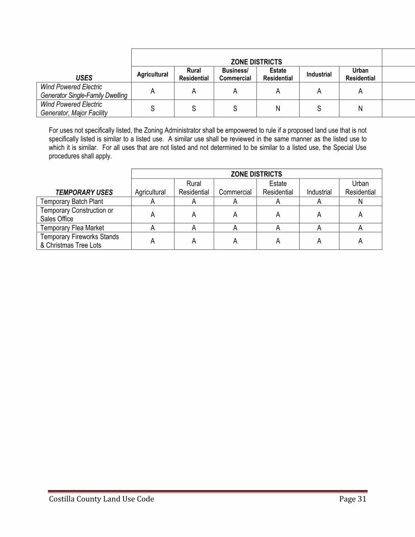
Costilla County Land Use Code Page 31
ZONE DISTRICTS
USES Agricultural
Rural Residential
Business/ Commercial
Estate Residential
Industrial Urban
Residential
Wind Powered Electric Generator Single-Family Dwelling
A A A A A A
Wind Powered Electric Generator, Major Facility
S S S N S N
For uses not specifically listed, the Zoning Administrator shall be empowered to rule if a proposed land use that is not specifically listed is similar to a listed use. A similar use shall be reviewed in the same manner as the listed use to which it is similar. For all uses that are not listed and not determined to be similar to a listed use, the Special Use procedures shall apply.
TEMPORARY USES
ZONE DISTRICTS
Agricultural
Rural Residential
Commercial
Estate Residential
Industrial
Urban Residential
Temporary Batch Plant A A A A A N
Temporary Construction or Sales Office
A A A A A A
Temporary Flea Market A A A A A A
Temporary Fireworks Stands & Christmas Tree Lots
A A A A A A

Costilla County Land Use Code Page 32
ARTICLE 5 DEVELOPMENT STANDARDS AND REVIEW CRITERIA Section 5.10 Minimum Lot Size, Setbacks and Building Height The following Development Standards are established for all Zone Districts:
ZONE DISTRICTS
Development Standard Agricultural Rural
Residential Estate
Residential Commercial Industrial Urban
Residential
Minimum Lot Size 160 Acres 35 Acres 1 Acre 1 Acre 1 Acre Footnote 6
Minimum Front Setback 50 Feet 25 Feet 20 Feet None 1 25 Feet 1 Footnote 7
Minimum Side Setback 35 Feet 25 Feet 5 Feet None 1,2 25 Feet 1,2 Footnote 7
Minimum Rear Setback 50 Feet 25 Feet 25 Feet 25 Feet 3 25 Feet 1,3 25 Feet 6,7
Maximum Building Height*5
45 feet 35 Feet 4 (2 Story)
35 Feet 4 (2 Story) 35 Feet 45 Feet 35 Feet
1. Setback may be increased to insure compatibility during site plan review process.
2. Where adjacent to residential zone or use, setback shall be a minimum of 25 feet.
3. Where adjacent to residential zone or use, setback shall equal the setback requirement of the adjacent residential zone.
4. In Watershed Protection Overlay, building height shall be subject to review for visual impact, and may be reduced to one story.
5. Building height for all uses subject to Special Review will be determined as a part of the review process.
6. Minimum Lot Size for lots created prior to January 1, 2013 shall be 3500 square feet. Minimum Lot Size for lots created after January 1, 2013 shall be 7000 square feet.
7. Setbacks for all new construction shall be established as a part of the Land Use Permit Review Process.
Section 5.20 Parking (Reserved)
Section 5.30 Review Criteria This Section describes the review criteria that will be applied by the County in its decisions to approve, approve with conditions, or deny requests for Land Use Permits for developments that are classified as Rezoning, Administrative Review, Limited Impact Review, Special Review, and Mobile Home Parks.

Costilla County Land Use Code Page 33
All plans submitted for review shall be prepared by a qualified professional. All plans, reports, and specifications for development required by this Code shall be prepared by or under the supervision of a qualified professional licensed to do business in the State of Colorado. Final public improvement plans, reports and specifications shall bear the seal and signature of a qualified professional licensed in the State of Colorado to perform such work. A. General Review Criteria. The following general review criteria shall apply to all uses that require a Land Use
Permit except uses subject to review and approval under Community Overlay District standards.
1. Property Rights. The applicant shall have obtained all necessary property rights, permits and approvals necessary to conduct the activity.
2. Comprehensive Plan and Intergovernmental Agreements. The use is consistent with relevant provisions of the Costilla County Comprehensive Plan and any intergovernmental agreement between the County and a municipality that applies to the area where the use will occur.
3. Mobile Home.
a. Mobile Homes manufactured prior to 1976 are prohibited in unincorporated Costilla County. b. Applicant has applied for a Hook-up Permit in compliance with the provisions of Section 5.40 C. c. Mobile Home will be located in compliance with the provisions of this Code.
4. Manufactured Home. Construction shall be in compliance with applicable industry standards and the
structure will be safe and habitable.
5. Water Supply. All land use changes for which water is required and necessary element of the development shall provide a water supply that is legally and physically adequate in terms of quality, quantity, dependability and pressure. Article 12 Section 12.70.
6. Sewage Disposal & Wastewater Treatment. All land use changes shall not be permitted unless a method
of sewage disposal is available to that lot or development that complies with applicable standards of the Costilla County Individual Sewage Disposal System Regulations and of the Colorado Department of Public Health and Environment. Individual sewage disposal systems will not be allowed on parcels less than one acre in size. Article 12 Section 12.60.
7. Risk from Natural Hazards. The use shall not be permitted if it is subject to risk from natural hazards. A
report prepared by a qualified professional or may be required to determine if hazards are present on the site. Article 12, Section 12.20 I; See Preliminary Plan Checklist.
8. Utilities. Public utilities shall be available to serve the use.
9. Access and Roadways. Access to and from the use shall be safe and in conformance with applicable County access standards. Roads serving the proposed use have the capacity to accept the additional traffic generated by the use safely and efficiently.
10 Compatibility. The nature, scale, and intensity of the proposed use shall be compatible with adjacent land
uses and will not result in an adverse impact to adjacent land. The County is authorized to impose conditions on the approval of any land use permit that are deemed necessary to mitigate potential adverse impacts to adjacent uses. Conditions may include, but are not limited to, impacts related to hours of operation, noise and glare, lighting, height of structures, and dust control.
Costilla County Land Use Code Page 34
11. Water Quality Protection. The use shall not cause degradation of the quality of surface or groundwater
resources. 12. Visual Impacts. The use shall preserve views and vistas. Construction on ridgelines that are visible from
major roadways or residential development shall be prohibited. The design of the activity shall be compatible with the surrounding natural environment and shall be required to comply with the Watershed Protection Overlay Guidelines when located within the Watershed Protection Overlay Zone..
13. Wildlife. The proposed use shall not be located in wildlife habitat areas as defined by the Colorado Division of Wildlife unless evidence is provided by the applicant that demonstrates that mitigation recommended by the Division of Wildlife and the County will offset impacts created by the proposed use.
14. Ability to Provide Services. The proposed use shall not have an adverse affect on the ability of the
County to provide and deliver services commonly available to all residents of the County.
15. Air Quality. The proposed use shall not cause air quality to be reduced below levels established by the Colorado Air Pollution Control Division.
16. Nuisance. The Proposed use shall not cause a nuisance as defined in this Code.
17. Natural and Cultural Resources. The proposed use shall protect natural and cultural resources of the
County, including but not limited to areas of topographic, paleontological, historic, or archeological importance.
18. Recreation Impacts. The proposed use shall not have a adverse effect on the quality or quantity of
recreational opportunities and experience within the County, including but not limited to hunting, fishing, hiking, and similar recreational activities.
19. Traffic. The proposed use shall not cause traffic congestion or unsafe traffic conditions. All impacts to the
roadway system shall be mitigated through roadway improvements or impact fees, or both.
20. Erosion. Erosion and sedimentation control measures shall be implemented that ensure that disturbed areas and soil stockpiles are stabilized. Disturbed areas must be re-vegetated within one growing season pursuant to an approved re-vegetation plan.
21. Stormwater Run-off. Run-off shall be kept on the site in a stormwater detention system approved by the
County. Waters in excess of historic run-off shall be prevented from leaving the site during construction and after site development. Subject to Major Development only
22. Protection of Agricultural Lands.
a. No Adverse Affect to Agricultural Operations. Proposed land use changes on lands adjacent to or
directly affecting agricultural operations shall not adversely affect existing agricultural operations. Proposed division and development of land shall minimize the impacts of residential development on agricultural lands and agricultural operations, and maintain the opportunity for agricultural production.
b. Irrigation Ditches.
i. Maintenance. Where irrigation ditches cross or adjoin land proposed to be developed, the developer shall insure that the use of those ditches, including maintenance, can continue

Costilla County Land Use Code Page 35
uninterrupted.
ii. Rights-of-Way. The proposed land use change shall not interfere with the ditch rights-of-way.
iii. Maintenance Easement. A maintenance easement of at least twenty-five (25) feet from the edges of the ditch banks shall be preserved and indicated on any final plat for subdivision, or the final development plan of any non-subdivision use. When approved in notarized written form by the ditch owner(s), that distance may be decreased.
B. Review Criteria for Rezoning Request.
Unless otherwise provided in these Regulations, the following criteria shall apply to rezoning requests.
1. Initiation. Rezoning may be initiated by the Board of County Commissioners, the Planning Commission,
the Land Use Administrator, or the legal owner of any property in Costilla County or their authorized agent. No rezoning request shall be processed unless it is accompanied by a request to conduct a specific land use.
2. No Spot Zoning. The proposed rezoning shall result in a logical and orderly development pattern and shall not constitute spot zoning.
3. Change in Area. The area in the vicinity of the proposed rezoning has changed or is changing to such a degree that it is in the public interest to encourage a new use or density in the area.
4. Demonstrated Community Need. The proposed rezoning addresses a demonstrated community need with respect to facilities, services or housing.
5. Correction of Original Zone Designation. The proposed rezoning addresses errors in the original zone district map.
C. Review Criteria for Mobile Homes, Mobile Home Parks, and RV Park/Campground.
1. Permit Required. A Land Use Permit is required to establish a mobile home park or recreational vehicle
park/campground, and for additions to existing parks and campgrounds. To establish a mobile home park or recreational vehicle park or for additions to existing parks, the provisions set forth in this Article are in addition to the Special Review application, review and approval procedures.
2. Hook-up Permit Required.
a. An individual mobile home to be occupied as a single-family dwelling and not located in a mobile home park is a use subject to Administrative Zoning Review in the Agricultural, Rural Residential and Estate Residential zone districts. The provisions set forth in this Article are in addition to the Administrative Zoning Review application, review and approval procedures.
b. All mobile homes or manufactured homes require a land use permit prior to being located or being occupied.
c. No Recreational Vehicle Park/Campground space shall be occupied if the space has not received the
appropriate hook-up permits.

Costilla County Land Use Code Page 36
d. It shall be unlawful for any mobile home to be moved onto a lot, or into a mobile home park space or to be moved from one space to another within the mobile home park without first applying for a hook-up permit.
3. Restricted Use.
a. Mobile Home Use Restricted to Single-Family Dwelling. The sole use of a mobile home shall be for
the purpose of a single-family dwelling. Use of a mobile home as an accessory structure or temporary structure for the purpose of storage is prohibited.
b. Recreational Vehicle Use Restricted. Use of a recreational vehicle for storage purposes, as an
accessory structure, or as a dwelling space for any purpose other than temporary dwelling for travel, recreation or vacation use is prohibited.
c. Long-Term Camping in a (Delete) Recreational Vehicle Use is Restricted. Use of a recreational
vehicle or other camping shelter for longer than a total of 14 days during any consecutive three months on the same parcel shall be prohibited in areas zoned estate residential (ADD) Long-term Camping Permit, which may be obtained from the Planning Department. (Delete)
4. Application Submittal Requirements. In addition to the relevant application requirements for a use
subject to Special Review, additional submittal requirements shall apply to a Land Use Permit application for a mobile home park or recreational vehicle park/campground or additions to existing park/campground. A checklist of the requirements is available from the Land Use Administrator.
5. Review Criteria Applicable to Mobile Home Park and RVs. No Land Use Permit for a Mobile Home Park shall be approved unless the Mobile Home Park satisfies the following review criteria. These standards shall be applied in addition to the standards for approval of Land Use Permits subject to Special Review. a. Site Selection Criteria for Mobile Home Parks.
i. Comprehensive Plan Compliance. The mobile home park shall be in compliance with the Comprehensive Plan.
ii. Vegetation. Mobile home parks shall be located in sparsely to moderately wooded sites providing
shade trees and natural buffering from the environment and from public views.
iii. Topography. The topography of the proposed site shall be free from natural hazards and subject to ready access and ease of maintenance.
iv. Protection of Natural Environment, and Historical and Archeological Features. Existing
streams and other natural amenities shall be preserved. Adequate mitigation measures shall be provided for wildfire hazard mitigation, the protection of critical wildlife habitat, wildlife migration corridors and the preservation of historical and archeological features.
v. Hazards. Mobile home parks shall not be sited in areas subject to flooding, fire or other natural
hazards nor shall they be located in proximity to chronic nuisances such as noise, smoke fumes or odors.
b. Site Improvement Standards for Mobile Home Parks and RV Parks and Campgrounds.

Costilla County Land Use Code Page 37
i. Access. The park or campground shall have safe access to a public road that accommodates all traffic generated by the use, and by emergency vehicles.
ii. Drainage. The park or campground shall be located on a well-drained site, that is graded or
drained and is to be free from stagnant pools of water.
iii. Landscaping. The site plan shall include a landscape plan that provides for adequate landscaping to provide buffering from adjacent uses and roadways and to prevent erosion. The required landscape setback will be established on a case by case basis during the Special Review process.
iv. Minimum Setbacks and Parcel Size.
a. Mobile Home Park.
i. Mobile Home Park Boundaries. The mobile home park boundaries shall comply with the
following setbacks: (1) Front Yard. No unit within a mobile home park shall be placed closer than fifty feet to
an arterial or collector road or twenty-five feet to a local or mountain road.
(2) Side or Rear Property Line. No unit within a mobile home park shall be placed closer than twenty feet to any side or rear property line.
ii. Mobile Home Space. The minimum setbacks for manufactured home units for each
space line shall be:
(1) Front. Twenty feet from the front space line. (2) Side. Twenty feet between units. (3) Rear. Five feet from the rear space line; or 20 feet between units, whichever is
greater.
b. RV Park/Campground.
i. Minimum Area. A recreational vehicle park shall contain a minimum of five acres. ii. All recreational vehicles and/or tents shall be separated by a minimum of twenty feet from
each other. iii. A Recreational vehicle park shall comply with the following minimum setbacks:
(1) Front Yard. The recreational vehicle park shall be setback a minimum of fifty feet from an arterial or collector road or twenty five feet from a local or mountain road.
(2) Side or Rear Property Line. The recreational vehicle park shall be setback a
minimum of twenty feet from any side or rear property line.
v. Density Provisions. The gross density of a mobile home park shall not exceed six (6) mobile home units per acre.

Costilla County Land Use Code Page 38
vi. Design Standards.
a. Mobile Home Spaces, General. Each mobile home space shall contain a minimum of three
thousand eight hundred square feet of area per single-wide unit and five thousand square feet for a double- or multi-wide unit, exclusive of park driveways. The area in which the mobile home is placed shall be graded for drainage and improved to prevent shifting or settling of the mobile home.
b. Obstruction of Roadways and Walkways Prohibited. No mobile home unit or camping unit
shall be installed or parked in any manner that any part of the unit would obstruct or block any portion of a roadway or walkway.
c. Mobile Home Parking. Each mobile home space shall contain a minimum of two off-street
parking spaces.
d. Driveways. All mobile home spaces shall abut upon an appropriate surfaced driveway that provides unobstructed access to a public street or highway. The minimum unobstructed width of such driveways shall be twenty-five feet. All driveways within the park shall be sufficiently illuminated to ensure safety for park residents.
e. Interior Roadways. Interior roadways shall conform, at a minimum, to the Costilla County
standards and specifications for local streets, and all other applicable roadway and right-of-way requirements. All surfacing shall meet the road construction standards adopted by or in prevailing use by Costilla County or as determined by review.
f. Walkways. All walkways and bicycle paths shall be paved with asphalt or concrete. Walkway
widths shall not be less than five (5) feet wide and all walkways and bicycle paths shall be provided with illumination.
g. Easements, Rights-of-Way, Public Open Space and Common Areas.
i. Open Space and Common Areas. Mobile home parks, RV Parks and Campgrounds shall provide public open space or common areas in an amount of at least ten percent of the total area of the project area. Maintenance of private common areas shall be the responsibility of the owner or operator.
ii. Dedication of Easements, Rights-of-way, and Public Lands. Applicants shall submit a warranty deed or file a plat of the site to assure the dedication of all easements and public lands prior to the approval of the Land Use Permit application. All lands, including easements and rights-of-way to be dedicated shall be accompanied by full legal descriptions prepared by a Colorado licensed or registered professional land surveyor.
iii. Restrictions. Land to be provided for public and/or private recreational use and/or open
space shall not include any area dedicated as a roadway, or any area dedicated to a mobile home site, RV space, or storage area, or any area required for setbacks.
h. Maintenance. All mobile home lots, RV spaces, and campsites shall be maintained in a clean
and sanitary condition, free from hazardous and noxious materials, weeds and refuse, in

Costilla County Land Use Code Page 39
compliance of this Code. The unit or campground owner shall be responsible for ensuring compliance.
i. Minimum Facilities for Recreational Vehicle Spaces. The area devoted to each
recreational vehicle space shall be adequate to accommodate the following facilities: i. Picnic Facilities. Each space shall be provided with a fireplace or fire circle, a picnic
table and well-drained, level site.
ii. Parking Space. Each space shall provide one graveled parking space.
iii. Vehicle Barriers. Adequate barriers shall be provided to confine vehicles to driveways and parking spaces.
vii. Water Supply and Distribution.
a. Comply with Standards. A domestic water supply that is in compliance with the drinking
water standards of the Colorado Department of Health shall be provided. A water supply adequate to serve the mobile home park, RV Park/Campground shall be provided. The determination of adequacy of the water supply shall be based on a report submitted by the applicant prepared by a registered professional engineer. Where a public supply of water of satisfactory quantity, quality, and pressure is available, connection shall be made thereto and it shall be the exclusive supply used.
viii. Sewage Disposal.
a. Adequate System Required. An adequate sewage disposal system shall be provided in
each mobile home park, RV Park/Campground for the purpose of conveying and disposing of all sewage. Such system shall be designed, constructed and maintained in accordance with state and local laws.
ix. Fire Protection. Applicant shall demonstrate that adequate fire protection shall be provided and
shall be in compliance with all applicable fire codes and standards.
x. Service Buildings. See Checklist provided by Land Use Administrator for design requirements.
6. Land Use Permits for Mobile Homes and RVs.
a. Mobile Homes. Applications for a hook-up permit for mobile homes shall be submitted to the Land Use Administrator. The information required to be supplied prior to issuance of a hook-up permit shall be specified on a checklist available from the Land Use Administrator. No occupancy of a mobile home may occur until a hook-up permit is approved.
b. RVs. Owners of RV Parks/Campgrounds are required to obtain hook-up permits for each RV space prior to offering the space for occupancy. The information required to be supplied prior to issuance of a hook-up permit shall be specified on a checklist available from the Land Use Administrator. No occupancy of a RV space may occur until a hook-up permit is approved.
c. Inspections. A site inspection will be performed by the Land Use Administrator or his designee prior to issuance of an occupancy permit for any hook-up permit described in this Section. An inspection fee in an amount established by Costilla County will be charged for each inspection.

Costilla County Land Use Code Page 40
d. Standards. Standards for issuance of a hook-up have been established by the County. The standards
are indicated on the hook-up checklist.
D. Review Criteria for Non-Residential Uses.
All non-residential land uses must demonstrate in the land use permit application that the proposed use will comply with the following review criteria:
1. Compatibility. All non-residential uses shall be found to be compatible to adjacent residential and
agricultural uses and zoning. Compatibility may be demonstrated by the use of buffers and landscaping, building setbacks, restrictions in hours of operation and other means deemed appropriate to the proposed use by the Board of County Commissioners.
2. No Adverse Impacts. All non-residential land uses shall be found to have no adverse impacts on adjacent properties by means of objectionable emissions and noise, such as but not limited to dust, odor, heat, vibration, gas, fumes, glare, and constant or intermittent sound.
3. Lighting. All non-residential uses shall be designed so that on site lighting does not shine off of the property. a. A detailed lighting plan may be required by the Land Use Administrator to accompany a site plan for
non-residential uses. The lighting plan shall indicate the location of light fixtures, including pole fixtures and fixtures attached to buildings.
b. No light shall be cast outside of the property line of a non-residential use.
c. All light fixtures shall be fully shielded.
d. The light element (lamp or globe) shall not extend below the cutoff shield of the light fixture.
e. When a canopy (freestanding or attached) is illuminated, the lighting element shall not extend below the ceiling of the canopy.
f. Floodlighting is prohibited.
g. Lighting shall only provide for security of parking areas, access points, and building entrances.
h. Traditional seasonal lighting is exempt from these regulations.
i. Variances to the provisions of this Article 5, Section 5.40 D may only be approved as a Special Review.
4. Screening of Storage Areas. All storage areas associated with non-residential uses shall be screened from view from adjacent properties and from public streets.
5. Site Access and Circulation. All non-residential uses shall be designed so that site access to a public road is provided. No use shall be permitted that causes undue congestion to public streets. Site design shall insure that truck traffic and equipment operations used as a part of the non-residential use shall not cause a negative impact on public streets or on adjacent uses.

Costilla County Land Use Code Page 41
6. Design Guidelines. Costilla County may provide design guidelines that detail lighting, noise, and other standards to assist applicants in meeting these review criteria.
E. Review Criteria for Mining Uses.
All applications for a Land Use Permit for mining, unless specifically exempted from the provisions of this section, shall address the following review criteria in addition to the review criteria applicable to non-residential uses. A written Mining Operation Plan shall accompany a Land Use Permit Application for mining.
1. Compliance with Regulations. The Mining Operations Plan shall demonstrate how the mining activity will
be designed and operated in compliance with all applicable laws, regulations and permit requirements of County State and Federal governments.
2. Reclamation Plan. Applicant shall provide a copy of a Reclamation Plan approved by the Colorado Mined Land Reclamation Board.
3. Haul Roads. The Mining Operations Plan shall demonstrate how the location, timing and use of haul roads by the mining operation shall avoid residential areas and environmentally sensitive areas.
4. Location. Mining shall not be permitted within ½ mile of any existing residential structure, or in any area proposed or planned for future population growth as indicated in the Costilla County Comprehensive Plan.
5. Emergency Preparedness. The Mining Operations Plan shall describe how the mine operator shall notify the County Sheriff’s Department of any emergency situation, and shall provide a detailed plan that addresses how emergency situations will be addressed should they arise.
6. Protection of Streams and Water bodies. The Mining Operations Plan shall detail how on site and nearby streams and water bodies shall be protected from degradation by the mining activity.
7. Use of Cyanide. The use of cyanide ore-processing reagents using heap or vat leaching in open mining, including open-cut and open-pit mining for gold and silver is prohibited.
F. Review Criteria for Energy Utilities. (Public and Private)
A Land Use Permit is required for the installation or extension of facilities used to generate or transmit energy, including the generation and transmission of electricity, natural gas, and petroleum products. A Land Use Permit is also required for any service line proposed to be located aboveground. The Land Use Permit application shall address, in addition to the review criteria for non-residential uses, the following additional review criteria. Facilities subject to the review criteria listed below include but are not limited to electric generation facilities, electric transmission and service lines, gas and petroleum pipelines, wind farms, and solar power generation facilities.
1. Permit Required. A Land Use Permit is required prior to any land disturbance related to the construction of
any facility used in the production or transmission of energy. The Land Use Permit shall include conditions which must be met in the operation of the energy utility, which shall be established during the review and approval process.
2. Comprehensive Plan. Facilities of Energy Utilities shall be located so as to be consistent with the Costilla County Comprehensive Plan.
Costilla County Land Use Code Page 42
3. Alternative Analysis Required. Applicant shall provide and present all alternatives that were reviewed and evaluated to determine the most appropriate alternative location for the facilities requested in the Land Use Permit application.
4. Underground Location. County policy is that all energy transmission and service lines shall be placed underground, including line extensions. The County may vary this requirement if the applicant can demonstrate that physical conditions of the site or corridor preclude placing transmission lines underground.
5. Safety. The application for Land Use Permit shall demonstrate how safety measures to protect the public will be implemented during the construction and maintenance of all facilities.
6. Disruption of Service. Areas around the facilities of an energy production or transmission utility shall be administered so as to minimize disruption of the service being provided.
7. The Land Use Permit conditions of approval will include details related to roadway crossings/cuts; restoration requirements; notice to proceed; and submittal of As-Built drawings.
G. Review Criteria for Telecommunications Facilities. All applications for a Land Use Permit for a Telecommunications Facility shall address the following review
criteria in addition to the review criteria applicable to non-residential uses.
1. Telecommunications Act. All telecommunications facilities shall comply with the standards of this Code, all applicable standards of the Federal Telecommunications Act of 1996, and all applicable requirements of the Federal Aviation Administration (FAA).
2. Residential Setbacks. Telecommunications facilities and towers shall be set back from all residentially
zoned or used property by a minimum of two hundred (200) feet, or two hundred (200) percent of the height of the proposed tower or facility, whichever is greater. Setback requirements shall be measured from the outside perimeter of the base of the tower, and from every other vertical component of the telecommunications facility or tower higher than ten (10) feet, to any portion of the adjoining property. If notice to the adjoining property owner is given, the County may reduce any such setback by up to twenty-five (25) percent, but only if such reduction is necessary to reduce the visual impact of the tower.
3. Setback from the property line. All telecommunication facilities and transmission towers shall be set back
a minimum of eighty-five (85) feet from the property line or at a 2:1 ratio (two (2) feet of setback for every foot of tower height from the property boundary of the facility) whichever is greater.
4. Monopole Tower Separation. Monopole tower structures shall be separated from all other transmission towers, whether monopole, self-supporting lattice or guyed, by a minimum of seven hundred and fifty (750) feet.
5. Telecommunications Facility Support Structures. Telecommunications facility support structures shall
not exceed the minimum height necessary to ensure effective telecommunications service within the relevant market area. All telecommunications facility support structures shall be screened and painted to minimize their visibility.
6. Self-supporting Latticed or Guyed Transmission Towers. Self-supporting lattice or guyed transmission towers shall be separated from all other self-supporting lattice or guyed towers by a minimum of one thousand five hundred (1,500) feet.

Costilla County Land Use Code Page 43
7. Shared Facilities. Shared use/co-location of wireless communication facilities on existing structures, towers or buildings in a manner that precludes the need for the construction of a freestanding structure of its own shall be utilized wherever possible.
8. New Towers and Facilities. No new transmission tower or facility shall be permitted unless the applicant demonstrates to the satisfaction of the County that no existing tower, structure or utility facility can be used by the applicant. To gain approval to construct a new transmission tower or facility, the applicant must demonstrate that:
a. No existing transmission tower, facility or utility structure is located within a distance which meets the
applicant's engineering requirements; or
b. No existing transmission tower, facility or utility structure is located within a distance which meets the applicant's engineering requirements and which has sufficient structural strength or space available to support the applicant's telecommunication facility and related equipment; or
c. The applicant's proposed telecommunication facility will not cause unreasonable electromagnetic or
other interference with the antennae on existing towers, structures or utility structures or the antennae of existing transmission towers, facilities or utility structures or that such existing facilities would interfere with the applicant's uses such that co-location is not possible; or
d. No owner of existing towers, structures or utility structures, within a distance that meets the applicant's
engineering requirements, will allow the applicant to place its telecommunication facility thereon.
9. Structural and Engineering Standards. The applicant shall submit evidence concerning structural and engineering standards prepared by a Colorado registered professional engineer. The safety of the property and the neighborhood shall be protected.
10. Interference. Every transmission tower and telecommunication facility shall meet the regulations of the
Federal Communications Commission (FCC) regarding physical and electromagnetic interference.
11. Health Standards. Transmission towers and telecommunication facilities shall meet applicable health and safety standards for electromagnetic field (EMF) emissions as established by the FCC and/or any other Federal or State agency having jurisdiction.
12. Public and Utility Structures. Transmission towers or telecommunication facilities mounted on existing structures of public utilities that have a franchise or other written permission from the County and use concealed transmission towers and telecommunication facilities are permitted in all non-residential zoning districts, unless otherwise specified by this Code. The County may approve the placement, extension or replacement of a transmission tower or telecommunication facility on an existing public utility structure up to fifty (50) feet above the highest point on the same; the County may waive public notice and other submittal requirement if the Land Use Administrator believes that the public interest will not be harmed by such a waiver.
13. Design, Materials and Color. Transmission towers and telecommunication facilities shall be designed and maintained to minimize visual impact; carry gravity and wind loads required by law; and shall use concealment or stealth methods, such as camouflaging Transmission Towers to look like light poles or trees. At a minimum, the transmission towers and facilities shall meet design standards found on a checklist available from the Land Use Administrator.

Costilla County Land Use Code Page 44
14. Exterior Transmission Tower or Telecommunication Facility Equipment Building(s) or Cabinet(s). Exterior tower or telecommunication facility equipment building(s) or cabinet(s) shall not contain more than four hundred (400) square feet of gross floor area, shall not be more than twelve (12) feet in height, and shall maintain the minimum setback, landscaping and screening requirements of the zone in which it is located.
15. Modification or Demolition. Any transmission tower or telecommunications facility being modified,
demolished or rebuilt shall be brought into compliance with the standards adopted in this Code.
16. Maintenance. Every owner of a transmission tower or telecommunication facility shall take special care to operate, repair and maintain all such facilities so as to prevent failures and accidents which cause damage, injuries or nuisances to the neighborhood and public. All wires, cables, fixtures and other equipment shall be installed in compliance with the requirements of the National Electric Safety Code and all FCC, FAA, State and local regulations, and in such a manner that will not interfere with radio communications, electronic transmissions or all other electromagnetic communications or otherwise cause a safety hazard.
17. Review. Each new tower or facility will be subject to a two (2)-year review by the Land Use Administrator.
The review will determine whether or not the originally approved number of antennae and design are still appropriate and necessary to provide adequate communications services.
18. Abandonment. The wireless telecommunication facility owner shall remove all wireless telecommunication
facilities which have not been in use for any six (6)-month period. Removal shall occur within three (3) months of the end of such six (6) month abandonment. As a part of such removal, the owner shall re-vegetate the site so that it is compatible with the neighborhood. The Board of County Commissioners shall only determine abandonment after the owner has had notice and an opportunity to be heard.
19. Federal Aviation Agency (“FAA”) Form. The applicant shall submit FAA Form 7460-1, Notice of
Proposed Construction or Alteration, except that such form shall not be required for the following:
a. An amateur radio antenna if owned and operated by a federally licensed amateur radio operator or used exclusively for a receive-only antenna.
b. Any existing tower and antennae provided a building permit was issued for a tower or antennae prior to
the adoption of this Code.
c. Any emergency telecommunication facilities used exclusively for emergency services including, but not limited to, police, fire and operation of governmental entities.
d. Any antennae used for Federal Communications Commission (FCC) licensees engaged in AM, FM or
television broadcasting. H. Review Criteria for Solid Waste Disposal Sites.
All applications for a Land Use Permit for a Solid Waste Disposal Site shall demonstrate compliance with the following standards in the application.
1. Recycling and Conservation. Solid waste disposal sites shall be developed in accordance with sound
conservation practices and shall emphasize, where feasible, the recycling of waste materials.
Costilla County Land Use Code Page 45
2. Certificate of Designation. Solid waste disposal sites shall comply with State laws and regulations applicable to Solid Waste Disposal Sites and shall receive a Certificate of Designation from the County in accordance with State requirements.
I. Review Criteria for (Major) Timbering.
All applications for a Land Use Permit for Timbering shall address the following review criteria in addition to the review criteria applicable to non-residential uses. A written Forest Management Plan prepared by a qualified professional forester shall accompany a Land Use Permit Application for timbering.
1. Forest Management Plan. Tree removal and restoration shall be in accordance with a Forest Management
Plan approved by the County. At a minimum, implementation of the timbering management plan shall ensure that areas are re-vegetated; that mature seed trees are left in all timbered areas; that wind and erosion impacts are mitigated; that remaining trees are not destabilized; and that the timbering conforms to general standards of sound forest management..
2. Setbacks. No timbering shall be allowed within 1000 feet of any public park, public building or area of historic or archaeological significance.
3. Hours. Hours of timbering and timber hauling on County roads shall be 7:00 A.M. until 7:00 P.M. unless other hours are approved by the County after determining that such other hours shall comply with the intent of this Land Use Code.
4. Road location. Road building shall be prohibited in areas of greater than 3:1 slope or unstable soils. J. Review Criteria for Floodplain Overlay District.
All Land Use Permit applications for a proposed use located within the Floodplain Overlay District shall address the following review criteria in addition to the review criteria for the underlying Zone. If a structure, lot or parcel of land lies partly within the Floodplain Overlay, the part of the structure, lot or parcel lying within the Floodplain Overlay District shall meet all requirements for the Floodplain Overlay. A report prepared by a registered professional engineer shall address how these criteria are met by the Land Use Permit application.
1. All new construction and improvements shall be constructed by methods and practices that minimize flood
damage and use materials and utility equipment resistant to flood damage.
2. The proposed development shall not cause danger to persons or property upstream, downstream or in the vicinity of the proposed use.
3. All new construction and improvements shall be anchored to prevent floatation, collapse, or lateral movement of the structure and shall be capable of resisting any potential hydrostatic and hydrodynamic loads anticipated to be placed on it.
4. The cumulative effect of any proposed development when combined with all other existing and anticipated
development shall not increase the water surface elevation of the base flood more than one foot at any point.
5. Design of structures proposed to be located within the Floodplain Overlay District shall be certified by a
registered professional engineer. The certification shall state that the design and methods of construction are in accordance with accepted standards of practice for meeting the provisions of this Code.

Costilla County Land Use Code Page 46
6. New construction and improvements of any residential structure shall have the lowest floor, including basement, two feet above the base flood elevation.
7. New construction and improvements of any non-residential structure shall either have the lowest floor,
including basement, elevated two feet above the base flood elevation or, together with attendant utility and sanitary facilities shall:
a. Be flood-proofed so that below the base flood elevation the structure is water tight with walls
impermeable to the passage of water.
b. Have structural components capable of resisting hydrostatic and hydrodynamic loads and effects of buoyancy.
8. New and replacement water supply systems within the Floodplain Overlay District shall be designed to minimize or eliminate infiltration of flood waters into the systems.
9. New and replacement sanitary sewage systems shall be designed to minimize or eliminate infiltration of
flood waters into the systems and discharges from the systems into flood waters; on site sanitary waste disposal systems shall be located to avoid impairment to them or contamination from them during flood events.
10. Electrical, heating, ventilation, plumbing and air conditioning equipment and other service facilities shall be
designed and located to prevent water from entering or accumulating within the components during flood conditions.
11. Storage or processing of materials that may create a hazard during a flood, solid waste disposal sites,
wastewater treatment systems, and residential development of any kind shall be prohibited within the portion of the Floodplain defined as Floodway by FEMA.
K. Review Criteria for Townsite Overlay District. (Reserved)
L. Review Criteria for Watershed Protection Overlay District. All applications for a Land Use Permit within the Watershed Protection Overlay Zone shall address the following review criteria and regulations, in addition to the review criteria applicable to non-residential uses and shall comply with design guidelines of the Watershed Protection Overlay District, found in the Watershed Protection Overlay District checklist. 1. Performance Guaranty. In addition to any other security that may be required, a performance guaranty
letter of credit or other security in a form acceptable to the permit authority shall be posted before any Land Use Permit is issued. The security shall be in an amount sufficient to cover the full cost of restoring or mitigating any negative impacts to the watershed or aquatic environment caused during construction. The security shall be released upon a finding by the permit authority that: (i) construction is completed; and, (ii) the post-construction watershed or aquatic environment is restored to the same quality as pre-construction conditions.
2. Increase in Pollution Prohibited. All non-point and point sources of pollutants caused or associated with
the activity shall not result in any measurable increase in pollution, as measured at the point of compliance established by the County, over the existing water quality in any water body affected by the activity.
Costilla County Land Use Code Page 47
3. Drainage Alterations. Any alteration to water drainage courses shall be prohibited that increases or decreases rates of stream flow, increases sediment deposition, causes erosion to stream banks, result in increases or decreases of temperature, or otherwise causes injury to the aquatic environment. Impervious areas are prohibited within seventy-five (75) feet of intermittent streams and one hundred (100) feet of perennial streams.
4. Timbering. Any timber harvesting, other than to clear trees for structures, roads or driveways, or to protect
the health of the forest ecosystem in accordance with a Forest Management Plan, shall be prohibited. 5. Damage to Waterworks Prohibited. Any activity causing impairment or damage to publicly-owned
waterworks shall be prohibited. 6. Construction in Water Bodies Prohibited. Construction, other than stream-bank reinforcement or repair,
water diversion placement or repair, or stream crossings, specifically allowed by a Land Use Permit, within any waters in the watershed district shall be prohibited.
8. Storage of Hazardous Materials Prohibited. No pesticides, petroleum products, or other substances
that have the potential to degrade water quality, shall be stored within one hundred (100) horizontal feet of any water body. No sand and salt for road de-icing shall be stored within one hundred (100) horizontal feet of any water body. Open storage of fertilizers within one hundred (100) horizontal feet of the water body is also prohibited.
M. Review Criteria for Marijuana, Sales, Cultivation, Infused and Retail..
A. Purpose.
Regulated medical and retail marijuana is allowed in Colorado under the provisions of Sections 14 and 16 of article XVIII of the Colorado Constitution; the Colorado Medical Marijuana Code, Article 43.3 of title 12, C.R.S.; the Colorado Retail Marijuana Code, Article 43.4 of title 12, C.R.S.; and rules promulgated pursuant to these authorities, 1 CCR 212-1 and 1 CCR 212-2 (“State Regulations”). The laws authorize counties and municipalities to permit and regulate certain medical and retail marijuana establishments (‘” marijuana business”) within their jurisdictions. The purpose of these regulations is to further prescribe the manner in which marijuana businesses can be conducted in unincorporated Costilla County and to authorize licensing in Costilla County as provided in 12-43.3-301 and 12-43.4-301, C.R.S., as amended. These regulations shall have no applicability within any local municipality.
Prior to operation of any medical, sales, cultivation, infused or retail marijuana, in unincorporated Costilla County a Special Use Review Permit Application must be obtained from the Costilla County Planning and Zoning and be in compliance with the review criteria in Section 5.30 including this Section M Review Criteria for Marijuana in the Costilla County Land Use Code. All applicants must comply with Costilla County Marijuana Licensing Regulations and State of Colorado Marijuana Regulations.
All applicants within the Watershed Protection Overlay District need to follow the Guidelines for Watershed Protection Overlay Development.
B. Review Criteria
No Marijuana Business/Establishment shall be allowed as Home Occupation use.
2. Separation Requirements:

Costilla County Land Use Code Page 48
The separation is measured in the direct line direct between the nearest wall of premise to the nearest point on the lot or parcel of land of the use listed below.
Location: No medical marijuana dispensaries, optional premises cultivation operation, infused products or retail
marijuana businesses, retail cultivation facility shall be located within 100 feet of the following:
Any existing church or religious institution in any district;
Any existing licensed childcare facility;
Any existing alcohol or drug rehabilitation facility;
Any existing group home for the developmentally disabled;
Any public community center, park, publicly owned or maintained building or facility open for use to the general public;
Residential Dwelling. “This distance limitation shall not apply to residential dwelling located within a Commercial Zoned District.”
Location: No medical marijuana center, sales, cultivation, infused and retail marijuana store shall be located within 1000 feet of any existing public or private elementary, middle, junior high or high school as measured from the property line of the school to the wall of the Medical Marijuana center sales, cultivation, infused or Retail Marijuana Store/establishment. No Marijuana Businesses/Establishment shall be located in:
A building containing residential units.
A movable or mobile structures. Prohibited Use: Pursuant to C.R.S. 9-7-113 “Use of flammable gases in the extraction of THC or other cannaboids is expressly prohibited in the unincorporated areas of Costilla County. Sales. Retail sales of marijuana and/or marijuana infused products shall be separated from a grow operation as required by state law. Visual Screening. Fencing and/or landscaping plan may be required depending on the proximity of the proposed cultivation to neighboring properties or public rights of way. Such plan shall demonstrate adequate visual blending of outdoor storage areas, cultivation operations from adjacent properties, applicable view corridors, and/or public roads and right of way. Adequate Water Supply. The applicant for a marijuana growing operation shall demonstrate is part of the special use permit that all property to be used for a marijuana growing operation has a legal, physical, and right to use a water supply and dependable water supply at the time of application as required by the Division of Water Resources. Confirmation of the required water supply much be attached to t the Special Use Permit. In addition to Section 5.30, marijuana sales/growing operations must have possession, own decreed water rights or provide proof from a municipality that it agrees to provide water to the applicant. Odor Mitigation Plan. The applicant may be require to provide an Odor Mitigation Plan and/or report detailing the effective mitigation of any odors of the proposed use(s) such as proper ventilation/filtering or the mitigation and rectification of any past odors reported from cultivation operations on the property. Security. The Special Use Permit shall comply with any and all applicable State rules and regulations for on-site security.
Costilla County Land Use Code Page 49
Products and Accessories. All alarms, horns, strobe lights, products and accessories shall be stored within a completely enclosed, alarmed and secured building at all times. Products, accessories and associated paraphernalia shall not be visible from a public sidewalk or right of way. Signage. The applicant will be required to follow Article 5, Section 5.40 Signs; Costilla County Land Use Code. Structure Size Limitations. Any cultivation commercial operation of any size shall be constructed in compliance with state marijuana regulations and Costilla County Land Use Permits for Construction. No entitlement of vested right. No person shall have any entitlement or vested right to licensing under these regulations, the Costilla County zoning approvals, or Costilla County land use permits. To lawfully engage in the business of selling, cultivating marijuana in unincorporated Costilla County, all persons must obtain a license/permit under these regulations. Such a license/permit is a revocable privilege subject to the will and scrutiny of local and state authorities. Transfer of Ownership. Any license/permit issued under these regulations is not transferable or assignable. Any change of ownership shall require a new license/permit. Change of Location. Any license/permit granted under these regulations is limited to the location(s) specified on the license/permit application. Operation of a medical marijuana center, optional premises cultivation facility, retail marijuana store, retail marijuana cultivation facility or an off-premises storage facility at a new location requires a new license/permit. Section 5.40 Signs The purpose of these sign regulations is: A. To protect the appearance of the community and enhance the attractiveness of Costilla County as a place to
live, do business and visit. B. To enable places of residential development and commerce to be easily identified and allow the communication
of information necessary to the conduct of business. C. To permit signs that are compatible with their surroundings, but preclude placement in a manner that conflicts
with the principal uses of the site, adjacent land uses, or adjacent signs, or interferes with or obstructs the vision of, or distracts motorists, bicyclists or pedestrians.
D. To limit the size and number of signs and sign messages to the minimum reasonably necessary to identify a
residential or business location and the nature of any such business. E. To prevent hazardous situations, confusion and visual clutter caused by proliferation, improper placement or
installation, illumination, animation and excessive height, area and bulk of signs that compete for the attention of motorists, bicyclists and pedestrians.
F. Protect the public from dangers of unsafe signs, and require signs to be constructed, installed and maintained in
a safe manner. Section 5.41 Sign Permit Required

Costilla County Land Use Code Page 50
Unless specifically exempted by provisions of these regulations, all signs require a Sign Permit, issued by the Land Use Administrator, prior to installation or placement on property located in unincorporated Costilla County. Any application for a sign permit must include the information listed on a Sign Permit Checklist available from the Land Use Administrator. Section 5.42 Prohibited Signs The following types of signs or advertising devices are prohibited in all zone districts. A. Structurally Unsafe. Signs that are structurally unsafe or constitute a hazard shall not be permitted. B. Signs with Moving Parts. Signs with visible moving, revolving or rotating parts, flashing or fluttering lights or
other illuminating devices that have a changing brightness or intensity or color, or any mechanical movement or apparent movement achieved by electrical, electronic or mechanical means, except time, temperature and date signs or holiday decorations.
C. Off-Premises Signs. Signs not located upon the property or business identified or advertised by the sign, and
signs located in the public right-of-way or easement. D. Vehicle Signs. Signs placed on vehicles or trailers that are parked or located for the apparent purpose of
advertising a product, service or activity or to direct people to a business or activity located on the premises or nearby
E. Obsolete Signs. Signs that are located on property that becomes vacant and unoccupied for a period of six
months or more, or a sign that pertains to a time, event or purpose that no longer applies shall be considered obsolete. The sign face of an obsolete sign shall be removed by the owner of the sign or the owner of the property. A sign that is not so removed by the owner may be removed by the Administrator, under the procedures found in Article 8, provided however, that the following types of signs shall be excepted from these provisions.
1. Exception for Change of Ownership. Signs displayed on a business temporarily suspended because of a
change of owner ship or management of the business shall not be construed to be obsolete unless the property remains vacant or the business is closed for a period of six months or more.
2. Exception for Seasonal Business. Permanent signs displayed on a business that is open only on a seasonal basis shall not be construed to be obsolete unless the property remains vacant or the business is closed for a period of twelve months or more.
F. Signs on Natural Features. Signs painted on rocks or other natural features. G. Billboards. Billboard signage is prohibited in all zone districts. Section 5.43 Temporary Signs A. No Permit Required. Temporary signs include political signs, real estate signs, garage sale signs and
construction signs. Temporary signs are allowed in all zone districts without a sign permit if they meet all of the following restrictions and conditions.
1. Not Commercial. Sign is not commercial in nature, including campaign and election signs, community
event or non-profit fund raiser signs, and on-site signs that identify contractors working on a project on the

Costilla County Land Use Code Page 51
site or advertise the parcel for sale. One sign shall be allowed for each candidate, issue or event per parcel of land.
2. Size. Temporary signs shall not exceed ten (10) feet in height, and thirty-two (32) square feet in dimension.
3. No Illumination. Temporary signs shall not be illuminated.
4. Restricted Location. Temporary signs must be placed to avoid any sight obstruction for motorists, cyclists and pedestrians.
5. Removal. Temporary signs shall be removed within five (5) days after a campaign, election or event. Banners, balloons and flags may be used for a time period not to exceed a total of fourteen (14) days in any calendar year to promote a special event. Construction activity signs shall be removed within thirty (30) days of construction completion. For Sale signs shall be removed within thirty (30) days of sale of the property or transaction removing the property from the market.
Section 5.44 Development Identification Signs. A sign that identifies a development may be permitted as part of the Special Use review process. Size, height, location and construction materials will be reviewed in the context of the proposed development. A sign permit is required for all Development Identification signs. The permit application shall be reviewed based on the review criteria established for signs. Section 5.45 Sign Table The size and height of signs must comply with the standards shown in the Sign Table below. Where a sign has two display faces, the area of one side shall be considered the total area for that sign.
Zoning District
Max. Sign Size Sq.Ft.)
Max. Sign Height (Ft.)
Interstate Highway Signs*
Agricultural 15 None N/A
Rural Residential 15 None N/A
Estate Residential 4 None N/A
Commercial ** ** 180/60*
Industrial 30 None 180/60*
* Interstate highway signs apply only to uses that provide gasoline, food or lodging and have frontage on the Interstate right-of-way or Interstate frontage road. ** Sign Regulations in the Commercial Zone shall be determined in conjunction with a Special Use Permit for the proposed use.
Section 5.46 Maintenance Standards Signs and sign structures shall be maintained at all times in a state of good repair, with all braces, bolts, clips, supporting frame and fastenings free from deterioration, insect infestation, rot, rust or loosening. All signs shall be kept neatly finished, including all metal parts and supports that are not galvanized or constructed of rust resistant metals. Section 5.47 Nonconforming Signs

Costilla County Land Use Code Page 52
A. Legally Nonconforming Signs. Signs lawfully erected prior to the enactment of these regulations and lawfully maintained in accordance with the provisions of prior regulations, but which do not conform with the provisions of these regulations, shall be allowed to continue as nonconforming signs under the following provisions. Signs not in conformance with this Section shall be considered in violation of this Article and subject to removal by action of the County.
1. Sign May Not Be Changed. Any legally nonconforming sign may be continued in operation and maintained, provided that no such sign shall be changed in any manner that increases the nonconformity of such sign.
2. Burden Rests Upon Owner. The burden of establishing a sign to be a legally nonconforming sign under these regulations shall rest entirely upon the owner.
B. Termination of Legally Nonconforming Signs.
1. Abandonment. Signs pertaining to activities or occupants that are no longer using a property shall be removed from the premises within six months after the associated activity or occupant has vacated the premises. Any such sign not removed within the required period shall constitute a violation and shall be subject to removal by action of the County.
D. Destruction, Damage or Obsolescence. The right to maintain any legally nonconforming sign shall terminate
whenever the sign sustains damage in excess of fifty percent of its replacement cost, or becomes obsolete or substandard to the extent that the sign becomes a hazard.
E. Failure to Maintain. The right to continue use of a legally nonconforming sign shall terminate if the sign is not
maintained in good structural and visual condition.
4. Violations. Any violation of this these regulations or the prior regulations under which a sign has been permitted shall immediately terminate the right to continue use of the sign.
5. Condemnation. The Board of County Commissioners may choose to condemn a nonconforming sign found to be in violation of these regulations. Recommendations for condemnation shall be made by the Administrator.
Section 5.48 Violations Violations of the provisions of this section shall be enforced according to the procedures found in Article 8 of this Code.
Section 5.49 Review Criteria for Signs.
All applications for a Land Use Permit for signs shall address the following review criteria and regulations.
1. Location. All signs shall be entirely located on private property and shall not be placed on or over road easements or rights-of-way. No sign shall create an obstruction to traffic or create any hazard for motorists, cyclists or pedestrians. No sign shall obstruct or interfere with traffic signs or signals, or impair visibility in the public right-of-way. Signs shall not prevent free ingress or egress from any door, window or fire escape. No sign of any kind shall be attached to a standpipe or fire escape, except those signs that may be required by other codes, regulations, or ordinances. No sign shall be located within a clear vision area.

Costilla County Land Use Code Page 53
2. Signs Shall Not Obstruct Visibility. Signs that obstruct or interfere with traffic signs or signals, or that impair visibility in the public right-of-way, or that are located within a clear vision area shall not be permitted.
3. Signs Shall Not Display Open Light Bulbs. External displays which consist of unshielded or open light
bulbs, other than temporary decorative holiday lighting, shall not be permitted.
4. Signs Shall Have Adequate Clearance from Power Lines. Signs that have been constructed or maintained with less horizontal or vertical clearance from authorized communication or energized electrical power lines than that prescribed by state law or required by the utility provider shall not be permitted.
5. Safety. Signs shall be structurally safe and shall not create a hazard.
a. Wind Load. Signs over ten feet in height and/or forty square feet or greater in surface area shall be
engineered to withstand a wind loading of a minimum of thirty pounds per square foot of sign area without failure of the face retention system or sign structure.
b. Electrical Wiring. Electrical wiring for the sign shall be underground in the case of freestanding signs,
and behind the sign cabinet in the case of wall or projecting signs. c. Support. Roof signs, signs mounted on marquees, or projecting signs shall be engineered in such a
manner that no guy wires are needed for support, other than for the sign structure itself. d. Protection of Anchors and Supports. Anchors and supports shall be protected when near
driveways, parking lots or similar locations where they could be damaged by moving vehicles. Signs attached to masonry, concrete or steel shall be safely and securely fastened thereto by means of metal anchors, bolts or approved expansion screws of sufficient size and anchorage to safely support the loads applied. No anchor or support of any sign, except flat wall signs, shall be connected to or supported by a parapet wall that is not braced.
e. Moving Features. The sign shall not contain any flashing, rotating, animated or otherwise moving
features. Signs with a changeable message must remain motionless for not less than one minute.
f. Illumination.
i. Flashing Lights Prohibited. The sign shall not have blinking, flashing, moving or fluttering lights or other illuminating devices that have a changing light intensity, brightness or color.
ii. No Impact to Neighboring Property. Illuminated signs shall not cause glare or otherwise
adversely impact residential areas.
iii. No Impacts to Traffic. Neither the direct or reflected light from any light source illuminating the sign shall create a traffic hazard to operators of motor vehicles on public thoroughfares or approaches to public thoroughfares. Colored lights shall not be used at any location or manner so as to be confused with or construed as a traffic control device.
iv. Lighting Standards Met. Illuminated signs, including franchise signs, shall conform to applicable
provisions of the general lighting standards adopted by the County.

Costilla County Land Use Code Page 54
ARTICLE 6 ADMINISTRATION Section 6.10 Purpose; Authority The purpose of this Article 6 is to provide for timely and efficient review of Land Use Permits; to ensure fairness and due process in public hearings; to provide methods for the implementation of this Land Use Code. The procedures described in Article 6 detail and categorize how decisions that implement the Costilla County Land Use Code are made. Section 6.20 Levels of Review Levels of Review of Land Use Applications are hereby established as Administrative Review; Limited Review; Special Review; and Exempt from Review. Levels of review are categorized in Article 4 of this Code. Section 6.30 Powers and Duties
A. Costilla County Board of County Commissioners.
Powers and Duties. In addition to any authority granted to the Board of County Commissioners by general or special law, the Board of County Commissioners shall have the following powers and duties under the provisions of this Land Use Code, including but not limited to:
1. Approve the Costilla County Comprehensive Plan. Upon recommendation of the Planning Commission, hear, review, consider and approve or disapprove the Costilla County Comprehensive Plan.
2. Amendment to text of this Land Use Code. To initiate, hear, consider and approve or disapprove
applications to amend the text of these regulations. 3. Amendment to Official Zone District Map/Rezoning. To initiate, hear, review, consider and approve or
disapprove applications for amendment to the Official Zone District Map/Rezoning.
4. Exemptions from Subdivision. To hear, review, consider and approve or disapprove applications for Subdivision Exemptions.
5. Subdivision. To hear, review, consider and approve, approve with conditions, or disapprove applications
for Sketch Plan/Preliminary Plan and Final Plat for Subdivision.
6. Uses by Special Review. To hear, review, consider and approve, approve with conditions, or disapprove Special Review Permits.
7. Land Use Permits for Areas and Activities of State Interest. To hear, review, consider and approve,
approve with conditions, or disapprove applications in Areas and Activities of State Interest (1041).
8. Appeals of Administrative Zoning Permits and Limited Impact Review. To hear, review, consider and approve, approve with conditions, or disapprove appeals of a decision by the Land Use Administrator to issue an Administrative Zoning Permit, and decisions by the Planning Commission to issue a Land Use Permit for Limited Impact Uses.
9. Road Vacations. To hear, review, consider and approve, approve with conditions, or disapprove vacations
of public ways and easements.

Costilla County Land Use Code Page 55
10. Other Action. To take such other action not delegated to the Planning Commission, or Land Use Administrator, as the Board of County Commissioners may deem desirable and necessary to implement the provisions of the Comprehensive Plan and this Code.
11. Board of Adjustment. To hear appeals sitting as the Board of Adjustment in review of appeals to
administrative decisions regarding variances.
B. Costilla County Planning Commission. Powers and Duties. The Costilla County Planning Commission shall have the following powers and duties under the provisions of these land use regulations for all matters within the unincorporated portions of Costilla County.
1. Prepare/Amend Comprehensive Plan. To prepare, and to recommend to the Board of County
Commissioners, the adoption of and amendments to the Costilla County Comprehensive Plan.
2. Recommend Amendments to the Text of this Land Use Code. To initiate, hear, review, consider, and make recommendations to the Board of County Commissioners to approve or disapprove applications to amend the text of this Land Use Code.
3. Recommend Amendments to the Official Zone District Map. To initiate, hear, review, consider and make recommendations to the Board of County Commissioners to approve or disapprove amendments to the Official Zone District Map of this Land Use Code.
4. Uses by Limited Review. To hear, review, consider and approve, approve with conditions, or disapprove
applications for Limited Impact Review Permits.
5. Uses by Special Review. To hear, review, consider and make recommendations to the Board of County Commissioners to approve, approve with conditions or disapprove applications for Special Review Permits.
6. Subdivision. To hear, review, consider and make recommendations to the Board of County Commissioners to approve, approve with conditions or disapprove applications for development permit for Sketch Plans and Preliminary Plans for Subdivisions.
C. Land Use Administrator.
Duties and Responsibilities. The Land Use Administrator or his designated representatives shall have the following powers and duties under the provisions of these land use regulations for all matters within the unincorporated portions of Costilla County.
1. Administer all ordinances and regulations, requirements and provisions of this Code.
2. Enforce the provisions of this Code.
3. Review and approve, approve with conditions, or disapprove applications for variances from the provisions
of this Code.
4. Perform the duties of Secretary to the Planning Commission, and the Board of County Commissioners when acting upon land use issues.
5. Review, consider and approve, approve with conditions, or disapprove applications for Administrative Land Use Permits.

Costilla County Land Use Code Page 56
6. Review, consider and make recommendations to the Planning Commission to approve, approve with conditions, or disapprove applications for Limited Review and Special Review.
7. Review, consider and make recommendations to the Planning Commission and Board of County
Commissioners to approve, approve with conditions, or disapprove applications for Subdivision.
Section 6.40 General Application and Review Procedures A. Pre-application Conference Required. Unless expressly provided otherwise in this Code, a pre-application
conference is required for all applicants for all requested actions under this Code.
1. Participating Parties. The pre-application conference shall be held between the applicant and the Land Use Administrator or staff.
2. Purpose. This meeting is intended to provide an understanding of the applicable review procedures, requirements and standards, and to provide information pertinent to the site and the proposal. The Administrator will explain the application procedures and the materials required for submittal.
3. Materials. The applicant shall bring a conceptual site plan to the pre-application conference showing in sufficient detail the location, parcel size, and basic concept of the proposed land use.
4. Determination of Level of Review. The Administrator will determine the appropriate type of review
process for the land use change that is being sought.
5. Optional Report. After the pre-application conference, the Administrator may, at his discretion, prepare and mail to the applicant a written report and meeting minutes regarding any concerns or conflicts raised by the applicant’s proposal and re-stating procedures to be followed in a subsequent application and review
B. Submit Application. Applications for Land Use Permits shall be submitted to the Land Use Administrator by the owner, or any other person having a recognized interest in the land for which the development is proposed, or their authorized agent. A checklist indicating the submittal materials and Review Criteria required to be addressed for a complete submittal will be provided by the Land Use Administrator to facilitate complete submittals and efficient review.
C. Fees. Reasonable fees sufficient to cover the costs of administration, inspection, publication of notice and
similar matters will be charged to applicants for all Land Use Permit applications. A schedule of fees, as adopted by the Costilla County Board of County Commissioners, is available through the Costilla County Planning & Zoning Department. In addition to the application fees, referral agency fees and outside consulting fees may be required. When the Land Use Administrator determines that the County is in need of additional technical expertise in order to conduct a competent analysis of the application, the Land Use Administrator shall be authorized to engage the services of a qualified consultant. These services shall be provided at the applicant’s expense. It is anticipated that a determination on whether to use outside consulting services, for the review of an application, will be made during the pre-application conference.
D. Referral Agency Review. Based upon the specific nature of the application, the Land Use Administrator shall
distribute a copy of a completed application to other reviewers, such as other Costilla County Departments and outside review agencies. The applicable reviewing agencies will have up to thirty (30) days to respond. The express purpose of this distribution is to solicit review comments and to ensure that the proposal complies with all applicable development standards and requirements. Outside review agencies to which referrals will be made shall be identified by the Land Use Administrator.

Costilla County Land Use Code Page 57
E. Review of Application by the Land Use Administrator. The Land Use Administrator shall review the Land Use Application to determine if the application is complete. A complete application will be reviewed for compliance with the requirements of this Land Use Code. If an incomplete application is received, the Land Use Administrator shall inform the applicant of the deficiencies in writing and shall take no further action on the application until the deficiencies are remedied.
F. Notice of Public Hearing. Certain Land Use Permits will require a public hearing. When a public hearing is
required, the following public notice shall be required unless otherwise specified.
1. Manner and Type of Notice. a. Notice by Publication. At least fourteen (14) days prior to the day of the scheduled public hearing
before the Planning Commission, and at least thirty (30) days prior to the day of the scheduled public hearing before the Board of County Commissioners, a notice of public hearing shall be published in a newspaper of general circulation in Costilla County. Publication of said notice shall follow a form prescribed by the County.
b. Notice to Adjacent Property Owners. At least thirty (30) days prior to day of the scheduled public
hearing by the Planning Commission and at least thirty (30) days prior to the scheduled hearing before the Board of County Commissioners, the applicant shall mail a written notice of the public hearing by registered mail, return receipt requested, to the owners of record of all property adjacent to the property. The notice shall include a vicinity map, a short narrative describing the current zoning and proposed land use change, and an announcement of the date, time and location of the scheduled hearing.
c. Posting of Notice. At least fourteen (14) days prior to the day of the scheduled public hearing before the Planning Commission and at least thirty (30) days prior to the day of the scheduled public hearing before the Board of County Commissioners, the applicant shall post notice of the public hearing on the property. Such notice shall follow a form prescribed by the County and shall consist of at least one sign facing each adjacent public right-of-way, located within ten (10) feet of the property line and located so as to be fully visible from the right-of-way. Such signs shall measure at least 3 feet by four feet, the size of all letters shall be at least two inches high and the signs shall be erected on posts no less than four feet, nor more than six feet above ground level.
G. Threshold of Review. The following table identifies the final review authority for various levels of review and
applications.
Threshold of Review
Application Type Review Authority
Administrative Review Land Use Administrator *
Variances Land Use Administrator *
Limited Review Planning Commission *
Special Review Board of County Commissioners
Appeals Board of County Commissioners
Amend Text of Land Use Code Board of County Commissioners
Amend Official Zone Map (Zone Change) Board of County Commissioners
Exemptions from Subdivision Board of County Commissioners
1041 Reviews Board of County Commissioners
Road Vacation Board of County Commissioners
Subdivision Reviews Board of County Commissioners
* Unless Appealed to the Board of County Commissioners
Costilla County Land Use Code Page 58
H. Appeals. An applicant may request review by the Board of County Commissioners of a decision by the
Planning Commission or the Land Use Administrator by filing a written request for appeal within ten (10) days of notice of the decision. The request for appeal must include a justification statement detailing the basis for the appeal. Notice for appeals shall follow the procedures of Article 6, Section 6.40 F.
Section 6.50 Conduct of Public Hearing A. Hearing Process. A public hearing shall be conducted in accordance with the following process upon public
notification pursuant to the provisions of Section 6.40 F. B. Rights of All Persons. Any person may appear at a public hearing and submit evidence, including oral
testimony, either individually or as a representative of an organization. Comment may also be submitted in written form before or during the hearing. Comments may be submitted within a period of time after the hearing has closed if so designated by the review body chairperson.
C. Order of Proceedings and Rules of Procedure. The Order of Proceedings and the method of conducting hearings under this Code shall be described in Rules of Procedure established by the Costilla County Board of County Commissioners for Public Hearings.
D. Ex Parte Communications. Members of decision-making bodies shall not engage in communications with the
applicants and their agents and applicants and their agents shall not engage in communications with the Planning Commission, Board, or other decision making body about applications under review or reasonably anticipated to come under review. If an ex parte communication is attempted by telephone, in person, by telefax or other means outside of a regularly scheduled public meeting, the member of the decision-making body involved shall first attempt to stop the party from the prohibited behavior, then document the communication and notify the Land Use Administrator by telephone or in written form. The Administrator shall then enter that documentation into the public file. The Administrator shall report that documentation at the next meeting or hearing on the subject application. No ex parte communication shall be considered by a decision-making body, or by any of its members, in making a decision on a land use permit matter.
Section 6.60 Review Criteria Review Criteria and Development Standards for Land Use Permit applications are located in Article 5 of this Code. The Review Criteria and Development Standards of Costilla County shall be addressed by applicants and used by County Staff, by Referral Agencies, by persons providing evidence either in support or in opposition of an application, and by the Land Use Administrator, the Planning Commission and the Board of County Commissioners as a basis for deliberating issues and decision making.

Costilla County Land Use Code Page 59
ARTICLE 7 NONCONFORMING USES
Section 7.10 General A nonconforming use is any legally existing use that does not conform to the use regulations of this Code for the zoning district in which such nonconforming use is located, as a result of either the adoption or amendment of this Code, or a final administrative or judicial decision precluding the County from enforcing this Code specific to a use on the basis of estoppel, laches, or waiver.
Section 7.20 Intent and Purpose The County seeks to allow legal nonconforming uses, structures, and lots which further the goals and policies of the Costilla County Comprehensive Plan to continue to exist and be maintained and put to productive use and to encourage as many aspects of the uses, structures, and lots to be brought into conformance with this Code as is reasonably practical. Provisions of this Article encourage the conversion of nonconforming uses, structures and lots which legally exist, but do not further the goals and policies of the Costilla County Comprehensive Plan, to be changed to conforming uses, structures and lots over time.
Section 7.30 Types of Nonconformity and General Regulations Nonconformity can occur in the following ways. A. Uses of land which are not permitted under current zoning regulations. Nonconforming uses of land may
continue under the provisions of this Article.
B. Structures which do not meet current building codes. Nonconforming structures may remain and be maintained under the provisions of this Article.
C. Dimensional requirements of the Code. Uses are not considered nonconforming due to inadequate parking.
D. Lot or parcel size. Legally created vacant residential lots may be used as permitted in the zone district in which they are located if served by adequate services after review and approval of a Land Use Permit.
E. Signs which do not meet the sign criteria of the current Code, including off-premises advertising signs and signs that no longer advertise an existing business.
F. Mobile homes and recreational vehicles used as residences that do not meet the current definitions of these uses.
Section 7.40 Enlargement or Alteration of a Nonconforming Use A. No Enlargement or Alteration of Nonconforming Use. The right to continue a nonconforming use terminates
immediately when the nonconforming use is enlarged, expanded, extended, or altered in any of the following ways, and the property owner does not successfully pursue any of the options specified in these regulations within thirty (30) calendar days after the Land Use Administrator provides written notification of an alleged illegal enlargement or alteration to the owner.
1. The addition of a new structure containing, or accessory to, the nonconforming use.

Costilla County Land Use Code Page 60
2. Enlargement or alteration of a structure containing, or accessory to, the nonconforming use including but not necessarily limited to an increase in floor area, an increase in height, or any other alteration or improvement in excess of normal or routine maintenance of the structure.
3. Enlargement or alteration in the land area occupied by the nonconforming use, unless the basic nature of the use, at the time it became nonconforming, clearly indicated or contemplated such an increase or alteration.
4. Any other enlargement or alteration of the nonconforming use which has the effect or threatened effect of creating a hazard or nuisance on or off the property, of adversely affecting the character of the neighborhood, or of intensifying the use of the land or its need for services.
5. Removal or replacement of any structural member in a use for which the County is precluded from enforcing this Code specific to use on the basis of estoppel, laches, or waiver.
6. The following shall not be considered prohibited enlargement or alteration: a. A change of ownership of the property.
b. An alteration or expansion which the Land Use Administrator determines is necessary to rectify a
hazardous health or safety situation or to comply with the public health or safety requirements of another governmental entity having lawful jurisdiction over the structure.
c. An extension of the nonconforming use within the structure containing the use, provided that such
extension is not accompanied by an alteration of the structure falling within category (b), above.
d. The addition of a solar energy device to a structure containing a nonconforming use.
e. Any replacement or upgrading of outmoded or worn equipment or supplies. B. Nonconforming Agricultural Uses. Owners of legal building lots containing agricultural uses which have
become nonconforming as a result of adoption or amendment of this Code may restore, modify, and maintain the existing structures, and may construct new conforming structures, provided such structures are directly related to the agricultural use, and provided the use is not enlarged or altered in any other way.
Section 7.50 Change of a Nonconforming Use A. Change to Conforming Use. A nonconforming use may be changed only to a use which is conforming in the
zoning district in which the use is located. B. Termination of Nonconforming Use. Any change of a nonconforming use to any other use shall immediately
terminate the right to continue the nonconforming use. Thereafter, the property shall be used only in conformity with the use provisions of its zoning district.
Section 7.60 Destruction of a Structure Containing a Nonconforming Use A. Structure Deemed Destroyed. A structure containing a nonconforming use shall be deemed destroyed when
either greater than fifty (50) percent of its floor area, or greater than fifty (50) percent of its actual value (as determined by the Costilla County Assessor) is destroyed.

Costilla County Land Use Code Page 61
B. Termination of Nonconforming Use. The right to continue a nonconforming use terminates immediately when the structure containing that use is destroyed by an intentional act of the property owner or structure owner or their agent.
C. Restoration of Structure. In all other cases, when a structure containing a nonconforming use is damaged, the
structure may be restored, and the nonconforming use may be reestablished.
1. Restoration of the structure must be commenced within six (6) months after the date on which the nonconforming structure was destroyed and completed within one year after the date on which the restoration was commenced.
2. These times may be extended for a reasonable period, if approved by the County Commissioners at a public hearing upon a showing of extraordinary circumstances by the property owner or their agent.
Section 7.70 Abandonment of a Nonconforming Use A. Termination of Nonconforming Use. The right to continue a nonconforming use terminates as soon as the
use is abandoned through the discontinuance of the use for an uninterrupted period of six (6) months or more, as a result of causes within the control of the property owner or their agent.
B. Termination of Seasonal Nonconforming Use. If the nonconforming use is a seasonal use, the use shall be
terminated if it is discontinued for an entire single season based upon the history and nature of the use. C. Abandonment of Seasonal Nonconforming Use. Any nonconforming use may be abandoned in less than six
(6) months or a season, as applicable, if the property owner expressly states an intent to abandon the use, or engages in action which unambiguously expresses an intent to abandon.
Section 7.80 Notice of Termination in the Event of Unlawful Enlargement or Alteration of a
Nonconforming Use, Change of Use, Abandonment of a Nonconforming Use, or Destruction or Damage to a Structure Containing a Nonconforming Use
A. Written Notification. In the event that the Land Use Administrator receives information that the right to continue
a nonconforming use has been or may have been terminated, the Director shall provide a written notification of this determination by first class mail to the property owner, and to the parcel address, all as shown on the records of the County Assessor. The property owner shall have thirty (30) calendar days after the date of the notification within which to provide evidence satisfactory to the Administrator to show that the determination is in error, to abate the illegal enlargement or alteration, or to file an appeal of the Administrator's determination to the Board of County Commissioners. In any appeal, the property owner shall have the burden to show that the right to continue the nonconforming use was not terminated according to the applicable provisions of this Article, when judged in light of the history and nature of the use and the circumstances of the alleged termination.
B. Right to Bring Enforcement Action. Nothing in these regulations shall alter or diminish the County's right to
take enforcement action against the unlawful continuation of a nonconforming use. Except in the case of an illegal enlargement or alteration for which the owner shall be provided with a thirty (30) day opportunity to abate, any failure by the Administrator to provide a notification of a determination of termination as provided for in this regulation shall in no way entitle the property owner to continue or resume a nonconforming use terminated under provisions of these regulations.

Costilla County Land Use Code Page 62
ARTICLE 8 ENFORCEMENT Section 8.10 Purpose The purpose of this Article is to require compliance with the Land Use Code of Costilla County; to state which activities violate this Code; and to establish remedies when a violation of the Code exists. Section 8.20 Authority to Enforce The Costilla County Board of County Commissioners and their duly appointed representatives shall have the following authority: A. To enforce the Zoning provisions of this Code. B. To enforce conditions of Permits issued under the provisions of this Code. Pursuant to Section 30-28-124.5
C.R.S., it is unlawful to erect, construct, reconstruct, alter, or use any building, structure, or land in violation of any regulation in, or any provisions in the Land Use Code without first obtaining a Land Use Permit.
C. To enforce the provisions of the Subdivision Regulations of this Code. D. Nothing in this Article or any other provision of this Code shall be construed to restrict the ability of the Board of
County Commissioners to pursue any available means of enforcement available to it under State Statute.
E. Section 30-15-401 C.R.S., as amended, authorizes the Board of County Commissioners to adopt regulations for the control of matters of local concern, including providing for and compelling the removal of rubbish, junk, weeds and brush, and unsafe structures from land in the unincorporated areas of the County.
F. Removal of Rubbish, Junk, Weeds and Brush, or Unsafe Structures. It shall be the duty of any person who is the
owner, lessee or occupant of a lots, tracts and parcels of land in Costilla County to remove rubbish, junk, weeds and brush, and unsafe structures from the land.
Section 8.30 Right to Inspect The Land Use Administrator or his designee is hereby empowered to inspect any building, structure, real property, proposed right-of-way, or tract of land within or upon which there is reasonable cause to believe a use exists or construction or alteration work is being performed, or has been performed, in violation of the applicable provisions of this Code. Such inspections may include the following: A. Observation of the property from those portions of the property which are open or accessible to the public, from
public property, or from other private property from which permission to enter has been obtained from the owner or occupant.
B. Entry into the property pursuant to court order obtained after submitting an application for an administrative search warrant which includes a sworn affidavit detailing facts to support a reasonable belief that a violation is likely to exist and that further investigation of the property is warranted.
C. Entry onto property in emergency situations in which the Land Use Administrator has reason to believe that the public health or safety is in imminent danger and could be jeopardized by any delay in securing entry.
D. Entry onto the property after receiving permission from the alleged violator.

Costilla County Land Use Code Page 63
E. Application Signature Constitutes Consent to Enter.
1. Signing an application for a development permit shall constitute permission for the Land Use Administrator or his designee to enter and inspect a property until the use, activity, development, subdivision or construction that is the subject of the development application or permit has concluded.
2. Signing an application for rezoning, variance, site plan, vacation or preliminary plan shall constitute permission for the Land Use Administrator or his designee to enter and inspect a property until the application has received final approval by the approval authority.
3. Inspections provided for in this Section shall be carried out during normal business hours except in
emergency situations or when the violation typically occurs or can only be observed outside of normal business hours.
Section 8.40 Procedures The following procedures are hereby established for the abatement of violations under this Code. A. Informal Contact. The Land Use Administrator or his designee shall have the authority to effectuate the
abatement of a violation through informal meetings or conversations. B. Notice and Order. The Land Use Administrator may issue a Notice and Order to a violator of the provisions of
this Code ordering the cessation of an illegal condition within ten days of the date of the Notice. A Notice and Order shall:
1. Be in writing. 2. Be personally served whenever feasible. 3. Describe the asserted violation existing on the premises which gives rise to the Notice and Order.
4. Specify the period of time in which the violation must be abated or corrected. 5. State the appeal procedure and timeframe of the appeal procedure available to the alleged violator.
C. Summons and Complaint. Land Use Administrator may issue a Summons and Complaint should the violator
fail to correct the violation within the ten day period. The Land Use Administrator or his designee may request that the Sheriff of the County issue a Summons and Complaint to the violator stating the nature of the violation. The Summons and Complaint shall require that the violator appear in county court at a definite time and place stated therein to answer and defend the charge.
D. Violators Rights. Any person who receives a Notice and Order may agree to abate the violation without
prejudice, or may appeal the issuance of the Notice and Order to the Board of County Commissioners as specified in Section 6.40 H.
E. Remedies. The following remedies are hereby established for the abatement of violations.
1. Revocation of Permits. In instances where a land use permit is approved by an administrative action, the
Land Use Administrator may revoke or withhold land use permits where activity is found to be occurring in violation of the conditions of the land use permit.
Costilla County Land Use Code Page 64
2. Agreement to Abate. The Land Use Administrator may enter into an agreement with a violator of the regulations of this Code whereby the violator agrees to abate the violation within a certain timeframe. Should the violator not abide by the terms and conditions of the agreement to abate, the Land Use Administrator may proceed with abatement as authorized in Section 8.40.
3. Appeals. A Notice and Order may be appealed to the Board of County Commissioners under the
procedures found in Section 6.40 H. An appeal shall operate as a stay in the zoning enforcement decision unless the Land Use Administrator certifies in writing that the condition constitutes an imminent hazard to the public health, safety and welfare, or that the violation is of such short term that by the time that the appeal hearing is held, the violation will have been terminated or moved to another site. The timeframe in which violations of this nature operate is such that a stay would make the enforcement process ineffective. Hearing notice for appeals shall follow the procedures in Section 6.40 F.
4. Failure to Comply. The following additional remedies are available to the County should a violator not comply with a Notice and Order or with the conditions of an agreement to abate.
5. County Abatement. Upon advice of the County Attorney and under the direction of the County Board of
County Commissioners, the Land Use Administrator shall have the power to authorize abatement of a zoning violation which causes imminent hazard to the public health, safety and welfare. The cost of County abatement shall be borne by the violator.
6. Civil Penalties. Civil violation of this Code shall be punishable by a minimum fine in an amount of five
hundred dollars ($500.00) and not more than one thousand dollars ($1,000.00). Each day after the issuance of the order of the county court during which such unlawful activity continues shall be deemed a separate violation and shall, in accordance with the subsequent provisions of this section, be the subject of a continuing penalty in an amount not to exceed one hundred dollars ($100.00) for each such day. In addition, a lien may be placed on the property if the violator fails to pay the assessed penalty imposed by the county court pursuant to 30-28-124.5 C.R.S.
7. Injunction. In case any building or structure is or is proposed to be erected, constructed, reconstructed,
altered, maintained or used in violation of the provisions of this Code, the Board, the district attorney or any owner of real property within Costilla County, in addition to other remedies provided by law, may institute an injunction, mandamus, abatement or other appropriate action or proceeding to prevent, enjoin, abate or remove such unlawful erection, construction, reconstruction, alteration, maintenance or use.
8. Criminal Proceedings. Criminal violations of this Code shall be punished by a fine in an amount not to
exceed one hundred dollars ($100.00) for each violation or by imprisonment in the County jail for not more than ten (10) days, or by both such fine and imprisonment, or by such other remedy as may be specified by amendment to C.R.S. § 30-28-124. Such fine shall inure to the General Fund at the County. Each day during which such illegal erection, construction, reconstruction, alteration, maintenance, or use continues shall be deemed a separate offense.
Section 8.50 Enforcement Regulations Applicable to Subdivision A. Requirement for County Subdivision Approval.
1. Approval in Compliance with Code Required for Recording. No plans of streets or highways for public use, or plans, plats, plots, and replats of land laid out in subdivision or building lots or the streets, highways, alleys, or other portions of the same intended to be dedicated to a public use or the use of purchasers or owners of lots fronting thereon or adjacent thereto, shall be recorded in any public office unless the same is approved in compliance with this Code.

Costilla County Land Use Code Page 65
2. Criminal Remedy, Transfer or Sale Prior to Final Plat Approval and Recording. Any subdivider or
agent of a subdivider who transfers or sells land before a Final Plat for the land has been approved pursuant to the requirements of this Code and recorded or filed in the Office of Clerk and Recorder shall be guilty of a misdemeanor and upon conviction thereof shall be punished by a fine of not more than one thousand dollars ($1000.00) nor less than five hundred dollars ($500.00) for each parcel or interest in subdivided land which is sold or offered for sale. All fines collected shall be credited to the General Fund of the County.
3. Action to Enjoin. The Board shall have the power to bring an action to enjoin any subdivider from selling
proposed subdivided land before a Final Plat for such land has been approved by the Board and filed for recording in the Office of the County Clerk and Recorder. (C.R.S. § 30-28-110(4)(b))
4. Permits Withheld. In addition to any other enforcement action specified in this Code, the Land Use
Administrator is authorized to withhold or demand the withholding of the issuance of a land use permit or related permit under this Code sought or requested for property which is determined to have been divided without the required County approval. (C.R.S. § 30-28-110(4)(a))
5. Conformance with Code Required. Properties that were divided in violation of the County’s land use
regulations in effect at the time of such division shall be further subdivided only if the proposal includes provisions which bring the entire original parcel, including the area previously divided in violation of County regulations, into compliance with current zoning or subdivision requirements.
B. Enforcement of Subdivision Process and Platting Requirements.
1. Authority to Compel Enforcement. The Board or any purchaser of any lot or other subdivided land subject to a plat restriction which is the security portion of a subdivision improvements agreement shall have the authority to bring an action in any District Court to compel the enforcement of any subdivision improvements agreement on the sale, conveyance, or transfer of any such lot or other subdivided land or of any other provision of Part 1, Article 28, Title 30, C.R.S., as amended. Such authority shall include the right to compel rescission of any sale, conveyance, or transfer of title of any lot or other subdivided land contrary to the provisions of any such restriction set forth on the plat or in any separate recorded instrument, but any such action shall be commenced prior to the issuance of a building permit by any county where so required or otherwise prior to commencement of construction on any such lot or other subdivided land. (C.R.S. 30-28-137(3), as amended.)
2. Authority to Bring Action for Injunctive Relief. In addition to any other remedy set forth in Part 1, Article 28, Title 30, C.R.S., as amended, the Board or any purchaser of any lot or other subdivided land shall have the authority to bring an action for injunctive relief to enforce any plat restriction (including all obligations contained in documents required to be executed and recorded as part of the Final Plat approval and all commitments of record of the subdivider related to the County's approval of the Final Plat), plat note, plat map, or provision of a subdivision improvements agreement, and for damages arising out of failure to adhere to any such plat restriction, plat note, plat map, or provision of a subdivision improvements agreement. Nothing in Part 1, Article 28, Title 30, C.R.S., as amended, shall require the Board to bring any action authorized in this provision. (C.R.S. § 30-28-137 as amended.)
C. Acceleration of Enforcement Process to Protect Public Health, Safety and the Environment. The
enforcement process set forth in this Article may be accelerated if the County Public Health Officer or Land Use Administrator makes a written finding that the public health, safety, welfare, or the environment could be endangered by a continuing violation. After such finding is made, the County Attorney shall take immediate action to end the threat to the public health, safety, welfare, or the environment through, but not limited to, ex-
Costilla County Land Use Code Page 66
parte restraining orders as authorized under the Colorado Rules of Civil Procedure and/or action by local law enforcement of public safety agencies as deemed appropriate and necessary.
Costilla County Land Use Code Page 67
COSTILLA COUNTY LAND USE CODE
DIVISION 2 SUBDIVISION
ARTICLE 9 GENERAL PROVISIONS The subdivision regulations establish rules, regulations, procedures, criteria and design standards governing the subdivision, platting, re-platting and plat vacation of land in the unincorporated area of Costilla County.
Section 9.10 Subdivision Plat Approval Required The division of land into two or more parcels is a subdivision and requires approval by the Board of County Commissioners under this Code. The term "subdivision" does not apply to any division of land that creates parcels of land where each parcel is 35 acres or more in size or a division of land that is approved as a Subdivision Exemption. All plats and other divisions of land shall be recorded with the Office of the Costilla County Clerk and Recorder.
Section 9.20 Sales Prohibited Prior to Platting No person with any interest in land located within a subdivision or proposed subdivision shall transfer or agree to sell or offer to sell or sell any land before the plat for the subdivision has been approved by the Board of County Commissioners and recorded or filed in the Office of the County Clerk and Recorder.
Section 9.30 Public Improvements Required The Board of County Commissioners may require other reasonable improvements, not specifically mentioned herein, but found appropriate and necessary to meet the purpose of this Code, and to mitigate impacts of the proposed subdivision. All required public improvements shall be noted on the Final Plat and shall be constructed at the applicant’s expense, or shared by the applicant and Costilla County, as specified in the Subdivision Improvements Agreement. Such improvements shall be made within a reasonable time and to such reasonable specifications as the Board of County Commissioners deems necessary and appropriate.
Section 9.40 Subdivision Improvements Agreement Required No Final Plat shall be approved by the Board of County Commissioners until the applicant has submitted a Subdivision Improvements Agreement or similar contract setting forth the plan, parties responsible and method for the construction of all required public improvements shown on the Final Plat documents. A. The agreement or contract shall adhere to design standards of the County or prevailing engineering practices. B. The agreement shall, in the judgment of the Board of County Commissioners make reasonable provision for
completion of the specified improvements in a specified time period, with appropriate phasing, as a condition of acceptance by the Board.
C. Suitable collateral in an amount stipulated in the Subdivision Improvements Agreement shall be required prior to
recording of Final Plat. Collateral is required to ensure completion of the public improvements according to design and time specifications. Such collateral shall be in the form of a payment and performance bond. (Reference Article 13 Financial Guarantees as to method of guarantee.)

Costilla County Land Use Code Page 68
D. County shall inspect improvements covered by the collateral to determine if they have been installed to County specifications. If the improvements requiring installation are not constructed in accordance with the required specifications, the County shall notify the applicant of the noncompliance and establish schedules for the correction of the noncompliance. If the Board of County Commissioners determines that any or all of the improvements will not be constructed in accordance with the specifications, the County shall have the power to annul the Subdivision Improvements Agreement, either fully or in part, and withdraw from the deposit of collateral such funds as are necessary to construct the improvements in accordance with the specifications previously established. Should an applicant not provide suitable collateral to insure completion of the required public improvements, the Final Plat shall not be accepted by the Office of the County Clerk and Recorder until said improvements are constructed and approved by the Board of County Commissioners. As the required public improvements in a subdivision are completed, the applicant may apply in writing to the Board of County Commissioners for a partial or full release of the collateral. Upon receipt of such requests, the Board of County Commissioners or its appointed agent shall inspect the public improvements that have been completed. If the Board determines from such inspection that the improvements have been made in accordance with the Final Plat and the Subdivision Improvements Agreement, a portion of the collateral shall be released, provided that the Board of County Commissioners retains sufficient collateral to cover the cost of the uncompleted improvements. (Reference Article13 Enforcement.)
.

Costilla County Land Use Code Page 69
ARTICLE 10 SUBDIVISION PROCEDURES Section 10.10 Minor Subdivisions The Zoning Administrator shall determine if a proposed subdivision is permitted to use the Minor Subdivision review process, based on the following criteria: A. No more than 4 single-family dwelling units or lots are proposed.
B. A second single-family dwelling unit is proposed on one parcel. C. A subdivision of an agricultural property to serve as a family member homestead is proposed. D. Vacation of a previously recorded subdivision is proposed.
Section 10.15 Minor Subdivision Review Process The following review process shall apply to Minor Subdivision applications.
A. Application and Submittal Requirements. The application and submittal requirements for a Minor Subdivision
shall be identified on a checklist provided by the Zoning Administrator at the Pre-application Meeting. B. Review of Final Plat by Zoning Administrator. The Zoning Administrator shall review the Final Plat. If it
substantially complies with the requirements of these regulations, the Administrator shall schedule the Final Plat for review and approval by the Board of County Commissioners at a public hearing.
C. Public Notice of Hearing. Public notice that the Board of County Commissioners will conduct a public hearing
to consider the application shall be made pursuant to Article 6 Section 6.40 F of this Code. D. Public Hearing and Action on Final Plat by Board of County Commissioners. The Final Plat shall be
considered by the Board of County Commissioners at a public hearing, after proper notice, in accordance with the provisions of Article 6 Section 6.40 F. The Board of County Commissioners shall approve, approve with conditions or deny the Final Plat.
Section 10.20 Major Subdivisions - Sketch Plans A Sketch Plan is the first step in the approval process for a Major Subdivision. The Sketch Plan process reviews, at a conceptual level, the feasibility and design characteristics of the proposed subdivision based on the standards set forth in this Code. A. Application and Submittal Requirements. The application and submittal requirements for a Sketch Plan shall
be identified on a checklist provided by the Land Use Administrator at the Pre-application Meeting. B. Sketch Plan Review Process. A Sketch Plan application and review shall follow the procedures set forth under
Special Review in Article 6 of this Code. C. Expiration of Sketch Plan Approval. If the applicant fails to proceed with the submittal of a Preliminary Plan
for all or a part of the land for which Sketch Plan approval has been granted within 12 months of the approval date, the Sketch Plan approval shall expire. The Board of County Commissioners may extend the time period for submitting the Preliminary Plan application for good cause and upon a finding by the Board of no substantial change in the circumstances of the Sketch Plan approval.

Costilla County Land Use Code Page 70
Section 10.30 Major Subdivisions – Preliminary Plan The Preliminary Plan is the second step in the approval process for a Major Subdivision. The Preliminary Plan is a working document used for detailed, but not final, design and review of a proposed subdivision, based on an approved Sketch Plan. A. Application and Submittal Requirements – Preliminary Plan. The application and submittal requirements for
a Preliminary Plan shall be identified on a checklist provided by the Land Use Administrator at the Pre-application Meeting.
B. Preliminary Plan Review Process. A Preliminary Plan application and review shall follow the procedures set
forth under Special Review in Article 6 of this Code. C. Development Agreement. If a Development Agreement is to be a part of the subdivision review and approval,
then a draft of the proposed Development Agreement shall be submitted for review along with the Preliminary Plan.
D. Expiration of Preliminary Plan Approval. Unless another timeframe has been agreed to in a Development
Agreement, the Preliminary Plan approval shall expire within twelve (12) months of date of approval. The Board of County Commissioners may extend the time period for submitting the Preliminary Plan application for good cause and upon a finding by the Board of no substantial change in the circumstances of the Preliminary Plan approval.
Section 10.40 Major Subdivisions – Final Plat The Final Plat is the third and final step in the Major Subdivision process. Upon completion of the requirements of this section, the Final Plat document is recorded, and the land shown on the Final Plat is thereby divided into lots, blocks, tracts, easements, streets and rights-of-way. A. Application and Submittal Requirements. The application and submittal requirements for a Major Subdivision
shall be identified on a checklist provided by the Land Use Administrator at the Pre-application Meeting. B. Major Subdivision Review Process. A Major Subdivision application and review shall follow the procedures
set forth under Special Review in Article 6 of this Code. C. Documents Required to Be Approved with Final Plat. No Final Plat shall be deemed to be finally approved
unless and until the Board of County Commissioners also has approved the following documents that accompany the Final Plat.
1. Final Engineering Plans. Final engineering documents for roadway, drainage, erosion and sedimentation
control plans along with a grading plan and a re-vegetation plan shall be submitted and approved as a part of the Final Plat approval. The grading plan shall be indicated by solid line contours superimposed on dashed line contours of the existing topography of the area to be platted. Certification of approval by the Planning Commission and the Board of County Commissioners is required.
2. Subdivision Improvement Agreement. A Subdivision Improvement Agreement in a form approved by the
Land Use Administrator and Land Use Counsel.
3. Permits and Approvals. A copy of any state, local or federal permits and approvals, including but not limited to permits issued under Section 404 of the Clean Water Act, state, local or federal highway access permits, and air quality permits.

Costilla County Land Use Code Page 71
4. Drawings. Plan, profile and typical cross sectional drawings of all roads, bridges, culverts and other drainage structures, noting to what depths underground utility lines will be buried beneath such features.
5. Additional Plat Notes. Other plat notes and submittal items as the Planning Commission or the Board of
County Commissioners may reasonably request to review and act upon the Final Plat.
6. Water Report. (Evidence of sufficient Quantity, Quality and Dependability as determined by review by State Engineer’s office.)
7. Financial Guarantees. Financial Guarantees for the improvements specified in the Subdivision
Improvements Agreement shall be submitted and approved in final form prior to recording of the Final Plat. Financial Guarantees shall be made in accordance with Article 13 of this Code.
D. Recording. The approved Final Plat shall be recorded in the office of the Costilla County Clerk.
Section 10.50 Minor Administrative Procedures (Reserved) Section 10.60 Vacation of Roadways, Rights-of-Way and Easements The vacation process is used to legally void the County’s interest in previously dedicated rights-of-way, easements, and streets when they are determined by the Board of County Commissioners to no longer be needed for public purpose. A. Application and Review Process. The application and submittal process for a vacation shall follow the same
procedures as a Minor Subdivision. Submittal requirements shall be identified on a checklist provided by the Zoning Administrator at the Pre-application Meeting.
B. Approval from Users of Roadway, Right-of-Way and Easement Required. Documentation that the utilities or other persons that may use the roadway, right-of-way or easement have no objection to the vacation shall accompany the application.
C. Approval Standards. To approve a roadway, right-of-way or easement vacation, the Board of County
Commissioners must find the following conditions exist.
1. The roadway, right-of-way or easement proposed to be vacated is not located within the limits of any city or town.
2. If the roadway, right-of-way or easement proposed to be vacated constitutes the boundary line between
Costilla County and an adjacent county or a city or town, the adjacent entity has vacated or will vacate the roadway, right-of-way or easement in a joint action with the County.
3. The proposed vacation will not leave any adjoining land without an established public road or private access
easement connecting the land with another established public road. 4. The vacation of a roadway established as a county road at any time requires that a resolution be approved
by the Board at a public meeting for which proper notice has been completed as set forth in Article 6 Section 6.40 F.
5. The vacation of a roadway that has been established as a state highway requires a resolution approved by
the Transportation Commission, pursuant to C.R.S. 43-1-106(11).

Costilla County Land Use Code Page 72
6. The proposed vacation will not result in any significant negative impacts on utility and drainage services, transportation facilities, surrounding properties or the natural environment.
7. The proposed vacation will not adversely affect property values in the surrounding area. 8. The proposed vacation is compatible with existing and proposed development in the surrounding area, and
does not conflict with the Comprehensive Plan. 9. The roadway, right-of-way or easement proposed to be vacated is no longer needed for the purpose for
which it was dedicated, and the proposed vacation would be in the best interest of the residents of Costilla County.
D. Plat Required for Re-Subdivision. If the roadway, right-of-way or easement to be vacated is within the
boundaries of a subdivision, the applicant must submit a re-subdivision plat, eliminating the vacated roadway, right of way or easement and showing the lot configurations that will change as a result of the vacation. The re-subdivision plat shall be prepared by a surveyor or engineer, in a clear and legible manner acceptable to the Land Use Administrator at a scale of one (1) inch to one hundred (100) or two hundred (200) feet.
E. Recordation and Vesting of Title. Upon vacation of a roadway or right-of-way associated with a roadway, title
to the lands included within such roadway or associated right-of-way, or so much thereof as may be vacated, shall vest subject to the same encumbrances, liens, limitations, and restrictions as the land to which it accrues, as follows:
1. In the event that a roadway which constitutes the exterior boundary of a subdivision or other tract of land is
vacated, title to said roadway shall vest in the owners of the land abutting the vacated roadway to the same extent that the land included within the roadway, at the time the roadway was acquired for public use, was a part of the subdivided land or was a part of the adjacent land.
2. In the event that less than the entire width of a roadway or easement is vacated, title to the vacated portion
shall vest in the owners of the land abutting such vacated portion. 3. In the event that a roadway bounded by straight lines is vacated, title to the vacated roadway or associated
right-of-way shall vest in the owners of the abutting land, each abutting owner taking to the center of the roadway, except as provided in paragraphs (1) and (2) above. In the event that the boundary lines of abutting lands do not intersect said roadway at a right angle, the land included within such roadway shall vest as provided in paragraph (4) below.
4. In all instances not specifically provided for, title to the vacated roadway shall vest in the owners of the
abutting land, each abutting owner taking that portion of the vacated roadway to which his land, or any part thereof, is nearest in proximity.
5. No portion of a roadway upon vacation shall accrue to an abutting roadway.
F. Recording Required. Within thirty (30) days following approval of a vacation, the resolution and maps or amended plats documenting the vacation shall be recorded in the office of the Costilla County Clerk and Recorder.

Costilla County Land Use Code Page 73
ARTICLE 11 SUBDIVISION EXEMPTIONS, CLUSTER SUBDIVISIONS AND LARGE LOT LAND DIVISIONS
Section 11.10 Divisions of Land Exempt from Subdivision Unless the method of disposition is adopted for the purpose of evading this Section and these land use regulations, the following divisions of land are exempt from procedures and standards of the Subdivision Regulations. A. Types of Exemptions
1. Boundary Line Adjustment and Lot Line Revision, Correction
a. Division of land for the purpose of revising boundary lines and lot lines from those shown on a recorded plat and which creates no more than the previously recorded number of parcels, provided that: (i) any lot or parcel which is now conforming shall remain so, (ii) any lot or parcel that is nonconforming shall not increase its degree of nonconformance and, (iii) the plat amendment process and other appropriate provisions of this Code are satisfied.
b. Division of land for the purpose of correcting an engineering or survey error in a recorded plat, provided
that the correction(s) meet the applicable provisions of this Code.
2. Consolidation
a. Any division of land combining contiguous parcels of land into one larger parcel. If the resulting parcel is less than thirty-five (35) acres in land area, only one interest in said land shall be allowed. If the resulting parcel is greater than thirty-five (35) acres in land area, such land area, divided by the number of interests in the resulting parcel, must result in thirty-five (35) or more acres per interest. Easements and rights-of-way shall not be considered interests for the purposes of this section.
3. Family Transaction Exemption
a. Any division of land which is created by and for the purpose of a gift, transfer or sale by a parent to his or her offspring, whether related by blood, marriage or legal adoption, or by such offspring to a parent or grandparent or by a legally appointed guardian to a person under that guardian’s care, so long as the parcel created fully conforms to the zoning and other provisions contained within these regulations. Such a gift, sale or transfer shall be specifically prohibited from creating nonconforming lots.
Section 11.11 Submittal Requirements Established The submittal requirements for a Subdivision Exemption shall be identified on a checklist provided by the Zoning Administrator at the Pre-application Meeting.
Section 11.12 Review Process A. Review of Exempt Subdivision by Land Use Administrator, and Plat Recordation. The Administrator shall
review the proposed exempt subdivision for compliance with the Criteria for Approval of Requests for Subdivision Exemption, Section 11.13. If the proposed division qualifies as an exemption then the exemption map shall be filed with the Costilla County Clerk and Recorder. Notice shall be provided to adjacent property owners in accordance with Section 6.40 F. 1. b. of this Code.

Costilla County Land Use Code Page 74
B. Appeal to the Board of County Commissioners of Land Use Administrator’s Decision. Any person aggrieved by the decision of the Land Use Administrator on a request for Subdivision Exemption may appeal the Administrator’s decision to the Board of County Commissioners according to Section 6.40 H. 1. A written notice of appeal setting forth the reasons why the Board of County Commissioners should revise
or reverse the decision of the Administrator must be submitted to the Administrator within fourteen (14) days of the decision by the Administrator on the request for Subdivision Exemption.
2. The Land Use Administrator shall schedule a hearing by the Board of County Commissioners within forty-
five (45) days of receipt of the notice of appeal. 3. Public notice of the hearing shall be made by publication and notice to adjacent property owners in
accordance with the procedures set forth in Section 3.230, except that it is not necessary to post a notice of the hearing on the property, and written notice to adjacent property owner shall be mailed at least twenty (20) days prior to the hearing and public notice shall be the responsibility of the County.
4. Following a properly noticed public hearing, the Board of County Commissioners shall uphold the decision
of the Administrator, reverse the decision of the Administrator, or revise the decision of Administrator.
Section 11.13 Approval Criteria Criteria for Approval of Requests for Subdivision Exemption. A Subdivision Exemption shall meet the following criteria in order to be approved: A. Adequate access, adequate potable water, and adequate sewage treatment facilities shall be available. B. The proposed parcel boundaries and development shall be suitably located and sized with respect to the
physical characteristics of the land, the character of the neighborhood, and the County’s goals of preserving agricultural and forestry lands.
C. Proposed building lots and structures shall be suitably sized and located with respect to the character of the
neighborhood and shall be appropriately landscaped and screened to minimize the obtrusiveness of structures, and to maximize visual blending with the surrounding topography.
D. The design of proposed building lots and the location, size, height, and design of proposed structures shall
minimize adverse impacts on streams, areas subject to flooding, drainage, geologic hazards, lakes, high ground water areas, topography, scenic views, vegetative cover, climatology, and other environmental features.
E. Review Criteria found in Article 5 Section 5.40 A shall be met.
Section 11.20 Cluster Subdivisions The Rural Land Use Process/Cluster Subdivision Development Process is authorized by 30-28-101(1)(c)(X), C.R.S. and 30-28-401, C.R.S. et seq. A development approved pursuant to this section is eligible for the cluster well exemption set forth in 30-28-404, C.R.S.
Section 11.21 Eligible Parcels The Rural Land Use Process may be used to create a cluster subdivision development on a parcel of land 70 acres or more in any unincorporated area of the County.

Costilla County Land Use Code Page 75
Section 11.22 Exempt from Subdivision Regulations A cluster development shall be exempt from the standard subdivision and permit procedures set forth in the Land Use Code and shall be governed by this Rural Land Use Process.
Section 11.23 Standards for Cluster Development A Cluster Development must have all the following characteristics to be reviewed under this Rural Land Use Process. A. Use. The subdivision must be for single-family residential purposes only. B. Open Space. At least two-thirds of the total area of the parcel to be divided into a Cluster Subdivision
Development must be preserved as contiguous open space. C. Density. The residential density of the Cluster Subdivision Development shall not exceed two (2) residential
units for every thirty-five (35) acres within the parcel, and shall not exceed one residential unit for each seventeen and one-half (17 ½) acre increment.
D. Ratio of Wells to Lots. Where well water is used, the annual withdrawal rate shall not exceed the rate of one
acre-foot for each thirty-five (35) acres within the Cluster Development unless a water augmentation plan is approved. One well shall be allowed per residential lot in accordance with Section 30-28-404, C.R.S.
Section 11.24 Application, Submittal and Review Process for Cluster Subdivisions A. Application and Submittal Requirements. The application and submittal requirements for a Cluster
Development shall be identified on a checklist provided by the Zoning Administrator at the Pre-application Meeting.
B. Major Subdivision Review Process. A Cluster Development application and review shall follow the procedures set forth under Special Review in Article 6 of this Code.
Section 11.25 Cluster Development Review Criteria The following review criteria shall apply to all proposed Cluster Development Applications: A. Proposed division and development of the land minimizes the impacts of residential development on agricultural
lands and agricultural operations, and maintains the rural character of lands.
B. Proposed division and development of the land maintains the opportunity for agricultural production on the most productive and viable parcels of land.
C. Buildable lots shall be clustered. D. Proposed division and development of the land minimizes negative visual impact as viewed from public rights-of-
way including roads, and public open spaces. E. Topsoil shall be replaced and the landscape re-vegetated with native plant materials of adequate quantity and
quality within one growing season after disturbance of the area.

Costilla County Land Use Code Page 76
F. The proposed division and development of the land provides adequate buffers between water bodies and development to protect water quality, enhance wildlife habitat and improve visual quality of rivers, lakes, wetlands and irrigation ditches and avoid sedimentation and runoff impacts during and after development including those impacts that affect irrigation ditches.
G. Lots and building sites shall be designed to minimize impacts on public roads and services. H. Roads, water and wastewater services shall be adequate to serve the proposed Cluster Development. Where
well water is used, the annual withdrawal rate shall not exceed the rate of one acre-foot for each thirty-five acres within the Cluster Development unless a water augmentation plan is approved. One well shall be allowed per residential lot in accordance with Section 30-28-404, C.R.S.
I. Proposed division and development of the land shall avoid negative impacts to wildlife and wildlife habitat. J. Proposed division and development of the land locates all development outside known and/or active hazard
areas. These include: ground subsidence, potential rock fall, fault or fault zone, unstable slopes, slope failure complex, landslide, mudflow, floodplain and earth flow areas.
K. Proposed division and development of the land minimizes the risk of wildfires. L. Two-thirds of the parcel shall be preserved as contiguous open space to be used as wildlife habitat, grazing
land, critical natural areas or similar uses. M. The proposed division of land is for single-family dwelling use only, and the residential density does not exceed
two (2) residential units for every thirty-five (35) acres or one residential unit for each seventeen and one half (17½) acre increment.
Section 11.26 Recordation Within thirty (30) days following approval of the Cluster Development Subdivision by the Board of County Commissioners, the map of the Cluster Development Subdivision and the Development Agreement, if any, shall be recorded in the office of the Costilla County Clerk and Recorder.
Section 11.30 Large Lot Land Divisions A Large Lot Land Division is a process by which one or more parcels of land are created whereby each parcel of land so created is a minimum of 35 acres in size.
A. Zone Change Required. A Zone Change application and review is required prior to approval by the County of Large Lot Land Divisions for changes of use to residential use.
B. Recording of Plat Required. All divisions of land which create parcels of land each of which comprise thirty-five (35) acres or more shall be accompanied by a recording of a plan or plat with the Costilla County Clerk and Recorder.
C. Plat Information. Large Lot Division plats shall contain the following information:
1. Plan. A plan, drawn in ink, prepared by a registered professional land surveyor indicating the bearings,
distances and curve data of all perimeter boundary lines and legal descriptions and dimensions of all parcels of land that have been so divided.

Costilla County Land Use Code Page 77
2. Access Drive Easement. For all such parcels not adjoining a County maintained public street or road, an access drive easement not less than thirty (30) feet in width shall be designated as such and bearings and dimensions given between the parcel and a public road or street.
3. Identification. The information on the plan shall include the name of the tract if applicable; the current
date; the Township, Range and Section in which it is located; the name and mailing address of the seller; and the buyer shall endorse the plan, warranty deed or the recorded deed with the following statement:
a. “The buyer hereby acknowledges that the Board of County Commissioners of Costilla County,
Colorado is not responsible in any fashion for the construction, acceptance or maintenance of access drives or roads or streets indicated on this plan. Public service vehicles, emergency vehicles and other vehicles and persons within them having legitimate business to transact shall have the right of ingress, egress and regress along all such drives, roads and streets. The buyer also acknowledges that the right of such access on roads and streets not constructed for or by, nor dedicated to or accepted by and not maintained by Costilla County does not assure prompt, timely arrival of public safety vehicles or the prompt, timely delivery of public safety services.”
Signed: Date: Buyer

Costilla County Land Use Code Page 78
ARTICLE 12 SUBDIVISION DESIGN STANDARDS AND SPECIFICATIONS The following design standards and specifications shall apply to all subdivisions in the County except as otherwise provided for within the provisions of this Code.
Section 12.10 General Review Criteria In addition to the design standards and specifications listed herein, all proposed subdivisions shall satisfy the following general standards: A. Conformance with the Comprehensive Plan. The proposed subdivision shall be consistent with the Costilla
County Comprehensive Plan.
B. Compatible with Neighboring Uses. The proposed subdivision shall be found to be consistent with and in harmony with neighboring land uses and future intended land uses in the area.
C. Mitigate Traffic Congestion and Hazards. The proposed subdivision will not result in unmitigated traffic
congestion or hazards to vehicular or pedestrian traffic at full build out.
D. Avoid Negative Impacts. The proposed subdivision shall be designed to avoid or mitigate negative impacts upon agricultural lands, critical wildlife habitat and wildlife, scenic views and existing cultural and historical resources. As required by 1041 Regulations and Watershed Protection Overlay Zoned District.
E. Preserve the Environment and Promote Public Health, Safety and Welfare. Subdivisions shall be located
and laid out so as to protect the public health, safety, welfare and convenience of the residents of the proposed subdivision and to preserve and enhance the natural terrain, vegetation, soils, wildlife habitat and migration corridors, natural drainages, land forms and other positive characteristics of the site.
F. Design Standards. Costilla County will adopt Design Standards for public and private improvements, which are
requirements of subdivision permitting. In the event that no standard for a particular design element has been adopted by the County, the applicant shall use State of Colorado standards or best practices in designing facilities.
G. All zone changes have been approved.
Section 12.20 Subdivision Lots and Blocks All lots and blocks in any subdivision shall conform to the following specifications: A. Lots Conform to Zoning District Standards. Lot dimensions and other characteristics shall conform to the
applicable Zoning District requirements and other appropriate provisions of this Code. B. Lots Have Access to Public Roadways. All lots shall have access by easement or other means of access to a
public street or road. C. Double Frontage Lots Avoided. Lots with double frontage shall be avoided except where essential and
unavoidable to provide separation from major arterials and from incompatible land uses, topographical features or other environmental considerations.

Costilla County Land Use Code Page 79
D. Side Lot Line Alignment. Side lot lines shall be substantially at right angles or radial to street right-of-way lines.
E. Lot Configuration - Cul-de-sac Design. Wedge shaped lots or lots fronting on cul-de-sacs shall not be less
than thirty (30) feet in width at the front property line.
F. Lot Division by Boundaries or Roads. No lots shall be divided by County or municipal boundaries, roads or other lots.
G. Lot Size Adequate to Accommodate Proposed Individual Septic Systems. The size of lots shall be adequate to accommodate leaching fields where individual septic disposal systems are proposed.
H. Lot Size Adequate to Accommodate Both Proposed Wells and Individual Septic Systems. The size of lot
shall be adequate for the location of domestic wells where individual septic disposal systems are used.
I. Delineation of Potential Development in Hazard Areas. Delineation of areas for potential building sites, or building envelopes, shall be required for those lots significantly affected by any designated or known one hundred (100) year flood plain, major drainage way, area of excessive slope of twenty (20) percent or greater, or other identifiable natural or man-made hazard.
J. Slope Development/Development on Lots with Slopes Greater Than 20 Percent.
1. Building Permits. No building permit shall be issued for construction on building lots with twenty (20)
percent or greater slope where construction would occur without an applicant submitting a special engineering study to the Land Use Administrator prior to seeking the building permit. The study shall show the feasibility of the site to allow for construction of the intended structures and it shall also describe the mitigation measures to be used to overcome excessive slope problems.
2. New Lots. No lot shall be created on land where there is a slope of 20 percent or greater unless the
following studies and criteria are met:
a. A Geologic Hazard study prepared by a licensed professional has been prepared that identifies any areas of building constraint; and
b. All areas of an existing or proposed lot having a building constraint have been identified and shown as
NO BUILD areas, or show building evelopes.
c. The areas of building constraint are identified on the Final Plat or Site Plan, with a note referring to the Geologic Hazard Study and to the measures identified in the Study that are required in order to mitigate hazards.
d. A Visual Impact Study has been prepared that demonstrates how the proposed development will avoid
or mitigate undesirable view impacts to and from public roads and places. K. Nonconforming Lots Prohibited. The division of land shall not create nonconforming lots.
L. Multi-Family Development Prohibited on Single Parcel of Land. Except for subdivided lots approved for
multi-family housing, no subdivided lot or division of land which creates a single parcel shall be occupied by more than one dwelling.

Costilla County Land Use Code Page 80
M. Maximum Block Length. Block lengths shall not be longer than one thousand two hundred (1200) feet, except that where they enter main through streets, block length may be increased where required for access control or safety considerations.
N. Accommodation for Future Subdivision. When a tract is to be subdivided into larger parcels than ordinary
building lots, such parcels shall be so arranged to allow the opening of future rights-of-way and logical further subdivision of the tract and adjoining lands.
O. Block Size Adequate for Access and Safety. The size of blocks shall be designed for convenient access,
vehicular and pedestrian circulation, and control and safety of street traffic.
Section 12.30 Street and Road Standards Private and public streets and roads in new subdivisions and other development elsewhere in the County shall be designed and constructed to the standards and specifications set forth below, and in any other applicable laws, resolutions or regulations of Costilla County.
A. Advantageous Street System Design. Street systems shall be devised for the most advantageous development of the entire area. Principal streets in adjoining subdivisions or other development shall be continued and the street system shall provide for the future projection of principal streets into subdivided and un-subdivided adjoining property.
B. Ingress and Egress from Subdivision. Except in the case of subdivisions less than twenty (20) lots, at least two (2) means of access to the subdivision shall be provided, so that all lots within the subdivision are provided with adequate ingress and egress in the event of emergency. In the case of large subdivisions, the County may require more than two entrances and in other cases, on application and the demonstration of good cause, the Planning Commission may waive the requirement of two (2) means of access.
C. Arterial Street Buffering. When a subdivision or other development abuts or contains an existing or proposed major arterial street or highway, the County may require service roads, reverse frontage lots with screen planting in a reservation strip abutting the major arterial or other such treatment as may be necessary to adequately protect residential properties and separate local and through traffic.
D. Adequate Capacity of County Roads. When a proposed subdivision or other development is located in an area serviced by a County road, the County roads shall be adequate to serve the proposed development. If the County determines that the traffic generated by the subdivision will result in safety hazards for drivers, pedestrians or adjacent residents, or result in substantially increased County maintenance costs, the County may determine that improvements are necessary to bring the road to acceptable standards for safe and adequate service for both present and future residents. The applicant and the Board shall agree upon a cost-sharing program and/or construction timetable to bring the road to an acceptable condition and such agreement shall be incorporated into the Subdivision Improvement Agreement.
E. Paving of Roads. The County may require the paving of any street or road that, in the Board’s opinion, would be hazardous to the public health, safety, welfare or convenience if not paved.
F. Cul-de-sacs. Cul-de-sacs shall not be longer than one thousand three hundred and twenty (1320) feet in length, nor service more than twenty (20) residential units. Every such street which serves as the sole frontage of any lot shall provide a turning space at its closed end with at least one hundred (100) feet in useable diameter between property lines. Cul-de-sacs will be allowed only in cases where it can be demonstrated that the street
Costilla County Land Use Code Page 81
will be passable year-round by virtue of minimum grade and curvature, adequate parking provisions and allowance for snow removal and storage.
G. Dead-End Streets. Dead-end streets (not including cul-de-sacs) shall be prohibited unless they are platted to the boundary of the subdivision and are so located to provide logical connection to adjoining undeveloped lands. All dead-end streets shall be provided with a temporary turnaround right-of-way easement having a diameter of at least one hundred (100) feet.
H. Street Intersections. There shall be a minimum number of intersections of residential streets with state and federal highways. No more than two streets or roads shall intersect at one point. Streets shall not intersect at an angle of less than sixty (60) degrees nor more than one hundred and twenty (120) degrees, except under unusual circumstances, and upon approval of the Planning Commission. Intersecting streets shall be connected with each other by a curve of at least twenty-five (25) feet in radius.
I. Curves. All horizontal and vertical curves shall be laid out so that there shall be clear vision ahead and behind within the traveled way for a safe distance, based on the design speed of the roads.
J. Bridges. Bridges shall be constructed to the following standards:
1. Sufficient strength to accommodate an AASHO (American Association of State Highway Officials) H-20 live load carrying capacity. It shall be the responsibility of the applicant to demonstrate that this standard will be met.
2. Adequate pedestrian facilities for safe passage.
3. Approach grades and curvatures adequate to ensure safe sight distance.
4. Hydraulic flow capacity to pass the maximum one hundred (100) year probable flood, as determined by the
drainage study or other professionally prepared study.
K. Road Grades. Street and road grades shall in general conform to the terrain and shall not, except as provided below, be constructed at grades of less than one (1) percent nor more than the following percent grades:
County Road .................................................................................................................................. 6% Arterial ........................................................................................................................................... 8% Collector Street .............................................................................................................................. 8% Local Street .................................................................................................................................. 10%
L. Rights-of-Way Width. Street and road rights-of-way shall conform to the following minimum right-of-way widths, except as provided for in M. below.
County Road ............................................................................................................................. 60 feet Frontage Road .......................................................................................................................... 30 feet Residential Streets: Arterial ............................................................................................................................... 60 feet Collector ............................................................................................................................ 60 feet Local .................................................................................................................................. 50 feet Cul-de-sac Diameter ........................................................................................................ 100 feet Alleys (where proposed) .................................................................................................... 12 feet

Costilla County Land Use Code Page 82
M. Minimum Road Width. Street and road roadway surfacing widths, as measured from shoulder edge to shoulder edge or curb to curb, shall conform to the following minimums, unless expressly waived by the Board of County Commissioners after a finding that a waiver is in furtherance of the objectives of the Land Use Code and Comprehensive Plan.
County Road ...................................................................................................................... 40 feet Frontage Road ................................................................................................................... 30 feet Residential Streets: Arterial ........................................................................................................................ 40 feet Collector ..................................................................................................................... 32 feet Local ........................................................................................................................... 30 feet Alleys (where proposed) ............................................................................................. 12 feet
N. Road Base. Roads, where not paved, shall be constructed with an eight (8) inch base and a two (2) inch finish of a size and quality of construction material acceptable to the Board of County Commissioners and shall comply with all Colorado Department of Transportation standards for gradation of materials, compaction and other applicable standards.
O. Additional Road Standards. The Board may also, by majority vote, establish from time to time by Resolution additional standards and specifications for the construction of streets and roads within proposed subdivisions and elsewhere in the County.
P. Lighting. Roadway lighting within subdivisions shall conform to the General Lighting Standards.
Section 12.40 Utilities A. Underground Utilities Required. All utilities except major power transmission lines, transformers, switching
and terminal boxes, meter cabinets and other facilities necessarily appurtenant to such utilities, shall be placed beneath the ground, buried to a depth acceptable to the Planning Commission or as specified by the utility provider.
B. Road Cuts. The construction, installation and repair of right-of-way openings for subsurface utilities require
approval from Costilla County, including the posting of an appropriate bond and evidence of adequate insurance.
C. Utility Easements. Utility easements shall measure twelve and one half (12.5) feet on each side of all rear lot lines, including the subdivision perimeter rear lot lines adjacent to un-subdivided property. Side lot easements, where necessary, shall measure ten (10) feet in width on either side of the property line. If the location of utility easements adjacent to rear property lines is unsuitable for use by utility companies due to drainage, irrigation or other obstructions, the subdivider shall provide like width easements adjacent to said areas of obstruction. Utility easements shall be subject to approval by the applicable utility companies and, where requested, additional easements shall be required for main switching stations and substations. Applicants shall make the necessary arrangements with each serving utility for the installation of required utilities.
Section 12.50 Drainage, Erosion Control, Sedimentation and Flood Control Plans A. General. Applicants for subdivision approval shall be responsible for the design and construction of all drainage
and erosion, sedimentation and flood control facilities required to direct and control all permanent and seasonal water, and for providing all necessary drainage easements. All facilities shall be designed by a registered professional engineer licensed to practice in the State of Colorado. Such facilities shall be designed and constructed in a manner that will protect all roadways and lots, permit the unimpeded flow of natural water
Costilla County Land Use Code Page 83
courses, ensure the adequate drainage of all low areas and avoid stream degradation within and downstream from the proposed subdivision.
B. Drainage Systems. Drainage systems proposed as part of a proposed subdivision shall be based on review
and consideration of the drainage basin as a whole and shall be capable of accommodating not only runoff from the proposed subdivision but also, where applicable, the runoff from areas adjacent to and upstream from the subdivision itself. Total runoff shall be calculated using standard engineering techniques, and drainage easements shall be provided as necessary to accommodate the expected flow in any one hundred (100) year period.
C. Drainage Structures. Drainage structures shall be designed to prevent heavy sedimentation within or erosion
or overtopping of channels or damage to structures. Drainage structures shall be designed in a manner that will not increase the magnitude, depth or velocity of flow at the point where channels cross the boundary line of the proposed subdivision or increase the stream channel energy gradient within or without the proposed subdivision.
D. Culverts and Drainage under Roadways. All drainage facilities under roadways shall be designed and
constructed to withstand an AASHO recommended H-20 live loading, unless specifically exempted by the County. The minimum accepted culvert size shall be eighteen (18) inches in diameter. Drop structures shall be installed as needed, as shall storm sewers with appropriate inlets and manholes.
E. Drainage and Erosion Control. The proposed subdivision shall be designed so as to cause minimal erosion
problems. To that end, the design and execution of the proposed drainage facilities shall ensure that the subdivision shall be constructed in a manner which will minimize disturbance of existing vegetation and soil cover. Adequate provision shall be made for re-vegetation and for soil stabilization during and after development of the site. All cuts and fills shall be designed, engineered and landscaped to control erosion as well as provide stability for the entire mass. Natural drainage patterns shall be preserved and protected from increased water flows that could alter such patterns or subject existing channels and adjacent areas to increased erosion.
F. Vegetation. Natural vegetation shall be preserved adjacent to streams, rivers, lakes and reservoirs and the
planting of trees and bushes, where feasible, is encouraged along open areas. In addition, all road cuts and fills should be replaced or reseeded with grasses suited to the environment.
G. Floodplain. Portions of a proposed subdivision located within a designated one hundred (100) year floodplain
shall be subject to the design limitations, standards and regulations contained in Article 5 Section 5.40 J. These conditions shall be satisfied in conjunction with an application for a Preliminary Plan. All proposed development within a designated or identified floodplain located within a proposed subdivision shall comply with the building and land use provisions of this Code and all applicable provisions of the Federal Emergency Management Agency (FEMA) minimum standards and regulation for land use and construction in identified flood hazard areas.
H. Stream Setback. A minimum fifty (50) foot strip of land measured horizontally from the mean identifiable high
water mark on each side of any running stream or creek located within the boundaries of a proposed subdivision shall be protected in its natural state with the exception that footpaths, bridges, irrigation structures, drainage and erosion control structures, flood control devices and outdoor recreation features may be constructed thereon. If such stream is located along the outer boundaries of a proposed subdivision, this requirement shall apply to that part of such stream and strip that is located within the proposed subdivision.
I. Design Certification and Review. The design of Drainage, Erosion Control, Sedimentation and Flood Control
Structures shall be prepared by and certified by a professional engineer licensed to perform work in the State of Colorado. The County may require that the applicant provide a review fee for the professional review of design plans by an independent design professional.

Costilla County Land Use Code Page 84
Section 12.60 Sanitary Sewage Disposal Systems A. General. No final subdivision plat shall receive approval unless the Colorado Department of Public Health and
Environment and/or County Health Department has made a favorable recommendation regarding the proposed method of sewage disposal.
B. Central System. All subdivisions with fifteen lots or more, or subdivisions with a density of more than one unit
per acre shall be served by a community or centralized sewage disposal system.
C. Extension of Service. For development within 2,000 feet of an existing sanitary sewer main or in a service area of a special district authorized to serve such development, the Board may require the subdivider to extend service as a condition of approval.
D. Existing System Not Accessible. Where an existing wastewater treatment system approved by the Colorado
Department of Health and Environment is not reasonably accessible or connection to it is not feasible, the applicant shall, at the direction of the Board of County Commissioners, implement either of the following options:
1. Install Wastewater Treatment System. Install a wastewater treatment system, with sewage lines to each
lot, the design, construction, and maintenance of which complies with the County’s regulations and with the standards of the Colorado Department of Health and Environment; or
2 Submit Evidence of Adequacy of Individual Systems. Submit evidence satisfactory to Costilla County that it will be feasible to install an individual sewage disposal system on each lot in the proposed development that will comply with the requirements of the Costilla County Individual Sewage Disposal System Regulations. The area of the lot where the system is to be located shall be identified.
3. Referral to Colorado Department of Health and Environment. The County may refer the development plans to the Colorado Department of Health and Environment for review, comment, and approval to make use of the expertise and judgment of that agency to evaluate the potential impacts of individual systems, and to determine if a permit from that agency will be required.
E. Individual Sewage Disposal Systems (ISDS). On-site individual sewage disposal systems shall comply with this Code and with all applicable State of Colorado statutes and regulations governing the construction of such systems. In addition, applicants shall comply with all other regulations regarding the design and construction of sewage disposal systems, including the following provisions:
1. Each lot to be served by an on-lot soil absorption sewage disposal system shall have fifty (50) percent of its
minimum required lot area or twenty thousand (20,000) square feet, whichever is less, in slopes of less than fifteen (15) percent.
2. Any subdivision lot to be served by an on-site sewage disposal system shall have a minimum distance of
eight (8) feet from the surface of the ground to the ground water surface, based on the annual high water level.
3. Any on-site waste disposal system must be at least one hundred (100) feet from any water supply well and at least fifty (50) feet from any stream or watercourse.
4. Soils having a percolation rate faster than five (5) minutes per inch or slower than sixty (60) minutes per inch shall not be divided into building sites to be served by on-lot soil absorption sewage disposal systems.

Costilla County Land Use Code Page 85
F. Minimum Lot Requirements for Private Systems. Unless otherwise provided in these regulations, the proposed system shall comply with the minimum lot requirements set forth in Table 12.60 F below. 1. The minimum lot area may be increased and the number of uses allowed under the applicable zoning
district decreased if the Costilla County Health Department determines that the proposed use of septic tanks or other individual sewage treatment facilities could result in danger to public health.
2. Private sewage disposal system minimum lot requirements shall be as follows:
TABLE 12.60 F
PRIVATE SEWAGE DISPOSAL SYSTEM MINIMUM LOT REQUIREMENTS
METHOD OF DISPOSAL LOT AREA
Less than 1 Acre 1-2 Acres Over 2 Acres
Cesspool Prohibited Prohibited Prohibited
Anaerobic Disposal on Lot2 Prohibited7 Allowed4 Allowed
Aerobic Treatment on Lot3 Prohibited7 Allowed4 Allowed
Treatment Off-Lot – Nondischarging5 Allowed Allowed Allowed
Treatment Off-Lot – Discharging6 Allowed Allowed Allowed
TABLE NOTES: 1. Cesspool prohibited by state law. 2. Septic tank and subsurface disposal or dispersal method shall comply with Costilla County Individual
Sewage Disposal Systems Regulations and applicable state requirements. 3. Aeration plant and disposal or dispersal method shall comply with the Costilla County Individual
Sewage Disposal Systems Regulations and applicable state requirements. 4. Domestic water shall be supplied from an approved central source. 5. Wastewater treatment works with subsurface disposal shall be approved by the state and by Costilla
County Planning and Zoning Department. 6. Wastewater treatment works discharging to ground surface or waters of the state shall be approved
by the state and by Costilla County Planning and Zoning Department. 7. Prohibited for new development; may be considered for legally allowed pre-existing single lot.
G. Future Connection to Central System. Where County, municipal or special district plans indicate that the
construction or extension of sewage collection lines may serve a proposed subdivision within a reasonable period of time, the Board of County Commissioners may require the installation of capped sanitary sewer mains and house connections in addition to the installation of temporary on-lot sewage disposal systems. It shall be the responsibility of Costilla County or of a designated public health authority for the design approval and supervision of the installation of all capped sewers, laterals and house connections. If there is a water and sanitation district, or a sanitation district in place that will eventually serve the subdivision, that district may assume the responsibility of design approval and installation.

Costilla County Land Use Code Page 86
Section 12.70 Water Service A. General. No subdivision Final Plat shall be approved by the Board of County Commissioners unless a reliable
water supply system is available for the lots within that subdivision. Water service that is provided to every lot or parcel by a community or collective water supply and distribution system shall be favored where such systems are practical. Water supplies shall be treated, as necessary, by methods acceptable to the Colorado Department of Public Health and Environment. Any proposed water supply system for a proposed subdivision shall meet the following conditions and requirements:
1. Quality, Quantity and Dependability. There shall be a sufficient quantity, quality, dependability and
pressure to provide an appropriate supply of water for the type of subdivision proposed, as determined by the Office of the State Engineer and the Colorado Department of Public Health and the Environment.
B. Central System Required. A central water system shall be required for all subdivisions on fifteen or more lots. C. On-lot Water Systems. All lots in a proposed subdivision which cannot practically be provided with a
community or centralized water treatment and distribution system shall be provided with individual on-lot water supply system. The installation of an individual on-lot water system satisfactory to the Board of County Commissioners shall be required before or in conjunction with a building permit application. All subdivisions with lots where a community or central water supply is not available shall have a note placed on the Final Plat indicating that an on-lot water supply system is required to be installed before any structure on the lot may be occupied.
D. Requirements for On-lot Water Systems. Reports approved by the State Engineer are required
demonstrating that the following criteria are met:
1. Evidence shall be provided that underground aquifers are adequate to supply the projected future needs of the subdivision.
2. Well permits are available from the Colorado Division of Water Resources.
3. Well usage will not interfere with vested water rights.
E. Compliance with Colorado Drinking Water Standards. Representative samples of the water source shall be analyzed by a reputable, qualified laboratory to determine compliance with Colorado drinking water standards. When the proposed land use will require potable water for human consumption, the quality of the water shall meet the Primary Drinking Water Standards of the Colorado Department of Health and Environment.
F. Water Rights. The applicant shall demonstrate ownership, or the right of acquisition, of sufficient water rights to
serve the proposed Subdivision or land use. G. Future Demands. Centralized water treatment and distribution systems shall be sized hydraulically to meet the
initial and future demands of the proposed subdivision and over-sizing of lines may be required for likely extensions. Such systems shall be sized hydraulically for maximum day plus fire demands or peak hour, whichever is greater. Maximum day demand shall be assumed to be three (3) times average day demand, and maximum hour demand shall be assumed to be six (6) times average day demand, unless other specifications are specifically approved by the Board of County Commissioners upon written application and the demonstration of good cause. In addition, new centralized water systems shall be designed with sufficient treatment and storage capacity to serve the specified maximum hour demands for a period of six (6) hours or a maximum day demand plus the required fire demand for the specified duration.

Costilla County Land Use Code Page 87
Section 12.80 Fire Safety A. Fire Lanes. Subdivisions may be required to include fire lanes where the forested portion of a proposed
subdivision joins or parallels other forested areas. Such lanes shall be of sufficient width to allow the passage of tractors, trucks and other heavy firefighting equipment and the lanes to be cleared and created shall be indicated on the Preliminary Plan. In cases where fire lanes are required, provision shall be made for them in the Subdivision Improvement Agreement, including provision that all slash materials, vegetative residue, fallen trees, limbs, roots and related material shall be removed from the subdivision or cut for firewood and stacked at appropriate sites indicated on the Preliminary Plan. The width and other characteristics of required fire lanes shall be established for each proposed subdivision by the Board of County Commissioners in consultation with the Planning Commission, the appropriate fire suppression agencies and the U. S. Forest Service.
B. Fire Hydrants. Fire hydrants shall be required in all subdivisions serviced by a centralized water treatment and
distribution system. Hydrants shall be spaced not more than one thousand (1000) feet apart and provided with adequate pressure, flow and duration, as determined by prevailing underwriter standards for fire-fighting purposes.
Section 12.90 Survey Monumentation A. Survey Monuments Required. Permanent survey monuments shall be set within all subdivisions pursuant to
Sections 38-51-104 and 38-51-105, C.R.S. In addition, No. 5 steel rebar, twenty-four (24) inches or longer in length, shall be set at all lot corners prior to selling or advertising for sale of such lots. All monuments, markers and benchmarks shall have fixed securely to the top thereof the registration number of the land surveyor responsible for the establishment of such monument, marker or benchmark. Benchmarks shall be stamped with the letters “BM” and with the elevation of the benchmark.
B. Monuments in Streets. Monuments located within streets shall be of No. 5 rebar steel, thirty-six (36) inches or
longer in length, placed so that their tops are six (6) inches below the final street surface. When a street is paved or otherwise surfaced, all such monuments within the paved or surfaced area shall be fitted with monument boxes of sturdy construction and monuments set after paving or surfacing shall also be provided with sturdy monument boxes.
C. Monuments to Be Witnessed. All monuments, markers and benchmarks shall be set or witnessed according
to standard construction techniques and in a fashion that is satisfactory to the Board of County Commissioners.
Costilla County Land Use Code Page 88
ARTICLE 13 FINANCIAL GUARANTEES Section 13.10 Financial Guarantee Required Before any permit is issued under these Regulations, the Board shall require the applicant to file a guarantee of financial security deemed adequate by the Board and payable to the County. The purpose of the financial guarantee is to assure the following: A. That the Project is completed and, if applicable, that the Development Area is properly reclaimed. B. That the applicant performs all mitigation requirements and permit conditions in connection with the construction,
operation and termination of the Project. C. That all public facilities required by the Subdivision Improvements Agreement have been installed as designed. D. That shortfalls to County revenues are offset in the event that the Project is suspended, curtailed or abandoned.
Section 13.20 Amount of Financial Guarantee In determining the amount of the financial guarantee, the County shall consider the following factors: A. The estimated cost of completing the Project and, if applicable, of returning the Development Area to its original
condition or to a condition acceptable to the County. B. The estimated cost of performing all mitigation requirements and permit conditions in connection with the
construction, operation, and termination of the Project, including:
1. The estimated cost of providing all public services necessitated by the proposed activity until two (2) years after the proposed activity ceases to operate; and
2. The estimated cost of providing all public facilities necessitated by the proposed activity until all such costs
are fully paid.
Section 13.30 Basis of Estimate Estimated cost shall be based on the applicant’s submitted cost estimate plus the Board’s estimate of the additional cost to the County of bringing in personnel and equipment to accomplish any unperformed purpose of the financial guarantee. The Board shall consider the duration of the development or activity and compute a reasonable projection of increases due to inflation. The Board may require, as a condition of the permit, that the financial security be adjusted upon receipt of bids to perform the requirements of the permit and Regulations.
Section 13.40 Form of Financial Guarantee A. The financial guarantee may be in any form acceptable to the Board. B. At least ten percent (10%) of the amount of the financial guarantee must be in cash deposited with the County’s
treasurer and placed in an earmarked escrow account mutually agreeable to the Board and applicant.

Costilla County Land Use Code Page 89
Section 13.50 Release of Guarantee The financial guarantee may be released only when: A. The permit has been surrendered to the Board before commencement of any physical activity on the site of the
permitted Project; or B. The Project has been abandoned and the site has been returned to its original condition or to a condition
acceptable to the County; or C. The Project has been satisfactorily completed; or D. A phase or phases of the Project have been satisfactorily completed allowing for partial release of the financial
guarantee consistent with Project phasing and as determined appropriate by the Board; or E. The applicable guaranteed conditions have been satisfied.
Section 13.60 Cancellation of the Financial Guarantee Any financial guarantee may be canceled only upon the Board’s written consent, which may be granted only when such cancellation will not detract from the purposes of the security.
Section 13.70 Forfeiture of Financial Guarantee A. If the Board determines that a financial guarantee should be forfeited because of any violation of the permit,
mitigation requirements, conditions or any applicable Regulations adopted by the Board, it shall provide written notice to the surety and the permittee that the financial guarantee will be forfeited unless the permittee makes written demand to the Board, within thirty (30) days after permittee’s receipt of notice, requesting a hearing before the Board. If no demand is made by the permittee within said period, then the Board shall order the financial guarantee forfeited.
B. The Board shall hold a hearing within thirty (30) days after the receipt of the demand by the permittee. At the
hearing, the permittee may present for the consideration of the Board statements, documents, and other information with respect to the alleged violation. At the conclusion of the hearing, the Board shall either withdraw the notice of violation or enter an order forfeiting the financial guarantee.
C. The deposit described above may be used by the Board in the event of the default or allowed default of the
permit holder, only for the purposes of recovering on the surety or fulfilling the permit obligation of the permit holder. In the event that the ultimate reviewing court determines that there has been a default by the permit holder, that portion of any moneys expended by the County from the escrow funds relating to such default shall be replaced in the escrow account by the Board immediately following such determination. The County may arrange with a lending institution, which provides money for the permit holder, that said institution may hold in escrow any funds required for said deposit. Funds shall be disbursed out of escrow by the institution to the County upon County’s demand for any purpose specified in this section.
D. If the forfeiture results in inadequate revenue to cover the costs of accomplishing the purposes of the financial
guarantee, the County’s attorney shall take such steps as deemed proper to recover such costs where recovery is deemed possible.

Costilla County Land Use Code Page 90
Section 13.80 Substitute of Financial Guarantee If the license to do business in Colorado of any surety upon a security filed pursuant to this regulation is suspended or revoked by any state authority, then the applicant shall within sixty (60) days after receiving notice thereof, substitute a good and sufficient surety licensed to do business in Colorado. Upon failure of the permittee to make substitution within the time allowed, the Board shall suspend the permit until proper substitution has been made.
Costilla County Land Use Code Page 91
ARTICLE 14 RESERVATION AND DEDICATION OF PUBLIC SITES
Section 14.10 Dedication of Public Land Required. The subdivider shall reserve and dedicate to the County land for public purposes in an amount that the Board of County Commissioners determines will offset impacts to public facilities caused by the proposed subdivision.
Section 14.20. Amount of Public Land Dedicated. In considering the proportion of land, if any, to be reserved or dedicated for public or community purposes, the Board of County Commissioners shall take into account the size, location and characteristics of the proposed subdivision, the current and likely future uses of the surrounding area, and the impact of the subdivision on public services and facilities. The amount of land dedicated for public purposes shall not exceed the amount roughly proportionate to the impacts of the subdivision.
Section 14.30 Standards for Dedication or Reservation of Land. A. Areas other than rights-of-way proposed for reservation and dedication shall be suitable and usable for the
purpose(s) and use(s) intended. B. Dedication of public sites to Costilla County or other eligible entity shall be achieved through deed or other legal
transfer of the property at the time of Final Plat approval and before recording of the Final Plat. C. Areas reserved for private uses shall be reserved through deed restrictions and the maintenance of said sites
shall be the responsibility of a homeowners association.
Section 14.40 Payment in Lieu of Dedication of Public Sites. Upon written request by an applicant, the Board of County Commissioners may accept a cash payment in lieu of dedicated land, in whole or part, not to exceed the current market value of such land that would have been dedicated to the County or other public entity. Cash payments received by the Board in lieu of dedicated land shall be held in an escrow account by the County for the purposes allowed by law.