division 3, part v environmental protection act 1986€¦ · division 3, part v environmental...
TRANSCRIPT

Licence: L9028/2017/1
i
Application for Licence
Division 3, Part V Environmental Protection Act 1986
Licence Number L9028/2017/1
Licence Holder: GMF Contractors Pty Ltd
ACN: 061 809 318
File Number: DER2016/002212-1
Premises: Part Lot 508 Pederick Road
NEERABUP WA 6031
Date of report: 12/10/2018
Status of Report Issued
Decision Report

Licence: L9028/2017/1
ii
Table of Contents
1. Definitions of terms and acronyms ................................... v
2. Purpose and scope of assessment ................................... 1
3. Background ......................................................................... 1
4. Overview of Premises ........................................................ 2
4.1 Infrastructure .......................................................................................................... 2
5. Legislative context ............................................................. 3
5.1 Other relevant approvals ........................................................................................ 3
Planning approvals .......................................................................................... 3
Groundwater Licence ...................................................................................... 3
5.2 Part V of the EP Act ............................................................................................... 3
Applicable Regulations, Standards and Guidelines ......................................... 3
6. Consultation ........................................................................ 3
7. Location and siting ............................................................. 4
7.1 Siting context .......................................................................................................... 4
7.2 Residential and sensitive Premises ........................................................................ 4
7.3 Specified ecosystems ............................................................................................. 4
7.4 Groundwater and water sources ............................................................................. 5
7.5 Meteorology ........................................................................................................... 5
Wind direction and strength ............................................................................. 5
Rainfall and temperature ................................................................................. 5
8. Risk Assessment ................................................................ 6
8.1 Determination of emission, pathway and receptor .................................................. 6
8.2 Consequence and likelihood of risk events ............................................................. 9
8.3 Acceptability and Treatment of Risk Event ........................................................... 10
8.4 Risk Assessment – Dust (Operation) .................................................................... 10
General hazard characterisation and impact ................................................. 10
Criteria for assessment.................................................................................. 10
Applicant controls .......................................................................................... 11
Key findings ................................................................................................... 11
Consequence ................................................................................................ 11
Likelihood of consequence ............................................................................ 11
Overall rating ................................................................................................. 11
8.5 Risk Assessment – Noise (Operation) .................................................................. 12

Licence: L9028/2017/1
iii
General hazard characterisation and impact ................................................. 12
Criteria for assessment.................................................................................. 12
Applicant controls .......................................................................................... 17
Key findings ................................................................................................... 17
Consequence ................................................................................................ 17
Likelihood of consequence ............................................................................ 17
Overall rating ................................................................................................. 17
8.6 Risk Assessment – Asbestos Fibre (Operation).................................................... 18
General hazard characterisation and impact ................................................. 18
Criteria for assessment.................................................................................. 18
Applicant controls .......................................................................................... 18
Key findings ................................................................................................... 19
Consequence ................................................................................................ 19
Likelihood of consequence ............................................................................ 19
Overall rating ................................................................................................. 19
8.7 Risk Assessment – Contaminated Stormwater (Operation) .................................. 19
General hazard characterisation and impact ................................................. 19
Criteria for assessment.................................................................................. 19
Applicant controls .......................................................................................... 20
Key findings ................................................................................................... 20
Consequence ................................................................................................ 20
Likelihood of consequence ............................................................................ 20
Overall rating ................................................................................................. 20
8.8 Summary of Acceptability and Treatment of Risk Events ...................................... 21
9. Regulatory Controls ......................................................... 22
9.1 Licence controls ................................................................................................... 22
Dust management ......................................................................................... 22
Noise management ....................................................................................... 23
Asbestos fibre management .......................................................................... 23
Contaminated Stormwater ............................................................................. 25
10. Determination of Licence conditions .............................. 25
11. Applicant’s comments ..................................................... 25
12. Conclusion ........................................................................ 26
Appendix 1: Key Documents
Attachment 1: Issued Licence L9028/2017/1

Licence: L9028/2017/1
iv
Table 1: Definitions ................................................................................................................ v
Table 2: Prescribed Premises Categories applied for ............................................................... 1
Table 3: Premises infrastructure .............................................................................................. 2
Table 4: Receptors and distance from activity boundary .......................................................... 4
Table 5: Specified ecosystems ................................................................................................. 4
Table 6: Groundwater and water sources ................................................................................. 5
Table 7: Average annual rainfall (mm) for Wanneroo site 009105 ............................................ 6
Table 8: Average annual temperatures (oC) for Hillarys Boat Harbour NTC AWS site 009265 . 6
Table 9: Identification of emissions, pathway and receptors during operation .......................... 7
Table 10: Risk Rating Matrix .................................................................................................... 9
Table 11: Risk Criteria Table .................................................................................................... 9
Table 12: Risk Treatment Table ............................................................................................. 10
Table 13: Applicant’s proposed controls for Dust (Operation) ................................................. 11
Table 14: Applicant’s proposed controls for Noise (Operation) ............................................... 17
Table 15: Applicant’s proposed controls for Asbestos Fibre (Operation) ................................ 18
Table 16: Applicant’s proposed controls for Contaminated Stormwater (Operation) ............... 20
Table 17: Risk assessment summary ..................................................................................... 21
Table 18: Summary of regulatory controls to be applied ......................................................... 22
Table 19: Summary of conditions to be applied to the Licence ............................................... 25
Licence: L9028/2017/1
v
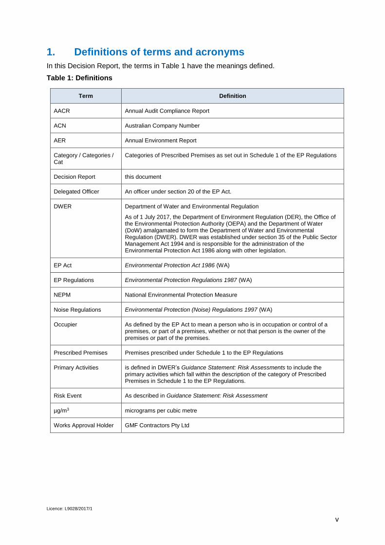
1. Definitions of terms and acronyms
In this Decision Report, the terms in Table 1 have the meanings defined.
Table 1: Definitions
Term Definition
AACR Annual Audit Compliance Report
ACN Australian Company Number
AER Annual Environment Report
Category / Categories / Cat
Categories of Prescribed Premises as set out in Schedule 1 of the EP Regulations
Decision Report this document
Delegated Officer An officer under section 20 of the EP Act.
DWER Department of Water and Environmental Regulation
As of 1 July 2017, the Department of Environment Regulation (DER), the Office of the Environmental Protection Authority (OEPA) and the Department of Water (DoW) amalgamated to form the Department of Water and Environmental Regulation (DWER). DWER was established under section 35 of the Public Sector Management Act 1994 and is responsible for the administration of the Environmental Protection Act 1986 along with other legislation.
EP Act Environmental Protection Act 1986 (WA)
EP Regulations Environmental Protection Regulations 1987 (WA)
NEPM National Environmental Protection Measure
Noise Regulations Environmental Protection (Noise) Regulations 1997 (WA)
Occupier As defined by the EP Act to mean a person who is in occupation or control of a premises, or part of a premises, whether or not that person is the owner of the premises or part of the premises.
Prescribed Premises Premises prescribed under Schedule 1 to the EP Regulations
Primary Activities is defined in DWER’s Guidance Statement: Risk Assessments to include the primary activities which fall within the description of the category of Prescribed Premises in Schedule 1 to the EP Regulations.
Risk Event As described in Guidance Statement: Risk Assessment
µg/m3 micrograms per cubic metre
Works Approval Holder GMF Contractors Pty Ltd

Licence: L9028/2017/1
1
2. Purpose and scope of assessment
GMF Contractors Pty Ltd submitted a concurrent application on 31 October 2016 for a Works Approval and Licence under the Environmental Protection Act 1986 (EP Act) for the crushing of waste building material generated via demolition works and the establishment of a solid waste depot.
This Decision Report assesses emissions and discharges associated with the crushing and storage of the waste building material. It takes into account the potential for the presence of asbestos within the types of material intended to be crushed.
This assessment has resulted in the Department of Water and Environmental Regulation (DWER) granting Licence L9028/2017/1 (Licence).
3. Background
The Applicant holds a current lease over a portion of Lot 508 Pederick Road, Neerabup from the land owners for the purpose of a building waste recycling facility. The Applicant has committed to purchasing the Premises from the land owners, pending the approval of a subdivision proposal currently under assessment by the Western Australian Planning Commission.
As part of existing demolition works conducted off site, the Applicant intends to transport demolished building material to the Premises in order to crush and screen the material, and store it at the Premises for future re-use.
The application relates to the primary activities of crushing and screening and subsequent storage of demolition material at the Premises for the Prescribed premises Categories as defined in Schedule 1 of the Environmental Protection Regulations 1987 (EP Regulations) as listed in Table 2.
The Applicant obtained Works Approval W6027/2017/1 granted on 4 August 2018 and lodged compliance documentation on 29 August 2018 indicating compliance with all conditions of the Works Approval.
Table 2: Prescribed Premises Categories applied for
Classification of Premises
Description Approved Premises production or design capacity or throughput
Category 13 Crushing of building material: premises on which waste building or demolition material (for example, bricks, stones or concrete) is crushed or cleaned.
100 000 tonnes per Annual Period
Category 62 Solid waste depot: premises on which waste is stored, or sorted, pending final disposal or re-use.
100 000 tonnes per Annual Period

Licence: L9028/2017/1
2
4. Overview of Premises
4.1 Infrastructure
The Premises infrastructure, as it relates to Category 13 and 62 activities, is detailed in Table 3 and with reference to the Site Layout (Figure 1). Information has been summarised from the application.
Table 3: Premises infrastructure
Infrastructure: Prescribed Activity Category 13 and 62
1 One Terex Finlay J-1175 mobile crusher
2 One McCloskey R155 mobile screen plant
3 Stormwater drainage infrastructure
Figure 1: Site layout

Licence: L9028/2017/1
3
5. Legislative context
5.1 Other relevant approvals
Planning approvals
The City of Wanneroo granted development approval for the premises on 7 April 2017.
Groundwater Licence
An application has been made to DWER for a groundwater licence. Approval is pending.
5.2 Part V of the EP Act
Applicable Regulations, Standards and Guidelines
The overarching legislative framework of this assessment is the EP Act and EP Regulations.
DWER Guidance Statements which inform this assessment are:
Guidance Statement: Regulatory Principles (July 2015);
Guidance Statement: Setting Conditions (October 2015);
Guidance Statement: Land Use Planning (February 2017);
Guidance Statement: Licence Duration (August 2016);
Guidance Statement: Publication of Annual Audit Compliance Reports (May 2016);
Guidance Statement: Decision Making (February 2017);
Guidance Statement: Risk Assessments(February 2017); and
Guidance Statement: Environmental Siting (November 2016).
6. Consultation
The application was advertised in the West Australian on 6 February 2017 for a comment period ending on 26 February 2017.
A letter inviting comment was sent to the City of Wanneroo on 31 January 2017. DWER received the following advice on 10 February 2017:
The City received an application on 28 June 2016 from GMF Contractors to commence development of an Industry – General (Recycling Yard) at the subject land;
Under the provisions of the city of Wanneroo District Planning Scheme No. 2, the subject land is zoned Industrial Development;
In the Neerabup Industrial Area – Agreed Structure Plan No. 17, the land is zoned General Industrial, and the Industry – General (Recycling Yard) is a Permissible use;
‘Solid waste depot, crushing and screening facility’ is not listed in the Zoning Table of DPS2, and the closest being Industry – General; and
The City is considering the above said development application and will determine it in due time.
DWER referred the draft Works Approval, Licence and Decision Report to the Applicant on 14 July 2017.

Licence: L9028/2017/1
4
7. Location and siting
7.1 Siting context
The Premises is located at part Lot 508 Pederick Road Neerabup.
7.2 Residential and sensitive Premises
The distances to residential and sensitive receptors are detailed in Table 4:
Table 4: Receptors and distance from activity boundary
Sensitive Land Uses Distance from Prescribed Activity
Residential Premises 1060m south and 1530m east of the proposed crushing location.
Horticultural activities: specifically market gardens, greenhouses and processing/packing sheds for the production of food for human consumption.
Immediately adjacent to the western boundary of the Premises.
200m north of the Premises boundary.
7.3 Specified ecosystems
Specified ecosystems are areas of high conservation value and special significance that may be impacted as a result of activities at or Emissions and Discharges from the Premises. The distances to specified ecosystems are shown in Table 5.
Table 5: Specified ecosystems
Specified ecosystems Distance from the Premises
Bush Forever: Regional open space or proposed regional open space
Bush Forever Site 295 Flynn Drive Bushland: one continuous site circling the Premises at a distance of 440m east, 770m south and 1190m south west of the Premises boundary.
Threatened Ecological Communities and Priority Ecological Communities
Threatened ecological communities site ‘Neerabup East’ 290m west of the Premises boundary.
Priority ecological communities site ‘pinj12’ 580m east north-east of the Premises boundary.
Priority ecological communities site ‘BIW20’ 720m south of the Premises boundary.
Biological component Distance from the Premises
Threatened/Priority Fauna Endangered birds sighted 440m north east of the Premises boundary.
Endangered birds sighted 660m south west of the Premises boundary.
Priority 4 insects caught or trapped 660m south west of the Premises boundary.
Priority 4 mammal diggings identified 810m north east of the Premises boundary.
Licence: L9028/2017/1
5
7.4 Groundwater and water sources
The distances to groundwater and water sources are shown in Table 6.
Table 6: Groundwater and water sources
Groundwater and water sources Distance from the Premises Environmental value
Public drinking water source areas Gnangara Public Drinking Water Source Area: one continuous site circling the Premises at a distance of 1520m south-east and 1550m north of the Premises boundary.
Gazetted as a Priority P1 public drinking water source area and managed under the Gnangara Land Use and Water Management Strategy.
Major watercourses/waterbodies Lake Pinjar geomorphic wetland 880m north east of the Premises boundary
Seasonally inundated sumpland basin
Lake Pinjar significant stream 880m north east of the Premises boundary
Area subject to inundation
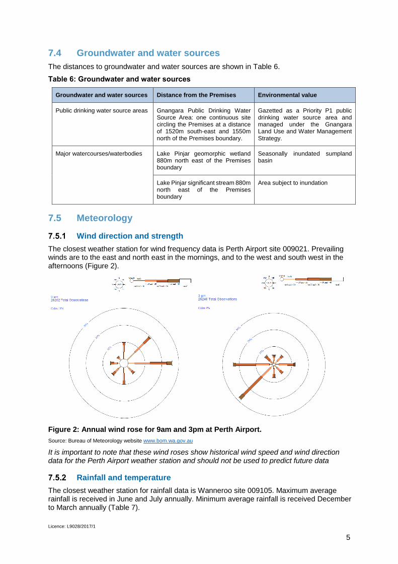
7.5 Meteorology
Wind direction and strength
The closest weather station for wind frequency data is Perth Airport site 009021. Prevailing winds are to the east and north east in the mornings, and to the west and south west in the afternoons (Figure 2).
Figure 2: Annual wind rose for 9am and 3pm at Perth Airport.
Source: Bureau of Meteorology website www.bom.wa.gov.au
It is important to note that these wind roses show historical wind speed and wind direction data for the Perth Airport weather station and should not be used to predict future data
Rainfall and temperature
The closest weather station for rainfall data is Wanneroo site 009105. Maximum average rainfall is received in June and July annually. Minimum average rainfall is received December to March annually (Table 7).

Licence: L9028/2017/1
6
Table 7: Average annual rainfall (mm) for Wanneroo site 009105
Source: Bureau of Meteorology website www.bom.wa.gov.au
The closest weather station for temperature data is Hillarys Boat Harbour NTC AWS site 009265. Highest average temperatures are experienced in January and February annually. Lowest average temperatures are experienced July to September annually (Table 8).
Table 8: Average annual temperatures (oC) for Hillarys Boat Harbour NTC AWS site 009265
Source: Bureau of Meteorology website www.bom.wa.gov.au
8. Risk Assessment
8.1 Determination of emission, pathway and receptor
In undertaking its risk assessment, DWER will identify all potential emissions pathways and potential receptors to establish whether there is a Risk Event which requires detailed risk assessment.
To establish a Risk Event there must be an emission, a receptor which may be exposed to that emission through an identified actual or likely pathway, and a potential adverse effect to the receptor from exposure to that emission. Where there is no actual or likely pathway and/or no receptor, the emission will be screened out and will not be considered as a Risk Event. In addition, where an emission has an actual or likely pathway and a receptor which may be adversely impacted, but that emission is regulated through other mechanisms such as Part IV of the EP Act, that emission will not be risk assessed further and will be screened out through Table 10.
The identification of the sources, pathways and receptors to determine Risk Events are set out in Table 9 below.

Licence: L9028/2017/1
7
Table 9: Identification of emissions, pathway and receptors during operation
Risk Events Continue to
detailed Risk Assessment
Reasoning
Sources/Activities Potential
Emissions Potential
Receptors Potential Pathway
Potential Adverse Impacts
Operation of infrastructure
Vehicle movements on gravel roads
Dust
Closest residential premises located 1062m south and 1530m east of the proposed crushing location. Horticultural activities located immediately adjacent to the western boundary, and 200m north of the Premises boundary. Bush Forever Site 295 Flynn Drive Bushland located 440m east of the Premises boundary. Threatened Ecological Communities located 290m west, 580m east north-east and 720m south of the Premises boundary. Threatened fauna located 440m north east, 660m south west, and 810m north east of the Premises boundary.
Air / wind dispersion
Amenity impacts
No
The frequency of vehicle movements and the low number of vehicles likely to be used during operation will generate low quantities of dust.
The Delegated Officer considers the low quantities of dust likely to be generated when combined with the distances to the closest residential premises, the Bush Forever Site, Threatened Ecological Communities and Threatened Fauna to be sufficient to ensure dust will not significantly impact the amenity of these sensitive receptors. No further risk assessment is required.
The Delegated Officer considers the low quantities of dust likely to be generated will not significantly impact upon the horticultural activities occurring at the adjacent premises. No further risk assessment is required.
Noise No
The frequency of vehicle movements and the low number of vehicles likely to be used during operation will generate low levels of noise.
The Delegated Officer considers the low levels of noise likely to be generated when combined with the distances to the closest residential premises, the Bush Forever Site, Threatened Ecological Communities and Threatened Fauna to be sufficient to ensure noise will not significantly impact the amenity of these sensitive receptors. No further risk assessment is required.
The Delegated Officer considers the low levels of noise likely to be generated will not significantly impact upon the horticultural activities occurring at the adjacent premises. No further risk assessment is required.

Licence: L9028/2017/1
8
Risk Events Continue to
detailed Risk Assessment
Reasoning
Sources/Activities Potential
Emissions Potential
Receptors Potential Pathway
Potential Adverse Impacts
Operation of infrastructure
Operation of mobile crusher, track mounted screener and loading machinery
Dust
Closest residential premises located 1062m south and 1530m east of the proposed crushing location.
Horticultural activities located immediately adjacent to the western boundary, and 200m north of the Premises boundary.
Bush Forever Site 295 Flynn Drive Bushland located 440m east of the Premises boundary.
Threatened Ecological Communities located 290m west, 580m east north-east and 720m south of the Premises boundary.
Threatened fauna located 440m north east, 660m south west, and 810m north east of the Premises boundary.
Air / wind dispersion
Amenity impacts
Yes
The Applicant intends to crush up to 100 000 tonnes of building material per year. This is a high volume of product likely to generate significant dust emissions which have the potential to impact the amenity of nearby sensitive receptors, therefore the Delegated Officer considers a detailed risk assessment is required.
Noise Yes
The Applicant intends to crush up to 100 000 tonnes of building material per year. This requires the use of machinery likely to generate significant noise emissions which have the potential to impact the amenity of nearby sensitive receptors, therefore the Delegated Officer considers a detailed risk assessment is required.
Asbestos fibre
Public health Yes
Asbestos was used extensively in Australian buildings and structures from the 1950’s through to 1990. The Applicant intends to crush up to 100 000 tonnes of building material per year. There is a risk the building material could be contaminated with asbestos, where subjecting it to crushing the asbestos fibre could be released. If people inhale these fibres there is the potential for impacts to public health, therefore the Delegated Officer considers a detailed risk assessment is required.
Contamination of stormwater
Contaminated stormwater
Surface water
dispersal Amenity impacts Yes
The Applicant intends to crush and store up to 100 000 tonnes of building material per year. This is a high volume of product likely to generate significant dust emissions which have the potential to contaminate stormwater, therefore the Delegated Officer considers a detailed risk assessment is required.

Licence: L9028/2017/1
9
8.2 Consequence and likelihood of risk events
A risk rating will be determined for risk events in accordance with the Risk Rating Matrix set out in Table 10 below.
Table 10: Risk Rating Matrix
Likelihood Consequence
Slight Minor Moderate Major Severe
Almost Certain Medium High High Extreme Extreme
Likely Medium Medium High High Extreme
Possible Low Medium Medium High Extreme
Unlikely Low Medium Medium Medium High
Rare Low Low Medium Medium High
DWER will undertake an assessment of the consequence and likelihood of the Risk Event in accordance with Table 11 below.
Table 11: Risk Criteria Table
Likelihood Consequence
The following criteria has been
used to determine the likelihood of
the Risk Event occurring.
The following criteria has been used to determine the consequences of a Risk Event occurring:
Environment Public health* and amenity (such as air
and water quality, noise, and odour)
Almost
Certain
The risk event is
expected to occur
in most
circumstances
Severe onsite impacts: catastrophic
offsite impacts local scale: high level
or above
offsite impacts wider scale: mid-level
or above
Mid to long-term or permanent impact to
an area of high conservation value or
special significance^
Specific Consequence Criteria (for
environment) are significantly exceeded
Loss of life
Adverse health effects: high level or
ongoing medical treatment
Specific Consequence Criteria (for
public health) are significantly
exceeded
Local scale impacts: permanent loss
of amenity
Likely The risk event will
probably occur in
most circumstances
Major onsite impacts: high level
offsite impacts local scale: mid-level
offsite impacts wider scale: low level
Short-term impact to an area of high
conservation value or special
significance^
Specific Consequence Criteria (for
environment) are exceeded
Adverse health effects: mid-level or
frequent medical treatment
Specific Consequence Criteria (for
public health) are exceeded
Local scale impacts: high level
impact to amenity
Possible The risk event
could occur at
some time
Moderate onsite impacts: mid-level
offsite impacts local scale: low level
offsite impacts wider scale: minimal
Specific Consequence Criteria (for
environment) are at risk of not being met
Adverse health effects: low level or
occasional medical treatment
Specific Consequence Criteria (for
public health) are at risk of not being
met
Local scale impacts: mid-level
impact to amenity
Unlikely The risk event will
probably not occur
in most
circumstances
Minor onsite impacts: low level
offsite impacts local scale: minimal
offsite impacts wider scale: not
detectable
Specific Consequence Criteria (for
environment) likely to be met
Specific Consequence Criteria (for
public health) are likely to be met
Local scale impacts: low level impact
to amenity
Rare The risk event may
only occur in
exceptional
circumstances
Slight onsite impact: minimal
Specific Consequence Criteria (for
environment) met
Local scale: minimal to amenity
Specific Consequence Criteria (for
public health) met
^ Determination of areas of high conservation value or special significance should be informed by the Guidance Statement: Environmental Siting. * In applying public health criteria, DWER may have regard to the Department of Health’s Health Risk Assessment (Scoping) Guidelines. “onsite” means within the Prescribed Premises boundary.

Licence: L9028/2017/1
10
8.3 Acceptability and Treatment of Risk Event
DWER will determine the acceptability and treatment of Risk Events in accordance with the Risk Treatment in Table 12 below:
Table 12: Risk Treatment Table
Rating of Risk Event
Acceptability Treatment
Extreme Unacceptable. Risk Event will not be tolerated. DWER may refuse application.
High May be acceptable.
Subject to multiple regulatory controls.
Risk Event may be tolerated and may be subject to multiple regulatory controls. This may include both outcome-based and management conditions.
Medium Acceptable, generally subject to regulatory controls.
Risk Event is tolerable and is likely to be subject to some regulatory controls. A preference for outcome-based conditions where practical and appropriate will be applied.
Low Acceptable, generally not controlled
Risk Event is acceptable and will generally not be subject to regulatory controls.
8.4 Risk Assessment – Dust (Operation)
General hazard characterisation and impact
Fugitive dust emissions may be generated from loading machinery, the mobile screener unit and track mounted crusher unit during operation at the Premises.
Air emissions potential pathway is air or wind dispersal. Prevailing winds are east and north east in the mornings, and west and south west in the afternoons (Figure 2).
Potential impacts from dust emissions include degradation of local air quality at nearby residential premises located 1062m south and 1530m east of the proposed crushing location, and upon horticultural cropping activities involved in the production of food for human consumption located immediately adjacent to the western boundary and 200m north of the Premises.
Potential impacts upon the ecology and/or flora of the Threatened Ecological Communities located 290m west, Threatened Fauna located 440m north east, and the Bush Forever Site 295 Flynn Drive Bushland located 440m east of the Premises boundary.
Criteria for assessment
NEPM 2003 recommends that PM10 does not exceed 50 µg/m3 over a 24 hour averaging period. However, ambient monitoring at the receiving receptors is not currently undertaken.

Licence: L9028/2017/1
11
Applicant controls
The Applicant controls to reduce and manage dust emissions are set out in Table 13.
Table 13: Applicant’s proposed controls for Dust (Operation)
Controls for Dust (Operation)
Control Description
Limited stockpile dimensions
Stockpiles will be limited in height to 5m and diameter to 30m.
Sealed vehicle ring road
Installation of a 7m wide, asphalt sealed ring road, particularly along the eastern, southern and western boundaries.
Setback Creation of a 6m setback on the southern boundary.
Landscaping Installation of 0.5m of landscaping along the eastern and western boundaries.
Key findings
The Delegated Officer has reviewed the information regarding Dust (Operation) and has found:
1. The asphalt sealed ring road will prevent dust generation from vehicle movements, and act as a minor buffer zone to prevent dust migration off the Premises.
2. The 6m setback area and 0.5m landscaping will act as a minor buffer to minimise dust migration off the Premises.
3. Additional conditions will be required to minimise dust emissions during operation.
Consequence
The Delegated Officer has had regard to the nature and quantity of fugitive dust emissions from the Premises during operation and has determined that the impact of dust emissions will result in low level off-site impacts at a local scale to the horticultural cropping activities located immediately adjacent to the western boundary and 200m north of the Premises. Therefore the Delegated Officer considers the consequence to be moderate.
Likelihood of consequence
Based upon the distance to nearest sensitive receptors and Applicant controls, the Delegated Officer has determined that the likelihood of impacts from fugitive dust emissions may occur in some circumstances during operation, due to the westerly prevailing winds in the afternoons likely to disperse dust emissions onto the horticultural cropping activities located immediately adjacent to the western boundary. Therefore, the Delegated Officer considers the likelihood of impacts arising from fugitive dust emissions to be possible.
Overall rating
The Delegated Officer has compared the consequence and likelihood ratings described above with the Risk Rating Matrix (Table 11) and determined that the overall rating for the risk of impacts arising from fugitive dust emissions to be medium.

Licence: L9028/2017/1
12
8.5 Risk Assessment – Noise (Operation)
General hazard characterisation and impact
Noise emissions may be generated from loading machinery, the mobile screener unit, track mounted crusher unit and trucks during operation at the Premises.
Noise emissions potential pathway is air or wind dispersal. Prevailing winds are east and north east in the mornings, and west and south west in the afternoons (Figure 2).
Potential impacts from noise emissions include degradation of local comfort and amenity at the adjacent neighbouring premises to the west, north, east and south, and at nearby highly noise sensitive residential premises located 1062m south and 1530m east of the proposed crushing location.
Criteria for assessment
The assigned (allowable) levels set out in regulation 8(3) of the Noise Regulations apply to noise emissions from the proposed Category 13 crushing activities.
The Applicant conducted initial noise modelling as part of the application for operational activities at the Premises which showed an exceedance of levels at the premises adjacent and to the north of the GMF Contractors premises and within Lot 508 Pederick Road. As a result the Applicant proposed the additional installation of a sea container wall to mitigate noise migration to the northern premises. Secondary noise modelling was performed for the operation of the crusher and screener (Figure 3) and for truck movements (Figure 4) with the sea container wall installed.
The secondary noise modelling was referred to Noise Branch within DWER for advice on the ability of the proposed activities to meet the assigned levels set out in regulation 8(3) of the Noise Regulations.
As a condition of Works Approval W6027/2017/1, the Applicant was permitted to commission all infrastructure and equipment on the Premises and undertake recept, crushing and screening of materials for the purpose of conducting necessary noise measurements, but must shut down equipment immediately following completion of noise measurements. Noise measurements were subsequently performed by Herring Storer on 11 December 2018.
Key points of the DWER Noise Branch technical advice and a comparison to the Herring Storer noise measurements are provided below.
Operating Hours
The Applicant has advised crushing and screening activities will occur from 0700 to 1900 weekdays and Saturdays.
Noise from truck movements
Advice was based on a truck speed of 20km/hr and a maximum of two trucks per hour, therefore four truck passes by a stationary position. The total time the trucks will be present on the approximately 250 m stretch of the initial portion of the access road will be 180 seconds (three minutes). The LA10 assigned level can be exceeded up to the LA1 assigned level for six minutes in any one hour period, therefore assessment of truck noise against the LA1 assigned level criteria is acceptable.
Noise received at premises adjacent to the east
The Suez Neerabup BioVision ARRT Facility, a composting facility, is located adjacent to the east of the GMF Contractors premises. Schedule 1 of the Noise Regulations classifies the Suez facility to be an industrial premises. Table 1 of the Noise Regulations provides an assigned level at all hours of LA10 65dB, LA1 80dB and LAmax 90dB. The noise modelling

Licence: L9028/2017/1
13
conducted by the Applicant shows noise received at the Suez premises is likely to meet these assigned levels.
Noise measurements on the eastern side of the GMF premises show a maximum reading of 62dB(A) which is below the assigned levels.
A comparison reading adjacent to the Suez facility showed the potential influence of activities occurring at the Suez facility increasing the noise measurements at the GMF premises, however this measurement reached a maximum reading of 64dB which still remains below 65dB.
Noise received at premises adjacent to the west
Trandos Farms is located adjacent and to the west of the GMF Contractors premises, within Lot 508 Pederick Road. As this premises is zoned General Industrial by the City of Wanneroo zoning, the Delegated Officer accepts the Applicant’s modelling showing the premises is Industrial for the purposes of Schedule 1 of the Noise Regulations. Table 1 of the Noise Regulations provides an assigned level at all hours of LA10 65dB, LA1 80dB and LAmax 90dB. The noise modelling conducted by the Applicant shows noise received at Trandos Farms may exceed these assigned levels by at least +5dB.
Noise measurements on the western side of the GMF premises show a maximum reading of 59dB which is below the assigned levels.
Noise received at premises adjacent to the north
Aerial imagery of the premises adjacent and to the north of the GMF Contractors premises and within Lot 508 Pederick Road, shows a house on the block. The Applicant has advised this is a caretaker’s facility for the purposes of the horticultural activities occurring at this block. The lease area does not include the caretaker’s facility, however after subdivision the portion of Lot 508 subject to purchase by the Applicant will include the caretaker’s facility.
As this premises is zoned General Industrial under the City of Wanneroo Neerabup Industrial Area – Agreed Structure Plan No. 17, the Delegated Officer accepts the Applicant’s modelling showing the adjacent premises is Industrial for the purposes of Schedule 1 of the Noise Regulations. Table 1 of the Noise Regulations provides an assigned level at all hours of LA10 65dB, LA1 80dB and LAmax 90dB. The noise modelling conducted by the Applicant shows with the installation of a bund wall that noise received at the premises adjacent to the north premises is likely to meet these assigned levels.
The wall was installed along the northern boundary of the premises, consisting of metal sea containers. The wall is 74m long and 2.4m high. Noise measurements conducted after installation of the wall show a maximum reading of 55dB which is below the assigned levels.
Noise received at premises adjacent to the south
Carramar Resource Industries is located adjacent to the south of the GMF Contractors premises. Schedule 1 of the Noise Regulations classifies the sand, soil and gravel extraction facility as an industrial premises. Table 1 of the Noise Regulations provides an assigned level at all hours of LA10 65dB, LA1 80dB and LAmax 90dB. The noise modelling conducted by the Applicant shows noise received at the Carramar Resources premises may exceed these assigned levels by at least +5dB.
Noise measurements were not conducted on the southern boundary.

Licence: L9028/2017/1
14
Figure 3: Noise modelling contour map for Category 13 equipment including a bund wall

Licence: L9028/2017/1
15
Figure 4: Noise modelling contour map for truck movements including a bund wall

Licence: L9028/2017/1
16
Figure 5: Noise measurement data for all operations including a sea container wall
Licence: L9028/2017/1
17
Applicant controls
The Applicant controls to reduce and manage noise emissions are set out in Table 14.
Table 14: Applicant’s proposed controls for Noise (Operation)
Controls for Noise (Operation)
Control Description
Hours of operation
The operating hours for the Category 13 activities is proposed to be 07:00 to 19:00 Monday to Saturday, excluding Public Holidays.
Infrastructure Installation of a sea container wall to the north of the GMF Contractors premises and within Lot 508 Pederick Road
Method of operation
Speed of trucks at 20km/hr
Key findings
The Delegated Officer has reviewed the information regarding Noise (Operation) and has found:
4. Modelling shows the assigned noise levels may be exceeded at the southern boundary of the Premises. Noise measurements were not conducted at this location.
5. The noise measurements show that the wall is effective at reducing noise migration across the northern boundary.
6. Additional conditions will be required to investigate noise emissions at the southern boundary during operation, and determine techniques to abate noise to meet the prescribed standards in the Noise Regulations.
Consequence
The Delegated Officer has had regard to the nature and quantity of noise emissions from the Premises during operation and has determined that the impact of noise emissions may result in low level off-site impacts at a local scale. Therefore the Delegated Officer considers the consequence of impacts arising from noise emissions to be moderate.
Likelihood of consequence
Based upon the distance to nearest sensitive receptors and Applicant controls, the Delegated Officer has determined that the likelihood of noise emissions not meeting a prescribed standard will probably occur in most circumstances during operation. Therefore, the Delegated Officer considers the likelihood of impacts arising from noise emissions to be likely.
Overall rating
The Delegated Officer has compared the consequence and likelihood ratings described above with the Risk Rating Matrix (Table 11) and determined that the overall rating for the risk of impacts arising from noise emissions during operation to be high.

Licence: L9028/2017/1
18
8.6 Risk Assessment – Asbestos Fibre (Operation)
General hazard characterisation and impact
Asbestos is a hazardous material that can cause mesothelioma, asbestosis or lung cancer. Asbestos was used extensively in Australian buildings and structures from the 1950’s through to 1990. The Applicant intends to demolish aged buildings and crush the waste bricks and concrete for reuse and recycling off site.
Asbestos fibre emissions potential pathway is air or wind dispersal. Prevailing winds are east and north east in the mornings, and west and south west in the afternoons (Figure 2).
Potential impacts from asbestos fibre emissions include health impacts such as asbestosis, mesothelioma and/or lung cancer at nearby residential premises located 1062m south and 1530m east of the proposed crushing location, and upon employees working outdoors at the horticultural cropping premises located immediately adjacent to the western boundary and 200m north of the Premises.
Potential contamination of the Threatened Ecological Communities located 290m west and the Bush Forever Site 295 Flynn Drive Bushland located 440m east of the Premises boundary.
Criteria for assessment
Contamination testing has not been performed at the Premises.
Applicant controls
The Applicant controls to reduce and manage asbestos fibre emissions are set out in Table 15.
Table 15: Applicant’s proposed controls for Asbestos Fibre (Operation)
Controls for Asbestos Fibre (Operation)
Control Description
Asbestos Management Plan
Plan for the identification and treatment of asbestos containing material (ACM) including:
Declaration by delivery drivers that the load is asbestos free;
Visual inspection for asbestos content during loading and on arrival at the weighbridge, at the picking station, and constant monitoring by operation staff throughout the process.
Review source of material to determine low or high contamination risk, with appropriate identification methods for high risk loads;
Rejection process for contaminated loads and a Rejected Loads Register;
Use of the wet spray method for the removal of ACM;
Use of polythene bags or sheeting for the containment of ACM;
Testing of final crushed product in accordance with AS4964-2004 to determine compliance with the Environmental Protection (Controlled Waste) Regulations 2004.

Licence: L9028/2017/1
19
Key findings
The Delegated Officer has reviewed the information regarding Asbestos Fibre (Operation) and has found:
7. The Asbestos Management Plan is consistent with DWER guidelines and contains inspection and testing techniques to ensure the potential for Asbestos Fibre emissions is minimised.
8. Additional management conditions will be required to adequately reduce the risk of asbestos fibre emissions occurring during operation.
Consequence
The Delegated Officer has had regard to the nature and quantity of asbestos fibre emissions from the Premises during operation and has determined that the impact of asbestos fibre emissions will result in adverse health effects requiring a high level or ongoing medical treatment. Therefore the Delegated Officer considers the consequence to be severe.
Likelihood of consequence
Based upon the distance to nearest sensitive receptors and Applicant controls, the Delegated Officer has determined that health impacts from asbestos fibre emissions will not occur in most circumstances during operation. Therefore, the Delegated Officer considers the likelihood of impacts arising from fugitive dust emissions to be rare.
Overall rating
The Delegated Officer has compared the consequence and likelihood ratings described above with the Risk Rating Matrix (Table 11) and determined that the overall rating for the risk of impacts arising from asbestos fibre emissions to be high.
8.7 Risk Assessment – Contaminated Stormwater (Operation)
General hazard characterisation and impact
Contaminated stormwater can be generated during rainfall events where contaminants within the crushed material are mobilised.
Contaminated stormwater emissions potential pathway is surface water dispersal.
Potential impacts from contaminated stormwater emissions include contamination of surface waters entering the horticultural cropping premises located immediately adjacent to the western boundary and 200m north of the Premises, and degradation of local surface water quality feeding into Threatened Ecological Communities located 290m west and the Bush Forever Site 295 Flynn Drive Bushland located 440m east of the Premises boundary.
Criteria for assessment
The National Water Quality Management Strategy, Australian and New Zealand Guidelines for Fresh and Marine Water Quality (ANZECC) and National Environment Protection (Assessment of Site Contamination) Measure 1999, amended in 2013 provide assessment criteria.

Licence: L9028/2017/1
20
Applicant controls
The Applicant controls to reduce and manage contaminated stormwater emissions are set out in Table 16.
Table 16: Applicant’s proposed controls for Contaminated Stormwater (Operation)
Controls for Contaminated Stormwater (Operation)
Control Description
Stormwater management
Sloped ground surface to direct contaminated stormwater towards a series of swales which drain into a stormwater drainage basin located in the north east corner of the Premises.
Setback Creation of a 6m setback on the southern boundary.
Sealed vehicle roads
Installation of a 7m wide, asphalt sealed ring road, particularly along the eastern, southern and western boundaries.
Landscaping Installation of 0.5m of landscaping along the eastern and western boundaries.
Key findings
The Delegated Officer has reviewed the information regarding Contaminated Stormwater (Operation) and has found:
9. The swales, setback and asphalt sealed roads around the boundary of the Premises will minimise contaminated and potentially contaminated stormwater exiting the Premises.
10. The swales and sloped ground surface within the Premises will direct contaminated and potentially contaminated stormwater into the drainage basin.
11. The drainage basin will retain contaminated and potentially contaminated stormwater within the Premises.
Consequence
The Delegated Officer has had regard to the nature and quantity of contaminated stormwater emissions from the Premises during operation and has determined that contaminated stormwater emissions will result in low level off-site impacts at a local scale to the horticultural cropping activities located immediately adjacent to the western boundary.
Therefore the Delegated Officer considers the consequence to be moderate.
Likelihood of consequence
Based upon the distance to nearest sensitive receptors and Applicant controls, the Delegated Officer has determined that the likelihood of impacts from contaminated stormwater emissions could occur at some time during operation. Therefore, the Delegated Officer considers the likelihood of impacts arising from contaminated stormwater emissions to be possible.
Overall rating
The Delegated Officer has compared the consequence and likelihood ratings described above with the Risk Rating Matrix (Table 11) and determined that the overall rating for the risk of impacts arising from contaminated stormwater emissions to be medium.

Licence: L9028/2017/1
21
8.8 Summary of Acceptability and Treatment of Risk Events
A summary of the risk assessment and the acceptability or unacceptability of the risk events set out above with the appropriate treatment and control are set out in Table 17 below. Controls are described further in section 9.
Table 17: Risk assessment summary
Description of Risk Event Applicant controls Risk Rating Acceptability with controls (conditions on instrument)
Emission Source Pathway/ Receptor
(Impact)
1. Dust (Operation) Loading machinery, the mobile screener unit and track mounted crusher unit.
Air / wind dispersal Limited stockpile dimensions
Sealed vehicle ring road
Setback
Landscaping
Moderate consequence
Possible likelihood
Medium Risk
Acceptable subject to regulatory controls
2. Noise (Operation) Loading machinery, the mobile screener unit, track mounted crusher unit and trucks
Air / wind dispersal Hours of operation
Installation of a bund wall
Speed of trucks
Moderate consequence
Likely likelihood
High Risk
Acceptable subject to regulatory controls
3. Asbestos Fibre (Operation)
Demolish aged buildings and crush the waste bricks and concrete for reuse and recycling off site
Air / wind dispersal Asbestos Management Plan Severe consequence
Rare likelihood
High Risk
Acceptable subject to regulatory controls
4. Contaminated Stormwater
The crushing and storage of material producing dust emissions which have the potential to contaminate stormwater.
Surface water dispersal Stormwater management
Setback
Sealed vehicle ring road
Landscaping
Moderate consequence
Possible likelihood
Medium Risk
Acceptable subject to regulatory controls

Licence: L9028/2017/1
22
9. Regulatory Controls
A summary of regulatory controls determined to be appropriate for the Risk Events is set out in Table 18. The risks are set out in the assessment in section 8 and the controls are detailed in this section. DWER will determine controls having regard to the adequacy of controls proposed by the applicant. The conditions of the works approval and licence will be set to give effect to the determined regulatory controls.
Table 18: Summary of regulatory controls to be applied
Controls
Sp
ecif
ied
Infr
astr
uctu
re a
nd
Eq
uip
men
t
Sp
ecif
ied
acti
on
Ris
k Ite
ms
(see r
isk a
ss
ess
men
t in
secti
on
8) 1. Dust (Operation)
• •
2. Noise (Operation)
•
3. Asbestos Fibre (Operation) • •
4. Contaminated Stormwater (Operation) •
9.1 Licence controls
The Licence will be subject to conditions which capture the commitments and specifications related to the actions proposed in the application to be conducted on the Premises, in order to maintain the assessed Risk Rating (Table 18).
Additional conditions will be imposed on the Licence by the Delegated Officer to reduce the Risk Rating, where required, to a level of acceptability (Table 18).
Dust management
The following specified actions as provided in the application must be implemented during operation to enable management of dust emissions:
Stockpile diameter of crushed product is to be limited to 30m; and
Stockpile height is to be limited to 5m.
The Delegated Officer has considered the information provided in the application and the overall rating of the risk assessment where impacts arising from fugitive dust emissions during operation are considered to be of medium risk, and has determined that additional conditions are required to mitigate the overall risk of dust emissions to an acceptable level, whereby:
A sprinkler system is routinely operated on each stockpile with sufficient throw to cover the diameter of each stockpile and sufficient volume to prevent visible dust lift off; and

Licence: L9028/2017/1
23
Where the sprinkler system is ineffective or likely to be ineffective at preventing visible dust lift off exiting the Premises boundary, waste processing activities must cease until additional measures have been put in place to prevent the discharge, or until the adverse weather conditions have passed.
In addition, the Delegated Officer has determined that additional conditions are required to manage the on-site infrastructure in order to mitigate the overall risk of dust emissions to an acceptable level, whereby:
Terex Finlay J-1175 Jaw Crusher
o Maintain the pipes and spray bars of the main conveyor;
o Maintain the pump, or maintain the connection to mains water supply, to provide water to the main conveyor;
o Maintain the additional dust cover on the discharge conveyor; and
o In accordance with the Manufacturer’s servicing instructions.
McCloskey R155 heavy duty mobile screener
o In accordance with the Manufacturer’s servicing instructions
Dust management
o Maintain the ring road with asphalt;
o Maintain a 6m setback for any stockpiling, materials storage or handling activities from the southern boundary; and
o Maintain a sprinkler system on each stockpile.
Noise management
The following specified actions as provided in documentation supporting the application must be implemented during operation to enable management of noise emissions during operational activities:
The operating hours for the Premises is proposed to be 07:00 to 19:00 Monday to Saturday, excluding Public Holidays.
Truck speed limited at or below 20km/hr.
The Delegated Officer has considered the information provided in the application and the overall rating of the risk assessment where impacts arising from fugitive noise emissions during operation are considered to be of high risk, and has determined that additional conditions are required to manage the on-site infrastructure in order to mitigate the overall risk of noise emissions to an acceptable level, whereby:
Maintain the sea container wall on the northern boundary of the Premises (as depicted in Schedule 1 Maps: Premises Map) to a length of 74m and a height of 2.4m during all crushing and screening activities.
In addition the Delegated Officer will consider the outcome of the specified actions required under monitoring conditions 23 and 24 to re-assess the risk of noise emissions from the Premises at the southern boundary during operation and the suitability of improvements to abate noise emissions. In addition the Delegated Officer may implement additional conditions to the Licence as required to mitigate noise emissions. The Applicant will have the opportunity to comment on the proposed Licence conditions prior to amending the Licence.
Asbestos fibre management
The following specified actions as provided in the application must be implemented during operation to enable management of asbestos fibre emissions:

Licence: L9028/2017/1
24
Visually inspect all loads of Inert Waste Type 1 material when they arrive at the Premises prior to unloading and during unloading to determine the risk of a load containing asbestos or ACM;
Where the inspection confirms asbestos or ACM, the Licensee must reject the waste material, maintain accurate records of all rejected loads, and record the details of the material source, material carrier, registration number of the vehicle and date of rejection;
Classified Loads identified as “high risk” continue to be managed in accordance with the high risk procedure as outlined in section 3.4 of the DWER Asbestos Guidelines;
Maintain records of all accepted load inspections and of any accepted loads which have been determined as Classified Loads or as “high risk” loads;
Continue to visually inspect material on the Premises at all stages of the storage, sorting and crushing process of Inert Waste Type 1;
Finished products used in the construction of infrastructure on the Premises or supplied for re-use are only used or supplied to customers from stockpiles that have been sampled and tested in accordance with section 4.3 of the DWER Asbestos Guidelines (Attachment 3) and shown to conform to the product specification of 0.001% asbestos weight for weight (w/w) for asbestos content (in any form) within any recycled products; and
Retain all asbestos testing records.
The Delegated Officer has considered the information provided in the application and the overall rating of the risk assessment where impacts arising from asbestos fibre emissions during operation are considered to be high, and has determined that additional conditions are required to mitigate the overall risk of asbestos fibre emissions to an acceptable level, whereby:
Maintain signage advising ‘No Asbestos’ is accepted;
A sprinkler system is routinely operated on each load to ensure all loads are wetted prior to unloading, and maintained in a wet state throughout the inspection process.;
Maintain all loads of Inert Waste Type 1 material on the Premises in at least three separate stockpiles areas for:
unprocessed material; processed material awaiting testing for ACM; and processed material tested for ACM;
Ensure adequate separation of the three separate stockpiles whereby: (a) unprocessed materials and processed materials must be clearly separated at a
minimum 3 m distance; (b) processed material tested for ACM and processed material awaiting testing for
ACM must be clearly separated by a minimum 3m distance or clearly delineated and separated with impermeable barriers; and
(c) clearly visible and legible signage must be erected at or on individual stockpiles to clearly identify and delineate unprocessed material, untested processed material and tested processed material;
Ensure all loads found to contain suspected ACM are isolated, kept damp, and appropriately contained; and
All loads found to contain suspected ACM is to be disposed of by an appropriately licensed waste transporter and to an appropriately licensed landfill premises.
Maintain a sprinkler system on each stockpile.

Licence: L9028/2017/1
25
Contaminated Stormwater
The Delegated Officer has considered the information provided in the application and the overall rating of the risk assessment where impacts arising from contaminated stormwater emissions during operation are considered to be of medium risk, and has determined that additional conditions are required to manage the on-site infrastructure in order to mitigate the overall risk of contaminated stormwater emissions to an acceptable level, whereby:
• Maintain contouring of the Premises so that the ground slopes towards the swales and/or the stormwater drainage basin; and
• Maintain the swales and stormwater drainage basin as per the locations and specifications shown in Schedule 1: Map of Stormwater Infrastructure.
10. Determination of Licence conditions
The conditions in the issued Licence in Attachment 1 have been determined in accordance with DER’s Guidance Statement: Setting Conditions.
The Guidance Statement: Licence Duration has been applied and the issued Licence expires in 20 years from date of issue.
Table 19 provides a summary of the conditions to be applied to this Licence.
Table 19: Summary of conditions to be applied to the Licence
Condition Reference Grounds
Premises Operation Conditions 1 to 6
These conditions are valid, risk-based and contain appropriate controls.
Management of Asbestos and ACM Conditions 7 to 20
These conditions are valid, risk-based and enable the Delegated Officer to make an informed decision on the suitability of granting a Licence
Infrastructure and equipment Condition 21
These conditions are valid, risk-based and contain appropriate controls.
Monitoring Condition 22 to 24
These conditions are valid, risk-based and contain appropriate controls.
Record Keeping Conditions 25 to 28
These conditions are valid and are necessary administration and reporting requirements to ensure compliance.
DWER notes that it may review the appropriateness and adequacy of controls at any time, and that following a review, DWER may initiate amendments to the Works Approval or Licence under the EP Act.
11. Applicant’s comments
The Applicant was provided with the draft Licence and Decision Report on 2 October 2018. The Applicant advised on 4 October 2018 that they were happy to go ahead with the Licence and the only comment is that the approval from the City of Wanneroo has been granted.

Licence: L9028/2017/1
26
12. Conclusion
This assessment of the risks of activities on the Premises has been undertaken with due consideration of a number of factors, including the documents and policies specified in this Decision Report (summarised in Appendix 1).
Based on this assessment, it has been determined that the Issued Licence will be granted subject to conditions commensurate with the determined controls and necessary for administration and reporting requirements.
Steve Checker Manager Licensing (Waste Industries) Delegated Officer under section 20 of the Environmental Protection Act 1986

Licence: L9028/2017/1
27
Appendix 1: Key Documents
Document Title In text ref Availability
1 Works Approval W6027/2017/1 GMF
Contractors Pty Ltd W6027/2017/1 A1501553
2 DER, July 2015. Guidance Statement:
Regulatory principles. Department of
Environment Regulation, Perth.
DER 2015a
accessed at http://www.dwer.wa.gov.au
3 DER, October 2015. Guidance Statement: Setting conditions. Department of Environment Regulation, Perth.
DER 2015b
4 DER, August 2016. Guidance
Statement: Licence duration.
Department of Environment
Regulation, Perth.
DER 2016a
5 DER, November 2016. Guidance
Statement: Risk Assessments.
Department of Environment
Regulation, Perth.
DER 2016b
DER, November 2016. Guidance Statement: Decision Making. Department of Environment Regulation, Perth.
DER 2016c

Licence: L9028/2017/1
28
Attachment 1: Issued Licence L9028/2017/1