dixie of mississauga plan 4.10... · plan), being an office consolidation of the dixie district...
TRANSCRIPT

SECTION 4.10 DIXIE
DISTRICT POLICIES OF
MISSISSAUGA PLAN
2012 November
NOTE:
THE POLICIES IN THIS DOCUMENT ARE SPECIFIC TO THE DIXIE PLANNING DISTRICT OF MISSISSAUGA PLAN, AND
MUST BE READ IN CONJUNCTION WITH ALL THE POLICIES OF MISSISSAUGA PLAN
PLEASE REFER TO MISSISSAUGA PLAN
FOR ADDITIONAL CITY-WIDE POLICIES WHICH APPLY TO THIS DISTRICT.
THE DIXIE DISTRICT POLICIES OF MISSISSAUGA PLAN CAME INTO EFFECT 2003 MAY 05, EXCEPT FOR THE AREAS MARKED AND OUTLINED IN THIS PLAN THAT HAVE BEEN
APPEALED TO THE OMB.
ALL APPEALS HAVING BEEN SETTLED, THE DIXIE DISTRICT POLICIES OF MISSISSAUGA PLAN ARE
IN FULL FORCE AND EFFECT.

MISSISSAUGA PLAN
Specific policies in this section must be read in conjunction with all the policies in this Plan.
Dixie District Policies of Mississauga Plan
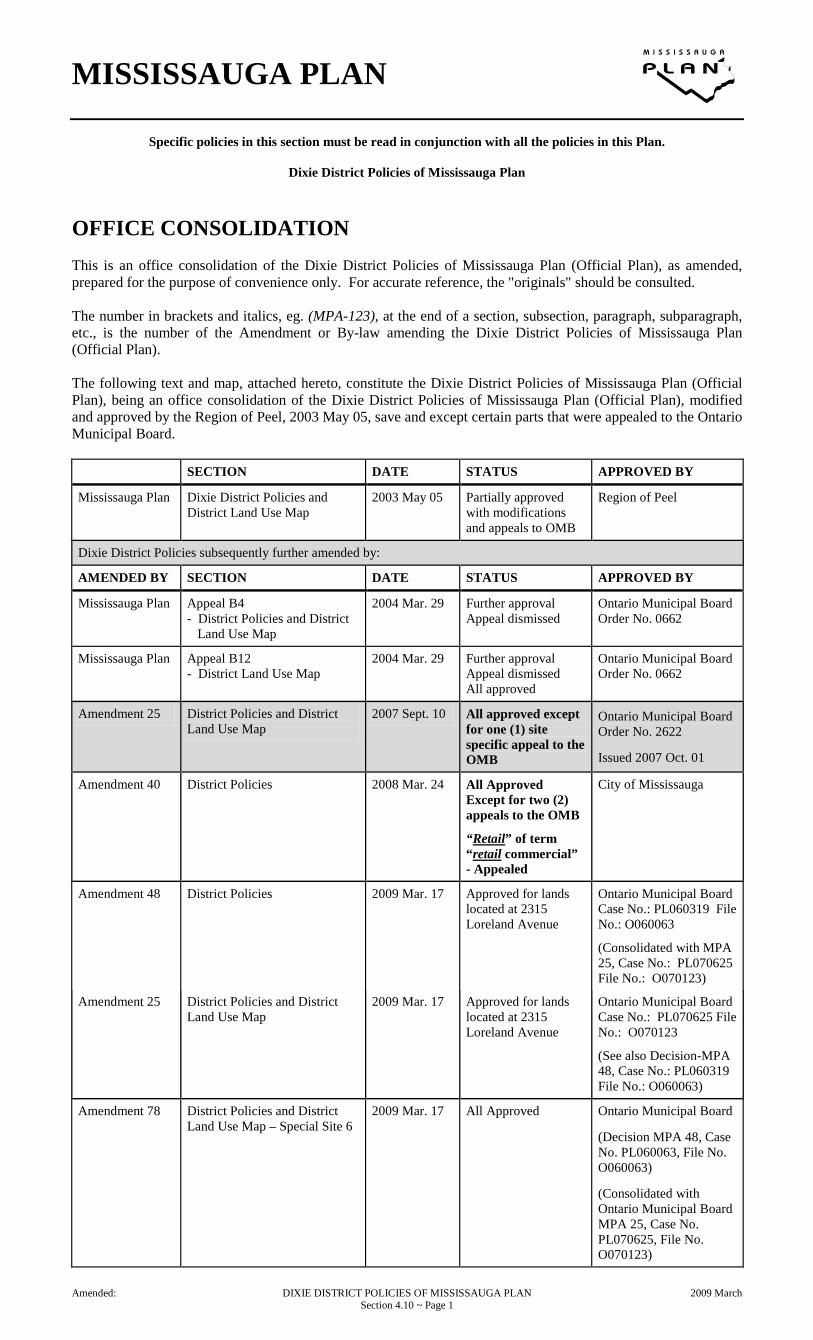
OFFICE CONSOLIDATION This is an office consolidation of the Dixie District Policies of Mississauga Plan (Official Plan), as amended, prepared for the purpose of convenience only. For accurate reference, the "originals" should be consulted. The number in brackets and italics, eg. (MPA-123), at the end of a section, subsection, paragraph, subparagraph, etc., is the number of the Amendment or By-law amending the Dixie District Policies of Mississauga Plan (Official Plan). The following text and map, attached hereto, constitute the Dixie District Policies of Mississauga Plan (Official Plan), being an office consolidation of the Dixie District Policies of Mississauga Plan (Official Plan), modified and approved by the Region of Peel, 2003 May 05, save and except certain parts that were appealed to the Ontario Municipal Board. SECTION DATE STATUS APPROVED BY
Mississauga Plan Dixie District Policies and District Land Use Map
2003 May 05 Partially approved with modifications and appeals to OMB
Region of Peel
Dixie District Policies subsequently further amended by:
AMENDED BY SECTION DATE STATUS APPROVED BY
Mississauga Plan Appeal B4 - District Policies and District
Land Use Map
2004 Mar. 29 Further approval Appeal dismissed
Ontario Municipal Board Order No. 0662
Mississauga Plan Appeal B12 - District Land Use Map
2004 Mar. 29 Further approval Appeal dismissed All approved
Ontario Municipal Board Order No. 0662
Amendment 25 District Policies and District Land Use Map
2007 Sept. 10 All approved except for one (1) site specific appeal to the OMB
Ontario Municipal Board Order No. 2622
Issued 2007 Oct. 01
Amendment 40 District Policies 2008 Mar. 24 All Approved Except for two (2) appeals to the OMB
“Retail” of term “retail commercial” - Appealed
City of Mississauga
Amendment 48
District Policies 2009 Mar. 17 Approved for lands located at 2315 Loreland Avenue
Ontario Municipal Board Case No.: PL060319 File No.: O060063
(Consolidated with MPA 25, Case No.: PL070625 File No.: O070123)
Amendment 25 District Policies and District Land Use Map
2009 Mar. 17 Approved for lands located at 2315 Loreland Avenue
Ontario Municipal Board Case No.: PL070625 File No.: O070123
(See also Decision-MPA 48, Case No.: PL060319 File No.: O060063)
Amendment 78 District Policies and District Land Use Map – Special Site 6
2009 Mar. 17 All Approved Ontario Municipal Board
(Decision MPA 48, Case No. PL060063, File No. O060063)
(Consolidated with Ontario Municipal Board MPA 25, Case No. PL070625, File No. O070123)
Amended: DIXIE DISTRICT POLICIES OF MISSISSAUGA PLAN 2009 March Section 4.10 ~ Page 1

MISSISSAUGA PLAN
Specific policies in this section must be read in conjunction with all the policies in this Plan.
Dixie District Policies of Mississauga Plan
SECTION DATE STATUS APPROVED BY
Amendment 40 District Policies and District Land Use Map
2009 Dec. 01 All Approved Except for two (2) Site Specific Appeals to the OMB
Term “retail commercial” is no longer under appeal
City of Mississauga
Amendment 95 District Policies and District Land Use Map
2010 Jan. 07 Partial Approval All Appealed to the OMB
(Azuria Group, Gemini Urban Design (Cliff) Corp., Orlando Corp., Solmar Dev. Corp. and Berkley Homes [current owners: Hush Homes] – as it relates to lands at 1745, 1765, 1775 Thorny Brae Place)
Region of Peel
Amendment 95 District Policies and District Land Use Map
2011 Feb. 25 Partial Approval All Appealed to the OMB
(Azuria Group, Gemini Urban Design (Cliff) Corp., Orlando Corp., Solmar Dev. Corp. and Berkley Homes – as it relates to lands at 1745, 1765, 1775 Thorny Brae Place)
Region of Peel
Withdrawn: Berkley Homes – as it relates to lands at 1745, 1765, 1775 Thorny Brae Place)
2011 Feb. 25
Case No. PL101408 File No. PL100111
Amendment 95 District Policies and District Land Use Map
2011 May 09 Partial Approval All Appealed to the OMB
(Azuria Group, Gemini Urban Design (Cliff) Corp.-as it relates to the lands located at 2021-2041 Cliff Road, Orlando Corp., Solmar Dev. Corp.
Region of Peel
Withdrawn: Solmar Dev. Corp., 2011 May 09
Case No. PL101408 File No. PL100111
Amendment 95 District Policies and District Land Use Map
2011 Dec. 13 Partial Approval All Appealed to the OMB
(Azuria Group, Gemini Urban Design (Cliff) Corp.-as it relates to the lands located at 2021-2041 Cliff Road, Orlando Corp.
Region of Peel
Withdrawn: Azuria Group Inc., 2011 Dec. 13
Case No. PL101408 File No. PL100111
Amended: DIXIE DISTRICT POLICIES OF MISSISSAUGA PLAN 2011 December Section 4.10 ~ Page 2

MISSISSAUGA PLAN
Specific policies in this section must be read in conjunction with all the policies in this Plan.
Dixie District Policies of Mississauga Plan
SECTION DATE STATUS APPROVED BY
Amendment 95 District Policies and District Land Use Map
2012 Apr. 25 Partial Approval Site Specific Appeal to the OMB
Gemini Urban Design (Cliff) Corp.-as it relates to the lands located at 2021-2041 Cliff Road Orlando Corp.
Region of Peel
Withdrawn: Orlando Corp., 2012 Apr. 25
Case No. PL101408 File No. PL100111
Amendment 95 District Policies and District Land Use Map
2012 Nov. 20 All Approved Region of Peel
Withdrawn: Gemini Urban Design (Cliff) Corp.-as it relates to the lands located at 2021-2041 Cliff Road 2012 Nov. 20 Case No. PL101408 File No. PL100111
Copyright © 2007 City of Mississauga Not to be reproduced without permission
Amended: DIXIE DISTRICT POLICIES OF MISSISSAUGA PLAN 2012 November Section 4.10 ~ Page 3

MISSISSAUGA PLAN
Specific policies in this section must be read in conjunction with all the policies in this Plan.
Dixie District Policies of Mississauga Plan
PREFACE The adopting By-laws and Region of Peel approval certificate for Mississauga Plan (Official Plan) is on file in the Planning and Building Department. CITY OF MISSISSAUGA APPROVAL Mississauga Plan (Official Plan) for the City of Mississauga, except for the Commercial Policies and Commercial Land Use Designations, was adopted by By-law Number 0317-2002 by City Council on the 10th day of July, 2002. The Commercial Policies, Commercial Land Use Designations and modifications for Mississauga Plan (Official Plan) were adopted by By-law Number 0085-2003 by City Council on the 26th day of February, 2003. REGION OF PEEL APPROVAL Pursuant to sections 17(35) of the Planning Act, the Region of Peel made a Decision on 2003 March 31, to modify and approve part of Mississauga Plan (Official Plan) for the City of Mississauga Planning Area as adopted by By-laws 0317-2002 and 0085-2003 Dated at Brampton this 31st day of March, 2003. "NICK TUNNACLIFFE" Commissioner of Planning Region of Peel The Notice of Decision was issued 2003 April 14 with the Last Date of Appeal being 2003 May 04.
ONTARIO MUNICIPAL BOARD APPEALS MISSISSAUGA PLAN (OFFICIAL PLAN) CAME INTO EFFECT 2003 MAY 05, EXCEPT FOR THE FOLLOWING WHICH HAVE BEEN APPEALED TO THE ONTARIO MUNICIPAL BOARD. Pursuant to section 17(42) of the Planning Act, the Region of Peel is forwarding to the Ontario Municipal Board the following parts of Mississauga Plan (Official Plan), which have been appealed as set out in Part B, and indicated in Mississauga Plan (Official Plan) text and on the Schedules and Land Use Maps and labelled as B#. THE FOLLOWING PARTS OF MISSISSAUGA PLAN HAVE BEEN APPEALED: B4. The following in their entirety (Greater
Toronto Airports Authority): ● Section 4.10, Dixie District
Policies: – Section 4.10.4.2, Commercial,
Land Use; – District Land Use Map, the
Commercial Land Use Designations.
APPEAL DISMISSED OMB Order No. 0662 - 2004 Mar. 29 B12. The following in their entirety
(Canadian Petroleum Products Institute): ● Section 4.10, Dixie District
Policies: – District Land Use Map, the
Business Employment Land Use Designations.
APPEAL DISMISSED OMB Order No. 0662 - 2004 Mar. 29 "MARK H. KLUGE" Principal Planner Development Planning Services Region of Peel ALL APPEALS HAVING BEEN SETTLED, THE DIXIE DISTRICT POLICIES OF MISSISSAUGA PLAN ARE IN FULL FORCE AND EFFECT.
Amended: DIXIE DISTRICT POLICIES OF MISSISSAUGA PLAN 2007 September Section 4.10 ~ Page 4

MISSISSAUGA PLAN
Specific policies in this section must be read in conjunction with all the policies in this Plan.
Dixie District Policies of Mississauga Plan
4.10 DIXIE 4.10.1 Planning Context Lands within the Dixie District were designated for industrial, commercial, residential and greenbelt uses under the Township of Toronto Plan. The 1981 Official (Primary) Plan designated the lands in the District (south of Dundas Street East) for primarily General Industrial, Mixed Industrial and Commercial, Residential and Major Open Space. The intersection of Dixie Road and Dundas Street East was also designated as a District Centre. The 1988 North Dixie Secondary Plan designates the lands north of Dundas Street East, east of Dixie Road as General Industrial, Mixed Industrial and Commercial and Greenbelt. Most of the lands in the District are developed for commercial and employment uses. Development along Dundas Street East has evolved over the last fifteen (15) years to be predominantly retail commercial in nature, dominated by retail warehouse uses, largely in the form of home furnishing outlets, as well as motor vehicle commercial uses, restaurants and motels. There are a few remaining general industrial uses between Dundas Street East and the St. Lawrence & Hudson Railway line, some of which have frontage on Dundas Street East. (MPA-40) A small pocket of residential development of approximately one-hundred (100) dwellings exists south of Dundas Street East, east of Dixie Road. Development north of Dundas Street East between Dixie Road and the Etobicoke Creek consists mainly of general industrial uses including warehousing and distribution and manufacturing. The District is within the watersheds of the Etobicoke Creek, the Little Etobicoke Creek, and Applewood Creek. The Etobicoke Creek and Little Etobicoke Creek are the main natural features in the District, and two (2) Special Policy Areas related to floodplain planning have been identified. The District also contains a number of contaminated sites or potentially contaminated sites and closed or current waste disposal sites.
NOTE: All terms listed in Section 7, Glossary, where used, are bolded and italicised throughout the text. (MPA-25)
Amended: DIXIE DISTRICT POLICIES OF MISSISSAUGA PLAN 2008 March Section 4.10 ~ Page 5
MISSISSAUGA PLAN
Specific policies in this section must be read in conjunction with all the policies in this Plan.
Dixie District Policies of Mississauga Plan
4.10.2 Development Concept This Plan recognizes the established nature of the District and encourages continued development for employment and commercial uses. Dundas Street East is recognized as a unique commercial corridor which offers a wide variety of goods and services which are not generally accommodated in the planned commercial facilities elsewhere in the City, and which provides a regional draw to the City. A broad range of employment uses in the non-commercial areas of the District is also allowed, recognizing current trends towards non-traditional industrial uses, and excluding uses which may negatively affect neighbouring Residential Districts. The existing residential enclave is recognized but the Plan does not accommodate further residential development. A high quality image is encouraged in the District through extensive design policies, particularly along major roads and at the Dundas Street East and Queensway East "gateways" to the City.
4.10.3 Urban Design Policies 4.10.3.1 Community Identity and Design a. An appropriate gateway treatment should
be created at the City boundaries at Dundas Street East and the Queensway East through the massing of buildings, landscape design, or the design of the streetscape. A gateway treatment for Dundas Street East is outlined in the Special Site policies. The Queensway East gateway should use adjacent greenbelt lands and the median on the Queensway East for feature landscaping to frame the entrance to the City.
b. The streetscape along Dundas Street East
should be enhanced by the punctuation of built form with architectural interest at designated sites. These locations include the gateways at the City boundary and the intersections of Dundas Street with Dixie Road, Haines Road and Stanfield Road. These sites should be developed with a unique and/or significant built form along the street to act as orienting landmarks. The built form and site layout should punctuate the streetscape with architectural interest, which can be achieved by maximizing building heights, encouraging creative building massing solutions to break up the dominant rhythm of one-storey structures, reducing front yard parking, emphasis on enhanced landscape treatment, and the inclusion of signage as an integral part of the overall architecture of the building(s).
c. Planting should be provided appropriate to
the circumstances and existing vegetation will be preserved in order to maintain the character of the District. Where continuous street planting along Dundas Street East is not possible, concentrated landscape planting may be required.
d. Development along Dixie Road between
Dundas Street East and the GO Transit Station should attempt to encourage active pedestrian use, by minimizing building setbacks and the amount of parking between the building and the street. Development should be designed with a significant portion of the building mass located along the linear street frontage. The space between the front wall of the building and the streetline should be treated as a continuous landscape area with no parking or driveway areas. A pedestrian connection should be provided from the public sidewalk to the principal building entrance.
Amended: DIXIE DISTRICT POLICIES OF MISSISSAUGA PLAN 2007 September Section 4.10 ~ Page 6

MISSISSAUGA PLAN
Specific policies in this section must be read in conjunction with all the policies in this Plan.
Dixie District Policies of Mississauga Plan
4.10.4 Land Use 4.10.4.1 Residential 4.10.4.1.1 Residential Low Density I The Residential Low Density I designation permits detached, semi-detached and duplex dwellings at a maximum density of 17 units per net residential hectare. 4.10.4.2 Commercial 4.10.4.2.1 General Retail Commercial (MPA-40) a. Offices and industrial uses, including,
manufacturing, assembling, processing, fabricating, research and development, sales and service, warehousing, distributing and wholesaling within enclosed buildings, will also be permitted.
b. Flea market uses will be limited to indoor
flea markets. 4.10.4.3 Business Employment (MPA-25) Notwithstanding the Business Employment policies of this Plan, the following additional uses will be permitted: a. existing industrial uses that require
extensive outdoor processing and storage will be permitted, and may expand, except where adjacent to residentially designated lands.
Amended: DIXIE DISTRICT POLICIES OF MISSISSAUGA PLAN 2008 March Section 4.10 ~ Page 7
MISSISSAUGA PLAN
Specific policies in this section must be read in conjunction with all the policies in this Plan.
Dixie District Policies of Mississauga Plan
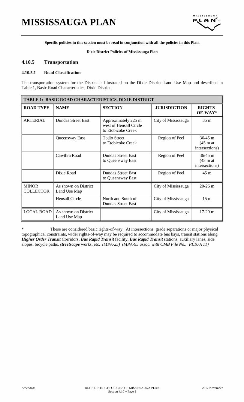
4.10.5 Transportation 4.10.5.1 Road Classification The transportation system for the District is illustrated on the Dixie District Land Use Map and described in Table 1, Basic Road Characteristics, Dixie District. TABLE 1: BASIC ROAD CHARACTERISTICS, DIXIE DISTRICT
ROAD TYPE NAME SECTION JURISDICTION RIGHTS- OF-WAY*
ARTERIAL Dundas Street East Approximately 225 m west of Hensall Circle to Etobicoke Creek
City of Mississauga 35 m
Queensway East Tedlo Street to Etobicoke Creek
Region of Peel 36/45 m (45 m at
intersections)
Cawthra Road Dundas Street East to Queensway East
Region of Peel 36/45 m (45 m at
intersections)
Dixie Road Dundas Street East to Queensway East
Region of Peel 45 m
MINOR COLLECTOR
As shown on District Land Use Map
City of Mississauga 20-26 m
Hensall Circle North and South of Dundas Street East
City of Mississauga 15 m
LOCAL ROAD As shown on District Land Use Map
City of Mississauga 17-20 m
* These are considered basic rights-of-way. At intersections, grade separations or major physical topographical constraints, wider rights-of-way may be required to accommodate bus bays, transit stations along Higher Order Transit Corridors, Bus Rapid Transit facility, Bus Rapid Transit stations, auxiliary lanes, side slopes, bicycle paths, streetscape works, etc. (MPA-25) (MPA-95 assoc. with OMB File No.: PL100111)
Amended: DIXIE DISTRICT POLICIES OF MISSISSAUGA PLAN 2012 November Section 4.10 ~ Page 8

MISSISSAUGA PLAN
Specific policies in this section must be read in conjunction with all the policies in this Plan.
Dixie District Policies of Mississauga Plan
4.10.5.2 Road System a. Access control will be emphasized along
arterial roadways such as Dundas Street East, where High Occupancy Vehicle (HOV) lanes are currently in operation between Dixie Road and the Etobicoke Creek.
b. Mississauga will consider the extension of
Mattawa Avenue westward to Dixie Road, and a connection of Jarrow Avenue southward to the Mattawa Avenue extension.
Amended: DIXIE DISTRICT POLICIES OF MISSISSAUGA PLAN 2007 September Section 4.10 ~ Page 9

MISSISSAUGA PLAN
Specific policies in this section must be read in conjunction with all the policies in this Plan.
Dixie District Policies of Mississauga Plan
4.10.6 Special Site Policies 4.10.6.1 Introduction There are sites within the District which merit special attention and are subject to the following policies. 4.10.6.2 Site 1
4.10.6.2.1 The following lands are identified as Special Site 1: • the lands on the northeast corner of Dixie
Road and Dundas Street East, bounded by the Little Etobicoke Creek. This site is situated within a spill zone associated with the Regional Storm flood overtopping the south bank of the Little Etobicoke Creek channel;
• the lands west of Etobicoke Creek at
Dundas Street East. This site is entirely within the Regional Storm floodplain of the Etobicoke Creek. These lands are shown conceptually and are subject to further review by the Toronto and Region Conservation Authority (TRCA).
The status of Site 1 as a Special Policy Area defined by Provincial Government criteria and as established by the Toronto and Region Conservation Authority (TRCA), is described in Appendix C: Regional Storm Floodline - Special Policy Areas. Notwithstanding the policies of this Plan which relate to development within the Regional Storm floodplain, and the provisions of the General Retail Commercial, Business Employment and Greenbelt designations, the following policies will apply: (MPA-40)
a. the construction of any buildings or structures, including any additions to an existing building, and the placing or dumping of fill of any kind, or the alteration of any watercourse, will not be permitted within the Special Policy Area without the approval of the appropriate Conservation Authority;
b. development will not be permitted within
the 100-year return storm floodplain; c. development outside the 100-year return
storm floodplain will be permitted only on the basis of approvals by the City and the appropriate Conservation Authority;
d. ideally, new buildings and structures will
be protected from flooding under Regional Storm conditions. Where this level of protection is technically or economically not feasible, Mississauga may, in consultation with the appropriate Conservation Authority, consider a lesser level of protection. In no case, however, will the minimum level of protection be less than the 350-year return storm floodplain;
Amended: DIXIE DISTRICT POLICIES OF MISSISSAUGA PLAN 2007 September Section 4.10 ~ Page 10
MISSISSAUGA PLAN
Specific policies in this section must be read in conjunction with all the policies in this Plan.
Dixie District Policies of Mississauga Plan
e. notwithstanding subsections c. and d. of this section, development, or additions will not be permitted, where, as a result of a flood event equal to or less than the Regulatory Flood, structures will be subject to flows which, due to velocity and/or depth, would present conditions of hazard to life or potential damage to structures;
f. in support of any development application,
the City or the appropriate Conservation Authority may require engineering studies related to flood frequency, velocity and depth of flood flows, appropriate flood damage reduction measures, and storm water management techniques. Based on these studies and other information, Mississauga or the TRCA may specify that any approval of the application will be subject to certain design considerations related to location, structural integrity, setbacks, coverage, elevation of ground floor openings, and other matters as may be determined by the City or the appropriate Conservation Authority;
• ingress and egress should be "safe"
pursuant to Provincial Government floodproofing standards, and/or achieve the maximum level of flood protection determined to be feasible and practical based on existing infrastructure;
• new development not be permitted to
locate in the floodplain where the use is:
— associated with the manufacture,
storage, disposal and/or consumption of hazardous substances or the treatment, collection and disposal of sewage, which would pose an unacceptable threat to public safety if they were to escape their normal containment/use as a result of flooding or failure of floodproofing measures;
— associated with uses, such as
hospitals, nursing homes and schools, which would pose a significant threat to the safety of the inhabitants (e.g. the sick, the elderly, the disabled or the young), if involved in an emergency evacuation situation as a result of flooding or failure of floodproofing measures;
and
— associated with services such as those provided by fire, police and ambulance stations and electrical substations, which would be impaired during a flood emergency as a result of flooding or failure of floodproofing measures;
where new development is not considered to pose an unacceptable risk to public safety, a higher level of flood protection and/or additional floodproofing precautions above the regulatory flood level, may still be required due to the sensitive nature of the development;
g. any amendment to the Zoning By-law will
include provisions required by the City or the appropriate Conservation Authority to implement the Special Site Policies of this Plan.
4.10.6.2.2 Area 1A The lands identified as Area 1A is located north and south of Dundas Street East, from Southcreeek Road to the municipal boundary, Etobicoke Creek. These lands function as the primary gateway into Mississauga from Toronto and areas to the east, and should promote distinctive built form, landscaping and street furniture elements as visual landmarks to identify the City entry and reinforce a quality image. Notwithstanding the provisions of the General Retail Commercial designation of the lands, the following additional policies will apply: (MPA-40) a. motor vehicle sales and rentals and other
commercial or industrial uses with outdoor storage, flea markets, and motor vehicle commercial uses will not be permitted;
b. consolidation of vehicular entrances should
be encouraged; c. active building frontages should be oriented
to the public street, maximizing the linear street frontage occupied by the building;
d. building definition is to be strengthened on
the street facade by use of prominent roof forms, upper level window bands, architectural projections, and other design elements to accentuate the height and prominence of single storey buildings;
Amended: DIXIE DISTRICT POLICIES OF MISSISSAUGA PLAN 2008 March Section 4.10 ~ Page 11
MISSISSAUGA PLAN
Specific policies in this section must be read in conjunction with all the policies in this Plan.
Dixie District Policies of Mississauga Plan
e. special formal street tree planting at regular intervals is encouraged along the frontage of the gateway properties.
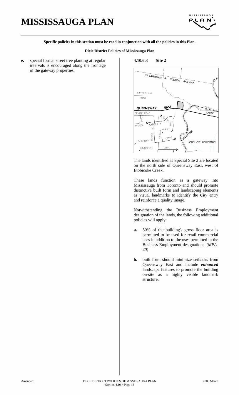
4.10.6.3 Site 2
The lands identified as Special Site 2 are located on the north side of Queensway East, west of Etobicoke Creek. These lands function as a gateway into Mississauga from Toronto and should promote distinctive built form and landscaping elements as visual landmarks to identify the City entry and reinforce a quality image. Notwithstanding the Business Employment designation of the lands, the following additional policies will apply: a. 50% of the building's gross floor area is
permitted to be used for retail commercial uses in addition to the uses permitted in the Business Employment designation; (MPA-40)
b. built form should minimize setbacks from
Queensway East and include enhanced landscape features to promote the building on-site as a highly visible landmark structure.
Amended: DIXIE DISTRICT POLICIES OF MISSISSAUGA PLAN 2008 March Section 4.10 ~ Page 12
MISSISSAUGA PLAN
Specific policies in this section must be read in conjunction with all the policies in this Plan.
Dixie District Policies of Mississauga Plan
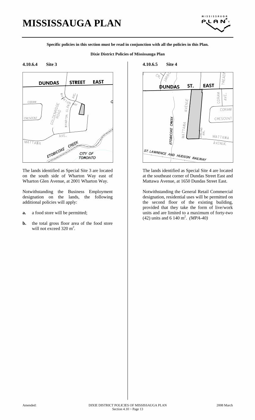
4.10.6.4 Site 3
The lands identified as Special Site 3 are located on the south side of Wharton Way east of Wharton Glen Avenue, at 2001 Wharton Way. Notwithstanding the Business Employment designation on the lands, the following additional policies will apply: a. a food store will be permitted; b. the total gross floor area of the food store
will not exceed 320 m2.
4.10.6.5 Site 4
The lands identified as Special Site 4 are located at the southeast corner of Dundas Street East and Mattawa Avenue, at 1650 Dundas Street East. Notwithstanding the General Retail Commercial designation, residential uses will be permitted on the second floor of the existing building, provided that they take the form of live/work units and are limited to a maximum of forty-two (42) units and 6 140 m2. (MPA-40)
Amended: DIXIE DISTRICT POLICIES OF MISSISSAUGA PLAN 2008 March Section 4.10 ~ Page 13

MISSISSAUGA PLAN
Specific policies in this section must be read in conjunction with all the policies in this Plan.
Dixie District Policies of Mississauga Plan
4.10.6.6 Site 5 Deleted by Amendment No. 25. (MPA-25)
4.10.6.7 Site 6 (MPA-25) (MPA- 78)
The lands identified as Special Site 6 are located on the east side of Loreland Avenue, south of Dundas Street East, at 2315 Loreland Avenue. Notwithstanding the provisions of the Business Employment designation on the lands and Section 3.11.6.3 Electric Power, Telephone and other Cabled Services, a Power Generating Facility will be permitted. (OMB File No. O070123)
Amended: DIXIE DISTRICT POLICIES OF MISSISSAUGA PLAN 2009 March Section 4.10 ~ Page 14

MISSISSAUGA PLAN
Specific policies in this section must be read in conjunction with all the policies in this Plan.
Dixie District Policies of Mississauga Plan
Amended: DIXIE DISTRICT POLICIES OF MISSISSAUGA PLAN 2007 September Section 4.10 ~ Page 15

MISSISSAUGA PLAN
Specific policies in this section must be read in conjunction with all the policies in this Plan.
Dixie District Policies of Mississauga Plan
Dixie District Land Use Map Amended by: Appeal B4 (OMB Order No. 0662) $ The OMB has dismissed the appeal of the
"Commercial" Land Use Designations (Greater Toronto Airports Authority).
Appeal B12 (OMB Order No. 0662) $ The OMB has dismissed the appeal of the
"Business Employment" Land Use Designations (Canadian Petroleum Products Institute).
Amendment No. 25 $ Amend – Land Use Designation of the lands
located north of the St. Lawrence and Hudson Railway, west of Blundell Road from "Business Employment" to "General Commercial";
$ Amend – Land Use Designation of the lands located as follows: - at the southwest corner of Dundas Street
East and Haines Road; - at the southeast corner of Dundas Street
East and Haines Road; - at the southeast corner of Dundas Street
East and Stanfield Road; - at the southeast corner of Dundas Street
East and Dixie Road; from " Motor Vehicle Commercial " to "General Commercial";
$ Amend – Land Use Designation of the lands located at the northwest corner of Queensway East and Cawthra Road from "Motor Vehicle Commercial" to "Business Employment";
$ Amend Land Use Designations – delete "Motor Vehicle Commercial";
$ Amend – Land Use Designation of the lands located south of the St. Lawrence and Hudson Railway, west of Etobicoke Creek, from "Open Space" to "Business Employment" and "Greenbelt";
$ Amend Land Use Designations – delete "Open Space";
Amendment No. 95 • Amend – Land Use Map by removing
Eglinton Avenue as a Major Transit Corridor. (MPA-95 assoc. with OMB File No.: PL100111)
Amended: DIXIE DISTRICT POLICIES OF MISSISSAUGA PLAN 2012 November Section 4.10 ~ Page 16