do geologic mapping programs in the u.s. as presently constituted meet pressing societal needs? don...
TRANSCRIPT

DO GEOLOGIC MAPPING PROGRAMS IN THE U.S. AS PRESENTLY CONSTITUTED
MEET PRESSING SOCIETAL NEEDS?
Don McKayIllinois State Geological Survey
Institute of Natural Resource Sustainability
Geological Society of AmericaPortland, OregonOctober 17, 2009

Overview
– Objectives of geologic mapping– Ongoing programs and progress– Are programs reaching objectives?– A role for geologic mapping coalitions– Charge: Make 3-D more than our secret!

National Cooperative Geologic Mapping Program (NCGMP)
A 3-D geologic framework is the integrator of geoscience information.
Mission: To provide reliable geologic maps and subsurface frameworks that contribute to sustaining and improving the quality of life and economic vitality of the Nation and
mitigating hazardous events and conditions.
Source: NCGMP 2009

Geologic Mapping Programs
• NCGMP– Since 1992– Components
• STATEMAP (mapping by state geological surveys)• EDMAP• FEDMAP
• Regional Coalitions and Federal Initiatives (NEW)– Funding (steady and not growing)– Progress (steady but slow)
• Other mapping in the U.S. – County and local funds or special projects & appropriations
• Mainly surficial mapping; some 3-D
– Innovative approaches using 3-D• U.S. Midwest and elsewhere
• International 3-D mapping! – U. K., Netherlands, Australia, France, Canada, Germany,
Finland...

NCGMP Approach
• Mainly bedrock or surficial geology• 1:24K and 1:100K• Standard map product:
– Map sheet and inset maps– Cross section(s)– Explanation and supplemental text– Digital graphics and sometimes data
• 3-D is a minor component so far
Bedrock vs. Surficial Mapping to Date
Source: NCGMP 2009
Bedrock Maps - 2,928
Surficial Maps - 863
23%
77%

$0.00
$1,000,000.00
$2,000,000.00
$3,000,000.00
$4,000,000.00
$5,000,000.00
$6,000,000.00
$7,000,000.00
1993 1995 1997 1999 2001 2003 2005 2007 2009
STATEMAP FUNDING 1993-2009
Source: NCGMP 2009
43 to 47 States Participating
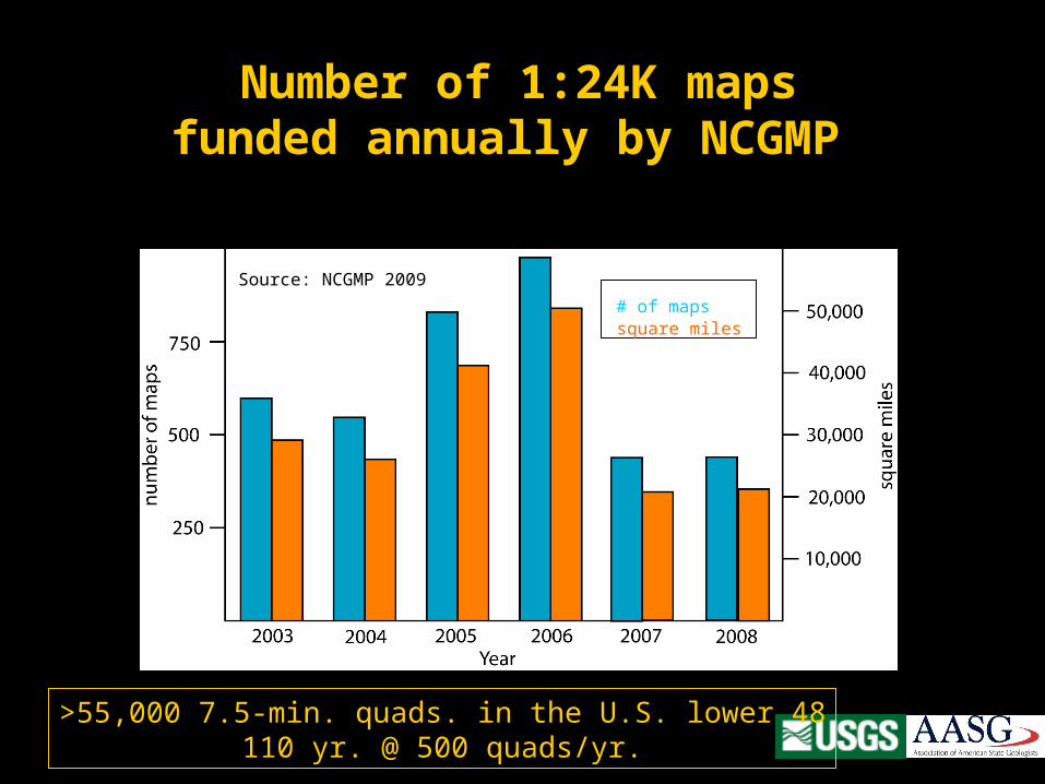
Number of 1:24K mapsfunded annually by NCGMP
# of mapssquare miles
Source: NCGMP 2009
>55,000 7.5-min. quads. in the U.S. lower 48110 yr. @ 500 quads/yr.

Total funding to State Surveys
since 1993:
$81,135,816
Matched $ for $
Source: NCGMP 2009

National Geologic Map Database of Area Mapped
Source: NCGMP 2009
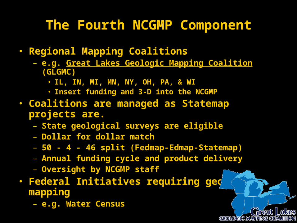
The Fourth NCGMP Component
• Regional Mapping Coalitions – e.g. Great Lakes Geologic Mapping Coalition (GLGMC)
• IL, IN, MI, MN, NY, OH, PA, & WI• Insert funding and 3-D into the NCGMP
• Coalitions are managed as Statemap projects are.– State geological surveys are eligible– Dollar for dollar match– 50 - 4 - 46 split (Fedmap-Edmap-Statemap)– Annual funding cycle and product delivery– Oversight by NCGMP staff
• Federal Initiatives requiring geologic mapping– e.g. Water Census

The GLGMC seeks to map near-surface (glacial) geology of select areas in 3-D
>100,000
>500,000
>1,000,000
Population by Metropolitan Statistical Area
>5,000,000
>2,500,000
Source: U.S. Census Bureau
3-D mapping is needed especially near cities where:
• Growth has been concentrated.• Natural resource demands are large.• Economic development is (can be) rapid. • Human health and safety issues are potentially severe.• Environmental problems are long-standing and widespread.• Consequences of decisions made in ignorance are serious.

3-D Approach is Optimum for:• Geologic data
– Integration– Visualization– Analysis– Interpretation
• Geologic framework – Synthesis– Representation– Refinement
• Technology transfer– Input to other models, e.g. groundwater flow & transport
• Presentation– Communication to non-scientists– Intuitive understanding

Bylot Island, Canada
Knik Glacier, AK
ice
sediment
Complex glacialsedimentaryenvironments
Unaware of
what lies beneath

Glaciated Terrain Demands Subsurface
Exploration
In glacial terrain:• Surficial features don’t allow prediction of subsurface unit character, composition, continuity, depth or thickness• Strike and dip are useless• Facies changes are abrupt• Erosion surfaces are common • Structural deformation may be intense

A State-Federal Partnership
since 1997

IndianapolisIndianapolis
19991997
Input from map users — indentified issues
Stakeholder Forums
1997199920012002
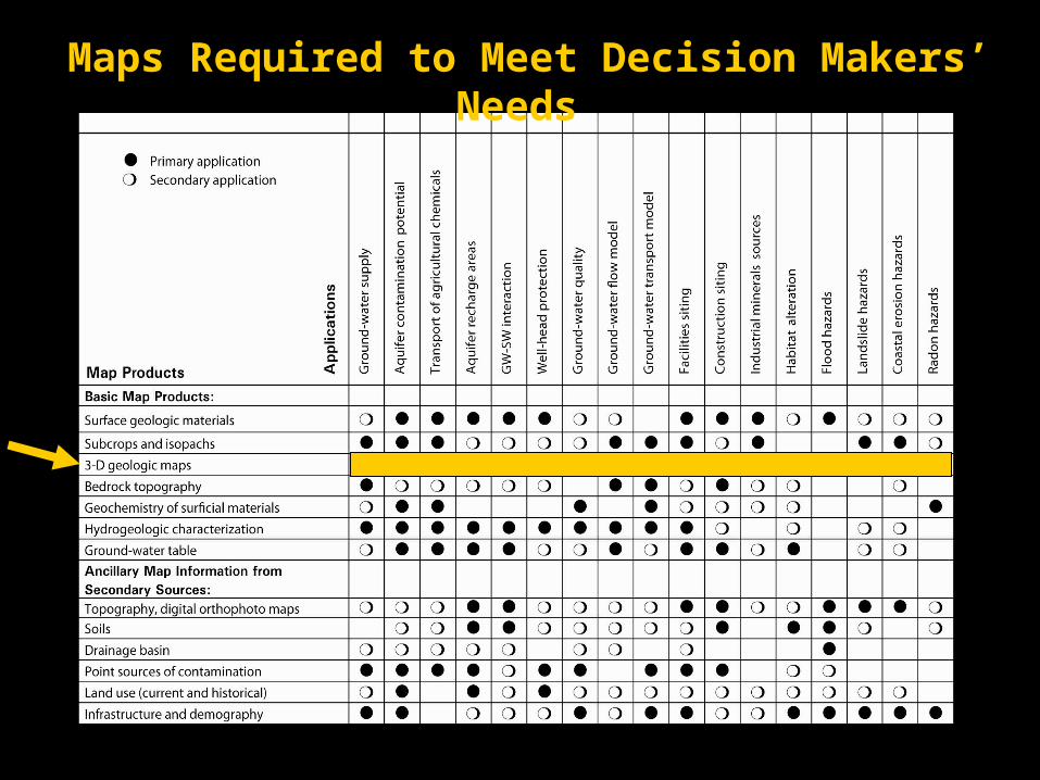
Maps Required to Meet Decision Makers’ Needs

Input from map users — identifies priority areas

Congressional InteractionsCoalition members and stakeholders
carry the message to Washington!
1997-2009
Coalition members and stakeholders
carry the message to Washington!
1997-2009
Great Lakes Geologic Mapping Coalition

“Hill” Visits 2009• Congressional offices of 6 of 8
Coalition states• 89 meetings• Multi-state Congressional
delegation letters (House & Senate)
• Interior Appropriations Staff (Senate and House)
• OSTP, Executive Office of the President
• Office of Management and Budget
• Department of the Interior


5 miles
GLGMC deliversmaps

Where needed the GLGMC maps the subsurface using 3-D tools
aquifersaquitards
NW Lake Co.
3-D Geologic model ofQuaternary deposits,
Lake Co., IL

Drift Thickness Bedrock Topography
Aquifer Extent Depth to Aquifer
Derivativesubsurfacemaps

Projected 3-D image
DEM and DOQ
Seismic profileSource: Virtalis
Adopt New Technology

Borehole records coded for lithotype, Lake Co., IL,
Buried ice-marginal delta
Source: Virtalis

What next?
• 3-D Workshops– 2001 | 2002 | 2004 | 2005 | 2007 | 2009 ...– 3-D tools, techniques, and products that were
novel in 2001 are increasingly sophisticated.– The technology and expertise are maturing.– The world community of 3-D practitioners is
interconnected and growing.
• The 3-D approach is a natural evolution of geological mapping
• Aren’t we ready to implement it widely?• Who better than the practitioners to help take
3-D to the next step?

ChargeMake 3-D more than our secret.
Be a factor in making 3-D geologic modeling & mapping the approach of choice.
– Share 3-D technology and resources. – Network with others using 3-D approaches.– Promote broader awareness of the need for 3-D. – Demonstrate the value of 3-D by applying it regularly.
– Form or join a mapping coalition. – Identify and involve stakeholders. – Contact Congress & Administration.– Seek to increase funding of the NCGMP. – Support your Geological Survey and Coalition.

AcknowledgementsIllinois State Geological Survey
Dick Berg, Steve Brown, Don Keefer, Jason Thomason
Institute of Natural Resource Sustainability - UIUCBill Shilts
GLGMC Member states: Indiana - John SteinmetzOhio - Larry WickstromMichigan - Hal FitchPennsylvania - Jay ParrishNew York - Bill KellyMinnesota - Harvey ThorliefsonWisconsin - Jamie Robertson
USGSRandy OrndorffDave SollerJim McNeilNCGMP team