do-roam: activity-oriented search and navigation with
TRANSCRIPT

DO-ROAM: Activity-Oriented Search andNavigation with OpenStreetMap
Mihai Codescu1, Gregor Horsinka1, Oliver Kutz2,Till Mossakowski1,2, and Rafaela Rau1
1 DFKI GmbH Bremen2 Research Center on Spatial Cognition (SFB/TR 8),
University of Bremen, Germany
Abstract. We develop a web service focusing on finding places not(only) by their address, but by systematically relating the places to ac-tivities that a person could perform there. This is helpful if a personwants to explore a new city, or plans leisure activities. OpenStreetMapprovides a rich set of tags that can be used for activity-oriented search.We propose the use of several ontologies that are related to each other us-ing matching tools to cope with the evolving nature of the tags availablein social media.
1 Introduction
OpenStreetMap has evolved into a rich source of geodata that in some as-pects (like e.g. the level of detail for certain pedestrian lanes) even gets aheadof Google maps. When searching and navigating through a map portal likehttp://www.openstreetmap.org, semantic metadata could greatly help withproviding an intention and activity-based access to the data. In the case of Open-StreetMap, the metadata is provided in the form of tags that are entered intothe database in a Social Web and wiki-like manner. Metadata obtained throughsuch Social Web, collaborative and community based efforts have specific charac-teristics, namely evolve in a bottom-up way, contain a lot of noise (typos, redun-dancies, etc.) and are subject to constant change. A main challenge now is howto use such metadata in flux in a meaningful way for an activity-based searchand navigation tool. In this paper, we use ontologies and (semi-automaticallygenerated) ontology mappings for bridging the gap between (a single) user’s in-tentions and the (community generated) metadata tags. This approach providesa relatively simple, yet effective solution to the generally rather hard problem ofhow to relate data to ontologies (see [15]).
Based on this, we have developed an open source tool—DO-ROAM3—whichis a prototype providing, beyond the usual search facilities inherited from theOpenStreetMap portal, an ontology-based search for located activities and open-ing hours.
3 Freely available at www.do-roam.org.
1.1 Related Work
The GeoShare project did pioneering work on ontology-based integration of geo-data sources and services [9]. Their system performs ontological, spatial andtemporal reasoning when processing user queries. However, as the authors note,“all application ontologies have in common that they are based on the samevocabulary”. We here follow a more flexible approach based on ontology match-ing. Moreover, the authors of the GeoShare/Buster software told us that it isnot used by any web service, and it would be a great effort to get the softwarerunning again. Indeed, we have the impression that the user interface was toocomplex—a stripped down version, however without the ontology-based search,is still online4.
Google maps5 obviously uses a mixture of full-text search and search in ataxonomy of categories; unfortunately, only parts of the taxonomy are openlyavailable. While full-text search can in some cases provide extra value, sometimesit can also produce misleading results. For example, when entering “new yorkbarber restaurant” or “new york barber near restaurant”, you get results inthe category “restaurant” for which the word “barber” occurs in a related textdocument (or vice versa), but only few restaurants near barbers. Searching for“charging station” in most cities does not deliver any results at all.
In comparison, whilst searching for “charging station” in OpenStreetMapdoes in fact not deliver any results at all, OSM’s internal data is open andpublicly accessible, and thus better search methods, employing e.g. the OSMtags, can be utilised in order to semantically enrich queries. Thus, we intendto realise an activity-oriented search where several activities can be combined,thereby leading to various possibilities for searching for nearby places, or for therestriction of a search to certain opening hours.
Google city tours6 suggests touristic tours starting from a given point; how-ever, the user cannot enter specific activities. Other works that stress the impor-tance of activities and actions in GIS include [10, 17], who argue that in orderto make geographical information really useful, corresponding ontologies wouldhave to be designed with a focus on human activities rather than being ‘staticand entity-based’. Moreover, similar to our approach mapping metadata tags toactivities in an ontology, e.g. [10] proposes to exploit textual descriptions of ac-tivities in order to derive domain ontologies. However, unlike the present paper,these works do neither employ statistical matching methods to link these twolayers, nor do they use the OWL language, nor apply ideas from recent progressin ontology-based data access.
Our work has been much inspired by an activity-oriented interactive routeplanning system [19], see Fig. 1 and http://www.digitaltravelmate.net. Thissystem allows the user to specify interesting locations via holiday activities, androutes are planned along locations where the selected activities can be performed.
4 http://www.geoshare.umwelt.bremen.de5 http://maps.google.com6 http://citytours.googlelabs.com
2

Fig. 1. Activity-oriented interactive route planning system
Routes can also be interactively corrected. However, the system is based on afixed fictitious map, and on a small predefined set of activities.
1.2 Organisation of the Paper
The aim of our work reported in this paper is to provide activity-orientedmap search and navigation with an evolving set of activities based on Open-StreetMap’s tags, which are continuously changing due to the wiki-nature ofOpenStreetMap.
The paper is organised as follows. Section 2 provides a set of use cases, andin Section 3 we describe the overall architecture of our DO-ROAM system. Themain parts of this system are then described in further detail in the subsequentsections: Section 4 recalls some technical background on the web ontology lan-guage OWL, Section 5 introduces the ontology of activities and Section 6 theontology of OpenStreetMap tags, Section 7 discusses the mapping between thesetwo ontologies, and Section 8 finally contains a discussion on how the ontologysearch is integrated with the actual representation of data. Section 9 concludesand discusses future work.
2 Motivating Use Cases
In this section, we describe some scenarios in which people search for locationswhere certain activities take place and for routes that include such activities.
3

One important such application scenario is electric mobility, in particular dueto the limited battery reach of electric automobiles and relatively long chargingtimes. Notice that we assume that the map presented to the user is taken fromOpenStreetMap; the approach is, however, flexible and it could also use multipledata sources. [1] provide different navigation scenarios based on an ontology forGIS, which inspired the format of our use cases.
– Scenario 1: Alan spends some days in a city and he want to charge his electriccar. First, he wants to know where he can find a charging station. Second,he is interested in which activities he could do within walking distance fromthe location of the charging station.
– Scenario 2: Betty is new in town. She wants to know which activities areoffered within her neighbourhood. She also knows she will be getting hungrysoon, so she searches for all restaurants close to home and which will be stillopen within the next two hours.
– Scenario 3: Maria wants to visit her friend. On her way she needs to stopat a supermarket, an ATM and a post office. She needs a system which willgenerate and present to her a route, including all these stops, in any order.She also wants to be able to modify the resulting route.
– Scenario 4: Tom wants to travel from A to B. He wants to take the mostscenic route possible. He also wants to see displayed all places of his interestwithin a certain area that he can choose and modify. Furthermore, he wantsto get a route suggestion which is still flexible and can be modified at a laterstage.
3 General Tool Architecture of DO-ROAM
We have designed and implemented the prototype of a tool DO-ROAM for an-swering such requests and for assisting the users in spatio-temporal planning ofactivities. DO-ROAM is an acronym for Data and Ontology driven Route-findingOf Activity-oriented Mobility.
Currently, only the search component is implemented and the route findingintegration is in progress. Therefore, only Scenarios 1 and 2 from those men-tioned in Section 2 are currently supported. The general GUI of the tool isillustrated in Fig. 2. The tool displays a map (based on OpenStreetMap) with azoom functionality which allows the user to focus on a certain area of interest.Searching for locations which allow to perform desired activities can be doneeither in a guided way, using the ontology navigation bar on the left of the map,or in a less contrained way, using a text field for introducing the query. In thelatter case, address and opening hours can also be taken into account.
The tool is implemented as a Web application, using Ruby on Rails7, apopular and powerful web application framework. We have built our tool on topof the existing Rails portal for OpenStreetMap8. It must solve a data integration
7 http://rubyonrails.org/8 http://wiki.openstreetmap.org/wiki/The\_Rails\_Port
4

Fig. 2. User interface of DO-ROAM prototype
problem in the sense that the way the OpenStreetMap data is represented shouldnot be directly visible to the user, and the interaction with the user should be asfacile as possible. The solution employed is ontology-based data access (OBDA)[16, 4], where the domain of interest is modelled as an ontology which is connectedwith the data in a way that allows queries expressed in terms of the ontology tobe translated to queries in the database. Therefore, we introduced an ontology ofspatially located activities playing a central role and connecting the user interfacewith the data integration management system. The ontology will be discussedin detail in Section 5. Interestingly, the access to data is achieved by introducinganother ontology for OpenStreetMap tags, which will be presented in Section 6.The two ontologies are connected via an ontology mapping, which relates theconcepts/roles in the ontology of activities with corresponding concepts/roles inthe ontology of OSM tags. We will discuss some of the fundamentals of ontologymappings and the means for generating such mappings automatically in Section7. Moreover, we give a brief intuition on OBDA and its implementation in ourtool in Section 8. Finally, the results of the queries are displayed on a map
5

using OpenStreetMap layers: each location of a certain activity is marked witha distinctive icon. This is realized dynamically in the sense that the markers areonly introduced for locations within the current view.
The architecture of our approach is depicted in Fig. 3.
Fig. 3. Architecture of DO-ROAM’s activity-based search
The user interaction is handled via two alternative interfaces, which we willnow motivate and describe in some detail. The first one is a simple text-basedinteraction for free search, similar to the one existing in tools like Google Mapsor OpenStreetMap, while the second provides a better structuring of the querywith the help of a Web form. While the first interface seems more intuitive, thesecond has the advantage that it is easier to relate with the concepts in theontology of activities. In the case of the former, the text input by the user needsto undergo a process of linguistic analysis which extracts from the query theconcepts which are matched.
For the linguistic analysis we currently use WordNet [5] synsets. That is,the user need not exactly match the concept names of the activities ontologywith his query, but can also enter synonyms. For example, take “eating place”.If you enter “eating place New York” into Google maps, you only get a fewrestaurants, however, if you enter “restaurant New York”, you get plenty ofrestaurants. With our connection to WordNet, we get the same set of restaurantsfor both queries since WordNet knows that “eating place” and “restaurant”are synonyms. Another example would be “clothing”: when typing in “clothingLondon” into Google Maps, you get plenty of results; however, when entering
6

“dress” or “vesture”, Google Maps delivers very few outputs; in case of “vesture”,not even one. WordNet in contrast knows all words as synonyms of clothing.
The linguistic analysis also needs to divide the user’s input into class names(from the activities ontology), address parts, and time information, and it evenneeds to infer role names in some cases (like the case with restaurants havinga cuisine of a given nationality). This is currently done with a simple matchingin a comma-separated list, then the synonyms of the activity are obtained fromWordNet and used to generate a list of queries. Addresses are resolved usingthe search engines of OSM, e.g. Nominatim9. In the future, in particular inconnection with way finding, we will also use the linguistic ontology GUM [3],since it provides a more detailed semantics for linguistic spatial expressions.
We will now illustrate the way the user interacts with the tool with a stepwisedescription for the case of Scenario 1 in Section 2 . First, Alan finds the city byusing the free search text field. Afterwards, he chooses “Charging Station” in theontology navigation bar. He can then select one charging station of his choiceand zoom in to the desired scale (which is indicated using the functionality of theOSM Rails Port in the bottom-left of the map), obtaining thus an estimate of thearea reachable by foot. Then he can get displayed markers for the locations ofthe free time activities or even all possible activities using again the navigationbar. The results can be seen in Fig. 4. There is one charging station, markedwith a plug, and various activities marked with different icons.
In Scenario 2, Betty searches for her address using the free search text field,then she selects in the ontology navigation bar “Gastronomy/Restaurants” andenters the current time and two hours for duration. The results of this query areshown in Fig. 5. There are several restaurants, a cafe (at the lower right corner)and some fastfoods.
4 Ontologies and the OWL language
Ontologies are formal descriptions of the concepts in a certain domain of dis-course and can be informally understood as fixing a meaning for the terms of aparticular field. Ontologies are used in artificial intelligence, the semantic web,systems engineering, software engineering, biomedical informatics, library sci-ence, enterprise bookmarking, and information architecture as a form of knowl-edge representation about the world or some part of it. Domain ontologies aretypically formulated in the web ontology language OWL10. The relation of ourdomain ontology introduced in the next section to a suitable foundational on-tology (typically formulated in a richer logical language) is left for future work.
Formally, an OWL ontology signature consists of sets of atomic concepts,roles and individuals, which fix the vocabulary. Sentences that can be expressedare of two types: TBox sentences are subsumption relations between conceptswhich are defined inductively from atomic concepts using the universal concept,
9 http://wiki.openstreetmap.org/wiki/Nominatim10 http://www.w3.org/TR/owl2-overview/
7

Fig. 4. User interface of DO-ROAM prototype: looking for activities near chargingstations.
the empty concept, unions, disjunctions, negations and universal and existentialquantification over roles. ABox sentences contain assertions saying that certainindividuals belong to certain complex concepts expressible in the vocabulary.Since the ontologies we use here do not contain individuals, we will concentrateon presenting TBox sentences.
Several syntaxes have been designed for ontology languages; in this paperwe prefer to use Manchester OWL syntax [7] which provides, for the fragmentcorresponding to the description logic ALC, the following grammar for concepts:
C ::= A | Thing | Nothing | C and C | C or C | not C | R some C | R all C
where R is a role and A is an atomic concept.The semantics is set-theoretical: an interpretation I consists of a non-empty
set W (the universe) and an interpretation function .I which assigns a subset ofthe universe to each atomic concept, a binary relation to each role and an ele-ment of the universe to each individual. The interpretation extends from atomic
8

Fig. 5. User interface of DO-ROAM prototype: looking for restaurants open in thenext two hours.
concepts to complex concepts in the expected set-theoretic way following thegrammar, more precisely: the top concept Thing is interpreted as the universeW , Nothing as the empty set (bottom concept), a conjunction C and D bythe intersection of the interpretations for C and D, a disjunction C or D bythe union of the interpretations, not C by set-theoretic complement, and finallyuniversal (R all C) and existential (R some C) role restrictions as follows:
(R all C)I = {x ∈ W | ∀y ∈ W . RI(x, y) implies y ∈ CI}
and(R some C)I = {x ∈ W | ∃y ∈ W . RI(x, y) and y ∈ CI}
Two ontologies can be related by an ontology mapping, sending atomic con-cepts, roles and individuals of the source ontology to (not necessarily atomic)concepts, roles and individuals of the target ontology. Among many other ap-plications, ontology mappings are important for extracting modules from largeontologies.
9

5 An Ontology of Spatially Located Activities
Since the scenarios presented in Section 2 are centred on activities, we developan ontology of spatially located activities, which means that the concepts of theontology refer to locations where a certain activity takes place. This providesan abstraction level from the representation of the data in the databases andthus the user can express queries using a vocabulary closer to natural language.Notice that from an ontological perspective, the ontology developed is a taskontology : here the main motivation is not to create and specify a model of adomain, but to solve a well-defined task, namely, searching locations.
We found some interesting guidelines for building ontologies in [12]. In par-ticular, they say
We advise only creating hierarchies when necessary for describing thedomain [. . . ]. The modeller should consider whether an alternative rela-tionship can be used instead. [12]
This means that instead of subclass relations, sometimes it is more useful to useroles. For example, instead of turning “French” into subclass of “Cuisine”, it isbetter to introduce a role “hasNationality” between Cuisine and Nationality.
The ontology has been designed in several steps. The initial design was basedon common sense reasoning about the domain, incorporating ideas from the spa-tial ontology of UbisWorld11 (the SpatialPurpose concepts) and the taxonomyof medical specialisations from the Bremen city portal12. Moreover, the choiceof names for the classes of the ontology was inspired by the OSM tags; this helpsin generating the ontology mapping automatically.
One main concept in the ontology is Activity, which implicitly means a loca-tion where an activity takes place. The selected activities are dependent on theparticular scenario chosen for the application. We have currently concentratedon daily life activities and tourism. Notice however that the approach is flexibleand the ontology can be easily adapted if an alternative scenario is chosen (e.g.business activities). Related activities are grouped and form subclasses of a cer-tain activity type; this provides the advantage that the search can be done insuch a way that all found locations can be displayed with a single search.
Locations can have associated addresses or opening hours. We decided tomodel these as abstract concepts OpeningHours and Address, and to makethe analysis of the query at the string level. In the case of the opening hours,for example, they are usually stored in the OSM database as strings containingassignments of time intervals to the days of the week. The query given by theuser will also be retrieved as a set of time intervals and the test whether acertain location satisfies a certain time restriction is done using Allen’s intervalcalculus [2], in particular, using the relations “contains” and “overlaps” betweenintervals.
To illustrate the ontology design, we present in the following the Restaurantconcept.
11 http://ubisworld.ai.cs.uni-sb.de/index.php12 http://www.bremen.de/gesundheit\_und\_soziales/aerztesuche
10

Fig. 6. Ontology of activities.
Fig. 7. Restaurants with cuisine.
The restaurants can be categorized according to their cuisine (see Fig. 7,where concepts are represented as discs, roles as arrows and subconcepts asdotted lines). The cuisine is either a food speciality, like pizza or seafood, ornation-specific, say French or Italian specialities. We model this by introducingconcepts Restaurant, Cuisine and Nation, together with corresponding roles: arestaurant can have a cuisine and a cuisine can have a nationality. For cuisinesand nationalities, we introduce the corresponding subconcepts. Strictly speaking,France should be an individual of the class Nation, but for keeping the symmetrywith the ontology of tags, we prefer to introduce it as a singleton class. Noticethat French restaurants could be expressed in OWL as the concept
Restaurant and hasCuisine some (hasNationality some France)
However, a conceptual design problem in the structure of tags in Open-StreetMap requires the presence of the role hasCuisineOfNationality as com-
11

position of hasCuisine and hasNationality and thus French restaurants areequally represented as
Restaurant and hasCuisineOfNationality some France
The entire ontology has been subject to an evolving process. As mentioned,the ontology of spatially located activities will be related to an ontology ofOpenStreetMap tags. Some tags may refer to activities that were not takeninto account when designing the initial ontology. Of course, the challenge is toadd such new concepts to the ontology of activities in an automatic manner.We will address this in the next section. Moreover, other data sources couldbe plugged in, like e.g. Google Maps. The situation repeats: the new databasemay contain data that was previously not considered to relate to interestingactivities, but has since become relevant in the new context. It is then sensibleto add a corresponding concept also at the abstract level, namely the ontologyof activities.
6 An Ontology of OpenStreetMap Tags
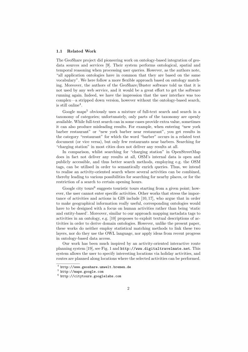
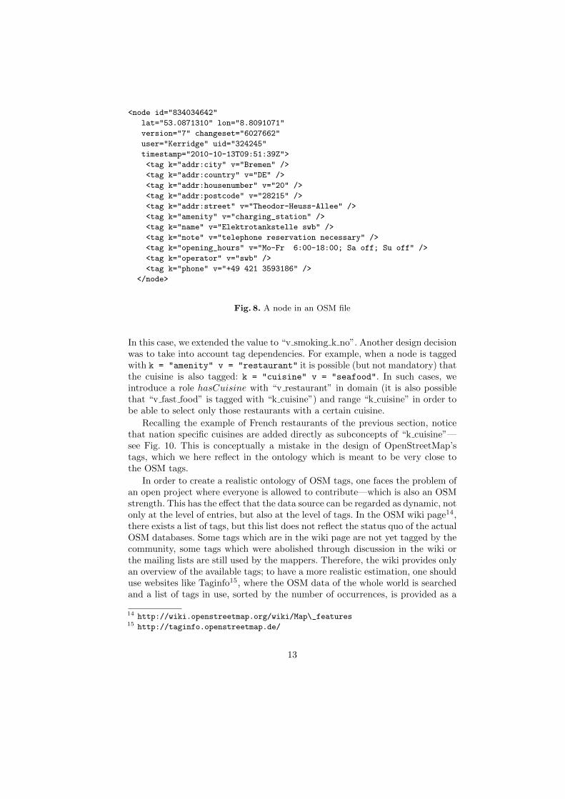
OpenStreetMap’s internal files are lists of nodes, ways and relations, which canbe tagged with information about the map element. The convention is that anyuser is free to introduce his own tag, but it is recommended to use existing tagsand only have new ones if they are not already covered by the existing ones. Thetags of the map elements are represented as pairs (key, value) and an element ofthe map may have multiple tags (see Figure 8 for the example of a OSM nodewith its tags in an XML representation. This format has been developed by theOSM community. The listed tags vary from node to node).
The purpose of the ontology of tags was to stay as close as possible to thestructure of the OSM files in order to facilitate database querying. This meansthat we do not try to correct any possible conceptual mistakes in the taxonomy ofOSM tags, but rather have it reflected faithfully in the structure of the ontology.
When designing the ontology, it makes sense to decompose the tags into ahierarchy according to the keys: the key becomes a superconcept of its values.We have followed this approach whenever the value was an OSM constant ratherthen a string/numeral. Since it is possible that a key and a value have the samename whilst the names of the concepts are required to be unique in OWL (OSMhas “station” as value of the key “railway” but also a key named “station”), wedecided to prefix all keys with “k ” and all values with “v ”, e.g.:
k = "amenity" v = "charging_station"
would introduce a concept “k amenity” with a subconcept “v charging station”.Moreover, another problem is that some values are subclasses of more than onekey. E.g. “v no” is a subclass of “k smoking” but also of “k smoking outside”.13
13 We maintain our design uniform, so “v no” must be a concept; other choices wouldalso be available.
12
<node id="834034642"
lat="53.0871310" lon="8.8091071"
version="7" changeset="6027662"
user="Kerridge" uid="324245"
timestamp="2010-10-13T09:51:39Z">
<tag k="addr:city" v="Bremen" />
<tag k="addr:country" v="DE" />
<tag k="addr:housenumber" v="20" />
<tag k="addr:postcode" v="28215" />
<tag k="addr:street" v="Theodor-Heuss-Allee" />
<tag k="amenity" v="charging_station" />
<tag k="name" v="Elektrotankstelle swb" />
<tag k="note" v="telephone reservation necessary" />
<tag k="opening_hours" v="Mo-Fr 6:00-18:00; Sa off; Su off" />
<tag k="operator" v="swb" />
<tag k="phone" v="+49 421 3593186" />
</node>
Fig. 8. A node in an OSM file
In this case, we extended the value to “v smoking k no”. Another design decisionwas to take into account tag dependencies. For example, when a node is taggedwith k = "amenity" v = "restaurant" it is possible (but not mandatory) thatthe cuisine is also tagged: k = "cuisine" v = "seafood". In such cases, weintroduce a role hasCuisine with “v restaurant” in domain (it is also possiblethat “v fast food” is tagged with “k cuisine”) and range “k cuisine” in order tobe able to select only those restaurants with a certain cuisine.
Recalling the example of French restaurants of the previous section, noticethat nation specific cuisines are added directly as subconcepts of “k cuisine”—see Fig. 10. This is conceptually a mistake in the design of OpenStreetMap’stags, which we here reflect in the ontology which is meant to be very close tothe OSM tags.
In order to create a realistic ontology of OSM tags, one faces the problem ofan open project where everyone is allowed to contribute—which is also an OSMstrength. This has the effect that the data source can be regarded as dynamic, notonly at the level of entries, but also at the level of tags. In the OSM wiki page14,there exists a list of tags, but this list does not reflect the status quo of the actualOSM databases. Some tags which are in the wiki page are not yet tagged by thecommunity, some tags which were abolished through discussion in the wiki orthe mailing lists are still used by the mappers. Therefore, the wiki provides onlyan overview of the available tags; to have a more realistic estimation, one shoulduse websites like Taginfo15, where the OSM data of the whole world is searchedand a list of tags in use, sorted by the number of occurrences, is provided as a
14 http://wiki.openstreetmap.org/wiki/Map\_features15 http://taginfo.openstreetmap.de/
13
Fig. 9. Ontology of OSM tags.
Fig. 10. Restaurants with cuisine.
result. Of course, this list will also contain spelling errors or falsely used tags. Themost straightforward solution here is to consider relevant those tags that havea certain, high occurrence in the database, using the list provided by Taginfo.This strategy could result in a limitation using a certain percentage (e.g., allvalues with, say, more than 0.3 % occurrence rate for the respective key areincluded), but this approach fails to capture all interesting values in the caseswhere some keys appear with a far higher occurrence and thus the percentageof important values is low. Also, some keys have far more values (e.g., amenitywith 7714 values in use according to Taginfo) than others (e.g., smoking with22 values), so that the percentage of each value naturally is quite low, which isanother point against a certain percentage as a limit for inclusion. This is whya limitation based on the absolute occurrence of a value makes more sense. Inour case, we decided to select all values which occur more than 100 times in thedatabase. Spelling errors are thus excluded as well (there is never 100 times the
14
same mistake), and still all relevant values will be in the database. Theoretically,this threshold could be exceeded by mistakes created during automatic taggingprocedures. In reality, there is no evidence in Taginfo that this is the case. Itis either prevented by the professionalism of those using automatic tagging, ormistakes of such quantity are quickly noticed by the community and repaired.After this procedure, we added the tags that are in the wiki but not coveredthrough our search of Taginfo. This guarantees that we also include tags whichare not yet used by the mappers, but in the future shall be implemented or willreplace other tags. To keep this ontology of tags up-to-date, one option wouldbe to make it available to the OSM community. People creating new tags couldinclude them themselves into the ontology as well. Another option is automation,e.g., programs searching regularly through Taginfo for new tags.
7 Mapping the Ontologies
The connection between the two ontologies is bi-directional. In one direction, wemap atomic concepts and roles from the ontology of activities to concepts androles in the ontology of tags. This is the first step towards assigning the elementsof the ontology of activities to queries over the database, and will be completedin the next section.
We allow the possibility that the ontology of activities contains conceptswhich are not related with OpenStreetMap tags. The reason for this is that itis possible to extend and complement the tool with a similar construction forother geographical database systems—indeed, the integration with Google Mapsis currently in progress, and this means that some activities with no counterpartin OpenStreetMap may still be found using another database. Thus, the mappingwe obtain is partial, and we can see this as having a sub-ontology of activitieswhich is then mapped totally to the ontology of OSM tags.
Since the number of concepts and roles is quite large, providing such a map-ping manually would be a very tedious process. We can, however, use an ontologymatching tool to obtain a list of pairs of concepts that are in correspondence.This approach is very effective—with the ontology matcher Falcon [8], the degreeof automation reaches 80%. This means that the user is still required to verifyand confirm the matches produced with the tool, and possibly introduce newmatchings between concepts that were not identified by the tool’s analysis.
In the other direction concerning the connection of the ontologies, the evolv-ing process for the ontology of activities has to be considered. The social char-acter of OSM makes the tags subject to continuous change: new tags are addedfrequently and they are often modifying. An example particularly relevant forthe topic of the paper is the tag for charging stations for electric cars: initially,a charging station was tagged as
k="amenity" v="fuel"
like any fuel station and with a supplementary tag
k="fuel:electricity" v="yes"
15

Fig. 11. Matching ontologies with Falcon.
This has later evolved into introducing a distinguished value for amenity:
k="amenity" v="charging_station"
but the two ways of tagging charging station still coexist. The dynamic characterof the OSM database should be reflected in our tool as well. As more locationson a map are being tagged, it is reasonable to expect that tags that did not passthe criteria for being selected in the ontology of tags now become relevant andshould be therefore included. We make use of this process to make the ontologyof activities evolve as well: if a certain tag denotes an activity (this could beverified semi-automatically by inspecting its superconcept), it can be added tothe ontology of activities.
7.1 The Heterogeneous Tool Set
The Heterogeneous Tool Set Hets [13] is a heterogeneous specification and proofmanagement tool, providing support for a multitude of logics (including OWLin Manchester syntax) and interfacing various logic specific tools like theoremprovers, consistency checkers etc. It relies on a heterogeneous specification lan-guage with an origin in CASL [14], a specification language developed withinthe IFIP working group 1.3 “Foundations of System Specifications”, and is a defacto standard in the area of software specification. This is particularly relevantfor ontology specification as this language can be employed for providing sup-port for modularisation and structuring (see [11] for a detailed analysis). Also,when discharging a proof obligation in the system, if proof support is not di-rectly available, a prover can be used by “borrowing” from another logic alonga suitable translation of logics.
16

In the context of our application, Hets can be employed to verify seman-tic correctness of the ontology mapping produced by a matching. This meansthat the sentences of the sub-ontology of activities identified by the matchingtool should translate along the mapping to logical consequences of the ontologyof tags. The corresponding Hets specification can be obtained in an automaticmanner: consider that Activities is a named specification containing the initialontology of activities and Tags contains the ontology of tags.16 The matchingprocedure returns a list of pairs having component concepts in the ontology ofactivities which have a corresponding match in the ontology of tags. This fits inexactly with the Hets syntax: ontology mappings are written as symbol maps,i.e., for a symbol of the source ontology, one must give its corresponding symbolalong the mapping. Also, the source and target ontologies must be explicitlygiven; while the target specification is simply Tags, the source specification isobtained from Activities by revealing the symbols in the sub-ontology, an oper-ation which hides the remaining ones. This finally gives a complete Hets specifi-cation of the ontology mapping and the tool can be used for verifying correctness.
The correctness of the mapping can be verified using Hets and the proversPellet17, Fact++18 or also first-order provers like SPASS [20]. A Protege 19 plu-gin for manipulating Hets-OWL specifications is under development.20 In thecurrent state of the ontologies, discharging the proof obligations is relatively sim-ple. The added value of using a formal verification method for the view becomesvisible in the presence of subsumptions implying more complex terms. Since suchterms could be introduced by changes in the database or usage of another datasource, we preferred to include this step as part of the tool methodology.
8 Ontology-Based Data Access
Ontology-based data access is a data integration methodology which separatesthe ‘knowledge’ about data from reasoning about it. This is achieved by providingan abstract representation of the application domain with the help of an ontology,a schema of the sources where the real data is stored, together with a mappingbetween the elements of the ontology and those of the data schema. Typically,the schema of the data is assumed to be a relational database schema, and themapping provides a query in the database for each concept and each role ofthe ontology. The advantage of this approach is that we can use the knowledgebase constituted by the TBox and the ABox sentences of the ontology to deriveinformation about the data which is not present in the database, using queryrewriting.
The data integration management component of our system follows the prin-ciples of OBDA: the domain of interest—spatially located activities—is modelled
16 Notice that here ontologies are regarded as logical theories in the OWL logic.17 http://clarkparsia.com/pellet/18 http://owl.man.ac.uk/factplusplus/19 http://protege.stanford.edu/20 https://github.com/pyneo/protege-hets
17

as an ontology, the OpenStreetMap data is stored in a database, and the conceptsof the ontology are related to queries in the database.
For the representation of and access to ontologies within the Ruby on Railsframework, we have developed a new library, Rails-OWL. Since OWL is rep-resented in XML, our library is based on the existing library REXML21 forreading in XML documents. Rails-OWL represents an OWL ontology in theRails database. This allows programmers to easily and flexibly access ontologiesin a way similar to the access of the geodata. Fig. 12 gives an overview of thedifferent classes (which by the ActiveRecord framework of Rails simultaneouslyare database tables) used for representing ontologies, their classes and mappingsbetween these. A “simple subclass relation” is one between named concepts,while in general, it can be postulated between arbitrary OWL class terms.
database table represented contents
Ontology ontologies
OntologyClass classes (of various ontologies)
OntologySubclass simple subclass relations
OntologyClassProperty subclass (and other) relations
OntologyRole roles (of various ontologies)
OntologyRoleProperty role relations
OntologyMapping ontology mappings
OntologyMappingElement mapped pairs (of various mappings)
Fig. 12. Classes for representing OWL ontologies in Ruby on Rails
In ontology-based data access, usually, one SQL query per ontology class isdesigned manually, and this is used for the database interpretation of ontologyterms, implemented by query rewriting. In case of OpenStreetMap, we wouldneed to design dozens of such SQL queries, which is a tedious process. Instead,we use the OSM tag ontology, which is tailored towards the OSM database insuch a way that the relation between classes in the OSM tag ontology and theOSM database is generic: since the basic classes directly correspond to keys andvalues of OSM tags, the corresponding SQL queries are simple, and this is thenused for query rewriting of more complex class terms. This query rewriting isimplemented in Rails-OWL easily, because classes, roles and such are first-classcitizens. The involved OSM tables are shown in Fig. 13.
9 Conclusion and Future Work
We have presented an ontology-based tool prototype for searching locations forspecific activities in OpenStreetMap. We have here concentrated on presentingthe architecture and the general ideas underlying our tool, and could only sketch
21 http://www.germane-software.com/software/rexml/
18

database table represented contents
Node geographical location with coordinates
NodeTag tags for nodes with key and values
Way polyline
WayNode incidence relation between nodes and ways
WayTag tags for way with key and values
Fig. 13. Classes used by OpenStreetMap for representing Geodata in Ruby on Rails
some of the technical details. The focus is not primarily on locations as such,but rather on (located) activities. Here, the central ontology of spatially locatedactivities is subject to evolution due to the continuous development of the Open-StreetMap databases, and we have introduced an intermediate ontology of datasource representation terms to facilitate querying.
Future work will enhance the ontology-based querying with a more sophis-ticated ontology navigation and query refinement, see [6] for an overview ofexisting approaches. Also, the searching of activities will be complemented withan activity-oriented route planning (such that Scenarios 3 and 4 in Section 2will be supported by our tool as well). Our main topic of interest is electric mo-bility which requires special route-finding algorithms that take into account theenergy consumption and the (projected) battery status at a given destinationpoint. We also intend to complement this with a radius visualisation of the areawithin battery reach.
Acknowledgments
This work has been supported by the German Research Foundation (DFG)and Project I1-[OntoSpace] of the SFB/TR 8 “Spatial Cognition”. We thankC. Maria Keet for proposing the name DO-ROAM and John Bateman and theanonymous referees for useful feedback. Moreover, Erwin R. Catesbeiana pointedout user queries that lead to no results. We also thank Shailen Sobhee and ShishirGautam for implementation work.
References
1. Neeharika Adabala and Kentaro Toyama. Purpose-driven navigation. In Rodrıguezet al. [18], pages 227–233.
2. James F. Allen. Maintaining knowledge about temporal intervals. Communicationsof the ACM, 26:832–843, 1983.
3. John A. Bateman, Joana Hois, Robert J. Ross, and Thora Tenbrink. A lin-guistic ontology of space for natural language processing. Artificial Intelligence,174(14):1027–1071, September 2010.
4. Diego Calvanese, Giuseppe De Giacomo, Domenico Lembo, Maurizio Lenzerini,Antonella Poggi, Mariano Rodriguez-Muro, Riccardo Rosati, Marco Ruzzi, andDomenico Fabio Savo. The MASTRO system for ontology-based data access. Se-mantic Web Journal, 2011. Forthcoming.
19
5. Christiane Fellbaum, editor. WordNet: An electronic lexical database. The MITPress, 1998.
6. Hanh Huu Hoang and A Min Tjoa. The state of the art of ontology-based querysystems: A comparison of existing approaches. In In Proc. of ICOCI06, 2006.
7. M. Horridge, N. Drummond, J. Goodwin, A. Rector, R. Stevens, and H. Wang.The Manchester OWL Syntax. In OWL: Experiences and Directions, 2006.
8. Wei Hu and Yuzhong Qu. Falcon-AO: A practical ontology matching system. InProc. of WWW-07, pages 237–239, 2008.
9. Sebastian Hubner, Rainer Spittel, Ubbo Visser, and Thomas J. Vogele. Ontology-based search for interactive digital maps. IEEE Intelligent Systems, 19(3):80–86,2004.
10. Werner Kuhn. Ontologies in support of activities in geographical space. Interna-tional Journal of Geographical Information Science, 15(7):613–631, 2001.
11. Oliver Kutz, Till Mossakowski, and Dominik Lucke. Carnap, Goguen, and theHyperontologies: Logical Pluralism and Heterogeneous Structuring in OntologyDesign. Logica Universalis, 4(2):255–333, 2010. Special Issue on ‘Is Logic Univer-sal?’.
12. Hayley Mizen, Catherine Dolbear, and Glen Hart. Ontology ontogeny: Under-standing how an ontology is created and developed. In Rodrıguez et al. [18], pages15–29.
13. Till Mossakowski, Christian Maeder, and Klaus Luttich. The Heterogeneous ToolSet. In Orna Grumberg and Michael Huth, editors, TACAS 2007, volume 4424of Lecture Notes in Computer Science, pages 519–522. Springer-Verlag Heidelberg,2007.
14. Peter D. Mosses. CASL Reference Manual, The Complete Documentation of theCommon Algebraic Specification Language, volume 2960 of Lecture Notes in Com-puter Science. Springer, 2004.
15. Antonella Poggi, Domenico Lembo, Diego Calvanese, Giuseppe De Giacomo, Mau-rizio Lenzerini, and Riccardo Rosati. Linking data to ontologies. J. on Data Se-mantics, X:133–173, 2008.
16. Antonella Poggi, Mariano Rodriguez-Muro, and Marco Ruzzi. Ontology-baseddatabase access with DIG-Mastro and the OBDA Plugin for Protege. In Patel-Schneider, editor, Proc. of the 4th Int. Workshop on OWL: Experiences and Di-rections (OWLED 2008 DC), volume 496. CEUR-WS, 2008.
17. Martin Raubal and Werner Kuhn. Ontology-based task simulation. Spatial Cog-nition & Computation, 4(1):15–37, 2004.
18. M. Andrea Rodrıguez, Isabel F. Cruz, Max J. Egenhofer, and Sergei Levashkin,editors. GeoSpatial Semantics, First International Conference, GeoS 2005, MexicoCity, Mexico, November 29-30, 2005, Proceedings, volume 3799 of Lecture Notesin Computer Science. Springer, 2005.
19. Inessa Seifert. Region-based model of tour planning applied to interactive tourgeneration. In Julie A. Jacko, editor, HCI (3), volume 4552 of Lecture Notes inComputer Science, pages 499–507. Springer, 2007.
20. C. Weidenbach, U. Brahm, T. Hillenbrand, E. Keen, C. Theobalt, and D. Topic.SPASS version 2.0. In Andrei Voronkov, editor, Automated Deduction – CADE-18, volume 2392 of Lecture Notes in Computer Science, pages 275–279. Springer-Verlag, July 27-30 2002.
20