d.o. watson!, l. peters, p.c. boxall, j. englin,cfs.nrcan.gc.ca/bookstore_pdfs/22911.pdf · the...
TRANSCRIPT

The Economic Value of Canoeing in Nopiming Park in relation to Forest and Park Management.
I. A Report of the 1993 Field Season.
D.O. Watson!, L. Peters, P.C. Boxall, J. Englin, and K. Chakraborty
File Report
January, 1994
IThe authors are respectively: Field economics associate, Northern Forestry Center, Canadian Forest Service, Edmonton. Summer research assistant, Manitoba District Office, Canadian Forest Service, Winnipeg Non-timber valuation economist, Northern Forestry Center, Canadian Forest Service, Edmonton Associate Professor, Department of Agricultural Economics, University of Nevada, Reno, Nevada Research Assistant, Department of Agricultural Economics, University of Nevada, Reno, Nevada

Acknowledgements
We gratefully acknowledge funding support provided by the Canada-Manitoba Partnership
Agreement in Forestry and the Manitoba Model Forest. Steve Price, John McQueen, and Merlin
Shoesmith were instrumental in supporting the project in the initial phases. Thanks to Mike
Waldram for carrying the torch with the Manitoba Model Forest. We also thank. Trucia Howard
for really starting things off by ensuring we got copies of the 1991 and 1992 permits. She also
enthusiastically assisted with survey production and traffic counters. Jim Crone, Kelly Leavesley,
and Grant Williamson made it all happen in the end through support, both administratively and
logistically. The field office staffs at Bisset and Lac du Bonnet, the campground attendants,
Duncan Mckinnon, Dieter Kuhnke, Tom Beckley, Dave Benoit, and Bonnie McFarlane assisted
in numerous ways. Thanks to all of you.
1
TABLE OF CONTENTS
Acknowledgements .................................................. i
TABLE OF FIGURES ............................................... v
TABLE OF TABLES ............................................... , V1
VOLUME I: A Report of the 1993 Field Season
CHAPTER 1: Introduction ............................................ 1 1.1 Nopiming Park - The Resource Use Conflict . . . . . . . . . . . . . . . . . . . . . . . . 1 1.2,Description of the Park . . . . . . . . . . . . . . . . . . . . . . . . . . . . . . . . . . . . . ., 2 1.3 A Brief History of Nopiming Park .............................. , 3 1.4 Historical Analysis - 1991 and 1992 ............................. 5 1.5 Field Season Preparation in Edmonton ............................ 6 1.6 Winnipeg Focus Group ...................................... , 8
CHAPTER 2: 1993 Data Collection System ................................ 11 2.1 Canoe Routes. . . . . . . . . . . . . . . . . . . . . . . . . . . . . . . . . . . . . . . . . . . .. 11 2.2 Survey Box and Display ..................................... 12 2.3 Survey forms ............................................. , 13
CHAPTER 3: Monitoring of use ....................................... , 38 3.1 General ................................................. , 38 3.2 Parking Lot Coverage ....................................... 38 3.3 Other Participation Enhancement ...... . . . . . . . . . . . . . . . . . . . . . . . . .. 39 3.4 Survey Collection. . . . . . . . . . . . . . . . . . . . . . . . . . . . . . . . . . . . . . . . . .. 40 3.5 Observations on Various 1993 Park Conditions from the Field Notes of D.
Watson ............................................... 40
CHAPTER 4: Establishment and Description of Databases ..................... , 54 4.1 Routes Database . . . . . . . . . . . . . . . . . . . . . . . . . . . . . . . . . . . . . . . . . . .. 54 4.2 Campsites Database ......................................... 59 4.3 Portages Database .......................................... 69 4.4 Backcountry Water Use Database. . . . . . . . . . . . . . . . . . . . . . . . . . . . . . .. 71 4.5 GIS & Mapping Databases .................................... 76
CHAPTER 5: Summary Statistics Based on 1993 Fieldwork .................... , 78 5.1 Introduction. . . . . . . . . . . . . . . . . . . . . . . . . . . . . . . . . . . . . . . . . . . . . .. 78 5.2 Physical Attribute Statistics: Routes, Portages, Campsites .............. , 78 5.3 User Statistics from Survey ................................... , 79
Chapter 6 Future work .............................................. , 93 6.1 General ................................................. 93 6.2 Future Work .............................................. 93 6.3 Recommendations 94
11

BffiUOGRAPHY .................................................. 99
APPENDIX: A List of Project Supporters. . . . . . . . . . . . . . . . . . . . . . . . . . . . . . ... 102
APPENDIX B: Boundary Waters Canoe Area and Congestion Literature Review. . . .. 103
APPENDIX C: Trip Diaries of River Routes Canoed in Nopiming Park 113
Appendix D: Nopiming Privincial Park Focus Group Summary Analysis ............ 137
VOLUME n: Appendices of Data Tables
APPENDIX E: Establishment and Description of Databases ..................... 1 E.l Routes Database ............................................ 1 E.2 Campsites Database . . . . . . . . . . . . . . . . . . . . . . . . . . . . . . . . . . . . . . . .. 21 E.3 Portages Database .......................................... 52 E.4 Backcountry Water Use Database ............................... 58
APPENDIX F: Forest Cover Along River Routes . . . . . . . . . . . . . . . . . . . . . . . . . . . . 155
iii

TABLE OF FIGURES
Volume I Figure 1.1 Location of Nopiming Park within Manitoba ....................... 9 Figure 2.1a 1992 Canoe Route Map (front face) . . . . . . . . . . . . . . . . . . . . . . . . . . . .. 17 Figure 2.1b 1992 Canoe Route Map (back face) . . . . . . . . . . . . . . . . . . . . . . . . . . . .. 18 Figure 2.2a 1993 Canoe Route Map (front face) . . . . . . . . . . . . . . . . . . . . . . . . . . . .. 19 Figure 2.2b 1993 Canoe Route Map (back face) . . . . . . . . . . . . . . . . . . . . . . . . . . . .. 20 Figure 2.3 Map of park with original routes ................................ 21 Figure 2.4 Map of park with additional routes . . . . . . . . . . . . . . . . . . . . . . . . . . . . . .. 22 Figure 2.5 1992 Kiosk Design . . . . . . . . . . . . . . . . . . . . . . . . . . . . . . . . . . . . . . . . .. 24 Figure 2.6 Photo of 1992 Kiosk. . . . . . . . . . . . . . . . . . . . . . . . . . . . . . . . . . . . . . . .. 25 Figure 2.7 Design of Survey Box for 1993 ................................ , 26 Figure 2.8 Photo of 1993 Kiosk ........................................ , 27 Figure 2.9 1992 Survey Form .......................................... 28 Figure 2.10a 1993 Initial Survey Form (Front) .............................. 29 Figure 2.lOb 1993 Initial Survey Form (Back) .............................. 30 Figure 2.11 United States Forest Service Survey Form. . . . . . . . . . . . . . . . . . . . . . . .. 31 Figure 2.12a 1993 Final Nopiming Survey Form (Front) ....................... 32 Figure 2.l2b 1993 Final Nopiming Survey Form (Zone A Back) ................. , 33 Figure 2.12c 1993 Final Nopiming Survey Form (Zone B Back) ................. , 34 Figure 2.12d 1993 Final Nopiming Survey Form (Zone C Back) ................. , 35 Figure 2.13a 1993 Atikaki Survey Form (Front) ............................. 36 Figure 2.13b 1993 Atikaki Survey Form (Back) ............................. 37 Figure 3.1 Windshield notice form ...................................... 44 Figure 3.2 Cottager Assistance Request Form .............................. 52 Figure 4.1 GIS Generated Route Map. . . . . . . . . . . . . . . . . . . . . . . . . . . . . . . . . . .. 77 Figure 5.1 Hometown of Nopiming Park Users ............................. 91 Figure 5.2 Home Location of Atikaki Park Users. . . . . . . . . . . . . . . . . . . . . . . . . . .. 92
lV

TABLE OF TABLES
Volume I Table 1.1 Canoe Routes and Use: 1991-1992 . . . . . . . . . . . . . . . . . . . . . . . . . . . . . .. 10 Table 2.1 Canoe Routes for 1993 .. . . . . . . . . . . . . . . . . . . . . . . . . . . . . . . . . . . . .. 16 Table 2.2 Locations of Survey Points .................................... 23 Table 3.1 A Summary of the Effort Expended in Monitoring Staging Areas ......... 45 Table 3.2 Vehicle Counts by Staging Area ................................ 46 Table 3.3 Survey Completion Rates ..................................... 53 Table 4.1 Description of Variables and Codes for Attributes in the Routes Database ... 56 Table 4.2 Campsite Attribute Checklist . . . . . . . . . . . . . . . . . . . . . . . . . . . . . . . . . .. 60 Table 4.3 Description of Variables and Codes for Attributes in the Campsite Database.. 64 Table 4.4 List of Plant Species Used in Databases ........................... 68 Table 4.5 Description of Variables and Codes for Attributes in the Portages Database .. 69 Table 4.6 Description of Variables and Codes for the Survey Database . . . . . . . . . . . .. 72 Table 5.1 Some Important Route Attributes .. . . . . . . . . . . . . . . . . . . . . . . . . . . . . .. 82 Table 5.2 Portage Statistics ........................................... 83 Table 5.3 Campsites Per Route. . . . . . . . . . . . . . . . . . . . . . . . . . . . . . . . . . . . . . . .. 84 Table 5.4 Campsite Capacity Per Route. . . . . . . . . . . . . . . . . . . . . . . . . . . . . . . . . .. 85 Table 5.5 Distribution of Watercraft Type by Park . . . . . . . . . . . . . . . . . . . . . . . . . .. 86 Table 5.6 Distribution of Routes Used by Motorized Boats ..................... 86 Table 5.7 Levels of Backcountry Use by Route: Canoeists ..................... 87 Table 5.8 Distribution of Group Type by Park . . . . . . . . . . . . . . . . . . . . . . . . . . . . .. 88 Table 5.9 Past use of the Parks ........................................ 89 Table 5.10 Duration of Canoe Trips and Days of Use. . . . . . . . . . . . . . . . . . . . . . . .. 90 Table 5.11 Distribution of Trips During the Summer Season .................... 90 Table B.1 Congestion and Boundary Water Canoe Area Bibliography. . . . . . . . . . . . .. 98
Volume II Table E.1 Description of Variables and Codes for Attributes in the Routes Database . . . .. 3 Table E.2 Route Attributes Database ............. ". . . . . . . . . . . . . . . . . . . . . . . .. 6 Table E.3 Campsite Attribute Checklist. . . . . . . . . . . . . . . . . . . . . . . . . . . . . . . . . .. 22 Table E.4 Description of Variables and Codes for Attributes in the Campsite Database .. 26 Table E.5 List of Plant Species Used in Databases . . . . . . . . . . . . . . . . . . . . . . . . . . .. 30 Table E.6 Campsite Attributes Database. . . . . . . . . . . . . . . . . . . . . . . . . . . . . . . . . .. 31 Table E.7 Description of Variables and Codes for Attributes in the Portages Database .. 52 Table E.8 Portages Attribute Database .................................... 54 Table E.9 Description of Variables and Codes for the Surveys Database . . . . . . . . . . .. 59 Table E.lO Backcountry User Survey Database ............................. 63 Table F.1 Forest Cover Along Water Canoe Routes ........................... 155
v

CHAPTER 1: Introduction
1.1 Nopiming Park - The Resource Use Conflict
The. apparent conflict between forest operations and recreation in Nopiming provide justifiable
reasons for understanding more fully the features and specific areas of the park that are important
to both user groups. Little is known about the levels and patterns of use and the values of forest
recreation in Nopiming and indeed most of the rest of the eastern shield belt of Manitoba. The
importance of the forest industry in the region, however, is well known with the town of Pine
Falls being the single most forest industry dependent town in the prairie provinces (Fletcher et
al. 1993). The situation represents a classic resource use conflict with recreation apparently being
irreconcilable with forestry. The forest industry contends that reduced wood supply in the region
requires limited harvesting of trees from the park. Without this supply, the mill in Pine Falls is
said to be in danger of closing, along with the demise of a full community with considerable
historical standing. Some recreationists contend that logging is incompatible with the designation
of the park as a protected area, and some claim outright that logging interferes directly with
recreational use of the park. With these reasons in mind, the investigators suggested a study of
recreation use in Nopiming Park with a view to understanding recreation there more fully, and
with the goal of attempting to come to grips with harmonizing the conflicting values of the park.
In September, 1992, Boxall, Englin, along with G. Williamson and I. Dyke from the
Manitoba District Office of the Canadian Forest Service, toured the park to try to understand the
current use and data collection systems in the park. They noted that there was a current system
of collection of data involving back country use of the park. It became apparent that canoeing
and other water based recreation were the most probable activities occurring in the park that
could directly conflict with forestry operations. The other frequent uses of the park are camping
at the three developed designated government campgrounds, and cottages. These areas were
located well away from logging, and there were likely to be many restrictions involving non
recreational activities near the campgrounds, and cottage sub-divisions. The researchers toured
the park and the surrounding communities and collected maps, brochures and other information
that would help to design a comprehensive study of recreational activities in the context of .
resource use conflict
It was decided that the existing backcountry registration system could be re-oriented to
1

provide a more complete census of use. This data could be used to construct travel cost models
that assess the economic value of sites and/or characteristics of sites. The intention was to use
these models to value all of the water routes travelled by recreationists in order to understand
spatial patterns of recreation values. In addition, the values of various forest, environmental and
management level features of routes could be ascertained. This could provide guidance to parks
staff in allocating management efforts, or to forest staff in developing cutting plans that could
reduce impact on recreational values.
More information on the development, use and results of preliminary travel cost analyses
will appear in a second report mentioned below, and in the future, other reports and articles
following the organization of a complete Nopiming Park database. The purpose of the present
document is to report progress on the establishment and organization of the recreation use and
physical features databases for the park.
1.2 Description of the Park
Nopiming Provincial Park is a 1,440 square kilometre tract of land is located between
Whiteshell Provincial Park to the south, and Bissett (and Atikaki Park) to the north. Figure 1
shows the location of the park in relation to other centres in Manitoba. It lies approximately 145
kilometres northeast of Winnipeg. The Park extends along the Manitoba-Ontario border and is
seldom more than 40 kilometres wide. Access is provided by secondary highways 304 from the
north, and 315 from the south. Highway 314 transects the park. The park is located within a
Precambrian Shield area of numerous rock outcrops and flat, hummocky bogs. Rock outcrops,
prevalent in the park, rise 6 to 36 meters above the surrounding countryside. Much of the park
is poorly drained with sedge meadows, bogs, rivers and many lakes of different sizes covering
a large percentage of the surface area. Most of the main river systems, which include the
Manigotogan, Moose, Black, Oiseau and Winnipeg rivers, contain many small rapids and
waterfalls. The smaller rivers have low water flow in the late season of a normal year.
The geology of the park is primarily a product of tectonic and glacier erosion and
depositional forces acting since the Precambrian era (Mazur 1975). Granite and granite-like rocks
formed from the molten state form the main body of the present bedrock. Included with the
granite are relatively narrow belts of altered sediments and lavas which are the remnants of rocks
which, in ancient times, covered the surface. These ancient rocks were folded into hills and were
2
intruded or largely replaced by the granite. These hills, worn down to their bases through
erosion, are now exposed as belts of lava and sediments contained within the granite.
The soils are primarily shallow podzols with brown podzolic profiles usually found from
0-3 cm in depth, (Weir 1960). These soils were developed on acid parent materials derived form
coarse-grained crystalline rocks and formed under a cover of coniferous forest. They are
generally strongly leached. Description of the vegetative zones present in the Nopiming
Provincial Park area may be found in Scoggan (1957). Although the Park is situated at the
southern limits of the Boreal Coniferous Forest Region, it lies within the Lower English River
and Northern coniferous Forest Sections as described by Rowe (1972). The predominately
granite outcrops are primarily covered with jack pine (Pinus banksiana Lamb.) in varying size
classes. Many of the bogs present contain mixed black spruce (Picea mariana (Mill.) BSP.) and
tamarack (Larix laricina (Du Roi) K. Koch) stands. Due to a recent history of widespread fires,
jack pine has gained prevalence. This is believed to be the most abundant species of tree in the
Park. On the poorer soils of the rock outcrops, jack pine are often short with lightly foliaged
branches, a condition common to the species (Hosie 1973).
Although trembling aspen (Populus tremuloides Michx.) is common throughout the Park,
it is generally associated with other tree species such as jack pine, the widespread white spruce
(Picea glauca (Moench) Voss), and in more moist locations, balsam poplar (Populus balsamifera
L.). Paper birch (Betula papyrifera Marsh.) is well represented while other species such as bur
oak (Quercus macrocarpa Michx.), mountain ash (Sorbus decora (Sarg.) Schn.), and black ash
(Fraxinus nigra Marsh.) are less prevalent. Mature mixed aspen-spruce is characteristic of the
Manigotogan River-Stormy lake region. For most of the park, however, frre and recent logging
activities account for large areas of regeneration. Rarely does a community cover more than a
20 hectare area. Plant insect and disease problems, such as spruce budworm, and dwarf mistletoe
occur in the region.
1.3 A Brief History of Nopiming Park
Nopiming Provincial Park was created in 1973. Prior to this, the area now included in
the park had a rich history of use, both by European and aboriginal cultures. Indeed, one of the
park's current attractions is a sense of reliving history by following the historic water routes
through the park.
3

Resource extraction was carried out in the park since the earliest arrival of European
culture in the region, and to a lesser extent, by the aboriginal cultures beforehand. Trapping of
fur-bearing animals was carried out by aboriginal people at the behest of Europeans, before the
arrival of the latter in the area. Wild rice harvesting occurred for subsistence use and was later
carried out commercially to provide food for voyageurs. Both of these activities are still
practised today and do not conflict with most recreational uses of the park.
Gold mining started near Quesnell Lake at the turn of the century. The gold was not
found on the surface or in sedimentary deposits, but was imbedded in bedrock, requiring
underground mining techniques. Several gold mines were operating in the park area until the mid
1970's. Mining for other minerals also occurred, for example, lithium near Cat Lake. Evidence
of past mining activity can be seen in tailings, for example, near Beresford Lake, Cat Lake, and
Slate Lake. The gold mining operations at Bisset may be re-opened in the future, and active
exploration is occurring outside the park boundary in this area.
The presence of mines in the region provided a major incentive to improve transportation
routes to link the area with larger urban centres. Transportation into the area started with boat
traffic across Lake Winnipeg, and up the Manigotagan or Wanipigow Rivers to Quesnell Lake.
Dams were built on Quesnell Lake to ease use by barges. These dams are still in place. The
first roads were also to the Bisset area. A southern entry started as mining and logging roads,
from Lac du Bonnet as far north as Cat Lake. A very rough one-lane trail (known as the
Nopiming Trail) existed through the park area by 1970. This trail did not encourage recreational
users to come to the area. A formal road was built in 1978 and expanded to its present state in
1988.
Cottages were originally built as housing for employees of mining operations and would
have been erected along with the mine formation. In 1945, cottages were built on Bird Lake,
Davidson Lake, Beresford Lake and Long Lake. A provincial lottery for the allocation of
recreational cottage sites on these same lakes was started in the 1970's, as well as for cottages
at Booster and Flanders lakes.
Today the most significant conflict between resource extraction and recreation in the park,
and probably in the province of Manitoba, involves forestry. Logging operations in the park area
started in the 1940's and they continue today at somewhat lower levels. The main commercial
tree species is spruce, which is valued for pulp. The wood harvested from the park is hauled to
4
Abitibi Price's pulp mill located at Pine Falls on the eastern shore of Lake Winnipeg. Several
environmental groups have spoken out in opposition to the company being allowed to log in a
provincial park. A specific interest group called the Defenders of Nopiming was formed to lobby
against the practice of logging in the park. The government responded by introducing Bill 41,
a proposed Parks Act. which allows the minister to divide parks into specific land use categories,
including areas for economic extraction of resources. l The conflict is continuing; the Bill has
not been proclaimed and lobbying continues from both sides including residents of the town of
Pine Falls.
1.4 Historical Analysis - 1991 and 1992
The first step taken by the researchers in addressing the broad study objectives was to
gather and assess the extent of past information on recreational use in the park. In February,
1993 Boxall contacted Manitoba Parks Branch staff in Winnipeg to obtain the 1991 and 1992
backcountry registration permits for the park. These were forwarded and two copies of the
permits were made. Englin obtained one of the copies, and in conjunction with K. Chakraborty,
a graduate student at the University of Nevada at Reno, started a preliminary travel cost analysis
of this historical use data. This analysis will be reported fully in a separate reporf, and only
a brief summary of the past use database appears in this document.
The fIrst stage of analysis of these permits consisted of constructing a computer database.
The key information from the permit included the name, address, and postal code of the party
leader and the launching point for the trip. Eight different launching points were identifIed in
the permit data. These are shown in Table 1.1. While these sites are distributed throughout the
Park, the Tulabi route is clearly the most popular. Three other sites: Rabbit River, Seagrim Lake
and Beresford Lake were also commonly used. The remainder were used by only a small
percentage of the canoeists in 1991 and 1992.
Distances between the party leader's reported residence and the launching site or staging
area were estimated and added to the database. This involved measuring the distance from the
1 See Winnipeg Free Press: June 1 1993 (p A-I) and July 22, 1993 (p B-3).
2 Ckakraborty, K. 1994. Valuing the Non-Market Impact of Forest Fire: An Analysis of Canoeing in Nopiming Park, Manitoba, Canada. UnpUblished M.S. Thesis in Agricultural Economics, Department of Agricultural Economics, University of Nevada, Reno.
5

home address, if possible, to the launching site. If the precise address could not be located then
the geometric center of the postal code area was used. Over half of the distances in the database
were measured from the leader's house address to launch site. Distances are one-way and are
measured in kilometres.
Demographic variables associated with the reported address on the permit card were added
to the database based on the appropriate census tract from the Census of Canada (1991). The age,
income, percent with post-secondary education and percent of aboriginal descent was added to
the computer ftIe. This information was matched to each permit on a postal code basis except
for canoeists from Winnipeg. Winnipeg was treated separately because of the way the census
was organized. All residents from Winnipeg were assumed to be from one postal code
(R9R9R9). Thus, the current demographic data for Winnipeg is approximate due to this
aggregation bias. If a more precise breakdown of the demographic responses from the census
can be obtained, these should be mapped into the permits. The researchers are currently
examining possible opportunities for enhancing the demographic component of the data.
The data had to be merged and re-organized into a database format that is amenable to
analysis for different clients and for different purposes. The database was organized for analysis
on mM PC based platforms and PARADOX 1.0 for WINDOWS was chosen as the software
package. The reasons for these choices involved cost, portability, as well as the fact that
Manitoba Provincial Government staff utilize mM PC hardware.
The challenge faced in utilizing travel cost models in the analysis of this past use
information will be twofold. First, over 50% of the canoeists in 1991 and 1992 went to one
route, Tulabi (Table 1.1). This makes any statistical model highly susceptible to variables that
are correlated to the Tulabi route. Second, most of the canoe route users came from the city of
Winnipeg. As a result, the statistical relationship between the distance travelled and the canoe
route chosen may not be as robust as in other similar travel cost studies (e.g. Peterson et al.
1982). For these reasons the 1993 data collection effort focused on gathering more complete
residence data and a more accurate picture of routes chosen by the recreationists.
1.5 Field Season Preparation in Edmonton
Mr. Watson was hired on May 10, and left for Manitoba on May 18 1993. During the
one week in Edmonton, he spent his time reviewing whatever information was available to him
6

to prepare for the field study season. Of particular interest were any literature relating to
congestion in wilderness canoe areas, and relating directly to Nopiming Park.
The main goal of the literature review was to study the type of work that had been done
in other areas relating to recreational canoeing, and the problems associated with congestion in
recreational activities. The literature review concentrated on the Boundary Waters Canoe Area,
because it was known to be well studied, and has many canoeing attributes similar to those found
in Nopiming. The BWCA has been used as the base for many studies relating to congestion,
people's attitudes and reactions to congestion, as well as managing wilderness areas in the face
of congestion. The literature review allowed for a better focus on the type of attributes needed
to be collected for canoe routes in Nopiming park.
The search was conducted on the Silver Platter CD ROM database at the University of
Alberta, and from there further references were examined. The summary of the BWCA and
congestion literatures searches are contained in Appendix B.
Background documents relating to Nopiming Park were received from the park manager,
K. Leavesley, by Boxall in early 1993. These documents were reviewed by Watson for
usefulness. In general, the documents provided· contained some valuable material, but those
directly relating to canoeing were somewhat dated, or did not apply directly to Nopiming Park.
There were several anthropology reports, and old surveys. Most seemed to have been prepared
prior to, and with an eye to, the opening of the park. The most recent were two of the park
visitor surveys, (Manitoba Natural Resources 1989, 1992), but these applied to all of the parks
in the province, and did not have details specific for all of Nopiming Park.
Cultural documents included Welch (1979), and Manitoba Natural Resources (1975a).
While good documents, they have no usefulness for this study. Natural history documents
include the two by Cuthbert (1978a & 1978b) which cover birds in particular, as well as a
general inventory. They provided a reasonably good inventory for plants, giving an idea of what
to look for.
The reports directly related to canoeing include Manitoba Natural Resources (1975b),
Anderson et al (1975), Land Planning (1976), Wall (1978), Manitoba Natural Resources (1980),
and Otto (1989). The two Manitoba Natural Resources documents and Anderson relate directly
to route information, and were planning documents for canoe routes near the time the park was
opened. Much of the information, especially in Anderson, is still accurate today, and proved
7
useful during the trips taken in the summer of 1993. The documents by Manitoba Natural
Reources (1980), Wall (1978) and Otto (1989) are surveys, and trend reports. They gave some
indication of what to expect in the park, but dealt with large areas of the province and could not
be used in any direct way for Nopiming park.
1.6 Winnipeg Focus Group
A focus group of recent users of Nopiming Park was proposed jointly by Forestry Canada,
and Manitoba Natural Resources. The focus group study was conducted and summarized by the
Parks and Natural Areas Marketing Unit. The focus group participants were randomly selected
from lists generated from the Nopiming backcountry registry (1992). Participants were past and
present users of the various water routes in Nopiming. The level of canoeing skills varied from
novice to wilderness expert.
The focus group allowed a better appreciation of the attitudes of actual users of Nopiming
park. Again, this allowed for a better focus on the types of attributes to be collected for the
canoe routes in Nopiming.
The summary of results prepared from the focus group is contained in Appendix D.
8

Figure 1.1 Location of Nopiming Park within Manitoba
9

Table 1.1 Canoe Routes and Use: 1991-1992
Route Number Launching Point Number of Users (1991-1992)
1 Flintstone Lake 2
2 Rabbit River 9S
3 Black Lake 6
4 Seagrim Lake 78
S Tulabi Lake 261
6 Beresford Lake 44
7 Davidson Lake S
8 Long Lake 9
10

CHAPTER 2: 1993 Data Collection System
In order to develop a system to understand use of the waterways in the park by canoeists
and other water-based recreationists, a number of changes to the 1991-1992 back-country
registration process were necessary. It was apparent, for example, that people were using areas
in the park that were not described in the maps and other material available from the Manitoba
Parks Branch. The authors developed a system to describe routes being used by recreationists
and then assessed the existing data collection system at staging areas. This assessment resulted
in the establishment of more registration points and a new survey form. It also resulted in
collection of data from 28 routes during 1993, as opposed to eight in 1991 and 1992. This
chapter describes the expanded canoe route list, the survey registration points, and the 1993
survey form distributed from the new and existing staging areas.
2.1 Canoe Routes
Working from the data collected on the 1991 and 1992 forms, as well as information
provided by the Manitoba Natural Resources personnel, there were expected to be at least eight
canoe routes in Nopiming Park (Table 1.1). These routes were assumed to be accessed from the
six staging areas mentioned below, with the exception of Flintstone Lake, which had no specified
access point. The six routes associated with staging areas are described in the canoe route map
issued by the province. Flintstone, however, is not associated with a staging area and is not
described in the park map. Canoeing in Flintstone Lake is not encouraged because there are
concerns of possible conflicts with a resident woodland caribou herd in the area. The Black
River is not designated on the park maps. The six routes from the staging areas were the only
areas in the park with designated campsites, and camping or making fires elsewhere is against
park rules. Figures 2.1 and 2.2 show the locations of the six major canoe routes. Figure 2.1
provides the Manitoba Parks Branch description for 1991 and 1992 and Figure 2.2 shows the map
as revised for 1993.
From initial inspections of the park, it became apparent that other areas were also being
used by canoeists, though perhaps not in large numbers. Potential difficulties in differentiating
day use canoeists from canoeists camping overnight, and canoeists from other types of water
recreationists (e.g. power boaters) was also apparent. In order to try to capture as best as
11

possible a complete census of back country users, more routes were designated.
Difficulty in defining new routes was encountered due to the overlapping nature of some
routes and the possibility of paddling routes from different directions, or where possible, as a
loop. For the pwposes of this study routes were defmed according to the following criteria:
1. The main characteristic defming a route is its starting point. This characteristic is
necessary because of the requirement that the cost of travel, based on distance from a canoeist's
home to the starting point of a route, is a major input into the economic models which will be
developed from the database. For example, a route that involves travelling from lake A to lake
B is not the same as a route involving travel from lake B to lake A, because each has a different
starting point.
2. Once at a starting point and in the canoe, the canoeist is assumed to experience all of
the characteristics of the route, even if it is known that all portions were not paddled. For
example, assume a route starts at lake A, travels through lakes B, C, and 0, to end at lake E, and
one can either return to A along the same path, or can end the trip at E. If a canoeist using this
route reports that he/she went to lake Conly, and returned, that person had the "potential use"
of lakes A to E, and is thus assumed to have "experienced" all of the features of lakes A-E in
the route.
3. Finally, a starting point may have more than one route associated with it. For example,
a canoeist may head east or west from the start point. In these cases there are two potential
routes associated with a starting point.
Based on inspections of the park, discussions with canoeists and park staff, and responses
to the 1993 surveys examined throughout the summer, a total of 28 routes were defmed in
Nopiming Park. These are described in Table 2.1.
2.2 Survey Box and Display
At the six existing staging areas a wooden box and display provided information on the
routes, the park, and contained Back Country Registration forms. Figure 2.3, describes the
design of these boxes that were present during 1991, 1992 and at the beginning of the 1993
season. The box had a display consisting of a large lexan map and notices attached to a panel
on the box; however, the maps no longer accurately defmed the routes displayed. It was decided
that the lexan maps be removed and replaced with a new display that contained the 1993 version
12

of the canoe route maps and an example copy of the 1993 survey form. This was done on June
30 by D. Watson and D. McLean from Lac du Bonnet.
Additional survey sites were required to ensure total coverage of known and potential
canoe routes in the park. The existing survey box design would have been difficult and
expensive to build for all of the new sites. In addition, they could not have been used for other
purposes in the future if the back country survey was not continued. For this reason, a new
survey box was designed by K. Leavesley in Beausejour incorporating suggestions provided by
D. Watson. The design of this new box is shown in Figure 2.4. These new boxes were erected
on June 30, 1993. The locations of survey boxes available in 1993 are shown in Table 2.2.
2.3 Survey forms
During 1991 and 1992 a survey card was available at the survey boxes located at the six
staging areas for registration of backcountry users. The design and wording on this card implied
a level of control over backcountry use that was no longer enforceable and thus did not apply
to Nopiming Park. An example of this card is shown in Figure 2.4. For the type of study
planned in 1993, this card did not contain the necessary information. In consultation with
provincial authorities, a new survey was created and replaced the old one in time for the May
long weekend. This form is shown in Figure 2.5. Due to time constraints, this form was planned
as a temporary version and was simply photocopied onto 8 1/2 by 14 inch paper. The intention
was to replaced it at a later date with a more appealing survey design.
During the summer, a more permanent and professionally designed survey form was
created. The main difference between this version and the earlier one is the print design, the type
of paper used, and maps that were printed on the back of the form. The temporary survey had
all of Nopiming Park in one map. This was difficult to read, and because respondents were
asked to trace their intended routes, more detailed "regional" maps were required. The final
survey forms involved dividing the park into 3 main areas. A specific survey form was then
created for each of the 3 regions in the park. The front page of all survey forms were common;
the backs had maps of only that third of the park which applied to the staging area where
individuals could trace routes from. This concept is illustrated in Figures 2.6 through 2.11
where the later style of survey forms are shown. These forms were put in the survey boxes on
June 30, and July I, 1993.
13

For very little additional effort some idea of the level of use of Atikaki Park, which lies
directly north of Nopiming Park, could be gathered. Thus, at the same time a survey was created
for Atikaki Park and a survey box was located at Wallace Lake, one of the few entry points to
this park recreationists can reach by road. The differences between the Atikaki and N opiming
surveys are the maps, where Atikaki Park was presented, and question 11, where Atikaki routes
were substituted.
The questions and wording on the 1993 survey differed from the original backcountry
registration card in four ways:
· the inclusion of a question to gather information about historical use of routes;
· the introduction of a map on the permit to allow the user to trace out the route;
· including all watercraft users, not just canoeists; and
· information about the primary purpose of the trip.
These changes fit into the proposed economic analysis framework in the following ways.
By gathering historical use information it becomes possible to develop estimates of the long run
demand for sites and canoe routes. One approach to assessing this is to follow the permit system
of the US Forest Service and ask how many trips the respondent has made in the last ten years.
This allows the estimation of count models of recreation demand (see Creel and Loomis, 1992;
Grogger and Carson, 1991; and Hellerstein, 1991). As Englin and Shonkwiler (1993) have
shown, quantity demand data is especially useful for evaluating recreation activities where such
things as weather introduces high annual variability. Hellerstein and Mendelsohn (1993)
demonstrate the underlying theoretical structure of these models.
The maps are useful from a modelling perspective. By providing the recreationist with
the opportunity to draw out the proposed route on a map it becomes possible for the researcher
to cost-effectively understand how the backcountry is being used. These data should be
interpreted with care, because the refusal rate is likely to be high. Nevertheless, the data provide
invaluable insight into the routes taken by recreationists. This information should also prove
helpful in the choice of key characteristics for models and the development of information about
trends.
It is also useful to gather information from all launch site users. The cost of establishing
the permiL to- serve all users is very low while the additional information is very valuable,
especially over time. The way overall use evolves, and the possible need for changes in
14

regulations, will be defensible if full user information is gathered.
Finally, a simple check-off box about whether or not recreation was the primary purpose
of the trip is very important. The economic models are based, by and large, on single purpose
trip information. If the trip is not the primary purpose, then these observations should be deleted
from the data used to develop single purpose models. Finally, knowing how many individuals
are there, particularly those not from Manitoba, and what they are doing is useful in the
development of tourism models.
15

Table 2.1 Canoe Routes for 1993
Route Route Descriptioo Number
1 Tulabi F8ns. Tulabi Lake. Bird River. Elbow Lake. McGregor Lake. to Ontario bonier
2 Bird Lake and Bird River west out of parle
3 Booster lake. and Summerhill Lake
4 Flanders lake
5 Davidson lake to Ontario bonier
6 Springer area; Springer Lake and creeks
7 Euclid area; Euclid Lake and creeks
8 Mink Lake and Sausage Lake
9 Cat Lake and creek
10 Shoe lake
11 Rabbit River east and south to Cole Lake
12 Rabbit River west to junctioo Black River. then west out of parle
13 Black River from Hwy 314 west out of park
14 Black lake and Black River exiting lake. west out of parle Note that all of route 13 is also in this route
15 Seagrim lake area; From Hwy 314 through two unnamed lakes. to Elton and Seagrim Lakes
16 Flintstooe Lake by portage from Hwy 314
17 Tooth Lake by portage from Hwy 314
18 Moose River accessed at crossing 00 Hwy 314 east to Flintstooe Lake
19 Moose River crossing Hwy 314. west to Turkey Lake. to Tooth Lake
20 Gem lake by portage from Hwy 314
21 Manigotagan River crossing Hwy 314. east to Gem Lake
22 Manigotagan River crossing Hwy 314 west to Long Lake
23 Beresford Lake. Beresford Creek. Garner Creek. Garner Lake
24 Beresford Lake. Moore Creek. Moore Lake
25 Moore lake by portage from Hwy 314
26 Long lake. west Manigotagan River. Manigotagan Lake. Quesnel Lake. to Caribou landing lodge
27 Manigotagan River east of Quesnel Lake; Manigotagan Lake. Happy Lake. Frenchman Lake
28 Manigotagan River west out of parle
16

Figure 2.1a 1992 Canoe Route Map (front face)
NOPIMING PROVINCIAL PARK REC~EATION WATER ROUTES
-Aoo __ , . .... l1li01 ..... _
:It ~""" .. -- dD Tal ...
~ 1oa1-"'fIOhII,e ......
A c.... ___
.... ....... ~ -...
It.....,. A w __ c ......
P "_"'0 ~-
--~
MANIGOTAGAN RECREATtON WATER ROUTE
17

Figure 2.1b 1992 Canoe Route Map (back face)
BIRD (OiSEAUl RIVER-ELBOW LAKE
o ·f ...
RABBIT RIVER-COLE LAKE·
SEAGRIM LAKE
18

Figure 2.2a 1993 Canoe Route Map (front face)
,- NOPIMING PROVINCIAL PARK I ' RECREATION WATER ROUTES '-_. I
MANIGOTAGAN WATER ROUTE
I CAN YOU HELP •••• 111
DurIng ....... _"'·liII """'-' ......... -..."' ... .. ............... tI'_ ............ _".....WOd ....... _ 1MrCl1DO\It,.. Itt .. ~ .. ItII rwat(1! you trnc.4.wwt 'tau' fIt'inianI D'1 ___ .... ,w"" .... """""' .. ....,ou .. _
r~- BACKCOUNTRY USERS PlEASE NOTE: \
PFlEPAAE INArWUIC,;" ' ....... "' .. I:."' ... catWlONy. 1'IIWWt ........ ~.~ mIIPancll""..wu\l .. t ......... l~I ..... " .. 'WI,.....,..,.., .. nurs ............ ·IUWC ...
PIICK .... ..- •• ou. _D~_ ... ,_._ ....... In .. ~_ ... ........ ., ... _- ......... CJI'LN .... U>N<LI'HUIIIN.W,._ ... ,.... __ ............ P_ ....... -" To.
ToBiooctt "'_II ...... _II __ "II .. 'fI\lf'u ........ __
C4\M0CH.V <IT DESlGNATl:D SITtS· 00I0r>IIN_ ...... ,._., ...........
Ma'll(Jnla9l"
PLEASE NOTE: PADIlUNG1lMI!INlUPORT_
. IlEIICRP'IONSARE AI'PROXIllAlm FOR THE _a:CAHOEI$T.
LONG LAKE TO CARIBOU LANDING STAGING -,. ........... ..-... \.ENIffiI - ..... _ID~\.endIng.:I5 ... (vIo" CAl/PNO-3_ ..................... ____ I_ ... ----..-......., ... --.. .. - (It ........ _ ... ,,"oIr;hargo).
AII_....-.. M........-n_Q/oInoI_ ... _111 ... ",_ ......... ...., ....... ~ 1.acIgo ...... ",-. ... _ ... -."'-- , _7or .. _ ........ ~A.-...-.. . ==.:-::--=_."eo.-
j, . T ... ·_ ........ _ .. , __ ~ 3...,.._
. _ .. _. ___ - ....... -"'chlpoll ... ".. .... _I .... __ I.Dt1I ...... c.IIN..-.· '111-' .... ..;, ___ .. _ .................. __ M
\.. """' ... i&J-'OIho----( ......... ~Ia_,
....... • ,au .......... W'~" Of ... -..o.r.IWIgInf ..... Of
....... _-- ,''''''roo
~
11-- (!)=--......... .mIl-11-,·, ...... !IiI_or-11-"'-
.....,.....".GMIIMi -=- ............... 11=_,-1..1 ..... --Li-....
19
'-
W __ ............ ....,~ .............. _ ... Ir:to __ • __ .. , "-Ior\'OU�IOlely ____
BERESFORD LAKE TO GARNER OR LONG LAKE STAGIIIIG·Ioj_LAlatLlllr'lr:ll" lDG1II- 8IoQIno _ ... Gamer ......... {tRIml
• .... _ .. LootLlloo.I/O ... p._ C-...cJ-5_",_~_"""""'_d-"""_DII.""_ 1IrtI __ ,. ___ ._ .. _ ....
""""'''',..,_1rC<IJ
--' -',
t n .. · _-"",,_IDo. •• LaIoe_m.'"" 1110 ............ _. Z_ .................... _IIo ........... IIIqLf ........ _ .. _ toa-' __ d __ 1.aII. ___ .. ~LAIat
.. _ .... ..., .. ""-............. ---. _4 ............... __ 112_ ...... ___ 1II1.OrIO'--
• _.-NEW FOR 1l1li3._
~m .. (i)...a.-..._~Uo* ... _ ... .....,.,""~ Uodp .. a.-.UIit. ... -..~ __ .......... __ ...,!'-Ior .. _ .. __ ,
• CoW. 'rIC I.OOQC 0FI'1C£ roll ~'rION: I,IlW. THl!Cf'I!IIAlOIIlIHO ___ n II-"~ - ~ --............... --..... ..., ...... - ......

Figure 2.2b 1993 Canoe Route Map (back face)
'LJ>
KEY MAP eM> Canoe Rout-.
Aeofe.raUOniStaglng Area.
•
SEAOAIM LAKE
STAGING· At Beagrtm ~ .... Qt.dIt ~ of ....... Lak.. ClUnPOfOUnc:I, LENGTH· P.rtdng ..... 1O ........ rnLak. _ 1S ..... ' .... rn. CAMPtNQ ~ 5 __ tel, rou....... . TIPS· ~ -ri.uu:,;==-: :.:-~~.*: =~ ~~'fuII day (for. p~ .r.""~ tong buI..-y to~.
CAN YOU HELP •••• ??? Dun,. .... ~r Of "--' 1nf0000000on .. .,.,.,. ~ 10 oem an UNtennand6ng of ~ uelng .. rIl canoe roua-.W"d Uke to kf'lO'W' more about ~w ... ~ _ the ........: •• you.....".. __ your opI~ on
:::~~:.:::.::: =.~ -::'..::.0 ...... ~.:-.::...~.::.. .... auon.lfyou ~our"" Of ~ .... --gInO .,_ Of' .tong • ..,. w ..... fOU ...... "....,... J"O'I
STAGINO· At Aa~ fiIIN.r '-'non .... ,el juncUon of PA 3'4 1M'M11he 8&aotil Rtv~
LENGTH • P.rk*ng.,.. .. eo. ........ _ act tun ,"""rn) CAMPtNG • 10 -.t .... rouW .... TIPS - MiNmwn ~..aI time _ a futl cMl)ra
n.. fV.t~ .... ""'Ihln" CM'a e-..~. No ~n.nt ~ •• but ~~ pUlleOuta ~ybe ~ d~ ""Ods of toww."r~.
• PLEASE NOTE:
PADDLING TWISS ANO fIOATAQa DeSCRIPTIONS AfIl_ APPAOXIMATRD POA THE NOVICE CANO.'8T.
"'R';~ (O •• .;,.U, ROVER -ELBOW "'K~J STABINO - AI TLtIabfi" .... tavnah .... . LENOTH - PWkIng.,.. to MaO .............. sa kin (.-..vm) CAMPING -ta....,. lOUIe ..... TIPS -~ ......... t.d ......... full eta".
::".::::r.,::..-:.=:.~~ end,..,.. from ~ ~ to ~,..tetl' CUftIOull.
- . ---. . ... -
20

Figure 2.3 Map of park with original routes
H...--u 21 J:,.,.
30' Il l~' . \ R 16 IS' I~ 17
21

Figure 2.4 Map of park with additional routes
22

Table 2.2 Locations of Smvey Points
Pre 1993 Registration Points Added Smvey Points for 1993
Tulabi Falls Bird Lake
Rabbit River Booster Lake
Seagrim Lake F1auders Lake
Beresford Lake Davidson Lake
Long Lake Shoe Lake
Caribou I anding. Quesnel Lake Cat Lake
Black Lake
Gem Lake
Tooth Lakel
ManigotagaD River at Hwy 314
Wallace Lake
IThis box was stolen after 1 week, and not replaced.
23

Figure 2.5 1992 Kiosk Design
/'
bror b&?<es- ~ff!.. UtI
ap~. Jt~~ #I ., .,
/t )(;l. 7 ;< 'I J.q
C ~~ aALtt. ~ Jw f s/of accesS" 0.3- N!IM"' d t k..; osk...
24
NlWStgn~ ~ I • oe postea. whe~ 't X'd.,
lS rtMovut

Figure 2.6 Photo of 1992 Kiosk
25

Figure 2.7 Design of Survey Box for 1993
"
.~;
'\ '1 " Uec.p
•
•
----~
f -- - - - - - - _ .. - -I
;-jL----- --:- -; I
I
I 1
I
, ___ ,__ --::y' I
- 1 _______ - _ ~-: - ' .
\~====~~====~~~I
Arel.1. tvr plo(..e n-erct 0 f. 11+ "'1" rl"-%> 15~ n
(Cr.tlltt..d. a,thU o.lO.j)
Ple)(I$loss Covet('"
With ,c. ... ~wS
Locl;
r--:::----~J---+-+==~f..._-- ~lu~It'lu.rY'I Su (\i t ~ ~ ~~ __ Mdo..l slsns
B¢ ~ +t f.1 I j •• 11 ~ t6.ps
(11'f!U d:tI'I~KIO"'~ Q.t
1tcst 11"" "Yz. \"i~ )
26
W.111ScrtwS (IA.", ~ ~r"., .dt )
J3001( ~ f; t 'I ~" II -; ~ (1 1~I't1'" D. t'VIt" $1 Crv\~ tiJ:
leGIst 4 1111 -;"12" ... ~ ~)

Figure 2.8 Photo of 1993 Kiosk
- - 27

Figure 2.9 1992 Survey Form
Pie ••• complete bOlh old •• of Ihll card If )'ou Inl."d to Ita)' ove,nlOhlln lile beck-count,), .r •••
C.,..M,. Ham ... 1
2
3
~ .-CrooiD LNde,
G, ..... ~.,·._,_
.,
Tole""" •• Nols).
""'. rime ............. _a.
DeI .. na1i~
RETUIIN
. ' COIIIIENTS
, &I
I
8
Orpnuelton
rtlelllloM II ...
Vehlcle'lI u.._ Nolal.
110.100,..,.. I Plea.e turn over ...
JPo.nt., Oapwh.,. A.m.ltt.m •
,ual. fWWi ri .... of ,,"1,..1 A' Oent""."oft
28
-_"-'reM Pa'k~
•· ... f ......
a ... /p·m •
'kl

Figure 2.10a 1993 Initial Survey Form (Front)
(
NOPIMING PROVINCIAL PARK
CANOE ROUTE SURVEY
"ntlnlt you for taJc1ng the time fO complete this form. 1he Informallon will hclp !be Dcpanmem of NalU1'3J Resources and Fonwrv Canada vndctaUlnd how you Vile IhllIlII'U and enrable ltafT to betler fIUIIlD.gc canoe routes.
1. Name: •• ·•• •••• iik.i' ...•••••••••••••••• ~ ~ii.i".' ................................. r,;;;'·· ..•..•••.•..•.•...••..
2. MaiUn; Address: Hii .... • ••• - ••••••••• $CMi; •••••••••••••••••• , ••••••••••••••••••••• c;iiif";;;· ., ............... .
•............. _ ............................................ .. .......Vii~c;:.;· .••••.•................
3. Number of peopJe in the JfOUP?I ... ___ -'
4. How would you describe your J1'OUp?
o Family o Fricnd.'1 D SchoollUniverslty o Youth
Othet(SpeclCy) .................. _ ............................................................................... .
S. Type or watercraft? o Canoe Dcanoe with moto!' 0 BnalllJ1d mOlnr o Other
6. Number of wruereraft.in the ,roup'1 L.1 ___ ...l
7. Todays elate: ····.:;;;·········~·······ViM····· .. · 8. Expected date you will complete your trip (1n this route: •.••• ~ ••••••••••• i.id ....•••... y.;, .......... .
9. How many times have you visited IIlis mute in the last 10 )'CW'II?
o Non~ 0 Once D Twice 0 Three 0 Four 0 Five or More
10. Which routes have you used in the Park in the hast 10 years? (Check • off the bters of the staging arc:aa • sec map em revenle side)
OM Dc OD IJ.Was this canue !rip the primary puf(lOAe for your visit to (his Park'~ .................................. .
If not. specify: ................................................................................................ .
..... __ .. _ .... _--_ ................................ _------ ...................... -.. -.................... __ .. _- ....... _ ..... -. _ ...... _--_ ........................... .
12. It is very important to learn whllll>pecilic canoe roU!e.'1 are used in Nopiming. P1ca~e refer to lhe map 00 the 1)lICk of Ibis sUIvey nnd trace your intcnded route from the fl1lI8ing 1I~. Abo, indic:ltc the number (If nighu yOll expect to 5tay on lOUIC.
29

Figure 2.10b 1993 Initial Survey Form (Back)
LEGEND ," ... ft .. 8OUNO .. '"
~t.A\.0A0
O'Ur,."nAD ---e--
..,,.. ... r.1 ..... ~ •• _ •
.-uwI. n "lAfrrlS~StOfril UHf
.. ·.·I' .. no .. '1UfII II
..,.A' lAU'-C • ...,g. tuto...... • a f:A.~"o......O" ... AftW,Of'fl(.' CD ""NUl IItOUfi .-e-CA.frfO' "'CUff , ....... tNC tIIOtfiIl ell 'lU"} ...... NE SEftYICf ;'I
D II
rUr.L
PI)I'" Of eN"'''''' JJ StORE
Ittr,...",.., 1 ...... "fTflYl'M!U "'N' ..
II D a
PLEASE TRACE YOUR INTENDED ROUTE ON THIS MAP. INDICATE THE NUMBER OF NIGHTS YOU
INTEND TO STAY
30

Figure 2.11 United States Forest Service Survey Form
.. j" ~ ('WI TllAWL I'LNI I ~-=--=--........................................ -- ..
VISITOR'S PERMIT =--=---......... -................................... (of~, i (IW ...... 131111 1-- . ..
ftI .... .,..-".", ......
...... .-~ .01\'.-111'&'" 1.1.' . ... ..,...., .......... -...... -~ ...... _-., .................. -- • .. • ..
":"':". .. .. ~ ...... ...-..... .. e • • ~.'-1'O'Iff
It • . . ,..... ...... ",. ....... !-i:- r.-.......................... ............... JWM' .MII ...... ., •
J; : m- ID- ID-........... "" ................. , ID- ID_ m_ .. _
hi-' hr-¥ [!]ftII ___ ....... _~ ............ r--
,..~., ... ~~~ ...... ...., ..... .,.. hi-(1) .... ....-.-............................. ...,. .....
Mr-, m ............ II*ae,._"'""' .......... fIII .... ~ :: ........ .,. ... ' ..... .........-.......... ~ ........ -................. ----. .., ...... .... -~ ... ,.., ....... y.,.. , .... . ._-
,. . ....-MUn_'I1II_ ....... __ • __ ...
31

Figure 2.12a 1993 Final Nopiming Survey Form (Front)
I No. o..~~(_1_-______ ~
NOPIMING PROVINCIAL PARK BACKCOUNTRY SURVEY
Thank you for taking the time to c:omplctll! this form. The iDfonDaliOll wiD help the Departmenc ofNItUnIl RcIources and FCJre$tty Canada undmItand how you use this IU'CII tnd CftIIbJc staR'to be1lef 1IIIIIIIP canoe nMa.
I.Name .......•• _ ............................................................... "_ ............... H ........... _ ....... _ ....... __ ...... _ ................ ,, ........... ..
~ ~- ~ 2.MaiJing Addn!ss: :: ........... ~'NOii.liii' ......................... s;;;,;; .......... - ...... --.................................. l'...a;;;,;. ............................... ..
4 'or --•. ~'iWi..;;;.taiiij ......................................................................... : ...... : ...... - ..................... ~ .. ~ .... - ........... - ..... .
3.Number of people in the 8fOUI>? ,-I _.r---' Ii
4.How woullYyou describe your group?
Q. Family 0 Friends Q Sd\ooVUrrivenity 0 Youtb Olhc:r(Speeify) ............................................................................................................................................................. .
I ~
S.Type of watercraft?
Q Canoe Q Canoe "'ith motor 0 Boat and motor 0 Other
6.Number of watercraft in the group?! I • 7.Todays date: ........ 'f>ii ............... iIMli .. ·· ......... V;;; ....... .
21 :D D
R.F.xpected date you will completJ! your trip OJ! this route: ........... -ra; .......................... 'JIiiiIj ........ _ ............ 'V .................. .. Ii u »
9.How many times have you visited this route in the last ten yean? o None Q Once Q Twice Q Three Q four Q Five or More
1().Which routes have: you used in the park in the lut ten years?
~80tagan R. Area 0 Black LJRabbit R. Area
08eresford L. Area 1;1 Shoe LJCat L. Area
~1 L. Area 0 Euclid LJSprinaer L. Area
o Booster LJFIandcrs L. Area o Othes{specify):
OSeqtim L. Area 0 Bini R. Area
II. Was this canoe trip the primary purpose for your visit to the Park? !;lYe! ONo lfnoc...spccify: ........................................................................................................................... - .......... _ ................ ..
12. It is very important to learn wtw specific; canoe routes an: used in NopimiJl&. Please refer to the map OJ! the back
of this SUJVey and trace your intended route ftom the staging an:a. Also. indicate with an@wbcre )'oU intend to camp.
32

Figure 2.12b 1993 Final Nopiming Survey Form (Zone A Back)
Jlla
"II II ;;.
Ci): . I .,. __
33

Figure 2.12c 1993 Final Nopiming Survey Form (Zone B Back)
f'" v
34
L ..... . ~-
. i C! l' Ip' .\ V ~. ~ t ; ! )~{ I \ . r .-
. ! ..
I I I , , ;
.I ; ~~ I c:.Jr·
,. i-~

-~ as Il:I U
! ~ r fIl
. S
.§
l -; .5 u..
~ ..... "d N ..... N Q)
.~ u..
.., =is .••
(
• •
PARa. IOf.ftbMT -cmollOAD ftliIf.-G1 __ nON
1OA"r4.AUNCMM'; FIA..
CAUro""""A'UC Ofl'a
'-IICIUTI
_IIOUTI' rM8AIIOt~ 1'0,"
1'UlA1 ........ R1I\/ICl ..... .-fICIC """" _O''''''-'''ST
S10IIE
l~
_fDIIItA(~
J " ';.>I. /' L..1~·"~'.4" . . f:'·': / ........ ~ ,r ','\) .. I
\ ~ ..... "'t..1 r.t' " '~"'-'~
v •• ",,-~.-_
. \ I 't _~ 1', -"\ .- , ...... )- -'.J i i ...
tI-__ ~., ____ "h I <1.,( ~ .. '7"~ •• J 1 f
.. ~ -~t -"4;; - "I '\l
(
It) ('t')

Figure 2.13a 1993 Atikaki Survey Form (Front)
canoe Route: , ...... --__ ---J]
ATIKAKI PROVINCIAL PARK
BACKCOUNTR Y SURVEY
Thank you for taJcing the time 10 c.omplete this fonn. The information wiU help the Departmenl ofNIIluraI RcsourteS IIJId Forc.\try ('..;macla undeTstaDd how ),OU use this area and enable staff to better manqe canoe routes.
l.Name •..•...•.•....................•••• ~ ......................................................................................................................................... . Toi' ~- 'f'
2.Mailing Address: ................. "f .......................... iT' .............. _ ............... ···· .... · .. · ...... · .. · .. · .. C;;iI'to.;;; .. ··_ .. •••• .. ••· ........ • .. ·· ..
.. .... ~T·t..-...;···· .. · .... · .. · .. -.. ··· .... · .. -······ ........ · .. ·· ...... · .......... ·-···· .. ···· .. -· .. ······ .. ·· .. · .... ····· .. ·;;;.iii.fi~-················ ......... .
:i.Number Dfpeople in the group? L.l --=---' It
4.How ",,-nuld you describe YOUl'~?
D "Family U Friends n SchonLiUniven.ity D Youth II IZ Y ...
Otber(Sp'ecify) ............. - ................................................................................. _ ............ _ ............................................ .. 15
S. Type ,!!:r'ateTcraft?
LJ CIIJllIe q Canoe with lOOtor Q &at IIId motor Q Otbcr
6.Number ofwatm:raft in the group?1 I '" 7.Tnday·s date:_ ....... p.;;._ ............ MiiioJO .......... _ •• y; ........ .
1I 11 U
B.Expccted date you will complete your trip on this route: ........... 't~ .. - ...................... ~-..................... yW ................ . 9.How many limes have you visited this route in the last ten years? o None 0 Once 0 Twice 0 Three 0 Four 0 Five or More
I'! 2t ,. '" n » to.Which roUU!~ have you used In the pad. in the lut len years?
DPigeoo RiYer 0 Bloodvein River 9 Other(specitY):
OAeyond River 0 Gammon River
11. Was this canoe trip the prima.ry purpose for your visit to the Parle.? 0 Yes 0 No Q ..
If n<llespecity: .......................................................................................................................................................... -.
12. II is vcry important 10 learn what specific canoe routes arc used in Atikaki. Please refer to the map on !he back. of
this SUlVey and tnICe your intended route 1iom the staging atea. Also, indicate with III(&) whete you intend to camp.
36

Figure 2.13b 1993 Atikaki Survey Form (Back)
PLEASE TRACE YOUR L'iTENDED
ROUTE ON l11IS MAP.
INDICATE wrm AN ® WHERE YOU INTEND TO CAMP.
37

CHAPTER 3: Monitoring of use
3.1 General
In order to judge the validity of using the completed survey forms as a census of users
it is essential to know the participation rate of users in completing the form. A strong effort was
undertaken to determine and influence the participation rate of canoeists in completing the survey.
This included counting vehicles in the staging areas (manually and with machine counters),
leaving notices on windshields, counting users encountered while paddling the routes, asking
canoeists encountered to fill out the form, and frequent collection of completed forms. The
Manitoba Recreational Canoe Association was contacted. The project team attempted as much
as possible to inform potential canoeists of the study and the reasons for the survey forms. This
chapter provides details on some of these methods and summarizes results of various attempts
to determine levels of use.
The summer of 1993 had a record level of rainfall, and inclement weather, which may
have affected park use during the canoeing season. The Winnipeg Climate Center of Environment
Canada reports that the rainfall was 145% of the normal for the summer. In total, there was
544mm of rainfall between May 1 and September 30, 1993, with single day precipitation
exceeding 50mm on three occasions.
3.2 Parking Lot Coverage
Monitoring of the staging area parking lots was carried out to increase participation rates.
This monitoring started after it was noticed that some users ignored the survey boxes, but would
fill out the form if asked personally. This involved personnel staying at the staging area for
extended periods of time to talk to arrivals, traffic counters placed when personnel were not
present, and counts of parked vehicles whenever personnel arrived for other purposes, such as
refilling the boxes with survey forms and collecting completed forms. This extended monitoring
was carried out from the May long weekend until the August long weekend. After 03 August
this practice was re-evaluated because the effort was not resulting in increased participation in
the survey. This was largely because few people were visiting the staging areas, and of those
that were, many were completing the survey. The inclement weather encountered during the
1993 field season was probably the reason for the low visitation rates. Table 3.1 provides a
summary of the hours of extended monitoring for the staging areas in the park.
38

At every opportunity, the vehicles parked in the staging areas had a notice placed on their
windshield. This notice asked the vehicle owner to complete a survey. An copy of this notice
is provided in Figure 3.1. The occasional counting of vehicles, windshield notices, and talking
to canoeists met by chance was continued, however. Table 3.2 summarizes the number of
vehicles counted at various times in the staging areas. It is not certain that vehicles parked in
the staging areas always belonged to canoeists because some staging areas were used for other
purposes.
There were numerous problems with the use of traffic counters. The initial counters
provided to the study personnel from the Manitoba Parks Branch did not work at all, despite
several returns for repairs. Two replacement models worked for the period the counters were
used. One of these had the attached pressure hose that lay across the road dragged away by the
chain of a boat trailer on the 5th day of use. This incident broke the counter. The second
counter was stolen after one week of operation, despite being chained to a large tree. The lock
and chain were also taken.
Overall, it is difficult to correlate the parking lot data with actual use, or with the number
of surveys completed. As mentioned above, some of the staging areas were used for other
purposes during the year. For example, Tulabi Falls was used by people who spent the afternoon
simply visiting the falls. Another example is the parking lot at Long Lake, which was used as
overflow parking for cottage owners.
3.3 Other Participation Enhancement
Efforts were made to involve the Manitoba Recreational Canoe Association in assisting
in the dissemination of the study. Project personnel offered to attend their meetings and to draft
articles for their newsletter; however, the meetings did not coincide well with their newsletter
publication dates. An article was prepared and submitted during the summer - we have been
informed that it will appear in an issue early in 1994.
It was also hoped to enlist the support of cottagers in staging area monitoring. A form
was created (see Figure 3.2) and placed on the notice boards of several cottage sub-divisions.
No response was ever received from this notice. In two locations, the notices were removed
within a week of posting. Setting up a meeting with cottager associations proved difficult.
The use of air carriers for distribution of surveys to Atikaki canoeists produced mixed
39

results. Several of the carriers were indifferent to the survey; one was hostile to the idea; and
two were quite helpful. Only one produced significant results. however. This was probably due
to the timing of distribution. and not to any fault of the carrier. Most companies reported that
the main season for charter flights into Atikaki occur during May and interest falls considerably
by early June. The forms were not distributed to the carriers until late June. when the surveys
were ready and a list of contacts created.
The campground attendants were very helpful in promoting participation in the survey.
Their level of public contact and public relations skills convinced many people to complete a
form that otherwise may not have been.
3.4 Survey Collection
The survey boxes were cleared frequently and without a regular schedule. Generally, the
boxes were checked at least every 3 days. and always when one of the field personnel were near
the box. Some of the more remote boxes. such as the one at Caribou landing. were checked once
a week. With the parking lot monitoring schedule on weekends. all boxes were checked prior
to the weekend rush. usually on the Friday afternoon. In spite of this. there were occasions when
the stock of forms in the boxes was depleted. and some participation may have been missed as
a result. Table 3.3 provides some idea of the completion rate of surveys available to
recreationists and an illustration of the intensity of effort involved in achieving this response.
At many sites surveys simply disappeared or were stolen by children.
Tulabi. the most frequently used route in the park. achieved a 50% response rate (Table
3.3). The other major staging areas: Rabbit River. Seagrim Lake. Beresford Lake. and Long
Lake. also achieved a similar response. The Nopiming lodge operator. as well as Bisset and
Selkirk Air carriers. provided good response rates from their appropriate clients. During the
course of the study greater than 1.500 surveys were provided in the various survey boxes. Of
these 457 were completed by water-based recreationists.
3.5 Observations on Various 1993 Park Conditions from the Field Notes of D. Watson
Roads
• Travelling from the south. the first obvious rock outcrops show at Sausage L.
• The point of interest at Cat Lake concerns an old lithium mine (with the implication that the mine may
open in the future if the price is right.
40

• Road access for Nopiming park is possible by three entry points. Highway 314 from the south. Highway
304 from the north. and the Trans-Licence road. which starts 10 Ian north of Pine Falls. and intersects with
Highway 314 2 Km north of Cat Lake.
• Hwy 44 is adequate. paved with gravel shoulders mmt of the way. There is construction in 1993 near
Garson. a project to twin the road. However. a bridge over a small creek is causing problems. so that for
all summer there is a spot where one has to slow to 40 Kph. The view along Hwy 44 is mmtly farmland.
broken by occasional woodlots. Hwy 314 near Lac du Bonnet is paved. and woodsy. with some forage
crops evident.
• New no-parking signs where Hwy 314 crmses the Rabbit River Aug 18; both sides of the road.
• I usually travel about 70 Ian in the park on the gravel.
• The Trans-License road meets Hwy 314 just north of Cat Lake. It runs for 44 Km. and joins with Hwy
304 just north of where the Black River crosses.
• Booster lake road has high washboard effect.
• Flanders lake cottage owners have put up a sign saying travel at your own risk. max 10 hp boat motor
restriction. and no parking allowed at the launch.
• At Bisset. can still see old mine buildings (quite large); the main grocery store/restaurant is open 7-9.
• Natural Resources office is at the NW end of town. not open to public on weekends.
• the gravel starts on Hwy 314 just as you cross the Bird River outside the park.
Waterways
• There is a problem with boat caching on Gem Lake; they leave them at the depot of garbage cans. etc.
• Also boat caching on Turtle Lake. on the Manigotagan River route.
• Manigotogan River where it crosses Hwy 314 is not very large.
• I was told by a local trapper with cottage on Long Lake that the Manigotagan River is not passable
between Hwy 314 and Long Lake; (but I did it anyways).
• There are two small rivers flowing into Black Lake that are said to be big enough for canoeing; NE end
of lake.
• Lake areas Springer (82 ha); Euclid (95 ha); Shoe (957 ha); Tooth (510 ha).
Campgrounds
• At Bird Lake the no vacancy sign went up by 3 PM on the May long weekend .
.• The Black Lake campground no vacancy sign went up by 6 PM on the May long weekend.
• The Beresford Lake no vacancy sign went up by 8:30 PM on the May long weekend. The attendant Bob
always seems to fit stragglers in somewhere.
• Caribou Landing was packed on May 22. though most were not canoeists. they were staying at the lodge
or in the campground.
• The operator of Caribou Landing Lodge provides a service where he will drive people back from dropping
their cars off at Manigotogan for $20.
41

• Lots of signs in the park regarding open fires. even along the BUd River canoe route near the second
portage.
• Sign on office of Tulabi Falls campground says fIrewood available for purchase at Nopiming Lodge. The
cost at the lodge is $3 for about 4 logs.
• There was a fishing derby at Bird Lake on the long weekend in May. and it was jam-packed. The same
applies for Black Lake. the following weekend.
• Fish derby Shoe lake. weekend of 5 June
• Note that weekend of Jun 12 was free entrance and use of parks in Manitoba. Campground offices were
closed.
• Fees for all campgrounds are $7.49 (with tax)
• Collection of campground fees ends the sunday of labour day. attendants last work is the weekend after
labour day.
Forestry
• There were skidders parked close to 314 near Shoe Lake wayside and in plain view in May. By June they
were gone. The cut is also evident. Same at Cat Lake. though the cut there was not evident.
• The operator of Caribou Landing Lodge says that the company put up a Bailey bridge last winter over
the Frenchman River which effectively cuts off all traffic. including canoes.
• Signs of heavy forestry activity 2 km north of Gem lake. starting on the week after the August long
weekend. Mostly clearing out old "overmature" stuff. from road looks awful. but from road can only see
it as an old burn area.
• Logging is presently quite close to Long Lake and Beresford Lake. The buffers limits (by regulation) are
100m. and 25m for creeks.
• Forestry activity picking up near Shoe Lake Aug 18. could bear activity while paddling the lake.
• Activity started beside (south of) the Rabbit river route the day after labour day in September. could hear
it while paddling.
Staging Areas
• The field at the Long lake boat launch (canoe staging area) is used as overflow parking for the cottagers.
They also use it as long term storage area for boat trailers.
• Marsh marigold is plentiful in the park. Many ladyslippers showing at Seagrim staging area.
• There is both a boat launch and a canoe launch at Tulabi Falls; boat launch is below the falls. canoe
staging area is above the falls.
Cottages
• List of the "cottage lakes"; Bird. Long. Beresford
Comments
• A camper/canoeist met at Long L commented an how "appalling" it was that there were so many cabins
42

and com.meICial development in the park. He also didn't like the idea of paying for backcountry
campgrounds.
Things to Find Out
• What do canoeists consider the canoe season to be?
• Could fa:estry roads be providing new access points?
• Is Nopiming a substitute for Whiteshell? The road to Whiteshell is paved the whole way. Nopiming roads
are not.
• Do the "com.meICial" (customers that pay for backcountry sites) at Caribou Landing have the same
perceptions as other canoeists and boaters?
Travel Times and distances
• Beausejour to Lac du Bonnet is 25-30 min; 25 min from Lac do Bonnet to where pavement ends at Bird
River crossing. there to park sign 10 min. tmnoff to Bird lake from. start of gravel is 13 min; tmnoff to boat
launch is 20 min.
• Caribou landing tmnoff to Manigotagan town is about 35 min.
• Caribou landing tmnoff to the lake itself is about 45 minutes.
43

Figure 3.1 Windshield notice form
CAN YOU HELP??? During the summer of 1993, information is being collected to gain an understanding of
visitors using park water routes. We'd like to know more about you and the routes that you use.
Please assist us by taking a few minutes and filling out a survey card located in the box at the end of the staging area (marked surveys). If you have already filled out a survey, thank you for your participation.
Manitoba Natural Resources, Parks and Natural Areas
44

Table 3.1 A Summary of the Effort Expended in Monitoring Staging Areas
Staging Area Hours
Tulabi Falls June 12th, 9 am to 2 pm 34 June 18, 5 pm to 9pm June 19, 9amt02pm June 25, 4 pm to 8 pm July 2, 3 pm to 8 pm July 3, 8:30 am to 2 pm July 30, 2 pm to 7:30 pm
Rabbit River May 29, 9 am to 2 pm 20 June 12, 8amt02pm July 2, 3:30 pm to 7:30 pm July 30, 2:30 pm to 7 pm
Seagrim Lake June 26, 9 am to 2 pm 14 July 2, 3:30 pm to 7:30 pm July 30, 2:30 pm to 7 pm
Beresford June 11, 5 pm to 9 pm 16 Lake June 18, 5 pm to 9 pm
July 2, 4: 15 pm to 6:45 pm July 30 3 pm to 8 pm
Long Lake May 22, 4 pm to 6 pm 23 May 28, 3 pm to 8 pm June 11, 5 pm to 9 pm July 2 4:30 pm to 6:30 pm July 23 3 pm to 8 pm July 30 3 pm to 8 pm
Caribou May 23 2 pm to 5 pm 37 Landing June 19 8 am to 12 noon
July 9 3:30 pm to 12 midnight July 10 00:00 am to 3:30 pm July 23 3pmt08pm July 30 4 pm to 10 pm July 31 8 am to 1 pm
Davidson July 30 2 pm to 7:30 pm 5 Lake
Shoe Lake July 30 2:30 pm to 7 pm 5
Wallace Lake July 30 2:30 pm to 8:30 pm 6
I Total I I 160 I 45
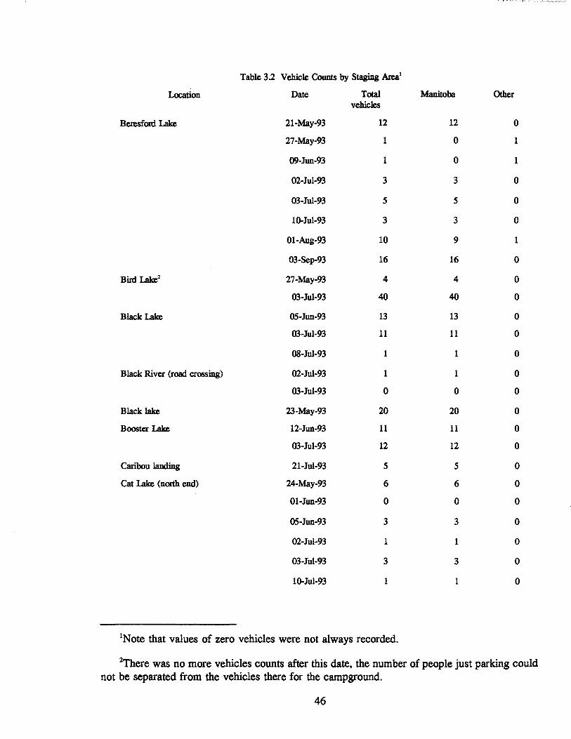
Table 3.2 Vehicle Counts by Staging Areal
Location Date Total Manitoba Other vehicles
Beresford Lake 21-May-93 12 12 0
27-May-93 1 0 1
09-Jun-93 1 0 1
02-Jul-93 3 3 0
03-Jul-93 5 5 0
lo-Jul-93 3 3 0
01-Aug-93 10 9 1
03-Sep-93 16 16 0
Bird Lake2 27-May-93 4 4 0
03-Jul-93 40 40 0
B1ack Lake 05-Jun-93 13 13 0
03-Jul-93 11 11 0
OB-Jul-93 1 1 0
Black River (road crossing) 02-Jul-93 1 1 0
03-Jul-93 0 0 0
Black lake 23-May-93 20 20 0
Booster Lake 12-Jun-93 11 11 0
03-Jul-93 12 12 0
Caribou landing 21-Jul-93 5 5 0
Cat Lake (north end) 24-May-93 6 6 0
01-Jun-93 0 0 0
05-Jun-93 3 3 0
02-Jul-93 1 1 0
03-Jul-93 3 3 0
lo-Jul-93 1 1 0
INote that values of zero vehicles were not always recorded.
~ere was no more vehicles counts after this date, the number of people just parking could not be separated from the vehicles there for the campground.
46

20-Jul-93 0 0 0
24-Jul-93 3 3 0
31-Jul-93 3 3 0
01-Aug-93 5 5 0
14-Aug-93 4 4 0
26-Aug-93 0 0 0
03-Sep-93 2 2 0
Cat Lake (south end) 03-Jul-93 1 1 0
20-Jul-93 0 0 0
24-Jul-93 1 1 0
03-Sep-93 2 2 0
Davidson Lake 03-Jul-93 3 3 0
30-Jul-93 0 0 0
Flanders Lake 03-Jul-93 0 0 0
12-Jun-93 1 1 0
Flintstone Lake 23-May-93 3 3 0
02-Jul-93 1 1 0
03-Jul-93 1 1 0
24-Jul-93 1 1 0
03-Sep-93 0 0 0
Gem Lake 03-Jul-93 10 10 0
01-Aug-93 2 2 0
03-Sep-93 8 8 0
Long Lake 22-May-93 7 7 0
27-May-93 0 0 0
09-Jun-93 1 1 0
02-Jul-93 4 4 0
10-Jul-93 6 6 0
23-Jul-93 2 2 0
03-Sep-93 8 8 0
Manigotagan (village) 03-Jul-93 6 6 0
"---
47
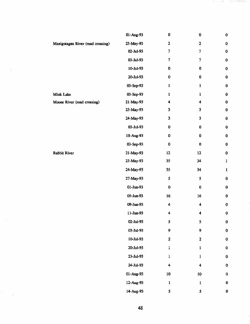
Ol-Aug-93 0 0 0
Manigotagan River (road crossing) 23-May-93 2 2 0
02-Jul-93 7 7 0
03-Jul-93 7 7 0
100Jul-93 0 0 0
20-Jul-93 0 0 0
03-Sep-93 1 1 0
Mink Lake 03-Sep-93 1 1 0
Moose River (road crossing) 21-May-93 4 4 0
23-May-93 3 3 0
24-May-93 3 3 0
03-Jul-93 0 0 0
18-Aug-93 0 0 0
03-Sep-93 0 0 0
Rabbit River 21-May-93 12 12 0
23-May-93 35 34 1
24-May-93 35 34 1
27-May-93 5 5 0
01-Jun-93 0 0 0
05-Jun-93 16 16 0
09-Jun-93 4 4 0
II-Jun-93 4 4 0
02-Jul-93 5 5 0
03-Jul-93 9 9 0
IO-Jul-93 2 2 0
20-Jul-93 1 1 0
23-Jul-93 1 1 0
24-Jul-93 4 4 0
01-Aug-93 10 10 0
12-Aug-93 1 1 0
14-Aug-93 5 5 0
48

17-Aug-93 1 1 0
18-Aug-93 1 1 0
03-Sep-93 6 6 0
Sausage I..ake 24-May-93 5 5 0
01-Jun-93 1 1 0
OS-Jun-93 0 0 0
03-Jul-93 2 2 0
31-Jul-93 1 1 0
03-Sep-93 3 3 0
Seagrim I..ake 21-May-93 12 12 0
23-May-93 17 17 0
24-May-93 21 21 0
27-May-93 1 1 0
01-Jun-93 0 0 0
OS-Jun-93 3 3 0
09-Jun-93 2 2 0
ll-Jun-93 7 7 0
02-Jul-93 7 7 0
03-Jul-93 10 10 0
08-Jul-93 1 1 0
10-Jul-93 5 5 0
20-Jul-93 0 0 0
23-Jul-93 3 3 0
24-Jul-93 4 4 0
30-Jul-93 2 1 1
0l-Aug-93 3 3 0
12-Aug-93 1 1 0
14-Aug-93 0 0 0
17-Aug-93 1 1 0
18-Aug-93 2 2 0
26-Aug-93 3 3 0
49

03-Sep-93 8 8 0
Shoe Lake 01-Joo-93 0 0 0
05-Joo-93 4 4 0
03-Jo1-93 20 20 0
100Jo1-93 15 15 0
20-Jo1-93 5 5 0
23-Jo1-93 8 8 0
24-Jul-93 15 15 0
01-Aug-93 27 27 0
14-Aug-93 12 11 1
17-Aug-93 2 2 0
26-Aug-93 3 3 0
03-Sep-93 13 13 0
Tooth Lake 02-Jul-93 3 3 0
03-Jo1-93 4 4 0
20-Jul-93 0 0 0
24-Jo1-93 1 1 0
03-Sep-93 0 0 0
23-May-93 4 4 0
Tulabi Falls 21-May-93 18 18 0
27-May-93 18 13 5
O5-Joo-93 21 21 0
09-Joo-93 4 4 0
I1-Joo-93 5 4 1
12-Joo-93 15 15 0
02-Jo1-93 20 20 0
03-Jo1-93 26 24 2
OS-Jul-93 8 7 1
IO-Jul-93 11 11 0
23-Jo1-93 13 12 1
30-Jo1-93 6 6 0
50

18-Aug-93 3 3 0
03-Sep-93 17 16 1
Wallace Lake 22-May-93 15 15 0
21-Jun-93 4 3 1
02-Jul-93 6 6 0
01-Aug-93 8 8 0
03-Sep-93 0 0 0
51
Figure 3.2 Cottager Assistance Request Form
Manitoba Natural Resources Parks and Natural Areas Box 52
1495 SI. James Street Winnipeg MB R3H r:NtI9 CANADA
ATTENTION COTTAGERS .~
The Department of Natural Resources and Forestry Canada are conducting a back-country water use survey in Nopiming Provincial Park the summer of 1993.
Volunteers are required to increase participation levels for survey completion. The task would involve monitoring the boat launch areas for several hours and asking boaters to complete the survey form.
For more information or to volunteer, call Dave Watson @ 983-4817 or Trucia Howard @ 945-4368 in Winnipeg.
52

I Table ~t~ Survey Completion Rates I Location Surveys Surveys Surveys Percentage
Placed Completed returned Completed incomplete or returned
Tulabl Falls ::s~U n::s n )U Davidson Lake 25 4 0 16 Booster Lake 65 4 2 9 Flanders Lake 41 3 3 15 Brrd Lake 44 2 6 18 Cat Lake 24 2 4 25 Shoe Lake 89 13 11 27 Rabbit River 109 64 4 62 Seagrim Lake 127 51 13 50 Black Lake 66 7 2 14 Tooth Lake 20 1" 0 5 Gem Lake 10 1 7 80 Mamgotogan River 45 9 3 27 Beresford Lake 107 32 14 43 Long Lake 59 21 6 46 Caribou landing 57 7 2 16 Wallace Lake 75 11 8 25 Atikaki backcountry patrol 40 13 27 100 Nopiming park patrol 8 0 8 100 Tulabi campground office 15 0 15 100 NopImmg lodge 34 9 9 53 Black lake campground 14 1 14 100 office Whites hell Air 20 0 20 100 Eagle Air 15 0 15 100 Bisset Air 15 2 13 100 Selkirk Air 35 21 14 100 Northway Aviation 20 0 20 100 Tall TImbers lodge 20 1 19 100 Northern Expeditions 15 5 10 100
I Total I 1,379 I 457 I 2Si I 4i I Total at unmanned sites 1,377 414 111 38
3The one form was completed in the presence of the project staff. This box was stolen shortly after being put up, along with the forms inside.
53
CHAPTER 4: Establishment and Description of Databases
A significant portion of the field season was spent collecting attributes that could be used
in describing a recreational canoeing experience in Nopiming Park. These attributes were
gathered by canoeing every actual and most potential route in the park as well as examining
maps, aerial photographs, and other information available from Manitoba Parks Branch staff and
Abitibi Price woodland operations personnel. These attributes are summarized in Chapter 5 and
in various appendices compiled in conjunction with this document. The intent of this chapter is
to introduce interested readers to the types of attributes collected, how they were collected, and
how they were entered into the various databases associated with the project. This information
will essentially form a type of biophysical inventory of features of the park important to
recreational canoeing.
The relationship between the canoeing experience and forestry operations is an important
objective of this study. For this reason data on forest characteristics and past and future logging
operations is important. Considerable effort was expended collecting forest and vegetation data
while actually canoeing the routes. In addition, a copy of the provincial forest inventory data for
the park was obtained in digital form. This information was organized manually in a spreadsheet
format for each route and was also cleaned and organized for GIS analysis. These three
databases will eventually allow the various covers found in the provincial forest inventory to be
associated with recreational canoeing. Data on past fire history and forestry operations is in the
process of being gathered from Abitibi Price and will eventually be integrated into the
appropriate databases.
Attributes directly related to canoeing were also collected. For each route, basic
information such as the number and condition of campsites and portages was collected. This
was collected by visually inspecting the sites while actually canoeing the routes.
4.1 Routes Database
The canoe routes examined are shown in Table 2.1. As mentioned in Chapter 2, there
was some difficulty in determining exact routes. For this reason, information was collected on
segments of the routes that could later be combined as the exact routes became more fully
understood. The routes described in the databases thus include those that either have high
54

potential for canoeing, or where people have stated that they canoe. Some of the routes are not
contained completely within the park boundaries; thus, some were only partially surveyed.
The attributes were entered into a PARADOX 1.0 (WINDOWS version) database. Table
4.1 shows the coding format used for the routes database. The actual attributes that were
collected are shown in Table E.2 which can be found in Appendix E. Attributes for the Atikaki
Park"canoe routes were not collected during the 1993 field season.
These route attributes can be grouped into several categories. These include: route
identification, a route's geographic placement. associated canoe and camping features, and special
features. The route identification attribute category includes the variables ROUTE# and
DESCRIP. These two variables provide a unique identification along with a brief description of
the route and/or route segment.
The geographic placement category includes attributes that place the route within the
UTM mapping system. These attributes identify the mapsheet(s), or photo mapsheet(s). that
cover the route. as well as grid references to points along the route. This category contains the
attributes BEG_GR, END_GR, MAP A, MAP B. PHOTOA, PHOTOB. AND PHOTOC.
The canoe and camping features of routes form the largest and most diverse database
category. An initial set of variables describes the type of watercourse that comprises the route.
These are LENGRIV, AREALAKE, TYPRlE, TYPH20, and SEASONAL. LENGRIV and
AREALAKE identify the area and size of the route; one or the other is applicable to each route.
The type of route, and watercourse are then described. SEASONAL helps show the size of the
watercourse, and whether or not there is a potential for low water flows at certain times during
the canoeing season. The next group, containing CAMPGR, LAUNCH. ROAD, and STORE.
describe access to the route and some of the amenities located near the route's access point.
Features along the length of the route are contained in the next set of variables. This includes
#PORTAGE, DESIG#, PAYCAMP#, UNOFF#, COTTAGE, MOTORS, %BURNT, and
LOGGING. This set suggests some idea of the camping experience found along the route as well
as features that may detract from the canoeing experience. The last category of special features
shows attributes that may be unique to a route and that may in fact create a special attraction
such as sandy beaches or canyons.
55

Table 4.1 Description of Variables and Codes for Attributes in the Routes Database
NAME DESCRIPTION OF ATTRIBUTE NUMBER CODES
ROUTE# Route number; a unique number code as required created for each route or segment
DESCRIP Route Description no codes, text description
BEG_GR Start point Grid Reference six figure GR from map sheet 999999 if indeterminate
END _ GR End point Grid reference six figure GR from map sheet 999999 if indeterminate
MAP A Topographic map sheet that contains the Map sheet number main portion of the route/segment
MAP B Topographic map sheet that contains a Map sheet number smaller portion of the route/segment
PHOTOA Photo map that contains the main portion Photo map number of the route/segment
PHOTOB Photo map that contains a smaller Photo map number portion of the route/segment
PHOTOC Photo map that contains a smaller Photo map number portion of the route/segment
LENGRIV Length of reach of river in kilometers Length value
AREALAKE Area of lake in square kilometers
TYPRTE Type of trip possible on route
TYPH20 type of Watercourse
56
Area value
1= return route same as entry route 2= one way trip, start not same as finish 3= route can be either 1 or 2, choice of canoeists
1= predominately lake 2= predominately river 3= predominately stream 4= equal parts of 1&2, or 1&3
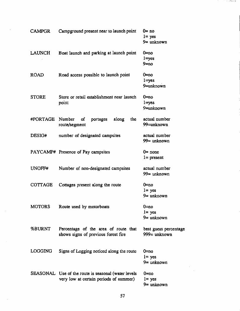
CAMPGR Campground present near to launch point 0= no 1= yes 9= unknown
LAUNCH Boat launch and parking at launch point O=no
ROAD
STORE
Road access possible to launch point
Store or retail establishment near launch point
1 =yes 9=no
O=no 1 =yes 9=unknown
O=no 1 =yes 9=unknown
#PORT AGE Number of portages along the actual number route/segment 99=unknown
DESIG# number of designated campsites
PA YCAMP# Presence of Pay campsites
UNOFF# Number of non-designated campsites
COTTAGE Cottages present along the route
MOTORS Route used by motorboats
%BURNT Percentage of the area of route that shows signs of previous forest fIre
LOGGING Signs of Logging noticed along the route
SEASONAL Use of the route is seasonal (water levels very low at certain periods of summer)
57
actual number 99= unknown
0= none 1= present
actual number 99= unknown
O=no 1= yes 9= unknown
O=no 1= yes 9= unknown
best guess percentage 999= unknown
O=no 1= yes 9= unknown
O=no 1= yes 9= unknown

BEACH Sandy beaches present
MEANOR Meander rating; rating from 1-5
OUTCROP Rocky outcrops special
CANYON Canyons present
O=no 1= yes 9= unknown
1 =Straight 5=Twisty 9=Unknown
O=no 1= yes 9= unknown
O=no 1= yes 9= unknown
FISHIN Fishing rating unknown
rating 1-10, 99 if 1= poor 1O=very good 99= unknown
UNIKFLOR Special forest present
MANMADE Other manmade features
COMMENT Comments; includes details of manmade features
58
O=no 1= yes 9= unknown
O=no 1= yes 9= unknown

4.2 Campsites Database
While visiting the routes it became apparant that although park regulations restrict
camping to particular sites, individuals were camping in many nondesignated campsites. Thus,
it was decided to collect attributes of both the designated and as many of the nondesignated sites
as could be found while inspecting the routes.
A designated site was defined as a site that was identified on the canoe information map
provided to canoeists at most of the staging areas (Figure 2.2). During the route inspections it
was important to note the exact location of the designated site and whether was equipped with
a tenting area and concrete fIre pit. Designated sites were also classifIed as either free or in the
case of a few, commercial (where a fee was collected by an operator for use). A new
arrangement was created in 1993 for certain sites on the Manigotagan and Quesnell lakes for
commercial operation; in return for maintenance of the sites, an operator at Caribou Landing
Lodge on Quesnell Lake was allowed to establish a reservation system and charge a fee for the
use of the sites. It was important to ensure that this feature could be included in the database.
A preliminary trip involving two important routes, Rabbit River and Seagrim Lake,
showed that canoeists were using other locations for camping. These were called nondesignated
sites. If these nondesignated sites can be shown to have attributes that are statistically different
than designated sites, then there will need to be a change in the criteria for placement of
designated sites. If however, they have similar attributes, then people are using these sites
because of a lack of suffIcient designated sites on a particular route.
A fIeld checklist of campsite attributes was constructed. This was taken into the fIeld to
facilitate the collection of campsite attributes. These attributes are shown in Table 4.2. For most
of the routes the information was collected by the project fIeld staff. Information on the location
of sites on the Black River, and the Moose River/Happy Lake route was provided by Natural
Resource OffIcers based in Bisset (D. Langley) and Lac du Bonnet (M. Boiteau and G. Rossett).
Sites east of Quesnell Lake on the Manigotagan River, were surveyed by K. Leavesley of the
Manitoba Natural Resources offIce in Beausejour. As well, some sites were located, but not
surveyed, by backcountry clean-up staff.
59

Table 4.2 Campsite Attribute Checklist
1. Location a. Is the campsite (For designated campsites) where the canoe route map has it
marked? (YIN) What is the 6 figure grid reference of the campsite (designated and non-designated) from the topographical map. _____ _
b. Is the campsite easy to spot from the water (YIN) c. Is the campsite along the natural canoe route (YIN). IT no, give an appraisal of
the distance (in metres) from the natural canoe route. ________ _ Is the campsite on the main shore, a peninsula, or on an .island? (circle one)
d. What is the height of the main campsite area above the water level, in meters. (Some sites may have a "secondary plateau", make note of these also) _______ _
e. Is the metal and concrete firebox on shore, on rocks, in the main camp area (circle one, note if absent). For non-designated sites, location of campfrre rock
2. Exposure
3. Space
rings .. ________ _____
Are there other campsites within 300m of this campsite, (YIN); and if so, is there a clear line of sight. (YIN) or path (YIN) between the two?
Give an indication of the wind exposure of the following general areas of the campsite, (i.e. wind exposure from how many directions) Beach/landing area __ _ Firebox/cooking area __ _ Tent sites General space ______
a. Give a rough indication of the size of the open area created at the campsite (i.e. 1~by2~e~) ____________ __
b. Describe the openness of the trees in the immediate area; grass, few trees, tall trees with no undergrowth, heavy undergrowth.
c. Number of tent sites available, under "normal" and "shared/crowded" conditions
d. Size of landing area, number of boats/canoes that could be simultaneously landed.
e. Is there room on shore near landing area for beaching boats out of the water (YIN)
60

4. Amenities a. Are there toilets provided (YIN). If yes, are they easily located, and agreeable?
b. List any structures created by previous users, such as fish cleaning tables, docking anchors, tables, supplementary campfIre rings etc.
c. Describe the view to other areas, (Le. long view of lake and other shoreline, view less than 100m, no view of sky etc.)
d. Has there been a fIre or forestry cutting in the area in the last 10 years (easily visible) (YIN)
e. Is there readily available fallen debris for fIrewood (YIN) f. List any particular characteristics (rock outcrop to climb, plentiful berries,
waterfall nearby etc)
g. Is the site "generally clean", without obvious signs of "rough toilets", fIsh parts, or long term litter of tins etc (YIN)
5. Vegetation a. What are the predominant tree species in the immediate area? 1 , 2 ___ ,
3 __ _ b. What are the predominant tree species in the distant view? 1 ___ , 2, __ _
3_~_
c. list any understory, flowers and shrubs noticed as common in the area~ ____________________ __
d. Give a rough indication of the spacing and height of the trees in the main area, and the surrounding area __________ _
e. Is the surrounding area easily penetrated (YIN) f. Are there numerous fallen trees in the area (YIN) Are there signs that previous
users have been cutting trees (this year; and/or previous years) (YIN)
61

These campsite attributes were also entered into a PARADOX database using the coding
format shown in Table 4.3. The categories of these attributes are identification, location, shore,
terrain features, exposure, special features, and flora. Identification includes a unique number,
SITE#, a cross-reference number (ROUTE#) for the canoe route along which the site is found,
and the type of site, DESIG or PAY. The location variable GRIDREF places the site
geographically. The variable INPLACE identifies if the site is where it should be, and the
variable FOUND identifies whether it can actually be found. A straight line route was drawn
from start to fInish for each route, and this line was called the "natural canoe route". If a site
was in a bay, or side channel off this natural route, it was seen to be a special attribute, both
because it may require some extra effort to reach and it may have a higher level of privacy. The
attributes ONROUTE and OFFROUTE capture these features. The location category also places
the site in relation to the proximity of other campsites; SITENEAR, SITESEEN, and SITEPATH
portray these features.
The variable TERRAIN suggests the topography in the general area of the site.
HITEMAIN and HITE2ND identify the placement of the site in relation to the shore. The
placement of important features within the site include FIREBOX and CAMPFIRE. The category
also includes attributes, AREASITE and TENTS POT, which describe the size of the campsite.
Exposure describes the view from and wind exposure of many of the campsite features.
Wind exposure can be either positive or negative, depending on what the fIeld staff considered
as the canoeist's point of view. This point of view need not be the same for all features. For
example, high wind exposure may be considered good in the main area to keep biting flies and
mosquitoes away; however, low exposure may be preferred in the tenting area for shelter from
the elements while sleeping. The OPENSITE attribute describes these features.
The shore category describes the ease of accessing and landing at the site. The variables
CANOLAND and LANDEASY describe these features and CANOBEAC identifies the security
of the canoe from the elements on the shore.
The category of special features details any attribute present that may contribute to
making one site unique and different from others along a route. Some of these may show
human presence, such as MANMADEC, TOILETS, or LOGGING. Others represent natural
features, such as FIRESEEN, BERRIES, or RAPIDS.
The flora category describes the dominant and secondary tree species and up to three main
62

understory species. The type of forest may have some importance to the canoeist and this may
be reflected in the value of the camping experience.
The contents of the database of campsite attributes is shown in Appendix E, Table E.6.
63

Table 4.3 Description of Variables and Codes for Attributes in the Campsite Database
NAME
SITE,
ROV1'E*
INPLACE
GRIDREF
DESIG
PAY
FOUND
ONROUTE
OFFROUTE
TERRAIN
HITEMAIN
HITE2ND
FIREBOX
DESCRIPTION OF ATTRIBUTE
Site number
Route number
At the indicated location
Grid reference
Is it a designated site
Is payment required to stay at the site.
Is the designated site locatable, if no then no data on all other attributes
Is it along the natural route
Distance off the natural route
Located on what type of feature
Height above water level of the main campsite area
Height above water level of any secondary campsite area
Location of fIrebox within campsite
64
NUMBER CODES
Created unique value for each
As per routes database
0= no 1= yes
Topographic 6 figure
0= no 1= yes
0= no 1= yes
0= no 1= yes
0= no 1= yes
distance in meters 0= on the route
1= main shore 2= peninsula 3= island
in meters
in meters
0= not present 1 = on the shore 2= on rocks 3= in main area, clearing 9= no answer

CAMPFIRE
SITENEAR
SITESEEN
SITEPATH
EXPOSB
EXPOSF
EXPOSC
EXPOSM
EXPOST
AREASITE
OPENSITE
TENTSPOT
CANOLAND
Location of unofficial campfire 0= not present 1 = on the shore 2= on rocks 3= in main area, clearing 9= no answer
Other campsites located nearby 0= no 1= yes
Other campsites can be seen 0= no 1= yes
Path exists to other campsites 0= no 1= yes
Wind exposure (# of directions) 1 to 4 canoe beaching
Wind exposure (# of directions) 1 to 4 firebox
Wind exposure (# of directions) 1 to 4 cooking area
Wind exposure (# of directions) 1 to 4 main area of campsite
Wind exposure (# of directions) 1 to 4 tent area
Size of the campsite in square meters
Openness of the campsite 1= grassy lawn 2= few trees 3= tall trees, min 2m spacing 4= tall trees, <2m spacing 5= dense regrowth, not tall 6= tall trees with heavy undergrowth
The number of tents that can be # of spots, best guess erected at the campsite
The number of canoes that can be Best guess landed at the same time
65

LANDEASY The relative ease of landing a canoe, 1 to 5 1 = easy, flat 5= hard, steep bank
CANOBEAC Can canoe be beached 0= no 1= yes
TOILETS Are Toilets present 0= no 1= yes
TOILFIND Are toilets easy to find 0= no 1= yes 9 if not present
TOILCLEN Are toilets clean 0= no 1= yes 9 if not present
MANMADEC Are there man- made structures, such 0= no as tables, racks, docking rings etc 1= yes
GOODVIEW Is there a good view 0= no 1= yes
FIRESEEN Is there evidence of past fires 0= no 1= yes
LOGGING Is there evidence of logging nearby 0= no 1= yes
FIREWOOD Is there debris for firewood 0= no 1= yes
SANDBEAC Are sandy beaches present at site 0= no 1= yes
SPECROCK Twisted or contorted rock present 0= no 1= yes
OUTCROP Rock outcrop to explore 0= no 1= yes
BERRIES Berries present in abundance 0= no 1= yes
66

CHUrnS Waterfall at campsite 0= no 1= yes
RAPIDS Rapids at campsite 0= no 1= yes
FLORA Special or unique flora 0= no 1= yes
SITECLEN Is the site generally clean 0= no 1= yes
TREE 1 Dominant tree species at site see attached list
TREE2 Secondary tree species at site see attached list
UNDER 1 Dominant understory species at site see attached list
UNDER2 Secondary understory species at site see attached list
UNDER3 Secondary understory species at site see attached list
DISTIREE Tree species that make up view in see attached list distance
CANOPY Canopy /tree spacing 1 to 5 1= wide open 5= dense
TREEHITE Tree height 0= no trees 1= 1m 2= 2m 3= 3m 4=4m 5= 5m or more
DENSE Denseness of surroundings 0= impenetrable 1 = penetrable
CUTIREE Evidence of trees cut by campers 0= no 1= yes
COMMENT Comments
67

Table 4.4 List of Plant Species Used in Databases
1. Conifer general 2. Deciduous general 3. Jack pine 4. Black spruce 5. White spruce 6. Tamarack 7. Balsam fIT 8. poplar sp 9. birch sp. 10. Willow sp 11. Bur oak 12. Manitoba maple 13. Hazelnut 14. White elm 15. Alder
1. Grass 2. Moss and lichens 3. Juniper 4. Blueberries 5. raspberries 6. Rose 7. Achillea 8. pincherry 9. prickly pear cactus 10. saskatoon 11. dogbane 12. dogwood 13. bunchberry 14. Queen Anne's Lace 15. ferns 16. plantain 17. horsetail 18. wildrice 19. wild grape 20. harebell 21. honeysuckle 22. strawberry 23. chokecherry 24. poison ivy 25. golden rod 26. bearberry
PLANT LIST A : TREES n/a n/a Pinus banksiana Lamb. Picea mariana (Mill.) BSP. Picea glauca (Moench) Voss Larix laricina (Du Roi) K. Koch Abies balsamea (L.) Mill. Populus sp Betula sp. Salix sp. Quercus macrocarpa Michx. Acer spicatum Lam. Corylus comuta Marsh. Ulmus americana L. Alnus crispa (Ait.) Pursh
PLANT LIST B: UNDERGROWTH n/a
68
n/a Juniperus sp. Vaccinium angustifolium Ait. Rubus idaeus L. Rosa sp. Achillea millifolium L. Prunus pensylvanica L. f. Opuntia jragi/is (Nutt.) Haw. Amelanchier alnifolia Nutt. Apocynum androsaemifolium L. Comus stolonifera Michx. Comus canadensis L. Daucus carota L. n/a Plantago major L. Equisetum sp Zizania aquatica L. Vitus riparia Michx. Campanula rotundifolia L. Lonicera dioica L. Fragaria virginiana Duchesne Prunus virginiana L. Rhus radicans L. Solidago sp. Arctostaphylos uva-ursi (L.) Spreng.

4.3 Portages Database
Portage attributes may be an important consideration in the selection of a route to canoe.
In particular the number of portages and their degree of difficulty may be important to
individuals. The fIrSt variable in the attribute list gives a unique number to each portage and
cross references it to the route on which it is located. The next category of attributes determines
the physical location of the portage and places it within the general topography. This is followed
by factors describing the difficulty of the portage and some idea of various amenities found
within it. Table 4.5 shows the coding scheme for this database. Table E.8, in Appendix E
provides the contents of this database of attributes.
Table 4.5 Description of Variables and Codes for Attributes in the Portages Database
NAME
IDNUM
ROUTE#
BEGGR
ENDGR
SIDE
WIDTH
TOPO
SURFACE
TREEPI
DESCRIPTION
Identification number
NUMBER CODES
Unique coding number, indexed to route
Route number, indexed to route Number for route portage is located database on
Grid reference of start point From topographical maps
Grid reference of end point From topographical maps
Side of stream the portage is on 1= north 2= south 3= east 4= west
Width of portage path
General Topography
Path surface type
Dominant Tree type
69
1= very narrow 2= canoe width 3= wider than canoe
1= flat 2= rolling 3= steep points
1= rock 2= grass 3= dirt
see species list

TREEP2 Secondary Tree type see species list
UNDERP1 Dominant Undergrowth see species list
UNDERP2 Secondary Undergrowth see species list
CLEAN General Cleanliness of portage 1 to 5 where; 1= dirty 5= clean
VIEWH20 View of water from trail <>=no 1= yes
THRUBURN Through an old burn 0= no 1= yes
FINDEASY Trail is easy to fmd O=no 1 =yes
TRAIL a path exists <>=no 1= yes
RATING Subjective rating 1 to 5 where; 1= poor 5= very good
OBSTACS Obstacles present along trail 0= no 1= yes
COMMENT Comments
70

4.4 Backcountry Water Use Database
Completed surveys were collected from the survey boxes located in staging areas, air
carriers who transported canoeists into Atikaki Park, Manitoba Parks personnel, and some directly
from canoeists. These were entered into a database called the backcountry water use database.
Table 4.6 shows the coding format for the surveys, and Table E.lO, Appendix E, provides the
contents of this database. Names and addresses of respondents have been deleted for
confidentiality .
The attributes listed were taken directly from the survey questions with the exception of
some administrative details. These include a unique identification number for each form and a
cross-reference to the route the respondent indicated was used. The source of the form (staging
area, personal delivery, etc.) is also identified. To include the information requested on the back
of the form, the presence or absence of a line-trace of the route is noted, as well as campsites
used if indicated. The campsite number is cross-referenced to the campsite database.
71

Table 4.6 Description of Variables and Codes for the Survey Database
NAME
IDENT#
STARTPI'
PRENOM
INIT
LASTNAME
HOUSE#
STREET
CITY
PROV
POSTCODE
COUNTRY
PARK
YEAR
GRPSIZE
GRPTYPE
DESCRIPTION NUMBER CODES
Unique Identification number for From survey forms each survey form
Source or location where survey was no number code, list name collected, no number code
First Name no number code, list name
Initial no number code, list name
Last name no number code, list name
Apartment and/or house number no number code, list name
Street no number code, list name
City no number code, list name
Province no number code, list name
Postal code no number code, list name
Country of origin no number code, list name
Park for survey form 1= Nopiming 2= Atikaki
Year missing not allowed No code, list actual
Group size Actual number, if missing No code, list actual except 99= then 99 missing
Group type 1= Family 2= Friends
72
3= schooVuniversity 4= Youth 5= Solo (group size = 1) 6= Combination of 1 & 2 7= work group 9= missing response
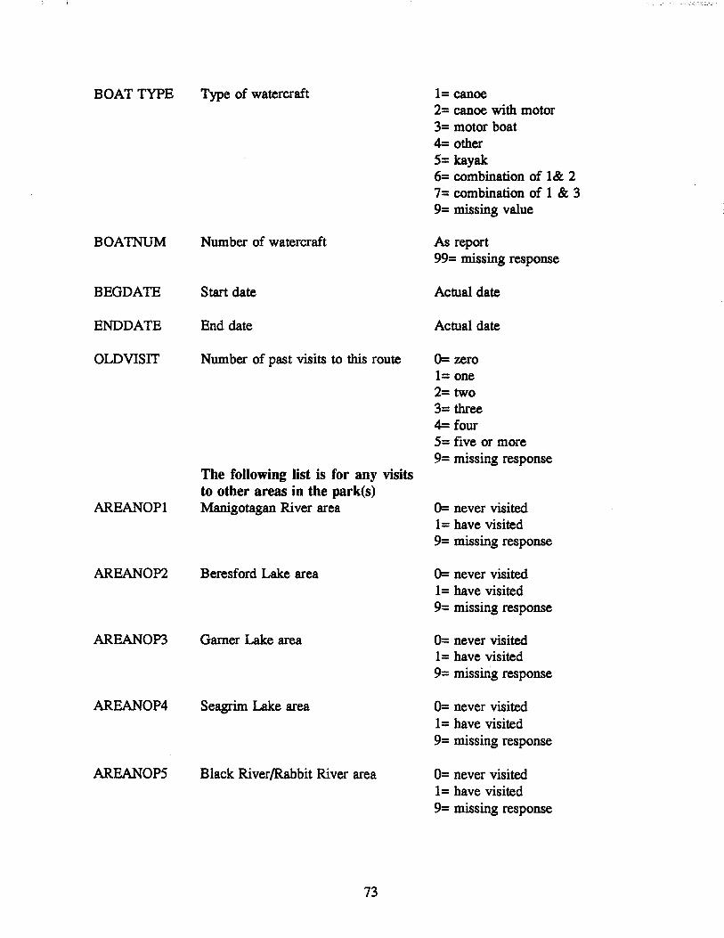
BOAT TYPE Type of watercraft 1= canoe 2= canoe with motor 3= motor boat 4= other 5= kayak 6= combination of 1& 2 7= combination of 1 & 3 9= missing value
BOA1NUM Number of watercraft As report 99= missing response
BEGDATE Start date Actual date
ENDDATE End date Actual date
OLDVISIT Number of past visits to this route 0= zero 1= one 2= two 3= three 4= four 5= five or more 9= missing response
The following list is for any visits to other areas in the park(s)
AREANOPI Manigotagan River area 0= never visited 1 = have visited 9= missing response
AREANOP2 Beresford Lake area 0= never visited 1 = have visited 9= missing response
AREANOP3 Garner Lake area 0= never visited 1= have visited 9= missing response
AREANOP4 Seagrim Lake area 0= never visited 1= have visited 9= missing response
AREANOP5 Black River/Rabbit River area 0= never visited 1= have visited 9= missing response
73

AREANOP6
AREANOP7
AREANOP8
AREANOP9
NOPOTHER
AREAATI1
AREAATI2
AREAATI3
AREAATI4
ATIOTHER
CANOTRIP
Shoe Lake/Cat Lake area
Euclid Lake/Springer Lake area
Bird Lake area
Booster LakelFlanders Lake area
0= never visited 1 = have visited 9= missing response
0= never visited 1 = have visited 9= missing response
0= never visited 1 = have visited 9= missing response
0= never visited 1 = have visited 9= missing response
Other Nopiming areas not listed 0= never visited above 1 = have visited
9= missing response
Pigeon River area, for Atikaki 0= never visited surveys 1 = have visited
9= missing response
Leyond River area, for Atikaki 0= never visited surveys 1= have visited
9= missing response
Bloodvien River area, for Atikaki 0= never visited surveys 1 = have visited
Gammon River area, for Atikaki surveys
9= missing response
0= never visited 1 = have visited 9= missing response
Other Atikaki areas not listed above 0= never visited 1 = have visited
Was the main purpose of this trip canoeing?
74
9= missing response
0= no 1= yes 9= missing response

OTHRTRIP If not a canoe trip, what is the main 1= fishing reason for this visit to the park(s) 2= work
3= own or visiting cottage 4= camping 9= missing
ROUTE# Route Identifier Number from routes database 99= missing response
SEGMENT Last segment route number Number from routes database 99= missing response
MAPLINE Was the route traced on the back of 0= no map trace the survey form 1= map trace done
9= missing response
CAMPS 1 First Campsite number from campsite database
CAMPS 2 Second Campsite number from campsite database
CAMPS 3 Third Campsite number from campsite database
75

4.5 GIS & Mapping Databases
The provincial government provided forest inventory data for the 28 townships comprising
Nopiming Park. This came in two forms, hard copy paper maps, and digital data in ARC INFO
format on computer disk. The hard copy maps were examined by L. Peters and a spreadsheet
was created showing all forest polygons that touched upon the water routes in Nopiming Park.
This important work will allow the examination of the importance of forest cover as a factor in
site selection by canoeists. Watercourses were broken down into segments and the cover along
each segment was detailed. This work was carried out before final designation of routes,
consequently the segments do not exactly match those shown in the routes database.. Combining
of segments to form routes will be done before use of this data in the construction of economic
models.
For rivers and streams, the cover was sequentially identified on both banks. Wherever
there was a change in cover along either bank, the distance from the last change was measured
with a measuring wheel and recorded. For portages, the cover type through which the trail
passed was also recorded. Lakes were first traced with a "natural canoe route", which is the
shortest distance from the entry point to the exit point. Then polygons that touched fIrst the left
side, then the right side, of the natural route were noted. Cover on islands was reported as they
were encountered, either to the left or the right, of the natural route. The database created from
this process is shown in Table F.l in Appendix F.
The forest inventory data on computer disk was used to generate GIS data within 200
metre buffer strips along the water routes. This was conducted by Geowest Environmental
Consulting of Edmonton. These buffers identify all forest cover types within 200 meters of the
canoe segments throughout the park. Both hard copy maps of the routes and databases of the
routes will be derived from this GIS analysis. Amalgamation of the database with the other
attribute lists will allow further research on the choice of water routes by canoeists. Full details
of the GIS work will be published in a separate report. An example of a GIS generated map that
incorporates the buffer zones, and the campsite database is shown in Figure 4.1.
76

~ (Jq
"'r:J1)" tn:r..ff.!', ~ ('11
f'>-Designated Cam(2sites -·0 0
·A .1 Cij
.50°43' 0" ~
Fomd Cam(2sites ~ ·0 [ ·1 g
~
ExQosed Rocks i
• Unclassified
.~0042'O" '-l Portages '-l
P Unclassified
-1
... ' I I .00 0 1000 1ft
~'2e 500 41' 0"
~~C!24' .950 23' .950 22' .950 25'

CHAPTER 5: Summary Statistics Based on 1993 Fieldwork
5.1 Introduction
This chapter presents a summary of the important statistics from the user survey, and the
attributes collected on routes, campsites, and portages. Most of the attribute information is not
amenable to summarization, so the bulk of the information on these must be attained in the
databases contained in Appendix E.
As will be seen in section 5.3, surveys were not received for all of the potential routes
listed in Table 2.1. In some cases there may have been use, but the absence of a survey box for
the site may have been the cause of non-response. Table 5.6 and Table 5.7 show the routes
actually used, along with the numbers of users. These are the only routes that are described by
certain of the summary tables for attributes in the following sections.
It will be noticed that the totals listed at the bottom of tables (where appropriate) will not
always be the same from one table to the next. This is due to missing responses on some of the
portions of the data list.
5.2 Physical Attribute Statistics: Routes, Portages, Campsites
All of the major, and most of the minor routes within Nopiming Park were inventoried
during the summer of 1993. The majority of the attributes cannot be summarized, and are only
useful in a modelling framework. Table 5.1 shows what should be the major modelling attributes
for the routes used by canoeists in 1993. The use of these attributes was determined by initial
modelling efforts described in Chapter 1, and the results of the focus group study summarized
in Appendix D. They are not the only attributes to be used in future modelling.
The number and size of portages is very important to canoeists, as well as deciding which
routes will not be used by motorboats. Table 5.2 shows these details. Another very important
attribute that can be shown is the allocation of campsites along the routes. In particular, the
number of designated versus non-designated sites will be a strong management consideration.
Table 5.3 shows the distribution of campsites along the Nopiming routes. Table 5.4 shows the
average and total number of tent sites per route in the park. This figure can be used in
determining the use capacity for a route, and when compared with the actual use determined by
the survey, it provides an indication of congestion.
78

5.3 User Statistics from Survey
The total number of surveys collected during the summer of 1993 was 472. This total
does not include surveys deleted at the source due to various data deficiencies and foul language.
It does include 13 surveys from the end of the season for 1992. The surveys collected were not
all 100% complete, but there was enough data for most categories. The initial aim of the survey
was not to collect data on Atikaki Park, or motorboat users, and the data on these groups is
known to be incomplete, but the collected surveys do allow for some conclusions to be made.
Of the total of 459 respondants for 1993, 403 were from Nopiming park, and 56 were
from Atikaki park. This includes canoeists and well as motorboaters, and those without
designation of boat type. Table 5.5 shows the type of boat used by respondants in the two parks.
The use of motorboats is shown to be minimal in Atikaki Park. However, it should be
remembered that tourists flying in to lodges, which have boats available on-site, were not
surveyed, and so the use of motorboats in Atikaki Park is underestimated. Table 5.6 shows the
distribution of motorized boat users within Nopiming Park. Within Nopiming, motorboats did
not appear on all routes. Partly this may be due to the fact that many (as ascertained from
interviews on site) thought the survey was only for canoeists. As well, it is because some routes
are not amenable for motorboats. There is a strong relation between the number of portages, and
the number of motorized boats on the routes. This can be an important management
consideration, as the focus group summary in Appendix D shows that canoeists are not fond of
sharing water routes with motorboats.
Far and away the majority of the respondants were canoeists, 312 out of 459, with 36
missing values. Motorboats users accounted for 57 surveys in Nopiming Park, and 4 in Atikaki
park, motorized canoes were 27, with 1 in Atikaki. Going strictly by the survey checkboxes, the
mixed categories should all be included under "other", but if respondants wrote in extra
information, this was included. The deletion of motorboat users reduced the number of routes
from the potential of 28 listed in Table 2.1, to actual use of 16 routes. This is shown in Table
5.7, the routes used by canoeists.
It could not always be determined from the survey which route was taken. Of the 338
surveys for Nopiming Park, only 202 actually traced their route using the map on the back side
of the form. For Atikaki the number was 32 of 51. Since the Atikaki routes have not yet been
delimited, all of the numbers for this park have been summed into one row. In some cases for
79

Nopiming Park, the route could be extrapolated from the collection point, but this did not
eliminate all of the missing values. The location of campsites was even poorer, only 86
respondants indicated campsites.
Table 5.6 and 5.7 show a far different geographic distribution of trips. Canoeists are
concentrated on the Tulabi Lake, Seagrim Lake, and Rabbit River routes. Motorboat users
concentrate on Beresford/Garner lakes, and Shoe Lake.
The type of group could also be a criteria in the selection of a route, or a park. Table 5.8
shows the distribution of group type by park. The majority of groups (75%) fall into the
categories of "Family", "Friends", and the combination of family and friends. There is a slightly
higher average of the group "Friends" in Atikaki than Nopiming. The distribution of youth or
school groups falls within the general pattern. Of the 8 school groups, 4 went to the Tulabi
route, the others to Seagrim Lake and Rabbit River. The youth group category shows 6 to the
Tulabi Lake route, 2 to Rabbit River and the others to Seagrim Lake.
Another important consideration in the evaluation of backcountry use, and planning for
the management of parks, is the knowledge of awareness of users of other sites. Management
plans that try to shift users to alternate sites are of no use if the people involved are not aware
of other sites as recreation potential. Part of the survey asked the respondants if they had at any
time in the last ten years used sites in 9 generic regions of the park. There is evidence that the
question was not fully understood by some users, but overall the response was good. Table 5.9
shows the average number of users that had previously used each general region, as well as the
average number of previous visists for the site visited where the survey was completed.
Table 5.10 shows the length of the canoe trips taken on each route. In conjunction with
Table 5.4, which shows the capacity of routes, this information can be used to calculate the
congestion of the various canoe routes. Given that use is not evenly distributed over the summer
period, Table 5.11 which shows the use by month, should also be used. The totals in tables 5.10
& 5.11 do not accurately reflect the total trip days of use of Nopiming Park because the
calculation is based on the average trip length in days times the groups' size. If the dates were
not recorded (only 279 surveys had valid dates) then they were not included. A calculation using
the park average trip days and group size for the missing records would increase the total of
group days to 351 from 319, and persondays from 1795 to 1974.
The two charts that show the hometown of park users delineate a strong difference
80

between the two parks. As shown in Figures 5.1 and 5.2, Atikaki Park shows a higher
percentage of non-Canadian users than Nopiming Park. Slightly over 50% of the Atikaki users
are from outside of the country. This may be due in part to missing some Manitoba resident
users early in the season, but for at least the period of July and August, it is accurate.
Another interesting fact from the two figures is that the city of Winnipeg only accounts
for 23% of Atikaki users, but for Nopiming Park, Winnipeg residents account for 65% of users.
During the survey period, the number of out of province (Canadian and non-Canadian) users of
Nopiming Park was very small (6%).
81

I Table 5.1 Some Important Route Attributes
Route# CAMPGR LAUNCH STORE COTTAGE
1 1 1 1
2 1 1 1
3 0 1 0
4 0 1 0
5 0 1 0
10 0 1 0
11 0 1 0
14 1 1 0
15 0 1 0
20 0 0 0
21 0 0 0
22 0 0 0
23 1 1 0
26 0 1 0
27 0 0 0
28 0 0 0
The coding for the above table is as follows: CAMPGR = campground at start point LAUNCH = boat launch at start point STORE = commercial store at start point COTTAGE = cottages present along the route MOTORS = motorized watercraft probable along route
0
1
1
0
1
1
0
0
0
0
0
1
1
1
0
0
MOTORS
1
1
1
9
1
1
1
1
1
1
1
1
1
1
1
1
%BURNT
10
5
unknown
unknown
90
0
65
unknown
35
75
55
60
15
0
35
unknown
%BURNT = The percent of the shoreline of the route that shows signs of forest fire 1 = present 0= absent
I
The major routes are 1 - Tulabi Lake; 11 - Rabbit River; 15 - Seagrim Lake; 23 -Beresford/Garner Lakes; 26 - Long Lake/Manigotagan River; 28 - Manigotagan River west out of the park.
82

Table 5.2 Portage Statistics
Route Number Portages Average length Total length of Portages Longest Portage
1 5 243 1.215 820
2 0 0 0 0
3 0 0 0 0
4 0 0 0 0
51 0 0 0 0
7 1 unknown unknown unknown
10 0 0 0 0
11 6 73 435 150
122 5 unknown unknown unknown
13 5 unknown unknown unknown
14 7 unknown unknown unknown
15 4 220 880 275
16 1 1.000 1.000 1.000
17 I 1.000 1.000 1.000
18 1 50 50 50
19 4 119 475 150
20 1 1.500 1.500 1.500
21 5 180 910 300
22 3 50 150 100
23 0 0 0 0
25 1 400 400 400
26 4 105 420 200
27 2 unknown unknown unknown
28 2 plus unknown unknown unknown
IThere are no portages between the start point and the provincial border, where the data collection ended. There are known to be portages in Ontario.
2Routes 12, 13 & 14 are variations of the Black River route. It is estimated that there are at least 3 portages on the portion of the Black River outside of the park, but these were not surveyed in 1993.
83

I Table 5.3 Campsites Per Route I Route # Designated User pay Unofficial Total
1 11 0 11 22
2 0 0 n/a3 0
3 0 0 n/a 0
4 0 0 n/a 0
5 0 0 n/a 0
6 0 0 n/a 0
7 0 0 n/a 0
8 0 0 n/a 0
9 0 0 1 1
10 0 0 7 7
11 7 0 8 15
12 0 0 2 2
13 0 0 2 2
14 0 0 3 3
15 4 0 11 15
16 0 0 0 0
17 0 0 0 0
18 0 0 3 3
19 0 0 0 0
20 0 0 0 0
21 0 0 0 0
22 0 0 1 1
23 5 0 5 10
24 0 0 0 0
25 0 0 0 0
26 5 3 1 9
27 2 8 0 10
28 0 0 3 plus 0
3Routes with n/a in this column were not surveyed, they have no designated or user pay sites, but the presence or absence of unofficial sites is unknown.
84

Table 5.4 Campsite Capacity Per Route: Total Tent Space4
Route # Total Tent Total Tent Total Tent Total Tent Space at Space at User Space at Space Along Designated pay Sites Unofficial Sites Route Sites
Tulabi Lake 38 0 27 65 (3.4) (2.4)
Shoe Lake 0 0 40 40 (5.7)
Rabbit River 23 0 37 60 (3.3) (4.6)
Black Lakel 0 0 0 0 Black River
Seagrim Lake 17 0 38 5S (4.2) (3.4)
Flintstone Lake 0 0 8 8 (2.7)
Beresford! 15 0 21 36 Garner lakes (4.6) (4.2)
Long Lakel 11 9 S 2S Manigotagan (2.2) (5)
River
Quesnell/ 2 9 0 11 Happy lakes5 (1) (3)
Manigotagan 0 0 6 6 River west (0) (2)
4Average number of tent spots per campsite are listed in brackets.
5Not all campsites along this route were surveyed.
85

Table 5.5 Distribution of WateJ:craft Type by Park
Category of boat Nopiming Atikaki Total
Canoe 262 50 312
Canoe with motor 26 1 27
motorboat 57 4 61
Other 6 0 6
Kayak 4 0 4
Canoe and canoe with motor 9 0 9
Canoe and motorboat 4 0 4
Missing values 35 1 36
Total User Groups 403 56 459
Table 5.6 Distribution of Routes Used by Motorized Boats
Route start poi.n.f Canoe with motor Motorboat
Beresford Lake 3 14
Black Lake 1 3
Booster Lake 0 2
Cat Lake 0 2
Gem Lake 0 1
Long Lake 3 2
Manigotagan River crossing of Hwy 314 1 1
Rabbit River 6 6
Seagrim Lake 4 4
Shoe Lake 1 8
Tooth Lake 0 1
Tulabi Falls 5 5
Quesnell Lake 0 1
Total 23 50
~outes have not yet been designated for Atikaki Park.; surveys for Atikaki Park are not included.
86

Table 5.7 Levels of Backcountry Use by Route: Canoeists'
Route number Number Total Average Percent of groups visitors group size of Total
1. Tulabi Lake 147 598 4.1 50
2. Bird Lake (west) 2 3 1.5 1
3. Booster Lake 2 8 4 1
4. Flanders Lake 1 2 2 < 1
5. Davidson Lake 5 16 3.2 2
10. Shoe Lake 6 44 7.3 2
11. Rabbit River 50 186 3.7 17
14. Black Lake & River 3 7 2.3 1
15. Seagrim Lake 38 146 3.8 13
20. Gem Lake (portage in) 2 6 3 1
21. Gem Lake (from Hwy 314) 3 11 3.7 1
22. Hwy 314 to Long Lake 1 4 4 < 1
23. Beresford/Gamer 17 81 4.5 6
26. Long Lake west 13 55 4.2 4
27. Happy Lake 1 4 4.0 <1
28. Manigotagan River 6 29 4.8 2
Total Nopiming 297 1200 4.0
Atikaki 51 287 5.6
'There may have been use made of other routes, but no surveys were collected. This may be due to the absence of survey boxes at some route entry points.
87

Table S.8 Distribution of Group Type by Park
Category NopUning Park Atikaki Park
Number Percent Number Percent of of Park of of Park
groups total groups total
1. Family 137 34 9 16
2. Friends 177 44 26 46
3. School/University 8 2 6 11
4. Youth 11 3 11 20
S. Solo (single person) 13 3 2 4
6. Combination: Family and Friends 26 6 1 2
7. Working group 1 < 1 1 2
9. Missing response 30 7 0 0
88
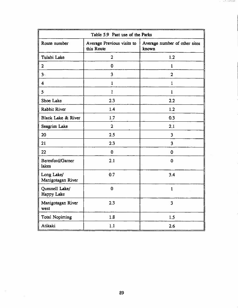
Table 5.9 Past use of the Parks
Route number Average Previous visits to Average number of other sites this Route known
Tulabi Lake 2 1.2
2 0 1
3, 3 2
4 1 1
5- 1 1
Shoe Lake 2.3 2.2
Rabbit River 1.4 1.2
Black Lake & River 1.7 0.3
Seagrim Lake 2 2.1
20 2.5 3
21 2.3 3
22 0 0
Beresford/Garner 2.1 0 lakes
Long Lake/ 0.7 3.4 Manigotagan River
Quesnell Lake/ 0 I Happy Lake
Manigotagan River 2.3 3 west
Total Nopiming 1.8 1.5
Atikaki 1.1 2.6
89

Table 5.10 Duration of Canoe Trips and Days of Use
Route number Group Average Trip Total Days of Use Total Days of Use Duration (in days) (by Groups) (by Person)
1 2.9 421 1.712
2 1 2 3
3 (1 0 0
4 0 0 0
5 4.6 23 74
10 1.7 10 73
11 1.8 91 338
14 0 0 0
15 2.3 89 342
20 2.5 5 15
21 4 12 44
22 0 0 0
23 3.2 55 261
26 3.3 43 182
27 7 7 28
28 2.8 17 82
Total 2.6 775 3155 Nopiming
Atikaki 6.2 319 1795
Table 5.11 Distribution of Trips During the Summer Season
Month Nopiming Park Atikaki Park
May 38 1
June 56 5
July 103 27
Aug 67 17
Sept 26 1
8 A value of zero indicates that trip dates were not recorded.
~ese numbers underestimate actual use; complete coverage of the parks did not begin until the last week of June.
90

Figure 5.1 Hometown of Nopiming Park Users
unknown (2.7%) USA (3.2%)
Canada (2.0%)
Manitoba (27.3%)
91
Winnipeg (64.8%)

Figure 5.2 Home Location of Atikaki Park Users
Germany (5.40/0) France (3.6%)
Spain (5.4%)
USA (42.9%)
92
Winnipeg (23.2%)
Manitoba (12.50/0)
Canada (7.1%)

Chapter 6 Future work
6.1 General
The efforts taken during the summer season of 1993 have provided valuable information,
both for management considerations, and for the economic modelling of canoeing in Nopiming
Provincial Park. In particular, it has shown some areas where prior knowledge was deficient,
where some improvements can be made, and where further knowledge is required.
It is accepted by the project team that there are still areas where the data could be
improved. The distribution of the survey for 1993 did not start early enough, and did not
adequately cover all geographic areas, for example, Atikaki Provincial Park.
The recommendations outlined below are being offered as advice from researchers who
are not experts in park management. They are given instead as suggestions from one user for
adjustments that could improve the recreational experience in the park, and as areas for future
study.
6.2 Future Work
The project team will continue to survey the recreational users of parks in east-central
Manitoba. For the summer season of 1994, planning is presently underway to ensure that the
survey is initiated early enough to obtain as complete a census of users as possible. This will
provide better accuracy of the use in a single year, and the modelling of repeat users. The
combination of the registration forms for 1991, 1992, with the survey forms of 1993 and 1994
will allow study of how users "graduate" to more difficult routes as their experience increases,
and the formation of habits through returning to the same route over several years.
The study team plans to enlarge the scope of the survey for 1994. During the season of
1993, it became obvious that the water routes of Nopiming Park are part of a larger system. The
study of Nopiming Park in isolation, while valuable, does not give a complete picture of the
choices available to water-based recreationists, particularly canoeists. The system of rivers and
lakes extends through Nopiming and Atikaki parks, as well as Woodland Caribou Provincial Park
in Ontario. The Tulabi Lake route is a good example, where a boater starting at Tulabi Lake can
do a circle route involving Snowshoe Lake in Ontario, and returning by way of Davidson Lake
in Nopiming Park. The same start point could allow a canoeist, with some creative portaging,
93

to take a trip through Gem Lake and the Manigotagan River. or even into Atikaki Park by way
of several different rivers. The Manitoba Recreational Canoe Association has trip logs of some
of these trip possibilities. The appropriate authorities for all of these parks have been contacted.
and are part of the planning for the 1994 survey.
Expanding the scope of the study also allows for a better substitution set of trip
destinations, which will permit more accurate economic modelling. For this reason. Whiteshell
Provincial Park will also be included in the work for 1994. The park manager of Whiteshell
Provincial Park. Mark Clark. is part of planning at this time. The variation in the level of
difficulty and challenge of water routes. both between the parks. and between routes within each
park, will provide an excellent model of the reason for the choice of a particular route by users
of the parks.
The survey instrument that is completed by users on site provides very good information.
but supplementary data would also be helpful. The present form is considered to be a suitable
length for an onsite questionnaire, any longer and the participation rate would decrease, and a
shorter form would not provide adequate information. In order to gain further data, particularly
socio-economic data, a questionnaire to be administered by mail is being planned. This will be
sent to the respondents who have completed the onsite survey. and elicit additional information
on the demographics of users, and their motivations for choosing the route that they used.
6.3 Recommendations
SURVEY FORM
There was several areas where the survey form for 1993 did not appear to be properly
understood by respondents. The question that asked the user to fill in the dates of the trip was
misleading, in that it asked for "todays date" and the "trip end date". Numerous respondents had
the same date in both spaces. If the trip was actually of one day duration, this is correct;
however if the respondent completed the form after completing the trip, then the start date is
wrong. This can lead to errors in estimation of the amount of use of the route. The question
should be changed to read "start date" and "end date".
Respondents did not always understand the intent of the nine "other areas" of Nopiming
Park question. Many wrote in the name of a lake or river that was intended to be within one of
these 9 zones. The map on the back of the form should be amended in such a way that the zones
94

are obvious.
The survey for 1994 will be directly targeting canoeists and other boaters, and will be
amended to reduce the perception that it is directed to canoeists only. In particular, the question
which asks "was this canoe trip the main reason for visiting the park?" should be changed to ask
"What was your primary reasonfor visiting the parK?", with a series of check boxes. The check
boxes can include canoe trip as an option, as well as possibilities such as fishing trip, camping,
boating etc ..
Further refinement of the route map on the backside of the survey form will be carried
out for 1994. With the GIS database now available, the location of campsites can be pinpointed,
hopefully increasing the completion rate of this section.
KIOSKS
The kiosks built for the 1993 season will be modified for 1994. It was found that the size
of the main section was overly large, and that the forms tended to roll over within the space.
As well, the many forms that disappeared from the boxes cannot be completely accounted for
from acts of petty vandalism. The possibility exists that forms were taken for the maps included
on the back of the form. Many users were unaware that the offices of the campgrounds had
supplies of both canoe route maps, and park maps. The survey box for 1994 will have the main
box divided into two sections, one for the survey form, and one section for park maps. The
display section will be amended to show a large poster, that contains information about the
survey, and the route. Several of the kiosk locations will be shifted on site in an attempt to
enhance participation. The original registration kiosks, in place prior to 1993, are very efficient
for survey distribution, and dissemination of information. As was the case in 1993, the cost of
such a kiosk at all of the additional sites for 1994 is prohibitive. This is especially true when
new survey locations are added for Atikaki and Whiteshell provincial parks.
ROUTES
The following are suggestions, bearing in mind budget constraints, to improve the
recreation experience of users of routes in Nopiming park. The Natural Resources Department
is aware of many of the problems involved, but perhaps not from the perspective of a user. In
some cases, other considerations that a user would not be aware of are part of the decision
process of the department. For example, Flintstone Lake is not promoted because of potential
95

conflicts with the woodland caribou herd that resident in the area. For this reason, and
considerations of forest fIres, education programs for users should be continued with diligence.
In general, the boating potential of east-central Manitoba does not seem to be well known
outside of the province. The high number of visitors to Atikaki park are the result of a small
group of tour operators, such as the Boys Scouts of America, and Outward Bound, both from Ely
Minnesota. It is interesting to note that both of these groups originate in the center of the BWCA
(Boundary Waters Canoe Area), one of the premier canoeing regions in the United States.
Congestion in the BWCA, and the difficulty of getting reservations for routes, results in the
choice of Manitoba as an alternative. The visitors from Europe are the result of two enterprising
Europeans who arrange all of these visits. The tourism potential of the Manitoba parks, with the
accompanying economic boost to the province, should be aggressively studied in the future.
The canoe route maps issued by the province are in the process of being updated.
Inconsistencies noted by the fIeld staff are being incorporated into the maps for 1994. Several
of the designated campsites need improvement, or no longer exist where they are supposed to be
located. These sites should be refurbished to provide secure locations for camping. In the future,
if use increases, further routes may have to be added.
The possibility of separating users that currently might be in conflict should be looked
at. It is known from the focus group that canoeists are seeking a wilderness experience that does
not include developments such as cottages, and motorboats. Designations of certain routes as
restricted to one type of user may geographically separate users. This should be done as part of
a regional planning effort, that would include the managers of the adjacent parks.
The Tulabi Lake route is the most heavily used in Nopiming Park, and at peak periods
exhibits signs of congestion. Efforts to alleviate this should be entertained. The diversion of
users from a return route are among the possibilities. A circle route that ends at Davidson Lake
might be improved by upgrading the parking facilities at Davidson Lake. At present, the portage
marked on the park map between the Bird River, and Cole Lake is not passable. The cleaning
of this portage may encourage users to traverse a circle route that includes the Rabbit River, or
relieve pressure on Elbow Lake campsites for return trips. The number of non-designated
campsites on this route suggest that more designated sites are necessary. This, in conjunction
with education programs, will provide better security against the potential of forest fIre occurring
from casual campfIres.
96

The Rabbit River route is also heavily used, and could require upgrading. It is suggested
that this would be a route appropriate for motorboat restriction. At present, the portages provide
an inefficient obstacle for motorboat access, mainly anglers who wish to get to Cole Lake. The
designated campsites on this route need to be upgraded, in particular on Cole lake. The regrowth
from recent forest fires make many of the sites unattractive to campers, who are creating other
sites at various locations. Campers instinctively choose the best locations, and perhaps the
location of designated sites should be a function of where people actually camp. This is true for
all of the routes in the park.
The Seagrim Lake route needs extra campsites. At present there are no sites on Seagrim
lake at all, which is a serious deficiency. The use patterns of this route suggests that users enter
the area, and stay in one place for several days. Getting to the site is a matter of several hours.
There are many side bays that could hold sites, allowing privacy and a camping experience that
does not endanger the forest.
The Beresford/Garner Lake route is readily accessible by motorboats, as noted by the park
canoe route map. It is not practical to restrict this route against motorboat use, and the presence
of motors should be further highlighted. Users who wish to enter by canoe will be aware of
other types of users. The presence of alternatives stemming from the Beresford Lake staging area
should be highlighted. In particular, Moore Lake could be another way to travel out of Beresford
Lake. While this route is not totally in the park, it is at present under-utilized, and as time passes
the signs of past forest fires will disappear. Planning of designated campsites on Moore Lake
should be started in the near future.
The Long Lake/Manigotagan River complex does not seem to be as well used as the
existing controversy would suggest. Suggestions as to how to increase use are difficult; at
present it is sufficiently challenging, campsites are adequate, and the scenery is attractive.
Perhaps users who have the time and experience required for the route prefer the greater
wilderness attraction of other parks such as Atikaki.
Many minor routes are probably not attractive to canoeists. These include Tooth Lake,
Euclid Lake, Shoe Lake and Black Lake, among others. With the possibility of physically
separating types of boaters, these all would be good candidates for motorboat users, as indeed
they are presently used. Gem Lake could be a very good entry point for the Manigotagan River
into Ontario, and the inherent potential of long-range tripping. The Black River, and the Moose
97

River between Hwy 314 and Happy Lake, if clean-up maintenance was carried out, could relieve
pressure on other routes, at least in the early part of the season before water levels drop .
•
98

BmuOGRAPHY
Anderson, B. and R. Beaudry. 1975. The Garner. Manigotogan, Moose River Canoe Route. Manitoba Department of Natural Resources, Planning Divison, Eastern Region, Beausejour, Manitoba
Creel M. and J. Loomis. 1992. Modeling hunting demand in the presence of a bag limit, with tests of alternative specifications. Journal of Environmental Economics and Management. 22:99-113.
Cuthbert, C.W. 1978. A Preliminary Floral and Faunal Inventory. Nopiming Provincial Park 1977. Unpubl Rep. Manitoba Department of Renewable Resources and Transportation Services. Research Branch, Winnipeg. Manitoba
Cuthbert. C.W. 1978. Spring and Summer Bird Observations, Nopiming Provincial Park 1977. Unpubl Rep. Manitoba Department of Renewable Resources and Transportation Services, Research Branch. Winnipeg. Manitoba
Englin, J. and J.S. Shonkwiler. 1993. Estimating social welfare using count data models: An application to long run demand under conditions of endogenous stratification and truncation." Review of Economics and Statistics (under review).
Fletcher. S.B .• W.A. White, W.E. Phillips, and L.F. Constantino. 1993. Prairie provinces forest dependent communities: Methodology, empirical results. and welfare implications. In Forest Dependent Communities: Challenges and Opportunities. eds. D. Bruce and M. Whitla. University of New Brunswick Rural and Small Town Research and Studies Program Monograph.
Grogger. J. and R. Carson. 1991. Models for truncated counts. Journal of Applied Econometrics. 6:225-238.
Hellerstein. D. 1991. Using count data models in travel cost analysis with aggregate data. American Journal of Agricultural Economics. 73:860-867.
Hellerstein. D. and R. Mendelsohn. 1993. A theoretical foundation for count data models. American Journal of Agricultural Economics. 75: 604-611.
Hosie. R.C. 1975. Native Trees of Canada. Can For Serv (7th ed.). Information Canada. Ottawa. Ontario
Land Planning Section. Eastern Region. 1976. Preliminary Canoe Route Systems Report. Manitoba Department of Renewable Resources and Transportation Services. Winnipeg. Manitoba.
Manitoba Department of Natural Resources. Fisheries Branch 1985 Caribou (Quesnell)Manigotagan Lakes Creel Census 1984 Prepared by Fisheries Branch. Beausejour. Manitoba.
99

Manitoba Department of Natural Resources, Parks Branch 1992. 1991 Park Visitor Survey, Prepared by Parks and Narural Areas Branch, Winnipeg, Manitoba.
Manitoba Department of Natural Resources, Parks Branch 1990. Survey of Cottage Owners in Provincial Parks, Prepared by Prairie Research Associates Inc. Winnipeg, Manitoba.
Manitoba Department of Natural Resources, Parks Branch 1989. Manitoba Provincial Parks Visitor Survey 1988, Prepared by Commuinications, Economics and Planning Branch, Winnipeg, Manitoba.
Manitoba Department of Natural Resources, Parks Branch 1987 Manitoba Provinicial Parks Visitors Survey (1986) Prepared by Resource Allocation and Economics Branch, Winnipeg, Manitoba.
Manitoba Department of Natural Resources, Parks Branch 1980. Canoe Survey Summary. Unpubl. Rep. Manitoba Natural Resources, Winnipeg, Manitoba.
Manitoba Department of Natural Resources, Parks Branch. 1975a. Subtopic n : Archaeology of Quesnell and Manigotogan Lakes. Unpubl. Rep. Manitoba Natural Resources, Winnipeg Manitoba.
Manitoba Department of Natural Resources, Parks Branch, 1975b. Subtopic ill: Nopiming Canoe Route Brochure. Unpubl. Rep. Manitoba Natural Resources, Winnipeg, Manitoba.
Mazur, D.H. 1975. Preliminary plan for Nopiming Provincial Park. Dept of Tourism, Recreation and Cultural Mfairs. Winnipeg, Manitoba
Otto, W.O. 1989. Wilderness Recreational Canoeing Trends. prepared for Manitoba Department of Natural Resources, Winnipeg, Manitoba
Peterson, O.L., D.H. Anderson, and D.W. Lime. 1982. Multiple-use site demand analysis: An application to the Boundary Waters Canoe Area Wilderness. Journal of Leisure Research 14(1): 27-36.
Rowe, J.S. 1972. Forest Regions of Canada. Can. Dep. Fish. Environ., Can. For. Serv., Ottawa, Ontario. Publ. 1300.
Scoggan, H.J. 1957. Flora of Manitoba. Natl. Mus. Can. Ottawa, Ontario. Bull 140.
Wall, C.L. 1978. Recreational Canoeing - East Side of Lake Winnipeg. Department of Mines, Natural Resources and Environment, Winnipeg, Manitoba
Weir, T. (ed) 1960. Economic atlas of Manitoba. Dept of Ind. and Comm., Winnipeg, Manitoba.
100

Welch. D. 1979. Cultural History Themes. Nopiming Provincial Park. Parks Branch. Natural Resources Division. Manitoba Department of Natural Resources and Environment. Winnipeg. Manitoba.
101

APPENDIX A: List of Project Supporters
Manitoba Natural Resources, Headquarters, Winnipeg: Dr. Merlin Shoesmith, Assistant Deputy Minister, Resources
Manitoba Natural Resources, Eastern Region, Beausejour, Manitoba: Bob Enns, Acting Director, Operations Division, Eastern Region Bruce Bremner, Regional Parks Manager Kelly Leavesley, Nopiming Park Manager Tim Swanson, Resource Technician, Forestry
Manitoba Natural Resources, Parks and Natural Areas, Winnipeg: Jim Crone, Head of Marketing, Visitors Services Section Trucia Howard, Marketing Assistant, Visitors Services Section
Manitoba Natural Resources, District Office, Lac Du Bonnet: Larry Teetaert, Chief NRO Marc Boiteau, NRO Jerry Rossett, NRO
Manitoba Natural Resources, District Office, Bisset: Kelly Ritchie, Chief NRO
Manitoba Natural Resources, Forestry Branch, Winnipeg: Dave Rannard, Director
Canadian Forest Service, Manitoba District Office, Winnipeg: John McQueen, Manager, District Office Grant Williamson, Silviculturist Jake Dyck, Silviculturist
Canadian Forest Service, Northern Forestry Center, Edmonton: Steve Price, Director, Regional Development
Manitoba Model Forest, Pine Falls Manitoba: Mike Waldram, General Manager
Geowest Environmental Consulting, Edmonton: Eric Ellehoj, GIS specialist
University of Nevada, Reno Jeff Englin, Professor, Department of Agricultural Economics
102

APPENDIX B: Boundary Waters Canoe Area and Congestion Literature Review
In preparation for the field season in Nopiming Park, a review of literature was
undertaken. The main goal of the literature review was to study the type of work that had been
done in other areas relating to recreational canoeing, and the problems associated with congestion
in recreational activiites. The literature review concentrated on the Boundary Waters Canoe
Area, because it was known to be well studied.
The search was conducted on the Silver Platter CD ROM database at the University of
Alberta, and from there further references were examined.
Table B.l Congestion and Boundary Water Canoe Area Bibliography
Ahlgren, C. 1984. Lob trees in the wilderness. University of Minnesota Press. Minneapolis, USA An ecological history of human activity in the Quetico-Superior wilderness area, and
especially the Boundary Waters Canoe Area, which covers over one million acres. Topics include flora, effects of forest fires, pre-settlement forests, pine logging and pulpwood logging periods, recreation and conservation. The lob trees of the title were tall pines or spruces selected and lopped as guideposts in wilderness areas of the Minnesota-Ontario border.
Allen, P.G., Stevens, T.H. 1979. The economics of outdoor recreation congestion: a case study of camping. I-Northeast-Agric-Econ-Counc. Amherst, The Council. 8 (1):13-16.
Bias in estimating recreational values may result if congestion is ignored in the demand model specification. Theoretical and empirical considerations pertaining to recreation congestion are summarized. Empirical results for camping in Western Massachusetts are presented which demonstrate the potential degree of bias from demand model misspecification. The results indicate that recreational values may be strongly influenced by congestion effects and that camping areas with relatively low densities may have a higher economic value than high density areas with similar facilities.
Anderson, D.H. 1980. Displacement of visitors within the BWCA wilderness. Unpub PhD dissertation. Colorado State Univ. Fort Collins, Colorado.
Baker, W. 1989. Landscape ecology and nature reserve design in the Boundary Waters Canoe Area, Minnesota. Ecology 70(1):25-35
Fire history data for 1727-1868 are used to reconstruct temporal changes at 5 spatial scales in the patch-mosaic of the 404 OOO-ha study area. The forests are dominated by pines (Pinus banksiana, P. strobus, P. resinosa), spruces (Picea mariana, P. glauca), balsam fir (Abies balsamea), tamarack (Larix laricina), white cedar (Thuja occidentalis), quaking aspen (populus tremuloides) and paper birch (Betula papyrifera). Before European settlement, fires burned the equivalent of the entire area about every 100 yr. No stability at any scale in the patch-mosaic was observed due to spatial heterogeneity in the frre-regime and/or environment. In the design and
103

management of nature reserves, temporal fluctuations should be seen as part of landscape structure and process, not just as an influence on species.
Barton, M.A. 1969. "Water pollution in remote recreational areas.", J. Soil Wat. Conserv. 24(4):132-4
Briefly discusses dangers arising from visitors' sanitary wastes and litter, oil discharge fromo utboard motors, etc., in conjunction with other polluting influences, natural and man-made,with special reference to the Boundary Waters Canoe Area in the Superior National Forest,Duluth, Minn., and possible remedies.
Bonsor, N.C., FJ. Anderson. 1974. Congestion & the Valuation of Recreational Resources Land Econ 74(1):51-7
Borden, F.Y., Turner,B.J., and C.H. Strauss, "Colorado River campsite inventory USDA-For-Serv-Gen-Tech-Rep-NC-North-Cent-For-Exp-Stn, 1977, 28:226-231.
Brooks, P. 1975. "A Roadless Area Revisited", Audubon 77(2):28 The sharp disputes over uses of the famous quetico-superior canoe country of Northern
Minnesota and southwestern Ontario are analyzed. The U.S. portion is officially known as the boundary waters canoe area, the largest wilderness East of the Rocky Mountains. The struggle to preserve quetico-superior since the days of Theodore Roosevelt is documented Significant victories by environmentalists are interspersed with inroads made by logging and mineral exploration interests.
Bury, R.L. and C.B. Fish. 1980. Controlling Wilderness Recreation: What Managers Think and Do. J Soil & Water Conservation, 35:90-94
Increased recreational use throughout the Nat'l Wilderness Preservation System has produced congestion and related problems that threaten the integrity of the natural ecosystems and the sociopsychological qualities of people's wilderness experience. Many wilderness managers have begun to implement controls on the intensity and character of visitor use. A survey of resource managers within the Nat'! Wilderness Preservation System identified the frequency of controls within the system, reasons for control and selection, the major types of controls preferred, the effectiveness of controls, and public reactions to controls.
Cesario, F. 1980. Congestion and the Valuation of Recreation Benefits. Land Econ 56:329-339 The existence of congestion at outdoor recreation sites gives rise to certain problems when
analyzing the benefits of expanding the capacities of such sites. Relevant increments in surpluses associated with the demand for existing facilities must be considered. Two policies are developed to analyze such situations: one assumes ubiquitous marginal cost pricing, and the other assumes zero price approaches. Both policies are found to result in serious underestimates of recreational benefits.
Clark, D.E. and J.R. Kahn. 1989. The two-stage hedonic wage approach: a methodology for the valuation of environmental amenities. J-Environ-Econ-Manage. 16:106-120.
This paper extends the hedonic wage model to a two-stage model in which willingness to pay may be estimated for specific amenities. In concert with supply relationships, which may be estimated independent of the hedonic model, these willingness to pay functions allow for the
104

computation of the value of changes in the level of the amenity. The technique has several important advantages over other valuation techniques, including less stringent data requirements and fewer econometric problems such as intractable identification problems and truncation biases. The model is applied to freshwater fishing and benefits associated with changes in fishing quality are estimated, both generically and through specific water quality improvements.
Cordell, H.K., Hammon, G.A., Graham, J., Hafley, W.L., and M.R. Warren. 1975. ity of water-based recreation systems. m. Methodology and fndings". Rep. Water Resour. Res. Inst. Univ. N.C.
Cullen, R. 1985. Rationing Recreation Use of Public Land. J Env Management, 21:213-225 Growing recreational use of public land in new Zealand is leading to congestion in some
popular areas. Six rationing devices are employed to control and allocate use of public land. The efficiencies of prices effort requirements, lotteries, queues, permits, and zones are analyzed The equity and usefulness of these devices for land managers are also discussed. For both efficiency and equity, criteria price appears to be the best rationing device, unless public land recreation is judged a merit good or is dominated by lower-income people.
Debettencourt, J., and Peterson, G. 1981. Environmental Threshold Functions for User Oriented Resource Planning and Management. Water Resources B. 17:1050-1056
Environmental threshold modeling is a measurement procedure whereby the relative site Quality of outdoor recreational resources can be assessed Mathematic functions are used to represent individual recreationist criteria. illustrative calibration results gathered from canoeists in Michigan's pine river are provided.
Debettencourt, J.S., G.L. Peterson, Pai Kang Wang. 1978. Managing Wilderness Travel: a Markov-Based Linear Programming Model. Env & Planning 10:71-9
Mathematical methods used in the management of a real recreational travel system are assessed. Overnight travel by watercraft in the boundary waters canoe area, minn., is described as a discrete parameter Markov chain. The management problem is defmed, and the analytical approach is stated briefly. The manner in which the mathematical model was applied to the problem is considered. A simple normative model of the system as a steady state process in terms of constant daily entry rates and expected daily populations in interior zones is constructed By means of linear programing, and given constraints on entry rates and zone average daily populations, optimal entry quotas for each of the 33 entry points are determined. The quotas thus derived provided the basis for an actual control program implemented in 1976. Information pertaining to the validity of the application is presented, and the use of the model in policy formulation is discussd. (8 refs)
Douglas, A.J. and R.L. Johnson. Congestion and Recreation Site Demand: a Model of Demand-Induced Quality Effects. J Environ Manag, Nov 92, v36(3):201-13
A model is presented that considers the benefits of an outdoor recreation site, in view of the costs of congestion. The congestion costs consist of encounters with other recreationists. Data on encounters and crowding effects can be used in programming models for maximizing benefits conferred by specific outdoor recreation sites. The theory of consumer choice to multisite recreation expenditures is described, and a graphical device for analyzing demand for trips to outdoor recreation sites with crowding effects is presented. It is recommended that the applicable
105

Federal agencies gather data on visitation rates, participation rates, encounter rates, and congestion costs at outdoor recreation facilities to better monitor and assess site specific quality changes.
Field, D.R., Cheek, N.H. Ir 1974. "A basis for assessing differential participation in water-based recreation". Water-Res our-Bull, 10:1218-1227.
Griesbach, R.I., Asher, I.H. Ir. 1982. Orchids of the Boundary Waters Canoe Area of northern Minnesota in the temperate and boreal coniferous forest biome. Orchid-Dig. 46:213-228.
Hammon, G.A., Cordell, H.K., Graham, 1., Moncrief, L.W., Warren, M.R., and R.A. Crysdale. 1974. "Capacity of water-based recreation systems. i. the state of the art--a literature review." Rep. Water Resour. Res. Inst. Univ. N.C.
Heberlein, T.A. 1977. Density, crowding, and satisfaction: sociological studies for determining [the recreation] carrying capacities [of wilderness]. USDA For. Servo Gen. Tech. Rep. N.C. North Cent. For. Exp. Stn. 28:67-76.
Heinselman, M.L., 1977. Crisis in the Canoe Country. Living Wilderness, 40:12-13 Northeastern Minnesota's million-acre boundary waters canoe area is the only large
Lakeland unit of the Nat'l Wilderness Preservation System and the system's second largest unit of any kind. It attracts more recreationists than any other wilderness area in the nation attracts However, the area is also an important source of timber, and is therefore facing the threat of environmental damage from the timber and mining industries. Legislation dealing with the crisis was initiated in 1976 but was never implemented. If partisans of logging, motorboating snowmobiling, and mining succeed in initiating legislation removing part of the area from wilderness status, not only will this important wilderness area be diminished, but also a menacing precedent for the entire Nat'l Wilderness Preservation System will be set. (3 maps, 10 photos, 1 tables)
Heinselman, M.L., 1970. "Restoring fIre to the ecosystems of the Boundary Waters Canoe Area, Minnesota, and to similar wilderness areas.", Proc. Tall Timbers Fire Ecol. Conf. 10:9-23.
The remaining virgin forests of this area owe their composition and structure to periodic fIres over the past 400 years, and the whole ecosystem is adapted to fIre. The problem of retaining the ecosystem depends on the reintroduction of fIre as a key environmental factor, and methods of achieving this, and its implications for management policy, are discussed.
Hellerstein, D.M. 1991. Using count data models in travel cost analysis with aggregate data. Am-I-Agric-Econ. 73(3):860-866.
In order to control for censoring and the integer nature of trip demand, the use of count data models in travel cost analysis is attractive. Two such models, the Poisson and negative binomial, are discussed. Robust estimation techniques that loosen potentially stringent distributional assumptions are also reviewed. For illustrative purposes, several count data models are used to estimate a county-level travel cost model using permit data from the Boundary Waters Canoe Area. \\\ XAU: Resources and Technology Division, Economic Research Service, U.S. Department of Agriculture.
106

Herrick, T.A., and C.D. McDonald. 1991. Factors affecting overall satisfaction with a river recreation experience. Environ-Manage. 16:243-247.
Higgins, J.F. 1977. A visitor distribution program for the Boundary Waters Canoe Area. Naturalist. 28:22-29. Natural History Society of Minnesota.
Hof, J. 1983. Long-Term Outdoor Recreation Participation Projections for Public Land Management Agencies. J Leisure Research, 19831: 1-14
A theoretical structure for developing long-term outdoor recreation projections for public land agencies is detailed, using data from USDI's 1977 Nat'l Outdoor Recreation Survey. Substantial increases in outdoor recreation participation are anticipated, implying that recreation planning cannot simply aim at a target level of participation without considering supply demand interactions. Activities surveyed include camping, hiking horseback riding, driving off-road vehicles, picnicking, sightseeing canoeing, and kayaking, sailing, swimming outdoors, downhill skiing, and snowmobiling.
Hulbert, J. 1977. BWCA visitor distribution scheme. Journal-of-Forestry.75:338-340; A system for limiting and distributing visitors to the Boundary Waters Canoe Area was
introduced in this wilderness area in the Superior National Forest (NE Minnesota) in 1976. The method involved issuing a limited number of reservable wilderness permits for each entry point; quotas were derived using travel simulator models, and were based on numbers of campsites in each area and predicted travel behaviour from past records. Only 25% of the permits were reservable for more than 48 h. Obstacles to the system included the many commercial interests in the area (means used to overcome this are described), and the concurrent jurisdiction of both Minnesota State and the Federal Government over the waterways. The system worked well except for a few minor problems, for which solutions are discussed.
King, J.G., and A. C. Mace. Effects of Recreation on Water QUality. WPCF J. 46:2453(7) Water QUality parameters are measured near campsites in the boundary waters canoe area.
The use of campsites leads to highly significant increases in coliform bacteria populations and smaller increases in available phosphate concentrations in nearby waters. Drainage from the pit toilets located at each site may be the cause.
Leitch, J.A., Nelson, W.C., 1976. "Environmental trade-offs in the lower Sheyenne Valley". Agric. Econ. Rep. N.D. Agric. Exp. Stn. Dep. Agric. Econ.
The priority evaluator technique (PET) was used to estimate preferences of residents of the Lower Sheyenne Valley in North Dakota toward: (1) scenic view, (2) water recreation, (3) floods, (4) wildlife habitat, and (5) land recreation. three levels of each of the five environmental categories were involved along with prices of each level, a limited budget, and a requirement to purchase one level of each of the five categories. respondents purchased a set of environmental attributes which included a higher level of flood protection and water recreation than currently exists in the valley. they decreased the level of scenic view and land recreation while maintaining wildlife habitat at a level approximately equal to existing level.
Lime, D.W. 1969. Wilderness-like recreation opportunities adjacent to the Boundary Waters Canoe Area. Naturalist 20:36-41.
107

Lime, D.W. 1977. When the wilderness gets crowded? Boundary Waters Canoe Area, recreational use. Naturalist. 28:2-7 ..
Lime, D.W. and R.G. Buchman. 1974. Putting Wilderness Pennit Information to Work. J Forestry,72:622-625
In 1973 visitors to 43 wilderness and primitive areas were required to obtain a pennit before entering the regions. In time USFS expects to use permits on all wilderness areas. The use of visitor information obtained from the permits by wilderness managers and by the public is discussed The use of online computerized systems for park management and for analyzis of day-to-day use patterns is also discussed. Permit data for the boundary waters canoe area are described.
Longstaff, F. 1980. The River Everyone Wants. Seasons 20:30-36 The Spanish river of Ontario is highly prized by environmentalists for
its recreational and scenic resources, primarily canoeing and camping However, the provincial government issued a directive in 1978 that the Spanish river would be developed as a multi-use resource. The construction of hydroelectric dams along the waterway are proposed. Such developments are opposed by environmentalists, as fragile ecosystems will be degraded and the pristine wilderness will be invaded.
Marion, J.L., L.C. Merriam. 1985. "Recreational impacts on well-established campsites in the Boundary Waters Canoe Area Wilderness."Station Bulletin Minnesota, Agricultural Experiment Station.
Marion, J.L.and T. Sober. 1987. Environmental impact management in the Boundary Waters Canoe Area Wilderness. North J. Appl. For. 4:7-10.
McConnell, K. 1977. Congestion and Willingness to Pay: a Study of Beach Use. Land Econ. 53:185-196
A model for estimating the demand for congested recreation sites in densely populated areas is developed and applied. The model is used to estimate benefit functions for a set of Rhode Island beaches. Management strategies for short-run decision-making are demonstrated by comparing optimal beach use implied by benefit functions to the standards of beach use established by the U.S. bureau of outdoor recreation and by state comprehensive outdoor recreation plans of several states.
McCool, S.F., Merriam, L.C. and C.T. Cushwa. 1969. The condition of wilderness campsites in the Boundary Waters Canoe Area. Minn. Forest Res. Notes 202.
McCool, S.F, and L.C. Merriam. 1970. Travel method preferences of Boundary Waters Canoe Area campers. Minn. Forest Res. Notes 219.
Merriam, L.C., Goeckermann, K., Bloemendal, J.A. and T.M. Costello. 1971. A progress report on the condition of newly established campsites in the Boundary Waters Canoe Area. Minn. Forest Res. Notes 232.
108

Merriam, L. and R.F. Peterson. 1983. Impact of 15 years of use on ·some campsites in the Boundary Waters Canoe Area. Minnesota Forestry Research Notes 282.
Merriam, L.C., Jr.and C.K. Smith. 1975. "Newly established campsites in the Boundary Waters Canoe Area. Restudy of selected sites Minnesota Forestry Research Notes 254.
A study in 1974 of fIve camp sites in the Boundary Water Canoe Area in Minnesota showed that damage was not increasing except on one Aspen/Birch site near a main road where soil compaction, area of bare soil, and area of camp site had increased. Damage had decreased on one Spruce/Fir site where shrubs appeared to have prevented expansion of the site and heavyorganic matter had prevented soil compaction.
Merriam, L.C., Jr., and C.K. Smith. 1974. Visitor impact on newly developed campsites in the Boundary Waters Canoe Area. Journal-of-Forestry. 72:627-630.
Describes a 5-year study of the effects of visitors at new camp sites in each of six forest types [cf. FA 33, 7226]. Aspen/Birch sites were most susceptible to damage, followed by Spruce/Balsam Fir, Jack pine, Red Pine/White Pine, White Cedar and open sites. The amount of damage increased during the fIrst two years and then remained constant. Recommendations are made for minimizing and containing the amount of damage in forested recreational areas.
Morgan, J., and F.R. Kuss. 1986. A First Alternative for Estimating the Physical Carrying Capacities of Natural Areas for Recreation. Env Management 10:255(8)
A method for approximating the physical carrying capacity of natural areas for outdoor recreation utilizes an adaptation of the Universal Soil Loss Equation. ClassifIcation of forested Woodland and fIeld environments is based on the conversion of ground cover coeffIcients to the percentage of ground cover required to maintain soil productivity over time. Four canopy types, three canopy densities, and two general types of ground cover are recognized in the equation, as are soil characteristics. The approach requires that the areal distribution of soils occurring within natural areas be mapped.
Peterson, G.L., 1974. "A Comparison of the Sentiments and Perceptions of Wilderness Managers and Canoeists in the Boundary Waters Canoe Area". J Leisure Research, 6:194(13)
Wilderness managers and summer canoeists were studied in the boundary waters canoe area to determine whether the two groups differ in their wilderness motivations, attitudes, preferences, and perceptions Psychological inventories were used, and environmental disposition was studied using mckechnie's environmental response inventory. There were strong tendencies toward agreement, especially for environmental disposition. However, regarding details of the human response to the bwca, there are important differences in degree. The managers are more disposed toward many things that the canoeists fInd undesirable. The managers seem to have more varied motivations and apparently are more knowledgeable about the area. The canoeists have an inflated image of the area's wilderness character, but apparently are more demanding in their expectations and use of different criteria to evaluate recreational performance. The managers tend to rate performance higher than the canoeists do.
Peterson, G.L., Anderson, D.H. and D.W. Lime. 1982. Multiple-use site demand analysis: an application to the boundary waters canoe area wilderness. J. Leisure Res. 14:27-36.
109
Pfister, R.E. 1977. "Campsite choice behavior in the river setting: a pilot study on the Rogue River, Oregon. USDA-For-Serv-Gen-Tech-Rep-NC-North-Cent-For-Exp-Stn, 28:351-358.
Prince, R., and E. Ahmed. 1989. Estimating individual recreation benefits under congestion and uncertainty. J. Leisure Res. 21:61-76.
Ravenscraft, DJ. and J.F. Dwyer. Estimating the influence of congestion on the willingness of users to pay for recreation areas. For-Res-Rep-Agric-Exp-Stn-Univ-lli. 78-5,
Harrington, W. 1987. Measuring Recreation Supply. Resources for the Future Report, 1987(85) An assessment of recreation supply and recreation resource scarcity in the U.S. is outlined.
It is argued that recreation resource scarcity can be approached in a manner analogous to that used for market commodities, by converting the costs incurred by both recreation participants and the operators of recreation areas into a common metric that will serve as a scarcity measure. A relationship is determined between the social cost of producing a recreation experience and the number of participants served. A price of a recreation experience is defmed that corresponds to the price of final products. One of the most important elements of this price, the cost of congestion, is examined.
Roggenbuck, J.W., and R.M. Schreyer. 1977. "Relations between river trip motives and perception of crowding, management preference, and experience satisfaction. USDA For Serv Gen Tech Rep NC North Cent For Exp Stn, 28:359-364.
Shaw, S.P. 1977. "Compatability of intensive timber culture with recreation, water and wildlife management". USDA-For-Serv-Gen-Tech-Rep-NE-U-S-Northeast-For-Exp-Stn, 29:279-289.
Shelby, B. 1980. Crowding models for backcountry recreation. Land-Econ. 56: 43-55.
Smith, V.K. 1974. A Simulation Model for the Management of Low Density Recreational Areas J Env Beon & Mgmt 1:187-202
To account for the congestion externalities associated with intensified use during a given period at a low density recreational area, the effects of alternative use levels on the expected Quality of each individual's experience must be determined. A simulation model for wilderness recreation is applied to the Spanish peaks areas in Montana.
Stankey, G.H., Robert C., Lucas, D.W. Lime. 1975. Crowding in Parks and Wilderness. Design & Env. 7:38(4)
Wilderness use of national forests grew an average of 10%/yr between the end of world war II and 1975. Suggested solutions for this problem include: spreading people more evenly and providing areas managed specifically for primitive recreation. Generalized statistics are presented for use patterns and use density related to crowding.
Stewart, W. 1991. Compliance with Fixed-Itinerary Systems in Water-Based Parks Env Management 15:235(6)
In many parks and wilderness areas, permits are required when traveling overnight in the backcountry. The permit operation is a f!Xed-itinerary system when it designates a campsite location for each night of a user's trip. Some studies at land-based parks indicate that trip
110

information from itineraries does not always coincide with actual user behavior. To assess the effectiveness of the fixed-itinerary system at a water-based park., discrepancies between the itineraries recorded on permits and those reported by overnight users, foll,?wing visits to Everglades Natl Park., FL, were studied. Motorboaters were most likely to comply with their permit conditions than canoeists. Having to share campsites with noncomplying campers reduced the enjoyment of the wilderness for 11 % of respondents.
Stynes, D.J., Peterson, G.L. and D.H. Rosenthal. 1986. Log Transformation Bias in Estimating Travel Cost Models. Land Economics 62:94(10)
Semi- and double-log models used as travel cost methods for estimating the demand for and value of recreation sites are addressed. With the expected value of .the conditional.mean function as the desired estimate the bias resulting from estimation of semi- and double-log models by linear regression is reviewed. Relevant adjustment procedures are proposed and illustrated with an example of canoeing in the boundary waters canoe area wilderness.
Titre, J., and A.S. Mills. 1982. Effect of encounters on perceived crowding and satisfaction. Misc Publ Univ Minn Agric Exp Stn. st. Paul: The Station. 18:146-153. Presented in the Forest and Rivers Content Area of the Symposium on Leisure Research, October, 1981, Minneapolis.
Vaux, H.J. 1977. The Costs of Congestion and Wilderness Recreation. Env Management 1:495(9)
Existing research on the effects of congestion in wilderness areas suffers from problems associated with asking the public directly what it would be willing to pay to avoid congestion under hypothetical circumstances. Two inferential methodologies are used to examine visitors' willingness to pay for the use of three California wilderness areas during peak and off-peak use periods. Inferential methodologies do not provide unambiguous measures of consumer surpluses. They do, however yield the conclusion that, with the exception of a relatively few individuals, solitude is not of overriding importance. Convenience of timing and the attributes of different wilderness areas appear to be more important than congestion.
Walsh, R.G., and L.O. Gilliam. 1982. Benefits of wilderness expansion with excess demand for Indian Peaks. West J Agric Beon. 7:1-12.
The contingent valuation approach was applied to the problem of estimating the recreation benefits from alleviating congestion at Indian Peaks wilderness area, Colorado. A random sample of 126 individuals were interviewed while hiking and backpacking at the study site in 1979. The results provide an empirical test and confirmation of the Cesario and Freeman proposals that under conditions of excess recreational demand for existing sites, enhanced opportunities to substitute newly designated sites by reducing congestion results in external benefits to the remaining peak day users who do not substitute, and should be added to the recreational use benefits of new sites.
West, P.C. 1982. Effects of user behavior on the perception of crowding in backcountry forest recreation. For-Sci. 28:95-105.
Wetzel, J.N. 1981. Congestion and economic valuation: a reconsideration Recreation areas; beach, forest, parks. J. Environ Econ Manage. 8:191-195.
111

Wikle, T.A. 1991. "Evaluating the acceptability of recreation rationing policies used on rivers.", Environ-Manage. 15:389-394.
Wolf, R.E. 1978. Planning--the Minnesota Boundary Waters Canoe Area--U.S. view Superior National Forest, timber sales, land use policy. Proc-Soc-Am-For. pp 384-388.
Wright, H.E. 1974. "The Boundary Waters: Wilderness at Stake". Living Wilderness 38:21(13) No remnant of the U.S. past presents a better case for wilderness preservation than the
lake-dotted million-acre expanse in northeastern Minnesota known as the boundary waters canoe area. Half is virgin forest the largest that remains in the U.S. East of the Rocky Mountains; yet proper protection for this national asset is unassured because USFS charged with maintaining the region's primitive character, has pursued an equivocal course in the area's management. Significant changes in forest use in boundary waters are documented. Alarming management strategies, which permit administrative cutting in the forest. are examined.
112

APPENDIX C: Trip Diaries of River Routes Canoed in Nopiming Park
The known and potential canoe routes in Nopiming Park were paddled during the summer
of 1993. The primary purpose of these trips was to collect attributes of the routes, campsites,
and portages. Vegetation species were inventoried at various points as ground-truthing for
eventual comparison with GIS Forest Inventory work. A secondary purpose of the trips was to
view users' actual use of the canoe routes.
An effort was made to disturb other users as little as possible. For this reason, along with
the weather, more than one trip was made on several of the routes. If a campsite was in use, it
seemed better to return at another time to survey the attributes of the site. If the other users
encountered on portages or while canoeing seemed sociable, they were talked to on the route.
The following trip diaries contain a chronological sequence of the trips taken during the
summer period. They contain the trip date, people involved, general impressions, and
information that could not be placed elsewhere in the report. The diaries are written in the first
person by D. Watson, who was present on all trips except one on the Tulabi route. Specific
details on the attributes are not included, since they are better presented in the databases in
Appendix E.
ROUTE 15 SEAGRIM LAKE, TRIP ONE
The flrst trip of the season was taken with P. Boxall of Edmonton on June 1st and 2nd.
We started out in the early afternoon, and finished by noon of the next day. This trip was
primarily a test case, to help defme the attributes to be collected, and the method of collection.
It was not intended to collect the attributes of the whole route on this journey. It was also used
to allow one of the authors based in Edmonton a chance to see some of the backcountry of the
park. The trip proved the worth of mini-cassette recorders for keeping track of details. They are
easy to carry and use, and much more efficient than pen and paper.
On this trip, Peter and I just poked around the flrst two lakes, (unnamed), and visited the
designated campsites. The canoe route maps provided by the province were quite accurate on
locations of these sites, and the portages. They may not have shown all of the islands, more of
an outline, but there was enough to get around. The recommendation of taking topographic maps
as well is good advice.
The trip starts with a portage from the staging area to the ftrst unnamed lake. The trail
113

is muddy at one point, but overall well maintained. wide and straight. The first lake does not
have a lot of significant attributes. and no official campsites. though it is very pleasant scenery.
It can be traversed in about 15 minutes.
The portage to lake 2 is 275m long. again a pleasant hike over a well maintained trail.
As opposed to the fll"St lake. here we began to see signs of fire. It was on this lake that the first
designated campsites were found. as well as the first non-designated ones. In fact the first site
found was non-designated. It had several manmade features. besides the obvious campfIre ring.
In particular. a bench/chair made of birch logs. and padded with moss. Someone went to a lot
of effort to build it.
Mter paddling around to all the designated sites on the lake. we set up our camp at
number 15.04. The area is a bit soggy and damp. but in a forest area of mature. well spaced
jackpine. Behind it is a large hill. providing a view of the back bay. and across to Elton Lake.
The site itself provides a view of the whole lake. meaning it can also be seen from everywhere.
However. we were the only ones camped on the lake this night.
The next day we again paddled around this second lake a bit. and walked across the
portage to Elton Lake. Though we did not plan to go further. it was interesting to walk across
and see the next lake. It did not take long to paddle and portage back to the car. and then return
to Winnipeg.
ROUTE 11 RABBIT RIVER TO COLE LAKE, TRIP ONE
There were two trips taken on this route during the summer season. the fIrst on the
weekend of June 5-6. with Duncan McKinnon of Beausejour. Manitoba. This trip, like the fIrst
trip on route 11, was primarily a test case, to help define the attributes to be collected, and the
method of collection. It was not intended to collect the attributes of the whole route on this
journey.
The trip was started from the launch area at 3 pm. The launch area is a parking lot beside
Hwy 314 where it crosses the Rabbit River. The river during the fll"St 10 minutes of paddling
(0.5 km) was very twisty, with tight meander bends, and shallow, (0.7 to 1 m deep). There were
also 3 beaver dams blocking the river within the fIrst 500 metres. A fourth extensive beaver dam
complex blocks both the Rabbit River, and the outlet from the unnamed lake to the north-east
(route segment 11.2). These beaver dams were easy to cross, with Duncan stepping out of the
114

canoe as we nosed up to the dam. He then held the boat while I got out, and we pulled the boat
over the dam, and re-entered it on the upstream side. Shortly after the junction, the river widens,
becoming a long deep lake with rocky shores. This lake is about 1.5 km long, and 500 to 800
meters wide. There are some potential camping sites, other than those designated. Several show
signs of past use, and one was in use during this trip. This portion of the route shows no signs
of past forest fIfes, or logging activities. Users would be aware that there is logging nearby in
the area, as evidence can be seen from the road near the staging area. A group with one canoe
was camping near where the fIrSt designated campsites are marked on the canoe route (peninsula
campsite.
At the end of this river widening, there is a portage, measured by pacing to be 35-4Om
long, on the north shore. The portage skirts a bouldery rapids, that could not be canoed going
upstream. After the portage, the river narrows, with tight meanders as previously seen on the
early section. However, the valley here is wider, with littoral vegetation of sedge, kahlia, and
willows. The meandering river-type continues until a second lake (river widening) is
encountered. It was during this second twisting section that Duncan remarked that this would
be a good family river, where he would be comfortable bringing his young children. The second
lake is long and narrow. It took us 2 1/4 hours to paddle to this point from the launch site.
A second portage lies at the end of this lake, on the north shore, 75 m long, again skirting
a short rapids. After the second portage there is a small lake, then a section of straight but rocky
river for about 600m. This ends in a third portage, on the north shore, which is 125m long.
Above the third portage, there is a lake, about 150 m wide, and 1 km long. A group of two
young men were camped at the end of this lake, at designated number 11.07. When we met
them, they were in the bay, fishing from their small motor boat. They hadn't caught anything.
Across from them, on the north shore, a large group was camped at a non-designated site. They
had three canoes beached. The lake ends in a portage, followed by a small lake, and a fifth
portage. The fourth and fIfth portages are both less than 50 m long, and on the north side of the
river. We did not carry our canoe across the last portage, but walked it and looked downstream.
After this fifth portage, the river seemed to be through a canyon, with good tree growth.
The time at this point was 6:30 pm, and we decided to camp. We stayed at a non
designated site on the small lake between the portages. It showed signs of heavy previous use,
and all designated sites nearby were occupied. While we were cooking our supper on the gas
115

stove, we heard a helicopter flying over nearby, in the direction we had come.
We left our campsite at 8:40 am, went back across portage four, and looked at campsite
11.07, where the boys had been the night before. A feature that we would find regularly during
the summer was noted; that while there was a frrepit present there was also signs that campfIres
were made outside of the mepits.
On the return trip, we met the backcountry patrol, who were there in a motor equiped
canoe. The helicopter we had heard was a me fIghting unit. The island on the frrst lake where
we had seen campers had a small forest me. The campers had already left when the fIrefighters
arrived, and the backcountry patrol was trying to find out who had been there.
The return trip was uneventful and we met no further people. From the upstream end the
beaver dams were easy to paddle across without getting out of the canoe. No doubt this was
easier after the heavy motor canoes had passed and created a channel. We arrived back at the
staging area at about 1 pm.
ROUTE 23, BERESFORD LAKE TO GARNER LAKE TRIP
The trip from Beresford Lake to Garner Lake was taken on Wednesday, June 9th, with
L. Peters. We started out from the Beresford Lake boat launch, near the campground, at 9: 15
am. The area around the campground has not been burnt, but we quickly entered an area that had.
By 9:30 am we exited the lake by going under an old logging bridge. The trip down Beresford
creek was uneventful, we passed an large motorboat of anglers coming out, heavily laden with
camping gear. The trip along Beresford Creek to Garner Creek took about an hour, through an
area of low hills. The valley is wide, and the creek has a wide floodplain.
The canoe route map shows a portage is necessary at the junction of Beresford and Garner
creeks, but the portage is only needed for those continuing to the west. There is no need to
portage to go up Garner Creek to Garner Lake. By 12 noon we were nearing Garner lake;
Garner creek was wide, shallow, meandering, with swampy flats. The burn area ended shortly
after entering the creek. There is a reasonably good diversity of vegetation along Garner creek.
We saw one non-designated campsite about one half km before the lake. It wasn't much of a
campsite but is a nice grassy, open spot. We stopped because of the interesting black basaltic
rock.
We stopped for lunch on a very small island in the first large bay of the lake, it was
116

vegetated with shrubs, but the northeast end was flat rock, good for a lunch. Mter lunch we
continued along into the lake, to look for the designated campsites. The first one, # 23.02, we
could not find. The campground attendant at Beresford, Bob, later said that not many people find
that one. It was the only one on this route that was not very obvious. This was the first time
where we noticed the ingenuity of campers in "improving" the campsites. Nearly every site had
some sort of addition built in. Most had rough tables for the cleaning of fish, others had holding
pens for fish, one even had a stump cemented into the shore to tie the boats up. Another had a
complete parks picnic table brought in. We found no real evidence of non-designated sites on
the lake, the dense undergrowth suggests that they would be both hard to create, and easy to see
if they were there. The route seems to have more islands than the canoe route map suggests,
which gives the lake a smaller feel than it looks on the map.
The real surprise was found at the east shore of the lake. Along the part of the lake that
is in Ontario, there is a stretch of sandy beach about one km long. This has a series of non
designated campsites built into the woods behind. We joked that it was a promotion of Ontario,
and that they had brought the sand in for tourists.
Near the sandy beach, at the entrance to the large bay that points north, there is a cabin.
We met the owners, who said they were from the USA. As a group, some teachers bought the
lease of the cabin, with the only provision being that they have to maintain it. They come in by
turns during the summer to use the cabin.
During the trip back to where we entered the lake, we discovered that it did have one
characteristic of a large lake, dangerous waves. We were paddling the north shore, and the wind
from the south picked up very quickly. Soon we were battling to keep moving, running parallel
to the waves. The shore here was not appealing, with no place to camp if we stopped. And to
get to one of the island campsites, we would have to go into the waves across open water. Mter
nearly one hour of this, we came to where we entered the lake, and a good campsite. We
quickly set up out tents, and hid from the rain. By 7:00 pm, the storm had ended. While in
principle we could have gotten back to Beresford Lake that night, after the work of paddling
through the storm, we decided it would be best to stay the night.
The next morning, an easy two hour paddle brought us back to the staging area, and the
end of the trip. It would be possible to do the trip in one day, certainly many do it in motor
boats, but for a canoeist the best would be at least an overnight trip.
117

ROUTE 1, TULABI LAKE TO McGREGOR LAKE, TRIP ONE
This route was surveyed on the weekend of June 15-16 with D. Kuhnke of Forestry
Canada in Edmonton. We started about 10:30 am from the staging area near the Tulabi Lake
campground. We had wanted to start day before, but the wind was too high. It takes about lO
IS minutes to cross Tulabi lake. The area shows the signs of a mature forest, with mixed tree
growth, predominately conifer. In addition to the portages outlined in Appendix E, a portage has
been built from before the flfSt portage to after the third portage. It was put in place by the
builders of the youth group (see below) on Elbow lake, located where campsites 1.09 and 1.10
should be. The ftrst two portages both have steep hills, with wide dirt tracks. If rainy, the hills
would be very slippery.
Between the second and third portages, near 1pm, we heard what sounded like a chain
saw. Though we could see nothing from the shore, we got out and looked around. We found
a cut block, of at least 100 acres. We didn't ftnd the source of the noise, but there was no one
actively cutting. It was probably a trail bike. From then on we started to look more closely for
signs of forestry.
We found several non-designated sites along this section of the route, in particular near
the portages. While the ftrst two portages were absolutely necessary, the third was really just
one ledge, and could be run going downstream by the daring.
We left the third portage at 3:10pm, after a cold lunch. Entering Elbow Lake, we easily
found all but three of the designated campsites. The lake shows a good variety, and adequate
number of campsites. The ftrst one not found had had its ftrebox moved to another location,
which we did fmd. Designated campsites 1.09 and 1.10 were not found, and no longer exist. The
peninsula where they should have been was occupied by a half completed youth camp. There
were several big buildings, a nice rocky beach, and docks on both sides. Some machinery had
been left on site, and vandals had been active in places. There was no sign that the area had
been used by campers.
Mter exploring the lake, and surveying the pertinent attributes, we set up for the night
at the last campsite on Elbow Lake before the river continues to McGregor Lake. By now it was
early evening, and the maps suggested a longish trip to McGregor Lake. We dined on my
infamous macaroni and cheese. We walked around the area a bit, but as usual, there wasn't
much of interest away from the shore. Mter supper, we saw some ftsh jumping, so Dieter tried
118

some fishing. He wasn't succesful though not for lack of trying. At one point when he was
nearly ready to quit, he shouted that there were no fish; just then a large one jumped right beside
his canoe.
The next moring we continued on to McGregor Lake. It wasn't as far as the map made
us believe. We got there in about one half hour, after paddling through a section of river with
canyon features. The water was rocky as we approached the portage at the west end of Mcgregor
Lake. This portage is a beautiful spot, with two waterfalls. There are two short portages, both
on the north side. We stopped at the end of the first, and from there we could see the designated
campsite, and McGregor Lake.
Given the time, and worsening weather, we decided to turn back, and investigate
McGregor Lake at a later date. On the way back we met up with several groups. A party of iwo
was travelling in as we approached Elbow Lake. As well, exiting Elbow Lake a lone paddler
was met. By this time it was raining heavily, he didn't seem disturbed by it though we were.
At the second portage we had to wait offshore because of other groups. There was a group of
four heading up towards Snowshoe Lake. Ahead of us was a party of two boys that we had seen
the night before looking for a campsite on Elbow Lake. Mter the mini traffic jam, we
encountered no problems on the rest of the route. We arrived at about 2:30 pm, which meant
a paddle of around 5 hours from McGregor, without working very hard.
ROUTE 22, MANIGOTAGAN RIVER FROM HWY 314 TO LONG LAKE
The route was surveyed on July 22, with L. Peters. We parked our vehicle at the pull out
beside the east side of the highway, and carried the canoe across to the west side, and started out
down the river at 8:40 am. The trip is not overly interesting, basically just a short river run,
good for a half day of being outdoors. The three portages are quite close together, and arrived
at early on the trip, about one half an hour after starting out. The first two are in flat country,
and skirt short rapids. The first we lined the canoe through, the second was a bit steeper, 2 short
shelves. The third is more extensive, around a small canyon, with a sloppy, very narrow and
rough path. It was marked with flagging tape. We fInished the portages just after 9:30 am.
The river showed signs of an old burn for the first part, but after the third portage, it was
a canyon type paddle for a short distance where the burn did not reach. We arrived at Long lake
at 10: 18, then took about 15 min to go across the lake to the boat launch. No special features
119

at all along the route, except maybe the canyon area (10 M high walls) near the 3rd portage. A
cottage owner on Long Lake said that before the highway went in, it was one long portage on
the north side of the stream. We again encountered some high waves crossing Long Lake.
ROUTE 21, HWY 314 TO GEM LAKE AND RETURN BY MOOSE RIVER
The trip was undertaken Jul 27-28 with L. Peters. We left one vehicle on the roadside
where Hwy 314 crosses the Moose River, and continued on to where the road crosses the
Manigotagan River. Here there is a turn-out, with a small parking area. We left the
Manigotogan River crossing at 1:25pm. The late start was because we were both coming from
Winnipeg, and stopped along the way to check the survey boxes. After a short paddle along a
burnt but pleasant stretch of river, we reached the turnoff, the junction with Garner creek, at
1 :4Opm. The Manigotagan river to this point is about 20-3Om wide, with swampy edges. The
Manigotagan River from here towards Gem Lake is at most 10m wide, with swampy reedy edges.
There is no canoe route map for this route, so we had little prior knowledge of the river, or
portages. We reached the ftrst portage at 2:35pm. It was rather long (300m), and seemed more
so since the trail is narrow and sloppy; less than 1 m wide, too narrow for the canoe in some
places. At least it was easy to fmd, on the west side of the stream. Here there were no signs
of ftre.
It was less than 100m of paddling to portage 2. The river here is very narrow, less than
3 m wide, with many rocky outcrops. There is heavy underbrush, with deftnite signs of an old
burn. The portage is only about 150m long, on the west side of the river. We found flagging
on the upstream end of the portage.
The next stop, portage 3 is again 150m long, on the east side, with a very rough trail.
We managed to lose the trail twice on this short haul. Somewhat surprised to fmd hazelnuts.
These portages are all close together, it was only 200m from the second portage.
The stream remained narrow, but a pleasant paddle the 500m to the fourth portage. Lily
started to recognize the signs of approaching rapids, the faster water, and slight foam. The fourth
portage was on the east side, and not obvious from the water as we approached on the
downstream end. The trail was very rough, did not seem to have been used much, though when
we reached the end we found a campftre ring on the upstream end. It did not seem likely anyone
was camping there. From here to the ftfth portage it was 800m.
120

We fInished the fifth portage at 4:30 pm, and both strongly hoped it would be the last.
The trails are not maintained (this is not an officaial route), nor are they well used. The fifth at
least was short. 75m on the west side. Again we found flagging on the upstream end. not all that
useful for someone going upstream. However, for the most part the trails are not hard to fmd.
The understory on portage 5 is not as thick as the others, and also had some sort of wild grape,
not seen elsewhere.
The fIrst 300-4OOm since portage five has been burned, then the forest looks good. The
river is basically straight lines, a wide quiet river. It shows a narrow channel between weeds on
shore, the valley a total of about 25m wide, the river occupies one third. Near 5:15pm we
stopped at a rock outcrop. At one time there was lots of use here, with a fallen down cabin, and
two derelict boats. The point is very close to Gem lake, and may be still be a stopping point for
boaters coming downstream from the lake.
The last bit of river into Gem Lake shows signs of old fire, and diseased trees. We
arrived at Gem lake at 5:50 pm, and around the bay to the "boat launch" at 6: lOpm. Just at the
entrance to the lake we met two boys in a motor boat fishing. Their boat was normally cached,
and they brought the motor in on a trail bike (quad). We had been warned that many people had
boats cached on the lake, that are brought in over the portage in the winter. We did not expect
as many as we found. I counted 48 boats in the open and obvious, including several "fleets",
for example, 4 neatly stacked stenciled Baptist Youth Camp. Several boats have been abandoned
forever, both in and out of the water. A fmal count of obvious, abandoned, and well hidden
boats was 77. The area itself has lots of garbage, in particular minnow containers.
We left boat launch at 18:30hrs, and reached the biggest island on the lake at 19:15. The
island has a cabin, and other buildings, as well as recreational extras (diving board). We guessed
that it might be the Baptist Youth Camp. We did not explore all of the bays of the lake, as it
was getting late, and the weather was threatening. What we did see did not seem like great
camping. The north and east shores were heavily wooded, the southwest shows signs of an old
burn; a rough guess would be that 70% of the southern shoreline was burnt, 20% on the north
shore. So we camped on the island. We had to hide in our tents for awhile as the expected rain
arrived. During the break we quickly set up the stove, and heated supper, then back into the
tents for the night.
The morning showed slightly better weather, overcast but not raining. We left the island
121

at 9: 15 am. It was easy to fmd the portage out of the lake. It skirts a very nice little wateIfall.
Two men were fishing at the bottom, without evident success. It took about 30 min to portage,
over a bad trail, that was also badly marked. It didn't seem that anyone had used the trail in
several years. We fmished it at 10:15 am.
After the portage, the area has defmitely burned, in places it was eerily beautiful, with
all the dead trees still standing. The river is about 20m wide, with a reedy, marshy shoreline,
broad and flat. Banksian Lake was nice though the exit was hard to find, the lake was in a burn
area, with no standing deadfall. The shoreline was about 95% burnt. After Banksian Lake, the
route to Lily Lake showed heavy burn, everything seen was standing deadfall. Between the two
lake the only obstacle was a small beaver dam that we crashed across.
We arrived at Lily Lake at 11:10 am. The area has been 100% burnt, with some regrowth
on the south shore. The river skirts the east edge of the lake, before heading southeast towards
Slate Lake. Nothing of interest seen on this bit of the trip. We arrived at Slate Lake at 11:45
am, the last reach was swampy and reedy, through a burn. Slate Lake showed some burn; the
south shore 10% burnt, the north 90% burnt. We could see where the river entered Slate Lake
from Ontario, and the smallish creek to Wrathall Lake, but decided at this point to return to Lily
Lake, and fmish the journey.
We got back to Lily Lake at 12:30 pm, and had crossed it in 10 minutes. It is a shallow,
flat lake, and the regrowth seemed diseased, and turning red.
And here, though we didn't know it yet, the ordeal would begin. The park map, and the
topographic maps show a stream to a small unnamed lake to the west. We hoped to go up the
stream, and then take a short portage out of the unnamed lake to the Moose River and get home
early. We should have checked the photomaps which are more recent! The end of the lake is
marshy and overgrown, the stream evidently has gone underground several years ago. The
"portage" was nearly one kilometer, and took us roughly four hours. There was no trail, it was
heavy bushwacking through 2m tall black spruce, carrying the packsacks and dragging the canoe
behind. Luckily the rain kept the bugs to a minimum. It didn't help that I missed the lake
slightly, and we went an extra 200m. We fmished the portage at 4:30 pm. The small lake took
5 minutes to cross, and we were faced with a cliff, with very heavy jack pine regrowth.
Somehow we managed not to say nasty words, to each other or about life in general. By 5:15
pm we fmished the portage into Finger lake, after hauling the canoe and gear up a steep hill, and
122

down another on the other side. Somehow we noticed that Finger Lake was 95% burnt. We
looked over where the Moose River where it enters Finger Lake, as we would be doing that route
in the near future. It looked like most of the other rivers by then, though the entrance was
heavily grown in with wild rice. The lake in general had abundant wild rice. There was a small
rapids at the exit of Finger Lake, but by then we were tired enough of portaging to simply crash
through it. Not the best for the canoe, but we didn't tip, so it was okay. We got to the roadside,
and the vehicle at 7 pm. I decided we would take the next day off. This route is not to be
recommended, even to people you dislike.
ROUTE 15, SEAGRIM LAKE ROUTE, TRIP TWO
This second trip on the Seagrim Lake route was taken on Jul 31, with P. Boxall of
Edmonton. As we were starting out we met a large family group just fmishing their trip, they
had been camping on Elton Lake for nearly a week. Interesting for us, part of the group had
come from Minnesota to use Nopiming Park. They said that they thought the Boundary Waters
Canoe Wilderness Area was "too developed, with portages like highways".
We decided not to camp, but instead to go straight to the farther areas and survey Elton
and Seagrim Lakes. We arrived at Elton Lake at 2:15 pm, about one hour after starting out. We
paddled straight to the far end, noticing a non-designated site near the exit portage.
The portage to Seagrim Lake was probably the most pleasant on the route, going through
a mature forest, with plenty of blueberries. Once on Seagrim Lake, we immediately found two
non-designated sites along the south west shore. This section of the lake has not been burnt, and
is very pleasant camping.
The highlight of the trip was seeing a woodland caribou in the bush in the west arm of
Seagrim Lake. It was a young male, about 20m away from the shore. Unfortunately, by the
time we got the canoe turned to face, and the camera out. he was moving away, and the pictures
taken were not exceptional.
There were two people on the lake, camped on an island at the north end, (#15.12). They
let us come up and look over the site to survey the attributes. They said they had been there for
several days, and planned to stay one more. The group of two was using kayaks to move around
and fish.
Seagrim Lake showed variable signs of old fire, the southeast finger was all burnt. The
123

north shore showed about 50% burn, as did some small islands. However, the west fmger, and
south shore near the portage was untouched.
After investigating Seagrim Lake, we went back across the portage, and down Elton Lake.
There were campsites in the southwest arm to survey. Of the two, the east was occupied by a
large group, western one was empty. We did not want to bother the large group, so looked only
at the western one (giving me a reason to come back to the route that I liked the best). The
western site, number 15.07 was not very good, with poor camping, steep forest floor, and thick
undergrowth. The firebox was right on the shore, with very little room for sitting or moving
about. It might be more amenable with lower water levels.
ROUTE 1, TULABI LAKE TO SNOWSHOE LAKE VIA McGREGOR LAKE, TRIP TWO
This route was paddled on 31 July to 2 August by Dieter Kuhnke and Tom Beckley. This
trip is the second one on this route, with the chief objective of surveying the campsites and
portages of Snowshoe Lake that were not reached on the first trip due to inclement weather.
We left the Tulabi Lake launch area shortly before noon under sunny and warm
conditions. Heavy traffic was encountered at the first portage; we had to maintain station on the
water until space became available around the landing area to beach our canoe. It reminded
Dieter of an airport holding pattern. This was in contrast to the first trip where few people were
encountered either at the portages or enroute.
This portage and the next one (reached after a short paddle across an unnamed lake) were
difficult to negotiate because of slippery knee-deep mud due to recent heavy rains. The steep
slopes at the shore were particularly challenging. Several groups travelling in both directions were
encountered. Both portages ought to have corduroy placed to ease travel and prevent further
deterioration from erosion and heavy rutting.
We paddled steadily towards McGregor Lake; that was the furthest point reached on the
first trip. Since campsites up to this point had been surveyed on the first trip, there was no need
to stop other than for a lunch break at the third portage (the one where the rapids could be
"shot") and a brief stop for nostalgic reasons and survey calibration at the campsite on Elbow
Lake where Messrs. Watson and Kuhnke camped on the first trip. We did notice enroute that
most campsites were occupied.
With daylight waning, we opted to survey campsites on McGregor Lake on our return
124

from Snowshoe Lake and continued east on McGregor until an unofficial campsite was selected
in a bay roughly halfway down the lake. An unmarked hut was spotted enroute to this campsite.
Around this time we noticed that our rented craft had sprung a leak; water was building up
alarmingly. A dip in the lake au naturel was refreshing and a fitting end to a long day.
The weather turned nasty overnight, with rain the next morning. Breakfast was a rushed
affair. We left our tent and other overnight gear at our campsite to lessen the weight in our
canoe. The pretty campsite alongside impressive waterfalls emptying into the east end of
McGregor Lake from Snowshoe Lake made this the best campsite of the trip so far. It was
occupied. The portage to Snowshoe (about 300 m long) was tricky in spots due to slippery rocks
that had to be climbed. Emptying the canoe at portages was becoming a necessity.
After surveying the occupied campsite at the Snowshoe Lake outflow on the east end of
the portage, we proceeded along the lake surveying several campsites, some of which are in
Ontario. None of these campsites were occupied. Weather conditions were worsening, with strong
winds creating dangerously high waves. The possibility of capsizing weighed heavily on our
minds as we opted to abort further eastward travel and head back to McGregor. We realized
leaving most of our gear at our campsite was a mistake.
Upon reaching our campsite after some harrowing paddling, we opted to stay put for a
while to wait out the storm. Winds had become so strong that 15-20 cm dbh jack pine trees close
to our tent were being snapped in two like toothpicks. We managed to doze in the tent for a
while anyway before opting to try paddling west in the early evening after the winds and rain
had lessened a little. Before shoving off however, we tried plugging the leak in our canoe by
whittling a piece of jack pine to fit the hole where a rivet had popped out and securing it with
plenty of pine pitch.
We surveyed several campsites on McGregor and another one on one of the two short
portages that connect to the short stretch of canyon-bottom river that leads back to Elbow Lake.
This was one of the few campsites (other than the ones on Snowshoe Lake) that was not
occupied. The friendly duck we encountered on the way east was not around; we reckoned that
it must have done time in an urban park because it waddled right up to our feet expecting food.
We stopped at several campsites on Elbow Lake (some of which were occupied) before
deciding to stay at a campsite that was not surveyed on the first trip. Most campsites along this
route are suitable for only one party. This campsite, with two widely spaced fireboxes separated
125

by trees and undergrowth. was an exception. We had supper in the dark.
More rain greeted us the next morning; we greatly hoped that our compatriots had met
with great misfortune on their wimpy route. The return trip was uneventful except for Tom's
interviewing several groups on the return portages using our Nopiming recreation survey forms.
Traffic on these portages was again heavy. We were surprised at the number of people heading
out as the long weekend was almost over. The repairs to the canoe worked; only a small amount
of water was building up in the craft.
We stopped briefly at Davidson Lake and snapped pictures to prove that we had at least
seen what was supposed to be the start of our second trip this weekend. The conditions at
McGregor Lake obliged us to stay a day longer than expected on the Tulabi route. We headed
for Pine Falls after dropping off the canoe.
ROUTE 25, MOORE LAKE TO BERESFORD LAKE
This trip was done solo, on the 10th of August. I started to portage from the road at
10:15, and soon found it wasn't quite the portage I thought it was. I had wanted to go directly
overland to Moore Lake, and knew there were two paths in; I picked the better of the two,
actually a sort of road. a truck could drive it but not the station wagon I had. The trail I picked
was a route through Overhang Lakel. So after a portage of 200m. you paddle 200m across the
lake. and then another portage of 300m. I spent some time checking exactly where I was. and
only arrived at Moore lake at 12: 15 pm. It could have been done in far less time.
Moore Lake has been heavily burnt. and the scenery is not the greatest. In time. it could
be pleasant. there is a nice rise on both sides of lake. about 10 m. By 1:10 pm I was heading
down Moore Lake. looking for the second portage in a bay at GR 385450. I didn't find it from
the water. but have seen a trail from the road.
Along Moore Lake I saw no reasonable places to put a campsite. the shore is generally
steeply sloping. 4-6m, with dense regrowth. deadfall and standing deadfall. The major part of the
lake is a heavy burn area. The very south end of Moore Lake was unburnt, with tall white
spruce. and poplar.
I started down Moore Creek at 2:10 pm. Initially it is nicely wooded, spruce. 10m tall.
IThe topographical maps do not have a name for this small lake. but the photomaps call it Overhang.
126

The creek is at maximum 10m wide, meandering very slowly in a 100m floodplain, with lots of
lily pads. A major drawback is that one can hear road traffic along the whole route. About half
way along the creek, the floodplain had become overgrown with tall willows. The willows,
combined with the twists and turns, allowed a view of less than 5m in most stretches.
The entrance to Beresford Lake is on the west side of what was once an island. Now
there is enough reeds grown in, that the east side of the island has no water running through it.
Even on the west, the path is narrow through the weeds, and involves some struggle.
Any sense of isolation, and wilderness, that may have been picked up on Moore Creek,
is immediately lost upon entering Beresford Lake. The first view I had was of 8 motorboats with
people fishing. These were flitting back and forth, trying to find a good spot. About 15 minutes
farther south, cottages came into view; these would comprise the scenery for the rest of the trip.
Beresford Lake would not be recommended for canoeing, unless it is an afternoon paddle for
someone with a cottage. For those seeking wilderness, and privacy, Beresford Lake would be
a large disappointment.
ROUTE 10, SHOE LAKE
The Shoe Lake route was surveyed on Aug 11, with L. Peters. This trip started out as
a pleasant paddle, but the winds picked up as we reached the far end. Reporting on some of the
campsite features was sparse, as it was too dangerous to approach certain areas. This is not a
good lake for canoeing on a windy day, and the winds can pick up on short notice.
We started the trip at 1 :50 pm. From the boat launch the lake view is very nice, with no
sign of fire in the mature forest. While the lake is large and wide, there are also numerous bays
and islands for diversity of view. There is a cabin noticeable across from the boat launch; I was
later told that this belongs to the provincial department of Natural Resources, and is used for
training purposes. As we paddled north along the west shore, we could hear chain-saws and
heavy equipment being operated, but the buffer was wide enough that the operations could not
be seen.
There are no designated campsites on this lake, but there are numerous sites that have
been used for camping. The lake has many locations on the shore with large flat rock shelfs,
with open woods behind. In general, the campfire rings found here are bigger than on the other
routes surveyed. Several of the islands also had signs of camping.
127

The end bay, which is the exit for Moose Creek, had plentiful signs of wild rice. A sign
was posted giving a lease number.
The east shore was not well surveyed, by this time the water was getting dangerous with
high winds. However, the shoreline showed less sign of rock shelves than the west shore, and
so less attractive for camping. We got back to the boat launch at 3:45 pm. The lake might be
pleasant for an afternoon paddle on a sunny, calm day, but would not be a great location for
canoe camping.
ROUTE 9, CAT LAKE
The route was surveyed on Aug 11, with L. Peters. This lake should probably not be
considered a canoe route, though it may be a good practice location for novices. The lake is too
small for canoe tripping, and the outlet, Cat creek, is too small and narrow to be a pleasant
paddle.
We started our traverse of the lake at 4:35pm, at the north or Cat Creek end. The trip
ended at 515 pm, on the south end of the lake. The south-west shore has a mature mixed conifer
forest, with signs of extensive disease. The east (road side) is poplar, mixed deciduous. There
is an island part way along, with an old campsite of sorts. It didn't seem like a nice spot, but
there was a campfire ring, and some lines tied between trees. Nearby, on the east shore near the
south end of the island is a stashed boat, and a small pier. These would be about the spot where
a truck was frequently seen parked on the road, just 200m north of the Point of Interest display
on the highway.
ROUTE 16, FLINTSTONE LAKE
The route was paddled on Aug 11, with L. Peters. It should be noted here that the
features mentioned will also be in route 18; both routes cover the same area, but from opposite
directions.
We started by portaging in from the road, leaving one vehicle there, and another where
the highway crosses the Moose River. It might be possible to portage in from where there is a
sign for the lake on the highway. but it would be a much wetter portage, the creek there is not
deep enough to float a canoe. The route that we and most others use has a very good, and dry,
portage trail. We left the road to start the portage at 8:50 am, and arrived at the lake at 9:10 am.
128
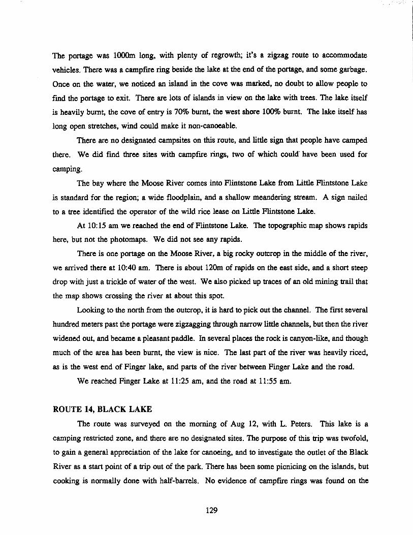
The portage was 1000m long, with plenty of regrowth; it's a zigzag route to accommodate
vehicles. There was a campfire ring beside the lake at the end of the portage, and some garbage.
Once on the water, we noticed an island in the cove was marked, no doubt to allow people to
fmd the portage to exit. There are lots of islands in view on the lake with trees. The lake itself
is heavily burnt, the cove of entry is 70% burnt. the west shore 100% burnt. The lake itself has
long open stretches. wind could make it non-canoeable.
There are no designated campsites on this route. and little sign that people have camped
there. We did fmd three sites with campftre rings. two of which could- have been used for
camping.
The bay where the Moose River comes into Flintstone Lake from Little Flintstone Lake
is standard for the region; a wide floodplain. and a shallow meandering stream. A sign nailed
to a tree identifted the operator of the wild rice lease on Little Flintstone Lake.
At 10:15 am we reached the end of Flintstone Lake. The topographic map shows rapids
here, but not the photomaps. We did not see any rapids.
There is one portage on the Moose River, a big rocky outcrop in the middle of the river,
we arrived there at 10:40 am. There is about 120m of rapids on the east side, and a short steep
drop with just a trickle of water of the west. We also picked up traces of an old mining trail that
the map shows crossing the river at about this spot.
Looking to the north from the outcrop, it is hard to pick out the channel. The ftrst several
hundred meters past the portage were zigzagging through narrow little channels, but then the river
widened out, and became a pleasant paddle. In several places the rock is canyon-like, and though
much of the area has been burnt, the view is nice. The last part of the river was heavily riced,
as is the west end of Finger lake, and parts of the river between Finger Lake and the road.
We reached Finger Lake at 11:25 am, and the road at 11:55 am.
ROUTE 14, BLACK LAKE
The route was surveyed on the morning of Aug 12, with L. Peters. This lake is a
camping restricted zone, and there are no designated sites. The purpose of this trip was twofold,
to gain a general appreciation of the lake for canoeing, and to investigate the outlet of the Black
River as a start point of a trip out of the park. There has been some picnicing on the islands, but
cooking is normally done with half-barrels. No evidence of campfIre rings was found on the
129

islands.
Black lake does not seem like a large body of water while canoeing. The numerous, and
quite large, islands, reduces it to a series of wide channels. This also could give a sense of
privacy, as the islands block long range views. The channel reaches are long enough. and
oriented such that wind could render many sections dangerous for canoes on a bad day.
There were signs of a small ftre at the outlet of the Black river. This was likely a picnic
spot. as tent spots are not apparent. Just in case. it was listed as a campsite in the attribute list
of Appendix E. There is an obligatory portage at this point, to avoid a waterfall/rapids complex
which is impassable. The portage does not have a well defmed trail, but would be quite easy.
approximately 30m long, on the north shore (right of the falls going downstream). The river
after the falls would not be pleasant to paddle between this portage and Highway 314, being
jumbled boulders. and fallen trees.
There could be advantage in taking this route to start the trip. as it is safer to park cars
in the campground parking lot, rather than on the shoulder of the road. However, the aggravation
of the portage is a negative factor. and traversing the lake on a windy day could be diftcult.
Another option would be to park at the Rabbit River parking lot, and start the trip on a short
section of the Rabbit River. The two rivers are similar as they cross the highway.
ROUTE 11, RABBIT RIVER TO COLE LAKE, TRIP TWO
The second trip along the Rabbit River route was during the weekend of August 14-15
with David Benoit of Winnipeg. The trip started at 1:30pm. Aug 14. in pouring rain.
Unfortunately, by this time of the year, we had little choice but to continue the trip in the rain
and hope for the best. There had been plenty of rain during the summer, and the time to fmish
all the routes was getting short. We reached the ftrst portage at 2:10pm. There were two
separate groups camped on the island (campsites 11.03 to 11.06); the ftrst ones marked on the
canoe route map. The water was very high, a result of the heavy rainfalls in July and August.
We reached the designated campsite 15.07 at 4:00 pm, and had tea. The rain had mostly stopped,
to a light drizzle. Paddling through the heavy rain had been very tiring, and we were bailing
often.
A short time later, we passed the point where I had stopped with Duncan on the flrst trip.
For the next several kilometers past this point, the river flows through a small canyon, with tall
130

old conifers, very attractive to paddle through. Where the canyon ends, evidence of a past fire
begins. This frre was evident for the whole rest of the trip, including most of the shoreline of
Cole lake. Another designated campsite (number 11.10) was found along the last stretch of river
before Cole Lake. We did not fmd this site attractive, and it did not appear as if it had been
used recently. We tried fishing, and caught a small northern pike, which we released. The river
on this section is mainly straight, with wide meanders when present, and through a wide valley.
We arrived on Cole lake shortly after 6 pm., after crossing an exit portage. The portage
is about 75m long, and bypasses a short rapids, with a beaver dam on the upper end. The normal
route is on the north, (as we discovered on our return), but we took a path on the south shore,
which was not very good. The normal portage path was completely flooded, and in fact we
paddled down the path to exit the lake the next day. Over 75% of the shoreline and islands of
Cole lake were burnt, with just some isolated patches on the east shore, and some islands
escaping unburnt. The area shows heavy regrowth, mostly jackpine about 2m tall.
We started by following the south shore to the east, and found the first designated
campsite quite easily. At this point, we were both collecting attributes, and looking for a nice
spot to spend the night. We climbed a rocky ridge behind the campsite to the southwest, that
allows a good view of the lake. From here we could see that there would not be any attractive
sites on the lake to camp, due to the old fire. We could also see that another group was camped
on a small island near the north end of the lake, at a non-designated site, number 11.16.
We continued along the south shore, but could not fmd the second designated campsite.
Near where it should be, we found a cabin on the tip of the big island. Our guess was that it was
an outcamp or rice camp. It was not elaborate, and the door was open. After looking at non
designated site 11.14, we made our camp on the island where the designated site (number 11.13)
should have been, it was the only one with trees. We used the gas stove to cook our supper as
darkness fell, and went to sleep well tired out from the day.
We left the campsite at 8:30, and within half and hour of paddling the south and east
shores found the next designated site, number 11.15. We noted here that with the exceptional
water levels, our guesses of the position of the frreboxes in relation to the shore might not be
accurate in normal years. The site did not look used this year.
We continued on to the campers we had seen the night before, on a non-designated site
131

on a kidney shaped island. They were still present, but agreed to let us look the site over. They
were especially accommodating when we told them there was a notice at the staging area about
a found wallet; one of them had lost it, and was glad to hear it was at the police station in Lac
du Bonnet. This group of four had one motor boat, and one motorized canoe.
Mter leaving the group we continued around the north part of lake, and had no trouble
fmding the remaining designated sites on Cole Lake. None of them was as nice as the island
being used by the campers we met, though they will be in a few years when the trees grow
larger.
The way back was nicer than the journey in, it helps when there is no rain falling! We
"leapfrogged" the way along, passing and being passed by the motor boat group. They had the
advantage in the open water, but we were faster at the portages, and in the meanders. We shot
all the portages going downstream without difficulty. We also took the time to look at the sites
not yet surveyed. We found an error in the canoe route map where the fIrst campsites are
marked (numbers 11.05 and 11.06). Two groups had been in the area the night before, but now
were gone. The map shows a peninsula, but it is actually an island. And rather than two sites,
there is one firebox in the middle of the island. It didn't look used, a tree was growing directly
beside the box. Instead, campers have created a site at each end of the .island.
We decided it might be easier to find the site on the offshoot lake by going overland from
the shore near site 11.04. Indeed it was, there was a marked trail between the two lakes, with
flagging on trees to show the way. We found the site easily, and also found the layout for
several cabins. I later found out that the trail leads to an area that is to be leased to Faith Baptist
church of Winnipeg. A member of the church who I met later in the parking lot at Rabbit River,
said that the church will be allowed to build a youth camp in exchange for clean up duties on
the route. A path along the river from the boat launch goes to their lease, as does another trail
overland from the other end of the staging area.
A return trip of the whole route can be comfortably completed in two days with normal
water levels. Anecdotal evidence suggests that in a normal year, the water levels are very low
by August, though this was not the case in 1993. Record rainfalls in July and early August left
the water levels higher in August and September than during the spring runoff period.
132

ROUTE 19, MOOSE RIVER-MOOSE LAKE-TOOTH LAKE
The trip started from where Hwy 314 crosses the Moose river at 9:20 am, Aug 18th, with L.
Peters. Again we used two vehicles, parking one at the start point, and another at the roadside
where the portage into Tooth Lake starts. The river initially flows through a burned area, with
little regrowth. By 9:40 am we reached the first portage, 50-7Om long, took on the north shore.
The portage skirted a rapids that started with a beaver dam, then became a series of drops with
sweepers. The portage was through an area of regrowth, with fallen timbers, and no real path.
Due to heavy rainfall, a small runoff stream was coming in across our portage, and we got wet
crossing it. The river here is 20m wide at best, in a wide shallow flood plain;
At 10: 15 am we reached the second portage, through a burn area, though there were
patches of unburnt. This portage was around a definite narrowing of valley, and a Cshaped
curve. We found no real path, so we cut across the end of the C, and with creative zigzagging
ended up only carrying for about 100m. The river after this portage is is 10m wide, and flows
through a flood plain that is 100-15Om wide. Any rock outcrops that are accessible from the
stream are steep sided, with no campsites available. Along the rest of the way to our junction
for Tooth and Turkey Lakes that were numerous places where the reed grass was so high that
we could see nothing in the distance.
We reached the junction that leads to Tooth Lake at 11:15 am. From here we took a side
trip through Turkey Lake to Moose Lake. On Aug 8 I had talked to Kelly Ritchie at the MNR
in Bisset. Apparently his park patrol went down the Moose River in 1992 and it was impassable
after Moose Lake. It seemed best to survey Moose Lake on this trip, and not do the route
between Moose Lake and Happy Lake at all. A report of the backcountry patrol trip in 1992 was
provided.
We reached Turkey lake, at 11:30 am. It is highly eutrophic, with some wild rice, and
lots of weeds. It is surrounded by low hills that have signs of forest fIre. There is no potential
for camping here. There is a white colored ridge at the east end that stands out, and served as
a guide for us, we always had a good idea of the distance back to the lake when it was in sight.
The exit from Turkey Lake was diffIcult to fmd. A huge floating island of weeds completely
blocked the exit stream. It was only be climbing up onto a muskrat house that we found out that
the stream continued on past it. This floating mat must have just recently moved into place, as
133

the stream between Turkey and Moose Lakes shows high use.
There are two portages between Turkey Lake and Moose Lake. They are all well
travelled, with wide straight paths. Both are around large rapids. We fmished the 2nd portage
at 12:20 pm. There was a campfire ring at the upstream end of the frrst.
The staff at Lac du Bonnet had asked us to look over a cabin on the Moose River just
past Moose Lake. This request and past experience led us to expect one or two on the lake. It
still came as a shock to see 6 cabins on Moose lake, all highly visible, and most very large. We
found the cabin on the Moose River, about 2 Km past the lake at 1:15 pm. It wasn't anything
special, a fish or rice shack. It seemed like a good place to turn around, and head for Tooth
Lake.
Mter once again passing through Turkey Lake, we reached Tooth Lake in worsening
weather (no surprise there). The lake is in an area of heavy burn, and the potential for camping
is limited. As well, the shape of the lake could cause dangerous waves for canoeists. We
paddled across some. There are two cabins on the large island at the east end of the lake, but
nothing of real interest. It is said to be a very good lake for fishing, but we hadn't brought our
rods. We reached the end of the large, and the portage to the road, at 3:40 pm.
ROUTE 15, SEAGRIM LAKE ROUTE, TRIP THREE
This trip was mostly mop up, collecting the few bits of characteristics that had not been
surveyed on the previous trips. Also, it is a pleasant area that I wanted to see one more time.
The trip was taken with L. Peters on Aug 19. We started by reexaming the sites on the second
lake that hadn't been completely surveyed on the first trip. The only remarkable thing was a new
building, located where campsite 15.05 should have been. It was hidden back in the woods, and
painted in a way to camouflage it from view. It looked like an anglers shack of some sort, with
a sleeping platform, and a small table with a coleman stove. When I later told the parks staff
in Lac du Bonnet about it they said it would be removed over the winter.
The main goal was to see Elton Lake's last site, campsite 15.08. It was a nice site, easy
to see why it had been occupied the last visit. The whole trip to the end of the southern arm of
Elton Lake took about one half day return. And for once we had good weather, though
surprisingly we didn't meet anyone else on the route.
134

ROUTE 26, LONG LAKE TO CARmOU LANDING
The trip was taken with G. Williamson of Winnipeg on Aug 24-26. The first day of this
trip was used to drive from Winnipeg to the park. We drove into Caribou Landing on Quesnell
Lake to drop off one vehicle, with a parking fee of $7.00. We then went on to Long Lake,
where the MNR had allowed us the use of a cabin for the summer. We also checked the survey
boxes along the way, as well as the charter airlines who had forms in Bisset.
We left the cabin on Long Lake at 10:00 am the next morning. Long lake itself is not burnt, and
is pleasing to the eye. Some of the forest shows evidence of disease. However, the distractions
of a lodge, and numerous cottages detracts from the experience for canoeists. We found a couple
of non-designated sites on islands, near the east end of the lake, one which was probably a picnic
site, the other with evidence of camping. The end of the lake is obvious with a power line
crossing the lake. From here the "wilderness experience begins.
The first designated campsite, # 26.02, is actually on island, 1/3 of the length from the
east end. It is 45 minutes paddling time from the last island on Long Lake. We saw no
evidence of non-designated campsites along the length of the Manigotagan River.
The next designated campsite is on the first portage. The portage is on the south shore,
200m long, with a good trail that deteriorates at the east end. It skirts one long rapids of 100m,
then a bay, then a short waterfalls. The rapids can be run, but through the falls you swamp,
either empty or loaded. We tried. Mter setting up camp on the portage, we ran the empty canoe
through the whitewater. There was no problem in the rapids, but the alignment of the rocks over
the waterfall created backwashes that swamped us. It felt great, this was the frrst hot, sunny day
in a long time, and we needed a swim anyway. Just as we were hanging up the wet clothes, a
party of four in two canoes walked by, scouting the rapids. We told how we fared, and they
decided to try it as well, with loaded canoes. They both swamped, but did come closer to
succeeding than us. I took some pictures as they went through, and traded a promise of copies
for a promise of a completed survey form at Caribou Landing.
In the evening we tried ftshing at both ends of the portage, and managed to catch a few
small pike, that we released. During this time, another chap came through, paddling solo. He
said he was going all the way to Lake Winnipeg.
We started out early the next morning, and reached the 2nd portage within ftfteen
minutes. It is on the north shore, 200-300m from frrst, avoiding a 5-Sm falls, which is not
135

runnable. The other two portages along the river are similar, not always easy, but obvious to find
and follow, and not too much work. One was marked with flagging tape at both ends.
Immediately following the fourth portage, we arrived in Manigotagan Lake, and ran into
a motorboat with a group fishing and drinking beer. So long wilderness. We went to work
surveying the lake and campsites towards the east, in the direction taken to get to Happy Lake.
This section is actually part of what this project has called route 27, (Manigotagn Lake west
Happy Lake). All of these sites are now operated on a commercial basis by the owner of the
Caribou Landing Lodge, on Quesnell Lake. They do not appear drastically different from the
other sites seen. None were in use. The farthest away, # 27.03, is by far the nicest, on a narrow
peninsula, with an open birch forest. We also were surprised to find cactus growing at site
number 27.02.
This part of the lake is mature forest, some of it giving way to disease. There were
several cabins on the lake. There is one designated campsite on a large island opposite the
portage, that is not commercial. There are supposed to be two, but there was only one sign
found. The sign said: "canoe campsite only". This is probably necessary, as we saw many
motorboats on both Manigotagan and Quesnell Lakes.
Quesnell Lake shows some signs of fire, in particular the island that contains site # 26.06.
Disease was again obvious in the standing forest. We arrived at Caribou Landing, and the end
of the trip during the late afternoon, picked up our vehicle and headed home.
136

APPENDIX D: Nopiming Privincial Park Focus Group Summary Analysis
BACKGROUND
The Nopiming Canoeist Focus Group Study was conducted in June, 1993 as a component of a joint Forestry Canada/Manitoba Natural Resources research project, examining the nonmarket value of forest areas. The overall project will provide information on the numbers and demographics of canoeists, their expectations and needs, as well as information on the economic value of canoeing in Nopiming. The focus group study was conducted and summarized by the Parks and Natural Areas Marketing Unit. The results of the study will help in the development of a more detailed mail-out survey and provide qUalitative information about the many canoe attributes associated with the Nopiming routes.
PARTICIPANT PROFILE
The focus group participants were randomly selected from lists generated from the Nopiming backcountry registry (1992). Participants were past and present users of the various water routes in Nopiming. The level of canoeing skills varied from novice to wilderness expert. Occupations included; child care worker, justice department employee, business owner, computer scientist, teacher, grad student, hair stylist, retiree, student, parent, body work employee. The majority of the participants were married.
DEMOGRAPIDCS
Participants were asked if there were any personal demographic questions that they did not feel comfortable answering when completing surveys (e.g. how many children, level of education, etc.). The group agreed that the only demographic questions (normally seen in surveys) they felt uncomfortable related to income.
IMAGES OF NOPIMING
When asked what images came to mind when participants thought about Nopiming, the responses included; rugged/wilderness area, place to explore, burned out areas, peace and quiet, small navigable rivers, wildlife photography, fishing, canoeing. Several individuals mentioned logging.
EXPERIENCES SOUGHT
Most participants associated their experiences with being "close to nature". Specific experiences sought included; peace and quiet/isolation, get away from people, spiritual and physical rejuvenation, solitude, sounds of nature, excitement of rapids, the exhilaration of showing someone new to the area what Nopiming has to offer, being able to draw upon memories of canoeing in Nopiming when back in every-day life, a return to one's roots in the backcountry away from crowded cities.
137
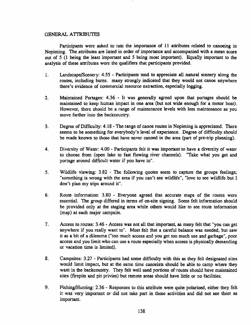
GENERAL ATTRmUTES
Participants were asked to rate the importance of 11 attributes related to canoeing in Nopiming. The attributes are listed in order of importance and accompanied with a mean score out of 5 (1 being the least important and 5 being most important). Equally important to the analysis of these attributes were the qualifiers that participants provided.
1. Landscape/Scenery: 4.55 - Participants tend to appreciate all natural scenery along the routes, including burns. many strongly indicated that they would not canoe anywhere there's evidence of commercial resource extraction, especially logging.
2. Maintained Portages: 4.36 - It was generally agreed upon that portages should be maintained to keep human impact in one area (but not wide enough for a motor boat). However, there should be a range of maintenance levels with less maintenance as you move farther into the backcountry.
3. Degree of Difficulty: 4.18 - The range of canoe routes in Nopiming is appreciated. There seems to be something for everybody's level of experience. Degree of difficulty should be made known to those that have never canoed in the area (part of pre-trip planning).
4. Diversity of Water: 4.00 - Participants felt it was important to have a diversity of water to choose from (open lake to fast flowing river channels). "Take what you get and portage around difficult water if you have to".
5. Wildlife viewing: 3.82 - The following quotes seem to capture the groups feelings; "something is wrong with the area if you can't see wildlife", "love to see wildlife but I don't plan my trips around it".
6. Route information: 3.80 - Everyone agreed that accurate maps of t!te routes were essential. The group differed in terms of on-site signing. Some felt information should be provided only at the staging area while others would like to see route information (map) at each major campsite.
7. Access to routes: 3.46 - Access was not all that important, as many felt that "you can get anywhere if you really want to". Most felt that a careful balance was needed, but saw it as a bit of a dilemma ("too much access and you get too much use and garbage", poor access and you limit who can use a route especially when access is physically demanding or vacation time is limited).
8. Campsites: 3.27 - Participants had some difficulty with this as they felt designated sites would limit impact, but at the same time canoeists should be able to camp where they want in the backcountry. They felt well used portions of routes should have maintained sites (firepits and pit privies) but remote areas should have little or no facilities.
9. Fishing/Hunting: 2.36 - Responses to this attribute were quite polarized, either they felt it was very important or did not take part in those activities and did not see them as important.
138

10. Facilities: 1.82 - Facilities (fIrepits, pit privies, picnic tables, etc.) were not considered very important to participants. The group was again split as to whether frrepits and pit privies should be provided along the routes. A balance is required to control impact in heavily used areas and to keep more remote areas natural looking (free of facilities).
Note: Safety was included on the list of attributes, but participants had a difficult time rating the importance of it. Safety seemed to mean something different to each individual, although it was agreed that everyone wanted to be "safe" (it is important to know your limitations before selecting a route).
VEGETATIONILANDSCAPE
Participants were asked to rate 9 photo images of vegetation/landscape types found in Nopiming as to how appealing they were. The images are listed in order of preference with a bean score out of 5 (1 being least appealing and 5 being most appealing).
1. Jackpine/Rock outcrop: 4.82 2. Mixed Coniferous/Deciduous: 4.55 3. Wild Berries/Bushes: 4.18 4. 5. Black Spruce Stand: 4.09 6. White Spruce Stand: 3.73 7. Mixed Balsam/Spruce: 3.55 8. Burn Area: 2.73 9. Cut Area: 2.30
CULTURAL mSTORY THEMES
Participants were asked to rate the importance of 6 cultural history themes associated with Nopiming. The themes are listed in order of importance with a mean score out of 5 (1 being least important and 5 being most important).
1. Prehistoric Art: 4.36 2. Historic Exploration/Fur Trade: 3.73 3. Historic Lifeways: 3.64 4. Historic Mining: 2.55 5. Historic Forestry: 2.27 6. Historic Trapping: 2.00
Most participants felt it was important to have information available on the cultural history themes ("we need to know where we've been to assess where we might go in the future"). Material should "not be too heavy", "we are reading for interest not a lesson". Most would pay for literature if it was well written and covered the entire history of the park. One individual felt that it may not be cost effective to produce given the limited market interested in Nopiming history.
139

RESOURCE USES
Participants were asked to list any resource use activities that they were aware of in Nopiming. The group was then asked if any of these activities had a direct affect on how they use canoe routes in the park (i.e. have you experienced any of these firsthand and has any activity caused you to change your use patterns?). The list and associated comments are as follows:
Logging: Two participants indicated that they had come across evidence of timber cutting to the rivers edge on a section of the route between Tulabi Falls and Davidson Lake in the early 1980's. They indicated that they never travelled on that route again. The rest of the group indicated that they had not come across any physical signs of logging in recent years and therefore had not ceased using a route because of logging activities.
Fishing: Fish guts left behind by sport fishermen is bothersome in heavily fished areas. Participants try to avoid these areas when possible (e.g. island on McGregor Lake.)
Cottaging: Most indicated that cottages and the associated activities around them detracted from their canoeing experience. many try to paddle through these areas as fast as possible. One individual indicated he now uses Nopiming only to get to rivers in northwest Ontario to get away from the development.
Power boating: Many indicated that they had been driven to Nopiming to get away from power boats. Most felt strongly that power boats were an intrusion and paddled further into remote areas to get away from them.
Hunting: Most indicated that they now avoided any area where hunters are present.
Camping: No comments
Trapping: no comments
Tourism: no comments
USE PATTERNS
Participants were asked if the following situations or activities would change their use patterns (e.g. would you cease using a particular route or take a detour?).
Bridges: Most would avoid a route especially if bridges were permanent.
Burn area: Burns are not seen as a detraction. They add to the diversity of the trip and are good areas to see and photograph wildlife. If an entire route was burned over, it may cause concern and a change in use patterns.
140

Garbage: Garbage seems to affect the choice of campsite more than choice of route. Many indicated that they often pack out other people's garbage (the Bird River route seems to be the worst).
Aircraft flying over or landing: Not much of a concern and in fact can be a plus (sense of safety, if something goes wrong in remote areas you could get help from the pilot).
Logging (in view and sounds): The group was quite adamant that they would change their route if logging activities were visible. For many, just the knowledge that logging occurs in the park bothered them. Most indicated a strong opposition to cutting in parks.
Hydro lines: Participants agreed that power lines were an eye sore but were also considered a "necessary evil". They indicated that lines were only in view for a short period and in some cases made good portages, but poor camping areas.
People congestion: Most indicated they would paddle farther into remote areas to get away from other people and that they didn't like to "battle" for a campsite. Some had quit using Bird River because of congestion and one individual had outright stopped using the park (now canoes in northwest Ontario).
Hunting: Most were generally indifferent to hunting, except for big game rifle hunting which was viewed as being dangerous. Generally, they stay away if hunting season is underway (rifle hunting). Two participants were avid bow hunters.
Trapping: Most have never seen signs of trapping and even if they did, would not change their route. Some indicated a fascination with trapping and old trappers' cabins.
Wild rice harvesting: Participants had little problem with small scale rice harvesting operations (ie non-mechanized), but would change routes if large scale mechanized harvesting was occurring.
Mining: Most had not seen much evidence of mines along routes, but expressed a concern about potential leaching of toxins into water. many felt they would avoid routes if operational mines existed, but some were interested in historic mine sites.
CONGESTION
Staging areas: Bird River seems to be a concern for many with one individual indicating he had to wait in line to launch his canoe. Also identified by some to be a problem was the Rabbit River/Cole Lake route.
On route: It was generally accepted that Nopiming had designated canoe routes, so you have to expect to see other people on them. There was some concern about power boats, especially on narrow stretches of water.
Portages: Areas of concern included the Bird River (Tulabi to McGregor Lake) and Snowshoe Lake.
141

Campsites: Securing a campsite was concern on busier routes such as the Bird River, but "you move on until finding a suitable site". It was felt river capacity could be set by regulating the number of campsites and having canoeists register ahead of time.
TRAVEL TO ROUTES
Travel time is dependent on time spent canoeing. Most participants are willing to travel 2 to 2.5 hours to canoe for a weekend, but it not be uncommon to travel a day or more for trips of a week or longer.
When travelling to Nopiming from home the only complaint is .dry, dusty and rough roads. This was also seen as a positive as it keeps the park remote and limits the use (less people encountered when canoeing).
OTHER CANOE ROUTES
Other areas canoed in by participants included Atikaki Provincial Park, Woodland Caribou Provincial Park, Lake of the Woods, Quetico Provincial Park, Lake Superior and the Berens River.
142