doctoral thesis bistrita river hydrological regime ...phdthesis.uaic.ro/phdthesis/costea (cojoc),...
TRANSCRIPT
A. I. CUZA UNIVERSITY OF IASI
FACULTY PF GEOGRAPHY AND GEOLOGY
DEPARTMENT OF GEOGRAPHY
DOCTORAL SCHOOL OF CHEMISTRY AND LIFE AND
EARTH SCIENCES
DOCTORAL THESIS
BISTRITA RIVER HYDROLOGICAL
REGIME ANALYSIS CONSIDERING THE
EXISTENCE OF THE HYDROPOWER
PROJECTS
SCIENTIFIC ADVISER
Prof. GHEORGHE ROMANESCU, PhD
PhD Student
Gianina Maria COSTEA
Married COJOC
September
2015
Bistrița River hydrological regime analysis considering the existence of the hydropower projects
Drd. Gianina Maria Costea (Cojoc) 2
CONTENTS
FOREWORD ..................................................................... 4
AKNOWLEDGEMENT .................................................... 4
GRANT .............................................................................. 5
FIGURE LIST .................................................................... 6
TABLE LIST ..................................................................... 8
1. INTRODUCTION ....................................................... 10
2. HISTORY RESEARCH .............................................. 13
3. DATABASE. RESEARCH METHODOLOGY AND
TECHNIQUES OF MONITORING THE RESERVOIRS
.......................................................................................... 17
4. THE HYDROMETRIC ACTIVITY IN BISTRITA
RIVER BASIN ................................................................. 20
4.1. Hydrometric development of the network in Bistrita
River Basin ....................................................................... 20
4.2. The structure of the hydrometric network from Bistrita
River Basin today ............................................................. 20
4.3. Modern monitoring methods ..................................... 24
5. PHYSICO-GEOGRAPHICAL CONDITIONS FOR
THE WATER RESOURCES EVOLUTION .................. 29
5.1. Localization and limits .............................................. 29
5.2. The paleogeographical evolution and the geological
compozition ...................................................................... 31
5.3. The relief – significant support of evolution of the
Bistrita River system ........................................................ 34
5.4. Caracterization of the climatic elements ................... 41
5.4.1. The frecquency and velocity of the wind ............... 41
5.4.2. Water temperature .................................................. 42
5.4.3. Precipitation ........................................................... 45
5.4.4. Evapotranspiration ................................................. 51
5.4.5. Relative humidity ................................................... 52
5.4.6. Fog ......................................................................... 53
5.4.7. Nebulosity .............................................................. 54
5.4.8. Duration of sunshine .............................................. 54
Bistrița River hydrological regime analysis considering the existence of the hydropower projects
Drd. Gianina Maria Costea (Cojoc) 3
5.5. The soil and its influence on runoff ......................... 54
5.6. The vegetation and the land use ............................... 57
5.7. The hydrological regime in Bistrița River Basin ..... 63
5.7.1. Groundwater ......................................................... 63
5.7.2. Surface water. River network................................ 67
5.7.2.1. Runoff regime – average runoff. ........................ 70
5.7.2.2. Maximum runoff ................................................ 73
5.7.2.4. Minimum runoff ................................................. 92
6. RESERVOIRS .......................................................... 103
6.1. The necessity of Bistrita River development ......... 105
6.2. Morfometry of the reservoir ................................... 106
6.3. The ecosystem of the reservoir. The biotope and the
biocoenosis .................................................................... 107
7. THE PARAMETERS OF THE RESERVOIRS IN
BISTRITA RIVER BASIN ........................................... 110
7.1. Izvoru Muntelui – Bicaz Dam and Dimitrie Leonida –
Stejaru Power Plant ....................................................... 112
7.2. Pângărați Dam and Power Plant ............................ 114
7.3. Vaduri Dam and Power Plant ................................ 115
7.4. Piatra Neamț (Bâtca Doamnei) Dam and Power
Plant .............................................................................. 117
7.5. Reconstrucția Dam and Săvinești (Vânători) Power
Plant .............................................................................. 118
7.6. Piatra Neamț – Buhuși channel .............................. 118
7.7. Racova Dam and Power Plant ................................ 119
7.8. Gârleni Dam and Power Plant ................................ 120
7.9. Lilieci (Bacau I) Dam and Power Plant ................. 121
7.10. Bacău II (Șerbănești) Dam and Power Plant ........ 123
7.11. Lac Agrement Dam .............................................. 124
7.12. Topoliceni Dam and Power Plant ........................ 125
8. RESERVOIR WATER BALANCE ......................... 127
8.1. Methodology information ...................................... 127
8.2. Reservoir water balance ......................................... 128
Bistrița River hydrological regime analysis considering the existence of the hydropower projects
Drd. Gianina Maria Costea (Cojoc) 4
9. THE RESERVOIR INFLUENCE ON RUNOFF .......135
9.1. The exploitation and the influence of the reservoirs on
runoff...............................................................................135
9.2. Replenishment of the flow .......................................138
9.3. Reservoir influence on maximum runoff and flood
attenuation .......................................................................141
9.3.1. Reservoir exploitation during high level waters and
flash floods ......................................................................144
9.4. The lacustrine sediment origin and the degree of silting
.........................................................................................153
9.5. The degree of silting and its influence on reservoir
exploitation .....................................................................154
9.6. Reservoir sustainable management ..........................162
10. RIVER AND RESERVOIR WATER QUALITY ....164
10.1. Sources of pollution in Bistrita River Basin ..........164
10.2. Quality classes in Bistrița River Basin ...................175
11. HYDRAULIC MODELING – maps of inundability 179
12. CONCLUSIONS .......................................................191
13. BIBLIOGRAPHY .....................................................196
FIGURE LIST
Fig. 1 The map of Moldavia reproduced by Dimitrie Cantemir
(https://harlau625.wordpress.com/2011/01/20/o-harta-a-moldovei-
din-vremea-domului-dimitrie-cantemir/) ....................................... 14
Fig. 2 The hydroenergetic deelopment of Bistrița River (after Siret
Water Basin Administration, 2014) ................................................ 21
Fig. 3 Automatic station (AHSS) Drăgoiasa on Neagra River ....... 25
Fig. 4 Automatic station (APPS) Panaci from Panaci locality ...... 26
Fig. 5 Interface of HydroNet Briefing Terminal. Information about
the hydrometrical station Cârlibaba on Bistrița River (Print screen
from Siret Water Basin Prognosis Centre, Bacău) ........................ 26
Fig. 6 Interface of HydroThreatNet. Information about a hydrometric
station from Olt River Basin (image taken the National Centre of
Basin Prognosis, București) ........................................................... 27
Bistrița River hydrological regime analysis considering the existence of the hydropower projects
Drd. Gianina Maria Costea (Cojoc) 5
Fig. 7 Interface of the hydrological prognosis program RFS.
Information concerning the hydrometrical station Cârlibaba on
Bistrița River (Image taken from preluată după Centrul de Prognoză
Bazinală, Bacău) ............................................................................ 28
Fig. 8 Localization of Bistriţa River Basin in Romania and in Siret
River Basin ..................................................................................... 30
Fig. 9 Map of lithology of Bistrița River (after Map of Romanian
Geology scale 1:200000 made the Geologic Institute in 1968) ..... 33
Fig. 10 Units of relief in Bistrița River Basin (after Ungureanu I.,
2004) .............................................................................................. 35
Fig. 11 Călimani sulphourous gravel pit (today it is in the process of
greening) ........................................................................................ 37
Fig. 12 Bistriței Valley Zugreni sector .......................................... 38
Fig. 13 Bistrița River at Poiana Teiului ........................................ 38
Fig. 14 Annual average temperature map in Bistrița River Basin . 44
Fig. 15 Annual average precipitation map in Bistrița River Basin 46
Fig. 16 Maximum precipitation in Bistrița River Basin ................. 48
Fig. 17 Maximum precipitation variation in Bistrița River Basin long
profile ............................................................................................. 48
Fig. 18 Season precipitation variation in Bistrița River Basin ...... 50
Fig. 19 Season precipitation variation on the Bistrița tributarries 50
Fig. 20 Soil on Bistrița River Basin (after Soil Map scala 1:1000000
from Romania Atlas, 1978; and the Romanian Taxonomy System of
Soil, 2012) ...................................................................................... 56
Fig. 21 Alpine vegetation in Călimani mountains (at Călimani
Meteorological station – 2020 m) .................................................. 57
Fig. 22 Mountainous scenary in Bistrița Bistrița River Basin (at
Dorna Arini) ................................................................................... 58
Fig. 23 Land use in Bistrița River Basin (after CORINE
LANDCOVER, 2006) ..................................................................... 62
Fig. 24 Groundwater bodies in Bistrița River Basin (after Siret
Water Basin Administration, 2015) ................................................ 66
Fig. 25 Synoptic sketch – Bistrita River Basin (after Siret Water
Basin Administration, Bacau, 2015) .............................................. 68
Fig. 26 Longitudinal profile on Bistrita River (the inferior sector, the
one one with the reservoirs) ........................................................... 69
Fig. 27 The most important floods recorded in 1970 in Bistrița River
Basin .............................................................................................. 76
Bistrița River hydrological regime analysis considering the existence of the hydropower projects
Drd. Gianina Maria Costea (Cojoc) 6
Fig. 28 Mounthly average flows from 1991 compared to the annual
average flows on Cuejdiu, Iapa and Cracau .................................. 78
Fig. 29 The 1991, July-August flood hydrographs at Cuejdiu and
Slobozia hydrometrical stations ..................................................... 79
Fig. 30 The most important floods recorded in 1991 in Bistrița River
Basin .............................................................................................. 80
Fig. 31 The most important floods recorded in 2005 in Bistrița River
Basin .............................................................................................. 83
Fig. 32 The 2005 floods in Bacau – pictures from the dam and Insula
de Agrement (after Siret Water Basin Administration, Bacau) ...... 85
Fig. 33 The 2005 floods in Bacau – pictures from the town (after
Siret Water Basin Administration, Bacau) ..................................... 85
Fig. 34 The 2005, July 9 – 23 flash flood, at Straja hydrometrical
station on Bistrita River ................................................................ 86
Fig. 35 The 2005, July 7–27 flash flood, at Frunzeni hydrometrical
station on Bistrita River ................................................................ 86
Fig. 36 The most important floods recorded in 2010 in Bistrița River
Basin .............................................................................................. 88
Fig. 37 The 2010 floods hydrographs on Trebes, Barnat and Negel
Rivers ............................................................................................. 89
Fig. 38 Sectors from the Trebes River flooded in 2010 ................. 90
Fig. 39 Deposits broughts by Trebes River during 2010 floods ..... 90
Fig. 40 The CFR neighborhood from Bacau flooded in 2010 by the
Negel River ..................................................................................... 91
Fig. 41 The lowest flows recorded during 1976 – 2011 in Bistrita
River Basin ..................................................................................... 92
Fig. 42 The minimum runoff in Trebes River Basin – the Bistrita
right side tributary ......................................................................... 93
Fig. 43 The hydrological drought phenomenon in Trebes River
Basin - the Bistrita tributary (mai exact pe Râul Valea Budului la
Valea Budului) ............................................................................... 94
Fig. 44 The alluvial suspension in 2010 floods on Trebes River... 96
Fig. 45 Comparison between water and air multiannual average
temperatures – Bistrita River, year 2000 ....................................... 97
Fig. 46 Comparison between water and air multiannual average
temperatures – Bistrita River, year 2014 ....................................... 97
Fig. 47 Ice jam phenomenon on Bistrita River ............................. 101
Fig. 48 Ice jam phenomenon on Bistrita River 2008-2009
(after Siret Water Basin Administration, 2015) 101
Bistrița River hydrological regime analysis considering the existence of the hydropower projects
Drd. Gianina Maria Costea (Cojoc) 7
Fig. 49 Bistrita hydropower development scheme (after Siret Water
Basin Administration, 2015) ........................................................ 104
Fig. 50 The bird protection areas map in Bistrita River Basin .... 109
Fig. 51 Localization of reservoirs: Topoliceni, Izvoru Muntelui,
Pangarati, Vaduri, Batca Doamnei and Reconstructia ................ 110
Fig. 52 Localization of reservoirs: Racova, Garleni, Bacau I
(Lilieci), Bacau II, Canal Redresare UHE and Lac Agrement ..... 111
Fig. 53 The Izvoru Muntelui – Bicaz Dam ................................... 112
Fig. 54 Pangarati Reservoir ......................................................... 115
Fig. 55 Vaduri Reservoir .............................................................. 116
Fig. 56 Piatra Neamt (Batca Doamnei) Reservoir ....................... 117
Fig. 57 Reconstrucția Dam .......................................................... 118
Fig. 58 Buhuși Hydropower Plant and a section from Piatra Neamt
– Buhusi Channel ......................................................................... 119
Fig. 59 Racova Hydropower Plant and the section downstream . 120
Fig. 60 Gârleni Hydropower Plant and the section downstream . 121
Fig. 61 Lilieci (Bacău I) tail lake ................................................. 122
Fig. 62 Lilieci (Bacău I) Hydropower Plant and Dam ................. 122
Fig. 63 Bacău II Dam and Channel ............................................. 123
Fig. 64 Lac agrement (drained for the moment in order to be
rearranged into AQUAPARC) ..................................................... 125
Fig. 65 Topoliceni Dam ............................................................... 126
Fig. 66 Poiana Teiului Hydropower Plant ................................... 126
Fig. 67 IZVORU MUNTELUI volumetric curve .......................... 130
Fig. 68 PANGARATI volumetric curve ........................................ 132
Fig. 69 VADURI volumetric curve ............................................... 133
Fig. 70 PIATRA NEAMT(BATCA DOAMNEI)volumetric curve . 134
Fig. 71 Monthly average multiannual flows on Bistrita River (1940-
2014) ............................................................................................ 136
Fig. 72 Comparison between average measured flows – average
reconstituted flows at Straja hydrometrical station ..................... 139
Fig. 73 Comparison between average measured flows – average
reconstituted flows at Frunzeni hydrometrical station ................. 140
Fig. 74 Situation plan – Bistrita River, Izvoru Muntelui Reservoir
sector (source SC HIDROELECTRICA SA)................................ 141
Fig. 75 Limnimetric flow range of the overflow device – completely
open limit (source SC HIDROELECTRICA SA) .......................... 143
Fig. 76 Limnimetric flow range of the overflow device – partcially
open limit (source SC HIDROELECTRICA SA) .......................... 143
Bistrița River hydrological regime analysis considering the existence of the hydropower projects
Drd. Gianina Maria Costea (Cojoc) 8
Fig. 77 Capacity curve of Izvoru Muntelui Reservoir based on
bathymetric measurement from 2009 (source HIDROLOG, Siret
Water Basin Administration, 2015) .............................................. 156
Fig. 78 Comparison between the capacity curves of the reservoir
according to the reservoir levels from 1960,1985,1997 și 2009
(source SC Hidroelectrica SA, Piatra Neamt) ............................. 156
Fig. 79 The variation in timp of the talweg (source SC Hidroelectrica
SA, Piatra Neamt) ........................................................................ 157
Fig. 80 Racova and Bacau II reservoirs silting ........................... 158
Fig. 81 Piatra Neamt Reservoir volume during 1965-2007 ......... 160
Fig. 82 Reconstrucția Reservoir volume during 1963-2002 ........ 160
Fig. 83 Lilieci and Bacau II Reservoirs volume during 1966-1997
and respectively 1966-2002 ......................................................... 160
Fig. 84 Pollution sources in Bistrita River Basin ......................... 170
Fig. 85 S.C. CARPAT CEMENT HOLDING S.A. – Tasca working
point ............................................................................................. 171
Fig. 86 The thereshold parametres .............................................. 172
Fig. 87 Wastewater treatment Plant of S.C. FIBREX NYLON S.A.
from Savinesti ............................................................................... 172
Fig. 88 Wastewater treatment Plant of Buhuși ............................ 175
Fig. 89 The interface of ISIS hydrological modeling .................. 183
Fig. 90 The sector of the river hydrologically modeled in ISIS (source
Siret Water Basin Administration) ............................................... 185
Fig. 91 Inundability sectors with 10%, 5%, 1% and 0.1%
probabilities for the sector downstream Izvoru Muntelui
Reservoir ...................................................................................... 188
Fig. 92 Inundability sectors with 10%, 5%, 1% and 0.1%
probabilities for the sector upstream Izvoru Muntelui Reservoir 189
TABLE LIST
Table 1 The hydrometrical stations from Bistrita River Basin needed
for the study and the periods of time the data was available ____ 17
Table 2 Meteorologic and pluviometric stations in Bistrita River
Basin needed for the study and the periods of time the data was
available ____________________________________________ 18
Table 3 The hydrological network in Bistrita River Basin ______ 22
Bistrița River hydrological regime analysis considering the existence of the hydropower projects
Drd. Gianina Maria Costea (Cojoc) 9
Table 4 The average annual velocity of the wind (%) (Clima
României, 2008) ______________________________________ 42
Table 5 The average annual frequency of the wind (%) (Clima
României, 2008) ______________________________________ 42
Table 6 The air temperature variation at the meteorological stations
in Bistrita River Basin (1950-2014) _______________________ 43
Table 7 The precipitation regime at the hydrometrical stations frim
Bistrita River Basin ___________________________________ 47
Table 8 The average and extreme data of the first and last snow day
and the duration of this phenomenon (Clima României, 2008)___ 51
Table 9 The average and maximum number of days with snow cover
(Clima României, 2008) ________________________________ 51
Table 10 The average monthly thickness of the snow cover (cm)
(Clima României, 2008) ________________________________ 51
Table 11 The real average monthly and annual evaporation in Bistrita
River Basin __________________________________________ 52
Table 12 The relative humidity in Bistrita River Basin _________ 53
Table 13 Monthly variation of the number of days with fog ____ 54
Table 14 The evolution of the forested area diring 1990-2006 (source
CORINE LAND COVER, 2006) __________________________ 61
Table 15 Average annual runoff in Bistrita River Basin ________ 71
Table 16 The seasonal ditribution of average runoff in Bistrita River
Basin _______________________________________________ 72
Table 17 The precipitation from May, 4-16, year1970 in the
mountainous area in Bistrita River Basin (mm) ______________ 75
Table 18 Maximum flow recorded until 1969 ________________ 76
Table 19 Average multianual flow in 1969 __________________ 76
Table 20 The average monthly precipitation regime during I – V 1970,
compared to the average multiannual flow __________________ 76
Table 21 Maximum flow recorded in May, 1970, in Bistrita River
Basin _______________________________________________ 77
Table 22 The average monthly precipitation regime during January-
July 1991, compared to the average multiannual flow _________ 78
Table 23 The highest amount of precipitation from July, 28-29, year
1991 ________________________________________________ 79
Table 24 The maximum levels recorded on the most important rivers
in Bistrita River Basin in 1991 ___________________________ 79
Table 25 The damage recorded in 1991 in Bistrita River Basin __ 80
Bistrița River hydrological regime analysis considering the existence of the hydropower projects
Drd. Gianina Maria Costea (Cojoc) 10
Table 26 The average monthly precipitation regime during January-
June 2005, compared to the average multiannual flow_________ 81
Table 27 Amounts of precipitations from the first decade of July 2005,
compared to the monthly range ___________________________ 82
Table 28 Precipitations in July, 11-14, year 2005, in Bistrita River
Basin _______________________________________________ 83
Table 29 Maximum levels and flows in July, 12-15, year 2005 __ 84
Table 30 Maximum levels and flows in July, 12 – 17 iulie 2005 __ 86
Table 31 Damage recorded in 2005 in Bistrita River Basin _____ 87
Table 32 The average monthly precipitation regime during I – VII
2010, compared to the monthly range ______________________ 87
Table 33 Maximum levels from the summer of 2010 recorded in
Bistrita River Basin ____________________________________ 88
Table 34 Damage recorded in 2010 in Bistrita River Basin _____ 89
Table 35 The alluvial flow in Bistrita River Basin ____________ 95
Table 36 The water temperature variation compared to the air
temperature for some hydrometric stations in Bistrita River Basin 99
Table 37 Evolution of winter phenomena in Bistrita River Basin _ 99
Table 38 Industrial water supply ________________________ 119
Table 39 IZVORUL ALB hydrometrical station _____________ 129
Table 40 RUGINEȘTI Evaporimetrical station ______________ 129
Table 41 Q hydrometrical station + Qprecipitation = Qaffluent 130
Table 42 Qturbined + Qevaporation= Qdeffluent ___________ 130
Table 43 BALANCE CALCULATION - Izvoru Muntelui ______ 130
Table 44 BALANCE CALCULATION - Pangarati ___________ 131
Table 45 BALANCE CALCULATION - Vaduri _____________ 133
Table 46 BALANCE CALCULATION - Batca Doamnei ______ 134
Table 47 Monthly average multiannual flow in Bistrita River Basin
during 1950 – 2012 ___________________________________ 135
Table 48 Limnimetric correlation of the limit device (completely
opened) (sourceSC HIDROELECTRICA SA) _______________ 142
Table 49 Limnimetric correlation of the limit device (partially
opened) (source SC HIDROELECTRICA SA) ______________ 143
Table 50 The characteristics of the flash flood waves at the reservoir
section _____________________________________________ 145
Table 51 The attenuation volume of the flash floods for the reservoirs
in Bistrita River Basin _________________________________ 146
Table 52 The characteristics of the flash flood waves at Pangarati
Reservoir ___________________________________________ 147
Bistrița River hydrological regime analysis considering the existence of the hydropower projects
Drd. Gianina Maria Costea (Cojoc) 11
Table 53 The characteristics of the flash flood waves at Vaduri
Reservoir ___________________________________________ 148
Table 54 The characteristics of the flash flood waves at Bâtca
Doamnei Reservoir ___________________________________ 148
Table 55 The characteristics of the flash flood waves at Reconstrucția
Reservoir ___________________________________________ 149
Table 56 The characteristics of the flash flood waves at Racova
Reservoir ___________________________________________ 150
Table 57 The characteristics of the flash flood waves at Gârleni
Reservoir ___________________________________________ 150
Table 58 The characteristics of the flash flood waves at Lilieci
Reservoir ___________________________________________ 151
Table 59 The characteristics of the flash flood waves at Bacău II
Reservoir ___________________________________________ 152
Table 60 The characteristics of the flash flood waves at Topoliceni
Reservoir ___________________________________________ 152
Table 61 The characteristic volumes evolution until today _____ 156
Table 62 The characteristics of the reservoirs from Bistrita ____ 159
Table 63 Equipment used for determining certain indicators ___ 176
Table 64 Elements and standards of physico-chemical quality for
water ______________________________________________ 176
Table 65 Main characteristics of ISIS 1 D models ___________ 184
Table 66 Types of structure _____________________________ 185
Table 67 Simulated flows based calculation scenaries in certain
points of control _____________________________________ 186
Table 68 Calculation scenaries for 10%, 5%, 1% and 0.1% ___ 187
This work was supported by strategic grand
POSDRU 159/1.5/133391, Project ”Doctoral and Post-
doctoral programs of excellence for highly qualified
human resources training for research in the field of Life
sciences, Environment and Earth science ” cofinaced by
the European Social Fund within the Sectorial
Operational Program Human Resources Development
2007 - 2013.
Bistrița River hydrological regime analysis considering the existence of the hydropower projects
Drd. Gianina Maria Costea (Cojoc) 12
Keywords: Bistrita, hydrological regime, flash floods,
reservoir lakes, flow reconstitution, silting, water quality
1. INTRODUCTION
The complex influences of human society on the
hydrographic networks have lately gained a particular
momentum because of the development of economic
activities. Very often even if the hydrotechnical works
were meant to bring benefits, they had many negative side
effects, and sometimes disastrous.
The anthropogenic activities have an important
impact on the environment due to a complex development
of water courses (in this case - Bistrița River Basin) for
primordial economic interests, namely: drinking water
supply, irrigation, industrial and prevention and defence
against floods, gravel pits, resources exploitation C.E.S.
(soil erosion), hydropower, etc.
The present doctoral thesis aims to be challenging
on the study, in terms of the hydrological regime, of the
Bistrita River Basin. The research focuses on the most
important aspects and does not detail the myriad
hydrological issues. The meteorological and hydrological
data (up to the year 2014) collected from various
institutions: National Administration of Meteorology,
National Institute of Hydrology, and Water Management
Administration, Siret Water Basin Administration, SC
Hidroelectrica SA. Observations in the field aimed to link,
validate the data, and completed by photographic images
in order to have a clearer image of the terrain.
In addition to all this it has been achieved a
number of thematic maps by means of modern techniques
of ArcGIS type. The maps display in a suggestive manner
Bistrița River hydrological regime analysis considering the existence of the hydropower projects
Drd. Gianina Maria Costea (Cojoc) 13
issues relating to the elements that make up the natural
setting in which it forms and evolves water resources from
the Bistriţa River basin (relief, geology, soils, vegetation,
land use, etc.).
2. DATABASE AND METHODOLOGY
The database includes hydrological data
(maximum flow, medium liquid, and mud in suspension)
from hydrometrical stations from the Bistrița River Basin,
climatic data (rainfall, annual, and monthly temperatures)
from pluviometric and meteorological stations in the area.
New information related to the degree of silting of the
reservoirs from Bistrița, and land use were analysed (the
international database CORINE Land Cover and
cartographicmaterials – ortophotoplans 2006;
topographic maps 1:25000, edition ’80; digital terrain
model for Romania, SRTM90).
Geological, geomorphologic, and soil data etc.
were taken from the literature or from personal
observations resulting from field trips. Cartographic base
conforms to the maps in the scale 1:25.000 and
ortophotoplans developed by ANCPI Romania. The
cartographic materials have also been taken from
http://srtm.csi.cgiar.org/website (CGIAR CHALLENGE,
2008) SRTM 90 m (Digital Elevation Data). Data on the
degree of afforestation is taken from the Corine Land
Cover 2006 prepared by the Ministry of the Environment
and Sustainable Development
(http://www.eea.europa.eu/data-and-maps/data).
The database has been processed both graphically
and statistically for the achievement of the objectives of
the work. The software used to process graphics and
Bistrița River hydrological regime analysis considering the existence of the hydropower projects
Drd. Gianina Maria Costea (Cojoc) 14
database for statistical analysis are Microsoft Excel
(XLstat) and Sigmaplot, and maps were constructed using
ArcGIS software 10.3.
Methodology of classical and contemporary work
includes:
- Surveys in areas with a high level of flood
occurring;
- Statistical interpretation of numerical,
hydrological and climate data in order to identify some
correlations and obtain specific opportunities of
forecasting, etc.;
- Terrain investigation to validate data;
- Mapping (through software) of the climatic
parameters with impact on the hydrological regime of the
rivers;
- Data processing, starting from the digital terrain
Model, to emphasise a number of morphometric
parameters of water basins (area, length, slope of the
basin, of river network, different hydrographic network
density, form factors, with the development of surface and
subsurface flow routing etc.);
- Testing, validation and application of
mathematical models for forecasting.
3. RESULTS
3.1. Runoff regime (average, maximum, and
minimum).
In order to make an analysis of the runoff regime
were taken into account more hydrometrical stations, both
on the main course and tributaries. The main source of
runoff water supply is precipitation and snow cover.
Groundwater bring an intake of about 30 percent, even
Bistrița River hydrological regime analysis considering the existence of the hydropower projects
Drd. Gianina Maria Costea (Cojoc) 15
more according to some other studies (Lăzărescu, Panait,
1958; Băloi, 1971; Amăriucăi, 1975; Diaconu et al., 1982;
Olariu, 1992).
After a monthly analysis of runoff, the result is
that the winter months register the lowest values. In terms
of percentage, in the winter months (December-February)
runs between 8.4% of the annual volume at hydrometric
station Poiana Stampei and 23.0% at stations in Bacau
(Barnat River). In December, the runoff was between
3.3% and 6.8%; 2.5% in January and 6.4 percent and in
February by 2.4 percent and 6.2 percent. Spring is the
richest season, from this point of view, having a total of
32.5-50.0%. Summer runoff retain is also rich (28.4% of
24.5-annual volume) due to the large quantities of rain
falling this season. Since early august the monthly runoff
decreases (-11.8%) and 6.9 this drop continues throughout
the fall: September (6.8-7.9%), October (3.8-6.8%) and
November (3.4-6%). In general, one can speak of rich
runoff, when the specific flow rates are higher than 10
l/sec/km ².
Analysing the runoff for a longer period of time
we can identify years with average runoff (1956, 1960,
1965, 1967, 1976, 1985, 1993, 2000, 2004, 2006 etc.),
years with rich runoff – rainy years (1955, 1969, 1970,
1972, 1973, 1975, 1978, 1979, 1981, 1984, 1988, 1991,
1995, 2006, 2008, 2010) and years with poor runoff –
droughty years (1950, 1952, 1963, 1968, 1987, 1990,
1994, 1995, 2003).
The hydrotechnical works from the main course of
Bistrita River and main tributaries aimed to alleviate
flooding, to ensure the supply of water and electricity.
Floods from 1970 could not be prevented since the spring
Bistrița River hydrological regime analysis considering the existence of the hydropower projects
Drd. Gianina Maria Costea (Cojoc) 16
rains have filled the riverbeds up to banks level and the
reservoirs were full. In this case, the floods manifested as
on an undeveloped river. The latest floods, from 1991,
2005, or 2010, occurred mostly on some tributaries. Flood
waves were propagated on Bistrita River because some
reservoirs have a high degree of silting, so they could not
take up the excess water and the waves had devastating
effects. In the case of watershed flow, small floods which
occur are caused by the existence of conditions favouring
local: anthropogenic deforestation, inappropriate works
(bridges, dams, etc.), occupation of the minor riverbed
due to economic objectives (sawmills, gravel and sand
stations etc.) or houses etc.
For mitigation and actual warning of floods
DESWAT program (installation of automated stations and
flow tracking).
3.2. The hydrotechnical development of Bistrita River
Basin and the impact on the aquatic ecosystem.
The large basin surface (4070 km² – in the middle
and inferior sectors), the average flow 50.7 m³/s and
maximum flow1080 m³/s, a fall of 372 m for 125 km
distance and an average power potential of 1200 kw/km,
make this sector perfect for a series of functionalities:
energy producer, flow regulation, mitigation of floods,
irrigation, water supply and recreation.
The construction of reservoirs is a major
intervention in the natural hydrologic system because of
the modifications that occur. Therefore, the water balance
has great importance when analysing a reservoir.
Bistrița River hydrological regime analysis considering the existence of the hydropower projects
Drd. Gianina Maria Costea (Cojoc) 17
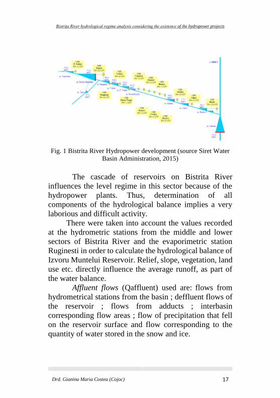
Fig. 1 Bistrita River Hydropower development (source Siret Water
Basin Administration, 2015)
The cascade of reservoirs on Bistrita River
influences the level regime in this sector because of the
hydropower plants. Thus, determination of all
components of the hydrological balance implies a very
laborious and difficult activity.
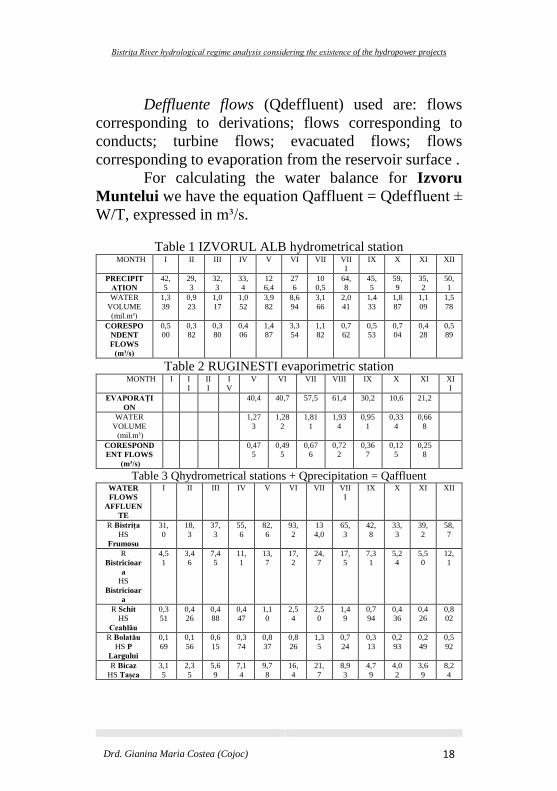
There were taken into account the values recorded
at the hydrometric stations from the middle and lower
sectors of Bistrita River and the evaporimetric station
Ruginesti in order to calculate the hydrological balance of
Izvoru Muntelui Reservoir. Relief, slope, vegetation, land
use etc. directly influence the average runoff, as part of
the water balance.
Affluent flows (Qaffluent) used are: flows from
hydrometrical stations from the basin ; deffluent flows of
the reservoir ; flows from adducts ; interbasin
corresponding flow areas ; flow of precipitation that fell
on the reservoir surface and flow corresponding to the
quantity of water stored in the snow and ice.
Bistrița River hydrological regime analysis considering the existence of the hydropower projects
Drd. Gianina Maria Costea (Cojoc) 18
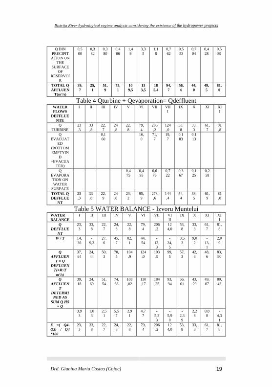
Deffluente flows (Qdeffluent) used are: flows
corresponding to derivations; flows corresponding to
conducts; turbine flows; evacuated flows; flows
corresponding to evaporation from the reservoir surface .
For calculating the water balance for Izvoru
Muntelui we have the equation Qaffluent = Qdeffluent ±
W/T, expressed in m³/s.
Table 1 IZVORUL ALB hydrometrical station MONTH I II III IV V VI VII VII
I
IX X XI XII
PRECIPIT
AȚION
42,
5
29,
3
32,
3
33,
4
12
6,4
27
6
10
0,5
64,
8
45,
5
59,
9
35,
2
50,
1
WATER
VOLUME
(mil.m³)
1,3
39
0,9
23
1,0
17
1,0
52
3,9
82
8,6
94
3,1
66
2,0
41
1,4
33
1,8
87
1,1
09
1,5
78
CORESPO
NDENT
FLOWS
(m³/s)
0,5
00
0,3
82
0,3
80
0,4
06
1,4
87
3,3
54
1,1
82
0,7
62
0,5
53
0,7
04
0,4
28
0,5
89
Table 2 RUGINESTI evaporimetric station MONTH I I
I
II
I
I
V
V VI VII VIII IX X XI XI
I
EVAPORAȚI
ON
40,4 40,7 57,5 61,4 30,2 10,6 21,2
WATER
VOLUME
(mil.m³)
1,27
3
1,28
2
1,81
1
1,93
4
0,95
1
0,33
4
0,66
8
CORESPOND
ENT FLOWS
(m³/s)
0,47
5
0,49
5
0,67
6
0,72
2
0,36
7
0,12
5
0,25
8
Table 3 Qhydrometrical stations + Qprecipitation = Qaffluent WATER
FLOWS
AFFLUEN
TE
I II III IV V VI VII VII
I
IX X XI XII
R Bistrița
HS
Frumosu
31,
0
18,
3
37,
3
55,
6
82,
6
93,
2
13
4,0
65,
3
42,
8
33,
3
39,
2
58,
7
R
Bistricioar
a
HS
Bistricioar
a
4,5
1
3,4
6
7,4
5
11,
1
13,
7
17,
2
24,
7
17,
5
7,3
1
5,2
4
5,5
0
12,
1
R Schit
HS
Ceahlău
0,3
51
0,4
26
0,4
88
0,4
47
1,1
0
2,5
4
2,5
0
1,4
9
0,7
94
0,4
36
0,4
26
0,8
02
R Bolatău
HS P
Largului
0,1
69
0,1
56
0,6
15
0,3
74
0,8
37
0,8
26
1,3
5
0,7
24
0,3
13
0,2
93
0,2
49
0,5
92
R Bicaz
HS Tașca
3,1
5
2,3
5
5,6
9
7,1
4
9,7
8
16,
4
21,
7
8,9
3
4,7
9
4,0
2
3,6
9
8,2
4
Bistrița River hydrological regime analysis considering the existence of the hydropower projects
Drd. Gianina Maria Costea (Cojoc) 19
Q DIN
PRECIPIT
AȚION ON
THE
SURFACE
OF
RESERVOI
R
0,5
00
0,3
82
0,3
80
0,4
06
1,4
9
3,3
5
1,1
8
0,7
62
0,5
53
0,7
04
0,4
28
0,5
89
TOTAL Q
AFFLUEN
T(m³/s)
39,
7
25,
1
51,
9
75,
1
10
9,5
13
3,5
18
5,4
94,
7
56,
6
44,
0
49,
5
81,
0
Table 4 Qturbine + Qevaporation= Qdeffluent WATER
FLOWS
DEFFLUE
NTE
I II III IV V VI VII VII
I
IX X XI XI
I
Q
TURBINE
23
,3
33
,8
22,
7
24
,8
22,
8
79,
4
206
,2
124
,0
53,
8
33,
3
61,
7
81
,8
Q
EVACUAT
ED
(BOTTOM
EMPTYIN
D
+EVACUA
TED)
0,1
60
16,
0
71,
7
19,
7
0,1
83
0,1
13
Q
EVAPORA
TION ON
WATER
SURFACE
0,4
75
0,4
95
0,6
76
0,7
22
0,3
67
0,1
25
0,2
58
TOTAL Q
DEFFLUE
NT
23
,3
33
,8
22,
9
24
,8
23,
2
95,
9
278
,6
144
,4
54,
4
33,
5
61,
9
81
,8
Table 5 WATER BALANCE - Izvoru Muntelui WATER
BALANCE
I II III IV V VI VII VI
II
IX X XI XI
I
Q
DEFFLUE
NT
23,
3
33,
8
22,
7
24,
8
22,
8
79,
4
206
,2
12
4,0
53,
8
33,
3
61,
7
81,
8
W / T 14,
36
-
9,3
27,
6
45,
7
82,
1
44,
54
-
12,
3
-
24,
5
3,5
3
9,0
2
-
13,
1
2,0
9
Q
AFFLUEN
T = Q
DEFLUEN
T(±W/T
m³/s)
37,
64
24,
44
50,
3
70,
5
104
,9
124
,0
193
,9
99,
5
57,
3
42,
3
48,
6
83,
90
Q
AFFLUEN
T
DETERMI
NED AS
SUM Q HS
= Q
39,
18
24,
69
51,
54
74,
66
108
,02
130
,17
184
,25
93,
94
56,
01
43,
29
49,
07
80,
43
3,9
3
1,0
3
2,5
1
5,5
7
2,9
1
4,7
7
-
5,2
3
-
5,9
0
-
2,3
9
2,2
8
0,8
8
-
4,3
1
E =( Q4-
Q3) / Q4
*100
23,
3
33,
8
22,
7
24,
8
22,
8
79,
4
206
,2
12
4,0
53,
8
33,
3
61,
7
81,
8
Bistrița River hydrological regime analysis considering the existence of the hydropower projects
Drd. Gianina Maria Costea (Cojoc) 20
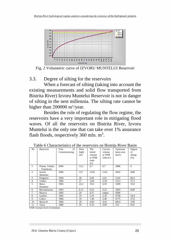
Fig. 2 Volumetric curve of IZVORU MUNTELUI Reservoir
3.3. Degree of silting for the reservoirs
When a forecast of silting (taking into account the
existing measurements and solid flow transported from
Bistrita River) Izvoru Muntelui Reservoir is not in danger
of silting in the nest millennia. The silting rate cannot be
higher than 200000 m³/year.
Besides the role of regulating the flow regime, the
reservoirs have a very important role in mitigating flood
waves. Of all the reservoirs on Bistrita River, Izvoru
Muntelui is the only one that can take over 1% assurance
flash floods, respectively 360 mln. m3.
Table 6 Characteristics of the reservoirs on Bistrița River Basin No Reservoir Year of
Commissioning
Dam
hight
(m)
The
initial
volume
at NNR
(mln
m³)
Current
volume
at NNR
(mln m³)
Upstream
basin area
(km²)
Degree
of
silting
(%)
1 Poiana Teiului
– Topoliceni
2004 15,5 0,7 0,7 2886 0
2 Izvoru
Muntelui
1960 127 1230 1122 4022 8,80
3 Pangarati 1964 28 6,00 2,01 5142 66,5
4 Vaduri 1966 27 5,60 2,39 5213 57,3
5 Batca
Doamnei
1963 22,3 10,0 6,50 5290 35,0
6 Reconstructia 1963 8,15 0,25 0,23 5403 8,00
7 Racova 1965 20 4,37 empty 6580 -
8 Garleni 1965 19 5,10 2,30 6758 54,9
9 Lilieci 1966 19 7,40 5,40 6775 27,0
10 Bacau II 1966 18 4,60 4,42 6814 3,90
11 Tasca 1980 20 0,10 0,09 512 0,01
NNR=normal level of retention.
Bistrița River hydrological regime analysis considering the existence of the hydropower projects
Drd. Gianina Maria Costea (Cojoc) 21
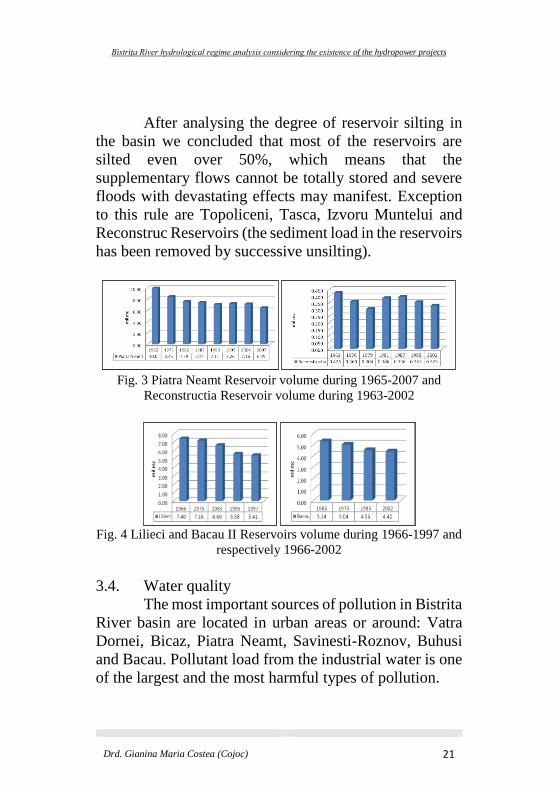
After analysing the degree of reservoir silting in
the basin we concluded that most of the reservoirs are
silted even over 50%, which means that the
supplementary flows cannot be totally stored and severe
floods with devastating effects may manifest. Exception
to this rule are Topoliceni, Tasca, Izvoru Muntelui and
Reconstruc Reservoirs (the sediment load in the reservoirs
has been removed by successive unsilting).
Fig. 3 Piatra Neamt Reservoir volume during 1965-2007 and
Reconstructia Reservoir volume during 1963-2002
Fig. 4 Lilieci and Bacau II Reservoirs volume during 1966-1997 and
respectively 1966-2002
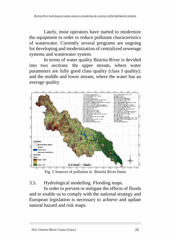
3.4. Water quality
The most important sources of pollution in Bistrita
River basin are located in urban areas or around: Vatra
Dornei, Bicaz, Piatra Neamt, Savinesti-Roznov, Buhusi
and Bacau. Pollutant load from the industrial water is one
of the largest and the most harmful types of pollution.
Bistrița River hydrological regime analysis considering the existence of the hydropower projects
Drd. Gianina Maria Costea (Cojoc) 22
Lately, most operators have started to modernize
the equipment in order to reduce pollutant characteristics
of wastewater. Currently several programs are ongoing
for developing and modernization of centralized sewerage
systems and wastewater system.
In terms of water quality Bistrita River is devided
into two sections: the upper stream, where water
parameters are fully good class quality (class I quality);
and the middle and lower stream, where the water has an
average quality.
Fig. 5 Sources of pollution in Bistrita River basin
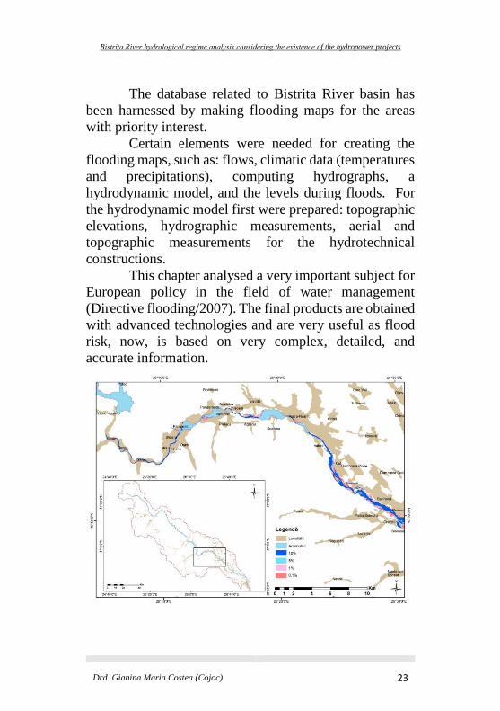
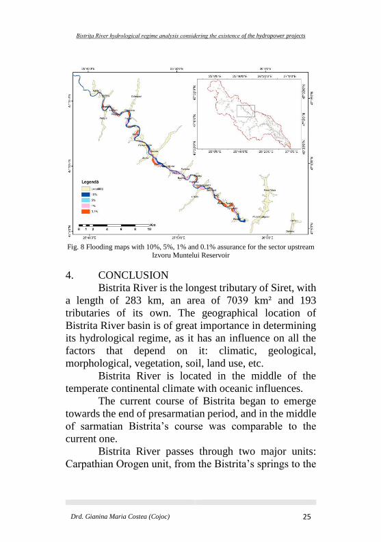
3.5. Hydrological modelling. Flooding maps.
In order to prevent or mitigate the effects of floods
and to enable us to comply with the national strategy and
European legislation is necessary to achieve and update
natural hazard and risk maps.
Bistrița River hydrological regime analysis considering the existence of the hydropower projects
Drd. Gianina Maria Costea (Cojoc) 23
The database related to Bistrita River basin has
been harnessed by making flooding maps for the areas
with priority interest.
Certain elements were needed for creating the
flooding maps, such as: flows, climatic data (temperatures
and precipitations), computing hydrographs, a
hydrodynamic model, and the levels during floods. For
the hydrodynamic model first were prepared: topographic
elevations, hydrographic measurements, aerial and
topographic measurements for the hydrotechnical
constructions.
This chapter analysed a very important subject for
European policy in the field of water management
(Directive flooding/2007). The final products are obtained
with advanced technologies and are very useful as flood
risk, now, is based on very complex, detailed, and
accurate information.
Bistrița River hydrological regime analysis considering the existence of the hydropower projects
Drd. Gianina Maria Costea (Cojoc) 24
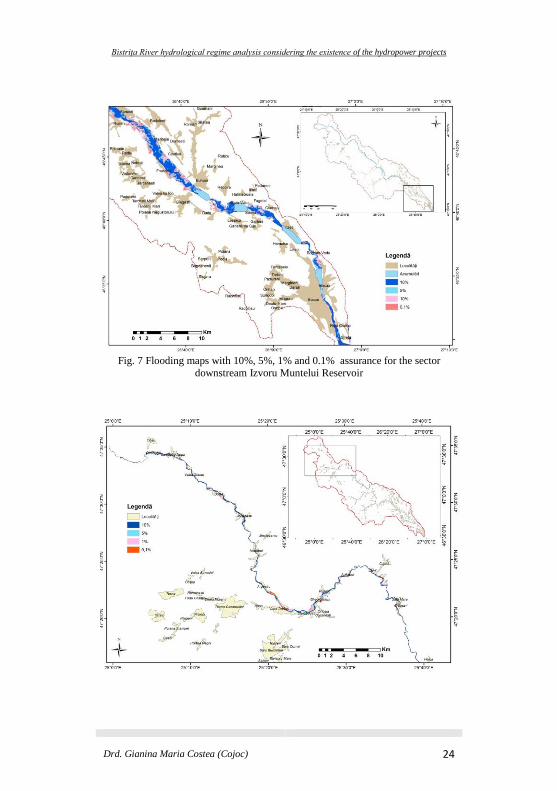
Fig. 7 Flooding maps with 10%, 5%, 1% and 0.1% assurance for the sector
downstream Izvoru Muntelui Reservoir
Bistrița River hydrological regime analysis considering the existence of the hydropower projects
Drd. Gianina Maria Costea (Cojoc) 25
Fig. 8 Flooding maps with 10%, 5%, 1% and 0.1% assurance for the sector upstream
Izvoru Muntelui Reservoir
4. CONCLUSION
Bistrita River is the longest tributary of Siret, with
a length of 283 km, an area of 7039 km² and 193
tributaries of its own. The geographical location of
Bistrita River basin is of great importance in determining
its hydrological regime, as it has an influence on all the
factors that depend on it: climatic, geological,
morphological, vegetation, soil, land use, etc.
Bistrita River is located in the middle of the
temperate continental climate with oceanic influences.
The current course of Bistrita began to emerge
towards the end of presarmatian period, and in the middle
of sarmatian Bistrita’s course was comparable to the
current one.
Bistrita River passes through two major units:
Carpathian Orogen unit, from the Bistrita’s springs to the
Bistrița River hydrological regime analysis considering the existence of the hydropower projects
Drd. Gianina Maria Costea (Cojoc) 26
locality Racova; and the Platform unit, from Racova
locality to the confluence with the Siret River.
There can be identified tree large sectors of relief:
the mountainous sector (Oriental Carpathians) from
Bistrita’s springs to Piatra Neamt locality; the
subcarpathian sector from Piatra Neamt locality to
Racova locality; and the tableland sector, from Racova
locality to the confluence with Siret River. The high
terraces are well represented, and the meadow steps reach
large widths.
The diversity of physical-geographical factors
(relief, climate, soils) favoured the development of
complex vegetation (alpine, sub-alpine, spruce forest,
mixed beech-coniferous and beech).
The most significant floods from Bistrita River
basin registered in 1970, 1991, 2005, and 2010.
After 1950, the Bistrita hydropower development
started to shape. For the whole cascade of reservoirs on
the Bistrita River were constructed 10 dams, 12
hydropower plants, and 61 km of channel. In order to
transform this sector sometimes people and localities had
to be moved.
The construction of reservoirs represented an
intervention in the natural hydrologic system by changing
some of its characteristics. Therefore calculating the water
balance is of great importance because it represents the
balance between the total affluent flows (A) and total
deffluent flows (B) and, of course, the variation of the
water volume in the reservoir (W/T). The reservoirs have
a significant role because they can mitigate the flood wave
downstream.
Bistrița River hydrological regime analysis considering the existence of the hydropower projects
Drd. Gianina Maria Costea (Cojoc) 27
The reservoirs on Bistrita River have a degree of
silting over more than 50%, which means that
supplementary flows cannot be stored completely and
may manifest devastating floods. The Topoliceni, Tasca
(on Bicaz River), Izvoru Muntelui and Reconstructia (the
alluvial deposit has been removed by successive
unsilting) are the exceptions.
The main sources of pollution in Bistrita River
Basin are from the traditional human activities and from
recent industry. The water quality is first class on the
upper stream and IInd, IIIrd, IVth, Vth class on the middle
and inferior course.
The HYDRAULIC MODELLING chapter –
flooding maps analysed a very important and up to date
subject. The database was analysed and the flooding maps
for Bistrita River have been achieved by using ISIS
modelling program.
5. BIBLIOGRAPHY 1. ABAS (Administraţia Bazinală de Apă Siret) (1950-2015),
date nepublicate.
2. Blynth K., Biggin D.S. (1993), Monitoring floodwater
inundation with ERS-1 SAR, Earth Observation Quartely 42:
6-8.
3. Breabăn V. (1997), Amenajări hidroenergetice, Universitatea
Ovidius, Constanța.
4. Cârdu M., Bara T. (1998), Romanian achievement in hydro-
power plant, Energy Conversion and Management, Vol 39,
Issue 11, pg. 1193-1201.
5. Cojoc G.M., Romanescu G., Tirnovan A. (2014), The degree
of silting and the impact an alluvial deposits in the river beds
of Bistrita River basin, Apa si Aerul International Conference
Proceedings, Cluj Napoca
http://aerapa.conference.ubbcluj.ro/.
Bistrița River hydrological regime analysis considering the existence of the hydropower projects
Drd. Gianina Maria Costea (Cojoc) 28
6. Cojoc G.M., Romanescu G., Tirnovan A. (2014), The
importance of water temperature fluctuations in relation to the
hydrological factors. Case study – Bistrita river basin,
Simpozionul international Mediul actual si dezvoltarea
durabilă, editia a IX a, 6-8 iunie 2014
http://pesd.ro/articole/nr.8/nr.2/10432%20-
%20Volume8_issue_2%2014_paper.pdf.
7. Cojoc GM, Tirnovan A, Obreja F, (2014) Modern means of
monitoring the hydrological regime in the Siret River Basin
(Romania), Scientific Annals of Ștefan cel Mare University of
Suceava, Geography Series, DOI:
http://dx.doi.org/10.4316/GEOREVIEW.2014.24.1.165.
8. Cojoc G.M., Romanescu G., Tirnovan A. (2014), Prognoza
hidrologică în Bazinul hidrografic Bistrița cu ajutorul
programului RFS (River Forecast System), 11-13 septembrie
2014, Conference Proceedings, Volume I “Hydrology and
Water Resources”
http://www.limnology.ro/water2014/proceedings/72_Cojoc.p
df.
9. Cojoc G.M., Romanescu G., Tirnovan A. (2014), Exceptional
floods on a developed river. Case study for Bistrita River from
Oriental Carpathians (Romania), NATURAL HAZARDS,
DOI: 10.1007/s11069-014-1439-2.
10. Dăscălescu N. (2000), History of dam construction in
Romania, Romanian National Comitee on Large Dams,
Bucharest, pg. 16-26.
11. Diaconu C., Alexandrescu G. (1980), Cote de apărare pe
râuri, I.M.H., Probleme de hidrometrie, Bucureşti, pg.31-38.
12. Diaconu C., Şerban P., Paşoi I. (1980), Îndrumări
metodologice şi tehnice pentru reconstituirea scurgerii
naturale a râurilor, Bucureşti.
13. Diaconu C., Şerban P. (1994), Sinteze şi regionalizări
hidrologice, Editura Tehnică, Bucureşti.
14. Donisă I. (1968), Geomorfologia Văii Bistriţei, Editura
Academiei, Bucureşti.
15. Drobot R., Carbonnel J.P. (1997), Măsuri non-structurale în
gospodărirea apelor, Editura N*G*A*, București.
Bistrița River hydrological regime analysis considering the existence of the hydropower projects
Drd. Gianina Maria Costea (Cojoc) 29
16. Feyen L., Dankers R., Bódis K., Salamon P., Barredo J.I.
(2012), Fluvial flood risk in Europe in present and future
climates, Climate Change 112(1): 47-62.
17. Förster S., Kuhlmann B., Lindenschmidt K.E., Bronster A.
(2008), Assessing flood risk for a rural detention area, Natural
Hazards and Earth System Sciences 8: 311-322.
18. Gaume E., Bain V., Bernardova P., Newinger O., Barbuc M.,
Bateman A., Blaškovičová L., Blöschl G., Borga M.,
Dumitrescu A., Daliakopoulos I., Garcia J., Irimescu A.,
Kohnova S., Soutroulis A., Marchi L., Matreata S., Medina V.,
Preciso E., Sempere-Torres D., Stancalie G., Szolgay J.,
Tsanig I., Velasco D., Viglione A. (2009), A compilation of
data on European flash floods, Journal of Hydrology 367(1-
2): 70-78.
19. Giurmă I. (1997), Colmatarea lacurilor de acumulare, Editura
H.G.A., Bucureşti.
20. Hirsch R.M., Helsel D.R., Cohn T.A., Gilroy E.J. (1993),
Statistical analysis of hydrologic data. In: Handbook of
Hydrology (ed. by D. R. Maidment), Ch. 17, 17.11–17.37.
McGraw-Hill, New York, USA.
21. Komma J, Reszler C, Blöschl G, Haiden T. (2007), Ensemble
prediction of floods – catchment non-linearity and forecast
probabilities, Natural Hazards and Earth System Sciences
7(4): 431-444.
22. Lăzărescu D. (1972), Prognoza scurgerii în timpul viiturilor
din ploi pe teritoriul României, I.M.H., Studii de hidrologie,
vol.XXXII, Bucureşti.
23. Lăzărescu D., Panait I. (1957), Bilanţul hidrologic al
României, Meteorologia şi hidrologia, vol.2, nr.4, Bucureşti,
pg. 52-61.
24. Lockheed Martin Romania (2012), Raport final privind
implementarea proeictului DESWAT (Destructive Waters) în
bazinul hidrografic Siret.
25. Marinescu P. (2000), Aspecte privind efectele negative ale
inundaţiilor, Hidrotehnica, 45, nr.3-4, Bucureşti.
26. Mustaţă L. (1973), Calculul debitelor maxime din ploi pe
râurile din România, Studii de hidrologie, XXXVI, Bucureşti.
27. Mustăţea A. (2005), Viituri exceptionale pe teritoriul
Romaniei, Editura Institutului National de Hidrologie si
Bistrița River hydrological regime analysis considering the existence of the hydropower projects
Drd. Gianina Maria Costea (Cojoc) 30
Gospodarire a Apelor, București, pg. 409.
28. Nistor I. (2004), Studiul undei de viitură rezultate de la
ruperea unui baraj, ICDPM, nr.1, Editura Performantica, Iaşi,
pg. 63-72.
29. Olariu P. (1990), Controlul producţiei de aluviuni în bazinul
hidrografic Bistriţa, Lucrările celui de al III-lea simpozion
Provenienţa şi efluenţa aluviunilor, Piatra Neamţ.
30. Rădoane M., Ciaglic V., Rădoane N. (2009), Hydropower
impact on the ice jam formation on the upper Bistrita River,
Romania, Cold Regions Science and Technology.
31. Romanescu G. (2005), Riscul inundaţiilor în amonte de lacul
Izvorul Muntelui si efectul imediat asupra trăsăturilor
geomorfologice ale albiei, Riscuri şi catastrofe 4: 117-124.
32. Romanescu G., Nistor I. (2011), The effect of the July 2005
catastrophic inundations in the Siret River’s Lower
Watershed, Romania, Natural Hazards 57: 345-368. Doi:
10.1007/s11069-010-9617-3.
33. Romanescu G. (2013), Floods in the Siret and Pruth Basins,
99-120. In: Geomorphological Impacts of Extreme Weather.
Case Studies from Central and Eastern Europe. Edited by
Dénes Lóczy, Springer, Dordrecht, Heidelberg, New York,
London.
34. Romanescu G., Cojoc G.M., Tirnovan A., Dascalita D., Paun
E., (2014) Surface Water Quality in Bistrita River Basin 14th
GeoConference on WATER RESOURCES. FOREST,
MARINE AND OCEAN ECOSYSTEMS, Conference
Proceedings, Vol. I, Albena
http://sgem.org/sgemlib/spip.php?article4422.
35. Romanescu G., Cojoc G.M., Sandu I.G. Tirnovan A.,
Dascalita D., Sandu I. (2015), Sursele de poluare din bazinul
hidrografic al raului Bistrita, REVISTA DE CHIMIE,
București,
http://www.revistadechimie.ro/pdf/ROMANESCU%20G.pdf
%206%2015.pdf.
36. Sorocovschi V. (2004b), Percepția riscurilor induse de
inundații. Rezultatul unui sondaj de opinie desfășurat în
Dealurile Clujului și Dejului, Riscuri și catastrofe, 1:122-137.
37. Stănescu V. (1985), Modele matematice în hidrologie
(probleme de concepţie sistemică), I.M.H., Bucureşti.
Bistrița River hydrological regime analysis considering the existence of the hydropower projects
Drd. Gianina Maria Costea (Cojoc) 31
38. Șelărescu M., Podani M. (1993), Apărare împotriva
inundațiilor, Editura Tehnică, București, pg. 260.
39. Şerban P. (1990), Proceduri de reactualizarea prognozelor
hidrologice, Hidrotehnica, vol.35, nr.5, Bucureşti.
40. ***(2000), Hydrologic and Hydraulic Modeling Support with
Geographic Information Systems, compiled and edited by Dr.
David Maidment and Dr.Dean Djokic, Published by
Environmental System Research Institute, California.
41. ***(2012), Regulament de exploatare amenajarea
hidroenergetică Izvoru Muntelui, Hidroelectrica SA.
42. ***Directiva 2008/1/CE – IPPC (Prevenirea și controlul
integrat al poluării) http://www.anpm.ro/