doe/rl-96-32, hanford site biological resources management plan
TRANSCRIPT
DOE/RL-96-32 Revision 2
Hanford Site Biological Resources Management Plan
Prepared for the U.S. Department of Energy Assistant Secretary for Environmental Management
P.O. Box 550 Richland, Washington 99352
Approved for Public Release; Further Dissemination Unlimited

This page intentionally left blank.
DOE/RL-96-32 Revision 2
Hanford Site Biological Resources Management Plan
Date Published February 2017
Prepared for the U.S. Department of Energy Assistant Secretary for Environmental Management
P.O. Box 550 Richland, Washington 99352
Release Approval Date
Approved for Public Release; Further Dissemination Unlimited
By Janis Aardal at 12:39 pm, Feb 21, 2017

TRADEMARK DISCLAIMER Reference herein to any specific commercial product, process, or service by trade name, trademark, manufacturer, or otherwise, does not necessarily constitute or imply its endorsement, recommendation, or favoring by the United States Government or any agency thereof or its contractors or subcontractors. This report has been reproduced from the best available copy. Printed in the United States of America
DOE/RL 96-32 Revision 2
i
Executive Summary
Resource stewardship is an integral part of U.S. Department of Energy (DOE) responsibilities at the Hanford Site. Appropriate management strategies and actions, based on the best scientific information available, are important components of stewardship and land-use planning at the site. The Hanford Site Biological Resources Management Plan (BRMP) is DOE’s primary implementation plan for managing natural resources under the Hanford Comprehensive Land-Use Plan (CLUP).
The CLUP, which is described in the Final Hanford Comprehensive Land-Use Plan Environmental Impact Statement (HCP-EIS; DOE 1999) and defined in the Record of Decision (ROD; 64 FR 61615), consists of a land-use map, land-use designations, land-use policies, and a set of procedures for plan implementation. The CLUP land-use policies that direct land-use actions and help ensure individual land-use actions collectively advance the CLUP’s goals and objectives over time. BRMP is one of several implementation plans under the framework of the CLUP. Each addresses unique resources and key activities that, together, provide a comprehensive approach for managing land and facilities at the Hanford Site.
S.1. Introduction
The Hanford BRMP establishes DOE’s management objectives, strategies, actions, and general directives for managing biological resources on the Hanford Site. The purpose of BRMP is to provide the Richland Operations Office (RL), the Office of River Protection (ORP), Hanford contractors, and other organizations conducting work on the Hanford Site with a
consistent approach to protect and manage biological resources on the site. Essential aspects of Hanford biological resource management include resource monitoring, impact assessment, mitigation, and restoration. The BRMP’s overarching goals are to:
• Foster preservation of important biological resources.
• Minimize adverse impacts to biological resources from site development and other management activities.
• Balance the site cleanup mission with resource stewardship obligations.
This document applies to all actions that occur on Hanford Site lands managed by DOE, including central Hanford and the portions of the Hanford Reach National Monument (HRNM) currently managed by RL.
S.2. Roles and Responsibilities
RL is responsible for administering and implementing BRMP for the Hanford Site. The RL and ORP site managers are ultimately responsible for the site’s natural resources, but each program manager and assistant manager within RL and ORP is responsible for adhering to the resource management policies described in this document. The RL Site Stewardship Division (SSD) is responsible for defining Hanford’s approach to biological resource management and will assist other RL and ORP programs, contractors, and other organizations conducting work on the Hanford Site with interpretation of these guidelines. The SSD oversees monitoring and impact assessment support and tracks performance of mitigation actions.

DOE/RL 96-32 Revision 2
ii
Portions of the Hanford Site were declared part of the HRNM in 2000 by Presidential Proclamation 7319, “Establishment of the Hanford Reach National Monument,” for their ecological, cultural, and geological values. The U.S. Fish and Wildlife Service (USFWS) manages portions of the HRNM and islands in the Hanford Reach as part of the Mid-Columbia River National Wildlife Refuge Complex through the Hanford Reach National Monument Comprehensive Conservation Plan and Environmental Impact Statement (HRNM-CCP).
Under existing DOE permits, the USFWS is responsible for protecting and managing HRNM resources and access to HRNM lands under its control. Because DOE is currently the underlying landholder, it retains approval authority over certain management aspects of the monument that could affect DOE operations such as safety or security buffers, access to and operation of research sites, or seismic, meteorological, or environmental monitoring sites.
All contractors and subcontractors, and any other entity performing work on Hanford lands managed by DOE, will conduct work in accordance with this management plan, as established by the CLUP implementing procedures. Each contractor is responsible for incorporating biological resource protection measures into project planning, requesting ecological compliance reviews for its activities, and implementing mitigation actions for any project for which it is responsible. Unless otherwise controlled by legal or contractual requirements, BRMP also applies to lands under lease, permit, or easement.
S.3. Regulatory Basis
The Hanford BRMP was developed to support DOE compliance with applicable federal
laws, regulations, Executive Orders, and DOE Orders. Key federal acts and Executive Orders that are relevant to biological resource management include the following:
• Endangered Species Act of 1973 (ESA)
• National Environmental Policy Act of 1969 (NEPA)
• Migratory Bird Treaty Act of 1918 (MBTA)
• Bald and Golden Eagle Protection Act
• Comprehensive Environmental Response, Compensation, and Liability Act of 1980 (CERCLA)
• Resource Conservation and Recovery Act of 1976 (RCRA)
• Clean Water Act of 1977 (CWA)
• Sikes Act
• Magnuson-Stevens Fishery Conservation and Management Act of 1976
• Executive Order 13112, “Invasive Species”
• Executive Order 11990, “Protection of Wetlands”
• Executive Order 11988, “Floodplain Management”
• Presidential Memorandum of June 20, 2014, “Creating a Federal Strategy to Promote the Health of Honey Bees and Other Pollinators”
• Presidential Proclamation 7319, “Establishment of the Hanford Reach National Monument”
• DOE Order 430.1C “Real Property Asset Management” (August 19, 2016).
DOE/RL 96-32 Revision 2
iii
BRMP also considers applicable Washington State regulations, especially those regarding fish and wildlife management and noxious weed control.
S.4. Hanford’s Biological Resources
The Hanford Site lies within the interior, low elevation, Columbia River Basin, which is within the shrub-steppe zone. The diversity of physical features across the Hanford Site contributes to a corresponding diversity of biological communities. The majority of the Hanford Site consists of shrub-steppe habitats, but valuable riparian, wetland, and aquatic habitats are associated with the Hanford Reach of the Columbia River.
The Hanford Site also contains a diversity of other rare terrestrial habitats such as riverine islands, bluffs/cliffs, basalt outcrops, swales, and sand dunes. Both shrub-steppe and riparian habitats are considered “priority habitats” by the Washington Department of Fish and Wildlife (WDFW). In addition, Washington’s Natural Heritage Program (WNHP) has mapped and classified portions of the native plant communities found on Hanford as priority ecosystems.
The Hanford Site is home to at least 46 species of mammals, 10 species of reptiles, 5 species of amphibians, over 200 species of birds, well over 1000 species of insects and invertebrates, and approximately 700 species of plants. There have been 46 fish species identified in the Hanford Reach, as well as numerous insects, crayfish, and mollusks. Many of these species are considered to be rare or of special concern to federal or state resource management agencies.
The Columbia River is designated as critical habitat for three federal endangered or threatened fish species (Upper Columbia River spring Chinook, Upper Columbia River steelhead, and bull trout), and two federal threatened terrestrial plant species (Umtanum desert buckwheat and White Bluffs bladderpod) are found on the Hanford Site. In addition to these species, the WNHP lists approximately 25 plant species as endangered, threatened, or sensitive. The WDFW lists 29 wildlife species as threatened, endangered, sensitive, or candidate. Also, approximately 23 plant species and 51 species of wildlife are listed as state monitor, review, or watch list.
S.5. Resource Management Approach and Implementation
The primary goals in managing Hanford’s species, habitats, and ecosystem resources are to maintain sustainable population levels of terrestrial and aquatic resident species and maintain or increase the quantity and quality of functioning native systems across the Hanford Site.
The overarching objective of BRMP is to provide strategies and management actions necessary to sustain Hanford’s biological resources. Specific DOE resource management objectives for Hanford are to:
• Protect species and habitats of state and federal concern
• Maintain and preserve native biological diversity
• Reduce the spread of invasive species and provide integrated control of noxious weeds
• Where and when feasible, improve degraded habitats in a strategic manner
DOE/RL 96-32 Revision 2
iv
to increase landscape connectivity and native diversity
• Reduce and minimize fragmentation of habitats
• Maintain landscapes that provide regional connectivity to habitats surrounding Hanford.
To meet these objectives, BRMP provides a set of general directives for Hanford Site operations; places all site biological resources into six resource priority levels, with accompanying management guidance; and for certain species or resources, provides specific management guidance based on federal and/or state recommendations.
S.5.1. General Directives and Practices
DOE developed the following general directives and practices for biological resource management at the Hanford Site. They apply to all actions occurring within portions of the site managed by DOE, including the areas of the HRNM that DOE manages.
• All actions and activities that potentially affect biological resources require an ecological compliance review and determination of potential impacts before proceeding. This directive not only applies to ground-breaking disturbances and excavation, but also to any treatments or actions that alter the current natural state of the environment, habitat, or a species population, including mowing, prescribed burning, herbicide application in native vegetation, and creating excessive noise. The ecological review process is a component of early project planning.
• If an ecological compliance review determines adverse impacts to biological resources—such as habitat alterations or disturbances that could affect the reproductive success of a species of concern—specific mitigation actions will be identified, and the mitigation actions—avoidance, minimization, or compensation—will be implemented by the responsible contractor.
• All entities conducting work on the Hanford Site will conduct activities and work in accordance with access restrictions and administrative designations related to resource protection areas, including the following:
o Areas containing rare plant communities (element occurrences)
o Mitigation/restoration areas
o Collection/propagation areas for native plant materials
o Lands used under permit and leased properties
o Administrative control areas for species of concern which include bald eagle buffer zones, fall Chinook salmon spawning locations, ferruginous hawk and burrowing owl buffer zones, and known populations/ occurrences of plant species of concern.
• Activities that increase habitat fragmentation and degrade existing native habitats will be avoided as practical. New facilities should be located within previously disturbed areas; new linear infrastructure development should be co-located with
DOE/RL 96-32 Revision 2
v
existing roads or corridors to minimize habitat fragmentation.
• No vehicles are permitted off established roads on the Hanford Site unless specifically approved by RL’s SSD and the Hanford Fire Department, unless required by an emergency situation.
• Actions that remove or significantly degrade native vegetation will require replanting with native species in areas not needed for on-going operations following the practices outlined in DOE/RL-2011-116, Hanford Site Revegetation Manual.
• Plant material used for habitat improvements or habitat restoration should be native to the Hanford Site and preferably should be of locally derived genetic stock.
• Domestic livestock grazing is not allowed on Hanford lands.
• No recreational hunting, fishing, or trapping is allowed on Hanford Site lands managed by DOE.
• No agriculture is allowed on lands managed by DOE.
This guidance must be followed unless its application is waived for a certain circumstance by the appropriate site manager for either RL or ORP.
S.5.2. Fire Management
The overall wildfire management policy for the Hanford Site is to minimize the potential for human-caused fires and to aggressively fight wildfires. The following paragraphs describe specific elements of this policy.
To the greatest extent possible during a wildfire, fire suppression and control actions will be conducted to protect existing stands of late successional shrub-steppe, and to avoid direct surface disturbance within late successional shrub-steppe areas, plant community element occurrence areas, and other rare or sensitive habitat areas. To the extent practical during a firefighting effort, the Fire Department incident commander should coordinate or consult with the site natural resource subject matter experts.
Any temporary firebreaks constructed during fire fighting should be re-contoured and reseeded with locally derived native plant species as described in the Hanford Site Revegetation Manual (DOE 2013a).
Replanting of areas burned by wildfire will be considered on a case-by-case basis depending on the site, pre-existing plant community, characteristics of the wildfire, level of damage sustained by native vegetation, and likelihood that the burned area will further degrade if restoration actions are not performed. If performed, locally derived native species should be planted.
Preventative fire control will include installation and maintenance of a system of permanent fire breaks. These will use existing roads, rail lines, and utility corridors to the extent practicable. Installation and maintenance of these fire breaks will be conducted in a manner that minimizes adverse impacts to biological resources.
Controlled burning of accumulations of dry plant material, particularly along roadways, is conducted to remove sources of fuel that could provide a mechanism for rapidly accelerating uncontrolled burns.
DOE/RL 96-32 Revision 2
vi
S.5.3. Noxious Weed Management
Noxious weeds are controlled on the Hanford Site for regulatory compliance with the Federal Noxious Weed Act of 1974 as amended in 1990 and by the Washington Administrative Code (WAC) 16-750, Washington State Noxious Weed List and Schedule of Monetary Penalties, to prevent adverse impacts to neighboring agricultural operators, keep deep-rooted vegetation from invading Hanford waste sites, and protect native communities from further degradation. The goal of noxious weed management on the Hanford Site is to eliminate existing populations of noxious weeds and prevent new populations from becoming established.
Implementation of noxious weed management, especially in less disturbed areas, must meet other biological resource management requirements, such as evaluating the presence of rare species and unique habitats, avoiding and minimizing impacts, and mitigating habitats as applicable. The need for active reestablishment of desirable vegetation is recognized as a critical component of successful long-term control of noxious weeds and other undesirable vegetation.
S.5.4. Resource Priority Levels
To help facilitate and standardize management of resources, all species and habitats on the Hanford Site have been assigned resource priority levels that range from Level 5 (highest priority) to Level 0 (lowest priority). This hierarchical approach allows biological resources to be prioritized and appropriate actions—protection, monitoring, impact assessment, mitigation, and restoration—taken based on the type and relative ecological value of the resource. The
following paragraphs describe the priority levels:
• Level 5 resources include species that are listed or proposed-to-be listed under the ESA and their critical habitat, as well as rare and irreplaceable habitats. The management goal for this level is preservation, and a high level of status monitoring is appropriate. Impacts to Level 5 resources should be avoided, and compensatory mitigation will be determined on a case-by-case basis.
• Level 4 resources include federal candidate species; Washington State threatened or endangered species; habitat or exclusion buffers for federal candidates and Washington State threatened or endangered species; high-quality mature shrub-steppe; wetlands, swales, and riparian areas; and buffer areas for bald eagles and ferruginous hawks. The management goal for this level is preservation, with a high level of status monitoring. Avoidance and minimization of impacts is expected, but if required, habitat compensation will be at an area ratio of 5:1.
• Level 3 resources include Washington State sensitive, candidate, and review species; WDFW priority species; lower quality mature shrub-steppe—such as shrub stands that are less mature, have lower shrub density or canopy cover, and/or a greater proportion of cheatgrass in the understory than stands that qualify for Level 4. Level 3 also includes high-quality grasslands, conservation corridors, snake hibernacula, bat roosts, rookeries, burrowing owl buffer areas, and areas

DOE/RL 96-32 Revision 2
vii
with significant quantities of culturally important species. The management goal for Level 3 is conservation, with a moderate level of status monitoring. Impacts should be avoided or minimized if practical and, if needed, compensatory mitigation will be at a ratio of 3:1.
• Level 2 resources include migratory birds, state watch list plants and monitor list animals, recreationally and commercially important species, and lower quality steppe and shrub-steppe. The management goal is conservation, with a low level of status monitoring. Impacts should be avoided if possible, and compensation may be at a ratio of 1:1. However, Level 2 habitat areas may often be good areas to perform actions to mitigate for impacts to higher-level habitat resources.
• Level 1 resources include individual common native plant and wildlife species, upland stands of non-native plants, and abandoned agricultural fields. Impacts should be avoided or minimized if possible, but there are no compensation requirements for impacts to Level 1 resources.
• Level 0 resources consist of non-native plants and animals (unless otherwise listed at a higher level), non-vegetated areas, and industrial areas. Management goals and actions are limited to those needed for regulatory compliance, such as the MBTA.
S.5.5. Species-Specific Management Guidance
Management of most species on the Hanford Site will be based on the general
guidance provided above for the six resource priority levels. However, specific management policies and guidance have been developed for certain species that have additional legal protections, require management actions beyond habitat protection, are unusually sensitive to human disturbance, or are resources of special interest to the public or the local Tribes.
Specific management guidance, based on federal or state resource management agency recommendations, is provided for federally listed spring Chinook salmon, steelhead, and bull trout. Specific guidance also is provided for fall Chinook salmon, bald eagles, ferruginous hawks, burrowing owls, greater sage grouse, peregrine falcons, American white pelicans, ground squirrels, bat roosts, rookeries, snake hibernacula, and federal- or state-listed rare plants.
S.6. Ecological Compliance Assessment
The Hanford Site ecological compliance assessment process incorporates evaluating potential impacts to biological resources before they occur and mitigating adverse impacts if they do occur. This process provides an essential link between DOE’s responsibility to protect biological resources and its site missions, including remediation and waste management.
As noted, all actions with the potential to affect biological resources require an ecological compliance review (ECR). This includes actions previously considered under CERCLA, RCRA, and/or NEPA. Specific examples of proposed actions that require an ECR include those that:
• Require an excavation permit
DOE/RL 96-32 Revision 2
viii
• Remove or modify dead or living vegetative cover
• Will be conducted on the outside of buildings and facilities
• Will be conducted within abandoned buildings and facilities
• Have the potential to alter or affect the living environment, including landscape-scale practices such as applications of fertilizers, herbicides, prescribed fire, or fire recovery efforts.
An ECR is conducted to ensure the proposed action will not affect rare plants or animals, or adversely affect habitats of concern. The review will normally require a site-specific field survey by a qualified biologist, and also may draw on records from previous surveys, maps, photos, and the scientific literature.
If the proposed action will adversely affect rare species or habitats, the ECR will include provisions for mitigation of the impacts, commensurate with the resource priority level of the species or habitat. All projects and programs are expected to comply with the requirements identified in the ECR. This may include recommendations to avoid and/or minimize adverse impacts to ecological resources by taking the following actions:
• Implementing alternatives that would result in fewer adverse impacts
• Locating projects at a less ecologically sensitive site
• Reducing or modifying the project footprint
• Scheduling project activities so disruption of key species and functions is minimized.
In unusual cases when significant impacts cannot be reasonably avoided or minimized, the ECR will provide recommendations for compensatory mitigation based on the floral and faunal characteristics of the habitat that will be disturbed.
S.7. Biological Resource Mitigation
Mitigation is a series of prioritized actions that reduce or eliminate adverse impacts to biological resources, including avoidance, minimization, onsite rectification, and compensation. Avoidance and minimization are always preferable to rectification and compensation, and should always be considered and implemented first. To facilitate a balance between Hanford Site mission elements and stewardship obligations, the BRMP mitigation strategy is intended to:
• Divert impacts away from higher priority resources and toward lower priority resources.
• Ensure consistent and effective implementation of mitigation recommendations and requirements.
• Ensure that mitigation measures for biological resources meet the responsibilities committed to by DOE within a NEPA, CERCLA, or RCRA decision.
• Enable Hanford Site development and cleanup projects to anticipate and plan for mitigation needs via early identification of mitigation requirements.
• Provide guidance for implementing cost-effective and timely mitigation actions.

DOE/RL 96-32 Revision 2
ix
• Conserve Hanford’s biological resources while facilitating balanced development and cleanup activities.
If compensatory mitigation is needed for a project, the specific requirements will depend on the priority level of the resource. For Level 2, 3, or 4 habitat resources, such as steppe, shrub-steppe, and other habitats, compensatory mitigation may be triggered if the impact (after avoidance, minimization, and onsite rectification) is greater than 0.5 ha (1.25 ac), regardless of the project’s location on the Hanford Site.
The compensation ratio will vary depending on the priority level of the affected habitat. Level 4 resources will be replaced at a ratio of 5:1, Level 3 at 3:1, and Level 2 at a ratio of 1:1. In all cases, disturbed portions of a project site that are not needed for continued operations should be replanted using native species in accordance with the Hanford Site Revegetation Manual.
Habitat replacement should include all the principal vegetation community components (i.e., native grasses, forbs, and shrubs). Projects that disturb late-successional sagebrush steppe will plan for replacement mitigation using standard replacement units. A project that is replacing habitat via rectification at a ratio of 1:1 should plan for one replacement unit/ha habitat disturbed, whereas a project that is replacing habitat via compensatory mitigation at a ratio of 3:1 should plan for three replacement units/ha habitat disturbed.
For planning purposes, a replacement unit for late-successional sagebrush steppe is defined as:
• 1500 shrubs/ha (600/ac)
• 1500 forbs/ha (600/ac)
• A native, perennial bunchgrass understory, either already present or planted according to the Hanford Site Revegetation Manual.
Although projects plan and implement their own mitigation actions via a mitigation action plan (MAP), it is DOE’s goal to coordinate all compensatory mitigation via some form of mitigation bank. A coordinated mitigation bank would allow all actions to be implemented consistently, reduce project-by-project learning curves, take advantage of economies of scale, allow for better planning and budgeting for mitigation actions, and allow mitigation actions from multiple projects to contribute toward broader scale resource management goals.
Mitigation areas must be monitored for at least 5 years after planting to ensure the planted vegetation is developing to meet the goals of the project MAP. If performance monitoring indicates that one or more of the performance measures is below satisfactory levels, such as transplant shrub survival below predetermined action levels, the mitigation bank manager, project manager, or appropriate responsible office within DOE should identify means to redress the deficiencies, including replanting shrubs, grasses, and/or forbs as necessary.

DOE/RL 96-32 Revision 2
x
This page intentionally left blank.
DOE/RL 96-32 Revision 2
xi
Contents 1.0 Introduction ............................................................................................................................... 1.1
1.1 Purpose and Scope .......................................................................................................... 1.1 1.2 Relationship to the Hanford Comprehensive Land-Use Plan .......................................... 1.3
Land-Use Designations ......................................................................................... 1.4
Hanford Comprehensive Land-Use Plan Policies ................................................. 1.7 1.3 Management Requirements and Policies ....................................................................... 1.7 1.4 Management Plan Organization ..................................................................................... 1.9
2.0 Roles and Responsibilities ......................................................................................................... 2.1
2.1 Department of Energy ..................................................................................................... 2.1 2.2 Contractors and Other Entities Performing Work on the Hanford Site .......................... 2.1 2.3 U.S. Fish and Wildlife Service .......................................................................................... 2.2 2.4 National Park Service ...................................................................................................... 2.2
2.5 Other Lease, Permit, or Easement Holders ..................................................................... 2.3 2.6 Hanford Tribal Involvement ............................................................................................ 2.3 2.7 Ecological Resources Working Group.............................................................................. 2.3
3.0 Applicable Guidance and Requirements ................................................................................... 3.1 3.1 Endangered Species Act .................................................................................................. 3.2
3.2 National Environmental Policy Act .................................................................................. 3.2 3.3 Migratory Bird Treaty Act ................................................................................................ 3.3 3.4 Bald and Golden Eagle Protection Act ............................................................................ 3.4 3.5 Comprehensive Environmental Response, Compensation, and Liability Act ................. 3.4
3.6 Resource Conservation and Recovery Act ...................................................................... 3.5 3.7 Clean Water Act .............................................................................................................. 3.5 3.8 Sikes Act .......................................................................................................................... 3.5 3.9 Magnuson-Stevens Fishery Conservation and Management Act ................................... 3.6
3.10 Executive Order 13112 .................................................................................................... 3.6 3.11 Executive Orders 11988 and 11990 ................................................................................ 3.6 3.12 Presidential Memorandum of June 20, 2014 .................................................................. 3.7 3.13 Presidential Proclamation 7319 ...................................................................................... 3.7 3.14 DOE Order 430.1C – Real Property Asset Management ................................................. 3.8
3.15 Noxious Weed Control .................................................................................................... 3.8 Federal Regulations .............................................................................................. 3.8 Washington State Regulations ............................................................................. 3.8
4.0 Overview of Hanford Biological Resources ............................................................................... 4.1
DOE/RL 96-32 Revision 2
xii
4.1 Environmental Setting ..................................................................................................... 4.2 Hanford Site History and Past Land Use ............................................................... 4.4 Fire History ........................................................................................................... 4.7
4.2 Biological Resources ........................................................................................................ 4.7
Shrub-Steppe Habitats ......................................................................................... 4.9 Wetlands and Riparian Habitats ......................................................................... 4.11 Significant or Rare Habitats ................................................................................ 4.13 Washington State Element Occurrences ............................................................ 4.13
Wildlife ............................................................................................................... 4.13 5.0 Resource Management Approach and Implementation ........................................................... 5.1
5.1 Resource Management Strategies .................................................................................. 5.1 General Directives and Practices .......................................................................... 5.2 Interface with the Hanford Reach National Monument ...................................... 5.3
Fire Management ................................................................................................. 5.3 Noxious Weed Management................................................................................ 5.5
5.2 Biological Resource Values and Priorities ....................................................................... 5.5 Assigning Resource Value and Resource Priority Levels ...................................... 5.6
Integration of Multiple Resource Values ........................................................... 5.11 5.3 Species-Specific Management Goals and Requirements .............................................. 5.19
Upper Columbia River Spring Chinook Salmon, Steelhead, and Bull Trout ....... 5.19 Fall Chinook Salmon ........................................................................................... 5.19
Bald Eagle ........................................................................................................... 5.21 Ferruginous Hawk............................................................................................... 5.21 Burrowing Owl .................................................................................................... 5.24 Greater Sage Grouse .......................................................................................... 5.24 Peregrine Falcon ................................................................................................. 5.24
American White Pelican ..................................................................................... 5.26 Rookeries ............................................................................................................ 5.26
Raptors ............................................................................................................... 5.26 Ground Squirrels ................................................................................................ 5.28
Bat Roosts ........................................................................................................... 5.28 Elk ....................................................................................................................... 5.30 Black-Tailed Jackrabbit ....................................................................................... 5.30 Snake Hibernacula .............................................................................................. 5.30
Rare Plants .......................................................................................................... 5.33 5.4 Resource Status and Trends Evaluation ........................................................................ 5.33
6.0 Ecological Compliance Assessment ........................................................................................... 6.1
DOE/RL 96-32 Revision 2
xiii
6.1 Background...................................................................................................................... 6.1 6.2 Ecological Compliance Reviews ....................................................................................... 6.1
Actions Requiring an Ecological Compliance Review ........................................... 6.2 Biological Resources of Concern .......................................................................... 6.4
6.3 Ecological Compliance Review Methodology ................................................................. 6.5 6.4 Ecological Compliance Review Reporting and Documentation ...................................... 6.6 6.5 Blanket Ecological Compliance Reviews.......................................................................... 6.7 6.6 Cumulative Impact Reporting ......................................................................................... 6.8
6.7 Impact Management Recommendations ........................................................................ 6.9 7.0 Biological Resource Mitigation Strategy ................................................................................. 7.11
7.1 Mitigation Strategy Overview ....................................................................................... 7.11 7.2 Requirements for Mitigation ........................................................................................... 7.3 7.3 Triggers for Mitigation and Threshold Levels .................................................................. 7.3
7.4 Implementation ............................................................................................................... 7.4 Identifying Mitigation Needs ................................................................................ 7.4 Mitigation at a Project Site ................................................................................... 7.5 Mitigation Away from a Project Site .................................................................... 7.5
Mitigation Levels and Ratios ................................................................................ 7.5 Habitat Mitigation Replacement Units................................................................. 7.7 Mitigation/Restoration Methods ......................................................................... 7.8 Native Plant Nursery and Grass Farm .................................................................. 7.8
Rare Plant Mitigation ........................................................................................... 7.8 7.5 Mitigation Banking .......................................................................................................... 7.9
Mitigation Bank Operations ............................................................................... 7.10 Mitigation Bank Oversight .................................................................................. 7.12
7.6 Mitigation Monitoring, Reporting, and Contingencies ................................................. 7.12
Mitigation Performance Measures and Monitoring .......................................... 7.13 Performance Reporting ...................................................................................... 7.13 Contingencies ..................................................................................................... 7.13
7.7 Project-Specific Mitigation Action Plans ....................................................................... 7.14
8.0 References ................................................................................................................................. 8.1 9.0 Glossary ..................................................................................................................................... 9.1
DOE/RL 96-32 Revision 2
xiv
Appendices
APPENDIX A Federal and State Listed Species ............................................................................... A-1
APPENDIX B Attributes Used to Create Level of Concern Maps .................................................... B-1
Figures
Figure 1.1 Map and General Features of the Hanford Site ........................................................................................ 1.2 Figure 1.2 Hanford Site Comprehensive Land-Use Plan Land Use Designations (Based on DOE 2008) ................... 1.6 Figure 2.1 Management Units of the Hanford Reach National Monument (USFWS 2008) ...................................... 2.4 Figure 4.1 The Hanford Site within the Columbia Plateau Ecoregion ........................................................................ 4.1 Figure 4.2 Soils of Central Hanford and the Fitzner/Eberhardt Arid Lands Ecology Reserve .................................... 4.3 Figure 4.3 Historic Distribution and Extent of Land Cover Classes within the Columbia Plateau Ecoregion ............. 4.5 Figure 4.4 Current Distribution and Extent of Land Cover Classes within the Columbia Plateau Ecoregion ............. 4.6 Figure 4.5 Hanford Site Fire Boundaries from 1978 to 2016 ..................................................................................... 4.8 Figure 4.6 Vegetation Cover Types on the Hanford Site .......................................................................................... 4.10 Figure 4.7 Riparian Vegetation Types Along the Columbia River ............................................................................ 4.12 Figure 4.8 Significant or Rare Habitats, including Swales, Springs, and Water Bodies ............................................ 4.14 Figure 4.9 Washington State Plant Community Element Occurrences on the Hanford Site ................................... 4.15 Figure 4.10 Plant Populations of Conservation Concern on the Hanford Site ......................................................... 4.20 Figure 5.1 General Hierarchical Prioritization of Habitat Resources on the Hanford Site ......................................... 5.6 Figure 5.2 Irreplaceable Biological Resources Classified as Level 5 ......................................................................... 5.12 Figure 5.3 Essential Biological Resources Classified as Level 4 ................................................................................ 5.13 Figure 5.4 Important Biological Resources Classified as Level 3 .............................................................................. 5.14 Figure 5.5 Mid-Successional Habitats Classified as Level 2 ..................................................................................... 5.15 Figure 5.6 Marginal Habitats Classified as Level 1 ................................................................................................... 5.16 Figure 5.7 Industrial Sites, Highly Developed and Highly Disturbed Areas Classified as Level 0 ............................. 5.17 Figure 5.8 Integration of all Resource Levels Across the Hanford Landscape ......................................................... 5.18 Figure 5.9 Fall Chinook Salmon Redd Distribution in the Hanford Reach ............................................................... 5.20 Figure 5.10 Bald Eagle Nests and Night Roost Sites with Buffers ............................................................................ 5.22 Figure 5.11 Historic and Recent Ferruginous Hawk Nest Locations Sites with Protective Buffers .......................... 5.23 Figure 5.12 Burrowing Owl Nest Locations and Artificial Burrows (2015)............................................................... 5.25 Figure 5.13 Raptors on the Hanford Site ................................................................................................................. 5.27 Figure 5.14 Known Townsend’s Ground Squirrel Colonies on the Hanford Site ..................................................... 5.29 Figure 5.15 Elk Sightings on the Central Hanford Site (Winter 2015-16) ................................................................ 5.31 Figure 5.16 Black-Tailed Jackrabbit Observations on the Hanford Site ................................................................... 5.32 Figure 6.1 Flowchart to Determine Need for Ecological Compliance Review ........................................................... 6.3 Figure 7.1 Comparison of Spatial- or Quality-Based Replacement Ratios ................................................................. 7.6
DOE/RL 96-32 Revision 2
xv
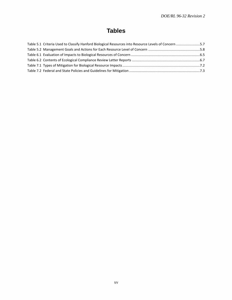
Tables
Table 5.1 Criteria Used to Classify Hanford Biological Resources into Resource Levels of Concern ......................... 5.7 Table 5.2 Management Goals and Actions for Each Resource Level of Concern ...................................................... 5.8 Table 6.1 Evaluation of Impacts to Biological Resources of Concern ........................................................................ 6.5 Table 6.2 Contents of Ecological Compliance Review Letter Reports ....................................................................... 6.7 Table 7.1 Types of Mitigation for Biological Resource Impacts ................................................................................. 7.2 Table 7.2 Federal and State Policies and Guidelines for Mitigation .......................................................................... 7.3
DOE/RL 96-32 Revision 2
xvi
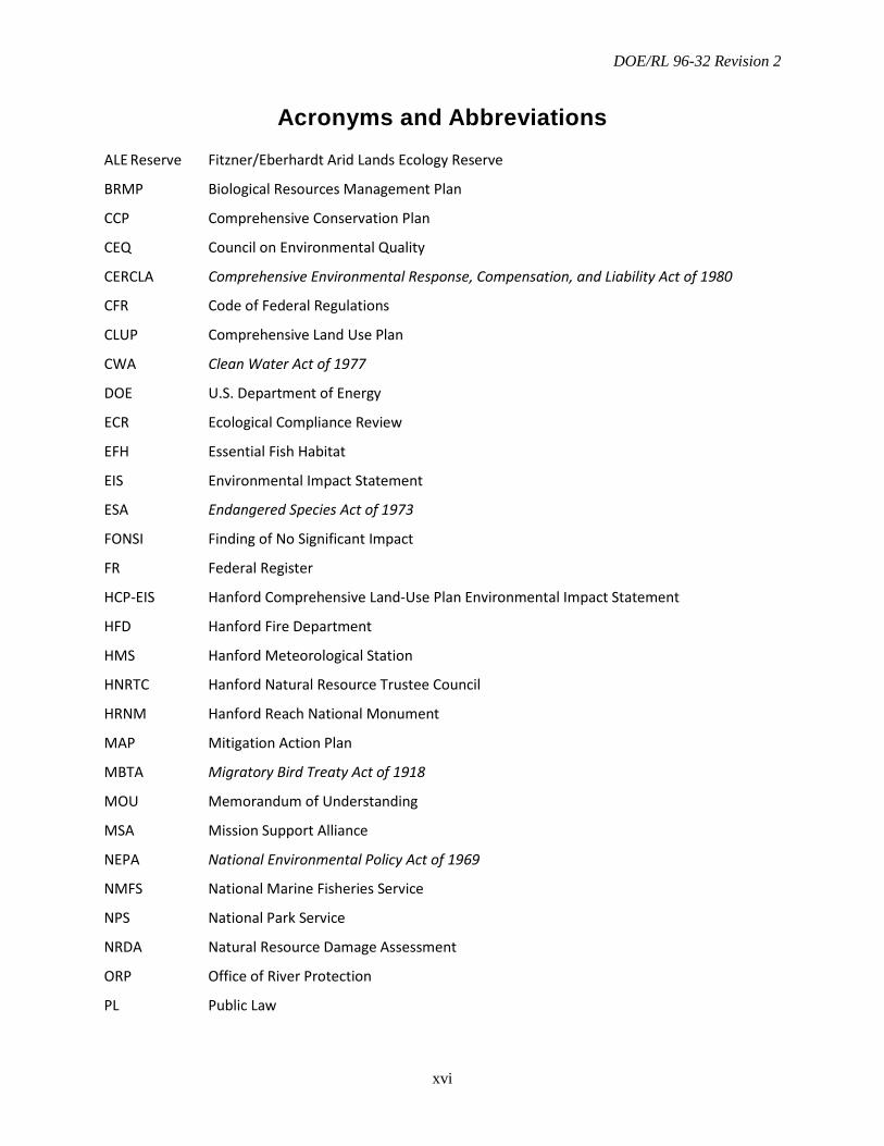
Acronyms and Abbreviations ALE Reserve Fitzner/Eberhardt Arid Lands Ecology Reserve
BRMP Biological Resources Management Plan
CCP Comprehensive Conservation Plan
CEQ Council on Environmental Quality
CERCLA Comprehensive Environmental Response, Compensation, and Liability Act of 1980
CFR Code of Federal Regulations
CLUP Comprehensive Land Use Plan
CWA Clean Water Act of 1977
DOE U.S. Department of Energy
ECR Ecological Compliance Review
EFH Essential Fish Habitat
EIS Environmental Impact Statement
ESA Endangered Species Act of 1973
FONSI Finding of No Significant Impact
FR Federal Register
HCP-EIS Hanford Comprehensive Land-Use Plan Environmental Impact Statement
HFD Hanford Fire Department
HMS Hanford Meteorological Station
HNRTC Hanford Natural Resource Trustee Council
HRNM Hanford Reach National Monument
MAP Mitigation Action Plan
MBTA Migratory Bird Treaty Act of 1918
MOU Memorandum of Understanding
MSA Mission Support Alliance
NEPA National Environmental Policy Act of 1969
NMFS National Marine Fisheries Service
NPS National Park Service
NRDA Natural Resource Damage Assessment
ORP Office of River Protection
PL Public Law
DOE/RL 96-32 Revision 2
xvii
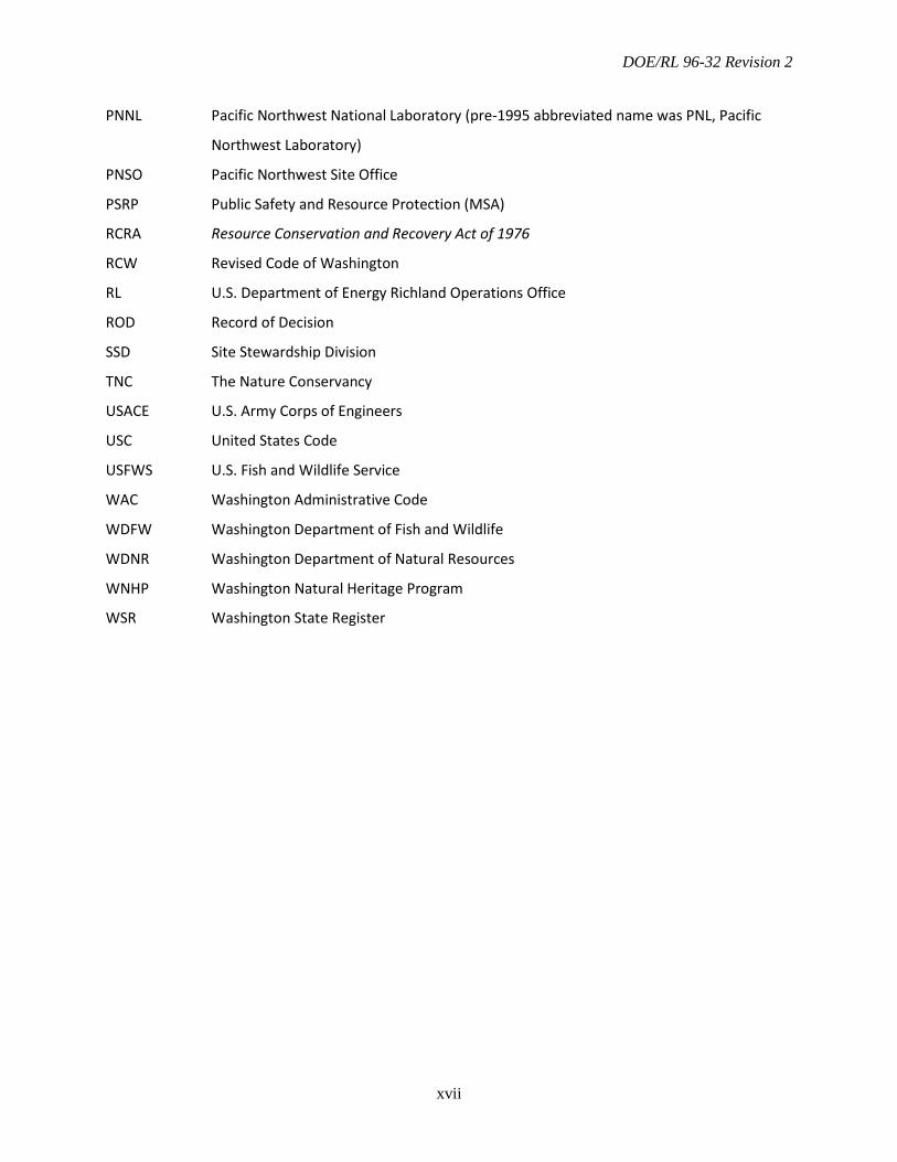
PNNL Pacific Northwest National Laboratory (pre-1995 abbreviated name was PNL, Pacific
Northwest Laboratory)
PNSO Pacific Northwest Site Office
PSRP Public Safety and Resource Protection (MSA)
RCRA Resource Conservation and Recovery Act of 1976
RCW Revised Code of Washington
RL U.S. Department of Energy Richland Operations Office
ROD Record of Decision
SSD Site Stewardship Division
TNC The Nature Conservancy
USACE U.S. Army Corps of Engineers
USC United States Code
USFWS U.S. Fish and Wildlife Service
WAC Washington Administrative Code
WDFW Washington Department of Fish and Wildlife
WDNR Washington Department of Natural Resources
WNHP Washington Natural Heritage Program
WSR Washington State Register

DOE/RL 96-32 Revision 2
xviii
This page intentionally left blank.
DOE/RL 96-32 Revision 2
1.1
1.0 Introduction
Biological resource stewardship is an integral part of U.S. Department of Energy (DOE) responsibilities at the Hanford Site. An appropriate management strategy, based on the best scientific information available, is an important component of responsible stewardship and land-use planning. As such, DOE developed this document as its primary implementation plan for managing biological resources under the Hanford Comprehensive Land-Use Plan (CLUP).
The CLUP, which is described in the Final Hanford Comprehensive Land-Use Plan Environmental Impact Statement (HCP-EIS; DOE 1999) and defined in the Record of Decision (ROD; 64 FR 61615), consists of a land-use map, land-use designations, land-use policies, and a set of procedures for plan implementation. The CLUP land-use policies that direct land-use actions and help ensure individual land-use actions collectively advance the CLUP’s goals and objectives over time. The Biological Resources Management Plan (BRMP) is one of several management plans described in the CLUP, each of which addresses unique resources and key activities that, together, provide a comprehensive approach for managing Hanford Site lands and facilities.
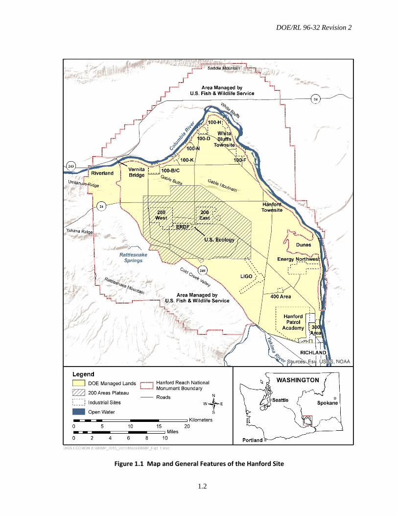
The policies and guidance provided in BRMP apply to all actions that occur on Hanford lands managed by DOE. This includes central Hanford and portions of the Hanford Reach National Monument (HRNM) managed by DOE (Figure 1.1). Policies described in the plan apply to all Richland Operations Office (RL) and Office of River Protection (ORP) contractors as well as permit and lease holders if included in the permit or lease documents. Existing contracts, permits, and leases may be modified, as
necessary, to meet the management objectives of this plan. The BRMP does not create any right, benefit, or trust responsibility, substantive or procedural, enforceable against the United States, its agencies, officers, or any person.
1.1 Purpose and Scope
The purpose of BRMP is to provide RL, ORP, Hanford contractors, and other organizations conducting work on the Hanford Site with a consistent approach to protect and manage biological resources on the site. This approach includes monitoring, assessing, and mitigating impacts to biological resources from Hanford operations, environmental cleanup, and restoration activities.
The BRMP’s overarching goals are to:
• Foster preservation of important biological resources
• Allow for site development with minimal adverse impacts to those resources
• Balance the site cleanup mission with resource stewardship obligations.
The BRMP formalizes a means to meet these goals and implement the primary Hanford Site missions of waste management, environmental restoration, and technology development. To achieve these goals, DOE has committed to the following actions:
• Inventory and monitor key ecological resources on the Hanford Site within the context of surrounding land-use and resource patterns.
DOE/RL 96-32 Revision 2
1.2
Figure 1.1 Map and General Features of the Hanford Site
DOE/RL 96-32 Revision 2
1.3
• Protect and conserve significant biological resources under DOE stewardship consistent with the HCP-EIS, and as required by applicable statutes, regulations, and orders.
• Control project costs and minimize mission delays by incorporating biological resource considerations during early stages of project planning and design to minimize environmental impacts and focus scarce resources on effective mitigation when projects affect key resources.
• Facilitate project planning by incorporating biological resource requirements into land-use planning.
• Facilitate project execution by streamlining the compliance process.
Although BRMP provides overall biological resource management policies, objectives, and goals, specific management activities for particular species and habitats of concern are included in the following documents:
• Integrated Biological Control Program (Mission Support Alliance [MSA] 2014)
• Threatened and Endangered Species Management Plan: Salmon, Steelhead, and Bull Trout, Revision 2 (DOE 2015a)
• Bald Eagle Management Plan for the Hanford Site, South-Central Washington, Rev. 2 (DOE 2013b).
Additionally, the Hanford Site Revegetation Manual (DOE 2013a) provides guidance for planning and performing revegetation and restoration actions on the Hanford Site. It supports overall BRMP goals, especially in the areas of mitigation and restoration. It also provides for consistency among revegetation
actions performed for various purposes, including Comprehensive Environmental Response, Compensation, and Liability Act of 1980 (CERCLA) restoration actions, Natural Resource Damage Assessment (NRDA) restoration credits, mitigation plantings, fire recovery, and other purposes.
1.2 Relationship to the Hanford Comprehensive Land-Use Plan
The Hanford Site has diverse missions associated with environmental restoration, waste management, and science and technology. The CLUP provides a comprehensive, long-term approach to planning and directing Hanford activities consistent with overall land-use objectives.
The BRMP is one implementation procedure and control of the CLUP, which is listed in Chapter 6 of the HCP-EIS (DOE 1999). The policies outlined in the HCP-EIS were originally developed to implement and address DOE’s Land- and Facility-Use Policy, which was subsequently cancelled and replaced by DOE Order 430.1C, Real Property Asset Management. These policies protect and sustain native species and their habitats on the site and maintain the capabilities to support site-specific missions and objectives.
The CLUP fulfills DOE’s responsibilities under the Atomic Energy Act of 1954 and Congress’s direction in the National Defense Authorization Act for Fiscal Year 1997. DOE issued the HCP-EIS in September 1999 and a Record of Decision (64 FR 61615) in November 1999, which established the CLUP.
DOE/RL 96-32 Revision 2
1.4
The following elements of the CLUP address land-use activities and protect and manage unique resources of the site:
• A land-use map depicts designated land uses for areas of the Hanford Site and supports full implementation of the DOE mission elements assigned to the site (HCP-EIS Section 3.2.5, Figure 3-3).
• Land-use designations define the purpose, intent, and principal uses of each geographic area shown by the final CLUP map.
• Land-use policies direct land-use actions and help ensure individual land-use actions collectively advance CLUP’s goals and objectives over time.
• Land-use plan implementation procedures and controls and administrative procedures are used to review and approve proposed land-use requests. In addition, these procedures are used to make recommendations on actions to be taken under the land-use plan to align and coordinate Hanford Site area and resource management plans such as the Hanford Cultural Resource Management Plan (DOE 2001a) and Hanford Long-Term Stewardship Program Plan (DOE 2012a). These types of plans are used by DOE as implementing procedures and controls to ensure consistency in land-use activities on the Hanford Site. They include consideration and management of the land; facilities; infrastructure; and unique biological and cultural resources on the Hanford Site.
The BRMP provides an integral part of implementing the CLUP to address management of biological resources during active and post-cleanup activities, mission
support operations, and other land- management activities on the Hanford Site. When evaluating land-use requests through the established CLUP implementing procedures and controls, the BRMP provides important information to ensure appropriate protectiveness of biological resources and habitats. Like BRMP, each management plan described in the CLUP addresses unique resources and key activities. Together, these plans provide DOE with a comprehensive approach for managing Hanford lands and facilities.
Land-Use Designations
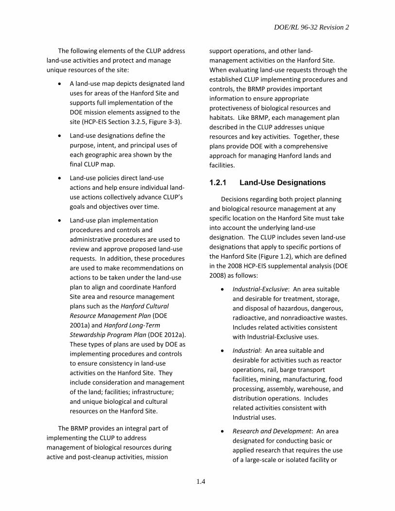
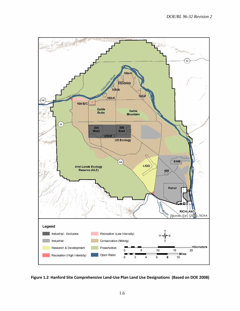
Decisions regarding both project planning and biological resource management at any specific location on the Hanford Site must take into account the underlying land-use designation. The CLUP includes seven land-use designations that apply to specific portions of the Hanford Site (Figure 1.2), which are defined in the 2008 HCP-EIS supplemental analysis (DOE 2008) as follows:
• Industrial-Exclusive: An area suitable and desirable for treatment, storage, and disposal of hazardous, dangerous, radioactive, and nonradioactive wastes. Includes related activities consistent with Industrial-Exclusive uses.
• Industrial: An area suitable and desirable for activities such as reactor operations, rail, barge transport facilities, mining, manufacturing, food processing, assembly, warehouse, and distribution operations. Includes related activities consistent with Industrial uses.
• Research and Development: An area designated for conducting basic or applied research that requires the use of a large-scale or isolated facility or

DOE/RL 96-32 Revision 2
1.5
smaller scale time-limited research conducted in the field or in facilities that consume limited resources. Includes scientific, engineering, technology development, technology transfer, and technology deployment activities to meet regional and national needs. Includes related activities consistent with Research and Development.
• High-Intensity Recreation: An area allocated for high-intensity visitor-serving activities and facilities (commercial and governmental), such as golf courses, recreational vehicle parks, boat launching facilities, Tribal fishing facilities, destination resorts, cultural centers, and museums. Includes related activities consistent with High-Intensity Recreation.
• Low-Intensity Recreation: An area allocated for low-intensity visitor-serving activities and facilities, such as improved recreational trails, primitive boat launching facilities, and permitted campgrounds. Includes related activities consistent with Low-Intensity Recreation.
• Conservation (Mining): An area reserved for the management and protection of archaeological, cultural, ecological, and natural resources. Limited and managed mining (e.g., quarrying for sand, gravel, basalt, and topsoil for governmental purposes only) could occur as a special use (i.e., a permit would be required) within appropriate areas. Limited public access would be consistent with resource conservation. Includes activities related to Conservation (Mining), consistent with the protection of archeological, cultural, ecological, and natural resources.
• Preservation: An area managed for the preservation of archeological, cultural, ecological, and natural resources. No new consumptive uses (i.e., mining or extraction of non-renewable resources) would be allowed within this area. Limited public access would be consistent with resource preservation. Includes activities related to Preservation uses.
DOE/RL 96-32 Revision 2
1.6
Figure 1.2 Hanford Site Comprehensive Land-Use Plan Land Use Designations (Based on DOE 2008)

DOE/RL 96-32 Revision 2
1.7
Hanford Comprehensive Land-Use Plan Policies
The CLUP sets forth the policies that direct land-use actions. The policies help ensure that individual land-use actions are consistent over time. These policies are set forth to
• Establish land-use mitigation procedures.
• Establish hierarchies, priorities, and standards relating to land use, resource use, and values.
• Integrate competing land and resource goals and objectives.
• Provide reference points for addressing unanticipated circumstances and amending the CLUP when necessary.
• Identify which resource and area management plans are part of the CLUP implementation.
The overall CLUP policy was developed to accomplish the following:
• Protect the Columbia River and associated natural and cultural resources and water quality.
• Wherever possible, locate new development, including cleanup and remediation-related projects, in previously disturbed areas.
• Protect and preserve the natural and cultural resources of the Site for the enjoyment, education, study, and use of future generations.
• Honor treaties with American Indian Tribes as they relate to land uses and resource uses.
• Reduce exclusive use areas to maximize the amount of land available for alternate uses while still protecting the public from inherently hazardous operations.
• Allow access for other uses (e.g., recreation) outside of active waste management areas, consistent with the land-use designation.
• Ensure that a public involvement process is used for amending the CLUP and land-use designation to respond to changing conditions.
• As feasible and practical, remove pre-existing, non-conforming uses.
• Facilitate cleanup and waste management.
For more information, see the HCP-EIS, ROD, supplemental analysis, and amended ROD on DOE’s EIS web site at http://www.hanford.gov/page.cfm/EnvironmentalImpactStatements.
1.3 Management Requirements and Policies
The BRMP specifies DOE policies, goals, and objectives relative to different biological resource management concerns and prescribes how such goals and objectives will be met. The BRMP applies to all RL and ORP programs at all locations within RL’s and ORP’s administrative control. DOE uses the HCP-EIS (DOE 1999; DOE 2008; DOE 2015b) ecosystem-based strategy to manage and control development of Hanford lands and facilities.

DOE/RL 96-32 Revision 2
1.8
DOE has established a broad biological resources protection policy (DOE 1997) that states:
It is the policy of the U.S. Department of Energy, Richland Operations Office to act as a responsible steward of the environment. This stewardship will be based on the principles of ecosystem management and sustainable development.
As part of this broader policy, DOE has developed specific stewardship policies, including the following:
• Act to preserve and enhance the biological resources under DOE stewardship as valuable national resources.
• Ensure that biological resource values are considered by all programs in all actions conducted on DOE’s behalf consistent with applicable treaties, laws, regulations, and obligations as a natural resource trustee.
• Endeavor to enhance an awareness of and appreciation for biological resource values and their preservation, restoration, and enhancement throughout the Hanford Site.
• Integrate biological resource management goals and administrative procedures into relevant program- and project-level activities to ensure that potential adverse impacts to biological resources are avoided or minimized.
• Integrate biological resource information into site land- and facility-use plans to ensure that broad-scale land-use planning and specific site-selection decisions consider biological resource values, apply ecosystem
management principles, and minimize cumulative impacts to biological resources.
• Incorporate ecosystem management principles and tools into the program (project) planning process to facilitate meeting biological resource management goals and objectives while minimizing impacts to program (project) budgets and schedules.
• Adopt the recommendations of the Council on Environmental Quality (CEQ) to incorporate biodiversity considerations into National Environmental Policy Act of 1969, as amended (NEPA) environmental impact analyses (CEQ 1993).
• Mitigate, as necessary, adverse impacts to biological resources that may result from present and future Hanford activities in a manner commensurate with the value of the resource and the severity of the impact. DOE will adhere to a hierarchy of mitigation actions in the following preferred order: avoid, minimize, rectify, and/or compensate.
• As the Lead Response Agency at Hanford under the National Contingency Plan (40 CFR 300), conduct response activities, such as removal or remedial actions, in a cost-effective manner that avoids or minimizes adverse impacts to biological resources.
• Cooperate with federal and state resource agencies to ensure a cost-effective information baseline on resource status is maintained for Hanford’s biological resources within a bioregional context.
• Coordinate with other governmental agencies and stakeholders, as

DOE/RL 96-32 Revision 2
1.9
applicable, on biological resource management issues in an open and cooperative manner.
• Manage the DOE-administered portions of the HRNM in a manner consistent with the rest of the monument.
1.4 Management Plan Organization
The BRMP is designed to assist Hanford Site program and project managers and resource professionals, local Tribes, resource agencies, and other stakeholders who have an interest or a role in the management of Hanford’s biological resources. Chapter 2.0 of this plan describes the roles and responsibilities of DOE and its contractors with respect to biological resource management. Chapter 3.0 provides a
brief description of the primary legal drivers for biological resource management and the relationship of BRMP to federal and state laws, Executive Orders, and DOE Orders.
An overview of the biological resources and past land-use history of the Hanford Site is presented in Chapter 4.0. Chapter 5.0 outlines DOE’s approach to biological resource management and describes implementing actions and policies. Chapter 6.0 defines the process for ecological compliance reviews for projects and work taking place on Hanford lands. Chapter 7.0 discusses mitigation and restoration strategies and policies. Chapter 8.0 provides references cited in the text, and Chapter 9.0 provides a glossary of terms.

DOE/RL 96-32 Revision 2
1.10
This page intentionally left blank.
DOE/RL 96-32 Revision 2
2.1
2.0 Roles and Responsibilities
It is DOE policy to steward Hanford Site natural resources through responsible ecosystem management. This chapter outlines DOE management responsibilities and identifies the federal agencies and other entities responsible for managing biological resources on specific portions of the site.
The RL and ORP managers are ultimately responsible for the site’s natural resources. The RL Assistant Manager for Mission Support is charged with development and oversight of land and resource management policies. The BRMP is an important part of implementing such policies. It is designed to provide a consistent approach in managing the site’s natural resources within the context of its primary missions of environmental remediation and waste management.
2.1 Department of Energy
To ensure BRMP is applied consistently throughout the portions of the Hanford Site managed by DOE, each program manager and assistant manager within RL and ORP is responsible for adhering to the resource management guidance and policies described in this document. The RL’s Site Stewardship Division (SSD) is responsible for defining Hanford’s approach to biological resource management and will assist other RL and ORP programs, contractors, and other organizations conducting work on the Hanford Site with interpreting this document. The SSD oversees monitoring and impact assessment support and tracks performance of mitigation actions.
Close coordination between SSD and program and project managers within RL, ORP, and DOE’s Pacific Northwest Site Office (PNSO)
(when PNSO-sponsored work occurs on the Hanford Site) is required in early phases of Hanford Site project development. This is an important part of identifying areas where resource protection is a prime consideration, alternatives should be considered, or mitigation may be necessary. PNSO-sponsored work that occurs on the Hanford Site is subject to BRMP, and PNSO activities that occur on land managed by PNSO is subject to the management plan developed for the PNSO site (DOE 2015c).
The SSD also has responsibility to act as DOE’s primary point of contact for forming ecosystem management partnerships with outside organizations. The division coordinates with the U.S. Fish and Wildlife Service (USFWS) to confirm USFWS’s management of DOE-owned property within the HRNM is consistent with DOE’s biological resource management policies.
2.2 Contractors and Other Entities Performing Work on the Hanford Site
All contractors and subcontractors, or any other entity performing work on Hanford lands managed by RL or ORP, will conduct work in accordance with the policies and guidance provided in this management plan, as established by the CLUP implementing procedures.
Implementation of much of this management plan is assigned to the Public Safety and Resource Protection (PSRP) Program, currently managed by Mission Support Alliance (MSA). MSA’s implementation responsibilities include, among other actions, ecological monitoring, compliance reviews, reporting,

DOE/RL 96-32 Revision 2
2.2
implementing some protective measures or administrative controls, and determining mitigation requirements.
Each contractor is responsible for incorporating biological resource protection measures into project planning. Each contractor also is responsible for requesting an ecological compliance review (ECR) for its activities and implementing mitigation actions, if needed, for any project for which it is responsible.
2.3 U.S. Fish and Wildlife Service
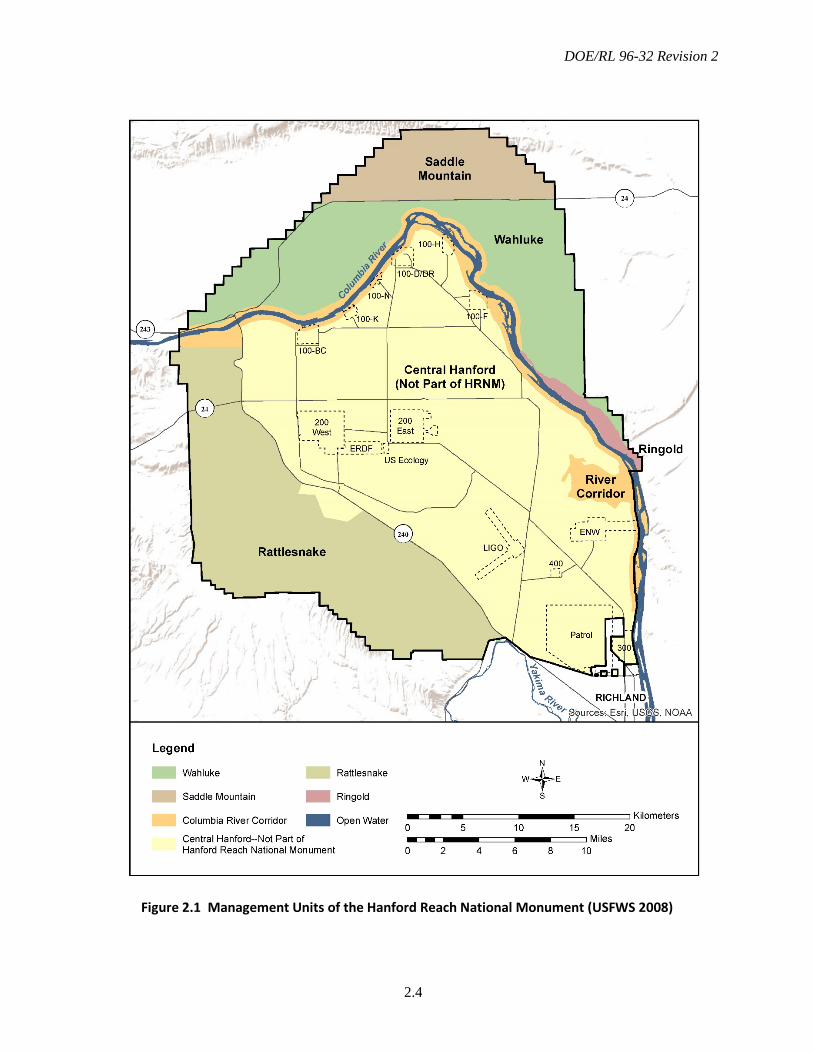
Portions of the Hanford Site were designated as the HRNM in 2000 by Presidential Proclamation7319 (65 FR 37253-37257, “Establishment of the Hanford Reach National Monument”) under provisions of the Antiquities Act of 1906 as amended (16 USC 431-433). These areas were selected for their ecological, cultural, and geological values. The USFWS manages several portions of the 789 km2
(195,000-ac) monument, including the north bank of the Columbia River Corridor, Saddle Mountain Unit, Rattlesnake Unit (which includes the Fitzner/Eberhardt Arid Lands Ecology (ALE) Reserve, a federal research natural area), Wahluke Unit (west and east), and Ringold Unit (Figure 2.1). The USFWS manages these areas and various islands in the Hanford Reach as part of the Mid-Columbia River National Wildlife Refuge Complex.
Under existing permits from DOE, the USFWS is responsible for protecting and managing HRNM resources and access to HRNM lands under its control. This is accomplished through Presidential Proclamation 7319 and the Hanford Reach National Monument Comprehensive Conservation Plan and Environmental Impact Statement (HRNM-CCP;
USFWS 2008). Because DOE is currently the underlying landholder, it retains approval authority over certain management aspects on the HRNM that could affect DOE operations such as safety or security buffers, access to and operation of research sites, or seismic, meteorological, or environmental monitoring sites.
Collaboration between the DOE and the Department of the Interior, including USFWS, related to the long-term protection of important and ecologically sensitive lands on the Hanford Site is defined in an interagency Memorandum of Understanding (DOE and USFWS 2014). The scope of this MOU includes those areas of the Hanford Site outside the current boundaries of the HRNM.
2.4 National Park Service
In December 2014, President Obama signed the National Defense Authorization Act of 2015 (PL 113-291), which included provisions authorizing the Manhattan Project National Historic Park to be located at three sites: Oak Ridge, Tennessee; Hanford, Washington; and Los Alamos, New Mexico. Facilities and areas on the Hanford Site included in the park include the B Reactor National Historic Landmark, Hanford High School in the town of Hanford and the Hanford Camp Historic District; the White Bluffs bank building in the White Bluffs Historic District; the warehouse at Bruggeman’s Agricultural Complex; the Hanford Irrigation District Pump House; and the T Plant (221-T) Process Building).
A Memorandum of Agreement between DOE and the NPS that defines their respective roles and responsibilities in creating and managing the park was signed in 2015. The agreement included provisions for enhanced
DOE/RL 96-32 Revision 2
2.3
public access, management, interpretation, and historic preservation (DOE and NPS 2015).
2.5 Other Lease, Permit, or Easement Holders
Several entities use land on Hanford under permits, leases, or easements. These are managed by SSD, which oversees the protection of Hanford Site resources through the appropriate implementation plans contained in the CLUP. Unless otherwise controlled by legal or contractual requirements, the BRMP applies to lands under lease, permit, or easement.
2.6 Hanford Tribal Involvement
As a result of the Nuclear Waste Policy Act of 1982 and the DOE American Indian Tribal Government Interactions Policy (DOE Order 141.1), the Nez Perce Tribe, Confederated Tribes of the Umatilla Indian Reservation, and Yakama Nation all actively participate in cleanup issues at Hanford. All three Tribes are members of the Hanford Natural Resource Trustee Council (HNRTC) and have cooperative agreements with DOE to provide advice and
guidance on CERCLA response and NRDA issues. These Tribes work on issues related to mitigation and restoration of natural resources at Hanford. The Wanapum people, a non-federally recognized Tribe, also participate in cleanup issues at Hanford
2.7 Ecological Resources Working Group
An Ecological Resources Working Group is established to assist and advise SSD on Hanford Site biological resource-related issues as needed. The working group generally comprises representatives from the local Tribes, HNRTC, resource management agencies, resource professionals from site contractors, and SSD staff. The working group meets as needed to address any significant problems with BRMP implementation and new resource management issues. Staff from other DOE programs or their contractor representatives may be invited to the meetings to discuss specific resource issues, policies, or concerns.
DOE/RL 96-32 Revision 2
2.4
Figure 2.1 Management Units of the Hanford Reach National Monument (USFWS 2008)

DOE/RL 96-32 Revision 2
3.1
3.0 Applicable Guidance and Requirements
This chapter outlines the primary federal laws, Executive Orders, DOE Orders, and state laws considered in developing BRMP as an implementing document of the CLUP. It also discusses key factors of these laws as they apply to biological resource management and how BRMP assists DOE in implementing the requirements.
BRMP was developed to support DOE compliance with the following federal acts:
• Endangered Species Act of 1973 (ESA)
• National Environmental Policy Act of 1969 (NEPA)
• Migratory Bird Treaty Act of 1918 (MBTA)
• Bald and Golden Eagle Protection Act of 1972
• Comprehensive Environmental Response, Compensation, and Liability Act of 1980 (CERCLA)
• Resource Conservation and Recovery Act of 1976 (RCRA)
• Clean Water Act of 1977 (CWA)
• Sikes Act
• Magnuson-Stevens Fishery Conservation and Management Act of 1976.
Regulatory agencies responsible for enforcing these acts also promulgate pertinent regulations to implement the laws. Agencies also can develop additional guidelines specific to their organizations. For example, in addition to requirements provided in NEPA (42 USC 4321, et seq.), DOE developed guidelines defining its own responsibilities under the act (10 CFR 1021).
In addition to federal laws, BRMP also helps DOE implement various Executive Orders, Proclamations, and Memoranda as well as DOE Orders, including the following:
• Executive Order 13112, “Invasive Species”
• Executive Order 11990, “Protection of Wetlands”
• Executive Order 11988, “Floodplain Management”
• Presidential Memorandum of June 20, 2014, “Creating a Federal Strategy to Promote the Health of Honey Bees and Other Pollinators”
• Presidential Proclamation 7319, “Establishment of the Hanford Reach National Monument”
• DOE Order 430.1C “Real Property Asset Management” (August 19, 2016).
BRMP was developed with consideration of Washington State laws and regulations that may apply to Hanford Site activities and biological resource management practices. Particularly applicable are rules regulating fish and wildlife described in Chapter 77 of the Revised Code of Washington (RCW), Title 232 of the Washington Administrative Code (WAC), and rules regarding noxious weed control described in RCW Chapter 17 and WAC Chapter 16-750.
DOE/RL 96-32 Revision 2
3.2
3.1 Endangered Species Act
The ESA provides for the designation and protection of wildlife, fish, and plant species that are endangered or threatened with extinction because of natural or human-made factors, and the conservation of the ecosystems upon which they depend. The ESA makes it illegal to kill, harm, harass, or otherwise take a listed species or adversely modify designated critical habitat.
Under Section 7 of the ESA, federal agencies are required to evaluate actions they perform, fund, or permit to determine whether any species listed as endangered or threatened at 50 CFR 17.11 and 50 CFR 17.12 may be affected by the proposed action. Authorizations called “Incidental Take Permits” are required under Section 10 of the ESA for non-federal activities that may result in a “take” of threatened or endangered species. The USFWS and National Marine Fisheries Service (NMFS) share responsibility for implementing the ESA. Consultation with one or both of the agencies is required if a proposed action may affect listed species or designated critical habitat.
BRMP implements the ESA by providing a process to 1) identify whether ESA-protected species or critical habitats may be affected by DOE activities, and 2) confirm DOE compliance with ESA requirements. In addition to the ESA, management of threatened and endangered salmonids on the Hanford Site is addressed in the Threatened and Endangered Species Management Plan, Salmon, Steelhead and Bull Trout (DOE 2015a). This management plan was developed to assist in the consultation process with the NMFS (salmon and steelhead) and USFWS (bull trout) required by Section 7 of the ESA.
3.2 National Environmental Policy Act
As stated in the NEPA implementing regulations, “The NEPA process is intended to help public officials make decisions that are based on an understanding of environmental consequences, and take actions that protect, restore, and enhance the environment” (40 CFR 1500.1c).
Executive Order 11514, “Protection and Enhancement of Environmental Quality,” and Executive Order 11991, “Relating to Protection and Enhancement of Environmental Quality,” further define the role of federal agencies in implementing NEPA. Executive Order 11514 states that federal agencies shall “monitor, evaluate, and control on a continuing basis their agencies’ activities so as to protect and enhance the quality of the environment. Such activities shall include those directed to controlling pollution and enhancing the environment and those designed to accomplish other program objectives which may affect the quality of the environment.” Executive Order 11991 requires federal agencies to “comply with the (NEPA) regulations issued by the Council (on Environmental Quality) except where such compliance would be inconsistent with statutory requirements.”
Proper application of the NEPA process requires a thorough understanding of the biological resources present, potential impacts of a proposed action on those resources, and the ultimate consequences of those actions. BRMP directly supports the NEPA decision-making process by providing the basic biological information and assessment methodology needed to determine whether adverse impacts to biological resources may occur on the Hanford Site. It also provides the resource context and management guidelines needed to
DOE/RL 96-32 Revision 2
3.3
determine the magnitude of potential impacts to biological resources and appropriate mitigation actions as needed. The BRMP and the Hanford Site NEPA Characterization (Duncan et al. 2007) provide ecological information and guidance for the preparation of NEPA documents.
3.3 Migratory Bird Treaty Act
The MBTA makes it illegal for anyone without a waiver to take, capture, or kill any migratory bird or to take any part, nest, or egg of any such bird, included in the terms of the conventions or treaties between the United States, and Great Britain (for Canada), Mexico, Japan, and Russia (covered species are listed at 50 CFR 17.13). In addition, Executive Order 13186, “Responsibility of Federal Agencies to Protect Migratory Birds,” further clarifies federal agency responsibilities under the MBTA and other regulations. It requires, among other things, that agencies “identify where unintentional take reasonably attributable to agency actions is having, or is likely to have, a measurable negative effect on migratory bird populations, focusing first on species of concern, priority habitats, and key risk factors.”
In 2006, DOE signed an MOU with the USFWS regarding implementation of Executive Order 13186 (DOE and USFWS 2006). In 2013, when the order was modified and the MOU was re-signed (DOE and USFWS 2013), DOE committed to, among other items and within statutory and budgetary limits, the following actions:
• Implement management practices that avoid or minimize adverse effects on migratory bird populations and their nesting, foraging, migration, staging, or wintering habitats.
• When designing new projects, ensure that they avoid important migratory bird habitats and otherwise avoid or minimize direct and indirect effects of new projects on migratory birds and their habitats, and when practicable and appropriate, restore and enhance bird habitat.
• Institute management practices for controlling non-native plants and animals to protect migratory birds and their habitats.
• Construct or utilize engineered constraint systems to prevent migratory birds from nesting or roosting in areas of recognized hazard.
• Promote monitoring, research, and information exchange related to migratory bird conservation and program actions that may affect migratory birds, including collaborating on studies on migratory bird species that may be affected by agency actions, infrastructure, or facilities; and to identify habitat conditions essential to sustain migratory bird populations.
• Develop partnerships with other agencies and non-federal entities to further bird conservation, as practicable.
• Identify training opportunities for DOE and contractor employees in methods and techniques to inventory and monitor migratory birds, assess population status of migratory birds, assess bird use within project areas, evaluate effects of projects on migratory birds, and develop management practices that avoid or minimize adverse effects and promote
DOE/RL 96-32 Revision 2
3.4
beneficial approaches to migratory bird conservation.
• Engage the USFWS for coordination regarding proposed actions that may have direct and indirect adverse effects on migratory birds or their habitats.
• Engage the USFWS on development and implementation of strategies to improve the conservation of migratory birds and their habitats in the conduct of environmental cleanup activities at DOE sites.
• Engage the USFWS on development and implementation of strategies to improve or enhance the conservation of migratory birds and their habitats at the Hanford Site.
• Support efforts to promote the ecological, economic, and recreational values of migratory birds by supporting outreach and educational activities and materials, as appropriate.
In addition to the actions above, DOE maintains a federal fish and wildlife permit for migratory birds. This special purpose permit authorizes limited takes of migratory birds on the Hanford Site and adjacent lands with land owner approval for the purposes of ecological monitoring and protecting human health and safety. The migratory bird permit is administered through the SSD and its named sub-permittees.
BRMP and the actions described in this section assist DOE to determine whether protected migratory birds on the site may be affected by proposed actions. The plan also assists in determining if intentional or unintentional take is likely and the potential effects of such take. In addition, BRMP provides the overall context to identify
opportunities to enhance migratory bird habitat and populations.
3.4 Bald and Golden Eagle Protection Act
The Bald and Golden Eagle Protection Act of 1972 makes it illegal to take (pursue, wound, kill, molest, or disturb), as applicable, any bald or golden eagle, or any part, nest, or egg of these eagles. The National Bald Eagle Management Guidelines issued by the USFWS define “disturb” as any activity that may cause injury or decrease productivity (USFWS 2007a). The BRMP and the Hanford Site Bald Eagle Site Management Plan (DOE 2013b) provide DOE and its contractors with guidance to ensure compliance with the Bald and Golden Eagle Protection Act.
3.5 Comprehensive Environmental Response, Compensation, and Liability Act
The primary purpose of CERCLA is to provide for timely compensation, cleanup, and emergency response for hazardous substances released into the environment, as well as the cleanup of inactive hazardous waste disposal sites. The CERCLA planning process requires evaluation of natural resources, including biological resources, on the Hanford Site in an area potentially affected by the release. DOE, through its contractors, has primary responsibility for these evaluations when planning and performing CERCLA cleanup actions.
BRMP is the means by which DOE defines which resources that may be affected by a cleanup action are important, and provides the framework for determining impacts and appropriate mitigation measures. The CERCLA
DOE/RL 96-32 Revision 2
3.5
planning and evaluation process can be used in place of a NEPA evaluation; in those cases, BRMP supports the CERCLA process in the same way it would support a NEPA review.
Section 107(f) of CERCLA identifies and defines natural resource trustees, who are authorized to act in the public interest with regard to natural resources. For the Hanford Site, seven trust entities organized under an MOU to form the Hanford Natural Resource Trustee Council (HNRTC 1996). The trustees are DOE, U.S. Department of the Interior (represented by the USFWS), states of Washington and Oregon, Yakama Nation, Confederated Tribes of the Umatilla Indian Reservation, and Nez Perce Tribe. These natural resource trustees are authorized to evaluate the impacts to resources resulting from the release of hazardous substances to the environment through a process called a Natural Resource Damage Assessment, and to use the results of that assessment to direct restoration activities aimed at replacing the resources and services lost due to a hazardous substance release.
Although the trustees may make their own determinations about what resources could be damaged and how or where they should be restored, the determinations should be consistent with overall site-wide resource management goals, including BRMP and CLUP. This ensures that NRDA restoration and DOE non-CERCLA actions are synergistic and mutually beneficial. With this in mind, DOE may plan and perform “early restoration” or “enhanced mitigation” that could potentially be used as credit to offset some or all impacts resulting from contaminant release. Such actions should consider the procedures and guidance provided in Chapter 7.0 of this document and in the Hanford Site Revegetation Manual (DOE 2013a).
3.6 Resource Conservation and Recovery Act
The primary purpose of RCRA is to ensure the safe and environmentally acceptable management of solid wastes. RCRA outlines the framework of national programs to achieve environmentally sound management of both hazardous and non-hazardous wastes. Waste site operation activities and RCRA compliance activities may have significant adverse impacts to biota. RCRA activities must comply with other federal statutes that do not deal directly with control and abatement of solid waste or hazardous waste disposal—for example, NEPA and ESA. BRMP provides data in direct support of RCRA permits and helps ensure RCRA activities are not adversely affecting biota, and activities are in compliance with other applicable laws.
3.7 Clean Water Act
Section 404 of the Clean Water Act (CWA) authorizes the U.S. Army Corps of Engineers (USACE) to issue permits for the discharge into or dredging of wetlands (33 CFR 320 et seq.). The U.S. Environmental Protection Agency guidelines (40 CFR 230) require that potential impacts to physical, chemical, and biological characteristics of the aquatic systems be considered in the permit process. BRMP provides the baseline data and resource management structure for DOE to determine whether any wetlands may be affected by a proposed action.
3.8 Sikes Act
The Sikes Act (16 USC 670) originally provided for cooperation by the U.S. Department of the Interior and the U.S. Department of Defense with state agencies in “planning, development, maintenance and
DOE/RL 96-32 Revision 2
3.6
coordination of wildlife, fish and game conservation and rehabilitation” on military reservations throughout the United States. A 1974 amendment to the Act (PL 93-452) authorized conservation and rehabilitation programs on lands managed by DOE and several other federal departments and agencies. These programs are carried out in cooperation with the states by the Secretary of the Interior. BRMP provides the basis for coordination and interaction with stakeholders and resource professionals from state and tribal agencies.
3.9 Magnuson-Stevens Fishery Conservation and Management Act
Federal agencies are obligated, under Section 305(b)(2) of the Magnuson-Stevens Fishery Conservation and Management Act, and its implementing regulations (50 CFR 600, Subpart K), to consult with the NMFS about actions that are authorized, funded, or undertaken by those agencies that may adversely affect Essential Fish Habitat (EFH), which is defined by the Act as “those waters and substrate necessary to fish for spawning, breeding, feeding, or growth to maturity.” The purpose of the procedure is to promote protection of EFH via the review of federal and state actions that may adversely affect these habitats. Activities in or near the Columbia River may affect defined EFH for salmonids. Management of EFH in the Columbia River is coordinated through BRMP and the Threatened and Endangered Species Management Plan: Salmon, Steelhead, and Bull Trout (DOE 2015a).
3.10 Executive Order 13112
Executive Order 13112, “Invasive Species,” requires all executive agencies to identify actions that may affect the status of invasive species; prevent the introduction of such
species; detect, monitor, and control populations of invasive species; restore native species and habitats that have been invaded; and conduct research on the prevention and control of invasive species. In addition, executive agencies are prohibited from authorizing or funding activities that are likely to cause or promote the introduction or spread of invasive species, unless the benefit of such an action clearly outweighs the potential harm from the invasive species.
BRMP provides the overall guidance and philosophy for invasive species management on the Hanford Site. BRMP also provides direction for prioritization of species and coordination of invasive species control activities with other site resource management priorities. However, detailed implementation may be deferred to an integrated pest management plan (MSA 2014).
3.11 Executive Orders 11988 and 11990
Executive Order 11990, “Protection of Wetlands,” and Executive Order 11988, “Floodplain Management,” require federal agencies to minimize the loss or degradation of wetlands on federal lands and account for floodplain management when developing water- and land-use plans, respectively. DOE implements the requirements of these two Executive Orders via 10 CFR 1022, “Compliance with Floodplain and Wetlands Environmental Review Requirements.” It is DOE policy to 1) restore and preserve natural and beneficial values served by floodplains; 2) minimize the destruction, loss, or degradation of wetlands; and 3) preserve and enhance the natural and beneficial value of wetlands. As with the wetland provisions of the Clean Water Act, the identification, management, protection, and when necessary, mitigation of wetlands and
DOE/RL 96-32 Revision 2
3.7
floodplains on the Hanford Site are coordinated through BRMP.
3.12 Presidential Memorandum of June 20, 2014
The Presidential Memorandum of June 20, 2014 (79 FR 35903-35907), addressed “Creating a Federal Strategy to Promote the Health of Honey Bees and Other Pollinators.” This memorandum called for establishment of a multi-agency Pollinator Health Task Force, which included DOE as a member. This task force was charged with developing a national pollinator health strategy and implementing plans for Increasing and improving pollinator habitat.
One of the primary goals addressed in the resulting Pollinator Research Action Plan (Pollinator Health Task Force 2015) is to “Restore or enhance 7 million acres of land for pollinators over the next 5 years through federal actions and public/private partnerships.” Appendix E to this action plan is the DOE-specific Pollinator Protection Plan, which focuses on DOE adoption of best management practices to enlarge the land area and protect pollinator health. The BRMP describes best management practices used at the Hanford Site, and include the removal of invasive species, maintenance of riparian areas, and restoration, rehabilitation, and/or revegetation of native plant communities.
3.13 Presidential Proclamation 7319
Presidential Proclamation 7319 (65 FR 37253-37257) under the Antiquities Act of 1906 established the HRNM within portions of the Hanford Site. The USFWS manages portions of the HRNM under agreements with DOE, and DOE manages other portions of the HRNM.
The USFWS prepared a CCP (USFWS 2008), and currently is developing implementing procedures that will guide its management activities to meet the policies and objectives developed in the CCP. The BRMP provides the comparable guidance for DOE’s management of biological resources, and it functions as the primary interface for biological resource management between the USFWS and DOE.
In addition to Proclamation 7319, President Clinton, in an accompanying Memorandum of Understanding (White House 2000), provided the following direction to the Secretary of Energy:
The area being designated as the Hanford Reach National Monument forms an arc surrounding much of what is known as the central Hanford area. While a portion of the central area is needed for Department of Energy missions, much of the area contains the same shrub-steppe habitat and other objects of scientific and historic interest that I am today permanently protecting in the monument. Therefore, I am directing you to manage the central area to protect these important values where practical. I further direct you to consult with the Secretary of the Interior on how best to permanently protect these objects, including the possibility of adding lands to the monument as they are remediated.
The biological aspects of this directive are implemented through BRMP as part of the CLUP.
DOE/RL 96-32 Revision 2
3.8
3.14 DOE Order 430.1C – Real Property Asset Management
The objective of DOE Order 430.1C is to “establish a data-driven, risk-informed, performance-based approach to the life cycle management of real property assets that aligns the real property portfolio with DOE mission needs; acquire, manage, positively account for, and dispose of real property assets in a safe, secure, cost-effective, and sustainable manner; and ensure the property portfolio is appropriately sized, aligned, and in the proper condition to support efficient mission execution.”
This order establishes land-use planning requirements for DOE sites, and states that “real property planning must ensure applicable requirements related and not limited to climate change resilience and adaptation, and sustainability; environment, health, safety, and security; earthquake risks; cultural and natural resource preservation; and historic preservation are addressed.” BRMP directly supports implementation of this order by identifying important resources on the Hanford Site and providing guidance for the management of those resources consistent with the HCP-EIS.
3.15 Noxious Weed Control
The need for control of undesirable species such as noxious weeds is established by several federal and state regulations, orders, and agreements, as described in the following subsections.
Federal Regulations
The Federal Noxious Weed Act of 1974, as amended by Section 15 - Management of Undesirable Plants on Federal Lands, 1990,
authorizes the Secretary of Agriculture "to cooperate with other federal and state agencies, and others in carrying out operations or measures to eradicate, suppress, control, prevent, or retard the spread of any noxious weed. Each federal agency must 1) designate an office or person adequately trained to develop and coordinate an undesirable plants management program for control of undesirable plants on federal lands under the agency's jurisdiction, 2) establish and adequately fund an undesirable plants management program through the agency's budgetary process, 3) complete and implement cooperative agreements with State agencies regarding the management of undesirable plant species on federal lands, and 4) establish integrated management systems to control or contain undesirable plant species targeted under cooperative agreements."
A Memorandum of Understanding for the Establishment of a Federal Interagency Committee for the Management of Noxious and Exotic Weeds, 1994, identified a government interagency united effort to control exotic and noxious weeds on government properties. The federal agencies include the U.S. Departments of the Interior, Agriculture, Defense, Transportation, and Energy.
Washington State Regulations
The Revised Code of Washington Chapter 17.10 -Noxious Weed - Control Boards provides the regulatory authority for control of noxious weeds in Washington. It also establishes county and regional noxious weed control boards and the structure for establishing county noxious weed lists. WAC 16-750, Washington State Noxious Weed List and Schedule of Monetary Penalties, provides the list of species categorized in Washington as

DOE/RL 96-32 Revision 2
3.9
noxious weeds and defines monetary penalties for failure to control their spread.
DOE established an agreement with neighboring counties’ noxious weed control boards via the Memorandum of Understanding between the Washington State Department of Agriculture, Adams County Noxious Weed Control Board, Benton County Noxious Weed
Control Board, Franklin County Noxious Weed Control Board, Grant County Noxious Weed Control Board, and US. Department of Energy Richland Field Office for Management of Noxious Weeds and Undesirable Plants, 1997, for ongoing control of noxious weeds on the Hanford Site.

DOE/RL 96-32 Revision 2
3.10
This page intentionally left blank.

DOE/RL 96-32 Revision 2
4.1
4.0 Overview of Hanford Biological Resources
This chapter describes the current extent and distribution of biological resources found on the Hanford Site. It also provides a brief description of the climate, soils, and topography and characterizes how these physical features influence the vegetation and wildlife of the Hanford Site. A brief history of past land use and a fire history are also included to provide context for understanding how historic land use and wildfire have influenced the habitats and wildlife that occupy the site. Additional detailed information characterizing the geology, climate, and surface waters of the Hanford Site can be found in the Hanford Site NEPA Characterization (Duncan et al. 2007).
The Hanford Site is located within the Columbia Basin Ecoregion, an area that historically included over 6 million ha (14.8 million ac) of steppe and shrub-steppe vegetation across most of central and
southeastern Washington State (Franklin and Dyrness 1973) as well as portions of north-central Oregon. The current Hanford Site occupies about 1516 km2 (586 mi2) at the approximate center of the ecoregion (Figure 4.1). The Hanford Site represents one of the largest tracts of native shrub-steppe habitat remaining in Washington State.
A wide variety of habitat types and associated plant communities can be found on the Hanford Site, ranging from habitats on talus slopes, unstabilized sand dunes, and high-elevation basalt outcrops to vast expanses of sagebrush/bunchgrass communities. In addition to shrub-steppe habitats, Hanford also includes valuable swale, riparian, wetland, and aquatic resources. A free-flowing stretch of the Columbia River, the Hanford Reach, bisects the Hanford Site, and a couple of perennial streams flow within the site boundaries.
Figure 4.1 The Hanford Site within the Columbia Plateau Ecoregion
DOE/RL 96-32 Revision 2
4.2
The Hanford Site’s biological resources have been recognized for their state, regional, and national significance. In addition to the Presidential Proclamation designating portions of the Hanford Site as the HRNM (65 FR 37253), DOE designated the entire site designated a National Environmental Research Park in 1994. This designation reflected Hanford’s importance in providing a protected area for research demonstrations and education in ecology. Also, the ALE Reserve is designated a federal Research Natural Area (Franklin et al. 1972). This federal designation is based on the site’s ability to provide opportunities for researchers, students, and educators to study and observe a relatively large and undisturbed ecosystem in which natural processes are retained (PNL 1993). The research natural area designation also furthers the purposes of Washington’s Natural Heritage Plan (WDNR 2011) by providing protection for rare plant communities.
4.1 Environmental Setting
The climate at Hanford is semi-arid with hot, dry summers and cold, wet winters. Based on data collected from 1945 through 2015 (http://www.hanford.gov/hms), the average monthly temperatures at the Hanford Meteorological Station (HMS) ranged from a low of -0.4°C (31.3°F) in January to a high of 24.9°C (76.9°F) in July. Average annual precipitation at the HMS during this period was 17 cm (6.8 in.). Most precipitation is received between October and April, and precipitation increases with elevation (Thorp and Hinds 1977). The highest elevation on the Hanford Site is 1150 m (3500 ft) at the crest of Rattlesnake Mountain. Protected areas along the ridgeline may receive 28 to 30 cm (11 to 12 in.) of precipitation annually—severe winds and freezing weather make it difficult to
measure precipitation on the crest accurately. The upper slopes of this northeast-facing anticlinal ridge fall steeply to about 490 m (1600 ft) elevation, where slopes become more moderate, but continue to descend to approximately 152 m (500 ft) in the Cold Creek Valley and eastward to the Columbia River where annual average precipitation is approximately 12 cm (6 to 7 in.) (Hoitink et al. 2005).
The 200-Area plateau rises a few hundred feet above the rest of the central portion of the Hanford Site, with Gable Butte and Gable Mountain rising fairly steeply to 236 m (773 ft) and 331 m (1085 ft), respectively (Figure 1.1). Soils range from silt loams and stony silt loams on the slopes of Rattlesnake Mountain, Gable Mountain, Gable Butte, and Umtanum Ridge, to sandy loams, loamy sands, and dune sands on the Columbia River Plain Plain (Rickard et al. 1988; Hajek 1966). See Figure 4.2. There are also areas of talus and basalt scree on all major ridges. Variation in soils, elevation, and precipitation from the river to the top of Rattlesnake Mountain allow a variety of shrub-steppe plant species and habitats to exist across the site.
Although the Hanford Site’s biological resources are characteristic of the Columbia Plateau Ecoregion, the site is unique in that it is located within the driest and hottest portion of the ecoregion (Franklin and Dyrness 1973). These climatic conditions result in somewhat unusual species assemblages relative to the rest of the ecoregion. These same conditions also may result in Hanford shrub-steppe communities being less resilient to disturbance, making restoration and rehabilitation after large-scale disturbance more difficult than other areas that are cooler and receive more precipitation.
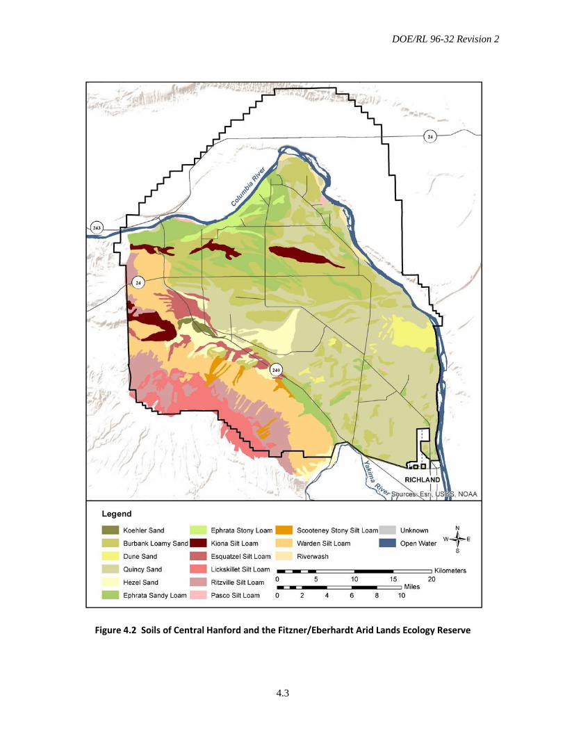
DOE/RL 96-32 Revision 2
4.3
Figure 4.2 Soils of Central Hanford and the Fitzner/Eberhardt Arid Lands Ecology Reserve
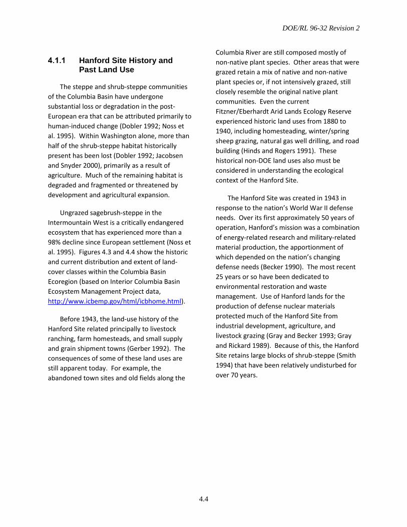
DOE/RL 96-32 Revision 2
4.4
Hanford Site History and Past Land Use
The steppe and shrub-steppe communities of the Columbia Basin have undergone substantial loss or degradation in the post-European era that can be attributed primarily to human-induced change (Dobler 1992; Noss et al. 1995). Within Washington alone, more than half of the shrub-steppe habitat historically present has been lost (Dobler 1992; Jacobsen and Snyder 2000), primarily as a result of agriculture. Much of the remaining habitat is degraded and fragmented or threatened by development and agricultural expansion.
Ungrazed sagebrush-steppe in the Intermountain West is a critically endangered ecosystem that has experienced more than a 98% decline since European settlement (Noss et al. 1995). Figures 4.3 and 4.4 show the historic and current distribution and extent of land-cover classes within the Columbia Basin Ecoregion (based on Interior Columbia Basin Ecosystem Management Project data, http://www.icbemp.gov/html/icbhome.html).
Before 1943, the land-use history of the Hanford Site related principally to livestock ranching, farm homesteads, and small supply and grain shipment towns (Gerber 1992). The consequences of some of these land uses are still apparent today. For example, the abandoned town sites and old fields along the
Columbia River are still composed mostly of non-native plant species. Other areas that were grazed retain a mix of native and non-native plant species or, if not intensively grazed, still closely resemble the original native plant communities. Even the current Fitzner/Eberhardt Arid Lands Ecology Reserve experienced historic land uses from 1880 to 1940, including homesteading, winter/spring sheep grazing, natural gas well drilling, and road building (Hinds and Rogers 1991). These historical non-DOE land uses also must be considered in understanding the ecological context of the Hanford Site.
The Hanford Site was created in 1943 in response to the nation’s World War II defense needs. Over its first approximately 50 years of operation, Hanford’s mission was a combination of energy-related research and military-related material production, the apportionment of which depended on the nation’s changing defense needs (Becker 1990). The most recent 25 years or so have been dedicated to environmental restoration and waste management. Use of Hanford lands for the production of defense nuclear materials protected much of the Hanford Site from industrial development, agriculture, and livestock grazing (Gray and Becker 1993; Gray and Rickard 1989). Because of this, the Hanford Site retains large blocks of shrub-steppe (Smith 1994) that have been relatively undisturbed for over 70 years.
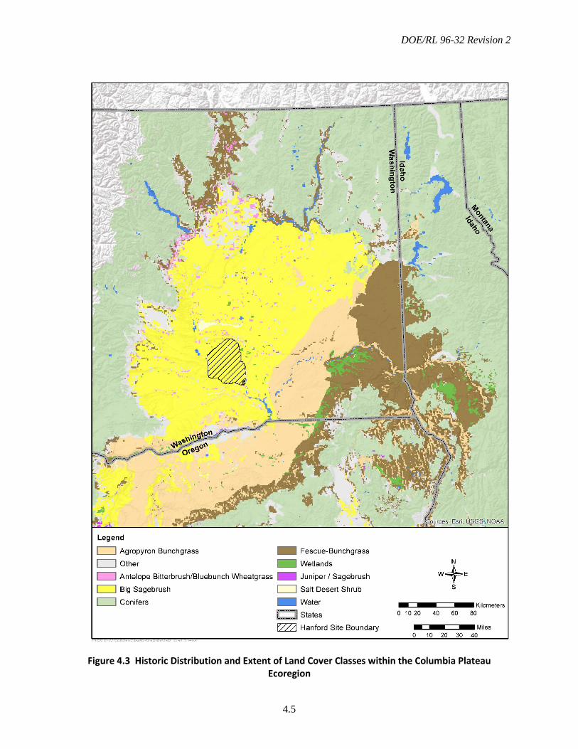
DOE/RL 96-32 Revision 2
4.5
Figure 4.3 Historic Distribution and Extent of Land Cover Classes within the Columbia Plateau Ecoregion
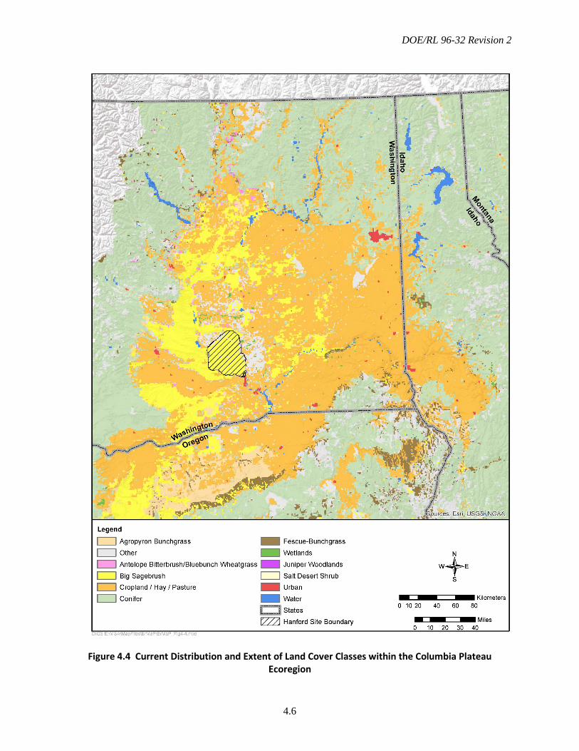
DOE/RL 96-32 Revision 2
4.6
Figure 4.4 Current Distribution and Extent of Land Cover Classes within the Columbia Plateau Ecoregion
DOE/RL 96-32 Revision 2
4.7
Fire History
Over the last several decades, the Hanford Site has been subject to large wildfires that have burned thousands of acres (Figure 4.5). Wildfire in the shrub-steppe historically occurred at intervals of 32 to 70 years in sagebrush vegetation types (Wright et al. 1979), allowing sufficient intervals for the native shrubs to re-establish from seed after a wildfire. Some areas within the shrub-steppe ecosystem now experience fire-return intervals of less than 10 years (Pellant 1990; Whisenant 1990), effectively resulting in the loss of sagebrush and other key plant and wildlife species over large areas (Knick 1999).
The introduction and spread of the alien annual cheatgrass (Bromus tectorum) in the arid western United States has been linked to increased wildfire frequency in shrub-steppe habitats. During the 1990s, cheatgrass-dominated areas were found to burn nearly four times more often than any native vegetation type. Cheatgrass was also disproportionately represented in the largest fires (Balch et al. 2012).
As cheatgrass has become more prevalent in shrub-steppe communities, and human disturbance and development pressure have increased, the frequency and severity of fires in this ecoregion have increased. The recovery of shrub-steppe habitats after wildfire varies depending on factors, including the composition of the pre-fire plant community, time of the wildfire, and severity of the burn.
4.2 Biological Resources
The Hanford Site lies within the interior, low elevation, Columbia River Basin, which is within the shrub-steppe zone (Daubenmire 1970). The diversity of physical features across the Hanford Site contributes to a corresponding diversity of biological communities (TNC 1995, 1996, 1998, and 1999). Although the majority of the Hanford Site consists of shrub-steppe habitats, valuable riparian, wetland, and aquatic habitats are associated with the Hanford Reach. The Hanford Site also contains a diversity of other rare terrestrial habitats such as riverine islands, bluffs/cliffs, basalt outcrops, and sand dunes (Downs et al. 1993; Hallock et al. 2007). Both shrub-steppe and riparian habitats are considered “priority habitats” by the Washington Department of Fish and Wildlife (WDFW). In addition, the Washington Natural Heritage Program (WNHP) has mapped and classified portions of the native plant communities found on Hanford as priority ecosystems. The location of priority habitats on Hanford provides opportunities for creating habitat and landscape connectivity with other large adjacent areas of shrub-steppe habitat within the ecoregion, such as with the Yakima Training Center to the west and north and Columbia National Wildlife Refuge to the north and east.
This section describes those habitats and the wildlife found on the Hanford lands currently managed by DOE, including central Hanford and the McGee Ranch/Riverlands area. Descriptions of habitats occurring on HRNM lands currently managed by USFWS can be found in the HRNM-CCP (USFWS 2008).
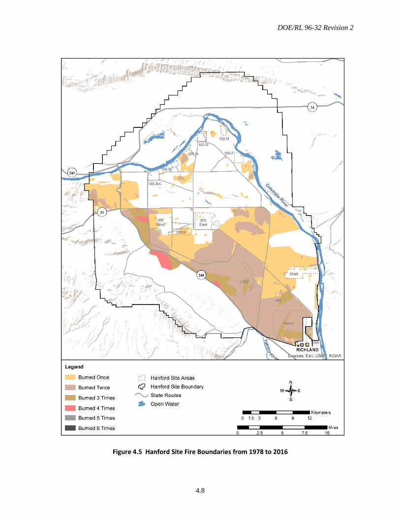
DOE/RL 96-32 Revision 2
4.8
Figure 4.5 Hanford Site Fire Boundaries from 1978 to 2016
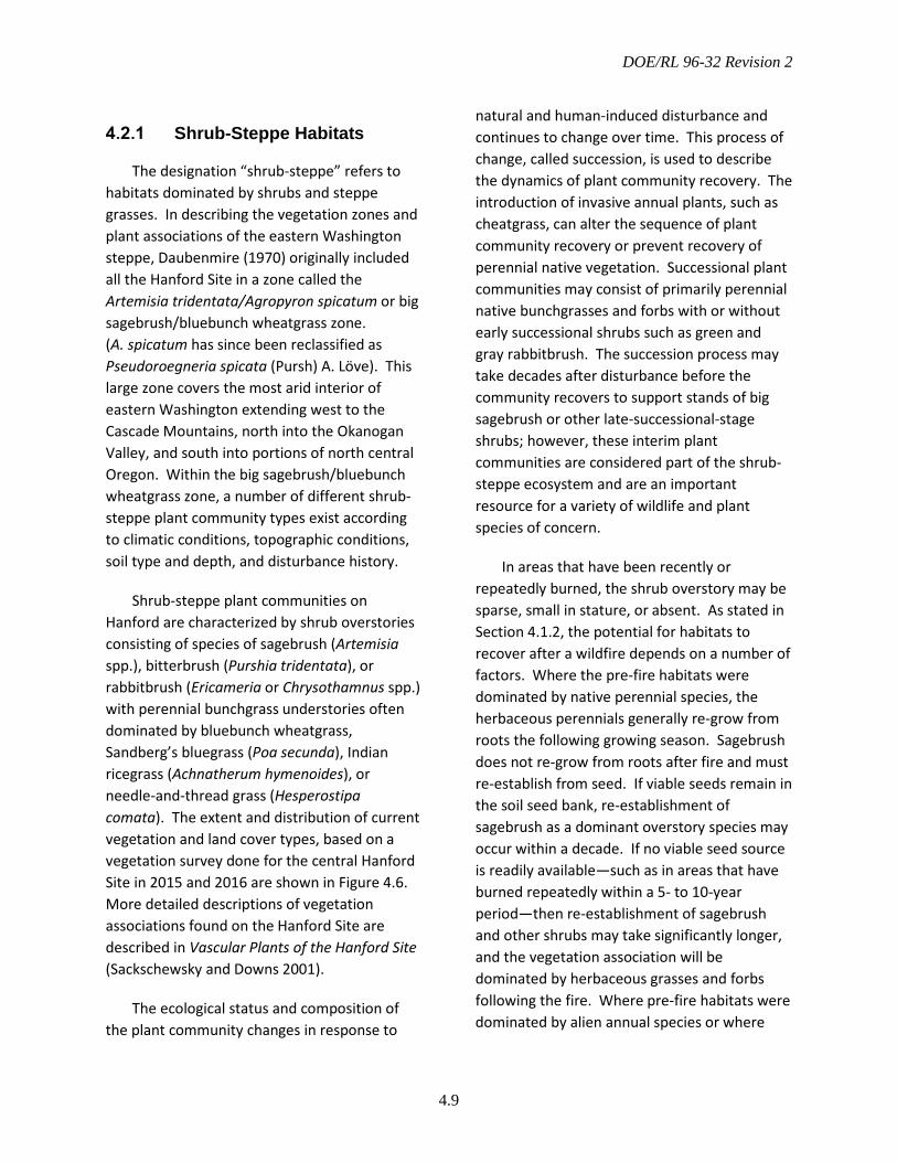
DOE/RL 96-32 Revision 2
4.9
Shrub-Steppe Habitats
The designation “shrub-steppe” refers to habitats dominated by shrubs and steppe grasses. In describing the vegetation zones and plant associations of the eastern Washington steppe, Daubenmire (1970) originally included all the Hanford Site in a zone called the Artemisia tridentata/Agropyron spicatum or big sagebrush/bluebunch wheatgrass zone. (A. spicatum has since been reclassified as Pseudoroegneria spicata (Pursh) A. Löve). This large zone covers the most arid interior of eastern Washington extending west to the Cascade Mountains, north into the Okanogan Valley, and south into portions of north central Oregon. Within the big sagebrush/bluebunch wheatgrass zone, a number of different shrub-steppe plant community types exist according to climatic conditions, topographic conditions, soil type and depth, and disturbance history.
Shrub-steppe plant communities on Hanford are characterized by shrub overstories consisting of species of sagebrush (Artemisia spp.), bitterbrush (Purshia tridentata), or rabbitbrush (Ericameria or Chrysothamnus spp.) with perennial bunchgrass understories often dominated by bluebunch wheatgrass, Sandberg’s bluegrass (Poa secunda), Indian ricegrass (Achnatherum hymenoides), or needle-and-thread grass (Hesperostipa comata). The extent and distribution of current vegetation and land cover types, based on a vegetation survey done for the central Hanford Site in 2015 and 2016 are shown in Figure 4.6. More detailed descriptions of vegetation associations found on the Hanford Site are described in Vascular Plants of the Hanford Site (Sackschewsky and Downs 2001).
The ecological status and composition of the plant community changes in response to
natural and human-induced disturbance and continues to change over time. This process of change, called succession, is used to describe the dynamics of plant community recovery. The introduction of invasive annual plants, such as cheatgrass, can alter the sequence of plant community recovery or prevent recovery of perennial native vegetation. Successional plant communities may consist of primarily perennial native bunchgrasses and forbs with or without early successional shrubs such as green and gray rabbitbrush. The succession process may take decades after disturbance before the community recovers to support stands of big sagebrush or other late-successional-stage shrubs; however, these interim plant communities are considered part of the shrub-steppe ecosystem and are an important resource for a variety of wildlife and plant species of concern.
In areas that have been recently or repeatedly burned, the shrub overstory may be sparse, small in stature, or absent. As stated in Section 4.1.2, the potential for habitats to recover after a wildfire depends on a number of factors. Where the pre-fire habitats were dominated by native perennial species, the herbaceous perennials generally re-grow from roots the following growing season. Sagebrush does not re-grow from roots after fire and must re-establish from seed. If viable seeds remain in the soil seed bank, re-establishment of sagebrush as a dominant overstory species may occur within a decade. If no viable seed source is readily available—such as in areas that have burned repeatedly within a 5- to 10-year period—then re-establishment of sagebrush and other shrubs may take significantly longer, and the vegetation association will be dominated by herbaceous grasses and forbs following the fire. Where pre-fire habitats were dominated by alien annual species or where
DOE/RL 96-32 Revision 2
4.10
alien annual species are prevalent, these species often increase after fire.
Figure 4.6 Vegetation Cover Types on the Hanford Site
DOE/RL 96-32 Revision 2
4.11
Wetlands and Riparian Habitats
In addition to shrub-steppe, the Hanford Site contains riparian, wetland, and aquatic habitats. Riparian and wetland areas are important because of the increased habitat diversity they provide. Riparian environments also provide critical linkages and transition zones between the upland and aquatic environments. These zones provide a variety of ecosystem functions, such as wildlife habitat, contribution to fish habitat, unique plant species habitat, flood control improvement, and sediment trapping. Riparian vegetation along the Hanford Reach usually consists of a vegetation band along the river shoreline that is influenced by the flow of the river and the increased availability of water for plant growth at the river edge. This type of vegetation is characterized by plants that can persist in wetted soils or that require higher levels of soil moisture than can be found in the more arid uplands.
The Hanford Reach contains native riparian habitat, free-flowing riffles, gravel bars, oxbow ponds, and backwater sloughs that are otherwise limited in occurrence elsewhere along the Columbia River (USFWS 1980; NPS 1994; 65 FR 37253). Riparian vegetation is limited in extent, with narrow bands or buffers near the water consisting of a number of forbs, grasses, sedges, reeds, rushes, cattails, and deciduous trees and shrubs. Much of the riparian zone along the Columbia River has been colonized by invasive plant species that can act to displace native species. Along the Hanford Reach, mulberry (Morus alba) and Russian olive (Elaeagnus angustifolia) trees are more frequent than the native black cottonwood (Populus balsamifera ssp.
trichocarpa). In places along the Columbia River shoreline, the native cattails (Typha latifolia), sedges (Carex sp.), and rushes (Juncus sp.) may be displaced by reed canary grass (Phalaris arundinacea).
Where the banks of the river are steep, the riparian vegetation forms a band that roughly extends from the surface elevation corresponding to average low flows along the river to a few meters above the shoreline elevation corresponding to average high flows. Thus, this band of vegetation can be as narrow as 5 to 10 m (15 to 30 ft) where river banks are steep; but, in areas where the river bank slopes are mild and areas of slower backwater flows (sloughs), the extent of the band of riparian vegetation can be much greater—up to 700 to 800 m (2300 to 2600 ft) in width in some areas. Riparian vegetation types along the Columbia River bordering the Hanford Site are shown in Figure 4.7.
Riparian and wetland areas not directly associated with the Columbia River are widely scattered across the Hanford Site. These areas include a mix of small, naturally occurring springs and streams, artificial wetlands created by irrigation runoff (north of the Columbia River), and a few temporary water bodies attributed to past waste-water discharges (Neitzel 2000; Downs et al. 1993). The springs and streams and their associated vegetation are especially important for providing water, forage, cover, and breeding sites for wildlife within the dry-land portions of the Hanford Site (Downs et al. 1993). Most of these features are found on Hanford lands currently managed by the USFWS and are described in the HRNM-CCP (USFWS 2008). Springs and water bodies found on central Hanford and McGee Ranch/Riverlands are shown in Figure 4.8.
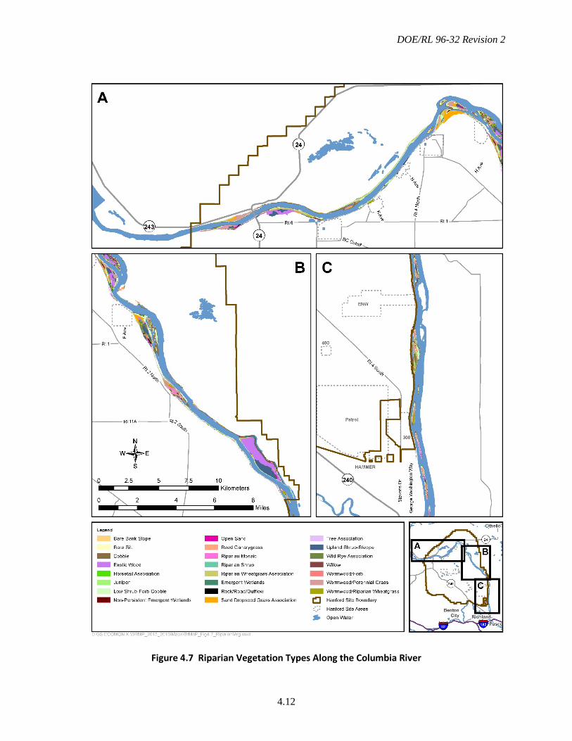
DOE/RL 96-32 Revision 2
4.12
Figure 4.7 Riparian Vegetation Types Along the Columbia River
DOE/RL 96-32 Revision 2
4.13
Significant or Rare Habitats
Within the Hanford Site boundaries, a number of physical features create unique habitat for plants and wildlife (Figure 4.8). In the areas currently managed by DOE, these habitats include the following:
• Basalt outcrops, cliffs, and talus slopes—which support rare plants, rare plant communities, and specialized wildlife
• Upland springs—which support rare wildlife species and high wildlife use
• Desert streams – which also support rare wildlife species and high wildlife use
• Vernal pools – which provide rare plant habitat and support wildlife use
• Columbia River sloughs—which support high fish and wildlife use (provide important habitat diversity within the Hanford Reach) and associated rare plant species and communities
• Columbia River islands—which provide unique wildlife habitat through isolation and support rare plants
• Sand dunes—which are considered a priority ecosystem and support rare plant species and communities
• Swales—which contain unique vegetation assemblages that support heavy use by pollinators.
More detailed information about each of these habitats and their associated plants and wildlife can be found in Habitat Types on the
Hanford Site: Wildlife and Plant Species of Concern (Downs et al. 1993).
Washington State Element Occurrences
The Hanford Site also contains relatively large areas of native plant communities that have been mapped and identified as “element occurrences” by the WNHP and are currently classified as priority ecosystems within the state (Figure 4.9). An element is a basic unit of Washington’s biologic and geologic environment identified as a needed component of a system of natural areas. An element can be an entire ecological system, such as a plant community or a wetland ecosystem that includes the native plants and animals common to that system. Occurrences of priority species or ecosystems are assessed by WNHP regarding their overall condition and viability.
Wildlife
Wildlife use habitats on the Hanford Site according to species-specific requirements. Their use of shrub-steppe, riparian, and aquatic habitats may vary during different portions of their life cycle or different seasons. Wildlife at Hanford may be resident or migratory and include recreationally and commercially important species. Hanford provides habitat for a variety of mammals, reptiles, amphibians, birds, fish, and invertebrates. They are discussed briefly in this subsection. Comprehensive lists of the wildlife species observed on Hanford Site are provided in Duncan et al. (2007).
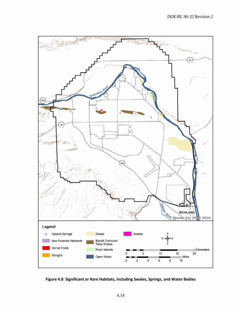
DOE/RL 96-32 Revision 2
4.14
Figure 4.8 Significant or Rare Habitats, including Swales, Springs, and Water Bodies

DOE/RL 96-32 Revision 2
4.15
Figure 4.9 Washington State Plant Community Element Occurrences on the Hanford Site
DOE/RL 96-32 Revision 2
4.16
4.2.5.1 Mammals
The approximately 46 mammalian species present on the site are representative of those found in shrub-steppe, riparian, and aquatic habitats of the region (Duncan et al. 2007). Many of the smaller and less mobile mammal species, such as mice, rabbits, and shrews, are resident, and individuals spend their entire lives within the boundary of the site. Individuals of more mobile species, such as bats, or occasional transients like the mountain lion (Puma concolor), may only be present seasonally.
Because most of the site is dominated by shrub-steppe, the Hanford mammal community is representative of upland species that occur in shrub-steppe habitats. Habitat generalists, such as the ubiquitous coyote (Canis latrans), mule deer (Odocoileus hemionus), Rocky Mountain elk (Cervus elaphus nelsoni), American badger (Taxidea taxus), deer mouse (Peromyscus maniculatis), and Great Basin pocket mouse (P. parvus) can be found in many different habitats. Black-tailed and white-tailed jackrabbits (Lepus californicus and L. townsendii), and ground squirrels (Urocitellus spp.) are only found in shrub-steppe habitats. The porcupine (Erithozon dorsatum), striped skunk (Mephitis mephitis), vagrant shrew (Sorex vagrans), and white-tailed deer (Odocoileus virgianus) are mainly found in riparian areas along the Columbia River. Beaver (Castor canadensis), muskrat (Ondatra zibethicus), mink (Mustela vison), and river otter (Lontra canadensis) occur in both riparian and aquatic habitats.
Other Hanford mammal species only occur in very specific habitats. The least chipmunk (Tamias minimus), Merriam’s shrew (S. merriami), and sagebrush vole (Lemmiscus curtatus) are only found at higher elevations on
Hanford. Bats on the Hanford Site are less common and restricted to very specific habitats such as rock outcrops, abandoned buildings, and large trees. Common bat species found on the Hanford Site are the Yuma myotis (Myotis yumanensis), silver-haired bat (Lasionycteris noctivagans), and pallid bat (Antrozous pallidus).
4.2.5.2 Reptiles and Amphibians
There are approximately 10 reptile species known to occur on the Hanford Site. Of the three lizard species, the common side-blotched lizard (Uta stansburiana) is the most frequently observed and occurs in most native upland habitats. Sagebrush lizards (Sceloporus graciosus) are also found on Hanford and generally occupy habitats where some shrub cover is available. The pygmy short-horned lizard (Phrynosoma douglasii) is relatively uncommon on the Hanford Site.
Six snake species are known to occur on Hanford. Most of the snakes commonly occur in upland habitats only, including the western yellow-bellied racer (Coluber constrictor) and the Great Basin gopher snake (Pituophis catenifer). The western rattlesnake (Crotalus viridis) is often found in or near basalt outcrops on Hanford or along the Columbia River, while the striped whipsnake (Masticophis taeniatus) and desert nightsnake (Hypsiglena chlorophaea) also occur in uplands, but have rarely been encountered on the site. The western garter snake (Thamnophis elegans) prefers riparian habitats. The painted turtle (Chrysemys picta) is the only turtle known to occur on the Hanford Site.
Amphibians are somewhat limited in abundance and distribution on the site because of the limited abundance and distribution of water and moist habitats. Only five amphibian
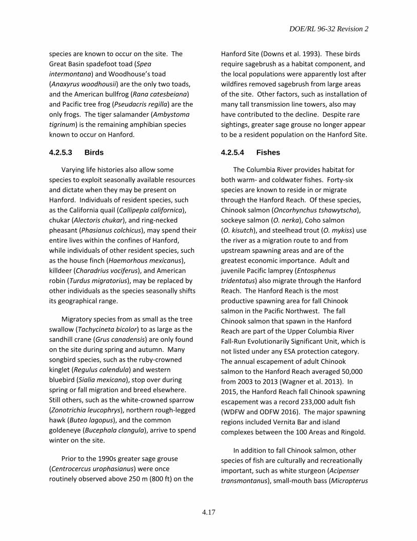
DOE/RL 96-32 Revision 2
4.17
species are known to occur on the site. The Great Basin spadefoot toad (Spea intermontana) and Woodhouse’s toad (Anaxyrus woodhousii) are the only two toads, and the American bullfrog (Rana catesbeiana) and Pacific tree frog (Pseudacris regilla) are the only frogs. The tiger salamander (Ambystoma tigrinum) is the remaining amphibian species known to occur on Hanford.
4.2.5.3 Birds
Varying life histories also allow some species to exploit seasonally available resources and dictate when they may be present on Hanford. Individuals of resident species, such as the California quail (Callipepla californica), chukar (Alectoris chukar), and ring-necked pheasant (Phasianus colchicus), may spend their entire lives within the confines of Hanford, while individuals of other resident species, such as the house finch (Haemorhous mexicanus), killdeer (Charadrius vociferus), and American robin (Turdus migratorius), may be replaced by other individuals as the species seasonally shifts its geographical range.
Migratory species from as small as the tree swallow (Tachycineta bicolor) to as large as the sandhill crane (Grus canadensis) are only found on the site during spring and autumn. Many songbird species, such as the ruby-crowned kinglet (Regulus calendula) and western bluebird (Sialia mexicana), stop over during spring or fall migration and breed elsewhere. Still others, such as the white-crowned sparrow (Zonotrichia leucophrys), northern rough-legged hawk (Buteo lagopus), and the common goldeneye (Bucephala clangula), arrive to spend winter on the site.
Prior to the 1990s greater sage grouse (Centrocercus urophasianus) were once routinely observed above 250 m (800 ft) on the
Hanford Site (Downs et al. 1993). These birds require sagebrush as a habitat component, and the local populations were apparently lost after wildfires removed sagebrush from large areas of the site. Other factors, such as installation of many tall transmission line towers, also may have contributed to the decline. Despite rare sightings, greater sage grouse no longer appear to be a resident population on the Hanford Site.
4.2.5.4 Fishes
The Columbia River provides habitat for both warm- and coldwater fishes. Forty-six species are known to reside in or migrate through the Hanford Reach. Of these species, Chinook salmon (Oncorhynchus tshawytscha), sockeye salmon (O. nerka), Coho salmon (O. kisutch), and steelhead trout (O. mykiss) use the river as a migration route to and from upstream spawning areas and are of the greatest economic importance. Adult and juvenile Pacific lamprey (Entosphenus tridentatus) also migrate through the Hanford Reach. The Hanford Reach is the most productive spawning area for fall Chinook salmon in the Pacific Northwest. The fall Chinook salmon that spawn in the Hanford Reach are part of the Upper Columbia River Fall-Run Evolutionarily Significant Unit, which is not listed under any ESA protection category. The annual escapement of adult Chinook salmon to the Hanford Reach averaged 50,000 from 2003 to 2013 (Wagner et al. 2013). In 2015, the Hanford Reach fall Chinook spawning escapement was a record 233,000 adult fish (WDFW and ODFW 2016). The major spawning regions included Vernita Bar and island complexes between the 100 Areas and Ringold.
In addition to fall Chinook salmon, other species of fish are culturally and recreationally important, such as white sturgeon (Acipenser transmontanus), small-mouth bass (Micropterus
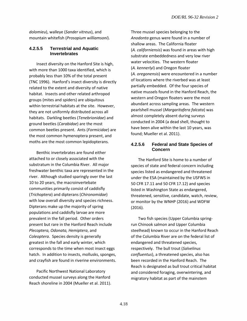
DOE/RL 96-32 Revision 2
4.18
dolomieu), walleye (Sander vitreus), and mountain whitefish (Prosopium williamsoni).
4.2.5.5 Terrestrial and Aquatic Invertebrates
Insect diversity on the Hanford Site is high, with more than 1000 taxa identified, which is probably less than 10% of the total present (TNC 1996). Hanford’s insect diversity is directly related to the extent and diversity of native habitat. Insects and other related arthropod groups (mites and spiders) are ubiquitous within terrestrial habitats at the site. However, they are not uniformly distributed across all habitats. Darkling beetles (Tenebrionidae) and ground beetles (Carabidae) are the most common beetles present. Ants (Formicidae) are the most common hymenoptera present, and moths are the most common lepidopterans.
Benthic invertebrates are found either attached to or closely associated with the substratum in the Columbia River. All major freshwater benthic taxa are represented in the river. Although studied sparingly over the last 10 to 20 years, the macroinvertebate communities primarily consist of caddisfly (Trichoptera) and dipterans (Chironomidae) with low overall diversity and species richness. Dipterans make up the majority of spring populations and caddisfly larvae are more prevalent in the fall period. Other orders present but rare in the Hanford Reach include Plecoptera, Odonata, Hemiptera, and Coleoptera. Species density is generally greatest in the fall and early winter, which corresponds to the time when most insect eggs hatch. In addition to insects, mollusks, sponges, and crayfish are found in riverine environments.
Pacific Northwest National Laboratory conducted mussel surveys along the Hanford Reach shoreline in 2004 (Mueller et al. 2011).
Three mussel species belonging to the Anodonta genus were found in a number of shallow areas. The California floater (A. californiensis) was found in areas with high substrate embeddedness and very low river water velocities. The western floater (A. kennerlyi) and Oregon floater (A. oregonensis) were encountered in a number of locations where the riverbed was at least partially embedded. Of the four species of native mussels found in the Hanford Reach, the western and Oregon floaters were the most abundant across sampling areas. The western pearlshell mussel (Margaritafera falcata) was almost completely absent during surveys conducted in 2004 (a dead shell, thought to have been alive within the last 10 years, was found; Mueller et al. 2011).
4.2.5.6 Federal and State Species of Concern
The Hanford Site is home to a number of species of state and federal concern including species listed as endangered and threatened under the ESA (maintained by the USFWS in 50 CFR 17.11 and 50 CFR 17.12) and species listed in Washington State as endangered, threatened, sensitive, candidate, watch, review, or monitor by the WNHP (2016) and WDFW (2016).
Two fish species (Upper Columbia spring-run Chinook salmon and Upper Columbia steelhead) known to occur in the Hanford Reach of the Columbia River are on the federal list of endangered and threatened species, respectively. The bull trout (Salvelinus confluentus), a threatened species, also has been recorded in the Hanford Reach. The Reach is designated as bull trout critical habitat and considered foraging, overwintering, and migratory habitat as part of the mainstem
DOE/RL 96-32 Revision 2
4.19
Upper Columbia River critical habitat unit (75 FR 63898-64069).
In April 2013, the USFWS listed two plant species, the Umtanum desert buckwheat (Eriogonum codium) and White Bluffs bladderpod (Physaria tuplashensis), as threatened, with critical habitat, under the ESA (78 FR 23984 and 78 FR 24008). Following an extended public comment period, USFWS affirmed their decision to list these species as threatened, and in December 2013, the final revised rule took effect (78 FR 76995-77005).
No other plants or animals known to occur on the Hanford Site are currently on the federal list of endangered and threatened species. The USFWS also maintains a list of species of concern in Washington State (USFWS 2013) that includes species being monitored that may be
considered for federal candidate status in the future. Thirteen species that occur on the Hanford Site are included on the USFWS list. A complete inventory of species listed by state or federal resource agencies is provided in Appendix A.
Plant populations monitored on the Hanford Site include taxa listed by Washington State as endangered, threatened, or sensitive and those species listed as Review Group 1, which includes taxa in need of additional field work before status can be determined (WNHP 2016). More than 100 plant populations of 53 different taxa listed by WNHP as endangered, threatened, sensitive, review, or watch list have been found at the Hanford Site (Figure 4.10) (Sackschewsky and Downs 2001; TNC 1995, 1996, 1998, 1999).

DOE/RL 96-32 Revision 2
4.20
Figure 4.10 Plant Populations of Conservation Concern on the Hanford Site
DOE/RL 96-32 Revision 2
5.1
5.0 Resource Management Approach and Implementation
As a federal land manager, DOE is responsible for conserving plant and animal populations and their habitats on the Hanford Site. The primary goals in managing Hanford’s species, habitats, and ecosystem resources include maintaining sustainable population levels of terrestrial and aquatic resident native species, and maintaining or increasing the quantity and quality of functioning native systems across the Hanford Site. The primary objective of this management plan is to provide the strategies and management actions necessary to sustain Hanford’s biological resources.
This chapter describes DOE’s management objectives, strategies, and general directives for the Hanford Site. Essential aspects of Hanford biological resource management include resource monitoring, impact assessment, mitigation, and restoration. DOE’s resource management strategies address habitat and population monitoring and the role of monitoring in implementing adaptive management strategies that are flexible in application and responsive to emerging issues and changing conditions. The process and actions necessary to assess potential impacts to resources and to effectively mitigate for those impacts through avoidance, minimization, and restoration are described in Chapters 6.0 and 7.0.
The DOE process for managing Hanford biological resources is based on a landscape-level ecosystem management approach, which is aimed at protecting, maintaining, restoring, and enhancing essential ecosystem components, processes, and functions. Ecosystem management recognizes the complex links between all biotic and abiotic
components, functions they provide, and processes acting on these resources. Because ecosystems are so complex, management is conducted at the resource level and at various scales within the landscape where realistic goals, thresholds, and monitoring strategies can be achieved and measured.
5.1 Resource Management Strategies
Ecosystem-based conservation is a broad approach to natural resource management that involves identifying, protecting, and restoring complete ecosystems, including the structural components and processes, while fully incorporating social, economic, and other human concerns into planning. For DOE, a key objective of this approach is to achieve conservation and protection goals by eliminating or minimizing potential adverse impacts of site operations and ongoing projects without affecting the Hanford Site’s ongoing mission, goals, and objectives. Resource management objectives for Hanford are to:
• Protect species and habitats of state and federal concern
• Maintain and protect native biological diversity
• Reduce the spread of invasive species and provide integrated control of noxious weeds
• Where and when feasible, improve degraded habitats in a strategic manner to increase landscape connectivity and native diversity
• Reduce and minimize fragmentation of habitats
DOE/RL 96-32 Revision 2
5.2
• Maintain landscapes that provide regional connectivity to habitats surrounding Hanford.
Although DOE generally does not directly manage individual species or manage for individual species, it does manage actions and processes that affect multiple species, habitats, and ecosystems. Part of DOE’s strategy to protect the biological resources on the Hanford Site includes general directives to avoid and minimize impacts to native habitats and species. The directives that all DOE, contractor, and subcontractor personnel are expected to follow are provided below. Also provided are summaries of DOE’s policies regarding two of the most significant and far-reaching threats to the sites biological resources: fire and noxious weeds.
General Directives and Practices
The following general directives apply to all actions occurring within portions of the Hanford Site managed by DOE, including portions of the HRNM under DOE management (central Hanford and McGee Ranch/Riverlands).
• All actions and activities that potentially affect biological resources require an ECR and determination of potential impacts before proceeding. This directive not only applies to ground-breaking disturbances and excavation, but to any treatments or actions that alter the current natural state of the environment, habitat, or a species population such as mowing, prescribed burning, herbicide application in native vegetation, and excessive noise. The ecological compliance assessment process described in Chapter 6.0 is a component of early project planning.
• If an ECR determines adverse impacts to biological resources—such as habitat alterations or disturbances that could affect a species listed under the ESA or the reproductive success of a species of concern—specific mitigation actions will be identified (see Chapters 6.0 and 7.0), and mitigation actions will be implemented by the responsible contractor.
• All entities conducting work on the Hanford Site will conduct activities and work in accordance with access restrictions and administrative designations related to resource protection areas including the following:
o Areas containing rare plant communities (element occurrences)
o Mitigation/restoration areas
o Collection/propagation areas for native plant materials
o Lands used under permit and leased properties
o Administrative control areas for species of concern, which include bald eagle buffer zones, fall Chinook salmon spawning locations, ferruginous hawk and burrowing owl buffer zones, and known populations/occurrences of plant species of concern.
• Activities that increase habitat fragmentation and degrade existing native habitats should be avoided. If new facilities or new road/railroad/ utility corridors are required, they should be built, as much as possible, within previously disturbed areas or co-
DOE/RL 96-32 Revision 2
5.3
located with existing roads or corridors to minimize habitat fragmentation.
• No vehicles are permitted off established roads on the Hanford Site unless specifically approved by the SSD and the Hanford Fire Department (HFD) for conducting work activities, or if required by an emergency situation.
• Consistent with the CLUP and the Presidential Proclamation, domestic livestock grazing is not allowed on Hanford lands except where previous limited agreements allow access across DOE lands to private grazing lands. Although limited grazing occurred in the past, Presidential Proclamation 7319 (June 9, 2000) establishing the HRNM restricts grazing and off-road vehicle use.
• Actions that remove or significantly degrade native vegetation will require revegetation or restoration of areas not needed for future operations following the practices outlined in the Hanford Site Revegetation Manual (DOE 2013a). Plant material used for habitat improvements or habitat restoration should be native to the Hanford Site and preferably should be of locally derived genetic stock.
• No hunting, fishing, or trapping is allowed on Hanford Site lands managed by DOE. Hunting, fishing, and trapping below the ordinary high water mark of the Columbia River are subject to the laws and regulations of Washington State. The USFWS may allow hunting, fishing, or trapping on portions of the HRNM consistent with its HRNM-CCP (USFWS 2008) and the laws and regulations of Washington State.
• Consistent with the CLUP, no agriculture will be allowed on lands managed by DOE. Several small leases have previously been in place on the Wahluke Unit, and agriculture is not specifically excluded by the HRNM proclamation. Agricultural leases on monument lands managed by USFWS would be at the discretion of USFWS consistent with its HRNM-CCP (USFWS 2008).
The guidance above must be followed unless its application is waived for a certain circumstance by the appropriate site manager for either RL or ORP.
Interface with the Hanford Reach National Monument
The following guidelines describe how the BRMP and the HRNM-CCP (USFWS 2008) will interact for actions on the HRNM.
• USFWS actions on HRNM lands managed by USFWS will be guided by the HRNM-CCP.
• DOE actions on HRNM lands managed by DOE will be guided by the BRMP.
• DOE actions on HRNM lands managed by USFWS will generally follow BRMP, but DOE will coordinate with USFWS on major actions to ensure its activities are not contrary to the goals and objectives of the HRNM-CCP. DOE will normally conduct its own biological and cultural resource reviews for its own projects, and will mitigate impacts according to BRMP, regardless of location.
Fire Management
Many plant communities on Hanford and their associated wildlife species have evolved in
DOE/RL 96-32 Revision 2
5.4
the presence of natural fires. However, past and present land-use practices and the presence of non-native plant species, especially cheatgrass, have altered the frequency and severity of fires. More frequent and severe fires have reduced the availability of late-successional shrub-steppe habitat for species that are dependent on this habitat type for at least part of their life cycle. Also, in addition to fire itself, many plant communities on Hanford are sensitive to, and slow to recover from, the impacts of certain fire-fighting activities such as the creation of firebreaks.
Large fires are one of the greatest threats to Hanford Site native habitats and biological diversity. The HFD has an annually updated a Fire Management Plan that is implemented as a subcomponent of BRMP, as described in the HCP-EIS supplemental analyses (DOE 2008). The HFD prepares annual maintenance and burn plans for firebreak maintenance and fuels reduction. The DOE’s overall wildfire management policy for the Hanford Site is to minimize the potential for human-caused fires and to fight wildfires aggressively. The following sections briefly describe DOE’s fire management policy regarding biological resources as defined in the Fire Management Plan.
5.1.3.1 Wildfire Control
To the extent possible during a wildfire, fire suppression and control actions will be conducted to protect existing stands of late-successional shrub-steppe, and to avoid direct surface disturbance within late-successional shrub-steppe areas, plant community element occurrences, and other rare or sensitive habitat areas. To the extent practical during a firefighting effort, the Fire Department incident commander should coordinate or consult with site natural resource subject matter experts.
Temporary firebreaks constructed during fire-fighting should be re-contoured and reseeded with an appropriate mix of locally derived native plant species as described in the Hanford Site Revegetation Manual (DOE 2013a).
Burned area replanting will be considered on a case-by-case basis. Determining if replanting is needed depends on the site, pre-existing plant community, characteristics of the wildfire, level of damage sustained by native vegetation, and likelihood the burned area will further degrade if restoration actions are not performed. If performed, replanting will use locally derived native species.
5.1.3.2 Prescribed Fires and Fuel Management
Prescribed burning for the purposes of habitat management or hazardous fuels reduction has not been a regular element of the Hanford Site biological resources management strategy, but was considered within the Environmental Assessment: Integrated Vegetation Management on the Hanford Site, Richland, Washington (DOE 2012b). Proposals to use prescribed burning for habitat improvement or hazardous fuels reduction, other than burning of tumbleweed accumulations along fence lines, fire breaks, linear transportation, or utility corridors, will be considered on a case-by-case basis, and will require review by SSD and Hanford Fire Department approval and cooperation. The ecological effects of fire in semi-arid shrub-steppe habitats are often unpredictable, and restoration of burned areas requires careful consideration of site-specific conditions and the final desired habitat. Prescribed burn plans, other than for burning of tumbleweed accumulations along fence lines and firebreaks, will include detailed restoration, revegetation, and long-term monitoring plans.
DOE/RL 96-32 Revision 2
5.5
Preventative fire control includes installation and maintenance of a system of permanent firebreaks that will use existing roads, rail lines, and utility corridors. Installation and maintenance of these firebreaks will be conducted in a manner that minimizes adverse impacts to biological resources.
Controlled burning of accumulations of dry plant material, particularly along roadways, is conducted to remove large potential sources of fuel that, if accidentally ignited, could provide a mechanism for rapidly accelerating uncontrolled burns.
Noxious Weed Management
A noxious weed is defined as “a plant that when established is highly destructive, competitive, or difficult to control by cultural or chemical practices” (RCW 17.10.010). The Washington State Noxious Weed Control Board determines which species are considered noxious weeds in the state, and what level of control is required for each species. Noxious weeds are controlled on the Hanford Site for regulatory compliance with the Federal Noxious Weed Act of 1974 as amended in 1990 and by WAC 16-750, Washington State Noxious Weed List and Schedule of Monetary Penalties, to prevent adverse impacts to neighboring agricultural operators, and keep deep-rooted vegetation from invading Hanford waste sites.
Noxious weed management is implemented as part of the site-wide Integrated Biological Control Plan (MSA 2014) as a subcomponent of BRMP and is described in the 2008 HCP-EIS supplemental analysis (DOE 2008). The goal of noxious weed management on the Hanford Site is to eliminate existing populations of noxious weeds and prevent new populations from becoming established.
The environmental impacts of noxious weed control on the Hanford Site were evaluated in the Environmental Assessment: Integrated Vegetation Management on the Hanford Site, Richland, Washington (DOE 2012b). Noxious weeds are to be treated as soon as appropriate after they are identified to minimize seed production, and in this assessment, DOE determined that an integrated vegetation management/adaptive management approach that includes chemical, physical, biological, cultural, and prescribed burning methods was preferable to using any one method by itself or a no-action alternative. Noxious weed management, especially in relatively less disturbed areas, must meet other biological resource management requirements described in BRMP, such as evaluations for the presence of rare species and unique habitats, avoidance and minimization of impacts whenever practical and possible, and habitat mitigation as applicable. The need for active reestablishment of desirable vegetation is recognized as a critical component of successful long-term control of noxious weeds and other undesirable vegetation on the Hanford Site.
5.2 Biological Resource Values and Priorities
Although all ecological resources and habitats may be considered important, DOE recognizes that some resources will require greater management attention than others. This management plan applies a hierarchical approach to prioritize biological resources and associate different levels of management actions—protection, monitoring, impact assessment, mitigation, and restoration—based on the type and relative ecological value of the resources (Figure 5.1). Applying this framework allows management strategies to account for differences in resource “value,” meaning that some resources require greater management

DOE/RL 96-32 Revision 2
5.6
attention and protection than others. For example, a relatively intact biological community that is rare in the ecoregion would warrant greater management protection than would a degraded habitat area dominated by non-native plants such as cheatgrass.
Assigning Resource Value and Resource Priority Levels
The strategy for assessing resource values and management priorities considers the relative value of both species and habitats. To address differences in resource “value,” and ensure limited fiscal and staff resources focus on those resources that require specific
protection and management attention, the biological resources on the Hanford Site are categorized into six priority levels, 0 through 5 (Figure 5.1). Species are assigned a resource value by considering attributes such as legal or listing status, recreational, commercial, cultural, and ecological value (Table 5.1). Known locations of federal and state threatened or endangered plants and animals are included in the landscape-scale resource level determination. Distributions of species that are more common or have a lower priority listing status are often unknown and are not accounted for in the spatial representations provided in this section.
Figure 5.1 General Hierarchical Prioritization of Habitat Resources on the Hanford Site

DO
E/RL 96-32 Revision 2
5.7
Table 5.1 Criteria Used to Classify Hanford Biological Resources into Resource Levels of Concern
Resource Level of Concern
Species Habitat Administrative Boundaries
Level 5 Irreplaceable Resources
• Federal threatened or endangered • Proposed federal threatened or
endangered (see Appendix A)
• Rare habitats, including cliffs, lithosols, dune fields, ephemeral streams, and vernal pools
• Fall Chinook salmon and steelhead spawning areas
• Critical habitat for federal threatened or endangered species
• Plant community element occurrences
Level 4 Essential Resources
• State threatened or endangered • Federal candidate
• Upland stands with a native climax shrub overstory and a native grass understory
• Wetlands, swales, and riparian habitats
• Bald eagle nest and roost site buffers
• Ferruginous hawk and burrowing owl nest sites and buffers
• Mitigation and restoration areas Level 3 Important Resources
• State sensitive or review plants • State sensitive or candidate wildlife • Federal species of concern (see Table
A.1) • WDFW priority • Culturally important
• Shrub-steppe habitats with a native climax shrub overstory and cheatgrass co-dominant in the understory along with native grasses
• Shrub-steppe stands with a successional shrub overstory and predominantly native understory
• Native stands of bunchgrass-dominated vegetation
• Snake hibernacula • Bat colonial roost sites • Wading bird rookeries
• Floodplains • Conservation corridors • Burrowing owl nest site buffers • WDFW priority habitats not
included in Level 4 or 5
Level 2 Mid-Successional Communities
• Migratory birds • State Watch List plants • State monitor wildlife • Recreationally and commercially
important species
• Upland stands with a sparse climax or successional shrub overstory and non-native understory
• Steppe stands with native plants co-dominant with non-native plants
•
Level 1 Marginal Habitats
• Common plant and animal species not otherwise included in higher BRMP levels
• Upland stands of non-native plants • Abandoned agricultural fields • Very small, isolated patches of shrub-steppe
surrounded by industrial areas or other Level 0 habitats
•
Level 0 Industrial Areas
• Non-native plants and animals not already categorized as Level 1-5 resources
• Non-vegetated areas • Industrial sites such as paved and compacted
gravel areas
•

DOE/RL 96-32 Revision 2
5.8
Habitats are assigned a resource value by considering several attributes, including whether habitats are critical or essential for species of concern, Washington State priority habitats and element occurrences, attributes of the vegetation cover types found on the Hanford Site, landscape-level attributes such as connectivity and/or fragmentation, or
administratively designated resource areas. Each level reflects different management priorities, and each has a specific set of associated management actions and requirements. At increasing levels of priority, the number of applicable management actions may increase and become more restrictive to preserve the resource (Table 5.2).
Table 5.2 Management Goals and Actions for Each Resource Level of Concern Resource Level of Concern
Management Goal
Management Action
Status Monitoring Effort
Compensatory Habitat Mitigation Action
Level 5 Preservation Avoidance High Compensation determined on case-by-case basis
Level 4 Preservation Avoidance/ minimization preferred
High Habitat replacement at 5:1
Level 3 Conservation Avoidance/ minimization preferred
Moderate Habitat replacement at 3:1 or as per other legal requirements (wetland mitigation)
Level 2 Conservation Primarily Avoid/minimize
Low Level Habitat replacement possible at 1:1. Such areas may be preferred sites to perform mitigation actions
Level 1 Mission support
Avoid/minimize as practicable regulatory compliance (MBTA)
None Habitat replacement is not required, but site could be suitable for use as a restoration or mitigation area
Level 0 Mission support Regulatory compliance
None None
The following sections describe each resource level. Figures 5.2 to 5.7 show the distribution of resources within each level after applying the criteria described. The specific attributes used for each resource-level map are provided in Appendix B. Note that the maps showing the distribution of different resource levels are intended for planning purposes only. The presence or absence of any resource can only be confirmed through field surveys at appropriate times of the year. The determination of resource values in the
landscape depends on evaluation of all resource characteristics and administrative designations. The resources at a particular location and particular time are managed for the highest applicable resource value as described in Section 5.2.2.
5.2.1.1 Irreplaceable Resources (Level 5)
Resources classified as Level 5 are the rarest and most sensitive habitats and species and are considered irreplaceable or at risk of extirpation
DOE/RL 96-32 Revision 2
5.9
or extinction. These species include those listed or formally proposed to be listed as threatened or endangered under the ESA. Habitats include areas that are designated critical habitats for federal threatened or endangered species or are essential for those species to persist on the site. Other irreplaceable habitats are plant community element occurrences and rare habitats, including cliffs, lithosols, dune fields, ephemeral streams, and vernal pools as well as fall Chinook salmon and steelhead spawning areas. The distribution of Level 5 resources is depicted in Figure 5.2.
The primary management goal for Level 5 resources is preservation because any loss of these resources would represent a significant impact to threatened or endangered populations, the site’s biological diversity, and biodiversity and ecological integrity of the shrub-steppe and riparian habitats of the Columbia Basin Ecoregion. There is no practical way to replace or restore a Level 5 habitat resource if it is lost. Therefore, avoidance is the preferred mitigation measure for these species and habitats. If any Level 5 resources are lost due to Hanford Site actions, compensation will be determined on a case-by-case basis.
Actions that could affect federal threatened or endangered species or affect critical habitat for such species require interagency consultation under Section 7 of the ESA with the USFWS, NMFS, or both. These agencies have the regulatory authority to allow for some impacts to listed species and would likely require specific mitigation measures to prevent or reduce the magnitude of such impacts. It is DOE’s policy to avoid impacts to these species and their habitats whenever possible.
Regular inventory and monitoring is a critical component of DOE’s strategy to effectively manage Level 5 resources.
Monitoring provides the information needed to determine population trends, distribution of the species or habitat, and whether habitat quality is declining in these areas. This information can then be used to determine if management actions are effective or if additional access restrictions or other protective measures are required.
5.2.1.2 Essential Resources (Level 4)
Species and habitats classified as Level 4 are considered essential to the biological diversity of the site and the Columbia Basin Ecoregion. These include species listed by the WDFW or WNHP as endangered or threatened, and those listed as candidate species for ESA protection by the USFWS or NMFS. Level 4 habitats include those habitats and vegetation cover types essential to sustain populations of state endangered or threatened species and federal candidate species, such as ferruginous hawk and burrowing owl nest sites. Also included are riparian habitats, wetlands, swales, and high-quality (but non-element occurrence) high-quality mature sagebrush steppe (Figure 5.3). Although the bald eagle is no longer listed under the ESA, it is protected under the Bald and Golden Eagle Protection Act, and habitat on Hanford essential to the eagle’s continued existence is also considered a Level 4 resource. Areas that have been planted as mitigation or restoration areas also are defined as Level 4 habitat areas.
The primary management goal for Level 4 resources is preservation. Level 4 resources are extremely difficult to replace, and loss of these species or habitats would represent a significant decrease in the biological diversity of the Hanford Site and surrounding region. Therefore, avoidance is the preferred means of mitigation. For example, a waste site excavation could take place in proximity to an
DOE/RL 96-32 Revision 2
5.10
eagle nesting or roosting site if conducted while the eagles are not present, but could have a significant effect during the winter roosting season. Unlike Level 5 resources, there is some leeway allowed for impacts to Level 4 resources. If avoidance is impossible, and the habitat cannot be restored, then compensatory mitigation must be performed to begin the process of replacing the lost habitat. As with Level 5 resources, regular monitoring is critical to the successful management and preservation of Level 4 resources.
5.2.1.3 Important Resources (Level 3)
Level 3 resources include species recognized by Washington State as having conservation concern, including state sensitive and review plant species, state sensitive and candidate animal species, WDFW priority species, and those listed by USFWS as federal species of concern in the Columbia Basin Ecoregion. Culturally important species that are not classified as a higher level resource are considered Level 3 resources. Landscape features recognized as important to sustaining native fish and wildlife populations over time, such as conservation corridors and floodplains, are Level 3 resources. Also included are certain vegetation cover types such as shrub-steppe communities that contain discontinuous canopies of climax shrubs as well as transitional shrub-steppe and steppe communities that are predominantly native species. The overall distribution of Level 3 resources is provided in Figure 5.4.
The management goal for Level 3 is to conserve and sustain those species and habitats present and provide avenues for overall enhancement of key habitat components through management and stewardship of the site’s biological resources. Any disturbance
within Level 3 habitat areas must be replanted using locally derived native species.
5.2.1.4 Lower Priority Species and Mid-Successional Communities (Level 2)
Other plant and animal species of potential conservation concern, including migratory birds, state watch list plants, and state monitor wildlife, fall into Level 2. Also included are recreationally or commercially important species. Mid-successional habitats, including shrub-steppe or steppe communities where the herbaceous layer is dominated by non-native species are Level 2 habitats that have a high potential or value as restoration areas (Figure 5.5)
The management goal for Level 2 is to conserve and sustain those native species and habitats present. Management of these resources focuses on avoidance or minimization of impacts when and where possible. Level 2 habitats may be used to minimize impacts to higher level resources. Similar to Level 3 resources, sowing native plant seed where existing vegetation has been removed is required to minimize impacts to Level 2 resources.
5.2.1.5 Common Species and Marginal Habitat Resources (Level 1)
Level 1 resources include relatively common native species as well as fragmented habitats that are too small, too degraded, and/or too isolated to be of conservation value. Examples of these habitats are large expanses of cheatgrass or communities dominated by Russian thistle (Salsola tragus) or other invasive, non-native species (Figure 5.6). In general, these areas are not high-priority areas for restoration, although some abandoned

DOE/RL 96-32 Revision 2
5.11
agricultural fields may be useful sites for restoration projects.
In general, mitigation for these resources is not required, unless impacts could be minimized or avoided by moving a proposed project into Level 0 habitat. More often, Level 1 resource areas would be disturbed and used in lieu of higher level resources to minimize impacts to higher level habitat areas. Level 1 resources are not normally monitored, except to document overall site-wide biological diversity.
5.2.1.6 Non-Native Species, Industrial Sites, and Other Developed Areas (Level 0)
Level 0 consists of non-native species and habitats that are subject to continuing anthropogenic influences, such as industrial areas, landscaped areas, and parking lots. In general, these resources provide little or no ecological value and require no protection or conservation (Figure 5.7).
The primary management goal for Level 0 is mission support; these species and habitats are managed to best support the ongoing waste management, environmental restoration, and technology development missions of the Hanford Site. There are no mitigation requirements associated with these resources beyond regulatory compliance. The primary regulation affecting these resources would be the MBTA, in that migratory birds will nest on industrial buildings, gravel parking lots, and in landscaped areas. In these cases, the birds and nests are considered higher level resources and are protected to comply with the MBTA during
the nesting/fledging season, but the “habitat” is not otherwise protected. Other regulations may be applicable in specific circumstances. Monitoring Level 0 resources is not required, except for noxious weeds monitored for the purpose of eventual elimination from the site.
Integration of Multiple Resource Values
Biological resources at a particular location or at a particular time may have characteristics representative of more than one resource level. In these cases, the resources are managed at the highest applicable resource level. The highest resource level takes precedence over a lower level if the resources occur at the same time and location. For example, an area dominated by cheatgrass would be classified as a Level 1 resource based on the dominant vegetation. However, if this area were located within a designated conservation corridor, it would be considered a Level 3 resource regardless of the dominant vegetation. If this cheatgrass patch were also located within the buffer area of a ferruginous hawk nest site, then it would be considered and managed as a Level 4 resource regardless of dominant vegetation or its occurrence in a conservation corridor.
Integration in this way results in a distribution of resource levels depicted in Figure 5.8. Note that the map provided in Figure 5.8 should be considered useful for general guidance and planning purposes only. The actual resources present, priority level, potential impacts, and mitigation requirements can only be determined by field surveys as part of an ecological impact assessment or compliance review.
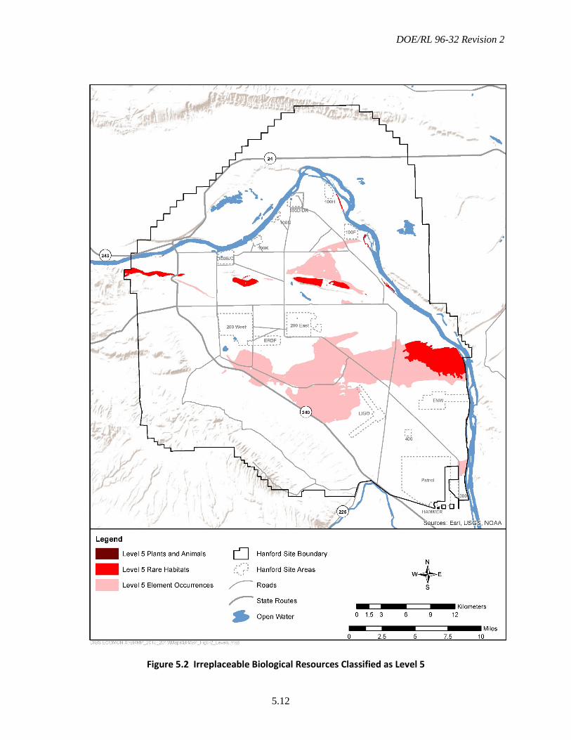
DOE/RL 96-32 Revision 2
5.12
Figure 5.2 Irreplaceable Biological Resources Classified as Level 5
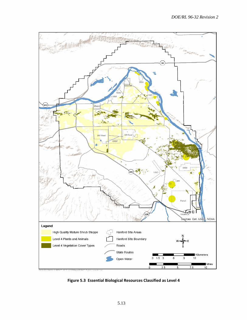
DOE/RL 96-32 Revision 2
5.13
Figure 5.3 Essential Biological Resources Classified as Level 4

DOE/RL 96-32 Revision 2
5.14
Figure 5.4 Important Biological Resources Classified as Level 3
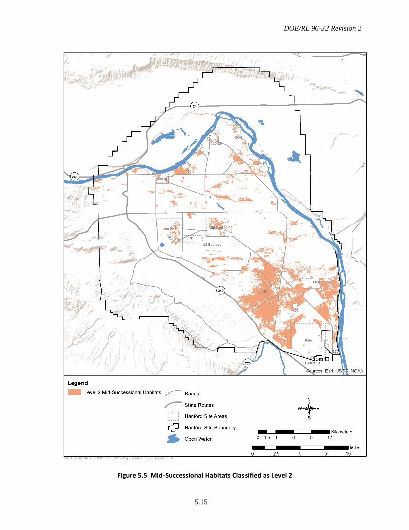
DOE/RL 96-32 Revision 2
5.15
Figure 5.5 Mid-Successional Habitats Classified as Level 2
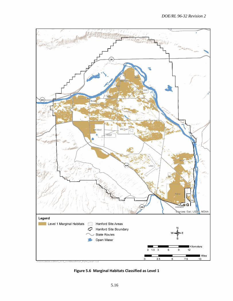
DOE/RL 96-32 Revision 2
5.16
Figure 5.6 Marginal Habitats Classified as Level 1
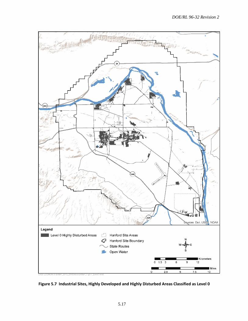
DOE/RL 96-32 Revision 2
5.17
Figure 5.7 Industrial Sites, Highly Developed and Highly Disturbed Areas Classified as Level 0
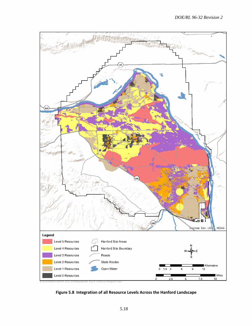
DOE/RL 96-32 Revision 2
5.18
Figure 5.8 Integration of all Resource Levels Across the Hanford Landscape
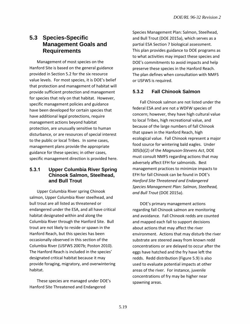
DOE/RL 96-32 Revision 2
5.19
5.3 Species-Specific Management Goals and Requirements
Management of most species on the Hanford Site is based on the general guidance provided in Section 5.2 for the six resource value levels. For most species, it is DOE’s belief that protection and management of habitat will provide sufficient protection and management for species that rely on that habitat. However, specific management policies and guidance have been developed for certain species that have additional legal protections, require management actions beyond habitat protection, are unusually sensitive to human disturbance, or are resources of special interest to the public or local Tribes. In some cases, management plans provide the appropriate guidance for these species; in other cases, specific management direction is provided here.
Upper Columbia River Spring Chinook Salmon, Steelhead, and Bull Trout
Upper Columbia River spring Chinook salmon, Upper Columbia River steelhead, and bull trout are all listed as threatened or endangered under the ESA, and all have critical habitat designated within and along the Columbia River through the Hanford Site. Bull trout are not likely to reside or spawn in the Hanford Reach, but this species has been occasionally observed in this section of the Columbia River (USFWS 2007b; Poston 2010). The Hanford Reach is included in the species’ designated critical habitat because it may provide foraging, migratory, and overwintering habitat.
These species are managed under DOE’s Hanford Site Threatened and Endangered
Species Management Plan: Salmon, Steelhead, and Bull Trout (DOE 2015a), which serves as a partial ESA Section 7 biological assessment. This plan provides guidance to DOE programs as to what activities may impact these species and DOE’s commitments to avoid impacts and help preserve these species in the Hanford Reach. The plan defines when consultation with NMFS or USFWS is required.
Fall Chinook Salmon
Fall Chinook salmon are not listed under the federal ESA and are not a WDFW species of concern; however, they have high cultural value to local Tribes, high recreational value, and because of the large numbers of fall Chinook that spawn in the Hanford Reach, high ecological value. Fall Chinook represent a major food source for wintering bald eagles. Under 305(b)(2) of the Magnuson-Stevens Act, DOE must consult NMFS regarding actions that may adversely affect EFH for salmonids. Best management practices to minimize impacts to EFH for fall Chinook can be found in DOE’s Hanford Site Threatened and Endangered Species Management Plan: Salmon, Steelhead, and Bull Trout (DOE 2015a).
DOE’s primary management actions regarding fall Chinook salmon are monitoring and avoidance. Fall Chinook redds are counted and mapped each fall to support decisions about actions that may affect the river environment. Actions that may disturb the river substrate are steered away from known redd concentrations or are delayed to occur after the eggs have hatched and the fry have left the redds. Redd distribution (Figure 5.9) is also used to evaluate potential impacts at other areas of the river. For instance, juvenile concentrations of fry may be higher near spawning areas.
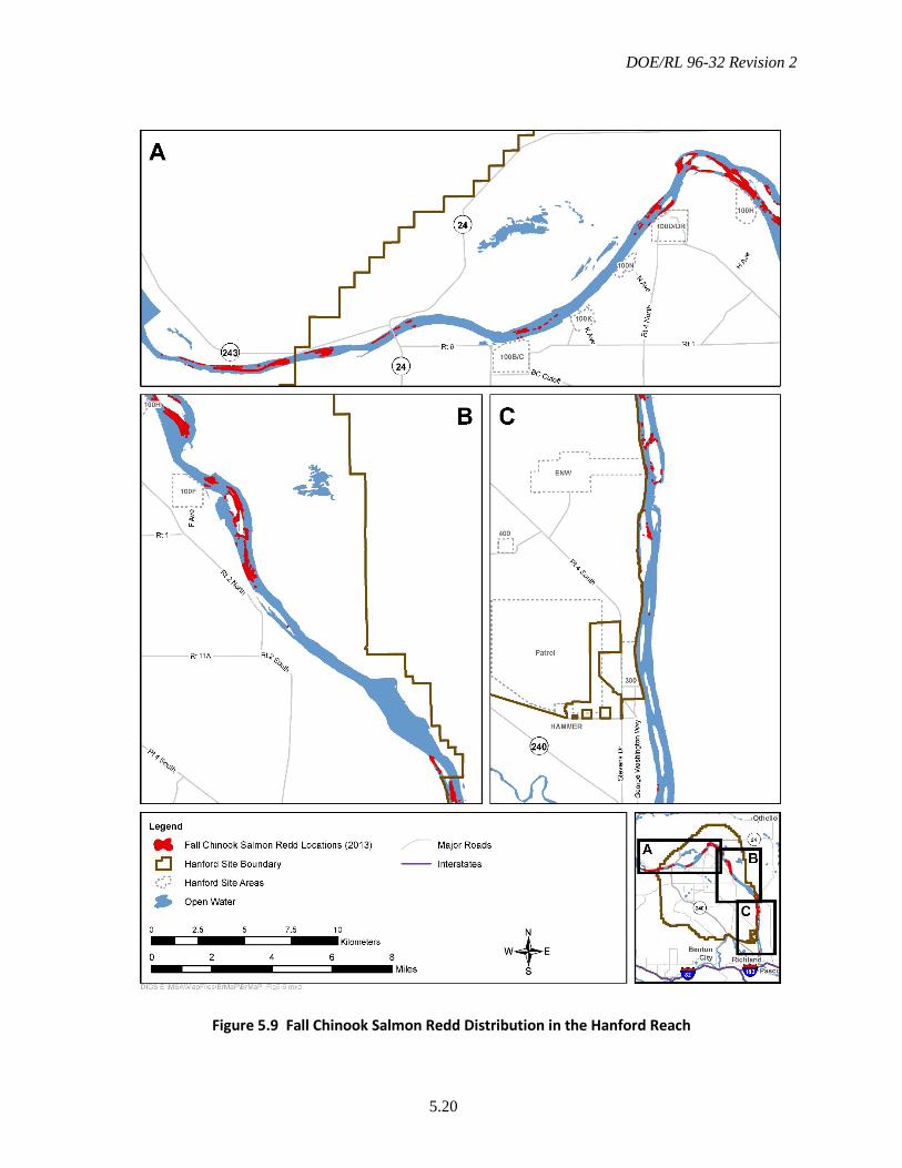
DOE/RL 96-32 Revision 2
5.20
Figure 5.9 Fall Chinook Salmon Redd Distribution in the Hanford Reach
DOE/RL 96-32 Revision 2
5.21
Bald Eagle
The bald eagle was removed from the federal threatened or endangered species list in 2007 (72 FR 37346-37372) and downgraded from threatened to sensitive by the WDFW in 2008 (Washington State Register [WSR] 08-03-068). The bald eagle has continued its recovery in the Northwest, and the recent Draft Periodic Status Review for the Bald Eagle in Washington (Kalasz and Buchanan 2016), recommends that this species be removed from Washington’s list of endangered species. However, this species is still protected under the Bald and Golden Eagle Protection Act, is of high cultural value to local Tribes, and is important to the public.
The DOE Bald Eagle Management Plan for the Hanford Site, South-Central Washington (DOE 2013b) describes DOE’s management policies. In most cases, bald eagle roost and active nest sites are protected with 400-m (0.25- mi) buffers. Work-related, routine access within night-roost buffer areas is allowed between the hours of 10 a.m. and 2 p.m.; however, no activities are allowed within nest buffer areas without a permit issued by the USFWS. Several eagle pairs have attempted to nest on the Hanford Site, and one pair has had a successful nest each year since 2013.
Figure 5.10 shows the location of the primary communal night roosts and buffer areas. DOE will continue to monitor roost usage by wintering bald eagles to determine which sites require roost buffers and will monitor potential nest sites to determine when nest area buffers need to be enforced. Because known roost or nest areas are considered Level 4 resources, damage or removal of trees within these areas is not allowed, even when eagles are not present.
Ferruginous Hawk
The ferruginous hawk is listed as threatened by Washington State, and is a USFWS species of concern for the Columbia Basin. Ferruginous hawks are obligate grassland or desert shrubland nesters (WDFW 2004). Home ranges have been measured at between 10 and 80 km2/pair (4 and 31 mi2/pair) and require at least 50% of the area to be non-cultivated (WDFW 1996). Natural nests are on cliffs, large trees, and occasionally on the ground, but on the Hanford Site, ferruginous hawks most frequently nest on 230-kV transmission line towers. Known nesting locations on the Hanford Site are shown in Figure 5.11. From the late 1980s to the present between 2 and 12 active nests have been observed on the Hanford Site, with a peak in the late 1990s. At times nearly 20% of Washington State breeding pairs have been on the Hanford Site (including central Hanford, ALE Reserve, and the Wahluke Slope).
Ferruginous hawks are much more sensitive to human disturbance and intrusion into nesting areas than other Buteo species (WDFW 2004). The Hanford Site complies with WDFW guidelines (WDFW 2004) that recommend buffers of at least 250 m (0.16 mi) for all human disturbance between March 1 and May 31, and 1000 m (0.6 mi) for prolonged (>0.5 h) activities during the entire nesting and fledging season. Surveys are performed annually across the Hanford Site to determine the location of active ferruginous hawk nests and establish and post disturbance buffers. DOE follows these guidelines for active nests, and considers the buffer areas to be Level 4 resources; thus, development, even during the non-nesting season, should be avoided in these areas.

DOE/RL 96-32 Revision 2
5.22
Figure 5.10 Bald Eagle Nests and Night Roost Sites with Buffers
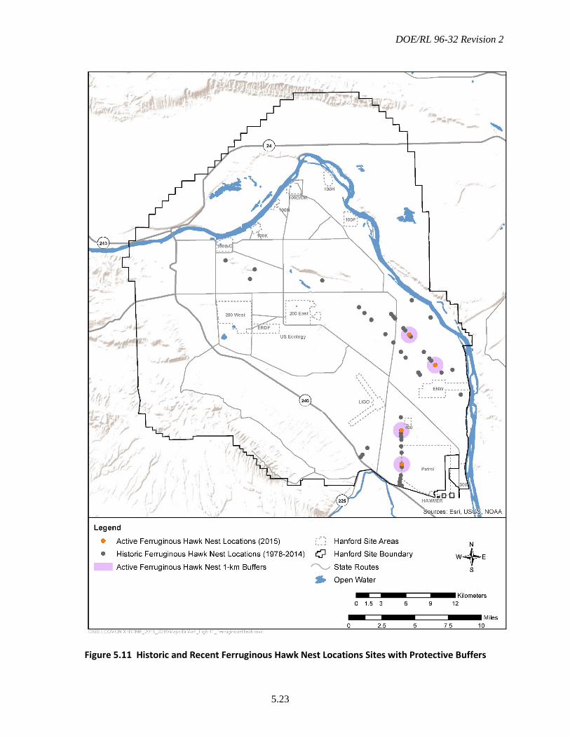
DOE/RL 96-32 Revision 2
5.23
Figure 5.11 Historic and Recent Ferruginous Hawk Nest Locations Sites with Protective Buffers
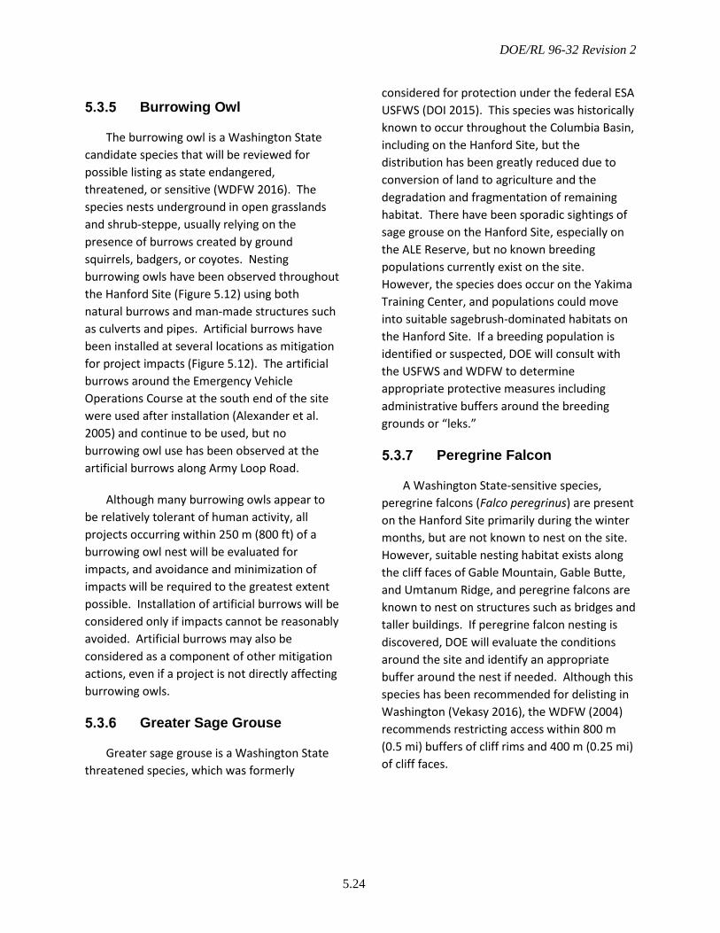
DOE/RL 96-32 Revision 2
5.24
Burrowing Owl
The burrowing owl is a Washington State candidate species that will be reviewed for possible listing as state endangered, threatened, or sensitive (WDFW 2016). The species nests underground in open grasslands and shrub-steppe, usually relying on the presence of burrows created by ground squirrels, badgers, or coyotes. Nesting burrowing owls have been observed throughout the Hanford Site (Figure 5.12) using both natural burrows and man-made structures such as culverts and pipes. Artificial burrows have been installed at several locations as mitigation for project impacts (Figure 5.12). The artificial burrows around the Emergency Vehicle Operations Course at the south end of the site were used after installation (Alexander et al. 2005) and continue to be used, but no burrowing owl use has been observed at the artificial burrows along Army Loop Road.
Although many burrowing owls appear to be relatively tolerant of human activity, all projects occurring within 250 m (800 ft) of a burrowing owl nest will be evaluated for impacts, and avoidance and minimization of impacts will be required to the greatest extent possible. Installation of artificial burrows will be considered only if impacts cannot be reasonably avoided. Artificial burrows may also be considered as a component of other mitigation actions, even if a project is not directly affecting burrowing owls.
Greater Sage Grouse
Greater sage grouse is a Washington State threatened species, which was formerly
considered for protection under the federal ESA USFWS (DOI 2015). This species was historically known to occur throughout the Columbia Basin, including on the Hanford Site, but the distribution has been greatly reduced due to conversion of land to agriculture and the degradation and fragmentation of remaining habitat. There have been sporadic sightings of sage grouse on the Hanford Site, especially on the ALE Reserve, but no known breeding populations currently exist on the site. However, the species does occur on the Yakima Training Center, and populations could move into suitable sagebrush-dominated habitats on the Hanford Site. If a breeding population is identified or suspected, DOE will consult with the USFWS and WDFW to determine appropriate protective measures including administrative buffers around the breeding grounds or “leks.”
Peregrine Falcon
A Washington State-sensitive species, peregrine falcons (Falco peregrinus) are present on the Hanford Site primarily during the winter months, but are not known to nest on the site. However, suitable nesting habitat exists along the cliff faces of Gable Mountain, Gable Butte, and Umtanum Ridge, and peregrine falcons are known to nest on structures such as bridges and taller buildings. If peregrine falcon nesting is discovered, DOE will evaluate the conditions around the site and identify an appropriate buffer around the nest if needed. Although this species has been recommended for delisting in Washington (Vekasy 2016), the WDFW (2004) recommends restricting access within 800 m (0.5 mi) buffers of cliff rims and 400 m (0.25 mi) of cliff faces.
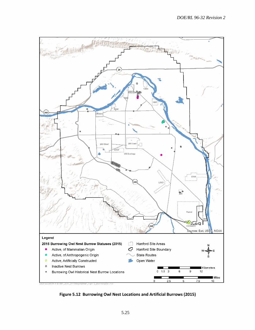
DOE/RL 96-32 Revision 2
5.25
Figure 5.12 Burrowing Owl Nest Locations and Artificial Burrows (2015)
DOE/RL 96-32 Revision 2
5.26
American White Pelican
The American white pelican (Pelicanus erythrorhynchos) is currently listed as endangered by Washington State; however, the number of this species has increased in recent years and the WDFW has recommended that it be down-graded to state-threatened (Stinson 2016). Although the white pelican is a resident along the Columbia River year-round, no nesting sites have been observed on the Hanford Reach, and the only known nesting colony in Washington is on Badger Island, approximately 39 km (24 mi) southeast of the Hanford Site. If nesting were to occur, it would likely be on islands in the Columbia River. The WDFW (2004) recommends that nest islands be closed to prevent human access, and that boating be limited within 400 to 800 m (0.25 to 0.5 mi) of breeding areas. If nesting is identified, DOE will work with USFWS and WDFW to evaluate the setting and potential threats and determine what, if any, specific protections or administrative controls it can implement to protect the nesting site.
Rookeries
Great blue herons (Ardea herodias) and other wading birds such as egrets (Ardea alba), black-crowned night herons (Nycticorax nycticorax), and cormorants (Phalacrocorax auritus) are colonial breeders, forming groups of nests called rookeries in tall trees near the Columbia River shoreline. Suitable rookery habitat is limited to isolated groves of trees on the site. Rookeries are considered priority habitats by the WDFW (WDFW 2008), and the primary threat to rookeries is tree removal. All rookeries will be identified so that impacts to those areas can be avoided or mitigated. Great blue herons can also be very sensitive to
disturbance, leading to possible colony abandonment. Each rookery will be managed on a case-by-case basis, considering existing levels of disturbance. The standard buffer for great blue heron rookeries is 300 m (1000 ft; WDFW 2004) from mid-February through July. Any proposed actions within 300 m (1000 ft) of a rookery will be assessed for impacts.
Raptors
The Hanford Site is home to a variety of raptors, including the American kestrel (Falco sparverius), great horned owl (Bubo virginianus), long-eared owl (Asio otus), osprey (Pandion haliaetus), prairie falcon (Falco mexicanus), red-tailed hawk (Buteo jamaicensis), and Swainson’s hawk (Buteo swainsoni). Raptor species observations on the Hanford Site in 2015 are shown in Figure 5.13. Most of these species reside along the Columbia River corridor, where both aquatic and terrestrial resources can be exploited, rather than the more arid Central Plateau. Bald eagles, burrowing owls, and ferruginous hawks are excluded from this section, as they are addressed elsewhere in this management plan.
Raptor species have likely benefitted from the restrictions of public access on the Hanford site, as well as the landscapes created by pre-Hanford agricultural settlement and the Manhattan/Cold-War Era built-environment. These cultural occupations of the Hanford site provided anthropogenic structures (e.g., transmission line towers and buildings) as well as domestic vegetation resources (e.g., locust and orchard trees) for raptor species nests and roosts (Nugent et al. 2016). Surveys are performed bi-annually to monitor the presence of raptor species and to understand their relationships to changes in jackrabbit and other prey populations.

DOE/RL 96-32 Revision 2
5.27
Figure 5.13 Raptors on the Hanford Site
DOE/RL 96-32 Revision 2
5.28
Ground Squirrels
The Washington ground squirrel (Urocitellus washingtoni) and Townsend’s ground squirrel (U. townsendii) are both listed as state candidate species by WDFW (2016), and the Washington ground squirrel is a candidate for federal protection under the ESA. These species play an important role in the Hanford ecosystem. Squirrels are a food source for many raptor species found on the site, as well as for some mammals, including badgers. Abandoned ground squirrel burrows can become burrowing owl burrows, supplying additional habitat for this candidate raptor species.
As colonies are identified, DOE will evaluate the setting and potential threats to each colony and will determine what, if any, specific protections or administrative controls can be implemented. The USFWS has successfully trapped and relocated Washington ground squirrel colonies in the area (Heidi Newsome, personal communication). Although not a preferred option, DOE will consider relocating colonies that otherwise would be destroyed by site activities. The locations of known Townsend’s ground squirrel colonies on the Hanford Site are shown in Figure 5.14. Washington ground squirrel colonies are known to occupy areas in the Saddle Mountains (Finger et al. 2007).
Bat Roosts
Approximately 10 species of bats may occur on the Hanford Site. Of these, pallid bats (Antrozous pallidus), canyon bats (Parastrellus hesperus), and spotted bats (Euderma maculatum) are classified as state monitor species while the Townsend’s big-eared bat (Corynorhinus townsendii) is classified as a state candidate and federal species of concern
(WDFW 2016). In addition, roosting congregations of big-brown bats (Eptesicus fuscus), myotis bats (Myotis spp.), and pallid bats are considered priority habitats by the WDFW (WDFW 2008). Maternity colonies of Yuma myotis (M. yumanensis) and pallid bats have been identified in the 100-F and 100-D Areas.
Maternity roosts, night roosts, and winter roosts for many of these species potentially occur on the Hanford Site. These roost locations are essential to the life cycle of these species, and individuals return to the locations to form colonies year-after-year. Thus, protection from disturbance and destruction is necessary. All known and newly identified bat roosts on the Hanford Site are mapped in a database. If bat roosts are identified in project areas, evaluations must be made by a qualified biologist to determine impacts and mitigation. If an important roost site is identified in a non-contaminated facility that is scheduled for demolition, DOE will evaluate whether the facility can be left in place as bat habitat, as has been determined at the 183-F and 100-D drywells. Bat boxes or alternative roosting structures may be provided to help mitigate the loss of roost sites that may occur from facility demolition.
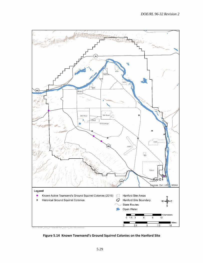
DOE/RL 96-32 Revision 2
5.29
Figure 5.14 Known Townsend’s Ground Squirrel Colonies on the Hanford Site
DOE/RL 96-32 Revision 2
5.30
Elk
Elk (Cervus elaphus) were first documented on the Hanford Site in the early 1970s (Lindsey et al. 2013a). With few natural predators, the elk population quickly grew, and the USFWS estimated elk herd size on the Hanford Site in the winter of 2014/15 to be more than 1100 individuals (USFWS 2015). This group of elk is referred to as the Rattlesnake Hills elk herd, which is a subset of the Yakima herd as defined by WDFW.
Smaller groups of the Rattlesnake Hills elk herd can be found on the DOE-managed portion of central Hanford, particularly during the winter months. Figure 5.15 shows the locations of elk sightings on DOE-managed lands in winter 2015-16. The largest group of elk seen during this period contained 77 individuals; in comparison, the largest herd counted on central Hanford in 2012 consisted of 37 individuals (Lindsey et al. 2013a).
Besides their importance to wildlife resource agencies and local Tribes, both as an indicator of overall habitat quality and as a game species, elk migrating across highways and major roadways pose potential hazards and conflicts with automobile traffic. DOE will continue to monitor elk populations and migration patterns on the DOE-managed lands of the Hanford Site and will work with USFWS to address population size issues as needed.
Black-Tailed Jackrabbit
The black-tailed jackrabbit (Lepus californicus) is a sagebrush-obligate species that also exploits areas of rabbitbrush (Chrysothamnus spp) and antelope bitterbrush (Purshia tridentata). Jackrabbits are currently candidates for listing on Washington’s threatened or endangered species list
(WDFW 2016). Jackrabbit presence on the Hanford Site seems to be decreasing compared to historical levels (Grzyb et al. 2016). Sightings of black-tailed jackrabbit on the Hanford Site from 2013 to 2015 are reflected in Figure 5.16.
To-date, monitoring efforts have focused on verifying black-tailed jackrabbit populations in areas known to contain preferred habitat through the use of trail cameras, incidental sightings, and snow surveys. DOE will continue to monitor, map, and study the black-tailed jackrabbit population bi-annually to establish a complete picture of populations across all DOE-managed lands. Information gathered from these activities assist DOE in better understanding the implications fluctuating populations levels of black-tailed jackrabbit may have on other predatory species.
Snake Hibernacula
Hibernacula provide habitat essential to the life cycle of snake species on the Hanford Site. Snakes depend on hibernacula for survival during the winter, as well as for reproduction. Snakes fill an important role in the ecosystems they occupy: eating a variety of prey and providing a source of food for other predators. Destruction of hibernacula can result in significant losses to local snake populations, including sensitive species such as the striped whipsnake (Masticophis taeniatus), night snake (Hypsiglena torquata), and yellow-bellied racer (Coluber constrictor) (Lindsey et al. 2013b).
All identified snake hibernacula are mapped and included in a long-term database. When a hibernaculum is identified, DOE will make reasonable efforts to protect it from disturbance and maintain natural habitat areas in the vicinity. Construction of potential new hibernacula sites will be included in site restoration efforts whenever feasible.

DOE/RL 96-32 Revision 2
5.31
Figure 5.15 Elk Sightings on the Central Hanford Site (Winter 2015-16)

DOE/RL 96-32 Revision 2
5.32
Figure 5.16 Black-Tailed Jackrabbit Observations on the Hanford Site
DOE/RL 96-32 Revision 2
5.33
Rare Plants
More than 50 plant species potentially exist on the Hanford Site that have been listed at various levels of concern by federal (ESA, 50 CFR 17) and state (WNHP 2015) resource agencies. Populations of these species are found throughout the Hanford Site (Figure 4.10) and could be impacted by site activities. DOE will continue to monitor known populations of rare plants on the Hanford Site and use the impact assessment process described in Chapter 6.0 to determine if site actions will adversely affect rare plants, and, if so, provide means to mitigate such impacts following the guidelines provided in Section 7.4.8. Project activities should not result in net losses of any plant species of concern classified at Level 3 or higher.
5.4 Resource Status and Trends Evaluation
Inventorying and monitoring biological resources at Hanford are critical management actions that allow DOE to show its activities are not resulting in significant adverse cumulative impacts to the biological resources present on the Hanford Site. Biological resources inventory and monitoring also provide the technical basis for resource management via an ecosystem management approach.
Much of the inventory work on Hanford’s biological resources (identity, location, population size, or community distribution) has been completed through various DOE ecological and biological surveys, the site ecosystem monitoring program, and The Nature Conservancy surveys. However, ongoing inventory work is needed for a number of
specific areas, habitat classes, species distributions, and other biological components. Completion of the Hanford Site biological inventory is vital because it is the first step in determining what the important biological resources are, where they are, and how they can most efficiently and effectively be protected.
Monitoring is a repetitive process through which the status and condition of a resource is followed over time. Monitoring may be directed at multiple levels, including the population or species level, habitat or plant community level, or ecosystem level. Most monitoring on the Hanford Site has been directed at identifying trends in populations to determine impacts from site activities, the status of certain species of concern to meet legally mandated protection requirements, or radioactive contaminant levels in selected organisms in various locations. Additional efforts have been initiated to monitor ecosystem integrity and the success of mitigation actions.
These monitoring efforts provide the technical basis for biological resources management policies and identify needed changes to those policies. Monitoring population, habitat, and ecosystem integrity will enable DOE to determine what activities are most impacting resources of concern, which resources are being most affected, and which should be reclassified into lower or higher levels of concern. Monitoring areas used for replacement mitigation will ensure that mitigation efforts are successful and that they meet commitments made in project- or program-specific Records of Decision or Mitigation Action Plans.

DOE/RL 96-32 Revision 2
5.34
This page intentionally left blank.
DOE/RL 96-32 Revision 2
6.1
6.0 Ecological Compliance Assessment
This chapter identifies and describes the organization, requirements, and procedures used to implement the ecological compliance assessment process on the Hanford Site, which includes impact assessment and impact management. Impact assessment is accomplished by evaluating potential impacts before they occur, and impact management is accomplished by avoiding or mitigating adverse impacts.
Mitigation is a series of prioritized actions that, taken together, reduce or eliminate adverse project impacts to biological resources. Mitigation actions that rely on changes to project timing or location to avoid or minimize impacts are considered part the ecological compliance assessment process and are described in this chapter. Mitigation actions that rely on replacement or improvements to habitat are part of the broader strategy for biological resources mitigation and are discussed in Chapter 7.0. For any specific project, the need for mitigation actions of any type is determined via the ECR, which is described in this chapter.
6.1 Background
Analyses of the ecological effects of major federal actions have a long history at the Hanford Site, particularly as implemented through compliance with NEPA. In 1993, to further ensure such analyses were applied uniformly, DOE issued directions requiring all Hanford Site contractors to obtain an ECR for all actions with the potential to impact ecological resources before initiating such action (DOE 1993a). The scope of projects requiring such evaluations includes those 1) being considered for functional equivalence under
CERCLA and/or RCRA, 2) projects covered under NEPA categorical exclusions, and 3) those for which a full NEPA evaluation is required.
Since 1994, the responsibility for conducting ECRs has been assigned to RL’s PSRP Program, currently managed by MSA, for all Hanford Site activities (DOE 1993b; DOE 1993c). The PSRP performs ECRs for all DOE-related activities that take place within the Hanford Site and for DOE-activities within the HRNM, including those areas currently managed by the USFWS. The USFWS evaluates and manages impacts resulting from its own activities on the HRNM.
Non-RL/ORP federal agencies, such as the Bonneville Power Administration or the DOE Office of Science, and non-federal entities performing non-RL/ORP funded work on the Hanford Site must comply with the resource protection aspects of BRMP. However, these agencies have latitude in selecting a contractor to perform the ECR or comparable ecological analyses, such as collecting field data in support of an EIS.
6.2 Ecological Compliance Reviews
Ecological compliance reviews are performed before projects are implemented to identify and assess any impacts that may occur and identify opportunities to avoid or minimize those impacts. The review process helps ensure Hanford Site programmatic objectives are met. It also ensures protection of the site’s resources and compliance with applicable laws, regulations, Executive Orders, and DOE Orders.
Impacts to ecological resources are evaluated through a trackable ECR process that

DOE/RL 96-32 Revision 2
6.2
relies on field and desktop assessments of the presence of species and/or habitats of concern and any previous assessments done within a project region. The objectives of an ECR are to:
• Assess the potential for proposed Hanford activities to adversely affect biological resources of concern.
• Ensure compliance with relevant laws such as the ESA, MBTA, and other regulations, orders, and guidelines.
• Provide timely information to project managers to support planning decisions.
• Identify mitigation requirements and options.
• Document the results of the assessment for the proposed project and DOE.
The ECR process ensures that actual and potential impacts of Hanford Site operations on biological resources of concern are identified and evaluated, and impacts to protected species are evaluated and documented in compliance with the ESA, NEPA, and other applicable laws, regulations, and orders. In addition, the ECRs provide DOE with the information it needs to interact productively with federal, state, and tribal agencies on ecological resource issues. The ECR process also provides the information needed to evaluate the cumulative impacts of all Hanford projects on the ecological resources of the site.
Projects requiring ECRs are those that have the potential to adversely affect biological resources of concern on the Hanford Site. Resources of concern include those categories of species or their habitats that are identified under DOE’s NEPA implementing procedures, as well as state candidate, sensitive, and monitor species. Additionally, migratory birds, floodplains, wetlands, and other unique
habitats are considered resources of concern on the Hanford Site. Chapter 5.0 categorizes all species and habitats on the Hanford Site by levels representing the continuum of resource value. Each level has specific management and mitigation requirements.
Actions Requiring an Ecological Compliance Review
Any site action with the potential to affect ecological resources of concern adversely requires an ECR. This includes actions that are covered under NEPA categorical exclusions. Project planners may use the decision flowchart shown in Figure 6.1, or use Site Form A-6006-139, Criteria for Determining the Need for Ecological and Cultural Resources Reviews and Clearance, to determine if an ECR is needed for a specific action. If the answer at any level on the decision flowchart is “yes” or “maybe,” the project should either submit a review request or informally contact the ecological compliance contact provided on Site Form A-6006-139 to discuss if a formal ECR is needed. Not all “yes” answers will definitively lead to the need for an ECR. If there is any question, the project planner should contact the ecological compliance contact.
Examples of activities that generally require an ECR include those that:
• Require an excavation permit
• Remove or modify dead or living vegetative cover
• Would be conducted on the outside of buildings and facilities
• Would be conducted within abandoned buildings and facilities

DOE/RL 96-32 Revision 2
6.3
• Would result in chemical or radiological releases requiring changes to existing permits
• Have the potential to alter or affect the living environment, such as landscape-scale applications of fertilizers, herbicides, prescribed fire, or fire recovery efforts.
Figure 6.1 Flowchart to Determine Need for Ecological Compliance Review
DOE/RL 96-32 Revision 2
6.4
Biological Resources of Concern
Resources considered during the ECR process include all those described as Levels 5 through 1. The higher the value level, the greater emphasis the resource receives during the ECR process. Particular species and habitats include the following:
• Federal endangered, threatened, proposed, or candidate species
• Washington State endangered, threatened, candidate, sensitive, monitor, review, or watch list species
• Bird species listed under the MBTA
• Rare or sensitive habitats, including terrestrial vegetation associations identified by Washington State as element occurrences, wetlands, floodplains, riparian communities, swales, dunes, basalt outcrops, cliffs, and mid- and late-successional sagebrush steppe
• Anadromous fish spawning areas
• Bald eagle night roost and active nest locations
• Ferruginous hawk and burrowing owl nest locations
• Landscape features related to specific habitats, communities, or species.
Impact assessments consider direct and simple indirect effects to biological resources of concern. Direct effects include mortality, habitat loss (reproductive, cover/roosting, foraging habitat), nest or den destruction, or disturbance, such as visual or noise impacts causing loss of productivity. Simple indirect effects include habitat fragmentation, increased edge effects, and introduction of potential competitors or predators. Indirect effects will often be considered qualitatively, but as quantitative tools are developed, such as habitat suitability models, they may be incorporated quantitatively into the effects evaluation. Table 6.1 shows the sources considered in determining impacts.
Determination of impact is based on whether a species of concern may be present and whether the proposed action could result in any of the impacts described in Table 6.1. Presence of a species of concern can be determined by direct observation or inferred based on habitat because many species of concern have very specific habitat requirements, which are described in the scientific literature. When suitable habitat is present within a project area, impacts to species of concern that may use those habitats should be evaluated.
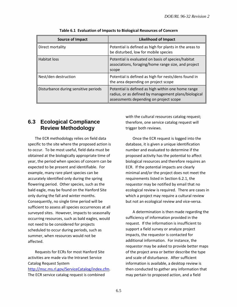
DOE/RL 96-32 Revision 2
6.5
Table 6.1 Evaluation of Impacts to Biological Resources of Concern
6.3 Ecological Compliance Review Methodology
The ECR methodology relies on field data specific to the site where the proposed action is to occur. To be most useful, field data must be obtained at the biologically appropriate time of year, the period when species of concern can be expected to be present and identifiable. For example, many rare plant species can be accurately identified only during the spring flowering period. Other species, such as the bald eagle, may be found on the Hanford Site only during the fall and winter months. Consequently, no single time period will be sufficient to assess all species occurrences at all surveyed sites. However, impacts to seasonally occurring resources, such as bald eagles, would not need to be considered for projects scheduled to occur during periods, such as summer, when resources would not be affected.
Requests for ECRs for most Hanford Site activities are made via the Intranet Service Catalog Request System http://msc.ms.rl.gov/ServiceCatalog/index.cfm. The ECR service catalog request is combined
with the cultural resources catalog request; therefore, one service catalog request will trigger both reviews.
Once the ECR request is logged into the database, it is given a unique identification number and evaluated to determine if the proposed activity has the potential to affect biological resources and therefore requires an ECR. If the potential impacts are clearly minimal and/or the project does not meet the requirements listed in Section 6.2.1, the requestor may be notified by email that no ecological review is required. There are cases in which a project may require a cultural review but not an ecological review and vice-versa.
A determination is then made regarding the sufficiency of information provided in the request. If the information is insufficient to support a field survey or analyze project impacts, the requestor is contacted for additional information. For instance, the requestor may be asked to provide better maps of the project area or better describe the type and scale of disturbance. After sufficient information is available, a desktop review is then conducted to gather any information that may pertain to proposed action, and a field
Source of Impact Likelihood of Impact
Direct mortality Potential is defined as high for plants in the areas to be disturbed, low for mobile species
Habitat loss Potential is evaluated on basis of species/habitat associations, foraging/home range size, and project scope
Nest/den destruction Potential is defined as high for nests/dens found in the area depending on project scope
Disturbance during sensitive periods Potential is defined as high within one home range radius, or as defined by management plans/biological assessments depending on project scope
DOE/RL 96-32 Revision 2
6.6
survey is conducted if needed. The ecological compliance staff will use information gathered during the desktop evaluation and/or field survey to evaluate the potential impacts of the proposed project on species or habitats of concern.
For efficiency purposes and cost considerations during the desktop evaluation, staff query the ecological compliance database to determine whether a field survey has been performed at or near the proposed project site within the last year. When such data exist and are adequate, the ECR may be based on this information, as well as pertinent information from other available data sources or databases. When previously collected data are used, additional site inspections may be required prior to conducting the proposed activity to ensure nesting migratory birds are not impacted because conditions may have changed (e.g., birds began nesting) since the previous survey was conducted.
The desktop review may also include photographic evidence provided by the requestor, which can partially substitute for an onsite inspection by the ecological compliance review staff if the photographs clearly indicate the location of the proposed project and specific area, such as a paved or graveled parking lot, that will be disturbed contain no biological resources. If adequate existing data are not available, site-specific field surveys will be completed as appropriate.
Site-specific field surveys include a walk down of the proposed project area by a qualified biologist, who records the presence, distribution, and abundance of all plants and animals observed. Spatial data and digital photography may also become part of the survey record. These data are then entered into the appropriate databases for storage and
query. As previously mentioned, detection of some species, such as spring flowers and wintering eagles, is temporally limited, and the biologist will take this into account when scheduling or performing surveys.
6.4 Ecological Compliance Review Reporting and Documentation
Compliance review reporting consists of a letter report to the requestor documenting the ECR and its findings. Contents of ECR reports vary according to the type of action under review, but all reports contain the action title and description, assigned review number, objectives of the review, and findings. Table 6.2 shows specific contents for actions that would cause minor disturbance in paved or graveled areas, those that will not result in loss of mitigable habitat and those that will. Mitigable habitats include the following:
• Habitats necessary for plant and animal species of concern
• Rare or unusual plant assemblages as defined in the Washington Natural Heritage Plan (WDNR 2011)
• Habitats with high native plant or animal diversity
• Habitats lacking significant anthropogenic disturbance
• Habitats specifically protected under state or federal regulation such as jurisdictional wetlands.
ECR letter reports for projects that will not result in loss of mitigable habitat include the following information: 1) a reference to the physical field survey performed as the basis for the review; 2) a description of the affected habitat, the primary plant and animal species that could be affected by the action, and any
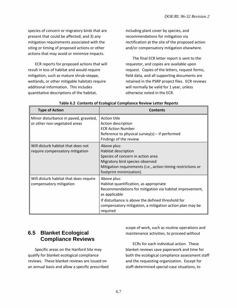
DOE/RL 96-32 Revision 2
6.7
species of concern or migratory birds that are present that could be affected; and 3) any mitigation requirements associated with the siting or timing of proposed actions or other actions that may avoid or minimize impacts.
ECR reports for proposed actions that will result in loss of habitat and would require mitigation, such as mature shrub-steppe, wetlands, or other mitigable habitats require additional information. This includes quantitative descriptions of the habitat,
including plant cover by species, and recommendations for mitigation via rectification at the site of the proposed action and/or compensatory mitigation elsewhere.
The final ECR letter report is sent to the requestor, and copies are available upon request. Copies of the letters, request forms, field data, and all supporting documents are retained in the PSRP project files. ECR reviews will normally be valid for 1 year, unless otherwise noted in the ECR.
Table 6.2 Contents of Ecological Compliance Review Letter Reports
Type of Action Contents
Minor disturbance in paved, graveled, or other non-vegetated areas
Action title Action description ECR Action Number Reference to physical survey(s) – if performed Findings of the review
Will disturb habitat that does not require compensatory mitigation
Above plus: Habitat description Species of concern in action area Migratory bird species observed Mitigation requirements (i.e., action timing restrictions or footprint minimization)
Will disturb habitat that does require compensatory mitigation
Above plus: Habitat quantification, as appropriate Recommendations for mitigation via habitat improvement, as applicable If disturbance is above the defined threshold for compensatory mitigation, a mitigation action plan may be required
6.5 Blanket Ecological Compliance Reviews
Specific areas on the Hanford Site may qualify for blanket ecological compliance reviews. These blanket reviews are issued on an annual basis and allow a specific prescribed
scope of work, such as routine operations and maintenance activities, to proceed without
ECRs for each individual action. These blanket reviews save paperwork and time for both the ecological compliance assessment staff and the requesting organization. Except for staff-determined special-case situations, to

DOE/RL 96-32 Revision 2
6.8
qualify for a blanket review, an area must meet the following criteria:
• Already highly disturbed habitat or little to no value for flora or fauna (typically Level 0)
• Clearly defined boundaries
• Low probability of adverse ecological impacts
• Considerable project activity that would require numerous individual reviews per year.
Areas that have qualified for blanket ecological compliance reviews in the past include the 100-K Area, the 200 Areas tank, the Plutonium Finishing Plant, and active portions of the solid waste burial grounds in the 200 Areas. Blanket ecological compliance reviews contain recommendations to reduce impacts to ecological resources that may be specific to the area and require that any nesting birds be reported to ecological compliance staff to determine if they are a protected species, such as a migratory species.
Blanket reviews will usually provide complete coverage during the non-nesting season, generally late July to early March, and non-migratory bird coverage during the nesting season. The potential for impacts to nesting migratory birds must be considered on a project-by-project basis during nesting season. Blanket reviews need to be periodically re-examined and re-issued to allow ecological compliance staff to ensure blanket area environmental compliance officers and project staff are aware of any management changes they need to be aware of, for instance, changes in bald eagle night roost exclusion areas or ferruginous hawk buffers. In addition, any unexpected change in conditions or changes to
project scope will require re-evaluation of the blanket review to ensure its adequacy.
Because ecological and cultural resource reviews are conducted in tandem, a blanket ecological review is normally most useful for areas where a similar review exemption exists for cultural resources.
6.6 Cumulative Impact Reporting
As funding permits, the ecological compliance assessment staff will prepare an annual summary of projects reviewed. At a minimum, this summary will be included as part of the annual Hanford Site Environmental Report (DOE 2015d). The summary will detail potentially significant activities during the year, and may include the following information:
• Number of review requests received and processed, by type of action and action contractor
• Breakdown of review requests by area of the site, affected habitat, and affected species
• Acreage of habitats converted to other uses
• Summary of actions affecting federal- or state-listed species
• Summary of interactions with projects that limit impacts to species of concern and habitats, such as implementation of measures to avoid or minimize impacts
• Summary of mitigation recommendations involving necessary habitat improvement onsite or offsite
• Summary of interactions with the USFWS, NMFS, or WDFW regarding action impacts to Hanford Site plants, fish, and wildlife

DOE/RL 96-32 Revision 2
6.9
• Assessment of cumulative impact, such as habitat fragmentation changes from previous environmental baseline
• Assessment of the effectiveness of previously implemented mitigation projects.
6.7 Impact Management Recommendations
Although DOE recognizes that adverse impacts to biological resources cannot always be eliminated, the potential for impacts must be considered during the early phases of project development and their consequences incorporated in decision making. Means to accomplish impact avoidance or minimization are identified through the ECR and project site selection processes before project implementation. The ECR may include recommendations to avoid or minimize adverse impacts to ecological resources by:
• Implementing alternatives that would result in fewer adverse impacts
• Locating projects at a less ecologically sensitive site
• Reducing or modifying the project footprint
• Scheduling project activities so that disruption of key species and functions is minimized.
In unusual cases when significant impacts cannot be reasonably avoided or minimized, the
ECR will provide recommendations for compensatory mitigation based on the characteristics of the habitat that will be disturbed. Implementation of such mitigation will be in accordance with the requirements and procedures defined in Chapter 7.0. If mitigation beyond avoidance and minimization is likely, ecological compliance assessment staff will meet with the project staff (both DOE and contractor) to:
• Provide information on potentially significant biological issues pertinent to a specific project.
• Help identify alternatives to the proposed action that could reduce adverse impacts.
• Provide information on the location of important biological resources to assist, as necessary, in the Hanford Site selection process for individual projects.
• Present information on Hanford policy with regard to mitigation.
• Develop a common schedule for conducting an ECR that would minimize impacts to the schedule of the proposed project.
These meetings will be schedule as needed. Ecological compliance staff will attempt to initiate interactions in a proactive manner when informed of upcoming major actions. These efforts and resulting recommendations will be reported to DOE via regular reporting processes.

DOE/RL 96-32 Revision 2
6.10
This page intentionally left blank.
DOE/RL 96-32 Revision 2
7.11
7.0 Biological Resource Mitigation Strategy
This chapter identifies and describes the biological resource mitigation strategy on the Hanford Site. It focuses primarily on mitigation actions that rely on habitat improvement, rectification, and compensation. Habitat improvement may be necessary for projects that eliminate or degrade habitat. However, mitigation actions based on avoidance or minimization of adverse impacts, such as changes to project timing or location, are the most important components of the overall mitigation strategy. These mitigation actions are implemented via the interactive impact assessment and management process described in Chapter 6.0. Mitigation of impacts to species listed under the ESA will be determined under the consultation requirements in Section 7 of the ESA.
This chapter also provides guidance on accounting for habitat protection or improvement as part of the project planning process. In addition, it provides guidance and a reference for preparation of project-specific MAPs under the DOE NEPA implementation procedures (10 CFR 1021). This includes a brief overview of suggested contents for project-specific MAPs.
7.1 Mitigation Strategy Overview
Mitigation is a series of prioritized actions intended to reduce or eliminate adverse
impacts to biological resources. These actions include avoidance, minimization, onsite rectification, and compensation (Table 7.1). The basis of this strategy is that a project begins mitigation at the avoidance level of the hierarchy and only moves to the next level if reasonable options at the previous level are exhausted.
To facilitate a balance between Hanford Site mission elements and stewardship obligations, the BRMP mitigation strategy is intended to:
• Divert impacts away from higher priority toward lower priority resources
• Ensure consistent and effective implementation of mitigation recommendations and requirements
• Ensure biological resource mitigation measures meet the responsibilities committed to by DOE within a NEPA or CERCLA ROD or a NEPA finding of no significant impact
• Enable Hanford Site projects to anticipate and plan for mitigation needs via early identification of mitigation requirements
• Provide guidance for implementing cost-effective mitigation actions
• Conserve Hanford’s biological resources while facilitating balanced development and cleanup activities.
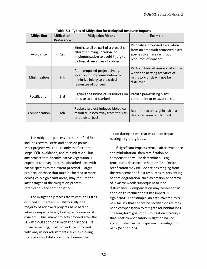
DOE/RL 96-32 Revision 2
7.2
Table 7.1 Types of Mitigation for Biological Resource Impacts Mitigation Utilization
Preference Mitigation Means Example
Avoidance 1st
Eliminate all or part of a project or alter the timing, location, or implementation to avoid injury to biological resources of concern
Relocate a proposed excavation from an area with protected plant species to an area without resources of concern
Minimization 2nd
Alter proposed project timing, location, or implementation to minimize injury to biological resources of concern
Perform habitat removal at a time when the nesting activities of migratory birds will not be disturbed
Rectification 3rd Replace the biological resources on the site to be disturbed
Return pre-existing plant community to excavation site
Compensation 4th Replace project-induced biological resource losses away from the site to be disturbed
Replant mature sagebrush in a degraded area on Hanford
The mitigation process on the Hanford Site includes several steps and decision points. Most projects will require only the first three steps: ECR, avoidance, and minimization. But, any project that disturbs native vegetation is expected to revegetate the disturbed area with native species to the extent practical. Larger projects, or those that must be located in more ecologically significant areas, may require the latter stages of the mitigation process: rectification and compensation.
The mitigation process starts with an ECR as outlined in Chapter 6.0. Historically, the majority of reviewed projects have had no adverse impacts to any biological resources of concern. Thus, many projects proceed after the ECR without additional mitigation actions. Of those remaining, most projects can proceed with only minor adjustments, such as moving the site a short distance or performing the
action during a time that would not impact nesting migratory birds.
If significant impacts remain after avoidance and minimization, then rectification or compensation will be determined using procedures described in Section 7.4. Onsite rectification may include actions ranging from the replacement of lost resources to preventing habitat degradation, such as erosion or control of invasive weeds subsequent to land disturbance. Compensation may be needed in addition to rectification if the impact is significant. For example, an area covered by a new facility that cannot be rectified onsite may need compensation to mitigate for habitat loss. The long-term goal of this mitigation strategy is that most compensatory mitigation will be accomplished via participation in a mitigation bank (Section 7.5).
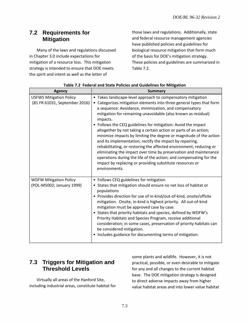
DOE/RL 96-32 Revision 2
7.3
7.2 Requirements for Mitigation
Many of the laws and regulations discussed in Chapter 3.0 include expectations for mitigation of a resource loss. This mitigation strategy is intended to ensure that DOE meets the spirit and intent as well as the letter of
those laws and regulations. Additionally, state and federal resource management agencies have published policies and guidelines for biological resource mitigation that form much of the basis for DOE’s mitigation strategy. These policies and guidelines are summarized in Table 7.2.
Table 7.2 Federal and State Policies and Guidelines for Mitigation Agency Summary
USFWS Mitigation Policy (81 FR 61031, September 2016)
• Takes landscape-level approach to compensatory mitigation • Categorizes mitigation elements into three general types that form
a sequence: Avoidance, minimization, and compensatory mitigation for remaining unavoidable (also known as residual) impacts.
• Follows the CEQ guidelines for mitigation: Avoid the impact altogether by not taking a certain action or parts of an action; minimize impacts by limiting the degree or magnitude of the action and its implementation; rectify the impact by repairing, rehabilitating, or restoring the affected environment; reducing or eliminating the impact over time by preservation and maintenance operations during the life of the action; and compensating for the impact by replacing or providing substitute resources or environments.
WDFW Mitigation Policy (POL-M5002; January 1999)
• Follows CEQ guidelines for mitigation • States that mitigation should ensure no net loss of habitat or
populations • Provides direction for use of in-kind/out-of-kind, onsite/offsite
mitigation. Onsite, in-kind is highest priority. All out-of-kind mitigation must be approved case by case.
• States that priority habitats and species, defined by WDFW’s Priority Habitats and Species Program, receive additional consideration; in some cases, preservation of priority habitats can be considered mitigation.
• Includes guidance for documenting terms of mitigation.
7.3 Triggers for Mitigation and Threshold Levels
Virtually all areas of the Hanford Site, including industrial areas, constitute habitat for
some plants and wildlife. However, it is not practical, possible, or even desirable to mitigate for any and all changes to the current habitat base. The DOE mitigation strategy is designed to direct adverse impacts away from higher value habitat areas and into lower value habitat
DOE/RL 96-32 Revision 2
7.4
areas, or preferably, into areas that are already disturbed and contain little or no habitat value. Two obvious benefits from avoiding adverse impacts are reduced costs to projects and preservation of highly valued biological resources and habitats.
It is the policy of DOE to determine mitigation requirements based on resource value, as described in Chapter 5.0, rather than strictly on the size of the impacted area. Impacts to higher value resources will result in greater mitigation commitments than impacts to lower value resources. This policy encourages projects to be located in areas with low extant habitat value because the mitigation requirements associated with these areas will be less than the requirements associated with the disturbance of the same acreage of higher quality habitat.
Impact thresholds will depend on the point in the mitigation hierarchy the project is at, as well as the particular resource(s) that may be impacted. In the first two steps of the mitigation process, avoidance and minimization, no set threshold level exists if managed resources are present. All projects are expected to avoid and minimize adverse impacts to the greatest extent possible, and should weigh these considerations equally with other project siting criteria. Likewise, all projects are expected to rectify impacts at the project site to the extent practicable, including replanting disturbed areas with native species.
Some resources have specific regulatory requirements that may affect mitigation considerations such as threshold level. For instance, jurisdictional wetlands have no mitigation threshold level, and any impact would likely require mitigation as part of the Clean Water Act Section 404 permit from the USACE.
For Level 2, 3, or 4 habitat resources, such as steppe, shrub-steppe, and other habitats, compensatory mitigation may be triggered if the impact, after avoidance, minimization, and onsite rectification, is greater than 0.5 ha (1.2 ac), regardless of the project’s location.
7.4 Implementation
Implementation follows the order of mitigation priorities presented in Table 7.1. Impacts should be avoided or minimized if possible, and rectified or compensated only if avoidance and minimization do not satisfy all project mitigation needs and the residual impacts are above the mitigation threshold identified in Section 7.3. Avoidance and minimization actions are likely to be less costly, have less potential to adversely impact project schedules, and cause less injury to biological resources than actions that rely on habitat improvement. If compensatory mitigation is required away from the project site, mitigation requirements should be met through participation in a mitigation bank, if available, as described in Sections 7.4.3 and 7.5.
Identifying Mitigation Needs
Mitigation should be identified and implemented as early in the project as possible. If not determined earlier, mitigation needs are identified during the ecological compliance assessment process. Impact management should occur during the site-selection process to address the avoidance and minimization steps of the mitigation process, thereby reducing the need for rectification and/or compensation. Additional mitigation needs may be identified later in the project via the ecological compliance review as described in Chapter 6.0.

DOE/RL 96-32 Revision 2
7.5
Mitigation at a Project Site
Mitigation at the project site includes avoiding, minimizing, or rectifying project impacts (Table 7.1). Project impacts can be avoided or minimized by taking actions such as the following:
• Implementing non-disturbing alternatives
• Locating a project at a less ecologically sensitive site
• Reducing project land-use requirements
• Scheduling project activities to minimize disturbance to biological resources of concern.
Mitigation Away from a Project Site
Projects that are unable to reduce the impacts below mitigation thresholds via avoidance and/or minimization, and are unable to rectify the loss on the project site fully, will perform mitigation away from the project site. In most cases, this mitigation will consist of habitat improvements at a selected mitigation area; although, in some cases, other methods, such as acquisition of high-quality, at-risk lands may be an option.
The siting of mitigation areas should be performed within the context of the CLUP and Hanford Site biological resource management goals, and should consider landscape-scale factors to best enhance or complement existing resources. Mitigation areas include lands that will allow for in-kind replacement of habitat value lost at project sites and should be:
• Contained either wholly within DOE-administered or managed lands or on the HRNM.
• Placed in regions designated within the CLUP as conservation or preservation areas.
• Located near, within, and/or surrounding lands that possess significant habitat value.
• Adjacent to areas that are already protected or to areas with complementary habitat if management objectives include preserving a mosaic of habitat types.
• Capable of serving as a core area of wildlife usage as well as a wildlife travel corridor either within the Hanford Site or between the site and adjacent non-DOE lands.
• Able to balance the effects of large-scale disturbance and habitat fragmentation.
• Viewed in the context of the surrounding landscape, including lands adjacent to Hanford.
• Capable of achieving in-kind habitat value replacement via habitat improvement. The habitat potential of the mitigation area and project impact area must be similar.
• Located in a non-radiological control area or non-hazardous materials management area.
Mitigation Levels and Ratios
Mitigation levels range from impact avoidance to compensation (Table 7.1). A mitigation replacement ratio is the ratio of the quantity of habitat units created at a compensation site to the quantity lost at the site of adverse impacts. Sometimes this may translate as the area over which mitigation measures are applied to the area receiving
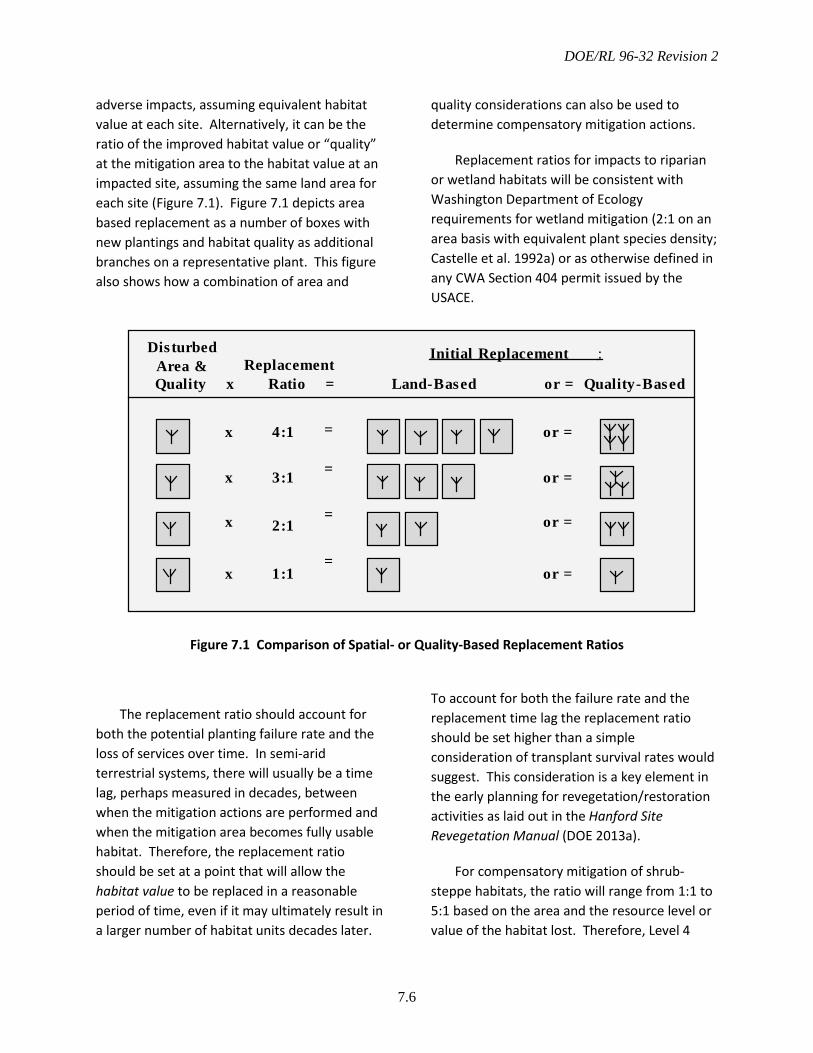
DOE/RL 96-32 Revision 2
7.6
adverse impacts, assuming equivalent habitat value at each site. Alternatively, it can be the ratio of the improved habitat value or “quality” at the mitigation area to the habitat value at an impacted site, assuming the same land area for each site (Figure 7.1). Figure 7.1 depicts area based replacement as a number of boxes with new plantings and habitat quality as additional branches on a representative plant. This figure also shows how a combination of area and
quality considerations can also be used to determine compensatory mitigation actions.
Replacement ratios for impacts to riparian or wetland habitats will be consistent with Washington Department of Ecology requirements for wetland mitigation (2:1 on an area basis with equivalent plant species density; Castelle et al. 1992a) or as otherwise defined in any CWA Section 404 permit issued by the USACE.
Figure 7.1 Comparison of Spatial- or Quality-Based Replacement Ratios
The replacement ratio should account for both the potential planting failure rate and the loss of services over time. In semi-arid terrestrial systems, there will usually be a time lag, perhaps measured in decades, between when the mitigation actions are performed and when the mitigation area becomes fully usable habitat. Therefore, the replacement ratio should be set at a point that will allow the habitat value to be replaced in a reasonable period of time, even if it may ultimately result in a larger number of habitat units decades later.
To account for both the failure rate and the replacement time lag the replacement ratio should be set higher than a simple consideration of transplant survival rates would suggest. This consideration is a key element in the early planning for revegetation/restoration activities as laid out in the Hanford Site Revegetation Manual (DOE 2013a).
For compensatory mitigation of shrub-steppe habitats, the ratio will range from 1:1 to 5:1 based on the area and the resource level or value of the habitat lost. Therefore, Level 4
DisturbedArea &Quality
ReplacementRatio Land-Based Quality-Basedx = or =
or =
or =
or =
or =
x
x
x
x
4:1
3:1
2:1
1:1
Initial Replacementi
:
=
=
=
=

DOE/RL 96-32 Revision 2
7.7
habitat areas will be replaced at a higher ratio than Level 3 or 2 habitat areas. Rectification at the site of impact should be used for a portion of the mitigation action, when feasible, and may satisfy all the mitigation requirements for Level 2 habitat areas.
Mitigation ratios are specifically designed to compensate for losses of vegetative habitat. However, other resources, such as snake hibernacula, bat roosts, ground squirrel colonies, burrowing owl burrows, eagle roosting areas, heron rookeries, and others could be impacted and may also require mitigation. For these types of impacts, it is not feasible to follow the same ratios as outlined for losses of vegetative habitat. Therefore, a qualified biologist must determine the appropriate type and amount of mitigation actions needed to offset the impact. The type and amount of mitigation must take into account the resource level of the species being impacted, the severity of the impact, and the likelihood of success.
Habitat Mitigation Replacement Units
Successful planning and budgeting for mitigation commitments require that the level of effort, number of transplanted shrubs or tublings, and quantity and type of seed needed to achieve the mitigation goals be quantified in the early stages of project planning. Ideally, the level of effort is determined based on the habitat value at the project site and the level of improvement possible through rectification or through compensation at a mitigation area. Quantitative habitat value models are required for these calculations. Because such models are not available, projects that disturb late-successional sagebrush steppe will plan for replacement mitigation using standard replacement units. Replacement units for other habitats will be developed as needed.
As an example, a project replacing habitat via rectification at a ratio of 1:1 should plan for 1 replacement unit/ha disturbed habitat. A project replacing habitat via compensatory mitigation at a ratio of 3:1 should plan for three replacement units/ha disturbed habitat.
A replacement unit for late-successional sagebrush steppe will consist of:
• 1500 shrubs/ha (600/ac)
• 1500 forbs/ha (600/ac)
• Native, perennial bunchgrass understory either already present or planted according to the Hanford Site Revegetation Manual (DOE 2013a).
This replacement unit is based on the assumption that tublings or bareroot seedlings will provide the bulk of the shrub density and canopy coverage replacement, and the final community at maturity will have at least 10% sagebrush cover, forb diversity similar to native stands, and a native perennial grass understory.
The replacement unit may be modified based on the actual site that is to be disturbed. For instance, a site with unusual forb or shrub diversity may necessitate the inclusion of forbs or a broader range of shrub transplants to the project MAP. Deviation from the standard replacement unit would be determined as part of the ECR for the project.
Habitat replacement at the point of impact or at more degraded mitigation areas may require that the native understory be recreated following the guidelines provided in the Hanford Site Revegetation Manual (DOE 2013a). If a selected mitigation area already has suitable cover of native perennial grasses, additional understory manipulations may not be required.
DOE/RL 96-32 Revision 2
7.8
Alternatives to any of these requirements may be developed on a case-by-case basis, as long as the functional aspects of the requirements are preserved and the alternative is approved by SSD.
Mitigation/Restoration Methods
Methods used for habitat improvement will vary according to specific site conditions and mitigation goals. Methods to be considered include salvaging plant material and topsoil, preparing the site, amending the soil, and selecting plant species and planting methods. The Hanford Site Revegetation Manual (DOE 2013a) provides guidance for planning revegetation actions that may be performed for restoration, mitigation, or habitat enhancement purposes.
Native Plant Nursery and Grass Farm
Mitigation actions that involve habitat amendment, reclamation, or creation will require plant material that is both native and locally adapted. To meet these needs, DOE supports the concept of native plant nurseries and/or farms to provide locally derived plant material for revegetation and restoration purposes. This includes any cost-effective means to produce these plant materials, including farms and/or nurseries located onsite or offsite, and operated by DOE, another federal or state agency, private contractor, or tribal vendors. All contractors or vendors would be expected to follow standards set by the Association of Official Seed Certifying Agencies for source-identified seed (AOSCA 2003).
Rare Plant Mitigation
Mitigation for plant species of concern should follow the hierarchy described in Section 7.1 with the following additional considerations.
Avoidance and Minimization: Selecting an alternate project site is the preferred approach for rare species conservation. It is the one approach that precludes the need for additional mitigation measures. However, this approach could be impractical because of project limitations, or because a new population may colonize an area at any time, even after several years of site use and development. If avoidance is not possible, minimization may be accomplished by redesigning the project to avoid most of a population, thereby limiting the overall impact. If appropriate, this should include placement of a clearly delineated administratively controlled zone around the protected population. To prevent inadvertent entry by pedestrians or vehicles, site workers should be informed of the site’s nature and importance.
Population Replacement: If impacts to a rare plant population cannot be adequately avoided or minimized, the next two mitigation options are, in order of preference, replacement of the population on the project site and replacement at an area away from the project site. Such efforts may include transplanting mature plants, sowing seed at the original or new site, or collecting seed or mature plants for establishment in a greenhouse or garden for eventual planting in the field. Because the probability of successful replacement or relocation is usually low, these options should be considered as a last resort, to be used only when the avoidance and minimization options are infeasible. A revegetation specialist should be engaged to

DOE/RL 96-32 Revision 2
7.9
help determine how and where to best replace a rare plant population.
7.5 Mitigation Banking
The following section describes the concept of mitigation banking that could be established for the Hanford Site. Mitigation banking is the establishment of habitat for managed resources, or the resources themselves, in areas other than the impact site to compensate for unavoidable habitat value losses expected to result from future project development. Use of a centralized bank for compensatory mitigation simplifies the mitigation process for small projects because the goals, methodologies, and locations for compensatory mitigation will be pre-defined. A small project would not be required to design, implement, and monitor its own mitigation actions, but would simply pay into the established system or bank.
A bank enables the mitigation requirements for numerous projects be coordinated and conducted in a manner that creates the greatest overall improvement in habitat value while reducing costs because of the economy of scale. Mitigation banking is not currently used on the Hanford Site, but DOE recognizes the advantages of mitigation banking, and will continue to explore the means to move to a banking system as described in the following paragraphs.
The degree to which compensatory mitigation is coordinated site wide could range from essentially none—the current, project-by-project approach—to complete coordination with pre-emptive habitat replacement. The following four basic levels of coordination have been identified:
1. Each project (or program) identifies its compensatory mitigation areas, plans and implements its own habitat
improvements, and is responsible for maintaining and monitoring the mitigation areas. There is no coordination among different projects or mitigation actions. This is the current Hanford Site approach to mitigation planning.
2. One or more common mitigation areas are identified, but each project continues to plan and implement habitat improvements within that area and is responsible for the continued monitoring and maintenance of its portion of the mitigation area.
3. A pseudo-mitigation bank is created with one or more common mitigation area(s). Habitat improvements are coordinated by the bank managers, using standardized implementing procedures. Maintenance and monitoring of the mitigation areas are performed under the guidance of the bank managers. Under a pseudo-bank, credits are created through habitat improvement as a response to project needs, and usually such credits are created concurrently with losses or after the losses already have occurred.
4. A true mitigation bank is created. This is essentially the same as a pseudo-bank, except that credits are created in anticipation of future project needs and before the project-induced losses occur. As impacts occur, the responsible project would purchase some of the existing bank credits; the purchase money would be used to create more credits.
Use of a common mitigation area saves time and money because siting decisions only need to be made once. Use of a banking system
DOE/RL 96-32 Revision 2
7.10
would save additional money because projects would not be required to engineer the habitat improvements, set up individual subcontracts to perform the improvements, or coordinate long-term monitoring efforts. Under a bank system, each project would pay into a common pool overseen by the bank managers who would oversee selection of mitigation sites and coordinate the habitat improvements, monitoring, and maintenance for all projects.
Use of a true mitigation bank would ultimately be the most cost-effective because investments made in habitat improvements “gain interest” in the form of plant growth and increased ecological function; therefore, the same monetary investment would purchase more ecological credit. However, a true mitigation bank would require that non-project specific “seed money” be identified and appropriated to create the initial bank credits before they are needed by projects.
Advantages of mitigation banking include the following:
• Overall coordination of site mitigation
• Elimination of the project-by-project learning curve
• Reduced time and resources required to conduct the appropriate NEPA analyses
• Consistent mitigation practices
• Better landscape-scale considerations in planning
• Potential reduction in site-wide loss of ecological services
• Elimination of extended project durations required for mitigation
• More adequate project planning and budgeting for mitigation
• Experienced personnel perform mitigation actions
• Impacts of a similar nature are treated in a similar but comprehensive manner.
Mitigation banking provides a means to minimize the risk to resource health and survival posed by future projects and to perform habitat improvement and monitoring in a cost-efficient manner. Mitigation banking has been developed for addressing wetland impacts (Castelle et al. 1992a, 1992b), but has been less well defined for impacts in other areas. It is recognized as a potential component of mitigation by both the USFWS (81 FR 61031, 2016) and the WDFW (1999).
Mitigation Bank Operations
Mitigation banking requires the following components to be identified and established:
• Bank objectives and currency
• Bank site(s), including necessary site protection and controls
• Policy for bank operation, including payments, construction, use of credits and debits, and bank management responsibilities
• Funds and schedule for monitoring, corrective actions, and reporting on bank operations
• Funds available to mitigate for unforeseen events such as a site fire.
7.5.1.1 Bank Objectives
The objectives for mitigation bank(s) on the Hanford Site would be to:
• Consolidate numerous small mitigation projects into one or a few sites that can meet broader management objectives
DOE/RL 96-32 Revision 2
7.11
requiring a landscape-level and holistic site-wide approach.
• Provide compensation for habitat loss resulting from Hanford site activities.
• Ensure that lost habitat value is adequately compensated.
• Maintain mitigable resources within limits of abundance and temporal stability conducive to survival and health of the resources.
• Preserve the bank’s mitigated resources through long-term monitoring and management.
• Ensure that mitigation projects complement and enhance each other.
7.5.1.2 Bank Site Protection and Control
Banks sites would be administratively protected. The mitigation bank site(s) would be designated as Level 4 resource(s) and would be clearly designated on site-planning and land-use maps. Functionally, this should prevent disturbance of the site(s) for as long as DOE maintains administrative control of the area. If deed restrictions are instituted, site protection could continue long after DOE’s mission is completed. Protecting bank site(s) in this way should not incur significant costs. At a minimum, bank site(s) must be protected for the life of the participating projects or until all the habitat value lost as a result of participating projects is replaced, whichever is longer.
Bank credits would normally be given only for improvements on lands under the direct control of DOE. However, lands managed by or released to other federal agencies may be eligible for use as bank sites, if the receiving party agrees that the bank site would be managed for its resource values. Bank
withdrawals should consider habitat value replacement, not simply acreage or cost for habitat improvement, land purchase, or management.
7.5.1.3 Bank Operation Policy
Projects could pay into the bank at any time, but the preferred method of bank operation is to initiate habitat improvements before use of the credits. This would help ensure that levels of the affected biological resources did not decline between the time of project impact and the time when suitable improved habitat was available to support the resources. Project budgets should be developed to allow credits to be purchased early in the project life: the first year of the project for projects of three years or less.
The bank would be overseen by DOE through an oversight committee, as described in Section 7.5.2, with short- and long-term direct management led by SSD. Short-term management responsibilities include developing guidance for operation and habitat improvements within the banking site(s), coordinating habitat improvements within the bank, monitoring the improvements and evaluating improvement methods, and managing credits and debits. Long-term management responsibilities include monitoring, maintenance, reporting, and determining necessary corrective actions. SSD also would ensure mitigation bank sites are clearly identified on Hanford Site land-use planning maps.
Bank maintenance could include:
• Controlling weeds
• Minimizing depredation of transplants
• Irrigating
• Preventing and controlling fires
DOE/RL 96-32 Revision 2
7.12
• Modifying banking guidance, as necessary, to respond to changes in management needs and habitat improvement methodologies.
Bank corrective actions may include:
• Replanting if mortality causes habitat values to fall below target levels
• Designing and implementing new habitat improvement methodologies.
Monitoring and reporting are necessary to ensure the bank meets its resource maintenance and improvement goals, can respond to contingent needs and events, and functions in a cost-efficient manner. Specific monitoring needs may include factors such as shrub survival and growth, plant species composition, abundance, and spatial pattern, wildlife usage, and sources of plant mortality.
Reporting should occur regularly and provide information summaries that:
• Track the progress of the banking program against its goals
• Ensure mitigation actions are documented
• Track the status of the bank with regard to credits and debits
• Provide a means for resource agencies, natural resource trustees, and other outside groups to assess the relative success of the program
• Provide information necessary to allow DOE to alter its operational guidance for the bank to better meet its objectives
• Provide information to assist outside agencies in developing their own banking programs.
Mitigation Bank Oversight
Mitigation banks generally have an oversight group. Functions that this oversight group could be responsible for include:
• Determining operating policies
• Approving locations for mitigation banks
• Determining if an appropriate level of mitigation has been assigned to projects
• Determining mitigation “fees” or “taxes”
• Identifying mitigation opportunities
• Overseeing, at a high level, mitigation implementation
• Ensuring appropriate mitigation area monitoring is performed and reported.
Such a group also could provide oversight and guidance for other BRMP-related issues that cross organizational boundaries, including oversight of landscape-scale management actions, resource and trend monitoring, coordinating with parallel restoration or management actions by other agencies, and mediating issues when other Hanford Site goals or objectives may conflict with those of BRMP.
7.6 Mitigation Monitoring, Reporting, and Contingencies
Mitigation actions, especially if they include habitat improvements, must be monitored to determine if the mitigation requirements for a project have been satisfied. Monitoring mitigation performance is necessary to:

DOE/RL 96-32 Revision 2
7.13
• Ensure mitigation actions, including a mitigation bank, meet resource maintenance and improvement goals
• Evaluate mitigation and habitat improvement methods
• Provide information to respond to contingent needs and events
• Ensure mitigation functions in a cost-effective manner.
A monitoring program requires defining the specific performance measures to be evaluated, procedures to be followed, and reporting procedures for distributing the monitoring results.
Project-specific mitigation monitoring is funded by the instigating project or contractor and conducted and reported by that contractor or a designee. As more mitigation is conducted cooperatively through a mitigation bank, monitoring and reporting would be led by the oversight committee.
Mitigation Performance Measures and Monitoring
Performance measures for a mitigation site should be based on the specific mitigation goals for that site. The selection of specific site-performance measures may depend on factors such as size and location of the mitigation site, types of mitigation actions performed, and mitigation goals. Performance monitoring should occur at least annually, until the mitigation goals of a site or project have been met. Monitoring procedures used will depend on the specific performance measures and goals for a mitigation site. Performance measures may include:
• Native plant cover
• Shrub survival and growth
• Diversity of native plants
• Wildlife usage
• Alien plant intrusion
• Structural composition of the community
• Spatial pattern of vegetative components
• Physical and geochemical processes such as erosion and soil microbial activity
• Recruitment of planted species.
Performance Reporting
Results of the monitoring efforts should be reported annually. The SSD will review these reports for completeness, adequacy, and consistency. Reporting should provide information to:
• Track the progress of mitigation actions against goals
• Provide means for resource agencies, natural resource trustees, and other interested parties to assess the relative success of the mitigation program
• Provide the information needed by DOE to identify additional actions that may be required to meet mitigation goals
• Provide information needed by planners to develop efficient and cost-effective mitigation actions.
Contingencies
All individual project MAPs should include a contingency plan and predefined minimum performance levels that can be used to compare with mitigation monitoring results. If the performance monitoring indicates that one or more of the performance measures are
DOE/RL 96-32 Revision 2
7.14
below satisfactory levels, such as transplant shrub survival is below predetermined action levels—more than 50% mortality—the mitigation bank manager, project manager, or appropriate DOE responsible office should consider and identify ways and means to redress the deficiencies.
In the event that all or part of a mitigation area is lost due to actions or events under the control of DOE, the mitigation bank manager, project manager, or appropriate responsible office within DOE should plan and provide for replacement or repair of the mitigation area. In the event that all or part of a mitigation area is lost due to actions or events that are beyond DOE control, such as wildfire, DOE will not be responsible for replacement or repair of the mitigation areas.
7.7 Project-Specific Mitigation Action Plans
Unless a mitigation bank system is instituted that would relieve small projects of the planning requirements for mitigation implementation, individual projects must prepare project-specific MAPs that describe how the mitigation commitments for that project will be met. Even with an active mitigation bank, some larger projects and those with more comprehensive NEPA coverage, such as an EIS or mitigated environmental assessment, may still require project-specific MAPs. A project-specific MAP would not preclude cooperation with or participation in a mitigation bank.
It is not within the scope of BRMP to define specific commitments applicable to any project-specific MAP. Each project will be unique in the types and amounts of resources that need to be mitigated as well as physical and other
constraints. Therefore, the project-specific MAP will state the particular mitigation commitments that DOE will make regarding that project. Although project MAPS can be issued for other reasons, they are usually prepared as part of the ROD for an EIS, a FONSI for an EA, or a CERCLA ROD.
MAPs are usually prepared to describe how a project’s impacts will be mitigated and primarily discuss compensatory mitigation actions. However, in some cases, a project-specific MAP may function as a road map describing how project or programmatic impacts will be avoided or minimized. An example of this type is the MAP prepared for the remedial action projects in the 100- and 600-Area Operable Units (DOE 2001b).
MAPS should provide information in the following areas:
• Summary of project
• Summary of impacts to be mitigated
• Specific mitigation goals and objectives
• Description of mitigation site(s)
• Description of mitigation actions
• Monitoring plan
• Performance standards and success criteria
• Site protection measures
• Maintenance activities
• Contingency actions if mitigation goals are not met
• Responsibilities
• Other mitigation needs, such as consideration of cultural resources, dust control.

DOE/RL 96-32 Revision 2
8.1
8.0 References
10 CFR 1021. National Environmental Policy Act Implementing Procedures.
10 CFR 1022. Compliance with Floodplain and Wetlands Environmental Review Requirements.
33 CFR 320. Corps of Engineers, General Regulatory Policies.
40 CFR 230. Section 404(b)(1) Guidelines for Specification of Disposal Sites for Dredged or Fill Material.
40 CFR 300. National Oil and Hazardous Substances Pollution Contingency Plan.
40 CFR 1500-1508. Council on Environmental Quality NEPA Regulations.
50 CFR 17. Endangered and Threatened Wildlife and Plants.
50 CFR 600. Magnuson-Stevens Fisheries Conservation and Management Act Provisions.
64 FR 61615-61625. November 12, 1999. “Record of Decision: Hanford Comprehensive Land-Use Plan Environmental Impact Statement.”
65 FR 37253-37257. June 13, 2000. Presidential Proclamation 7319 of June 9, 2000, “Establishment of the Hanford Reach National Monument.”
72 FR 37346-37372. July 9, 2007. “Endangered and Threatened Wildlife and Plants; Removing the Bald Eagle in the Lower 48 States from the List of Endangered and Threatened Wildlife (50 CFR 17).”
75 FR 63898-64069. October 18, 2010. “Endangered and Threatened Wildlife and Plants; Revised Designation of Critical Habitat for Bull Trout in the Conterminous United States.”
78 FR 23984-24005. April 23, 2013. “Endangered and Threatened Wildlife and Plants; Threatened Status for Eriogonum codium (Umtanum Desert Buckwheat) and Physaria douglasii subsp. tuplashensis (White Bluffs Bladderpod); Final Rule.”
78 FR 24008-24032. April 23, 2013. “Endangered and Threatened Wildlife and Plants; Designation of Critical Habitat for Eriogonum codium (Umtanum Desert Buckwheat) and Physaria douglasii subsp. tuplashensis (White Bluffs Bladderpod); Final Rule.”
78 FR 76995-77005. December 12, 2013. “Endangered and Threatened Wildlife and Plants; Threatened Status for Eriogonum codium (Umtanum Desert Buckwheat) and Physaria douglasii subsp. tuplashensis (White Bluffs Bladderpod) and Designation of Critical Habitat; Final Rule; revision.”
79 FR 35903-35907. June 24, 2014. Memorandum of June 20, 2014 -“Creating a Federal Strategy to Promote the Health of Honey Bees and Other Pollinators” by the President of the United States.
DOE/RL 96-32 Revision 2
8.2
81 FR 61031. September 2, 2016. “Endangered and Threatened Wildlife and Plants; Endangered Species Act Compensatory Mitigation Policy.” https://www.federalregister.gov/documents/2016/09/02/2016-20757/endangered-and-threatened-wildlife-and-plants-endangered-species-act-compensatory-mitigation-policy
Alexander, A. K., M. R. Sackschewsky, and C. A. Duberstein. 2005. Use of Artificial Burrows by Burrowing Owls (Athene cunicularia) at the HAMMER Facility on the U.S. Department of Energy Hanford Site. PNNL-15414. Pacific Northwest National Laboratory, Richland, Washington. http://www.pnl.gov/main/publications/external/technical_reports/PNNL-15414.pdf
Antiquities Act of 1906, 16 USC 431–433.
AOSCA (Association of Official Seed Certifying Agencies). 2003. The AOSCA Native Plant Connection, Association of Official Seed Certifying Agencies. Available at: http://www.aosca.org/SiteContent/Documents///aoscanativeplantbrochure.pdf
Atomic Energy Act of 1954, 42 USC 2011, et seq.
Balch, J. K., B. A. Brafley, C. M. D’Antonio, and J. Gomez-Dans. 2012. “Introduced annual grass increases regional fire activity across the arid western USA (1980-2009).” Global Change Biology 19(1):173-103.
Bald and Golden Eagle Protection Act of 1972, 16 USC 668-668d (PL 92-535).
Becker, C. D. 1990. Aquatic Bioenvironmental Studies: The Hanford Experience 1944–84. Elsevier, Amsterdam, Netherlands.
Castelle, A. J., C. Conolly, M. Emers, E. D. Metz, S. Meyer, M. Witter, S. Mauermann, M. Bentley, D. Sheldon, and D. Dole. 1992a. Wetland Mitigation Replacement Ratios: Defining Equivalency. Publication #92-8, Washington State Department of Ecology, Olympia, Washington.
Castelle, A. J., S. Luchessa, C. Conolly, M. Emers, E. D. Metz, S. Meyer, and M. Witter. 1992b. Wetlands Mitigation Banking. Publication #92-12, Washington State Department of Ecology, Olympia, Washington.
CEQ (Council on Environmental Quality). 1993. Incorporating Biological Diversity Considerations into Environmental Impact Analysis Under the National Environmental Policy Act. Council on Environmental Policy, Executive Office of the President, Washington, D.C. http://energy.gov/sites/prod/files/nepapub/nepa_documents/RedDont/G-CEQ-BiodiversityConsiderations.pdf
Clean Water Act of 1977. 33 USC 1251, et seq. (PL 95-217).
Comprehensive Environmental Response, Compensation, and Liability Act of 1980, 42 USC 9601-9675. (PL 96-510).
Daubenmire, R. F. 1970. Steppe Vegetation of Washington. Washington State University Press. Pullman, Washington. 131pp.
Dobler F. C. 1992. The Shrub-Steppe Ecosystem of Washington: A Brief Summary of Knowledge and Nongame Wildlife Conservation Needs. Shrub Steppe Ecosystem Project, Washington Department of Wildlife, Olympia, Washington.
DOE/RL 96-32 Revision 2
8.3
DOE (U.S. Department of Energy). 1993a. Scheduling the Evaluation of Effects on Cultural Resources (Historic Structures and Archeological Sites) and Ecological Resources in the National Environmental Policy Act (NEPA) Process. Letter from J. D. Wagoner, DOE-RL to Hanford Site Contractors. Letter number 9303208. April 9, 1993.
DOE (U.S. Department of Energy). 1993b. Consolidation of Site Ecological Resource Assessments. Letter from J. D. Wagoner, DOE-RL to T. M. Anderson, Westinghouse Hanford Company. August 18, 1993.
DOE (U.S. Department of Energy). 1993c. Implementation of Consolidation of Site Ecological Resources Assessments. Letter from J. D. Wagoner, DOE-RL to T. M. Anderson, Westinghouse Hanford Company. December 3, 1993.
DOE (U.S. Department of Energy). 1994. National Environmental Research Parks. DOE/ER-0615P, DOE, Office of Energy Research, Washington, D.C.
DOE (U.S. Department of Energy). 1997. U.S. Department of Energy Richland Operations Office (RL) Environment, Safety, and Health Policies. Letter from DOE/RL to Defense Nuclear Facilities Safety Board. 97-0002315. 97-PAD-069. July 3, 1997. http://www.dnfsb.gov/sites/default/files/Board%20Activities/Letters/1997/ltr_199773_12196.pdf
DOE (U.S. Department of Energy). 1999. Final Hanford Comprehensive Land-Use Plan Environmental Impact Statement. DOE/EIS-0222-F. U.S. Department of Energy, Richland, Washington. http://www.hanford.gov/files.cfm/Final_Ha
nford_Comprehensive_Land-Use_Plan_EIS_September_1999_.pdf
DOE (U.S. Department of Energy). 2001a. Hanford Cultural Resource Management Plan. DOE/RL-98-10, Rev. 2. U.S. Department of Energy, Richland, Washington.
DOE (U.S. Department of Energy). 2001b. Mitigation Action Plan for the 100 and 600 Areas Operable Units of the Hanford Site. DOE/RL-96-19, U.S. Department of Energy, Richland, Washington.
DOE (U.S. Department of Energy). 2008. Hanford Comprehensive Land-Use Plan Environmental Impact Statement Supplemental Analysis. DOE/EIS-0222-SA-01. U.S. Department of Energy, Richland, Washington. http://www.hanford.gov/files.cfm/SAwith_signed-R1.pdf
DOE (U.S. Department of Energy). 2012a. Hanford Long-Term Stewardship Program Plan. DOE/RL-2010-35, Rev. 1. U.S. Department of Energy, Richland, Washington.
DOE (U.S. Department of Energy). 2012b. Environmental Assessment, Integrated Vegetation Management through Physical, Chemical, Biological, Prescribed Burning, and Revegetation Methods on the Hanford Site, Richland, Washington. DOE/EA-1728. U.S. Department of Energy, Richland Operations Office, Richland, Washington. http://www.hanford.gov/files.cfm/Final_DOE-EA-1728_Vegetation_Management_EA_3-14-12.pdf

DOE/RL 96-32 Revision 2
8.4
DOE (U.S. Department of Energy). 2013a. Hanford Site Revegetation Manual. DOE/RL-2011-116, Rev. 1. U.S. Department of Energy, Richland, Washington. http://www.hanford.gov/files.cfm/DOE-RL-2011-116_-_Rev_01.pdf
DOE (U.S. Department of Energy). 2013b. Bald Eagle Management Plan for the Hanford Site, South-Central Washington. DOE/RL-94-150, Rev. 2. U.S. Department of Energy, Richland, Washington. http://www.hanford.gov/page.cfm/EcologicalMonitoring
DOE (U.S. Department of Energy). 2015a. U.S. Department of Energy Hanford Site Threatened and Endangered Species Management Plan: Salmon, Steelhead, and Bull Trout. DOE/RL-2000-27, Rev. 2. U.S. Department of Energy, Richland, Washington.
DOE (U.S. Department of Energy). 2015b. Hanford Comprehensive Land-Use Plan Environmental Impact Statement Supplemental Analysis. DOE/EIS-0222-SA-02. U.S. Department of Energy, Richland, Washington. http://www.hanford.gov/files.cfm/DOE-EIS-0222-SA-02_-_Rev_00.pdf
DOE (U.S. Department of Energy). 2015c. Pacific Northwest Site Office Cultural and Biological Resources Management Plan. PNSO-PLAN-09, Rev. 3. U.S. Department of Energy, Pacific Northwest Site Office, Richland, Washington.
DOE (U.S. Department of Energy). 2015d. Hanford Site Environmental Report for Calendar Year 2014. DOE/RL-2014-52, Rev. 0. U.S. Department of Energy, Richland, Washington.
http://msa.hanford.gov/files.cfm/DOE-RL-2014-52.pdf
DOE (U.S. Department of Energy) Order 141.1. Department of Energy Management of Cultural Resources. https://www.directives.doe.gov/directives/0141.1-APolicy/view
DOE (U.S. Department of Energy) Order 430.1C. Real Property Asset Management. August 19, 2016. https://www.directives.doe.gov/directives-documents/400-series/0430.1-BOrder-c
DOE and NPS (U.S. Department of Energy and National Park Service). 2015. “Memorandum of Agreement between the United States Department of the Interior and the Department of Energy for the Manhattan Project National Historic Park.” http://energy.gov/management/office-management/operational-management/history/manhattan-project/manhattan-project-0
DOE and USFWS (U.S. Department of Energy and U.S. Fish and Wildlife Service). 2006. “Memorandum of Understanding between the United States Department of Energy and the United States Fish and Wildlife Service regarding implementation of Executive Order 13186, ‘Responsibilities of Federal Agencies to Protect Migratory Birds.”’
DOE/RL 96-32 Revision 2
8.5
DOE and USFWS (U.S. Department of Energy and U.S. Fish and Wildlife Service). 2013. “Memorandum of Understanding between the United States Department of Energy and the United States Fish and Wildlife Service regarding implementation of Executive Order 13186, ‘Responsibilities of Federal Agencies to Protect Migratory Birds.”’ https://www.fws.gov/migratorybirds/pdf/management/moudoe.pdf
DOE and USFWS (U.S. Department of Energy and U.S. Fish and Wildlife Service). 2014. “Memorandum of Understanding between the United States Department of Energy and the United States Fish and Wildlife Service to provide a foundation for collaboration related to protection of lands on the Hanford Site.”
DOI (U.S. Department of the Interior). 2015. Historic Conservation Campaign Protects Greater Sage-Grouse. Press Release dated September 22, 2015. Office of the Secretary, Department of the Interior, Washington, D.C. https://www.doi.gov/pressreleases/historic-conservation-campaign-protects-greater-sage-grouse
Downs, J. L., W. H. Rickard, C. A. Brandt, L. L. Cadwell, C. E. Cushing, D. R. Geist, R. M. Mazaika, D. A. Neitzel, L. E. Rogers, M. R. Sackschewsky, and J. J. Nugent. 1993. Habitat Types on the Hanford Site: Wildlife and Plant Species of Concern. PNL-8942, Pacific Northwest Laboratory, Richland, Washington.
Duberstein C. A., M. A. Simmons, M. R. Sackschewsky, and J. M. Becker. 2008. Development of a Habitat Suitability Index Model for the Sage Sparrow on the
Hanford Site. PNNL-16885, Pacific Northwest National Laboratory, Richland, Washington.
Duncan J. P., K. W. Burk, M. A. Chamness, R. A. Fowler, B. G. Fritz, P. L. Hendrickson, E. P. Kennedy, G. V. Last, T. M. Poston, M. R. Sackschewsky, M. J. Scott, S. F. Snyder, M. D. Sweeney, and P. D. Thorne. 2007. Hanford Site National Environmental Policy Act (NEPA) Characterization. PNNL-6415 Rev 18, Pacific Northwest National Laboratory, Richland, Washington. http://www.pnl.gov/main/publications/external/technical_reports/PNNL-6415Rev18.pdf
Endangered Species Act of 1973, 16 USC 1531-1544 (PL 93-205).
Executive Order 11514, Protection and Enhancement of Environmental Quality, March 5, 1970.
Executive Order 11988, Floodplain Management, May 24, 1977.
Executive Order 11990, Protection of Wetlands, May 24, 1977.
Executive Order 11991, Relating to Protection and Enhancement of Environmental Quality, May 24, 1977.
Executive Order 13112, Invasive Species, February 3, 1999.
Executive Order 13186, Responsibilities of Federal Agencies to Protect Migratory Birds, January 10, 2001.
Federal Noxious Weed Act of 1974, 7 USC 2801-2814, January 3, 1975, as amended 1988 and 1994 (PL 93-629).
DOE/RL 96-32 Revision 2
8.6
Finger, R., G. J. Wiles, J. Tabor, and E. Cummins. 2007. Washington Ground Squirrel Surveys in Adams, Douglas, and Grant Counties, Washington, 2004. Washington Department of Fish and Wildlife. Olympia, Washington. 47 pp. http://wdfw.wa.gov/publications/01182/wdfw01182.pdf
Franklin J. F., F. C. Hall, C. T. Dyrness, and C. Maser. 1972. Federal Research Natural Areas in Oregon and Washington: A Guidebook for Scientists and Educators. U.S. Department of Agriculture, Forest Service, Pacific Northwest Forest and Range Experiment Station, Portland, Oregon.
Franklin J. F., and C. T. Dyrness. 1973. Natural Vegetation of Oregon and Washington. Gen. Tech. Rep. PNW-8. U.S. Department of Agriculture, Forest Service, Pacific Northwest Forest and Range Experiment Station, Portland, Oregon. http://www.fs.fed.us/pnw/publications/pnw_1972_franklin001/
Gerber M. S. 1992. Legend and Legacy: Fifty Years of Defense Production at the Hanford Site. WHC‑MR‑0293, Rev. 2. Westinghouse Hanford Company, Richland, Washington.
Gray R. H., and C. D. Becker. 1993. “Environmental Cleanup: The Challenge at the Hanford Site, Washington, USA.” Environ. Manag. 17:461–475.
Gray R. H., and W. H. Rickard. 1989. “The Protected Area of Hanford as a Refugium for Native Plants and Animals.” Environ. Conserv. 16:251–260, 215–216.
Grzyb, J., J. Nugent, and J. Wilde. 2016. Hanford Site Black-Tailed Jackrabbit Monitoring Report for Fiscal Year 2015. HNF-59398,
Rev. 0. Mission Support Alliance. Richland, Washington. http://www.hanford.gov/files.cfm/HNF-59398_-_Rev_00.pdf
Hajek, B. F. 1966. Soil Survey Hanford Project in Benton County, Washington, Pacific Northwest Laboratory, Richland, Washington. www.osti.gov/scitech/biblio/6152345
Hallock, L.A., Haugo, and R. Crawford. 2007. Conservation Strategy for Washington State Inland Sand Dunes. Unpublished report by Washington Natural Heritage Program, DNR, submitted to BLM, Spokane, Washington. Natural Heritage Report 2007-05. 35p + appendices.
HNRTC (Hanford Natural Resources Trustee Council). 1996. Memorandum of Agreement U.S. Department of Energy – Hanford Site. http://www.hanford.gov/?page=651
Hinds N. R., and L. E. Rogers. 1991. Ecological Perspective of Land Use History: The Arid Lands Ecology (ALE) Reserve. PNL-7750. Pacific Northwest Laboratory, Richland, Washington.
Hoitink, D. J., K. W. Burk, J. V. Ramsdell, Jr., and W. J. Shaw. 2005. Hanford Site Climatological Summary 2004 with Historical Data. PNNL-15160, Pacific Northwest National Laboratory, Richland, Washington.
DOE/RL 96-32 Revision 2
8.7
Jacobsen, J. E., and M. C. Snyder. 2000. Shrubsteppe Mapping of Eastern Washington Using Landsat Satellite Thematic Mapper Data. Washington Department of Fish and Wildlife, Olympia, Washington. http://sagemap.wr.usgs.gov/ftp/washington/WDFW/ss_report.PDF
Kalasz, K. S., and J. B. Buchanan. 2016. Periodic Status Review for the Bald Eagle in Washington. Washington Department of Fish and Wildlife, Olympia, Washington. http://wdfw.wa.gov/publications/01825/wdfw01825.pdf
Knick, S. T. 1999, “Requiem for a sagebrush ecosystem?” Northwest Sci. 73, 53–57.
Lindsey, C., B. Tiller, J. Nugent, and J. Wilde. 2013a. Elk Monitoring Report for Calendar Year 2012. HNF-54666, Rev. 0. Mission Support Alliance. Richland, Washington. http://www.hanford.gov/files.cfm/HNF-54666_-_Rev_00_without_coversheets.pdf
Lindsey, C., S. Johnson, J. Nugent, and J. Wilde. 2013b. Hanford Site Snake Hibernacula Monitoring Report for Calendar Year 2013. HNF-54666, Rev 0. Mission Support Alliance. Richland, Washington. http://www.hanford.gov/files.cfm/HNF-56087_-_Rev_00_nc.pdf
Magnuson-Stevens Fishery Conservation and Management Act of 1976. 16 USC 1801-1883 (PL 94-2651).
Memorandum of Understanding for the Establishment of a Federal Interagency Committee for the Management of Noxious and Exotic Weeds, 1994. http://environment.fhwa.dot.gov/guidebook/vol1/doc9c.pdf
Memorandum of Understanding between the Washington State Department of Agriculture, Adams County Noxious Weed Control Board, Benton County Noxious Weed Control Board, Franklin County Noxious Weed Control Board, Grant County Noxious Weed Control Board, and U.S. Department of Energy Richland Field Office for Management of Noxious Weeds and Undesirable Plants, 1997.
Migratory Bird Treaty Act of 1918, 16 USC 703, et seq.
MSA (Mission Support Alliance). 2014. Integrated Biological Control Program. MSC-RD-BC-39470, Rev. 1. Mission Support Alliance, Richland, Washington
Mueller R. P., B. L. Tiller, M. D. Bleich, G. Turner, and I. D. Welch. 2011. Assessment of the Species Composition, Densities, and Distribution of Native Freshwater Mussels along the Benton County Shoreline of the Hanford Reach, Columbia River, 2004. PNNL-19933, Pacific Northwest National Laboratory, Richland, Washington.
National Defense Authorization Act for Fiscal Year 1997, PL 104-201, Section 3153.
National Defense Authorization Act for Fiscal Year 2015, PL 113-291. Enacted December 19, 2014. Carl Levin and Howard P. “Buck” McKeon National Defense Authorization Act for Fiscal Year 2015, Section 3039: Manhattan Project National Historic Park.
National Environmental Policy Act of 1969, 42 USC 4321, et seq. (PL 91-190).

DOE/RL 96-32 Revision 2
8.8
Neitzel, D. A. (ed). 2000. Hanford National Environmental Policy Act (NEPA) Characterization. PNNL-6415, Rev. 12. Pacific Northwest National Laboratory, Richland, Washington.
NPS (National Park Service). 1994. The Hanford Reach of the Columbia River: Final River Conservation Study and Environmental Impact Statement. U.S. Department of the Interior, National Park Service, Seattle, Washington.
Noss R. F., E. T. LaRoe III, and J. M. Scott. 1995. Endangered Ecosystems of the United States: A Preliminary Assessment of Loss and Degradation. Biological Report 28. U.S. Department of the Interior, National Biological Service, Washington, D.C.
Nuclear Waste Policy Act of 1982. 42 USC 10101 et seq.
Nugent, J. J., K. J. Cranna, J. W. Wilde, and J. E. Grzyb. 2016. Hanford Site Raptor Nest Monitoring Report for Calendar Year 2015. HNF-59755, Rev. 0, Mission Support Alliance, Richland, Washington. http://www.hanford.gov/files.cfm/HNF-59755_-_Rev_00.pdf
Pellant, M. 1990. :The Cheatgrass-Wildfire Cycle–Are There Any Solutions?” in: E. D. McArthur, E. M. Romney, S. D. Smith, and P. T. Tueller (Comps.): Proceedings—Symposium on Cheatgrass Invasion, Shrub Die-Off, and Other Aspects of Shrub Biology and Management, 5–7 April 1989, Las Vegas, NV. Gen. Tech. Rep. INT-276, U.S. Department of Agriculture, Forest Service, Intermountain Research Station, Ogden, Utah. pp. 11–17.
PNL (Pacific Northwest Laboratory). 1993. Arid Lands Ecology (ALE) Facility Management
Plan. PNL-8506, Pacific Northwest Laboratory, Richland, Washington.
Pollinator Health Task Force. 2015. Pollinator Research Action Plan. The White House, Washington, D. C. https://www.whitehouse.gov/sites/default/files/microsites/ostp/Pollinator%20Research%20Action%20Plan%202015.pdf
Poston, T. M. 2010. Assessment of Apatite Injection at 100-NR-2 for Potential Impact on Threatened and Endangered Species. PNNL-SA-75348. Pacific Northwest National Laboratory, Richland, Washington. http://pdw.hanford.gov/arpir/index.cfm/viewdoc?accession=0084235.
Resource Conservation and Recovery Act of 1976, 42 USC 6901, et seq. (PL 94-580).
RCW (Revised Code of Washington) Chapter 17.10, Noxious Weeds - Control Boards.
RCW (Revised Code of Washington) Chapter 77, Fish and Wildlife.
Rickard W. H., L. E. Rogers, B. E. Vaughn, and S. F. Liebetrau (eds.). 1988. Shrub-Steppe: Balance and Change in a Semi-Arid Terrestrial Ecosystem. Developments in Agricultural and Managed-Forest Ecology 20. Elsevier, New York.
Sackschewsky, M. R., and J. L. Downs. 2001. Vascular Plants of the Hanford Site. PNNL-13688, Pacific Northwest National Laboratory, Richland, Wasington. http://www.pnl.gov/main/publications/external/technical_reports/pnnl-13688.pdf
Sikes Act, 16 USC 670a-670o, PL 86-797, as modified by PL 93-452.
DOE/RL 96-32 Revision 2
8.9
Smith M. R. 1994. “Evaluating the Conservation of Avian Diversity in Eastern Washington: A Geographic Analysis of Upland Breeding Birds.” M.S. Thesis, University of Washington, Seattle, Washington.
Stinson, D. 2016. Periodic Status Review for the American White Pelican in Washington. Washington Department of Fish and Wildlife, Olympia, Washington. http://wdfw.wa.gov/publications/01829/
Thorp, J. M., and W. T. Hinds. 1977. Microclimates of the Arid Lands Ecology Reserve 1968 – 1975. BNWL-SA-6231. Battelle Pacific Northwest Labs. Richland, Washington.
TNC (The Nature Conservancy of Washington). 1995. Biodiversity Inventory and Analysis of the Hanford Site: 1994 Annual Report. The Nature Conservancy, Seattle, Washington.
TNC (The Nature Conservancy of Washington). 1996. Biodiversity Inventory and Analysis of the Hanford Site: 1995 Annual Report. The Nature Conservancy, Seattle, Washington.
TNC (The Nature Conservancy of Washington). 1998. Biodiversity Inventory and Analysis of the Hanford Site: 1997 Annual Report. The Nature Conservancy, Seattle, Washington.
TNC (The Nature Conservancy of Washington). 1999. Biodiversity Inventory and Analysis of the Hanford Site: Final Report 1994-1999. The Nature Conservancy, Seattle, Washington.
USACE (U.S. Army Corps of Engineers), Washington Department of Ecology, and Washington Department of Fish and Wildlife). 2012. Interagency Regulatory Guide: Advance Permittee-Responsible
Mitigation. Ecology Publication No. 12-06-015. https://fortress.wa.gov/ecy/publications/publications/1206015.pdf
USFWS (U.S. Fish and Wildlife Service). 1980. Important Fish and Wildlife Habitat of Washington: An Inventory. U.S. Department of the Interior, U.S. Fish and Wildlife Service, Portland, Oregon.
USFWS (U.S. Fish and Wildlife Service). 1988. Mitigation Banking, Biological Report 88(41). USFWS, Department of the Interior, Washington, D.C.
USFWS (U.S. Fish and Wildlife Service). 2007a. National Bald Eagle Management Guidelines. U.S. Fish and Wildlife Service, Midwest region. https://www.fws.gov/southdakotafieldoffice/NationalBaldEagleManagementGuidelines.pdf.
USFWS (U.S. Fish and Wildlife Service). 2007b. Biological Opinion for the Priest Rapids License Renewal. USFWS Reference Numbers 13260-2007-F-0062 and 13260-2006-P-0008. USFWS Central Washington Field Office, Wenatchee, Washington.
USFWS (U.S. Fish and Wildlife Service). 2008. Hanford Reach National Monument Final Comprehensive Conservation Plan and Environmental Impact Statement. https://www.fws.gov/uploadedFiles/Region_1/NWRS/Zone_2/Mid-Columbia_River_Complex/Hanford_Reach_National_Monument/Documents/final-ccp.pdf

DOE/RL 96-32 Revision 2
8.10
USFWS (U.S. Fish and Wildlife Service) 2013. Washington Fish and Wildlife Office. 2013. Federally Listed, Proposed, Candidate, Delisted, and Species of Concern by Taxonomic Group. https://www.fws.gov/wafwo/specieslist.html
USFWS and WDFW (U.S. Fish and Wildlife Service), Washington Fish and Wildlife Office. 2015. Draft Annual Summary and Evaluation of the Sightability Survey for Rocky Mountain Elk on the Arid Lands Ecology Reserve Unit of the Hanford Reach National Monument. USFWS, Mid-Columbia River National Wildlife Refuge, Burbank, Washington.
Vekasy, M. S. 2016. Periodic Status Review for the Peregrine Falcon. Washington Department of Fish and Wildlife, Olympia, Washington. http://wdfw.wa.gov/publications/01828/
WAC (Washington Administrative Code) Chapter 232. Fish and Wildlife, Department of (Wildlife).
WAC (Washington Administrative Code) Chapter 16-750, State Noxious Weed List and Schedule of Monetary Penalties.
Wagner, P., C. Lindsey, and J. Nugent. 2013. Hanford Reach Fall Chinook Redd Monitoring Report for Calendar Year 2012. HNF-54808. Mission Support Alliance, Richland, Washington. http://www.hanford.gov/files.cfm/HNF-54808_-_Rev_00_NC.pdf
WDFW (Washington Department of Fish and Wildlife). 1996. Washington State Recovery Plan for the Ferruginous Hawk. Washington Department of Fish and
Wildlife, Olympia, Washington. http://wdfw.wa.gov/publications/01336/
WDFW (Washington Department of Fish and Wildlife). 2004. Management Recommendations for Washington’s Priority Species – Volume IV: Birds. Updated March 2012. Washington Department of Fish and Wildlife, Olympia, Washington. http://wdfw.wa.gov/publications/00026/wdfw00026.pdf
WDFW (Washington Department of Fish and Wildlife). 2008. Priority Habitats and Species List. Updated April 2014. Washington Department of Fish and Wildlife, Olympia, Washington. http://wdfw.wa.gov/publications/00165/wdfw00165.pdf
WDFW and ODFW (Washington Department of Fish and Wildlife, Oregon Department of Fish and Wildlife). 2016. 2016 Joint Staff Report: Stock Status and Fisheries for Fall Chinook Salmon, Coho Salmon, Chum Salmon, Summer Steelhead, and White Sturgeon. Washington Department of Fish and Wildlife, Olympia, Washington. http://wdfw.wa.gov/publications/01830/wdfw01830.pdf
WDFW (Washington Department of Fish and Wildlife). 2016. Species of Concern in Washington State. http://wdfw.wa.gov/conservation/endangered/
WDNR (Washington Department of Natural Resources). 2011. Natural Heritage Plan. 2011 Update. Olympia, Washington. http://www1.dnr.wa.gov/nhp/refdesk/plan/amp_nh_plan_2011.pdf
DOE/RL 96-32 Revision 2
8.11
Whisenant, S. G. 1990, “Changing Fire Frequencies on Idaho’s Snake River Plains: Ecological and Management Implications,” In: E. McArthur, R. Durant, M. S. Evan, D. T. Stanley and T. Paul (Comps.) Proceedings—Symposium on Cheatgrass Invasion, Shrub Die-Off, and Other Aspects of Shrub Biology and Management, 5–7 April 1989, Las Vegas, NV. Gen. Tech. Rep. INT-276. U.S. Department of Agriculture, Forest Service, Intermountain Research Station, Ogden, Utah. pp. 1–7.
WDNR (Washington State Department of Natural Resources). 2011. State of Washington Natural Heritage Plan 2011 Update. http://www1.dnr.wa.gov/nhp/refdesk/plan/amp_nh_plan_2011.pdf
White House. 2014. “Presidential Memorandum—Creating a Federal Strategy to Promote the Health of Honey Bees and Other Pollinators.” Memorandum for Heads of Executive Departments and Agencies, June 20, 2014. 79 FR 35903-35907. https://www.whitehouse.gov/the-press-office/2014/06/20/presidential-memorandum-creating-federal-strategy-promote-health-honey-b
White House. 2000. “Presidential Memorandum on the Hanford Reach
National Monument.” Memorandum for the Secretary of Energy, June 9, 2000. https://www.gpo.gov/fdsys/pkg/WCPD-2000-06.../WCPD-2000-06-12-Pg1324.pdf
WNHP (Washington Natural Heritage Program). 2016. Status and Ranking System used by the Natural Heritage Network. http://www1.dnr.wa.gov/nhp/refdesk/lists/stat_rank.html
WNHP (Washington Natural Heritage Program). 2015. List of Vascular Plants Tracked by the Washington Natural Heritage Program, dated April 19, 2011. http://www1.dnr.wa.gov/nhp/refdesk/lists/plantrnk.html
Wright, H. A., L. F. Neuenschwander, and C. M. Britton. 1979. The Role and Use of Fire in Sagebrush-Grass and Pinyon-Juniper Plant Communities: A State-of-the-Art Review. USDA General Technical Report INT-58. U.S. Department of Agriculture, Ogden, Utah.
WSR (Washington State Register) 08-03-068. Effective February 14, 2008. Washington State Department of Fish and Wildlife, Amend WAC 232-12-011 Wildlife Classified shall not be hunted or fished. Effective February 14, 2008. Washington State Register.

DOE/RL 96-32 Revision 2
8.12
This page intentionally left blank.
.
DOE/RL 96-32 Revision 2
9.1
9.0 Glossary
ABIOTIC: The non-living material components of the environment such as air, rocks, soil particles, and inorganic compounds.
ADAPTIVE MANAGEMENT: An approach to monitoring impacts and managing resources that involves three steps: 1) monitoring, 2) using the information gathered from monitoring to better understand the resources, and 3) modifying management practices based on the information gathered.
AQUATIC: Of or related to water.
AVOIDANCE: Mitigation actions that rely on elimination of all or part of a project, or changes to project timing, location, or structural modifications to completely avoid adverse impacts to biological resources. Avoidance is the first step in the mitigation hierarchy.
BANK CREDIT: Increased habitat value derived from habitat improvements on a mitigation banking site. Habitat improvements identified as mitigation banking credits are typically implemented before project impacts take place. Pre-existing habitat value does not count as credit.
BIOLOGICAL DIVERSITY (BIODIVERSITY): The variety of life and its processes, including the variety in genes, species, ecosystems, and the ecological processes that connect everything in ecosystems. As used in the BRMP, this definition specifically excludes artificial diversity (i.e., those biotic elements added through direct manipulation by humans).
BIOLOGICAL RESOURCE: A biological species, population, species assemblage, habitat, community, or ecosystem.
BIOTIC: Pertaining to any aspect of living components.
CANDIDATE SPECIES (FEDERAL): A species for which there is sufficient information on biological vulnerability and threat(s) to support issuance of a proposed rule to list it as endangered or threatened but issuance of the proposed rule is precluded (i.e., by other listing activity or lack of funding). (STATE): Wildlife species that are under review by the Washington Department of Fish and Wildlife for possible listing as endangered, threatened, or sensitive.
CATEGORICAL EXCLUSION: A category of actions as defined in DOE’s NEPA implementing procedures (10 CFR 1021) for which neither an environmental assessment nor an environmental impact statement is normally required.
CENTRAL HANFORD: The Hanford Site excluding the Fitzner/Eberhardt Arid Lands Ecology Reserve and the areas north and east of the Columbia River.
COMPENSATORY MITIGATION: Amelioration of project impacts by replacing lost habitat value away from a project site. Can be accomplished by either habitat improvement or by acquisition and protection of substitute, high-quality resources. Compensation is the last step in the mitigation hierarchy.
CONSERVATION (LAND USE): An area reserved for the management and protection of natural and cultural resources. Limited resource extraction or consumptive use is allowed.
DOE/RL 96-32 Revision 2
9.2
CONSERVATION (RESOURCE MANAGEMENT GOAL): The protection and management of ecologically significant resources so as to maintain essential qualities, such as population size and viability for species, and the block size, native species diversity, and habitat quality for landscape features. Maintenance of these essential qualities requires active management, but limited disturbance or consumptive use of these resources can occur without a significant degradation of the resource, provided that commensurate mitigating actions are performed.
CORRECTIVE ACTION (MITIGATION): Actions taken following the unsuccessful implementation of mitigation measures that ensure that project-specific mitigation objectives are met.
CULTURALLY SIGNIFICANT RESOURCE: A plant or animal of importance to local Native American Tribes because of its use as food, medicine, fiber, or dye, or because of its spiritual significance.
ECOLOGICAL COMPLIANCE REVIEW: An assessment performed to determine the potential for a proposed project to adversely impact biological resources.
ECOREGION: A continuous geographic area in which the environmental complex, produced by climate, topography, and soil, is sufficiently uniform to develop characteristic potential major vegetative communities.
ECOSYSTEM: A complete interacting system of organisms and their environment or a naturally occurring, self-maintaining system of biotic and abiotic interacting parts that are self-organized into biophysical and social components and are linked to each other by exchanges of energy, matter, and information.
ECOSYSTEM MANAGEMENT: A process that integrates scientific knowledge of ecological relationships within a complex sociopolitical and values framework toward the general goal of protecting native ecosystem integrity over the long term.
ELEMENT: The basic unit of Washington’s biologic and geologic environment identified as a needed component of a system of natural areas and defined in the (Washington Department of Natural Resources) Natural Heritage Plan. Elements can be plant communities, special species, wetlands, aquatic systems or geologic features. (The equivalent term “cells” is used by the federal Research Natural Area Program.)
ELEMENT OCCURRENCE: The actual on-the-ground example of an element. (Information about each occurrence is stored in the information system of the Natural Heritage Program.)
ENDANGERED SPECIES: Any species that is in danger of extinction throughout all or a significant portion of its range.
ENHANCEMENT: An improvement in the value of an existing habitat. Under U.S. Fish and Wildlife Service policy, enhancement specifically refers to habitat improvements that are independent of mitigation commitments or waste site restoration actions.
FLOODPLAIN: The nearly level alluvial plain that borders a stream or river and is subject to inundation under flood-stage conditions unless protected artificially. It is usually a constructional landform built of sediment deposited during overflow and lateral migration of streams and rivers. As defined in Executive Order 11988, “Floodplain Management,” the floodplain of concern is the 100-yr floodplain;
DOE/RL 96-32 Revision 2
9.3
however, because the U.S. Federal Emergency Management Agency has never mapped the floodplains at the Hanford Site, no 100-yr floodplain has been designated for the site.
GOAL: Desired condition to be achieved at some unspecified time in the future.
HABITAT: The combination of biotic and abiotic components that provides the ecological support system for plant or animal populations.
HABITAT AMENDMENT: Increasing habitat value by supplementing an area that already contains some of the desired habitat components with missing habitat components.
HABITAT IMPROVEMENT: An increase in habitat value through amendment, reclamation, or creation.
HABITAT SUITABILITY INDEX: An estimate, ranging from 0 to 1 of the utility of the habitat in a specific area to support an evaluation species. A value of 1 indicates optimal habitat, a value of 0 indicates that the area is unusable by the evaluation species.
HABITAT UNIT: The unit of currency in habitat evaluation procedures that takes into account the quality and quantity of habitat. Habitat Units = Quality (HSI value) x Quantity (area).
HABITAT VALUE: The suitability of an area to support selected animal and/or plant evaluation species.
HOME RANGE: The land area required for an animal species to survive and/or successfully reproduce.
IN-KIND MITIGATION: Replacement of lost habitat value with substitute resources that closely approximate that lost, so that populations of species associated with that
habitat may remain relatively stable in the area over time.
INVENTORY: The process of collecting initial information concerning the occurrence and status of particular biological resources.
LANDSCAPE: A heterogeneous land area composed of a cluster of interacting ecosystems that are repeated in similar form throughout. Landscapes are the spatial matrix in which organisms, populations, communities, habitats, ecosystems, and the like are set.
LANDSCAPE SCALE: A scale of ecological evaluation that includes multiple habitats, ecosystems, and land uses.
LATE-SUCCESSIONAL SHRUB-STEPPE: Habitat characterized by a relatively constant plant species composition and by large shrubs (usually big sagebrush) whose canopy cover is relatively stable in the absence of a disturbance.
LEVELS OF CONCERN: A management approach used in BRMP that classifies Hanford’s biological resources into six different levels (0 to 5) of management concern. Each level corresponds to a different set of management actions required for biological resources included at that level. At higher levels of concern, such as Level 5, the associated biological resources are considered of higher “value,” and require greater and more restrictive management actions.
MINIMIZATION: Mitigation actions that rely on changes to project timing, location, or structural modifications that minimize adverse impacts to biological resources. There may still be some residual adverse impacts to mitigable resources following minimization. Minimization is the second step in the mitigation hierarchy.
DOE/RL 96-32 Revision 2
9.4
MITIGATION: A series of prioritized actions that when achieved in full ensure project impacts will result in no net loss of habitat value or wildlife populations. The sequence of mitigation actions proceeds from the highest to lowest priority as follows: 1) avoid the impact altogether, 2) minimize the impact, 3) rectify the impact by restoring the affected environment, and 4) compensate for the impact by replacing or providing substitute resources or environments. Mitigation actions are applicable for potential impacts to biological resources of concern as a result of proposed Hanford Site activities. The degree to which mitigation actions are conducted is commensurate with the value of the resource and the amount of impact to that resource.
MITIGATION ACTION PLAN (MAP): Document associated with a Record of Decision for an environmental impact statement or a finding of no significant impact for an environmental assessment for proposed actions that require mitigation that explains how mitigation commitments will be planned and implemented [see DOE’s NEPA implementing procedures (10 CFR 1021.104 and 10 CFR 1021.331)].
MITIGATION AREA: Any area on site (mitigation via rectification) or offsite (mitigation via compensation) within which habitat improvements occur as part of a mitigation commitment. The offsite mitigation area must include locations where the habitat improvements occur and adjacent native habitat areas. The latter provides the relevant ecological context that enables the habitat improvements to effectively replace lost habitat value. An offsite mitigation area may include lands that are dedicated to a mitigation bank and post-impact compensation areas.
MITIGATION BANKING: Habitat improvement actions taken for the specific purpose of
compensating for unavoidable losses before the impacts occur. Allows for a mitigation credit/debit system and for compensatory actions for multiple projects to be coordinated.
MITIGATION (REPLACEMENT) RATIO: The ratio of the area over which mitigation measures are applied to the area receiving adverse impacts. The calculation of an appropriate ratio (and any adjustments made to the ratio because of time delays in accomplishing mitigation, etc.) ensures that the lost habitat value, and not simply the lost acreage, is replaced.
MITIGATION THRESHOLD LEVEL: The amount of habitat value reduction or potential species population impact that will trigger the requirements for rectification and/or compensatory mitigation.
MONITORING: The process of collecting information to evaluate if the objectives of a management plan are being realized, or if implementation is proceeding as planned. Specifically for mitigation: the collection of specific types of data to determine if the goals and objectives of project-specific mitigation or the mitigation bank are met.
MONITOR SPECIES (STATE): Washington Department of Fish and Wildlife term for animal taxa that are of potential concern but are not listed as sensitive, candidate, threatened, or endangered. Monitor species are not actively tracked by WDFW.
NATIVE: A species, plant community type, or habitat whose presence in an area is due to natural processes and not as a result of direct human manipulation. Native biotic elements and natural processes contribute to biological diversity.
NON-NATIVE: A species, plant community type, or habitat that has been introduced or modified
DOE/RL 96-32 Revision 2
9.5
as a result of human actions. Non-native biotic elements or human-dependent processes contribute to artificial diversity. Non-native species also may be referred to as introduced or exotic species.
OBJECTIVE: Measurable result to be achieved within a specified time period.
OFFSITE: Away from the project site and, unless otherwise specified, still within the Hanford Site boundary.
ONSITE: The location where project impacts to biological resources occur on the Hanford Site.
OUT-OF-KIND MITIGATION: Replacement of lost habitat value with substitute resources that are physically or biologically different from those lost.
PLANT COMMUNITY: All the plant populations occurring in a shared habitat or environment.
PRESERVATION (LAND USE): An area managed for the preservation of natural and cultural resources. No new consumptive uses are allowed.
PRESERVATION (RESOURCE MANAGEMENT GOAL): The protection and management of ecologically significant resources so as to protect essential qualities such as population size and viability for species, and the block size, native species diversity, and habitat quality for landscape features. Any loss of these resources, even with mitigation, will result in a long-term degradation of the resource and will reduce the overall biological integrity of the Hanford Site.
PRIORITY HABITAT: A habitat designated by the Washington Department of Fish and Wildlife as having unique or significant value to many wildlife species. A priority habitat may be
described by a unique vegetation type, dominant plant species of primary importance to fish and wildlife, successional stage, or specific habitat element (e.g., talus slopes) that is of key value to fish and wildlife.
PRIORITY SPECIES: Wildlife species designated by the Washington Department of Fish and Wildlife that require protective measures and/or management guidelines to ensure their perpetuation. Criteria for designating a species as priority are: 1) listed and candidate species, 2) vulnerable aggregations, and 3) species of recreational, commercial, and/or tribal importance.
PRODUCTIVITY: The amount of energy or biomass accumulated by an individual, population or community during a specific time period.
PROPOSED SPECIES (FEDERAL): A species that is the subject of a formal rule, published in the Federal Register, proposing that listing the species as threatened or endangered under the Endangered Species Act is warranted.
RECORD OF DECISION (ROD): Decision document for a NEPA or CERCLA action. A NEPA ROD is a concise public document that 1) states the decision made, 2) identifies all alternatives considered by the agency in reaching its decision, 3) specifies the alternative or alternatives that were considered to be environmentally preferable, 4) identifies and discusses all factors used by the agency in making its decision, and 5) states whether all practicable means to avoid or minimize environmental harm from the alternative selected have been adopted, and, if not, why they were not (40 CFR 1505.2). A CERCLA ROD is the decision document describing the remedial action based on the remedial investigation/feasibility study process for
DOE/RL 96-32 Revision 2
9.6
application to the specific area listed on the National Priorities List.
RECTIFICATION: Amelioration of project impacts by replacing lost habitat value at the project site. Rectification is the third step in the mitigation hierarchy.
REMEDIATION (WASTE SITE): Actions taken at a past-practice waste site to remove or isolate physical, chemical, or radiological hazards.
REPLACEMENT UNIT: The amount of habitat improvement, per resource type and unit area, that is necessary to achieve the mitigation goal.
RESTORATION (INDIVIDUAL SITE): Actions taken to create habitat value at a past-practice waste site subsequent to the completion of remediation or at a non-contaminated, but human-impacted site (e.g., industrial area, road), subsequent to decommissioning or end of use. The degree to which habitat values are restored depends on the future land use of the site and the restoration goal.
RESTORATION (SITE-WIDE): Actions taken to replace habitat value and ecological function within the context of a broad geographic area to account for past losses of value and function attributable to human-induced impacts.
RIPARIAN: Generally relating to the transition zone between aquatic (specifically flowing water) and terrestrial ecosystems within which plants are dependent on a perpetual source of water.
SENSITIVE SPECIES (STATE): A species native to the state of Washington that is vulnerable or declining and likely to become endangered or threatened without active management or the removal of threats.
SHRUB-STEPPE: Plant communities consisting of one or more layers of perennial grass with a conspicuous but discontinuous overstory layer of shrubs. Communities with dominant shrubs such as bitterbrush (Purshia tridentata), big sagebrush (Artemisia tridentata), and threetip sagebrush (A. tripartita) illustrate shrub-steppe physiognomy in Washington.
SPECIES OF CONCERN: Narrowly defined—A species of concern is a species that a federal or state agency has identified via law, regulation, or policy as deserving management attention; that is, any federal endangered, threatened, proposed, or candidate species, any species covered under the Migratory Bird Treaty Act, any additional species identified as endangered, threatened, sensitive, or monitor in Washington State, plus any additional species identified by the Washington Department of Fish and Wildlife as a Priority Species. Broadly defined—A species of concern is any species identified in the BRMP that is assigned a specific resource level of concern.
STEPPE: In contrast to a desert, has moisture relations adequate to support an appreciable cover of perennial grasses on zonal soils (deep loams on gentle upland slopes), yet not enough to support trees.
THREATENED SPECIES: Any species which is likely to become an endangered species within the foreseeable future throughout all or a significant portion of its range.
TERRESTRIAL: Pertaining to the land.
WETLANDS: Areas that under normal circumstances have hydrophytic vegetation, hydric soils, and wetland hydrology.
DOE/RL 96-32 Revision 2
A.1
APPENDIX A
Federal and State Listed Species

DOE/RL 96-32 Revision 2
A.2
This page intentionally left blank.
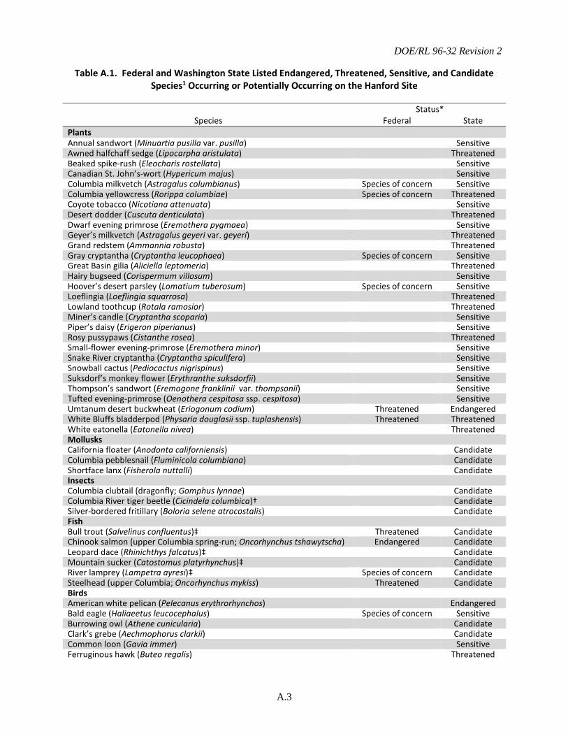
DOE/RL 96-32 Revision 2
A.3
Table A.1. Federal and Washington State Listed Endangered, Threatened, Sensitive, and Candidate Species1 Occurring or Potentially Occurring on the Hanford Site
Species Status*
Federal State Plants Annual sandwort (Minuartia pusilla var. pusilla) Sensitive Awned halfchaff sedge (Lipocarpha aristulata) Threatened Beaked spike-rush (Eleocharis rostellata) Sensitive Canadian St. John’s-wort (Hypericum majus) Sensitive Columbia milkvetch (Astragalus columbianus) Species of concern Sensitive Columbia yellowcress (Rorippa columbiae) Species of concern Threatened Coyote tobacco (Nicotiana attenuata) Sensitive Desert dodder (Cuscuta denticulata) Threatened Dwarf evening primrose (Eremothera pygmaea) Sensitive Geyer’s milkvetch (Astragalus geyeri var. geyeri) Threatened Grand redstem (Ammannia robusta) Threatened Gray cryptantha (Cryptantha leucophaea) Species of concern Sensitive Great Basin gilia (Aliciella leptomeria) Threatened Hairy bugseed (Corispermum villosum) Sensitive Hoover’s desert parsley (Lomatium tuberosum) Species of concern Sensitive Loeflingia (Loeflingia squarrosa) Threatened Lowland toothcup (Rotala ramosior) Threatened Miner’s candle (Cryptantha scoparia) Sensitive Piper’s daisy (Erigeron piperianus) Sensitive Rosy pussypaws (Cistanthe rosea) Threatened Small-flower evening-primrose (Eremothera minor) Sensitive Snake River cryptantha (Cryptantha spiculifera) Sensitive Snowball cactus (Pediocactus nigrispinus) Sensitive Suksdorf’s monkey flower (Erythranthe suksdorfii) Sensitive Thompson’s sandwort (Eremogone franklinii var. thompsonii) Sensitive Tufted evening-primrose (Oenothera cespitosa ssp. cespitosa) Sensitive Umtanum desert buckwheat (Eriogonum codium) Threatened Endangered White Bluffs bladderpod (Physaria douglasii ssp. tuplashensis) Threatened Threatened White eatonella (Eatonella nivea) Threatened Mollusks California floater (Anodonta californiensis) Candidate Columbia pebblesnail (Fluminicola columbiana) Candidate Shortface lanx (Fisherola nuttalli) Candidate Insects Columbia clubtail (dragonfly; Gomphus lynnae) Candidate Columbia River tiger beetle (Cicindela columbica)† Candidate Silver-bordered fritillary (Boloria selene atrocostalis) Candidate Fish Bull trout (Salvelinus confluentus)‡ Threatened Candidate Chinook salmon (upper Columbia spring-run; Oncorhynchus tshawytscha) Endangered Candidate Leopard dace (Rhinichthys falcatus)‡ Candidate Mountain sucker (Catostomus platyrhynchus)‡ Candidate River lamprey (Lampetra ayresi)‡ Species of concern Candidate Steelhead (upper Columbia; Oncorhynchus mykiss) Threatened Candidate Birds American white pelican (Pelecanus erythrorhynchos) Endangered Bald eagle (Haliaeetus leucocephalus) Species of concern Sensitive Burrowing owl (Athene cunicularia) Candidate Clark’s grebe (Aechmophorus clarkii) Candidate Common loon (Gavia immer) Sensitive Ferruginous hawk (Buteo regalis) Threatened
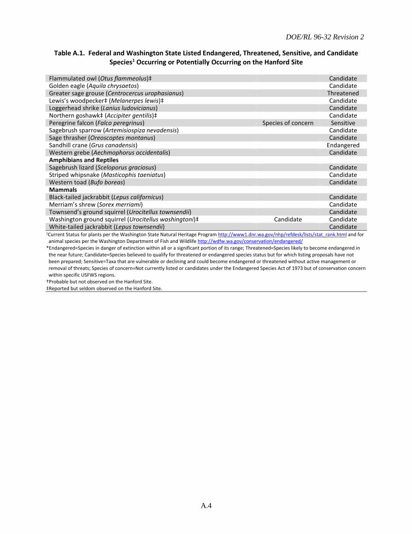
DOE/RL 96-32 Revision 2
A.4
Table A.1. Federal and Washington State Listed Endangered, Threatened, Sensitive, and Candidate Species1 Occurring or Potentially Occurring on the Hanford Site
Flammulated owl (Otus flammeolus)‡ Candidate Golden eagle (Aquila chrysaetos) Candidate Greater sage grouse (Centrocercus urophasianus) Threatened Lewis’s woodpecker‡ (Melanerpes lewis)‡ Candidate Loggerhead shrike (Lanius ludovicianus) Candidate Northern goshawk‡ (Accipiter gentilis)‡ Candidate Peregrine falcon (Falco peregrinus) Species of concern Sensitive Sagebrush sparrow (Artemisiospiza nevadensis) Candidate Sage thrasher (Oreoscoptes montanus) Candidate Sandhill crane (Grus canadensis) Endangered Western grebe (Aechmophorus occidentalis) Candidate Amphibians and Reptiles Sagebrush lizard (Sceloporus graciosus) Candidate Striped whipsnake (Masticophis taeniatus) Candidate Western toad (Bufo boreas) Candidate Mammals Black-tailed jackrabbit (Lepus californicus) Candidate Merriam’s shrew (Sorex merriami) Candidate Townsend’s ground squirrel (Urocitellus townsendii) Candidate Washington ground squirrel (Urocitellus washingtoni)‡ Candidate Candidate White-tailed jackrabbit (Lepus townsendii) Candidate
1Current Status for plants per the Washington State Natural Heritage Program http://www1.dnr.wa.gov/nhp/refdesk/lists/stat_rank.html and for animal species per the Washington Department of Fish and Wildlife http://wdfw.wa.gov/conservation/endangered/
*Endangered=Species in danger of extinction within all or a significant portion of its range; Threatened=Species likely to become endangered in the near future; Candidate=Species believed to qualify for threatened or endangered species status but for which listing proposals have not been prepared; Sensitive=Taxa that are vulnerable or declining and could become endangered or threatened without active management or removal of threats; Species of concern=Not currently listed or candidates under the Endangered Species Act of 1973 but of conservation concern within specific USFWS regions.
†Probable but not observed on the Hanford Site. ‡Reported but seldom observed on the Hanford Site.
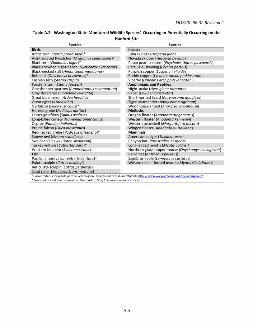
DOE/RL 96-32 Revision 2
A.5
Table A.2. Washington State Monitored Wildlife Species1 Occurring or Potentially Occurring on the Hanford Site
Species Species Birds Insects Arctic tern (Sterna paradisaea)* Juba skipper (Hesperia juba) Ash-throated flycatcher (Myiarchus cinerascens)* Nevada skipper (Hesperia nevada) Black tern (Chlidonias niger)* Pasco pearl crescent (Phyciodes tharos pascoensis) Black-crowned night-heron (Nycticorax nycticorax) Persius duskywing (Erynnis persius) Black-necked stilt (Himantopus mexicanus) Purplish copper (Lycaena helloides) Bobolink (Dolichonyx oryzivorus)* Ruddy copper (Lycaena rubida perkinsorum) Caspian tern (Sterna caspia) Viceroy (Limenitis archippus lahontani) Forster’s tern (Sterna forsteri) Amphibians and Reptiles Grasshopper sparrow (Ammodramus savannarum) Night snake (Hypsiglena torquata) Gray flycatcher (Empidonax wrightii) Racer (Coluber constrictor) Great blue heron (Ardea herodias) Short-horned lizard (Phrynosoma douglasii) Great egret (Ardea alba) Tiger salamander (Ambystoma tigrinum) Gyrfalcon (Falco rusticolus)* Woodhouse’s toad (Anaxyrus woodhousii) Horned grebe (Podiceps auritus) Mollusks Lesser goldfinch (Spinus psaltria) Oregon floater (Anodonta oregonensis) Long-billed curlew (Numenius americanus) Western floater (Anodonta kennerlyi) Osprey (Pandion haliaetus) Western pearlshell (Margaritifera falcata) Prairie falcon (Falco mexicanus) Winged floater (Anodonta nuttalliana) Red-necked grebe (Podiceps grisegena)* Mammals Snowy owl (Nyctea scandiaca) American badger (Taxidea taxus) Swainson’s hawk (Buteo swainsoni) Canyon bat (Parastrellus hesperus) Turkey vulture (Cathartes aura)* Long-legged myotis (Myotis volans)† Western bluebird (Sialia mexicana) Northern grasshopper mouse (Onychomys leucogaster) Fish Pallid bat (Antrozous pallidus) Pacific lamprey (Lampetra tridentata)† Sagebrush vole (Lemmiscus curtatus) Paiute sculpin (Cottus beldingi) Western small-footed myotis (Myotis ciliolabrum)† Reticulate sculpin (Cottus perplexus) Sand roller (Percopsis transmontana) 1 Current Status for plants per the Washington Department of Fish and Wildlife http://wdfw.wa.gov/conservation/endangered/
*Reported but seldom observed on the Hanford Site; †Federal species of concern.
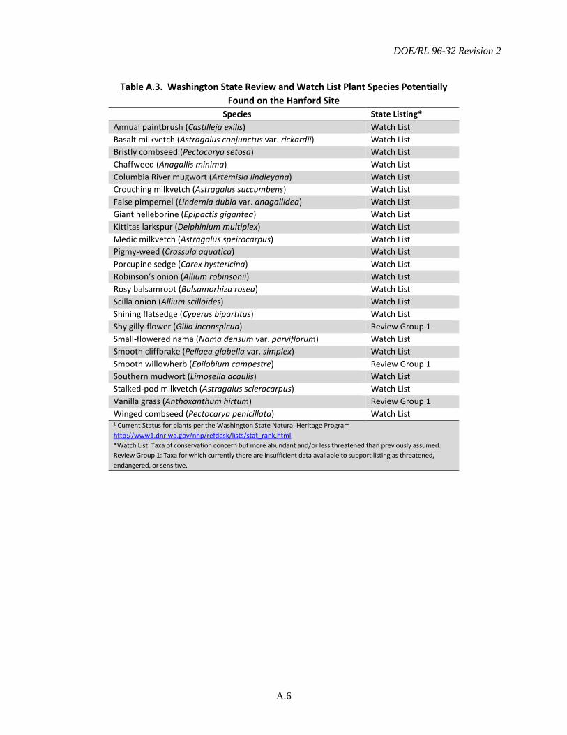
DOE/RL 96-32 Revision 2
A.6
Table A.3. Washington State Review and Watch List Plant Species Potentially
Found on the Hanford Site Species State Listing*
Annual paintbrush (Castilleja exilis) Watch List Basalt milkvetch (Astragalus conjunctus var. rickardii) Watch List Bristly combseed (Pectocarya setosa) Watch List Chaffweed (Anagallis minima) Watch List Columbia River mugwort (Artemisia lindleyana) Watch List Crouching milkvetch (Astragalus succumbens) Watch List False pimpernel (Lindernia dubia var. anagallidea) Watch List Giant helleborine (Epipactis gigantea) Watch List Kittitas larkspur (Delphinium multiplex) Watch List Medic milkvetch (Astragalus speirocarpus) Watch List Pigmy-weed (Crassula aquatica) Watch List Porcupine sedge (Carex hystericina) Watch List Robinson’s onion (Allium robinsonii) Watch List Rosy balsamroot (Balsamorhiza rosea) Watch List Scilla onion (Allium scilloides) Watch List Shining flatsedge (Cyperus bipartitus) Watch List Shy gilly-flower (Gilia inconspicua) Review Group 1 Small-flowered nama (Nama densum var. parviflorum) Watch List Smooth cliffbrake (Pellaea glabella var. simplex) Watch List Smooth willowherb (Epilobium campestre) Review Group 1 Southern mudwort (Limosella acaulis) Watch List Stalked-pod milkvetch (Astragalus sclerocarpus) Watch List Vanilla grass (Anthoxanthum hirtum) Review Group 1 Winged combseed (Pectocarya penicillata) Watch List 1 Current Status for plants per the Washington State Natural Heritage Program http://www1.dnr.wa.gov/nhp/refdesk/lists/stat_rank.html *Watch List: Taxa of conservation concern but more abundant and/or less threatened than previously assumed. Review Group 1: Taxa for which currently there are insufficient data available to support listing as threatened, endangered, or sensitive.
DOE/RL 96-32 Revision 2
B.1
APPENDIX B
Attributes Used to Create Level of Concern Maps

DOE/RL 96-32 Revision 2
B.2
This page intentionally left blank.
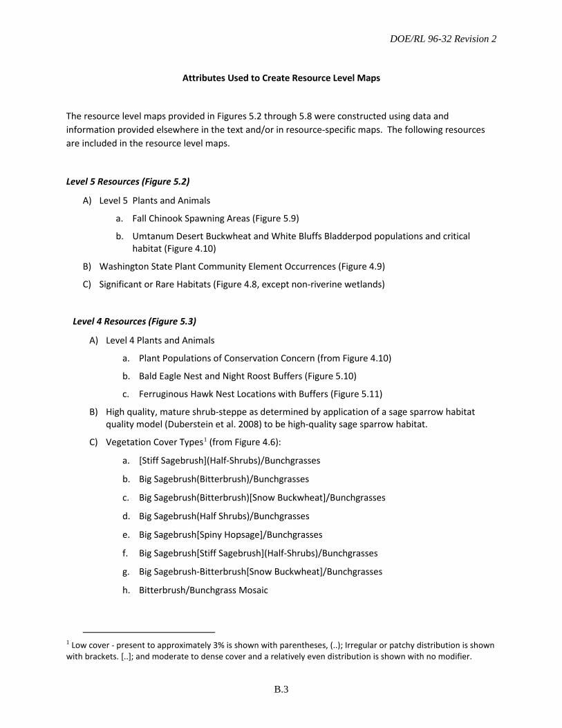
DOE/RL 96-32 Revision 2
B.3
Attributes Used to Create Resource Level Maps
The resource level maps provided in Figures 5.2 through 5.8 were constructed using data and information provided elsewhere in the text and/or in resource-specific maps. The following resources are included in the resource level maps.
Level 5 Resources (Figure 5.2)
A) Level 5 Plants and Animals
a. Fall Chinook Spawning Areas (Figure 5.9)
b. Umtanum Desert Buckwheat and White Bluffs Bladderpod populations and critical habitat (Figure 4.10)
B) Washington State Plant Community Element Occurrences (Figure 4.9)
C) Significant or Rare Habitats (Figure 4.8, except non-riverine wetlands)
Level 4 Resources (Figure 5.3)
A) Level 4 Plants and Animals
a. Plant Populations of Conservation Concern (from Figure 4.10)
b. Bald Eagle Nest and Night Roost Buffers (Figure 5.10)
c. Ferruginous Hawk Nest Locations with Buffers (Figure 5.11)
B) High quality, mature shrub-steppe as determined by application of a sage sparrow habitat quality model (Duberstein et al. 2008) to be high-quality sage sparrow habitat.
C) Vegetation Cover Types1 (from Figure 4.6):
a. [Stiff Sagebrush](Half-Shrubs)/Bunchgrasses
b. Big Sagebrush(Bitterbrush)/Bunchgrasses
c. Big Sagebrush(Bitterbrush)[Snow Buckwheat]/Bunchgrasses
d. Big Sagebrush(Half Shrubs)/Bunchgrasses
e. Big Sagebrush[Spiny Hopsage]/Bunchgrasses
f. Big Sagebrush[Stiff Sagebrush](Half-Shrubs)/Bunchgrasses
g. Big Sagebrush-Bitterbrush[Snow Buckwheat]/Bunchgrasses
h. Bitterbrush/Bunchgrass Mosaic
1 Low cover - present to approximately 3% is shown with parentheses, (..); Irregular or patchy distribution is shown with brackets. [..]; and moderate to dense cover and a relatively even distribution is shown with no modifier.
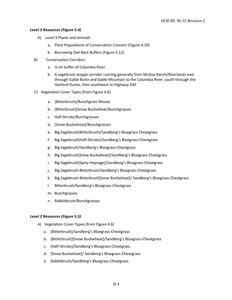
DOE/RL 96-32 Revision 2
B.4
Level 3 Resources (Figure 5.4)
A) Level 3 Plants and Animals
a. Plant Populations of Conservation Concern (Figure 4.10)
b. Burrowing Owl Nest Buffers (Figure 5.12)
B) Conservation Corridors
a. ¼-mi buffer of Columbia River
b. A sagebrush steppe corridor running generally from McGee Ranch/Riverlands east through Gable Butte and Gable Mountain to the Columbia River, south through the Hanford Dunes, then southwest to Highway 240
C) Vegetation Cover Types (from Figure 4.6)
a. (Bitterbrush)/Bunchgrass Mosaic
b. (Bitterbrush)[Snow Buckwheat/Bunchgrasses
c. Half-Shrubs/Bunchgrasses
d. [Snow Buckwheat]/Bunchgrasses
e. Big Sagebrush(Bitterbrush)/Sandberg’s Bluegrass-Cheatgrass
f. Big Sagebrush(Half-Shrubs)/Sandberg’s Bluegrass-Cheatgrass
g. Big Sagebrush/Sandberg’s Bluegrass-Cheatgrass
h. Big Sagebrush[Snow Buckwheat]/Sandberg’s Bluegrass-Cheatgrass
i. Big Sagebrush[Spiny Hopsage]/Sandberg’s Bluegrass-Cheatgrass
j. Big Sagebrush-Bitterbrush/Sandberg’s Bluegrass-Cheatgrass
k. Big Sagebrush-Bitterbrush[Snow Buckwheat]/ Sandberg’s Bluegrass-Cheatgrass
l. Bitterbrush/Sandberg’s Bluegrass-Cheatgrass
m. Bunchgrasses
n. Rabbitbrush/Bunchgrasses
Level 2 Resources (Figure 5.5)
A) Vegetation Cover Types (from Figure 4.6)
a. (Bitterbrush)/Sandberg’s Bluegrass-Cheatgrass
b. (Bitterbrush)[Snow Buckwheat]/Sandberg’s Bluegrass-Cheatgrass
c. (Half-Shrubs)/Sandberg’s Bluegrass-Cheatgrass
d. [Snow Buckwheat]/ Sandberg’s Bluegrass-Cheatgrass
e. Rabbitbrush/Sandberg’s Bluegrass-Cheatgrass
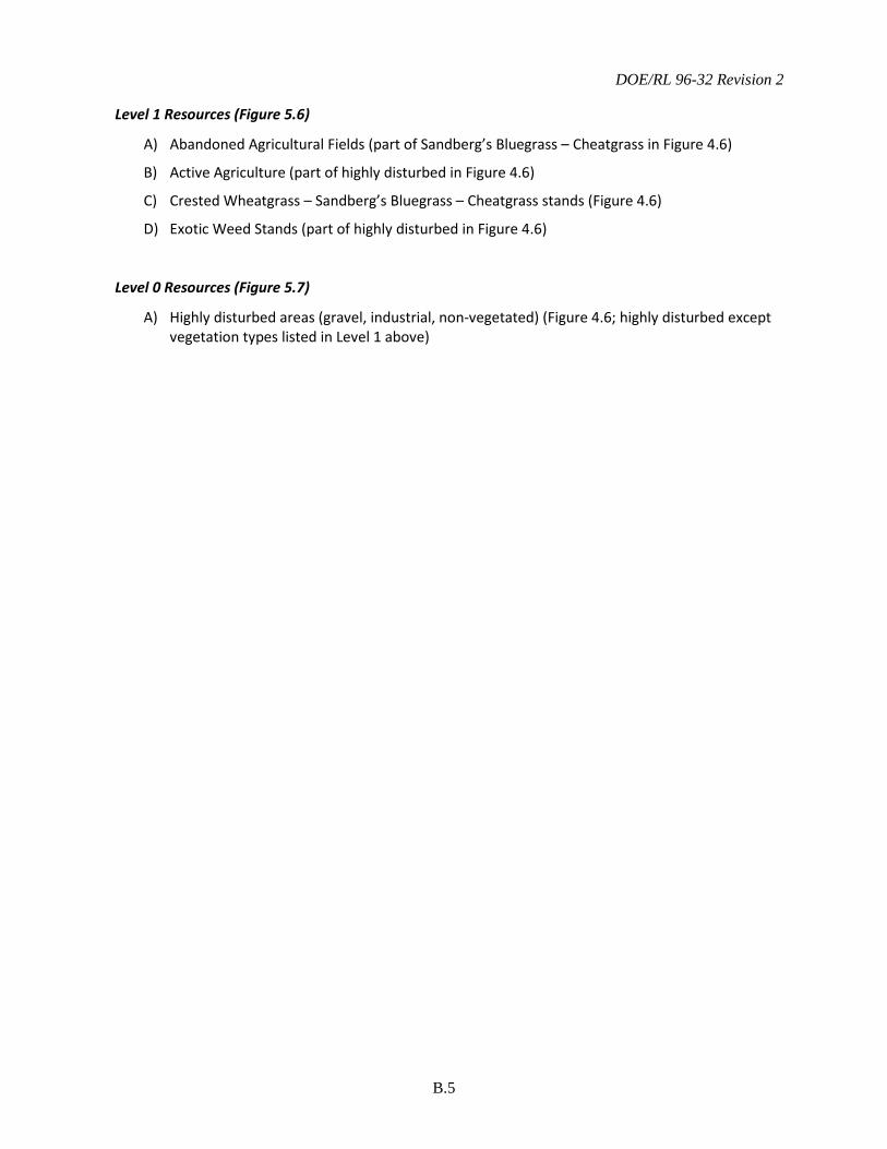
DOE/RL 96-32 Revision 2
B.5
Level 1 Resources (Figure 5.6)
A) Abandoned Agricultural Fields (part of Sandberg’s Bluegrass – Cheatgrass in Figure 4.6)
B) Active Agriculture (part of highly disturbed in Figure 4.6)
C) Crested Wheatgrass – Sandberg’s Bluegrass – Cheatgrass stands (Figure 4.6)
D) Exotic Weed Stands (part of highly disturbed in Figure 4.6)
Level 0 Resources (Figure 5.7)
A) Highly disturbed areas (gravel, industrial, non-vegetated) (Figure 4.6; highly disturbed except vegetation types listed in Level 1 above)

DOE/RL 96-32 Revision 2
B.6
This page intentionally left blank.