
American Community Survey Summary File Page 1 of 34
2009 ACS 1-Year Summary File: Technical Documentation
American Community Survey Office
U.S. Census Bureau
Version: 1.0
Date: September 27, 2010
Document History
Version Number Date Summary of Changes
1.0 September 27, 2010 Baseline Document
American Community Survey Summary File Page 2 of 34
Table of Contents
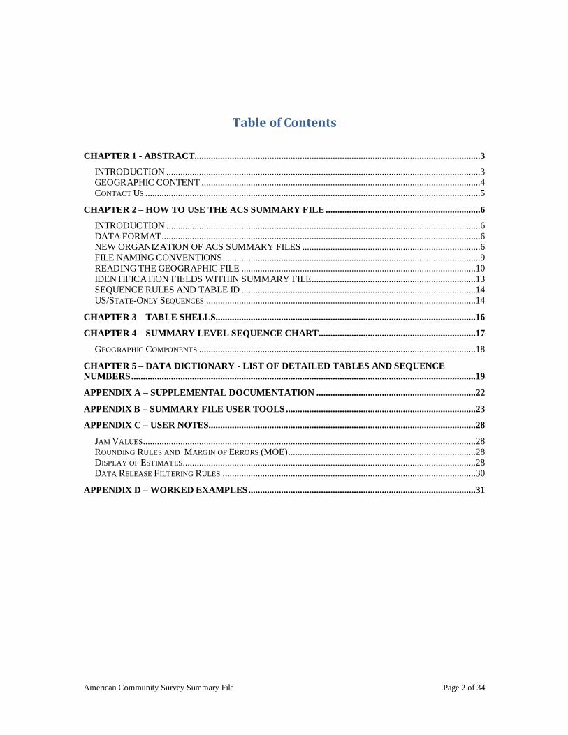
CHAPTER 1 - ABSTRACT..........................................................................................................................3
INTRODUCTION ......................................................................................................................................3 GEOGRAPHIC CONTENT .......................................................................................................................4 CONTACT US ...............................................................................................................................................5
CHAPTER 2 – HOW TO USE THE ACS SUMMARY FILE ..................................................................6
INTRODUCTION ......................................................................................................................................6 DATA FORMAT ........................................................................................................................................6 NEW ORGANIZATION OF ACS SUMMARY FILES ............................................................................6 FILE NAMING CONVENTIONS ..............................................................................................................9 READING THE GEOGRAPHIC FILE ....................................................................................................10 IDENTIFICATION FIELDS WITHIN SUMMARY FILE......................................................................13 SEQUENCE RULES AND TABLE ID ....................................................................................................14 US/STATE-ONLY SEQUENCES ...................................................................................................................14
CHAPTER 3 – TABLE SHELLS...............................................................................................................16
CHAPTER 4 – SUMMARY LEVEL SEQUENCE CHART ...................................................................17
GEOGRAPHIC COMPONENTS ......................................................................................................................18
CHAPTER 5 – DATA DICTIONARY - LIST OF DETAILED TABLES AND SEQUENCE NUMBERS ...................................................................................................................................................19
APPENDIX A – SUPPLEMENTAL DOCUMENTATION ....................................................................22
APPENDIX B – SUMMARY FILE USER TOOLS .................................................................................23
APPENDIX C – USER NOTES..................................................................................................................28
JAM VALUES..............................................................................................................................................28 ROUNDING RULES AND MARGIN OF ERRORS (MOE) ................................................................................28 DISPLAY OF ESTIMATES.............................................................................................................................28 DATA RELEASE FILTERING RULES ............................................................................................................30
APPENDIX D – WORKED EXAMPLES .................................................................................................31
American Community Survey Summary File Page 3 of 34
Chapter 1 - Abstract
INTRODUCTION
The American Community Survey (ACS) is a relatively new survey conducted by the
U.S. Census Bureau. It uses a series of monthly samples to produce annually updated
data for the same small areas (census tracts and block groups) formerly surveyed via the
Decennial Census long-form sample. Five years of data collection will be required to
produce these small-area data. Once the Census Bureau has collected 5 years of data,
new small-area data will be produced annually. The Census Bureau will produce 3-year
and 1-year data products for larger geographic areas. The ACS includes people living in
both housing units (HUs) and group quarters (GQs). The ACS is conducted throughout
the United States and in Puerto Rico, where it is called the Puerto Rico Community
Survey (PRCS). For ease of discussion, the term ACS is used here to represent both
surveys.
The American Community Survey releases meaningful data products on the Census
Bureau‘s American FactFinder website. To address other requests, the American
Community Survey produces the Summary File product that contains the complete set of
the detailed tables in a comma delimited file format to allow for importation of this data
into databases, spreadsheets, SAS datasets, and other formats. The American
Community Survey‘s Summary File follows the approach taken for the Census 2000
Summary File 3 format. The American Community Survey Summary File consists of
approximately 1,300 detailed tables of demographic, social, economic, and housing
characteristics for the 1-year and 3-year products. For information about Census
geographies, please visit http://www.census.gov/geo/www/cob/metadata.html .
The American Community Survey detailed tables contain both a base and collapsed
version. The base tables provide detailed information on a given topic, and the collapsed
tables provide a consolidated version of a base table. The base table name begins with
the letter ―B‖ and the collapsed table name begins with the letter ―C‖ to allow for easy
identification.
The American Community Survey covers a broad spectrum of geographic areas within
the United States and Puerto Rico. The American Community Survey divides
characteristics into demographic, social, housing, and economic topics.
Demographic:
o Sex o Age
o Households by type o Race
o Relationship o Hispanic origin

American Community Survey Summary File Page 4 of 34
Social:
o School enrollment o Educational attainment
o Fertility o Residence one year ago
o Veteran status o Disability status
o U.S. citizenship status o Language spoken at home
o Marital status o Place of birth
o Year of entry o Ancestry
o Grandparents caring for children o World region of birth of foreign born
Economic:
o Employment status o Commuting to work
o Class of worker o Income and benefits
o Industry o Occupation
o Poverty status o Health Insurance Coverage
Housing:
o Housing occupancy o Housing tenure
o Units in structure o Year structure built
o Number of rooms o Number of bedrooms
o House heating fuel o Housing value
o Occupants per room o Vehicles available
o Mortgage status and costs o Utility cost
o Year householder moved into unit o Gross rent
GEOGRAPHIC CONTENT
The American Community Survey Summary Files include all detailed tables for all
geographic areas published by the 2009 1-Year ACS. The main directory of the
American Community Survey‘s Summary File product release, located within the file
transfer protocol (FTP) site, contains documentation about the Summary Files and
information pertaining to the United States, each of the individual states, the District of
Columbia, and Puerto Rico.
The following list outlines the hierarchical geographic levels contained within the
Summary File release.
State Files
The ACS 1-Year Summary File for states contains the following geographic areas:
o State
o County
American Community Survey Summary File Page 5 of 34
o County Subdivision
o Place
o Metropolitan Statistical Area/Micropolitan Statistical Area-State-Principal City
o New England City and Town Area-State-Principal City
o State-School District (Elementary, Secondary, and Unified)
o State-Alaska Native Regional Corporation
o Congressional District (111th
Congress)
o Public Use Microdata Sample Area (PUMA)
National Files
The ACS Summary File for the U.S. contains the following geographic areas:
o United States
o Region
o Division
o American Indian Area/Alaska Native Area/Hawaiian Home Land
o Metropolitan Statistical Area/Micropolitan Statistical Area
o Metropolitan Statistical Area-Metropolitan Division
o Combined Statistical Area
o Combined New England City and Town Area
o New England City and Town Area (NECTA)-NECTA Division
o New England City and Town Area
o Urban Area
CONTACT US
Please send any technical questions or comments you have via email to:
[email protected]. If you have questions or comments about the American
Community Survey, please contact us online at http://ask.census.gov.
American Community Survey Summary File Page 6 of 34
Chapter 2 – How to Use the ACS Summary File
INTRODUCTION
This chapter is intended to provide a guide for data users to the American Community
Survey Summary Files. New users should review this chapter before attempting to use
the Summary File product.
DATA FORMAT
The American Community Survey Summary Files (ACS-SF) are available in .zip file
format. The Zip file format is a compressed format used to reduce the file size. Users
can download the .zip files through the File Transfer Protocol (FTP) from the American
Community Survey FTP site located at
http://www2.census.gov/acs2009_1yr/summaryfile/. To read the Summary Files data, the
compressed files must be uncompressed (unzipped) to allow access to the data.
NEW ORGANIZATION OF ACS SUMMARY FILES
Based on user feedback, the ACS Summary File is now organized into three categories
1. Entire_SF: This zip file contains all of the Summary File data, MOE's, and
geography files - 1 File in Directory
/acs2009_1yr/summaryfile/Entire_SF/20091YRSF.zip
For the user‘s convenience, this zip file contains all of the Summary Files for the U.S.,
Puerto Rico, states, and District of Columbia. For example, to obtain all Summary Files
for nation (U.S.), states, District of Columbia, and Puerto Rico, just download and unzip
the file 20091YRSF.zip.

American Community Survey Summary File Page 7 of 34
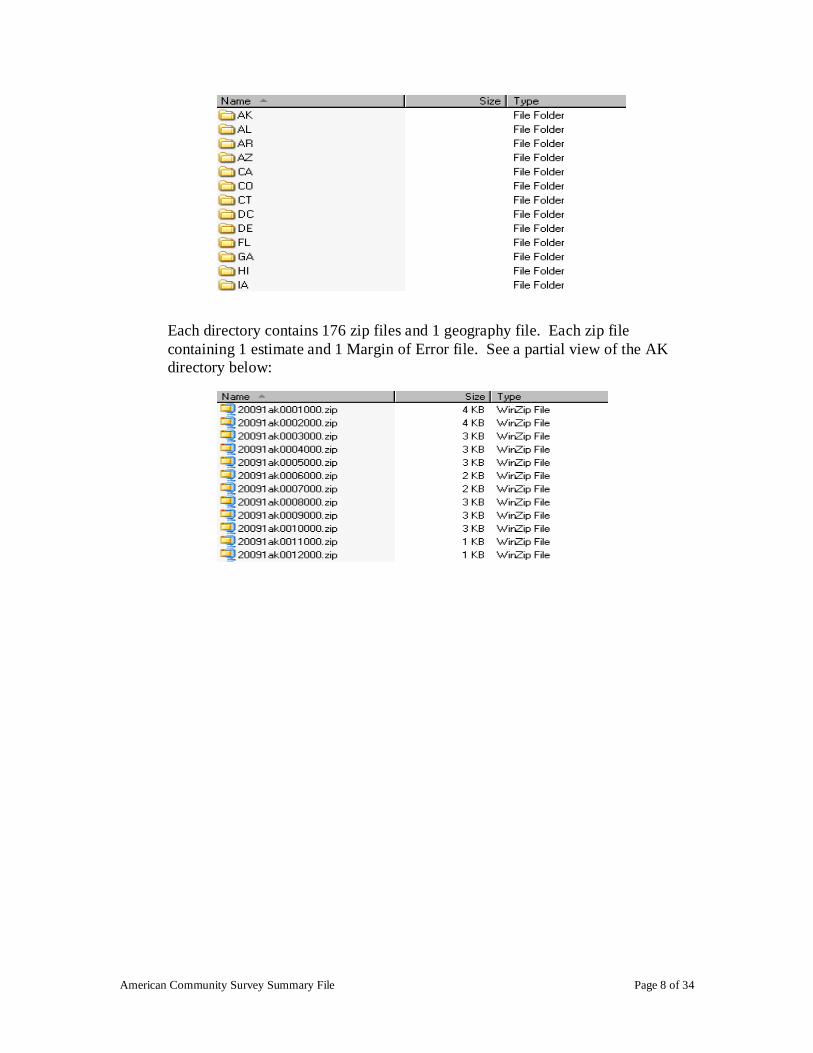
2. Entire_States: These files contain all of the summary file data, MOE's, and
geography files per state - 53 Files in Directory (50 States, 1 US, DC, PR)
/acs2009_1yr/summaryfile/Entire_States/<FULL STATE NAME>.zip
This directory contains 53 zip files that include the United States, each of the 50
states, District of Columbia, and Puerto Rico. Each zip file contains 176 estimate
files, 176 Margin of Error files, and 1 geography file. See partial contents of the
zip file for Alabama below.
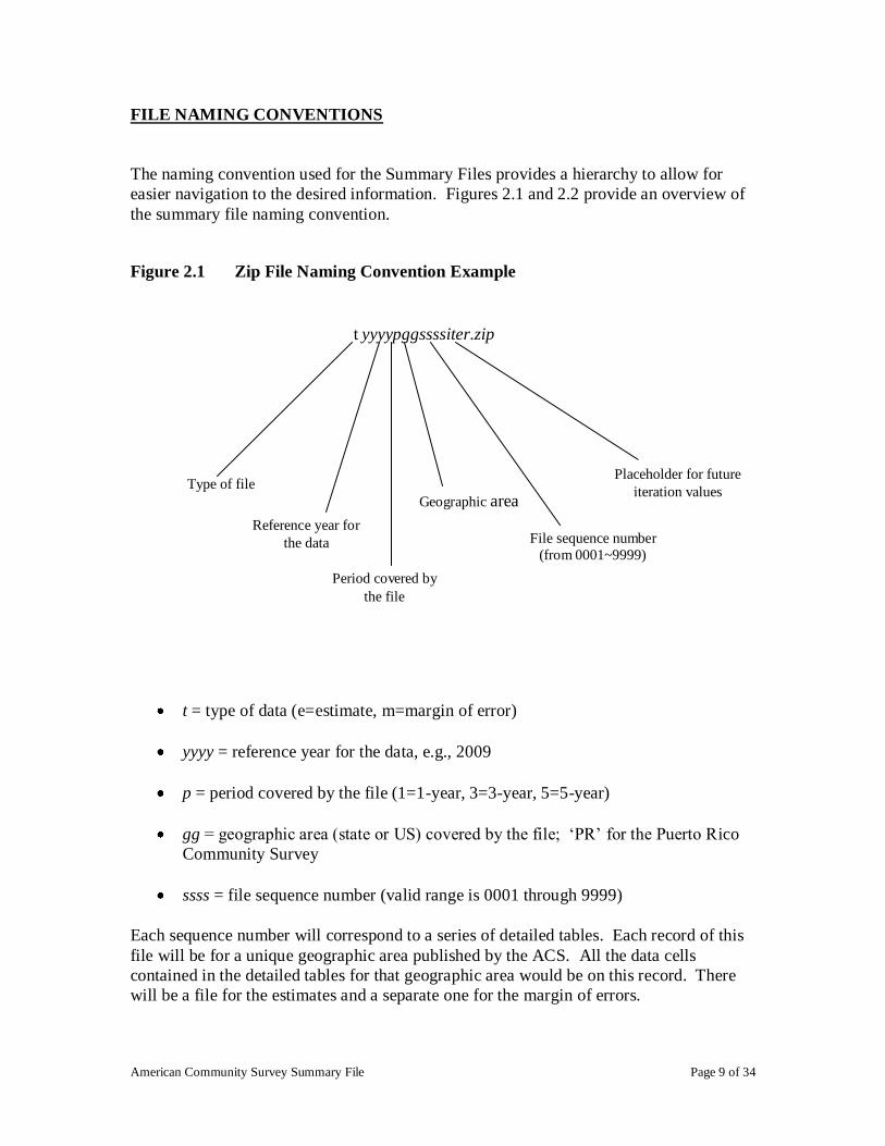
3. Seq_By_ST: 53 directories with 176 Compressed Sequence Files (both Estimates
& MOE's) and 1 Geography file in each directory
/acs2009_1yr/summaryfile/Seq_By_ST/<ST ABBRV>/<Sequence ID>.zip
American Community Survey Summary File Page 8 of 34
Each directory contains 176 zip files and 1 geography file. Each zip file
containing 1 estimate and 1 Margin of Error file. See a partial view of the AK
directory below:
American Community Survey Summary File Page 9 of 34
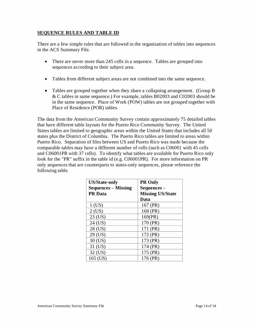
FILE NAMING CONVENTIONS
The naming convention used for the Summary Files provides a hierarchy to allow for
easier navigation to the desired information. Figures 2.1 and 2.2 provide an overview of
the summary file naming convention.
Figure 2.1 Zip File Naming Convention Example
t = type of data (e=estimate, m=margin of error)
yyyy = reference year for the data, e.g., 2009
p = period covered by the file (1=1-year, 3=3-year, 5=5-year)
gg = geographic area (state or US) covered by the file; ‗PR‘ for the Puerto Rico
Community Survey
ssss = file sequence number (valid range is 0001 through 9999)
Each sequence number will correspond to a series of detailed tables. Each record of this
file will be for a unique geographic area published by the ACS. All the data cells
contained in the detailed tables for that geographic area would be on this record. There
will be a file for the estimates and a separate one for the margin of errors.
t yyyypggssssiter.zip
Geographic area
File sequence number
(from 0001~9999)
Reference year for
the data
Period covered by
the file
Type of file
Placeholder for future
iteration values

American Community Survey Summary File Page 10 of 34
iter = ‘000’, placeholder for future values for iteration
r = data revision indicator, only present if needed. ‗a‘, ‗b‘, etc
Figure 2.2 Geoheader Summary File Naming Convention Example
t = type of data (g= geographic header file)
yyyy = reference year for the data, e.g., 2009
p = period covered by the file (1=1-year, 3=3-year, 5=5-year)
gg = geographic area is represented by 2 digit FIPS state code
READING THE GEOGRAPHIC FILE
The geographic file layout is below (Table 2.1). The geographic file provides the
reference name, field description, field size, field starting position, and geographic
summary levels that apply. The information pertaining to summary level identifies
additional geographic information. Each record of the geographic file contains particular
geographic area codes. For example, the reference name ―PLACE‖ only contains
information for summary levels 160 - State-Place, 312 - Metropolitan Statistical
Area/Micropolitan Statistical Area-State-Principal City and 352 - New England City and
Town Area-State-Principal City. For more detail on geographic definitions, see
"Geographic Terms and Concepts"
tyyyypgg.txt
Type of file
Reference year for
the data
Geographic area
Period covered by
the file

American Community Survey Summary File Page 11 of 34
Table 2.1 Geographic Header Record Layout for the ACS Summary File
Data Dictionary
Reference Name
Description Field
Size
Starting
Position
Geographic Summary Levels For
Single-Year Tables
RECORD CODES
FILEID Always equal to ACS Summary File
identification
6 1 All Summary Levels
STUSAB State Postal Abbreviation 2 7 All Summary Levels
SUMLEVEL Summary Level 3 9 All Summary Levels
COMPONENT Geographic Component 2 12 All Summary Levels
LOGRECNO Logical Record Number 7 14 All Summary Levels
GEOGRAPHIC
AREA CODES
US US 1 21 010
REGION Census Region 1 22 020
DIVISION Census Division 1 23 030
STATECE State (Census Code) 2 24 Blank for All Summary Levels
STATE State (FIPS Code) 2 26 040, 050, 060,160, 230, 312, 352, 500,
795, 950, 960, 970, M01, M06, M07,
M08, M11, M15, P01, P06, P07, P08,
P11, P15
COUNTY County of current residence 3 28 050, 060, M01, M08, P01, P08
COUSUB County Subdivision (FIPS) 5 31 060, M08, P08
PLACE Place (FIPS Code) 5 36 160, 312, 352, M07, M11, M15, P07,
P11, P15
BLANK 6 41 Reserved for future use
BLANK 1 47 Reserved for future use
BLANK 5 48 Reserved for future use
AIANHH American Indian Area/Alaska Native Area/
Hawaiian Home Land (Census)
4 53 250
AIANHHFP American Indian Area/Alaska Native Area/
Hawaiian Home Land (FIPS)
5 57 250
BLANK 1 62 Reserved for future use
BLANK 3 63 Reserved for future use
BLANK 5 66 Reserved for future use
ANRC Alaska Native Regional Corporation (FIPS) 5 71 230
CBSA Metropolitan and Micropolitan Statistical
Area
5 76 310, 312, 314, 332, M10, M11, M12,
P10, P11, P12
CSA Combined Statistical Area 3 81 330, M09, P09
METDIV Metropolitan Statistical Area-Metropolitan
Division
5 84 314, M12, P12
MACC Metropolitan Area Central City 1 89
MEMI Metropolitan/Micropolitan Indicator Flag 1 90 010, 020, 030, 040, 314
NECTA New England City and Town Area 5 91 350, 352, 355, M14, M15, M16, P14, P15, P16
CNECTA New England City and Town Combined
Statistical Area
3 96 335, M13, P13
NECTADIV New England City and Town Area Division 5 99 355, M16, P16
UA Urban Area 5 104 400
BLANK 5 109 Reserved for future use
CDCURR Current Congressional District *** 2 114 500
BLANK 3 116 Reserved for future use
BLANK 3 119 Reserved for future use

American Community Survey Summary File Page 12 of 34
BLANK 6 122 Reserved for future use
BLANK 3 128 Reserved for future use
BLANK 5 131 Reserved for future use
SUBMCD 5 136 Reserved for future use
SDELM State-School District (Elementary) 5 141 950
SDSEC State-School District (Secondary) 5 146 960
SDUNI State-School District (Unified) 5 151 970
UR Urban/Rural 1 156 010, 020, 030, 040
PCI Principal City Indicator 1 157 010, 020, 030, 040, 312, 352
BLANK 6 158 Reserved for future use
BLANK 5 164 Reserved for future use
PUMA5 Public Use Microdata Area – 5% File 5 169 795
BLANK 5 174 Reserved for future use
GEOID Geographic Identifier 40 179 All Summary Levels
NAME Area Name 200 219 All Summary Levels

American Community Survey Summary File Page 13 of 34
IDENTIFICATION FIELDS WITHIN SUMMARY FILE
The first six columns of the estimates and margin of error files provide data and
geographic information related to the tables contained within the same row.
FILEID = File Identification - 6 characters
FILETYPE= File Type - 6 characters
STUSAB = State/U.S.-Abbreviation (USPS) - 2 characters
CHARITER= Character Iteration - 3 characters
SEQUENCE= Sequence Number - 4 characters
LOGRECNO= Logical Record Number - 7 characters
A logical unique record number is assigned to all files for a specific geographic entity so
that all records for a specific entity can be linked together across files. Besides the
logical record number, other identifying fields are also carried over from the geographic
header file to the table files. For more details on these fields, see the example below.
TABLE B08406:
SEX OF WORKERS BY MEANS OF TRANSPORTATION TO WORK FOR WORKPLACE GEOGRAPHY
Car,
FILEID FILE Truck, Drove
TYPE STUSAB CHARITER SEQUENCE LOGRECNO Total or Van Alone
ACSSF 2009e1 ak 000 0003 0000001 342551 275208 230130
ACSSF 2009e1 ak 000 0003 0000010 157650 141673 120945
ACSSF 2009e1 ak 000 0003 0000011 . . .
ACSSF 2009e1 ak 000 0003 0000012 . . .
ACSSF 2009e1 ak 000 0003 0000013 157650 141673 120945
ACSSF 2009e1 ak 000 0003 0000017 157650 141673 120945
American Community Survey Summary File Page 14 of 34
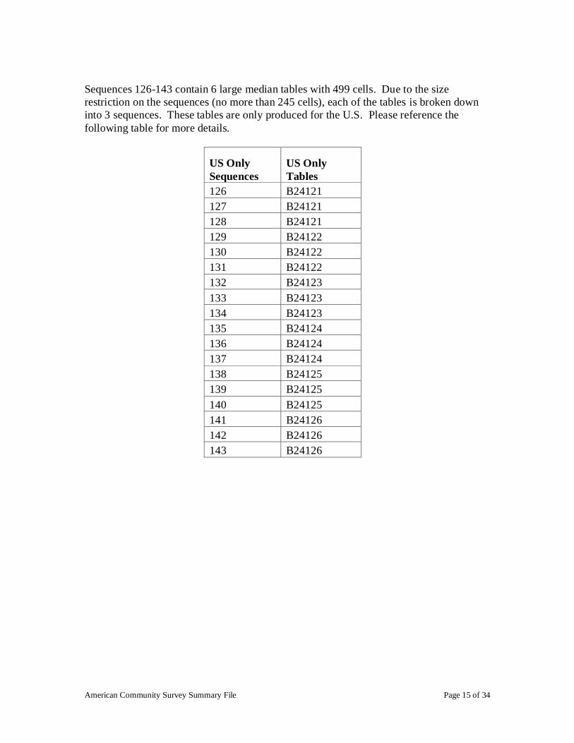
SEQUENCE RULES AND TABLE ID
There are a few simple rules that are followed in the organization of tables into sequences
in the ACS Summary File.
There are never more than 245 cells in a sequence. Tables are grouped into
sequences according to their subject area.
Tables from different subject areas are not combined into the same sequence.
Tables are grouped together when they share a collapsing arrangement. (Group B
& C tables in same sequence.) For example, tables B02003 and C02003 should be
in the same sequence. Place of Work (POW) tables are not grouped together with
Place of Residence (POR) tables.
The data from the American Community Survey contain approximately 75 detailed tables
that have different table layouts for the Puerto Rico Community Survey. The United
States tables are limited to geographic areas within the United States that includes all 50
states plus the District of Columbia. The Puerto Rico tables are limited to areas within
Puerto Rico. Separation of files between US and Puerto Rico was made because the
comparable tables may have a different number of cells (such as C06001 with 45 cells
and C06001PR with 37 cells). To identify what tables are available for Puerto Rico only
look for the "PR" suffix in the table id (e.g. C06001PR). For more information on PR
only sequences that are counterparts to states-only sequences, please reference the
following table.
US/State-only
Sequences – Missing
PR Data
PR Only
Sequences –
Missing US/State
Data
1 (US) 167 (PR)
2 (US) 168 (PR)
23 (US) 169(PR)
24 (US) 170 (PR)
28 (US) 171 (PR)
29 (US) 172 (PR)
30 (US) 173 (PR)
31 (US) 174 (PR)
32 (US) 175 (PR)
165 (US) 176 (PR)
American Community Survey Summary File Page 15 of 34
Sequences 126-143 contain 6 large median tables with 499 cells. Due to the size
restriction on the sequences (no more than 245 cells), each of the tables is broken down
into 3 sequences. These tables are only produced for the U.S. Please reference the
following table for more details.
US Only
Sequences
US Only
Tables
126 B24121
127 B24121
128 B24121
129 B24122
130 B24122
131 B24122
132 B24123
133 B24123
134 B24123
135 B24124
136 B24124
137 B24124
138 B24125
139 B24125
140 B24125
141 B24126
142 B24126
143 B24126
American Community Survey Summary File Page 16 of 34
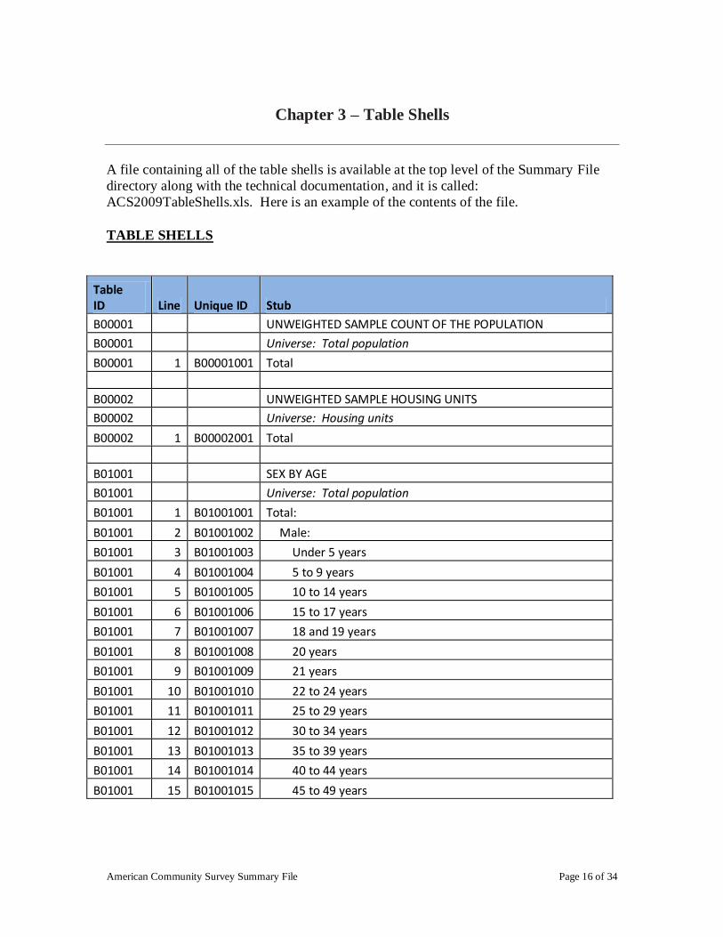
Chapter 3 – Table Shells
A file containing all of the table shells is available at the top level of the Summary File
directory along with the technical documentation, and it is called:
ACS2009TableShells.xls. Here is an example of the contents of the file.
TABLE SHELLS
Table ID Line Unique ID Stub
B00001 UNWEIGHTED SAMPLE COUNT OF THE POPULATION
B00001 Universe: Total population
B00001 1 B00001001 Total
B00002 UNWEIGHTED SAMPLE HOUSING UNITS
B00002 Universe: Housing units
B00002 1 B00002001 Total
B01001 SEX BY AGE
B01001 Universe: Total population
B01001 1 B01001001 Total:
B01001 2 B01001002 Male:
B01001 3 B01001003 Under 5 years
B01001 4 B01001004 5 to 9 years
B01001 5 B01001005 10 to 14 years
B01001 6 B01001006 15 to 17 years
B01001 7 B01001007 18 and 19 years
B01001 8 B01001008 20 years
B01001 9 B01001009 21 years
B01001 10 B01001010 22 to 24 years
B01001 11 B01001011 25 to 29 years
B01001 12 B01001012 30 to 34 years
B01001 13 B01001013 35 to 39 years
B01001 14 B01001014 40 to 44 years
B01001 15 B01001015 45 to 49 years

American Community Survey Summary File Page 17 of 34
Chapter 4 – Summary Level Sequence Chart
2009 American Community Survey Data Products SUMMARY LEVEL SEQUENCE
Geographic
Component
00, 01, 43, A0, C0,
C1, C2, E0, E1,
E2, G0, H0, 89,
91-94
00, 01, 43, A0, C0,
C1, C2, E0, E1,
E2, G0, H0
00, 01, 43, A0, C0,
C1, C2, E0, E1,
E2, G0, H0
00, 01, 43, A0, C0,
C1, C2, E0, E1,
E2, G0, H0
00
00
00 00
00
00
00
00
00
00
00
00
00
00
00
00
00
00
00
Summary Level
010 United States1
020 Region1
030 Division1
040 State2
050 State-County3
060 State-County-County Subdivision
160 State-Place 500 State-Congressional District (111th)
795 State-Public Use Microdata Sample Area (5%)
950 State-School District (Elementary)/Remainder4
960 State-School District (Secondary) /Remainder4
970 State-School District (Unified)/Remainder4
230 State-Alaska Native Regional Corporation
250 American Indian Area/Alaska Native Area/Hawaiian Home Land
310 Metropolitan Statistical Area/Micropolitan Statistical Area
312 Metropolitan Statistical Area/Micropolitan Statistical Area-State-Principal City
314 Metropolitan Statistical Area-Metropolitan Division
330 Combined Statistical Area
335 Combined New England City and Town Area
350 New England City and Town Area
352 New England City and Town Area-State-Principal City
355 New England City and Town Area (NECTA)-NECTA Division
400 Urban Area
1Land area, water area, population counts, and housing unit counts for the United States, Regions, and
Divisions do not include Puerto Rico.
2State, District of Columbia, or Puerto Rico.
3Parish in Louisiana, Borough or Census Area in Alaska, and Municipio in Puerto Rico; in Maryland,
Missouri, Nevada, and Virginia, one or more cities are independent of counties and are treated as statistical
equivalents of counties; the entire District of Columbia, which has no counties, is treated as a county
equivalent.

American Community Survey Summary File Page 18 of 34
Geographic Components
Geographic
Components Geographic Component Description
00 Not in any geographic component
01 Urban
43 Rural
A0 In metropolitan or micropolitan statistical area
G0 Not in metropolitan or micropolitan statistical area
C0 In metropolitan statistical area
C1 In metropolitan statistical area—in principal city
C2 In metropolitan statistical area—not in principal city
H0 Not in metropolitan statistical area
E0 In micropolitan statistical area
E1 In micropolitan statistical area—in principal city
E2 In micropolitan statistical area—not in principal city
89 American Indian Reservation and Trust Land – Federal
91 Oklahoma Tribal Statistical Area
92 Tribal Designated Statistical Area
93 Alaska Native Village Statistical Area
94 State Designated Tribal Statistical Area (Formerly SDAISA)
4Remainder of school districts are published for ACS 5-year data.
American Community Survey Summary File Page 19 of 34
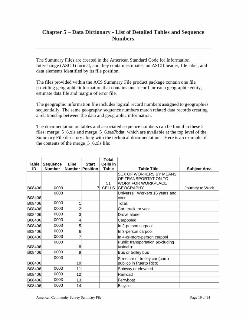
Chapter 5 – Data Dictionary - List of Detailed Tables and Sequence
Numbers
The Summary Files are created in the American Standard Code for Information
Interchange (ASCII) format, and they contain estimates, an ASCII header, file label, and
data elements identified by its file position.
The files provided within the ACS Summary File product package contain one file
providing geographic information that contains one record for each geographic entity,
estimate data file and margin of error file.
The geographic information file includes logical record numbers assigned to geographies
sequentially. The same geography sequence numbers match related data records creating
a relationship between the data and geographic information.
The documentation on tables and associated sequence numbers can be found in these 2
files: merge_5_6.xls and merge_5_6.sas7bdat, which are available at the top level of the
Summary File directory along with the technical documentation. Here is an example of
the contents of the merge_5_6.xls file:
Table ID
Sequence Number
Line Number
Start Position
Total Cells in Table Table Title Subject Area
B08406 0003 7 51
CELLS
SEX OF WORKERS BY MEANS OF TRANSPORTATION TO WORK FOR WORKPLACE GEOGRAPHY Journey to Work
B08406 0003
Universe: Workers 16 years and over
B08406 0003 1 Total:
B08406 0003 2 Car, truck, or van:
B08406 0003 3 Drove alone
B08406 0003 4 Carpooled:
B08406 0003 5 In 2-person carpool
B08406 0003 6 In 3-person carpool
B08406 0003 7 In 4-or-more-person carpool
B08406 0003
8 Public transportation (excluding taxicab):
B08406 0003 9 Bus or trolley bus
B08406
0003
10 Streetcar or trolley car (carro publico in Puerto Rico)
B08406 0003 11 Subway or elevated
B08406 0003 12 Railroad
B08406 0003 13 Ferryboat
B08406 0003 14 Bicycle

American Community Survey Summary File Page 20 of 34
B08406 0003 15 Walked
B08406 0003
16 Taxicab, motorcycle, or other means
B08406 0003 17 Worked at home
B08406 0003 18 Male:
B08406 0003 19 Car, truck, or van:
B08406 0003 20 Drove alone
B08406 0003 21 Carpooled:
B08406 0003 22 In 2-person carpool
B08406 0003 23 In 3-person carpool
B08406 0003 24 In 4-or-more-person carpool
B08406 0003
25 Public transportation (excluding taxicab):
B08406 0003 26 Bus or trolley bus
B08406
0003
27 Streetcar or trolley car (carro publico in Puerto Rico)
B08406 0003 28 Subway or elevated
B08406 0003 29 Railroad
B08406 0003 30 Ferryboat
B08406 0003 31 Bicycle
B08406 0003 32 Walked
B08406 0003
33 Taxicab, motorcycle, or other means
B08406 0003 34 Worked at home
B08406 0003 35 Female:
B08406 0003 36 Car, truck, or van:
B08406 0003 37 Drove alone
B08406 0003 38 Carpooled:
B08406 0003 39 In 2-person carpool
B08406 0003 40 In 3-person carpool
B08406 0003 41 In 4-or-more-person carpool
B08406 0003
42 Public transportation (excluding taxicab):
B08406 0003 43 Bus or trolley bus
B08406
0003
44 Streetcar or trolley car (carro publico in Puerto Rico)
B08406 0003 45 Subway or elevated
B08406 0003 46 Railroad
B08406 0003 47 Ferryboat
B08406 0003 48 Bicycle
B08406 0003 49 Walked
B08406 0003
50 Taxicab, motorcycle, or other means
B08406 0003 51 Worked at home
B08412
0003
58 39
CELLS
SEX OF WORKERS BY TRAVEL TIME TO WORK FOR WORKPLACE GEOGRAPHY Journey to Work
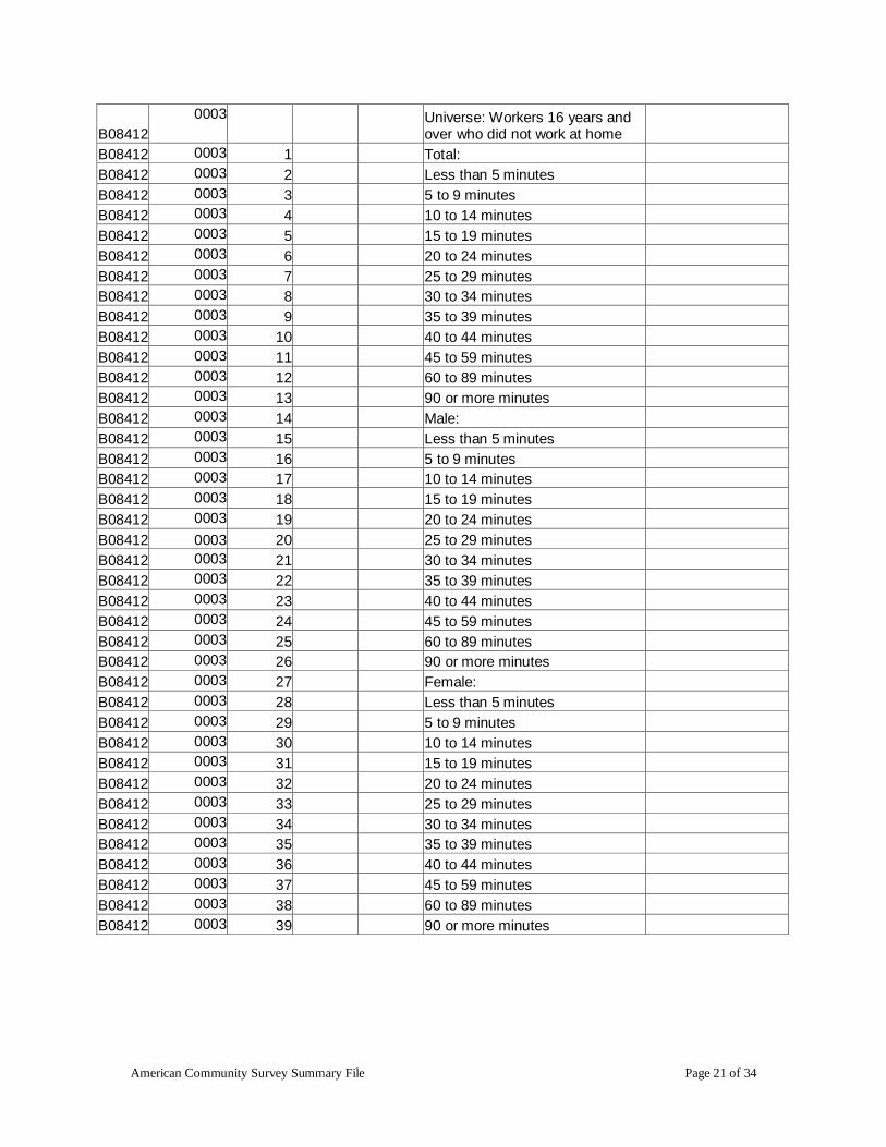
American Community Survey Summary File Page 21 of 34
B08412
0003
Universe: Workers 16 years and over who did not work at home
B08412 0003 1 Total:
B08412 0003 2 Less than 5 minutes
B08412 0003 3 5 to 9 minutes
B08412 0003 4 10 to 14 minutes
B08412 0003 5 15 to 19 minutes
B08412 0003 6 20 to 24 minutes
B08412 0003 7 25 to 29 minutes
B08412 0003 8 30 to 34 minutes
B08412 0003 9 35 to 39 minutes
B08412 0003 10 40 to 44 minutes
B08412 0003 11 45 to 59 minutes
B08412 0003 12 60 to 89 minutes
B08412 0003 13 90 or more minutes
B08412 0003 14 Male:
B08412 0003 15 Less than 5 minutes
B08412 0003 16 5 to 9 minutes
B08412 0003 17 10 to 14 minutes
B08412 0003 18 15 to 19 minutes
B08412 0003 19 20 to 24 minutes
B08412 0003 20 25 to 29 minutes
B08412 0003 21 30 to 34 minutes
B08412 0003 22 35 to 39 minutes
B08412 0003 23 40 to 44 minutes
B08412 0003 24 45 to 59 minutes
B08412 0003 25 60 to 89 minutes
B08412 0003 26 90 or more minutes
B08412 0003 27 Female:
B08412 0003 28 Less than 5 minutes
B08412 0003 29 5 to 9 minutes
B08412 0003 30 10 to 14 minutes
B08412 0003 31 15 to 19 minutes
B08412 0003 32 20 to 24 minutes
B08412 0003 33 25 to 29 minutes
B08412 0003 34 30 to 34 minutes
B08412 0003 35 35 to 39 minutes
B08412 0003 36 40 to 44 minutes
B08412 0003 37 45 to 59 minutes
B08412 0003 38 60 to 89 minutes
B08412 0003 39 90 or more minutes
American Community Survey Summary File Page 22 of 34
Appendix A – Supplemental Documentation
Supplemental documentation concerning the American Community Survey, to assist
users using this technical document, is located on the ACS Website on:
http://www.census.gov/acs/www/data_documentation/documentation_main/. Documents
such as the Subject Definitions, Accuracy of the Data documentation, and Code Lists are
available on the URL listed above.

American Community Survey Summary File Page 23 of 34
Appendix B – Summary File User Tools
American Community Survey 1-Year Summary File Sample SAS ™
Programs and Excel Templates
The American Community Survey Office has provided sample SAS ™ programs and
Excel Templates for each Summary File data file. SAS datasets or Excel files can be
generated using the ASCII ACS Summary Files as input to these programs or using the
Excel templates. All of these materials are located in a sub-directory named /UserTools.
Sample SAS Programs
a. Main Program to make all the 16,000+ SAS programs to read in each
individual sequence - SF_All_Macro.sas
b. All 16,000+ SAS Programs: SF20091YR_SAS.zip
SF20091YR_SAS.zip - Contains 16,000+ sas programs, one for each summary file,
which can be used to convert each estimate and margin of error summary file into a SAS
Dataset, which include table stubs.
SF_All_Macro.sas – This is a detailed example SAS program containing SAS macros
which accesses the three different type of Summary Files for one table for all geographies
from the ACS summary file. It is recommended that you review this document before
using this SAS program.
Basic Instructions for Using the Sample SAS Programs
Light modifications need to be made to the SAS programs in the zip file before using
them. The SAS programs included in the sascode.zip have variable and value labels.
Using SAS, a data user can open any of the programs, edit the libname and infile
statements of the program, and modify the input, output file names and the directories
being used to store data to reference the summary files after they have been copied onto
the user's computer. Data users may also want to delete columns from output SAS data
set not being used to reduce the data set size. After these modifications are made, these
programs should be able to run using SAS. Users who do not have SAS are free to read
these ACSII summary files into any program of their choice. All values in the ASCII
summary files are in CSV-format (comma-separated values).
Sample SAS Code showing how to combine the contents of the data files with the
geographic file:

American Community Survey Summary File Page 24 of 34
/* Add a libname statement referencing the directory being used */
/* Sort all four summary file files by LOGRECNO */
PROC SORT data=census.g20091ak;
by LOGRECNO;
RUN;
PROC SORT data=census.SFe0001ak;
by LOGRECNO;
RUN;
PROC SORT data=census.SFm0001ak;
by LOGRECNO;
RUN;
/* Merge all four files by LOGRECNO */
DATA census.coall;
MERGE census.g20091ak census.SFe0001ak census.SFm0001ak;
by LOGRECNO;
RUN;
Sample Excel Templates
Excel Templates: SummaryFileXLS.zip - The Compressed file contains 176 individual
XLS files, 1 per each Summary File Sequence. User can import the summary file (text
file) into Excel to make the summary file more user friendly.
Importing Summary Files into Excel Template (Excel 2007)
1) Open the appropriate Excel template for the Sequence ID you would like to
import into Excel. The file will default to open on sheet ―E‖. Both Sheet ―E‖ and
―M‖ have the same information; one sheet is for ―Estimates‖ and one sheet for
―Margin of Errors‖. When the file is open in Excel 2007 it should appear as
Figure 1-1 below.

American Community Survey Summary File Page 25 of 34
Figure 1-1
2) Place your cursor in cell ―A3‖ and click on the ―Data‖ tab in the Excel tool bar.
As shown in Figure 1-2 below. Figure 1-2
3) To import the Summary File text file into Excel click on ―From Text‖ in the ―Get
External Data‖ section of the tool bar. Figure 1-3

American Community Survey Summary File Page 26 of 34
4) The Step 1 of the Excel ―Text Import Wizard‖ will appear. Under ―Original data
type‖ choose ―Delimited‖ , and then click ―Next‖.
Figure 1-4
5) Step 2 of the Excel ―Text Import Wizard‖ will appear. Under ―Delimiters‖
choose ―Comma‖, you may click ―Finish‖ to import the file at this or choose
―Next‖ to format the excel columns to your liking; Example purposes click
―Next‖. Figure 1-5
A Pop up window will appear for to confirm cell ―A3‖ as the correct cell. Click
―OK‖. Figure 1-6
6) The summary file will be imported in Excel, Figure 1-7
Do NOT check ‗Treat
consecutive
delimiters as one‖

American Community Survey Summary File Page 27 of 34
Figure 1-7
Row 1 - Contains a unique identifier of Table ID and Line Number with a ―_‖ between
them
Row 2 - Contains the associated metadata for each unique Identifier
Row 3 – Is the first Row of the imported data
American Community Survey Summary File Page 28 of 34
Appendix C – User Notes
Jam Values
Some data values represent unique situations where either the information to be conveyed
is an explanation for the absence of data, represented by a symbol in the data display,
such as "(X)", or the information to be conveyed is an open-ended distribution, such as
115 or greater, represented by 115+.
The following special data values (and their meaning), can appear in the ACS Summary
File table as an explanation for the absence of data:
Missing Value = ―.‖: A dot ―.‖, indicates that the estimate is unavailable. All ACS
tables contain these values when estimates are missing due to certain special conditions.
Filtered Value or Geographic Restriction = ― ―: A blank indicates that a value is
filtered or is not shown due to a geographic restriction.
Margin of Error (MOE) = 0: Estimate is controlled, which indicates the estimates are
controlled and a statistical test is not appropriate.
Rounding Rules, Margin of Errors (MOE)
A. B00001, B00002, B98001, and B98002 are sample counts, not estimates, and do not
have margin of error (MOE) associated with them. Tables in series B99* imputation
tables and B98* quality measure tables (except B98001 and B98002) do not provide
margin of error calculations. The margin of error calculations are set to -1 for these
tables.
B. There are a few special rules on how certain margin of error are determined for ACS
estimates. The accuracy of the estimate (decimal place) within the detailed tables
determines how many digits the margin of error is rounded.
The only exceptions to these rules are tables B19082 (Shares of aggregate household
income by quintile) and B19083 (GINI index of income inequality). Estimates are
rounded to 2 decimal places for all estimates and the margin of error to 3 decimal places.
Display of Estimates
Display of whole numbers in the summary files: The estimates in the summary files
are stored using standard notation instead of in scientific notation. The largest estimate in
a Summary File contains 14 digits and stored as whole numbers.

American Community Survey Summary File Page 29 of 34
The following list shows median and ratio tables, their table types, and accuracy.
Table ID Table Title Table Type Accuracy
B01002 MEDIAN AGE BY SEX MEDIAN Tenths
B01002A MEDIAN AGE BY SEX (WHITE ALONE) MEDIAN Tenths
B01002B MEDIAN AGE BY SEX (BLACK OR AFRICAN AMERICAN ALONE) MEDIAN
Tenths
B01002C MEDIAN AGE BY SEX (AMERICAN INDIAN AND ALASKA NATIVE) MEDIAN
Tenths
B01002D MEDIAN AGE BY SEX (ASIAN ALONE) MEDIAN Tenths
B01002E MEDIAN AGE BY SEX (NATIVE HAWAIIAN AND OTHER PACIFIC ISLANDER ALONE) MEDIAN
Tenths
B01002F MEDIAN AGE BY SEX (SOME OTHER RACE ALONE) MEDIAN Tenths
B01002G MEDIAN AGE BY SEX (TWO OR MORE RACES) MEDIAN Tenths
B01002H MEDIAN AGE BY SEX (WHITE ALONE, NOT HISPANIC OR LATINO) MEDIAN
Tenths
B01002I MEDIAN AGE BY SEX (HISPANIC OR LATINO) MEDIAN Tenths
B05004 MEDIAN AGE BY CITIZENSHIP STATUS BY SEX MEDIAN Tenths
B06002 MEDIAN AGE BY PLACE OF BIRTH IN THE UNITED STATES MEDIAN Tenths
B06002PR MEDIAN AGE BY PLACE OF BIRTH IN PUERTO RICO MEDIAN Tenths
B07002 MEDIAN AGE BY RESIDENCE 1 YEAR AGO IN THE UNITED STATES MEDIAN
Tenths
B07002PR MEDIAN AGE BY RESIDENCE 1 YEAR AGO IN PUERTO RICO MEDIAN Tenths
B08103 MEDIAN AGE BY MEANS OF TRANSPORTATION TO WORK MEDIAN Tenths
B08503 MEDIAN AGE BY MEANS OF TRANSPORTATION TO WORK FOR WORKPLACE GEOGRAPHY MEDIAN
Tenths
B12008 MEDIAN AGE AT FIRST MARRIAGE MEDIAN Tenths
B12008A MEDIAN AGE AT FIRST MARRIAGE (WHITE ALONE) MEDIAN Tenths
B12008B MEDIAN AGE AT FIRST MARRIAGE (BLACK OR AFRICAN AMERICAN ALONE) MEDIAN
Tenths
B12008C
MEDIAN AGE AT FIRST MARRIAGE (AMERICAN INDIAN AND
ALASKA NATIVE ALONE) MEDIAN
Tenths
B12008D MEDIAN AGE AT FIRST MARRIAGE (ASIAN ALONE) MEDIAN Tenths
B12008E MEDIAN AGE AT FIRST MARRIAGE (NATIVE HAWAIIAN AND OTHER PACIFIC ISLANDER ALONE) MEDIAN
Tenths
B12008F MEDIAN AGE AT FIRST MARRIAGE (SOME OTHER RACE ALONE) MEDIAN
Tenths
B12008G MEDIAN AGE AT FIRST MARRIAGE (TWO OR MORE RACES) MEDIAN Tenths
B12008H MEDIAN AGE AT FIRST MARRIAGE (WHITE ALONE, NOT HISPANIC OR LATINO) MEDIAN
Tenths
B12008I MEDIAN AGE AT FIRST MARRIAGE (HISPANIC OR LATINO) MEDIAN Tenths
B19082 SHARES OF AGGREGATE HOUSEHOLD INCOME BY QUINTILE GINI Tenths
B19083 GINI INDEX OF INCOME INEQUALITY GINI Thousandths
B23013 MEDIAN AGE BY SEX FOR WORKERS 16 TO 64 YEARS MEDIAN Tenths
B23020
MEAN USUAL HOURS WORKED IN THE PAST 12 MONTHS FOR
WORKERS 16 TO 64 YEARS RATIO
Tenths

American Community Survey Summary File Page 30 of 34
Table ID Table Title Table Type Accuracy
B23021 MEAN WEEKS WORKED IN THE PAST 12 MONTHS FOR WORKERS 16 TO 64 YEARS RATIO Tenths
B25010 AVERAGE HOUSEHOLD SIZE OF OCCUPIED HOUSING UNITS BY TENURE RATIO Hundredths
B25018 MEDIAN NUMBER OF ROOMS MEDIAN Tenths
B25021 MEDIAN NUMBER OF ROOMS BY TENURE MEDIAN Tenths
B25071 MEDIAN GROSS RENT AS A PERCENTAGE OF HOUSEHOLD INCOME IN THE PAST 12 MONTHS (DOLLARS) MEDIAN
Tenths
B25092
MEDIAN SELECTED MONTHLY OWNER COSTS AS A PERCENTAGE OF HOUSEHOLD INCOME IN THE PAST 12
MONTHS MEDIAN
Tenths
Data Release Filtering Rules
Data release filtering rules. Filtering rules, based on statistical reliability of the survey
estimates, are used because certain geographic areas contain detailed tables include
estimates whose level of reliability is unacceptable. The data release rules for the
American Community Survey data tables include the following.
Every base table consists of a series of estimates. If more than half the estimates are not
statistically different from 0 (at a 90 percent confidence level), then the table fails. Each
estimate is subject to sampling variability that is summarized by its standard error.
Dividing the standard error by the estimate yields the coefficient of variation (CV) for
each of the estimates. (If the estimate is 0, a CV of 100 percent is assigned.) To
implement this requirement for each table at a given geographic area, CVs are calculated
for each of the table's estimates, and the median CV value is determined. If the median
CV value for the table is less than or equal to 61 percent, the table passes for that
geographic area; if it is greater than 61 percent, the table fails. Tables that are too sparse
will fail this test. In that case, the table will not be published for that geographic area.
Whenever a table fails, a simpler table that collapses some of the detailed lines together
can be substituted for the original, more detailed table. The rules are then applied to the
simpler table. If it passes, the simpler table is released. If it fails, none of the estimates
for that particular table is released for this geographic area. These rules are applied to
single-year period estimates and multi-year period estimates based on three years of
sample data.

American Community Survey Summary File Page 31 of 34
Appendix D – Worked Examples
ACS Summary File Worked Example
Let‘s say that you want to create Table B08406, ―Sex of workers by means of
transportation to work for workplace geography,‖ for the state of Alaska from the files on
the ftp site http://www2.census.gov/acs2009_1yr/summaryfile/Seq_By_ST. Which files
do you need? How do you read the files?
You will need three files:
1. The data dictionary (merge_5_6.sas7bdat)
2. The zip file/data file /acs2009_1yr/summaryfile/Seq_By_ST/<ST ABBRV>/<Sequence
ID>.zip (20091ak0003000.zip - e2009ak0003000.txt)
3. The geography file (g20091ak.txt)
Start with the data dictionary, merge_5_6.sas7bdat. Under the ―Tblid‖ column, look for
the value ―B08406‖. You will see that the ―Sequence Number‖ is ―0003.‖ This means
that the data you looking for are in the data file ―e2008ak0003000.txt‖. How do you
know this is the right file? You know this from the name of the file: the ―e‖ stands for
estimate, 2009 is the year, ―ak‖ is the state (Alaska), and ―0001‖ is the sequence number
(which contains the data for Table B08406). See the ―File Naming Conventions‖ section
in Chapter 2.
Then use the geography file for Alaska to determine the location within the state to which
the data refer. The appropriate file is g20091ak.txt, where ―g‖ means ―geography‖, 2009
is the year, 1 is the period estimate (in this case, 1-year estimate), and ―ak‖ is the state.
(For each state, the geography file contains the lower-case FIPS State Code.)
When you open the data file, e20091ak0003000.txt, you will see the following comma-
delimited fields on the first line:
ACSSF,2009e1,ak,000,0003,0000001,342551,275208,230130,45078,35960,,…
The first six fields – from ―ACSSF‖ to ―0000001‖ – are identifiers.
A. The first field tells you that this is an ACS Summary File;
B. The second tells you that these data are one-year estimates for the year 2009 (notice
the ―e‖ before ―2009‖ and the ―1‖ at the end);
C. The third tells you the state (―ak‖ is Alaska);
D. The fourth is an iteration number;
E. The fifth is the sequence number,
F. The last is a logical record code (LOGRECNO). The LOGRECNO identifies the
geographic area within a state.
The geography file, g20091ak.txt, defines the LOGRECNO. Each LOGRECNO
specifies a geographic area pertaining to the state. For example, a LOGRECNO of

American Community Survey Summary File Page 32 of 34
―0000001‖ means the state of Alaska; a LOGRECNO of ―0000002‖ means just the urban
areas in Alaska; a LOGRECNO of ―0000003‖ refers to just rural areas in Alaska. Notice
that each
state has its own geography file. For more information, see Chapter 2, Table 2.1.
The other fields in the data file, from the seventh on, are data values. Each field
corresponds to the value of the ―line number‖ variable in the data dictionary. So field
number seven (the 342551 value, after the sixth comma) corresponds to line number one,
which is ―Total‖. Field number eight (the 275208 value, after the seventh comma) refers
to line number two, which is ―Car, Truck, or Van.‖ Field number nine (the 230130 value)
corresponds to line number three, which is ―Drove alone.‖ This continues all the way up
to line number 51, at which point Table B08406 ends.
Were you to read this into a computer program using software such as SAS, you could
translate the first nine fields of e20091ak0003000.txt as follows:
TABLE B08406:
SEX OF WORKERS BY MEANS OF TRANSPORTATION TO WORK FOR WORKPLACE GEOGRAPHY
Car,
FILEID FILE Truck, Drove
TYPE STUSAB CHARITER SEQUENCE LOGRECNO Total or Van Alone
ACSSF 2009e1 ak 000 0003 0000001 342551 275208 230130
ACSSF 2009e1 ak 000 0003 0000010 157650 141673 120945
ACSSF 2009e1 ak 000 0003 0000011 . . .
ACSSF 2009e1 ak 000 0003 0000012 . . .
ACSSF 2009e1 ak 000 0003 0000013 157650 141673 120945
ACSSF 2009e1 ak 000 0003 0000017 157650 141673 120945
See formatted example of Table B08406 below:
Table ID
Line Number
Sequence Number Table Title Estimates
Margin of Error
B08406 003
SEX OF WORKERS BY MEANS OF TRANSPORTATION TO WORK FOR WORKPLACE GEOGRAPHY
B08406 003
Universe: Workers 16 years and over
B08406 1 003 Total: 342551 +/-6,394
B08406 2 003 Car, truck, or van: 275208 +/-6,304
B08406 3 003 Drove alone 230130 +/-6,492
B08406 4 003 Carpooled: 45078 +/-3,523
B08406 5 003 In 2-person carpool 35960 +/-3,399
B08406 6 003 In 3-person carpool 5656 +/-1,243
B08406 7 003 In 4-or-more-person carpool 3462 +/-976

American Community Survey Summary File Page 33 of 34
Advanced ACS Summary File Worked Example Using SAS
Here is an example of how to access the Summary Files for one table for all geographies
from the ACS summary file.
Question: I am interested in downloading table B01001 for all published ACS
geographies, how would I do this?
1. Go to Chapter 5 to locate sequence number for table B01001.
There are files that summarizes this information at:
http://www2.census.gov/acs2009_1yr/summaryfile/merge_5_6.xls
http://www2.census.gov/acs2009_1yr/summaryfile/merge_5_6.sas7bdat
2. Use the Summary File SAS Example Macros located at
http://www2.census.gov/acs2009_1yr/summaryfile/UserTools/summary_file_exa
mple_macros.sas
Run the macro for %TableShell(B01001);
This macro will provide metadata information on a given table, in this case
B01001
3. The following SAS dataset will be created with information about table
B01001
Table ID Sequence Number
Line Number
Start Position
Total Cells in Table
Total Cells in
Sequence Table Title
B01001 0013 7 49 CELLS SEX BY AGE
B01001 0013 Universe: Total population
B01001 0013 1 Total:
B01001 0013 2 Male:
B01001 0013 3 Under 5 years
B01001 0013 47 75 to 79 years
B01001 0013 48 80 to 84 years
B01001 0013 49 85 years and over
We can see that table B01001 is located in Sequence 0013; this applies to all
published geographies.
4. We can read into SAS all tables in the 0013 sequence by running the SAS
Example Macros.

American Community Survey Summary File Page 34 of 34
%CallSt;
This macro will run a do loop creating State two-digit abbreviations, which will
allow a simple way to read the Summary Files into SAS for all geographies. Each
time a valid two digit state abbreviation is created, the macro %AllSeqs is ran
with the two digit state abbreviation.
%AllSeqs Macro performs the following tasks
a) Read the Geographic header file - %AnyGeo Macro.
b) There is a do loop to allow you to choose which sequences you
would like to read in for example if you wanted sequence 0010 set the
loop to be do x=13 %to 13; - The 0 values will be filled in.
c) Within the do loop the following marcros will be executed:
I. %TablesBySeq; - This will give information about the whole
10 sequence, not just table B01001.
II. %ReadDataFile – Macro is called 2 times once for each type
of estimate. This macro will generate and run SAS code for each
sequence specified in the do loop in step 2 and for each
geography specified in the %CallSt macro.
III. Lastly there is a merge statement that will merge together
each of the three types of estimates and the geography header file
by sequence number per geography.
5. You now will have all tables in the 0013 sequence read into SAS in the
following dataset names (if the code is not modified), in the work directory
Sf0013<st two-digit abbrev>.sas7bdat


