1
EXCERPTS FROM THE REVISED REGIONAL PLANNING STRATEGY THAT MAY
HAVE BEARING ON THE PORT WALLACE SECONDARY PLANNING STRATEGY
CHAPTER 2: ENVIRONMENT, ENERGY AND CLIMATE CHANGE
2.1 OBJECTIVES
1. Promote an approach to environmental management and economic development
that supports a sustainable future through cooperation with other levels of
government, government agencies, residents, and non-governmental organizations;
2. Foster a land management and community design approach which integrates
preservation of lands and aquatic systems of ecological, cultural and environmental
significance; lands suited for renewable resource extraction; and lands suited for
parks, trails and corridors which provide recreational and educational
opportunities;
3. Adopt development practices that sustain air, land, water and groundwater
resources; and
4. Conserve energy and respond to climate change.
E-9 Where HRM is considering approval of new secondary planning strategies or
amendments to existing secondary planning strategies to allow new developments,
natural corridors shall first be delineated, consistent with the Greenbelting and Public
Open Space Priorities Plan approach, to identify areas to be retained for natural areas
and natural corridors.
E-10 The recommendations of the Urban Forest Master Plan, adopted in principle by HRM in
September 2012, shall be considered in planning, programming and regulatory activities
related to managing and enhancing the urban forest cover in HRM.
E-15 HRM shall, through the applicable land use by-law, establish a Wetlands Schedule to be
used as a reference in determining the presence of wetlands 2000 m² or greater in area.
On all applications for development approval, the by-law shall require the proponent to
verify the existence and extent of any wetland shown on the schedule. The by-law shall
prohibit development within any such wetland except as required to allow for public
infrastructure. HRM may consider amending the restrictions made under the land use by-
laws from time to time to conform to any guidelines or Statement of Provincial Interest
adopted by the Province.
2
E-16 HRM shall, through the applicable land use by-law, require the retention of a minimum
20 metre wide riparian buffer along all watercourses throughout HRM to protect the
chemical, physical and biological functions of marine and freshwater resources. Through
a secondary planning process, the width of the riparian buffer may be increased. Lands
designated Halifax Harbour on the Generalized Future Land Use Map (Map 2), industrial
lands within the port of Sheet Harbour and lands within the Waterfront Residential (R-
1C) Zone under the Shubenacadie Lakes Secondary Planning Strategy shall be exempted
from the buffer requirement.
Development within the riparian buffer shall generally be prohibited but provisions may
be made to permit water control structures, boardwalks, walkways and trails of limited
width, fences, public road crossings, driveway crossings, wastewater, storm and water
infrastructure, marine dependent uses, fisheries uses, boat ramps, wharfs, small-scale
accessory buildings or structures and attached decks, conservation uses, parks on public
lands and historical sites and monuments within the buffer. In addition, no alteration of
land levels or the removal of vegetation in relation to development will be permitted.
E-17 Further to policy E-16, where a development may be considered by development
agreement, HRM shall consider the acquisition of riparian buffers as public open space.
E-21 HRM shall restrict development and prohibit the placement of fill or alteration of grades
in association with development that restricts the capacity of flow or increases flood
levels within the 1 in 100 year and 1 in 20 year floodplains for designated watercourses,
under secondary planning strategies and land use by-laws. Water control structures,
boardwalks and walkways, conservation uses, historic sites and monuments and
wastewater, stormwater and water infrastructure shall be permitted within floodplains.
Within the 1 in 100 year floodplain, HRM may, through secondary planning strategies
and land use by-laws, permit development which has been adequately flood-proofed.
E-23 HRM shall undertake watershed or sub-watershed studies concerning natural
watercourses prior to undertaking secondary planning strategies in areas where new or
additional development could adversely affect watercourses within the watershed. The
studies, where appropriate, shall be designed to:
(a) recommend measures to protect and manage quantity and quality of groundwater
resources;
(b) recommend water quality objectives for key receiving watercourses in the study area;
(c) determine the amount of development and maximum inputs that receiving lakes and
rivers can assimilate without exceeding the water quality objectives recommended
for the lakes and rivers within the watershed;
(d) determine the parameters to be attained or retained to achieve marine water quality
objectives;
(e) identify sources of contamination within the watershed;
(f) identify remedial measures to improve fresh and marine water quality;
3
(g) identify any areas around watercourses where increased flow from development
could cause flood damage to properties or environmental damage and estimate the
maximum increase in flow from the area to be developed that would not cause
damage to the areas identified;
(h) recommend strategies to adapt HRM’s stormwater management guidelines to achieve
the water quality objectives set out under the watershed study;
(i) recommend methods to reduce and mitigate loss of permeable surfaces, native plants
and native soils, groundwater recharge areas, and other important environmental
functions within the watershed11
and create methods to reduce cut and fill and overall
grading of development sites;
(j) identify and recommend measures to protect and manage natural corridors and
critical habitats for terrestrial and aquatic species, including species at risk;
(k) identify appropriate riparian buffers for the watershed;
(l) identify areas that are suitable and not suitable for development within the watershed;
(m) recommend potential regulatory controls and management strategies to achieve the
desired objectives; and
(n) recommend a monitoring plan to assess if the specific water quality objectives for the
watershed are being met.
E-24 HRM may consider preparing a water quality monitoring protocol to provide guidance
for water quality monitoring plans accepted by HRM under clause (n) of policy E-23 and
any other monitoring programs to be undertaken for HRM by landowners.
E-26 The Community Energy Plan (CEP), approved by HRM in 2007 and as updated, shall
provide guidance to HRM actions and programs with the goal of embedding
considerations of energy security, energy conservation, energy distribution and energy
consumption into all aspects of HRM activities. Updates to the CEP will seek proven,
integrated and systematic approaches to energy planning in collaboration with
community stakeholders with the goal of reducing corporate and community energy
consumption with particular emphasis on using renewable energy (geothermal, solar,
wind) and district energy.
E-27 Where deemed advisable to implement or further an action or program of the Community
Energy Plan or the Economic Strategy under Section 5.2, HRM shall consider
amendments to Secondary Planning Strategies and Land Use By-laws or any other by-
laws of the Municipality.
11
Gibbon, J. Addressing Imperviousness In Plans, Site Design and Land Use Regulations, Non-Point Education for
Municipal Officials. 1998. Technical Paper Number 1, University of Connecticut.
4
CHAPTER 3: SETTLEMENT AND HOUSING
3.1 OBJECTIVES
1. Direct growth so as to balance property rights and life-style opportunities with
responsible fiscal and environmental management;
2. Target at least 75% of new housing units to be located in the Regional Centre and
urban communities with at least 25% of new housing units within the Regional
Centre over the life of this Plan;
3. Focus new growth in centres where supporting services and infrastructure are
already available;
4. Design communities that:
(a) are attractive, healthy places to live and have access to the goods, services and
facilities needed by residents and support complete neighbourhoods as
described in 6.2.2 (v) of this Plan;
(b) are accessible to all mobility needs and are well connected with other
communities;
(c) promote energy efficiency and sustainable design;
(d) protect neighbourhood stability and support neighbourhood revitalization;
(e) preserve significant environmental and cultural features;
(f) promote community food security1;
(g) provide housing opportunities for a range of social and economic needs and
promote aging in place;
5. Maintain the character of rural communities;
6. Preserve agricultural and resource lands;
7. Provide opportunities to establish a network of interconnected greenbelts and open
spaces; and
8. Support housing affordability.
S-1 The Urban Settlement Designation, shown on the Generalized Future Land Use Map
(Map 2), encompasses those areas where HRM approval for serviced development has
been granted and to undeveloped lands to be considered for serviced development over
the life of this Plan. Amendments to this Boundary may be considered:
1 Community food security exists when community residents obtain a safe, culturally acceptable, nutritionally
adequate diet through a sustainable food system that maximizes community self-reliance and social justice.
5
(a) where reviews of regional population and housing forecasts have been undertaken
and the proposed amendments may assist in achieving the growth targets established
by this Plan; and
(b) the lands are within or adjacent to a growth centre.
S-2 Where requests are received to initiate secondary planning for any of the areas
identified above as potential growth areas, consideration shall be given to:
(a) the need for additional lands and the fiscal implications to HRM and Halifax Water
and their capacity to meet additional financial commitments; and
(b) the implications for achieving the HRM growth targets.
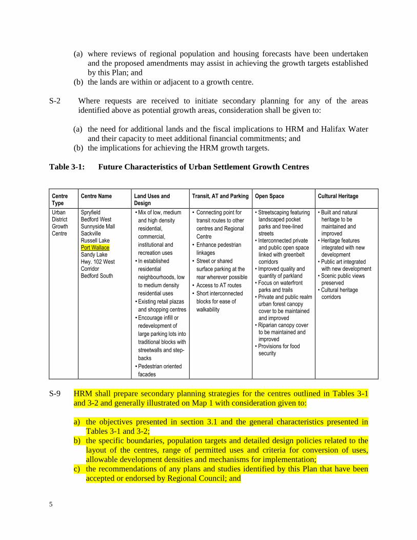
Table 3-1: Future Characteristics of Urban Settlement Growth Centres
Centre Type
Centre Name Land Uses and Design
Transit, AT and Parking Open Space Cultural Heritage
Urban District Growth Centre
Spryfield Bedford West Sunnyside Mall Sackville Russell Lake Port Wallace Sandy Lake Hwy. 102 West Corridor Bedford South
• Mix of low, medium
and high density
residential,
commercial,
institutional and
recreation uses
• In established
residential
neighbourhoods, low
to medium density
residential uses
• Existing retail plazas
and shopping centres
• Encourage infill or
redevelopment of
large parking lots into
traditional blocks with
streetwalls and step-
backs
• Pedestrian oriented
facades
• Connecting point for
transit routes to other
centres and Regional
Centre
• Enhance pedestrian
linkages
• Street or shared
surface parking at the
rear wherever possible
• Access to AT routes
• Short interconnected
blocks for ease of
walkability
• Streetscaping featuring landscaped pocket parks and tree-lined streets
• Interconnected private and public open space linked with greenbelt corridors
• Improved quality and quantity of parkland
• Focus on waterfront parks and trails
• Private and public realm urban forest canopy cover to be maintained and improved
• Riparian canopy cover to be maintained and improved
• Provisions for food security
• Built and natural heritage to be maintained and improved
• Heritage features integrated with new development
• Public art integrated with new development
• Scenic public views preserved
• Cultural heritage corridors
S-9 HRM shall prepare secondary planning strategies for the centres outlined in Tables 3-1
and 3-2 and generally illustrated on Map 1 with consideration given to:
a) the objectives presented in section 3.1 and the general characteristics presented in
Tables 3-1 and 3-2;
b) the specific boundaries, population targets and detailed design policies related to the
layout of the centres, range of permitted uses and criteria for conversion of uses,
allowable development densities and mechanisms for implementation;
c) the recommendations of any plans and studies identified by this Plan that have been
accepted or endorsed by Regional Council; and
6
d) any other relevant objectives and policies of this Plan.
S-12 HRM shall encourage the Province and the Halifax Regional School Board to take into
consideration the objectives of this Plan and secondary planning strategies when deciding
where to locate schools and other public facilities to integrate complementary
developments.
S-30 When preparing new secondary planning strategies or amendments to existing secondary
planning strategies to allow new developments, means of furthering housing affordability
and social inclusion shall be considered including:
a) creating opportunities for a mix of housing types within designated growth centres
and encouraging growth in locations where transit is or will be available;
b) reducing lot frontage, lot size and parking requirements;
c) permitting auxiliary dwelling units or secondary suites within single unit dwellings;
d) permitting homes for special care of more than three residents of a scale compatible
with the surrounding neighbourhood;
e) permitting small scale homes for special care as single unit dwellings and eliminating
additional requirements beyond use as a dwelling;
f) introducing incentive or bonus zoning in the Regional Centre;
g) allowing infill development and housing densification in areas seeking revitalization;
and,
h) identifying existing affordable housing and development of measures to protect it.
CHAPTER 4: TRANSPORTATION AND MOBILITY
4.1 OBJECTIVES
1. Implement a sustainable transportation strategy by providing a choice of integrated
and connected travel modes emphasizing public and community based transit,
active transportation, carpooling and other viable alternatives to the single occupant
vehicle;
2. Promote land settlement patterns and urban design approaches that support fiscally
and environmentally sustainable transportation modes;
3. Forecast HRM’s need for mobility and provide service and infrastructure to meet
this demand while influencing choices towards transportation sustainability; and
4. Design complete streets for all ages, abilities, and modes of travel.
T-1 The Halifax Transportation Demand Management (TDM) Functional Plan (June 2010)
shall provide guidance for future strategies and programs to further the transportation
objectives of this Plan.

7
T-2 The Active Transportation Plan, approved by HRM in November 2006, shall provide
guidance for the objectives, policies, plans and standards for an active transportation
network. Consideration shall be given to revisions to this Plan to further advance the
goals of, supporting healthy lifestyles, enhancing mobility and public safety, improving
environmental quality and reducing auto dependency.
T-3 When preparing secondary planning strategies or negotiating development agreements,
HRM shall consider:
(a) protecting greenways from development that would disrupt the continuity of planned
greenways;
(b) requiring planned greenways to be built by developers to HRM standards when the
land abutting them is developed; and
(c) requiring new development be connected to, and provide access to, existing and
planned greenways.
T-7 The Urban Transit Service Boundary, illustrated in Map 7 of this Plan, shall establish the
area within which HRM will direct future investment in public transit services, with the
exception of rural commuter express service which may be considered outside of this
Boundary. The level of service outside this boundary shall not be increased, but
modifications to services may be considered that serve to facilitate operational planning.
Existing routes and services not contained within this boundary will continue to exist, and
as with any public transit routes or services, any service reductions will be based upon
performance standards approved by HRM.
T-8 Transit priority measures, such as designated transit lanes, transit signal priority, and
queue jump lanes may be made to improve the reliability and travel time of public transit
vehicles.
T-9 HRM shall require mixed use residential and commercial areas designed to maximize
access to public transit (Transit Oriented Development) within the Urban Transit Service
Boundary through secondary planning strategies, and shall strive to achieve the intent of
this policy through land use by-law amendments, development agreements and capital
investments.
T-12 The Regional Parking Strategy Functional Plan, approved by HRM in 2008, shall
provide guidance for strategies and policies to increase the efficiency of the existing
parking system, reduce parking demand and advance related transportation objectives of
this Plan.
T-16 Streets shall be designed to support pedestrians, bicyclists, and public transit and to
improve public health and safety.
T-17 Municipal service design standards for streets shall be reviewed from time to time to
ensure that streets are designed for all ages, abilities and modes of travel and reflect the
character of the community in which the streets are located.
8
CHAPTER 5: ECONOMY AND FINANCE
5.1 OBJECTIVES:
6. Ensure that there are sufficient lands available around the harbour and in business
parks to provide economic opportunities;
7. Prepare financial plans and strategies that support and encourage the outcomes of
this Plan, including environmental conservation, housing affordability, economic
competitiveness, revitalization of the Regional Centre and neighbourhood stability.
EC-5 Where HRM has identified lands that may be suitable for industrial uses, amendments to
secondary planning strategies and land use by-laws shall be initiated to allow for the
intended uses and to ensure that these lands remain available while minimizing conflicts
with existing or future incompatible uses in the vicinity.
EC-7 HRM shall seek to protect and improve road and rail access to existing and future
industrial lands within business parks and on Halifax Harbour.
EC-8 HRM may consider permitting private business parks in appropriate locations within or
adjacent to designated growth centres.
EC-9 Provisions may be established under secondary planning strategies to allow for
residential developments within private business parks through a development agreement.
Policy criteria shall be established to achieve compatible developments and ensure that
residents have adequate services and infrastructure.
EC-18 HRM shall establish provisions under Secondary Planning Strategies and the Regional
Subdivision By-law to allow for imposition of infrastructure charges required to service
new growth areas. The charge shall be determined separately for each charge area in
accordance with the Infrastructure Charges Best Practices Guide: A Capital Cost
Contribution Policy, adopted by HRM in 2002, as may be amended from time to time.
EC-19 HRM shall consider establishing by-laws to allow for the recovery of growth related costs
both on a regional basis and on an area basis where growth related re-development is
being contemplated through secondary planning provisions. In determining an
appropriate charge, consideration shall be given to the recommendations of the HRM
Infrastructure Charge Study: Final Report (2006).

9
CHAPTER 7: CULTURAL AND HERITAGE RESOURCES
7.1 OBJECTIVES
1. Preserve cultural and heritage resources in HRM and develop policies, programs
and regulations to protect and enhance them;
2. Promote cultural and heritage considerations in HRM’s broader planning and
municipal decision making processes;
3. Assist communities in identifying and celebrating cultural and heritage assets;
4. Support cultural and heritage tourism through investment in signature cultural and
heritage attractions and events;
5. Broaden heritage protection through the identification and preservation of cultural
landscapes;
6. Increase opportunities for cultural activity and bolster the creative economy; and
7. Recognize the importance of arts, including professional arts, to the creative
economy and vitality of our region.
CH-1 The HRM Cultural Plan (March 2006), as amended from time to time, shall provide
strategic direction to guide HRM in achieving its long-term cultural goals.
CH-2 The Model for Assessing Cultural Heritage Values in the Halifax Regional Municipality
(April 2005) shall provide guidance for the identification of sites, communities, and
landscapes of cultural and historical significance in HRM.
CH-3 HRM shall prepare a Culture and Heritage Priorities Plan for consideration of adoption
by HRM in whole or in part.
CH-5 HRM shall consider the retention, preservation, rehabilitation and restoration of those
buildings, public building interiors, streetscapes, cultural landscapes, areas and districts of
historic, architectural or cultural value in both urban and rural areas and encourage their
continued use.
CH-8 HRM shall, through the Culture and Heritage Priorities Plan and secondary planning
processes, consider the recognition, preservation, and promotion of significant cultural
landscapes.
CH-9 When considering any amendments to secondary planning strategies involving lands
adjacent to the Shubenacadie Canal, HRM shall give consideration to the potential impact
of development on the visual quality, cultural and historic value and environmental
resources of the Shubenacadie Canal.

10
CH-14 HRM shall adopt the Standards & Guidelines for the Conservation of Historic Places in
Canada, 2nd
Edition (hereinafter referred to as the Standards & Guidelines) in place of its
existing Heritage Building Conservation Standards and amend the Heritage Property
Bylaw, Barrington Street Heritage Conservation District Bylaw, Downtown Halifax
Secondary Municipal Planning Strategy, Downtown Halifax Land Use Bylaw, and other
secondary planning strategies, and land use bylaws, as necessary, to effect this change.
CH-18 To protect HRM’s built heritage and cultural landscapes, HRM shall, through secondary
planning strategies consider:
(a) the priorities established through the Culture & Heritage Priorities Plan;
(b) designating historically significant buildings, sites, streetscapes, conservation
districts and cultural landscapes for heritage protection;
(c) using Heritage Conservation Districts as a means to protect and promote the unique
built and visual heritage features throughout HRM, and implement incentive
programs for those designated Heritage Districts;
(d) developing additional, area-specific design criteria that supplement and embody the
principles of the Standards & Guidelines for the Conservation of Historic Places in
Canada, 2nd
Edition and reinforce the heritage character of an area;
(e) developing mapping and inventories of heritage buildings based on building age,
architectural significance, historic events or persons;
(f) developing mapping, inventories and policies in support of the preservation of
cultural landscapes, including, but not limited to:
(i) scenic views, and sites of potential archaeological significance;
(ii) areas representative of the cultural origins, social heritage and ethnic diversity of
local communities;
(iii) cemeteries and places of worship;
(g) strategies for the development of central public spaces and amenities for performing
arts, visual arts, and heritage activities, for the incorporation of arts and culture
facilities into new civic developments, and for the incorporation of public art,
horticultural elements, monuments and commemorative markers into new
development;
(h) strategies to encourage the reuse, restoration, and retention of registered heritage
properties and throughout HRM, including but not limited to:
(i) allowing for a relaxation of zoning requirements for registered heritage properties,
such as setback or side yard provisions, permitted uses, or parking requirements,
where it can be demonstrated that current limitations are an impediment to the
revitalization, rehabilitation, and ongoing use of the property;
(ii) allowing for a relaxation of building code requirements through the application of
the Alternate Compliance Methods of the Nova Scotia Building Code Regulations;
and
(iii) amending zoning requirements to better reflect the traditional form and
placement of heritage buildings and the streetscape typology of the neighbourhood;
(i) preserving heritage buildings and areas when undertaking municipal public works;
11
(j) prior to selling or otherwise disposing of any surplus municipal property which may
have heritage significance, carrying out an evaluation of the property to determine
the level of significance, if any. Where the surplus property is of significance,
measures should be undertaken to ensure the retention of the building to the greatest
reasonable extent through heritage registration, restrictive covenants or other
appropriate means;
(k) requiring that applications for redevelopment of a registered heritage property, a
property adjacent to a registered heritage property, or a property within a heritage
district, include a heritage impact statement that describes impacts of the
development on heritage areas;
(l) measures to protect significant viewplanes;
(m) identifying scenic entry routes;
(n) requiring that if registered heritage properties or structures within a heritage
conservation district must be replaced due to age, fire or forces of nature, there be
flexibility within the review process to allow reconstruction on the original building
footprint and in the original building form by permitting relief from building
setbacks, height restrictions, or other conditions that would otherwise change the new
structure's location or historic form;
(o) adopting policies to permit incentive or bonus zoning within the geographic area
permitted under applicable legislation where such policies provide for the
preservation and sustainability of heritage buildings and where the public benefit to
the heritage building can be clearly quantified or illustrated;
(p) identifying and protecting regionally significant views as a component of cultural
landscapes;
(q) developing guidelines for:
(i) scenic lookouts, information and directional signs to important urban and rural
cultural, heritage, environmental and tourism destinations;
(ii) the protection of views to natural and cultural heritage features, mature trees and
roadside vegetation along and beyond the road right-of-way; and
(iii) coordination with private landowners and the provincial government regarding
landscaping, berming, pathways and other features; and
(r) considering the preservation of significant cultural landscapes, and culturally
significant coastal villages and their landscapes through mechanisms such as
management plans, land use designations, architectural design guidelines, direct
purchase, lease, conservation easements or other means available under the authority
of applicable provincial legislation.
CHAPTER 8: MUNICIPAL WATER SERVICES, UTILITIES AND SOLID WASTE
8.1 OBJECTIVES
1. Coordinate municipal initiatives with the Halifax Regional Water Commission
(Halifax Water) to:
(a) provide water, wastewater and stormwater services in a cost-effective manner;
(b) recoup growth related costs from benefitting property owners; and
12
(c) reduce degradation to the natural environment.
2. Manage growth to make the best use of existing water, wastewater and stormwater
infrastructure and avoid unnecessary or premature expenditures;
3. Support environmentally sustainable practices for developments serviced with on-
site water and wastewater services;
4. Reduce above grade electrical and telecommunication lines;
5. Encourage the development of an comprehensive natural gas distribution system;
and
6. Reduce the amount of solid waste generated and operate solid waste facilities in an
environmentally responsible and cost-effective manner.
SU-1 HRM shall work with Halifax Water to coordinate municipal land use planning and
development initiatives with the planning and development of municipal water, waste-
water and stormwater facilities in a manner that is consistent with the objectives of this
Plan, the Transfer Agreement and can satisfy policies and regulations of Halifax Water
and the Review Board.
SU-2 HRM shall establish an Urban Service Area under the Regional Subdivision By-law to
designate those areas within the Urban Settlement Designation and the Harbour
Designation where municipal wastewater collection and water distribution systems are to
be provided. The Area shall initially include all lands within existing service boundaries
established under secondary planning strategies at the time of adoption of this Plan.
Lands within the Urban Service Area shall only be developed with municipal wastewater
collection and water distribution systems. Any service boundary established under
existing secondary planning strategies shall be replaced by the Urban Service Area
boundary in the Regional Subdivision By-law.
SU-4 When considering any expansion of the Urban Service Area, HRM shall have regard to
the following:
(a) that a Secondary Planning Strategy for the lands to be included within the Urban
Service Area has been adopted by HRM except that this requirement may be waived
where, in the opinion of HRM, the proposed extension represents a minor adjustment
to the Area;
(b) the financial ability of HRM to absorb any costs relating to the extension;
(c) if required, a watershed or sub-watershed study has been completed in accordance
with Policy E-23;
(d) that, if required to pay for growth-related municipal infrastructure costs, a municipal
infrastructure charge area has been established or is adopted concurrently with the
boundary amendment;

13
(e) the need to oversize the water, wastewater or stormwater systems to allow for future
development within an Urban Settlement or Urban Reserve designation; and
(f) a charge needed to pay for growth related improvements to the water, wastewater or
stormwater systems has, where required, been approved by the Review Board.
SU-5 Within the Urban Service Area, where a new Secondary Planning Strategy or an
amendment to an existing Secondary Planning Strategy is proposed to accommodate
future growth, no approval shall be granted unless:
(a) a by-law has been established or is proposed concurrently to pay for growth related
municipal infrastructure or HRM has determined that a by-law is not warranted; and
(b) a charge needed to pay for growth related improvements to the water, wastewater or
stormwater services has been, where required, been approved by the Review Board.
SU-7 HRM shall consider adopting a stormwater management and erosion control by-law with
provisions made that may be area specific and may vary by type of development and,
where required, be subject to approval by the Review Board. When considering adoption
or amendments to the by-law, the following matters may be considered:
(a) the cost and effectiveness of methods to reduce increased stormwater flows caused
by development with consideration given to problems associated with downstream
flooding, stream bank erosion, groundwater contamination and inflow and
infiltrations into wastewater systems;
(b) the potential for employing naturally occurring soils and native plant species in
stormwater management plans;
(c) means to reduce site disturbance and impervious surfaces in new developments;
(d) methods of reducing sediments, nutrients and contaminants being discharged into
watercourses; and
(e) the recommendations contained in a watershed study undertaken pursuant to policy
E-23 of this Plan.
SU-8 HRM may consider regulatory and operational measures to reduce the quantity and
improve the quality of stormwater entering public stormwater facilities and watercourses
including, but not limited to, public education programs, animal waste control, spill
prevention plans, removing illegal connections, enhanced street sweeping, reduction in
road salts, land use restrictions and revisions of development standards. Any such
measures may apply in whole or in part of HRM and may require approval of the Review
Board.
SU-9 HRM may consider supporting retrofits to existing stormwater facilities where it has been
determined that such retrofits could be expected to mitigate flooding or to improve the
quality of stormwater entering watercourses.

14
CHAPTER 9: GOVERNANCE AND IMPLEMENTATION
9.1 OBJECTIVES
1. Engage citizens in the development of policies, programs and services as the basis
for building healthy, strong and inclusive communities;
2. Monitor the effectiveness of policies and programs of this Plan;
3. Undertake periodic reviews of this Plan to assess whether changes are needed; and
4. Ensure that HRM policies and programs are aligned to achieve the vision and
objectives of this Plan.
G-1 The HRM Community Engagement Strategy, approved by HRM in 2008, shall guide how
HRM will inform, consult with, and engage the public in developing and implementing
its programs and services.
G-3 When preparing secondary planning strategies, HRM shall incorporate a visioning
program as part of the planning process.
G-5 When undertaking reviews of this Plan, Secondary Planning Strategies or other HRM
programs and investments, HRM shall seek the views of citizens, institutions, businesses
and community organizations in evaluating the effectiveness of existing policies,
programs and investments.
G-9 When new secondary planning strategies or amendments to existing secondary planning
strategies are brought forward for approval, HRM shall consider whether the proposed
objectives and policies are consistent with or further achieve the objectives and policies
of this Plan.


