A Step Change in Military Autonomous Technology

Introduction
Commercial vs Military AUV operations
Typical Military Operation (Man-Portable
Class)
Fusion System Components
User Interface (HMI)
Modes of Operation
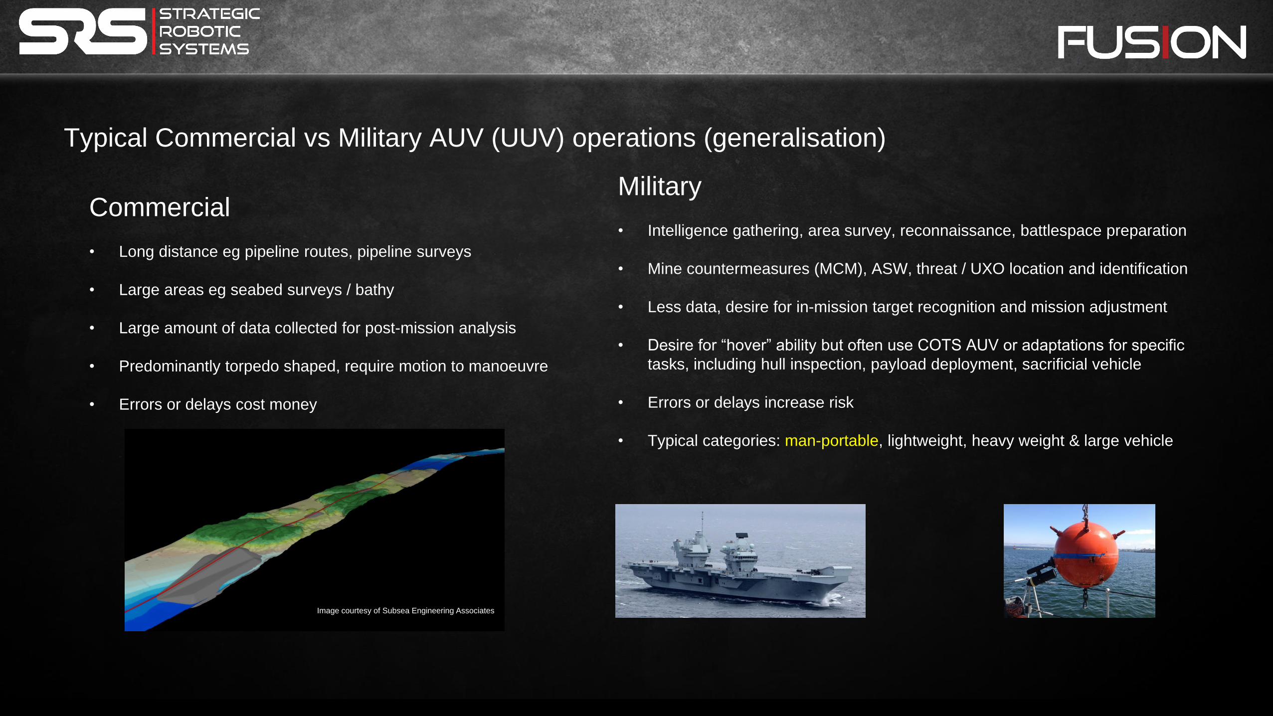
Typical Commercial vs Military AUV (UUV) operations (generalisation)
Commercial
• Long distance eg pipeline routes, pipeline surveys
• Large areas eg seabed surveys / bathy
• Large amount of data collected for post-mission analysis
• Predominantly torpedo shaped, require motion to manoeuvre
• Errors or delays cost money
Military
• Intelligence gathering, area survey, reconnaissance, battlespace preparation
• Mine countermeasures (MCM), ASW, threat / UXO location and identification
• Less data, desire for in-mission target recognition and mission adjustment
• Desire for “hover” ability but often use COTS AUV or adaptations for specific
tasks, including hull inspection, payload deployment, sacrificial vehicle
• Errors or delays increase risk
• Typical categories: man-portable, lightweight, heavy weight & large vehicle
Image courtesy of Subsea Engineering Associates

Typical Current Military Operation (Man-Portable Class) Assets Equipment
Cost
• Survey areas of interest using AUV & identify targets of interest: AUV & Operating Team USD 250k to USD millions
• Deploy ROV to perform detailed survey of identified targets: ROV & Operating Team USD 200k to USD 450k
• Deploy divers to deal with targets: Dive Team with Nav Aids & USD 25k – USD 100ks
Diver Propulsion
---------------------------------------------------------------------------------
3 teams, 3 sets of equipment
= opportunity for cost reduction
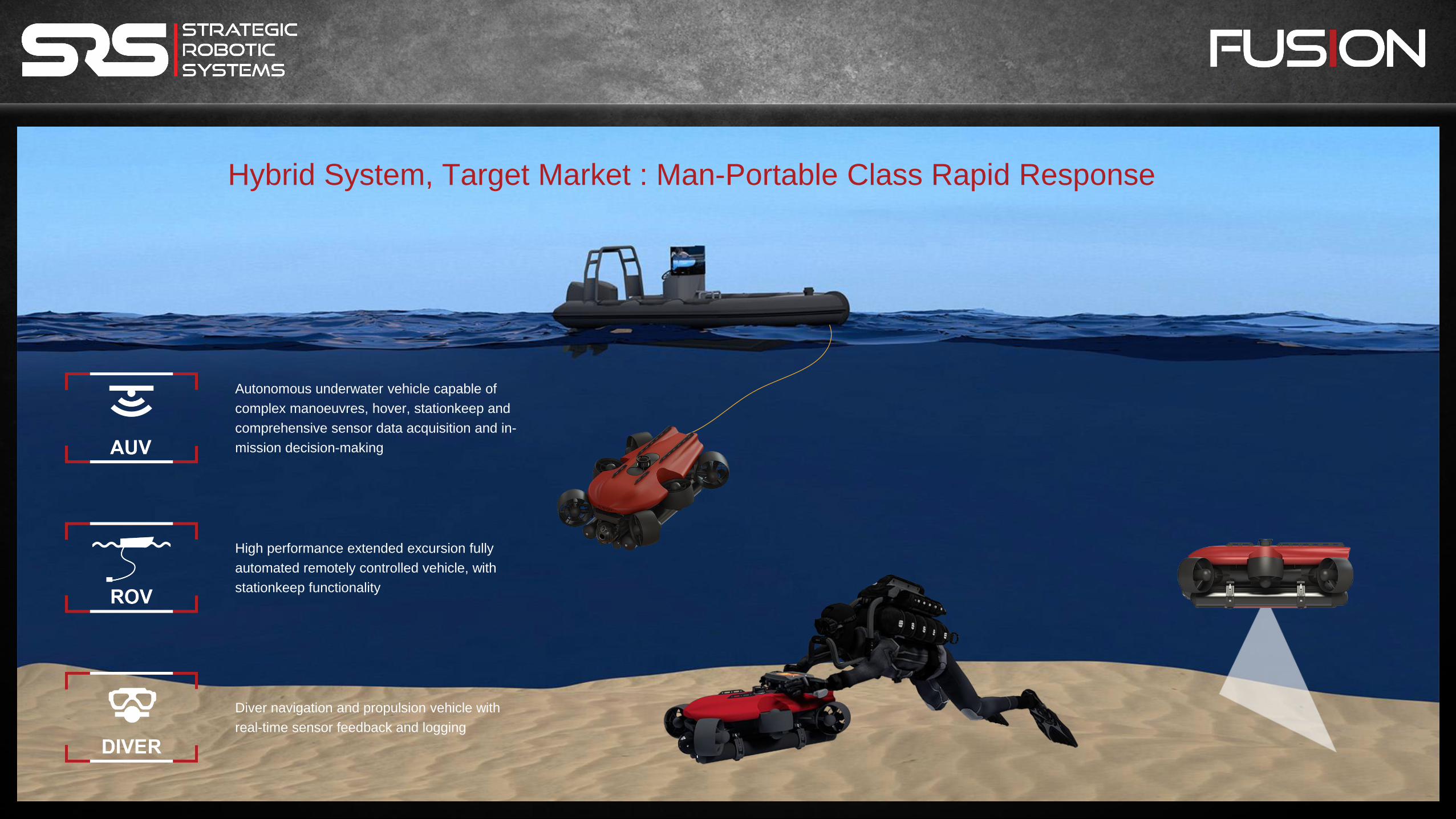
Hybrid System, Target Market : Man-Portable Class Rapid Response
High performance extended excursion fully
automated remotely controlled vehicle, with
stationkeep functionality
Autonomous underwater vehicle capable of
complex manoeuvres, hover, stationkeep and
comprehensive sensor data acquisition and in-
mission decision-making
Diver navigation and propulsion vehicle with
real-time sensor feedback and logging

Heig
ht
- 275m
m
Wid
th -
477m
m
Length - 686mm
Vehicle Weight 27.5kg
Depth rating 300m
Forward speed 4+ knots (target 5 knots)
Vehicle Stats
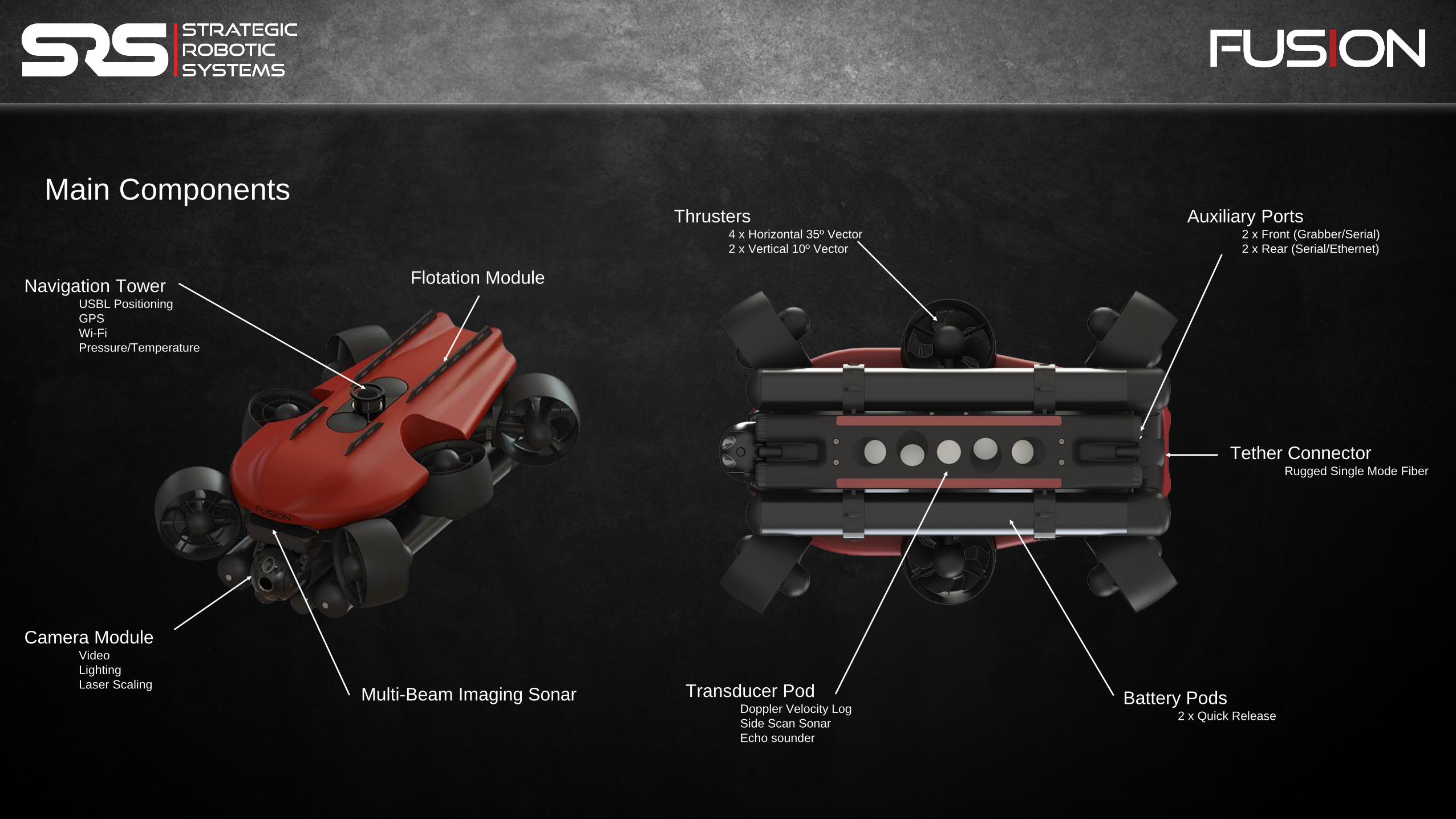
Main Components
Camera Module Video
Lighting
Laser Scaling
Navigation Tower USBL Positioning
GPS
Wi-Fi
Pressure/Temperature
Multi-Beam Imaging Sonar Battery Pods 2 x Quick Release
Transducer Pod Doppler Velocity Log
Side Scan Sonar
Echo sounder
Thrusters 4 x Horizontal 35º Vector
2 x Vertical 10º Vector
Auxiliary Ports 2 x Front (Grabber/Serial)
2 x Rear (Serial/Ethernet)
Tether Connector Rugged Single Mode Fiber
Flotation Module

Camera Module Resolution - 1080p30 HD
Lights - 3 x LED
Scaling - 2 x Red Laser Line
Tilt - 135º
Navigation Tower USBL Positioning
Range - 1+km
Resolution - ± 50mm
Angular Resolution - ± 1º
GPS
Channels - 72
Accuracy - 2.5m
GNSS - GPS / GLONASS
Wi-Fi
Frequency - 2.4GHz
Pressure & Temperature
Accuracy - 0.01m
Multi-Beam Imaging Sonar Frequency - 750kHz / 1.2MHz
Horizontal Beam Width - 130º
Vertical Beam Width - 20º / 12.5º
Range (750kHz) - 0.1-100m
Range (1.2MHz) - 0.1-35m
1º/0.6º acoustic angular resolution
4mm/2.5mm range resolution
256 beams
Side Scan Sonar Frequency - 450kHz CHIRP
Horizontal Beam Width - 0.5º
Vertical Beam Width - 60º
Range - 100m / 328ft
DVL / Altimeter DVL Frequency - 1MHz
Altimeter Frequency - 500kHz
Altitude Range - 0.2m-50m
Velocity Range - ±16m/s
Velocity Resolution - 0.01mm/s
Internal Navigation AHRS
Roll & Pitch Accuracy - 0.2º
Heading - 1º
Heave - 0.1m
Sensor Suite
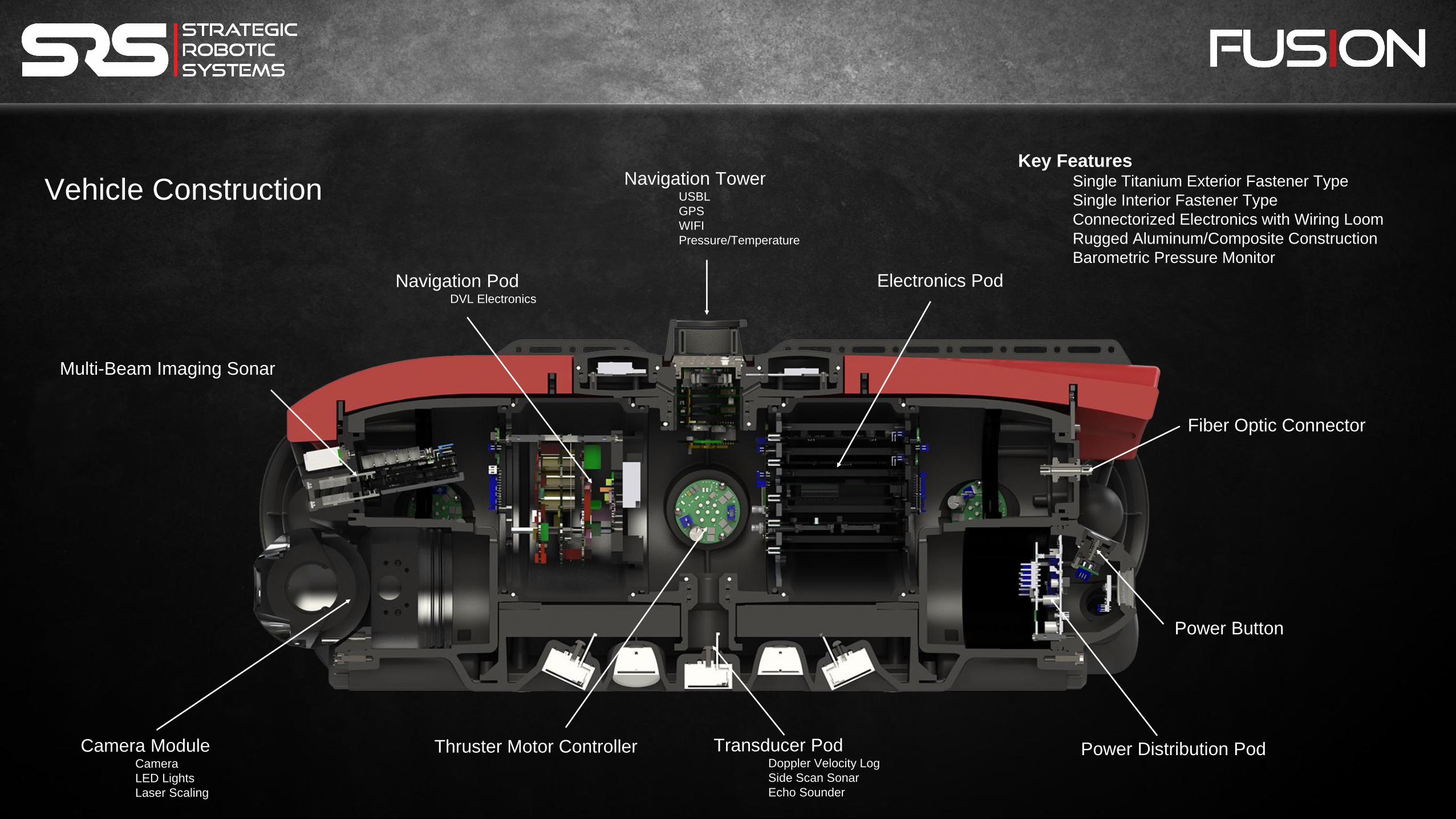
Key Features Single Titanium Exterior Fastener Type
Single Interior Fastener Type
Connectorized Electronics with Wiring Loom
Rugged Aluminum/Composite Construction
Barometric Pressure Monitor
Transducer Pod Doppler Velocity Log
Side Scan Sonar
Echo Sounder
Camera Module Camera
LED Lights
Laser Scaling
Multi-Beam Imaging Sonar
Navigation Pod DVL Electronics
Electronics Pod
Navigation Tower USBL
GPS
WIFI
Pressure/Temperature
Power Distribution Pod
Power Button
Fiber Optic Connector
Thruster Motor Controller
Vehicle Construction

Key Features
4 vectored horizontal thrusters
2 vectored vertical thrusters
Low maintenance, flooded design
Electronics inside vehicle
Tool-less rapid thruster change
Quick-detach guard
Propulsion

Battery Pack Specifications
Chemistry – Lithium Ion
Capacity - 457w-hr (ea)
Voltage range 21- 29VDC
Certification - UN38.3
Cycle Life - Est. 750+
Charge times
0-100% - 4 hrs (pair)
0-90% - 2 hrs (pair)
Key Features
Quick change mechanism
Intelligent battery management
2 pairs included
Battery Clamps
Battery Power
Battery storage (2 sets), charger and vacuum pump

Key Features
Quick change spool
2,000m capacity
Level wind
Electrical slip-ring
Compact & lightweight
Tether
500m tether
2,000m tether
Reel
Key Features
2.4mm diameter (nominal)
500m length (standard)
2,000m length (optional)
110kgf strength
Gigabit / 1000baseT Ethernet
Single Mode optical fiber
Rugged / kink free design
Neutral in fresh water

Hotkey Buttons Programmable
Dual Thumbwheels Adjustable Orientation
Dual Joysticks Programmable
User Interface (HMI) Rugged Tablet
Quick Detach
Key Features
Single interface for all modes
Shared data between modes
Intuitive / simplistic display
Built in support manuals/videos
Maintenance prompts and automation
User configurable
Based on commercial drone interface
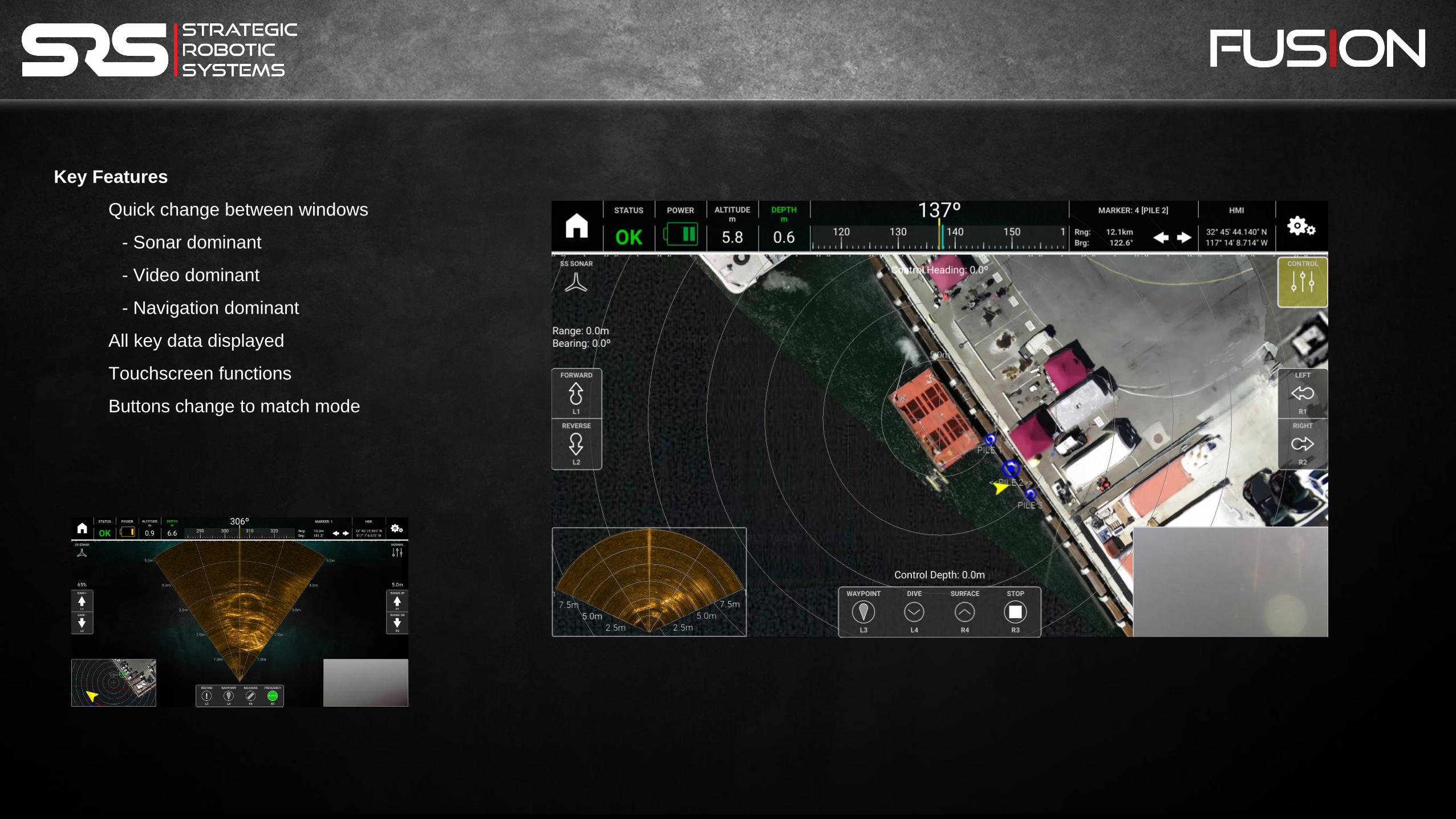
Key Features
Quick change between windows
- Sonar dominant
- Video dominant
- Navigation dominant
All key data displayed
Touchscreen functions
Buttons change to match mode

Modes of Operation:
Normal
Control
Mission
Manual
Tethered Functionality

Vertical Dive / Surface Complex Maneuvres • Enhanced maneuverability
• 300 meter operational depth
• 4+ hour mission capability
• Extensive sensor data
• Side scan
• Multi-beam imaging sonar
• HD video
• Laser scaling
• Intuitive mission planning
Orbit Lateral Movement
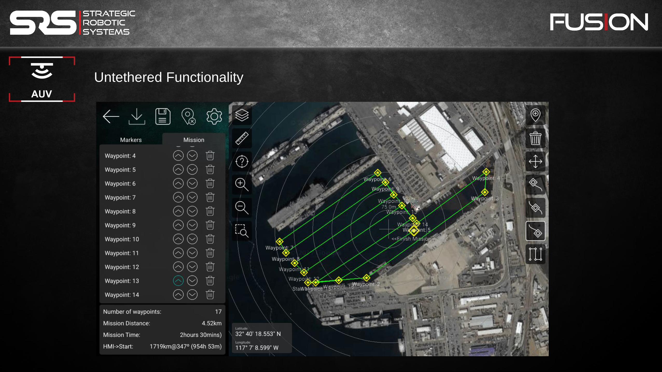
Untethered Functionality

Untethered Functionality
Traditional AUV mission patterns
“Orbit” pattern
User-defined patterns
Shallow turn radius due to thruster configuration
No surfacing requirement
Vehicle communications during mission
USBL Reduced mission durations
2 hours, 42 minutes
1 square kilometer
@ 2.5 knots
with 50 meter side scan range
@ 100 meter depth
1,000m
1,0
00
m
Untethered Functionality

DIVER Mode
• Quick attach diver module
• Nav & propulsion controls
• 178mm screen
• Sonar and navigation
• Propulsion
• Virtual anchor when not in use
• Video recording
• 1.5 knot forward velocity (est)
• 60-90 minute duration (est)

CURRENT
STATUS:
• Production of stationkeep ROV version has commenced
• Mission planning is in testing, nearing completion
• Obstacle avoidance under development
ONGOING AND FUTURE DEVELOPMENT:
• Target recognition / identification
• Integrated Fusion / RIB / dive package
• Remote deployment (helicopter drop / remote surface vessel)
• Test Correlation Velocity Log (CVL) vs DVL
• Ability to “swarm”

QUESTIONS


