
Advancements in GIS-based fire modeling applications

How would they fight firein Star Trek?
Advancements in GIS-based fire modeling applications

Natural Resources CanadaCanadian Forest Service
Ressources naturelles CanadaService canadien des forêts
Fire Information Systems
• Fire growth modelling (PFAS, Burn-P3,
Pandora, Pegasus, Bigfoot)
• Fire danger mapping (SFMS)
CFS Fire Information Systems group:
Kerry Anderson, Richard Carr, Peter Englefield,
John Little, Marc Parisien, Rod Suddaby
PFAS
Pandora
Burn-P3
BigfootPegasus
SFMS

Natural Resources CanadaCanadian Forest Service
Ressources naturelles CanadaService canadien des forêts
Fire Growth Modelling
• Long-range / probabilistic (PFAS)
• Burn probability (Burn-P3)
• Batch / no user interface (Pandora)
• Simple / on the web (Pegasus)
• Automated (Bigfoot)

Natural Resources CanadaCanadian Forest Service
Ressources naturelles CanadaService canadien des forêts
Fire Growth Modelling Applications
Short range
Tactical
Operational
Deterministic
Long range
Strategic
Planning
Probabilistic
Prometheus Bigfoot PFAS Burn-P3Pegasus Pandora

Natural Resources CanadaCanadian Forest Service
Ressources naturelles CanadaService canadien des forêts
Prometheus COM

Natural Resources CanadaCanadian Forest Service
Ressources naturelles CanadaService canadien des forêts
Prometheus
Applications
Prometheus COM
Pandora
Burn-P3
Prometheus
ApplicationPegasus
SFMS
Bigfoot

Natural Resources CanadaCanadian Forest Service
Ressources naturelles CanadaService canadien des forêts
Accessing Prometheus through the back door
• "Batch Prometheus"
• Run one or many simulations sequentially
• All input parameters specified in text file
• Minimal user interface (optional)
• Help file
• Progress window displays status, simulation time, and area burned

Natural Resources CanadaCanadian Forest Service
Ressources naturelles CanadaService canadien des forêts
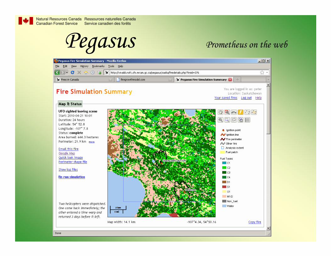
Pegasus• "Prometheus on the web"
• Minimal set of input parameters
• Data stored and prepared by server
• No client-side data or software needed
• User can modify weather, fuels, ignitions
• Simulations done on server via Pandora
• Fire perimeter displayed using map server
• Developed in collaboration with Saskatchewan FMFP
Natural Resources CanadaCanadian Forest Service
Ressources naturelles CanadaService canadien des forêts
Pegasus Prometheus on the web
Natural Resources CanadaCanadian Forest Service
Ressources naturelles CanadaService canadien des forêts
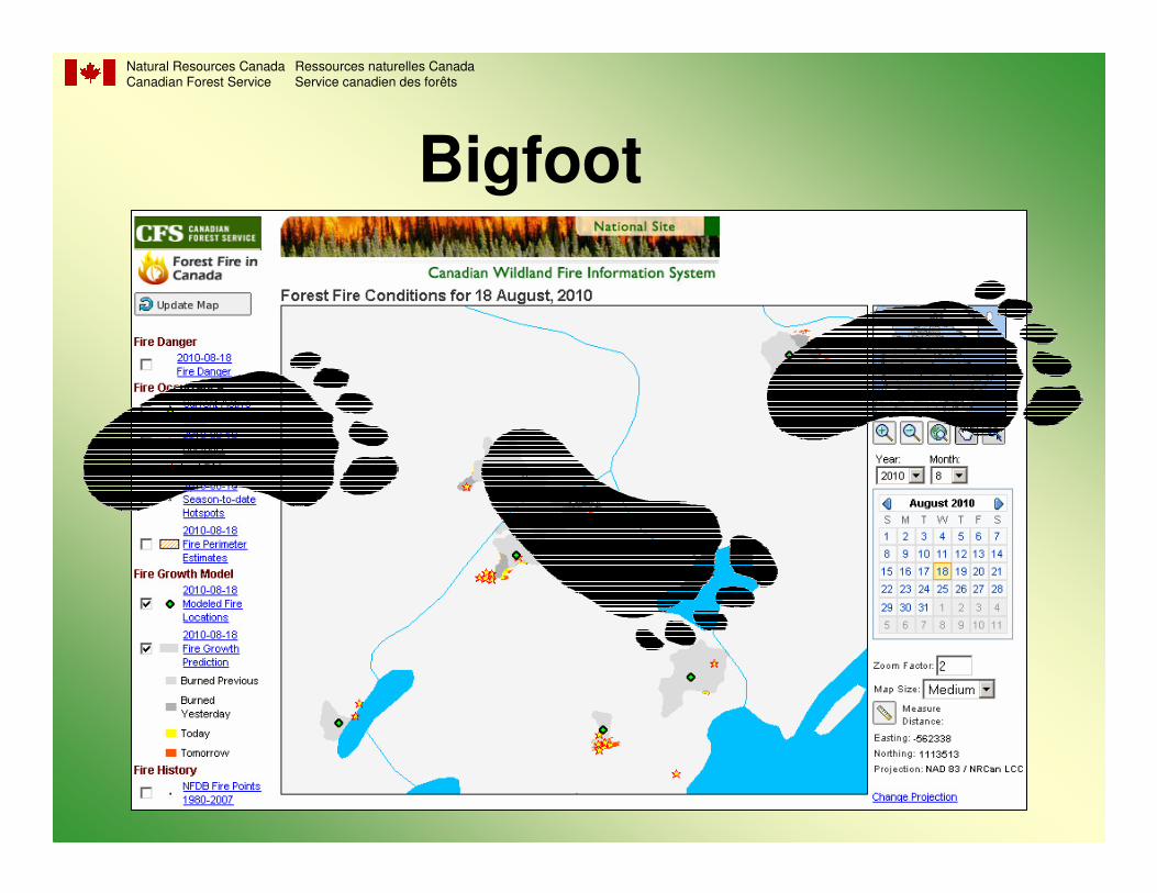
Bigfoot
• Automated fire growth simulations
• Start fire growth from:– ignition point
– fire perimeter
– hotspot buffer perimeter
• 48-hour simulations
• Run daily at 5:00 AM

Natural Resources CanadaCanadian Forest Service
Ressources naturelles CanadaService canadien des forêts
Burn-P3
• Burn Probability, Prediction, and Planning
• Multiple simulations
• Ignition and weather based on historical data
• Prometheus COM

Natural Resources CanadaCanadian Forest Service
Ressources naturelles CanadaService canadien des forêts
Burn-P3 fire simulation modeling inputs
Wood Buffalo National Park
Non-spatial inputs:•Number of fires per year•Weather conditions•Duration of burning
Spatial inputs:•Fuels•Topography•Ignition patterns

Burn-P3

Burn-P3

Natural Resources CanadaCanadian Forest Service
Ressources naturelles CanadaService canadien des forêts
Untreated landscape
Parisien et al. (2007, Int. J. Wildland Fire)
Evaluating fuel treatment effectiveness
Treated landscape

Natural Resources CanadaCanadian Forest Service
Ressources naturelles CanadaService canadien des forêts
PFAS
• Prescribed Fire Analysis System
• Long-range forecast (weeks / months)
• Climatology input
• Probabilistic output
15 day 30 day

Natural Resources CanadaCanadian Forest Service
Ressources naturelles CanadaService canadien des forêts
The model calculates the probabilities of spread and of survival
for each grid cell based on historical weather and mutiplies
them to produce the probable fire extent map.
Probability of Spread Probability of Survival Probable Extent
PFAS

Natural Resources CanadaCanadian Forest Service
Ressources naturelles CanadaService canadien des forêts
Spatial Fire Management SystemSpatial Fire Management System

Natural Resources CanadaCanadian Forest Service
Ressources naturelles CanadaService canadien des forêts
What is SFMS?
• Fire information analysis and display software
• Incorporates fire science models (CFFDRS)
• Runs on GIS platform (ArcView 3.x)
• Now being re-developed as a stand-alone application

Natural Resources CanadaCanadian Forest Service
Ressources naturelles CanadaService canadien des forêts
Modules
• Weather (WX)
• Fire Weather Index (FWI)
• Fire Behaviour Prediction (FBP)
• Optimal Resource Allocation & Prepositioning (ORAP)
• Wildfire Threat Rating (WTR)
• Fire Occurrence Prediction (FOP)
• Fire Growth Modelling (FGM)

Natural Resources CanadaCanadian Forest Service
Ressources naturelles CanadaService canadien des forêts
Interpolation Options
• Inverse Distance Weighting (IDW)
• Kriging
• Thin plate smoothing spline (Anusplin)

Natural Resources CanadaCanadian Forest Service
Ressources naturelles CanadaService canadien des forêts
Natural Resources CanadaCanadian Forest Service
Ressources naturelles CanadaService canadien des forêts
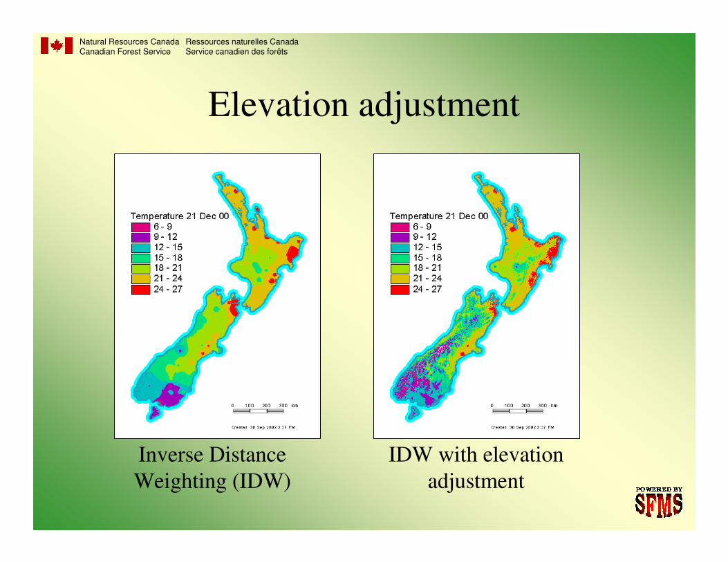
Elevation adjustment
Inverse Distance
Weighting (IDW)
IDW with elevation
adjustment

Natural Resources CanadaCanadian Forest Service
Ressources naturelles CanadaService canadien des forêts
Fire Climatology

Natural Resources CanadaCanadian Forest Service
Ressources naturelles CanadaService canadien des forêts
Wildfire Threat Rating
Fire Risk Fire Behavior
Values at Risk Suppression
Capability

Natural Resources CanadaCanadian Forest Service
Ressources naturelles CanadaService canadien des forêts

Natural Resources CanadaCanadian Forest Service
Ressources naturelles CanadaService canadien des forêts
Fire Occurrence Prediction
Human-caused
• People
Lightning-caused
• Sparky
• LCFOP

Natural Resources CanadaCanadian Forest Service
Ressources naturelles CanadaService canadien des forêts
Fire Growth Modeling

Natural Resources CanadaCanadian Forest Service
Ressources naturelles CanadaService canadien des forêts
Fire growth ensemble modelling

Natural Resources CanadaCanadian Forest Service
Ressources naturelles CanadaService canadien des forêts

Natural Resources CanadaCanadian Forest Service
Ressources naturelles CanadaService canadien des forêts

Natural Resources CanadaCanadian Forest Service
Ressources naturelles CanadaService canadien des forêts
Next GenerationNext Generation
Spatial Fire Spatial Fire
Management SystemManagement System
SFMS

Natural Resources CanadaCanadian Forest Service
Ressources naturelles CanadaService canadien des forêts
SFMS re-development
• Independent of any commercial software
• Written in C
• Can be compiled for Windows or Unix
• Run from the command line
• No GUI, at least initially
• Open Source approach allowing for collaboration and
minimizing obstacles to implementation
• GeoTIFF grid format allowing for easy file management and
compatibility with various GIS/mapping platforms
• ODBC for retrieving weather data

Natural Resources CanadaCanadian Forest Service
Ressources naturelles CanadaService canadien des forêts
SFMS re-development
• Modular design
• Core modules:
– Initialization
– Database
– Weather
– FWI
– FBP
• MapServer to render map images
• Run in daily or hourly mode

Natural Resources CanadaCanadian Forest Service
Ressources naturelles CanadaService canadien des forêts
Fire Weather
This module produces maps of FWI components by
interpolation or cell-by-cell calculation.
Parameters: startup procedures, daily/hourly FFMC
Fire Behavior
Cell-by-cell calculation of ROS, HFI, TFC, etc.
Input grids: Fuel type, elevation, slope, aspect
Parameters: curing, greenup
SFMS re-development
Natural Resources CanadaCanadian Forest Service
Ressources naturelles CanadaService canadien des forêts
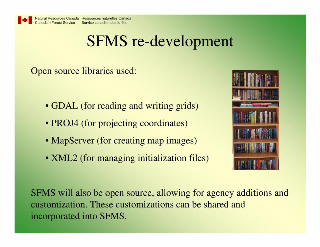
Open source libraries used:
• GDAL (for reading and writing grids)
• PROJ4 (for projecting coordinates)
• MapServer (for creating map images)
• XML2 (for managing initialization files)
SFMS will also be open source, allowing for agency additions and
customization. These customizations can be shared and
incorporated into SFMS.
SFMS re-development

Natural Resources CanadaCanadian Forest Service
Ressources naturelles CanadaService canadien des forêts
SFMS re-development
Additional modules to be included after the completion of the
SFMS core system, depending on user demand:
• Web-based user interface
• Fire growth modelling
• Fire occurrence prediction
• Wildfire threat rating
• Optimal resource allocation and prepositioning
• Fire climatology

Natural Resources CanadaCanadian Forest Service
Ressources naturelles CanadaService canadien des forêts
KHAN'S TALLY


