An insitu-model-aircraft cross validation strategy for SMOS
Jeffrey Walker1, Christoph Rüdiger1, Jean-Christophe Calvet2 and Yann Kerr3
(1)Department of Civil and Environmental Engineering, University of Melbourne, Melbourne, Australia
(2)CNRM (Météo-France, CNRS), Toulouse, France(3)CESBIO (UPS, IRD, CNRS, CNES), Toulouse, France

Microwave satellites: near-future
SMOS (Soil Moisture and Ocean Salinity) launch 9 Sept. 2009 40km 3days; synthetic aperture radiometer
AQUARIUS (Ocean Salinity and soil moisture)launch May 2010 ~100km 7days; “traditional” active passive
SMAP (Soil Moisture Active Passive) launch ~2013 40-10km 3days; high resolution active

Microwave satellites: current
ASCAT (Advanced Scatterometer) launched 2006 50km 1-3days; c-band microwave scatterometer
AMSR-E (Advanced Microwave Scanning Radiometer for the Earth observing system) launched 2002 25km 1-3days; “traditional” c-band radiometer
WindSAT (Wind Satellite)launched 2003 Same as AMSR-E but 6:30am/pm overpass time rather than 1:30am/pm
ASAR (Advanced Synthetic Aperture Radar)launched 2004 1km ~10days; c-band microwave scatterometer

The cross-validation strategy
A SMOS cross-validation strategy using in-situ measurements, airborne measurements, model predictions and satellite observations

The Murrumbidgee: A demonstration test-bed
0 500km

Murrumbidgee Catchment characteristics

Murrumbidgee Catchment monitoring

OzNet monitoring network
www.oznet.unimelb.edu.au

MoistureMap: An overview …
Data Assimilation
SMO
S Si
mul
ator
1km LanduseLandcover Data
Project 4Multi-angle Retrieval
Rainfall and ET Data
BoM
Rea
l-ti
me
Obs
ervi
ng
Net
wor
k
BoM
7-da
y N
WP
Fore
cast
BoM
Sea
sona
l Cli
mat
e Fo
reca
st
50km
SM
OS
Dat
a
1km
MO
DIS
Dat
aMoistureMap
A soil moisture monitoring, prediction and reporting system for land management
1km
Soi
l Moi
stur
e P
redi
ctio
n M
odel
Walker et al. (2003), MODSIM
SMMR Assimilation

CABLE: CSIRO Atm. Bio. Land Exchange
Canopy radiation;sunlit & shaded visible &near infra-red,albedo stomata transp.
& photosynthesis
Carbon fluxes;GPP, NPP,NEP
SEB & fluxes;for soil-vegetationsystem:λEf , Hf , λEg , Hg;
evapotranspiration
soil moisture snow
carbon pools; allocation & flow
CASA-CNP
vegetation dynamics/disturbance
soil temp. soil respiration
Developed at present
Future development

Airborne sensing instruments
L-band Radiometer6 x Everest TIR’s
Thermal Imager 6 x Skye VIS/NIR/SWIR Spectrometers
Full Waveform Laser Scanner
R/G/B/NIRVideo Hyperspectral
(400 to 2500nm)
21MPixel Camera
L-band Radar (InSAR)
Hyperspectral (400 to 900nm)

1km
Multi-spectral data: example
Merlin, Walker et al., 2009. Adv. Water Resour.
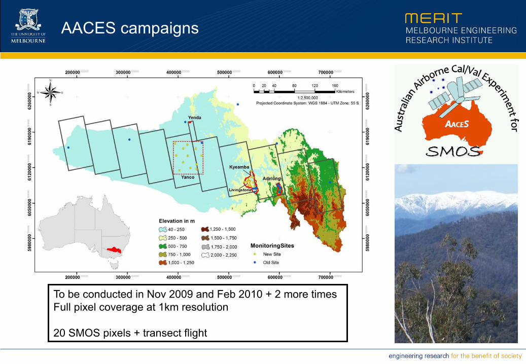
AACES campaigns
To be conducted in Nov 2009 and Feb 2010 + 2 more timesFull pixel coverage at 1km resolution
20 SMOS pixels + transect flight
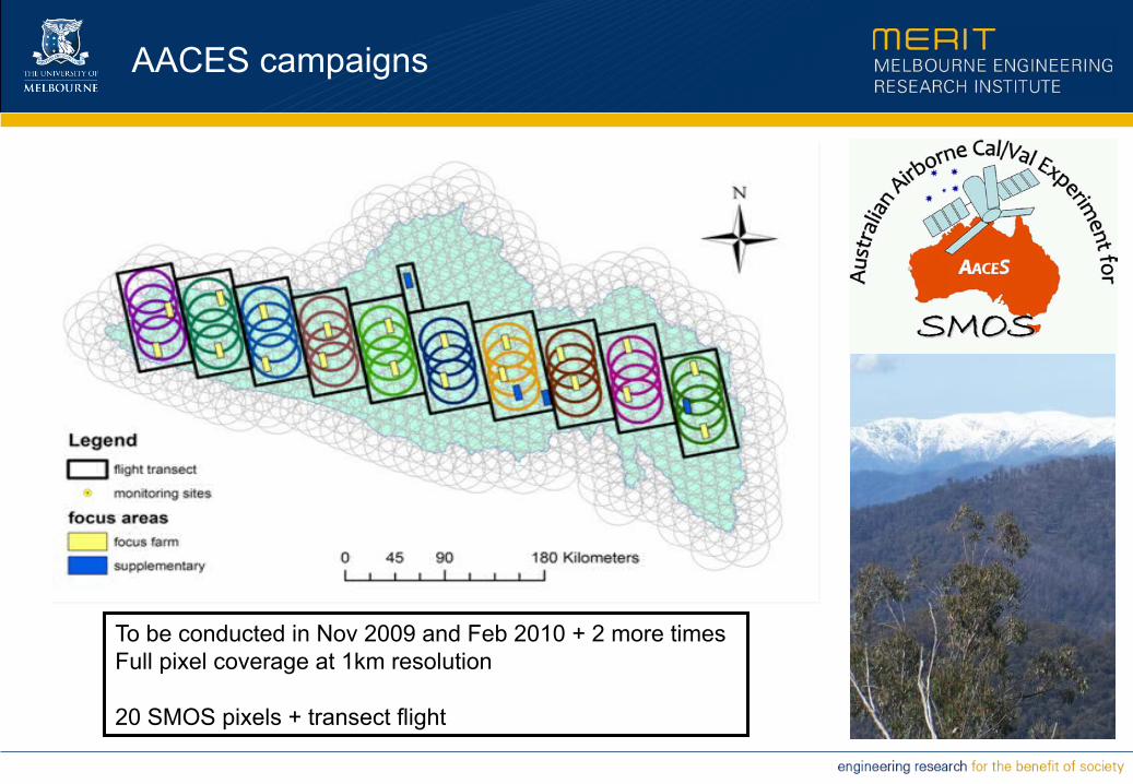
AACES campaigns
To be conducted in Nov 2009 and Feb 2010 + 2 more timesFull pixel coverage at 1km resolution
20 SMOS pixels + transect flight
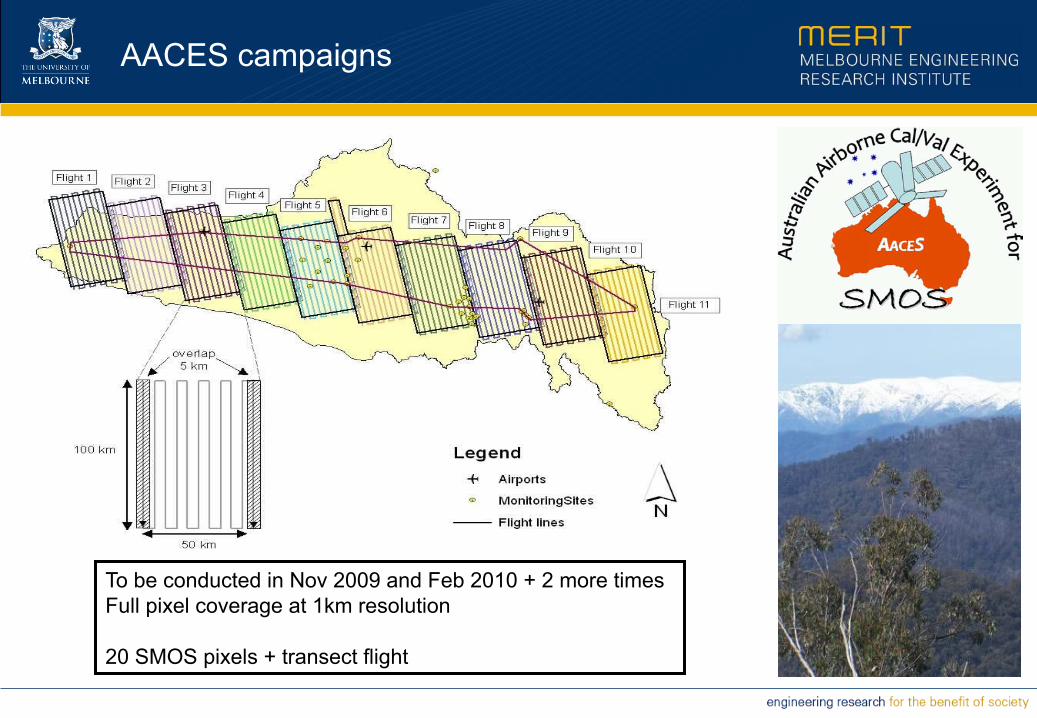
AACES campaigns
To be conducted in Nov 2009 and Feb 2010 + 2 more timesFull pixel coverage at 1km resolution
20 SMOS pixels + transect flight
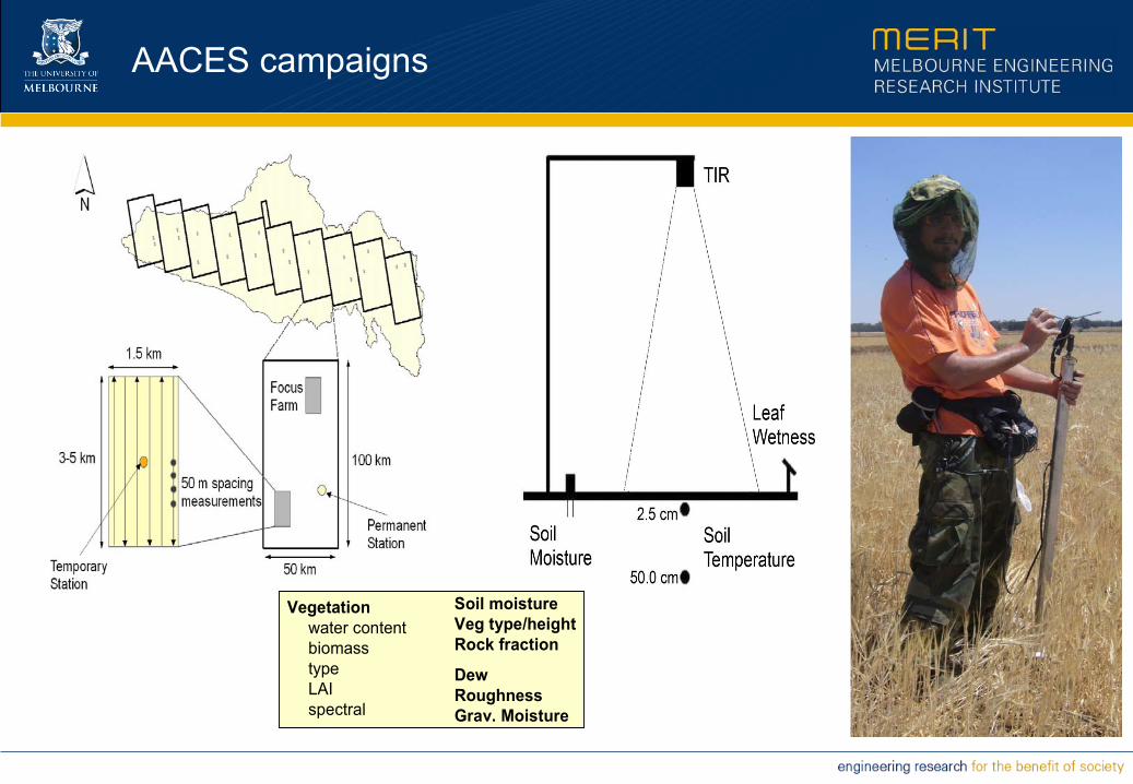
AACES campaigns
Vegetation
water contentbiomasstypeLAIspectral
Soil moistureVeg type/heightRock fraction
DewRoughnessGrav. Moisture
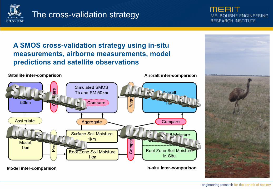
The cross-validation strategy
A SMOS cross-validation strategy using in-situ measurements, airborne measurements, model predictions and satellite observations
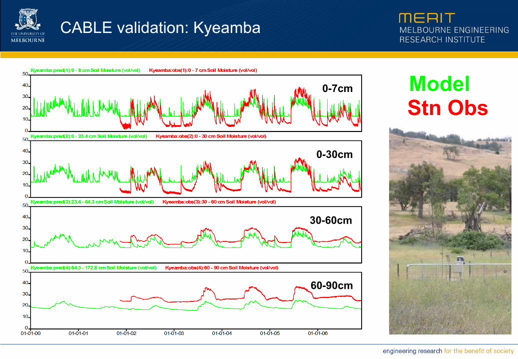
CABLE validation: Kyeamba
0-7cm
0-30cm
30-60cm
60-90cm
ModelStn Obs

AMSR-E validation: Adelong
Draper, Walker et al. (2009) RSE
+ AMSR-E
- Stn Obs
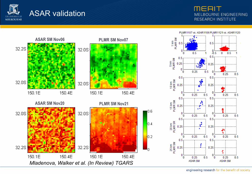
ASAR validation
PLMR SM Nov21
PLMR SM Nov07ASAR SM Nov06
ASAR SM Nov20
Mladenova, Walker et al. (In Review) TGARS

“Make no little plans; they have no magic to stir the blood and probably will themselves not be realized. Make big plans; aim high in hope and work, remembering that a noble, logical diagram once recorded will not die.” Daniel Burnham
Raphael The School of Athens
Fin


