
An Integrated Framework for An Integrated Framework for Information and Communication Information and Communication Technology Supported Disaster Technology Supported Disaster Preparedness System in IndiaPreparedness System in India
Neena SinhaNeena SinhaUniversity School Of Management University School Of Management StudiesStudiesGGS IP UNIVERSITY, DELHIGGS IP UNIVERSITY, DELHI
ININDDIAIA

POLAR ICE CAPS ARE MELTING FASTER THAN EVER…
MORE AND MORE LAND IS BEING DEVASTATED BY DROUGHT…RISING WATERS ARE DROWNING LOW-LYING COMMUNITIES…
April, 2006 Issue TIME

TechnologyTechnology
The Cause ?The Cause ?Technology can solve the very same problemsTechnology can solve the very same problemsit has caused. it has caused. ICTs certainly contribute to global warming, but ICTs certainly contribute to global warming, but much more important is their role in monitoring, much more important is their role in monitoring, mitigating and adapting to climate change induced mitigating and adapting to climate change induced disasters.disasters.

Impact of Climate Change in IndiaImpact of Climate Change in India
Water resourcesWater resourcesThe hydrological cycle is likely to be alteredThe hydrological cycle is likely to be alteredThe severity of droughts and intensity of The severity of droughts and intensity of
floods in various parts of India is likely to floods in various parts of India is likely to increase.increase.Further, a general reduction in the quantity of Further, a general reduction in the quantity of available runavailable run--off is predicted.off is predicted.

Impact of Climate Change in Impact of Climate Change in IndiaIndia
Coastal zoneCoastal zoneSimulation models show an increase in Simulation models show an increase in frequencies of tropical cyclones in the Bay of frequencies of tropical cyclones in the Bay of Bengal; particularly intense events are projected Bengal; particularly intense events are projected during the postduring the post--monsoon period. monsoon period. Sea level rise is projected to displace populations Sea level rise is projected to displace populations in coastal zones, increase flooding in lowin coastal zones, increase flooding in low--lying lying coastal areas, loss of crop yields from coastal areas, loss of crop yields from inundation and salinization.inundation and salinization.
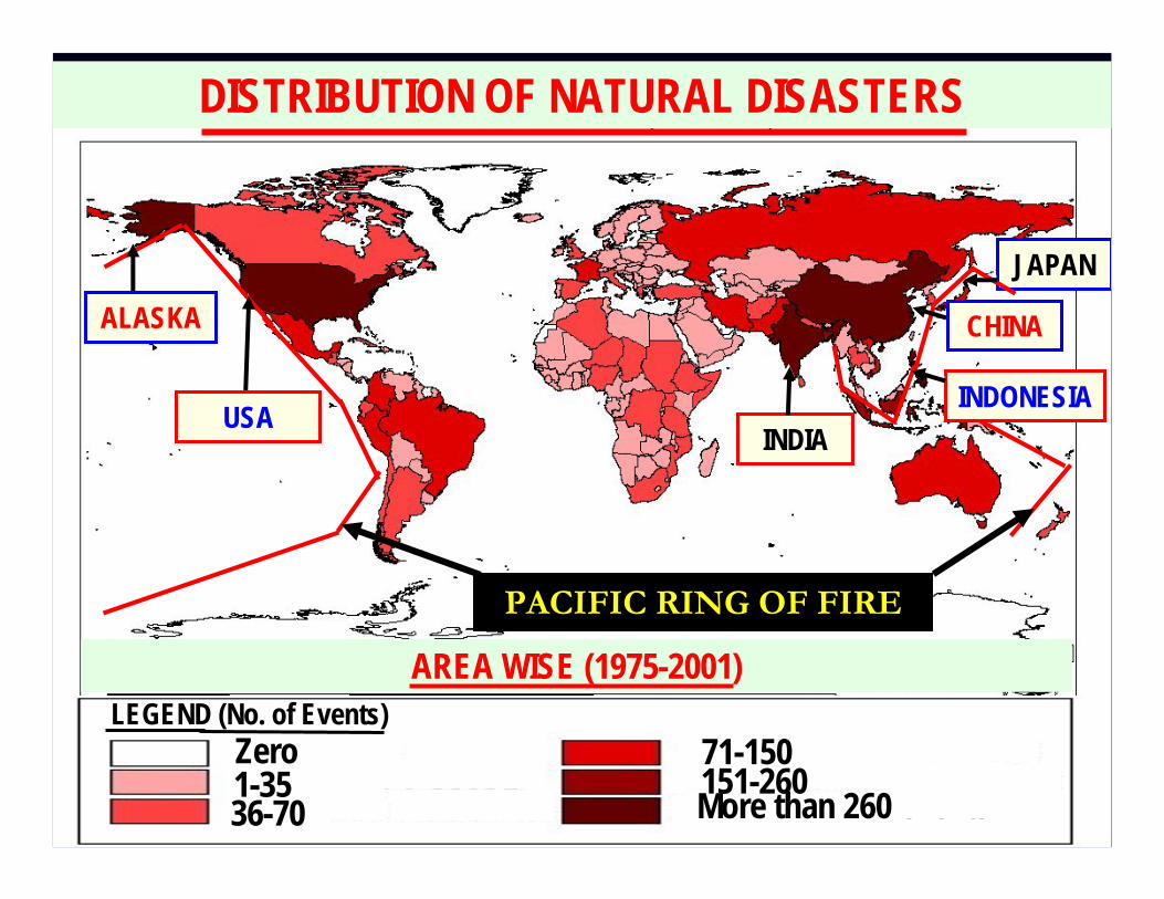
INDIA
ALASKA
USA
CHINA
AREA WISE (1975-2001)
More than 260 events
DISTRIBUTION OF NATURAL DISASTERS
INDONESIA
JAPAN
PACIFIC RING OF FIRE
LEGEND (No. of Events)Zero1-3536-70
71-150151-260

BY NATURAL DISASTERS (1975-2001)
DISTRIBUTION OF PEOPLE AFFECTED
INDIA
ALASKA
USA
CHINA
INDONESIA
JAPAN
One to 18 Million. Zero.
18 to 48 Million. 48 Million to One Billion. One Billion to 3.5 Billion. More Than 3.5 Billion.
LEGEND

Lack of disaster preparedness at all levels.Lack of mitigation planning Lack of communication networking and dissemination of information among statesDelayed response due to mismanagement of relief, resources, manpower and duty delegationLack of Interface and Coordination with State, District Administration & Community
HUGE LOSS OF LIFE & PROPERTY
Lessons from DisastersLessons from Disasters

Vulnerability factors in Disaster ManagementVulnerability factors in Disaster Management
PhysicalPhysicalLandLand--use use planning, planning, engineering and engineering and architecture architecture density levels, density levels, remoteness of a remoteness of a settlement, design settlement, design and materials and materials used for critical used for critical infrastructure and infrastructure and for housingfor housing
SocialSocialLiteracy, education, Literacy, education, peace and security, peace and security, access to basic access to basic human rights, human rights, systems of good systems of good governance, social governance, social equity, positive equity, positive traditional values, traditional values, knowledge knowledge structures, customs structures, customs and ideological and ideological beliefs and overall beliefs and overall collective collective organizationalorganizational
EconomicEconomicPoverty ratio, Poverty ratio, national economic national economic reserves, socioreserves, socio--economic economic infrastructure, infrastructure, communication communication network, utilities, network, utilities, supplies, supplies, transportation, transportation, water, sewage and water, sewage and healthcare etc.healthcare etc.
EnvironmentalEnvironmental
Extent of natural Extent of natural resource resource depletion, state of depletion, state of resource resource degradation, loss degradation, loss of resilience of of resilience of ecological system, ecological system, loss of loss of biodiversity, biodiversity, exposure to toxic exposure to toxic and hazardous and hazardous pollutants.pollutants.
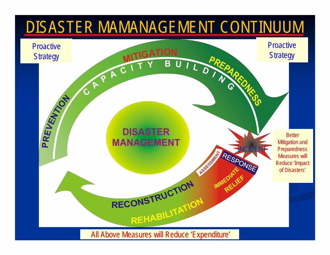
INCIDENT
DISASTER MAMANAGEMENT CONTINUUM
All Above Measures will Reduce ‘Expenditure’
Proactive Strategy
Better Mitigation and Preparedness Measures will
Reduce ‘Impact of Disasters’
Proactive Strategy
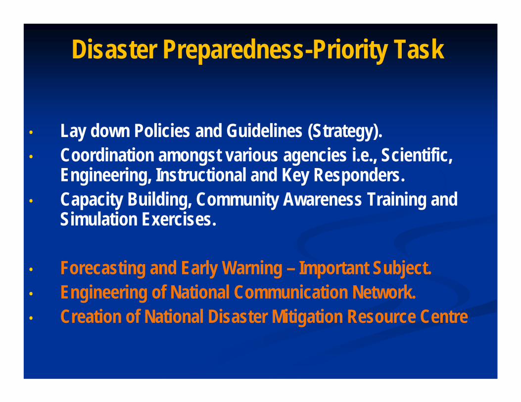
Disaster Preparedness-Priority Task
• Lay down Policies and Guidelines (Strategy).• Coordination amongst various agencies i.e., Scientific,
Engineering, Instructional and Key Responders.• Capacity Building, Community Awareness Training and
Simulation Exercises.
• Forecasting and Early Warning – Important Subject.• Engineering of National Communication Network.• Creation of National Disaster Mitigation Resource Centre

Information and Communication Technology Support
to Disaster Management
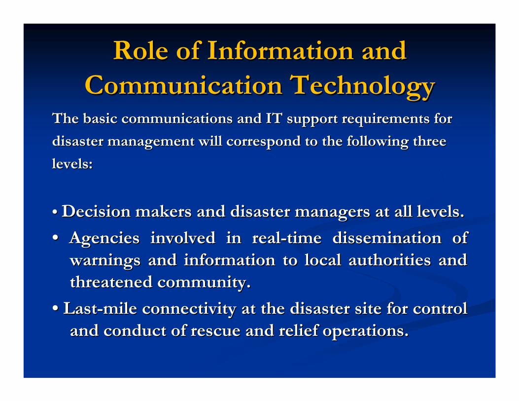
Role of Information and Role of Information and Communication TechnologyCommunication Technology
The basic communications and IT support requirements forThe basic communications and IT support requirements for
disaster management will correspond to the following threedisaster management will correspond to the following three
levels:levels:
•• Decision makers and disaster managers at all levels.Decision makers and disaster managers at all levels.
•• Agencies involved in realAgencies involved in real--time dissemination of time dissemination of warnings and information to local authorities and warnings and information to local authorities and threatened community.threatened community.
•• LastLast--mile connectivity at the disaster site for control mile connectivity at the disaster site for control and conduct of rescue and relief operations.and conduct of rescue and relief operations.

NDMA
NATIONAL DISASTER MITIGATION RESOURCE
CENTRES
NATIONAL DISASTER MANAGEMENT STRUCTURE
MINISTRIES & DEPARTMENTS OF
GOVT OF INDIA
MHA
NATIONAL CRISIS MANAGEMENT
COMMITTEE NATIONAL INSTITUTE OF DISASTER MANAGEMENTNEC
NATIONAL DISASTER RESPONSE FORCE
STATE GOVTsSTATE GOVTsSDMAs
ACADEMIC INSTITUTIONS
CORPORATE SECTOR
NGOs
SCIENTIFIC & TECHNICAL INSTITUTIONS
PROFESSIONAL BODIES
C O M M U N I T Y
DISTTs
LOCAL BODIES
ARMED FORCES
CABINET COMMITTEE ON MANAGEMENT OF
NATURAL CALAMITIES
GOVT OF INDIA
DDMAs
CABINET COMMITTEE ON
SECURITY

Decision-making and Standing bodies at the Central level• Union Cabinet, headed by the Prime Minister.
• Empowered Group of Ministers, headed by the Deputy Prime Minister
• National Crisis Management Committee (NCMC), under the chairmanship of the
Cabinet Secretary.
• Crisis Management Group (CMG): under the chairmanship of the Central Relief
Commissioner comprising senior officers from the various Ministries and other concerned Departments which reviews contingency plans, measures required for dealing with a natural disaster, and co-ordinates the activities of the Central Ministries and the State Governments in relation to disaster preparedness response and relief.
• Technical Organizations, such as the Indian Meteorological Department (cyclone/earthquake), Central Water Commission (floods), Building and Material Promotion Council (construction laws), Bureau of Indian Standards (norms), Defence Research & Development Organization (nuclear/biological), Directorate General Civil Defence provide specific technical support to coordination of disaster response and management functions.

Updating and Digitization of
Flood Plain Zoning Maps
• The Central Water Commission now intends to carry out the updating and digitization of existing flood plain zoning maps covering the area of 54,740 sq. km. of the states of U.P., Bihar, West Bengal, Punjab, Haryana, Delhi, Assam and J&K by SOI
• Maps to be in five layers viz. contour, water bodies (rivers/ponds), communication, vegetation and existing flood control works i.e. embankments, anti-erosion works etc.
• Digitized maps should be GIS ready.

OCEANOGENIC DISASTERS• 13% of World’s
Cyclones in the Seas around India.
• Annual; Frequent Phenomenon.
• Inundation of Coastal Areas.
• Tsunami in Indian Ocean.
• Highly Devastative.

CommunicationsCommunicationsAt the National Level At the National Level
Dedicated Communication System for disaster Dedicated Communication System for disaster management with builtmanagement with built--in redundancies. in redundancies. Multi Channel Communication System Links include Multi Channel Communication System Links include DOT, POLNET, NICNET, ISDN and SPACENET.DOT, POLNET, NICNET, ISDN and SPACENET.Satellite Communication based on mobile Satellite Communication based on mobile
voice/data/video communication between national voice/data/video communication between national EOC and State EOC/ District EOC/Mobile EOC and EOC and State EOC/ District EOC/Mobile EOC and Disaster/Emergency Site.Disaster/Emergency Site.GIS based National Database for Disaster GIS based National Database for Disaster ManagementManagement..

National Emergency Operation National Emergency Operation CentreCentre
Control Room at MHA upgraded to National Control Room at MHA upgraded to National Emergency Operation Centre which is equipped Emergency Operation Centre which is equipped with SATPHONES, GPS, GIS info system etcwith SATPHONES, GPS, GIS info system etc--Control room personnel trained in use of Control room personnel trained in use of equipmentsequipmentsStates being assisted to set up Control Rooms at States being assisted to set up Control Rooms at the State level GOIthe State level GOI--UNDP project.UNDP project.602 Emergency Operation Centers in each district 602 Emergency Operation Centers in each district in the country being set up under GOIin the country being set up under GOI--UNDP UNDP project.project.

The National Emergency The National Emergency Communication NetworkCommunication Network
With almost a hundred per cent With almost a hundred per cent reliability, this network will ensure reliability, this network will ensure realreal--time dissemination of time dissemination of warnings and information direct to warnings and information direct to the affected community and local the affected community and local authorities. authorities.

Cyclone Monitoring & Mitigation

Cyclone Monitoring & MitigationCyclone Monitoring & Mitigation
With geostationary satellites like GOES, Meteosat and With geostationary satellites like GOES, Meteosat and GMS, and since 1982 with INSAT, tropical cyclones came GMS, and since 1982 with INSAT, tropical cyclones came under a global roundunder a global round--thethe--clock surveillance right from their clock surveillance right from their genesis up to landfallgenesis up to landfall
Because of the wealth of data that the new generation Because of the wealth of data that the new generation of satellites are making available, the ability of of satellites are making available, the ability of meteorologists to make predictions of cyclone tracks meteorologists to make predictions of cyclone tracks has been consistently improvinghas been consistently improving

Track predictionTrack prediction
The accuracy of cyclone track prediction by The accuracy of cyclone track prediction by operational numerical weather prediction centres operational numerical weather prediction centres has steadily improved over the past ten yearshas steadily improved over the past ten yearsHowever, even now, track predictions made 5 However, even now, track predictions made 5 days in advance can be wrong by as much as 600 days in advance can be wrong by as much as 600 km and the 3km and the 3--day predictions by more than 300 day predictions by more than 300 kmkmEven the 24Even the 24--hour predictions could be in error hour predictions could be in error by up to 150 kmby up to 150 km

Minimization of impactsMinimization of impacts
Primarily by an application of the increasing Primarily by an application of the increasing scientific knowledge of the behaviour of scientific knowledge of the behaviour of cyclonescyclonesBy a fuller utilization of the new technological By a fuller utilization of the new technological tools like satellites and Doppler weather radarstools like satellites and Doppler weather radars

Doppler Weather RadarsDoppler Weather Radars
India has DWRs at India has DWRs at Sriharikota Sriharikota ChennaiChennaiMachilipatnamMachilipatnamKolkata Kolkata VisakhapatnamVisakhapatnam

The futureThe future
It is only with a tropical cyclone that nature It is only with a tropical cyclone that nature gives us a few days noticegives us a few days noticeWe have to make the best use of this grace We have to make the best use of this grace periodperiod

Using Grid (EUUsing Grid (EU--India Grid Project) for India Grid Project) for Earth & Atmospheric Sciences StudiesEarth & Atmospheric Sciences Studies
Physic of Weather and Climate group at ICTP and Physic of Weather and Climate group at ICTP and Computational Atmospheric Science group of CComputational Atmospheric Science group of C--DAC/PuneDAC/Pune Focus on developing a Regional Focus on developing a Regional coupled atmospherecoupled atmosphere--ocean model system for the ocean model system for the prediction of the Indian summer monsoonprediction of the Indian summer monsoonRegional Climate Model (RegCM3)Regional Climate Model (RegCM3)Regional Ocean Modeling System (ROMS)Regional Ocean Modeling System (ROMS)Results achieved (some presented at EGEE User Results achieved (some presented at EGEE User Forum in May 2007):Forum in May 2007):
RegCM3 and ROMS ported to both GARUDA and RegCM3 and ROMS ported to both GARUDA and gLitegLiteProof of concept with limited problem size (few Proof of concept with limited problem size (few MBs, one CE only)MBs, one CE only)Coupled system tested on gLite Coupled system tested on gLite
Next steps: implementing adequate data Next steps: implementing adequate data management, increasing problem size to enable management, increasing problem size to enable realistic simulationsrealistic simulations
RegCM3
ROMS

Mitigation Measures
Most of the mitigation measures are built into the national, state and district disaster management plans which already exist and in the event of a cyclone threat, they can be enforced by the concerned authorities.
In practice, this is easier said than done !

Socio-Economic Aspects
Fishermen may be advised not to venture into the sea, but they may not listen to this advice
If the storm is brewing far out at sea, there may not be enough evidence on the coast for the fishermen to take the meteorologists’ predictions seriously.
Much of the coastal population consists of farmers and fishermen living below the poverty line, who earn for the day and feel compelled to take the risk of going to work rather than let the family starve.
Decisions about leaving one’s homes in the wake of a cyclone warning are many times taken by the village chief on the basis of his past experience with cyclone warnings.
WHAT IS THE SOLUTION ?

Mobile Technology at the Grass Root LevelMobile Technology at the Grass Root Level
Global System for Mobile Communications (GSM) wireless network Global System for Mobile Communications (GSM) wireless network TechnologyTechnology
. For the purpose of disaster management works, it is import. For the purpose of disaster management works, it is important to ant to identify geographic location of the disaster prone area. Locatioidentify geographic location of the disaster prone area. Location of the n of the mobile user can be identified by two basic approaches mobile user can be identified by two basic approaches
One is through the MOBILE NETWORK SIGNAL SYSTEM where One is through the MOBILE NETWORK SIGNAL SYSTEM where signals is send by the mobile phone system to its base signals is send by the mobile phone system to its base
Another is through using INTEGRATED GLOBAL POSITIONING Another is through using INTEGRATED GLOBAL POSITIONING SYSTEM (GPS) with the mobile phone receiver, an additional SYSTEM (GPS) with the mobile phone receiver, an additional hardware that takes care of location functions.. Although accurahardware that takes care of location functions.. Although accuracy of cy of location based on signal system over integrated GPS is still an location based on signal system over integrated GPS is still an issue of issue of debate but in the context of less developed country like India adebate but in the context of less developed country like India adding dding hardware at the userhardware at the user’’s end will involves additional cost at users end will involves additional cost at user’’s end s end which is not possible to effort for a lot of userwhich is not possible to effort for a lot of user..

Mobile Penetration in India Mobile Penetration in India
On a brighter note, In India the growth rate for mobile On a brighter note, In India the growth rate for mobile phone market has been 200 percent over the last two years. phone market has been 200 percent over the last two years. The total number of telephone connections stood at 281.62 The total number of telephone connections stood at 281.62 million at the end of January 2008. million at the end of January 2008.
Almost every single village in India has been brought Almost every single village in India has been brought under the coverage of mobile network system. under the coverage of mobile network system.
Due to the wide prevalence of low cost preDue to the wide prevalence of low cost pre--paid cards, there paid cards, there are now many who can afford to keep a mobile phone since are now many who can afford to keep a mobile phone since the minimum bill payable per month is about US$ 5.the minimum bill payable per month is about US$ 5.

Mobile TelecommunicationMobile Telecommunication
The central NDMA coordinators will collect weather information fThe central NDMA coordinators will collect weather information from rom the weather information department. the weather information department.
After receiving location based weather report, the central cAfter receiving location based weather report, the central coordinator oordinator will write a Short Message Service (SMS) describing the weather will write a Short Message Service (SMS) describing the weather report report and necessary steps to be taken and then send it to the mobile pand necessary steps to be taken and then send it to the mobile phone hone operators. Mobile operators then disseminate this short message operators. Mobile operators then disseminate this short message to all to all mobile phones in a specific geographical area.mobile phones in a specific geographical area.
Using mobile technology concurrent information can be gatheUsing mobile technology concurrent information can be gathered from red from thethe
field which in turn ensures proper distribution and minimizfield which in turn ensures proper distribution and minimizes losses.es losses.
INDIA DISASTER RESOURCE NETWORKINDIA DISASTER RESOURCE NETWORK

INDIA DISASTER INDIA DISASTER RESOURCE RESOURCE NETWORKNETWORK
WWW.IDRN.GOV.INWWW.IDRN.GOV.IN

What is IDRN?What is IDRN?ItIt’’s a webs a web--enabled GIS based Allenabled GIS based All--India Resource India Resource Inventory i.e. onInventory i.e. on--line centralized database.line centralized database.This Resource inventory titled IDRN (Indian This Resource inventory titled IDRN (Indian Disaster Resource Network) will be available on the Disaster Resource Network) will be available on the
website with the Url website with the Url www.idrn.gov.inwww.idrn.gov.in to to all the disaster managers in the state & at the centreall the disaster managers in the state & at the centreThe IDRN is a live system providing for updating The IDRN is a live system providing for updating of inventory every year. Entries into of inventory every year. Entries into the inventory the inventory are made at two levels are made at two levels –– district district and State level. and State level. It has 226 items.It has 226 items.IDRN inaugurated on 1IDRN inaugurated on 1stst September 2003September 200369,329 records in 545 districts uploaded. 69,329 records in 545 districts uploaded.

Work ProcessWork Process
Database at NIC Database at MHA
State
District District
Line Dept. 1 Line Dept. 1 Line Dept. 1 Line Dept. 1
Internet
Data entry through Online & offline application
Data collection in paper format
State level coordination for building inventory database
synchronized

CONCLUSIONCONCLUSIONThere is a need to integrate the fragmented, decoupled There is a need to integrate the fragmented, decoupled institutional setup for preparedness and quick response and institutional setup for preparedness and quick response and further strengthen it through Publicfurther strengthen it through Public--Private Partnership (PPP).Private Partnership (PPP).The right mix of policy, institutional arrangements and use The right mix of policy, institutional arrangements and use of Information and Communication technology provides of Information and Communication technology provides the framework for a country's approach to disaster the framework for a country's approach to disaster mitigation. Worldwide, there has been a shift away from a mitigation. Worldwide, there has been a shift away from a strictly strictly ‘‘toptop--downdown’’ approach relying on government alone, approach relying on government alone, to a combination of to a combination of ‘‘toptop--downdown’’ and and ‘‘bottombottom--upup’’approaches.approaches.
The aim is to enhance the indigenous coping mechanisms The aim is to enhance the indigenous coping mechanisms of vulnerable communities; draw on their cooperative spirit of vulnerable communities; draw on their cooperative spirit and energy; and empower them through appropriate and energy; and empower them through appropriate information communication technology to mitigate information communication technology to mitigate disasters.disasters.

Thank You. Thank You.


