A N T A R C T I C P O L A R F R O N T Z O N E
A R N O L D L . G O R D O N
Lamont-Doherty Geological Observatory of Columbia University, Palisades, New York 10964
Abstract. The thermal structure across the antarctic polar front zone in the South Pacific is inspected. The structure is variable; however, it is often possible to identify some unifying pattern. A generalized thermal section can be constructed that contains all or most of the structural elements found by the particular bathythermograph sections. The basic components are as follows: The primary polar front zone is characterized by a cold water cell vertically elongated relative to other ocean features, which is isolated from the main mass of cold water further south. To the immediate south of the primary front is a warm water zone. The southern component of the polar front zone is the secondary polar front zone. Here the subsurface temperature minimum (Train) that identifies the Antarctic Surface Water has a very variable structure. Occasional indications of vertical convection are found. South of the double polar front zone, the Antarctic Surface Water is found to lie uniformly over the upper Circumpolar Deep Water with little sign of instability.
The mechanism responsible for the formation of the double polar front zone is not known. Various possibilities are offered. The common occurrence of the double front suggests that the mean wind may be the cause. However, the mean wind field that could produce the double front is not consistent with the wind distribution thought to exist over antarctic waters. The wind variations may be more important, and the passing of an isolated storm system may produce the double front. Another possibility is the influence of bottom topography on the transport of the Antarctic Circumpolar Current. A n additional possibility is the progression of internal waves from south to north between the Antarctic Surface Water and upper Circumpolar Deep Water. The pycnocline gradually weakens between these two water masses from the Antarctic Divergence to the polar front zone. This weakening distorts the internal waves near the northern limit of the Train layer, causing a severance into two parts.
To study the antarctic double polar front zone properly, it would be necessary to conduct a multiship operation similar to those devoted to the Gulf Stream.
I N T R O D U C T I O N
The zone separating the antarctic and subantarctic surface water masses has been subject to much debate in oceanographic literature. This debate is not limited to the finer details of the boundary but involves its fundamental structure, and even the problem of the most suitable name to describe this feature. Much of the confusion is derived from the fact that the zone shows a great variability in both form and position and that the available data are too widely spaced for these variations to be understood properly. Many of the descriptions given are true relative to the specific data used, but are not valid in the general sense. Some data clearly show a convergence process with the Antarctic Surface Water slipping below and mixing with the Subantarctic Surface Water; hence the name Antarctic Convergence. Other data indicate more complicated processes that imply divergence, and so the name Antarctic Divergence has been proposed. Still other data show no evidence of either of these processes, or
so complicated a structure that no simple circulation model is obvious. The term 'polar front' is preferred by many oceanographers, since it implies a situation analogous to an atmospheric polar front. This name implies only that along this boundary a fluid mass with polar characteristics abuts with one with subpolar properties.
The varying descriptions of the polar front naturally lead to varying methods used in its recognition. The most common is the presence of a relatively large drop in the surface temperature encountered on progressing from north to south. Although this method is acceptable in many crossings, it often leads to ambiguous results, since occasionally no sharp zone of temperature change is found. This condition occurs in summer when warming of the upper layers of the surface water obliterates the gradient, or when a thin layer of Subantarctic Surface Water overrides the Antarctic Surface Water. For this reason, a subsurface feature is often preferred in defining the polar front.
205
Antarctic Research Series Antarctic Oceanology I Vol. 15
Copyright American Geophysical Union
206 ARNOLD L. GORDON
T A B L E 1
Surface Subsurface Reference Expression Expression Name
Meinardus [1923]
Schott [1926]
Deacon [1933] [1937]
Mackintosh [1946]
Garner [1958]
Wexler [1959]
Burling [1961]
Ostapoff [19626]
Botnikov [1963]
Houtman [1964]
G W o r c [1967]
Grad T*
Grad T
Grad T
Grad T
Grad T
Grad T followed by a reversal in the north-south surface temperature gradient
Grad T
Surface position of the 2 ° C isotherm (winter only)
Mid-point of Grad T
Grad T
Northern limit of Antarctic Bottom Water
Position of temperature minimum at 200 meters
Northern limit of the subsurface temperature inversion
Immediately north of an isolated core of cold water ( > 50 miles wide)
Northern extent of the 1°C isotherm in the Tmin layer
The axis of the circumpolar salinity minimum belt at 200 meters
Northern limit of the 2 ° C isotherm within the Tmin layer (summer only)
Position at which the jTmin layer ends or shows an abrupt change in depth
Meinardus Line (he uses term 'polar front' in 1944 ed.)
Antarctic Convergence
Antarctic Convergence
Antarctic Convergence
Antarctic Divergence
Antarctic Convergence
Polar Front
Antarctic Convergence Zone
Antarctic Convergence
Polar Front Zone
* Grad T refers to a relatively large north-south surface temperature gradient with decreasing temperatures toward the south.
Table 1 lists the methods of identification of various authors and their choice for a name for what is called the polar front zone in this paper.
In 1946 Mackintosh constructed his much referenced chart of the mean position of the polar front based on crossings by the Discovery II and William Scoresby. This position must be used with reservation, since variations do occur; as Mackintosh points out: Tt forms twists and loops that may extend as much as 100 miles north and south, and it possibly even forms isolated rings.' Meanders and eddies or rings appear to be fairly common, a condition that prompts the often used comparison of the polar front with the 'cold wall' of the Gulf Stream and its meanders and eddies.
Some studies of the seasonal or longer time-dependent variations have been made. Botnikov [1963, 1964] concludes that the seasonal variations are usually 1° to 2° of latitude (60-120 miles) and that the long-term variations (from 1901 to 1960) are as much as 4° of latitude (180-240 miles). Gordon [1967] shows a polar front zone to be from 2° to 4° of latitude in width, whereas Ostapoff [1962a, 19626] indicates an even broader 5° zone. Data from which indications
of the short time variations (days or weeks) can be gained are not complete and only vaguely suggest that such fluctuations do occur.
From past work it can be said with some assurance that somewhere in a broad circumpolar belt there is a sharp or diffuse boundary separating the Antarctic and Subantarctic Surface Water masses, along which evidence of either convergence or divergence may be found. It is believed [Gordon, 1967] that the position of this wide belt or zone may be related to bottom topography, as is the northern limit of the Antarctic Bottom Water, but the position of the polar front within this zone is controlled by wind and/or thermohaline factors.
The terms 'primary' and 'secondary' were added to the polar front zone by Gordon [1967] to indicate the presence of a double frontal structure in the western section of the Southeast Pacific Basin. The basis in performing this separation deals with the detail structure of the subsurface temperature minimum (7mm). A similar structure was noted by Wexler [1959] along the 180° meridian and discussed further by Burling [1961] , Ostapoff [1962a], and Houtman [1967] . In this paper the frontal structure is further
Antarctic Research Series Antarctic Oceanology I Vol. 15
Copyright American Geophysical Union

ANTARCTIC POLAR FRONT ZONE 207
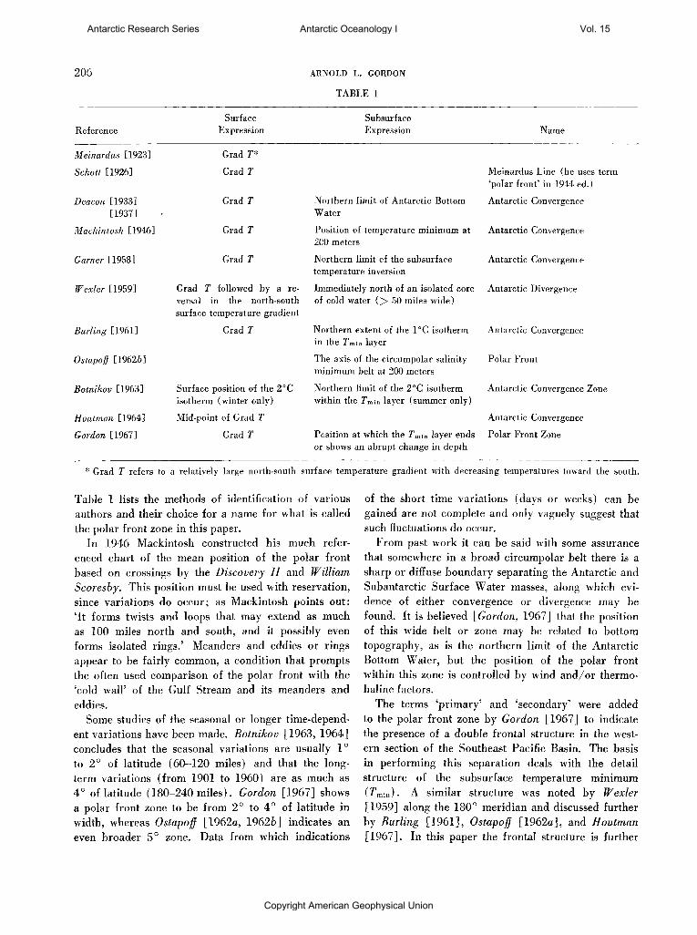
investigated using primarily bathythermograph (BT) and expendable bathythermograph (XBT) data gathered by the USNS Eltanin cruises 25, 27, 32, and 33. The analysis is limited to the area east of the Macquarie Island. At present the USNS Eltanin is gathering data south of Australia. When this task is completed, a study of the polar front zone for that area will be published and related to this study.
The BT and XBT sections to be discussed are shown in Figure 1. Discussion of the other information shown in this figure is found below.
T E M P E R A T U R E P R O F I L E S A C R O S S
T H E P O L A R F R O N T Z O N E
In the course of studying the many bathythermograph profiles across the antarctic polar front zone, one is struck by the seemingly unlimited variations in the surface and subsurface temperature structure. On proceeding northward, the water temperatures increase; however, the rate of warming with latitude is highly varied with the presence of numerous reversals. The BT sections in the South Pacific do demonstrate some similarities, enabling an attempt at a generalized thermal section. This was first noticed in dealing with the sections of the western Southeast Pacific Basin, at which time the term double polar front zone was applied.
The generalized section is shown as Figure 2, and the following is a description of each component. The particular BT sections contain all or most of these elements. Certainly the daily weather conditions influence the surface temperature; however, since the double structure extends to depths as great as 800 meters and is found in numerous profiles, it is felt that it is of significance to the basic frontal structure and should be considered in any attempt to understand the polar front dynamics in the South Pacific sector of antarctic waters.
Proceeding from south to north, the sections encountered are as follows:
1. The stable zone is the area in which the cold Antarctic Surface Water mass lies uniformly above the upper Circumpolar Deep Water. The isotherms tend to be horizontal with a large gradient in temperature at the boundary of the surface and deep water. Toward the northern end, the Tm™ layer is variable in strength and depth.
2. The secondary polar front zone is separated from the stable zone by a drop in the depth of the Tm\n
layer and an increase in the surface temperature. Within the secondary zone the Tmin layer shows great variability but remains well defined. The isotherms
tend to be vertically oriented, with occasional evidence of filaments or streams of Tmin penetrating to fairly deep levels.
3. The warm water zone is the area in which the Tmin weakens to become discontinuous or absent. This zone is relatively warm, with the surface layers demonstrating higher stability than that found in the zones to the immediate north and south.
4. The primary polar front zone is relatively narrow and shows much vertical stretching of the water properties. This feature is vertically elongated only relative to other ocean features and not in the absolute sense. In this zone, the cold water is cold and is marked by re-establishment of the Tm\n layer. The patch of cold water is generally isolated in a north-south plane from the main body of Tm\n water to the south. The influence of the water of this cell occasionally extends to the surface, where it lowers the surface temperature below that of the surface of the more southerly warm zone. At the surface of the northern boundary of the primary zone, there is a fairly rapid temperature change.
5. The Subantarctic Surface Water is the northernmost zone. This zone is warmer than the other zones; it is always above 3°C and usually above 5°C. The isotherms slope steeply toward the north. Occasional reversals of the slope of the isotherm surfaces are found.
Each of these components is a zone; that is, they are broad regions and not lines on the sea surface. The following is a display of BT and XBT sections in an area from 115°W westward to 160 °E.
120°W
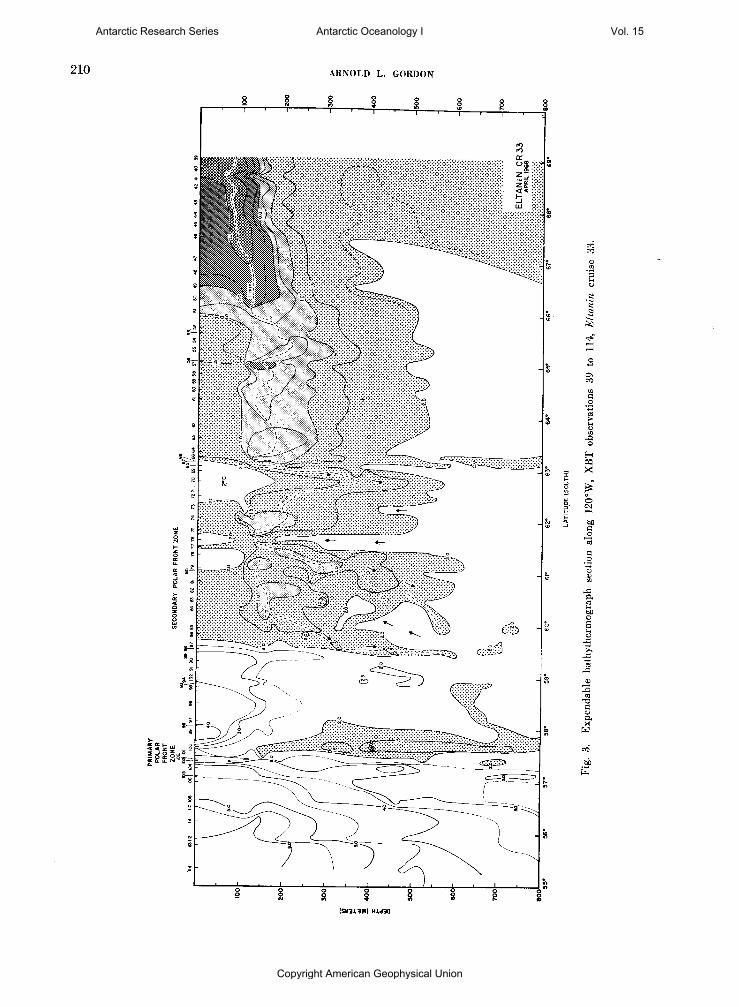
On Eltanin cruise 33 (March to May 1968) a temperature profile for the upper 800 meters along 120 ° W from 69 °S to 55 °S was obtained by the XBT system. This meridian traverses the double frontal zone shown on Plate 14 of Gordon [1967] . With the XBT probes, the finer details and change with depth of this apparently permanent feature could be studied. Figure 3 shows the thermal structure found along the ship's track.
The primary and secondary polar front zones were found in approximately the positions expected from the analysis of previous BT data: the primary zone at 57° 30' to 58 °S and the secondary zone between 59° 30 ' to 63°S (see Gordon [1967, pi. 1 4 ] ) . The Tmin layer, which represents the Antarctic Surface Water mass, shows a great variation within the secondary zone. Deep penetration of the cold surface water to 600 meters is found at various positions within this zone.
Antarctic Research Series Antarctic Oceanology I Vol. 15
Copyright American Geophysical Union
208 ARNOLD L. GORDON
o
CO ^
^ o
CO O
ti 0
H P3 X c
H
OH
E
Antarctic Research Series Antarctic Oceanology I Vol. 15
Copyright American Geophysical Union

ANTARCTIC POLAR FRONT ZONE 209
100-
200-1
300 J
SUBANTARCTIC | PRIMARY
POLAR FRONT (PPF)
WARM WATER
SECONDARY POLAR FRONT (SPF)
STABLE ANTARCTIC SURFACE
WATER
SURFACE EXPRESSION OF P P F
SOUTHERN BOUNDARY 0 F S P F W A R M
^ UNIFORM COLD
Tmin NOT FOUND IN SURFACE LAYER
WEAK, VARIABLE /
Tmin / ' ISOLATED WEAK OR / 'OCCASIONAL
A B S E N T / / E V I D E N C E OF Tmin SEGMENT SINKING
RELATIVE SURFACE TEMPERATURE •0
H O O
1-200
-300
Fig. 2. Schematic diagram of the antarctic double polar front zone.
between which occur columns of warmer deep water. At 62°S (XBT 76) water of over 2°C ascends to within 180 meters of the surface. Within the secondary zone, the vertical trend of the isotherms suggests that the rmin forms many filaments or streamers, perhaps similar to the cellular convection discussed by Turner [1967] and Foster [1968] , However, in the above case, salinity is the stabilizing influence rather than temperature, as discussed by Turner. The arrows shown on Figure 2 indicate the possible vertical motion of the water with the secondary polar front zone.
South of the secondary polar front zone is the zone with a more stable water column. Here the isotherms tend to be horizontal, whereas in the secondary zone and to its north the isotherms are more vertical.
The primary polar front zone is characterized in a manner described by Wexler [1959] . Along the sea surface from north to south, the temperature first drops sharply, then reverses gradient, resulting in a temperature minimum immediately south of the high temperature gradient. Below the minimum is a vertically elongated cell of cold water isolated in a north-south plane from the main body of cold surface water further south.
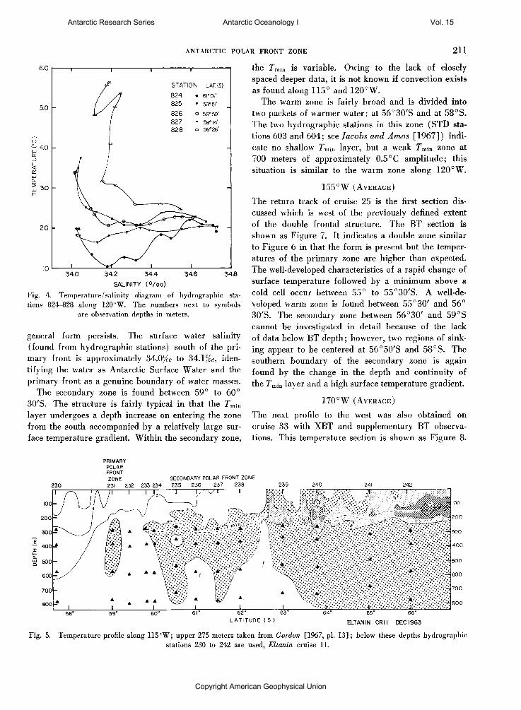
Between the two polar front zones is a region of warmer water. In Gordon [1967] , it is suggested that this warm water, occupying the region from 58° to 59°30'S for the section shown in Figure 3, results from upwelling, that is, a zone of divergence. In this case, the salinity of this zone should be above that of Antarctic Surface Water. However, the salinity of this zone for the upper 300 meters is shown in Figure 4 to be no higher than the Antarctic Surface Water mass, that is, less than 34.2% c, which is more characteristic of Subantarctic Surface Water and certainly less than that of the upper Circumpolar Deep Water (34.6%c). The higher temperatures, together with similar salini
ties, indicate that this water may be warmed Antarctic Surface Water.
115°W
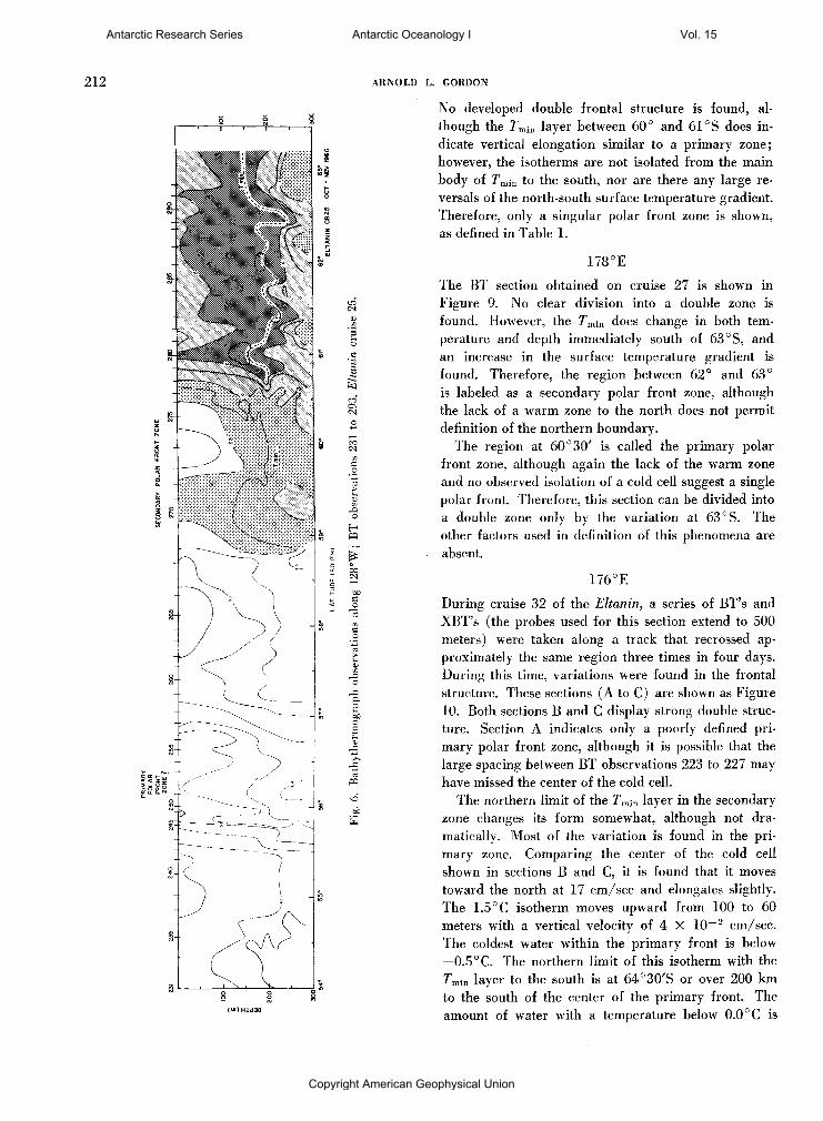
Figure 5 shows the temperature profile for the upper 800 meters along 115°W constructed from cruise 11 data. The upper 275 meters are taken from the BT observations (see Gordon [1967, pi. 1 3 ] ) . Below this depth the hydrographic station data are used; since these observations are spaced much farther apart than the BT data, the section represents only general structure. The temperature distribution shown in Figure 5 is similar to that along 120°W (Fig. 3) in that the double polar front is present.
The rmin layer continues below BT depth, although it is not as extreme as it is at shallower levels. The level character of this layer is more probably the product of too widely spaced data than a reflection of reality. The deep penetration of the 2°C isotherm at 60°30'S and 61°30'S suggests a convective process similar to that found along the 120 ° W section. The elongated cold cell of the primary zone exists, but the northern extent of the cell is uncertain owing to a larger spacing of the hydrographic stations at these latitudes.
128 ° W
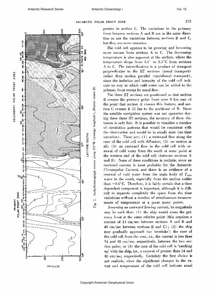
During cruise 25 another BT section was obtained in the region of the double frontal structure shown in Plate 14. The BT section is shown as Figure 6. In this section the primary polar front zone, although present, is not very well developed. The surface temperature drops suddenly from 6° to 5°C at 55°40'S, and a slight minimum of about 4 ° C occurs at 56° 15'S, below which is the upper part of a cell of colder than 3.5°C. Although these values are a few degrees above those in the primary zone previously encountered, the
Antarctic Research Series Antarctic Oceanology I Vol. 15
Copyright American Geophysical Union
210 ARNOLD L. GORDON
(SH313W) Hid3d
Antarctic Research Series Antarctic Oceanology I Vol. 15
Copyright American Geophysical Union
ANTARCTIC POLAR FRONT ZONE 211
34.0 34.2 34.4 34.6 34.8
SALINITY ( ° / o o ) Fig. 4. Temperature / salinity diagram of hydrographic stations 824-828 along 120° W . The numbers next to symbols
are observation depths in meters.
general form persists. The surface water salinity (found from hydrographic stations) south of the primary front is approximately 34.0%c to 34.1%o, identifying the water as Antarctic Surface Water and the primary front as a genuine boundary of water masses.
The secondary zone is found between 59° to 60° 30'S. The structure is fairly typical in that the rmin
layer undergoes a depth increase on entering the zone from the south accompanied by a relatively large surface temperature gradient. Within the secondary zone,
the rmin is variable. Owing to the lack of closely spaced deeper data, it is not known if convection exists as found along 115° and 120 °W.
The warm zone is fairly broad and is divided into two packets of warmer water: at 56°30 / S and at 58°S. The two hydrographic stations in this zone (STD stations 603 and 604; see Jacobs and Amos [1967]) indicate no shallow Tmin layer, but a weak Tmin zone at 700 meters of approximately 0.5°C amplitude; this situation is similar to the warm zone along 120 ° W .
155°W (AVERAGE)
The return track of cruise 25 is the first section discussed which is west of the previously defined extent of the double frontal structure. The BT section is shown as Figure 7. It indicates a double zone similar to Figure 6 in that the form is present but the temperatures of the primary zone are higher than expected. The well-developed characteristics of a rapid change of surface temperature followed by a minimum above a cold cell occur between 55° to 55°30'S. A well-developed warm zone is found between 55° 30' and 56° 30'S. The secondary zone between 56° 30' and 59°S cannot be investigated in detail because of the lack of data below BT depth; however, two regions of sinking appear to be centered at 56°50'S and 58°S. The southern boundary of the secondary zone is again found by the change in the depth and continuity of the Tmin layer and a high surface temperature gradient.
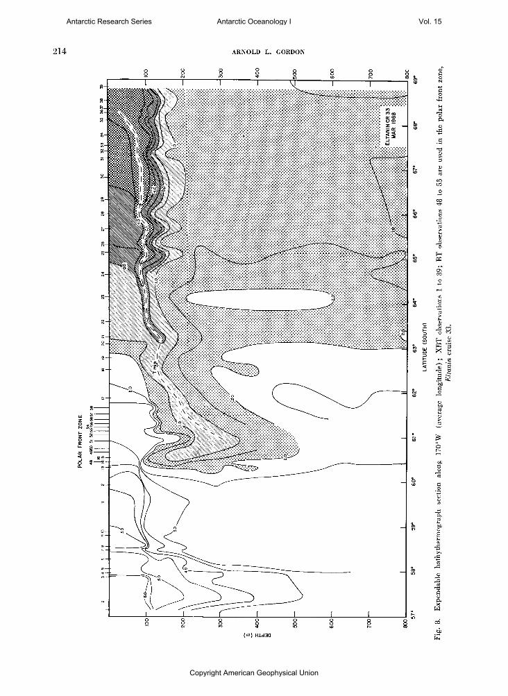
170°W (AVERAGE)
The next profile to the west was also obtained on cruise 33 with XBT and supplementary BT observations. This temperature section is shown as Figure 8.
PRIMARY POLAR FRONT ZONE SECONDARY POLAR FRONT ZONE
230 231 232 233 234 235 236 237 238 239 240 241 242
L A T I T U D E I S . ) ELTANIN CRM DEC 1963
Fig. 5. Temperature profile along 1 1 5 ° W ; upper 275 meters taken from Gordon [1967, pi. 1 3 ] ; below these depths hydrographic stations 230 to 242 are used, Eltanin cruise 11.
Antarctic Research Series Antarctic Oceanology I Vol. 15
Copyright American Geophysical Union
212 ARNOLD L. GORDON
( U J )
No developed double frontal structure is found, although the Tmin layer between 60° and 61 °S does indicate vertical elongation similar to a primary zone; however, the isotherms are not isolated from the main body of rmin to the south, nor are there any large reversals of the north-south surface temperature gradient. Therefore, only a singular polar front zone is shown, as defined in Table 1.
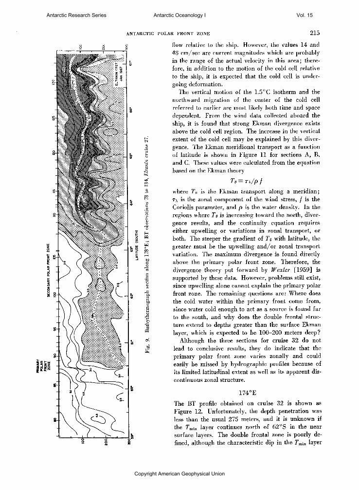
178°E
The BT section obtained on cruise 27 is shown in Figure 9. No clear division into a double zone is found. However, the Tmm does change in both temperature and depth immediately south of 63 °S, and an increase in the surface temperature gradient is found. Therefore, the region between 62° and 63° is labeled as a secondary polar front zone, although the lack of a warm zone to the north does not permit definition of the northern boundary.
The region at 60°30 / is called the primary polar front zone, although again the lack of the warm zone and no observed isolation of a cold cell suggest a single polar front. Therefore, this section can be divided into a double zone only by the variation at 63 °S. The other factors used in definition of this phenomena are absent.
176°E
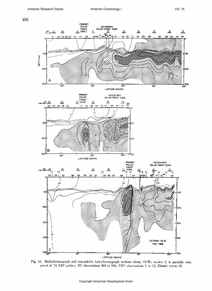
During cruise 32 of the Eltanin, a series of BT's and XBT's (the probes used for this section extend to 500 meters) were taken along a track that recrossed approximately the same region three times in four days. During this time, variations were found in the frontal structure. These sections (A to C) are shown as Figure 10. Both sections B and C display strong double structure. Section A indicates only a poorly defined primary polar front zone, although it is possible that the large spacing between BT observations 223 to 227 may have missed the center of the cold cell.
The northern limit of the Tmin layer in the secondary zone changes its form somewhat, although not dramatically. Most of the variation is found in the primary zone. Comparing the center of the cold cell shown in sections B and C, it is found that it moves toward the north at 17 cm/sec and elongates slightly. The 1.5° C isotherm moves upward from 100 to 60 meters with a vertical velocity of 4 X 1 0 ~ 2 cm/sec. The coldest water within the primary front is below —0.5 °C. The northern limit of this isotherm with the Tmin layer to the south is at 64° 30'S or over 200 km to the south of the center of the primary front. The amount of water with a temperature below 0.0 °C is
Antarctic Research Series Antarctic Oceanology I Vol. 15
Copyright American Geophysical Union
ANTARCTIC POLAR FRONT ZONE 213
(w) Hid
greater in section C. The variations in the primary front between sections A and B are in the same direction as are the variations between sections B and C, but they are more intensive.
The cold cell appears to be growing and becoming more intense from sections A to C. The decreasing temperature is also apparent at the surface, where the temperature drops from 4.5° to 3.5°C from sections A to C. The intensification is a product of transport perpendicular to the BT sections (zonal transport) rather than motion parallel (meridional transport), since the isolation and intensity of the cold cell indicate no way in which cold water can be added to the primary front except by zonal flow.
The three BT sections are positioned so that section B crosses the primary polar front zone 9 km east of the point that section A crosses this feature, and section C crosses it 55 km to the northeast of B. Since the satellite navigation system was not operative during these three BT sections, the accuracy of these distances is only fair. It is possible to visualize a number of circulation patterns that would be consistent with the observation and would be in steady state (no time variation). These are: (1) a westward flow along the core of the cold cell with diffusion; (2) no motion at all; (3) an eastward flow in the cold cell with renewal of cold water from the south at some point at the western end of the cold cell (between sections A and B ) . None of these conditions is realistic, since an eastward current is most probable for the Antarctic Circumpolar Current, and there is no evidence of a renewal of cold water from the main body of !Fmin water to the south, especially from the section colder than — 0.5°C. Therefore, it is fairly certain that a time dependent component is important, although it is difficult to separate completely the space from the time variations without a number of simultaneous measurements of temperature at a great many points.
Assuming an eastward flowing current, its magnitude may be such that: (1) the ship would cross the primary front at the same relative point (this requires a current of 14 cm/sec between sections A and B and 48 cm/sec between sections B and C) ; (2) the ship may gradually approach (or 'overtake') the core of the cold cell from the west, i.e., the current is less than 14 and 48 cm/sec, respectively, between the two section pairs; or (3) the core of the cold cell is 'catching up' with the ship, i.e., a current of greater than 14 and 48 cm/see, respectively. Certainly the first choice is not realistic, since the significant changes in the extent and temperature of the cold cell indicate zonal
Antarctic Research Series Antarctic Oceanology I Vol. 15
Copyright American Geophysical Union
214 ARNOLD L. GORDON
Antarctic Research Series Antarctic Oceanology I Vol. 15
Copyright American Geophysical Union
ANTARCTIC POLAR FRONT ZONE 215
flow relative to the ship. However, the values 14 and 48 cm/sec are current magnitudes which are probably in the range of the actual velocity in this area; therefore, in addition to the motion of the cold cell relative to the ship, it is expected that the cold cell is undergoing deformation.
The vertical motion of the 1.5° C isotherm and the northward migration of the center of the cold cell referred to earlier are most likely both time and space dependent. From the wind data collected aboard the ship, it is found that strong Ekman divergence exists above the cold cell region. The increase in the vertical extent of the cold cell may be explained by this divergence. The Ekman meridional transport as a function of latitude is shown in Figure 11 for sections A, B, and C. These values were calculated from the equation based on the Ekman theory
Te = r\/p f
where Te is the Ekman transport along a meridian; T\ is the zonal component of the wind stress, / is the Coriolis parameter, and p is the water density. In the regions where Te is increasing toward the north, divergence results, and the continuity equation requires either upwelling or variations in zonal transport, or both. The steeper the gradient of Te with latitude, the greater must be the upwelling and/or zonal transport variation. The maximum divergence is found directly above the primary polar front zone. Therefore, the divergence theory put forward by Wexler [1959] is supported by these data, However, problems still exist, since upwelling alone cannot explain the primary polar front zone. The remaining questions are: Where does the cold water within the primary front come from, since water cold enough to act as a source is found far to the south, and why does the double frontal structure extend to depths greater than the surface Ekman layer, which is expected to be 100-200 meters deep?
Although the three sections for cruise 32 do not lead to conclusive results, they do indicate that the primary polar front zone varies zonally and could easily be missed by hydrographic profiles because of its limited latitudinal extent as well as its apparent discontinuous zonal structure.
174°E
The BT profile obtained on cruise 32 is shown as Figure 12. Unfortunately, the depth penetration was less than the usual 275 meters, and it is unknown if the r m i n layer continues north of 62 °S in the near surface layers. The double frontal zone is poorly defined, although the characteristic dip in the Tmin layer
Antarctic Research Series Antarctic Oceanology I Vol. 15
Copyright American Geophysical Union
216 P R I M A R Y
P O L A R S E C O N D A R Y FRONT P O L A R FRONT Z O N E
LATITUDE (SOUTH)
PRIMARY SECONDARY POLAR POLAR FRONT ZONE FRONT
PRIMARY S E C O N D A R Y P O L A R POLAR F R O N T Z O N E
L A T I T U D E (SOUTH)
Fig. 10. Bathythermograph and expendable bathythermograph sections along 176°E; section C is partially com
posed of T4 X B T probes; B T observations 203 to 269; X B T observations 1 to 13, Eltanin cruise 32.
Antarctic Research Series Antarctic Oceanology I Vol. 15
Copyright American Geophysical Union

ANTARCTIC POLAR FRONT ZONE
50
40
I i 1 • i
T k ! \
- / \ . / c \. x ^
1 N
• i • i . i . N
63° LATITUDE (SOUTH)
Fig. 11. Meridional transport within the Ekman layer for
sections A , B, and C shown in Figure 10.
to the immediate south of the secondary polar front zone is present, as is the cold intrusion at 60 °S similar to the cold cell of the primary front. The temperature structure is similar to that found on the two crossings of cruise 25, in that the primary front is present but is composed of water warmer than that found in other sections.
OTHER BT SECTIONS SOUTH OF NEW ZEALAND
In addition to the Eltanin BT sections, a number of sections obtained by other ships south of New Zealand also show a double frontal structure. The BT and hydrographic station data of the HMNZS Kaniere [Houtman, 1967] , whose track is shown in Figure 1, show a clear double frontal structure, as do the BT data discussed by Wexler (1959—two sections of USS Glacier and one of HMNZS Pukaki). Since these last three sections all represent the same region, only the position of the second Glacier BT section is shown in Figure 1.
Two interesting BT sections are discussed by Burling [1961] . These are sections taken by HMNZS Pukaki and HMNZS Hawea only five miles apart at the same time. They are shown as one line on Figure 1. Burling's figures 46 and 4c are reproduced in Figure 13. Both show a strongly developed primary and secondary polar front zone, with only minor variation between the two sections. The BT sections taken during the northerly track of the two ships are far apart. The Hawea followed the 180° meridian and the Pukaki the 169° E meridian. The BT observation spacing on Hawea was too large to detect the narrow primary front. The Pukaki section shows a weak primary front (neither of these section positions are shown on Figure 1 ) . ( w ) H i d 3 0
Antarctic Research Series Antarctic Oceanology I Vol. 15
Copyright American Geophysical Union

218 ARNOLD L. GORDON
PRIMARY POLAR FRONT ZONE
SECONDARY POLAR FRONT
ZONE
60° 62° LATITUDE (SOUTH)
Fig. 13a. Bathythermograph section obtained by H M N Z S Pukaki (modified from Burling [ 1 9 6 1 ] ) .
D I S C U S S I O N
The positions of the primary and secondary polar front zones of each of the BT and XBT sections discussed are shown in Figure 1, in addition to the mean position of the Antarctic Convergence determined by Mackintosh [1946] . The primary front is often in
close proximity to the Mackintosh position, whereas the secondary front is 1 or 2 degrees of latitude further south. Between 170 °E to 180° the primary front is found to be consistently south of the Mackintosh mean position. It is probable that the southernmost penetration of the Subantarctic Surface Water around Antarctica occurs between 170°E to 180°.
SECONDARY POLAR FRONT
ZONE
LATITUDE (SOUTH) 56° 58°
Q.
200
3001
HAWEA <<<:>>{ D E C E M B E R 1956 X - 1
68°
I73°40'EI74°44'E I75°53'E I76°55'E I78°05'E I79°32'E | 7 9 ° 5 7 W
LONGITUDE Fig. 136. Bathythermograph section obtained by H M N Z S Hawea (modified from Burling [1961])
Antarctic Research Series Antarctic Oceanology I Vol. 15
Copyright American Geophysical Union
ANTARCTIC POLAR FRONT ZONE 219
For cruise 32 sections A to C it was shown above that Ekman divergence of the surface water is found above the primary polar front zone and that the ensuing upwelling is consistent with the structure of this zone. The wind data collected simultaneously with the other Eltanin BT and XBT sections were also inspected for similar structure. It is found that divergent conditions occur over the primary zone for sections 5 and 7, but not for the other sections. Therefore, the double structure cannot be explained entirely by the local wind for this reason and for the following additional reasons: (1) the structure penetrates to depths far below the Ekman layer; and (2) the common occurrence of the double structure also suggests at least a semipermanent presence, since it would be fortuitous that most BT sections are obtained during the period that the double structure exists, unless this period is long. If it is the wind which is responsible for this phenomenon, it is more likely the mean wind or the mean effect of the passage of storm systems.
It is possible to envision a mean zonal wind field that would create an Ekman circulation within a meridional plane consistent with the suspected pattern in the double polar front zone. The latitudinal variation of the proposed mean wind would show: (1) a west wind maximum over the southern boundary of the secondary polar front zone; (2) a minimum or slightly negative value (east wind) over the warm zone; (3) a very rapid increase in the west wind over the primary polar front zone. A circumpolar belt of low pressure caused by the passage of storm systems over the primary front can produce such a wind pattern. However, storm tracks most likely pass south of this front [Weyant, 1967] with an average position in the region of the Antarctic Divergence, which divides the easterly directed Antarctic Circumpolar Current from the westerly directed coastal current [Koopman, 1953] . In this case, the zonal wind is expected to increase toward the north from the Antarctic Divergence and would not create the above circulation pattern. Perhaps the mean zonal wind and average storm tracks are not as important as the short period fluctuations in the wind field. Wind fluctuations may contribute to the mean ocean circulation [Veronis, 1966] . The occasional passage of a storm north of the average storm track may divide the rmin layer into the two components of the double front. The double structure is produced by the single storm and once produced is not destroyed by the return of the usual west wind profile. The cold cell flows eastward and slowly dissipates by diffusion, perhaps months after its creation by a storm.
It is possible to differentiate the relative 'age' of the double polar front zone. Cruise 25 sections with a weak primary frontal zone may represent the final stages, i.e., the cold cell is warmer than usual and almost dissipated. A young or active stage is represented by cruise 33, section 5, and cruise 32, section 7. In both cases, the local wind pattern would produce a strong Ekman divergence over the primary front. Section 5 displays a continuous Tmin layer, but the distortion of this layer between 60° to 62 °S suggests the beginning of a vertically oriented cold cell and subsequent primary front. The cruise 32 section taken along 173 °E a few weeks before the 176° E sections shows dissipated conditions, indicating that during the intervening month a new double polar front was formed.
The sections along 115° W and 120 ° W represent 'middle-age' conditions, since the double frontal structure is well developed, but Ekman divergence does not occur over the primary front in either case. The dissipated condition is indicated by the cruise 27 section, in which the rmin of the secondary front moves northward to extend to the previous position of the primary front.
The speculation of Wexler [1959] on the formation of the cold cell by the wind leads to his suggestion that the entire polar front zone is a region of divergence. The cold cell results from strong winter winds north of the northern limit of the pack ice. The short summers do not allow sufficient time to destroy the cold cell. Wexler, by analogy with other upwelling areas, shows that the maximum upwelling is expected to occur 100 miles or so north of the maximum pack ice extent. His theory, while explaining the proposed upwelling within the primary polar frontal zone, does not explain the secondary front nor the problem of supplying cold water to the isolated cold cell.
Although a wind based theory is attractive, since the double polar front includes surface layer phenomena, the problems listed above are difficult to overcome. As pointed out by Gordon [1967] , the primary and secondary polar frontal zones in the western part of the Southeast Pacific Basin converge to a point directly above the Usarp Fracture Zone. This zone contains a deep canyon cutting across the Mid-Oceanic Ridge. Therefore, it was suggested in this earlier study that a 'wake' phenomenon may occur and be in a quasi steady state.
The 3000-meter contour shown in Figure 1 indicates that both north and south of Macquarie Island (55°S, 160°E) are deep passages similar to the Usarp Fracture Zone. From inspection of the dynamic topog-
Antarctic Research Series Antarctic Oceanology I Vol. 15
Copyright American Geophysical Union
220 ARNOLD L. GORDON
raphy of the sea surface relative to 2500-db level, it is found that a steep gradient occurs over the northern passage. Such a constriction of the streamlines at the sea surface is similar to the pattern above the Usarp Fracture Zone [Gordon, 1967, pi. 1 1 ] . The northern passage was crossed on Eltanin cruise 16. A 5500-meter channel was found at 52 °S, 161°30'E. In addition, the mean position of the Antarctic Convergence passes directly over the Usarp Fracture Zone and probably north of Macquarie Island, rather than intersecting the island as shown by Mackintosh. It appears that the structure of the water column has some similarities, and that propagation of a double polar frontal zone may occur over both regions. Perhaps its formation may be related to the theory of Burling [1961] : The northern extremity of a meander in the polar front breaks off, forming a cold eddy which, in conserving its vertical component of potential vorticity as the latitude decreases, must elongate into the observed cold cell. The deep channels may cause production of meanders that culminate in the form of cold eddies.
A third possible mechanism that may produce the double polar front zone is based on internal waves. The main pycnocline in antarctic waters occurs between the Antarctic Surface Water and upper Circumpolar Deep Water. On this pycnocline internal waves may occur. The wave patterns found in the isotherms below the Tmin layer on all BT sections south of the secondary polar front zone are most likely due to such internal waves. Calculation of wave length is dubious, since the section is obtained over a period of days.
The density variation across the pycnocline decreases toward the north. The upper circumpolar deep water decreases from a <Jt of 27.8 near the Antarctic Divergence to 27.6 near the polar front zone. The crt
of the Tmin layer decreases from 27.4 to 27.3 across the same distance. The separation between the two layers is slightly greater near the polar front zone than in the Antarctic Divergence vicinity. Therefore, the strength of the pycnocline decreases slightly from south to north.
The internal waves are initiated at the Antarctic Divergence owing to the passage of storm systems. The waves travel northward. As the pycnocline weakens, the waves progress more slowly and the wave length decreases. Accompanying this shortening of the wave, the amplitude would increase. The increase in amplitude and decrease in wave length is due to the reduction of the restoring force as the pycnocline weakens. Smaller amounts of energy are needed to produce simi
lar amplitude waves for a weak pycnocline than for a strong pycnocline. Therefore, the internal waves become large amplitude waves or relatively short-crested waves near the northern limit of the Tmin layer. Such a situation is analogous to the flapping of a flag in the wind, where the tension on the cloth is less at the free end, so that it oscillates more violently than does the flag near the flagpole. The internal waves in the vicinity of the northern boundary of the Tmin layer may become unstable with turbulence destroying the crests and troughs leaving only the sides of the wave. Such a process would produce the isolated cold water cell of the primary polar front zone and the cells of sinking within the secondary polar front zone.
C O N C L U S I O N
The present paper deals only with the area east of Macquarie Island. The double polar front zone may exist further west. The future Eltanin cruises will investigate this possibility. If it is found west of Macquarie Island, either the bottom topography theory would be proven wrong or another deep channel further west may exist.
None of the above theories is conclusive. However, with these in mind field work can be planned to best obtain an understanding of the double polar front zone. Certainly time series data are needed, as is a rapid survey of an area of limited extent over the primary polar front zone.
Acknowledgment. Grateful acknowledgment is due to R. Tsgonis for preparing the figures, to L. Child for drafting them, and to J. Stolz for secretarial assistance. The manuscript was critically read by Stanley S. Jacobs, Kenneth Hunkins, and Neil Opdyke. The work is financially supported by the National Science Foundation grants GA-1309, GA-10794, and GA-19032. Lamont-Doherty Geological Observatory contribution 1499.
R E F E R E N C E S
Botnikov, V. N., Geographical position of the Antarctic Convergence Zone in the Antarctic Ocean, Soviet Antarctic Exped. Inform. Bull., English Transl., 4(6), 324-327, 1963.
Botnikov, V. N., Seasonal and long-term fluctuations of the Antarctic Convergence Zone, Soviet Antarctic Exped. Inform. Bull., English Transl., 5 ( 2 ) , 92-95, 1964.
Burling, R. W . , Hydrology of circumpolar waters south of New Zealand, New Zealand Dept. Sci. Ind. Res. Bull., 149, 66 pp., 1961.
Deacon, G. E. R., A general account of the hydrology of the South Atlantic Ocean, Discovery Rept., 7, 171-238, Cambridge, 1933.
Deacon, G. E. R., The hydrology of the Southern Ocean, Discovery Rept., 15, 1-124, 1937.
Foster, T. D., Haline convection induced by the freezing of sea water, / . Geophys. Res., 73(6), 1933-1938, 1968.
Antarctic Research Series Antarctic Oceanology I Vol. 15
Copyright American Geophysical Union
ANTARCTIC POLAR FRONT ZONE 221
Garner, D. M. , The Antarctic convergence south of New Zea
land, New Zealand J. Geol. Geophys., 1 ( 1 3 ) , 577-594, 1958.
Gordon, A. L., Structure of Antarctic Waters between 20 ° W
and 1 7 0 ° W , Antarctic Map Folio Series, Folio 6, edited by
V. C. Bushnell, 10 pp. with maps, American Geographical
Society, New York, 1967.
Houtman, T. J., Surface temperature gradients at the Antarctic
convergence, New Zealand J. Geol. Geophys., 7 ( 2 ) , 245-270,
1964.
Houtman, T. J., Water masses and fronts in the Southern
Ocean south of New Zealand, 40 pp., New Zealand Dept.
Sci. Ind. Res. Bull., 174, 1967.
Jacobs, S. S., and A. F. Amos, Physical and chemical ocean
ographic observations in the Southern Oceans, USNS
Eltanin cruises 22-27, 1966-1967, 287 pp., Tech. Rept. 1-
CU-1-67, Lamont-Doherty Geological Observatory of Colum
bia University, Palisades, New York, 1967.
Koopman, G., Entstehung und Verbreitung von Divergenzen in
der oberflachennahen Wasserbewegung der antarktischen
Gewasser, Deut. Hydrograph. Z., Ergan 2, 39 pp., 1953.
Mackintosh, N. A., The Antarctic convergence and the distribu
tion of surface temperature in Antarctic waters, Discovery
Rept., 23, 177-212, 1946.
Meinardus, W . , Meteorologische Ergebnisse der Deutschen
Siidpolar Expedition 1901-1923, Deut. Sudpolar Exped. Ill Meteor. 1(1) Berlin, 1923.
Ostapoff, F., On the frictionally induced transverse circulation of the Antarctic circumpolar current, Deut. Hydrograph. Z., 15 ( 3 ) , 103-113, 1962a.
Ostapoff, F., The salinity distribution at 200 meters and the Antarctic frontal zones, Deut. Hydrograph Z., 15 ( 4 ) , 1 3 3 -142, 19626.
Schott, G., Geographie des Atlantischen Ozeans, 1st ed., Hamburg, 1926; 2nd ed., 438 pp., Hamburg, 1944.
Tolstikov, E. L, Ed., Atlas Antarktiki, vol. 1, G.U.C.K.. Moscow, 1966. (English Transl. in Soviet Geography: Rev. Transl., 8 ( 5 - 6 ) , American Geographical Society, New York, 1967.)
Turner, J. S., Salt fingers across a density interface, Deep-Sea Res., 14, 599-611, 1967.
Veronis, G., Generation of mean ocean circulation by fluctuating winds, Tellus, 18(1), 67-76, 1966.
Wexler, H., The Antarctic convergence—or divergence?, The Atmosphere and the Sea in Motion, edited by B. Bolin, pp. 106-120, Rockefeller Institute Press, New York, 1959.
Weyant, W . S., The Antarctic atmosphere: Climatology of the surface environment, Antarctic Map Folio Series, Folio 8, edited by V. C. Bushnell, 4 pp. with maps, American Geographical Society, New York, 1967.
Antarctic Research Series Antarctic Oceanology I Vol. 15
Copyright American Geophysical Union


