
Environmental Impact Statement Wellington North Solar Plant
17‐382 Final v2.0 F‐I
APPENDIX F ABORIGINAL CULTURAL HERITAGE
ASSESSMENT REPORT

Report Title Aboriginal Cultural Heritage Assessment Wellington North Solar Plant ‐ Draft
Author(s) Name Kirsten Bradley and Matthew Barber
Author(s)’
Organisation Name
(if applicable)
NGH Environmental Pty Ltd
Author(s) contact
details
Email: [email protected]
Phone: 02 6153 6320
Address of Subject
Area
No: 6444 Street: Goolma Road
Suburb: Bodangora State: NSW Postcode: 2820
Title Reference:
Solar farm plant:
Lots 75, 76, 77, 78, 79, 80, 81, 82, 83,84, 88 and 119, 120, 121/DP
2987
Lots 1 and 2 /DP 1104720
Lot 3/DP 976701
Lots 1, 2, 3 /DP 808748
Lot 100 /DP 750760
Lot 1/DP 664645
Lot 1/DP 1206579
Lot 1/DP 664645
Western Transmission line to TransGrid Substation:
Lots 69, 70, 71, 72, 73/DP 2987
Lot 1/DP 807187
Lot 2/DP 588075
Lot 1/DP 100778
Lot 12/DP 572344
Lot 2/DP 1226751;
Will connect to the national electricity network via the existing
TransGrid substation located on Goolma Road within Lot
1/DP1226751
Local Government Area: Dubbo Regional
Other:

Report prepared
for
Company Name: Wellington North Solar Farm Pty Limited
Contact Person: Jonathan Ambler
Address: Level 242, 200 George St, Sydney NSW 2000
Email: [email protected]
Phone: | t: 02 9921 2130 m: 0402 060 456
Date of Report May 2018
Use of Report/
Confidentiality
This report is not
confidential except
as expressly stated:
This report may be used by OEH in a number of ways including: placing it in a
database generally making hard and electronic copies available to the public and
communicating the report to the public. However, if this report (or part thereof) is
confidential or sensitive please advise OEH of this fact and any restrictions as to use
of this report in the space above, otherwise leave it blank.
Copyright owner of
the report
Report prepared on behalf of Wellington North Solar Farm Pty Limited. There is no
copyright on this report except for plans and drawings not originating with NGH
Environmental. Report was first published in Australia for a private company.
Indemnity
If the person/entity who claims to be the copyright owner of the report is not
entitled to claim copyright in the report, he/she/it indemnifies all persons using the
report in accordance with the National Parks & Wildlife Act 1974, against any claim,
action, damage or loss in respect of breach of copyright
Signature:
Date: 18/06/2018
www.nghenvironmental.com.au e [email protected]
Sydney Region 18/21 mary st
surry hills nsw 2010 (t 02 8202 8333)
Canberra ‐ NSW SE & ACT unit 17/27 yallourn st (po box 62)
fyshwick act 2609 (t 02 6280 5053)
Wagga Wagga ‐ Riverina and Western NSW suite 1, 39 fitzmaurice st (po box 5464)
wagga wagga nsw 2650 (t 02 6971 9696)
Newcastle ‐ Hunter and North Coast 153 tudor st
hamilton nsw 2303 (t 02 4969 4910)
Bega ‐ ACT and South East NSW suite 1, 216 carp st (po box 470) bega nsw 2550 (t 02 6492 8333)
Bathurst ‐ Central West and Orana 35 morrisset st (po box 434)
bathurst nsw 2795 (m 0448 820 748)
Aboriginal Cultural Heritage
Assessment WELLINGTON NORTH SOLAR PLANT
JUNE 2018

www.nghenvironmental.com.au e: [email protected]
Bega ‐ ACT and South East NSW suite 1, 216 carp st (po box 470) bega nsw 2550 (t 02 6492 8333)
Sydney Region 18/21 mary st
surry hills nsw 2010 (t 02 8202 8333)
Canberra ‐ NSW SE & ACT 8/27 yallourn st (po box 62)
fyshwick act 2609 (t 02 6280 5053)
Brisbane level 5, 320 adelaide st
brisbane qld 4000 (t 07 3511 0238)
Newcastle ‐ Hunter and North Coast 7/11 union st
newcastle west nsw 2302 (t 02 4929 2301)
Wagga Wagga ‐ Riverina and Western NSW suite 1, 39 fitzmaurice st (po box 5464)
wagga wagga nsw 2650 (t 02 6971 9696)
Bathurst ‐ Central West and Orana 35 morrisset st (po box 434)
bathurst nsw 2795 (t 02 6331 4541)
Document Verification
Project Title: Wellington North Solar Plant
Project Number: 17‐391
Project File Name: Wellington North Solar Plant ACHA DRAFT_31052018 Revision Date Prepared by (name) Reviewed by (name) Approved by (name)
Draft v1.0 16/03/18 Kirsten Bradley Matthew Barber Matthew Barber
Draft v1.1 23/05/18 Kirsten Bradley Minor reviews by AGL Matthew Barber
Draft v1.2 31/05/18 Kirsten Bradley Minor reviews by AGL Matthew Barber
Draft v1.3 18/06/18 Brooke Marshall (minor change to transmission line options)
Matthew Barber
NGH Environmental prints all documents on environmentally sustainable paper including paper made from
bagasse (a by‐product of sugar production) or recycled paper.
NGH Environmental Pty Ltd (ACN: 124 444 622. ABN: 31 124 444 622) and NGH Environmental (Heritage)
Pty Ltd (ACN: 603 938 549. ABN: 62 603 938 549) are part of the NGH Environmental Group of Companies.
17‐391 Draft i
CONTENTS
EXECUTIVE SUMMARY ....................................................................................................................... VIII
INTRODUCTION ........................................................................................................................................... VIII
PROJECT PROPOSAL .................................................................................................................................... VIII
ABORIGINAL CONSULTATION ....................................................................................................................... IX
ARCHAEOLOGICAL CONTEXT ......................................................................................................................... X
SURVEY RESULTS ............................................................................................................................................ X
POTENTIAL IMPACTS ..................................................................................................................................... XI
RECOMMENDATIONS ................................................................................................................................. XIV
1 INTRODUCTION .......................................................................................................................... 1
1.1 DEVELOPMENT CONTEXT .................................................................................................................... 1
1.2 PROJECT PROPOSAL ............................................................................................................................ 6
1.3 PROJECT PERSONNEL .......................................................................................................................... 7
1.4 REPORT FORMAT ................................................................................................................................. 7
2 ABORIGINAL CONSULTATION PROCESS ....................................................................................... 8
2.1 ABORIGINAL COMMUNITY FEEDBACK .............................................................................................. 10
3 BACKGROUND INFORMATION .................................................................................................. 11
3.1 REVIEW OF LANDSCAPE CONTEXT .................................................................................................... 11
3.1.1 Geology and Topography ..................................................................................................................... 11
3.1.2 Flora and Fauna .................................................................................................................................... 16
3.1.3 Historic Land use .................................................................................................................................. 16
3.1.4 Landscape Context ............................................................................................................................... 17
3.2 REVIEW OF ABORIGINAL ARCHAEOLOGICAL CONTEXT .................................................................... 19
3.2.1 Ethnohistoric Setting ............................................................................................................................ 19
3.2.2 AHIMS Search ....................................................................................................................................... 21
3.2.3 Regional Archaeological Models .......................................................................................................... 25
3.2.4 Previous archaeological studies ........................................................................................................... 26
3.2.5 Summary of Aboriginal land use .......................................................................................................... 28
3.2.6 Archaeological Site Location Model ..................................................................................................... 28
3.2.7 Comment on existing information ....................................................................................................... 29
4 ARCHAEOLOGICAL INVESTIGATION RESULTS ............................................................................. 30
4.1 SURVEY STRATEGY ............................................................................................................................ 30
4.2 SURVEY COVERAGE ........................................................................................................................... 31

17‐391 Draft ii
4.3 SURVEY RESULTS ............................................................................................................................... 37
4.3.1 Consideration of potential for subsurface material ............................................................................. 60
4.4 DISCUSSION ....................................................................................................................................... 71
5 CULTURAL HERITAGE VALUES AND STATEMENT OF SIGNIFICANCE ............................................ 72
6 PROPOSED ACTIVITY ................................................................................................................. 74
6.1 HISTORY AND LANDUSE ................................................................................................................... 74
6.2 PROPOSED DEVELOPMENT ACTIVITY .............................................................................................. 74
6.3 ASSESSMENT OF HARM ..................................................................................................................... 75
6.4 IMPACTS TO VALUES ......................................................................................................................... 82
7 AVOIDING OR MITIGATING HARM ............................................................................................ 82
7.1 CONSIDERATION OF ECOLOGICALLY SUSTAINABLE DEVELOPMENT (ESD) PRINCIPLES ................... 82
7.2 CONSIDERATION OF HARM ............................................................................................................... 83
8 LEGISLATIVE CONTEXT .............................................................................................................. 84
9 RECOMMENDATIONS ............................................................................................................... 86
10 REFERENCES ............................................................................................................................. 87
APPENDIX A ABORIGINAL COMMUNITY CONSULTATION ............................................................... 89
APPENDIX B AHIMS SEARCH .......................................................................................................... B‐I
APPENDIX C SITE CARDS ................................................................................................................ C‐I
TABLES
Table 1 Description of the Mitchell Landscape relevant to the proposal (DECC 2002) ...................................12
Table 2 Soil descriptions of Euchrozem Soils within the Bodangora Soil Landscape .......................................13
Table 3 Breakdown of previously recorded Aboriginal sites in the region. .....................................................21
Table 4 Breakdown of landforms mapped by Purcell in the Brigalow Belt South Bioregion. ..........................26
Table 5. Transect information. .........................................................................................................................35
Table 6. Artefacts and possible scarred tree characteristics ...........................................................................61
Table 7 Identified risk to known sites ..............................................................................................................76
FIGURES
Figure 1. General project location of the proposed Wellington North Solar Plant ...........................................2
Figure 2. Project area of the proposed Wellington North Solar Plant ...............................................................3

17‐391 Draft iii
Figure 3. Proposal site with development design. .............................................................................................4
Figure 4. Area assessed within report. ...............................................................................................................5
Figure 5. The Dubbo Geological map ...............................................................................................................14
Figure 6. Location of Mitchell landscapes. .......................................................................................................15
Figure 7. Location of landforms within Proposal site boundary ......................................................................18
Figure 8. Location of known AHIMS sites ........................................................................................................23
Figure 9. Location of known AHIMS sites near the proposal site. ...................................................................24
Figure 10. Landforms and survey photographs. ..............................................................................................34
Figure 11. Overview of recorded sites. ............................................................................................................69
Figure 12. Overview of recorded sites and landforms. ....................................................................................70
Figure 13. Overview of recorded sites and development footprint. ...............................................................81
PLATES
Plate 1 Tributary of Wuuluman Creek in the north of the Proposal site. ........................................................13
Plate 2 Unnamed drainage line that flows east to west across the southern portion of the Proposal site. ...13
Plate 3 Historical image of erosion in area that is now the SCS area taken pre‐ 1944 (Image provided by SCS).
.........................................................................................................................................................................17
Plate 4 Historical image of erosion in area that is now the SCS area taken pre‐ 1944 (Image provided by SCS).
.........................................................................................................................................................................17
Plate 5 Historical image of erosion in area that is now the SCS area taken pre‐ 1944 (Image provided by SCS).
.........................................................................................................................................................................17
Plate 6 Artist image of the SCS following its opening in 1944 (Image provided by SCS). ................................17
Plate 7 View west across the spur towards crest with outcropping. ...............................................................31
Plate 8 View south from flat up slope towards spur with crest with outcropping on the right of photo, note
good visibility in foreground. ...........................................................................................................................31
Plate 9 View south from contour bank on flats up slope towards crest with outcropping. ............................32
Plate 10 View south along tributary of Wuuluman Creek and associated flats. .............................................32
Plate 11 View west across the low slope, note good visibility and pile of rocks at tree in background. .........32
Plate 12 View south along slope. .....................................................................................................................32
Plate 13 View east across crest looking down towards tributary of Wuuluman Creek at tree line in the
background. .....................................................................................................................................................32
Plate 14 View west from drainage line towards low hill crest. ........................................................................32
17‐391 Draft iv
Plate 15 View north from the southern extent of Wuuluman Creek tributary and it associated flats, note crest
in the background. ...........................................................................................................................................33
Plate 16 View west from edge of crest looking down slope towards tributary of Wuuluman Creek. ............33
Plate 17 View south across slope and drainage line with the low hills in the background. ............................33
Plate 18 View from house on crest. .................................................................................................................33
Plate 19 View east up slope to low hill crest. ..................................................................................................33
Plate 20 View north along tributary of Wuuluman Creek and it associated flats............................................33
Plate 21. View west with adjacent powerline corridor. ...................................................................................37
Plate 22. Close up of Wellington Nth IF 1. .......................................................................................................37
Plate 23. View west with adjacent powerline corridor. ...................................................................................37
Plate 24. Close up of Wellington Nth IF 2. .......................................................................................................37
Plate 25. View east towards site and unnamed creek. ....................................................................................38
Plate 26. Close up of Wellington Nth IF 3. .......................................................................................................38
Plate 27. View south, scale pole shows artefact location. ...............................................................................38
Plate 28. Close up of Wellington Nth IF 4. .......................................................................................................38
Plate 29. View north, scale pole shows artefact location. ...............................................................................39
Plate 30. Close up of Wellington Nth IF 5. .......................................................................................................39
Plate 31. View west, scale pole shows artefact location. ................................................................................39
Plate 32. Close up of Wellington Nth IF 6. .......................................................................................................39
Plate 33. View west, scale pole shows artefact location. ................................................................................40
Plate 34. Close up of Wellington Nth IF 7. .......................................................................................................40
Plate 35. View east, scale pole shows artefact location. .................................................................................40
Plate 36. Close up of Wellington Nth IF 8. .......................................................................................................40
Plate 37. View west, scale pole shows artefact location. ................................................................................41
Plate 38. Close up of Wellington Nth IF 9. .......................................................................................................41
Plate 39. View north, scale pole shows artefact location. ...............................................................................41
Plate 40. Close up of Wellington Nth IF 10. .....................................................................................................41
Plate 41. View east, scale shows artefact location. .........................................................................................42
Plate 42. Close up of Wellington Nth IF 11. .....................................................................................................42

17‐391 Draft v
Plate 43. View north, scale pole shows artefact location. ...............................................................................42
Plate 44. Close up of Wellington Nth IF 12. .....................................................................................................42
Plate 45. View east, scale pole shows artefact location. .................................................................................43
Plate 46. Close up of Wellington Nth IF 13. .....................................................................................................43
Plate 47. View north, scale pole shows artefact location. ...............................................................................43
Plate 48. Close up of Wellington Nth IF 14. .....................................................................................................43
Plate 49. View north, scale pole shows artefact location on contour bank. ...................................................44
Plate 50. Close up of Wellington Nth IF 15. .....................................................................................................44
Plate 51. View south, scale pole shows artefact location. ...............................................................................44
Plate 52. Close up of Wellington Nth IF 16. .....................................................................................................44
Plate 53. View south, scale pole shows artefact location. ...............................................................................45
Plate 54. Close up of Wellington Nth IF 17. .....................................................................................................45
Plate 55. View south, scale pole shows artefact location. ...............................................................................45
Plate 56. Close up of Wellington Nth IF 18. .....................................................................................................45
Plate 57. View north, scale pole shows artefact location. ...............................................................................46
Plate 58. Close up of Wellington Nth IF 19. .....................................................................................................46
Plate 59. View west, scale pole shows artefact location. ................................................................................46
Plate 60. Close up of Wellington Nth IF 20. .....................................................................................................46
Plate 61. View east, scale pole shows artefact location. .................................................................................47
Plate 62. Close up of Wellington Nth IF 21. .....................................................................................................47
Plate 63. View south‐east , scale pole shows artefact location. ......................................................................47
Plate 64. Close up of Wellington Nth IF 22. .....................................................................................................47
Plate 65. View south, scale pole shows artefact location. ...............................................................................48
Plate 66. Close up of Wellington Nth IF 23. .....................................................................................................48
Plate 67. View west, scale pole shows artefact location. ................................................................................48
Plate 68. Close up of Wellington Nth IF 24. .....................................................................................................48
Plate 69. View east, scale pole shows artefact location. .................................................................................49
Plate 70. Close up of Wellington Nth IF 25. .....................................................................................................49

17‐391 Draft vi
Plate 71. View north, scale pole shows artefact location. ...............................................................................49
Plate 72. Close up of Wellington Nth IF 26. .....................................................................................................49
Plate 73. View west, scale pole shows artefact location. ................................................................................50
Plate 74. Close up of Wellington Nth IF 27. .....................................................................................................50
Plate 75. View north, scale pole shows artefact location. ...............................................................................50
Plate 76. Close up of Wellington Nth IF 28. .....................................................................................................50
Plate 77. View west, scale pole shows artefact location. ................................................................................51
Plate 78. Close up of flake from Wellington Nth AFT1. ...................................................................................51
Plate 79. Close up of edge grounded axe from Wellington Nth AFT2. ............................................................51
Plate 80. Close up of edge grounded axe from Wellington Nth AFT2. ............................................................51
Plate 81. Close up of basalt flake from Wellington Nth AFT2. .........................................................................52
Plate 82. Close up of quartz flake from Wellington Nth AFT2. ........................................................................52
Plate 83. View east, scale shows axe location. ................................................................................................52
Plate 84. View west to tributary of Wuuluman Creek. ....................................................................................52
Plate 85. View north‐west, scale pole shows artefact location. ......................................................................52
Plate 86. Close up of flake from Wellington Nth AFT3. ...................................................................................52
Plate 87. View north along track. .....................................................................................................................53
Plate 88. Close up of distal fragment from Wellington Nth AFT4. ...................................................................53
Plate 89. View west, scale pole shows axe location. .......................................................................................53
Plate 90. Close up of edge grounded axe from Wellington Nth AFT5. ............................................................53
Plate 91. View west down slope. .....................................................................................................................54
Plate 92. Close up of flake Wellington Nth AFT6. ............................................................................................54
Plate 93. View west with pole at flake artefact. ..............................................................................................54
Plate 94. Close up of flake Wellington Nth AFT7. ............................................................................................54
Plate 95. View south along drainage line. ........................................................................................................55
Plate 96. Close up of flake Wellington Nth AFT8. ............................................................................................55
Plate 97. Close up of edge grounded axe from Wellington Nth AFT9. ............................................................56
Plate 98. Close up of edge grounded axe from Wellington Nth AFT9. ............................................................56
17‐391 Draft vii
Plate 99. Close up of chert core from Wellington Nth AFT9. ...........................................................................56
Plate 100. Close up volcanic flake from Wellington Nth AFT9. ........................................................................56
Plate 101. Close up of volcanic core from Wellington Nth AFT9. ....................................................................56
Plate 102. Close up quartz flake from Wellington Nth AFT9. ..........................................................................56
Plate 103. View north along unnamed creek. ..................................................................................................57
Plate 104. View south‐west along flats associated with unnamed creek. .......................................................57
Plate 105. View east from raised flats associated with the creek. ..................................................................57
Plate 106. View west from raised flats associated with the creek. .................................................................57
Plate 107. Close up of possible scar at Wellington Nth ST1.............................................................................58
Plate 108. View south of Wellington Nth ST1. .................................................................................................58
Plate 109. Close up of possible scar at Wellington Nth ST2.............................................................................59
Plate 110. View east of Wellington Nth ST2. ...................................................................................................59
Plate 111. View south of Wellington Nth European Survey Marker Tree 1. ...................................................59
Plate 112. Close‐up of Wellington Nth European Survey Marker Tree 1. .......................................................59

17‐391 Draft viii
EXECUTIVE SUMMARY
INTRODUCTION
NGH Environmental has been contracted by Wellington North Solar Farm Pty Limited, a subsidiary of AGL
Energy Limited, to prepare an Aboriginal Cultural Heritage Assessment Report (ACHAR) for the proposed
Wellington North Solar Plant, located approximately 7 km north east of the town of Wellington in NSW.
The solar plant proposal would involve ground disturbance that has the potential to impact on Aboriginal
heritage sites and objects which are protected under the NSW National Parks and Wildlife Act 1974 (NPW
Act). The purpose of the Aboriginal Cultural Heritage Assessment (ACHA) is therefore to investigate the
presence of any Aboriginal sites and to assess the impacts and management strategies that may mitigate any
impact.
The Secretary of the DPE Environmental Assessment Requirements (SEARs) relating to Aboriginal heritage
were as follows:
Including an assessment of the likely Aboriginal and historic heritage (cultural and archaeological) impacts of the development, including adequate consultation with the local Aboriginal community (SEARs for Wellington North Solar Plant 18/12/17).
This ACHA Report was prepared in line with the following:
Guide to Investigating, Assessing and Reporting on Aboriginal Cultural Heritage in NSW (OEH 2011);
Code of Practice for the Archaeological Investigation of Aboriginal Objects in New South Wales (OEH 2010a), and
Aboriginal cultural heritage consultation requirements for proponents 2010 (ACHCRP)(OEH 2010b) produced by the NSW Office of Environment and Heritage (OEH)
The proposal site is within the Dubbo Regional Council Local Government Area.
PROJECT PROPOSAL
The Wellington North Solar Plant proposal would comprise of the installation of a solar plant with an upper
capacity up to 300 MW (AC). The power generated will be fed into the National Electricity Market (NEM) at
the transmission level from existing Wellington substation located approximately 3 km from the proposal
site on Goolma Road. Wellington North Solar Farm Pty Limited proposes to develop approximately 837 ha,
which includes up to 31 ha for offsite transmission line options.
The key infrastructure for the proposal would include:
PV modules mounted on a horizontal tracking structure;
Power conversion stations (PCS) to allow conversion of DC module output to AC electricity;
An onsite substation containing transformers and associated switchgear;
Underground electrical conduits and cabling to connect the arrays on the array site;
Internal access tracks and upgrades to existing access roads, where required;
Internal access tracks to allow for site maintenance;
Area for future battery storage facility;
Site office and maintenance building with associated car park;
17‐391 Draft ix
Perimeter security fencing and CCTV;
Native vegetation planting to provide visual screening from specific viewpoints, as required;
and
Approximately 7 km of high voltage powerline (combination of overhead and underground
132 kV or 330 kV being considered).
During the construction period some additional temporary facilities would also be located within the
proposal site.
The proposed eastern transmission line was unable to be surveyed and assessed in this report due to access
issues. Following the completion of the field survey the proposed western transmission route has had some
minor adjustments to the alignment, particularly the section from Goolma Road to the existing substation,
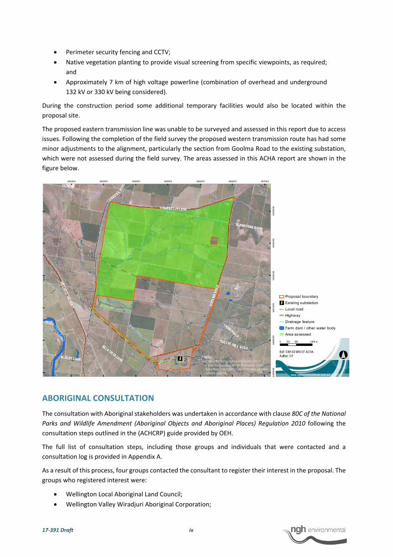
which were not assessed during the field survey. The areas assessed in this ACHA report are shown in the
figure below.
ABORIGINAL CONSULTATION
The consultation with Aboriginal stakeholders was undertaken in accordance with clause 80C of the National
Parks and Wildlife Amendment (Aboriginal Objects and Aboriginal Places) Regulation 2010 following the
consultation steps outlined in the (ACHCRP) guide provided by OEH.
The full list of consultation steps, including those groups and individuals that were contacted and a
consultation log is provided in Appendix A.
As a result of this process, four groups contacted the consultant to register their interest in the proposal. The
groups who registered interest were:
Wellington Local Aboriginal Land Council;
Wellington Valley Wiradjuri Aboriginal Corporation;
GOO
LMA
ROA
D
COBBORA
ROA
D
CAMPBELLS LANE
MITCHELLHIG
HWAY
TWELVE MILE ROADBELA VISTA LANE
GLADSTONE ROAD
BLACKS LANE
CADIA PLACE
W
UULUMAN CREE K
MACQUARIERIVER
681000 682000 683000 684000 685000 686000 687000
6399000
6400000
6401000
640
2000
640
3000
640
4000
0 500 1,000250 m
www.nghenvironmen tal.com.au
Ref: SW143 WN SF ACHAAuthor: SPNotes:
- Data co llected by nghenvironmental (2017)- Client data courtesy of Client, received 2018- Base map Copyright © Esri and its data suppliers. - GDA94 zone 55
Proposa l boundary
Existing substation
Local road
Highway
Drainage feature
Farm dam / other water body
Area assessed

17‐391 Draft x
Gallangabang Aboriginal Corporation; and
Binjang Wellington Wiradjuri Heritage Survey.
No other party registered their interest, including the entities and individuals recommended by OEH.
The fieldwork was organised, and all registered parties were asked to participate in the fieldwork. The
fieldwork was carried out in February 2018.
A copy of the draft report was provided to all the registered parties for comment.
ARCHAEOLOGICAL CONTEXT
The assessment included a review of relevant information relating to the existing landscape of the proposal
site. Included in this was a search of the OEH AHIMS database. No Aboriginal sites had previously been
recorded within the proposal site. A single isolated find site, Wellington Solar Farm IF 1 (#36‐4‐0142) is
located adjacent to the south‐western proposal boundary.
Assessment of Aboriginal site models for the region suggests that there appears to be a pattern of site
location that relates to the presence of potential resources for Aboriginal use. The most archaeologically
sensitive areas are noted to occur within close proximity of water. Nonetheless, given that Aboriginal people
have lived in the region for tens of thousands of years, there is some potential for archaeological evidence
to occur across the proposal site. This would most likely be in the form of stone artefacts and scarred trees.
SURVEY RESULTS
The survey strategy was to cover as much of the ground surface as possible within the proposal site. Although
the actual ground impact from the construction method for the proposed solar plant was likely to be low,
the placement of solar arrays across the landscape has the potential to cover any cultural heritage sites.
Survey transects were undertaken on foot across the proposal site to achieve maximum coverage. All mature
native trees within the proposal site were also inspected for evidence of Aboriginal scarring.
Visibility within the proposal site was variable however as a whole the proposal site generally had good
visibility averaging 35% overall. The effective visibility in the paddocks ranged from 90% in exposures to less
than 5% in areas of dense grass. Between the survey participants, over the course of the field survey,
approximately 800 km of transects were walked across the proposal site. Allowing for an effective view width
of 5 m for each person and given the variability in the ground visibility across the proposal site, overall the
survey effectively examined 13.1% of the proposal site. It is considered that the survey of Wellington North
Solar Plant proposal site had sufficient and effective survey coverage.
Despite the variable visibility encountered during the survey, there were 99 stone artefacts found across the
proposal site that were recorded as 37 site occurrences (as shown in the map below). These archaeological
features have been recorded as nine artefact scatters and 28 isolated finds. Two possible scarred trees and
a European survey marker tree were also recorded.
In terms of the current proposal therefore, extrapolating from the results of this survey, it is possible that
additional stone artefacts could occur within the proposed development footprint. Based on the land use
history, an appraisal of the landscape, soil, level of disturbance and the results from the field survey it was
concluded that there was negligible potential for the presence of intact subsurface deposits with high
densities of objects or cultural material within the proposal site.
The results of previous archaeological surveys in the Wellington region show that there are sites and artefacts
present across the landscape. The predictions based on the modelling for the proposal site were that stone

17‐391 Draft xi
artefacts and scarred trees were the most likely manifestation of Aboriginal occupation of the area. It was
noted that while Aboriginal sites may be expected throughout all landscapes the most archaeologically
sensitive areas occur in proximity to water. The survey results have confirmed this prediction with stone
artefacts recorded as isolated finds and artefact scatters across the proposal site, even in areas highly
disturbed by farming activities. The sites were identified across a range of landforms including slopes, flats,
spurs, low hill crests and along creeks/drainage lines and their associated flats. Over half of the artefacts
recorded during the survey were located along creeks/drainage lines and their associated flats.
The cultural significance of the sites recorded during this assessment is only determined by the local
Aboriginal community.
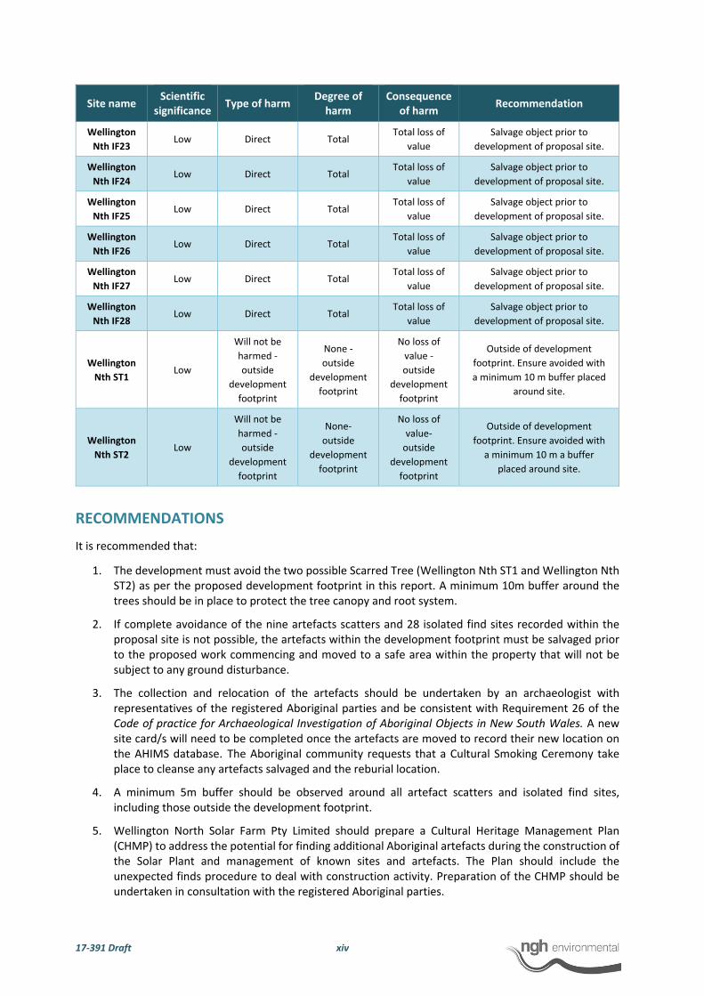
POTENTIAL IMPACTS
The proposal involves the construction of a solar plant and includes connection to the nearby substation with
an above ground powerline that will extend to the existing Wellington substation on Lot 1/DP1226751. The
development will result in disturbance of approximately 806 ha of the 970 ha property, plus 31 ha for the
‘worst case’ (largest impact area) transmission line option; resulting in a total disturbance of up to 837 ha.
The impact is likely to be most extensive where earthworks occur and would involve the removal, breakage
or displacement of artefacts. This is considered a direct impact on the Aboriginal objects by the development
in its present form.
The impact to the scientific values/ significance if the nine artefact scatters (Wellington Nth AFT1‐ Wellington
Nth AFT9) and 25 of the 28 recorded isolated finds (Wellington Nth IF1 to Wellington Nth IF10, Wellington
Nth IF12 Wellington Nth IF14 to Wellington Nth IF16, Wellington Nth IF18 to Wellington Nth IF28) were to
be impacted by the current proposal is considered low. It should be noted that the site Wellington Nth AFT9
will only be partially impacted. The two possible scarred tree sites will not be impacted by the proposal as
per the proposed development footprint.
Wellington Nth AFT6
Wellington Nth ST1
Wellington Nth European Survey Tree Marker 1
Wellington Nth ST2
Wellington Nth IF9Wellington Nth IF3
Wellington Nth IF4
Wellington Nth IF2
Wellington Nth IF1
Wellington Nth IF6
Wellington Nth IF7
Wellington Nth IF5
Wellington Nth IF10
Wellington Nth IF11
Wellington Nth IF25
Wellington Nth IF27
Wellington Nth IF24
Wellington Nth IF23Wellington Nth IF22
Wellington Nth IF16
Wellington Nth IF15
Wellington Nth IF14
Wellington Nth IF13
Wellington Nth IF12
Wellington Nth IF19
Wellington Nth IF20
Wellington Nth IF18
Wellington Nth IF26
Wellington Nth IF28
Wellington Nth IF21
Wellington Nth IF17
Wellington Nth AFT9
Wellington Nth AFT2
Wellington Nth AFT7
Wellington Nth AFT4
Wellington Nth AFT1
Wellington Nth AFT3
Wellington Nth AFT8
Wellington Nth AFT5
GO
OLM
AR
O AD
CO
BB
ORA
ROA
D
CAMPBELLS LANE
MITC
HELL HIGH
WAY
TWELVE MILE ROADBELA VISTA LANE
BLACKS LANE
CADIA PLACE
WUULUMAN
CREEK
681000 682000 683000 684000 685000 686000 687000
99000
6400000
64010
00
640
2000
6403000
6404
000
0 500 1,000250 m
www.nghenvironmen tal.com.au
Ref: SW143 Wellington North SF ArchAuthor: SP
Notes:- Data co llected by nghenvironmental (2017)- Client data courtesy of Client, rece ived 2018- Base map Copyright © Esri and its data suppliers. - GDA94 zone 55
European survey marker tree
Isolated find
Possible scarred tree
AHIMS listed sites
Artefact scatter
Existing substa tion
Local road
Highway
Proposal boundary

17‐391 Draft xii
The stone artefacts have little research value apart from what has already been gained from the information
obtained during the present assessment. This information relates more to the presence of the artefacts and
in the development of Aboriginal site modelling, which has largely now been realised by the recording. The
impact to the edge‐ground axes (Wellington Nth AFT 2, Wellington Nth AFT 5 and Wellington Nth AFT 9) are
considered to have low to moderate loss of scientific value.
The Wellington North Solar Plant proposal is classified as State Significant Development under the EP&A Act
which have a different assessment regime. As part of this process, Section 90 harm provisions under the NPW
Act are not required, that is, an AHIP is not required to impact Aboriginal objects as the Department of
Planning and Environment provides development approval.
The table below details the impacts to the nine artefact scatters, 28 isolated finds and two possible scarred
trees within the Wellington North Solar Plant proposal boundary. Of the 37 sites recorded with stone
artefacts three isolated find sites (Wellington Nth IF11, Wellington Nth IF13 and Wellington Nth IF17) and a
portion of the artefact scatter Wellington Nth AFT9 will be not impacted by the proposed development
footprint. The two possible scarred tree sites will also not be impacted by the proposed development
footprint.
Site name Scientific
significance Type of harm
Degree of harm
Consequence of harm
Recommendation
Wellington
Nth AFT1 Low Direct Total
Total loss of
value
Salvage objects prior to
development of proposal site.
Wellington
Nth AFT2 Low to
moderate Direct Total
Total loss of
value
Salvage objects prior to
development of proposal site.
Wellington
Nth AFT3 Low Direct Total
Total loss of
value
Salvage objects prior to
development of proposal site.
Wellington
Nth AFT4 Low Direct Total
Total loss of
value
Salvage objects prior to
development of proposal site.
Wellington
Nth AFT5 Low to
moderate Direct Total
Total loss of
value
Salvage objects prior to
development of proposal site.
Wellington
Nth AFT6 Low Direct Total
Total loss of
value
Salvage objects prior to
development of proposal site.
Wellington
Nth AFT7 Low Direct Total
Total loss of
value
Salvage objects prior to
development of proposal site.
Wellington
Nth AFT8 Low Direct Total
Total loss of
value
Salvage objects prior to
development of proposal site.
Wellington
Nth AFT9 Moderate Direct Partial
Partial loss
of value
Salvage objects within
development footprint prior to
development of proposal site.
Wellington
Nth IF1 Low Direct Total
Total loss of
value
Salvage object prior to
development of proposal site.
Wellington
Nth IF2 Low Direct Total
Total loss of
value
Salvage object prior to
development of proposal site.
Wellington
Nth IF3 Low Direct Total
Total loss of
value
Salvage object prior to
development of proposal site.
Wellington
Nth IF4 Low Direct Total
Total loss of
value
Salvage object prior to
development of proposal site.

17‐391 Draft xiii
Site name Scientific
significance Type of harm
Degree of harm
Consequence of harm
Recommendation
Wellington
Nth IF5 Low Direct Total
Total loss of
value
Salvage object prior to
development of proposal site.
Wellington
Nth IF6 Low Direct Total
Total loss of
value
Salvage object prior to
development of proposal site.
Wellington
Nth IF7 Low Direct Total
Total loss of
value
Salvage object prior to
development of proposal site.
Wellington
Nth IF8 Low Direct Total
Total loss of
value
Salvage object prior to
development of proposal site.
Wellington
Nth IF9 Low Direct Total
Total loss of
value
Salvage object prior to
development of proposal site.
Wellington
Nth IF10 Low Direct Total
Total loss of
value
Salvage object prior to
development of proposal site.
Wellington
Nth IF11 Low
Will not be
harmed ‐
outside
development
footprint
None ‐
outside
development
footprint
No loss of
value ‐
outside
development
footprint
Outside of development
footprint. Ensure minimum 5m
buffer to avoid inadvertent
disturbance or impacts to site.
Wellington
Nth IF12 Low Direct Total
Total loss of
value
Salvage object prior to
development of proposal site.
Wellington
Nth IF13 Low
Will not be
harmed ‐
outside
development
footprint
None ‐
outside
development
footprint
No loss of
value ‐
outside
development
footprint
Outside of development
footprint. Ensure minimum 5m
buffer to avoid inadvertent
disturbance or impacts to site.
Wellington
Nth IF14 Low Direct Total
Total loss of
value
Salvage object prior to
development of proposal site.
Wellington
Nth IF15 Low Direct Total
Total loss of
value
Salvage object prior to
development of proposal site.
Wellington
Nth IF16 Low Direct Total
Total loss of
value
Salvage object prior to
development of proposal site.
Wellington
Nth IF17
Low to
moderate
Will not be
harmed ‐
outside
development
footprint
None‐
outside
development
footprint
No loss of
value‐
outside
development
footprint
Outside of development
footprint. Ensure minimum 5m
buffer to avoid inadvertent
disturbance or impacts to site.
Wellington
Nth IF18 Low Direct Total
Total loss of
value
Salvage object prior to
development of proposal site.
Wellington
Nth IF19 Low Direct Total
Total loss of
value
Salvage object prior to
development of proposal site.
Wellington
Nth IF20 Low Direct Total
Total loss of
value
Salvage object prior to
development of proposal site.
Wellington
Nth IF21 Low Direct Total
Total loss of
value
Salvage object prior to
development of proposal site.
Wellington
Nth IF22 Low Direct Total
Total loss of
value
Salvage object prior to
development of proposal site.
17‐391 Draft xiv
Site name Scientific
significance Type of harm
Degree of harm
Consequence of harm
Recommendation
Wellington
Nth IF23 Low Direct Total
Total loss of
value
Salvage object prior to
development of proposal site.
Wellington
Nth IF24 Low Direct Total
Total loss of
value
Salvage object prior to
development of proposal site.
Wellington
Nth IF25 Low Direct Total
Total loss of
value
Salvage object prior to
development of proposal site.
Wellington
Nth IF26 Low Direct Total
Total loss of
value
Salvage object prior to
development of proposal site.
Wellington
Nth IF27 Low Direct Total
Total loss of
value
Salvage object prior to
development of proposal site.
Wellington
Nth IF28 Low Direct Total
Total loss of
value
Salvage object prior to
development of proposal site.
Wellington
Nth ST1 Low
Will not be
harmed ‐
outside
development
footprint
None ‐
outside
development
footprint
No loss of
value ‐
outside
development
footprint
Outside of development
footprint. Ensure avoided with
a minimum 10 m buffer placed
around site.
Wellington
Nth ST2 Low
Will not be
harmed ‐
outside
development
footprint
None‐
outside
development
footprint
No loss of
value‐
outside
development
footprint
Outside of development
footprint. Ensure avoided with
a minimum 10 m a buffer
placed around site.
RECOMMENDATIONS
It is recommended that:
1. The development must avoid the two possible Scarred Tree (Wellington Nth ST1 and Wellington Nth ST2) as per the proposed development footprint in this report. A minimum 10m buffer around the trees should be in place to protect the tree canopy and root system.
2. If complete avoidance of the nine artefacts scatters and 28 isolated find sites recorded within the proposal site is not possible, the artefacts within the development footprint must be salvaged prior to the proposed work commencing and moved to a safe area within the property that will not be subject to any ground disturbance.
3. The collection and relocation of the artefacts should be undertaken by an archaeologist with representatives of the registered Aboriginal parties and be consistent with Requirement 26 of the Code of practice for Archaeological Investigation of Aboriginal Objects in New South Wales. A new site card/s will need to be completed once the artefacts are moved to record their new location on the AHIMS database. The Aboriginal community requests that a Cultural Smoking Ceremony take place to cleanse any artefacts salvaged and the reburial location.
4. A minimum 5m buffer should be observed around all artefact scatters and isolated find sites, including those outside the development footprint.
5. Wellington North Solar Farm Pty Limited should prepare a Cultural Heritage Management Plan (CHMP) to address the potential for finding additional Aboriginal artefacts during the construction of the Solar Plant and management of known sites and artefacts. The Plan should include the unexpected finds procedure to deal with construction activity. Preparation of the CHMP should be undertaken in consultation with the registered Aboriginal parties.

17‐391 Draft xv
17‐391 Draft xvi
6. In the unlikely event that human remains are discovered during the construction, all work must cease in the immediate vicinity. OEH, the local police and the registered Aboriginal parties should be notified. Further assessment would be undertaken to determine if the remains were Aboriginal or non‐Aboriginal.
7. Further archaeological assessment would be required if the proposal activity extends beyond the area of the current investigation as detailed in this report, including the entire proposed eastern transmission route and any portions of the western transmission route outside the surveyed alignment. This would include consultation with the registered Aboriginal parties and may include further field survey.
8. The one possible European survey marker tree identified in the proposal site should be avoided by
the proposed works. If the development footprint is unable to be redesigned to be avoid the possible
European survey marker tree further recording is recommended to establish if it has any historical
significance.

17‐391 Draft 1
1 INTRODUCTION
Wellington North Solar Farm Pty Limited (the proponent), a subsidiary of AGL Energy Limited proposes the
development of a commercial scale solar plant approximately 7 km north east of the town of Wellington,
NSW (Figure 1 and 2). The 970 hectare site will be identified as the Wellington North Solar Plant (Figure 3).
The proposed Wellington North Solar Plant would generate up to 300 Mega Watt (AC). NGH Environmental
has been contracted to prepare an Aboriginal Cultural Heritage Assessment (ACHA) to investigate and
examine the presence, extent and nature of any Aboriginal heritage for the proposal site as part of an
Environmental Impact Assessment (EIS).
The solar plant proposal would involve ground disturbance that has the potential to impact on Aboriginal
heritage sites and objects which are protected under the NSW National Parks and Wildlife Act 1974 (NPW
Act). The purpose of the Aboriginal Cultural Heritage Assessment (ACHA) is therefore to investigate the
presence of any Aboriginal sites and to assess the impacts and management strategies that may mitigate any
impact.
1.1 DEVELOPMENT CONTEXT
The development of renewable energy projects is considered to be one of the most effective ways to achieve
the commitments of Australia and a large number of other nations under the Paris Agreement to reduce
greenhouse gas emissions. The Wellington North Solar Plant would provide the following benefits:
Reduction in greenhouse gas emissions from energy generation (when compared with fossil fuel generating sources).
Provision of embedded electricity generation to supply into the Australian grid close to a main consumption centre.
Provision of social and economic benefits through the provision of direct employment opportunities.
The establishment of a Solar Plant would therefore have local, National and International benefits.
As part of the development impact assessment process, the proposed development application will be
assessed under Part 4 of the Environmental Planning and Assessment Act 1979 (EP&A Act). Section 4.36 of
the EP&A Act provides that a development will be State Significant Development (SSD) if it is declared to be
SSD by a State Environmental Planning Policy (SEPP). The State Environmental Planning Policy (State and
Regional Development) 2011 (SRD SEPP) declares the Wellington North Solar Plant to be SSD. SSDs are major
projects which require approval from the Minister for Planning and Environment. The EIS has been prepared
in accordance with the requirements of the Secretary of the Department of Planning and Environment (DPE).
The Secretary of the DPE Environmental Assessment Requirements (SEARs) relating to Aboriginal heritage
were as follows:
Including an assessment of the likely Aboriginal and historic heritage (cultural and archaeological) impacts of the development, including adequate consultation with the local Aboriginal community (SEARS for Wellington North Solar Plant 18/12/17).
The assessment area is comprised of Lots 69, 70, 71,72, 73, 75, 76. 77, 78, 79, 80, 81, 82, 83,84, 88, and 119,
120, 121/DP 2987, Lots 1 and 2 /DP 1104720, Lot 3/DP 976701, Lots 1‐3 /DP 808748, Lot 100 /DP 750760,
Lot 1/DP 664645, Lot 1/ DP 1206579, Lot 1 DP 664645, Lot 1 DP 807187, Lot 2 DP 588075, Lot 1 DP 100778,
Lot 12 DP 572344 and Lot 2 DP 1226751 and will connect to the national electricity network via the existing
TransGrid substation located on Goolma Road within Lot 1/DP1226751 (see Figure 4). The proposed eastern
transmission line within Lots 14 and 15/DP 1018104, Lots 1 and 2/DP 1141897, Lot 1/DP 1069446 and Lot
32/DP 622471 was unable to be surveyed and assessed in this report due to access issues.

17‐391 Draft 2
Figure 1. General project location of the proposed Wellington North Solar Plant
17‐391 Draft 3
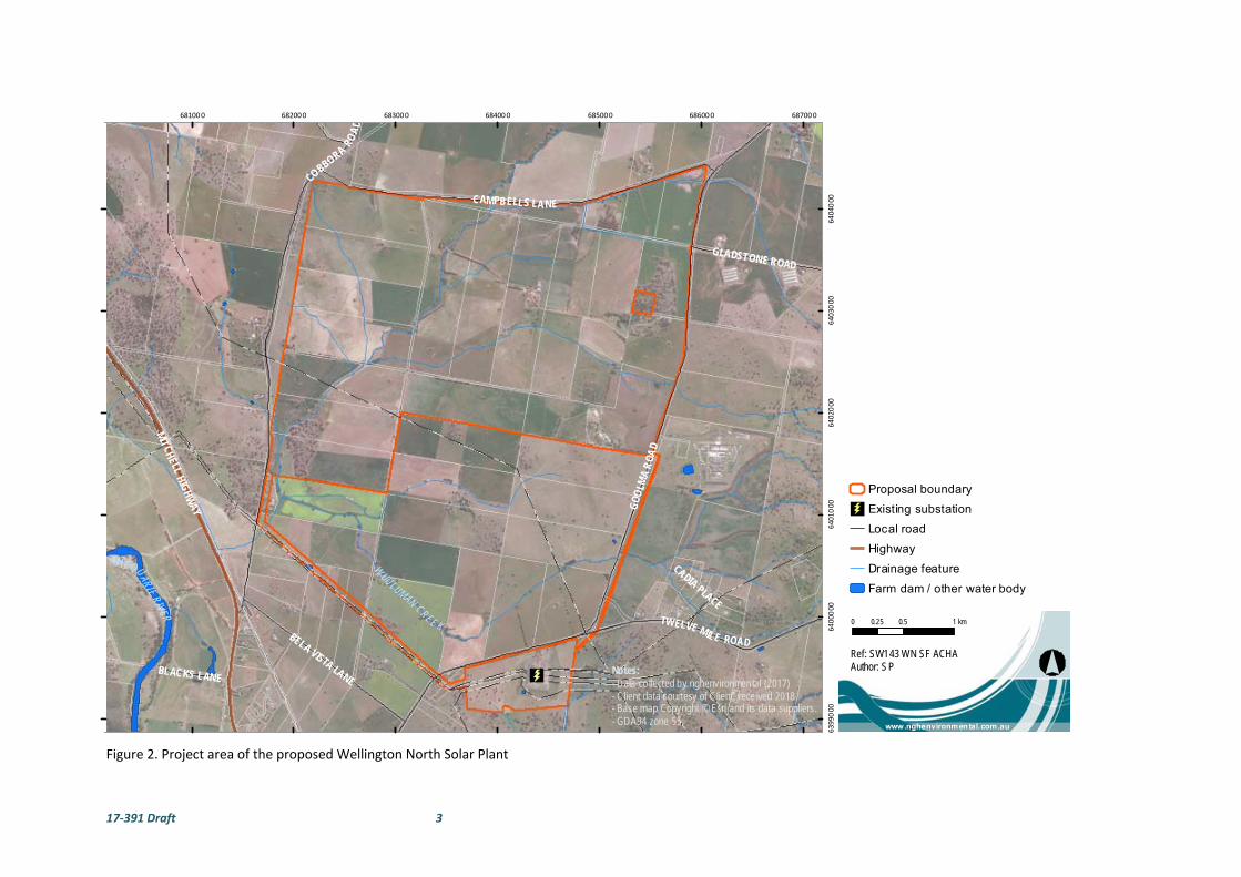
Figure 2. Project area of the proposed Wellington North Solar Plant
GOO
LMA
ROA
D
COBBORA
ROA
D
CAMPBELLS LANE
MITCHELLHIG
HWAY
TWELVE MILE ROADBELA VISTA LANE
GLADSTONE ROAD
BLACKS LANE
CADIA PLACE
W
UULUMAN CREE K
MACQUARIERIVER
681000 682000 683000 684000 685000 686000 687000
6399000
6400000
640
1000
6402000
6403000
6404000
0 0.5 10.25 km
www.nghenvironmental.com.au
Ref: SW143 WN SF ACHAAuthor: SPNotes:
- Data co llected by nghenvironmental (2017)- Client data courtesy of Client, rece ived 2018- Base map Copyright © Esri and its data suppliers. - GDA94 zone 55
Proposal boundary
Existing substation
Local road
Highway
Drainage feature
Farm dam / other water body
17‐391 Draft 4
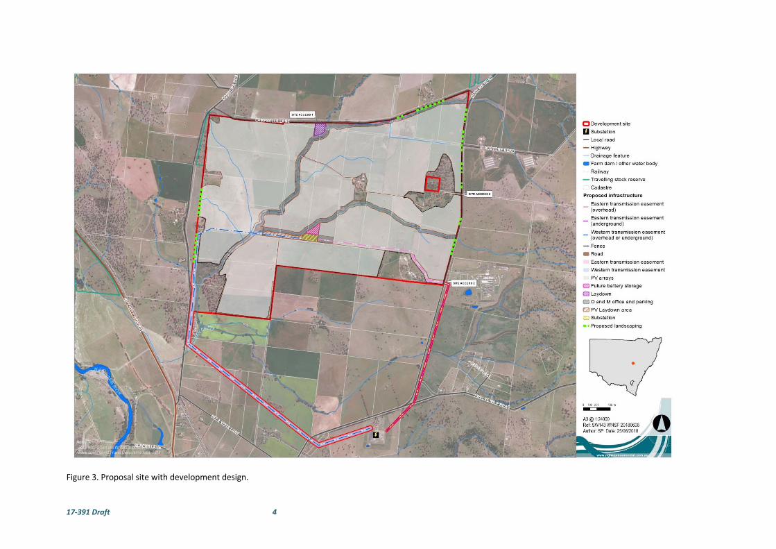
Figure 3. Proposal site with development design.
17‐391 Draft 5
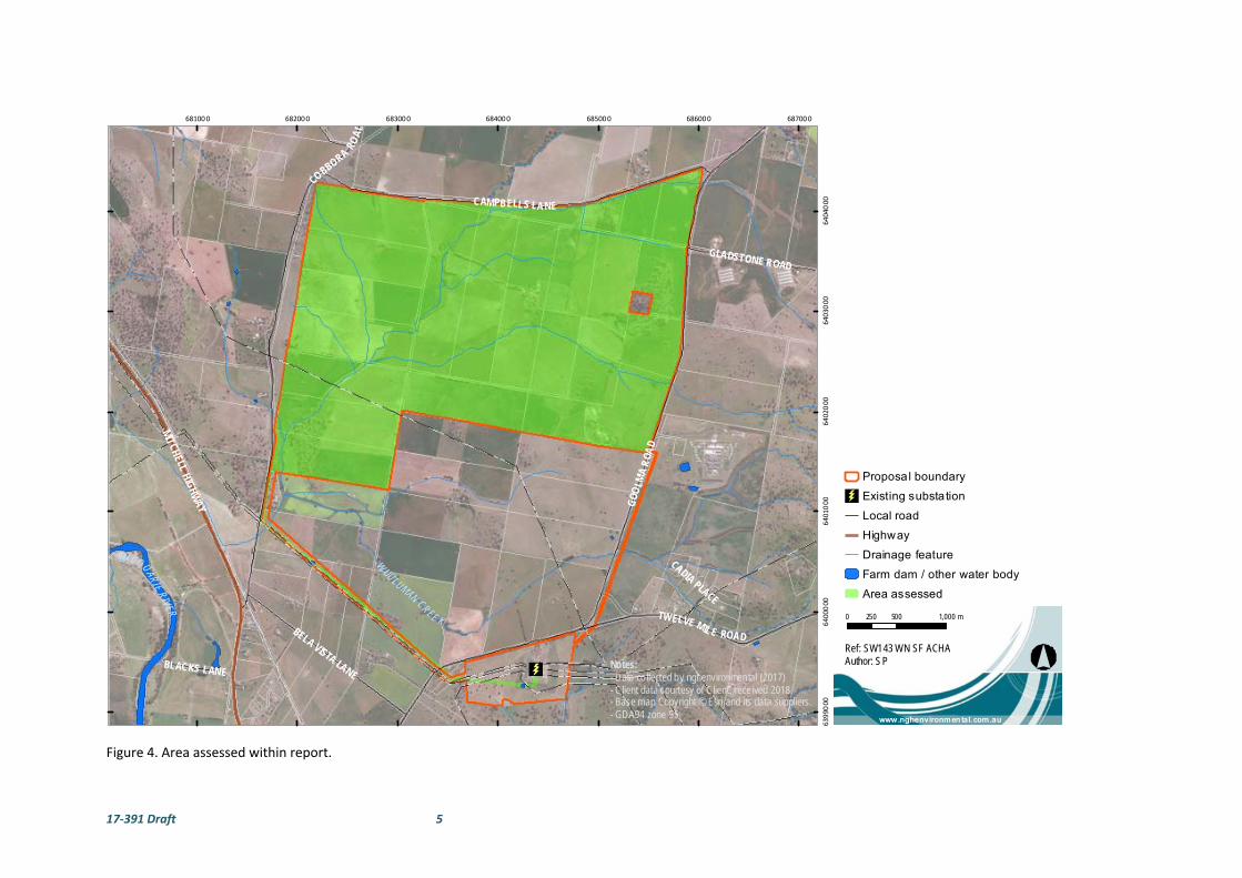
Figure 4. Area assessed within report.
GOO
LMA
ROA
D
COBBORA
ROA
D
CAMPBELLS LANE
MITCHELLHIG
HWAY
TWELVE MILE ROADBELA VISTA LANE
GLADSTONE ROAD
BLACKS LANE
CADIA PLACE
W
UULUMAN CREE K
MACQUARIERIVER
681000 682000 683000 684000 685000 686000 687000
63990
0064
00000
640
1000
6402
000
64030
0064
04000
0 500 1,000250 m
www.nghenvironmental.com.au
Ref: SW143 WN SF ACHAAuthor: SPNotes:
- Data co llected by nghenvironmental (2017)- Client data courtesy of Client, received 2018- Base map Copyright © Esri and its data suppliers. - GDA94 zone 55
Proposal boundary
Existing substation
Local road
Highway
Drainage feature
Farm dam / other water body
Area assessed

17‐391 Draft 6
Following the completion of the field survey the proposed western transmission route has had some minor
adjustments to the alignment, particularly the section from Goolma Road to the existing substation, which
were not assessed during the field survey. The areas along the western transmission line that now lie outside
the surveyed corridor are therefore not assessed in this report.
1.2 PROJECT PROPOSAL
The Wellington North Solar Plant proposal is located approximately 7km to the north‐east of Wellington,
NSW (see Figure 1). The assessment area is comprised of Lots 69, 70, 71,72, 73, 75, 76. 77, 78, 79, 80, 81, 82,
83,84, 88, and 119, 120, 121/DP 2987, Lots 1 and 2 /DP 1104720, Lot 3/DP 976701, Lots 1‐3 /DP 808748, Lot
100 /DP 750760, Lot 1/DP 664645, Lot 1/ DP 1206579, Lot 1 DP 664645, Lot 1 DP 807187, Lot 2 DP 588075,
Lot 1 DP 100778, Lot 12 DP 572344 and Lot 2 DP 1226751 and will connect to the national electricity network
via the existing TransGrid substation located on Goolma Road within Lot 1/DP1226751 (see Figure 4).
The proposed eastern transmission line within Lots 14 and 15/DP 1018104, Lots 1 and 2/DP 1141897, Lot
1/DP 1069446 and Lot 32/DP 622471 was unable to be surveyed and assessed in this report due to access
issues. Following the completion of the field survey the proposed western transmission route has had some
minor adjustments to the alignment, particularly the section from Goolma Road east to the existing
substation. Further archaeological assessment would be required if the proponent wishes to use a
transmission route alignment that extends beyond the area of the current investigation (as shown in Figure
4), including the entire proposed eastern transmission route and any portions of the western transmission
route outside the surveyed alignment as detailed in this report.
The site is bounded by Campbells Lane to the north, Goolma Road to the east, private land and Cobbora Road
to the west and private agricultural land to the south. Another solar farm, Wellington Solar Farm owned by
First Solar, is proposed on private property immediately south of the site.
The proposal site would have three vehicular access points. The primary access point during construction for
light and heavy vehicles would be off Campbells Lane, along the northern boundary of the site. Campbells
Lane would be accessed via Cobbora Road and the Mitchell Highway. Two existing driveways would also be
used as access points (one currently leads to the existing residence and the other to the SCS facility). These
access points would be used mostly by light vehicles.
The Wellington North Solar Plant proposal involves the construction, operation and decommissioning of a
ground‐mounted photovoltaic solar array which will generate up to 300 MW (AC) into the national electricity
grid. The proposal site is approximately 970 hectares in size and consists of several large paddocks primarily
used for grazing and cropping.
One 132kV or 330kV transmission line would be constructed to connect the solar plant to the existing
Wellington substation located approximately 3 km south of the proposal site. There are currently two
transmission line options under consideration however only the western option (which may be either
overhead or underground) was able to be surveyed and assessed in this report due to access restrictions
along at the eastern transmission line option (which would be underground only, if selected).
It is anticipated that the proposed solar plant development would include the following elements:
Approximately 1.2 million PV modules, spaced 4‐8m and mounted on east‐west horizontal
tracking systems or north‐orientated fixed‐tilt structures (both fixed and tracking options are
considered viable for the Proposal).
Up to approximately 155 PV inverter stations to allow conversion of DC module output to AC
electricity and transformation to medium voltage for site reticulation (typically 22kV or 33kV).
17‐391 Draft 7
Underground electrical conduits and cabling to connect the solar panels, combiner boxes and
inverters.
An onsite substation containing up to two transformers and associated switchgear.
Up to approximately 7km of 132kV or 330kV, overhead or underground transmission line to
the existing TransGrid 330kV substation (either an east and or west transmission line).
Additional electrical transformation equipment to be positioned in close proximity to the
existing TransGrid substation, if the 132kV transmission line option is progressed.
Site access off Campbells Lane, with additional access for mostly light vehicles off Goolma
Road.
Internal access tracks and upgrades to existing access roads, where required.
Site office and maintenance building with associated car park.
Space for future energy storage facility. Energy storage is not currently proposed and
therefore is not part of this assessment.
Perimeter security fencing and CCTV.
Vegetation planting to provide visual screening for specific viewers, as required.
The construction phase of the proposal would take approximately 18 – 24 months in total with a shorter peak
construction period of approximately 9 months, during which time the main construction works would take
place.
The Wellington North Solar Plant would be expected to operate for approximately 30 years. After this initial
operating period, the solar plant would either be decommissioned, removing all above ground infrastructure
and returning the site to its existing land capability, or repowered with new PV equipment to continue
operations as a solar plant.
1.3 PROJECT PERSONNEL
The assessment was undertaken by archaeologists Kirsten Bradley and Emily Dillon of NGH Environmental,
including research, Aboriginal community consultation, field survey and report preparation. Matthew Barber
of NGH Environmental also reviewed the report. James Graham‐Higgs, a third year University of New England
student studying a Bachelor of Arts (majoring in Archaeology) also assisted with the field survey.
Consultation with the Aboriginal community was undertaken following the process outlined in OEH’s
Aboriginal cultural heritage consultation requirements for proponents 2010. Four Aboriginal groups
registered their interest in the proposal.
These groups were:
Wellington Local Aboriginal Land Council;
Wellington Valley Wiradjuri Aboriginal Corporation;
Gallangabang Aboriginal Corporation;
Binjang Wellington Wiradjuri Heritage Survey; and
Further detail and an outline of the consultation process is provided in Section 2.
1.4 REPORT FORMAT
For the purposes of this assessment of the Wellington North Solar Plant, we have prepared the report in line
with the following:

17‐391 Draft 8
Guide to Investigating, Assessing and Reporting on Aboriginal Cultural Heritage in NSW (OEH, 2011);
Code of Practice for the Archaeological Investigation of Aboriginal Objects in New South Wales (OEH, 2010a), and
Aboriginal cultural heritage consultation requirements for proponents 2010 (ACHCRP) (OEH, 2010b) produced by the NSW OEH.
The purpose of this ACHA Report is to provide an assessment of the Aboriginal cultural values associated
with the study area and to assess the cultural and scientific significance of any Aboriginal heritage sites. This
conforms to the intention of the SEARs.
The objectives of the assessment were to:
Conduct Aboriginal consultation as specified in clause 80C of the National Parks and
Wildlife Regulation 2009, using the consultation process outlined in the ACHCRP;
Undertake an assessment of the archaeological and cultural values of the study area and any
Aboriginal sites therein;
Assess the cultural and scientific significance of any archaeological material:
Assess the impacts of the development proposal on cultural sites, and
Provide management recommendations for any objects found.
2 ABORIGINAL CONSULTATION PROCESS
The consultation with Aboriginal stakeholders was undertaken in accordance with clause 80C of the National
Parks and Wildlife Amendment (Aboriginal Objects and Aboriginal Places) Regulation 2010 following the
consultation steps outlined in the ACHCRP guide provided by OEH. The guide outlines a four stage process of
consultation as follows:
Stage 1 – Notification of project proposal and registration of interest.
Stage 2 – Presentation of information about the proposed project.
Stage 3 – Gathering information about cultural significance.
Stage 4 – Review of draft cultural heritage assessment report.
The full list of consultation steps, including those groups and individuals that were contacted and a
consultation log is provided in Appendix A. A summary of actions carried out following these stages are as
follows.
Stage 1. Letters outlining the development proposal and the need to carry out an ACHA were sent to the
Wellington LALC and various statutory authorities including OEH, as identified under the ACHCRP. An
advertisement was placed in the local newspaper, Dubbo Daily Liberal on the 27th of October 2017 seeking
registrations of interest from Aboriginal people and organisations. A further series of letters was sent to other
organisations identified by OEH in correspondence to NGH Environmental. In each instance, the closing date
for submission was 14 days from receipt of the letter.
As a result of this process, four groups contacted the consultant to register their interest in the proposal. The
groups who registered interest were Wellington Local Aboriginal Land Council, Wellington Valley Wiradjuri
Aboriginal Corporation, Gallangabang Aboriginal Corporation and Binjang Wellington Wiradjuri Heritage
Survey.
No other party registered their interest, including the entities and individuals recommended by OEH.

17‐391 Draft 9
Stage 2. On the 8th of December 2017, an Assessment Methodology document for the Wellington North Solar
Plant was sent to all registered parties. This document provided details of the background to the proposal, a
summary of previous archaeological surveys and the proposed heritage assessment methodology for the
proposal. The document invited comments regarding the proposed methodology and sought any information
regarding known Aboriginal cultural significance values associated with the subject area and/or any
Aboriginal objects contained therein. A minimum of 28 days was allowed for a response to the document.
Bradley Bliss responded for the Wellington Valley Wiradjuri Aboriginal Corporation and the Gallangabang
Aboriginal Corporation. The main points raised in the comments received from the Bradley Bliss on the
methodology were in relation to:
Survey spacing; and
Recording of sites and information provided by RAPs.
These comments were addressed by NGH in a reply letter sent to the Wellington Valley Wiradjuri Aboriginal
Corporation on the 6th of February 2018. No further correspondence was received regarding the letter from
NGH Environmental that addressed the comments on the methodology.
No other comments were provided from other registered parties.
Stage 3. The Assessment Methodology outlined in Stage 2 included a written request to provide any
information that may be relevant to the cultural heritage assessment of the study area. It was noted that
sensitive information would be treated as confidential. No response regarding cultural information was
received prior to fieldwork.
The fieldwork was organised and all of the registered parties were asked to participate in fieldwork. A single
representative from each of the four RAPs participated in the fieldwork. The fieldwork was carried out over
8 days in late February 2018.
The Aboriginal community representatives who participated in the field survey were:
Jamie Gray ‐ Binjang Wellington Wiradjuri Heritage Survey;
Peter Packham ‐ Wellington LALC;
Tjanara Talbot, ‐ a volunteer trainee heritage officer with the Wellington LALC
Bradley Bliss ‐ Wellington Valley Wiradjuri Aboriginal Corporation; and
Brendan Doherty ‐ Gallangabang Aboriginal Corporation.
During the fieldwork cultural information was provided to the archaeologists about the area from one of the
RAPs. This information has been requested to be treated as confidential and is not included in this report.
The information relates the project area to the larger Aboriginal cultural landscape and surrounding sites.
The cultural information may be relevant to the individuals that hold the appropriate knowledge in
determining the cultural significance of the sites. The cultural significance of sites can only be determined by
the local Aboriginal community.
Stage 4. In May 2018 a draft version of this Aboriginal Cultural Heritage Assessment Report for the proposal
(this document) was forwarded to each registered Aboriginal party inviting comment on the results, the
significance assessment and the recommendations. A minimum of 28 days was allowed for responses to the
document.

17‐391 Draft 10
2.1 ABORIGINAL COMMUNITY FEEDBACK
Community consultation occurred throughout the project. The draft report was provided to each of the
Registered Aboriginal Parties (RAPs) and feedback was sought on the recommendations, the assessment and
any other issues that may have been important.
On the 23rd of May 2018 Bradley Bliss, representing the Wellington Valley Wiradjuri Aboriginal Corporation,
informed NGH via email that four additional scarred tree sites had recently been recorded in the travelling
stock route land adjacent to the north‐western corner of the proposal site. The sites are now recorded on
AHIMS as #36‐1‐0742/Cobbora Road TSR Scar Tree, #36‐1‐0743/Cobbora Road TSR Scar Tree 1, #36‐1‐
0744/Cobbora Road TSR Scar Tree 2 and #36‐1‐0745/Cobbora Road TSR Scar Tree 3. Two of the sites (#36‐1‐
0742 and #36‐1‐0744) are located in close proximity to the proposal site and the management of these two
sites will now need to be considered in the Cultural Heritage Management Plan for the Wellington North
Solar Plant. The proponent has since been informed by NGH about the proximity of these two recently
recorded heritage sites to the proposal site. The proponent has been notified that they will need to ensure
these sites are not impacted or harmed during development, particularly during fencing, fire break and
vegetation screening works given that they are located close to the boundary of the Wellington North Solar
Plant proposal site.
Draft report feedback is still to be received and included in the report.
17‐391 Draft 11
3 BACKGROUND INFORMATION
3.1 REVIEW OF LANDSCAPE CONTEXT
3.1.1 Geology and Topography
The landscape context assessment is based on a number of classifications that have been made at national
and regional level for Australia. The national IBRA system identifies the proposal site as located within the
NSW South Western Slopes Bioregion and the Inland Slopes Subregion (DE&E 2016). The dominant IBRA
subregion affected by the proposal is the Inland Slopes Subregion.
The NSW South Western Slopes Bioregion extends north of Cowra through southern NSW into western
Victoria along the lower inland slopes of the Great Dividing Range. This region is characterised by foothills
and isolated ranges, 93% of which occur in NSW. The NSW portion of the bioregion occupies about 10.1
percent of the state.
The bioregion lies within the eastern section of the Lachlan Fold Belt consisting of a series of north to north
westerly trending folded bodies of Cambrian to Early Carboniferous sedimentary and volcanic rocks. Granites
form a dominate part of this bioregion, generally occurring as central basins surrounded by steep hills. Hilly
landscapes developed on sedimentary and volcanic rocks typically form lines of hills, following the strike of
more resistant rocks such as quartzite. The valleys between these features are generally granite or softer
rocks such as shale or slate.
To the west and north of the bioregion wide valleys filled with Quaternary alluvium and lakes become the
dominant landform. On the western edge however, alluvial fans from the Riverine Plain have buried most of
the bedrock. Gravel deposition in these fans form terraces in valleys and gravel outwash plains and are
attributed to higher river discharges in the past.
Notably there are several areas of fossil bearing limestone outcropping with developed karst topography and
a narrow belt of serpentinite with chemically distinctive soil that runs northwest from Tumut to
Cootamundra.
There are three subregions identified within the NSW South Western Slopes, the Inland Slopes, Lower Slopes
and the Capertee Valley. The proposal site is situated within the Inland Slopes Subregion.
The area is geologically dominated by Ordovician to Devonian folded and faulted sedimentary sequences
with inter‐bedded volcanics and intrusive granites. The soils tend to be shallow and stony forming on steep
slopes. The soils grade from red subsoils on upper slopes to yellow on the lower slopes comprised of alluvial
sands, loams and clays.
The Dubbo Geological map (1:250,000 SI/55‐4) indicates that geology underlying the proposal site consists
of the Quaternary, Ordovician and Silurian geological sequences as shown in Figure 5 and detailed below
(Colquhoun et al. 1999). The majority of the proposal site is within the Oakdale Formation (Oco).
Oco Basalt, basaltic andesite, latite lava and intrusions, volcaniclastic breccia,
conglomerate, sandstone and siltstone, minor allochthonous limestone.
Qa Alluvial silt, clay and sand, variable humic content, sporadic pebble‐ to cobble‐
sized unconsolidated conglomeratic lenses.
Qc Colluvial polymictic gravel, sand, silt and clay, may include some eluvial in situ
regolith deposits.
17‐391 Draft 12
Smb Poorly bedded to laminated, buff to brown to grey, quartzose shale and
siltstone; minor rhyolitic tuff and tuffaceous sandstone; calcareous sandstone and
siltstone.
Smd Rhyolitic to felsitic tuff and tuffaceous sandstone; siltstone; mafic to felsic lava;
limestone.
Smq Massive to bedded highly fossiliferous limestone and siltstone
Smdw Felsic crystal‐lithic sandstone and fossiliferous limestone.
Dgc Latitic, crystal lithic sandstones, breccia, siltstone, tuff, latite and lesser andesite,
basalt, minor allochthonous limestone and quartzose sandstone.
The proposal site is encompassed by two Mitchell Landscapes, the Mullion Slopes and the Macquarie Alluvial
Plains. The Mitchell Landscape descriptions are provided in Table 1 below and shown in Figure 6:
Macquarie Alluvial Plains occurs surrounding the main Wuuluman Creek tributary from the
south western to central northern portion of the proposal site.
Mullion Slopes occurs on the rest of the proposal site, 200m north and south of the main
Wuuluman Creek tributary.
Table 1 Description of the Mitchell Landscape relevant to the proposal (DECC 2002)
Mitchell Landscape
Mullion Slopes
Steep hills and strike ridges on tightly folded Ordovician andesite, conglomerate and tuff, Silurian rhyolite and
shale, Devonian quartz sandstones, slate and minor limestone, general elevation 500 to 830 m, local relief
200 m. Stony uniform sand and loam in extensive rock outcrop along crests, stony red and brown texture‐
contrast soil on slopes, yellow harsh texture‐contrast soil in valleys with some evidence of salinity. Gravel and
sand in streambeds.
Open forest to woodland of; white gum (Eucalyptus rossii), brittle gum (Eucalyptus mannifera), broad‐leaved
peppermint (Eucalyptus dives), red box (Eucalyptus polyanthemos), mountain grey gum (Eucalyptus
cypellocarpa), white box (Eucalyptus albens) with yellow box (Eucalyptus melliodora) on lower slopes and
river oak (Casuarina cunninghamiana) along the streams.
Macquarie Alluvial Plains
Holocene fluvial sediments of backplain facies of the Marra Creek Formation associated with the Macquarie
River main alluvial fan and distributary stream system, relief 1 to 3 m. Dark yellow‐brown silty clay with
patches of sand and carbonate nodules deposited from suspended sediments in floodwater, often with gilgai.
Slightly elevated areas with red‐brown texture‐contrast soils.
Open grasslands with scattered coolibah (Eucalyptus microtheca), black box (Eucalyptus largiflorens), river
cooba (Acacia stenophylla), bimble box (Eucalyptus populnea), belah (Casuarina cristata), lignum
(Muehlenbeckia cunninghamii) and myall (Acacia pendula).
Six watercourses occur within the proposal site, all are tributaries of Wuuluman Creek. The main tributary
flows from the north of the site to the south‐western corner of the site. Another tributary flows east to west
across the southern portion of the site (see Plates 1 and 2). These watercourses flow into the Macquarie
River, approximately 2.5 km downstream. The four other waterways onsite are minor incised drainage lines,
that would only have water after storm events. Four dams occur within the proposal site; three within the
south‐western portion of the proposal site and one in the south‐eastern corner of the proposal site.

17‐391 Draft 13
The topography of the proposal site is generally sloping from low hills down towards drainage lines and sits
at an elevation of between 300 and 400 m above sea level (ASL). The site includes the following topographic
features:
Low hills with outcropping rocks.
Several unnamed tributaries and drainage lines that join up with Wuuluman Creek
Plate 1 Tributary of Wuuluman Creek in the north of the Proposal site.
Plate 2 Unnamed drainage line that flows east to west across the southern portion of the Proposal site.
Soils within the proposal site are typically a reddish‐brown loam. The 1:250,000 Dubbo Soils Landscape series
sheet indicates that a single soil landscape, Bodangora Soil landscape with Euchrozems soils, occurs within
the proposal site as detailed below in Table 2 (Murphy and Lawrie 1998).
Table 2 Soil descriptions of Euchrozem Soils within the Bodangora Soil Landscape
Bodangora Soil Landscape with Euchrozem Soils
Description
Topsoil Dark reddish‐brown clay loams to light clays, moderately well‐structured with sub‐angular or
angular blocky peds.
Field pH increases from 5.5 to 7.0 in the A horizon; to 35 cm depth.
Subsoil Moderate to strongly structured reddish‐brown light to medium clays with smooth‐faced, sub‐
angular or polyhedral peds. Gravel increases with depth and soft nodules of calcium carbonate
begin to appear at about 90 cm depth.
Field pH 8.0 to 8.5.
The proposal site also contains a Soil Conservation Service (SCS) facility. The SCS is an environmental
consulting and soil conservation business entity within the Department of Primary Industries (DPI).
Accommodation facilities are also associated with the SCS. The SCS site is in the south eastern portion of the
proposal site (Lot 2 and 3 / DP808748 and Lot 88 / DP2987).
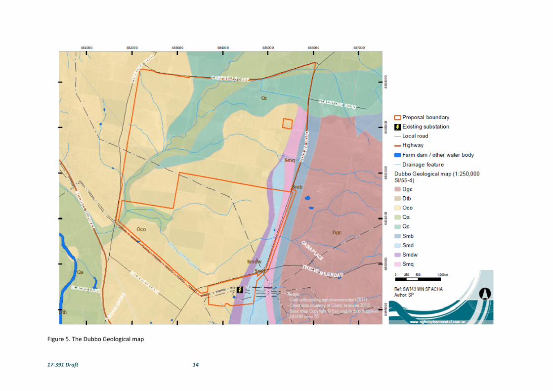
17‐391 Draft 14
Figure 5. The Dubbo Geological map

17‐391 Draft 15
Figure 6. Location of Mitchell landscapes.
GOO
LMA
ROA
D
COBBORA
ROA
D
CAMPBELLS LANE
MITCHELLHIG
HWAY
TWELVE MILE ROADBELA VISTA LANE
GLADSTONE ROAD
BLACKS LANE
CADIA PLACE
W
UULUMAN CREE K
MACQUARIERIVER
Mullion Slopes
Mullion Slopes
Mullion Slopes
Macquarie Alluvial Plains
Dubbo Basalts
Molong Ridges
681000 682000 683000 684000 685000 686000 687000
639
9000
6400
000
6401
000
6402
000
6403
000
6404
000
0 0.5 10.25 km
www.nghenvironmental.com.au
Ref: SW143 WN SF ACHAAuthor: SPNotes:
- Data co llected by nghenvironmental (2017)- Client data courtesy of Client, received 2018- Base map Copyright © Esri and its data suppliers. - GDA94 zone 55
Proposal boundary
Existing substation
Local road
Highway
Drainage feature
Farm dam / other water body
Mitchell Landscapes

17‐391 Draft 16
3.1.2 Flora and Fauna
The biodiversity assessment carried out by NGH Environmental identified two plant communities within
the proposal site. These include:
1. White Box – White Cypress Pine Shrub grass hills woodland in the Brigalow Belt South
Bioregion and Nandewar Bioregion. The remnant woodland within the development
site is very degraded having been extensively cleared and heavily grazed. Scattered
paddock trees remain in patches on the rocky hilltops and very little native understory
species remain. The dominant native species on the hilltops are White Box. Some
scattered White Cypress and Kurrajong also occur on the hill slopes. An occasional Grey
Box (Eucalyptus microcarpa) occurred on the lower hillslopes. Understory species are
mostly exotic pasture species however some native species occurred.
2. Yellow Box Grassy Tall Woodland on alluvium or parna loams and clays on flats in NSW
South Western Slopes Bioregion. The remnant woodland within the development site
is very degraded having been extensively cleared and heavily grazed. Scattered
paddock trees remain along the river flats and watercourses. The dominant native
species along the flats are Yellow Box with occasional Kurrajong (Brachychiton
populneus). Understory species are mostly exotic pasture species however some native
species occurred.
The remnant areas of vegetation have been highly disturbed and lack native understory due to grazing and
pasture improvement practices. Plantings of native species have been used as wind breaks and for
rehabilitation along onsite waterways. The vegetation communities provide numerous habitat types for
fauna. Canopy trees provide foraging and nesting/resting habitat for birds and arboreal fauna. The mid‐
storey provides foraging and nesting habitat for smaller birds, as well as refuge for small‐medium sized
mammals and reptiles. Ground cover plants, logs and fallen leaves also provide shelter and foraging habitat
for terrestrial fauna. Where hollow‐bearing trees are present, they may provide daytime resting habitat for
bats and mammals, and roosting habitat for birds.
3.1.3 Historic Land use
The proposal site has a history of intensive agricultural and pastoral use. The majority of the area has been
utilised for grazing and crop production since European settlement in the mid 1800’s. The location of the
proposed Solar Plant is within pastoral and agricultural fields and therefore has been subject to
considerable impacts from farming for many decades. The SCS facility and a residential house have also
been constructed within the proposal site. Historic images of the area from the SCS located within the
proposal boundary, show the high level of erosion in the area that was converted into the SCS area (Plates
3‐5). The SCS area has been extensively modified since the historical images were taken pre‐ 1944 when
the research facility was officially opened. Plate 6 shows and artist image of the SCS following its opening
in 1944.
There are also several man‐made dams and drainage lines within the proposal site. A number of contour
banks have also been constructed across the project area which has modified the ground. The contour
banks can clearly be seen in aerial photographs of the area. Overall, the project area would be categorised
as highly disturbed through consistent farming practices and land clearing over many decades.

17‐391 Draft 17
Plate 3 Historical image of erosion in area that is now the SCS area taken pre‐ 1944 (Image provided by SCS).
Plate 4 Historical image of erosion in area that is now the SCS area taken pre‐ 1944 (Image provided by SCS).
Plate 5 Historical image of erosion in area that is now the SCS area taken pre‐ 1944 (Image provided by SCS).
Plate 6 Artist image of the SCS following its
opening in 1944 (Image provided by SCS).
3.1.4 Landscape Context
Most archaeological surveys are conducted in a situation where there is topographic variation, and this can
lead to differences in the assessment of archaeological potential and site modelling for the location of
Aboriginal archaeological sites. As already noted, the terrain generally has low hills that slope down to
drainage lines including tributaries of Wuuluman Creek. The areas in close proximity to a water source on
slightly raised flat areas are likely to have been a major focus for Aboriginal people. However, prior to
European land modifications, this area as a whole may have provided resources, shelter, water and food
for Aboriginal people.
The different geological landscapes noted on the Dubbo Geological map (1:250,000 SI/55‐4) were not
readily identifiable within the survey area and were not used as a means of landscape differentiation. The
two Mitchell landscapes within the project area were readily identifiable however they were deemed to
be slightly too broad to be used as a means of landscape differentiation. The landforms for the survey were
instead determined to be seven units which include creek/drainage lines and associated raised flats, low
hill crests, spurs, raised outcrops, swamp/depression, flats and slopes (see Figure 7). These landform
divisions are based on landscape maps of the proposal site and visual inspection of the proposal site during
field survey.

17‐391 Draft 18
Figure 7. Location of landforms within Proposal site boundary
GOO
LMA
ROA
D
COBBORA
RO
AD
CAMPBELLS LANE
MITCHELLHIG
HWAY
TWELVE MILE ROADBELA VISTA LANE
GLADSTONE ROAD
BLACKS LANE
CADIA PLACE
W
UULUMAN CREE K
MACQUARIERIVER
0 0.5 10.25 km
www.nghenvironmen tal.com.au
Ref: SW143 WN SF ACHAAuthor: SPNotes:
- Data collected by nghenvironmental (2017)- Client data courtesy of Client, received 2018- Base map Copyright © Esri and its data suppliers. - GDA94 zone 55
Proposal boundary
Existing substation
Local road
Highway
Drainage feature
Farm dam / other water body
Landform
Creek / drainage
Flat
Low hill crest
Raised outcrop
Slope
Spur
Swamp / depression

17‐391 Draft 19
3.2 REVIEW OF ABORIGINAL ARCHAEOLOGICAL CONTEXT
3.2.1 Ethnohistoric Setting
Cultural areas are difficult to define and “must encompass an area in which the inhabitants have cultural
ties, that is, closely related ways of life as reflected in shared meanings, social practices and interactions”
(Egloff et al. 2005, p. :8). Depending on the culture defining criteria chosen ‐ i.e. which cultural traits and
the temporal context (historical or contemporary) ‐ the definition of the spatial boundary may vary. In
Australia, Aboriginal “marriage networks, ceremonial interaction and language have been central to the
constitution of regional cultural groupings” with the distribution of language speakers being the main
determinate of groupings larger than a foraging band (Egloff et al. 2005, pp. 8 & 16).
Wellington is within an area identified as part of the Wiradjuri language group. This is an assemblage of
many small clans and bands speaking a number of similar dialects (Tindale 1974, MacDonald 1983, Horton
1994).
The Wiradjuri language group was the largest in NSW prior to European settlement. The borders were
however, not static, they were most likely fluid, expanding and contracting over time to the movements of
smaller family or clan groups. Boundaries ebbed and flowed through contact with neighbours, the seasons
and periods of drought and abundance.
It was the small family group that was at the core of Aboriginal society and the basis for their hunting and
gathering life. The immediate family camped, sourced food, made shelter and performed daily rituals
together. The archaeological manifestations of these activities are likely to be small campsites,
characterised by small artefact scatters and hearths across the landscape. Places that were visited more
frequently would develop into larger site complexes with higher numbers of artefacts and possibly more
diverse archaeological evidence.
These small family units were part of a larger band which comprised a number of families. They moved
within an area defined by their particular religious sites (MacDonald 1983). Such groups might come
together on special occasions such as pre‐ordained times for ceremonies, rituals or simply if their paths
happened to cross. They may also have joined together at particular times of the year and at certain places
where resources were known to be abundant. The archaeological legacy of these gatherings would be
larger sites rather than small family camps. They may include large hearth or oven complexes, contain a
number of grinding implements and a larger range of stone tools and raw materials.
Identification and differentiation of such sites are difficult in the field. A family group and their antecedents
and descendants occupying a particular campsite repeatedly over a long period of time may leave a similar
pattern of archaeological signatures as a large group camped over a shorter period of time.
European settlers started arriving in the district in the 1820s. At this point the Aboriginal population was in
decline, due to disease such as small pox and influenza as well as dispossession from traditional lands and
acts of violence against the Aboriginal people meant there was great social upheaval and partial
disintegration of the traditional way of life. This meant that access to traditional resource gathering and
hunting areas, religious life and marriage links and access to sacred ceremonial sites were disrupted or
destroyed.
However, despite these disruptions, Aboriginal people continued to maintain their connections to sites and
the land in the early days of European settlement. Where Aboriginal people were moved to places like

17‐391 Draft 20
missions, people could maintain at least some form of association with country and maintain traditional
stories.
Early settlers and others who wrote about the Wiradjuri people and customs differentiated between the
origin of some groups, referring to people as the Lachlan or Murrumbidgee tribes, or the Levels tribe for
those between the two major rivers (Woolrych 1890). The extent of the Wiradjuri group means that there
were many different environments that were exploited for natural resources and food. Like everywhere in
Australia, Wiradjuri people were adept at identifying and utilising resources either on a seasonal basis or
all year round.
Terrestrial animals such as the possum was noted by many early observers as a prime food source and the
skins were made into fine cloaks that evidently were very warm (Evans 1815, Oxley 1820, Mitchell 1839).
Kangaroos were also eaten and their skins made into cloaks as well. A range of reptiles and other mammals
were food sources. Fish and mussels would have been prevalent from the rivers and creeks and insects
were also a common food type, in particular grubs and ants and ant eggs (Fraser 1892, Pearson 1981). Birds
including emus were common as a food source, often being caught in nets made from fibres of various
plants such as flax, rushes and kurrajong trees. Bird hunts were also often undertaken as group activities,
with emus, ducks and other birds targeted through groups of people flushing them out and driving them
into pre‐arranged nets (Ramson 1983).
On the 22nd of August 1817 John Oxley, the first European to explore the Wellington Valley observed an
abundance of fish, emus, swans and ducks’ as well as very large mussels growing among the reeds in many
stretches of the river. He noted that in such country there was no fear of being in want of food (Oxley 1820,
pp. 191–192).
Plant foods were equally as important and mostly consisted of roots and tubers, such as Typha or Cumbungi
whose tubers were eaten in late summer and the shoots in early spring. Other edible plants from the
Wiradjuri region include the Yam Daisy or Murnong, eaten in summer and autumn, the Kurrajong seeds
and roots, Acacia seeds and other rushes (Gott 1982).
Some of the early settlers and pastoralists, surveyors, explorers, administrators and others observed
traditional Aboriginal activities, including ceremonies, burial practices and general way of living, and
recorded these in letters, journals and books. These early records of Aboriginal lifestyle and society within
the region assist in understanding parts of the traditional Aboriginal way of life, albeit already heavily
disrupted at the time of the observations and through the eyes of largely ignorant and uninformed
observers.
The early observations also note that some weapons and tools were carried, some made from wood such
as spears, spear throwers, clubs, shields, boomerangs, digging sticks, bark vessels and canoes. Other
materials were observed in use such as stone axes, shell and stone scrapers and bone needles.
In an archaeological context, few of these items would survive, particularly in an open site context.
Anything made from bark and timber and animal skins would decay quickly in an open environment.
However, other items, in particular those made of stone would survive where they were made, placed or
dropped. Shell material may also survive in an archaeological context. Sources of raw materials, such as
the extraction of wood or bark would leave scars on the trees that are archaeologically visible, although
few trees of sufficient age survive in the modern context. Outcropping stone sources also provide clues to
their utilisation through flaking, although pebble beds may also provide sources of stone which leave no
archaeological trace.

17‐391 Draft 21
3.2.2 AHIMS Search
The Aboriginal Heritage Information Management System (AHIMS) is maintained by OEH and provides a
database of previously recorded Aboriginal heritage sites. A search provides basic information about any
sites previously identified within a search area. However, a register search is not conclusive evidence of
the presence or absence of Aboriginal heritage sites, as it requires that an area has been inspected and
details of any sites located have been provided to OEH to add to the register. As a starting point, the search
will indicate whether any sites are known within or adjacent to the investigation area.
A search of the AHIMS database was undertaken on the 24th of November 2017 over an area approximately
35 km east‐west by 35 km north‐south centred on the proposal site. The search coordinates were from Lat,
Long ‐32.6174, 148.778 to Lat, Long ‐32.3897, 149.1392 with a Buffer zone of 50 meters. The AHIMS Client
Service Number was: 314473. There are 105 Aboriginal sites recorded in the search area. No declared
Aboriginal Places are held for the search area in the database. Table 3 below shows the site types previously
recorded in the region and Figure 8 and Figure 9 shows the location of AHIMS sites in relation to the
Wellington North Solar Plant proposal site.
Table 3 Breakdown of previously recorded Aboriginal sites in the region.
Site Type Number
Artefact 61
Modified Tree 22
Artefact and PAD 3
Artefact and Hearth 2
PAD 2
Artefact and Shell 2
Restricted Sites 2
Burial 1
Stone Quarry 1
Grinding Groove 1
Aboriginal Ceremony and Dreaming and Modified Tree 1
Aboriginal Ceremony and Dreaming and Stone Arrangement 1
Aboriginal Resource and Gathering 1
Ceremonial Ring and Artefact 1
Ceremonial Ring and Modified Tree 1
Habitation Structure 1
Stone Arrangement, Stone Quarry and Artefact 1
Stone Arrangement and Stone Quarry 1
TOTAL 105

17‐391 Draft 22
The isolated find site, Wellington Solar Farm IF 1 (#36‐4‐0142) is located adjacent to the south‐western
proposal boundary. In total, there are 30 sites recorded with 1km of the proposal site and the transmission
line options. The majority of the sites (n= 26) were recently recorded by NGH Environmental during survey
for the First Solar Wellington Solar Farm adjacent to the current assessment area. The sites types recorded
on AHIMS within 1 km of the current assessment area included 16 isolated finds, 10 artefact scatters, two
modified trees and two areas of Potential Archaeological Deposit (PAD).
Additionally, it should be noted that NGH Environmental received email correspondence from David
Gordon (Senior Heritage Information Officer, Heritage Information Management team, Heritage Division,
The Office of Environment & Heritage) on the 30th of November 2017 that confirmed that the two restricted
Aboriginal sites listed in AHIMS are located outside the proposal site and will not be impacted by the works
for the proposed Wellington North Solar Plant. No further details regarding the two restricted sites was
provided.

17‐391 Draft 23
Figure 8. Location of known AHIMS sites

17‐391 Draft 24
Figure 9. Location of known AHIMS sites near the proposal site.
GOO
LMA
ROAD
MITCHELLHIGHW
AY
COBB
OR
AROAD
CAMPBELLS LANE
TWELVE MILE R OAD
MARYVALE
ROA D
BELA VISTA LANE
BRENN
AN SW
AY
GLADSTONE ROAD
G IPP
SST
R EE T
BLACKS LANE
WUULUMAN CR E EK
MA
CQU
AR
I ER
IVE
R
679000 680000 681000 682000 683000 684000 685000 686000 687000
6399
000
640
0000
640
1000
640
2000
6403
000
6404
000
6405
000
0 500 1,000250 m
www.nghenvironmental.com.au
Ref: SW143 WN SF ACHAAuthor: SP
Notes:- Data collected by nghenvironmental (2017)- Client data courtesy of Client, rece ived 2018- Base map Copyright © Esri and its data suppliers. - GDA94 zone 55
Proposal boundary
AHIMS listed sites
Existing substation
Local road
Highway
Farm dam / other water body
Drainage feature
Proposed infrastructure
Eastern transmission easement(overhead)
Eastern transmission easement(underground)
Western transmission easement(overhead or underground)
Fence
Development footprint

17‐391 Draft 25
3.2.3 Regional Archaeological Models
Aboriginal people have occupied what we now know as the Australian continent for at least 40,000 years and
perhaps 60,000 years and beyond (Mulvaney and Kamminga 1999, Hiscock 2007). While no regional synthesis
of the archaeology has been completed for the Wellington area, research studies have been undertaken in
the Upper Macquarie River region by Pearson (1981) and Koettig (1985). The following is a summary of the
finding from these studies.
Pearson (1981) analysed a series of sites which tended to be biased towards larger and more noticeable sites
identified by local residents. During this study, he excavated three rockshelters (Botobolar 5, Granites 1 and
Granites 2) which provided a record of regional Aboriginal occupation in the area to 5,000 years before
present. Based on his finding, Pearson categorised these sites as either occupation sites or non‐occupation
sites (sites that are generally for a single purpose i.e. scarred trees, grinding grooves and burial sites) and
built an archaeological model based on location. The model developed by Pearson is summarised below:
Distance to water from sites varied from 10 to 500 m, with larger sites found closer to a
water source.
Good soil drainage and an outlook over a water source were important to location.
Ceremonial and stone arrangement sites were located away from campsites.
Quarry sites were located in areas with desirable stone source qualities and reasonably
accessible.
Koettig (1985) continued to build on the archaeological understanding of this region by conducting a
comprehensive and systematic study of the Dubbo region, which although over 70 km to the west, is relevant
as one of only a few wide‐ranging archaeological studies. Koettig investigated all topographic landform units
and creek orders through sample survey to clarify locations and site types. The study arrived at the following
conclusions:
Aboriginal sites may be expected throughout all landscapes.
Artefact scatters, scar trees and grinding grooves are the most frequently occurring site
types.
The location and size of sites were determined by various factors; predominantly
environmental and social factors around the proximity to water, geological formations
and the availability of food resources.
Koettig (1985) suggested that larger and constantly occupied sites are likely to occur along permanent
watercourses, while more sporadic occupation would have occurred along ridge tops or temporary water
courses.
Purcell (2002) conducted a broad regional cultural heritage study of the Brigalow Belt South Bioregion in
NSW. This bioregion extends from Dubbo north to Moree. Over the course of the study Purcell recorded 110
oral history interviews, located 1,110 Aboriginal sites, documented 60 traditionally used plant species and
mapped landforms that have Aboriginal cultural heritage values. Of the 1,110 Aboriginal sites recorded
during this assessment 893 existed on the site register prior to the study.
The field survey portion of Purcell’s study primarily targeted government owned land such as state forests
and a landform mapping proposal was undertaken to assist with the development of a predictive model for
Aboriginal site distribution across the bioregion. Water localities were noted to be the major contributing
element influencing the distribution of sites among landforms with sites expected to be concentrated near
water localities. The landform types were classified into four key groups as shown in Table 4 below. The

17‐391 Draft 26
study indicated that Aboriginal sites have been recorded more frequently on high contour and alluvial
landforms. The majority of the sites recorded were within 100‐400 m of water.
Table 4 Breakdown of landforms mapped by Purcell in the Brigalow Belt South Bioregion.
Landforms Description Likelihood of Aboriginal sites
Alluvial Low lying areas associated with a variety of water features including rivers, creeks, channels, billabongs, swamps and lakes. Landforms include alluvial fans, alluvial terrace, alluvium, channel, floodplain, flood channel, gilgai, wetland/swamp and palaeo channels.
Aboriginal sites occur frequently.
Deep stable sand Landform types include yellow sand sheets and “sandy
monkey” palaeochannels. Water is scare. Aboriginal sites occur less frequently.
Terrace group Landform types consist of terrace with scalds, terrace with overland flow, terrace and clay pans. Each variety of terrace adjoins a landform associated with an alluvium landform.
Areas where terrace and floodplains overlap will have a high potential for sites.
Higher contour Landforms that are elevated and consist of rocky ground, rocky ravines, colluvial slope, soil mantled slope, bench and talus.
High frequency of sites when associated with alluvial landforms or creek lines.
OzArk (2007) conducted a cultural heritage review of the Dubbo LGA that overlaid all recorded sites within
the LGA on a mapped geomorphological GIS layer of landforms. The study confirmed that most Aboriginal
sites are recorded within 100 m of water accompanied by a general trend of there being fewer sites recorded
further away from water. Additionally, the majority of the recorded sites were identified to be located on
Quaternary alluvium soils that once supported the more complex ecological communities in the region. This
geological unit in the region occurs near major waterways and consequently, the likelihood of associated
Aboriginal objects and sites in such landforms increases.
3.2.4 Previous archaeological studies
The following are summaries of those archaeological survey reports that have been completed in the
Wellington area and in relative proximity to the current assessment area. The closest survey to the current
assessment area is the 2017 NGH Environmental survey for the adjacent Wellington Solar Farm for First Solar
Pty Ltd.
In 1982 Cubis surveyed the proposed electrical transmission line between Wellington and Lithgow. Cubis
identified 55 Aboriginal sites consisting of stone and glass artefact scatters and quarry sites. Most sites were
located in close proximity to drainage lines and/or located on ridges close to gullies, streams or swamps.
Cubis assessed the Central Western Region as being of archaeological significance due to the presence of
both prehistoric and contact archaeological sites (AMBS 2008, pp. 24–25).
A subsequent appraisal by Bowdler (1982) of five sites in the transmission corridor originally identified by
Cubis (1982) was undertaken. Bowdler (1982) established that none of the five sites were of significant future
research potential and the quarries identified by Cubis (1982) were not in fact quarries. It was suggested that
no further archaeological work was required for the proposal (AMBS, 2008, p. :25).

17‐391 Draft 27
In 1985 McIntyre surveyed the proposed reconstructed route of two proposed Electricity Commission
transmission lines between Wellington and Dubbo. The survey of these proposed transmission lines began
at the Wellington substation and followed the line of the Mitchell Highway approximately 54 km northwest
to Dubbo. A total of 27 sites were recorded generally situated within close proximity to water. McIntyre
noted that the areas of high archaeological sensitivity were areas adjacent to reliable seasonal water sources
and stands of mature native vegetation. (AMBS 2008, p. 25).
Lance (1985) surveyed a proposed transmission line between Wellington and Forbes. It is assumed that the
transmission line began at the Wellington Substation however this is not clearly stated in the report. During
the survey 16 open camp sites, 14 isolated finds and two scarred trees were identified. Lance noted that
that there was a direct correlation between the location of archaeological sites and water sources in the
area. Lance further concluded that in the Wellington area, quartz was the predominant raw material, while
further to the south, meta‐sedimentary and meta‐volcanic and other volcanic materials became dominant.
In 1995 Barber undertook a survey of a proposed communications GSM Tower approximately 6 km south
east of the proposal site. A single White Box scarred tree was identified in the survey area. Barber (1995)
suggested that the relative lack of archaeological material at this site was a true reflection as most camp sites
would be located on the flats, closer to rivers and creeks rather than on the crest of a hill. The presence
however, of the scarred tree demonstrates that ‘Aboriginal people utilised all of the resources available to
them and covered most of the country in which they lived’ (Barber 1995:6).
Kelton (1999) undertook a survey of a proposed sewage treatment plant approximately 4 km south west of
the current proposal site. No archaeological sites were identified within the study area although a scarred
tree was identified on a creek flat adjacent to the site. Kelton (1999) suggests that the presence of the scarred
tree indicates that prior to European land clearing of old growth trees there would have been potential for
such sites to have occurred within the study area.
AMBS (2008) recorded four Aboriginal heritage sites within the 100 km corridor of the proposed Wellington
gas pipeline, power station and compressor station. The proposed location of the power station was directly
adjacent to the southern boundary of the Wellington 330kV substation which will connect via overhead or
underground powerlines to the current assessment area. Three artefact scatters consisting of chert, silcrete
and quartz and a single scarred tree were recorded. All sites were identified on low slopes and flats within
proximity of a creek line or water source. None of the sites recorded were in close proximity to the current
assessment area. Furthermore, it was noted that the local Aboriginal community considered the scarred tree
to be highly culturally significant.
OzArk (2009) surveyed 9 km for the proposed upgrade of the existing 11kV electricity transmission line,
proposed extensions and associated access tracks south‐west of Wellington. This survey was approximately
4.5 km south of the current proposal site. Four Aboriginal sites were identified consisting of three open sites
with potential archaeological deposits (PAD) and one isolated find. The open sites consisted of a range of raw
material types including silcrete, chert, greywacke, hornfels and quartz. These sites were all located on
elevated creek confluences or spur crests overlooking water.
Pardoe (2010) carried out the Aboriginal cultural heritage assessment for the proposed Young to Wellington
Gas Pipeline Project. Eighteen (18) sites were identified consisting of 13 scarred trees and 5 open artefact
scatters. The artefact scatters tended to be on slightly raised ground associated with source of permanent
water, just above or within a few hundred meters of swampy ground and manufactured from locally sourced
quartz and volcanic stone. Most scars were on Yellow Box trees and the location of the scarred trees is
suggested to ‘largely reflect retention of trees on or near watercourses, or on sections of land that were too
rough to warrant clearing’ (Pardoe 2010:109).

17‐391 Draft 28
The Bodangora Wind Farm, approximately 10 km north east of the proposal site was surveyed by Dibden in
2011. Two Aboriginal sites were recorded on crests, comprised of an artefact scatter and a possible quartz
procurement site (2011). Dibden noted that all the artefacts were recorded on crests with no artefacts
recorded on the simple slopes.
In 2017 NGH Environmental (NGH) surveyed approximately 500 ha for the proposed Wellington Solar Farm
for First Solar Pty Ltd. The southern boundary of the current assessment area is shared with the northern
boundary of the First Solar project. Despite variable visibility, 61 stone artefacts were found across the
proposal site that were recorded as 25 site occurrences. These archaeological features were recorded as ten
artefact scatters and 15 isolated finds. A single scarred tree was also recorded. Additionally, two areas of
Potential Archaeological Deposit (PAD) were identified. The artefacts recorded were manufactured primarily
from quartz and volcanic material with a lesser number of silcrete, sandstone, fine‐grained siliceous and
quartzite artefacts recorded. The presence of cores, hammer stones and flakes indicated that tool
manufacture likely occurred onsite, although the presence of an edge ground axe implies some completed
tools were also brought to the site. The sites were all identified on low slopes and flats within proximity of a
creek line or water source, even in areas highly disturbed by farming activities. The results of the survey
increased the number of sites recorded in the local area by 21.6% from 98 to 125. It was noted that there
are likely to be many hundreds of such sites in the local area, and that the low number of sites recorded in
AHIMS was merely an indication that few surveys had been undertaken in the area and therefore the sites
are yet to be found.
3.2.5 Summary of Aboriginal land use
The results of previous archaeological surveys in the Wellington region show that there are sites and artefacts
present throughout the landscape. There is a dominance of artefacts either as isolated finds or in clusters as
artefact scatters. Scarred trees are also prevalent in the region.
There appears to be a pattern of site location that relates to the presence of potential resources for
Aboriginal use. The Aboriginal site modelling for the region to date suggests that while Aboriginal sites may
be expected throughout all landscapes the most archaeologically sensitive areas occur in close proximity to
water. The most likely site type to be encountered within the Wellington North Solar Plant proposal site
would be stone artefacts and scarred trees where old growth native trees remain.
A detailed understanding of the Aboriginal land use of the region is lacking, as few in depth studies have been
completed and no sites have been dated. It is possible however, to ascertain that proximity to water sources
and raw materials was a key factor in the location of Aboriginal sites. It is also reasonable to expect that
Aboriginal people ventured away from these resources to utilise the broader landscape but the current
archaeological record of that activity is currently limited.
3.2.6 Archaeological Site Location Model
Based on the results of the previous archaeological investigations in the local Wellington area, and through
extrapolation of Wiradjuri sites from the region it is possible to provide the following model of site location
in relation to the proposed Wellington North Solar Plant area.
Stone artefact scatters – representing camp sites can occur across the landscape, usually in association with
some form of resource or landscape unit such as spur and ridge crests. Within the proposal site there are
several tributaries of Wuuluman Creek that are an obvious resource. Artefact scatters are therefore likely to
occur within the proposal site.

17‐391 Draft 29
Burials – are generally found in elevated sandy contexts or in association with rivers and major creeks. No
such features exist with the proposal site and therefore such sites are unlikely to occur.
Scarred Trees – these require the presence of mature trees and are likely to be concentrated along major
waterways and around swamps areas. There are patches of remnant vegetation across the proposal site,
therefore, it is possible that this feature could occur.
Hearths/Ovens – are identified by burnt clay and stone used for heat retainers. None are recorded in the
district but they could occur either independently or in association with other Aboriginal cultural features
such as campsites, often in association with resource locations. Such places are not obvious within the
proposal site and this feature is therefore unlikely to occur.
Stone resources – are areas where people used natural stone outcrops as a source material for flaking. This
requires geologically suitable material outcropping so as to be accessible. The proposal site contains natural
outcropping therefore such sites could occur.
Shell Middens – are the agglomeration of shell material disposed of after consumption. Such places are found
along the edges of significant waterways, swamps and billabongs. The proposal site contains no significant
waterways, swamps and billabongs and this feature is therefore unlikely to occur.
Isolated Artefacts – are present across the entire landscape, in varying densities. As Aboriginal people
traversed the entire landscape for thousands of years, such finds can occur anywhere and indicate the
presence of isolated activity, dropped or discarded artefacts from hunting or gathering expeditions or the
ephemeral presence of short term camps.
In summary, the topography and landscape features within the proposed Wellington North Solar Plant
proposal site indicate that this area would likely have been part of the Wiradjuri landscape, particularly with
several tributaries of Wuuluman Creek within the proposal site. Therefore, the proposal site could potentially
be attractive to Aboriginal people to concentrate activity and therefore has a higher possibility of providing
an archaeological signature. Subsequently, given that Aboriginal people have lived in the region for tens of
thousands of years, there is potential for archaeological evidence to occur throughout the area, this is most
likely to be in the form of stone artefacts or as scarred trees.
3.2.7 Comment on existing information
The AHIMS database is a record of those places that have been identified and had site cards submitted to
OEH. It is not a comprehensive list of all places in NSW as site identification relies on an area being surveyed
and on the submission of site forms to AHIMS. There are likely to be many areas within NSW that have yet
to be surveyed and therefore have no sites recorded. However, this does not mean that sites are not present.
Within the Wellington area there have been few archaeological investigations. The information relating to
site patterns, their age and geomorphic context is little understood. The robustness of the AHIMS survey
results are therefore considered to be only moderate for the present investigation. There are likely to be
many sites that exist that have yet to be identified although the scale of farming and development has altered
the natural landscape in some places. This activity has also greatly disturbed the archaeological record and
there are unlikely to be many places that retain in situ archaeological material due to the scale of agricultural
and pastoral activities and development.
Regarding the limitations of the information available, archaeologists rely on Aboriginal parties to divulge
information about places with cultural or spiritual significance in situations where non‐archaeological sites
may be threatened by development. To date the project archaeologists have not been told of any such places

17‐391 Draft 30
within the proposal site. There is always the potential for such places to exist but insofar as the current
proposal is concerned, no such places or values have been identified.
4 ARCHAEOLOGICAL INVESTIGATION RESULTS
4.1 SURVEY STRATEGY
The survey strategy was to cover as much of the ground surface as possible within the proposal site. Although
the actual ground impact from the construction method for the proposed solar plant was likely to be low,
the placement of solar arrays across the landscape has the potential to cover any cultural heritage sites.
The strategy therefore was to walk a series of transects across the landscape to achieve maximum coverage.
Because the proposal site was generally cleared paddocks used for grazing livestock or recently ploughed
fields, transects were spaced evenly with the survey team spread apart at 25 m intervals, walking in parallel
lines. The cleared nature of the paddocks made this an ideal survey strategy. The team were able to walk in
parallel lines, at a similar pace, allowing for maximum survey coverage and maximum opportunity to identify
any heritage features. The survey team consisted of a minimum of 6 people and a maximum of 8 people
which allowed a 150 m to 200 m wide tract of the proposal site to be surveyed with each transect pending
on the number of people present. At the end of each transect, the team would reposition along a new
transect line at the same spacing and walk back on the same compass bearing.
While the proponent plans to retain existing viable native vegetation remnants where possible, the areas of
remnant vegetation were deemed to have high archaeological potential for mature trees within the proposal
site and were inspected for any evidence of Aboriginal scarring (Long 2005). Native paddock trees were also
inspected for any evidence of Aboriginal scarring (Long 2005).
NGH believes that the survey strategy was comprehensive and the most effective way to identify the
presence of Aboriginal heritage sites. Discussions were held in the field during each day between the
archaeologists and Aboriginal community representatives to ensure all were satisfied and agreed with the
spacing and methodology.
The proposal site was divided into seven landform divisions based on landscape maps of the proposal site
and visual inspection during field survey as listed below and shown in Figure 7.
Creek/drainage lines and associated raised flats;
Low hill crests;
Spurs;
Raised outcrops;
Swamp/depression;
Flats; and
Slopes.
The survey was undertaken by the team over eight days from the 19th to the 26th of February 2018. Notes
were made about visibility, photos taken and any possible Aboriginal features identified were inspected,
assessed and recorded if deemed to be Aboriginal in origin.

17‐391 Draft 31
4.2 SURVEY COVERAGE
Given that the topographic maps in the Wellington area are mapped at 20 m contours the visual inspection
of the project area during field survey was also used to establish the landforms within the proposal site.
The solar plant area comprised primarily of cleared paddocks with low hills sloping down to creeks and
drainage lines. The hills generally had low quality outcropping rocks and shallow soil deposits on the crests
and associated slopes. The slopes within the proposal site were generally low gradient and some had been
subject to contour banking. The entire proposal site had been subject to clearing and ploughing activities
with a number of rocks placed in piles across the project area. These piles were inspected for Aboriginal
objects during the survey.
Survey transects were undertaken on foot and traversed all the proposal site including the proposed western
powerline easement to the substation. The proposed eastern powerline easement was unable to be surveyed
during the fieldwork due to access issues.
Visibility within the proposal site was variable however as a whole the proposal site generally had good
visibility averaging 35% overall. The effective visibility in the paddocks ranged from 90% in exposures to less
than 5% in areas of dense grass. Between the survey participants, over the course of the field survey,
approximately, 800 km of transects were walked across the proposal site.
Table 5 below shows the calculations of effective survey coverage. Figure 10 shows the division of landforms
within the proposal site and the location of Plates 7‐ 20, that show examples of the transects and landforms
within the proposal site.
Allowing for an effective view width of 5m for each person and given the variability in the ground visibility
across the proposal site overall the survey effectively examined 13.1% of the proposal site. It is considered
that the survey of Wellington North Solar Plant proposal site had sufficient and effective survey coverage.
The discovery of a number of Aboriginal sites indicates that the survey technique was effective enough to
identify the presence of Aboriginal occupation in the area. Therefore, the results identified are considered a
true reflection of the nature of the Aboriginal archaeological record present within the proposal site.
Plate 7 View west across the spur towards crest with outcropping.
Plate 8 View south from flat up slope towards spur with crest with outcropping on the right of photo, note good visibility in foreground.

17‐391 Draft 32
Plate 9 View south from contour bank on flats up slope towards crest with outcropping.
Plate 10 View south along tributary of Wuuluman Creek and associated flats.
Plate 11 View west across the low slope, note good visibility and pile of rocks at tree in background.
Plate 12 View south along slope.
Plate 13 View east across crest looking down towards tributary of Wuuluman Creek at tree line in the background.
Plate 14 View west from drainage line towards low hill crest.

17‐391 Draft 33
Plate 15 View north from the southern extent of Wuuluman Creek tributary and it associated flats, note crest in the background.
Plate 16 View west from edge of crest looking down slope towards tributary of Wuuluman Creek.
Plate 17 View south across slope and drainage line with the low hills in the background.
Plate 18 View from house on crest.
Plate 19 View east up slope to low hill crest. Plate 20 View north along tributary of Wuuluman Creek and it associated flats.

17‐391 Draft 34
Figure 10. Landforms and survey photographs.
Plate 9Plate 8
Plate 7
Plate 20
Plate 19
Plate 18
Plate 17
Plate 16Plate 15
Plate 14
Plate 13
Plate 12
Plate 11Plate 10
GO
OLM
AR
OADCOBBORA
RO
AD
CAMPBELLS LANE
MITCHELLHIG
HWAY
TWELVE MILE ROADBELA VISTA LANE
GLADSTONE ROAD
BLACKS LANE
CADIA PLACE
W
UULUMAN CREE K
MACQUARIERIVER
681000 682000 683000 684000 685000 686000 687000
6399000
640
0000
64010
0064020
00640
3000
640
4000
0 0.5 10.25 km
www.nghenvironmen tal.com.au
Ref: SW143 WN SF ACHAAuthor: SPNotes:
- Data co llected by nghenvironmental (2017)- Client data courtesy of Client, rece ived 2018- Base map Copyright © Esri and its data suppliers. - GDA94 zone 55
Proposal boundary
Photo location
Existing substation
Local road
Highway
Drainage feature
Farm dam / other water body
Landform
Creek / drainage
Flat
Low hill crest
Raised outcrop
Slope
Spur
Swamp / depression

17‐391 Draft 35
Table 5. Transect information.
Landform Number of Survey Transects
Exposure type Project area
(ha)
Surveyed area
(length m x width m)
Survey area (m2)
Visibility
%
Effective coverage (area x visibility)
m2
Project area
surveyed (ha)
Percentage of Project
area effectively surveyed
Archaeological result
Slopes 70 Bare ground, gate entrances, fence
lines, vehicle tracks 601
6,980 x 35
1,300 x 15
6,000 x 30
41,400 x 40
244, 300
19,500
180,000
1,656,000
35 734,930 73.49 12.22
16 Isolated finds
3 Artefact scatters
1 European survey marker tree
Creek/drainage lines
and associated raised flats
30
Bare ground, gate entrances, fence lines, creek banks, vehicle tracks
185
1,200 x 35
1,200x 15
22,150 x 40
42,000
18, 000
886,000
40 378, 400 37.84 20.45 5 Isolated finds
2 Artefact scatters
Low hill crests
17 Bare ground, gate entrances, fence
lines, vehicle tracks 92
1,200x 35
7, 650 x 40
42,000
306,000 30 104,400 10.44 11.34
1 Isolated find
1 Artefact scatter
Flats 5 Bare ground, gate entrances, fence
lines, vehicle tracks 56 3,300 x 40 132,000 35 46,200 4.62 8.25 5 Isolated finds
Raised outcrops
2 Bare ground, fence
lines 18
1,300 X 40
300 X 15
52,000
4,500 10 5,650 0.56 3.11
2 possible scarred trees
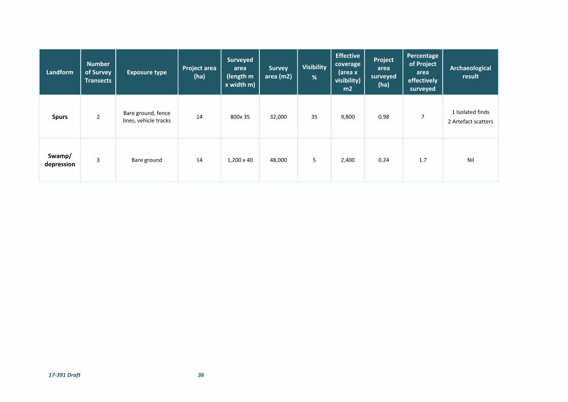
17‐391 Draft 36
Landform Number of Survey Transects
Exposure type Project area
(ha)
Surveyed area
(length m x width m)
Survey area (m2)
Visibility
%
Effective coverage (area x visibility)
m2
Project area
surveyed (ha)
Percentage of Project
area effectively surveyed
Archaeological result
Spurs 2 Bare ground, fence lines, vehicle tracks
14 800x 35 32,000 35 9,800 0.98 7 1 Isolated finds
2 Artefact scatters
Swamp/ depression
3 Bare ground 14 1,200 x 40 48,000 5 2,400 0.24 1.7 Nil

17‐391 Draft 37
4.3 SURVEY RESULTS
Despite the variable visibility encountered during the survey, there were 99 stone artefacts found across the
proposal site that were recorded as 37 site occurrences. These archaeological features have been recorded
as nine artefact scatters and 28 isolated finds. Two possible scarred trees and a European survey marker tree
were also recorded. The details of the sites are outlined below and artefact records are shown in Table 6.
Their locations are shown in Figure 11.
Wellington Nth IF1
This site consisted of a single artefact on an alluvial flat plain near an existing transmission line in a cleared
paddock. The artefact was a single platform volcanic core that had a single negative flake scare and 40%
riverine cortex. The deposits consisted of a reddish brown loam and visibility within the area was 50%. The
area has been subject to disturbance from ploughing in the past and the artefact had some recent trampling
damage from livestock.
Plate 21. View west with adjacent powerline corridor.
Plate 22. Close up of Wellington Nth IF 1.
Wellington Nth IF2
This site consisted of a single artefact on an alluvial flat plain near an existing transmission line in a cleared
paddock. The artefact was a volcanic flake. The deposits consisted of a reddish brown loam and visibility
within the area was 70%. The area has been subject to disturbance from ploughing in the past and the
construction of a dam which was in close proximity.
Plate 23. View west with adjacent powerline corridor.
Plate 24. Close up of Wellington Nth IF 2.
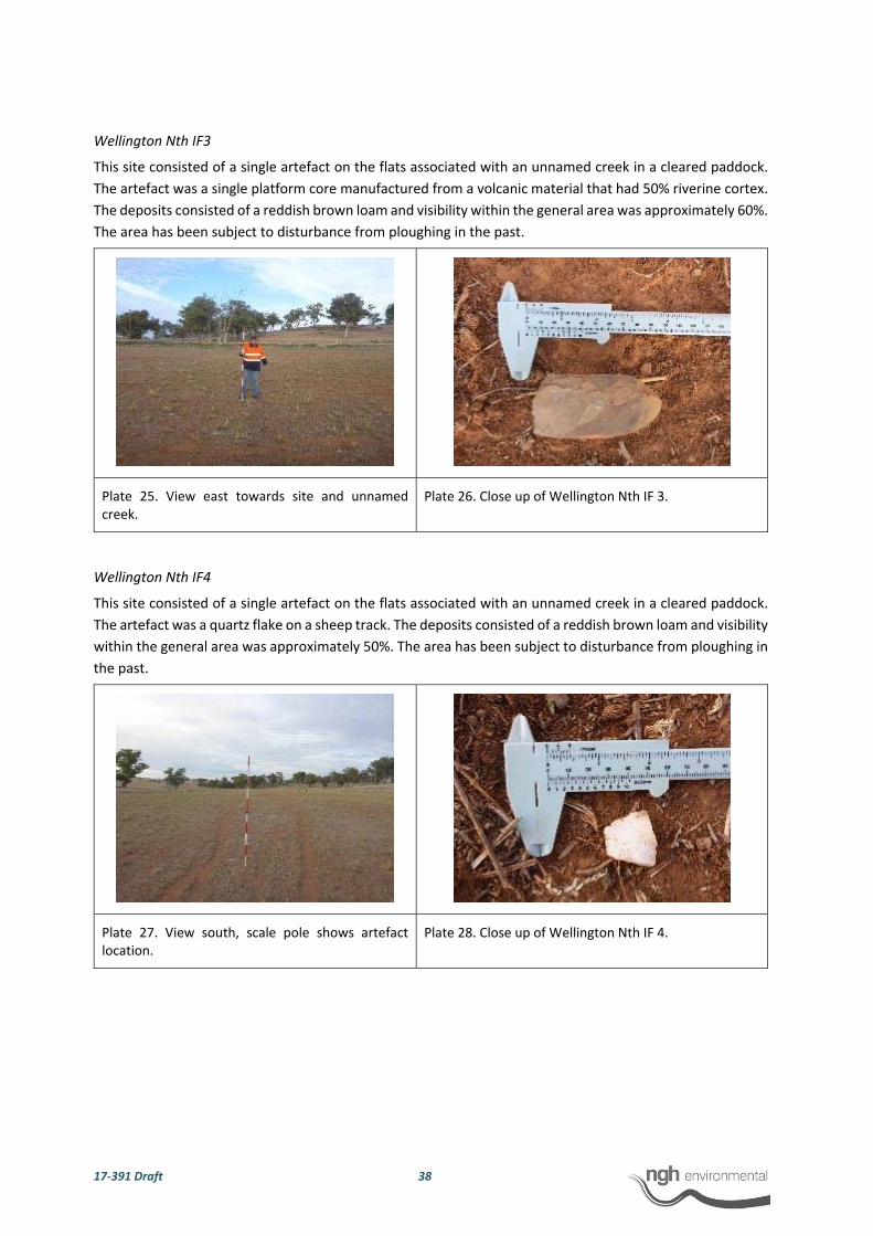
17‐391 Draft 38
Wellington Nth IF3
This site consisted of a single artefact on the flats associated with an unnamed creek in a cleared paddock.
The artefact was a single platform core manufactured from a volcanic material that had 50% riverine cortex.
The deposits consisted of a reddish brown loam and visibility within the general area was approximately 60%.
The area has been subject to disturbance from ploughing in the past.
Plate 25. View east towards site and unnamed creek.
Plate 26. Close up of Wellington Nth IF 3.
Wellington Nth IF4
This site consisted of a single artefact on the flats associated with an unnamed creek in a cleared paddock.
The artefact was a quartz flake on a sheep track. The deposits consisted of a reddish brown loam and visibility
within the general area was approximately 50%. The area has been subject to disturbance from ploughing in
the past.
Plate 27. View south, scale pole shows artefact location.
Plate 28. Close up of Wellington Nth IF 4.

17‐391 Draft 39
Wellington Nth IF5
This site consisted of a single artefact on a low slope in a cleared paddock approximately 10 m east of a fence
line. The artefact was a single platform quartz core with three negative flake scares with 25% pebble cortex.
The deposits consisted of a reddish brown loam and visibility within the general area was approximately 35%.
The area has been subject to disturbance from ploughing in the past.
Plate 29. View north, scale pole shows artefact location.
Plate 30. Close up of Wellington Nth IF 5.
Wellington Nth IF6
This site consisted of a single artefact on a low slope in a cleared paddock. The artefact was a quartz flaked
piece. The deposits consisted of a reddish brown loam with visibility within the general area approximately
60%. The area has been subject to disturbance from ploughing in the past.
Plate 31. View west, scale pole shows artefact location.
Plate 32. Close up of Wellington Nth IF 6.
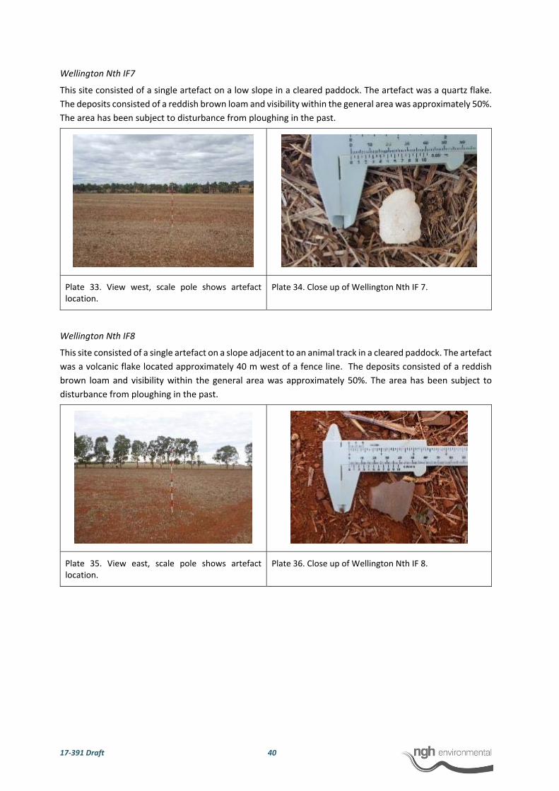
17‐391 Draft 40
Wellington Nth IF7
This site consisted of a single artefact on a low slope in a cleared paddock. The artefact was a quartz flake.
The deposits consisted of a reddish brown loam and visibility within the general area was approximately 50%.
The area has been subject to disturbance from ploughing in the past.
Plate 33. View west, scale pole shows artefact location.
Plate 34. Close up of Wellington Nth IF 7.
Wellington Nth IF8
This site consisted of a single artefact on a slope adjacent to an animal track in a cleared paddock. The artefact
was a volcanic flake located approximately 40 m west of a fence line. The deposits consisted of a reddish
brown loam and visibility within the general area was approximately 50%. The area has been subject to
disturbance from ploughing in the past.
Plate 35. View east, scale pole shows artefact location.
Plate 36. Close up of Wellington Nth IF 8.

17‐391 Draft 41
Wellington Nth IF9
This site consisted of a single artefact on a low slope in a cleared paddock approximately 20 m north of a
fence line. The artefact was a fine‐grained siliceous multiple platform core with some plough damage. The
deposits consisted of a reddish brown loam and visibility within the area was approximately 30%. The area
has been subject to disturbance from ploughing in the past with a number of rocks in the area exhibiting heat
and plough damage.
Plate 37. View west, scale pole shows artefact location.
Plate 38. Close up of Wellington Nth IF 9.
Wellington Nth IF10
This site consisted of a single artefact on a low slope in a cleared paddock approximately 5 m east of a fence
line. The artefact was a flake of basalt with 20% riverine cortex and some evidence of stock
damage/trampling. The deposits consisted of a reddish brown loam and visibility within the general area
was approximately 70%. The area has been subject to disturbance from ploughing in the past.
Plate 39. View north, scale pole shows artefact location.
Plate 40. Close up of Wellington Nth IF 10.

17‐391 Draft 42
Wellington Nth IF11
This site consisted of a single artefact on a low slope approximately 2 m north of a fence line in a cleared
paddock. The artefact was a quartz flake. The deposits consisted of a reddish brown loam with visibility
within the general area approximately 40%. The area has been subject to disturbance from ploughing in the
past.
Plate 41. View east, scale shows artefact location. Plate 42. Close up of Wellington Nth IF 11.
Wellington Nth IF12
This site consisted of a single artefact on a flat low hill crest in a cleared paddock approximately 5 m north of
a fence line. The artefact was a volcanic flake. The deposits consisted of a reddish brown loam and visibility
within the general area was approximately 80%. The area has been subject to disturbance from ploughing in
the past.
Plate 43. View north, scale pole shows artefact location.
Plate 44. Close up of Wellington Nth IF 12.

17‐391 Draft 43
Wellington Nth IF13
This site consisted of a single artefact on a low slope between a low hill crest with rocky outcropping and a
raised flat spur. The artefact was a volcanic flake with riverine cortex. The deposits consisted of a reddish
brown loam with and large volcanic rocks and limestone outcropping scattered across the slope and low hill.
Visibility within the general area was approximately 20%. This area does not appear to have been subject to
any ploughing activities in the past give the presence of bedrock outcropping in the immediate area.
Plate 45. View east, scale pole shows artefact location.
Plate 46. Close up of Wellington Nth IF 13.
Wellington Nth IF14
This site consisted of a single artefact on raised flat spur in a cleared paddock. The artefact was a single
platform volcanic core that had 2 negative flake scars and had 25% riverine cortex. The deposits consisted of
a reddish brown loam and visibility within the general area was approximately 20%. The area has been
subject to disturbance from ploughing in the past.
Plate 47. View north, scale pole shows artefact location.
Plate 48. Close up of Wellington Nth IF 14.

17‐391 Draft 44
Wellington Nth IF15
This site consisted of a single artefact in an exposure on a contour bank on an otherwise flat and cleared
paddock. The artefact was a quartzite flake with 30% riverine cortex. The deposits consisted of a reddish
brown loam and visibility within the general area outside the exposure was approximately 10%. The area has
been subject to disturbance from ploughing in the past and landscape modification with contour banks.
Plate 49. View north, scale pole shows artefact location on contour bank.
Plate 50. Close up of Wellington Nth IF 15.
Wellington Nth IF16
This site consisted of a single artefact in a flat and cleared paddock. The artefact was a quartzite flake with
20% riverine cortex. The deposits consisted of a reddish brown loam and visibility within the general area
was approximately 20%. The area has been subject to disturbance from ploughing in the past.
Plate 51. View south, scale pole shows artefact location.
Plate 52. Close up of Wellington Nth IF 16.

17‐391 Draft 45
Wellington Nth IF17
This site consisted of a single artefact in a flat and cleared paddock. The artefact was a reutilised piece of
clear glass. The reutilised piece was the bottom of a glass bottle with retouch along the top margin. The
deposits consisted of a reddish brown loam and visibility within the general area was approximately 10%.
The area also had other pieces of scatter glass and ceramics in the area that were inspected but no other
pieces appeared to be retouched or reutilised.
Plate 53. View south, scale pole shows artefact location.
Plate 54. Close up of Wellington Nth IF 17.
Wellington Nth IF18
This site consisted of a single artefact on a low slope in a cleared paddock approximately 30 m north of a
small drainage line. The artefact was a single platform volcanic core with three complete negative flake scares
and some core preparation noted. The core has 80% riverine cortex. The deposits consisted of a reddish
brown loam and visibility within the general area was approximately 20%. The area has been subject to
disturbance from ploughing in the past.
Plate 55. View south, scale pole shows artefact location.
Plate 56. Close up of Wellington Nth IF 18.

17‐391 Draft 46
Wellington Nth IF19
This site consisted of a single artefact on a low slope in a cleared paddock approximately 5 m off the adjacent
fence line. The artefact was a proximal fragment of quartz. The deposits consisted of a reddish brown loam
and visibility within the general area was approximately 40%. The area has been subject to disturbance from
ploughing in the past.
Plate 57. View north, scale pole shows artefact location.
Plate 58. Close up of Wellington Nth IF 19.
Wellington Nth IF20
This site consisted of a single artefact on a low slope in a cleared paddock. The artefact was a distal fragment
of chert. The deposits consisted of a reddish brown loam and visibility within the general area was
approximately 40%. The area has been subject to disturbance from ploughing in the past.
Plate 59. View west, scale pole shows artefact location.
Plate 60. Close up of Wellington Nth IF 20.

17‐391 Draft 47
Wellington Nth IF21
This site consisted of a single artefact on a low slope in a cleared paddock. The artefact was a fine grained
siliceous retouched flake with retouch along the distal margin for 63 mm. The deposits consisted of a reddish
brown loam and visibility within the general area was approximately 35%. The area has been subject to
disturbance from ploughing in the past and the artefact had some stock and plough damage.
Plate 61. View east, scale pole shows artefact location.
Plate 62. Close up of Wellington Nth IF 21.
Wellington Nth IF22
This site consisted of a single artefact on a low slope in a cleared paddock. The artefact was a chert flake
core. The deposits consisted of a reddish brown loam and visibility within the general area was approximately
20%. The area has been subject to disturbance from ploughing in the past.
Plate 63. View south‐east , scale pole shows artefact location.
Plate 64. Close up of Wellington Nth IF 22.

17‐391 Draft 48
Wellington Nth IF23
This site consisted of a single artefact on a low slope in a cleared paddock. The artefact was a volcanic flake
with 20% riverine cortex. The deposits consisted of a reddish brown loam and visibility within the general
area was approximately 40%. The area has been subject to disturbance from ploughing in the past.
Plate 65. View south, scale pole shows artefact location.
Plate 66. Close up of Wellington Nth IF 23.
Wellington Nth IF24
This site consisted of a single artefact on a low slope in a cleared paddock. The artefact was a fine grained
siliceous single platform core in an exposure. The deposits consisted of a reddish brown loam and visibility
within the general area was approximately 35%. The area has been subject to disturbance from ploughing in
the past and the artefact had some stock damage.
Plate 67. View west, scale pole shows artefact location.
Plate 68. Close up of Wellington Nth IF 24.
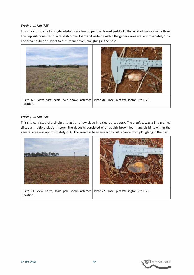
17‐391 Draft 49
Wellington Nth IF25
This site consisted of a single artefact on a low slope in a cleared paddock. The artefact was a quartz flake.
The deposits consisted of a reddish brown loam and visibility within the general area was approximately 15%.
The area has been subject to disturbance from ploughing in the past.
Plate 69. View east, scale pole shows artefact location.
Plate 70. Close up of Wellington Nth IF 25.
Wellington Nth IF26
This site consisted of a single artefact on a low slope in a cleared paddock. The artefact was a fine grained
siliceous multiple platform core. The deposits consisted of a reddish brown loam and visibility within the
general area was approximately 25%. The area has been subject to disturbance from ploughing in the past.
Plate 71. View north, scale pole shows artefact location.
Plate 72. Close up of Wellington Nth IF 26.
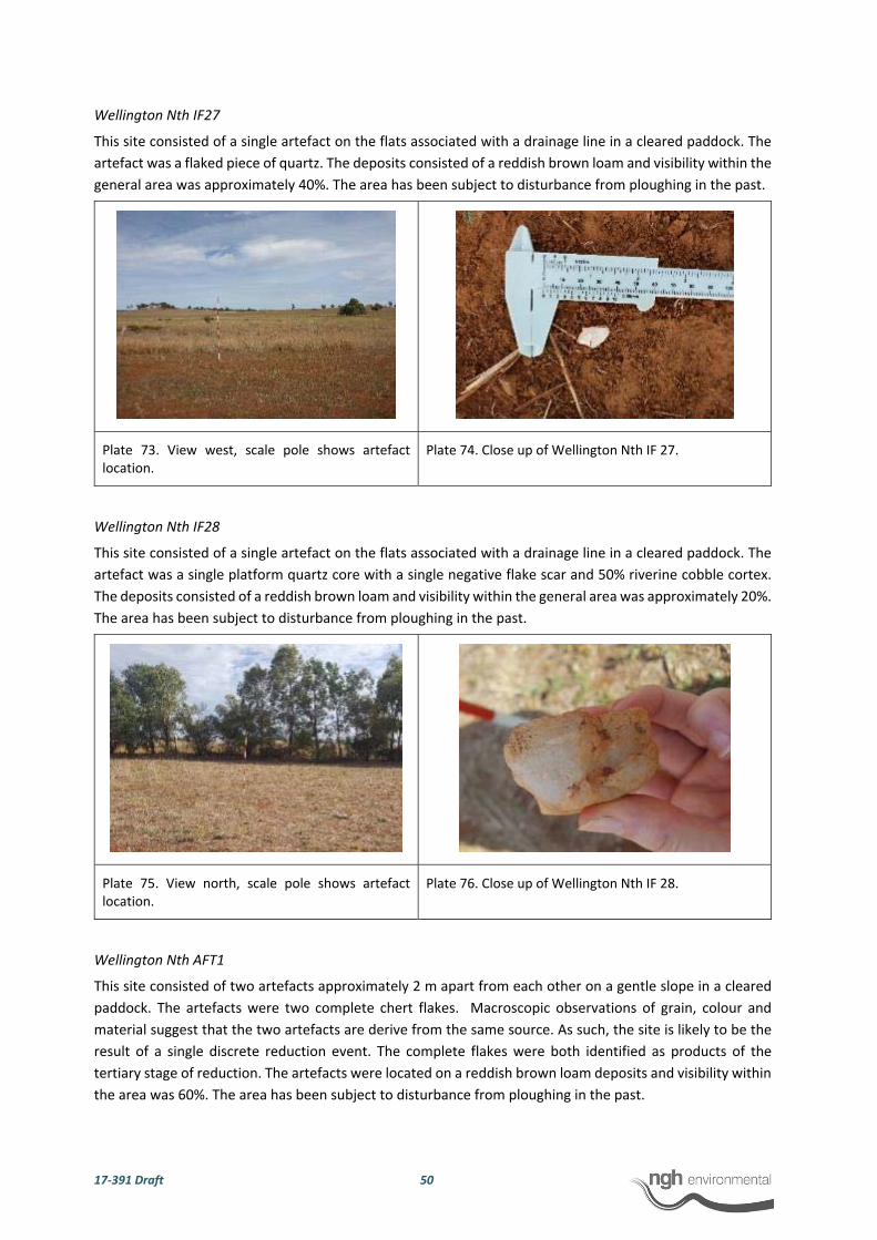
17‐391 Draft 50
Wellington Nth IF27
This site consisted of a single artefact on the flats associated with a drainage line in a cleared paddock. The
artefact was a flaked piece of quartz. The deposits consisted of a reddish brown loam and visibility within the
general area was approximately 40%. The area has been subject to disturbance from ploughing in the past.
Plate 73. View west, scale pole shows artefact location.
Plate 74. Close up of Wellington Nth IF 27.
Wellington Nth IF28
This site consisted of a single artefact on the flats associated with a drainage line in a cleared paddock. The
artefact was a single platform quartz core with a single negative flake scar and 50% riverine cobble cortex.
The deposits consisted of a reddish brown loam and visibility within the general area was approximately 20%.
The area has been subject to disturbance from ploughing in the past.
Plate 75. View north, scale pole shows artefact location.
Plate 76. Close up of Wellington Nth IF 28.
Wellington Nth AFT1
This site consisted of two artefacts approximately 2 m apart from each other on a gentle slope in a cleared
paddock. The artefacts were two complete chert flakes. Macroscopic observations of grain, colour and
material suggest that the two artefacts are derive from the same source. As such, the site is likely to be the
result of a single discrete reduction event. The complete flakes were both identified as products of the
tertiary stage of reduction. The artefacts were located on a reddish brown loam deposits and visibility within
the area was 60%. The area has been subject to disturbance from ploughing in the past.

17‐391 Draft 51
Plate 77. View west, scale pole shows artefact location.
Plate 78. Close up of flake from Wellington Nth AFT1.
Wellington Nth AFT2
The site is a low density artefact scatter measuring 40 m (north/south) by 160 m (east/west). Six artefacts
were recorded scattered across a low hill crest and extending down the slope. The artefact lithologies are
volcanic (n=4; 33.3%), basalt (n=2; 33.3%) and quartz (n=2; 33.3%). The typologies recorded included
complete flakes (n=14; 66.6%), a flaked piece (n=1; 16.7%) and an edge grounded axe (n=1; 16.7%). Field
observations suggest that artefacts were from tertiary and secondary stages of reduction with one artefact
noted to have riverine cortex. A basalt flake was recorded to have been retouched along the distal margin.
The axe was broken; it is unclear if this damage was the result of ploughing activities. The axe was noted by
the Aboriginal representatives onsite to be relativity close to the ground edge axe in the site Wellington Solar
Farm AS1 recorded in the adjacent Frist Solar project area. The artefacts were located on a reddish brown
loam deposit and visibility within the area was 35%. A number of white calcified stone material that can be
crushed down to form a white ochre like substance was noted across the site and general area. The Aboriginal
representatives onsite requested to have the opportunity to salvage this material for cultural use prior to
development.
Plate 79. Close up of edge grounded axe from Wellington Nth AFT2.
Plate 80. Close up of edge grounded axe from Wellington Nth AFT2.
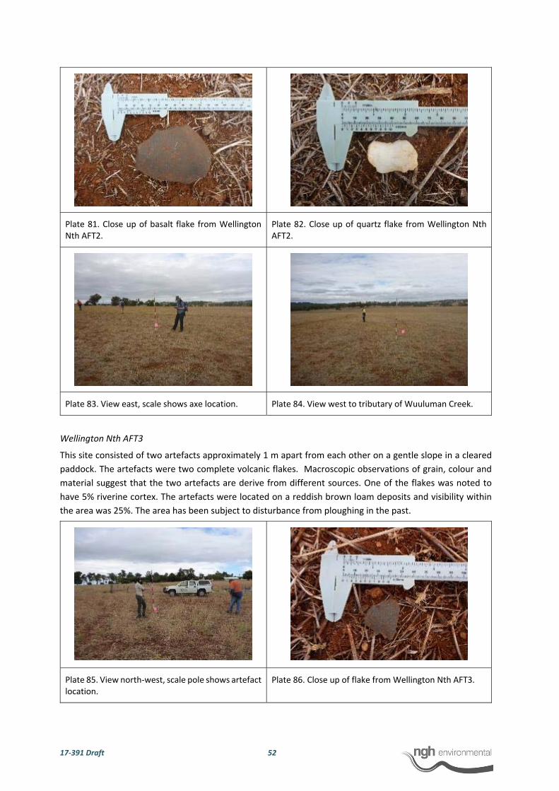
17‐391 Draft 52
Plate 81. Close up of basalt flake from Wellington Nth AFT2.
Plate 82. Close up of quartz flake from Wellington Nth AFT2.
Plate 83. View east, scale shows axe location. Plate 84. View west to tributary of Wuuluman Creek.
Wellington Nth AFT3
This site consisted of two artefacts approximately 1 m apart from each other on a gentle slope in a cleared
paddock. The artefacts were two complete volcanic flakes. Macroscopic observations of grain, colour and
material suggest that the two artefacts are derive from different sources. One of the flakes was noted to
have 5% riverine cortex. The artefacts were located on a reddish brown loam deposits and visibility within
the area was 25%. The area has been subject to disturbance from ploughing in the past.
Plate 85. View north‐west, scale pole shows artefact location.
Plate 86. Close up of flake from Wellington Nth AFT3.

17‐391 Draft 53
Wellington Nth AFT4
The site is a low density artefact scatter measuring 40 m (north/south) by 25 m (east/west). Seven artefacts
were recorded scattered across a raised flat spur adjacent to a low hill with outcropping. The artefacts were
three distal fragments (n=3; 42.8%) and four complete flakes (n=4; 57.2%). The lithologies recorded included
volcanic (n=4; 57.2%), chert (n=2; 28.6%) and quartz (n=1; 14.2%). The artefacts were located along a track
on a reddish brown loam deposit and visibility within the area was 30%. The area has been subject to
disturbance from ploughing in the past.
Plate 87. View north along track. Plate 88. Close up of distal fragment from Wellington Nth AFT4.
Wellington Nth AFT5
The site is a low density artefact scatter with two artefacts located 20 m from each other on a raised flat spur
in a cleared paddock. The artefacts were a volcanic single platform core and an edge grounded axe.
Macroscopic observations of grain, colour and material suggest that the two artefacts are derive from
different parent sources. The core was noted to have 6 negative flake scars and the axe was noted to have
some flaking and edge damage. The artefacts were located on a reddish brown loam deposits and visibility
within the area was 60%. The area has been subject to disturbance from ploughing in the past.
Plate 89. View west, scale pole shows axe location. Plate 90. Close up of edge grounded axe from Wellington Nth AFT5.

17‐391 Draft 54
Wellington Nth AFT6
The site is a low density artefact scatter with three artefacts located 2 m from each other on a low slope in a
cleared paddock. The artefacts were a two chert flakes and quartz flake. Macroscopic observations of grain,
colour and material suggest that the two chert artefacts are derive from different parent sources. The
artefacts were located on a reddish brown loam deposits and visibility within the area was 60%. The area has
been subject to disturbance from ploughing in the past.
Plate 91. View west down slope. Plate 92. Close up of flake Wellington Nth AFT6.
Wellington Nth AFT7
The site is a small low density artefact scatter measuring 50 m (north/south) by 50 m (east/west) with three
artefacts on a low slope in a cleared paddock. The artefacts were a quartz core, a basalt flake and a volcanic
core. The artefacts were located on a reddish brown loam deposits and visibility within the area was 60%.
The area has been subject to disturbance from ploughing in the past.
Plate 93. View west with pole at flake artefact. Plate 94. Close up of flake Wellington Nth AFT7.

17‐391 Draft 55
Wellington Nth AFT8
The site is a small low density artefact scatter with two artefacts approximately 15 m from each other along
a drainage line in a cleared paddock. The artefacts were a quartz and a volcanic flake. The artefacts were
located on a reddish brown loam deposits and visibility within the area was 15%. The area has been subject
to disturbances from ploughing in the past.
Plate 95. View south along drainage line. Plate 96. Close up of flake Wellington Nth AFT8.
Wellington Nth AFT9
The site is a large low density artefact scatter measuring approximately 1,000 m (north/south) by 300 m
(east/west) conforming to the upper section of an unnamed creek and its associated flats. A total of 44
artefacts were recorded, their lithologies are predominately volcanic (n=30; 68.2%) with lesser numbers of
fine‐grained siliceous, quartzite, quartz, basalt and chert artefacts recorded. The typologies recorded
included complete flakes (n=16; 36.4%), cores (n=15; 34.1%), flaked pieces (n=5; 11.4%), hammerstones
(n=3; 6.8 %), axes (n=3; 6.8%) a distal fragment (n=1; 2.3%) and a proximal fragment (n=1; 2.3%). Field
observations suggest that artefacts were from tertiary and secondary stages of reduction with a number of
artefacts (n=14; 31.8%) noted to have riverine cortex. Given that a third of the artefacts had riverine cortex
it is likely that these materials were sourced from the nearby creek. The two axes were also noted to be
ground edge axes while the third was an axe blank.
In summary, the size of the site and number of artefacts indicate that the site was likely occupied on more
than one occasion at low‐moderate intensity. The main activities evident by the assemblage are the
manufacture of artefacts. The artefacts were located on a reddish brown loam deposit on the raised flats in
close proximity to the unnamed creek and visibility within the area ranged from 100% to 15%. The area has
been subject to disturbances from ploughing and farming activities in the past. A well‐used access track also
runs along the western bank of the creek.

17‐391 Draft 56
Plate 97. Close up of edge grounded axe from Wellington Nth AFT9.
Plate 98. Close up of edge grounded axe from Wellington Nth AFT9.
Plate 99. Close up of chert core from Wellington Nth AFT9.
Plate 100. Close up volcanic flake from Wellington Nth AFT9.
Plate 101. Close up of volcanic core from Wellington Nth AFT9.
Plate 102. Close up quartz flake from Wellington Nth AFT9.

17‐391 Draft 57
Plate 103. View north along unnamed creek. Plate 104. View south‐west along flats associated with unnamed creek.
Plate 105. View east from raised flats associated with the creek.
Plate 106. View west from raised flats associated with the creek.
Wellington Nth ST1 (possible modified tree)
This site consists of a single scarred tree considered possible to be Aboriginal in origin within a stand of trees
on the edge of a raised rocky outcropping adjacent to an unnamed creek. The Black Box tree is alive, standing
and in good condition that has a single small scar assessed as possible to be Aboriginal in origin. The large
scar on the tree is noted to be natural and does not conform to the standard scarring morphology accepted
for Aboriginal modification (cf. Long, 2005). However, the smaller scar on the base of the trunk is considered
possible to be Aboriginal in origin. The scar is tear drop in shape and has had significant regrowth with the
original shape of the scar unable to be determined. The scar is north facing and the base of the scar is
approximately 80 cm above the ground. The scar measures 56 cm in length by 39 cm in width and has a depth
of 15 cm. The circumference of the trunk is 3.4m. As the scar was determined to possibly be Aboriginal in
nature, the Aboriginal representatives requested that the tree be avoided by the development.
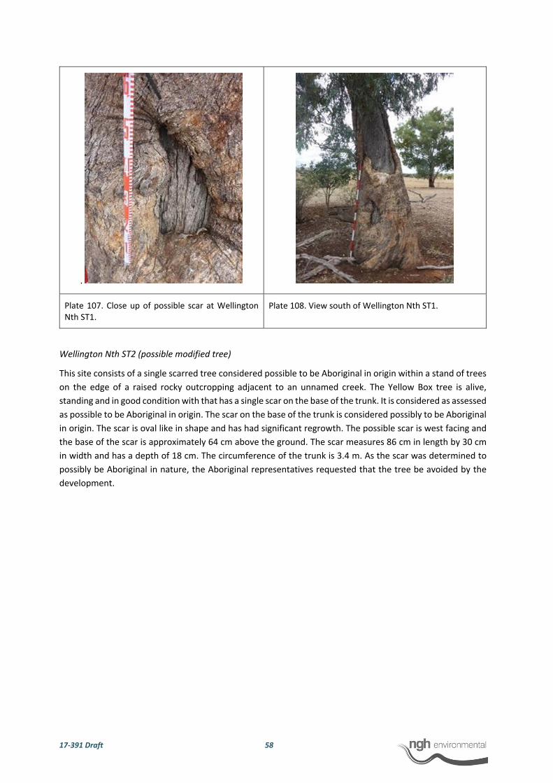
17‐391 Draft 58
.
Plate 107. Close up of possible scar at Wellington Nth ST1.
Plate 108. View south of Wellington Nth ST1.
Wellington Nth ST2 (possible modified tree)
This site consists of a single scarred tree considered possible to be Aboriginal in origin within a stand of trees
on the edge of a raised rocky outcropping adjacent to an unnamed creek. The Yellow Box tree is alive,
standing and in good condition with that has a single scar on the base of the trunk. It is considered as assessed
as possible to be Aboriginal in origin. The scar on the base of the trunk is considered possibly to be Aboriginal
in origin. The scar is oval like in shape and has had significant regrowth. The possible scar is west facing and
the base of the scar is approximately 64 cm above the ground. The scar measures 86 cm in length by 30 cm
in width and has a depth of 18 cm. The circumference of the trunk is 3.4 m. As the scar was determined to
possibly be Aboriginal in nature, the Aboriginal representatives requested that the tree be avoided by the
development.
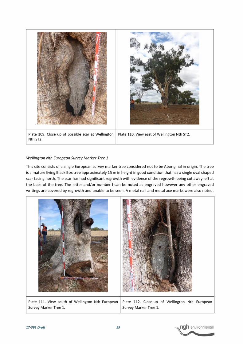
17‐391 Draft 59
.
Plate 109. Close up of possible scar at Wellington Nth ST2.
Plate 110. View east of Wellington Nth ST2.
Wellington Nth European Survey Marker Tree 1
This site consists of a single European survey marker tree considered not to be Aboriginal in origin. The tree
is a mature living Black Box tree approximately 15 m in height in good condition that has a single oval shaped
scar facing north. The scar has had significant regrowth with evidence of the regrowth being cut away left at
the base of the tree. The letter and/or number I can be noted as engraved however any other engraved
writings are covered by regrowth and unable to be seen. A metal nail and metal axe marks were also noted.
Plate 111. View south of Wellington Nth European
Survey Marker Tree 1.
Plate 112. Close‐up of Wellington Nth European
Survey Marker Tree 1.
17‐391 Draft 60
4.3.1 Consideration of potential for subsurface material
Discussions were held in the field with the representatives present to assess the potential for subsurface
deposits across the proposal site. Based on the land use history, an appraisal of the landscape, soil, level of
disturbance and the results from the field survey, it was concluded that there was negligible potential for the
presence of intact subsurface deposits with high densities of objects or cultural material within the proposal
site.
While the site Wellington Nth AFT9 was noted to have higher archaeological sensitivity given that it had a
number of artefacts scattered across the eastern and western bank of an unnamed creek and its associated
flats, the scatter is considered to be low density with an average of 1.2 surface artefacts per hectare.
Additionally, the banks were inspected for any evidence of cultural layers or Aboriginal objects eroding from
the deposit. No evidence for high density intact subsurface deposits was identified during the field inspection
of the banks along the creek. It was therefore determined that while Wellington Nth AFT9 has higher
archaeological sensitivity compared to the remainder of the proposal site there was negligible potential for
intact subsurface deposits with high densities of objects. Subsurface testing was therefore not warranted.

17‐391 Draft 61
Table 6. Artefacts and possible scarred tree characteristics
Artefact #
Site Name Artefact Type Raw Material
Dimensions (mm)
Comments
Length Width Thickness
1 Wellington Nth AFT1 Flake Chert 48 29 8 1 negative scar, tertiary reduction, flake scar platform, broad platform and feather termination
2 Wellington Nth AFT1 Flake Chert 30 15 7 flake scar platform, focal platform, feather termination tertiary reduction
3 Wellington Nth AFT2 Axe Volcanic 55 66 25 ground edge axe 1 negative flake scar on one side, ground surface both sides extending for 61 x 29mm on intact surface
4 Wellington Nth AFT2 Flake Basalt 78 62 20 retouched along distal margin for 58mm, riverine cortex 30%, flake scar platform, broad platform, feather termination secondary reduction
5 Wellington Nth AFT2 Flake Volcanic 43 40 10 flake scar platform, focal platform, feather termination
6 Wellington Nth AFT2 Flake Quartz 40 25 7 flake scar platform, broad platform, feather termination
7 Wellington Nth AFT2 Flaked piece Basalt 63 35 14
8 Wellington Nth AFT2 Flake Quartz 39 24 14 flake scar platform, focal platform, feather termination, tertiary reduction
9 Wellington Nth AFT3 Flake Volcanic 25 33 13 flake scar platform, broad platform, feather termination
10 Wellington Nth AFT3 Flake Volcanic 38 43 8 flake scar platform, broad platform, feather termination
11 Wellington Nth AFT4 Distal fragment Chert 10 10 3 feather termination
12 Wellington Nth AFT4 Flake Quartz 18 10 4 flake scar platform, focal platform, feather termination
13 Wellington Nth AFT4 Distal fragment Volcanic 34 18 6

17‐391 Draft 62
Artefact #
Site Name Artefact Type Raw Material
Dimensions (mm)
Comments
Length Width Thickness
14 Wellington Nth AFT4 Flake Volcanic 22 28 3
15 Wellington Nth AFT4 Distal fragment Volcanic 25 26 8
16 Wellington Nth AFT4 Flake Chert 20 16 6 flake scar platform, focal platform, feather termination, tertiary reduction
17 Wellington Nth AFT4 Flake Volcanic 36 46 12 indeterminate platform, indeterminate platform, feather termination
18 Wellington Nth AFT5 Core Volcanic 41 70 47 single platform 6 negative scars
19 Wellington Nth AFT5 Axe Volcanic 104 56 32 grinding 58 by 28 grounded edge with flaking damage
20 Wellington Nth AFT6 Flake Chert 30 24 8 2 negative flake scars, flake scar platform, broad platform, feather termination
21 Wellington Nth AFT6 Flake Chert 24 33 12 40% riverine, flake scar platform, broad platform, feather termination
22 Wellington Nth AFT6 Flake Quartz 15 10 8 flake scar platform, broad platform, feather termination
23 Wellington Nth AFT7 Core Quartz 40 45 40 milky quartz core 2 negative flake scars some stock damage
24 Wellington Nth AFT7 Core Volcanic 55 50 15
25 Wellington Nth AFT7 Flake Basalt 55 75 15 riverine cortex, flake scar platform, broad platform, hinge termination, tertiary reduction
26 Wellington Nth AFT8 Flake Volcanic 20 36 9 flake scar platform, broad platform, feather termination
27 Wellington Nth AFT8 Core Volcanic 43 48 40
28 Wellington Nth AFT9 Flake Volcanic 38 28 12 1 neg same material as core. flake scar platform, broad platform, feather termination
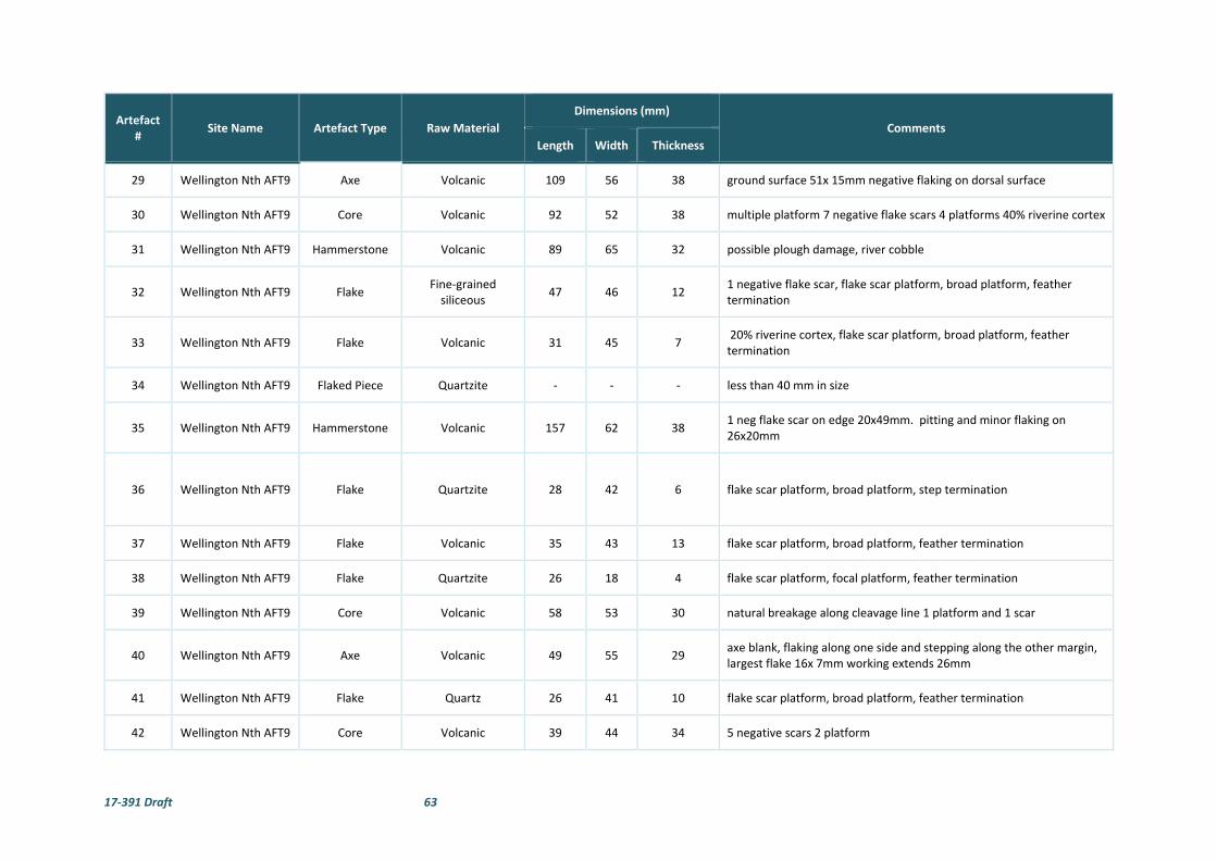
17‐391 Draft 63
Artefact #
Site Name Artefact Type Raw Material
Dimensions (mm)
Comments
Length Width Thickness
29 Wellington Nth AFT9 Axe Volcanic 109 56 38 ground surface 51x 15mm negative flaking on dorsal surface
30 Wellington Nth AFT9 Core Volcanic 92 52 38 multiple platform 7 negative flake scars 4 platforms 40% riverine cortex
31 Wellington Nth AFT9 Hammerstone Volcanic 89 65 32 possible plough damage, river cobble
32 Wellington Nth AFT9 Flake Fine‐grained siliceous
47 46 12 1 negative flake scar, flake scar platform, broad platform, feather termination
33 Wellington Nth AFT9 Flake Volcanic 31 45 7 20% riverine cortex, flake scar platform, broad platform, feather termination
34 Wellington Nth AFT9 Flaked Piece Quartzite ‐ ‐ ‐ less than 40 mm in size
35 Wellington Nth AFT9 Hammerstone Volcanic 157 62 38 1 neg flake scar on edge 20x49mm. pitting and minor flaking on 26x20mm
36 Wellington Nth AFT9 Flake Quartzite 28 42 6 flake scar platform, broad platform, step termination
37 Wellington Nth AFT9 Flake Volcanic 35 43 13 flake scar platform, broad platform, feather termination
38 Wellington Nth AFT9 Flake Quartzite 26 18 4 flake scar platform, focal platform, feather termination
39 Wellington Nth AFT9 Core Volcanic 58 53 30 natural breakage along cleavage line 1 platform and 1 scar
40 Wellington Nth AFT9 Axe Volcanic 49 55 29 axe blank, flaking along one side and stepping along the other margin, largest flake 16x 7mm working extends 26mm
41 Wellington Nth AFT9 Flake Quartz 26 41 10 flake scar platform, broad platform, feather termination
42 Wellington Nth AFT9 Core Volcanic 39 44 34 5 negative scars 2 platform

17‐391 Draft 64
Artefact #
Site Name Artefact Type Raw Material
Dimensions (mm)
Comments
Length Width Thickness
43 Wellington Nth AFT9 Distal Fragment Volcanic ‐ ‐ ‐ feather termination, less than 40 mm in size
44 Wellington Nth AFT9 Flaked Piece Quartz ‐ ‐ ‐ less than 30 mm in size
45 Wellington Nth AFT9 Flake Volcanic 40 34 9 some damage along distal margin. flake scar platform, focal platform, feather termination
46 Wellington Nth AFT9 Hammerstone Volcanic ‐ ‐ ‐ Less than 80 mm in size
47 Wellington Nth AFT9 Core Volcanic 80 50 24 single platform 3 negative flake scars, over hang removal for 82mm, 30% riverine cortex
48 Wellington Nth AFT9 Core Volcanic 86 80 21 20% riverine cortex 55mm of OHR, 3 platforms 3 negative scars
49 Wellington Nth AFT9 Flake Volcanic 41 48 13 stock damage, flake scar platform, broad platform, feather termination
50 Wellington Nth AFT9 Core Chert 65 30 55 terrestrial cortex 10‐20% 1 complete s scar some heat damage 20%
51 Wellington Nth AFT9 Axe Volcanic 124 71 28 some working on distal edge grounded width 12mm by 40mm long and 13mm from top edge
52 Wellington Nth AFT9 Flake Volcanic 51 56 16 plough damage, cortex platform, broad platform, feather termination
53 Wellington Nth AFT9 Flake Chert 27 24 6 5% riverine cortex, flake scar platform, broad platform, feather termination
54 Wellington Nth AFT9 Core Fine‐grained siliceous
25 45 43 1 platform, 4 negative scars, 20% heat pop, flake core
55 Wellington Nth AFT9 Core Volcanic 35 82 61 1 platform, 4 scars, 40% riverine cortex, flake core
56 Wellington Nth AFT9 Flake Chert 26 30 10 1 negative flake scar, flake scar platform, broad platform, feather termination

17‐391 Draft 65
Artefact #
Site Name Artefact Type Raw Material
Dimensions (mm)
Comments
Length Width Thickness
57 Wellington Nth AFT9 Flaked Piece Quartzite 26 30 9
58 Wellington Nth AFT9 Flaked Piece Volcanic 14 35 25
59 Wellington Nth AFT9 Proximal Fragment
Volcanic 24 26 9 20% riverine cortex, flake scar platform, broad platform
60 Wellington Nth AFT9 Flaked Piece Volcanic 20 32 6 10% riverine cortex
61 Wellington Nth AFT9 Flake Volcanic 28 36 7 flake scar platform, broad platform, feather termination
62 Wellington Nth AFT9 Core Volcanic 50 97 51 1 platform, 5 negative scars, 40% riverine cortex
63 Wellington Nth AFT9 Core Volcanic 69 168 36 1 platform 1 complete scar 50%pebble cortex
64 Wellington Nth AFT9 Flake Volcanic 44 64 10 flake scar platform, broad platform, feather termination, tertiary reduction
65 Wellington Nth AFT9 Core Basalt 32 40 30 multiple platform core 3 platforms
66 Wellington Nth AFT9 Flake Basalt 44 34 13 flake scar platform, broad platform, feather termination, tertiary reduction
67 Wellington Nth AFT9 Core Volcanic 30 50 50 single platform core some stock damage
68 Wellington Nth AFT9 Flake Quartz 22 20 8 flake scar platform, broad platform, feather termination, tertiary reduction
69 Wellington Nth AFT9 Flake Quartz 11 13 4 flake scar platform, indeterminate platform, feather termination
70 Wellington Nth AFT9 Core Volcanic 70 84 38 multiple platform core some plough and stock damage 10 percent riverine cortex

17‐391 Draft 66
Artefact #
Site Name Artefact Type Raw Material
Dimensions (mm)
Comments
Length Width Thickness
71 Wellington Nth AFT9 Core Volcanic 23 64 57 single platform core
72 Wellington Nth IF1 Core Volcanic 85 72 25 40% riverine cortex 1 negative flake scar from one platform.
73 Wellington Nth IF2 Flake Volcanic 43 43 13 flake scar platform, broad platform, feather termination
74 Wellington Nth IF3 Core Volcanic 66 87 38 riverine cortex 50 percent, single platform core
75 Wellington Nth IF4 Flake Quartz 22 20 6
76 Wellington Nth IF5 Core Quartz 26 37 40 single platform core, 3 negative flake scars, 25% pebble cortex
77 Wellington Nth IF6 Flaked Piece Quartz ‐ ‐ ‐ Less than 30mm in size
78 Wellington Nth IF7 Flake Quartz 25 18 7 flake scar platform, broad platform, feather termination
79 Wellington Nth IF8 Flake Volcanic 31 20 4 flake scar platform, broad platform, feather termination, tertiary reduction
80 Wellington Nth IF9 Core Fine‐grained siliceous
45 46 52 multiple platform core
81 Wellington Nth IF10 Flake Basalt 35 50 14 some stock damage 20 percent riverine cortex, flake scar platform, broad platform, feather termination, tertiary reduction
82 Wellington Nth IF11 Flake Quartz 21 25 9 flake scar platform, broad platform, feather termination, tertiary reduction
83 Wellington Nth IF12 Flake Volcanic 30 43 12 flake scar platform, broad platform, feather termination
84 Wellington Nth IF13 Flake Volcanic 46 32 8 riverine cortex flake scar platform, broad platform, feather termination, primary reduction

17‐391 Draft 67
Artefact #
Site Name Artefact Type Raw Material
Dimensions (mm)
Comments
Length Width Thickness
85 Wellington Nth IF14 Core Volcanic 52 26 19 single platform 2 scars, 25 percent riverine cortex, river pebble
86 Wellington Nth IF15 Flake Quartzite 52 52 15 flake scar platform, broad platform, feather termination, secondary termination
87 Wellington Nth IF16 Flake Quartzite 35 35 8 20 percent riverine cortex flake scar platform, broad platform, feather termination, secondary reduction
88 Wellington Nth IF17 RUP Glass 35 25 13 glass bottle bottom with retouch along top margin multi direction.
89 Wellington Nth IF18 Core Volcanic 110 63 38 80% riverine cortex, single platform with 3 complete negative scars, core preparation
90 Wellington Nth IF19 Proximal Fragment
Quartz 26 34 10 flake scar platform, broad platform
91 Wellington Nth IF20 Distal Fragment Chert 26 13 5 50% terrestrial cortex
92 Wellington Nth IF21 Retouched flake Fine‐grained siliceous
46 43 26 ohr retouch for 63mm, some fresh breakage, flake scar platform, broad platform
93 Wellington Nth IF22 Flake core Chert 43 50 55 flake core
94 Wellington Nth IF23 Flake Volcanic 26 24 5 20 percent riverine cortex, flake scar platform, broad platform, feather termination, secondary reduction
95 Wellington Nth IF24 Core Fine‐grained siliceous
10 50 30 single platform core some stock damage
96 Wellington Nth IF25 Flake Quartz 32 18 5 flake scar platform, focal platform, feather termination, tertiary reduction

17‐391 Draft 68
Artefact #
Site Name Artefact Type Raw Material
Dimensions (mm)
Comments
Length Width Thickness
97 Wellington Nth IF26 Core Fine‐grained siliceous
43 45 25 multiple platform 5 negative scars
98 Wellington Nth IF27 Flaked piece Quartz 12 14 4
99 Wellington Nth IF28 Core Quartz 48 49 40 1 negative flake scar 1 platform cortex 50% river cobble
100 Wellington Nth ST1 Possible Scarred
tree Eucalyptus 56 39 15
circumference of trunk 3.4 m, regrowth for 15 cm into scar, natural scar above with nail in tree, north facing scar, approx. 80 cm above ground surface, tree height 15 m, scar is tear drop in shape and has had significant regrowth with the original shape of the scar unable to be determined.
101 Wellington Nth ST2 Possible Scarred
tree Eucalyptus 89 30 18
Circumference of truck 3.4 m, in stand of trees yellow box, 50 m from creek, tree height 15 m, natural growths above scar, scar is oval like in shape and has had significant regrowth, west facing, base of the scar is approximately 64 cm above the ground.
102 Wellington Nth European Survey Marker Tree 1
European Survey marker
tree Eucalyptus 55 25 15
43 cm by 76 cm portion cut on ground is regrowth cut off to expose scar, grey box tree, significant regrowth over scar and possible lettering, surveying tree with letter 1 engraved, unable to read/ see other writings but likely covered by regrowth, new branches beginning to grow out of scar. Not Aboriginal in origin, metal axe marks also noted.

17‐391 Draft 69
Figure 11. Overview of recorded sites.
Wellington Nth AFT6
Wellington Nth ST1
Wellington Nth European Survey Tree Marker 1
Wellington Nth ST2
Wellington Nth IF9Wellington Nth IF3
Wellington Nth IF4
Wellington Nth IF2
Wellington Nth IF1
Wellington Nth IF6
Wellington Nth IF7
Wellington Nth IF5
Wellington Nth IF10
Wellington Nth IF11
Wellington Nth IF25
Wellington Nth IF27
Wellington Nth IF24
Wellington Nth IF23Wellington Nth IF22
Wellington Nth IF16
Wellington Nth IF15
Wellington Nth IF14
Wellington Nth IF13
Wellington Nth IF12
Wellington Nth IF19
Wellington Nth IF20
Wellington Nth IF18
Wellington Nth IF26
Wellington Nth IF28
Wellington Nth IF21
Wellington Nth IF17
Wellington Nth AFT9
Wellington Nth AFT2
Wellington Nth AFT7
Wellington Nth AFT4
Wellington Nth AFT1
Wellington Nth AFT3
Wellington Nth AFT8
Wellington Nth AFT5
GO
OLM
AR
O AD
CO
BB
ORA
ROA
D
CAMPBELLS LANE
MITC
HELL HIG
HW
AY
TWELVE MILE ROADBELA VISTA LANE
BLACKS LANE
CADIA PLACE
WUULUMAN
CREEK
681000 682000 683000 684000 685000 686000 687000
990
0064
000
00640
1000
64020
0064
030
00640
4000
0 500 1,000250 m
www.nghenvironmen tal.com.au
Ref: SW143 Wellington North SF ArchAuthor: SP
Notes:- Data co llected by nghenvironmental (2017)- Client data courtesy of Client, rece ived 2018- Base map Copyright © Esri and its data suppliers. - GDA94 zone 55
European survey marker tree
Isolated find
Possible scarred tree
AHIMS listed sites
Artefact scatter
Existing substation
Local road
Highway
Proposal boundary
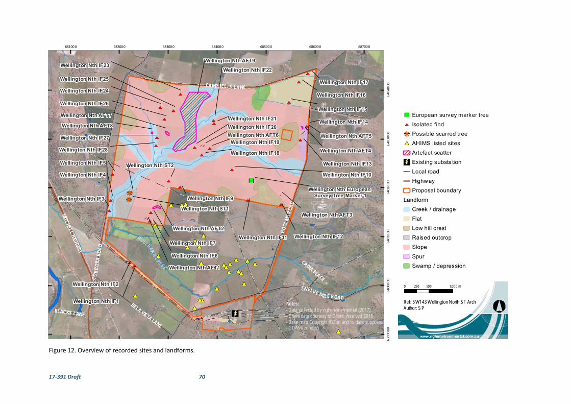
17‐391 Draft 70
Figure 12. Overview of recorded sites and landforms.
Wellington Nth AFT6
Wellington Nth ST1
Wellington Nth European Survey Tree Marker 1
Wellington Nth ST2
Wellington Nth IF9Wellington Nth IF3
Wellington Nth IF4
Wellington Nth IF2
Wellington Nth IF1
Wellington Nth IF6
Wellington Nth IF7
Wellington Nth IF5
Wellington Nth IF10
Wellington Nth IF11
Wellington Nth IF25
Wellington Nth IF27
Wellington Nth IF24
Wellington Nth IF23Wellington Nth IF22
Wellington Nth IF16
Wellington Nth IF15
Wellington Nth IF14
Wellington Nth IF13
Wellington Nth IF12
Wellington Nth IF19
Wellington Nth IF20
Wellington Nth IF18
Wellington Nth IF26
Wellington Nth IF28
Wellington Nth IF21
Wellington Nth IF17
Wellington Nth AFT9
Wellington Nth AFT2
Wellington Nth AFT7
Wellington Nth AFT4
Wellington Nth AFT1
Wellington Nth AFT3
Wellington Nth AFT8
Wellington Nth AFT5
GO
OLM
AR
O AD
CO
BB
ORA
ROA
D
CAMPBELLS LANE
MITC
HELL HIG
HW
AY
TWELVE MILE ROADBELA VISTA LANE
BLACKS LANE
CADIA PLACE
WUULUMAN
CREEK
681000 682000 683000 684000 685000 686000 687000
6399
000
6400
000
64010
00640
2000
640
3000
6404
000
0 500 1,000250 m
www.nghenvironmental.com.au
Ref: SW143 Wellington North SF ArchAuthor: SP
Notes:- Data collected by nghenvironmental (2017)- Client data courtesy of Client, rece ived 2018- Base map Copyright © Esri and its data suppliers. - GDA94 zone 55
European survey marker tree
Isolated find
Possible scarred tree
AHIMS listed sites
Artefact scatter
Existing substation
Local road
Highway
Proposal boundary
Landform
Creek / drainage
Flat
Low hill crest
Raised outcrop
Slope
Spur
Swamp / depression

17‐391 Draft 71
4.4 DISCUSSION
The results of previous archaeological surveys in the Wellington region show that there are sites and
artefacts present across the landscape. The predictions based on the modelling for the proposal site were
that stone artefacts and scarred trees were the most likely manifestation of Aboriginal occupation of the
area. It was noted that while Aboriginal sites may be expected throughout all landscapes the most
archaeologically sensitive areas occur in proximity to water. The survey results have confirmed this
prediction with stone artefacts recorded as isolated finds and artefact scatters across the proposal site,
even in areas highly disturbed by farming activities. The sites were identified across a range of landforms
including slopes, flats, spurs, low hill crests and along creeks/drainage lines and their associated flats.
Given the level of clearing within the proposal site the presence of only two possible scarred trees is not
surprising with few mature native trees remaining within the assessment area. Scarred trees provide a
tangible link to the past and provide evidence of Aboriginal subsistence activities through the deliberate
removal of bark or wood. It is likely that the high number of scarred trees as a site type in the area (n=22;
20.9%) is related to their more obtrusive nature.
Over half of the artefacts recorded (n=51; 51.5%) during the survey were located along creeks/drainage
lines and their associated flats within 46 artefacts recorded in close proximity to a creek. The concentration
of artefacts (n=44) in northern portion of the tributary of Wuuluman Creek and its associated flats within
site Wellington Nth AFT 9 indicate that the area was likely occupied on more than one occasion at low
intensity. Three of the five axes recorded within the proposal site were located within this site including
two ground edge axes and an axe blank. The three hammerstones recorded within the proposal site are
also all located within this site which is located on the raised flats either side of a creek. The area for
Wellington Nth AFT 9 was noted to be on more elevated flat ground which surrounded the unnamed creek
compared to the lower flats surrounding the creek line to the south.
The presence of stone artefacts in low densities across the remainder of the proposal site is likely to
represent the opportunistic use and movement of people through the landscape. The area was likely used
intermittently over a period of time for camping, hunting and gathering resources. Based on this
assumption, there is every chance that there are similar stone artefacts across similar landscapes in the
Wellington area.
The two axes recorded away from the creek were located on a raised flat spur and a low hill crest. It should
be noted that the ground edge axe in Wellington Nth AFT2 is approximately 300 m west of the site
Wellington Solar Farm AS1 recoded during survey for the adjacent First Solar Wellington Solar Farm project.
The artefacts recorded were manufactured primarily from volcanic material (n=51; 51.5%) and quartz
(n=18; 18.1%) that is common for the area. A lesser number of chert (n=11; 11.1%), basalt (n=6; 6.1%), fine‐
grained siliceous (n=6; 6.1%), quartzite (n=6; 6.1%) and glass (n=1; 1.0%) artefacts were also recorded
suggesting these materials may have been brought into the area. The presence of flakes, cores,
hammerstones and an axe blank indicates that tool manufacture likely occurred onsite, although the
presence of four edge ground axes may imply some completed tools were also brought to the site. The
high number of cores (n=28; 28.2%) may be representative of the high discard rate of raw material in the
area. A number of the cores were noted to be pebbles which suggests the opportune selection of materials
that were possibly sourced from a local creeks given that pebbles were noted on the creek bed and eroding
from sections of the creek bank within the proposal site.
It was noted by the Aboriginal representatives that the onsite outcropping material was of poor quality and
that it would not have been suitable for artefact manufacture. No evidence of quarrying from the outcrops
was identified.

17‐391 Draft 72
The use of a volcanic material for the manufacture of the edge‐grounded axes is common for the region
however it should be noted that two grinding grooves have been recorded to date within the AHIMS search
area. The recorded grinding groove sites are respectively recorded 13 km south‐west and 17 km south‐east
of the proposal site. This suggests that edge‐grounded axes in the Wellington area may have been shaped
and sharpened within the general area and used locally.
It should also be noted that the results of this investigation have increased the number of sites recorded in
the local area by 25.9% from 106 to 143. The dominance of artefacts as a common site type within the area
is further supported by the results of this survey. The implications for this relate to significance assessments
and the related appraisal of site representativeness. We would argue that there are likely to be many
hundreds of such sites in the local area, and that the relatively low number of sites recorded in AHIMS is
merely an indication that few surveys have been undertaken in the area and therefore they are yet to be
found.
In terms of the current proposal therefore, extrapolating from the results of this survey, it is possible that
additional stone artefacts could occur within the proposed development footprint. However, consideration
must also be given to the level of disturbance of any such sites. Based on the land use history of the
proposal site, and an appraisal of the results from the field survey, there is negligible potential for the
presence of intact subsurface deposits with high densities of objects or cultural material within Wellington
North Solar Plant proposal site.
5 CULTURAL HERITAGE VALUES AND STATEMENT
OF SIGNIFICANCE
The assessment of the significance of Aboriginal archaeological sites is currently undertaken largely with
reference to criteria outlined in the ICOMOS Burra Charter (Marquis‐Kyle and Walker 1994). Criteria used
for assessment are:
Social or Cultural Value: In the context of an Aboriginal heritage assessment, this value
refers to the significance placed on a site or place by the local Aboriginal community – either
in a contemporary or traditional setting.
Scientific Value: Scientific value is the term employed to describe the potential of a site or
place to answer research questions. In making an assessment of Scientific Value issues such
as representativeness, rarity and integrity are addressed. All archaeological places possess
a degree of scientific value in that they contribute to understanding the distribution of
evidence of past activities of people in the landscape. In the case of flaked stone artefact
scatters, larger sites or those with more complex assemblages are more likely to be able to
address questions about past economy and technology, giving them greater significance
than smaller, less complex sites. Sites with stratified and potentially in situ sub‐surface
deposits, such as those found within rock shelters or depositional open environments, could
address questions about the sequence and timing of past Aboriginal activity, and will be
more significant than disturbed or deflated sites. Groups or complexes of sites that can be
related to each other spatially or through time are generally of higher value than single sites.
Aesthetic Value: Aesthetic values include those related to sensory perception and are not
commonly identified as a principal value contributing to management priorities for
Aboriginal archaeological sites, except for art sites.
17‐391 Draft 73
Historic Value: Historic value refers to a site or place’s ability to contribute information on
an important historic event, phase or person.
Other Values: The Burra Charter makes allowance for the incorporation of other values into
an assessment where such values are not covered by those listed above. Such values might
include Educational Value.
All sites or places have some degree of value, but of course, some have more than others. In addition,
where a site is deemed to be significant, it may be so on different levels or contexts ranging from local to
regional to national, or in very rare cases, international. Further, sites may either be assessed individually,
or where they occur in association with other sites the value of the complex as a whole should be
considered.
Social or cultural value
While the true cultural and social value of Aboriginal sites can only be determined by local Aboriginal
people, as a general concept, all sites hold cultural value to the local Aboriginal community. An opportunity
to identify cultural and social value was provided to the Aboriginal representatives for this proposal
through the fieldwork and draft reporting process.
Feedback about the cultural value of the sites from the Aboriginal representatives during the field survey
indicated that all sites hold cultural value to the local Aboriginal community. It was clear from the
conversations held in the field that the community view the stone artefacts as important and would like to
see them collected before any damage or development occurs. It was noted during the conversations that
there was importance placed on collecting the artefacts and placing them in a safe location to avoid future
disturbance.
The cultural significance of the sites is only determined by the local Aboriginal community.
Scientific (archaeological) value
The research potential of the sites located during this assessment is considered to be low to moderate.
While the presence of the sites can be used to assist in the development of site modelling for the local
landscape, their scientific value for further research is limited.
While the artefacts identified themselves are intrinsically interesting in terms of their base technical
information their current lack of temporal context and the absence of information about local resources
makes further conclusions about land use difficult. Their scientific value for further research is also limited
due to the sparse distribution of the artefacts, disturbed nature of the landscape and the subsequent
movement of objects by clearing and ploughing activities. The stone axes are considered of higher value
due their relative rarity compared to common flaking material of cores and flakes. Axes are an indicator of
a different tool use and activity, being mostly for the removal of wood from trees that could have been
used for a variety of purposes such as carrying dishes, shields, spears and shelter as well as extraction of
food such as possums and honey from tree hollows. The presence of five axes, including edge‐ground axes,
within the proposal site would indicate that woodworking activities occurred in the area. Glass artefacts
are also considered of higher value due to their rarity in the region. The presence of a single glass artefact
is likely to be representative of the European contact period of occupation, an important aspect of the
Aboriginal history of the area.
The two possible scarred trees most likely represent the opportunistic use of the landscape but any further
observations are restricted especially given that the scars on the two trees were unable to be unequivocally
determined to be Aboriginal in origin. The fact that the surrounding landscape has been cleared and
modified means that as a representative example of this site type they have high value. While scarred trees

17‐391 Draft 74
are a common site type in the district they are relativity rare within a 5 km buffer of the proposal site. The
fact that survival of scarred trees is subject to natural factors such as death and decay and bushfires, as
well as man‐made threats such as land clearing, their long‐term survival prospects are diminished. This
leads to the conclusion that the remaining possible scarred trees in the landscape have high value as
examples of an ever‐reducing Aboriginal cultural feature. The trees therefore are assessed overall as having
high conservation value even though they were unable to be unequivocally determined to be Aboriginal in
origin.
The only other potential area of research would be to analyse the edge‐ground axes identified within the
proposed area to see if there are any residues present that could indicate what materials were ground or
cut. However, this is likely to be difficult as the items would have been moved around by pastoral and
agricultural activity and may have been compromised through contact with cereal crops and livestock.
Aesthetic value
There are no aesthetic values associated with the archaeological sites per se, apart from the presence of
Aboriginal artefacts and a modified tree in the landscape. The modified and heavily disturbed landscape
within the solar plant development footprint however detracts from this aesthetic setting.
Other values
There are no other known heritage values associated with the proposal site. The area may have some
educational value (not related to archaeological research) through educational material provided to the
public about the Aboriginal occupation and use of the area, although the archaeological material is within
private property and there is little for the public to see.
6 PROPOSED ACTIVITY
6.1 HISTORY AND LANDUSE
It has been noted above in Section 3.1.3 that historically the solar plant proposal site has been impacted
through land use practices specifically clearing, ploughing and grazing. It has also been impacted through
the construction of the Soil Conservation Service Centre and a residential house. The implications for these
activities is that the archaeological record has been compromised in terms of the potential for scarred trees
to remain. The implication for stone artefacts is that they may have been damaged or moved but they are
likely to be present and remain in the general area where they were discarded by Aboriginal people.
Despite these impacts, 99 Aboriginal artefacts and two possible scarred trees remain in the area, indicating
the presence of past Aboriginal people and providing indications of their use of this landscape.
6.2 PROPOSED DEVELOPMENT ACTIVITY
As noted above in section 1.2, the proposal involves the construction of a solar plant and includes
connection to the nearby substation via an overhead or underground electricity transmission lines. The
development will result in the disturbance of up to 837 ha.
Disturbances will largely be in the preparation of the ground for the solar plant. Piles would be driven or
screwed into the ground to support the solar array’s mounting system, which limits the potential overall
level of ground disturbance.

17‐391 Draft 75
PV modules would be installed on single axis tracking or fixed mounting structures across the site. Some
ancillary facilities would also be required including parking facilities, staff amenities and offices. Trenches
would be dug for the installation of a series of underground cables linking the arrays across the proposal
site. Some internal access tracks would also be required. A perimeter fence and a vegetation buffer would
also be constructed around the solar plant. An overhead or underground power line would be installed to
connect the solar plant to the existing substation. During the construction period some additional
temporary facilities may be constructed and a laydown area used.
The construction phase of the proposal would take approximately 18 – 24 months in total with a shorter
peak construction period of approximately 9 months, during which time the main construction works
would take place.
The Wellington North Solar Plant would be expected to operate for approximately 30 years. After this initial
operating period, the solar plant would either be decommissioned, removing all above ground
infrastructure and returning the site to its existing land capability, or repowered with new PV equipment
to continue operations as a solar plant.
The development activity will therefore involve disturbance of the ground during the construction of the
solar plant and transmission line to the existing substation. Once established however, there would be
minimal ongoing disturbance of the ground surface. The final details and timing of the proposed
construction activity have yet to be finalised but it is anticipated that construction could commence in
2019.
6.3 ASSESSMENT OF HARM
As described in this report, 37 archaeological sites, two possible scarred trees and a European survey
marker tree were located within the proposal site. The following table provides a summary of the degree
of harm and the consequence of that harm upon the heritage value of each site resulting from the proposed
works for the solar plant and the western transmission line to the substation. Figure 13 also shows the
location of the sites and the proposed development footprint.
There is Aboriginal archaeological material present within the solar plant area and the assessment is that
there are likely to be other artefacts and cultural material present as well, although in similar low densities
across the majority of the proposal site. The proposed level of disturbance for the construction of the solar
plant could impact the stone artefacts recorded during the field survey and others that may be present
within other areas of the development site.
The impact is likely to be most extensive where earthworks occur such as the installation of cabling and
the transmission line poles, which may involve the removal, breakage or displacement of artefacts and
cultural material. This is considered a direct impact on the sites and the Aboriginal objects by the
development in its present form.
The proposed construction methodology for the proposal will however result in only small areas of
disturbance. The construction of access and maintenance tracks may involve some grading but given a
number of these tracks already exist these works are likely to be minimal. The installation of the solar arrays
involves drilling or screwing the piles into the ground and no widespread ground disturbance work such as
grading or excavation is required to accomplish this. The assessment of harm overall for the proposal is
therefore assessed as low.

17‐391 Draft 76
Table 7 Identified risk to known sites
AHIMS Site name Site integrity Scientific significance
Type of harm Degree of harm
Consequence of harm
Recommendation
36‐4‐0173 Wellington Nth AFT1 Poor – 100+ year
history of agricultural
and pastoral use
Low Direct Total Total loss of
value
Salvage objects prior to
development of proposal site.
36‐4‐0174 Wellington Nth AFT2 Poor – 100+ year
history of agricultural
and pastoral use
Low to
moderate
Direct Total Total loss of
value
Salvage objects prior to
development of proposal site
36‐4‐0175 Wellington Nth AFT3 Poor – 100+ year
history of agricultural
and pastoral use
Low Direct Total Total loss of
value
Salvage objects prior to
development of proposal site.
36‐1‐0735 Wellington Nth AFT4 Poor – 100+ year
history of agricultural
and pastoral use
Low Direct Total Total loss of
value
Salvage objects prior to
development of proposal site.
36‐1‐0736 Wellington Nth AFT5 Poor – 100+ year
history of agricultural
and pastoral use
Low to
moderate
Direct Total Total loss of
value
Salvage objects prior to
development of proposal site.
36‐1‐0737 Wellington Nth AFT6 Poor – 100+ year
history of agricultural
and pastoral use
Low Direct Total Total loss of
value
Salvage objects prior to
development of proposal site.
36‐1‐0738 Wellington Nth AFT7 Poor – 100+ year
history of agricultural
and pastoral use
Low Direct Total Total loss of
value
Salvage objects prior to
development of proposal site.
36‐1‐0739 Wellington Nth AFT8 Poor – 100+ year
history of agricultural
and pastoral use
Low Direct Total Total loss of
value
Salvage objects prior to
development of proposal site.
36‐1‐0740 Wellington Nth AFT9 Poor – 100+ year
history of agricultural
and pastoral use
Moderate Direct Partial Partial loss of
value
Salvage objects within
development footprint prior to
development of proposal site.
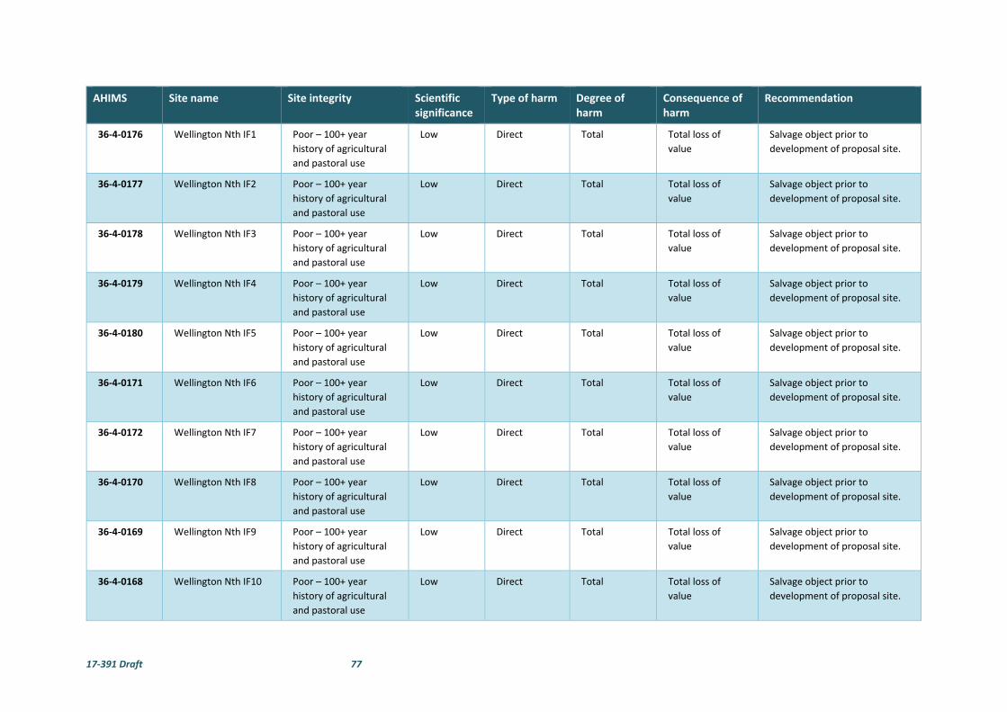
17‐391 Draft 77
AHIMS Site name Site integrity Scientific significance
Type of harm Degree of harm
Consequence of harm
Recommendation
36‐4‐0176 Wellington Nth IF1 Poor – 100+ year
history of agricultural
and pastoral use
Low Direct Total Total loss of
value
Salvage object prior to
development of proposal site.
36‐4‐0177 Wellington Nth IF2 Poor – 100+ year
history of agricultural
and pastoral use
Low Direct Total Total loss of
value
Salvage object prior to
development of proposal site.
36‐4‐0178 Wellington Nth IF3 Poor – 100+ year
history of agricultural
and pastoral use
Low Direct Total Total loss of
value
Salvage object prior to
development of proposal site.
36‐4‐0179 Wellington Nth IF4 Poor – 100+ year
history of agricultural
and pastoral use
Low Direct Total Total loss of
value
Salvage object prior to
development of proposal site.
36‐4‐0180 Wellington Nth IF5 Poor – 100+ year
history of agricultural
and pastoral use
Low Direct Total Total loss of
value
Salvage object prior to
development of proposal site.
36‐4‐0171 Wellington Nth IF6 Poor – 100+ year
history of agricultural
and pastoral use
Low Direct Total Total loss of
value
Salvage object prior to
development of proposal site.
36‐4‐0172 Wellington Nth IF7 Poor – 100+ year
history of agricultural
and pastoral use
Low Direct Total Total loss of
value
Salvage object prior to
development of proposal site.
36‐4‐0170 Wellington Nth IF8 Poor – 100+ year
history of agricultural
and pastoral use
Low Direct Total Total loss of
value
Salvage object prior to
development of proposal site.
36‐4‐0169 Wellington Nth IF9 Poor – 100+ year
history of agricultural
and pastoral use
Low Direct Total Total loss of
value
Salvage object prior to
development of proposal site.
36‐4‐0168 Wellington Nth IF10 Poor – 100+ year
history of agricultural
and pastoral use
Low Direct Total Total loss of
value
Salvage object prior to
development of proposal site.

17‐391 Draft 78
AHIMS Site name Site integrity Scientific significance
Type of harm Degree of harm
Consequence of harm
Recommendation
36‐4‐0167 Wellington Nth IF11 Poor – 100+ year
history of agricultural
and pastoral use
Low Will not be
harmed ‐
outside
development
footprint
None‐ outside
development
footprint
No loss of value‐
outside
development
footprint
Outside of development
footprint. Ensure minimum 5 m
buffer to avoid inadvertent
disturbance or impacts to site.
36‐4‐0166 Wellington Nth IF12 Poor – 100+ year
history of agricultural
and pastoral use
Low Direct Total Total loss of
value
Salvage object prior to
development of proposal site.
36‐1‐0733 Wellington Nth IF13 Poor – 100+ year
history of agricultural
and pastoral use
Low Will not be
harmed ‐
outside
development
footprint
None‐ outside
development
footprint
No loss of value‐
outside
development
footprint
Outside of development
footprint. Ensure minimum 5 m
buffer to avoid inadvertent
disturbance or impacts to site.
36‐1‐734 Wellington Nth IF14 Poor – 100+ year
history of agricultural
and pastoral use
Low Direct Total Total loss of
value
Salvage object prior to
development of proposal site.
36‐1‐0732 Wellington Nth IF15 Poor – 100+ year
history of agricultural
and pastoral use
Low Direct Total Total loss of
value
Salvage object prior to
development of proposal site.
36‐1‐0731 Wellington Nth IF16 Poor – 100+ year
history of agricultural
and pastoral use
Low Direct Total Total loss of
value
Salvage object prior to
development of proposal site.
36‐1‐0730 Wellington Nth IF17 Poor – 100+ year
history of agricultural
and pastoral use
Low to
moderate
Will not be
harmed ‐
outside
development
footprint
None‐ outside
development
footprint
No loss of value‐
outside
development
footprint
Outside of development
footprint. Ensure minimum 5 m
buffer to avoid inadvertent
disturbance or impacts to site.
36‐1‐0729 Wellington Nth IF18 Poor – 100+ year
history of agricultural
and pastoral use
Low Direct Total Total loss of
value
Salvage object prior to
development of proposal site.

17‐391 Draft 79
AHIMS Site name Site integrity Scientific significance
Type of harm Degree of harm
Consequence of harm
Recommendation
agricultural and
pastoral use
36‐1‐0728 Wellington Nth IF19 Poor – 100+ year
history of agricultural
and pastoral use
Low Direct Total Total loss of
value
Salvage object prior to
development of proposal site.
36‐1‐0727 Wellington Nth IF20 Poor – 100+ year
history of agricultural
and pastoral use
Low Direct Total Total loss of
value
Salvage object prior to
development of proposal site.
36‐1‐0726 Wellington Nth IF21 Poor – 100+ year
history of agricultural
and pastoral use
Low Direct Total Total loss of
value
Salvage object prior to
development of proposal site.
36‐1‐0725 Wellington Nth IF22 Poor – 100+ year
history of agricultural
and pastoral use
Low Direct Total Total loss of
value
Salvage object prior to
development of proposal site.
36‐1‐0724 Wellington Nth IF23 Poor – 100+ year
history of agricultural
and pastoral use
Low Direct Total Total loss of
value
Salvage object prior to
development of proposal site.
36‐1‐0723 Wellington Nth IF24 Poor – 100+ year
history of agricultural
and pastoral use
Low Direct Total Total loss of
value
Salvage object prior to
development of proposal site.
36‐1‐0722 Wellington Nth IF25 Poor – 100+ year
history of agricultural
and pastoral use
Low Direct Total Total loss of
value
Salvage object prior to
development of proposal site.
36‐1‐721 Wellington Nth IF26 Poor – 100+ year
history of agricultural
and pastoral use
Low Direct Total Total loss of
value
Salvage object prior to
development of proposal site.
36‐1‐720 Wellington Nth IF27 Poor – 100+ year
history of agricultural
and pastoral use
Low Direct Total Total loss of
value
Salvage object prior to
development of proposal site.
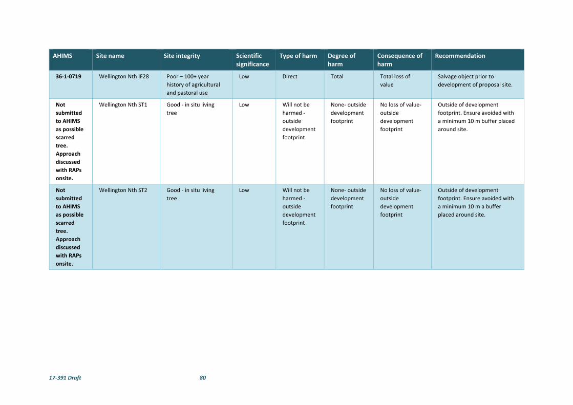
17‐391 Draft 80
AHIMS Site name Site integrity Scientific significance
Type of harm Degree of harm
Consequence of harm
Recommendation
36‐1‐0719 Wellington Nth IF28 Poor – 100+ year
history of agricultural
and pastoral use
Low Direct Total Total loss of
value
Salvage object prior to
development of proposal site.
Not
submitted
to AHIMS
as possible
scarred
tree.
Approach
discussed
with RAPs
onsite.
Wellington Nth ST1 Good ‐ in situ living
tree
Low Will not be
harmed ‐
outside
development
footprint
None‐ outside
development
footprint
No loss of value‐
outside
development
footprint
Outside of development
footprint. Ensure avoided with
a minimum 10 m buffer placed
around site.
Not
submitted
to AHIMS
as possible
scarred
tree.
Approach
discussed
with RAPs
onsite.
Wellington Nth ST2 Good ‐ in situ living
tree
Low Will not be
harmed ‐
outside
development
footprint
None‐ outside
development
footprint
No loss of value‐
outside
development
footprint
Outside of development
footprint. Ensure avoided with
a minimum 10 m a buffer
placed around site.
17‐391 Draft 81
Figure 13. Overview of recorded sites and development footprint.
Wellington Nth AFT6
Wellington Nth ST1
Wellington Nth European Survey Tree Marker 1
Wellington Nth ST2
Wellington Nth IF9Wellington Nth IF3
Wellington Nth IF4
Wellington Nth IF2
Wellington Nth IF1
Wellington Nth IF6
Wellington Nth IF7
Wellington Nth IF5
Wellington Nth IF10
Wellington Nth IF11
Wellington Nth IF25
Wellington Nth IF27
Wellington Nth IF24
Wellington Nth IF23Wellington Nth IF22
Wellington Nth IF16
Wellington Nth IF15
Wellington Nth IF14
Wellington Nth IF13
Wellington Nth IF12
Wellington Nth IF19
Wellington Nth IF20
Wellington Nth IF18
Wellington Nth IF26
Wellington Nth IF28
Wellington Nth IF21
Wellington Nth IF17
Wellington Nth AFT9
Wellington Nth AFT2
Wellington Nth AFT7
Wellington Nth AFT4
Wellington Nth AFT1
Wellington Nth AFT3
Wellington Nth AFT8
Wellington Nth AFT5
GO
OLM
AR
O AD
CO
BB
ORA
ROA
D
CAMPBELLS LANE
MITC
HELL HIG
HW
AY
TWELVE MILE ROADBELA VISTA LANE
BLACKS LANE
CADIA PLACE
WUULUMAN
CREEK
681000 682000 683000 684000 685000 686000 687000
3990
00
640
0000
6401
000
640
2000
640
3000
64040
00
0 500 1,000250 m
www.nghenvironmental.com.au
Ref: SW143 Wellington North SF ArchAuthor: SP
Notes:- Data co llected by nghenvironmental (2017)- Client data courtesy of Client, received 2018- Base map Copyright © Esri and its data suppliers. - GDA94 zone 55
Proposal boundary
European survey marker tree
Isolated find
Possible scarred tree
AHIMS listed sites
Artefact scatter
Existing substation
Local road
Highway
Proposed infrastructure
Eastern transmission easement(overhead)
Eastern transmission easement(underground)
Western transmission easement(overhead or underground)
Fence
Development footprint

17‐391 Draft 82
6.4 IMPACTS TO VALUES
The values potentially impacted by the development are any social and cultural values attributed to the
artefacts and the sites by the local Aboriginal community. The extent to which the loss of the sites or parts
of the sites would impact on the community is only something the Aboriginal community can articulate.
The impact to scientific values for this development are summarised in Section 5 and Table 7 above with
most sites rated as having low loss of scientific value.
The impact to the scientific values if the nine artefact scatters (Wellington Nth AFT1‐ Wellington Nth AFT9)
and 25 of the 28 recorded isolated finds (Wellington Nth IF1 to Wellington Nth IF 10, Wellington Nth IF 12
Wellington Nth IF14 to Wellington Nth IF 16, Wellington Nth IF8 to Wellington Nth IF 28) were to be
impacted by the current proposal is considered low. It should be noted that the site Wellington Nth AFT9
will only be partially impacted.
The stone artefacts have little research value apart from what has already been gained from the
information obtained during the present assessment. This information relates more to the presence of the
artefacts and in the development of Aboriginal site modelling, which has largely now been realised by the
recording.
The impact to the edge‐ground axes (Wellington Nth AFT 2, Wellington Nth AFT 5 and Wellington Nth AFT
9) are considered to have low to moderate loss of scientific value.
The intrinsic values of the artefacts themselves may be affected by the development of the proposal site.
Any removal of the artefacts, or their breakage would reduce the low to moderate scientific value they
retain.
The two possible scarred tree sites will not be impacted by the proposal as per the proposed design in this
report as shown in Figure 13.
No other values have been identified that would be affected by the development proposal.
7 AVOIDING OR MITIGATING HARM
7.1 CONSIDERATION OF ECOLOGICALLY SUSTAINABLE DEVELOPMENT
(ESD) PRINCIPLES
Consideration of the principles of Ecologically Sustainable Development (ESD) and the use of the
precautionary principle was undertaken when assessing the harm to the sites and the potential for
mitigating impacts to the sites recorded within the Wellington North Solar Plant proposal site. The main
consideration was the cumulative effect of the proposed impact to the sites and the wider archaeological
record. The precautionary principle in relation to Aboriginal heritage implies that development proposals
should be carefully evaluated to identify possible impacts and assess the risk of potential consequences.
In broad terms, the archaeological material located during this investigation is similar to what has been
found previously within the Wellington region. Currently there is no clear regional synthesis of the nature,
number, extent and content for archaeological sites within the Dubbo Regional Council LGA. Nevertheless,
given the size of the geographical area, it is certain that there would be similar artefacts present within the
region.

17‐391 Draft 83
The result of this Aboriginal heritage assessment has confirmed the proposed model of site location and
site distribution, whereby sites could be expected to occur across the landscape and in particular in
proximity to a water source, even in ploughed areas. The results of this Aboriginal heritage assessment
suggest that more sites could be expected to occur in the area than was previously envisaged.
The implications for ESD principles is that in fact more sites are likely to be present in the region than
previously thought, which reduces the individual value of the particular sites within the proposal site, as
they are likely to be represented elsewhere. It must be recognised that large parts of the region have been
heavily cleared, farmed and developed through the construction and maintenance of roads and residential
structures and therefore other sites are also likely to have been disturbed. The conclusion that similar sites
exist reduces the representative values of the sites within the proposal site. It should also be noted that
not all sites recorded during this survey fall within the proposed development footprint and that the sites
outside the development footprint will not be impacted by the proposed solar plant development.
As noted above, the archaeological values of the sites, considering the scientific, representative and rarity
values was deemed to be low. It is believed therefore that the proposed impacts to the sites through the
development would not adversely affect the broader archaeological record for the local area or the region.
The principle of inter‐generational equity requires the present generation to ensure that the sites and
diversity of the archaeological record is maintained or enhanced for the benefit of future generations. We
believe that the diversity of the archaeological record is not compromised by development of this particular
solar plant proposal.
We estimate, that while the current development proposal will impact the majority of the identified sites,
the overall cumulative impact on the archaeological record for the region is likely to be minimal, assuming
a similar density of sites remain across the wider region. Therefore, it is argued that the cumulative impacts
of the proposal are not enough to reject outright the development proposal.
7.2 CONSIDERATION OF HARM
Avoiding harm to all the sites is technically possible through avoidance. However, their position scattered
across the landscape and the extent of Wellington Nth AFT9 would pose serious design and operational
constraints on the solar plant proposal.
Based on the assessment of the sites, and in consideration of discussions with the Aboriginal
representatives during the field survey, it is not considered necessary to prevent all development at this
location. The sites with stone artefacts have been shown to be highly disturbed with little remaining
scientific value. Aboriginal cultural value has been determined by the local Aboriginal community to be
generally low enough to not prevent the development proposal proceeding.
All nine of the artefact scatter sites and 25 of the 28 isolated finds are situated within the development
footprint area of the proposed transmission line, solar arrays, tracks, cables, office parking and temporary
facilities. The most likely cause of harm to the artefacts will be through ground preparation activities such
as vegetation clearance, installation of the posts and solar arrays, tracks and underground cabling.
The question remains about possible occurrence of artefacts and cultural material within the balance of
the solar plant site. It is possible, and considered likely that additional artefacts will be present, most likely
in the form of isolated artefacts or very small, low density scatters. Without knowing their exact locations,
it is difficult to manage the impacts. We do not consider that the risk of such disturbances means the
development should be abandoned. The archaeological material identified in the survey, and potentially
present in the balance of the development site is not of sufficient value to reject the development proposal.

17‐391 Draft 84
Mitigation of harm to cultural heritage sites generally involves some level of detailed recording to preserve
the information contained within the site. Mitigation can be in the form of minimising harm, through slight
changes in the development plan or through direct management measures of the sites and Aboriginal
objects.
It is argued here that mitigation in the form of alteration is not feasible or warranted within the solar plant
development footprint for the sites in this situation. However, all these sites are conducive to salvage as a
mitigation strategy as requested by the Aboriginal community representatives onsite during the field
survey.
As identified above, it is recommended that the sites recorded within the proposed Wellington North Solar
Plant development footprint are salvaged by an archaeologist with representatives of the registered
Aboriginal parties prior to the proposed development commencing. The artefacts should be collected and
moved to a safe area within the property that will not be subject to any ground disturbance.
The Aboriginal community representatives onsite during the field survey noted their preference for the surface artefacts to be relocated and buried outside the development footprint prior to development commencing. The Aboriginal community representatives onsite during the field survey also requested that a Cultural Smoking Ceremony take place to cleanse any artefacts salvaged and the reburial location.
8 LEGISLATIVE CONTEXT
Aboriginal heritage is primarily protected under the NPW Act and as subsequently amended in 2010 with
the introduction of the National Parks and Wildlife Amendment (Aboriginal Objects and Places) Regulation
2010. The aim of the NPW Act includes:
The conservation of objects, places or features (including biological diversity) of cultural value within
the landscape, including but not limited to: places, objects and features of significance to Aboriginal
people.
An Aboriginal object is defined as:
Any deposit, object or material evidence (not being a handicraft made for sale) relating to the
Aboriginal habitation of the area that comprises New South Wales, being habitation before or
concurrent with the occupation of that area by persons on non‐Aboriginal extraction and includes
Aboriginal remains.
Part 6 of the NPW Act concerns Aboriginal objects and places and various sections describe the offences,
defences and requirements to harm an Aboriginal object or place. The main offences under section 86 of
the NPW Act are:
A person must not harm or desecrate an object that the person knows is an Aboriginal
object.
A person must not harm an Aboriginal object.
For the purposes of this section, "circumstances of aggravation" are:
o that the offence was committed in the course of carrying out a commercial activity,
or
o that the offence was the second or subsequent occasion on which the offender was
convicted of an offence under this section.
A person must not harm or desecrate an Aboriginal place.

17‐391 Draft 85
Under section 87 of the NPW Act, there are specified defences to prosecution including authorisation
through an Aboriginal Heritage Impact Permit (AHIP) or through exercising due diligence or compliance
through the regulation.
Section 89A of the Act also requires that a person who is aware of an Aboriginal object, must notify the
Director‐General in a prescribed manner. In effect this section requires the completion of OEH AHIMS site
cards for all sites located during heritage surveys.
Section 90 of the NPW Act deal with the issuing of an AHIP, including that the permit may be subject to
certain conditions.
The EP&A Act is legislation for the management of development in NSW. It sets up a planning structure
that requires developers (individuals or companies) to consider the environmental impacts of new
proposals. Under this Act, cultural heritage is considered to be a part of the environment. This Act requires
that Aboriginal cultural heritage and the possible impacts to Aboriginal heritage that development may
have are formally considered in land‐use planning and development approval processes.
Proposals classified as State Significant Development or State Significant Infrastructure under the EP&A Act
have a different assessment regime. As part of this process, Section 90 harm provisions under the NPW Act
are not required, that is, an AHIP is not required to impact Aboriginal objects. However, the Department
of Planning and Environment (DP&E) is required to ensure that Aboriginal heritage is considered in the
environmental impact assessment process. The Department of Planning and Environment DP&E will
consult with other departments, including OEH prior to development consent being approved.
The Wellington North Solar Plant proposal is a State Significant Development and will therefore be assessed
via this pathway. This does not negate the need to carry out an appropriate level of Aboriginal heritage
assessment or the need to conduct Aboriginal consultation in line with the requirements outlined by the
OEH Aboriginal cultural heritage consultation requirements for proponents 2010 (OEH, 2010b).
17‐391 Draft 86
9 RECOMMENDATIONS
The recommendations are based on the following information and considerations:
Results of the archaeological survey;
Consideration of results from other local archaeological studies;
Results of consultation with the registered Aboriginal parties;
The assessed significance of the sites;
Appraisal of the proposed development, and
Legislative context for the development proposal.
It is recommended that:
1. The development must avoid the two possible Scarred Tree (Wellington Nth ST1 and Wellington Nth ST2) as per the proposed development footprint in this report. A minimum 10m buffer around the trees should be in place to protect the tree canopy and root system.
2. If complete avoidance of the nine artefacts scatters and 28 isolated find sites recorded within the proposal site is not possible, the artefacts within the development footprint must be salvaged prior to the proposed work commencing and moved to a safe area within the property that will not be subject to any ground disturbance.
3. The collection and relocation of the artefacts should be undertaken by an archaeologist with representatives of the registered Aboriginal parties and be consistent with Requirement 26 of the Code of practice for Archaeological Investigation of Aboriginal Objects in New South Wales. A new site card/s will need to be completed once the artefacts are moved to record their new location on the AHIMS database. The Aboriginal community requests that a Cultural Smoking Ceremony take place to cleanse any artefacts salvaged and the reburial location.
4. A minimum 5m buffer should be observed around all artefact scatters and isolated find sites, including those outside the development footprint.
5. Wellington North Solar Farm Pty Limited should prepare a Cultural Heritage Management Plan (CHMP) to address the potential for finding additional Aboriginal artefacts during the construction of the Solar Plant and management of known sites and artefacts. The Plan should include the unexpected finds procedure to deal with construction activity. Preparation of the CHMP should be undertaken in consultation with the registered Aboriginal parties.
6. In the unlikely event that human remains are discovered during the construction, all work must cease in the immediate vicinity. OEH, the local police and the registered Aboriginal parties should be notified. Further assessment would be undertaken to determine if the remains were Aboriginal or non‐Aboriginal.
7. Further archaeological assessment would be required if the proposal activity extends beyond the area of the current investigation as detailed in this report, including the entire proposed eastern transmission route and any portions of the western transmission route outside the surveyed alignment. This would include consultation with the registered Aboriginal parties and may include further field survey.
8. The one possible European survey marker tree identified in the proposal site should be avoided by
the proposed works. If the development footprint is unable to be redesigned to be avoid the
possible European survey marker tree further recording is recommended to establish if it has any
historical significance.

17‐391 Draft 87
10 REFERENCES
AMBS, 2008. Wellington Gas Pipeline, Power Station & Compressor Station Heritage Assessment. Unpublished report to Parsons Brinckerhoff.
Barber, M., 1995. An Archaeological Survey of the Proposed Communications GSM Tower, Wellington, NSW. Unpublished report to Optus Communications.
Bowdler, S., 1982. Five Sites on the Proposed Transmission Line Route between Wellington and Wallerawang: An Assessment. Unpublished report to NSW NP&WS.
Colquhoun, G. P., Meakin, N., Morgan, E., Raymond, O., Scott, M., Watkins, J., Barron, L., Cameron, R., and Henderson, G., 1999. Dubbo 1:250 000 Geological Sheet SI/55‐04, 2nd edition. Geological Survey of New South Wales, Sydney.
Cubis, L., 1982. The Identification of Aboriginal Archaeological Sites on the Wallerawang/Wellington 330kV Electrical Transmission Line. Unpublished report.
DE&E, 2016. Interim Biogeographic Regionalisation for Australia (IBRA), Version 7 (Subregions). [online]. Available from: http://data.gov.au/dataset/74442a9f‐9909‐485d‐ae3f‐8dfa72e4b6b2.
DECC, 2002. Descriptions for NSW (Mitchell) Landscapes: Based on Descriptions compiled by Dr. Peter Mitchell. A Report prepared for the Department of Environment and Climate Change.
Dibden, J., 2011. Proposed Bodangora Wind Farm European and Aboriginal Cultural Heritage Assessment Report. Unpublished report to Bodangora Wind Farm Pty Ltd.
Egloff, B., Peterson, N., and Wesson, S. C., 2005. Biamanga and Gulaga: Aboriginal cultural association with Biamanga and Gulaga National Parks. Office of the Registrar, Aboriginal Land Rights Acts 1983 (NSW).
Evans, G., 1815. Historical Records of Australia Series 1, 8.
Fraser, J., 1892. The Aborigines of New South Wales. Sydney: Charles Potter, Government Printer.
Gott, B., 1982. Ecology of Root Use by the Aborigines of Southern Australia. Archaeology in Oceania, 17 (1), 59–67.
Hiscock, P., 2007. Archaeology of ancient Australia. Routledge.
Horton, D., 1994. The encyclopaedia of Aboriginal Australia: Aboriginal and Torres Strait Islander history, society and culture. Canberra: Aboriginal Studies Press.
Kelton, J., 1999. An archaeological study of the proposed upgrading of the Wellington Sewage Treatment Plant, Wellington, NSW.
Koettig, M., 1985. Assessment of Aboriginal sites in the Dubbo City area. Unpublished report to Dubbo City Council.
Lance, A., 1985. An Archaeological Survey of the Proposed Wellington to Forbes Transmission Line. Unpublished report to the Electricity Commission of NSW.
Long, A., 2005. Aboriginal scarred trees in New South Wales : a field manual. Dept. of Environment and Conservation.
MacDonald, G., 1983. The Concept of Boundaries in Relation to the Wiradjuri People of Inland New South Wales: An assessment of Inter‐Group Relationships at the Time of European Conquest. Report prepared for Wiradjuri Land Council.
Marquis‐Kyle, P. and Walker, M., 1994. The Illustrated Burra Charter: Making good decisions about the care of important places. Sydney: Australian Heritage Commission.
Mitchell, T., 1839. Three Expeditionas into the Interior of Eastern Austrlia. London.
Mulvaney, D. J. and Kamminga, J., 1999. Prehistory of Australia. Allen & Unwin.

17‐391 Draft 88
Murphy, B. and Lawrie, J., 1998. Soil Landscapes of the Dubbo 1:250,000 Sheet. NSW Department of Land and Water Conservation, Sydney.
NGH Environmental 2017 Aboriginal Cultural Heritage Assessment Wellington Solar Farm. Unpublished report prepared for First Solar Pty Ltd.
OEH, 2010a. Code of Practice for Archaeological Investigation of Aboriginal Objects in New South Wales.
OEH, 2010b. Aboriginal Cultural Heritage Consultation Requirements for Proponents 2010.
OEH, 2011. Guide to Investigating, Assessing and Reporting on Aboriginal Cultural Heritage in NSW.
Oxley, J., 1820. Journals of Two Expeditions Into the Interior of New South Wales, undertaken by order of the British Government in the Years 1817‐1818. London: John Murray.
OzArk, 2007. Dubbo Local Government Aboriginal Heritage Study. Unpublished report to DCC.
OzArk, 2009. Proposed upgrade / pole replacement of the Wellington 11 kV ETL. Unpublished report to Barnson Pty Ltd.
Pardoe, C., 2010. ERM Power Pty Ltd Young to Wellington Gas Pipeline: Cultural Heritage Assessment and Consultation. Unpublished report to ERM Power Pty Ltd.
Pearson, M., 1981. Seen through different eyes: changing land use and settlement patterns in the Upper Macquarie River region of NSW from prehistoric times to 1860. The Australian National University.
Purcell, 2002. Aboriginal Cultural Heritage Assessment Brigalow Belt South Stage 2. Unpublished report to the Resource and Conservation Assessment Council.
Ramson, M., 1983. To Kill a Flocking Bird. Unpublished B. Litt Thesis, Department of Prehistory and Anthropology, ANU.
Tindale, N. B., 1974. Aboriginal tribes of Australia: their terrain, environmental controls, distribution, limits, and proper names. Canberra: ANU Press.
Woolrych, F. B. W., 1890. Native names of some of the runs etc. in the Lachlan District. Journal of the Royal Society of New South Wales, 24, 63–70.
17‐391 Draft 89
APPENDIX A ABORIGINAL COMMUNITY
CONSULTATION
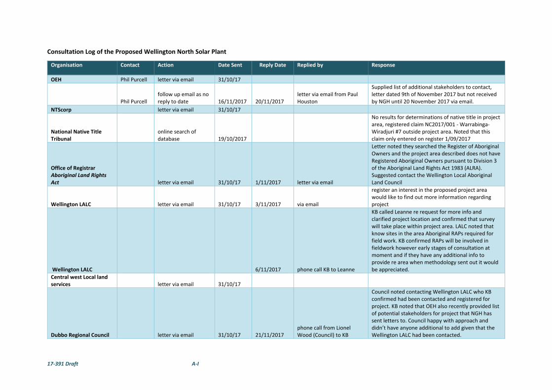
17‐391 Draft A‐I
Consultation Log of the Proposed Wellington North Solar Plant
Organisation Contact Action Date Sent Reply Date Replied by Response
OEH Phil Purcell letter via email 31/10/17
Phil Purcell follow up email as no reply to date 16/11/2017 20/11/2017
letter via email from Paul Houston
Supplied list of additional stakeholders to contact, letter dated 9th of November 2017 but not received by NGH until 20 November 2017 via email.
NTScorp letter via email 31/10/17
National Native Title Tribunal
online search of database 19/10/2017
No results for determinations of native title in project area, registered claim NC2017/001 ‐ Warrabinga‐Wiradjuri #7 outside project area. Noted that this claim only entered on register 1/09/2017
Office of Registrar Aboriginal Land Rights Act letter via email 31/10/17 1/11/2017 letter via email
Letter noted they searched the Register of Aboriginal Owners and the project area described does not have Registered Aboriginal Owners pursuant to Division 3 of the Aboriginal Land Rights Act 1983 (ALRA). Suggested contact the Wellington Local Aboriginal Land Council
Wellington LALC letter via email 31/10/17 3/11/2017 via email
register an interest in the proposed project area would like to find out more information regarding project
Wellington LALC 6/11/2017 phone call KB to Leanne
KB called Leanne re request for more info and clarified project location and confirmed that survey will take place within project area. LALC noted that know sites in the area Aboriginal RAPs required for field work. KB confirmed RAPs will be involved in fieldwork however early stages of consultation at moment and if they have any additional info to provide re area when methodology sent out it would be appreciated.
Central west Local land services letter via email 31/10/17
Dubbo Regional Council letter via email 31/10/17 21/11/2017 phone call from Lionel Wood (Council) to KB
Council noted contacting Wellington LALC who KB confirmed had been contacted and registered for project. KB noted that OEH also recently provided list of potential stakeholders for project that NGH has sent letters to. Council happy with approach and didn’t have anyone additional to add given that the Wellington LALC had been contacted.

17‐391 Draft A‐II
Organisation Contact Action Date Sent Reply Date Replied by Response
Local Newspaper
Dubbo Daily Liberal 27/10/17
OEH list of potential stakeholders
Binjang Wellington Wiradjuri heritage Survey 20/11/2017 20/11/2017 via email
registered interest in project and provided rates and insurances. Would like the methodology report email sent to Jamie for comment.
Binjang Wellington Wiradjuri heritage Survey Jamie Gray
KB sent email acknowledgment of interest in project 20/11/2017
Brian Draper letter via post 20/11/2017
Central West Catchment Management Authority letter via post 20/11/2017
Dubbo Aboriginal Community Working Party
Grace Toomey letter via post 20/11/2017
Dubbo Aboriginal Community Working Party Paul Carr letter via post 20/11/2017
DUBBO LALC Chairperson letter via post 20/11/2017
Katrina Mckinnon letter via post 20/11/2017
Mooka Neville Williams letter via post 20/11/2017
Natasha Rodgers letter via post 20/11/2017
Paul Brydon letter via post 20/11/2017
Peter Peckham letter via post 20/11/2017
Trevor Robinson letter via post 20/11/2017 letter returned to sender
Wamarr Cutural Consultants Craig Riley letter via post 20/11/2017
Wellington LALC Leanne Stanley
Already contacted and registered N/A
Wellington Valley Wiradjuri Aboriginal Corporation Chairperson
letter via email to Brad Bliss 20/11/2017 20/11/2017 via email
requested map of project area, KB replied on 23/11/2017 that waiting on permission to release map however suggested use of six maps for lot search.

17‐391 Draft A‐III
Organisation Contact Action Date Sent Reply Date Replied by Response
Wellington Valley Wiradjuri Aboriginal Corporation phone message to KB 23/11/2017 23/11/2017
via email‐ KB acknowledged registration and provided map of project location that is available from AGL website.
registered interest in project for WVWAC and Gallangabang Aboriginal Corporation
Wellington Valley Wiradjuri Aboriginal Corporation Brad called KB 24/11/2017 25/11/2017 via email
Brad and KB spoke, KB mentioned sent map and noted registration. Brad sent follow up email re previous reply.
Wiradjuri Council of Elders
Robert Clegg letter via post 20/11/2017
Wiradjuri Interim Working Party letter via post 20/11/2017 returned to sender received 8/1/2018
Wirrimbah Direct Descendants
Coral Peckham letter via post 20/11/2017
Restricted site information request
AHIMS
email request re 2 restricted sites in AHIMS search, requesting confirmation if within or adjacent to project area, Maps provided of project area. 24/11/2017 30/11/2017
via email from David Gordon (OEH‐Senior Heritage Information Officer)
“I can confirm that Restricted Aboriginal Sites Sit outside your Area of Works as outlined in the previous email and will not be impacted. If these plans change and more clarification is needed please don’t hesitate to contact me directly”.
Methodology Comments due 19 Jan 2018
Binjang Wellington Wiradjuri heritage Survey Jamie via email 8/12/2017
Wellington LALC Leanne via email 8/12/2017
Wellington Valley Wiradjuri Aboriginal Corporation Brad via email 8/12/2017 4/01/2018 via email
combined letter from WVWAC and GAC noted spacing no greater the 30m with 20m being optimal, recording all objects and information given by raps with pads and site information taken into account and the involved in all other investigations for project such as Envrio etc , provided insurances.

17‐391 Draft A‐IV
Organisation Contact Action Date Sent Reply Date Replied by Response
Gallangabang Aboriginal Corporation
Paul Campion and cc in Brad for WVWAC via email 8/12/2017 4/01/2018 via email Insurances provided
Reminder email sent re methodology comments due 19 Jan 2018
Binjang Wellington Wiradjuri heritage Survey Jamie via email 8/01/2018 8/01/2018 via email
provided rates and insurance details, no other comments provided
Wellington LALC Leanne via email 8/01/2018
OEH informed of RAPs
OEH
Paul Houston and Phil PURCELL via email 8/01/2018
Please note for your reference that there are four RAPs for the proposed Wellington North Solar Plant project. The RAPs for the project are listed below:
• Binjang Wellington Wiradjuri heritage Survey
• Wellington LALC
• Wellington Valley Wiradjuri Aboriginal Corporation
• Gallangabang Aboriginal Corporation
Additionally, please note that letters sent to Trevor Robinson and the Wiradjuri Interim Working Party were returned to sender should you wish to update your register
Follow up phone calls re methodology comments and insurances
Wellington LALC left voice mail as no answer 19/01/2018

17‐391 Draft A‐V
Organisation Contact Action Date Sent Reply Date Replied by Response
Wellington LALC
KB spoke with Leanne, asked for comments by end of week if possible 22/01/2018
Wellington LALC
follow up email requesting comments rates etc 29/01/2018
Wellington LALC follow up phone call left message 30/01/2018
Gallangabang Aboriginal Corporation
Paul Campion
email request for updated insurances 31/01/2018
Wellington LALC
follow up phone, spoke with reception Leanne to call KB back today 2/02/2018
Wellington LALC Leanne
KB spoke with Leanna confirmed rates, had no additional comments on methodology, wish to participate in fieldwork 5/02/2018
Wellington Valley Wiradjuri Aboriginal Corporation Brad
NGH responded to methodology comments 6/02/2017
Wellington Valley Wiradjuri Aboriginal Corporation
Brad via email 23/05/2018 NGH informed that 4 sites recently recorded adjacent to North‐western corner of project area. KB has plotted sites and informed the proponent. Information included in community consultation

17‐391 Draft A‐I
Public Notice placed in The Dubbo Daily Liberal on 27 October 2017.

17‐391 Draft A‐II
NGH response to Wellington Valley Wiradjuri Aboriginal Corporation methodology comments sent on
the 6th February 2018
17‐391 Draft B‐I
APPENDIX B AHIMS SEARCH

17‐391 Draft B‐I
Information withheld from public display due to cultural sensitivities.
17‐391 Draft C‐I
APPENDIX C SITE CARDS

17‐391 Draft C‐II
Information withheld from public display due to cultural sensitivities.


