1
Automatic Position Reporting System (APRS)
Kevin Paetzold (K1KWP)Minuteman Repeater Association
April 14, [email protected]
Thanks to Mike Heskett (WB5QLD), Ralph Fowler (N4NEQ), Tom Kinahan (N1CPE), Bill Northup (N1QPR) for their prior work included this presentation.

2
Agenda• What is APRS and how does it work…• Various APRS implementations…• Components of an APRS station and typical station
examples…• Tracking, Messages, and Objects…• Weather Stations and Severe Weather Warnings…• APRS over the Internet…• APRS over satellites…• Other APRS features…
3
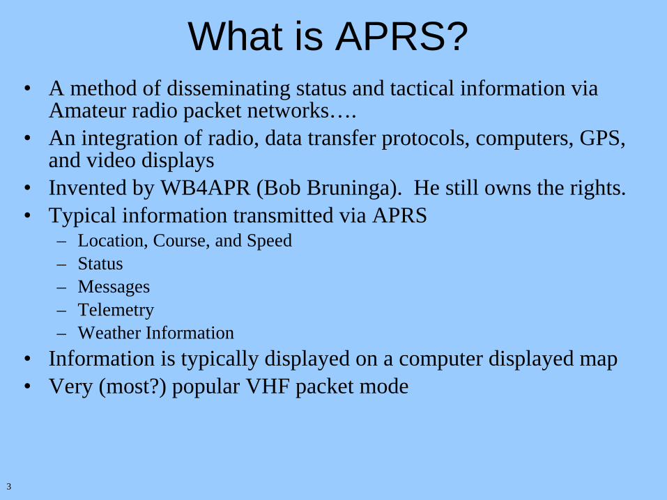
What is APRS?• A method of disseminating status and tactical information via
Amateur radio packet networks….• An integration of radio, data transfer protocols, computers, GPS,
and video displays • Invented by WB4APR (Bob Bruninga). He still owns the rights.• Typical information transmitted via APRS
– Location, Course, and Speed– Status – Messages– Telemetry– Weather Information
• Information is typically displayed on a computer displayed map• Very (most?) popular VHF packet mode

4 Vie
w o
f E
aste
rn M
A @
K1K
WP
200
2-03
-26

5 Map
sh
owin
g al
l hea
rd s
tati
ons

6 Vie
w o
f U
SA
MA
P @
K1K
WP
200
2-03
-26

7
These stations were heard direct during a band opening last summer
Typical 2M Direct Stations Range vs. a Band opening
Stations characteristically heard direct at K1KWP (no band opening or special propagation)

8
How APRS and its Network Operate• APRS uses the UI (connectionless/beacon) Frames of the AX.25
protocol. APRS protocol is layered above AX.25– The AX.25 specification is available at http://www.tapr.org/tapr/pdf/AX25.2.2.pdf– The APRS protocol specification is available at
ftp://ftp.tapr.org/aprssig/aprsspec/spec/aprs101/APRS101.zip
• APRS does not use the connected packets (eg. like a BBS)• Generally uses 2M AFSK at 1200 baud• Packets are Addressed to APRS and the packet “path” is
determined by the “UNPROTO” setting• When a station wants to transmit a packet it listens and when the
frequency is clear transmits the packet. Not unlike how Ethernet works….
• Uses “generic digipeating” to route packets

9
Generic Digipeating• APRS packets can be propagated without prior knowledge of the
network• Digipeaters use pre-defined/known aliases to recognize those
packets that should be digipeated. The common aliases are:– RELAY: all nodes are assumed to be RELAYs (note 1)– WIDE: High site (large coverage area) digipeaters – WIDEn-n: A better implementation of WIDE which helps prevent packet duplication– GATE: HF to VHF gateway (note 2)– There are other aliases. See the APRS protocol spec.
• Example paths– RELAY,WIDE– RELAY,WIDE2-2– W1YK,WIDE2-2
Note 1: In a populated area with good coverage (like Eastern MA) not all nodes should be RELAYs. There should almost never be more than one RELAY in a path and RELAY should always be only the first alias in a path.
Note 2: Packets should never ever be gated from VHF to HF as HF is limited to 300Baud.

10
Coverage area of station N1xxx
Coverage area
of mobile
station N1yyy
Coverage area of station N1zzz which is a WIDE digipeater
Coverage area of station N1www which is a WIDE digipeater
Cov
erag
e ar
ea o
f hom
e st
atio
n N
1ttt
whi
ch is
a R
ELAY
digi
peat
er
Coverage area of N1sss a mobile station
Packets from N1xxx (red) and N1yyy (yellow) are only heard in their respective coverage areas if not digipeated
If packets from N1xxx (red) include a WIDE in their UNPROTO path N1sss (blue) should hear N1xxx (red) packets after being digipeated by N1zzz (green). N1ttt (orange) and N1yyy (Yellow) would not hear these packets
If packets from N1yyy (yellow) include a RELAY,WIDE2-2 (or RELAY,WIDE,WIDE) in their UNPROTO path N1sss (blue) should hear N1yyy (yellow) packets after being digipeated by N1ttt (orange) followed by N1www (purple) followed by N1zzz (green)
Generic Digipeating Example

11
WIDEn-n Example• In example below WIDEn-x. “n” specifies how many successive WIDE
digipeaters should retransmit a packet. The initial transmission of the packet should have “n” and “x” equal. For example WIDE3-3. “n”=3 and “x”=3.
• Each WIDEn-x digipeater will decrement the “x” value when retransmitting the packet.
• Each WIDEn-x digipeater keeps a checksum of each retransmitted packet and does not retransmit packets seen recently with the same checksum.
• WIDE3-3 example:– Originating station sends the packet via WIDE3-3.– Any WIDE which heard the packet direct (being sent to WIDE3-3) retransmits using
WIDE3-2*.– Any WIDE which heard the packet second hand (being sent to WIDE3-2*)
retransmits using WIDE3-1*– Any WIDE which heard the packet third hand (being sent to WIDE3-1*) retransmits
it as WIDE3*.– Any WIDE which hears the WIDE3* packet will not retransmit it. The packet’s
lifespan on the network ends.

12
More on APRS Digipeaters• Digipeaters will respond to their own callsign, plus other aliases such as WIDE,
RELAY, etc…• To work successfully APRS needs a number of dedicated ‘WIDE’ digipeaters.• All ‘WIDE’ digipeaters are on the same channel, but are carefully positioned to
avoid extra contention.• Digipeaters keep track of the checksum of a packet for a defined period of time
(eg. 30 seconds) and suppress digipeating packets which have the same checksum as they would be duplicates.
• How far will a wide get around Eastern MA:– One WIDE – Potentially most of Eastern MA– Two WIDEs – Most of Massachusetts (at least East of Springfield) plus neighbouring
parts of RI, CT, VT, NH ME, etc…– Three WIDEs – Probably most of New England plus NY, NJ etc…– Even one WIDE is good enough for the packet to make it the Internet gateways
described later in the presentation

13
Typical Station Operations• Upon entry into APRS the user supplies a location or a
GPS unit can provide continuously updated locations over a serial port– This location is transmitted to other stations on network
following a the defined “unproto” path including various generic digipeaters.
– User can define how their station is displayed on map (Antenna, Tower, QTH, Car, Jeep, Bus, Plane, dozens more)
• Mobile stations with GPS receivers periodically transmit the NMEA strings from their GPS unit onto the APRS frequency. APRS decodes these packets and places the station on the map of the receiving stations.

14
AHUBWEST>APAX17,TCPIP*:!3241.32N\11425.33W& ahubwest.net ports 2023 (APRS Feed), 14579 (Regional Feed) 7 usersHB9IBI9>TV1QW4,HB9IAC4,HB9BA4,DB0LC*:'|'Rl >/]"8K}N0DYB9>GPS,N0BKB*,WIDE,WIDE:$GPRMC,170553,A,4129.043,N,09522.968,W,000.0,196.3,270302,004.1,E*6FIK2ANB11>APND0U,IK1VGG11*,TRACE77,IK1SLD,I:=4542.15NN00939.73E#PHG6630/Digi_Ned: A.R.I. Bg www.aribg.itK4HG>APM344,TCPIP*:=2439.68N/08128.95WiPHG0000/Steve via Internet FLDADMIAMI 344<138>PAKP>APRS,KK5WM6,I:@271615z6808.00N/15144.00W_040/010g000t18r000p000h62b10040wMETRN9OIG>APS203,TCPIP*:<IGATE MSG_CNT=23175 LOC_CNT=76 FILL_CNT=0KB8UUW1>APT202,RELAY,W8JEU10,W8APR*:!3908.20N/08430.77W>000/000/A=000770PAKP>APRS,KK5WM6,I:>KK5WM METAR Virtual WX Stn PAKP Anaktuvuk Pass ALK3JF15>WA2UEM4*>APRS:!4050.56NT07439.50W#PHG6460 Succasunna NJ Digi Wide/Relay/TraceVA3ZIP>APW246,TCPIP*::VA3DVR14:ack057W9KXQ15>APRS,WA9RES,W9DF15*:!3851.36N/08926.93W#PHG5330/WRT...Greenville, ILVA3ZIP>APW246,TCPIP*::VA3DVR14:ack058K4HG>APM344,TCPIP*:_03271549c007s009g012t076r000p000P000h79b10177mU2KK4LKL10>APRS,K4FB14*,WIDE33/1:!2803.43NN08157.17W#PHG7460 Lakeland ARC WRTFL [email protected]10>APRS,WIDE:!2821.00NN08239.32W#PHG7260 Hudson,FL Digi DKE6FOA15>APRS,W6BXN3*,WIDE:$GPRMC,170558,A,3724.267,N,12051.087,W,000.0,309.7,270302,015.5,E*6BAG4GR>APK101,KD4HTW9*,WIDE3:@271603z3452.33N/08221.78W;294/000/MicE/M0/Off duty>AG4GR>STUR3T,KD4HTW9*,WIDE3:'n1kl"z;/]"79}N8UMU>ID,RELAY,WIDE55:N8UMU/R WIDE/D N8UMU1/BDB0ZWI>APZ186,WIDE,WIDE:!5044.58N/01227.00E#PHG5630/APRS DIGI Zwickau/Sax. S60 {UIDIGI 1.8}F1MPR9>TX3WU0,F8KRH15*,WIDE76,TRACE77,F5STO,I:`x5dl >/>Phone sur V/U 91 ...KD5LBK>APW247,TCPIP*:=3301.38N/09700.55W_PHG0000/WinAPRS 2.4.6 / Davis WMII TXDENLEWISVIL247<530>EB7HGZ>APU24N,TCPIP*:=3723.23N/00604.14WIemail: [email protected] {UIV32}KB9GN9>APRS,K9MOT*,WIDE33:$GPRMC,170557.00,A,4205.70,N,08803.86,W,0.0,0.0,270302,0.0,E/GPS FIXK4IWL15>APK101,WR6ABD*:@271710z3715.35N/12157.65Wk117/000/MicE/M1/Enroute>VE6RAM>UQQWYP,RELAY,WIDE:'*XSl >/>W9RPM>APW251,TCPIP*:_03271606c164s010g010t048r000p000P000h00b00000wDAVKD7BYY7>APK101,N7LF10*,WIDE:@271610z4522.83N\12245.85WK336/009/MicE/M1/Enroute>K4IWL15>SW1USU,WR6ABD*:'1U^l!k/]"4v}LenPlano TX [email protected]7>TU2RXT,N7LF10*,WIDE:'2Iql}@K\]"4F}KD5LBK>APW247,TCPIP*:_03271606c177s001g003t058r000p000P000h51b10067wDAVDL0REN>APZ186,DB0ZWI*,WIDE:!5026.51N\01127.09ELPHG2880/JO50RK WetzsteinKD4LZN1>SR2T0U,LTROCK,WIDE3*,KD5AAY,I:'r)]l Fv/]"4a}N1WTQ>APW251,RELAY*,WIDE,W1YA,N1RWY,WIDE22:_03271706c114s000g001t037r000p000P000h99b10088wDAVKC0CNT>AP0922,N0ZED5*,WIDE33:=3941.20N/10505.74WrAPRS+SAKF6HJO>APW251,TCPIP*:_03271703c142s003g004t055r000p000P000h91b10115wU2KKD4LZN1>APK101,N4PK10*,WIDE3:@271606z3224.05N/08613.65Wv042/000/MicE/M1/Enroute>KE4HTM>APW251,TCPIP*:=3542.56N/08144.03WyPHG7190/Jamie in Morganton, NC USA (TCP/IP Only) NCBURMORGANTO251<630>
Example of some RAW APRS packets

15
Frequencies
• VHF/UHF–144.390 MHz
• HF–10.151 LSB - Active–7.085 LSB - Not very active

16
APRSdos Bob Bruninga (WB4APR)● The original implementation● The most functionality
MacAPRS Mark Sproul KB2ICI, Keith Sproul WU2Z WinAPRS Keith Sproul WU2Z, Mark Sproul KB2ICI
● A version for Windows 9X and a version for MACs● Someday will also work on Linux
JavAPRS Steve Dimse, K4HGAPRS+SA Brent Hildebrand, KH2Z PalmAPRS Mike MusnicUIVIEWXASTIR
The More Popular Implementations of APRS
URLs to obtain the above (and others) at the end of this presentation and in the handout and at www.tapr.org

17
DOSAPRS Screenshot

18
APRS+SA Screen Shot

19
Typical Components of an APRS station• 2M Radio
– There is also APRS over HF• TNC
– Essentially a computer modem for radio.– Some radios now have built in TNCs
• GPS– Optional. Makes current latitude and longitude available to TNC or computer
• Computer– Optional. Displays APRS information.
• Weather Station– Optional.
• Mic-E– Optional. From TAPR. – Allows mobile stations to update various APRS parameters and information. – Also provides compression of APRS packets.– Some radios with built in TNCs also provide the same functionality

20
GPS Receiver• GPS satellite system is used to determine current positions especially of mobile
stations • Data from GPS receivers communicate to computers/TNCs via ASCII strings
over a serial port– and transmitted over APRS– Interpreted by received stations
• Strings are actually called “sentences” and the format is specified by the NMEA (National Marine Electronics Association).
• There are multiple sentences that can be used for APRS. One of them is detailed below.
$GPRMC,220516,A,5133.82,N,00042.24,W,173.8,231.8,130694,004.2,W*70 1 2 3 4 5 6 7 8 10 11 12
1.220516 Time Stamp 2. A validity Aok, Vinvalid 3.5133.82 current Latitude 4. N North/South 5 00042.24 current Longitude 6. W East/West 7 173.8 Speed in knots 8. 231.8 True course 9 130694 Date Stamp 10. 004.2 Variation 11 W East/West 12. *70 checksum

21
TNC
• The TNC is usually the connection between computer and radio. Essentially a modem for radio. ASCII in/out of computer via RS232 and AFSK in/out of radio
• Other features:● GPS compatible● Many support two serial ports● Low power consumption● Advanced routing ● BBS Mailbox, KA-NODE ● Telemetry● Kantronics KPC3+ is a favorite (around $150 new)
PacComm Tiny TNC-2
Kantronics KPC3+

22
TNC to RADIO wiring diagrams The Packet Radio and PSK31 Interface Home Page http://www.packetradio.com/

23
Typical APRS Mobile Tracker/Station
Typical APRS Home Station

24
Typical Simple APRS Remote Digipeater
Remote APRS Digipeater with WX Station
No computers required

25
APRS Home Station with Weather Station
Many TNCs support two serial ports
Computer running APRSdos or WINAPRS etc…
Weather station could alternatively be connected directly to the TNC

26
APRS Tracker with Computer and WX Station
Alternatively the WX station could be connected directly to the TNC and the GPS connected to the computer
Many TNCs support two serial ports
Computer running APRSdos or WINAPRS etc…

27
TAPR• www.tapr.org - produced the original TNCs• Non profit amateur radio R&D corporation. Has
membership benefits.• The primary organization which promotes and organizes
VHF amateur packet radio. • Produces designs for equipment (like TNCs), MIC-E (no
longer available), PIC-E, etc.. • Home of the APRS SIG. Also the place to get latest
versions of software, specs, etc…• URL is http://www.tapr.org/tapr/html/Faprssig.html
Tucson Amateur Packet Radio Corporation

28
The MIC-ETM
• Developed by TAPR. Kit not currently available but: – Used compression to shorten APRS packets– Provided a way for mobile stations to update their status or change “unproto”
paths easily.
• Performs TNC function.• Could be used to add position information to the end of a voice
transmission • Same protocol mechanisms (such as compression) used by newer
APRS ready radios like Kenwood TM-D700 and TH-D7A.
29
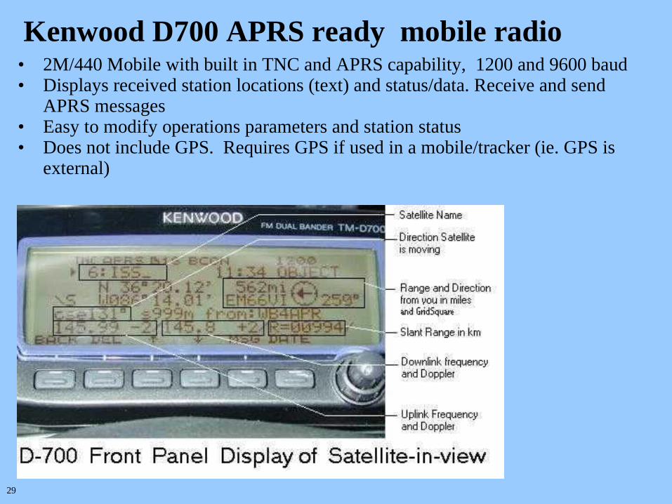
Kenwood D700 APRS ready mobile radio• 2M/440 Mobile with built in TNC and APRS capability, 1200 and 9600 baud• Displays received station locations (text) and status/data. Receive and send
APRS messages• Easy to modify operations parameters and station status• Does not include GPS. Requires GPS if used in a mobile/tracker (ie. GPS is
external)

30
Kenwood HT TH-D7A
• Dual Band (2M/440) HT with 1200 & 9600 baud built in TNC and APRS capability
• HT version of the same technology as the TM-D700A supplying the same capabilities.
• Does not include GPS

31
Station & Object
Tracking
Works for planes, trains, and automobiles as well as satellites
Also works for tracking objects (discussed later in presentation) as well as mobile stations
GPS Software programs can record received station locations and replay the locations that were received by those stations

32
• APRS stations can send messages to other APRS stations. – These stations to station messages are retransmitted until a defined
maximum or until acknowledged by the target station. – Because of the “Ack” mechanism you can determine if your message was
received.• Bulletins
– Short term messages that are time critical. For example storm warnings.– Bulletins (and announcements) are not acknowledged– Generally repeatedly transmitted at relatively short intervals for a couple
hours and then stop. • Announcements
– longer-term messages that are not very time critical. For example club meeting notifications.
– Generally sent once an hour for several days and then stop.
APRS Messaging
33 Exa
mp
les:
Mes
segi
ng,
Wea
ther
, Tra
ck I
nfo
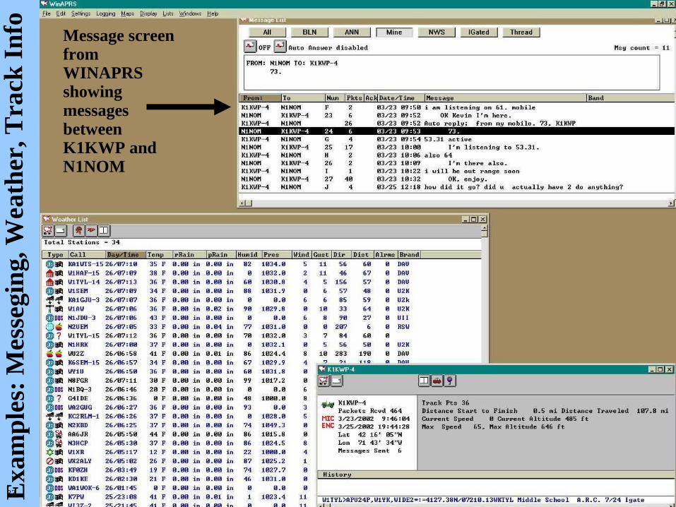
Message screen from WINAPRS showing messages between K1KWP and N1NOM

34
APRS Objects• Stations can place objects on maps which are transmitted to the other
stations. – Objects can be stationary. Examples: Non APRS stations, Hospitals, Houses,
DF sites, Firehouses, Fires, Accidents, EOCs, Shelters, Disasters– Objects can be moving with predetermined course. Examples: Storms,
Hurricanes, Tornados, Satellites– Object position can be moved manually and receiving stations will be updated
• Stations on the network will see the location of these objects• Stations on the network can update the location or status of the
object if needed.

35
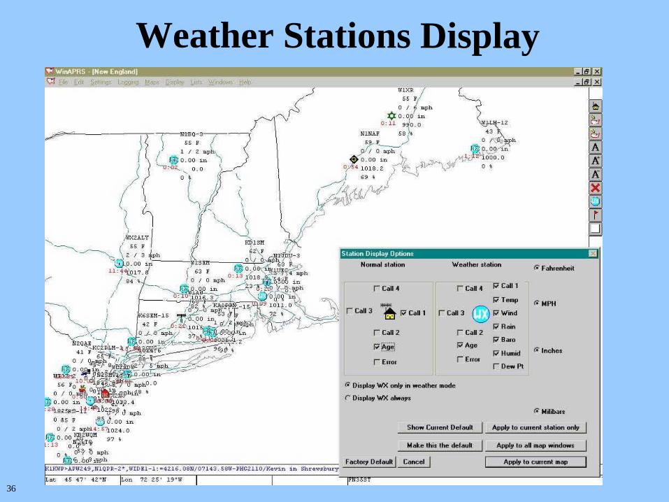
Weather Station Support and Reporting
• APRS can be used to make local weather observations available. – Used by the “Citizen Weather Observers Program”– Used by NWS, SKYWARN, etc…
• Peet Brothers Ultimeter or Davis Weather Station (and others) can be connected to APRS allowing data to be transmitted automatically to the network. – Temperature, Wind Speed, Wind direction, Rainfall, Humidity, Pressure
• Station can also manually enter data and send weather reports
Peet Brothers Ultimeter 2000 Weather Station
36
Weather Stations Display

37
Severe Weather Support • Highlights the geographical areas that currently have active
watches/warnings etc…• Uses the messaging and object support• Essentially the same geographical areas that NWS S.A.M.E.
(Specific Area Message Encoding) uses.• The APRS operator (or NWS/SKYWARN) can create objects for
Hurricanes, Tornadoes, Thunderstorms• As the status of the object changes the new status are shown to all
stations on the network• Notification of regions with watches and warnings can be sent and
these regions will be highlighted on maps.• Many NWS offices (including Taunton) have APRS support as
part of their SKYWARN program• MEMA has an APRS station in Framingham bunker

38
Example generated on Tuesday Sept 18,2001
Local NWS office can publish storm warnings on a area by area basis. Affected areas/counties will appear in silhouette

39 An
exa
mp
le f
rom
a lo
cal w
eath
er e
ven
t
40
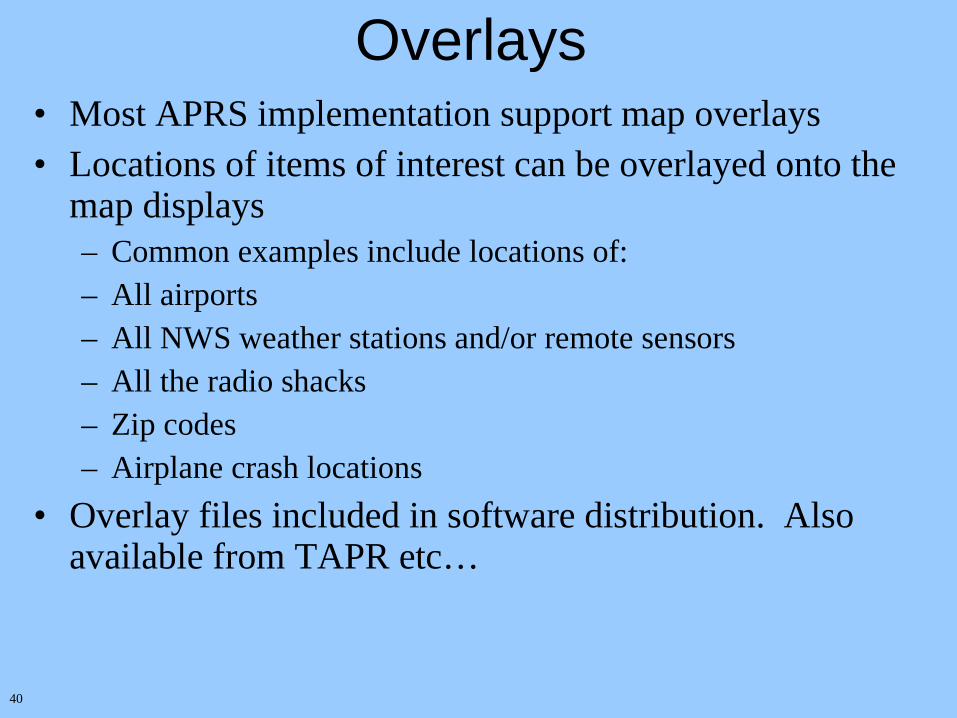
Overlays• Most APRS implementation support map overlays• Locations of items of interest can be overlayed onto the
map displays– Common examples include locations of:– All airports– All NWS weather stations and/or remote sensors– All the radio shacks– Zip codes– Airplane crash locations
• Overlay files included in software distribution. Also available from TAPR etc…

41
Ove
rlay
Exa
mp
le:
All
th
e R
adio
Sh
ack
s

42
APRS Internet SupportWWW.FINDU.COM
• For the last several years, the APRS internet system has been collecting APRS data from around the world and linking all the various local RF networks into a single real-time worldwide network– hundreds of simultaneous users– thousands of stations reporting. – about 300,000 packets a day. – driving force at this time is Steve Dimse (K4HG)
• Stores a single position and weather report for each station– no provision for any longer-term storage of the data.
• You can access this database from www.findu.com• Precautions have been taken to insure non-hams cannot get on the
air.

43
View of the worldwide APRS network using the Internet.
View of the USA APRS network using the Internet.

44
Stations Matching k1kwp* url: map.findu.com/k1kwp*
Position of K1KWP-418.8 miles northeast of WORCESTER, MAStatus: [email protected];on MMRA 53.81&146.61&449.925;Shrewsbury & N.Eastham MAReport received 6 hours 23 minutes 36 seconds agoRaw packet: K1KWP-4>GPSLJ,N1PWU-15*,WIDE2,W1TYL-00:$GPGLL,4225.715,N,07131.956,W,123221,A*35

45
Amateur Radio Stations heard via PCSat/NO-44http://www.findu.com/cgi-bin/pcsat.cgi

46
APRS on Satellites• Various satellites are configured to support APRS
packets– Easy way to get exposure to operating with satellites… small Doppler shifts
when using 2M… No special equipment (other than an APRS station)– APRS is an efficient way to share a single channel satellite – Immediate feedback on received station location
• The “birds”– MIR was the first. The station went down with ship.– Digipeater on the International Space Station – PCSAT
• APRS Internet support also shows APRS packets received from satellites from around the world
Note : Because operating parameters may change no frequency specifics are given in this presentation. However that information is available from URLs given in this presentation

47
MIR Space Station
K9YO>CQ,R0MIR*:Greetings from West Aurora High School ARC, K9YO and gangN5TAM>APW230,R0MIR*:=3225.55N/09749.00WPHG5160/[email protected] TXHOOGRANBURY230<530>KH2NC>CQ,R0MIR*:email [email protected]>BEACON:MIR SPACE STATIONK9YO>CQ,R0MIR*:Cedrick, Aurora, IL EN51 [email protected]>FN23AD,R0MIR*:welcome to woodstock, fn23R0MIR>QST:>MIR SPACE STATIONN5TAM>APW230,R0MIR*:=3225.55N/09749.00WPHG5160/[email protected] TXHOOGRANBURY230<530>N2LZH>FN23AD,R0MIR*:welcome to WoodstockR0MIR>QST::BLN1 :The MIR Crew & MIREX Team hopes you enjoy the R0MIR digipeaterN3ZLL>FM29BN,R0MIR*:Greetings from Maryland!K1KWP>APW227,R0MIR*:=4216.13N/07143.93WPHG0000/Kevin in Shrewsbury MA [email protected] N9YUK5>OLEYUK,R0MIR*:hello all mir chasers.....oleyuk@shwR0MIR>BEACON:MIR SPACE STATIONN4ZO>CQ,R0MIR*:http://www.users.sccoast.net/n4zo/n4zo.htmN3ZLL>FM29BN,R0MIR*:N5TAM>APW230,R0MIR*:=3225.55N/09749.00WPHG5160/[email protected] TXHOOGRANBURY230<530>N9YUK5>BEACON,R0MIR*:>> OLE YUK'S MIR SPACE CHASING SHACK <> CARRIER MILLS, IL. USAR0MIR>QST:>MIR SPACE STATIONN4ZO>CQ,R0MIR*:http://www.users.sccoast.net/n4zo/n4zo.htmN3ZLL>FM29BN,R0MIR*:Morning SteveR0MIR>BEACON:MIR SPACE STATIONKB0VBZ>DM79,R0MIR*:W4JXM>CQ,R0MIR*,DE,W4JXM:WA6YET>EM36EJ,R0MIR*:K1KWP>APW227,R0MIR*:N9WJJ>CQ,R0MIR*:KD4HBO>CQ,R0MIR*:HELLO N9WJJN1QAG>APR841,R0MIR*:=445 . N/0722 . Wy000/000/N.Troy.VTN2LZH>FN23AD,R0MIR*:FN23, Home of Woodstock 2004 !!!VE3CBJ7>T5RQ2X,R0MIR*:`gKvl />KB2UYF>HELLO,R0MIR*:R0MIR>QST:>MIR SPACE STATION
APRS was being tested on the Russian Space Station MIR.
MIR acted as a Wide Area Digipeater.
The HAM equipment went down with the ship.

48
International Space Station
VE4GLS-2>APW251,RS0ISS*:=4924.1 N/09718.2 W`>Gord, EN19; CQ Via ISS!N8IGJ>APW246,RS0ISS*:=4254.16N/08606.55W*PHG5170/[email protected] -MIOTTHOLLAND -246-<530>KD6UOI>APR851,RS0ISS*:;KD6UOI *021409z3639.59N/08202.85W`.../.../ABINGDON, VA [email protected]>APW251,RS0ISS*:=5027.35N\09657.23WUPHG3294/WinAPRS 2.5.1 Dunnottar, Mb, Ca [email protected] -251-<530>W2SKY>CQ,RS0ISS*,FN13GD,PETER:qsl k1kwp,w2kqKD6UOI>APR851,RS0ISS*:>021411zHELLO VIA THE INTERNATIONAL SPACE STATIONK1KWP-4>APK101,RS0ISS*::ALL :Greetings from FN51; Cape Cod; [email protected]{5K0TMH>ARISS,RS0ISS*:KB8KPV>CQ,RS0ISS*,EN75MH:Craig KB8KPV EN75MH Charlevoix MI [email protected]>APW246,RS0ISS*:=4129.43N/07259.16W-PHG3130/[email protected] Conrad -246-<530>KD6UOI>APR851,RS0ISS*:;KD6UOI *021409z3639.59N/08202.85W`.../.../ABINGDON, VA [email protected]>CQ:>ARISS - International Space StationKD6UOI>APR851,RS0ISS*:>021411zHELLO VIA THE INTERNATIONAL SPACE STATIONKA2HZO-3>CQ,RS0ISS*,FM29US,RON::ALL :Columbia Continues Hubble Chase DE KA2HZO Ron in NJVE2FCA>CQ,RS0ISS*:73's to all de francois n0an w9kao w2skyW9KAO>CQ,RS0ISS*:hi n0anKA2HZO-3>CQ,RS0ISS*,FM29US,RON:=3946.23N\07416.37WSGood Morning from the JERSEY SHORE [email protected]>4Q5R4S,RS0ISS*:'aW(l j/]>>FN42&FN51;[email protected]>CQ,RS0ISS*:GBA W9KAO,Schaumburg,ILVE2FCA>CQ,RS0ISS*:73's to all de francois n0an w9kao w2sky ve2mjy hi n8igj kb8kpv
The International Space Station is currently acting as a wide area digipeater
• Part of ARISS (http://ariss.gsfc.nasa.gov/)• Downlink (from ISS to Earth) on 2M. • Uplink (from Earth to ISS) is also a 2M frequency• APRS Equipment is in Russian part of the station.
Callsign is RS0ISS
49 Sta
tions
hea
rd v
ia I
SS
dig
ipea
ter
Feb
2002

50
NO-44 aka. PCSAT
Developed by Naval Academy Midshipmen for <50K$
Uses off the shelf components (tape measure for antennas)
Has generated a lot of interest!

51
Stations heard via PCSAT digipeater
Higher orbit allows greater contact range

52
K9KNW>RU5X6P,PCSAT1*:'mGtl v/>testVE3TKB>APM344,PCSAT1*,WIDE:=4430.05N/08014.05WMPHG1000/[email protected]iss/pcsat1wattbeacon ONSIMCOLLINGW344<063>VE3TKB>APM344,PCSAT1*,WIDE:=4430.05N/08014.05WMPHG1000/ve3tkb@sympatico44<063>PCSAT1>BEACON,SGATE:T#717,072,044,044,024,213,00111111,0100,1VE3TKB>APM344,PCSAT1*,WIDE:=4430.05N/08014.05WMPHG1000/[email protected]iss/pcsat1wattbeacon ONSIMCOLLINGW344<063>KG4RXU>S4TT6S,PCSAT1*,WIDE33:'n*El >/>[email protected]3>CQ,PCSAT1*,FM29US,RON:=3946.23N\07416.37WSHello via the PCSAT NO44 FRM [email protected] {UIVKA2KA2HZO3>CQ,PCSAT1*,FM29US,RON:Good Evening PCSAT (NO44) From Ron in NJ GOOD PASSWA4SAS3>3U0U4P,PCSAT1*:`lS=l >/>HELLO FROM CHARLOTTEWA4SSP7>3URY4X,PCSAT1*:'lVJl K\>Hello frm Denver,NCN8ULD>CQ,PCSAT1*,:DAVE,IN,BEXLEY,OH:WA4SAS3>3U0U4P,PCSAT1*:`lS=l >/>HELLO FROM CHARLOTTEKC5OXI>SQ5S4S,PCSAT1*,WIDE:'tW0nKOk/]"5=}SouthboundN0AN5>CQ,PCSAT1*,EN22XC,HASAN:>EN22XC/ "hasan" in Ogden, IA [email protected]1>BEACON,SGATE:T#821,015,033,110,098,213,00111111,0100,1K1KWP>APW251,PCSAT1*:=4216.08N/07143.58WPHG2110/Kevin; [email protected]; Shrewsbury MA; FN42 251<530>VE3TKB>APM344,PCSAT1*,WIDE:=4430.05N/08014.05WMPHG1000/[email protected]iss/pcsat1wattbeacon ONSIMCOLLINGW344<063>VE3TKB>APM344,PCSAT1*,WIDE:=4430.05N/08014.05WMPHG1000/[email protected]iss/pcsat1wattbeacon ONSIMCOLLINGW344<063>VE3TKB>APM344,PCSAT1*,WIDE:?APRS?K1KWP>APW251,PCSAT1*:=4216.08N/07143.58WPHG2110/Kevin; [email protected]; Shrewsbury MA; FN42 251<530>PCSAT1>BEACON,SGATE:T#137,015,033,044,024,213,00111111,0100,1N0AN5>CQ,PCSAT1*,EN22XC,HASAN:>EN22XC/ "hasan" in Ogden, IA [email protected]>APW251,PCSAT1*:=4216.08N/07143.58WPHG2110/Kevin; [email protected]; Shrewsbury MA; FN42 251<530>N0AN5>CQ,PCSAT1*,EN22XC,HASAN:>EN22XC/ "hasan" in Ogden, IA [email protected]1>BEACON,SGATE:T#241,015,033,044,024,213,00111111,0100,1N0AN5>CQ,PCSAT1*,EN22XC,HASAN:>EN22XC/ "hasan" in Ogden, IA [email protected]>APW251,PCSAT1*:=4216.08N/07143.58WPHG2110/Kevin; [email protected]; Shrewsbury MA; FN42 251<530>VE4KGB>APW251,PCSAT1*:=5027.35N\09657.23W*PHG3294/WinAPRS 2.5.1 Dunnottar, Mb, Ca [email protected] 251<530>PCSAT1>BEACON,SGATE:T#242,096,108,118,086,213,00111111,0101,1N0AN5>CQ,PCSAT1*,EN22XC,HASAN:>EN22XC/ "hasan" in Ogden, IA [email protected]1>APRS3::BLN3PCSAT:www.ew.usna.edu/pcsat for details of operating
RAW Traffic via PCSAT digipeater
PCsat, A Naval Academy Amateur Radio Satellite http://www.ew.usna.edu/~bruninga/pcsat.html

53
Stations can also receive and decode the telemetry packets which show the status of PCSAT
PCSAT control program screenshot

54
• APRS stations can transmit DF information that includes direction of the object signal from that QTH.
• Objects are added which correspond to non APRS stations participating in the hunt.
• These non-APRS stations of known location become part of the MAP that the whole network sees.
• Triangulation becomes possible. Every APRS station sees the bearings at the same time on the maps.
• Can be used with Omni-directional or beam antennas• Serial Interface to KA4IIA Doppler DF allows automatic
bearings to be sent
Direction Finding
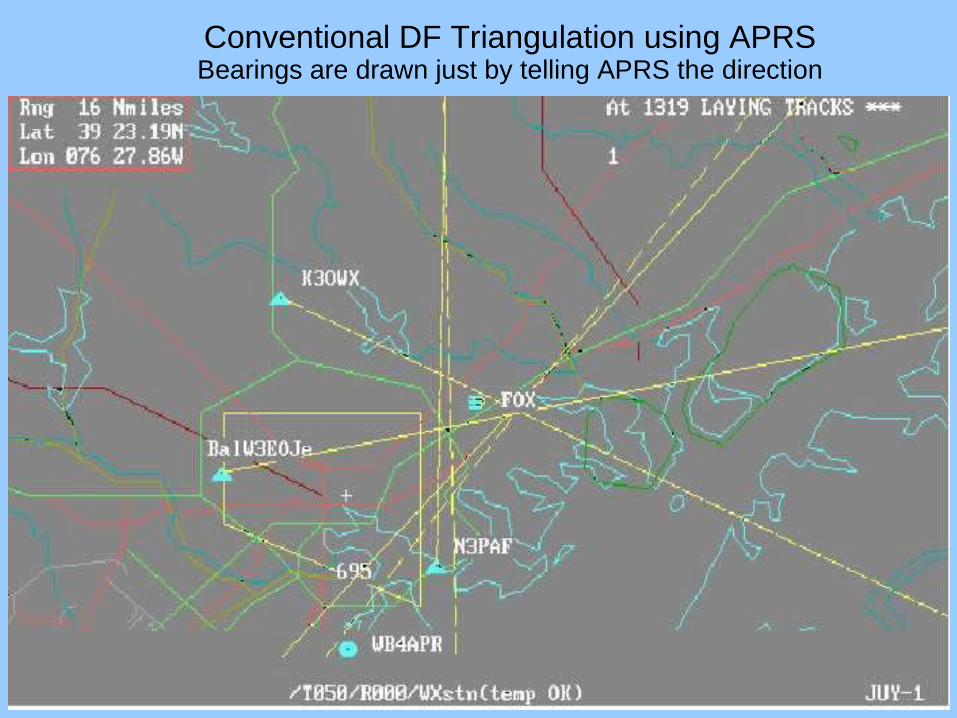
55
Conventional DF Triangulation using APRSBearings are drawn just by telling APRS the direction

56
D.F. Stations plotted on map

57
DF ing without beams!!Omni Stations NOT hearing Fox.

58
Omni stations that DO hear the Fox
59
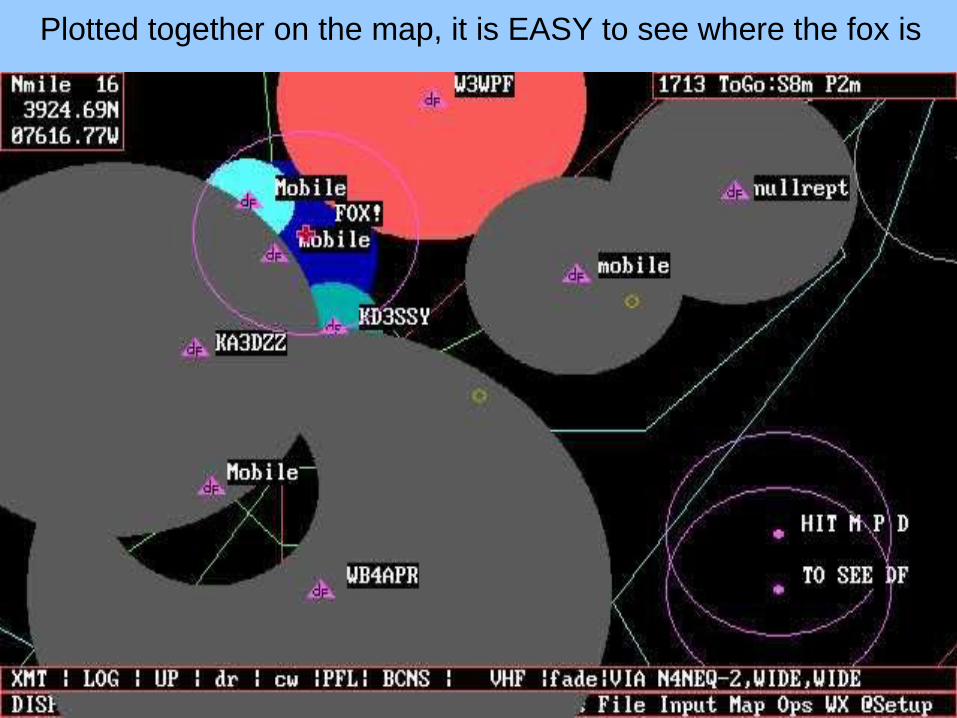
Plotted together on the map, it is EASY to see where the fox is

60
URLs:TAPR http://www.tapr.org/WB4APR APRS web page http://web.usna.navy.mil/~bruninga/aprs.htmlAPRS Satellite Tracking and Reporting System http://web.usna.navy.mil/~bruninga/astars.htmlAmateur Radio Stations heard via PCSat http://www.findu.com/cgi-bin/pcsat.cgiAmateur Radio Stations heard via ISS http://www.findu.com/cgi-bin/ariss/index.cgiA Very Questionable Page Indeed! http://www.dididahdahdidit.com/Geographical warning area support files: http://isl715.nws.noaa.gov/mapdata/newcat/
http://www.afcpo.com/na4v/nwszone.htmTNC to RADIO wiring diagrams http://www.packetradio.com/AX.25 Specification http://www.tapr.org/tapr/pdf/AX25.2.2.pdfAPRS specification ftp://ftp.tapr.org/aprssig/aprsspec/spec/aprs101/APRS101.zipCitizen Weather Observers Program http://www.fiu.edu/orgs/w4ehw/CWOP-Main.htmlKantronics web site http://www.kantronics.com/APRS FINDU Database Access http://www.findu.com/
Software:DOSAPRS http://www.tapr.org/tapr/html/softf.htmlUIVIEW http://website.lineone.net/~apritch/uiview.htmAPRS for Linux http://www.users.cloud9.net/~alan/ham/aprs/WINAPRS http://www.tapr.org/tapr/html/softf.htmlMACAPRS http://www.tapr.org/tapr/html/softf.htmljavAPRS http://www.aprs.net/javAPRS.htmlAPRSPOINT http://www.aprspoint.com/index.htmAPRS+SA http://www.tapr.org/~kh2z/aprsplus/


