Download - AWI 10_TargetAreas

8/3/2019 AWI 10_TargetAreas
http://slidepdf.com/reader/full/awi-10targetareas 1/21
Relating FrameworkThemes and Target ATARGET AREA PLANS6.
108 Target Areas and Table of Initiatives
110 Anacostia Park
112 Hill East Waterfront/ RFK Area
114 Poplar Point
116 East of the River Gateways
118 The Near Southeast Waterfront
120 The South Capitol Street Corridor
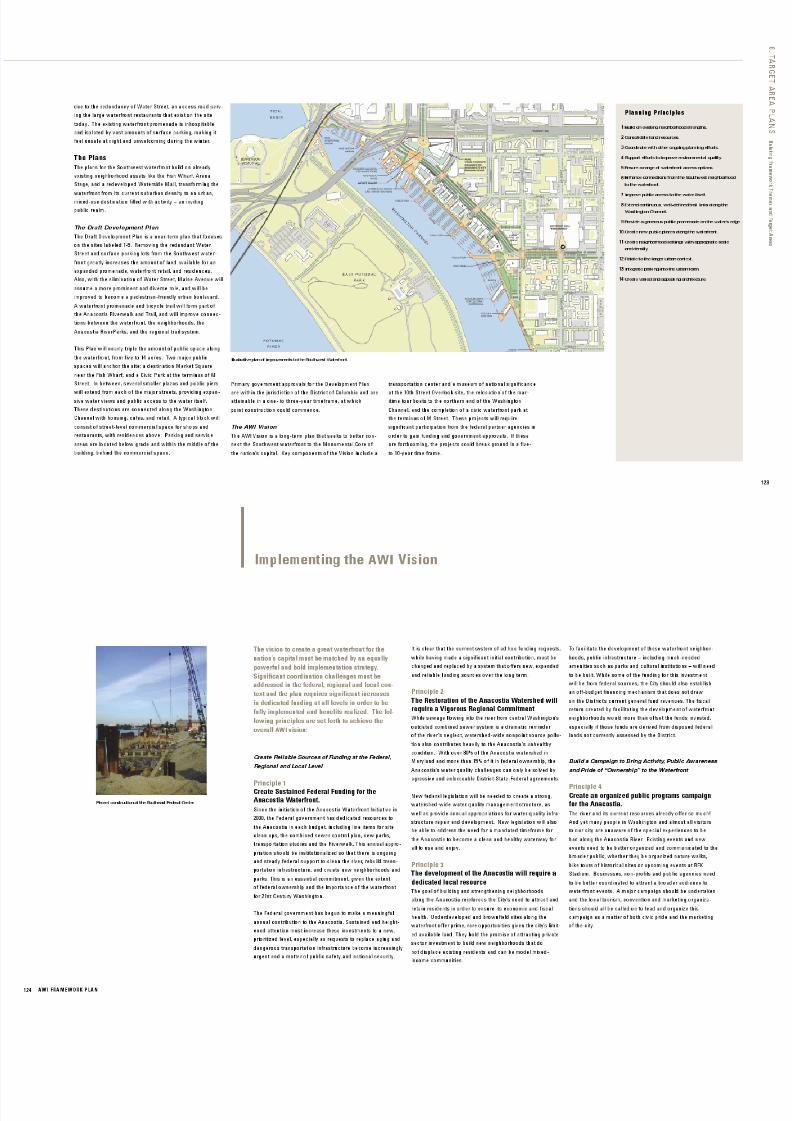
122 The Southwest Waterfront
124 Implementing the AWI Vision
The preceding chapters outlined an overall vision for the Anacostia waterfront, presenting
the goals of the Anacostia Waterfront Initiative in terms of five overarching themes and
planning intents. This chapter integrates the framework themes with the Target Areas,
studied in detail over the past two years.
The table on the next page provides a summary of the major Framework Plan recommendations
as they apply to each of the Target Areas. A summary of each Target Area follows.
The success of the Anacostia Waterfront Initiative will ultimately rest on how well the overall
vision and the many individual initiatives and places are woven together. The result of that
success will be a healthier and more accessible city, a more urbane, beautiful landscape, and
a more prosperous and just river environment.

8/3/2019 AWI 10_TargetAreas
http://slidepdf.com/reader/full/awi-10targetareas 2/21
AWI FRAMEWORK PLAN108
O v e r l a p p i n g t h e F r a m e w o r k T h e m e s w i t h t h e T a r g e t A r e a s
Framework Themes
“ I firmly believe this effort will
result in nothing less than the
transformation of the Anacostia
from a line of division within our
city into a great common ground.
We must strive to set our sights
high and create one of the greatest
waterfronts of any international
capital. We must do so in a man-
ner which is distinctly Washington.”
Mayor Anthony A. Williams,
March 2002 A Great RiverfrontPark System
A Riverfront of Distinct Placesand Cultural Destinations
Building and Sustaining Strong
Waterfront Neighborhoods
1
2
3
4
A Clean and Active River
Gaining Access to, Along, andAcross the River
5

8/3/2019 AWI 10_TargetAreas
http://slidepdf.com/reader/full/awi-10targetareas 3/21

8/3/2019 AWI 10_TargetAreas
http://slidepdf.com/reader/full/awi-10targetareas 4/21
110 AWI FRAMEWORK PLAN
Anacostia Park
VisionAs the centerpiece of the Anacostia RiverParks, Anacostia
Park will feature peerless waterfront parks in both natural
and urban settings.
The SiteAnacostia Park spans over 1,200 acres stretching seven miles
from the Frederick Douglass Memorial Bridge to the
D.C. /Maryland border. The park includes Kenilworth Parkand Aquatic Gardens, the Langston Golf Course, and the
areas known as Anacostia Park and Poplar Point. It is owned
and managed by the National Park Service.
The ProblemAnacostia Park is a multi-use, linear park with an extended
shoreline that suffers from disinvestment. It is difficult to
access from surrounding communities and confusing to find
for visitors. Most facilities are isolated from each other,
and no continuous park experience is possible due to frag-
mentation by highways and a railroad. Being a pedestrian
in Anacostia Park is a daunting experience.
The PlanLinking the disparate pieces of the park together with the
Anacostia Riverwalk and Trail and an improved park
road system will unify Anacostia Park and other open spaces
along the river into a continuous park corridor, the
Anacostia RiverParks. Integrating the park into a larger
regional system will transform the green areas into
an extended “emerald necklace,” helping to join the city
together and offering unique experiences along water-
ways in the Washington metropolitan region.
DEVELOPMENT GOAL
250 acres
750 acres
25 sites
45+ acres
48 miles
USE
Active recreation areas
and facilities
Open space/habitat
Commemorative spaces
Cultural facilities
Riverwalk, trails, and
promenades
The Vision: The Anacostia Riverwalk and Trail.
Kenilworth Park t oday.
Illustrative plan of Anacostial Park.
"Peerless waterfr ont parks in both natural and urban settings."

8/3/2019 AWI 10_TargetAreas
http://slidepdf.com/reader/full/awi-10targetareas 5/21
Kingman and Heritage Islands
The Target Area.
The Site: Kingman and Heritage Islands today.
The Vision: Restored wetlands and a Nature Center.
Illustrative plan of Kingman and Heritage Islands.
"Creating a living classroom."
VisionThese islands will become a city-wide resource for environ-
mental education, habitat exploration, and reflection.
The SiteKingman and Heritage Islands were created by the U.S.
Army Corps of Engineers (US-ACE) in 1916, from
dredge taken out of the Anacostia River. Kingman Island
is one-and-a-half miles long with 45 acres of land. It isbisected by Benning Road, NE, and the northern half is
owned by the National Park Service as part of Langston
Golf Course. Heritage Island, located west of Kingman
Island, comprises five acres. Since 2000 the islands have
been under the jurisdiction of the District of Columbia.
The ProblemThe islands were originally planned as a recreational area
for the surrounding neighborhoods. However, they have
been neglected and abused for many years. An environmen-
tal assessment by the US-ACE indicates that the soil is
safe for normal contact, requiring only minor remediation.
Currently, the islands are closed to the public, except for
special programs and events, until site and habitat restora-
tion are completed.
The PlanRestoration progress has already been made. A 100-foot
wooden bridge has been reconstructed by the Navy Sea
Bees. And in 2000, the Environmental Health Administration
restored over 41 acres of historic tidal freshwater marshin Kingman Lake, abutting the islands, at a cost of over
$7 million. The plan for Kingman and Heritage Islands
includes a new nature and exhibit center, self-guided
nature trails and a memorial tree grove.

8/3/2019 AWI 10_TargetAreas
http://slidepdf.com/reader/full/awi-10targetareas 6/21

8/3/2019 AWI 10_TargetAreas
http://slidepdf.com/reader/full/awi-10targetareas 7/21

8/3/2019 AWI 10_TargetAreas
http://slidepdf.com/reader/full/awi-10targetareas 8/21

8/3/2019 AWI 10_TargetAreas
http://slidepdf.com/reader/full/awi-10targetareas 9/21
8/3/2019 AWI 10_TargetAreas
http://slidepdf.com/reader/full/awi-10targetareas 10/21

8/3/2019 AWI 10_TargetAreas
http://slidepdf.com/reader/full/awi-10targetareas 11/21

8/3/2019 AWI 10_TargetAreas
http://slidepdf.com/reader/full/awi-10targetareas 12/21

8/3/2019 AWI 10_TargetAreas
http://slidepdf.com/reader/full/awi-10targetareas 13/21

8/3/2019 AWI 10_TargetAreas
http://slidepdf.com/reader/full/awi-10targetareas 14/21

8/3/2019 AWI 10_TargetAreas
http://slidepdf.com/reader/full/awi-10targetareas 15/21

8/3/2019 AWI 10_TargetAreas
http://slidepdf.com/reader/full/awi-10targetareas 16/21

8/3/2019 AWI 10_TargetAreas
http://slidepdf.com/reader/full/awi-10targetareas 17/21

8/3/2019 AWI 10_TargetAreas
http://slidepdf.com/reader/full/awi-10targetareas 18/21

8/3/2019 AWI 10_TargetAreas
http://slidepdf.com/reader/full/awi-10targetareas 19/21

8/3/2019 AWI 10_TargetAreas
http://slidepdf.com/reader/full/awi-10targetareas 20/21

8/3/2019 AWI 10_TargetAreas
http://slidepdf.com/reader/full/awi-10targetareas 21/21


