
Beijing Series Earth Observation Satellites and Services
Lisbon, May 2015
Dr. Wei Sun
International Marketing Director
Twenty First Century Aerospace Technology (21AT)

2
Introduction
EO satellite operator based in Beijing, 300+ employees.
Since 2005, the company has been providing EO data
and value added service in China.
EO satellite resources:
Beijing-1, 4m PAN/32m MS, 2005~2012
Tripe Satellite Constellation, 1m PAN/4m MS, will be
launched in Middle of 2015
Beijing -1 International data distribution through DMC
and disaster response through International Charter.
21AT will provide Triple Satellite Constellation image to
worldwide customers.
Located in Zhongguancun Science
and Technology Park
Haidian District, Beijing
First and Only Commercial EO Satellite Operator in China

First space-ground integrated small EO satellite system in China
3
Data Processing System
Data Distribution
Image Data Receiving
Imaging Scheduling and Tasking
Applications &Information Services
Satellite Operation (TT&C in Beijing)
12m 7.5m
Rapid Response, “Guaranteed Data” and Efficient Delivery
From Satellite Operation to Information Services
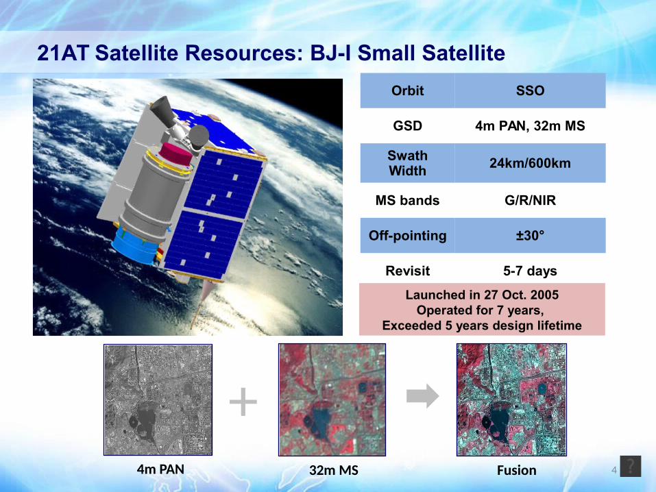
44m PAN 32m MS Fusion
Launched in 27 Oct. 2005Operated for 7 years,
Exceeded 5 years design lifetime
+
21AT Satellite Resources: BJ-I Small Satellite
Orbit SSO
GSD 4m PAN, 32m MS
Swath Width
24km/600km
MS bands G/R/NIR
Off-pointing ±30°
Revisit 5-7 days

First purposely built <1m 3 identical satellite constellation with global daily revisit capability
21AT satellite resources: Triple Satellite Constellation
Sat. Num. 3
OrbitSSO, 650km
LTAN:10:30am
GSD PAN: 1m, MS: 4m
Swath Width 23km
MS bands B/G/R/NIR
Off-pointing ±45°
Revisit 1 day
Manufacturer SSTL in UK
Launching in July by Indian PSLV and providing image in October 2015 5
6
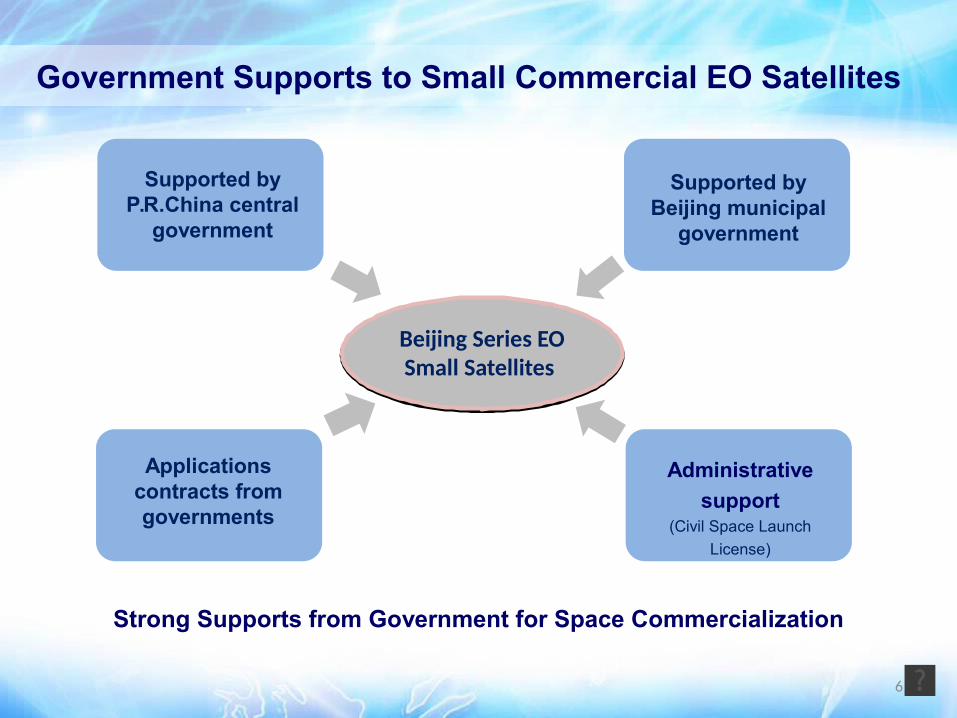
Government Supports to Small Commercial EO Satellites
Administrative
support(Civil Space Launch
License)
Beijing Series EOSmall Satellites
Strong Supports from Government for Space Commercialization
Supported by Beijing municipal
government
Applications contracts from governments
Supported by P.R.China central
government
Low cost small satellite constellation is an solution for operational services 7
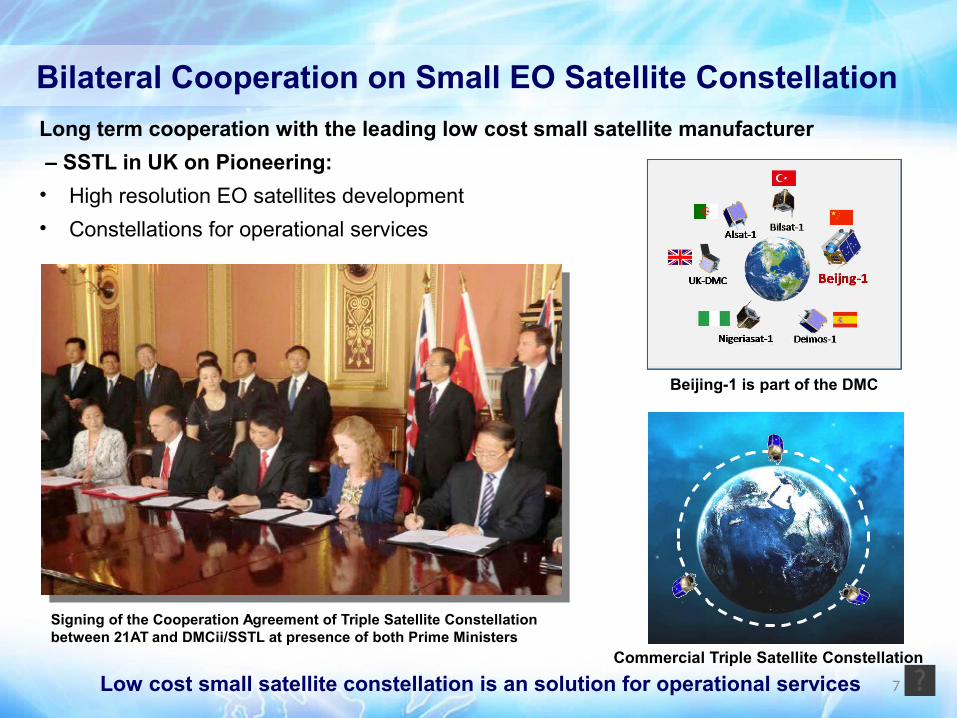
Signing of the Cooperation Agreement of Triple Satellite Constellation between 21AT and DMCii/SSTL at presence of both Prime Ministers
Bilateral Cooperation on Small EO Satellite Constellation
Long term cooperation with the leading low cost small satellite manufacturer
– SSTL in UK on Pioneering:
• High resolution EO satellites development
• Constellations for operational services
Beijing-1 is part of the DMC
Commercial Triple Satellite Constellation

8
Agriculture Statistics Bureau
Environment Protection Bureau
Water Admin. Bureau
Land Resource Mgmt. Bureau
Urban Afforestation Bureau
Bureau of Infrastructure and Facilities
Agricultural insurance RS Surveillance
Agricultural Facility Modernization re Surveillance
Agricultural Plantation Monitoring
Land Surface Thematic Surveillance
Regional Eco-environment Analysis
Eco-environment Engineering Management
Land Surface Water Resource management
Water Pollution Monitoring
Land Use Dynamic Monitoring
Land Use Verification
Land use registration and reporting
Disaster survey and monitoring
Monitoring of Land Illegal use
Forestry resource management
Aforestation and virescence Engineering Surveillance
Engineering Project Dynamic Monitoring
Urban Planning Precision management
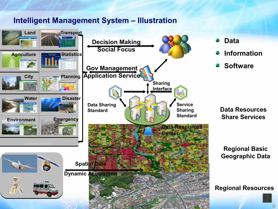
Services Overview of Intelligent City Management System
More than 100 Services for 11 government departments that can be classified into 6 categories. The following is the six major government departments served:
City Government
9
Regional Resources
Regional Basic Geographic Data
Spatial Data
Dynamic Acquisition
Service Sharing Standard
Data Sharing Standard
Sharing Interface
Gov ManagementApplication Service
……………………
Land
City
Water
Statistics
Environment
Agriculture
Transport
Planning
Disaster
Emergency
Data
Information
Software
Decision MakingSocial Focus
Data Resources Share Services
Data Resources Center
Intelligent Management System – Illustration

城市绿地
城市绿地
城市绿地
城市绿地
湿地
湿地道路
楼房区
平房区
楼房区
平房区
平房区
楼房区
楼房区
楼房区楼房区
楼房区楼房区
建筑施工裸地
建筑施工裸地
建筑施工裸地
Information Interpretation Process
10
Thematic Remote Sensing Information Products
11
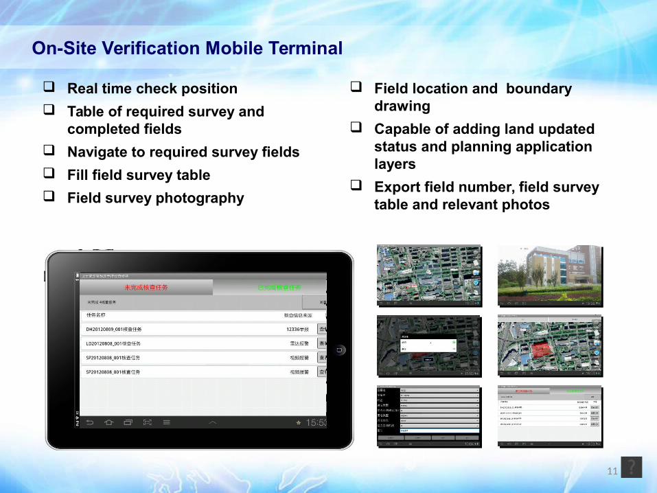
Real time check position
Table of required survey and completed fields
Navigate to required survey fields
Fill field survey table
Field survey photography
Field location and boundary drawing
Capable of adding land updated status and planning application layers
Export field number, field survey table and relevant photos
On-Site Verification Mobile Terminal
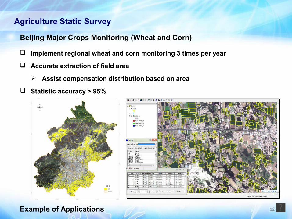
Agriculture Static Survey
Beijing Major Crops Monitoring (Wheat and Corn)
Implement regional wheat and corn monitoring 3 times per year
Accurate extraction of field area
Assist compensation distribution based on area
Statistic accuracy > 95%
12Example of Applications

13
Benefits
Statistic work efficiency improved significantly
Number of sample sites reduced by 40%
Manpower needed for basic survey reduced by 75%
Enhance accuracy and update frequency of statistic data
No. of Corn Sample Sites No. of Wheat Sample Sites
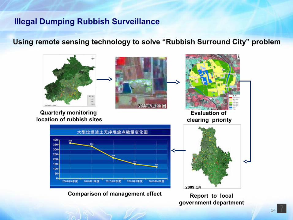
Quarterly monitoring location of rubbish sites
Change Display2009 Q4
Report to local government department
Evaluation of clearing priority
2010年第四季度2010 Q4
Comparison of management effect
Using remote sensing technology to solve “Rubbish Surround City” problem
Illegal Dumping Rubbish Surveillance
14

Illegal Dumping Rubbish Surveillance
Before After
15

Environment Impacts from Surrounding Provinces - the only way to collect such information
Air pollution sources identified from satellite imagery
Beijing
Hebei Province
Tianjing
4 KM
Cement factory
Sand Mining
16
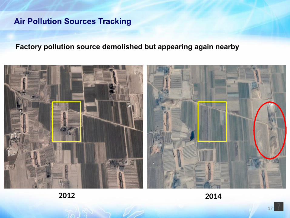
Air Pollution Sources Tracking
Factory pollution source demolished but appearing again nearby
2012 201417
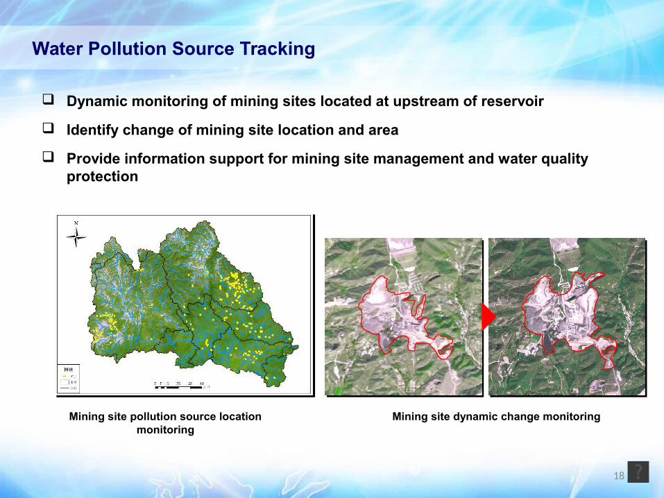
Mining site pollution source location monitoring
Water Pollution Source Tracking
Mining site dynamic change monitoring
Dynamic monitoring of mining sites located at upstream of reservoir
Identify change of mining site location and area
Provide information support for mining site management and water quality protection
18
19
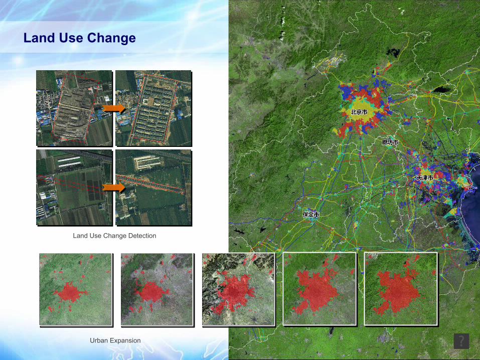
Land Use Change
Land Use Change Detection
Urban Expansion

.
.
.
.
.
.
Fire in Greece 2007Tsunami in Japan 2011Thailand Flood in 2011
Fire in Australia 2009Earthquake in Turkey 2011
20
Disaster Monitoring
Through International Charter
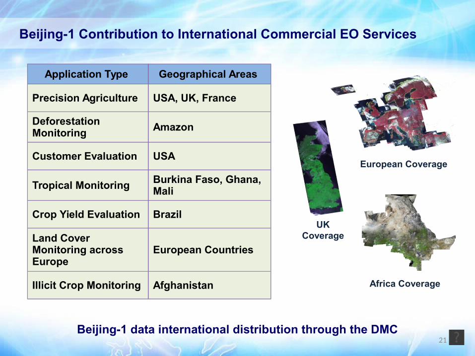
Africa Coverage
UK Coverage
European Coverage
Application Type Geographical Areas
Precision Agriculture USA, UK, France
Deforestation Monitoring Amazon
Customer Evaluation USA
Tropical Monitoring Burkina Faso, Ghana, Mali
Crop Yield Evaluation Brazil
Land Cover Monitoring across Europe
European Countries
Illicit Crop Monitoring Afghanistan
21Beijing-1 data international distribution through the DMC
Beijing-1 Contribution to International Commercial EO Services
22
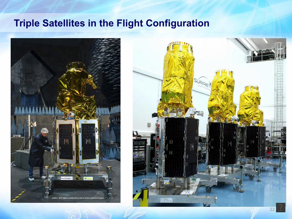
Triple Satellites in the Flight Configuration

Image Products: Basic imagery: 1m Pan/4m MS(G/R/B/NIR); Advanced imagery: Ortho, Mosaic, Pansharp, Stereo
Services Operational Monitoring based on guaranteed timely data
Change detection of interested features Change detection of targeted area
Guaranteed daily image acquisition – polar region or
emergency Land cover feature extraction Direct Receiving Station (DRS)
Applications City intelligent management
Image acquisition, information extraction, all data sources
integration, analysis/reporting and operational management
software
Products and Services from Triple Satellite Constellation
23
Information Services
Image Products
Software Products

24
Online Portal
Online Portal used to order Tripe Satellite Constellation imagery products
Most efficient way to find the image you want
24/7 ordering and delivery

25
Daily Imaging Anywhere on the Earth Triple Satellite Constellation launched by a single launcher Phasing three satellites 120° to form the ideal constellation Able to target anywhere on the Earth once per day using off-pointing capability
(45°Max.)
With frequent revisit capability, offering “quarterly guaranteed data” services
LatitudeOff-pointing / revisit period
5° 15° 25° 35°
0° 8 days 3 days 2 days Daily
±10° 8 days 3 days 2 days Daily
±20° 8 days 3 days 2 days Daily
±30° 7 days 3 days 2 days Daily
±40° 7 days 2 days 2 days Daily
±50° 6 days 2 days Daily Daily
±60° 4 days 2 days Daily Daily
±70° 3 days Daily Daily Daily
±80° 2 days Daily Daily Daily

26
Benefits to Worldwide Customers
The best combination of spatial resolution and time resolution
• <1m with 23km swath width that is the up limit of all very high resolution satellites
Identical payloads plus cross calibration over three satellites
• Convenient for quicker applications
High on-board geolocation accuracy
• Less ground reference points needed, less time and cost for map production
Stereo imaging and area imaging capabilities
• More applications are able to be created
24/7 imaging tasking plus large on-board memory
• Responsiveness and efficient cloud free image acquisition and download
“Earth surface change monitoring and intelligent management system”
• Creating new business opportunity for our customers
Comprehensive application expertise
• Provide in depth application supports


