
BELLS LINE OF ROAD CORRIDOR IMPROVEMENT PROGRAM
INFORMATION TO SUPPORT REFERRAL UNDER PART 3 OF ENVIRONMENT PROTECTION AND BIODIVERSITY CONSERVATION ACT 1999 (EPBC 2014/7346)
Preliminary documentation MAY 2015 Roads and Maritime Services 15.225 ISBN 978-1-925357-13-4


Preliminary Documentation supporting EPBC Act referral
NB00042 4201-RP-EV-076-Bells Line of Road Preliminary Documentation for DoE ii
Contents
1. Introduction ................................................................................................................................................ 1
1.1 Purpose .......................................................................................................................................................................................... 1
1.2 Description of the action ................................................................................................................................................................. 1
1.3 Changes to the action since referral ............................................................................................................................................... 3
2. Community and socio-economic ............................................................................................................. 9
2.1 Public consultation activities ........................................................................................................................................................... 9
2.1.1 Consultation – strategic level .......................................................................................................................................................... 9
2.1.2 Consultation – project level ............................................................................................................................................................. 9
2.2 Socio-economic aspects of the action .......................................................................................................................................... 10
2.2.1 Long-term benefits of the action ................................................................................................................................................... 10
2.2.2 Economic appraisal of overtaking lanes ...................................................................................................................................... 11
2.2.3 Employment opportunities ............................................................................................................................................................ 11
2.2.4 Capital investment and on-going value of the project ................................................................................................................... 12
2.2.5 Principles of Ecological Sustainable Development ....................................................................................................................... 12
2.2.6 Other matters of national environmental significance ................................................................................................................... 13
3. Offset Strategy Overview ........................................................................................................................ 14
3.1 Objectives ..................................................................................................................................................................................... 14
3.2 Potential offset sites subject to investigation ................................................................................................................................ 14
4. Offset Strategy Methodology ................................................................................................................. 16
4.1 Developing criteria for selection of offset sites.............................................................................................................................. 16
4.2 Desktop analysis ........................................................................................................................................................................... 16
4.3 Assessing landscape value........................................................................................................................................................... 17
4.4 Detailed field assessment of shortlisted sites ............................................................................................................................... 17
4.4.1 Vegetation classification and mapping.......................................................................................................................................... 17
4.4.2 Vegetation quality assessment ..................................................................................................................................................... 17
4.5 Determining adequacy of offsets .................................................................................................................................................. 20
4.5.1 EPBC Act Environmental Offsets Policy ....................................................................................................................................... 20
5. Biodiversity values .................................................................................................................................. 21
5.1 The Islands ................................................................................................................................................................................... 21
5.1.1 Geology and soils ......................................................................................................................................................................... 21
5.1.1.1 Lots 51 & 52 751658 ..................................................................................................................................................................... 21
5.1.2 Lot 140 DP 751658 ....................................................................................................................................................................... 21
5.1.3 Vegetation types ........................................................................................................................................................................... 21
5.1.3.1 Lots 51 and 52 751658 ................................................................................................................................................................. 21
5.1.4 Lot 140 DP 751658 ....................................................................................................................................................................... 22
5.2 Vegetation and habitat types ........................................................................................................................................................ 22
5.3 Vegetation and habitat quality ...................................................................................................................................................... 27
5.4 Fauna habitats .............................................................................................................................................................................. 27
5.5 Presence of target Threatened Ecological Community ................................................................................................................ 29
5.5.1 Turpentine-Ironbark Forest in the Sydney Basin Bioregion .......................................................................................................... 29

Preliminary Documentation supporting EPBC Act referral
NB00042 4201-RP-EV-076-Bells Line of Road Preliminary Documentation for DoE iii
6. Landscape values .................................................................................................................................... 32
6.1 ‘The Islands’ .................................................................................................................................................................................. 32
6.1.1 Strategic location .......................................................................................................................................................................... 32
6.1.2 Percentage native vegetation cover ............................................................................................................................................. 32
6.1.3 Vegetation patch size ................................................................................................................................................................... 32
7. Recommended offsets package ............................................................................................................ 34
7.1 Commitment to offsets for the project ........................................................................................................................................... 34
7.2 Adequacy of the offset .................................................................................................................................................................. 35
7.2.1 EPBC Act Environmental Offsets Policy ....................................................................................................................................... 35
7.2.2 EPBC Act Offsets Assessment Guide and Offsets Calculator ...................................................................................................... 37
8. Offset area management framework ..................................................................................................... 40
8.1 Options for securing the biodiversity offset site(s) in perpetuity.................................................................................................... 40
8.2 Aims and objectives ...................................................................................................................................................................... 40
8.3 Management considerations ......................................................................................................................................................... 40
8.3.1 Existing threats to biodiversity at ‘The Islands’ ............................................................................................................................. 41
8.3.2 Existing infrastructure ................................................................................................................................................................... 41
8.3.3 Interim management framework ................................................................................................................................................... 41
8.3.4 Long term management framework .............................................................................................................................................. 42
9. Summary and conclusions ..................................................................................................................... 45
10. References ............................................................................................................................................... 47
Appendix A. Photos of vegetation types within the potential offset properties
Appendix B. Threatened Species Scientific Committee’s description of Turpentine-Ironbark Forest in the Sydney Basin Bioregion
Appendix C. Species list from ‘The Islands’
Appendix D. Offsets guide calculations
Appendix E. Letter from landowner of “islands’ property
Appendix F. Letter of in principle support from the OEH
Figure 1-1 Location of the proposed overtaking lanes ............................................................................................................................... 2
Figure 1-2 Overtaking Lane 2: impacted areas of Turpentine-Ironbark Forest in the Sydney Basin Bioregion ................................ 4
Figure 1-3 Overtaking Lane 3: impacted areas of Turpentine-Ironbark Forest in the Sydney Basin Bioregion ................................ 5
Figure 1-4 Overtaking Lane 5: impacted areas of Turpentine-Ironbark Forest in the Sydney Basin Bioregion ................................ 6
Figure 1-5 Overtaking Lane 6: impacted areas of Turpentine-Ironbark Forest in the Sydney Basin Bioregion ................................ 7
Figure 1-6 Overtaking Lane 7: impacted areas of Turpentine-Ironbark Forest in the Sydney Basin Bioregion ................................ 8
Figure 3.1 : Location of the three inholding lots located at ‘The Islands’ embedded within the Wollemi National Park ................... 15
Figure 4.1 : Location of field survey effort at ‘The Islands’ ................................................................................................................... 18
Figure 4.3: Biobanking plot layout used in the field surveys ................................................................................................................ 19
Figure 5.1: Vegetation types, habitat types and condition at ‘The Islands’ ......................................................................................... 23
Figure 6.1 : Landscape assessment circles for ‘The Islands’. Blue circles are the 100ha assessment area. Yellow circles are the 1,000 ha assessment area. 33

Preliminary Documentation supporting EPBC Act referral
NB00042 4201-RP-EV-076-Bells Line of Road Preliminary Documentation for DoE 1
1. Introduction
1.1 Purpose
In September 2014, Roads and Maritime Services NSW (Roads and Maritime) submitted a referral under the
Environment Protection and Biodiversity Conservation Act 1999 (EPBC Act) concerning safety works along the
Bells Line of Road between Mount Tomah and Kurrajong Heights, NSW (EPBC 2014/7346). Subsequently, on 5
November 2014 the Commonwealth Department of the Environment (DoE) determined the project to be a
controlled action and would be assessed by preliminary information. This submission responds to the request
for Preliminary Documentation Information to further support and enable assessment of the relevant impacts of
the action in accordance with EPBC Act requirements.
1.2 Description of the action
Roads and Maritime propose to undertake safety improvement works along Bells Line of Road between Mount
Tomah and Kurrajong Heights. This comprises overtaking lanes at a total of seven sites. The referral applies to
five of these sites: Overtaking Lanes 2, 3, 5, 6 and 7.
The referred action involves widening sections of Bells Line of Road and adding about six kilometres of
additional overtaking lane at five separate locations. The works are part of the implementation of the joint NSW-
Commonwealth Bells Line of Road Long Term Strategic Corridor Plan (Australian and NSW Governments,
2012), which was completed in 2012 following community consultation.
The five sites that are subject of this referral are located in the Hawkesbury and Blue Mountains local
government areas, within the Sydney Basin bioregion (former Hawkesbury-Nepean Catchment Management
Area in the Wollemi sub-region), and shown in Figure 1-1.
The project has been referred to the Department of the Environment under Part 3 of the EPBC Act: specifically
with respect to potentially significant impacts on listed threatened species and communities (section 18), as it
may result in a cumulative loss of up 2.67 hectares of high condition Turpentine-Ironbark Forest in the Sydney-
Basin Bioregion (TIF) (critically endangered on EPBC Act). It is noted that the extent of vegetation impact has
slightly increased by 0.55 hectares since the original referral was submitted (with an estimated impact of 2.12
hectares). The changes to the proposal and the reasons for these are discussed in section 1.3.
The clearing of 2.67 hectares is in addition to 0.47 ha of TIF which was previously removed as part of an earlier
project at Bilpin on Bells Line of Road (referred to as Overtaking Lane 4 – OT4), which lies between the scope
of the current works at Kurrajong and Mount Tomah (SMEC 2014). OT4 has already been completed following
a separate, earlier environmental assessment, and is not part of this referral. However, Roads and Maritime is
also committed to an additional, complementary offset to address the 0.47 ha from OT4, as detailed in Chapter
7.
Each section of works will be the subject of detailed environmental assessment to meet the requirements of
Part 5 of the NSW Environmental Planning and Assessment Act 1979 (EP&A Act). This will involve completion
of a Review of Environmental Factors (REF) for each overtaking lane, which will include consideration of the full
range of potential environment impacts, including on biodiversity, together with identification of relevant
mitigation measures and environmental safeguards.
Funding to complete the proposed action is being provided though the Infrastructure NSW ‘Restart NSW’ fund
and other State government sources. Australian Government funding does not form part of the budget
allocation.

!
!
!
!
!
!
!
!
Bells Line of Road
GREAT WESTERN HIGHWAY
HAWKESBURYLGA
BLUE MOUNTAINSLGA
OBERON LGA
LITHGOWLGA
PENRITHLGA
Blue MountainsNational Park
WollemiNational Park
BLACKHEATH
KATOOMBA
KURRAJONG HEIGHTS
LITHGOW
MOUNT TOMAH
MOUNT VICTORIA
RICHMOND
SPRINGWOOD
C
LI F F D RI
VE
TERRACE ROAD
SPR
ING
WO
OD
ROAD
MO UNTIRVINE R O
AD
BLAXLAND S RIDGE
RO
AD
LON
DO
ND
ERR
Y R
OAD
CAS
TLER
EAGH
ROAD
MEG AL
O
NG
ROAD
0 5 10 Kilometres
NSW
SPA
TIA
L - G
IS M
AP
file
: N
B00
042_
420_
BLo
R_E
PB
C_F
001_
r2v1
!«N#
I:\NBIF\Projects\NB00042\General\Technical\Survey & GIS\GIS\GIS_Directory\ArcMap\Figures\TechnicalReports\BLoR\EPBC\NB00042_420_BLoR_EPBC_F001_r2v1.mxd
Figure 1-1 Location of proposed action EPBC REFERRALBells Line of Road
Length of Bells Line of Road relevantto the proposed action
Local Government National Park
!
!
!
!
LITHGOW
NEWCASTLE
RICHMOND
SYDNEY

Preliminary Documentation supporting EPBC Act referral
NB00042 4201-RP-EV-076-Bells Line of Road Preliminary Documentation for DoE 3
1.3 Changes to the action since referral
While the over-arching aim has remained to avoid and minimise impacts on the environment, further design
analysis has revealed some key constraints including:
Confirmed boundaries of the Blue Mountains and Wollemi national parks and World Heritage Area, which
must be avoided as they are subject to strict legal protections
Cost and bushfire constraints associated with electricity infrastructure
Private property constraints.
Detail design has resulted in design refinement primarily associated with road safety improvements, avoidance
and reduction of private property acquisition, drainage strategy, confirmation of Endeavour Energy design
requirements for bushfire prone areas and capital cost of the improvement. On the whole the changes are minor
refinements to the overall proposal, and the action as described within this document remains substantially the
same as that described in the original referral.
Consequently, since the submission of the referral under the Environmental Protection and Biodiversity
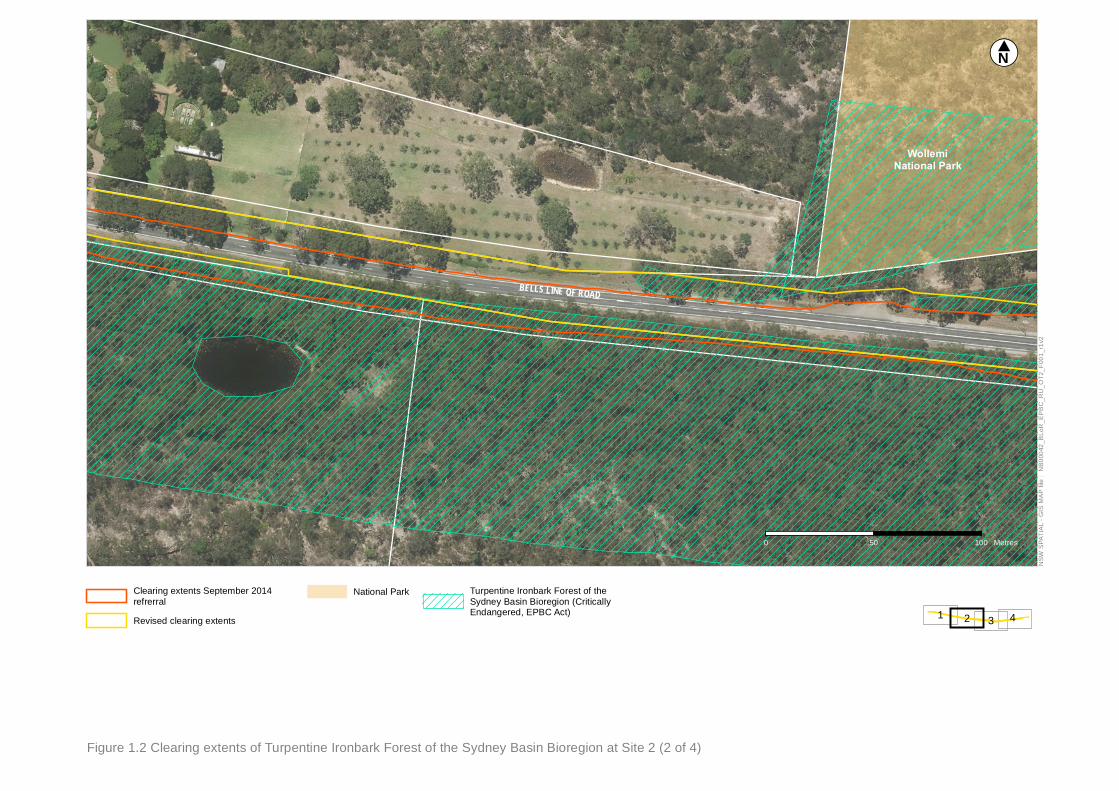
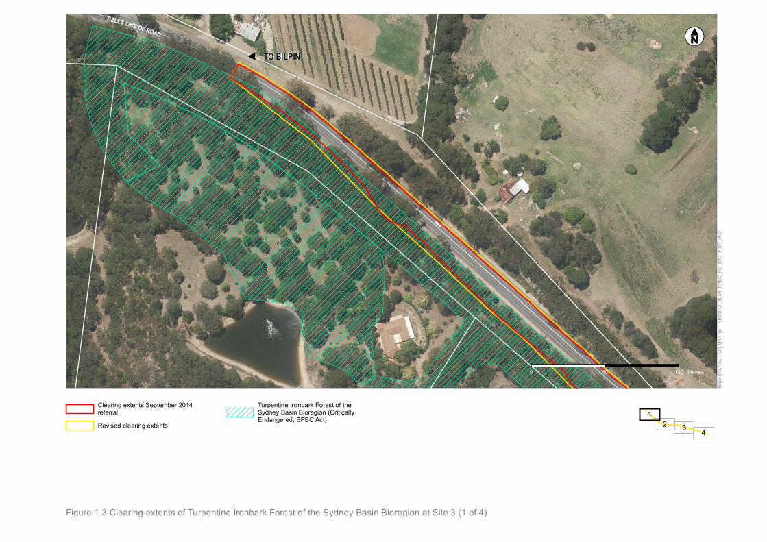
Conservation Act 1999 (26 September 2014), the proposed clearing areas of TIF has changed.
These design refinements have cumulatively resulted in increased TIF clearing from 2.12 hectares to 2.67
hectares. For some overtaking lanes a reduction on impacts to TIF has been possible, while in others the
impact has increased. OT7 represents the largest change in impact. At this location, the confirmed boundary of
the national park and associated World Heritage Area has necessitated realignment from the northern to
southern side of the existing road to avoid impacts on these areas.
The following table summarises changes to the TIF clearing extents since referral.
Table 1-1 Changes in TIF clearing extents since original referral
Site
EPBC – Turpentine-Ironbark Forest in the Sydney Basin Bioregion (hectares)
Referral clearing area (concept design) Final clearing area (detail design)
OT2 0.60 0.59
OT3 1.14 1.40
OT5 0.15 0.01
OT6 0.16 0.25
OT7 0.07 0.42
Total 2.12 2.67
It is noted that no additional matters of national environmental significance (MNES) are impacted by the
changes.
Figure 1.2 to Figure 1.6 provide details of the extent of clearing to TIF threatened ecological community and the
changes which have now occurred since referral.

TO BILPIN
" BELLS LINE OF ROAD
GLENARA ROAD
PITT
MANS
ROA
D
0 50 100 Metres
NSW
SPA
TIA
L - G
IS M
AP
file
: N
B00
042_
BLo
R_E
PB
C_R
U_O
T2_F
001_
r1v2
!«N#
I:\NBIF\Projects\NB00042\General\Technical\Survey & GIS\GIS\GIS_Directory\ArcMap\Figures\TechnicalReports\BLoR\EPBC\ReportUpdate\NB00042_BLoR_EPBC_RU_OT2_F001_r1v2.mxd
Figure 1.2 Clearing extents of Turpentine Ironbark Forest of the Sydney Basin Bioregion at Site 2 (1 of 4)
3 421
Clearing extents September 2014refrerral
Revised clearing extents
Turpentine Ironbark Forest of theSydney Basin Bioregion (CriticallyEndangered, EPBC Act)
BELLS LINE OF ROAD
WollemiNational Park
0 50 100 Metres
NSW
SPA
TIAL
- G
IS M
AP fi
le :
NB0
0042
_BLo
R_E
PBC
_RU
_OT2
_F00
1_r1
v2
!«N#
I:\NBIF\Projects\NB00042\General\Technical\Survey & GIS\GIS\GIS_Directory\ArcMap\Figures\TechnicalReports\BLoR\EPBC\ReportUpdate\NB00042_BLoR_EPBC_RU_OT2_F001_r1v2.mxdFigure 1.2 Clearing extents of Turpentine Ironbark Forest of the Sydney Basin Bioregion at Site 2 (2 of 4)
3 421
Clearing extents September 2014refrerral
Revised clearing extents
National Park Turpentine Ironbark Forest of theSydney Basin Bioregion (CriticallyEndangered, EPBC Act)

BELLS LINE OF ROAD
WollemiNational Park
0 50 100 Metres
NSW
SPA
TIAL
- G
IS M
AP fi
le :
NB0
0042
_BLo
R_E
PBC
_RU
_OT2
_F00
1_r1
v2
!«N#
I:\NBIF\Projects\NB00042\General\Technical\Survey & GIS\GIS\GIS_Directory\ArcMap\Figures\TechnicalReports\BLoR\EPBC\ReportUpdate\NB00042_BLoR_EPBC_RU_OT2_F001_r1v2.mxdFigure 1.2 Clearing extents of Turpentine Ironbark Forest of the Sydney Basin Bioregion at Site 2 (3 of 4)
3 421
Clearing extents September 2014refrerral
Revised clearing extents
National Park Turpentine Ironbark Forest of theSydney Basin Bioregion (CriticallyEndangered, EPBC Act)

"TO KURRAJONG
BELLS LINE OF ROAD
WollemiNational Park
0 50 100 Metres
NSW
SPA
TIAL
- G
IS M
AP fi
le :
NB0
0042
_BLo
R_E
PBC
_RU
_OT2
_F00
1_r1
v2
!«N#
I:\NBIF\Projects\NB00042\General\Technical\Survey & GIS\GIS\GIS_Directory\ArcMap\Figures\TechnicalReports\BLoR\EPBC\ReportUpdate\NB00042_BLoR_EPBC_RU_OT2_F001_r1v2.mxdFigure 1.2 Clearing extents of Turpentine Ironbark Forest of the Sydney Basin Bioregion at Site 2 (4 of 4)
3 421
Clearing extents September 2014refrerral
Revised clearing extents
National Park Turpentine Ironbark Forest of theSydney Basin Bioregion (CriticallyEndangered, EPBC Act)
"
TO BILPIN
BELLS LINE OF ROAD
0 50 100 Metres
NSW
SPA
TIA
L - G
IS M
AP
file
: N
B00
042_
BLo
R_E
PB
C_R
U_O
T3_F
001_
r1v2
!«N#
I:\NBIF\Projects\NB00042\General\Technical\Survey & GIS\GIS\GIS_Directory\ArcMap\Figures\TechnicalReports\BLoR\EPBC\ReportUpdate\NB00042_BLoR_EPBC_RU_OT3_F001_r1v2.mxd
Figure 1.3 Clearing extents of Turpentine Ironbark Forest of the Sydney Basin Bioregion at Site 3 (1 of 4)
42 3
1Clearing extents September 2014referral
Revised clearing extents
Turpentine Ironbark Forest of theSydney Basin Bioregion (CriticallyEndangered, EPBC Act)

BELLS LINE OF ROAD
JOHN
SONS
ROA
D
0 50 100 Metres
NSW
SPA
TIAL
- G
IS M
AP fi
le :
NB0
0042
_BLo
R_E
PBC
_RU
_OT3
_F00
1_r1
v2
!«N#
I:\NBIF\Projects\NB00042\General\Technical\Survey & GIS\GIS\GIS_Directory\ArcMap\Figures\TechnicalReports\BLoR\EPBC\ReportUpdate\NB00042_BLoR_EPBC_RU_OT3_F001_r1v2.mxdFigure 1.3 Clearing extents of Turpentine Ironbark Forest of the Sydney Basin Bioregion at Site 3 (2 of 4)
42 3
1Clearing extents September 2014referral
Revised clearing extents
Turpentine Ironbark Forest of theSydney Basin Bioregion (CriticallyEndangered, EPBC Act)

BELLS LINE OF ROAD
0 50 100 Metres
NSW
SPA
TIAL
- G
IS M
AP fi
le :
NB0
0042
_BLo
R_E
PBC
_RU
_OT3
_F00
1_r1
v2
!«N#
I:\NBIF\Projects\NB00042\General\Technical\Survey & GIS\GIS\GIS_Directory\ArcMap\Figures\TechnicalReports\BLoR\EPBC\ReportUpdate\NB00042_BLoR_EPBC_RU_OT3_F001_r1v2.mxdFigure 1.3 Clearing extents of Turpentine Ironbark Forest of the Sydney Basin Bioregion at Site 3 (3 of 4)
42 3
1Clearing extents September 2014referral
Revised clearing extents
Turpentine Ironbark Forest of theSydney Basin Bioregion (CriticallyEndangered, EPBC Act)

"TO KURRAJONG
BELLS LINE OF ROAD
0 50 100 Metres
NSW
SPA
TIAL
- G
IS M
AP fi
le :
NB0
0042
_BLo
R_E
PBC
_RU
_OT3
_F00
1_r1
v2
!«N#
I:\NBIF\Projects\NB00042\General\Technical\Survey & GIS\GIS\GIS_Directory\ArcMap\Figures\TechnicalReports\BLoR\EPBC\ReportUpdate\NB00042_BLoR_EPBC_RU_OT3_F001_r1v2.mxdFigure 1.3 Clearing extents of Turpentine Ironbark Forest of the Sydney Basin Bioregion at Site 3 (4 of 4)
42 3
1Clearing extents September 2014referral
Revised clearing extents
Turpentine Ironbark Forest of theSydney Basin Bioregion (CriticallyEndangered, EPBC Act)


