
Commonwealth of Pennsylvania
Statewide NG9-1-1 GIS Strategic Plan
November 2016
i
TABLE OF CONTENTS
Executive Summary .......................................................................................................................... 1
1. Introduction............................................................................................................................... 2
1.1. Purpose ..........................................................................................................................................2
1.2. Background .....................................................................................................................................3
1.2.1. Legacy 9-1-1 and E9-1-1 .................................................................................................................................... 3
1.2.2. Wireless E9-1-1 .................................................................................................................................................. 4
1.3. Role of the Strategic Plan ................................................................................................................4
2. The Role of GIS in Pennsylvania’s 9-1-1 System ........................................................................... 4
2.1. Vision .............................................................................................................................................5
2.2. NG9-1-1 Requirements of GIS ..........................................................................................................5
2.3. Goals/Objectives .............................................................................................................................5
3. Coordination and Collaboration ................................................................................................. 6
3.1. Local and Regional GIS .....................................................................................................................6
3.2. State Level GIS ................................................................................................................................7
3.2.1. State Geospatial Coordinating Board ................................................................................................................ 7
3.2.2. PA Office of Administration - Office for Information Technology ..................................................................... 8
3.2.3. Geospatial Data Repositories ............................................................................................................................ 9
3.2.4. Additional GIS Tools and Resources ................................................................................................................ 10
3.3. Initiatives ...................................................................................................................................... 11
3.4. Outcomes ..................................................................................................................................... 12
4. Staffing and Training ............................................................................................................... 12
4.1. GIS Manager/Geospatial Information Officer (GIO) ........................................................................ 12
4.2. GIS Liaisons to the Jurisdictions ..................................................................................................... 12
4.3. Training ........................................................................................................................................ 13
4.4. PEMA GIS Working Group .............................................................................................................. 13
4.5. Initiatives ...................................................................................................................................... 14
4.6. Outcomes ..................................................................................................................................... 14
5. Collaborative Data Collection ................................................................................................... 14
5.1. Challenge ...................................................................................................................................... 15
ii
5.2. Solution ........................................................................................................................................ 15
5.3. Incentive ....................................................................................................................................... 16
5.4. Precedent ..................................................................................................................................... 16
5.5. Return on Investment ................................................................................................................... 16
5.6. Recommendation .......................................................................................................................... 17
5.7. Initiatives ...................................................................................................................................... 17
5.8. Outcomes ..................................................................................................................................... 18
6. Data Distribution ..................................................................................................................... 18
6.1. Data Collection .............................................................................................................................. 18
6.2. Data Maintenance ......................................................................................................................... 19
6.3. Process and Application ................................................................................................................ 19
6.4. Initiatives ...................................................................................................................................... 21
6.5. Outcomes ..................................................................................................................................... 21
7. Funding ................................................................................................................................... 22
7.1. Initiatives ...................................................................................................................................... 22
7.2. Outcomes ..................................................................................................................................... 22
8. Standards and Requirements ................................................................................................... 22
8.1. GIS Data Standards for NG9-1-1 ..................................................................................................... 23
8.2. Minimum Standards for Computer Aided Dispatch (CAD) ............................................................... 23
8.3. Adoption of National Standards ..................................................................................................... 23
8.4. Initiatives ...................................................................................................................................... 24
8.5. Outcomes ..................................................................................................................................... 24
9. Road Map – Tasks And Milestones ........................................................................................... 25
9.1. Program Evaluation ....................................................................................................................... 26
9.2. Evaluate Pilot Project .................................................................................................................... 26
10. Summary ............................................................................................................................. 26
1
EXECUTIVE SUMMARY
In 2015, the State of Pennsylvania legislature passed Act 12, which amended PA Title 35, Chapter 53, 9-1-
1 Emergency Communications Services. The legislation makes it possible to enhance emergency
communications throughout the Commonwealth, which will result in the implementation of advanced
technology to support emergency services statewide. Central to this technology evolution is the
Commonwealth-wide migration from legacy 9-1-1 systems to Next Generation 9-1-1 (NG9-1-1) technology.
As PEMA and the Commonwealth's public safety answering points (PSAPs) transition to an NG9-1-1
environment, the need for a robust Geographic Information System (GIS) capability increases rapidly.
This is driven by a desire to improve emergency response by enhancing the ability to locate emergency
callers. Indeed, the advanced location capabilities of GIS are the foundation of NG9-1-1. The core services
within an NG9-1-1 system rely on GIS to provide both the most basic location services, as well as advanced
analysis of the spatial interrelations that exist between the multitudes of data layers that support the 9-1-1
mission. Local and State agencies across the Commonwealth recognize GIS as a powerful data-sharing
and decision-support tool, and have invested in GIS applications and data. The 9-1-1 stakeholder
community now must expand its lifesaving mission through the implementation of NG9-1-1.
As the Commonwealth progresses through this migration, the complexity of the stakeholder
relationships and systems architecture compounds exponentially. To address these issues and others,
PEMA commissioned a NG9-1-1 GIS Strategic Plan to guide the agency through the implementation of
GIS in support of NG9-1-1 across the Commonwealth. This Strategic Plan provides guidance to PEMA
regarding the systems and data needed to power NG9-1-1; how to build the necessary partnerships
with data stewards1 from all jurisdictions in the Commonwealth; and how to develop the staffing needed
to manage all aspects of the program.
Additional benefits for PEMA and the Commonwealth's residents and visitors are the advanced
capabilities of GIS and the data improvements in support of NG9-1-1 that will enhance the response,
recovery and mitigation aspects of emergency management. Although not a principal component of this
Strategic Plan, opportunities of combined benefit for both 9-1-1 services and emergency management
are identified in this document.
As the 9-1-1 rulemaking authority in the Commonwealth, PEMA’s NG9-1-1 vision is to become a
statewide leader in GIS for NG9-1-1 and emergency management, and to support its customers, the
PSAPs, with the tools necessary to achieve success. This is to be done through the development of an
established and dedicated GIS program that enhances response capabilities across the
Commonwealth to support public safety agencies in their mission to save lives and protect property.
This Strategic Plan provides the necessary guidance to establish and deploy a comprehensive GIS
framework that serves both the NG9-1-1 stakeholder community and emergency management
agencies in the Commonwealth.
1 Data stewards are GIS professionals who are vested in the creation and maintenance of spatial data in their respective
jurisdictions, and as such are the logical source for authoritative foundational data for NG9-1-1 from all jurisdictions in the
Commonwealth.
2
1. INTRODUCTION
The rapid evolution of consumer communications technology has far outpaced improvements to the
9-1-1 system in the United States. Traditional phone service is being replaced by voice over Internet
Protocol (VoIP) and cellular technology. In fact, more than 45 percent of all U.S. households no longer
have a landline phone2 and one half of the remaining consumers utilize VoIP3 rather than traditional
phone service. This trend has created a situation wherein a national average of 76 percent of all 9-1-1
calls are being generated from wireless devices. Unfortunately, many of these calls are received by
PSAPs without the technology to successfully process such calls.
In an NG9-1-1 environment, the entirety of the 9-1-1 call process is spatially enabled. The marriage
between GIS and NG9-1-1 will not just replace the antiquated static location methodology of historical
9-1-1 systems with the dynamic location services necessary to find today’s transient 9-1-1 caller—GIS
also will be used to route the call from the 9-1-1 caller to the proper PSAP. These complex, real-time
“asks” of the GIS require capabilities far beyond those of commercial mapping applications such as
Google or Bing maps. To meet the stringent requirements of NG9-1-1, this document provides
recommended actions to successfully position GIS within the Commonwealth in serving as a core
component within NG9-1-1, and to facilitate enhanced emergency management functions across the
state. The high-level recommendations contained in this document are being made to assist with both
the short-term and long-term program implementation requirements.
The implementation of a large-scale, enterprise-wide capability like GIS will require a tremendous level
of effort through a phased approach and significant stakeholder coordination and collaboration, as well
as adequate and sustained funding streams to support the program. The Commonwealth must
implement a program in adherence with nationally accepted standards; in doing so, it will position itself
in a forward-thinking mode by facilitating interoperable data-sharing practices that create flexibility and
sustainability within its program.
1.1. PURPOSE
This Strategic Plan provides the framework to deploy an NG9-1-1-compatible, public safety GIS
program that serves the Commonwealth of Pennsylvania and its PSAP, first responder and emergency
management stakeholder communities. In an effort to maximize existing resources, this Strategic Plan
is designed to incorporate and enhance current Commonwealth assets and capabilities. To
successfully meet the requirements of NG9-1-1, the Strategic Plan provides recommended actions to
successfully position the PEMA public safety GIS program in serving as a core component within NG9-
1-1, and to facilitate enhanced emergency management functions across the Commonwealth.
2 http://www.cdc.gov/nchs/data/nhis/earlyrelease/wireless201412.pdf
3 https://apps.fcc.gov/edocs_public/attachmatch/DOC-329975A1.pdf
3
1.2. BACKGROUND
While GIS tools and data historically may have been used on some level to create the data tables at the
core of a 9-1-1 system, the transition from legacy and E9-1-1 to NG9-1-1 systems is an evolving
process. With the advent of NG9-1-1 and the migration of fundamental 9-1-1 processes from tabular to
spatial queries, GIS applications, data and services are becoming woven into the entire NG9-1-1
process.
The PEMA 9-1-1 Strategic Plan provides guidance to the Commonwealth on ESInet interconnectivity,
network security, call routing and operational support requirements of NG9-1-1. This document is
carefully aligned with the PEMA 9-1-1 Strategic Plan and can be implemented as a separate program
or, in conjunction with the recommendations therein.
1.2.1. Legacy 9-1-1 and E9-1-1
Presently, when a landline 9-1-1 call is placed, the phone number initiating the call is identified through
the Automatic Number Identification (ANI) feature, while the subscriber address information is identified
through the Automatic Location Identification (ALI) feature. These two reference points, known as the
ANI/ALI, are then cross referenced against a Master Street Address Guide (MSAG), which then
determines the appropriate method for routing the emergency call to the correct PSAP.
The process for performing location calculations is fundamentally different in an NG9-1-1 environment.
The traditional selective routing and location validation processes are migrated to the spatial interface
(SI), a system that is solely based on geospatial data. The key elements of NG9-1-1 location validation
and call routing within the SI are the Location Validation Function (LVF) and Emergency Call Routing
Function (ECRF). The LVF contains all of the valid civic and/or geodetic locations within a jurisdiction.
The communication service providers (CSPs) will query the LVF to validate their subscriber’s location
prior to 9-1-1 call delivery. The ECRF contains the PSAP and responding agencies’ functional boundary
layers. The ECRF is queried by the routing system using the previously validated location to determine
the PSAP to which the call needs to be routed and/or transferred. NG9-1-1 cannot be implemented
without the LVF and ECRF, and these systems cannot be deployed without accurate GIS data and
refined GIS data-management processes.
Consequently, PEMA’s NG9-1-1 GIS Strategic Plan identifies the need to develop a GIS capability
across the Commonwealth to meet the specific needs of the LVF and ECRF. This objective recognizes
how an enterprise-level GIS capability is fundamental to the success of any mission-critical operation,
as many technology systems use location as the most common element. Using standards-based
technology, GIS data can be shared among disparate systems and at all levels of government to
promote collaboration, while improving decision-making, speeding response and enhancing recovery
capabilities.
4
1.2.2. Wireless E9-1-1
With the vast majority of 9-1-1 calls being placed from mobile devices, the MSAG no longer can provide
the location information and is being replaced by a dynamic spatial query of GIS data. The immediate
location information required for the ECRF is collected through a tabular lookup of cell tower and sector
information recorded in the wireless routing table, which results in a Phase I location. Once the caller’s
location is provided by the carrier, either through cellular tower network triangulation or a GPS chip in
the mobile phone, the general location of the caller is used to determine the best dispatching through a
data-query procedure designed to identify a point (caller’s location) in a polygon that corresponds to a
PSAP boundary. Additionally, the Phase I location is not always accurate enough to properly route the
call. As these capabilities evolve, wireless carriers will be expected to provide a Phase II location with
the initial call. GIS stakeholders must begin to prepare for this capability now.
1.3. ROLE OF THE STRATEGIC PLAN
PEMA developed the NG9-1-1 GIS Strategic Plan to establish an actionable framework of objectives
and to provide guidance regarding the advancement of geospatial services in public safety across the
Commonwealth. This framework includes recommendations on:
Stakeholder engagement and coordination
Incentivizing statewide data sharing
Spatial data steward outreach and training
Staffing
Program evaluation
Statewide imagery collection and remote sensing program4
This Strategic Plan is not only a charter for the development of a public safety GIS program, but also
must remain flexible as the program transitions from implementation to maintenance. As key milestones
are completed, the Strategic Plan must be updated with new goals, milestones and guidance. The
contextual overview of PEMA’s goals provided herein is meant to foster collaboration among the many
state, regional and local GIS programs providing data and support to the statewide NG9-1-1 migration.
2. THE ROLE OF GIS IN PENNSYLVANIA’S 9-1-1 SYSTEM
Guiding strategy: GIS is at the core of NG9-1-1. The migration to NG9-1-1 will require robust GIS
data for every community in Pennsylvania.
PEMA’s GIS vision, goals and related initiatives provide a roadmap for the integration of geospatial
data and applications with NG9-1-1 core services. The recommendations in this Strategic Plan will
guide staffing, funding and technology implementation decisions as PEMA moves forward.
4 https://apps.fcc.gov/edocs_public/attachmatch/FCC-15-9A1.pdf FCC has established a phased rollout of horizontal and
vertical location accuracy requirements which will require three dimensional (3D) data at the PSAP to properly intemperate.
5
Coordination of the many GIS efforts across the Commonwealth for alignment with public safety
requirements will necessitate a fundamental change in PEMA’s interactions with spatial data stewards.
It is not practical for PEMA to maintain the requisite datasets for NG9-1-1 for the entire Commonwealth.
These datasets already are maintained to some degree by data stewards at individual jurisdictions.
Accordingly, PEMA continues to solicit the involvement of GIS stakeholders in the development and
maintenance of this Strategic Plan. Once a strategy for moving forward is established, PEMA and the
9-1-1 and GIS stakeholders across the Commonwealth must come together to build an implementation
plan detailing requirements, methodologies and agreements necessary for a successful NG9-1-1
migration.
2.1. VISION
PEMA intends to become a leader in the Commonwealth regarding GIS for NG9-1-1 and emergency
management through an established GIS program that enhances response capabilities statewide, in
order to support responders in their mission to save lives and protect property. To achieve this goal,
PEMA must provide a pathway across the state for the integration and standardization of geospatial
data and other systems that support emergency management and NG9-1-1. While public safety GIS
and GIS-supporting programs currently exist in the Commonwealth at the local, regional and state
levels, these programs vary widely in maturity, capability and focus, which makes the effort more
challenging. In addition, the decentralized nature of these programs further complicates public safety
GIS efforts at PEMA, across state agencies and throughout the Commonwealth.
2.2. NG9-1-1 REQUIREMENTS OF GIS
The interactions of spatial data within the GIS provide NG9-1-1 systems with the capabilities to provide
service to a technologically advanced public. The tabular MSAG, which is limited to addressable
locations, is replaced by the GIS. The ECRF uses the actual physical location of the caller to route the
9-1-1 call to the correct PSAP. The data used for both the ECRF and the LVF are provisioned from the
GIS. Dispatching of 9-1-1 calls requires GIS, as does the routing of first responders to the incident
location.
GIS also allows PSAPs to ingest and utilize spatial data beyond their respective boundaries. PSAPs
can identify the location of misrouted 9-1-1 calls, provide call-taking and dispatching assistance to
neighboring PSAPs and share resources during large-scale, localized events. PEMA and the GIS
stakeholders understand the importance of these features and enthusiastically are willing to meet the
accuracy and time requirements of NG9-1-1.
2.3. GOALS/OBJECTIVES
PEMA has identified several key initiatives that will guide the agency in implementing a robust and
widely beneficial geospatial program in support of the larger public safety mission:
Actively participate in the State Geospatial Coordinating Board (GeoBoard) as a forum for
coordination of GIS efforts across the Commonwealth to achieve a greater return on investment.
6
Advance the PEMA GIS program as a means of providing PEMA, PSAPs, and the emergency
management community a powerful data-sharing and decision-support tool.
Maintain a consistent coordination forum to benefit the regions and individual jurisdictions in
establishing processes that facilitate more-frequent sharing of data and incident response best
practices.
Establish program metrics and measurable milestones to demonstrate and measure progress in
the establishment and sustainability of the public safety GIS program.
Incentivize county agencies to maintain and share data with the Commonwealth through a cost-
sharing program for select datasets.
Establish cost-sharing mechanisms and demonstrated economies of scale through a regional
shared services and resources approach.
Develop a “common GIS data” process across the Commonwealth that will meet or exceed
current National Emergency Number Association (NENA) standards, in order to standardize
data collection, maintenance and distribution practices for public safety-grade data.
3. COORDINATION AND COLLABORATION
Core principle: GIS programs in Pennsylvania must work in a collaborative environment, both
across jurisdictional boundaries and vertically through all levels of government.
Although a regional collaboration of local jurisdictions’ GIS programs in Pennsylvania exists, there is no
public safety-focused coordination of GIS efforts at the local, regional or state levels. The GeoBoard
was created, in part, to facilitate such relationships. PEMA should, in partnership with the GeoBoard,
foster the creation and regular collaboration of a public safety-centric community of stakeholders.
3.1. LOCAL AND REGIONAL GIS
Many counties and some cities in the Commonwealth maintain internal GIS programs that support
planning, transportation, public safety and more. In some jurisdictions, these programs are centralized
in a single department or agency, but in others the GIS functions are scattered throughout the agencies
that they support.
Local GIS programs are coordinated through regions that parallel the nine Homeland Security
Taskforces that exist in the Commonwealth. While these regions also are not equal in their capabilities,
they all are working to centralize communications and to collaborate with the state regarding public-
safety support through a single voice for each region. Consequently, it is paramount to the success of
the public-safety GIS program to not only secure buy-in from all of the regions and across the other
state agencies, but also to incorporate them into all phases of implementation, including:
Needs analysis
Conceptual design
Governance and maintenance of the overall GIS program
Hardware/software support solutions
Standards development
7
From a GIS perspective, many of the Commonwealth’s municipalities,
counties and regional taskforces have over time gained valuable
exposure to advanced GIS capabilities that facilitate the use of tools by
skilled personnel to gather, analyze and visually depict emergency-
management GIS data. There are current GIS layers common (but not
currently standardized) to all of the computer-aided dispatch (CAD)
maps that could be leveraged as the baseline for a statewide map to
support NG9-1-1. The minimum required spatial data for NG9-1-1
consists of road centerlines with address ranges, PSAP boundaries
and emergency service zones (ESZs). The regional aspect of NG9-1-1
requires that these three spatial datasets not only exist for each PSAP,
but that they snap – align spatially without overlap or gaps – internally to a PSAP and across PSAP
boundaries. Although PEMA could integrate and leverage the existing GIS data, the agency’s ability to
utilize this data has been hampered by a lack of technology implementation and data sharing,
inadequate policy and governance, and insufficient resources and training.
3.2. STATE LEVEL GIS
It is not the goal of this Strategic Plan to centralize all GIS functions for the Commonwealth at PEMA.
However, it is imperative to the success of the Public Safety GIS Program that it interacts and
integrates, at some level, with GIS programs across the state. The most-expensive piece of an
enterprise GIS is data acquisition. Many agencies across the state require the same data as PEMA; as
a result, substantial savings can be realized through collaborative agreements regarding data
collection. Additionally, the coordination of GIS data acquisition at the state and regional levels by the
Commonwealth should be a key component of Governor Wolf’s Go-Time initiative. A prime example of
fiscal responsibility and tiered government collaboration is a statewide remote-sensing program. Such a
program could save the Commonwealth more than $1 million per year in procurement costs, while
providing invaluable data to state agencies, the PSAPs, and other Commonwealth stakeholders.
Guidance for creating a remote-sensing data-collection program are included in Section 5 of this
document.
Additionally, PEMA must coordinate with the following state-level GIS programs to strategically manage
expenditures and maximize returns on investment.
3.2.1. State Geospatial Coordinating Board
In 2014, the General Assembly of Pennsylvania passed legislation creating a State Geospatial
Coordinating Board.
“There is established a State Geospatial Coordinating Board within the Governor's Office of
Administration. The board is established to provide advice and recommendations to the Governor and
the citizens of this Commonwealth on geospatial issues and provide uniform data standards,
A public safety systems
approach, accounting for many
different components such as
9-1-1, emergency management
and inclusion of stakeholders,
needs to be visualized and
implemented to serve all of the
component elements of a
broader, overarching system.
8
coordination and efficiency in geospatial policy and technology issues among Federal, State and local
government agencies, academic institutions and the private sector.”5
This body of decision-makers is, among other things, tasked with bringing the geospatial needs of the
stakeholder community to the Governor’s Office for consideration. The PEMA Director (or a designee)
is identified in the legislation as a voting member of the GeoBoard. This responsibility is paramount to
the success of the Public Safety GIS program at PEMA, as a large percentage of the goals for
supporting NG9-1-1 reach far beyond PEMA and require statewide effort at all levels of government.
Many of the recommendations contained in this Strategic Plan could be leveraged to benefit programs
in other agencies beyond PEMA. It is the GeoBoard’s role to consider such programs for
implementation statewide, in order to realize cost savings and provide better value for the taxpayers. It
is also the duty of the GeoBoard members to bring such ideas forward for consideration. A great deal of
overlap exists between the goals of this Strategic Plan and the goals and responsibilities of the
GeoBoard. In collaboration with the GeoBoard, PEMA should begin to establish a process to
standardize core spatial data creation and maintenance at state, regional and local levels across the
Commonwealth. This standardization process should be established as a high-priority initiative for all
state agencies, and will become a demonstrated cost-sharing mechanism. Once modeled into a
successful program, this approach then can be introduced to the regional and local GIS programs for
adoption. This approach will increase the availability of robust, accurate and current data while
maintaining or even reducing the cost to the taxpayers. PEMA can leverage this symbiotic relationship
with the GeoBoard by taking advantage of the advocacy of its members, while providing the GeoBoard
with a willing and motivated partner in the implementation of many of these priorities.
3.2.2. PA Office of Administration - Office for Information Technology
The Commonwealth currently provides centralized services through the Office of Administration - Office
for Information Technology (OA-OIT). PEMA should interact directly with OA-OIT to determine what
short- and long-term requirements can be met by existing offerings from OA-OIT. Specifically, server,
data storage, network services and enterprise licensing agreements (ELAs) for software and operating
systems necessary to operations or leveraging the State’s current GIS repositories for data intake and
dissemination. Many of the core GIS functions necessary for provisioning NG9-1-1 on the state level
already are performed at OA-OIT. However, the public-safety missions of both the Commonwealth
Response and Coordination Center (CRCC) and NG9-1-1 require around the clock, 365-day support of
hardware, software, services and staff. PEMA will have to work closely with OA-OIT to identify the core
functions that can be provided by OA-OIT, which can be performed by staff at PEMA, and which
mission-critical functions will have to be fulfilled through contracted managed-services offerings. In
addition to data-sharing coordination activities between the two agencies, PEMA should leverage past
standards-related efforts undertaken by OA-OIT for such requirements as data storage, network
operations and security or system design.
5
http://www.legis.state.pa.us/CFDOCS/Legis/PN/Public/btCheck.cfm?txtType=HTM&sessYr=2013&sessInd=0&billBody=S
&billTyp=B&billNbr=0771&pn=0826
9
3.2.3. Geospatial Data Repositories
The Commonwealth currently maintains two primary statewide geospatial data repositories: The
Geospatial Enterprise Server Architecture (GESA) Enterprise Database and the State Geospatial
Clearinghouse. The GESA Enterprise Database hosts agency GIS data that needs to be shared with
other Commonwealth agencies and used in geospatial applications. The GESA database is maintained
by OA-OIT. The data within the GESA database is maintained using security profiles to ensure that
data only can be shared with those agencies deemed to have a need to access it.
A key component of the State Geospatial Clearinghouse at the Pennsylvania State University’s (PSU)
University Park Campus is the Pennsylvania Spatial Data Access (PASDA) Repository, which is
housed at the Environmental Resources Research Institute (ERRI) and maintained through an initiative
jointly funded by the OA-OIT and PSU. The data within the PASDA repository is not secured and is
open for public access.
As part of this coordination effort, in cooperation with the GeoBoard, PEMA should determine the
usability and reliability of these repositories. With a preference to build and maintain a robust data-
exchange program across the Commonwealth, the possibility of extracting specific data subsets from
OA-OIT should be explored. This data then can be used as a foundation to update PEMA’s baseline
data and then customize the agency’s own emergency management and first responder data layers. A
data-sharing partnership with the two organizations may provide a long-term, data-redundancy solution
and also minimize costs by lessening duplication of efforts.
Although both of these repositories exist as robust resources, challenges exist with both the GESA and
PASDA geospatial databases. These challenges include the following:
Data is updated manually by the agencies as opposed to publishing real-time geospatial Web
feature services (WFS) and feeding them through the GESA database architecture.
Data is not updated by Commonwealth agencies, counties, and other geospatial data creators
frequently enough for public-safety purposes.
Data generally is published as is, without performing additional quality assurance (QA) or quality
control (QC).
Data may not always adhere to standards and formatting could change from one update to the
next.
Geospatial metadata is not always provided with the data updates in the GESA, making it
difficult to know when the data last was updated.
Data published in either database is not held to public-safety standards.
Security for sensitive, proprietary, licensed or other protected data supporting NG9-1-1 requires
stronger security and access controls than those offered by either database.
10
3.2.4. Additional GIS Tools and Resources
As an initial advancement of the GIS program, PEMA should focus on the use of existing software
licenses and an inventory of available datasets—both internal and external to PEMA. A thorough
assessment will highlight any gaps in existing datasets. PEMA should ensure that usable datasets can
be integrated easily into the NG9-1-1 program, without requiring significant time or monetary
investment.
In addition to the aforementioned repositories, additional statewide data-related assets exist that may
be of benefit to PEMA. The Pennsylvania Department of Transportation (PennDOT) maintains tools for
advanced traffic management and assessing road conditions. These tools provide real-time, road-
condition updates that include road restrictions and closures, treacherous surface conditions due to
weather, and maintenance and construction updates. The Road Condition Reporting System (RCRS)
has the ability to send real-time alerting notices via email, improving the timeliness of communications
and allowing decision-makers to plan and deploy resources as required. PEMA currently has view-only
access to this tool and would benefit from further integrating the RCRS data into its GIS platform.
Integration of the tabular data within RCRS would allow for real-time visualization of the RCRS data in
GIS, or in Knowledge Center through GIS.
Data from the RCRS is invaluable to 9-1-1 operations concerning the routing of emergency vehicles
and overall situational awareness. Relaying this information to first responders provides them with
pertinent details as they formulate their response plans. The few seconds gained through this
knowledge could make the difference in saving a life.
Likewise, situational-awareness data is critical to the response and mitigation of an emergency event.
PEMA’s CRCC and the Emergency Liaison Officers (ELOs) working therein can benefit greatly from the
sharing of this data, either through an incident-management application or, for those with the proper
training and skillset, directly in the GIS.
Beyond the core datasets required for NG9-1-1, there is currently a wealth of data available from state
agencies that would add value to both the 9-1-1 and emergency management missions. The
Pennsylvania Department of Human Services maintains location data for child care, assisted living and
other special requirements centers. The Department of Health maintains the same information for
hospitals and treatment centers. Other agencies, such as the Pennsylvania Department of
Environmental Protection (DEP) also maintain GIS mapping tools such as PA Oil and Gas Mapping, PA
AUL Registry, Wave Tool, and eMapPA, all of which could provide valuable data that—under the
GoTime – Open Data Initiative—could be used in support of the life-safety mission.
If PEMA determines that the use of, and reliance on, another state agency’s GIS data or repository
infrastructure is the optimal solution for either short-term or long-term GIS requirements, PEMA should
ensure that memoranda of agreement (MOA) or understanding (MOU) are established. These
MOA/MOU should cover such topics as data availability and integrity, validation procedures, periodic
updates, backup procedures and data security. As these spatial data and other resources are
integrated into the daily operations for 9-1-1 or emergency management, and the first responders and
11
decision-makers come to rely on them, these assets also must be maintained to public safety-grade
standards. For systems such as data storage and distribution, this requires 99.9 percent uptime of the
system and the network connecting the system and the operations center. The spatial datasets also are
subject to the expanded accuracy, integrity and currency requirements necessary for data supporting
NG9-1-1 and emergency management. Further, any system supporting the collection, storage or
distribution of the core spatial datasets for NG9-1-1 and other sensitive data must meet or exceed the
security requirements of such data. These standards should be developed in collaboration with OA-
OIT.
3.3. INITIATIVES
The following are the initiatives that PEMA should undertake (listed in chronological order of
recommended implementation, beginning immediately) to foster collaboration and coordination
amongst public-safety GIS data stakeholders and stewards across the Commonwealth:
Leveraging the PSAP inventory study process, and in conjunction with the GeoBoard to
minimize duplicative requests, perform an assessment of state, regional and local datasets to
determine:
Applicability for NG9-1-1 (supports the mission)
Readiness for NG9-1-1 (proper schema, necessary attribution)
Availability of data (use restrictions, service support)
Currency of data (update schedule)
Assess infrastructure supporting GIS data storage and delivery to confirm alignment with the
NG9-1-1 GIS Strategic Plan.
Work with the stakeholders and data stewards to identify standards-based processes and
procedures for data including extraction and dissemination to non-PEMA entities.
Define and implement NENA-based data standards
Design data workflow from data steward to PSAP including interdependencies and required
schedules and deadlines
Develop standard operating procedures (SOPs) for data creation and maintenance
Build, maintain, and ensure periodic updates to all databases using or integrated into the GIS
platform. Review data accuracy and perform field testing as required to validate data files.
Oversee the development and maintenance of the GIS platform, which will include coordinating
with other agencies and providing guidance on the design, review and dissemination of maps
and data files. Full system redundancy and elaborate security must be designed into the
platform as core components.
A foundational requirement for the PEMA Public Safety GIS Program is to continue supporting
public-safety GIS programs at the local level through training and large-scale data-collection
programs.
Promote the adoption of GIS standards based on the NENA Civic Location Database Exchange
Format (CLDXF) standard for all public-safety GIS datasets.
To ensure the success of the program, PEMA must provide training and collaboration
opportunities for all data stewards.

12
3.4. OUTCOMES
The following are the outcomes that can be expected from the aforementioned initiatives:
Readily available NG9-1-1-compliant GIS data from experienced data stewards
Training opportunities for state and local GIS professionals build better data stewards
Adoption of standards creates uniform data across the Commonwealth
4. STAFFING AND TRAINING
Core principle: PEMA will provide to all stakeholders the training, governance and outreach
support necessary to successfully prepare GIS data for the Commonwealth’s migration to
NG9-1-1. This goal only will be achieved through a coordinated effort across all levels of
government, led by a skilled team of liaisons focused on the success of all data stewards.
Implementing the recommendations in this Strategic Plan will require a great deal of management and
oversight. PEMA must hire a GIS Manager or Geospatial Information Officer (GIO) to oversee the GIS
program in the agency. This person will require the assistance of no less than three staff to provide
support to the regional and local jurisdictions. This team will be responsible for program oversight and
leading the coordination, development and ongoing maintenance of the public-safety GIS program.
4.1. GIS MANAGER/GEOSPATIAL INFORMATION OFFICER (GIO)
The PEMA GIO, in addition to coordinating all GIS efforts across the agency, will be the champion for
implementing the recommendations in this Strategic Plan. In addition to managing the GIS program at
PEMA, the GIO will:
Work with the OA-OIT
Oversee the liaisons
Coordinate GIS support of the EOC
Implement NENA standards at PEMA
Manage GIS grants to regions
Report GIS status to PEMA leadership
Recommend items to be brought before the GeoBoard
4.2. GIS LIAISONS TO THE JURISDICTIONS
PEMA will rely heavily on the support of data stewards at the local level for the creation and
maintenance of GIS data supporting NG9-1-1. To further this effort, PEMA must maintain open
communications with, and provide support to, the GIS staff at the jurisdictions. To this end, PEMA
should create an outreach program that includes staffing a liaison position for each of the three flight
zones described in Section 5.6 below. These key personnel will:
13
Report to the GIO
Work with jurisdictions to acquire data, coordinate multijurisdictional projects, report issues back
to PEMA, and ensure that standards are met
Provide education and outreach to PSAP staff, as well as to GIS data stewards, to garner buy-in
Provide instant return on investment (ROI) in the form of 9-1-1 data availability and coordinated
project cost savings
4.3. TRAINING
The complexities of implementing a GIS program, combined with the vast intricacies of NG9-1-1 and
the requirements it places on GIS, will require immediate and ongoing training for the PEMA staff,
external data stewards and NG9-1-1 stakeholders, to ensure that all participants are well-versed in the
importance of their positions in the program, as well as the impact of their individual and combined
successes and failures upon the life-safety mission. To this end, PEMA should establish training
recommendations and raise the awareness of all stakeholders to ensure that new GIS capabilities are
properly utilized and additional user requirements are met.
This training and technical assistance should include disseminating information to counties, other state
agencies, and PSAPs looking to utilize the PEMA GIS system or to provide a level of information
sharing for PEMA’s benefit. As the Commonwealth begins the transition to NG9-1-1, PEMA should
begin to focus on the longer-term strategic initiatives for the GIS program implementation and
sustainment.
Beyond NG9-1-1, this training also should extend to the use of GIS in the CRCC. CRCC staff can
benefit greatly from the same data and tools deployed in support of NG9-1-1. This added benefit with
minimal additional capital investment increases the ROI regarding the data and tools, and enhances the
efficacy of the CRCC in response, recovery and mitigation efforts.
4.4. PEMA GIS WORKING GROUP
The Strategic Plan is only a framework for implementing a public-safety GIS program at PEMA.
Governance of the implementation and daily operations of all aspects of the program will play a key role
in its success. PEMA should establish a working group to guide the implementation process and
refresh the Strategic Plan as the implementation progresses. This group of GIS professionals, led by
the GIO, will be comprised of members of the CRCC, Operations Planning, Technological Hazards
Planning, Special Response Office, Bureau of Technical Services (BTS), 9-1-1 Office, and other
internal stakeholders. Because this Strategic Plan, the future implementation plan, and the funding and
guidance decisions to be recommended by this group also directly affect the local jurisdictions’ GIS
programs, the PEMA GIS Working Group should seek the guidance of the GIS Pros as trusted advisors
and subject-matter experts. In addition to providing valuable knowledge and insight, the GIS Pros also
will ensure that PEMA’s initiatives are aligned with the needs and capabilities of the stakeholder
jurisdictions.
14
The mission of the PEMA GIS working group will be to ensure that the GIS needs of public safety and
emergency management for the agency and the larger 9-1-1 community are optimized. The working
group should identify operational gaps, determine feasible solutions to address these gaps, and
establish an enterprise-wide approach for maintaining awareness and understanding of all GIS data
and software applications throughout the agency. The working group also should focus on the
development and implementation of future strategic initiatives beyond the current Strategic Plan.
4.5. INITIATIVES
The following are the initiatives that PEMA should undertake in order to support the agency's
governance, training and support goals:
Create a working group to guide the NG9-1-1 implementation and update the Strategic Plan as
needed.
Create a senior-level position for the GIO, who will oversee the implementation of the Strategic
Plan.
Create three mid-level positions for the GIS liaisons who will interact with the data stewards.
Develop training requirements through coordination with both internal and external
stakeholders, in order to disseminate information, gather user requirements, and raise capability
awareness to maintain a sustainable program.
4.6. OUTCOMES
The following are the outcomes that can be expected from the aforementioned initiatives:
Staffing new positions provides important program oversight and fosters partnerships with data
stewards.
Instituting a training program shortens the learning curve with new staff (data steward) hires.
Establishing a working group will enable regular and ongoing refreshment of the Strategic Plan,
as well as guidance concerning standards and key decisions.
The Working Group can guide the development and execution of an implementation plan based
on the strategic recommendations contained herein.
5. COLLABORATIVE DATA COLLECTION
Core principle: GIS data, created and maintained at the standards necessary to support NG9-1-
1, requires expensive collection efforts beyond the financial reach of many jurisdictions in
Pennsylvania. PEMA should level the playing field by providing a standard set of imagery from
which other foundational data layers can be created.
During the exploratory phase of the broader NG9-1-1 implementation, PEMA solicited feedback from
the local and regional GIS programs across the Commonwealth. This outreach effort focused on
determining what services or assistance, if provided by PEMA, would be most beneficial to the local
GIS user community. The most common response was the provisioning of remote-sensing data
(LiDAR, ortho and oblique imagery, digital elevation model and the like) on a regular, recurring
15
schedule. These remote-sensing products provide a foundation for the creation and maintenance of
NG9-1-1 foundational data. Road centerlines can be derived from orthoimagery. Three-dimensional
(3D) data is necessary for meeting the Federal Communications Commission (FCC) wireless indoor
accuracy rules. These products are also invaluable to emergency management, damage assessment
and hazard mitigation.
5.1. CHALLENGE
PEMA provides significant 9-1-1 funds annually to the local jurisdictions for GIS services and has little
to no control over how this money is spent. Additionally, even on a regional scale, this funding will not
cover the cost of procuring remote-sensing data. Although most of the funding is directed to supporting
public-safety projects, the vast majority of these only benefit the locality; only in a small number of
instances does the funding support a regional GIS initiative. Finally, there is no incentive for the local
entities to invest the funding on a larger scale, or to pool the money to benefit multiple regions or the
entire Commonwealth.
A parallel issue exists concerning the need for public safety-grade GIS data from all jurisdictions in the
Commonwealth to support NG9-1-1. Again, PEMA is left without a means to either require the local GIS
programs to meet the demanding standards of NG9-1-1, or to share data freely with each other and/or
with PEMA to support any public-safety program.
5.2. SOLUTION
PEMA should provide a pathway to statewide remote-sensing data for state agencies and local
jurisdictions in exchange for creating, maintaining, and sharing the NG9-1-1-required, public safety-
grade GIS data. There are three considerations for data accuracy when creating public safety-grade
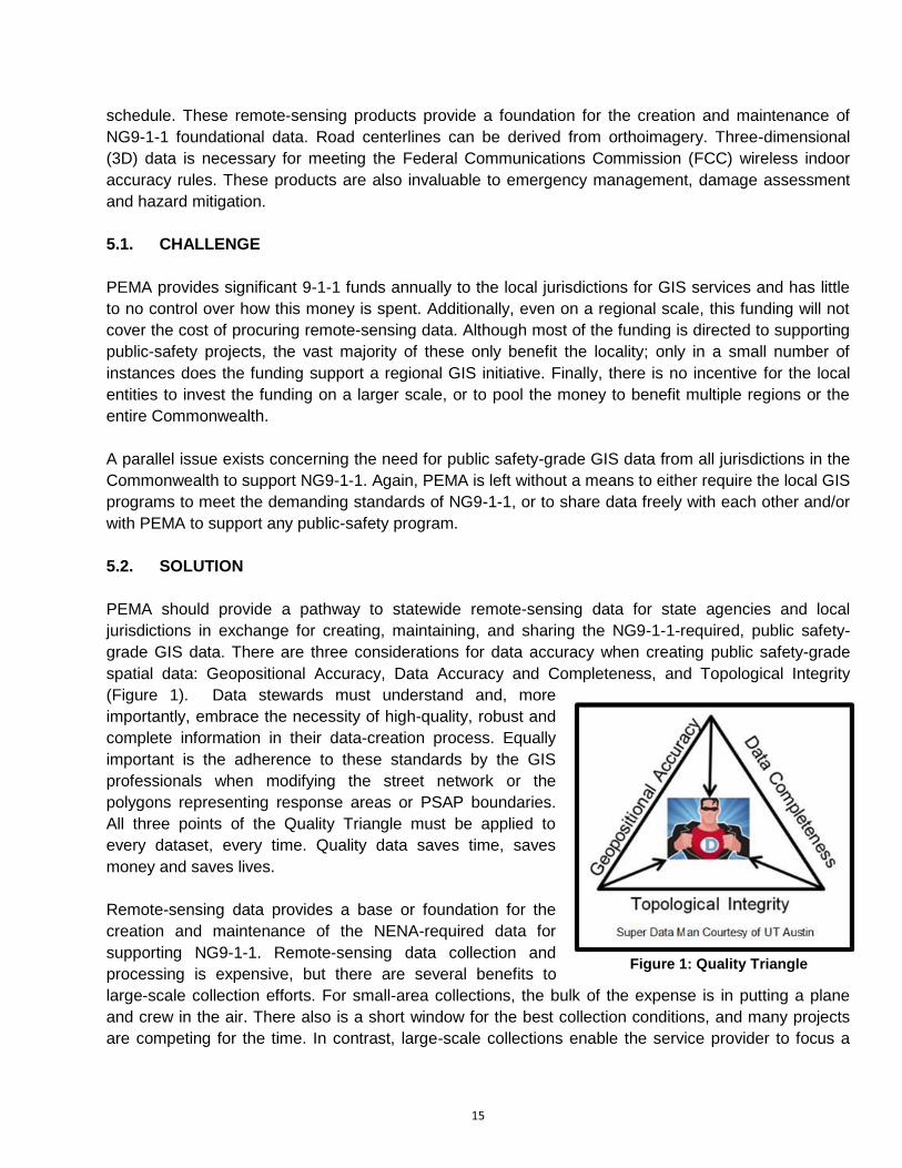
spatial data: Geopositional Accuracy, Data Accuracy and Completeness, and Topological Integrity
(Figure 1). Data stewards must understand and, more
importantly, embrace the necessity of high-quality, robust and
complete information in their data-creation process. Equally
important is the adherence to these standards by the GIS
professionals when modifying the street network or the
polygons representing response areas or PSAP boundaries.
All three points of the Quality Triangle must be applied to
every dataset, every time. Quality data saves time, saves
money and saves lives.
Remote-sensing data provides a base or foundation for the
creation and maintenance of the NENA-required data for
supporting NG9-1-1. Remote-sensing data collection and
processing is expensive, but there are several benefits to
large-scale collection efforts. For small-area collections, the bulk of the expense is in putting a plane
and crew in the air. There also is a short window for the best collection conditions, and many projects
are competing for the time. In contrast, large-scale collections enable the service provider to focus a
Figure 1: Quality Triangle

16
crew on one project, maximizing efficiency and minimizing overhead. Additionally, multiyear contracts
generally allow for a lower cost.
5.3. INCENTIVE
Orthoimagery is used by jurisdictions for everything from street and stream centerline updates to
change detection to future planning. Virtually every department in government can benefit from the
technology. Unfortunately, acquiring new, highly accurate, high-resolution orthoimagery is prohibitively
expensive for most jurisdictions. These same jurisdictions, however, already maintain most or all of the
GIS data required for NG9-1-1, and in many cases to its demanding specifications. By offering high-
resolution orthoimagery in exchange for a minimal increase in the data-development effort, PEMA will
create a mutually beneficial arrangement with the jurisdictions it serves. Ultimately, this arrangement
would facilitate the development of a regional, and eventually a statewide, base-map to be used for
NG9-1-1 call routing. By creating a remote-sensing data-collection program, and offering state and
local agencies the opportunity to purchase other remote-sensing products under the same contract,
PEMA can further the opportunities for savings at all levels of government. These buy-up options
should include, at a minimum, the opportunity to: increase the resolution (reduce the pixel size) of the
orthoimagery; to purchase other products such as LiDAR; and to add multiple flight lines for off-year
collection.
5.4. PRECEDENT
The PAMAP Program administered by the Pennsylvania Department of Conservation and Natural
Resources collected a statewide set of 1:2400 scale, leaf-off, full-color orthoimages at a 1-foot pixel
resolution between 2003 and 2008. The PAMAP program was established to provide LiDAR elevation
data and orthoimagery to government and the general public. This data is still in use today in many
jurisdictions across the Commonwealth.
Several states, including Ohio, Indiana, Maryland, Virginia, New York, Delaware, and North Carolina,
provide statewide orthoimagery on a scheduled interval, ranging between three and five years. Most of
these states provide the orthoimagery for their own use; however, some recognize the need to cross
state boundaries. For example, Delaware also collects orthoimagery for some New Jersey and
Pennsylvania jurisdictions in order to increase the economy of scale.
5.5. RETURN ON INVESTMENT
It is difficult to quantify the value of excellent public safety-grade GIS data. However, after the 2005
collection cycle, Indiana conducted an in-depth study on the ROI of statewide orthoimagery in an
attempt to continue to provide the service. The study revealed a 34:1 return on investment over a three-
year period. The study was conducted using two distinct calculation methods, each returning the same
result.6
6 http://www.igic.org/projects/indianamap/IndianaMapNews.pdf
17
5.6. RECOMMENDATION
It is in the best interest of PEMA to create, fund, and promote a statewide collection program that will
provide orthoimagery to all government agencies across the Commonwealth on a three-year rolling
schedule, covering one-third of the state each year. PEMA has secured approval for funding of such a
program from the 15-percent competitive incentive grants for consolidation and system efficiencies
monies. As such, the program must be directly tied to a 9-1-1 need. Pennsylvania is a large state of
approximately 46,000 square miles, creating a level of complexity that prohibits a single-year collection
of the entire state. Dividing the Commonwealth into three sections will mitigate that complexity and
manage the associated risk by spreading the acquisition and thereby, spreading the cost, over a three-
year period. A rolling three-year program also eliminates annual funding gaps and balances budgetary
needs to an annual constant.
Between 2003 and 2008, the Commonwealth contracted with Photo Science to procure 1-foot-
resolution imagery and a LiDAR-derived digital elevation model (DEM) under the PAMAP program.
These products provide a solid foundation on which a statewide orthoimagery program can be built at a
reduced cost and in an accelerated timeframe.
The DEM and a three-year procurement schedule with a multiyear contract would allow PEMA to
acquire complete orthoimagery coverage for the entire Commonwealth at a 6-inch resolution for a
fraction of the cost incurred by the jurisdictions that individually procure the same. Meanwhile, the
jurisdictions desire other remote-sensing products that can be acquired in conjunction with the
orthoimagery flights. Consequently, PEMA should not limit the contract to only orthoimagery. Several
other forms of remote-sensing data are valuable to agencies and jurisdictions in the Commonwealth,
including LiDAR, oblique imagery, quick-capture satellite imagery, upgrades in resolution and others.
Although PEMA will not fund these products in the near term, a broad contract covering all remote-
sensing products will enable the other agencies or jurisdictions to purchase these services without the
usual lengthy procurement process.
In addition to the collection of the orthoimagery, it is imperative that PEMA contract with a third-party
firm to perform QA/QC of the deliverables, to ensure that they meet the specifications set forth in the
contract. With such a large coverage area, it will be difficult for PEMA to perform quality checks on all
products with existing staff.
Reallocating a portion of the funding provided to the jurisdictions to orthoimagery will generate a greater
ROI for PEMA and the jurisdictions. This approach also will grant PEMA more control over the
procurements acquired through the expenditure of 9-1-1 funds, and create an unprecedented level of
accountability to the constituents funding the program.
5.7. INITIATIVES
The following are the initiatives that PEMA should undertake in order to support the agency's
foundational data-collection goals:
18
Present concept to GeoBoard to garner wide acceptance and offer opportunities for additional
products to agencies and jurisdictions.
Issue a request for information (RFI) to help develop a robust request for proposals (RFP) for
remote-sensing products.
Issue the RFP for remote-sensing products.
Solicit feedback from stakeholders regarding modifications to the program in future data-
collection efforts.
5.8. OUTCOMES
The following are the outcomes that can be expected from the aforementioned initiatives:
Current orthoimagery for all jurisdictions in the Commonwealth.
All products acquired under this program will be public data.
Substantial cost savings over individual collection efforts.
6. DATA DISTRIBUTION
PEMA realizes the necessity of current, accurate, always-available data to support emergency
management and 9-1-1 functions in the Commonwealth, and has made strides toward adopting a
federated model of spatial data maintenance that is centrally shared through a geospatial data
exchange (GDX).
6.1. DATA COLLECTION
Compiling the data necessary to support an NG9-1-1 implementation, especially an implementation that
spans several jurisdictions, can become unwieldy early in the process and virtually impossible once the
implementation reaches the maintenance phase, unless the proper pre-planning and related steps have
been executed. Today’s NG9-1-1 architects are faced with the daunting task of collecting, integrating,
and maintaining hundreds of data layers from dozens of jurisdictions across the enterprise.
The task becomes significantly more complicated when data stewards must coordinate many local
authorities spanning across multiple agencies and disciplines, ranging from public safety to planning to
tax assessment. For example, the local transportation authority may maintain the street centerlines in
Jurisdiction A, but the addresses are maintained by the jurisdiction’s Planning Department. However,
NENA places the responsibility regarding GIS data on the local 9-1-1 authorities, which can range from
the local PSAP to 9-1-1 Districts to Statewide 9-1-1 Authorities. The term “9-1-1 authority” often is used
as a generic term spanning all of the different levels of 9-1-1 authority across the U.S.
The greatest challenge in creating wide-area datasets to support PSAPs is managing the large number
of data stewards providing the core data. PEMA must coordinate with the Regional Taskforces to first
consolidate local data into regional datasets prior to aggregating these datasets into a statewide
NG9-1-1 database.
19
6.2. DATA MAINTENANCE
Compiled data is susceptible to becoming outdated the instant that it is replicated to another database.
Some datasets, such as street centerlines, only may be updated monthly or quarterly based on
development in a jurisdiction. Other datasets, such as addresses, could change daily. It is difficult to
construct a statewide plan to establish currency across potentially hundreds of datasets, each with its
own update schedule, and close to impossible to successfully implement such a process in a
centralized database environment. A federated model of data creation and maintenance—whereby the
data stewards retain ownership of and responsibility for the data, and share a view at the source rather
than replicating the database at every PSAP—creates an environment where GIS data is updated in
the CAD systems’ data caches daily. Call-routing and service-dispatching decisions then are made on
the most current GIS data available.
These spatial data from individual jurisdictions must be aggregated and checked for errors prior to
being loaded into the 9-1-1 system. The data aggregation should be tiered, beginning at the regional
level prior to statewide aggregation by PEMA. Error checking will identify issues that could cause the 9-
1-1 process to fail, such as overlapping road centerlines or address ranges, gaps or overlaps in PSAP
or ESZ boundaries, or duplicative/incorrect street names or addresses.
6.3. PROCESS AND APPLICATION
There are several examples of the NENA-suggested information flow available in presentations and
whitepapers from NENA members. GIS is a core element of the NG9-1-1 architecture; however, there
has been no concise direction provided by NENA to date regarding the methodology for building GIS
into an NG9-1-1 system. Nor is there a roadmap for navigating the difficulties of integrating disparate
data into a single system and then maintaining the data to the currency standards required to support
NG9-1-1.
If the purpose of migrating from legacy systems to NG9-1-1 is to overcome the limitations of antiquated
processes and technology, then it must be acknowledged that centralized data collection and storage
has proved ineffective in maintaining data currency, and that building new technology around failed
processes guarantees continued failure.
The GIS and public-safety communities must work together to integrate technologies that support real-
time access to data from the data source. Public safety must accept a federated model of data
maintenance and availability as vastly superior to centrally stored data, and data stewards must
embrace the higher level of data accuracy, attribution, and integrity that is demanded by NG9-1-1
systems. Wide stakeholder acceptance of this more efficient solution over the antiquated traditional
methods of legacy 9-1-1 systems is vital to the success of the NG9-1-1 implementation.
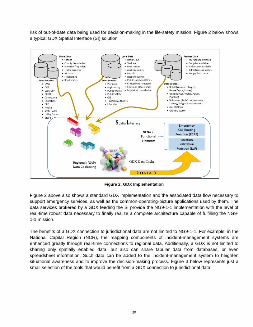
The creation of such a geospatial data exchange (GDX) solution in the Commonwealth to provide
secure access to NG9-1-1 datasets directly from the data stewards will provide PEMA and the
Commonwealth’s PSAPs with access to the most current data. The removal of many possible points of
failure between the data steward and the canned data repository at the PSAP drastically reduces the
20
risk of out-of-date data being used for decision-making in the life-safety mission. Figure 2 below shows
a typical GDX Spatial Interface (SI) solution.
Figure 2: GDX Implementation
Figure 2 above also shows a standard GDX implementation and the associated data flow necessary to
support emergency services, as well as the common-operating-picture applications used by them. The
data services brokered by a GDX feeding the SI provide the NG9-1-1 implementation with the level of
real-time robust data necessary to finally realize a complete architecture capable of fulfilling the NG9-
1-1 mission.
The benefits of a GDX connection to jurisdictional data are not limited to NG9-1-1. For example, in the
National Capital Region (NCR), the mapping components of incident-management systems are
enhanced greatly through real-time connections to regional data. Additionally, a GDX is not limited to
sharing only spatially enabled data, but also can share tabular data from databases, or even
spreadsheet information. Such data can be added to the incident-management system to heighten
situational awareness and to improve the decision-making process. Figure 3 below represents just a
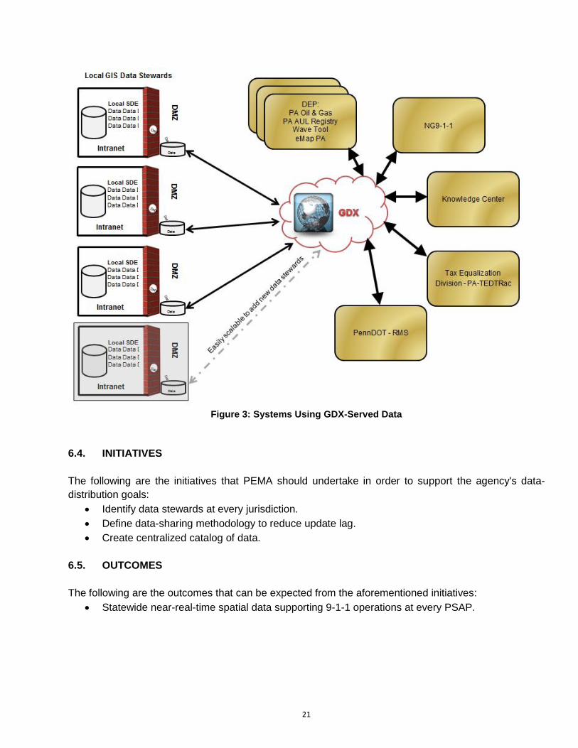
small selection of the tools that would benefit from a GDX connection to jurisdictional data.
21
Figure 3: Systems Using GDX-Served Data
6.4. INITIATIVES
The following are the initiatives that PEMA should undertake in order to support the agency's data-
distribution goals:
Identify data stewards at every jurisdiction.
Define data-sharing methodology to reduce update lag.
Create centralized catalog of data.
6.5. OUTCOMES
The following are the outcomes that can be expected from the aforementioned initiatives:
Statewide near-real-time spatial data supporting 9-1-1 operations at every PSAP.
22
7. FUNDING
As PEMA begins to further transition into the NG9-1-1 implementation phase, the requirement for
public-safety GIS capability will grow exponentially, as NG9-1-1 applications are planned for use and
the dynamics of emergency management functions increase. A GIS capability may require an initial
capital investment and then likely would need a less substantial, but sustained, long-term investment. In
order to build upon existing GIS capabilities and ensure continued growth with GIS-related tools and
technologies, a dedicated funding source and capture plan is required for the program.
Through the endorsement of a PEMA executive sponsor, PEMA should establish a business plan to
outline its specific budgetary requirements for program initiation and specific activities, milestones and
timeframes associated with various implementation phases. The business plan would specify the
resource and technology requirements associated with the implementation activities and timeframe, as
well as the overall short- and long-term goals of the program.
To lessen the long-term financial burden on any one government organization, statewide policy and
guidance should be established to educate stakeholders on funding for all GIS initiatives. This
guidance, best defined by the GeoBoard, must underscore the need for agencies to pool fund requests
in a collaborative manner. Many grant-issuing authorities—e.g., the Department of Homeland Security
(DHS), Federal Emergency Management Agency (FEMA), National Telecommunications and
Information Administration (NTIA), and state 9-1-1 grant programs— administer funding based on a
demonstrated approach to regionalizing this type of effort and applying funds across a broader
footprint.
7.1. INITIATIVES
The following are the initiatives that PEMA should undertake in order to support the agency's funding
goals:
Construct a business plan for the program including funding of key initiatives and staff.
Identify funding source(s) to ensure program continuity.
7.2. OUTCOMES
The following are the outcomes that can be expected from the aforementioned initiatives:
A viable public-safety GIS program providing quality data to Pennsylvania PSAPs.
8. STANDARDS AND REQUIREMENTS
The key to implementing a GIS capability in the Commonwealth is the adoption of national standards to
ensure effective data-sharing interoperability. The full benefits of GIS only can be realized with the
adoption of critical standards that ensure the capability’s use across data-sharing platforms. It is
imperative that PEMA define and implement applicable standards internally and across the enterprise
for data, systems, staffing and interoperability.
23
8.1. GIS DATA STANDARDS FOR NG9-1-1
As detailed in the PEMA 9-1-1 Strategic Plan, the following recommendations highlight some of the key
GIS layers requiring standardization, as suggested by NENA i3 guidelines:
GIS data fields that correspond to the Presence Information Data Format-Location Objects
(PIDF-LO) protocol.
Location data detailed in the CLDXF Standard.
Location information in Internet Engineering Task Force (IETF) format.7
PSAP service boundary.
Emergency service number (ESN) boundaries corresponding to local response agencies such
as law enforcement, fire, emergency medical services (EMS), special response taskforces, and
other response assets.
The recommendations described above provide a basis for identifying the applicable standards to be
used in the development of a GIS capability for the Commonwealth that is interoperable with other
relevant capabilities and technologies. These standards should be considered the minimum baseline
and used as a starting point from which PEMA GIS staff will build applicable standards for the NG9-1-1
GIS data-collection and -dissemination program.
8.2. MINIMUM STANDARDS FOR COMPUTER AIDED DISPATCH (CAD)
The successful implementation and utility of GIS for public safety relies heavily on the Commonwealth’s
ability to operationalize an enterprise-level capability that can be integrated easily with both current and
future technologies. These technologies and products are those used in day-to-day operations, as well
as specialized tools brought in for use during emergency response situations at the CRCC.
One such opportunity for PEMA is in the development of a minimum requirements specification that
governs how CAD systems will interact with the GIS data and services put in place in the
Commonwealth. The myriad of CAD systems across the Commonwealth, with widely varying spatial
capabilities, amplifies the difficulties in integrating GIS to the degree necessitated by NG9-1-1. As CAD
systems are upgraded or newly purchased, these specifications will ensure the jurisdictions’
interoperability with the statewide geospatial program. The GIS Pros will be instrumental in creating and
maintaining these standards and have offered their expertise to PEMA.
8.3. ADOPTION OF NATIONAL STANDARDS
Vetted standards have been developed by federal agencies and professional and governmental
associations for the vast majority of the initiatives necessary to support NG9-1-1. Location information
standards for address points, street centerlines and associated address ranges have been developed
by NENA.8 United States Geological Survey (USGS), American Society of Photogrammetry and
7 NENA Functional and Interface Standards for Next Generation 9-1-1 Version 1.0 (i3) 8 https://www.nena.org/resource/resmgr/Standards/NENA-INF-014.1-2015_SSAP_INF.pdf
24
Remote Sensing (ASPRS), Urban and Regional Information Systems Association (URISA), and
National States Geographic Information Council (NSGIC) all provide standards (related to and
referencing each other) for orthoimagery collection, QA/QC and delivery. As an industry leader, PEMA
should adopt the most stringent yet nationally accepted standards from these and other sources, to
guarantee the most interoperable and highest quality data and program available.
8.4. INITIATIVES
The following are the initiatives that PEMA should undertake in order to support the agency's goals
regarding standards and requirements development:
Identify and enhance GIS standards for public-safety data development and maintenance.
Implement standards through outreach and training efforts.
Develop core standards for CAD system implementations to be used by jurisdictions as the
replace antiquated legacy systems.
8.5. OUTCOMES
The following are the outcomes that can be expected from the aforementioned initiatives:
Compatibility and interoperability of systems and data across the Commonwealth.
Remainder of the page intentionally left blank
25
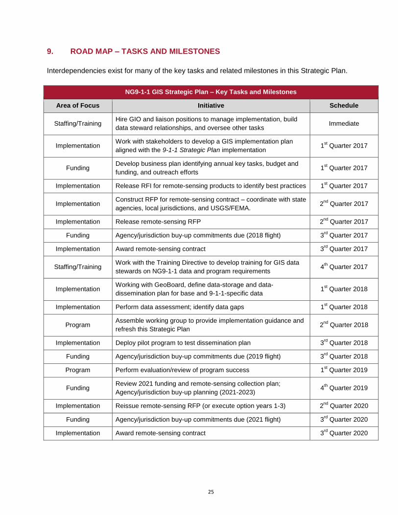
9. ROAD MAP – TASKS AND MILESTONES
Interdependencies exist for many of the key tasks and related milestones in this Strategic Plan.
NG9-1-1 GIS Strategic Plan – Key Tasks and Milestones
Area of Focus Initiative Schedule
Staffing/Training Hire GIO and liaison positions to manage implementation, build
data steward relationships, and oversee other tasks Immediate
Implementation Work with stakeholders to develop a GIS implementation plan
aligned with the 9-1-1 Strategic Plan implementation 1
st Quarter 2017
Funding Develop business plan identifying annual key tasks, budget and
funding, and outreach efforts 1
st Quarter 2017
Implementation Release RFI for remote-sensing products to identify best practices 1st Quarter 2017
Implementation Construct RFP for remote-sensing contract – coordinate with state
agencies, local jurisdictions, and USGS/FEMA. 2
nd Quarter 2017
Implementation Release remote-sensing RFP 2nd
Quarter 2017
Funding Agency/jurisdiction buy-up commitments due (2018 flight) 3rd
Quarter 2017
Implementation Award remote-sensing contract 3rd
Quarter 2017
Staffing/Training Work with the Training Directive to develop training for GIS data
stewards on NG9-1-1 data and program requirements 4
th Quarter 2017
Implementation Working with GeoBoard, define data-storage and data-
dissemination plan for base and 9-1-1-specific data 1
st Quarter 2018
Implementation Perform data assessment; identify data gaps 1st Quarter 2018
Program Assemble working group to provide implementation guidance and
refresh this Strategic Plan 2
nd Quarter 2018
Implementation Deploy pilot program to test dissemination plan 3rd
Quarter 2018
Funding Agency/jurisdiction buy-up commitments due (2019 flight) 3rd
Quarter 2018
Program Perform evaluation/review of program success 1st Quarter 2019
Funding Review 2021 funding and remote-sensing collection plan;
Agency/jurisdiction buy-up planning (2021-2023) 4
th Quarter 2019
Implementation Reissue remote-sensing RFP (or execute option years 1-3) 2nd
Quarter 2020
Funding Agency/jurisdiction buy-up commitments due (2021 flight) 3rd
Quarter 2020
Implementation Award remote-sensing contract 3rd
Quarter 2020
26
9.1. PROGRAM EVALUATION
PEMA staff members should establish program metrics and measurable milestones to demonstrate and
measure progress regarding the establishment and sustainability of the public-safety GIS program.
These metrics can be developed based upon similar statewide initiatives while accounting for industry
best practices and lessons learned from regions and counties within the Commonwealth, as well as
other states.
To effectively perform an ongoing evaluation of the program’s success, key milestones must be
established with targeted completion dates. These milestones should address short-term goals and
objectives that align with measureable successes for the program’s initial establishment, as well as
long-term goals that outline and shape the future of the program.
9.2. EVALUATE PILOT PROJECT
In order to validate the Commonwealth’s strategy for statewide public-safety GIS development and
deployment, PEMA should work with the GeoBoard to conduct a pilot project to test the data sharing
and integration of county-level GIS assets, through both regional approaches and individual county
submissions. A study of this nature would identify initial capability gaps, demonstrate the required level
of coordination and resource allocation, and evaluate the overall feasibility of a larger-scale (statewide)
program. The pilot area should include both rural and urban jurisdictions with varied GIS capabilities.
10. SUMMARY
As PEMA transitions the Commonwealth’s current 9-1-1 system to an NG9-1-1 environment, the
increasing demand and requirement for a robust GIS capability exists for both steady state and active
emergency response scenarios. The Commonwealth recognizes GIS as a powerful data-sharing and
decision-support tool that will serve the 9-1-1 community and emergency management practitioners.
Beyond public safety, Pennsylvania has embarked on several initiatives that will complement the PEMA
GIS initiative. Working closely with the GeoBoard, the regional GIS Pros and others, PEMA has the
opportunity to drive the development of a world-class geospatial program.
The implementation of a large-scale, enterprise-wide capability such as GIS will require a tremendous
effort through a phased approach, significant stakeholder coordination and collaboration, and adequate
(sustained) funding streams. However, by cooperatively implementing a program in adherence with
nationally accepted standards, the Commonwealth will position itself in a forward-thinking mode by
facilitating interoperable data-sharing practices that create flexibility and sustainability within its
program.


