This is a pre-copy-editing, author-produced PDF of an article accepted following peer review for publication in
Environment and History, 23, 163-196. The definitive publisher-authenticated version is available online, doi:
10.3197/096734017X14900292921734
1
Aeolian Empires: The Influence of Winds and Currents on European Maritime
Expansion in the Days of Sail
The great European maritime empires of the modern era depended more on wind than
they did on water. Before the conquistadors, priests, company merchants or colonial
bureaucrats could subdue, evangelise, exploit or administer their overseas possessions,
they first had to be taken there, conveyed over the water in ships powered by the wind.
Wind played a formative role in deciding where would-be adventurers and colonisers first
made landfall. Oceans might have been the highways or “marineways” of the past upon
which flowed the traffic of the pre-industrial age but water is only a medium and wind
constituted the primary source of energy available for long-distance transportation in the
pre-industrial age. Referring to the activities that transpire across its expanses as maritime
fails to draw specific attention to the influence winds and currents played in determining
the routes taken, the peoples linked together, the environments connected, and the timing
of such activities. There were “winds of empire” blowing backward and forward across
the Atlantic, Indian and Pacific Oceans during the days of sail between the sixteenth and
nineteenth centuries.
Historiography has generally paid insufficient attention to the influence of winds and
currents. While their significance is readily acknowledged, the discussion is usually
limited to an initial contextual page or two.1 Winds are more prominent in recent
scholarship but the focus is more on the impact of extreme events or anomalous weather
patterns on specific societies or even entire civilisations.2 However, as Felipe Fernández-

This is a pre-copy-editing, author-produced PDF of an article accepted following peer review for publication in
Environment and History, 23, 163-196. The definitive publisher-authenticated version is available online, doi:
10.3197/096734017X14900292921734
2
Armesto observed in his global history of exploration, there is “not enough wind” in
explaining the course of human interactions in general and the rise and form of European
maritime expansion in particular.3 The general atmospheric circulation (the prevailing
wind directions at any time of year) and the dominant flow of the currents (themselves
largely determined by the winds) not only dictated the place and pace of maritime
exchange but also greatly influenced the contours of imperial endeavour. The rise of
Western European states to world empires from the sixteenth century is usually
characterised as maritime in nature but should more fittingly be described as Aeolian or
wind-driven to denote their dependence on the prevailing patterns of atmospheric
circulation.
This article examines the role winds and currents played in influencing the outline,
structure and nature of Western European seaborne empires. It incorporates the patterns
of winds and currents in each ocean, and the endeavours and ventures of each major
European maritime power into a single global portrait that reveals the extent of the
historical influence such factors exerted in the age of sail.4 Unlike previous great
seafaring peoples like the Arabs, Malays and Polynesians, Europeans were the first to
operate across all the world’s oceans, coordinating and utilising winds and currents on a
truly global scale. The gradual discovery of global circulation patterns by European
mariners beginning with the Portuguese and Columbus revealed only two feasible
contours of empire available to Western European states: one utilising the North and
South Atlantic gyres and the monsoon winds to the Indian Ocean and beyond, and the
other employing the North Atlantic gyre to the Americas. The Portuguese and Spanish

This is a pre-copy-editing, author-produced PDF of an article accepted following peer review for publication in
Environment and History, 23, 163-196. The definitive publisher-authenticated version is available online, doi:
10.3197/096734017X14900292921734
3
imperia pioneered these models. The Dutch first emulated and then circumvented them.
The French and English maritime empires were largely variants on a theme. Where winds
and currents converged, key settlements were founded that facilitated imperial designs
and spawned new cultures and ecologies. Only the demise of sail as the primary engine of
maritime locomotion and its replacement by steam-powered vessels in the second half of
the nineteenth century led to a new geography of empire largely unconstrained by
meteorological and oceanographic limitations. While there has been something of a
renaissance in maritime history in recent years, the insufficient recognition given to the
guiding influence of winds and currents has impeded a proper understanding of the nature
and exercise of European maritime power in the heyday of empire.5
Depends which way the winds blow
The imperial drive may have been motivated by a combination of “god, gold and glory”
but its realisation – its form, extent and pulse were largely determined by the direction in
which the winds blew. The global wind pattern splits the surface winds of each
hemisphere into three belts: the easterly-blowing polar winds above 60o latitude, the
prevailing westerlies between 30-60o, and the tropical easterlies (trade winds) between 0-
30o degrees.6 As a result of the earth’s rotational motion, winds do not blow directly
northward or southward but are deflected to the right in the Northern Hemisphere and to
the left in the Southern.7 Air diverging from a high-pressure region spirals outward,
clockwise north of the equator and counter-clockwise in the south. The horizontal effect
of this force varies in proportion to the latitude; it is strongest at the poles and vanishes
altogether at the equator. Moreover, near the equator, the easterly trade winds of both

This is a pre-copy-editing, author-produced PDF of an article accepted following peer review for publication in
Environment and History, 23, 163-196. The definitive publisher-authenticated version is available online, doi:
10.3197/096734017X14900292921734
4
hemispheres form a narrow zone of low pressure known as the Inter-tropical
Convergence Zone. This is an area of cloud and humid conditions where winds are
alternating fitful or strong and vessels can be becalmed for days or even weeks in what
mariners called the “doldrums”.
Figure 1: Schematic global wind patterns (general circulation)
This zonal pattern of winds provides only a rough approximation of the actual
atmospheric circulation. In reality, the latter is considerably modified by the unequal
distribution across the globe of continents that constitute significant thermal and
topographical barriers.8 In particular, large landmasses heat up during the summer and
cool rapidly in winter. The seasonal variation of solar heating depending on the tilt of the
earth’s rotation means that areas of high pressure tend to build up over cold continental
land masses in winter, while low-pressure development takes place over the adjacent,
relatively warm oceans. Exactly the opposite conditions occur during summer, although
to a lesser degree. These resulting and contrasting pressures over land and water are the
cause of the monsoon winds.
Superimposed upon the general circulation are many lesser disturbances such as the
common storms of temperate mid-latitudes and the cyclones, typhoons and hurricanes of
the tropics. These generally move along the path of the prevailing winds and upper air
streams. Wind systems are further complicated by hemispheric variations. In the Pacific,
the region is characterised by a distinctive phenomenon known as the Southern

This is a pre-copy-editing, author-produced PDF of an article accepted following peer review for publication in
Environment and History, 23, 163-196. The definitive publisher-authenticated version is available online, doi:
10.3197/096734017X14900292921734
5
Oscillation in which variations in atmospheric pressure over the Indian Ocean (in the
West) are mirrored by the opposite changes over the south-eastern Pacific (in the East),
so that if one is falling the other is invariably rising. An El Niño Southern Oscillation
(ENSO) event is a combination of interrelated oceanic and atmospheric processes that
occurs every two to seven years when atmospheric pressures shift and the normally
easterly trade winds slacken and even temporarily reverse. Wind intensities are affected
too, especially close to the equator. Sailors might encounter unexpected variations in the
strength of the usually predictable northeast and southwest monsoons as well as more
localised fluctuations in direction and speed influenced by local island topography.9
A somewhat analogous phenomenon of atmospheric variability is found over the North
Atlantic. The North Atlantic Oscillation (NAO) refers to alternations in the pressure
differences between the subtropical atmospheric high-pressure zone centred over the
Azores and the atmospheric low-pressure zone over Iceland. It is the dominant mode of
atmospheric behaviour in the North Atlantic throughout the year and its inter-annual
variability and inter-decadal fluctuations are largely responsible for the severity of boreal
winters and the degree of sea-ice cover. It also affects the strength and character of the
Atlantic thermohaline circulation that drives the Gulfstream and the North Atlantic Drift,
and is associated with consequent changes in the mean wind speed and direction,
variations in temperature and moisture distribution, and the intensity, number and track of
storms in the North Atlantic region.10 Recent studies have uncovered significant
coherence between NAO and warm ENSO events with each influencing the other under
certain conditions.11

This is a pre-copy-editing, author-produced PDF of an article accepted following peer review for publication in
Environment and History, 23, 163-196. The definitive publisher-authenticated version is available online, doi:
10.3197/096734017X14900292921734
6
Figure 2: Ocean currents of the world
The oceans, too, are not inert bodies and have their own complex circulatory systems.
However, surface currents tend to conform closely to the prevailing wind system,
especially across the equatorial belt that girdles the globe.12 Two surface currents, the
North and South Equatorial Currents, flow westward blown by the trade winds and
separated by an eastward flowing surface Equatorial Counter-current.13 Near the western
margins of all oceans, moreover, the cumulative flow of the equatorial currents pile up
warm water against the continental boundaries. A portion of this surplus water returns
eastward via the surface and subsurface counter-currents but most of the water forms
deep narrow fast-moving western boundary currents that are mainly guided poleward by
the margins of the continental shelves at speeds of between three to five knots.14 These
winds and currents provide the Aeolian framework from which maritime empires were
formed.
Empires of the wind
The great European maritime empires of the modern era, what territories belonged to
which states largely owed their existence to a global pattern of winds and currents whose
outline was only beginning to be discerned by the sixteenth century. Prevailing European
knowledge had remained little changed since Aristotelian notions of a fixed earth
(primum mobile) around which body rotated the winds and oceans.15 Though both air and
water were considered to move from East to West, there is no evidence that people

This is a pre-copy-editing, author-produced PDF of an article accepted following peer review for publication in
Environment and History, 23, 163-196. The definitive publisher-authenticated version is available online, doi:
10.3197/096734017X14900292921734
7
believed the two to be linked.16 While mariners’ practical knowledge of winds and
currents expanded rapidly with the voyages of exploration and the drawing up of oceanic
rutters by the Portuguese and others in the sixteenth and seventeenth centuries, the
gradual acceptance of the Copernican system of the universe did not lead to any better
understanding of why winds blew or their origins.17 However, gradual improvements in
the design of ships as wind-catching devices and the development of precision
instrumentation to better determine position and speed represented a profitable marriage
between science and imperial design that greatly enhanced Europeans’ ability to navigate
these oceans.18 The eighteenth century was preoccupied by the successful search to
determine longitude at sea, and, with industrialisation, the development of precision
measurement that made tidal charts available to ships’ captains for home and colonial
ports. As Michael Reidy observes, science created “a geographical space that the
maritime powers of Europe could then control”.19 But there were also limits to this
control that historiography has largely overlooked.
Superimpose a map of European imperia on a chart of atmospheric circulation over the
oceans of the world and there is a remarkable “fit” between the prevailing winds and
currents and the form and extent of the various European empires. The routes that the
explorers took and so their initial landfalls were largely dictated by the prevailing winds
and the inter- and intra-oceanic currents.20 Territories and islands that served these routes
were largely incorporated within the imperial mantle, especially those strategically
located way stations or “maritories”, pivotal points where winds and currents
intersected.21 Those that did not were left outside of the imperial embrace despite their

This is a pre-copy-editing, author-produced PDF of an article accepted following peer review for publication in
Environment and History, 23, 163-196. The definitive publisher-authenticated version is available online, doi:
10.3197/096734017X14900292921734
8
initial “discovery”. Any historical appreciation of the spread of European colonialism and
culture is incomplete without due recognition of the central role of winds and currents in
shaping the form and nature of empires. This Aeolian logic also explains why Portugal
and Spain, states favourably placed along the Atlantic littoral with respect to the pattern
of general circulation, were at the forefront of European maritime expansion in the
sixteenth century.
The Portuguese Aeolian Empire
The Portuguese initiated regular seaborne-traffic between the North and South Atlantic,
the African Atlantic and South America, Western Europe and West Africa, as well as
between Europe and the Indian Ocean. The wind systems along the Atlantic coast of the
Iberian Peninsula and North Africa between about 35 and 42oN favour ocean-going
expeditions by sail. During the summer months, the trade winds blow mainly south and
west towards the coast of Guinea or the Americas but, for the rest of the year, the wind
blows predominantly from the west. Outward-bound vessels utilised the winds on the
southern flank of the sub-tropical anticyclones, while return voyages took place on their
northern margins. Routes across the Atlantic in the fifteenth and sixteenth centuries,
therefore, were effectively successive superimposed loops, known in Portuguese as
voltas, allowing ships originating from south-western ports such as Lisbon to return home
within a few months, sailing all the time either before the wind or with the wind on their
quarter.22
Figure 3: Great oceanic wind gyres

This is a pre-copy-editing, author-produced PDF of an article accepted following peer review for publication in
Environment and History, 23, 163-196. The definitive publisher-authenticated version is available online, doi:
10.3197/096734017X14900292921734
9
The two long-distance axes of the Portuguese imperium were the carreira do Brasil and
the carreira da India, the sea routes between Lisbon and Brazil and Lisbon and Goa via
the Cape of Good Hope. Routes and sailing times on these voyages were determined by
the wind systems and currents in the Atlantic and by the seasonal monsoons in the Indian
Ocean and South China Sea. As winds and currents circulate clockwise in the North
Atlantic and counter-clockwise in the South Atlantic, the initial lap in both voyages was
from Lisbon to one of the North Atlantic maritories driven by winds from the north and
northwest. Ships heading to Brazil made for Madeira or the Azores to pick up the
northeast trade winds which made for an easy run to the northern coast of South America.
The homeward voyage was facilitated by way of the westerlies and north-westerlies. It
was an appreciation of the circulatory wind patterns of the North Atlantic gyre (and its
oppositely gyrating South Atlantic counterpart) gained during the fifteenth century and an
inherited Arabic-Hebrew tradition in trigonometry that led to the development of the
quadrant (and later the sextant and octant), and allowed the so-called volta do mar or
return passage.23 Sailing times from Portugal, however, depended on the final destination
in Brazil with voyages south of Cape Sāo Roque (the easternmost tip of South America)
taking appreciably longer to complete. Round-trips, including time in port, ranged from
seven months to a year.24
India-bound náos (“great ships”) either carracks or galleons, initially followed the same
outward-bound path via Madeira and the Cape Verde Islands, leaving the Tagus in March
or early April and setting course for Pernambuco on the northeast coast of Brazil.25 South
of Cape Sāo Roque, after negotiating the uncertain winds and currents of the doldrums,
This is a pre-copy-editing, author-produced PDF of an article accepted following peer review for publication in
Environment and History, 23, 163-196. The definitive publisher-authenticated version is available online, doi:
10.3197/096734017X14900292921734
10
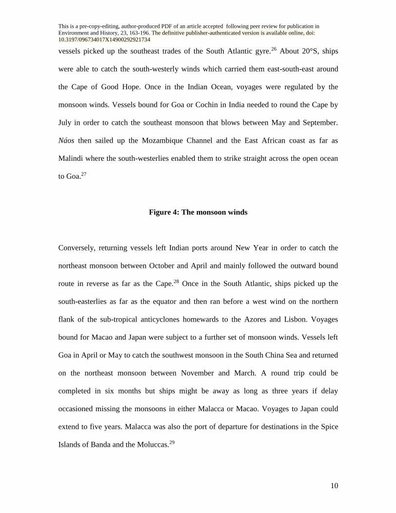
vessels picked up the southeast trades of the South Atlantic gyre.26 About 20°S, ships
were able to catch the south-westerly winds which carried them east-south-east around
the Cape of Good Hope. Once in the Indian Ocean, voyages were regulated by the
monsoon winds. Vessels bound for Goa or Cochin in India needed to round the Cape by
July in order to catch the southeast monsoon that blows between May and September.
Náos then sailed up the Mozambique Channel and the East African coast as far as
Malindi where the south-westerlies enabled them to strike straight across the open ocean
to Goa.27
Figure 4: The monsoon winds
Conversely, returning vessels left Indian ports around New Year in order to catch the
northeast monsoon between October and April and mainly followed the outward bound
route in reverse as far as the Cape.28 Once in the South Atlantic, ships picked up the
south-easterlies as far as the equator and then ran before a west wind on the northern
flank of the sub-tropical anticyclones homewards to the Azores and Lisbon. Voyages
bound for Macao and Japan were subject to a further set of monsoon winds. Vessels left
Goa in April or May to catch the southwest monsoon in the South China Sea and returned
on the northeast monsoon between November and March. A round trip could be
completed in six months but ships might be away as long as three years if delay
occasioned missing the monsoons in either Malacca or Macao. Voyages to Japan could
extend to five years. Malacca was also the port of departure for destinations in the Spice
Islands of Banda and the Moluccas.29

This is a pre-copy-editing, author-produced PDF of an article accepted following peer review for publication in
Environment and History, 23, 163-196. The definitive publisher-authenticated version is available online, doi:
10.3197/096734017X14900292921734
11
Even this brief description of the “Aeolian mechanics” incumbent in its principal
commercial arteries outlines the form and limitations imposed upon the Portuguese
empire. It is a striking example of an imperium whose extreme geographical dispersion
and dynamics were shaped and held together by wind and current. The paramount
importance of the Atlantic islands, Madeira, the Azores, and the Cape Verdes as
maritories is evident for ships bound either west or east. These islands, explored and
colonised in 1340-1420, were “points of articulation between the North and South
Atlantic, North and South America and the Caribbean, Africa and America, Africa and
Europe, and Europe and America”.30 The importance of the Atlantic littoral of South
America is evident, too, and its “discovery” in 1500 a not altogether unexpected
development.31 It also might explain why Pernambuco, so close to Cape Sao Roque and a
pivotal maritory on the voyage to India, was chosen as a site of initial Portuguese
settlement.32 The location of São Vicente (in the modern state of São Paulo), also selected
as an early colony, depended much more upon the southward flowing Brazil Current that
enabled ships to navigate along a lee shore across the face of the countervailing southeast
trades.33
Portugal’s East African empire was centred on the maritory of Mozambique Island, sited
strategically between the mainland and Madagascar. It served as a waystation for
homeward bound Indiamen and remained the colonial capital until 1898.34 The monsoon
winds and market opportunities made Goa on the west coast of India (annexation in
1510) a natural pivotal nexus for trade in and out of the Indian Ocean and it became the

This is a pre-copy-editing, author-produced PDF of an article accepted following peer review for publication in
Environment and History, 23, 163-196. The definitive publisher-authenticated version is available online, doi:
10.3197/096734017X14900292921734
12
official seat of the Viceroy of the Estado do India.35 The conquest of Malacca in the
following year secured the gateway to both the Spice Islands on the one hand and the
South China Sea on the other. The port’s position on the Strait of Malacca made it a key
maritory for vessels transiting between the Indian Ocean and the South China Sea.
Malacca provided a convenient place for merchants to sojourn while waiting for the
winds to change from east to west. The monsoon winds also made Macao (occupied circa
1557) a natural destination for trade with China and Japan and had transformed both it
and Nagasaki from obscure fishing villages to flourishing seaports by the close of the
sixteenth century.36 These ports of call on a global web of winds and currents
necessitated that the Portuguese empire was as much an intra-Asian trade network as one
between Europe and the Indian Ocean world.37
It was the winds, too, that governed the timing and place of exchange, not only the
seasonal nature of the monsoons but the synergy between their alternations and the fixed
winds of the Atlantic. Even Portugal's West African voyages of the fifteenth century that
initiated the entire maritime enterprise provided the necessary “schooling” in the
operating of the North Atlantic gyre. In particular, the technical and psychological
difficulties incumbent upon rounding Cape Bojador (the Cape of Fear) by sailing far out
to sea on a west-south-west course before finding an easterly wind were instrumental in
unlocking the routes to America, the South Atlantic, and ultimately egress into the Indian
Ocean. Incidentally it also laid the foundations for the Portuguese colony at Luanda and
its imperial and missionary endeavours in the Kingdom of the Kongo.38 Portugal, though
a relatively minor European power, was able to take advantage of its favourable

This is a pre-copy-editing, author-produced PDF of an article accepted following peer review for publication in
Environment and History, 23, 163-196. The definitive publisher-authenticated version is available online, doi:
10.3197/096734017X14900292921734
13
geographical location vis-à-vis the pattern of general atmospheric circulation to become
the first Aeolian empire. In many respects, too, its imperium was also the clearest
expression of the importance of wind over water in determining the contours of imperial
design.
Figure 5: European Aeolian empires
The Spanish Aeolian Empire
A unified Spain after 1492 enjoyed the same geographical advantages as Portugal in that
the ports of Cádiz and Seville had access to the southwest Atlantic coast of the Iberian
Peninsula. The contours of the Spanish empire were no less shaped by winds and currents
than those of their Portuguese neighbours. Columbus’s novel idea that a vessel might
reach the Indies by sailing west was premised on his knowledge of the winds at certain
latitudes. That the Americas lay in the path of that realisation was simply an Aeolian
“accident” of History.
Spanish seamen were also able to take advantage of the seasonal variation in prevailing
winds to sail and return to their home port using the southern and northern flanks of the
sub-tropical anticyclones. Like Portugal, Castile colonised its own Atlantic maritory as a
springboard for voyages into the deep North Atlantic.39 The Canary Islands, the conquest
of which began in 1402, served much the same pivotal role as the Portuguese Atlantic
islands as “a point of articulation” between Europe and the Americas.40 Situated around
28oN off the African coast, they lie on the northern fringes of the northeast trade winds so

This is a pre-copy-editing, author-produced PDF of an article accepted following peer review for publication in
Environment and History, 23, 163-196. The definitive publisher-authenticated version is available online, doi:
10.3197/096734017X14900292921734
14
that a ship sailing due west will reach the Caribbean. Many Spanish seamen had also
participated in Portuguese expeditions and acquired the same familiarity with winds and
currents.41 Christopher Columbus knew from living in the Azores that the winds blew
steadily from the west, while between 28-30oN the wind blew steadily from the east. On
his first voyage to the Americas in 1492, he sailed south to the Canaries and then
virtually due west till he reached the Bahamas.42 Castile’s possession of the Canary
Islands ensured that the Americas were predominantly Spanish rather than the colony of
some other European royal house.43 Indeed, Nicolás Wey Gómez maintains that
Columbus’s choice of the Canary Islands was premised on its location as Europe’s most
southerly outpost lying close to the path of the northeast trade winds.44
Columbus's route brought him to the Caribbean that as the Spanish Main was to remain
the fulcrum of Spain's empire in the New World.45 In a sense, all routes in the North
Atlantic lead to this “American Mediterranean Sea”.46 The conflux of the North and
South Equatorial Currents, particularly the latter which is deflected north-westwards
along the north coast of South America (the Guiana Current) diffuses into the Caribbean
Basin.47 Even when Columbus struck further south on his third voyage in 1498, this
westward drift still carried him back there.48 On entering the Caribbean, the current
funnels through the Yucatán Straits and splits in two: the stronger flow reverses direction
around the east end of Cuba and accelerates as it passes north-easterly through the Florida
Straits, and a weaker secondary current circulates clockwise around the circumference of
the Gulf of Mexico.49 Thus the nexus of Spain's American empire was set: Hispaniola
and Cuba as the launch pads of exploration, conquest and settlement in the New World.

This is a pre-copy-editing, author-produced PDF of an article accepted following peer review for publication in
Environment and History, 23, 163-196. The definitive publisher-authenticated version is available online, doi:
10.3197/096734017X14900292921734
15
The former provided the base from which Vasco Núñez de Balboa established the
isthmian colony of Castilla del Oro and the city of Darien in 1510, and the latter was
where Hernán Cortés embarked upon the conquest of Mexico in 1519.
Figure 6: Winds and currents in the Caribbean
The homeward voyage also proved formative in creating the imperial framework. On his
initial return passage, Columbus discovered the necessity of standing well to the north on
leaving the West Indies before attempting the Atlantic crossing. Around the latitude of
Bermuda (32.30oN), he found a westerly wind that ships could run before all the way
across the Atlantic to the Azores.50 The Florida Current as it exits the Caribbean Basin
encourages such a route as it immediately swings northwards along the coastline,
merging with the Antilles and North Equatorial Currents to form the mighty Gulfstream
that continues undiminished in a north-easterly direction as far as Cape Hatteras.51 Given
Florida’s strategic position at the confluence of currents, it was an early object of Spanish
exploration beginning with Ponce de León’s expedition in 1513. Construction of the
oldest masonry structure in the United States, the Castillo de San Marcos situated in the
city of St. Augustine was begun in 1672 to protect this return passage.52
Columbus’s voyages to the Americas, his passage southward to the Canary Islands and
then westward to the Caribbean using the prevailing northeast trade winds remained the
prevailing route followed by annual treasure fleets until 1779. The two components of
this fleet, one originating from the port of Veracruz bearing the mineral wealth of New

This is a pre-copy-editing, author-produced PDF of an article accepted following peer review for publication in
Environment and History, 23, 163-196. The definitive publisher-authenticated version is available online, doi:
10.3197/096734017X14900292921734
16
Spain and the other from South American ports bearing the riches of Tierra Firme
rendezvoused at Havana by using the clockwise circulatory current around the Caribbean
Basin.53 The combined fleet then exited via the Florida Straits and followed the
Gulfstream north to pick up the homeward-blowing westerly winds. Timing was dictated
by the winds. Outbound ships left Spain between February and September so as to enter
the Caribbean between May and November. Ships wintered in the Americas (also to
allow goods from the Manila Galleon to come overland from Acapulco) and returned
between February and August.54 Again winds and currents dictated this timetable as the
so-called contrary “northers” during the winter months made sailing between Veracruz
and Havana well-nigh impossible, even to the extent of reversing the prevailing direction
of the current.55 A recent study of derreteros (sailing directions) concludes that the routes
followed by Spanish sailing vessels were “the most favourable to make the voyage from
Veracruz to Havana in the shortest time in summer”.56 Unfortunately, late summer and
early autumn were also the months for hurricanes.57
Spain's empire extended into the Pacific as well: The first Spaniard to actually set eyes on
the “Southern Ocean” was Balboa who crossed the Isthmus of Panama in 1513.
Superimpose a map of the Spanish imperium in the Pacific on a chart of that ocean’s
atmospheric circulation and again there is a remarkable “fit” between the prevailing
winds and the form and extent of Spanish colonisation. The routes the initial explorers
took and therefore the landfalls they made were largely dictated by the trade winds. The
shape of the Manila-Acapulco galleon trade, the economic lifeblood of the whole Spanish
endeavour in this part of the world, was likewise dependent on the westerlies for the

This is a pre-copy-editing, author-produced PDF of an article accepted following peer review for publication in
Environment and History, 23, 163-196. The definitive publisher-authenticated version is available online, doi:
10.3197/096734017X14900292921734
17
passage out to Mexico, and on the northeast trades for the return route to the Philippines.
Islands that served this purpose fell within the Hispanic mantle; those that did not were
ignored. Even the settlements on the west coast of North America partially owe their
rationale to the dictates of this economic system. Likewise, islands like Hawai`i that one
might expect to have come within the orbit of Spanish influence were passed over
because of their location in relation to the winds. In this way, one can talk about there
being “winds of colonisation” blowing backward and forward across the Pacific during
the days of sail.58
The correlation between prevailing winds and colonization begins with the initial
crossing of the Pacific in 1520-1521. Ferdinand Magellan first headed north along the
South American coast before striking away from land between 32-34oS. Here he
encountered the prevailing southeast trade winds that carried him across the Pacific as far
as the Marianas. Needing to obtain fresh supplies, Magellan headed towards the largest of
these islands, Guam, before sailing on now driven by the northeast trades till he reached
the Philippines a week later.59 Thus from the first, the pivotal reference points of Spain’s
imperium in the Pacific were set by the general circulation: the Philippines as a base in
the East and Guam as the principal maritory.
Early Spanish enterprise in the Pacific was dominated by finding a return passage to
Mexico. The voyage was finally accomplished in 1565 by the veteran pilot, Andrés de
Urdaneta.60 Sailing before the monsoon winds, he climbed in a north-easterly direction to
about 30oN where the ship encountered the Kuroshio Current and the prevailing

This is a pre-copy-editing, author-produced PDF of an article accepted following peer review for publication in
Environment and History, 23, 163-196. The definitive publisher-authenticated version is available online, doi:
10.3197/096734017X14900292921734
18
westerlies that then carried it across the ocean to the American coast. There the California
Current took the vessel south where it dropped anchor in Acapulco on 8 September after
a voyage of 129 days. The route from Mexico was more direct and much quicker.
Galleons dropped from Acapulco to between 10-14oN where they encountered the
northeast trade winds that carried them across the ocean to Guam and thence to the
Philippines.61 This route was the one favoured during the ensuing 250 years of the Manila
Galleon’s history.62
Not only did the prevailing winds and currents set the routes and therefore the form and
extent of Spain's imperium in the Pacific but they also established the pulse at which it
operated. The date of departure from Manila was dependent on favourable winds for
timing. The seasonal capriciousness of the atmospheric circulation around the
archipelago made it advantageous for a galleon to commence its outward passage before
late June as failure to do so could lengthen the crossing considerably from four to eight
months. Such a delay might have serious medical consequences leading to disease,
famine and death on board. Mortality was high even at the best of times and exceeded
fifty per cent on some voyages. The great trade fair held annually at Acapulco in
February was similarly determined by this rhythm of the winds.63
Departure from Acapulco was also a matter of critical importance. The galleon had to be
underway by March as the monsoon begins to dominate the atmospheric circulation in
the Western Pacific by May. A ship approaching the Philippines before the end of June
generally enjoyed easier sailing with the trade winds extending all the way; vessels
This is a pre-copy-editing, author-produced PDF of an article accepted following peer review for publication in
Environment and History, 23, 163-196. The definitive publisher-authenticated version is available online, doi:
10.3197/096734017X14900292921734
19
making a later passage often had to contend with southwest winds for the second half of
the crossing.64 Greater variation in the general circulation of the Western Pacific caused
by more frequent ENSO events, such as occurred during the seventeenth century,
considerably exacerbated matters and lengthened voyages undertaken between 1630 and
1670. This period also witnessed the high-water mark of Spain’s imperial power and the
beginning of its slow decline punctuated by constant warfare and poor harvests due to the
extreme weather of the Little Ice Age.65
Just as the winds facilitated Spain’s imperial endeavour in some directions, they impeded
it in others. Spanish dominion along the Pacific coast of South America was dominated
by the problem of maritime communications between centres of power: in particular, by
passage through the doldrums which cuts Pacific South America in two; and the
Humboldt Current that persistently flows northward from around 45°S to the Equator.
For most of the year, winds in this region blow south to southeast making the length of
the voyage between Acapulco or Callao to Valparaiso or Concepcion from three months
to a year. The return trip northwards, however, was accomplished in three to four weeks.
It was not until the discovery of an open sea route that the problem was partly resolved.
Vessels struck out from the mainland south across the trade winds till around 30°S and
only then turned northeast to pick up the southerly winds and the Humboldt Current to
reach their destinations. These Aeolian complications seriously impeded the development
of Chile as a Spanish colony.66
Later Aeolian empires

This is a pre-copy-editing, author-produced PDF of an article accepted following peer review for publication in
Environment and History, 23, 163-196. The definitive publisher-authenticated version is available online, doi:
10.3197/096734017X14900292921734
20
With the discovery of the routes across the Pacific, the Aeolian mechanics of empire
were revealed. Two models emerged, the carreira da India (Portuguese) between Europe
and the Indian Ocean, and the carrera de las Indias (Spanish) between Europe and the
Americas. That both routes bore the same name to encompass contrary directions was a
reflection of how the scientific revolution in early modern knowledge had created a
maritime representation of the world that was understood in terms of a global system of
winds and currents upon which framework was sketched the imperial endeavour.67 The
rulers of these first Aeolian empires were quick to reach accommodation, dividing the
globe between them. The maritime boundaries imposed by the treaties of Tordesillas
(1494) and Zaragoza (1529) may have fixed an imaginary line that ran from pole to pole
370 nautical miles west of the Canary Islands but the organising principle of this
settlement was premised on the direction in which the winds blew. More particularly,
they were Aeolian treaties, agreements that split the world in half based on sailing routes:
the “southern Antipodes” for Portugal or all land that lay south of the Cape Verde
Islands; and the “western Antipodes” for Spain, territories encountered sailing west and
south from the Canaries.68 That the South dominated in these early modern European
conceptualisations of the world was largely premised on a discourse that accorded wealth
and riches to lands “wherever the sun is strong”.69
The north-western maritime states of Europe, however, did not enjoy such a favourable
geographical position as their Iberian rivals: the North Atlantic Drift passes south of the
British Isles.70 The disadvantage this partial Aeolian exclusion wrought on the states of
north-western Europe was evident to any ship’s captain. Winds in the English Channel, a

This is a pre-copy-editing, author-produced PDF of an article accepted following peer review for publication in
Environment and History, 23, 163-196. The definitive publisher-authenticated version is available online, doi:
10.3197/096734017X14900292921734
21
vital waterway for both Dutch and English shipping are very variable: westerlies
predominate in mid-winter (December-January) and mid-summer (July-August), while
easterlies occur most frequently in autumn (October-November) and between February
and June.71 Moreover, wind constancy fluctuates over time. For example, westerlies
predominated in all months between 1685 and 1750, and easterlies only blew on average
less than once every five days.72 In contrast, easterly winds were more prevalent during
the sixteenth century, and from the mid eighteenth to early nineteenth centuries.73 Quite
apart from the frequency of hostilities in north-western Europe in the late seventeenth and
early eighteenth centuries, this variability often left ships languishing in port waiting for
an easterly wind to take them down the Channel to catch the North Atlantic gyre. Dutch
vessels even found it expedient to sail around the coast of Scotland to reach the North
Atlantic.74 Once in the open ocean, however, the ships of Dutch, English, French and
other European maritime powers had little option but to follow in the wake of their
Iberian rivals.
The Dutch
The Dutch caught the same winds and currents as had the Portuguese before them and so
the two imperia initially mirrored each other closely. In fact, most of the early Dutch
knowledge about winds and routes came from foreign, mainly Iberian sources.75 Dutch
maritime expansion begins in 1598 with the capture of trade forts along the West African
coast, many of them like Fort Elmina seized from the Portuguese.76 They also
temporarily seized Luanda from the Portuguese (1641-1648). The Dutch, too, followed
the winds and the Portuguese into the Indian Ocean replacing the latter as the primary

This is a pre-copy-editing, author-produced PDF of an article accepted following peer review for publication in
Environment and History, 23, 163-196. The definitive publisher-authenticated version is available online, doi:
10.3197/096734017X14900292921734
22
European power in India along the Coromandel and Malabar coasts, in Bengal, and at
Surat during the seventeenth century.77 Between 1638 and 1640, the Dutch ousted the
Portuguese from their main possessions in Ceylon, establishing Galle, an east-west
orientated port approachable by ships nearly all year round, as an important martitory.78
They then proceeded to establish de facto rule over the island until they, in turn, were
replaced by the British in 1815.79 Their biggest success, however, came in the Spice
Islands where they established themselves in 1619 at the little Javanese port of Jacarta
(Batavia) which they used as a base to establish a spice-monopoly in the Moluccas and a
pepper-monopoly across the entire archipelago.80 The Dutch developed Batavia as their
principal maritory for the lucrative trade with China and Japan, replacing the Portuguese
on Formosa (1624-1662) and at Nagasaki up until 1853.81
Winds also governed when ships sailed. Outward-bound vessels left port in three
successive fleets: the Kermis (harvest fair fleet) departed in September, the Christmas
fleet sailed in December or early January, and the Easter fleet left in April or May.
Cargoes on the first of these fleets reached Batavia in March or April in time for the
southwest monsoon and trans-shipment to East Asian markets. Homeward bound fleets
left Batavia between late December and early February after the arrival of goods on the
northeast monsoon from ports in the South China Sea.82 Even short delays, though, had
major consequences if a connecting monsoon was missed.83 Homeward-bound fleets
called in at the Cape of Good Hope to take on supplies of water and fresh food leading to
the establishment of a Dutch settlement at Table Bay in 1652. Cape Town subsequently
became known as de Indische Zeeherberg (“The Tavern of the Indian Ocean”) because of

This is a pre-copy-editing, author-produced PDF of an article accepted following peer review for publication in
Environment and History, 23, 163-196. The definitive publisher-authenticated version is available online, doi:
10.3197/096734017X14900292921734
23
its strategic Aeolian location as a maritory on the passage between Europe and the Indian
Ocean.84
Dutch ships also followed the winds (and Portuguese and Spanish rutters) to the
Americas, creating, albeit for a short time, an Atlantic empire. The colonies of New
Holland based around Recife near Cape Sāo Roque, one of the principal maritories for
the South Atlantic, and New Netherlands on the banks of the Hudson River and the
shores of Manhattan Island were short-lived and attracted few settlers.85 Yet even after
their colonial possessions in the Atlantic were reduced to six small Caribbean islands, a
string of settlements along the north coast of South America and Fort Elmina on the Gold
Coast, Dutch vessels retained a lasting presence in American waters carrying much of the
trade that maintained the Spanish carrera de las Indias throughout the seventeenth
century, an empire of trade if not of territory.86
The Dutch, however, were not merely imitators. Their joint-stock chartered companies
were organised on a very different basis than those of Portugal or Spain.87 The Dutch
(like the French and English after them) established fortified factories (factorijen) where
they could store their merchandise securely and conduct trade in safety.88 A particularly
important innovation pioneered by the Dutch was their use of the Roaring Forties, the
strong westerly winds in the southern hemisphere, as a route for their East Indiamen in
the Indian Ocean. Once round the Cape, ships steered due east for approximately 1,000
miles until the vicinity of the islands of St Paul and Amsterdam. Depending on the
This is a pre-copy-editing, author-produced PDF of an article accepted following peer review for publication in
Environment and History, 23, 163-196. The definitive publisher-authenticated version is available online, doi:
10.3197/096734017X14900292921734
24
season, vessels then either sailed directly north (October-March) or set an east-north-east
course for the Straits of Sunda and Batavia. This route had certain distinct advantages:
the passage across the Indian Ocean was considerably shortened, it “outflanked” the
monsoonal system, there was less chance of encountering cyclones at these latitudes, and
foodstuffs conserved for longer as the temperature was cooler.89 One danger, however,
was for ships to be carried too far eastward and end up running aground off the coast of
New Holland (Western Australia).90
As a result, the Mascarenes, islands first discovered by the Portuguese and largely
ignored during the sixteenth century were occupied by the Dutch (Mauritius) in 1638 and
by the French (Rćunion and Rodriquez) in 1665 and 1691. The “great route” to the Indies
discovered in 1611 passed just south of the Mascarenes converting these islands into
important maritories for eastbound vessels.91 Batavia, too, became a key maritory for the
Dutch, the fulcrum or “traffic control centre” for most shipping in Asia.92 One of the key
advantages of Batavia was that ships were able to reach port in all seasons and were not
dependent on the monsoons.93 Vessels were required to dock there before continuing
their voyages to other locations in the Indian Ocean or onward into the South China Sea.
This rule was periodically relaxed after 1660 and voyages were permitted directly to and
from South Asia (e.g. Galle, Surat and Hugli) and China (e.g. Canton).94 Cargos from the
Westerkwartieren (western Indian Ocean) also had to be transhipped through Batavia as
long as goods reached there in good time before the departure of the return fleet, a
proviso that allowed for considerable latitude in the implementation of the regulations.95
However, where the Dutch really excelled was in logistics and keeping their ships at

This is a pre-copy-editing, author-produced PDF of an article accepted following peer review for publication in
Environment and History, 23, 163-196. The definitive publisher-authenticated version is available online, doi:
10.3197/096734017X14900292921734
25
sea.96 From Batavia ships fanned out in all directions sailing to the rhythms of the wind:
to Japan in May and June, to the Coromandel and Bengal in July and August, to Ceylon
and further west later in the year, and to the Moluccas between November and
February.97 Dutch ships were seldom laid-up in port. The primacy afforded Batavia in
this Aeolian framework partially explains the relative lack of interest the Dutch showed
in displacing the Portuguese from Goa, a port highly monsoon-dependent and especially
dangerous between April and September.98
French and English
The French and English/British built on the Dutch precedent to establish Aeolian empires
that embraced both the Portuguese and Spanish models. Early maritime endeavours were
in the North Atlantic but both crowns also went on to establish Indian Ocean empires.
France, however, was better situated than its rival as westerly winds and currents in the
Channel frequently hindered ready access for English shipping, and the French ports of
Brest, La Rochelle and Bordeaux enjoyed the advantage of being located further west
with easier access to the southward-flowing Canary Current. Only vessels operating from
south-western English ports such as Falmouth and Plymouth experienced minimal delays
waiting for a favourable wind.99
The North Atlantic figures more prominently in the history of the French and English
Aeolian empires. The so-called “sugar” and “tobacco” routes pioneered by Christopher
Columbus continued to be the most direct means of access to the plantation colonies of
the Caribbean. A West Indian landfall also remained a viable route to the colonies along

This is a pre-copy-editing, author-produced PDF of an article accepted following peer review for publication in
Environment and History, 23, 163-196. The definitive publisher-authenticated version is available online, doi:
10.3197/096734017X14900292921734
26
the southern Atlantic seaboard of North America but the most popular passage involved
sailing in an arc that might be very flat or just fall within the tropics to catch the edge of
the trade winds. These routes were referred to by mariners respectively as “the string”
and “the bow”.100 Vessels, however, heading for north-eastern American ports had a
much more arduous voyage, holding as close to west-by-south as headwinds and seas
allowed.101 A completely alternate route was taken by ships heading for Newfoundland
and Hudson Bay. Steering a northerly course from Ireland, ships caught the polar
easterlies that blow above latitude 60oN and availed themselves of the currents that curl
around the Arctic Circle linking Northern Europe to North America much as Norse
navigators had done in the tenth century.102 The East Greenland Current also wends its
way along the coast of Greenland and Baffin Bay before turning south along the Labrador
coast to meet the Gulfstream off the Grand Banks.103 Originally the route to the
Newfoundland fisheries, this “north-about” passage was also favoured by the Hudson
Bay Company.104
The development of such important Atlantic seaports as Boston, Philadelphia and New
York, however, cannot be accounted for in this manner. To some extent, Northeast
America represents a partial exception to the Aeolian argument outlined here though the
return passage to Europe was easily accomplished running before westerly winds. Indeed,
a reverse logic may even apply that has more to do with the inherent difficulties in sailing
from Western Europe as a factor in determining the initial choice of settlement. Boston
and Philadelphia were founded by Puritan and Quaker colonists respectively anxious to
distance themselves from the mainstream of contemporary society and the reach of the

This is a pre-copy-editing, author-produced PDF of an article accepted following peer review for publication in
Environment and History, 23, 163-196. The definitive publisher-authenticated version is available online, doi:
10.3197/096734017X14900292921734
27
English Crown. Moreover, these ports were slow to develop and remained marginal and
impoverished settlements until the mid-to late eighteenth century.105 Perhaps, part of the
attractiveness of such locations lay precisely in their character as Atlantic circulation
backwaters.
The French and English/British empires more fully realised the Dutch vision of a dual
model Aeolian empire, in many cases simply following the same winds and currents to
replace them as colonial overlords. In the Atlantic, the French colonised extensive areas
of North America (New France), acquired an Antillean empire in the West Indies,
attempted unsuccessfully to establish colonies in Brazil and Florida in the mid-sixteenth
century, settled French Guiana, and built a slave station at Saint-Louis in what is now
northern Senegal.106 In the Indian Ocean, they were more successful founding colonies in
the Mascarene Islands, the Seychelles and a string of fortified trading posts (comptoirs) in
India, the most important of which was Pondichéry.107
The English likewise mirrored this Aeolian rationale. In the Atlantic, fishing fleets
making use of the polar easterlies led to the establishment of English settlements along
the northeast coast of North America. More colonies at Jamestown in Virginia and New
Plymouth in New England followed in the early seventeenth century. Further south, the
English established plantations in the Caribbean based on sugar and slavery. The
significance of the winds was reflected particularly in the nomenclature of the Leeward
and Windward Islands, so called because of the formers’ supposedly more sheltered
position from the northeast trade winds despite their actual location to the north (not

This is a pre-copy-editing, author-produced PDF of an article accepted following peer review for publication in
Environment and History, 23, 163-196. The definitive publisher-authenticated version is available online, doi:
10.3197/096734017X14900292921734
28
west) of the latter.108 They also established a presence in West Africa on the Gold Coast
(now Ghana).109 The first English ship in the Indian Ocean arrived in 1591 and soon led
to the establishment of an East India Company whose vessels traded with the Spice
Islands and India. A number of coastal factories were established along the shores of the
Indian Ocean from Madras to Amboyna in the Moluccas.
These imperia reflected the same Aeolian logic as had the Portuguese, Spanish and Dutch
before them. Only in Oceania and the Pacific did the French and English follow where
the winds blew into oceans less explored by their predecessors, eventually incorporating
new territories like Australia, New Zealand, Fiji and Tahiti into the Aeolian framework of
empire. But even here, imperial pathfinders like James Cook and the Comte de Lapérouse
were often following in the wake of earlier Dutch explorers like Abel Tasman. And wind
remained a significant factor influencing colonisation well into the nineteenth century.
James Stirling’s submission to the Admiralty in 1829 advocated a British settlement at
Swan River (Perth) precisely because of its advantageous location with respect to the
prevailing winds: westerlies that speedily carried ships to its shores and the proximity of
the southeast trades that assured vessels ready access to ports in the northern Indian
Ocean.110 However, these later British and French empires span the transition to steam
and a post-Aeolian maritime world, one in which the dynamics of imperial geography
changed out of all recognition.
Other Aeolian imperial structures

This is a pre-copy-editing, author-produced PDF of an article accepted following peer review for publication in
Environment and History, 23, 163-196. The definitive publisher-authenticated version is available online, doi:
10.3197/096734017X14900292921734
29
Wind rather than water shaped much more than merely the contours of a European
imperial world and provided a conduit through which people, animals, plants and
pathogens circulated freely. Once formed, these ties precipitated a cascade of changes
that transformed the cultures and ecologies of both the New and Old World. The new
transnational landscapes created as a result of these exchanges were also the product of
an Aeolian logic that was given shape and form by a European maritime imperial order.
Winds of bondage and ethno-genesis
The way in which the wind blew was also instrumental in determining the dispersal of
different ethnicities to various landmasses across the globe. In particular, slavery and the
transatlantic triangular trade were largely responsible for the repopulation of the
Americas after the sixteenth century holocaust of the Iberian colonisation.111 As Pieter
Emmer and Wim Kloosters observe “the New World was demographically speaking an
extension of Africa rather than of Europe” until the mid-nineteenth century. More than 12
million Africans were brought to the Americas between 1500 and 1850 as opposed to the
settlement of no more than two to three million Europeans.112 The destination of these
forced migrants to the Americas, however, was not random. There were distinct
geographical concentrations where slaves from certain areas of Africa originated. Thus
two-thirds of Africans from the Bight of Benin and half the slaves from the Gold and
Windward Coasts left for the British Caribbean. Similarly, half the people leaving from
Senegambia went to the French Caribbean. On the other hand, three quarters of Africans
shipped from southeast Africa went to south-central Brazil, and half of those from west-
central Africa went to South Brazil.113

This is a pre-copy-editing, author-produced PDF of an article accepted following peer review for publication in
Environment and History, 23, 163-196. The definitive publisher-authenticated version is available online, doi:
10.3197/096734017X14900292921734
30
Figure 7: Slavery and the Aeolian Exchange
All regions of Africa sent slaves to almost all regions of the Americas but people tended
to flow along certain marineways or corridors. Of course, many factors influenced the
ultimate destination of Africans in the New World: the European power that controlled
the port of embarkation, the flag under which the slave vessel operated, demand at any
time, and trans-shipment between various entrepots in the Americas.114 Ultimately,
however, the defining consideration was the point of embarkation in relation to the
dominant wind system. The respective wind gyres and their associated currents operating
in the North and South Atlantic effectively divide Africa in two. Most of the slaves
destined for the markets of North America, the Caribbean and the northern captaincies of
Brazil came from ports between the Upper Guinea coast and the Costa da Mina. Those
that arrived further south mainly embarked at African markets in the South Atlantic.115
The reason for this division, as any slave ship captain knew, was that vessels leaving
from the South Atlantic for northern ports risked prolonged delays in the doldrums, the
calm waters either side of the equator, and the loss of their “all-too-perishable” cargos.
The nature of the black diaspora and the ethno-genesis of distinctive Afro-American
cultures depended, at least to some extent, on the winds. The nineteenth and twentieth
centuries also witnessed a dramatic increase in voluntary migration and settlement.
Between 1851 and 1924, 45 million people migrated from the Old World to the
Americas.116 However, these population movements largely occurred as the age of sail

This is a pre-copy-editing, author-produced PDF of an article accepted following peer review for publication in
Environment and History, 23, 163-196. The definitive publisher-authenticated version is available online, doi:
10.3197/096734017X14900292921734
31
was waning and the Aeolian framework of empire was replaced by the very different
dynamic of steam-powered locomotion.
The Aeolian exchange
The ships of empire also carried non-human cargoes. Alfred Crosby argues that the
European conquest and settlement of the New World was facilitated by Old World biota
that accompanied the invaders. Eurasian plants, animals and diseases, brought either
purposely or inadvertently, displaced supposedly weaker and less vigorous native species
in a process of “ecological imperialism” that paralleled the human succession.117
Europeans brought with them the same Mediterranean agro-system which they adapted,
with varying success, to the diverse ecological conditions found in the New World. There
they also encountered very resilient indigenous farmers that proved adept at selecting and
incorporating new cultivars and animal domesticates into their own diets in complex and
different ways.118
The scale of this “Aeolian Exchange” was truly global and not confined to Europe, the
Americas and Australasia.119 Across the Atlantic, ships, their crews and passengers
brought wheat, sugar, grapevines, olive trees, coffee (via Africa), sugar cane and bananas
(via Southeast Asia), pigs, cattle, horses, donkeys, sheep and goats. In reverse, flowed
rubber, tobacco, cocoa, cinchona, tomato, chilli peppers, maize, potatoes, pineapples and
various varieties of beans.120 Many Old World crops like sugar and coffee grew better in
New World soils in the absence of pests and parasites. The impact of New World foods

This is a pre-copy-editing, author-produced PDF of an article accepted following peer review for publication in
Environment and History, 23, 163-196. The definitive publisher-authenticated version is available online, doi:
10.3197/096734017X14900292921734
32
on European diets was dramatic: the tomato, for instance, transformed Italian and Greek
cuisines, as did the potato in North-western and Eastern Europe.121
In many cases, though, Europe acted only as a transit point for plants in this worldwide
network of interlinking winds. Many New World staples such as maize, cassava and the
potato are now more heavily consumed in the Old World, while other crops have become
essential to national cuisines.122 Capsicum, for example, forms the basis of many dishes
in South and Southeast Asia as well as in south-western China.123 The slave trade also
acted as a “corridor of crop diffusion”. The prevalence of African food staples on slave
ships such as plantains, cowpeas, yams and sorghum provided the seeds and cuttings for
the Africanization of food systems in the Americas, while enslaved Africans provided the
agricultural skills necessary for the cultivation of new crops like rice.124 John McNeill
talks about the creation in Atlantic America of low-latitude Neo-Africas and temperate
Neo-Europes divided by transition zones of “creolized biotas”.125 As with slavery, the
eastern seaboard of the Americas was divided in two by the North and South Atlantic
gyres.
Just as wind determined the sailing routes of the slave trade and so influenced the ethno-
genesis of distinctive Afro-American cultures, so the same general circulation gave rise
to new ecologies populated by plants and animals transplanted from distant landmasses.
Many new breeds of horse around the Indian Ocean, for example, were “invented”
through the transfer of equine genes and phenotypes along imperial networks of trade
based on wind patterns and sailing routes that linked Southern Africa to Southeast Asia.

This is a pre-copy-editing, author-produced PDF of an article accepted following peer review for publication in
Environment and History, 23, 163-196. The definitive publisher-authenticated version is available online, doi:
10.3197/096734017X14900292921734
33
As a result, horses in Thailand, the Philippines, South Africa, and Lesotho share a
common genetic lineage with the horse found in the Indonesian Archipelago.126 In some
cases, fauna and flora transported along these Aeolian corridors proved invasive in their
new surroundings, threatening the native ecology. Much of the distinctive fauna of the
fynbos in the Western Cape of South Africa is either extinct or is endangered by
introduced species such as the golden wattle (Acacia pycnantha) from Australia and the
pohutukawa (Metrosideros excelsa) from New Zealand.127
A better understanding of the underlying dynamics of this Aeolian Exchange and
particularly the role of key maritories might explain why some environments underwent
extensive transformation more than others. St Helena, for instance, used as a frequent
watering and provisioning place for first Dutch and then English East Indiamen was
altered out of all recognition, allowing “Paradise” to “become a desert” in the words of
Joseph Banks who visited the island in 1771.128 Other ports-of-call, such as the Canary
Islands, facilitated the transoceanic transfer of tropical plants like sugar, coffee and
bananas around the world.129 Maritory was linked to maritory and continent to continent
by winds and the ships that sailed between them were often the unwitting Arks
responsible for many of today’s terrestrial ecosystems.130
Empires against the wind
All this began to change in the latter nineteenth century as steam-powered and iron-
bottomed vessels began to supplant wooden sailing ships on long ocean routes. Though
the first circumnavigation of the globe by steam occurred in the 1840s, sailing ships were

This is a pre-copy-editing, author-produced PDF of an article accepted following peer review for publication in
Environment and History, 23, 163-196. The definitive publisher-authenticated version is available online, doi:
10.3197/096734017X14900292921734
34
not fully eclipsed until the 1880s. Indeed, the intervening decades represent the peak in
sail craft technology with advances in ship construction and the systematic study of ocean
tides, currents and winds significantly improving sailing times. For instance, Lt. Matthew
Maury U.S.N.’s systematic investigation of ships’ logbooks optimised sailing routes in all
seasons.131 Sailing vessels were to remain competitive on most long-distance routes until
the development of the steel triple expansion engine able to withstand pressures of up to
200lbs psi. Though the total registered tonnage for sail (3.85 million) was still greater
than that of steam (2.7 million) in 1880, the decline of the former was relentless in the
years that followed.132 Iron steamships that carried larger cargoes at increasingly
competitive prices, provided a more regular service, and did not depend on the wind
heralded the end of sail as an agent of imperial endeavour.
The post-Aeolian empires that emerged in the aftermath of this revolution in transport
were based on a different dynamic of locomotion. Changes were slow at first as early
steamships still depended on sail and only used engines as a supplementary source of
power. Steamships, therefore, did not initially forge new routes across the oceans as they
also benefited from winds and currents. But as boiler pressures increased and sailing
times became more reliable, steamships were able to strike more direct routes. The effect
was most noticeable in the North Atlantic between American and European ports where
the prevailing westerlies necessitated lengthy detours for vessels under sail.133 The
primary consideration for steamships was not necessarily winds or currents but the
amount of coal and later oil that they could carry and the distance between bunkering
depots. Strategically placed island atolls such as Diego Garcia in the Indian Ocean and

This is a pre-copy-editing, author-produced PDF of an article accepted following peer review for publication in
Environment and History, 23, 163-196. The definitive publisher-authenticated version is available online, doi:
10.3197/096734017X14900292921734
35
Midway Island in the Pacific or major naval stations such as Singapore and Hong Kong
created a completely new geography of empire.134 According to Fernández-Armesto,
steam also wrenched trade in new directions “away from coasts, towards interiors and
across continents”.135 The maritime empires of the later nineteenth century, those of
Britain and France, and especially the United States and Japan were not shaped by the
same Aeolian limitations and took different forms. In a sense, they were empires against
the wind.
Oceans have attracted increasing historical attention in recent years.136 In many cases,
these studies offer a radical alternative historiography to state-centred master narratives
by pursuing issues and questions that transcend the spatial and temporal boundaries of
any one place or region.137 Between 1500 and 1880, the framework of European empires
was to a large extent shaped by winds and currents that human ingenuity was increasingly
able to exploit but never fully direct to their own ends. The ability of shipwrights and
seamen, of human skill and technology to harness these natural forces steadily improved
over the centuries even if the scientific understanding of the laws and principles that
govern their motion required advances in instrumentation and state patronage that were
not forthcoming until the days of sail were on the wane.138 Certain patterns of empire
emerged as Aeolian corridors were explored and as one European seaborne power
successively replaced another: the Portuguese and Spanish by the Dutch, the Dutch by the
French and English. The ships that traversed these marineways were not simply
instruments of empire but carried with them the peoples, plants, animals and diseases
from which were fashioned many of the new hybrid cultures and ecologies of today.

This is a pre-copy-editing, author-produced PDF of an article accepted following peer review for publication in
Environment and History, 23, 163-196. The definitive publisher-authenticated version is available online, doi:
10.3197/096734017X14900292921734
36
“To master an oceanic environment, you have to penetrate the secrets of winds and
currents”, observes Fernández-Armesto, adding: “In most of our explanations of what has
happened in history, there is too much hot air and not enough wind”.139 Michael Pearson
accuses him of “putting it a bit strongly”,140 but a fuller consideration of the Aeolian
dimension invites a reassessment of larger historical narratives even if it does not go so
far as to propose a new, more radical model of empire.
In the first place, understanding where the winds blow identifies certain geographical
“choke points” and “pockets”. Choke points are the maritories or key ports and islands
where wind systems and currents converge, where vessels waited or refitted, where
merchandise was trans-shipped or traded, and where battles were won or lost over their
control. Havana, Pernambuco (Cape São Roque), Table Bay (Cape of Good Hope), Goa,
Galle, Malacca, Batavia, Guam, Madeira, the Azores, the Canaries and the Cape Verde
Islands all rose to prominence and prosperity on the strength of the winds and currents
that blew or flowed their way. At the same time, the creation of these marineways across
the oceans created pockets of “still water”, territories, so to speak, that lay between the
winds and currents. Hawai`i, the Mascarenes (until 1611), the islands of the South
Pacific, Chile, southern Brazil and much of the northeast seaboard of North America
were slow to be colonised or remained imperial backwaters whose future development
was largely determined by a very different set of historical factors.
This is a pre-copy-editing, author-produced PDF of an article accepted following peer review for publication in
Environment and History, 23, 163-196. The definitive publisher-authenticated version is available online, doi:
10.3197/096734017X14900292921734
37
Secondly, a more Aeolian perspective also suggests the outlines of a truly global
transnational historiography.141 Too often what purports to be oceanic studies are in
reality accounts of Anglophone endeavours with disproportionate prominence given to
the Atlantic Rim.142 There is a need to break away from this “oceanic regionalism” and
focus instead on the creation of global networks and the underlying dynamics of maritime
empire-building unconfined to any one region or European power.143 The Atlantic was as
much a Spanish and Dutch ocean as it was an English one and the Pacific remained a
“Spanish Lake” for centuries.144 The Indian Ocean was first Portuguese and then Dutch
long before it was ever English and it always remained an Arab one.145 Winds and
currents both facilitated and impeded European maritime powers in the days of sail
directing, at one time or another, vessels and their cargoes (literal as well as
metaphorical) to some locations and away from others. In fact, many of today’s cultures
and ecologies owe their ethno-genesis to the ways in which the wind blows. To better
understand the endeavours and motivations of people in the past, historians need to
overcome their inherent “terracentricism” and look at the world more through the eyes of
a ship’s captain preparing his vessel for sail and, inadvertently, setting a course for
empire.
1 Classic works in this vein include: C. R. Boxer, The Portuguese Seaborne Empire 1415-1825 (London:
Hutchinson and Co., 1977); C. R. Boxer, The Dutch Seaborne Empire 1600-1800 (London: Hutchinson and
Co., 1977); John Horace Parry, The Spanish Seaborne Empire (London: Hutchinson and Co. Ltd, 1977).
Recent studies largely continue to treat winds and currents in a similar fashion: Jeremy Black, The British
Seaborne Empire (New Haven and London: Yale University Press, 2004). Somewhat more prominence is

This is a pre-copy-editing, author-produced PDF of an article accepted following peer review for publication in
Environment and History, 23, 163-196. The definitive publisher-authenticated version is available online, doi:
10.3197/096734017X14900292921734
38
accorded the monsoons in the Indian ocean as in K. N. Chaudhuri, Trade and Civilisation in the Indian
Ocean: An Economic History from the Rise of Islam to 1750 (Cambridge: Cambridge University Press
1989) though a more recent study reverts to the more classical pattern, Edward A. Alders, The Indian
Ocean in World History (Oxford: Oxford University Press 2014).
2 The Caribbean figures prominently as a focus of this type of scholarship: Louis A. Pérez, Winds of
Change: Hurricanes and the Transformation of Nineteenth-Century Cuba (Chapel Hill: University of
North Carolina Press 2001); Matthew Mulcahy, Hurricanes and Society in the British Greater Caribbean,
1624–1783 (Baltimore, John Hopkins University Press 2005); and Stuart B. Schwartz, Sea of Storms: A
History of Hurricanes in the Greater Caribbean from Columbus to Katrina (Princeton and Oxford:
Princeton University Press 2015). The El Niño Southern Oscillation (ENSO) is often the subject of the
latter form of study; see, for example: Brian Fagan, Floods, Famines and Emperors, El Niño and the Fate
of Civilizations (New York: Basic Books 1999); and Richard Grove and John Chappell (eds.) El Niño:
History and Crisis (Isle of Harris: White Horse Press 2000).
3 Felipe Fernández-Armesto, Pathfinders: A Global History of Exploration (Oxford: Oxford University
Press, 2006).
4 As such, it builds on an earlier article of mine that looked at how winds and currents influenced the
Spanish in the Pacific Ocean. Greg Bankoff, ‘Winds of Colonisation: The Meteorological Contours of
Spain’s Imperium in the Pacific, 1521-1898’, Environment and History 12, 1 (2006): 65-88.
5 A review of recent maritime history (albeit with a British bias) is provided in Glen O’Hara, ‘“The Sea is
Swinging into View”: Modern British Maritime History in a Globalised World’, English Historical Review
124, 510 (2009): 1109-1134. See also the forum on ‘oceans of history’ published in the American
Historical Review, 111, 3 (2006).
6 Winds are named according to the point of the compass from which they blow.
7 The deflection away from the straight path of high to low pressure is known as the Coriolis effect.
8 Wind conditions are even more affected by local topographical features that “are far more significant to
the practical seamen than general wind patterns”. Renard Gluzman, ‘Between Venice and the Levant:

This is a pre-copy-editing, author-produced PDF of an article accepted following peer review for publication in
Environment and History, 23, 163-196. The definitive publisher-authenticated version is available online, doi:
10.3197/096734017X14900292921734
39
Reevaluating Maritime Routes from the Fourteenth to the Sixteenth Century’, The Mariner’s Mirror 96, 3
(2010): 271.
9 The discussion of atmospheric circulation is based mainly upon William van Dorn, Oceanography and
Seamanship (Centreville, Maryland: Cornell Maritime Press, 1993), 59-67.
10 James Hurrell, Yochanan Kushnir, Geir Ottersen and Martin Visbeck, ‘An Overview of the North
Atlantic Oscillation’, in the North Atlantic Oscillation: Climatic Significance and Environmental Impact,
eds. James Hurrell, Yochanan Kushnir, Geir Ottersen and Martin Visbeck (Washington DC: American
Geophysical Union, 2003), 1-35. Such climatic fluctuations affect agricultural harvests, water management
and fishery yields from eastern North America to western Siberia. Geir Ottersen, Benjamin Planque,
Andrea Belgrano, Eric Post, Philip C. Read and Nils C. Stenseth, ‘Ecological Effects of the North Atlantic
Oscillation’, Oecologia 128 (2001): 1-14.
11 Jianping Huang, Kaz Higuchi and Amir Shabbar, ‘The Relationship Between the North Atlantic
oscillation and El Niño-Southern Oscillation’, Geophysical Research Letter 25, 14 (1998): 2707-2710; A.
B. Polonsky, D. V. Basharin, E. N. Voskresenkaya, S. J. Worley and A. V. Yurovsky, ‘Relationship
Between the North Atlantic Oscillation, Euro-Asian Climate Anomalies and Pacific Variability’, Pacific
Oceanography 2, 1-2 (2004): 52-66. On both ENSO and NAO, see also Fagan, Floods, Famines and
Emperors, 39-70.
12 Currents in the oceans are driven by a complex variety of factors that include temperature differences,
water densities and tides as well as the wind.
13 There are also subsurface Equatorial Counter-currents that flow eastward beneath the surface currents.
14 Principal among these oceanic currents are: the Gulfstream, a deflection of the North and especially the
South Equatorial Currents and including its subsidiary the Caribbean Current that flows northward up the
east coast of North America; the Brazil Current, a seasonal, much weaker southern equivalent of the Gulf
Stream; the Kuroshio Current (also known as the Japan Current) off the north-east coast of Japan running
eastward at around 36oN in the direction of the prevailing westerlies as far as about 160-170oE; the
California Current in the eastern North Pacific flowing southward off the coast of North America; the New
Guinea and East Australia Current providing a local counter clockwise circulation between Australia and
New Zealand; the warm, poleward flowing Leeuwin Current off the west and south coasts of Australia

This is a pre-copy-editing, author-produced PDF of an article accepted following peer review for publication in
Environment and History, 23, 163-196. The definitive publisher-authenticated version is available online, doi:
10.3197/096734017X14900292921734
40
driven by a large-scale meridional (north-south) pressure gradient; and the Western Boundary Currents of
the Indian Ocean split between the North Equatorial Current that circulates generally westward during the
northwest monsoon and eastwards during the southwest monsoon, and the South Equatorial Current with its
strong southward flow down the Mozambique coastline. Dorn, Oceanography and Seamanship, 101-117.
15 R. G. Peterson, L. Stramma and G. Kortum, ‘Early Concepts and Charts of Ocean Circulation’, Progress
in Oceanography 37 (1996): 8-15.
16 Margaret Deacon, Scientists and the Sea 1650-1900: A Study of Marine Science (Aldershot: Ashgate,
1997), 48-49. The most common explanation for the pattern of ocean currents during the first half of the
sixteenth century derived from the supposed effect of evaporation and precipitation, and the consequent
movement of water from a higher to a lower level.
17 Oceanic rutters provided information on winds and currents while traditional rutters gave advice on
coastal navigation. A, Teixeira da Motu, ‘Atlantic Winds and Ocean Currents in Portuguese Nautical
Documents of the Sixteenth Century’, Proceedings of the Royal Society of Edinburgh 73 (1972): 61. Da
Motu cites two sixteenth century Portuguese sources with practical experience of navigation that had begun
to associate currents with winds (p.66). Arab seamen, however, had employed celestial navigation to ply
routes across the Indian Ocean and beyond as far as China from the eighth century. A. A. Aleem, ‘Concepts
of Currents, Tides and Winds among Mediaeval Arab Geographers in the Indian Ocean’, Deep-Sea
Research 14 (1967): 459-463. See also, R. J. Barendse, The Arabian Seas: The Indian Ocean World of the
Seventeenth Century (Armonk, New York and London: M.E. Sharpe 2002), 13-19; and Lincoln Paine, The
Sea and Civilization: A Maritime History of the World (New York: Kopf 2013).
18 On advances in European shipbuilding between the thirteenth and fifteenth centuries, see Pierre Chaunu,
European Expansion in the Later Middle Ages (Amsterdam, New York, Oxford: North-Holland Publishing
Company, 1979), 231-275.
19 Michael S. Reidy, Tides of History: Ocean Science and Her Majesty's Navy (Chicago and London:
University of Chicago press 2008), 7-9.
20 European ship’s masters and captains followed existing patterns of shipping borne of long experience
wherever possible.

This is a pre-copy-editing, author-produced PDF of an article accepted following peer review for publication in
Environment and History, 23, 163-196. The definitive publisher-authenticated version is available online, doi:
10.3197/096734017X14900292921734
41
21 Maritory is used here to signify a pivotal point of maritime interaction that links adjoining atmospheric
systems according to the French term, merritoire. Camille Parrian, ‘Sailing Routes and Stopovers: Spatial
Disparities across the Atlantic’, Journal of Coastal Research SI 61 (2011): 140-149. The term is also used
in both ethology – to describe a marine mammal’s mating territory – and in archaeology to denote the
marine area between communities separated by a body of water. In particular, Stuart Needham used the
term to indicate “a definable zone of privileged or high-flux interaction used for the execution of certain
specialist maritime ‘exchanges’”. Stuart P. Needham, “Encompassing the Sea: ‘Maritories’ and Bronze Age
Maritime Interactions”, in P. Clark (ed.), Bronze Age Connections: Cultural Contact in Prehistoric Europe
(Oxford: Oxbow Book, 2009), 18.
22 Pierre Chaunu, European Expansion in the Later Middle Ages (Amsterdam, New York, Oxford: North-
Holland Publishing Company, 1979), 96-97.
23 Fernández-Armesto, Pathfinders, 149-151. The Muslim world’s prowess in trigonometry was developed
largely as a by-product of the need to orientate mosques in the direction of Mecca. Patricia Seed,
Ceremonies of Possession in Europe's Conquest of the New World, 1492-1640 (Cambridge: Cambridge
University Press 1995), 108-125
24 A. J. R. Russell-Wood, The Portuguese Empire, 1415-1808: A World on the Move (Baltimore and
London: Johns Hopkins University Press, 1998), 32-35.
25 John Law, ‘On the Methods of Long-Distance Control: Vessels, Navigation, and the Portuguese Route to
India’ in Power, Action and Belief: a New Sociology of Knowledge? Sociological Review Monograph 32,
ed. John Law (Henley: Routledge 1986), 245.
26 Ships traversing the doldrums between the North and South Atlantic gyre had to contend with the
influence of the Guinea Current, North Equatorial Current, Equatorial Counter Current, South Equatorial
Current and Brazil Current. Da Motu, ‘Atlantic Winds and Ocean Currents’, 61.
27 Barendse, Arabian Seas, 299-380. Alpers, Indian Ocean, 7-9.
28 Boxer, Portuguese Seaborne Empire, 206.
29 Russell-Wood, Portuguese Empire, 35-38.
30 Ibid., 40.

This is a pre-copy-editing, author-produced PDF of an article accepted following peer review for publication in
Environment and History, 23, 163-196. The definitive publisher-authenticated version is available online, doi:
10.3197/096734017X14900292921734
42
31 The Portuguese discoverer of Brazil, Pedro Cabral, was incidentally in command of a fleet en route to
India.
32 Boxer, Portuguese Seaborne Empire, 86-87.
33 Fernández-Armesto, Pathfinders, 150.
34 Russell-Wood, Portuguese Empire, 37. It was by all accounts a very unhealthy place for Europeans and
often only kept manned through its simultaneous role as a penal colony. Barendse, Arabian Seas, 23-25.
Once steam finally replaced sail as the principal means of maritime location, the island’s strategic
importance declined.
35 Chaudhuri, Trade and Civilisation in the Indian Ocean, 71. Goa rose from being a fairly minor to a major
centre of exchanged based on the coercion exercised by the Estado da India. As a market, it always ranked
behind the major trading ports of Gujarat especially Suratte. Michael Pearson, The Indian Ocean (London
and New York: Routledge 2003), 135
36 Boxer, Portuguese Seaborne Empire, 63-64.
37 Pearson, Indian Ocean, 121.
38 Chaunu, European Expansion in the Later Middle Ages, 111-112, 118-119.
39 Ibid., 106.
40 Unlike the other Atlantic islands, the Canaries were inhabited by an aboriginal Berber population, the
Guanches, who resisted Spanish occupation. As an ethnicity, Guanches are no longer considered to exist.
Felipe Fernández-Armesto, Before Columbus: Exploration and Colonisation from the Mediterranean to the
Atlantic 1229-1492 (Philadelphia: University of Pennsylvania Press, 2007).
41 Chaunu, European Expansion in the Later Middle Ages, 96.
42 Rick Sanders, ‘The Science Behind Columbus’, Fidelio Magazine 1, 2 (1992), 43-44.
43 Attempts to explore the Atlantic from the Azores, though tried, failed possibly because the islands lay
close to the sub-tropical anticyclones where winds are more uncertain unlike on their margins where air
pressure gradients are steep and the winds more reliable.
44 Nicolás Wey Gόmez, The Tropics of Empire: Why Columbus Sailed South to the Indies (Cambridge:
MIT Press 2008), 43. Gόmez argues that Columbus purposely played down the extent to which he sailed
south, even to the point of dissimulation, as, by the Treaty of Alcáçovas (Toledo) 1479-80, Castile

This is a pre-copy-editing, author-produced PDF of an article accepted following peer review for publication in
Environment and History, 23, 163-196. The definitive publisher-authenticated version is available online, doi:
10.3197/096734017X14900292921734
43
recognised Portuguese sovereignty of everything south of the Canary Islands in exchange for the latter’s
recognition of Spanish claims to the archipelago. Gόmez, Tropics of Empire, 10-11. Fernández-Armesto,
Before Columbus, 207.
45 Schwartz, Sea of Storms, 39.
46 Matthias Tomczak and J. Stuart Godfrey, Regional Oceanography: An Introduction (Oxford: Elsevier
Science Ltd., 1994), 283-290.
47 Dorn, Oceanography and Seamanship, 104.
48 Arthur Davies, ‘The "Miraculous" Discovery of South America by Columbus’, Geographical Review 44,
4 (1954): 573-582.
49 Dorn, Oceanography and Seamanship, 104.
50 Parry, Spanish Seaborne Empire, 44-45.
51 Dorn, Oceanography and Seamanship, 104.
52 L. D. Scisco, ‘The Track of Ponce de Leon in 1513’, Bulletin of the American Geographical Society 45,
10 (1913): 721-735. Schwartz, Sea of Storms, 34. On the Castillo de San Marcos, now part of U.S. National
Park Service, see: http://www.nps.gov/casa/index.htm.
53 The South American ports were Cartagena (Colombia), Nombre de Dios and Porto Bello (both Panama).
54 A. Lugo-Fernández, G. A. Ball, M. Gravois, C. Horrell and J. B. Irion, ‘An Analysis of the Gulf of
Mexico's Veracruz-Havana Route of La Flota De Nueva España’, Journal of Marine Archaeology 2, 1
(2007): 27-28.
55 Ibid., 35.
56 Ibid., 37.
57 Ricardo Garcia-Herrera, Luis Gimeno, Pedro Ribera and Emiliano Hernández, ‘New Records of Atlantic
Hurricanes from Spanish Documentary Sources’, Journal of Geophysical Research 110, D3 (2005), 1-7.
Schwartz argues that Spaniards “learned to live with the storms and to adjust the rhythms of agriculture,
navigation, and commerce to their patterns”. Schwartz, Sea of Storms, 38.
58 Bankoff, ‘Winds of Colonisation’.
59 Oskar Spate, The Spanish Lake The Pacific since Magellan Volume 1 (London: Croom Helm, 1979), 47-
9.

This is a pre-copy-editing, author-produced PDF of an article accepted following peer review for publication in
Environment and History, 23, 163-196. The definitive publisher-authenticated version is available online, doi:
10.3197/096734017X14900292921734
44
60 On the early history of Spain in the Philippines, see John Leddy Phelan, The Hispanicization of the
Philippines: Spanish Aims and Filipino Responses 1565-1700 (Madison: University of Wisconsin Press,
1959).
61 William Schurz, ‘The Manila Galleon and California’, Southwest Historical Quarterly 21, 2 (1917): 107-
126; Rolando Garcia, Henry Díaz, Ricardo García-Herrera, Jon Eischeid, Maria del Rosario Prieto,
Emiliano Hernández, Luis Gimeno, Francisco Rubio Durán and Ana María Bascary, ‘Atmospheric
Circulation Changes in the Tropical Pacific Inferred from the Voyages of the Manila Galleons in the
Sixteenth-Eighteenth Centuries’, Bulletin of the American Meteorological Society 82, 11 (2001): 2346.
62 Spate, Spanish Lake, 104-6; William Schurz, The Manila Galleon (Manila: Historical Conservation
Society), 178-82.
63 Francisco Santiago Cruz, La Nao de China (Mexico: Editorial Jus, 1962), 103, 125-6, 130, 138, 140;
Garcia et al., ‘Atmospheric Circulation Changes in the Tropical Pacific’, 2448-50.
64 Garcia et al., ‘Atmospheric Circulation Changes in the Tropical Pacific’, 2440, 2442, 2447-8.
65 ENSO events occurred in 1638, 1639, 1641, 1642, 1646, 1648, 1650, 1651, 1652, 1659, 1660 and 1661
or twice as often as previously. Geoffrey Parker, Global Crisis: War, Climate Change and Catastrophe in
the Seventeenth Century (New Haven and London: Yale University Press 2013), 3-17, 254-290. Garcia et
al., ‘Atmospheric Circulation Changes in the Tropical Pacific’. On the Little Ice Age, see John L. Brooke,
Climate Change and the Course of Global History: A Rough Journey (Cambridge: Cambridge University
Press 2014).
66 Spate, Spanish Lake, 115-117.
67 Antonio Barrera-Osorio, Experiencing Nature: The Spanish American Empire and the Early Scientific
Revolution (Austin: University of Texas Press, 2006).
68 H. Vander Linden, ‘Alexander VI and the Demarcation of the Maritime and Colonial Domains of Spain
and Portugal, 1493-1494’, American Historical Review 22, 1 (1916): 12.
69 Christopher Columbus 7 July 1503 as quoted in Gόmez, Tropics of Empire, 40.
70 The North Atlantic Drift (Gulfstream) circles the Bay of Biscay (though a side branch flows into the
English Channel) before continuing along the Iberian and West African coasts to become the Canary
Current. Dorn, Oceanography and Seamanship, 106.

This is a pre-copy-editing, author-produced PDF of an article accepted following peer review for publication in
Environment and History, 23, 163-196. The definitive publisher-authenticated version is available online, doi:
10.3197/096734017X14900292921734
45
71 Sailing Directions (En Route) English Channel, Pub. 191 (Bethesda, Maryland: National Geospatial-
Intelligence Agency, 2010), 3
72 D. Wheeler, R. Garcia-Herrera, C. W. Wilkinson, C. Ward, ‘Atmospheric Circulation and Storminess
Derived from Royal Navy Logbooks: 1685 to 1750’, Climatic Change 101, 1-2 (2010): 257-280
73 C.E.P. Brooks and Teresa M. Hunt, ‘Variations of Wind Direction in the British Isles since 1341’,
Quarterly Journal of the Royal Meteorological Society 59, 252 (1933): 383, 386.
74 Jaap R. Bruijn, ‘Between Batavia and the Cape: Shipping Patterns of the Dutch East India Company,’
Journal of Southeast Asian Studies 11, 2 (1980): 259.
75 Pieter C. Emmer and Wim Klooster, ‘The Dutch Atlantic, 1600-1800 Expansion without Empire’,
Itinerario 23, 2 (1999): 52.
76 Dutch voyages to the Guinea coast may have begun as early as the 1560s. W.S. Unger, ‘Nieuwe
gegevens betreffende het begin der vaart op Guinea’, Economisch Historisch Jaarboek 21 (1940): 194-217.
Together these forts formed the colony of the Nederlandse Bezittingen ter Kuste van Guinea until 1872
when they were ceded to Great Britain. Johannes Postma, The Dutch in the Atlantic Slave Trade, 1600-
1815 (Cambridge: Cambridge University Press, 1990).
77 Barendse, Arabian Seas, 381-423.
78 Robert Parthesius, Dutch Ships in Tropical Waters: The Development of the Dutch East India Company
(VOC) Shipping Network in Asia 1595-1660 (Amsterdam: Amsterdam University Press 2010), 55-56, 57.
79 Boxer, Dutch Seaborne Empire, 92-97.
80 Anthony Reid, Southeast Asia in the Age of Commerce, 1450-1680: Expansion and Crisis Volume Two
(New Haven: Yale University Press, 1993), 30-31.
81 Chiu Hsin-Hu, The Colonial 'Civilizing Process' in Dutch Formosa, 1624-1662 (Leiden: Brill, 2008);
Grant Kohn Goodman, Japan and the Dutch, 1600-1853 (Richmond, Surrey: Curzon Press, 2000).
82 Boxer, Dutch Seaborne Empire, 197-198. Bruijn, ‘Between Batavia and the Cape’: 258-260.
83 Femme Gaastra, The Dutch East India Company: Expansion and Decline (Leiden: Walburg Press 2003),
111.
84 Bruijn, ‘Between Batavia and the Cape’: 243. The island of St Helena was also used to provision ships
returning from Asia. Parthesius, Dutch Ships in Tropical Waters, 60.
This is a pre-copy-editing, author-produced PDF of an article accepted following peer review for publication in
Environment and History, 23, 163-196. The definitive publisher-authenticated version is available online, doi:
10.3197/096734017X14900292921734
46
85 The colonies of New Holland lasted between 1624 and 1654, and New Netherlands between 1609 and
1664.
86 Emmer and Klooster, ‘The Dutch Atlantic’: 48-50, 58-61.
87 The United Netherlands Chartered East India Company (VOC) in the East and the Dutch West India
Company (WIC) in the West.
88 In this use of fortified factories, the Dutch copied the Portuguese who, in their turn, had only followed
the Genoese pattern established earlier in the Mediterranean. Geoffrey Vaughn Scammell, The World
Encompassed: The First European Maritime Empires, C. 800-1650 (Berkeley: University of California
Press, 1981).
89 Bruijn, ‘Between Batavia and the Cape,’ 255-256.
90 In the event, only four vessels suffered this fate, although at least another three were reported as missing.
Gaastra, Dutch East India Company, 114.
91 Francis Gooding, ‘Of Dodos and Dutchmen: Reflections on the Nature of History’, Critical Quarterly 47,
4 (2005): 38-40; P. J. Moree, A Concise History of Dutch Mauritius, 1598-1710: A Fruitful and Healthy
Land (London: Kegan Paul International, 1998), 9-12.
92 Parthesius, Dutch Ships in Tropical Waters, 51.
93 Gaastra, Dutch East India Company, 118.
94 Ibid., 115-116; Parthesius, Dutch Ships in Tropical Waters, 62.
95 Bruijn, ‘Between Batavia and the Cape,’ 253-254.
96 Parthesius, Dutch Ships in Tropical Waters, 57.
97 Gaastra, Dutch East India Company, 121.
98 Parthesius, Dutch Ships in Tropical Waters, 54.
99 Ian Steele, The English Atlantic 1675-1740: An Exploration of Communication and Community (New
York, Oxford: Oxford University Press, 1986), 21.
100 Ibid., 45-49.
101 Ibid., 57-50.
102 Fernández-Armesto, Pathfinders, 52-53.
103 Dorn, Oceanography and Seamanship, 117.

This is a pre-copy-editing, author-produced PDF of an article accepted following peer review for publication in
Environment and History, 23, 163-196. The definitive publisher-authenticated version is available online, doi:
10.3197/096734017X14900292921734
47
104 Steele, The English Atlantic, 86. Henry VII of England issued a charter to John Cabot in 1497 to find a
northwest-passage, and François I of France commissioned Jacques Cartier between 1534 and 1542 to
explore the North American coast of what later became New France. Both destinations lay on the route of
the polar easterlies.
105 For a cognate but different interpretation that considers the broader ecological and environment context,
see Carville Earle, Geographical Inquiry and American Historical Problems (New Haven: Stanford
University Press 1992), 25-87.
106 The territory of New France was divided into five colonies, each with its own administration: Canada,
Acadia, Hudson Bay, Newfoundland (Plaisance), and Louisiana.
107 Robert Aldrich, Greater France: A Story of French Overseas Expansion (Basingstoke: Macmillan Press,
1996), 11-17; Frederick Quinn, The French Overseas Empire (Westport, London: Prager, 2000), 24-29, 45-
60.
108 The current definition of which island in the Lesser Antilles belongs to which group originates from the
English presence in the Caribbean, with the Windward Islands starting at Dominica in the north and ending
with the Grenadines in the south, and the Leeward Islands comprising those islands lying between
Dominica and the Virgin Islands. The Windward Islands were so-called as they were the first (windward)
islands ships (most of them slavers) encountered when crossing the Atlantic from Africa. However, other
European powers made much the same distinction regarding an island’s relative location with respect to the
trade winds. To the Spanish, all islands to the north of South America lying away from the trade winds
were the Islas de Sotavento (Leeward Islands) and every island from Trinidad to the Virgin Islands were
referred to as the Islas de Barlovento (Windward Islands). The Dutch held a similar distinction with regard
to their own colonies now municipalities integrated into the Netherlands, denominating Saba, St Eustatius
and St Maarten as Bovenwindse, and Aruba, Bonaire and Curaçao as Benedenwindse, literally above and
below the winds. Robert L. Paquette, The Lesser Antilles in the Age of European Expansion (Gainesville:
University of Florida Press 1996), 11-12.
109 Cape Coast, the initial site of English interest on the Gold Coast exemplifies the sequential nature of
Aeolian colonisation being first settled by the Portuguese, then fortified by the Dutch, later seized by the

This is a pre-copy-editing, author-produced PDF of an article accepted following peer review for publication in
Environment and History, 23, 163-196. The definitive publisher-authenticated version is available online, doi:
10.3197/096734017X14900292921734
48
Swedes before passing to the British. Crown Jeremy Black, The British Seaborne Empire (New Haven and
London: Yale University Press, 2004), 40-46, 54.
110 R. T. Appleyard and Toby Manford, The Beginning: European Discovery and Early Settlement of Swan
River Western Australia (Perth: University of Western Australia Press 1979), 38-42. Vessels are able to
pick up the southeast trades at around 28oS approximately 400km north of Perth and incidentally close to
site of the major regional port of Geraldton.
111 Herbert S. Klein, The Atlantic Slave Trade (Cambridge: Cambridge University Press, 1999), 130-160.
112 Emmer and Klooster, ‘The Dutch Atlantic’, 55.
113 Philip D. Morgan, ‘The Cultural Implications of the Atlantic Slave Trade: African Regional Origins,
American Destinations and New World Developments’ in Routes to Slavery: Direction, Ethnicity and
Mortality in the Transatlantic Slave Trade, eds. David Eltis and David Richardson (London and Portland,
Oregon: Frank Cass, 1997), 125.
114 David Eltis, The Rise of African Slavery in the Americas (Cambridge: Cambridge University Press,
2000), 244-250.
115 Daniel B. Domingues da Silva, ‘The Atlantic Slave Trade to Maranhão, 1680-1846: Volume, Routes
and Organisation’, Slaver y and Abolition 29, 4 (2008): 485.
116 Nathan Nunn and Nancy Qian, ‘The Columbian Exchange: A History of Disease, Food, and Ideas, The
Journal of Economic Perspectives 24, 2 (2010): 181-182.
117 Alfred W. Crosby, The Columbian Exchange: Biological and Cultural Consequences of 1492 (Westport,
Connecticut: Greenwood Press, 1972); Alfred W. Crosby, Ecological Imperialism: The Biological
Expansion of Europe, 900-1900 (New York: Cambridge University Press, 1986). Subsequently, this
exchange has proven to be much more complex if for no other reason than it is very difficult to decide upon
the criteria necessary to assess such directional flows. William Beinart and Karen Middleton, ‘Plant
Transfers in Historical Perspective: A Review Article‘, Environment and History 10 (2004): 8.
118 Karl W. Butzer, ‘Biological Transfer, Agricultural Change, and Environmental Implications of 1492’ in
International Germplasm Transfer: Past and Present, ed., R. R. Duncan (Madison, WI: Crop Science
Society of America, 1995), 3-29. Exchanges have taken place over much longer periods of time than
simply the era of European imperial dominance. Haripriya Rangan, Judith Carney and Tim Denham,

This is a pre-copy-editing, author-produced PDF of an article accepted following peer review for publication in
Environment and History, 23, 163-196. The definitive publisher-authenticated version is available online, doi:
10.3197/096734017X14900292921734
49
‘Environmental History of Botanical Exchanges in the Indian Ocean World’, Environment and History 18
(2012): 311-342; Elizabeth Ann Pollard, ‘Pliny's Natural History and the Flavian Templum Pacis:
Botanical Imperialism in First-Century C.E. Rome’, Journal of World History 20, 3 (2009): 309-338.
119 Eric Pawson, ‘Plants, Mobilities and Landscapes: Environmental Histories of Botanical Exchange’,
Geography Compass 2, 5 (2008), 1465.
120 Crosby, The Columbian Exchange.
121 Pawson, ‘Plants, Mobilities and Landscapes’: 1467.
122 The People’s Republic of China accounted for 76 per cent of the world’s total production of sweet
potatoes in 2012. http://www.unctad.info/en/Infocomm/AACP-Products/COMMODITY-PROFILE---
Sweet-potato/ (accessed on 23 July 2013)
123 Nunn and Qian, ‘The Columbian Exchange’: 167-171.
124 Judith A. Carney Richard Nicholas Rosomoff, In the Shadow Slavery: Africa's Botanical Legacy in the
Atlantic World (Berkely: University of California Press, 2009); Judith Carney, Black Rice: The African
Origins of Rice Cultivation in the Americas (Cambridge: Harvard University Press, 2002).
125 These transition zones of “creolized biotas” lay between Cuba and Maryland (between 22-38o) in
northern latitudes and encompassed the Brazilian states of Minas Gerais, Espírito Santo, Rio de Janeiro and
São Paulo (between 16-26o) in southern latitudes. John R. McNeill, ‘Biological Exchanges in World
History’ in The Oxford Handbook of World History, ed., Jeremy Bentley (Oxford: Oxford University Press,
2011), 338.
126 Greg Bankoff and Sandra Swart, Breeds of Empire: the "Invention" of the Horse in South-East Asia and
Southern Africa 1500-1950 (Copenhagen: Nordic Institute of Asian Studies Press, 2007).
127 Pawson, ‘Plants, Mobilities and Landscapes’: 1469.
128 Sir Joseph Banks, diary entry, dt May 1771 as quoted in Richard Grove, ‘Conserving Eden: The
(European) East India Companies and Their Environmental Policies on St. Helena, Mauritius and in
Western India, 1660 to 1854’, Comparative Studies in Society and History 35, 2 (1993): 329; Parthesius,
Dutch Ships in Tropical Waters, 60.

This is a pre-copy-editing, author-produced PDF of an article accepted following peer review for publication in
Environment and History, 23, 163-196. The definitive publisher-authenticated version is available online, doi:
10.3197/096734017X14900292921734
50
129 Butzer, ‘Biological Transfer’. The establishment of botanical gardens later institutionalised this
exchange on a truly global scale. Lucile Brockway, Science and Colonial Expansion: The Role of the
British Royal Botanic Gardens (New York and London: Academic Press, 1979).
130 Crosby, Ecological Imperialism.
131 J. M. Lewis, ‘Winds over the World Sea: Maury and Köppen’, Bulletin of the American Meteorological
Society 77, (1996): 935–952.
132 Gerald S. Graham, ‘The Ascendancy of the Sailing Ship 1850-85’, Economic History Review 9, 1
(1956): 74-88.
133 Sailing ships, however, remained the chief means of replenishing these overseas coaling bases. Graham,
‘The Ascendancy of the Sailing Ship’: 84.
134 Fernández-Armesto, Pathfinders, 375-376.
135 Ibid., 377.
136 Jerry H. Bentley, ‘Sea and Ocean Basins as Frameworks of Historical Analysis’, Geographical Review
89, 2 (1999): 215-224. See also the AHR Forum, “Oceans of History,” American Historical Review 111, 3
(2006) and the articles by Peregrine Horden and Nicholas Purcell on the Mediterranean, Alison Games on
the Atlantic, and Matt K. Matsuda on the Pacific.
137 David Lambert, Luciana Martins and Miles Ogborn, ‘Currents, Visions and Voyages: Historical
Geography of the Sea’, Journal of Historical Geography 32 (2006): 482.
138 Deacon, Scientists and the Sea 1650-1900; Reidy, Tides of History.
139 Felipe Fernández-Armesto, Civilizations (London: Macmillan 2000), 488.
140 Pearson, Indian Ocean, 20.
141 Akira Iriye, ‘Transnational History’, Contemporary European History 13 (2004), 211–222.
142 David Armitage, ‘Three Concepts of Atlantic History’ in The British Atlantic World, 1500-1800, eds.
David Armitage and Michael Braddock (Basingstoke and New York: Palgrave Macmillan 2009), 11-27.
143 O’Hara, ‘“The Sea is Swinging Into View”: 1115-1118.
144 Spate, Spanish Lake. See also Rainer F. Buschmann, Iberian Visions of the Pacific Ocean, 1507-1899
(New York: Palgrave Macmillan 2014).
This is a pre-copy-editing, author-produced PDF of an article accepted following peer review for publication in
Environment and History, 23, 163-196. The definitive publisher-authenticated version is available online, doi:
10.3197/096734017X14900292921734
51
145 Paine, The Sea and Civilization; Barendse, Arabian Seas. See also G. R. Tibbetts, Arab Navigation in
the Indian Ocean before the Coming of the Portuguese: Being a Translation of Kitab al-Farawa’id fi usul
al-bahr wa’l-qawa’id of Ahmad b. Majid al-Najdi (London: oriental Translation Fund 1971), originally
published in 1490.


