CEWELL, ONGC, Makarpura Road, Baroda-390009, India
e-mail: ajaya_jena @yahoo.co.uk
P-458
Exploration Strategy in Tripura Fold Belt, Assam & Assam Arakan Basin,
India - Some Contemporary Approach
A.K.Jena*, B.S.Haldia, R.Solomon, A.K.Sahoo, A.K.Bhanja & Asim Samanta, ONGC
Summary
Tripura Fold Belt of Assam & Assam Arakan Basin is in news for a number of recent discoveries like Sundalbari, Kunjaban,
Khubal, Tulamura, Gojalia, Baramura etc. These discoveries have also guided us to think a bit unconventional and
adopt different strategies to understand the Hydrocarbon plays in the structures of Tripura Fold belt. Synclinal Exploration,
Exploration in Plunge parts of the structures, Determination of axial region of the structures, Identifying the stress direct ions
and pressure regimes, Challenges in petrophysical evaluation and overcoming drilling problems are some of the challenges.
Success in tapping gas from sands belonging to a relict feature of Upper Bhuban formation in synclinal area of Sundalbari
structure, discovery of gas in a lower Bhuban sand in Khubal structure in synclinal area has rekindled the hope to find out
similar ones in other synclinal areas between the structures. The gas discovery in Kunjaban structure which is the
northern plunge part of Agartala Dome has proved the potential of the plunge parts of different structures particularly the
northern plunge parts. Identification of fault cuts from log motifs in Baramura structure has helped in understanding
compartmentalization of structures where seismic coverage is poor. It is also observed that particularly in Baramura
structure, finding out the axial region is a challenge and slightly away from the axial region, the wells fall to water beari ng
sands. The super charged aquifers present in the structures pose serious problem while drilling with water blow outs like
what happened in Gojalia Structure. Interpretation of Hydrocarbon bearing sands where resistivity contrast is poor with
high resistivity shales is also a problem in exploration.
This paper discusses some answers to these problems with a contemporary approach armed with high -tech logging tools
and change in think tank patterns to address these challenges and come out with solutions for way ahead in explora tion.
Only a logical thinking of the possible entrapment model can solve and answer the key issues. The possible entrapments
like small culminations, relict features, updip pinchouts in synclinal areas, fault closures in plunge parts, unconformity
related entrapments are discussed in this paper. The petrophysical model to identify the low contrast hydrocarbon bearing
sand units have been discussed in this paper.
Keywords: Synclinal Exploration, Petrophysical Challenges
Introduction
The Tripura-Cachar Fold Belt of the Assam and Assam
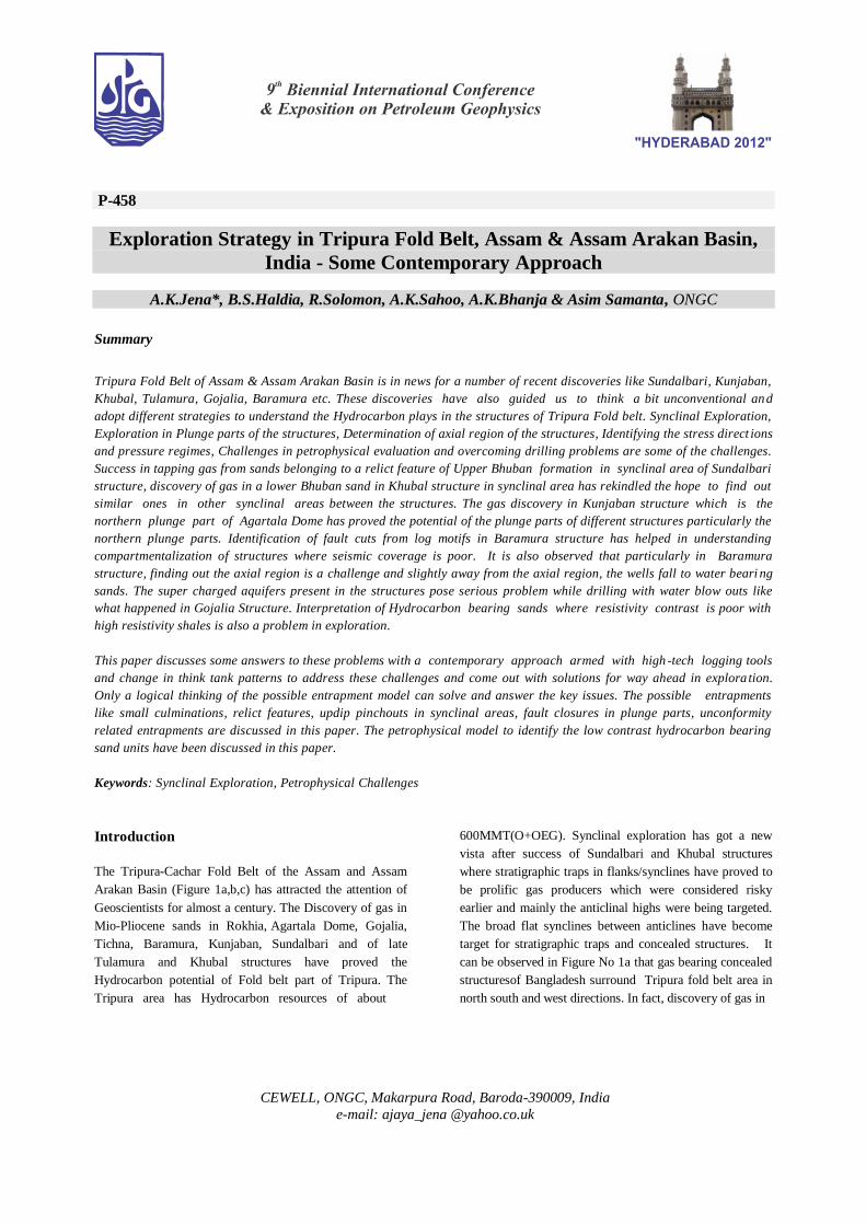
Arakan Basin (Figure 1a,b,c) has attracted the attention of
Geoscientists for almost a century. The Discovery of gas in
Mio-Pliocene sands in Rokhia, Agartala Dome, Gojalia,
Tichna, Baramura, Kunjaban, Sundalbari and of late
Tulamura and Khubal structures have proved the
Hydrocarbon potential of Fold belt part of Tripura. The
Tripura area has Hydrocarbon resources of about
600MMT(O+OEG). Synclinal exploration has got a new
vista after success of Sundalbari and Khubal structures
where stratigraphic traps in flanks/synclines have proved to
be prolific gas producers which were considered risky
earlier and mainly the anticlinal highs were being targeted.
The broad flat synclines between anticlines have become
target for stratigraphic traps and concealed structures. It
can be observed in Figure No 1a that gas bearing concealed
structuresof Bangladesh surround Tripura fold belt area in
north south and west directions. In fact, discovery of gas in
2
Petroleum Systems and Geological Modeling
Bangladesh in structures like Beani Bazar, Begumganj etc.
started in the same year i.e.1972 of gas discovery in
Baramura structure (Curiale J.A. et al 2002) To fulfill the
demand of 6MMSCD gas to Tripura Power Plant, a major
challenge lies ahead to step up exploration/exploitation
efforts to accrete more and more reserves. This paper is an
attempt to have a re-look about the contemporary
exploration / exploitation strategy in Tripura Fold belt.
Regional Geological setting
The Tripura-Cachar fold belt represents the frontal fold-belt
of Assam and Assam Arakan Basin. The belt comprises of
long linear tight N-S trending anticlines separated by broad
synclinal troughs. To the north the belt is bound by ENE-
WSW to E-W trending fold belt associated with Dauki
Transfer Fault which passes to the south of Shillong self.
The intensity of folding increases from West to East and
the tightly folded belt of Mizoram-Manipur, to the east
separated from the Tripura-Cachar belt by Kaladan Fault.
The Kaladan Fault is interpreted to be the eastern limit of
the Surma Sub-basin (Ref Jokhan Ram and Venkat
raman,1984).The folds decrease in intensity and
amplitude towards the west and pass below the Ganges-
Brahmaputra Alluvium in Bangladesh. In the
southern part, the Chittagong Hill tracts in Bangladesh
are contiguous to the fold belt part of Tripura in an en-
echelon pattern. The major anticlinal structures in the
area have associated thrusts on their flanks. Regionally
it is thought that the thrust fold association has its roots
to a decolment surface either within the topmost part of
Barail Group or within the Lower Bhubans (Kale A.S.et al
2007).
Stratigraphy
The stratigraphy of Assam & Assam Arakan fold belt has
been established and revised by a number of workers
likeEvans(1932), Mathur and Evans(1964), Dasgupta et al
(1977), Deshpande et al.(1993) etc. The Tripura Cachar
Fold Belt exposes different sedimentary units mainly along
the narrow linear ranges formed by the anticlines. The
cores of the anticlines usually expose the Bokabil or
Bhuban formations flanked by Bokabil and Tipam/Post
Tipam formations exposures. The pre-Surma sediments
have not been penetrated in the subsurface and are present
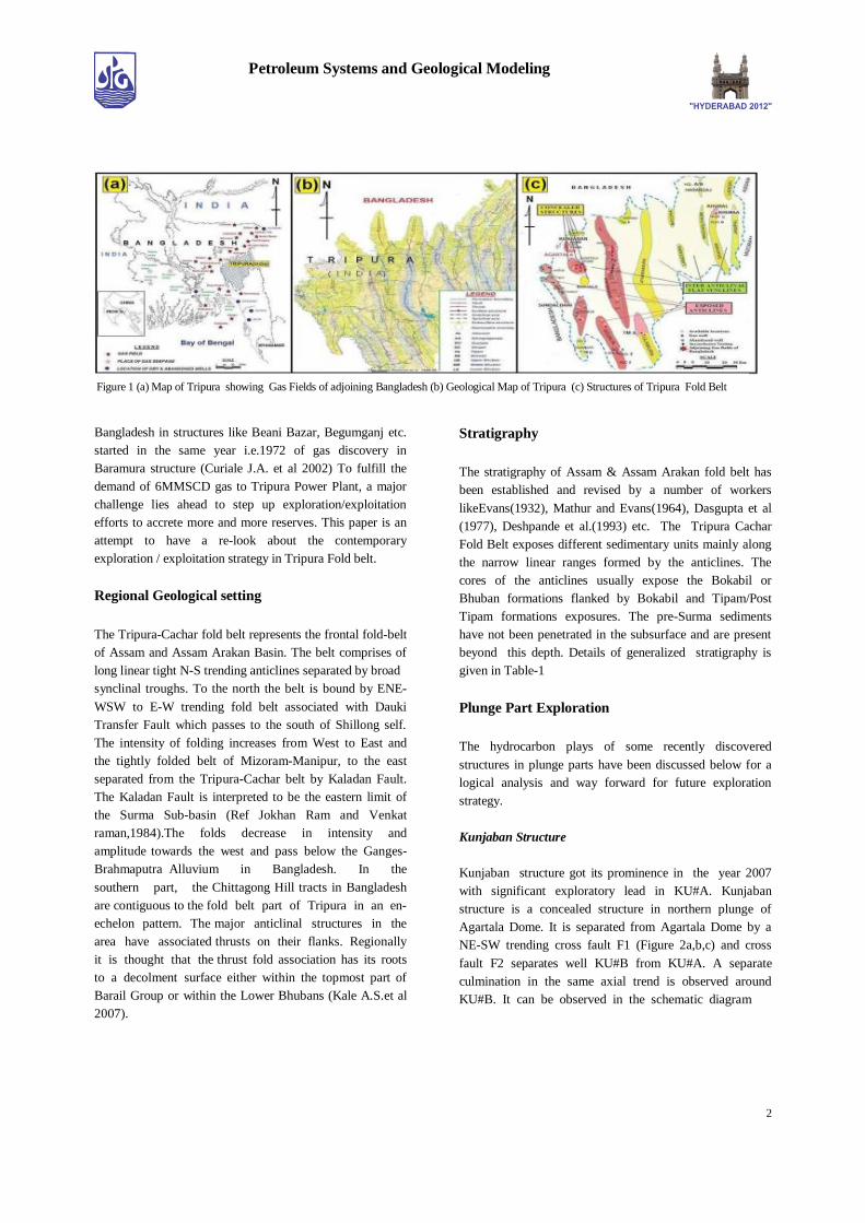
beyond this depth. Details of generalized stratigraphy is
given in Table-1
Plunge Part Exploration
The hydrocarbon plays of some recently discovered
structures in plunge parts have been discussed below for a
logical analysis and way forward for future exploration
strategy.
Kunjaban Structure
Kunjaban structure got its prominence in the year 2007
with significant exploratory lead in KU#A. Kunjaban
structure is a concealed structure in northern plunge of
Agartala Dome. It is separated from Agartala Dome by a
NE-SW trending cross fault F1 (Figure 2a,b,c) and cross
fault F2 separates well KU#B from KU#A. A separate
culmination in the same axial trend is observed around
KU#B. It can be observed in the schematic diagram
Figure 1 (a) Map of Tripura showing Gas Fields of adjoining Bangladesh (b) Geological Map of Tripura (c) Structures of Tripura Fold Belt
3
Petroleum Systems and Geological Modeling
Table 1: Generalised Stratigraphy of Tripura Fold Belt
Figure 2 (a ) Structure Contour Map close to Middle Bhubn top ( b) Seismic section X’X showing plunge part of Kunjaban
Structure ( c ) Schematic diagram showing entrapment of gas in plunge part of Kunjaban structure
4
Petroleum Systems and Geological Modeling
in Figure 2b that in NNW direction of Agartala Dome, there
are three culminations separated by F1 and F2. The
structurally lowest culmination around KU#B is gas
bearing where as in the structurally highest northern plunge
part, the equivalent sands in AD#X are water bearing.
Similarly the culmination around KU#A is gas bearing
which is below GWC of AD#X. The preferential charging
of the sands through fault conduits/permeable layers has
controlled the entrapment where top part of the structurally
lower culminations upto spill point has been charged with
gas where as structurally higher sands in AD#X are water
bearing with very gentle dip without any culmination.
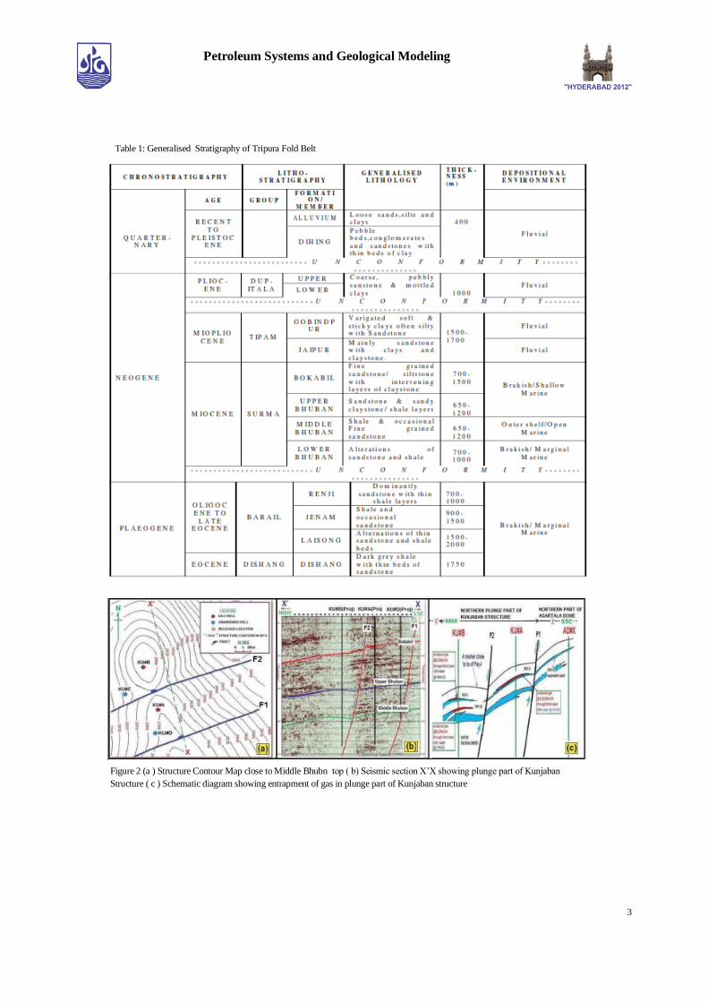
Figure 3: (a) Structure contour map at top of Middle Bhuban
Formation, Baramura Structure (b) Seismic section X - X’ showing
Southern culmination of Baramura Structure
Baramura Structure
The Baramura Anticline is an elongated doubly plunging
asymmetric anticline, trending NNW-SSE with slight
convexity to west near the central culmination (Figure
3a,b). Again there is a bulge in NE direction of well
BRM#Y with axial trend becoming slightly convex towards
NE direction. Recently a Middle Bhuban sand between B-
VII-III and B-VII-II produced gas @ 1,30,000 m3/d of gas
in BRM#Y in northern part of central culmination. The
southern culmination found to be relatively higher unlike
the earlier version, and hence it becomes prospective. The
northern concealed plunge part close to the anticlinal axis is
prospective. The western culmination, which is a concealed
structure looks to be prospective. With scanty seismic data
it is some times very difficult to find out the axial part just
based on Geological maps, so slightly away from the axial
part of the anticline the well falls in water bearing parts. So
a careful strategy to be adopted to probe the anticlinal
areaclose to axis in this logistically and environmentally
difficult structure.
Synclinal Exploration
Khubal Structure
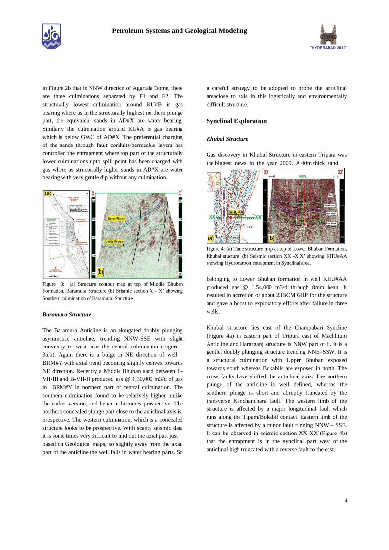
Gas discovery in Khubal Structure in eastern Tripura was
the biggest news in the year 2009. A 40m thick sand
Figure 4: (a) Time structure map at top of Lower Bhuban Formation,
Khubal stucture (b) Seismic section XX -X X’ showing KHU#AA
showing Hydrocarbon entrapment in Synclinal area.
belonging to Lower Bhuban formation in well KHU#AA
produced gas @ 1,54,000 m3/d through 8mm bean. It
resulted in accretion of about 23BCM GIIP for the structure
and gave a boost to exploratory efforts after failure in three
wells.
Khubal structure lies east of the Champabari Syncline
(Figure 4a) in eastern part of Tripura east of Machlitum
Anticline and Hararganj structure is NNW part of it. It is a
gentle, doubly plunging structure trending NNE–SSW. It is
a structural culmination with Upper Bhuban exposed
towards south whereas Bokabils are exposed in north. The
cross faults have shifted the anticlinal axis. The northern
plunge of the anticline is well defined, whereas the
southern plunge is short and abruptly truncated by the
transverse Kanchanchara fault. The western limb of the
structure is affected by a major longitudinal fault which
runs along the Tipam/Bokabil contact. Eastern limb of the
structure is affected by a minor fault running NNW – SSE.
It can be observed in seismic section XX-XX’(Figure 4b)
that the entrapment is in the synclinal part west of the
anticlinal high truncated with a reverse fault to the east.
5
Petroleum Systems and Geological Modeling
Sundalbari Structure
Sundalbari structure got its discovery in the year 2007 with
well SD#BB. Sundalbari Structure is a separate fault
closure in northern plunge of Tichna Anticline(Figure 5a).
Though Sundalbari structure is in the northern plunge of
Tichna field and is structurally down w.r.to nearby main
Tichna anticline, the commercial gas production from
SD#BB has proved that the structurally lowest fault blocks
of Sundalbari structure have suitable HC entrapment
condition in northern most plunge part of structure.
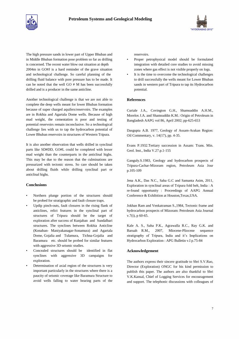
Figure 5 (a) Structure map at top of Upper Bhuban Formation, (close
to MFS), Sundalbari Structure (b) Seismic section A- A’ showing
hydro carbon bearing Relict feature in eastern syncline of Sundalbari
Structure
Tichna anticline, the commercial gas production from
SD#BB has proved that the structurally lowest fault blocks
of Sundalbari structure have suitable HC entrapment
condition in northern most plunge part of structure. It can be
observed in the seismic section AA’ (Figure 5b) that the
erosional relict feature in well SD#DD has arenaceous
bands with claystone/shale drapes which act as an effective
seal in the eastern synclinal part of Sundalbari Structure
(Jena A.K. et al 2011) and has trapped hydrocarbon. So
exploration haunt should be for similar stratigraphic traps in
the flat inter-structural synclines.
Anticlinal Closures
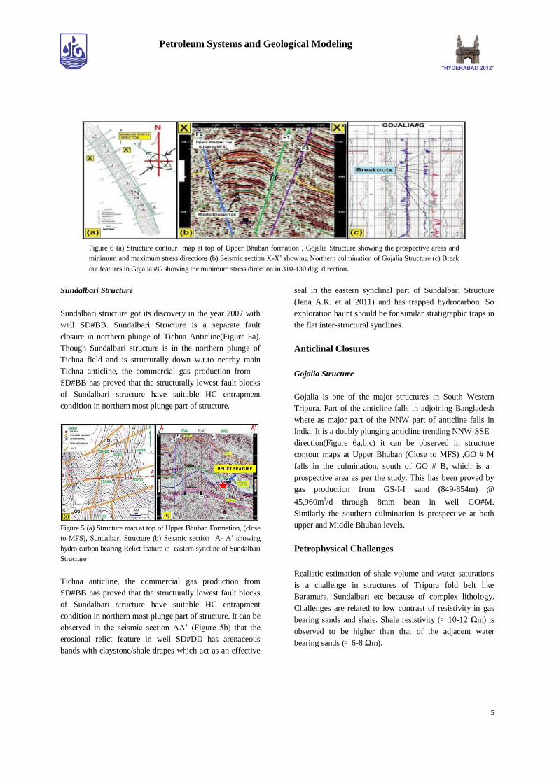
Gojalia Structure
Gojalia is one of the major structures in South Western
Tripura. Part of the anticline falls in adjoining Bangladesh
where as major part of the NNW part of anticline falls in
India. It is a doubly plunging anticline trending NNW-SSE
direction(Figure 6a,b,c) it can be observed in structure
contour maps at Upper Bhuban (Close to MFS) ,GO # M
falls in the culmination, south of GO # B, which is a
prospective area as per the study. This has been proved by
gas production from GS-I-I sand (849-854m) @
45,960m3/d through 8mm bean in well GO#M.
Similarly the southern culmination is prospective at both
upper and Middle Bhuban levels.
Petrophysical Challenges
Realistic estimation of shale volume and water saturations
is a challenge in structures of Tripura fold belt like
Baramura, Sundalbari etc because of complex lithology.
Challenges are related to low contrast of resistivity in gas
bearing sands and shale. Shale resistivity (≈ 10-12 Ωm) is
observed to be higher than that of the adjacent water
bearing sands (≈ 6-8 Ωm).
Figure 6 (a) Structure contour map at top of Upper Bhuban formation , Gojalia Structure showing the prospective areas and
minimum and maximum stress directions (b) Seismic section X-X’ showing Northern culmination of Gojalia Structure (c) Break
out features in Gojalia #G showing the minimum stress direction in 310-130 deg. direction.
6
Petroleum Systems and Geological Modeling
Therefore, the computed volume of shale using the
resistivity log appears to be higher. Both the Gamma Ray
and SP logs are quite erratic at several places. Apparent
Neutron shale porosity is observed to be in the range of 24-
30 p.u. and close to that of sandstone reservoir. Gas effect is
not visible on density-neutron log. Very low contrast
between shale density and sand matrix density is observed.
Sonic porosity is low and gas effect is not identifiable on
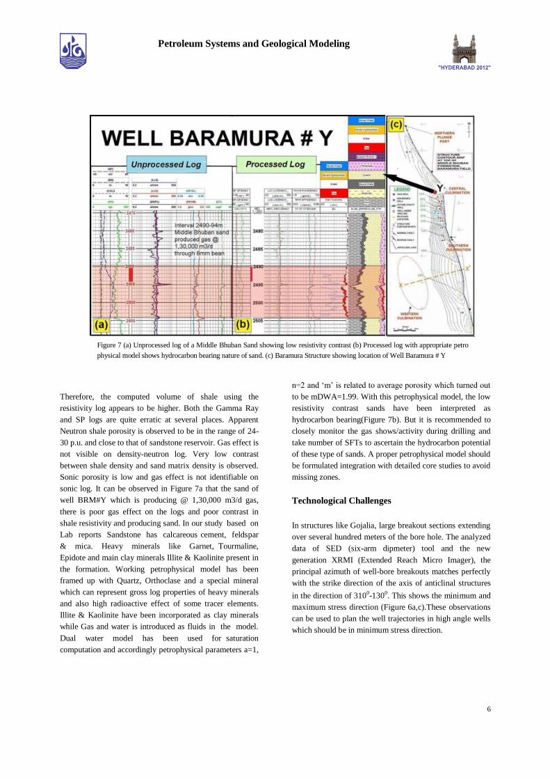
sonic log. It can be observed in Figure 7a that the sand of
well BRM#Y which is producing @ 1,30,000 m3/d gas,
there is poor gas effect on the logs and poor contrast in
shale resistivity and producing sand. In our study based on
Lab reports Sandstone has calcareous cement, feldspar
& mica. Heavy minerals like Garnet, Tourmaline,
Epidote and main clay minerals Illite & Kaolinite present in
the formation. Working petrophysical model has been
framed up with Quartz, Orthoclase and a special mineral
which can represent gross log properties of heavy minerals
and also high radioactive effect of some tracer elements.
Illite & Kaolinite have been incorporated as clay minerals
while Gas and water is introduced as fluids in the model.
Dual water model has been used for saturation
computation and accordingly petrophysical parameters a=1,
n=2 and ‘m’ is related to average porosity which turned out
to be mDWA=1.99. With this petrophysical model, the low
resistivity contrast sands have been interpreted as
hydrocarbon bearing(Figure 7b). But it is recommended to
closely monitor the gas shows/activity during drilling and
take number of SFTs to ascertain the hydrocarbon potential
of these type of sands. A proper petrophysical model should
be formulated integration with detailed core studies to avoid
missing zones.
Technological Challenges
In structures like Gojalia, large breakout sections extending
over several hundred meters of the bore hole. The analyzed
data of SED (six-arm dipmeter) tool and the new
generation XRMI (Extended Reach Micro Imager), the
principal azimuth of well-bore breakouts matches perfectly
with the strike direction of the axis of anticlinal structures
in the direction of 3100-1300. This shows the minimum and
maximum stress direction (Figure 6a,c).These observations
can be used to plan the well trajectories in high angle wells
which should be in minimum stress direction.
Figure 7 (a) Unprocessed log of a Middle Bhuban Sand showing low resistivity contrast (b) Processed log with appropriate petro
physical model shows hydrocarbon bearing nature of sand. (c) Baramura Structure showing location of Well Baramura # Y
7
Petroleum Systems and Geological Modeling
The high pressure sands in lower part of Upper Bhuban and
in Middle Bhuban formation pose problem so far as drilling
is concerned. The recent water blow out situation at depth
2004m in GO#J is a hard reminder of the grave situation
and technological challenge. So careful planning of the
drilling fluid balance with pore pressure has to be made. It
can be noted that the well GO # M has been successfully
drilled and is a producer in the same anticline.
Another technological challenge is that we are not able to
complete the deep wells meant for lower Bhuban formation
because of super charged aquifers/reservoirs. The examples
are in Rokhia and Agartala Dome wells. Because of high
mud weight, the cementation is poor and testing of
potential reservoirs remain inconclusive. So a technological
challenge lies with us to tap the hydrocarbon potential of
Lower Bhuban reservoirs in structures of Western Tripura.
It is also another observation that wells drilled in synclinal
parts like SD#DD, GO#L could be completed with lesser
mud weight than the counterparts in the anticlinal highs.
This may be due to the reason that the culminations are
pressurized with tectonic stress. So care should be taken
about drilling fluids while drilling synclinal part or
anticlinal highs.
Conclusions
• Northern plunge portion of the structures should
be probed for stratigraphic and fault closure traps.
• Updip pinch-outs, fault closures in the rising flank of
anticlines, relict features in the synclinal part of
structures of Tripura should be the target of
exploration after success of Kunjaban and Sundalbari
structures. The synclines between Rokhia Anticline
(Konaban- Maniyakanagar-Sonamura) and Agartala
Dome, Gojalia and Tulamura, Tichna-Gojalia and
Baramura etc. should be probed for similar features
with aggressive 3D seismic studies.
• Concealed structures should be identified in flat
synclines with aggressive 3D campaigns for
exploration.
• Determination of axial region of the structures is very
important particularly in the structures where there is a
paucity of seismic coverage like Baramura Structure to
avoid wells falling to water bearing parts of the
reservoirs.
• Proper petrophysical model should be formulated
integration with detailed core studies to avoid missing
zones where gas effect is not visible properly on logs.
• It is the time to overcome the technological challenges
to drill successfully the wells meant for Lower Bhuban
sands in western part of Tripura to tap its Hydrocarbon
potential.
References
Curiale J.A., Covington G.H., Shamsuddin A.H.M.,
Morelos J.A. and Shamsuddin K.M.: Origin of Petroleum in
Bangladesh AAPG vol 86, April 2002; pp-625-653
Dasgupta A.B. 1977, Geology of Assam-Arakan Region:
Oil Commentary, v. 14(17), pp. 4-35.
Evans P.1932.Tertiary succession in Assam: Trans. Min.
Geol. Inst., India V.27.p.1-155
Ganguly.S.1983, Geology and hydrocarbon prospects of
Tripura-Cachar-Mizoram region, Petroleum Asia Jour
p.105-109
Jena A.K., Das N.C., Saha G.C and Samanta Asim, 2011,
Exploration in synclinal areas of Tripura fold belt, India : A
re-found opportunity : Proceedings of AAPG Annual
Conference & Exhibition at Houston,Texas,USA.
Jokhan Ram and Venkatraman S.,1984, Tectonic frame and
hydrocarbon prospects of Mizoram: Petroleum Asia Journal
v.7(i), p 60-65.
Kale A. S., Saha P.K., Agrawalla R.C., Ray G.K. and
Baruah R.M., 2007, Miocene-Pliocene sequence
stratigraphy of Tripura, India and it’s Implications on
Hydrocarbon Exploration : APG Bulletin v.I p.75-84
Acknowledgement
The authors express their sincere gratitude to Shri S.V.Rao,
Director (Exploration) ONGC for his kind permission to
publish this paper. The authors are also thankful to Shri
V.K.Kansal, Chief of Logging Services for encouragement
and support. The telephonic discussions with colleagues of

8
Petroleum Systems and Geological Modeling
AAFB Block, A&AA Basin Jorhat is highly acknowledged.
The authors thank all the CEWELL colleagues for their
support.


