Download - FCC Rule 1.1307 NEPA Screening
FCC Rule 1.1307
NEPA Screening
Bremo Bluff Tower
Bremo Bluff, Fluvanna County, Virginia
EEE Project Number 16‐041
Prepared for:
707 East Main Street Richmond, VA 23219
Prepared by
8525 Bell Creek Road
Mechanicsville, Virginia 23116
(804)442‐3330
May 2016

This page intentionally left blank.

NEPA Screening Checklist
Client: Dominion Site Name: Bremo Bluff Tower EEE# 16-041 Location: Bremo Bluff, Fluvanna County, Virginia
Check either the left box below if positive, or the right box below if negative. NEPA Threshold Reference Positive Negative 1. Wilderness Area Is the proposed facility located in an officially designated wilderness area?
US Forest Service Wilderness Areas dataset, Bureau of Land Management Wilderness Areas and Wilderness Study Areas datasets, and National Park Service Wilderness Preservation System Areas dataset
x
2. Wildlife preserve Is the proposed facility located in an officially designated wildlife preserve?
US Fish and Wildlife Service (USFWS) Refuge Locator map and Virginia Department of Game and Inland Fisheries (DGIF) Wildlife Environmental Review Map Service
x
3. Threatened and Endangered Species Will the proposed facility likely affect threatened or endangered species or designated critical habitats?
USFWS’s Information, Planning, and Conservation System (IPaC) and DGIF’s Fish and Wildlife Information Service (VAFWIS)
x
4. Threatened and Endangered Species Will the proposed facility likely jeopardize the continued existence of any proposed or endangered species?
USFWS’s IPaC and DGIF’s VAFWIS x
5. Critical habitat Will the proposed facility likely result in the destruction or adverse modification of proposed critical habitats (as determined by the Endangered Species Act of 1973)?
USFWS’s IPaC x
6. National Register of Historic Places Will the facility affect districts, sites, buildings, structures, or objects, significant in American history, architecture, archeology, engineering or culture, that are listed (or eligible for listing) in the National Register of Historic Places?
7. Indian Religious Will the facility affect Indian religious site(s)?
Advisory Council on Historic Preservation guidance and regulations
x
8. Floodplain Is the facility located in a flood plain?
the site is located outside the floodplain (VBMP 2013 Imagery), National Flood Hazard Database Layer
x
9. Surface Features Will the construction of the proposed facility involve significant change in surface features (e.g., wetland fill, deforestation or water diversion)?
field visit and mapping – the site has been disturbed and is currently a 0.22 acre deteriorating basketball court; no Waters of the United States were observed during the site visit, and none are shown on Fluvanna County online mapping or National Hydrography Dataset mapping
x

10. High Intensity White Lights Will the proposed facility be located in a residential neighborhood as defined by local zoning law and equipped with high intensity white lights?
this site is zoned as an agricultural district, not residential (Fluvanna County online zoning map)
x
11. Facility Power Will the proposed NON-ROOFTOP facility equal or exceed total power (of all channels) of 2000 watts ERP for Broadband PCS or 1000 watts for Narrowband PCS and have antennas located less than 10 meters above ground level?
N/A - this pertains to cell towers, and this will be a microwave tower
x
The undersigned has reviewed and approved the completion of this NEPA checklist for the above reference site.
Signed: Title: Senior Environmental Scientist Date: 23 May 2016 Print Name: Susan L. Liszeski

Table of Contents
Introduction ......................................................................................................................... 1
Environmental Screening ..................................................................................................... 2
2.1 Wilderness Areas .............................................................................................................. 2
2.2 Wildlife Preserves ............................................................................................................. 3
2.3 Threatened and Endangered Species & Critical Habitat .................................................. 3
2.4 Cultural Resources ............................................................................................................ 4
2.5 Indian Religious Sites ........................................................................................................ 4
2.6 Floodplains ....................................................................................................................... 5
2.7 Surface Features ............................................................................................................... 5
2.8 High Intensity White Lighting ........................................................................................... 5
2.9 Facility Power ................................................................................................................... 5
Conclusion ............................................................................................................................ 6
Appendix A – Project Location Maps .............................................................................................. 7
Appendix B – Project Plans ............................................................................................................. 9
Appendix C – Threatened and Endangered Species ..................................................................... 11
Appendix D – Cultural Resources .................................................................................................. 13
Appendix E – FEMA Map ............................................................................................................... 15
Appendix F – Surface Features Maps............................................................................................ 17

This page intentionally left blank.

Dominion Resources Bremo Bluff Tower 1
INTRODUCTION
The National Environmental Policy Act (NEPA) of 1969, as amended, established a national goal
of protecting the environment. NEPA requirements apply to any action taken by a federal agency,
funded by a federal agency, or occurring on federal land. Specifically, NEPA and the regulatory
guidelines established by the Council on Environmental Quality (CEQ), which implemented the
Act (Title 40 of the Code of Federal Regulations [CFR] §§ 1500 et seq.), require all Federal agencies
to consider environmental consequences when making decisions or implementing projects which
could be deemed "major federal actions."
The Federal Communication Commission (FCC) is a licensing agency. The FCC complies with NEPA
by requiring its licensees to review their proposed actions for potential environmental
consequences. The FCC's rules for implementing NEPA are found in 47 CFR, Part 1, Subpart I, rule
sections 1.1301 to 1.1319.
Section 1.1307 of these rules lists eight categories of facilities that may have significant effects
on environmental or cultural resources. If, after assessing the potential impacts of a proposed
facility, the FCC determines there is the potential for significant impacts on environmental or
cultural resources, an Environmental Assessment should be prepared to fully address these
impacts. If no resources would be significantly impacted by the proposed facility, compliance
with NEPA is satisfied. Pursuant to Section 1.1307, these facilities are as follows:
(1) Facilities that are to be located in an officially designated wilderness area.
(2) Facilities that are to be located in an officially designated wildlife preserve.
(3) Facilities that: (i) May affect listed threatened or endangered species or designated
critical habitats; or (ii) are likely to jeopardize the continued existence of any
proposed endangered or threatened species or likely to result in the destruction or
adverse modification of proposed critical habitats, as determined by the Secretary of
the Interior pursuant to the Endangered Species Act of 1973.
(4) Facilities that may affect districts, sites, buildings, structures or objects, significant in
American history, architecture, archeology, engineering or culture, that are listed, or
are eligible for listing, in the National Register of Historic Places.
(5) Facilities that may affect Indian religious sites.
(6) Facilities to be located in a floodplain
(7) Facilities whose construction will involve significant change in surface features (e.g.,
wetland fill, deforestation or water diversion).
Dominion Resources Bremo Bluff Tower 2
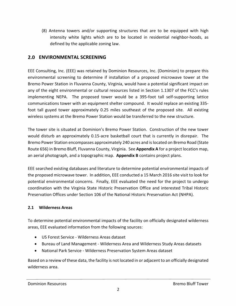
(8) Antenna towers and/or supporting structures that are to be equipped with high
intensity white lights which are to be located in residential neighbor‐hoods, as
defined by the applicable zoning law.
ENVIRONMENTAL SCREENING
EEE Consulting, Inc. (EEE) was retained by Dominion Resources, Inc. (Dominion) to prepare this
environmental screening to determine if installation of a proposed microwave tower at the
Bremo Power Station in Fluvanna County, Virginia, would have a potential significant impact on
any of the eight environmental or cultural resources listed in Section 1.1307 of the FCC’s rules
implementing NEPA. The proposed tower would be a 395‐foot tall self‐supporting lattice
communications tower with an equipment shelter compound. It would replace an existing 335‐
foot tall guyed tower approximately 0.25 miles southeast of the proposed site. All existing
wireless systems at the Bremo Power Station would be transferred to the new structure.
The tower site is situated at Dominion’s Bremo Power Station. Construction of the new tower
would disturb an approximately 0.15‐acre basketball court that is currently in disrepair. The
Bremo Power Station encompasses approximately 240 acres and is located on Bremo Road (State
Route 656) in Bremo Bluff, Fluvanna County, Virginia. See Appendix A for a project location map,
an aerial photograph, and a topographic map. Appendix B contains project plans.
EEE searched existing databases and literature to determine potential environmental impacts of
the proposed microwave tower. In addition, EEE conducted a 15 March 2016 site visit to look for
potential environmental concerns. Finally, EEE evaluated the need for the project to undergo
coordination with the Virginia State Historic Preservation Office and interested Tribal Historic
Preservation Offices under Section 106 of the National Historic Preservation Act (NHPA).
2.1 Wilderness Areas
To determine potential environmental impacts of the facility on officially designated wilderness
areas, EEE evaluated information from the following sources:
US Forest Service ‐ Wilderness Areas dataset
Bureau of Land Management ‐ Wilderness Area and Wilderness Study Areas datasets
National Park Service ‐ Wilderness Preservation System Areas dataset
Based on a review of these data, the facility is not located in or adjacent to an officially designated
wilderness area.

Dominion Resources Bremo Bluff Tower 3
2.2 Wildlife Preserves
To determine potential environmental impacts of the facility on officially designated wildlife
preserves, EEE evaluated information from the following sources:
US Fish and Wildlife Service (USFWS) ‐ Wildlife Refuge Locator map
Virginia Department of Game and Inland Fisheries (VDGIF) ‐ Wildlife Environmental
Review Map Service
Based on a review of these data, the facility is not located in or adjacent to an officially designated
wildlife preserve.
2.3 Threatened and Endangered Species & Critical Habitat
EEE assessed the potential environmental impacts of the facility on species with federal or state
protection. This includes those that are listed or proposed for listing as threatened or
endangered species and designated critical habitats. EEE evaluated information from the
following sources:
USFWS ‐ Information, Planning, and Conservation System (IPaC)
VDGIF ‐ Virginia Fish and Wildlife Information System (VAFWIS)
Virginia Department of Conservation and Recreation (DCR) – Division of Natural
Heritage Project Review
Based on a review of these databases, the proposed facility would not impact a listed or proposed
threatened or endangered species or their designated critical habitats. The DCR Natural Heritage
Review identified one landscape worthy of protection and stewardship action because of the
natural heritage resources and habitat they support. Appropriate erosion and sedimentation
controls (ESCs) would protect the James River ‐ Bremo Stream Conservation Unit approximately
1.7 miles from the proposed project site. ESCs would also protect the three state‐protected
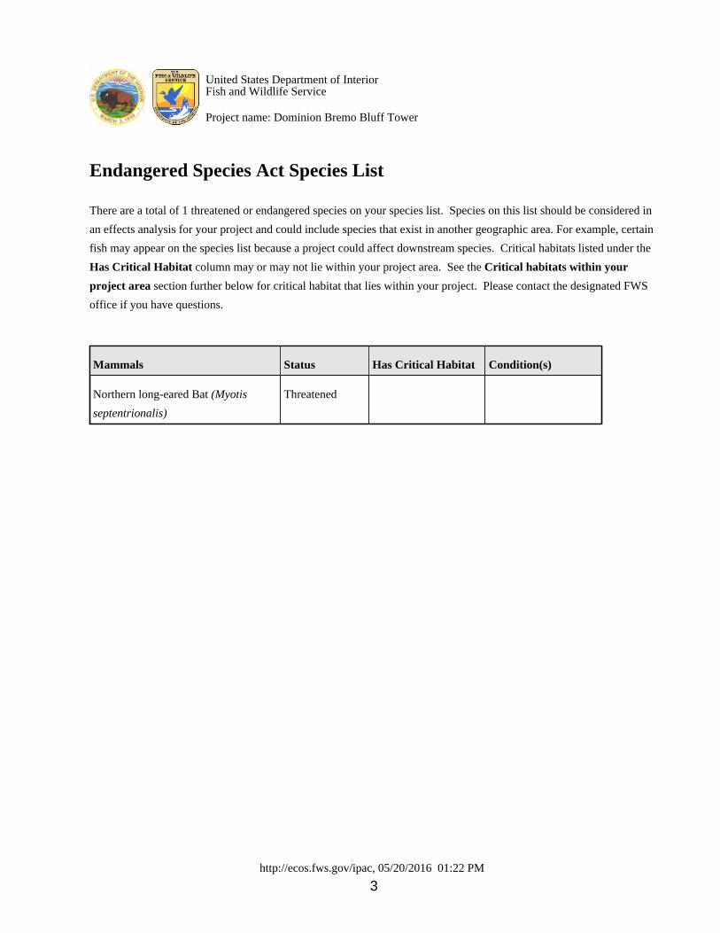
species that, according to VAFWIS, have been confirmed within two miles of the project site. IPaC
identified only the northern long‐eared bat (Myotis septentrionalis) as being in the vicinity of the
proposed tower. Since no trees would be removed, this project would not effect the bat.
Based on the above information, this project would not impact threatened or endangered
species. Refer to Appendix C for supporting documentation on this resource.

Dominion Resources Bremo Bluff Tower 4
2.4 Cultural Resources
The Nationwide Programmatic Agreement for Review of Effects on Historic Properties for Certain
Undertakings Approved by the Federal Communications Commission establishes the Area of
Potential Effect (APE) for communications facilities. Under the programmatic agreement (PA),
the APE for towers between 200 and 400 feet tall, such as the proposed facility, is 0.75 miles.
The PA states that only those properties which are listed in the National Register of Historic Places
(NRHP), or previously determined eligible for listing, need to be evaluated. The APE for
archaeological resources is limited to the area of ground disturbance.
There are no archaeological resources within the proposed limits of disturbance. Three
architectural resources fall within the 0.75‐mile APE. The VEPCO Power Plant is one of the listed
resources. Since the proposed tower would be a part of the plant and the plant is an industrial
facility, the new tower is not out of character with this resource. During the 15 March 2016 site
reconnaissance, EEE visited the remaining architectural resources, Spring Garden and Spring
Garden Slave House. Due to the heavily wooded nature of the area surrounding the proposed
tower site, the tower is unlikely to be visible from either architectural resource. Therefore, it is
concluded that the project would not have a significant impact on any historic resources. Refer
to Appendix D for supporting documentation for this resource.
2.5 Indian Religious Sites
According to the Advisory Council on Historic Preservation’s (ACHP) Consultation with Indian
Tribes in the Section 106 Review Process: A Handbook, “Section 106 of the NHPA requires federal
agencies to take into account the effects of their undertakings on historic properties and provide
the Advisory Council on Historic Preservation (ACHP) a reasonable opportunity to comment on
those undertakings. The ACHP has issued the regulations implementing Section 106 (Section 106
regulations), 36 CFR Part 800, ‘Protection of Historic Properties.’ The NHPA requires that, in
carrying out the Section 106 review process, federal agency must consult with any Indian tribe
that attaches religious and cultural significance to historic properties that may be affected by the
agency’s undertakings.”
EEE coordinated with all tribes identified through the Tower Construction Notification System
process. Letters were sent to the Catawba Indian Nation, the Cherokee Nation, the Delaware
Nation, the Eastern Shawnee Tribe of Oklahoma, and the Shawnee Tribe. The Catawba Indian
Nation and the Cherokee Nation both responded that they had no cultural concerns related to
the project. The remaining tribes have not provided comments.

Dominion Resources Bremo Bluff Tower 5
Based on the information above, it is concluded that the project would not have a significant
adverse impact on any Indian Religious sites.
2.6 Floodplains
To determine potential environmental impacts of the facility on 100‐year and 500‐year
floodplains, EEE evaluated the Federal Emergency Management Agency (FEMA) Map for
Fluvanna County, Virginia (All Jurisdictions), Panel ID Number 51065C0260C. Based on the review
of this map, the proposed facility is located outside both the 100‐year and 500‐year floodplain.
Therefore, this project would not have a significant impact on floodplains. Refer to Appendix E
for supporting documentation on this resource.
2.7 Surface Features
To determine potential environmental impacts of the facility on surface features, including
jurisdictional wetlands and streams, deforestation, and water diversion, EEE evaluated the
following information:
National Wetlands Inventory (NWI) map
Natural Resources Conservation Service (NRCS) Soil Survey map
Based on a review of these data and EEE’s site visit, the facility would not significantly impact
surface features. Unnamed tributaries to Holman Creek and the James River are located to the
north and to the southeast of the proposed tower site, respectively, but would not be impacted
by the project. According to the NWI map there are small freshwater emergent wetlands to the
northeast and southeast of the tower site, but they would also be unaffected by the project. No
deforestation would occur as a result of this project. Refer to Appendix F for supporting
documentation on this resource.
2.8 High Intensity White Lighting
The proposed tower will be located within a power station operated by Dominion, on land zoned
as an agricultural district. The land is not dedicated to residential use. In addition, high intensity
white lighting would not be used on the proposed tower. Therefore, lighting for the facility would
not have a significant impact on residential neighborhoods.
2.9 Facility Power
Based on information provided by Dominion, the proposed facility is a microwave tower, not a
cellular phone tower. Dominion has no Broadband PCS carriers collocated on the existing tower

Dominion Resources Bremo Bluff Tower 6
and there are no plans to allow PCS on the new structure. Therefore, there would be no concerns
with facility power when the new tower is built.
CONCLUSION
Based on a site visit and a review of publicly available data and literature, the facility would not
have a significant environmental impact on any of the environmental or cultural resources
identified under Section 1.1307. Therefore, the proposed construction and operation of the
switching station tower would be compliant with the requirements of NEPA.

APPENDIX A – PROJECT LOCATION MAPS


!!
FIGURE 1PROJECT LOCATION
DOMINION BREMO BLUFF TOWER0 5 10Miles
Fluvanna County, VirginiaSource: ESRI World Street MapPrepared by JK, April 2016EEE Project No. 16-041
Ü
Projection: NAD 1983 StatePlane Virginia South FIPS 4502 Feet
Project Area
!!

!!
FIGURE 2USGS TOPOGRAPHIC MAPDOMINION BREMO BLUFF TOWER0 0.5 1
MilesFluvanna County, VirginiaSource: ESRI World Street MapPrepared by JK, April 2016EEE Project No. 16-041
Ü
Projection: NAD 1983 StatePlane Virginia South FIPS 4502 Feet
1:24,000
Project Area

Source: Esri, DigitalGlobe, GeoEye, Earthstar Geographics, CNES/AirbusDS, USDA, USGS, AEX, Getmapping, Aerogrid, IGN, IGP, swisstopo, andthe GIS User Community, Esri, HERE, DeLorme, MapmyIndia, ©OpenStreetMap contributors, and the GIS user community
FIGURE 3AERIAL PHOTOGRAPH
DOMINION BREMO BLUFF TOWER0 0.5 1Miles
Fluvanna County, VirginiaSource: ESRI Aerial 2014Prepared by JK, April 2016EEE Project No. 16-041
Ü
Projection: NAD 1983 StatePlane Virginia South FIPS 4502 Feet
Project Area
!!
Source: Esri, DigitalGlobe, GeoEye,Earthstar Geographics, CNES/Airbus DS,USDA, USGS, AEX, Getmapping,Aerogrid, IGN, IGP, swisstopo, and theGIS User Community
! Center of Proposed Tower
Project Study Area


APPENDIX B – PROJECT PLANS


X
X
X
E
X
IS
T
IN
G
A
C
C
E
S
S
R
O
A
D
APPROX. LIMITS OF
NORTH ASH POND (TYP.)
(3
0
' P
R
E
S
C
R
IP
T
IV
E
R
/W
)
EXISTING
PLAYGROUND
EXISTING
STRUCTURE
EXISTING GATE
EXISTING GATE
EXISTING GATE
EXISTING
BASEBALL
DIAMOND
PROPOSED
COMMUNICATION
TOWER COMPOUND
(SEE DETAIL)
EXISTING GATE
EXISTING WOOD
FRAME PAVILION
NORTH ASH POND
X
X
X
X
X
2
3
'
R
3
9
0
'
X X X X X X
XX
X
XXXXXX
XX
17'
38.5'
12'
SECURITY FENCE
WITH DOUBLE SWING
GATE
EXISTING ASPHALT
(TO BE REMOVED)
EXISTING FENCE (TO BE REMOVED)
19.25'
X X X X X XX
XX
X
XX
XX
XX
XX
XX
XX
X
X
X
X
X
38.5'
PROPOSED 390'
SELF-SUPPORTING
TOWER
PROPOSED 1000
gal LP FUEL
TANK ON 5' X 15'
CONCRETE PAD.
PR
OP
. F
LU
VA
NN
A
CO
. 11'-8" X
16'-6"
EQ
UIP
ME
NT
SH
ELT
ER
PROPOSED DOMINION
POWER 12' X 20'
EQUIPMENT SHELTER
PROPOSED 50 kw LP FUEL
GENERATOR ON 5' X 10'
CONCRETE PAD.
ICE BRIDGE
5'
5'
5'
5'
1'
9'
4'
3'
4.68'
LEYLAND CYPRUS PLANTED 10' O.C.
30.85'
17.07'
GR
AV
EL
DR
IV
E
PROPOSED 500
gal LP TANK
GRAVEL
3'
MIN.
PROPERTY BOUNDARY
APPROXIMATE LIMITS OF NORTH ASH POND
EXISTING TOPOGRAPHIC CONTOURS (2' INTERVALS)
EXISTING TREE LINE
EXISTING FENCE
EXISTING OVERHEAD UTILITY LINE
LEGEND
300
X X
GENERAL NOTES
1. EXISTING CONDITIONS COMPILED FROM:
a. AERIAL TOPOGRAPHIC SURVEY PREPARED BY McKENZIE SNYDER, INC.,
DATE OF AERIAL PHOTO: 1/16/15 [CONTROL PREPARED BY H&B
SURVEYING & MAPPING (H&B)]
b. BOUNDARY SURVEY PREPARED BY H&B SURVEYING AND MAPPING, LLC
DATED 04/27/15.
2. SITE DATUM: NAD83 / NAVD88
3. WETLAND DELINEATION BY DOMINION ENVIRONMENTAL SERVICES ON 01/30/15
& 02/05/15 AND BY GOLDER ASSOCIATES ON 03/16/15 & 03/25/15. WATERS OF
THE U.S. CONFIRMED BY THE USACE DURING JUNE 4, 2015 SITE VISIT.
4. 100 YEAR FLOOD PLAIN DELINEATION BASED ON FLOOD ELEVATION DATA
REPRESENTED ON FEMA FLOOD INSURANCE RATE MAP (FIRM), MAP NUMBER
51065C0260C, EFFECTIVE DATE: 05/16/2008.
5. ADJACENT PARCELS ARE ZONED A-1 WITH THE EXCEPTION OF THE TWO NOTED
PARCELS AT THE NORTH WEST CORNER OF THE PROPERTY BOUNDARY.
6. GENERATOR TESTING SHALL OCCUR ONLY BETWEEN 9:00 AM AND 4:00 PM
MONDAY THROUGH FRIDAY.
GROMMETTED NYLON
STRAPPING W/ 10 GUAGE
GUY WIRE. TWIST UNTIL
TAUGHT
2' - 3' SAUCER WITH 2" - 3"
OF SHREDDED HARDWOOD
MULCH
FINISH GRADE
BACKFILL SOIL MIX AMEND
TO 2.5' DEPTH MIN. (SEE
PLANTING NOTES)
POSTS DRIVEN INTO
UNDISTURBED GROUND
OUTSIDE OF TREE PIT AREA
NEVER CUT MAIN LEADER
SELECTIVELY PRUNE TOP
1
4
TH OF BRANCHES
REMOVE BROKEN, DAMAGED
AND CONFLICTING BRANCHES
(2) 2"x2"x6' HARDWOOD STAKES
WRAP TRUNK WITH TREE WRAP, TIE
WITH TWINE AT 3 PLACES MINIMUM
TO SECURE WRAP (START FROM
BOTTOM AND WRAP UP)
CUT AND REMOVE BURLAP FROM
TOP
1
3
OF ROOT BALL
FIRMLY TAMPED AMENDED SOIL
12" MIN.
BALLED OR BURLAPPED TREE PLANTING DETAIL
NOT TO SCALE
NOTE: FOR TREES LESS THAN 2
1
2
" CALIPER
G:\P
lan P
roduction D
ata F
iles\D
raw
ing D
ata F
iles\15-20347\Q
- C
om
munication T
ow
er P
lan\A
ctive D
raw
ings\1520347Q
02.dw
g
050 50 100
SCALE FEET
SIT
E P
LA
N
DO
MIN
IO
N
BR
EM
O P
OW
ER
S
TA
TIO
N
CO
MM
UN
IC
AT
IO
N T
OW
ER
RE
LO
CA
TIO
N
FL
UV
AN
NA
C
OU
NT
Y, V
IR
GIN
IA
FIGURE 1
DESIGN
PROJECT No.
CADD
CHECK
REVIEW
FILE No.
SCALEREV.
RE
VIS
IO
N D
ES
CR
IP
TIO
NC
AD
DC
HK
RV
WD
ES
DA
TE
RE
V
TIT
LE
PR
OJE
CT
1520347
1520347Q02
0 AS SHOWN
ATN 03/15/2016
KLL 01/19/2016
TOWER COMPOUND DETAIL
SCALE: 1" = 10'-0"
1. ALL PLANTS SHALL BE HEALTHY, VIGOROUS MATERIAL FREE OF PESTS
AND DISEASE AT THE TIME OF PLANTING.
2. ALL PLANTS SHALL BE CONTAINER-GROWN OR BALLED AND BURLAPPED.
3. ALL PLANTS AND STAKED LOCATIONS ARE SUBJECT TO THE APPROVAL OF
THE VERIZON CONSTRUCTION MANAGER BEFORE, DURING AND AFTER
INSTALLATION.
4. ALL PLANTS AND PLANTING AREAS SHALL BE COMPLETELY MULCHED AS
SPECIFIED ON THE DETAIL.
5. PRIOR TO CONSTRUCTION, THE CONTRACTOR SHALL BE RESPONSIBLE
FOR LOCATING ALL UNDERGROUND UTILITIES AND SHALL AVOID DAMAGE
TO ALL UTILITIES DURING THE COURSE OF THE WORK.
6. THE CONTRACTOR IS RESPONSIBLE FOR MAINTAINING ALL PLANTING,
PLANTING AREAS AND LAWNS UNTIL THE WORK IS ACCEPTED IN TOTAL BY
THE VERIZON CONSTRUCTION MANAGER.
7. THE CONTRACTOR SHALL BE RESPONSIBLE FOR THE CARE AND
MAINTENANCE OF PLANTS FOR A PERIOD OF THREE YEARS FOLLOWING
PLANTING, AND THE REPLACEMENT OF ANY DEAD, DYING OR DISEASED
VEGETATION REQUIRED TO BE INSTALLED BY THE VERIZON
CONSTRUCTION MANAGER FOR THE LIFE OF THE PROJECT.
PLANTING NOTES
DRAFT


APPENDIX C – THREATENED AND ENDANGERED SPECIES

United States Department of the Interior
FISH AND WILDLIFE SERVICEVirginia Ecological Services Field Office
6669 SHORT LANEGLOUCESTER, VA 23061
PHONE: (804)693-6694 FAX: (804)693-9032URL: www.fws.gov/northeast/virginiafield/
Consultation Code: 05E2VA00-2016-SLI-2706 May 20, 2016Event Code: 05E2VA00-2016-E-03239Project Name: Dominion Bremo Bluff Tower
Subject: List of threatened and endangered species that may occur in your proposed projectlocation, and/or may be affected by your proposed project
To Whom It May Concern:
The enclosed species list identifies threatened, endangered, proposed and candidate species, aswell as proposed and final designated critical habitat, that may occur within the boundary ofyour proposed project and/or may be affected by your proposed project. The species list fulfillsthe requirements of the U.S. Fish and Wildlife Service (Service) under section 7(c) of theEndangered Species Act (Act) of 1973, as amended (16 U.S.C. 1531 ). Any activityet seq.proposed on National Wildlife Refuge lands must undergo a 'Compatibility Determination'conducted by the Refuge. Please contact the individual Refuges to discuss any questions orconcerns.
New information based on updated surveys, changes in the abundance and distribution ofspecies, changed habitat conditions, or other factors could change this list. Please feel free tocontact us if you need more current information or assistance regarding the potential impacts tofederally proposed, listed, and candidate species and federally designated and proposed criticalhabitat. Please note that under 50 CFR 402.12(e) of the regulations implementing section 7 ofthe Act, the accuracy of this species list should be verified after 90 days. This verification canbe completed formally or informally as desired. The Service recommends that verification becompleted by visiting the ECOS-IPaC website at regular intervals during project planning andimplementation for updates to species lists and information. An updated list may be requestedthrough the ECOS-IPaC system by completing the same process used to receive the enclosedlist.
The purpose of the Act is to provide a means whereby threatened and endangered species andthe ecosystems upon which they depend may be conserved. Under sections 7(a)(1) and 7(a)(2)of the Act and its implementing regulations (50 CFR 402 ), Federal agencies are requiredet seq.to utilize their authorities to carry out programs for the conservation of threatened and

endangered species and to determine whether projects may affect threatened and endangeredspecies and/or designated critical habitat.
A Biological Assessment is required for construction projects (or other undertakings havingsimilar physical impacts) that are major Federal actions significantly affecting the quality of thehuman environment as defined in the National Environmental Policy Act (42 U.S.C. 4332(2)(c)). For projects other than major construction activities, the Service suggests that a biologicalevaluation similar to a Biological Assessment be prepared to determine whether the project mayaffect listed or proposed species and/or designated or proposed critical habitat. Recommendedcontents of a Biological Assessment are described at 50 CFR 402.12.
If a Federal agency determines, based on the Biological Assessment or biological evaluation,that listed species and/or designated critical habitat may be affected by the proposed project, theagency is required to consult with the Service pursuant to 50 CFR 402. In addition, the Servicerecommends that candidate species, proposed species and proposed critical habitat be addressedwithin the consultation. More information on the regulations and procedures for section 7consultation, including the role of permit or license applicants, can be found in the "EndangeredSpecies Consultation Handbook" at:
http://www.fws.gov/endangered/esa-library/pdf/TOC-GLOS.PDF
Please be aware that bald and golden eagles are protected under the Bald and Golden EagleProtection Act (16 U.S.C. 668 ), and projects affecting these species may requireet seq.development of an eagle conservation plan(http://www.fws.gov/windenergy/eagle_guidance.html). Additionally, wind energy projectsshould follow the wind energy guidelines (http://www.fws.gov/windenergy/) for minimizingimpacts to migratory birds and bats.
Guidance for minimizing impacts to migratory birds for projects including communicationstowers (e.g., cellular, digital television, radio, and emergency broadcast) can be found at:http://www.fws.gov/migratorybirds/CurrentBirdIssues/Hazards/towers/towers.htm;http://www.towerkill.com; andhttp://www.fws.gov/migratorybirds/CurrentBirdIssues/Hazards/towers/comtow.html.
We appreciate your concern for threatened and endangered species. The Service encouragesFederal agencies to include conservation of threatened and endangered species into their projectplanning to further the purposes of the Act. Please include the Consultation Tracking Number inthe header of this letter with any request for consultation or correspondence about your projectthat you submit to our office.
Attachment
2

http://ecos.fws.gov/ipac, 05/20/2016 01:22 PM 1
Official Species List
Provided by: Virginia Ecological Services Field Office
6669 SHORT LANE
GLOUCESTER, VA 23061
(804) 693-6694
http://www.fws.gov/northeast/virginiafield/ Consultation Code: 05E2VA00-2016-SLI-2706Event Code: 05E2VA00-2016-E-03239 Project Type: COMMUNICATIONS TOWER Project Name: Dominion Bremo Bluff TowerProject Description: Dominion proposes to construct a 390-foot self-supporting communicationstower at the Bremo Power Station in Fluvanna County, Virginia. A 5' antenna will be placed on topof the tower, bringing the total height of the structure to 395'. The tower will replace an existing335-foot guyed tower. Please Note: The FWS office may have modified the Project Name and/or Project Description, so itmay be different from what was submitted in your previous request. If the Consultation Codematches, the FWS considers this to be the same project. Contact the office in the 'Provided by'section of your previous Official Species list if you have any questions or concerns.
United States Department of InteriorFish and Wildlife Service
Project name: Dominion Bremo Bluff Tower

http://ecos.fws.gov/ipac, 05/20/2016 01:22 PM 2
Project Location Map:
Project Coordinates: MULTIPOLYGON (((-78.27708191543425 37.71165464977148, -78.27713575841717 37.711485298939685, -78.27748939603354 37.71156685652781, -78.27742832920272 37.711720788639305, -78.27708191543425 37.71165464977148))) Project Counties: Fluvanna, VA
United States Department of InteriorFish and Wildlife Service
Project name: Dominion Bremo Bluff Tower
http://ecos.fws.gov/ipac, 05/20/2016 01:22 PM 3
Endangered Species Act Species List
There are a total of 1 threatened or endangered species on your species list. Species on this list should be considered in
an effects analysis for your project and could include species that exist in another geographic area. For example, certain
fish may appear on the species list because a project could affect downstream species. Critical habitats listed under the
Has Critical Habitat column may or may not lie within your project area. See the Critical habitats within your
project area section further below for critical habitat that lies within your project. Please contact the designated FWS
office if you have questions.
Mammals Status Has Critical Habitat Condition(s)
Northern long-eared Bat (Myotis
septentrionalis)
Threatened
United States Department of InteriorFish and Wildlife Service
Project name: Dominion Bremo Bluff Tower

http://ecos.fws.gov/ipac, 05/20/2016 01:22 PM 4
Critical habitats that lie within your project areaThere are no critical habitats within your project area.
United States Department of InteriorFish and Wildlife Service
Project name: Dominion Bremo Bluff Tower

http://ecos.fws.gov/ipac, 05/20/2016 01:22 PM - Appendix A 1
Appendix A: FWS National Wildlife Refuges and Fish Hatcheries
There are no refuges or fish hatcheries within your project area.
United States Department of InteriorFish and Wildlife Service
Project name: Dominion Bremo Bluff Tower


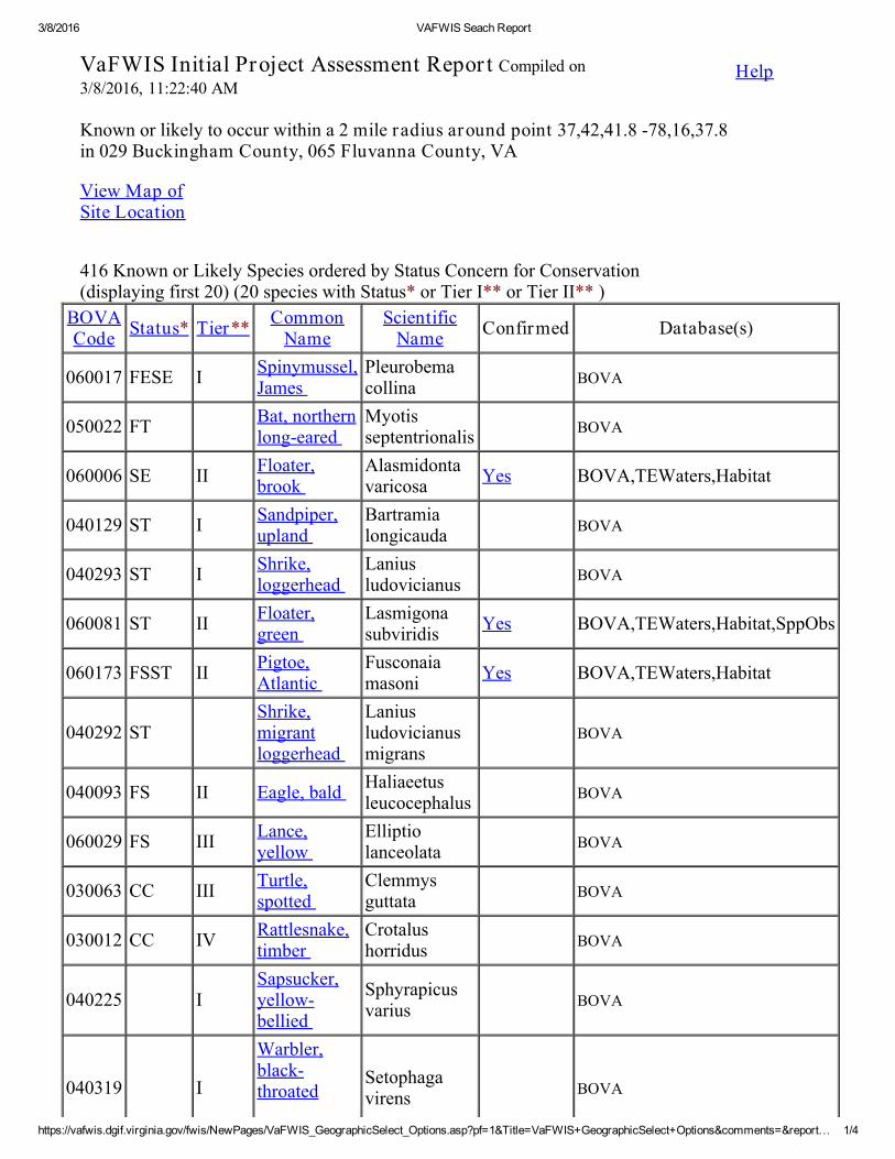
3/8/2016 VAFWIS Seach Report
https://vafwis.dgif.virginia.gov/fwis/NewPages/VaFWIS_GeographicSelect_Options.asp?pf=1&Title=VaFWIS+GeographicSelect+Options&comments=&report… 1/4
Help
Known or likely to occur within a 2 mile radius around point 37,42,41.8 -78,16,37.8 in 029 Buckingham County, 065 Fluvanna County, VA
View Map of Site Location
VaFWIS Initial Project Assessment Repor t Compiled on3/8/2016, 11:22:40 AM
416 Known or Likely Species ordered by Status Concern for Conservation (displaying first 20) (20 species with Status* or Tier I** or Tier II** )
BOVACode Status* Tier** Common
NameScientific
Name Confirmed Database(s)
060017 FESE I Spinymussel,James
Pleurobemacollina BOVA
050022 FT Bat, northernlong-eared
Myotisseptentrionalis BOVA
060006 SE II Floater,brook
Alasmidontavaricosa Yes BOVA,TEWaters,Habitat
040129 ST I Sandpiper,upland
Bartramialongicauda BOVA
040293 ST I Shrike,loggerhead
Laniusludovicianus BOVA
060081 ST II Floater,green
Lasmigonasubviridis Yes BOVA,TEWaters,Habitat,SppObs
060173 FSST II Pigtoe,Atlantic
Fusconaiamasoni Yes BOVA,TEWaters,Habitat
040292 ST Shrike,migrantloggerhead
Laniusludovicianusmigrans
BOVA
040093 FS II Eagle, bald Haliaeetusleucocephalus BOVA
060029 FS III Lance,yellow
Elliptiolanceolata BOVA
030063 CC III Turtle,spotted
Clemmysguttata BOVA
030012 CC IV Rattlesnake,timber
Crotalushorridus BOVA
040225 I Sapsucker,yellow-bellied
Sphyrapicusvarius BOVA
040319 I
Warbler,black-throated
Setophagavirens BOVA

3/8/2016 VAFWIS Seach Report
https://vafwis.dgif.virginia.gov/fwis/NewPages/VaFWIS_GeographicSelect_Options.asp?pf=1&Title=VaFWIS+GeographicSelect+Options&comments=&report… 2/4
Anadromous Fish Use Streams ( 1 records ) View Map of All Anadr omous Fish Use Str eams
Impediments to Fish Passage ( 4 records ) View Map of All Fish Impediments
Colonial Water Bird Survey
green
060084 I Pigtoe,Virginia
Lexingtoniasubplana BOVA
020023 II Salamander,mole
Ambystomatalpoideum BOVA
040052 II Duck,Americanblack
Anas rubripes BOVA
040105 II Rail, king Rallus elegans BOVA
040320 II Warbler,cerulean
Setophagacerulea BOVA
040266 II Wren,winter
Troglodytestroglodytes BOVA
To view All 416 species View 416
* FE=Federal Endangered; FT=Federal Threatened; SE=State Endangered; ST=State Threatened; FC=Federal Candidate; FS=Federal Species of Concern; CC=Collection Concern
** I=VA Wildlife Action Plan - Tier I - Critical Conservation Need; II=VA Wildlife Action Plan - Tier II - Very High Conservation Need; III=VA Wildlife Action Plan - Tier III - High Conservation Need; IV=VA Wildlife Action Plan - Tier IV - Moderate Conservation Need
Bat Colonies or Hibernacula: Not Known
StreamID
StreamName
ReachStatus
Anadromous Fish SpeciesView MapDifferent
SpeciesHighest
TE*HighestTier**
P189 James River 4 Potential 0 Yes
ID Name River View Map733 BREMO POWER STATION DAM JAMES RIVER Yes720 MCIVER DAM SPRING GARDEN CREEK Yes725 NEW ASH DAM SPRING GARDEN CREEK Yes723 OBRIEN DAM TR-HOLMAN CREEK Yes
N/A

3/8/2016 VAFWIS Seach Report
https://vafwis.dgif.virginia.gov/fwis/NewPages/VaFWIS_GeographicSelect_Options.asp?pf=1&Title=VaFWIS+GeographicSelect+Options&comments=&report… 3/4
Threatened and Endangered Waters ( 2 Reaches )
View Map of All Thr eatened and Endanger ed Water s
Managed Trout Streams
Bald Eagle Nests
Habitat Predicted for Aquatic WAP Tier I & II Species ( 4 Reaches )
View Map Combined Reaches fr om Below of Habitat Pr edicted for WAP Tier I & II Aquatic Species
Stream NameT&E Waters Species
ViewMap
HighestTE*
BOVA Code, Status*, Tier**,Common & Scientific Name
James River(02080203) FSSE
060006 SE II Floater,brook
Alasmidontavaricosa
060081 ST II Floater,green
Lasmigonasubviridis
060173 FSST II Pigtoe,Atlantic
Fusconaiamasoni
Yes
James River(02080203) ST 060081 ST II Floater,
green Lasmigonasubviridis Yes
N/A
Bald Eagle Concentration Areas and Roosts
N/A
N/A
Stream NameTier Species
ViewMap
HighestTE*
BOVA Code, Status*, Tier**,Common & Scientific Name
James River (20802031) FSSE
060006 SE II Floater,brook
Alasmidontavaricosa
060081 ST II Floater,green
Lasmigonasubviridis Yes

3/8/2016 VAFWIS Seach Report
https://vafwis.dgif.virginia.gov/fwis/NewPages/VaFWIS_GeographicSelect_Options.asp?pf=1&Title=VaFWIS+GeographicSelect+Options&comments=&report… 4/4
Habitat Predicted for Terrestr ial WAP Tier I & II Species
Public Holdings:
060173 FSST II Pigtoe,Atlantic
Fusconaiamasoni
James River (20802032) FSSE
060006 SE II Floater,brook
Alasmidontavaricosa
060081 ST II Floater,green
Lasmigonasubviridis
060173 FSST II Pigtoe,Atlantic
Fusconaiamasoni
Yes
James River (20802031) FSST060081 ST II Floater,
green Lasmigonasubviridis
060173 FSST II Pigtoe,Atlantic
Fusconaiamasoni
Yes
Bear Garden Creek(20802032) ST 060081 ST II Floater,
green Lasmigonasubviridis Yes
N/A
N/A
Compiled on 3/8/2016, 11:22:40 AM I713933.0 report=IPA searchType= R dist= 3218 poi= 37,42,41.8 -78,16,37.8
PixelSize=64; Anadromous=0.014717; BECAR=0.010497; Bats=0.010277; Buffer=0.09892; County=0.049738; Impediments=0.011725; Init=0.446481; PublicLands=0.019021;SppObs=0.12075; TEWaters=0.016046; TierReaches=0.028932; TierTerrestrial=0.034148; Total=0.909162; Tracking_BOVA=0.128021; Trout=0.01696

Molly Joseph Ward Secretary of Natural Resources
Clyde E. Cristman Director
Rochelle Altholz Deputy Director of
Administration and Finance
David C. Dowling Deputy Director of
Soil and Water Conservation
and Dam Safety
Thomas L. Smith Deputy Director of Operations
600 East Main Street, 24th Floor | Richmond, Virginia 23219 | 804-786-6124
State Parks • Soil and Water Conservation • Outdoor Recreation Planning Natural Heritage • Dam Safety and Floodplain Management • Land Conservation
April 5, 2016
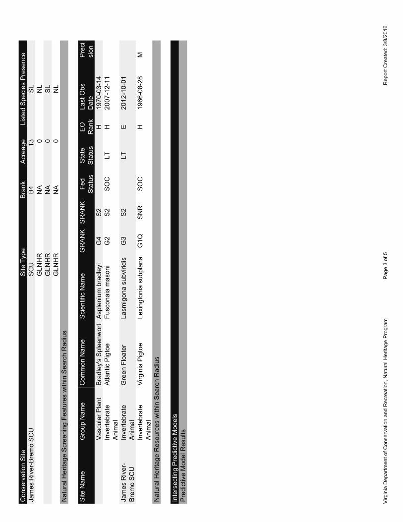
Joanna Kimmel EEE Consulting, Inc. 201 Church Street, Suite C Blacksburg, VA 24060 Re: 16-041, Dominion Bremo Bluff Cell Tower Dear Ms. Kimmel: The Department of Conservation and Recreation's Division of Natural Heritage (DCR) has searched its Biotics Data System for occurrences of natural heritage resources from the area outlined on the submitted map. Natural heritage resources are defined as the habitat of rare, threatened, or endangered plant and animal species, unique or exemplary natural communities, and significant geologic formations. According to the information currently in our files, the James River – Bremo Stream Conservation Unit (SCU) is within two miles of the project site. SCUs identify stream reaches that contain aquatic natural heritage resources, including 2 miles upstream and 1 mile downstream of documented occurrences, and all tributaries within this reach. SCUs are also given a biodiversity significance ranking based on the rarity, quality, and number of element occurrences they contain. The James River – Bremo SCU has been given a biodiversity ranking of B4, which represents a site of moderate significance. Natural heritage resources associated with this site are: Lasmigona subviridis Green floater G3/S2/NL/LT The Green floater, a rare freshwater mussel, ranges from New York to North Carolina in the Atlantic Slope drainages, as well as the New and Kanawha River systems in Virginia and West Virginia (NatureServe, 2009). In Virginia, there are records from the New, Roanoke, Chowan, James, York, Rappahannock, and Potomac River drainages. Throughout its range, the Green floater appears to prefer the pools and eddies with gravel and sand bottoms of smaller rivers and creeks, smaller channels of large rivers (Ortman, 1919) or small to medium-sized streams (Riddick, 1973). Please note that this species has been listed as state threatened by the Virginia Department of Game and Inland Fisheries (VDGIF). Furthermore, the Atlantic pigtoe (Fusconaia masoni, G2/S2/SOC/LT) and the Virginia pigtoe (Lexingtonia
subplana, G1Q/SH/NL/NL) have been historically documented downstream of the project site. The Atlantic pigtoe is a medium-sized freshwater mussel which ranges from the Ogeeshee drainage in Georgia north to Virginia (NatureServe, 2009). In Virginia, this species is known from the James, Chowan and Roanoke River basins (NatureServe, 2009). The Atlantic pigtoe prefers clear, swift waters with gravel or sand and gravel substrates. Many populations from the main stem of larger rivers have disappeared and the species is becoming limited to the headwater areas of drainages in which it occurs. This could have implications for populations being able to reestablish after a localized, catastrophic event and for genetic exchange.

Threats to the Atlantic pigtoe include pollution, impoundments, clearcutting, and dredging (Gerberich, 1991). This species does not appear to be able to tolerate habitat changes and it appears to be very poor at recolonizing previously disturbed habitats (NatureServe, 2009). A recent study determined that the glochidia of the Atlantic pigtoe are extremely sensitive to pollution (Augspurger et al., 2003). Please note that this species is currently listed as threatened by the VDGIF and is also tracked as a species of concern by the United States Fish and Wildlife Service (USFWS); however, this designation has no official legal status. The Virginia pigtoe is a state historic freshwater mussel. There are questions surrounding the Virginia pigtoe’s taxonomic status, and its original description as a species may be based on partially-gravid Atlantic pigtoe (Fusconaia masoni). If it is a valid species, it is endemic to the James River drainage of Virginia (NatureServe, 2009). Considered good indicators of the health of aquatic ecosystems, freshwater mussels are dependent on good water quality, good physical habitat conditions, and an environment that will support populations of host fish species (Williams et al., 1993). Because mussels are sedentary organisms, they are sensitive to water quality degradation related to increased sedimentation and pollution. They are also sensitive to habitat destruction through dam construction, channelization, and dredging, and the invasion of exotic mollusk species. In addition, James River has been designated by the VDGIF as a “Threatened and Endangered Species Water” for the Brook floater, Atlantic pigtoe, and Green floater. To minimize adverse impacts to the aquatic ecosystem as a result of the proposed activities, DCR recommends the implementation of and strict adherence to applicable state and local erosion and sediment control/storm water management laws and regulations. Due to the legal status of the Green floater, the Brook floater and the Atlantic pigtoe, DCR recommends coordination with Virginia's regulatory authority for the management and protection of this species, the VDGIF, to ensure compliance with the Virginia Endangered Species Act (VA ST §§ 29.1-563 – 570). According to the USFWS Guidance dated September 14, 2000 “new construction of communication towers creates a potentially significant impact on migratory birds, especially some 350 species of night-migrating birds”. “Communications towers are estimated to kill 4-5 million birds per year and some of these species affected are also protected under the Endangered Species Act and Bald and Golden Eagle Act” (USFWS, 2000). Therefore, DCR recommends voluntary implementation of USFWS interim guidelines for Communication Tower Siting, Construction, Operation, and Decommissioning (http://www.fws.gov/northeast/virginiafield/pdf/endspecies/Cell%20Towers/Cell%20Guidance.PDF). Under a Memorandum of Agreement established between the Virginia Department of Agriculture and Consumer Services (VDACS) and the DCR, DCR represents VDACS in comments regarding potential impacts on state-listed threatened and endangered plant and insect species. The current activity will not affect any documented state-listed plants or insects. There are no State Natural Area Preserves under DCR’s jurisdiction in the project vicinity. New and updated information is continually added to Biotics. Please re-submit a completed order form and project map for an update on this natural heritage information if the scope of the project changes and/or six months has passed before it is utilized. A fee of $95.00 has been assessed for the service of providing this information. Please find enclosed an invoice for that amount. Please return one copy of the invoice along with your remittance made payable to the Treasurer of Virginia, Department of Conservation and Recreation, Division of Natural Heritage, 600 East Main Street, 24th Floor, Richmond, VA 23219. Payment is due within thirty days of the invoice date. Please note late payment may result in the suspension of project review service for future projects.

The VDGIF maintains a database of wildlife locations, including threatened and endangered species, trout streams, and anadromous fish waters that may contain information not documented in this letter. Their database may be accessed from http://vafwis.org/fwis/ or contact Ernie Aschenbach at 804-367-2733 or [email protected]. Should you have any questions or concerns, feel free to contact me at 804-371-2708. Thank you for the opportunity to comment on this project. Sincerely,
S. René Hypes Project Review Coordinator CC: Troy Anderson, USFWS Ernie Aschenbach, VDGIF
Literature Cited Augspurger, T., A.E. Keller, M.C. Black, W.G. Cope, and F.J. Dwyer. 2003. Water quality guidance for protection of freshwater mussels (Unionidae) from ammonia exposure. Environmental Toxicology and Chemistry, 22: 2569-2575. Gerberich, Andy. 1991. Atlantic pigtoe. In Virginia’s Endangered Species: Proceedings of a Symposium. K. Terwilliger ed. The McDonald and Woodward Publishing Company, Blacksburg, Virginia. NatureServe. 2009. NatureServe Explorer: An online encyclopedia of life [web application]. Version 7.1. NatureServe, Arlington, Virginia. Available http://www.natureserve.org/explorer. (Accessed: April 27, 2010). Ortman, A.E. 1919. A monograph of the naiades of Pennsylvania, Part 3: Systematic account of the genera and species. Mem. Carnegie Mus. 8:1-384. Riddick, M.B. 1973. Freshwater mussels of the Pamunkey River system, Virginia. M.S. Thesis, Virginia Commonwealth University, Richmond, VA 105pp. U.S. Fish and Wildlife Service. 2000. Interim Guidelines for Recommendations on Communications Tower Siting, Construction, Operation, and Decommissioning. Williams, J.D., M.L. Warren, Jr., K.S. Cummings, J.L. Harris, and R.J. Neves. 1993. Conservation status of freshwater mussels of the United States and Canada. Fisheries 18: 6-9.


APPENDIX D – CULTURAL RESOURCES


Virginia Department of Historic Resources DHR ID: 032-0172Architectural Survey Form Other DHR ID: No Data
February 29, 2016 Page: 1 of 2
Property Information
Property NamesName Explanation NameDescriptive Spring Garden Slave House
Property Addresses
Current - Route 656
County/Independent City(s): Fluvanna (County)
Incorporated Town(s): No Data
Zip Code(s): No Data
Magisterial District(s): No Data
Tax Parcel(s): No Data
USGS Quad(s): ARVONIA
Property Evaluation Status
Not Evaluated
Additional Property Information
Architecture Setting: No Data
Acreage: No Data
Site Description:
No Data
Surveyor Assessment:
No Data
Surveyor Recommendation: No Data
Primary Resource Information
Resource Category: Domestic
Resource Type: Slave/Servant Quarters
Date of Construction: 1800Ca
Historic Time Period: Early National Period (1790 - 1829)
Historic Context(s): Domestic
Architectural Style: Other
Form: No Data
Number of Stories: 1.0
Condition: No Data
Interior Plan: Two-Room, Single Pile
Threats to Resource: No Data
Architectural Description:
No Data
Exterior Components
Component Component Type Material Material TreatmentRoof Gable Asphalt ShingleWindows Sash, Double-Hung Wood 4/4Chimneys Other Brick No DataStructural System andExterior Treatment
Frame Wood Weatherboard
Secondary Resource Information
Virginia Department of Historic Resources DHR ID: 032-0172Architectural Survey Form Other DHR ID: No Data
February 29, 2016 Page: 2 of 2
Secondary Resource #1
Resource Category: No Data
Resource Type: No Data
Architectural Style: No Data
Form: No Data
Date of Construction: No Data
Condition: No Data
Threats to Resource: No Data
Architectural Description:
No Data
Historic District Information
Historic District Name: No Data
Local Historic District Name: No Data
Historic District Significance: No Data
CRM Events
Event Type: Survey:Phase I/Reconnaissance
Project Review File Number: No Data
Investigator: C., E. A. and A. C. W.
Organization/Company: Unknown (DSS)
Sponsoring Organization: No Data
Survey Date: 12/1/1984
Dhr Library Report Number: No Data
Project Staff/Notes:
No Data
Bibliographic Information
Bibliography:
No Data
Property Notes:
No Data
Project Bibliographic Information:
No Data
Virginia Dept. of Historic Resources
LegendArchitecture ResourcesArchitecture LabelsIndividual Historic District PropertiesArchaeological ResourcesArchaeology LabelsUSGS GIS Place names
County Boundaries
Title: Architecture Labels Date: 2/29/2016 DISCLAIMER:Records of the Virginia Department of Historic Resources (DHR) have been gathered over many years from a variety of sources and the representationdepicted is a cumulative view of field observations over time and may not reflect current ground conditions.The map is for general information purposes and is notintended for engineering, legal or other site-specific uses. Map may contain errors and is provided "as-is". More information is available in the DHR Archives located atDHR’s Richmond office. Notice if AE sites:Locations of archaeological sites may be sensitive the National Historic Preservation Act (NHPA), and the Archaeological Resources Protection Act(ARPA) and Code of Virginia §2.2-3705.7 (10). Release of precise locations may threaten archaeological sites and historic resources.

Virginia Department of Historic Resources DHR ID: 032-0027Architectural Survey Form Other DHR ID: No Data
February 29, 2016 Page: 1 of 2
Property Information
Property NamesName Explanation NameHistoric/Current Spring Garden
Property Addresses
Current - Route 656
County/Independent City(s): Fluvanna (County)
Incorporated Town(s): No Data
Zip Code(s): No Data
Magisterial District(s): No Data
Tax Parcel(s): No Data
USGS Quad(s): ARVONIA
Property Evaluation Status
Not Evaluated
Additional Property Information
Architecture Setting: No Data
Acreage: No Data
Site Description:
No Data
Surveyor Assessment:
Example of 19th century dwelling with outbuildings.
Surveyor Recommendation: No Data
Primary Resource Information
Resource Category: Domestic
Resource Type: Single Dwelling
Date of Construction: 1800Ca
Historic Time Period: Early National Period (1790 - 1829)
Historic Context(s): Domestic
Architectural Style: No Data
Form: No Data
Number of Stories: 2.0
Condition: Good
Interior Plan: No Data
Threats to Resource: None Known
Architectural Description:
No Data
Exterior Components
Component Component Type Material Material TreatmentWindows Sash, Double-Hung Wood OtherStructural System andExterior Treatment
Masonry Brick Other
Roof Gable No Data OtherChimneys Interior Brick Cap, CorbeledPorch 1-story, 3-bay Wood Other
Secondary Resource Information

Virginia Department of Historic Resources DHR ID: 032-0027Architectural Survey Form Other DHR ID: No Data
February 29, 2016 Page: 2 of 2
Secondary Resource #1
Resource Category: Archaeology Site
Resource Type: Archaeological Site
Architectural Style: No Data
Form: No Data
Date of Construction: 1800
Condition: Good
Threats to Resource: None Known
Architectural Description:
Architecture Summary: Behind the house, aligned in a straight row parallel with the house facade, are the remians of three early outbuildings: akitchen, smokehouse, and dairy. Onely a mid-nineteeth century step-shouldered chimney survives from the kitchen. It has a single firebox. Thegable roofed smokehouse, has beaded siding, and is constructed with cut nails. The framing includes studs on two-foot centers and cornerbraces that rise to the same height. A rear window is a wire-nailed addition. The roofless dairy measure 12'2" square, has beading siding withhand-headed cut nails, and retains fragments of cyma-curnved vertical slats in front and rear ventilation grills. The small original window in therer wall here is original.
Historic District Information
Historic District Name: No Data
Local Historic District Name: No Data
Historic District Significance: No Data
CRM Events
Event Type: Survey:Phase II/Intensive
Project Review File Number: No Data
Investigator: No Data
Organization/Company: Unknown (DSS)
Sponsoring Organization: No Data
Survey Date: No Data
Dhr Library Report Number: No Data
Project Staff/Notes:
No Data
Bibliographic Information
Bibliography:
No Data
Property Notes:
No Data
Project Bibliographic Information:
No Data

Virginia Dept. of Historic Resources
LegendArchitecture ResourcesArchitecture LabelsIndividual Historic District PropertiesArchaeological ResourcesArchaeology LabelsUSGS GIS Place names
County Boundaries
Title: Architecture Labels Date: 2/29/2016 DISCLAIMER:Records of the Virginia Department of Historic Resources (DHR) have been gathered over many years from a variety of sources and the representationdepicted is a cumulative view of field observations over time and may not reflect current ground conditions.The map is for general information purposes and is notintended for engineering, legal or other site-specific uses. Map may contain errors and is provided "as-is". More information is available in the DHR Archives located atDHR’s Richmond office. Notice if AE sites:Locations of archaeological sites may be sensitive the National Historic Preservation Act (NHPA), and the Archaeological Resources Protection Act(ARPA) and Code of Virginia §2.2-3705.7 (10). Release of precise locations may threaten archaeological sites and historic resources.
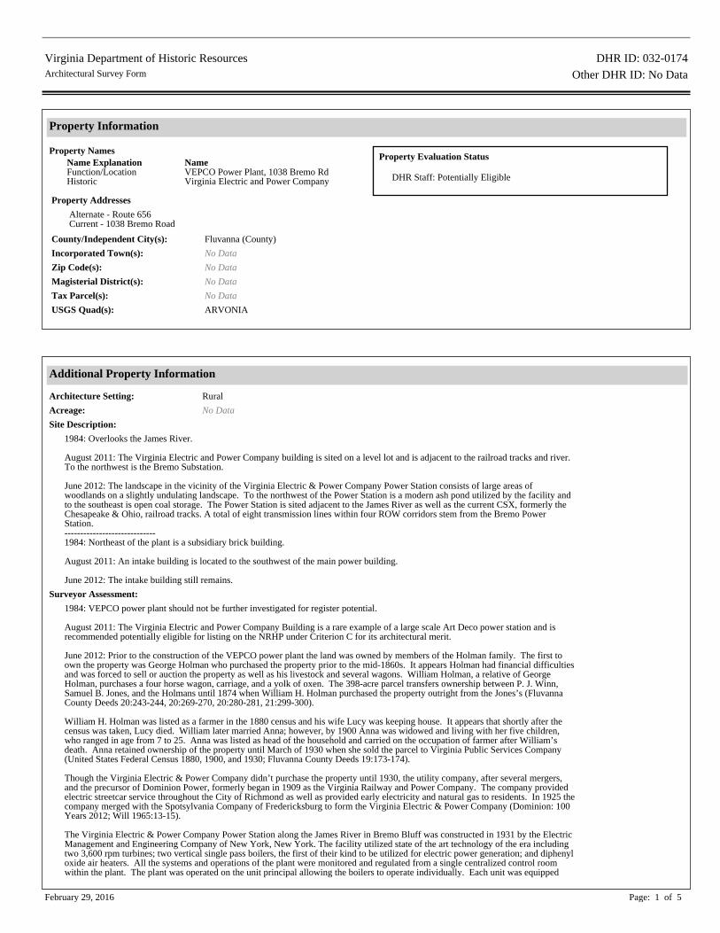
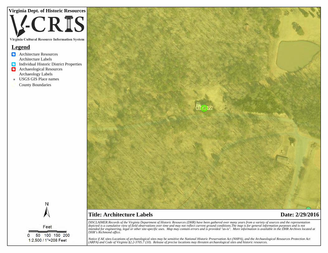
Virginia Department of Historic Resources DHR ID: 032-0174Architectural Survey Form Other DHR ID: No Data
February 29, 2016 Page: 1 of 5
Property Information
Property NamesName Explanation NameFunction/Location VEPCO Power Plant, 1038 Bremo RdHistoric Virginia Electric and Power Company
Property Addresses
Alternate - Route 656Current - 1038 Bremo Road
County/Independent City(s): Fluvanna (County)
Incorporated Town(s): No Data
Zip Code(s): No Data
Magisterial District(s): No Data
Tax Parcel(s): No Data
USGS Quad(s): ARVONIA
Property Evaluation Status
DHR Staff: Potentially Eligible
Additional Property Information
Architecture Setting: Rural
Acreage: No Data
Site Description:
1984: Overlooks the James River. August 2011: The Virginia Electric and Power Company building is sited on a level lot and is adjacent to the railroad tracks and river.To the northwest is the Bremo Substation. June 2012: The landscape in the vicinity of the Virginia Electric & Power Company Power Station consists of large areas ofwoodlands on a slightly undulating landscape. To the northwest of the Power Station is a modern ash pond utilized by the facility andto the southeast is open coal storage. The Power Station is sited adjacent to the James River as well as the current CSX, formerly theChesapeake & Ohio, railroad tracks. A total of eight transmission lines within four ROW corridors stem from the Bremo PowerStation.-----------------------------1984: Northeast of the plant is a subsidiary brick building. August 2011: An intake building is located to the southwest of the main power building. June 2012: The intake building still remains.
Surveyor Assessment:
1984: VEPCO power plant should not be further investigated for register potential. August 2011: The Virginia Electric and Power Company Building is a rare example of a large scale Art Deco power station and isrecommended potentially eligible for listing on the NRHP under Criterion C for its architectural merit. June 2012: Prior to the construction of the VEPCO power plant the land was owned by members of the Holman family. The first toown the property was George Holman who purchased the property prior to the mid-1860s. It appears Holman had financial difficultiesand was forced to sell or auction the property as well as his livestock and several wagons. William Holman, a relative of GeorgeHolman, purchases a four horse wagon, carriage, and a yolk of oxen. The 398-acre parcel transfers ownership between P. J. Winn,Samuel B. Jones, and the Holmans until 1874 when William H. Holman purchased the property outright from the Jones’s (FluvannaCounty Deeds 20:243-244, 20:269-270, 20:280-281, 21:299-300). William H. Holman was listed as a farmer in the 1880 census and his wife Lucy was keeping house. It appears that shortly after thecensus was taken, Lucy died. William later married Anna; however, by 1900 Anna was widowed and living with her five children,who ranged in age from 7 to 25. Anna was listed as head of the household and carried on the occupation of farmer after William’sdeath. Anna retained ownership of the property until March of 1930 when she sold the parcel to Virginia Public Services Company(United States Federal Census 1880, 1900, and 1930; Fluvanna County Deeds 19:173-174). Though the Virginia Electric & Power Company didn’t purchase the property until 1930, the utility company, after several mergers,and the precursor of Dominion Power, formerly began in 1909 as the Virginia Railway and Power Company. The company providedelectric streetcar service throughout the City of Richmond as well as provided early electricity and natural gas to residents. In 1925 thecompany merged with the Spotsylvania Company of Fredericksburg to form the Virginia Electric & Power Company (Dominion: 100Years 2012; Will 1965:13-15). The Virginia Electric & Power Company Power Station along the James River in Bremo Bluff was constructed in 1931 by the ElectricManagement and Engineering Company of New York, New York. The facility utilized state of the art technology of the era includingtwo 3,600 rpm turbines; two vertical single pass boilers, the first of their kind to be utilized for electric power generation; and diphenyloxide air heaters. All the systems and operations of the plant were monitored and regulated from a single centralized control roomwithin the plant. The plant was operated on the unit principal allowing the boilers to operate individually. Each unit was equipped

Virginia Department of Historic Resources DHR ID: 032-0174Architectural Survey Form Other DHR ID: No Data
February 29, 2016 Page: 2 of 5
with a pulverizing mill, turbine, coal burners, and associated fans and heaters as well as feed water systems including pumps and filters(Bremo Station 1931:2-3). The design of the Bremo Power Station, unlike others built during the same time period, and what made Bremo unique, is thecentralized control room, as previously mentioned. Traditionally the electrical bay of power stations constructed during the earlytwentieth century was connected to the turbine building and away from the boiler house. By using a centralized room which containedthe controls for the electrical and steam systems as well as feed water heaters and other control systems between the turbine buildingand boiler house, operators could more easily monitor the operations of both sections of the plant. These control systems were state-of-the-art at the time and could precisely regulate all operations to maximize efficiency (Bremo Station 1931:11). At the time of its construction the coal fired power plant produced 15,000 kw of power per turbine. Coal was delivered by railroad carto the power plant by the Chesapeake & Ohio Railroad, now CSX, whose tracks still run between the power plant and the James River.A spur off the main track serviced the complex for dispensing of coal as well as extended into the turbine building for the delivery ofheavy machinery and other equipment (Greg Searcy, personal communication 4 June 2012). Historically the coal brought in by railcarwas deposited into a large Bradford breaker to be processed for use within the building. The system was equipped with a bypass forcoal fine enough to be directly used by the plant or for storage in a designated area. Coal was also staged throughout the property andwas transported by a tail car which ran on a 400-foot radius track. A portion of the coal handling system was automated including acoal scale and feeder (Bremo Station 1931:5-6). The design of the boilers and associated housing also differed at Bremo from the more conventional designs at the time. As the overalldesign of the plant was meant to be streamlined and more efficient, the layout of the boiler house was also simplified. The designchosen for the boilers was a single-pass vertical boiler, a design that does not utilize baffles. In 1931, at the time of the installation ofthe boilers, Bremo was the only plant in the country to incorporate this boiler design. In overcoming the expense of the extensivelength of the ductwork and the loss of draft within the system, the use of a diphenyl oxide air heating system, another new innovationspecific to Bremo, eliminated these issues, and provided a more efficient way to manage heat transfer through the system (BremoStation 1931:7 and 10). The steel turbines utilized in the Bremo Station, at its time of construction, were also an innovation and the first time this type ofgeneration system was used. Each of the turbo-generators installed were 15,000 kw units and utilized automatic voltage regulators. Fans were placed at each end of the rotors for improved cooling and ventilation of the system. The system of tandem compoundturbines provides for greater efficiency at variable loads by utilizing 15 stages at high pressure and eight stages at low pressure, couldrun on higher speeds, up to 3,600 rpm, as opposed to older turbines which reached a maximum of 1,800 rpm, and were the largestcondensing turbines built in the country in 1930/31 (Bremo Station 1931:12). It took a number of people to run the power plant; however, because of the innovations in technology utilized in its design, the plantcould run with fewer employees as compared to most other plants of comparable size. In the 1940s the plant employed approximately26 people from the surrounding area. Most lived along Route 15, Route 656, or Route 657. Occupations utilized by the power plantduring this time period included plant operators, engineers, oilers, electric welders, mechanics, porters, and general help. Several plantsuperintendents and foremen were also hired to ensure the power station ran smoothly (United States Federal Census 1940). To meet increased demand for power during the 1950s, resulting from population growth in the area, two additional units were added. Unit 3 was added in 1950 and Unit 4 in 1958. The unit’s boilers were manufactured by Babcock and Wilcox and the turbinegenerators by Westinghouse Electric Corporation. In 1972 Units 1 and 2, the original turbines installed in the plant, were taken offline.The original stacks were removed in the 1980s (Greg Searcy, personal communication 4 June 2012). Large scale additions to theoriginal power plant were constructed in the late twentieth century to meet the ever expanding demand for electricity in the region. Currently the Bremo Bluff Power Station consumes 2,500 tons of coal daily to produce a net capacity of 227 megawatts of powerwhich services an area of approximately 30,000 square miles. Presently two units generate power at the plant which employsapproximately 75 people. To control emissions the station is equipped with low nitrogen oxide burners and electrostatic precipitators. The latter removes approximately 99 percent of the particles from the gases prior to venting from the large stacks (Bremo PowerStation 2012). The Virginia Electric & Power Company Power Station at 1038 Bremo Road, has been recommended as eligible for listing on theNRHP under Criteria A for engineering and industry for its use in new technological innovations incorporated into the design of thebuilding as well as in the redesign of systems to create the most efficient use of energy and manpower in a manner not found in otherpower generating plants of the time period. The Power Station is also recommended as eligible for listing under Criteria C for itsarchitectural merit as an excellent example of 1930s Art Deco industrial architecture.
Surveyor Recommendation: Legacy
Ownership
Ownership Category Ownership EntityPrivate No Data
Primary Resource Information
Resource Category: Industry/Processing/Extraction
Resource Type: Power Plant
Date of Construction: 1930Ca
Historic Time Period: World War I to World War II (1917 - 1945)
Historic Context(s): Architecture/Community Planning, Industry/Processing/Extraction, Technology/Engineering
Architectural Style: Art Deco
Form: No Data

Virginia Department of Historic Resources DHR ID: 032-0174Architectural Survey Form Other DHR ID: No Data
February 29, 2016 Page: 3 of 5
Number of Stories: No Data
Condition: Good
Interior Plan: No Data
Threats to Resource: Public Utility Expansion
Architectural Description:
Architecture Summary, 1984: The original part of the plant, built circa 1930, is constructed of brick and concrete in an industrial Art Deco style.Large sheet-metal sided addition to north, apparently constructed in the third quarter of the 20th century. Brick walls with concrete trim, flatroof. August 2011: The building comprises two sections. The western portion of the building is a tall, one-story structure constructed with brick in afive-course American bond pattern with poured concrete foundation and parapet. The eastern section is a multi-story building also constructedof brick in a five-course American bond pattern. Windows include multi-pane metal fixed and awning style. A number of large modernadditions have been constructed to the southeast and northeast sides of the building. June 2012: The three buildings, as part of the initial 1931 construction of the Bremo Station, as it was historically known, remain largely intact. The exterior walls of the turbine building and the boiler house are brick in a five-course American bond pattern with a poured concretefoundation and parapet. Both sections of the building incorporate tall recessed metal, multi-light windows. Designed in an Art Deco style, theexterior exhibits a streamlined appearance with only limited areas of ornament such as the low relief stepped square design above the entry intoTurbine Building and banded brickwork. A number of more modern additions behind the building have been constructed to accommodate thegrowing need for electricity during the mid-to late twentieth century. The interior of the turbine building still retains its hoist cranes in the ceiling and portions of railroad tracks in the floor which brought in heavymachinery by rail along a spur. Extant on the interior walls are the original brown, dark green, and tan glazed tiles/bricks. A new concreteblock wall now divides the space. The boiler house still contains both boilers including the original tan firebrick, although, not in operation, aswell as the breaker room and control room, which was built with windows overlooking the boilers. The wiring in the control room; however,has been removed, but the stations remain.
Secondary Resource Information
Secondary Resource #1
Resource Category: Industry/Processing/Extraction
Resource Type: Energy Facility
Architectural Style: Art Deco
Form: No Data
Date of Construction: 1930
Condition: Good
Threats to Resource: Public Utility Expansion
Architectural Description:
Architecture Summary, 1984: Subsidiary brick building, circa 1930, built in the same style as the power plant. August 2011: The intake building of the power plant is a one-story brick building in a five-course American bond pattern with a pouredconcreted foundation. Fenestration includes metal multi-light fixed and awning style windows. June 2012: The one-story intake building, located to the southwest of the main building is also five-course American bond brick with pouredconcrete. The building was constructed with narrow metal windows which flank centered twelve-light metal windows with poured concretesills. Along the southeastern side of the building is a high water line marker. The building was used to filter debris from the water pumped infrom the river for cooling (Greg Searcy, personal communication 4 June 2012).
Historic District Information
Historic District Name: No Data
Local Historic District Name: No Data
Historic District Significance: No Data
CRM Events
Event Type: Survey:Phase II/Intensive
Virginia Department of Historic Resources DHR ID: 032-0174Architectural Survey Form Other DHR ID: No Data
February 29, 2016 Page: 4 of 5
Project Review File Number: 2011-0693
Investigator: CRI
Organization/Company: Unknown (DSS)
Sponsoring Organization: No Data
Survey Date: 6/1/2012
Dhr Library Report Number: FV-022
Project Staff/Notes:
An Intensive Level Architectural Survey of the Bremo Power Station, Bremo Bluffs, Fluvanna County, Virginia Surveyed by: Sandra DeChardArchitectural Description and Data Entry by: Sandra DeChard
Event Type: DHR Staff: Potentially Eligible
DHR ID: 032-0174
Staff Name: Kirchen, Roger
Event Date: 1/31/2012
Staff Comment
Potentially individually eligible, intensive level survey recommended, evaluate under Criteria A and C.
Event Type: Survey:Phase I/Reconnaissance
Project Review File Number: 2011-0693
Investigator: CRI
Organization/Company: Unknown (DSS)
Sponsoring Organization: No Data
Survey Date: 8/1/2011
Dhr Library Report Number: FV-022
Project Staff/Notes:
A Phase I Cultural Resources Survey of the Approximately 43.3-Mile Dominion Virginia Power Dooms to Bremo 230 kV Transmission Line,Fluvanna, Albemarle and Augusta Counties, Virginia. Surveyed by: Emily LindtveitArchitectural Description and Data Entry by: Sandra DeChard
Event Type: Survey:Phase I/Reconnaissance
Project Review File Number: No Data
Investigator: No Data
Organization/Company: Unknown (DSS)
Sponsoring Organization: No Data
Survey Date: 12/1/1984
Dhr Library Report Number: FV-022
Project Staff/Notes:
Surveyor initials only: EAC and WJM
Bibliographic Information
Bibliography:
No Data
Property Notes:
No Data
Project Bibliographic Information:
Name: CRIDHR CRM Report Number: AB-171Record Type: ReportBibliographic Notes: Archaeological Survey of Six Potential Access Roads (Approximately 2.6 Linear Miles) along the Dominion Virginia Power 230kV Transmission Line from the Transco Delivery Point to the Dooms Substation, Albemarle and Augusta County, Virginia. 2012-----------------------------Name: CRIRecord Type: ReportBibliographic Notes: An Intensive Level Architectural Survey of the Bremo Power Station, Bremo Bluffs, Fluvanna County, Virginia. June 2012.

Virginia Department of Historic Resources DHR ID: 032-0174Architectural Survey Form Other DHR ID: No Data
February 29, 2016 Page: 5 of 5
-----------------------------Record Type: CensusBibliographic Notes: United States Federal Census, 1880, 1900, 1910, 1920, 1930, and 1940.-----------------------------Record Type: ArticleBibliographic Notes: Dominion Virginia Power2009“Dominion: 100 Years and Going Strong.” 15 June 2012. <http://www.dom.com/about/anniversary.jsp>-----------------------------Record Type: DeedBibliographic Notes: Fluvanna County Registry of Deeds and Probate, Circuit Court, Palmyra, VA-----------------------------Record Type: ArticleBibliographic Notes: Dominion Power2012“Bremo Power Station.” 15 June 2012. <http://www.dom.com/about/stations/fossil/bremo-power-station.jsp>-----------------------------Record Type: Oral History/InterviewBibliographic Notes: Greg Searcy, personal communication 4 June 2012-----------------------------Name: CRIDHR CRM Report Number: FV-022Record Type: ReportBibliographic Notes: Phase I Cultural Resource Survey of Approximately 12 Miles of the Dominion Virginia Power Bremo to Transco 230kVTransmission Line, Fluvanna County, VA. December 2011. DHR File No, 2011-0693; DEQ# 11-097S; SCC # PUE-2011-00039.

Virginia Dept. of Historic Resources
LegendArchitecture ResourcesArchitecture LabelsIndividual Historic District PropertiesArchaeological ResourcesArchaeology LabelsUSGS GIS Place names
County Boundaries
Title: Architecture Labels Date: 2/29/2016 DISCLAIMER:Records of the Virginia Department of Historic Resources (DHR) have been gathered over many years from a variety of sources and the representationdepicted is a cumulative view of field observations over time and may not reflect current ground conditions.The map is for general information purposes and is notintended for engineering, legal or other site-specific uses. Map may contain errors and is provided "as-is". More information is available in the DHR Archives located atDHR’s Richmond office. Notice if AE sites:Locations of archaeological sites may be sensitive the National Historic Preservation Act (NHPA), and the Archaeological Resources Protection Act(ARPA) and Code of Virginia §2.2-3705.7 (10). Release of precise locations may threaten archaeological sites and historic resources.

APPENDIX E – FEMA MAP


0 1,000 2,000Feet
Project Study AreaFlood Zones
Regulatory Floodway100-Year Floodplain500-Year Floodplain
±Prepared by ZAK, 4-28-16Sources: 2013 VBMP Aerial Imagery; FEMA NFHL Flood databaseProjection: NAD 1983 StatePlane Virginia North FIPS 4501 Feet
FIGURE 4FEMA FLOODPLAINS
BREMO BLUFF TOWER
Fluvanna County, VAProj# 16-041
Project Study Area


APPENDIX F – SURFACE FEATURES MAPS


0 670 1,340Feet
Project Study AreaNational Wetlands Inventory (NWI)
Freshwater Emergent WetlandFreshwater Forested/Shrub WetlandFreshwater PondLakeRiverineNational Hydrography Dataset (NHD)
±Prepared by ZAK, 4-28-16Sources: 2013 VBMP Aerial Imagery; FWS NWI Database, National Hydrography DatasetProjection: NAD 1983 StatePlane Virginia North FIPS 4501 Feet
FIGURE 5MAPPED WETLANDS
AND SURFACE WATERSBREMO BLUFF TOWER
Fluvanna County, VAProj# 16-041
Project Study Area
Unnamed Tributaries to Holman Creek
Unnamed Tributaries to James River


