
Rujukan Kami : JUPEM 18/7/2.148 ( 87 )
Tarikh : 6 September 2005
Semua Pengarah Ukur dan Pemetaan Negeri
Semua Pengarah Ukur Topografi
Semua Ketua Seksyen
PEKELILING KETUA PENGARAH UKUR DAN PEMETAAN BIL. 10 TAHUN 2005
GARIS PANDUAN PENGGUNAAN MODEL GEOID MALAYSIA (MyGEOID)
1.0 TUJUAN
Pekeliling ini bertujuan untuk menyediakan garis panduan berkaitan
model geoid Malaysia (MyGEOID) serta penggunaannya bagi kerja-kerja
pengukuran dan pemetaan di seluruh negara.
2.0 LATARBELAKANG
Kemajuan dalam teknologi Global Positioning System (GPS) telah
merevolusikan pengukuran bagi membolehkan penentuan maklumat
kedudukan mendatar dan juga ketinggian. Dalam hal ini, teknologi GPS
antara lain menyediakan kaedah alternatif bagi mendapatkan ketinggian
dengan lebih mudah. Walau bagaimanapun, nilai ketinggian yang
dihasilkan daripada ukuran GPS tidak seragam berbanding dengan
ketinggian yang didapatkan daripada ukuran aras. Keadaan ini
disebabkan ketinggian aras adalah berasaskan permukaan samaupaya

2
(equipotential surface) yang dikenali sebagai geoid, sementara
ketinggian GPS merujuk kepada permukaan bentuk bumi teoretikal yang
dikenali sebagai elipsoid. Ketinggian GPS (dikenali juga sebagai
ketinggian elipsoid) boleh ditukarkan kepada ketinggian berasaskan
geoid (dikenali juga sebagai ketinggian ortometrik) dengan tepat, jika
jarak pemisahan di antara geoid dan elipsoid (dikenali juga sebagai
ketinggian geoid) diketahui.
Pada tahun 2002, JUPEM telah melaksanakan projek pemetaan geoid
dengan objektif utama untuk menghasilkan model geoid berkejituan
tinggi dalam usaha menentukan nilai ketinggian geoid di seluruh negara.
Perhitungan untuk menerbitkan model geoid tersebut memerlukan antara
lainnya maklumat graviti yang padat. Dalam hubungan ini, JUPEM telah
menjalankan ukuran graviti bawaan udara bagi seluruh Semenanjung
serta Sabah dan Sarawak pada tahun 2002 dan 2003. Sebagai
tambahan, data graviti terrestrial, data altimeter satelit, model geoid
global dan digital terrain model telah turut digunakan dalam perhitungan
model geoid Malaysia. Disamping itu, ukuran aras GPS di atas tanda-
tanda aras telah diuruskan bagi memodelkan bias datum tegak dan
selanjutnya menerbitkan geoid kesepadanan (fitted geoid) dengan datum
tegak yang berasaskan nilai aras laut min. Usaha-usaha yang dijalankan
ini telah akhirnya menghasilkan model geoid Malaysia yang pertama
yang dikenali sebagai MyGEOID.
3.0 KONSEP GEOID Geoid adalah permukaan samaupaya bagi medan graviti bumi yang
boleh dianggap sepadan dengan aras laut min global. Sehubungan itu,
geoid boleh digunakan sama seperti aras laut min bagi tujuan rujukan
ketinggian. Nilai aras laut min pula adalah purata daripada aras tertinggi
dan terendah pasang surut air yang dicerap di Stesen Tolok Air Pasang
Surut (STAPS). Ianya digunakan sebagai rujukan kepada ketinggian
sesuatu butiran pada, di atas atau di bawah permukaan tanah.

3
Secara umumnya, hubungan di antara permukaan topografi, geoid dan
elipsoid boleh digambarkan seperti dalam Rajah 1. Ketinggian yang
merujuk kepada geoid bagi titik P di atas permukaan topografi dikenali
sebagai ketinggian ortometrik, H sementara ketinggian yang merujuk
kepada permukaan elipsoid dikenali sebagai ketinggian elipsoid, h. Jarak
pemisahan di antara permukaan elipsoid dan geoid pula dikenali sebagai
ketinggian geoid, N. Ketinggian ortometrik boleh diterbitkan dari
ketinggian elipsoid dan ketinggian geoid dengan menggunakan rumus
berikut:
Rajah 1: Perhubungan umum di antara permukaan Geoid dengan
permukaan Topografi dan Elipsoid.
4.0 MODEL GEOID MALAYSIA - MyGEOID
MyGEOID mengandungi nilai ketinggian geoid (atau nilai N) relatif
kepada permukaan rujukan elipsoid GRS80 dalam bentuk grid. Ianya
terdiri dari dua model geoid iaitu WMGEOID04 bagi Semenanjung
Malaysia dan EMGEOID05 bagi Sabah dan Sarawak.
H = h – N
STAPS
Geoid
Elipsoid
Aras Laut Min Paras Laut
TopografiH
hN
P

4
Di Semenanjung Malaysia ianya meliputi kawasan di antara latitud 0°
Utara hingga 8° Utara dan longitud 98° Timur hingga 107° Timur dengan
saiz grid 1’ x 1’ (1.8 km x 1.8 km). Sementara bagi Sabah dan Sarawak,
ianya meliputi kawasan di antara latitud 0° Utara hingga 9° Utara dan
longitud 106° Timur hingga 121° Timur dengan saiz grid 2’ x 2’ (3.6 km x
3.6 km).
Julat nilai ketinggian geoid bagi MyGEOID adalah di antara -16 meter
hingga 10 meter di Semenanjung Malaysia, sementara di Sabah dan
Sarawak adalah di antara 28 meter hingga 60 meter. Tanda negatif
dalam nilai ketinggian geoid bermaksud permukaan geoid tersebut
berada di bawah permukaan elipsoid.
MyGEOID membolehkan pengguna-pengguna GPS di Malaysia
memperolehi nilai ketinggian ortometrik pada tahap ketepatan 5
sentimeter di seluruh negara. Sehubungan itu, MyGEOID boleh
digunakan untuk penentuan ketinggian yang memerlukan tahap
ketepatan tersebut yang merangkumi antara lainnya kerja-kerja ukur
topografi dan pemetaan, ukur kejuruteraan, pemantauan bangunan-
bangunan tinggi dan pemendapan tanah. Selain itu MyGEOID
membolehkan penubuhan kawalan ketinggian di kawasan tanah tinggi
dan terpencil dilaksanakan dengan tepat dan cepat.
5.0 GARIS PANDUAN PERKHIDMATAN DAN PENGGUNAAN MyGEOID
Penerangan lanjut mengenai kaedah dan prosedur penggunaan
MyGEOID adalah sepertimana yang dinyatakan dalam garis panduan
seperti dikepilkan di LAMPIRAN ‘A’. Antara lain, maklumat yang
terkandung dalam garis panduan tersebut merangkumi perkara-perkara
berikut:
a. Definisi geoid, aras laut min dan ketinggian ortometrik.
b. Data yang digunakan bagi menghasilkan MyGEOID.

5
c. Penggunaan dan perkhidmatan yang berkaitan MyGEOID.
d. Format data yang dibekalkan serta bayaran bagi perkhidmatan
MyGEOID.
e. Prosedur cerapan GPS yang disyorkan bagi mendapatkan
ketinggian ortometrik.
Sekian, terima kasih.
“BERKHIDMAT UNTUK NEGARA”
(DATO’ HAMID BIN ALI) Ketua Pengarah Ukur dan Pemetaan
Malaysia
Salinan kepada: Timbalan Ketua Pengarah Ukur dan Pemetaan
Pengarah Ukur Bahagian (Pemetaan)
Pengarah Ukur Bahagian (Kadaster)
Setiausaha Bahagian (Tanah, Ukur dan Pemetaan) Kementerian Sumber Asli dan Alam Sekitar Pengarah, Institut Tanah dan Ukur Negara (INSTUN), Kementerian Sumber Asli dan Alam Sekitar Pengarah, Pusat Infrastuktur Data Geospatial Negara (MaCGDI) Kementerian Sumber Asli dan Alam Sekitar Ketua Penolong Pengarah, Unit Ukur Tanah, Cawangan Pengkalan Udara dan Maritim, Ibu Pejabat Jabatan Kerja Raya Malaysia
6
Penolong Pengarah, Unit Ukur Tanah, Bahagian Kejuruteraan Awam, Ibu Pejabat Jabatan Perumahan Negara Setiausaha, Lembaga Juruukur Tanah Semenanjung Malaysia Setiausaha, Lembaga Juruukur Tanah Sabah Setiausaha, Lembaga Juruukur Tanah Sarawak
LAMPIRAN ‘A’
MALAYSIA GEOID MODEL (MyGEOID) GUIDELINE
JABATAN UKUR DAN PEMETAAN MALAYSIA 2005

MyGEOID GUIDELINE
ii
CONTENTS
1. INTRODUCTION 1
2. BACKGROUND 1
2.1 The Geoid and Mean Sea Level 1
2.2. Orthometric Height or Elevation 2
2.3 Determination of the Geoid Model 2
2.4 Use of the Geoid Model 3
2.5 The Geoid-Ellipsoid Separation 4
3. MyGEOID 5
4. MyGEOID DATA 9
4.1 Data Format 9
4.2 Data Supply 9
4.3 Charges 10
5. MyGEOID RELATED SERVICES 11
6. RECOMMENDED PROCEDURES FOR GPS
DERIVED ORTHOMETRIC HEIGHT 11
7. EXCLUSION OF LIABILITY 14
8. CONDITIONS FOR DATA USE 14
GLOSSARY 15
MyGEOID GUIDELINE
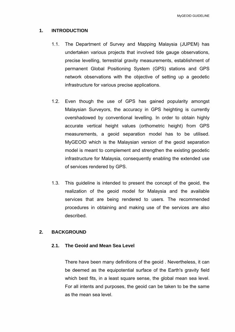
1. INTRODUCTION
1.1. The Department of Survey and Mapping Malaysia (JUPEM) has
undertaken various projects that involved tide gauge observations,
precise levelling, terrestrial gravity measurements, establishment of
permanent Global Positioning System (GPS) stations and GPS
network observations with the objective of setting up a geodetic
infrastructure for various precise applications.
1.2. Even though the use of GPS has gained popularity amongst
Malaysian Surveyors, the accuracy in GPS heighting is currently
overshadowed by conventional levelling. In order to obtain highly
accurate vertical height values (orthometric height) from GPS
measurements, a geoid separation model has to be utilised.
MyGEOID which is the Malaysian version of the geoid separation
model is meant to complement and strengthen the existing geodetic
infrastructure for Malaysia, consequently enabling the extended use
of services rendered by GPS.
1.3. This guideline is intended to present the concept of the geoid, the
realization of the geoid model for Malaysia and the available
services that are being rendered to users. The recommended
procedures in obtaining and making use of the services are also
described.
2. BACKGROUND
2.1. The Geoid and Mean Sea Level
There have been many definitions of the geoid . Nevertheless, it can
be deemed as the equipotential surface of the Earth's gravity field
which best fits, in a least square sense, the global mean sea level.
For all intents and purposes, the geoid can be taken to be the same
as the mean sea level.

MyGEOID GUIDELINE
2
The mean sea level on the other hand is the average level of the
ocean surface halfway between the highest and lowest levels
recorded by tide gauges at specified locations. It is utilised as a
plane upon which heights of features on, above or below the ground
can be referenced.
2.2. Orthometric Height or Elevation The height of a feature above mean sea level is called an
orthometric height or an elevation. Elevation of features has been
used in everyday lives, for example to build roads and in most types
of major construction. Elevations are measured by one of two
methods, i.e. either by using levelling or by using GPS derived
height.
Levelling has been used to determine elevations for hundreds of
years. It can be very accurate, but takes a long time and needs
several people to do the work. Poor weather and rough terrain could
cause more problems and these factors consequently made levelling
expensive. However, until recently, it was the only truly reliable
method.
With the advancement of technology, GPS can now be used to
quickly and easily determine not only very accurate positions, but
also elevations. In the latter case, there is no need to consider the
distance from the last point where elevation data is obtained, the
type of terrain or whether or not the weather is bad.
2.3. Determination of the Geoid Model The geoid can be considered as the mean sea level plus its natural
continuation under the landmass, as in Figure 1. This extension
must be determined mathematically or modelled. The geoid model is
actually based on gravity data collected, be it acquired through

MyGEOID GUIDELINE
3
ground, airborne or space gravity surveys. Once the geoid is
determined, the difference between the two surfaces, the ellipsoid
and the geoid can then be computed anywhere in the country.
FIGURE 1: The topography, geoid and ellipsoid.
2.4. Use of the Geoid Model
The Geoid model contributes to the vertical component of the
reference system so that ellipsoidal GPS heights can be converted
to orthometric elevations for practical uses.
The real challenge lies in knowing the relationship between the
ellipsoid and the geoid. Once the difference between these two
surfaces, called the "geoid-ellipsoid separation" or "geoidal height",
at a given point is determined, then application of the geoidal height
to the GPS height measurement can be made to obtain the mean
sea level elevation as in Figure 2.
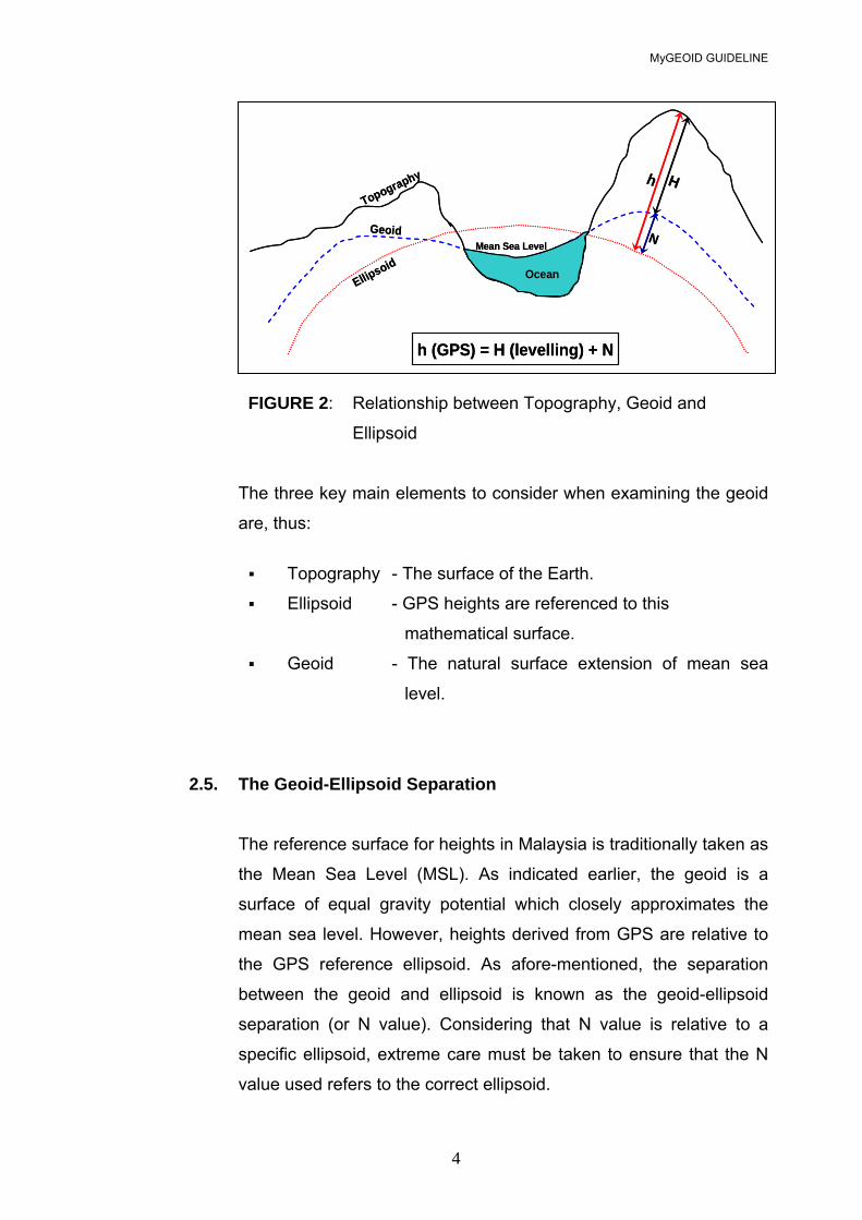
MyGEOID GUIDELINE
4
FIGURE 2: Relationship between Topography, Geoid and
Ellipsoid
The three key main elements to consider when examining the geoid
are, thus:
Topography - The surface of the Earth.
Ellipsoid - GPS heights are referenced to this
mathematical surface.
Geoid - The natural surface extension of mean sea
level.
2.5. The Geoid-Ellipsoid Separation
The reference surface for heights in Malaysia is traditionally taken as
the Mean Sea Level (MSL). As indicated earlier, the geoid is a
surface of equal gravity potential which closely approximates the
mean sea level. However, heights derived from GPS are relative to
the GPS reference ellipsoid. As afore-mentioned, the separation
between the geoid and ellipsoid is known as the geoid-ellipsoid
separation (or N value). Considering that N value is relative to a
specific ellipsoid, extreme care must be taken to ensure that the N
value used refers to the correct ellipsoid.
Topography
Geoid
EllipsoidOcean
Mean Sea Level
Hh
N
h (GPS) = H (levelling) + N
Topography
Geoid
EllipsoidOcean
Mean Sea Level
Hh
N
h (GPS) = H (levelling) + N

MyGEOID GUIDELINE
5
In the examples below, both the N value and the ellipsoidal height
refer to the same ellipsoid (usually WGS84 when working with GPS-
derived ellipsoidal heights or GRS80 ellipsoid; note that WGS84 is
taken as being the same as GRS80 ellipsoid):
Example 1 In an absolute sense, N is used as follows:
H = h - N If h = 62m and N = -12m
H = 62 - (-12) = 74m.
Example 2 In a relative (baseline) sense where the change in N is used:
(H2 - H1) = (h2 - h1) - (N2 - N1) i.e. ∆H = ∆h - ∆N
H2 = H1 + ∆H
If H1 = 636.5m (known); h1 = 623m; h2 =581m; N2 = -17m; N1 = -15m
∆h = 581 - 623 = - 42m ∆N = -17 - (-15) = - 2m ∆H = (- 42) - (- 2) = - 40m
H2 = 636.5 + (- 40) = 596.5 m
3. MyGEOID
3.1. The Malaysian geoid models or in short, MyGEOID consist of the
following:
• Peninsular Malaysia – WMGEOID04
• Sarawak and Sabah – EMGEOID05

MyGEOID GUIDELINE
6
The geoid models are hybrid ones, combining the gravimetric geoids
with datum transformations and GPS ellipsoid heights on levelled
bench marks. Table 1 shows the specifications of the geoid models.
FIGURE 3: Peninsular Malaysia Geoid 2004 (WMGEOID04)
99.5 100 100.5 101 101.5 102 102.5 103 103.5 104
1.5
2
2.5
3
3.5
4
4.5
5
5.5
6
6.5

MyGEOID GUIDELINE
7
FIGURE 4: Sabah & Sarawak Geoid 2005 (EMGEOID05)
3.2. Absolute comparison of gravimetric geoid-ellipsoid separation with
the geometric (GPS minus benchmark heights) equivalent revealed
existence of datum bias, or datum ambiguity. Therefore, the final
geoid model was computed by fitting the GPS-levelling and the
gravimetric geoid to produce Malaysia’s first ever geoid model –
MyGEOID, which fits the local Mean Sea Level of Peninsular
Malaysia as well as that of Sabah and Sarawak.
3.3. It should be stressed that this final geoid inherits the possible
systematic errors of GPS levelling, and thus could no longer be an
equipotential surface. However, the geoid will match the vertical
datum of Malaysia, and thus permits users to convert GPS heights in
ITRF to level heights in the said datum.
107 108 109 110 111 112 113 114 115 116 117 118 119 1200
1
2
3
4
5
6
7
8
MyGEOID GUIDELINE
8
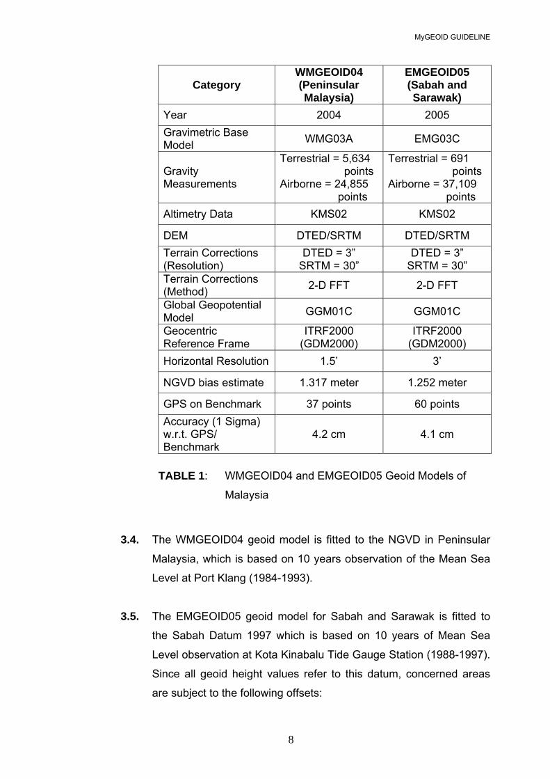
Category WMGEOID04 (Peninsular Malaysia)
EMGEOID05 (Sabah and Sarawak)
Year 2004 2005 Gravimetric Base Model WMG03A EMG03C
Gravity Measurements
Terrestrial = 5,634 points Airborne = 24,855 points
Terrestrial = 691 points Airborne = 37,109 points
Altimetry Data KMS02 KMS02
DEM DTED/SRTM DTED/SRTM Terrain Corrections (Resolution)
DTED = 3” SRTM = 30”
DTED = 3” SRTM = 30”
Terrain Corrections (Method) 2-D FFT 2-D FFT
Global Geopotential Model GGM01C GGM01C
Geocentric Reference Frame
ITRF2000 (GDM2000)
ITRF2000 (GDM2000)
Horizontal Resolution 1.5’ 3’
NGVD bias estimate 1.317 meter 1.252 meter
GPS on Benchmark 37 points 60 points Accuracy (1 Sigma) w.r.t. GPS/ Benchmark
4.2 cm 4.1 cm
TABLE 1: WMGEOID04 and EMGEOID05 Geoid Models of
Malaysia
3.4. The WMGEOID04 geoid model is fitted to the NGVD in Peninsular
Malaysia, which is based on 10 years observation of the Mean Sea
Level at Port Klang (1984-1993).
3.5. The EMGEOID05 geoid model for Sabah and Sarawak is fitted to
the Sabah Datum 1997 which is based on 10 years of Mean Sea
Level observation at Kota Kinabalu Tide Gauge Station (1988-1997).
Since all geoid height values refer to this datum, concerned areas
are subject to the following offsets:
MyGEOID GUIDELINE
9
No. Vertical Datum Offset (m) Sabah
1. Sabah 97 0.00
Sarawak
1. Sabah (Lawas) -0.16
2. Merapok (Lawas) -0.16
3. STAPS Jabatan Laut (Limbang) -0.32
4. Original (Miri) -0.14
5. Bintulu (Bintulu) -0.36
6. Pulau Lakei -0.35
4. MyGEOID DATA
4.1. Data Format
The data file format has a header for every file showing the geoid-
ellipsoid separation to 3 decimal places. MyGEOID consists of a 1’
by 1’ grid (approximately 1.8 km) of geoid-ellipsoid separations (N
Values) relative to the GRS80 ellipsoid, which is also used for the
Geocentric Datum of Malaysia (GDM2000).
4.2. Data Supply
Data can be obtained from the Geodesy Section by formal
application through letter, fax or e-mail and will be supplied as
required by user, either in hardcopy or softcopy form. Data can be
supplied in binary or ASCII grid format as well as in either point data
or block data. For point data, the following input information are
required:
MyGEOID GUIDELINE
10
i. Id, lat, long (degrees); or
ii. Id, lat, long (deg, min, sec); or
iii. Id, X, Y, Z (meter) ; or
iv. Id, N, E, (general UTM, meter).
Where: Id = point identification
lat = latitude
long = longitude
deg = degree
min = minute
sec = second
X, Y, Z = Cartesian coordinate in meter
N, E = Grid coordinate in meter
UTM = Universal Transverse Mercator
For block data, the coordinates defining the block for which geoid
separation data is required have to be provided.
4.3. Charges
As indicated earlier, geoid separation data available are in the the
form of 1' x 1' (1.8 km x 1.8 km) grid over the whole country. They
could be purchased in the forms and with payment of charges, as
follows:
Geoid Data RM / Unit
Point 15.00
Geoid Map Sheet (L7030 / T738 Series): 30 km x 30 km 1,000.00
Peninsular Malaysia 20,000.00 Sabah 10,000.00 Sarawak 10,000.00
MyGEOID GUIDELINE
11
5. MyGEOID RELATED SERVICES
In addition, JUPEM also provides the following related services:
a. Computation of the following information:
i. Geoid heights interpolation
ii. Ellipsoidal to orthometric heights
iii. Orthometric heights to ellipsoidal
iv. Deflection of vertical (arc sec)
b. Generation of geoid map (as requested) in the
form of grid block.
In providing the aforesaid services, the charges as mentioned in Para 4 will
apply.
6. RECOMMENDED PROCEDURES FOR GPS DERIVED ORTHOMETRIC HEIGHT
In order to achieve orthometric height of 5 cm or better accuracy, at least
the same level of accuracy must be obtained in GPS derived ellipsoidal
heights. Therefore, it is important to ensure that all components of GPS
observation meet the following requirements:
• Dual-frequency GPS receivers with full-wavelength are required for
all observations of base lines greater than 10 km.
• Geodetic antennas with ground planes or multipath mitigation
capability are required.
• All antennas used during a project should be identical; otherwise
corrections must be made for antenna phase patterns.
• Height of antennae must follow manufacturer’s specification.
MyGEOID GUIDELINE
12
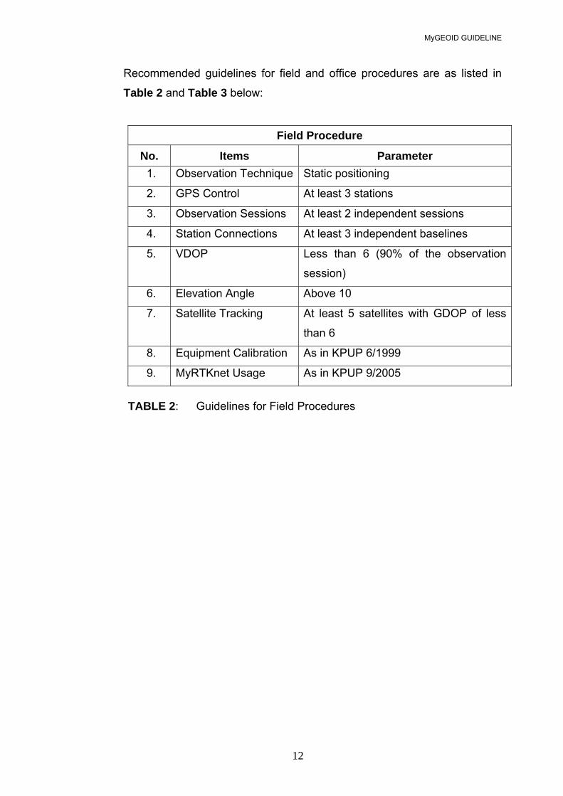
Recommended guidelines for field and office procedures are as listed in Table 2 and Table 3 below:
Field Procedure
No. Items Parameter 1. Observation Technique Static positioning
2. GPS Control At least 3 stations
3. Observation Sessions At least 2 independent sessions
4. Station Connections At least 3 independent baselines
5. VDOP Less than 6 (90% of the observation
session)
6. Elevation Angle Above 10
7. Satellite Tracking At least 5 satellites with GDOP of less
than 6
8. Equipment Calibration As in KPUP 6/1999
9. MyRTKnet Usage As in KPUP 9/2005
TABLE 2: Guidelines for Field Procedures
MyGEOID GUIDELINE
13
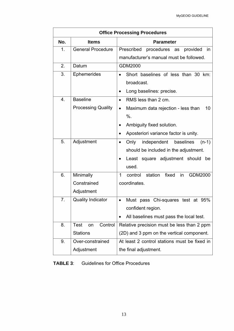
Office Processing Procedures
No. Items Parameter 1. General Procedure Prescribed procedures as provided in
manufacturer’s manual must be followed.
2. Datum GDM2000
3. Ephemerides • Short baselines of less than 30 km:
broadcast.
• Long baselines: precise.
4. Baseline
Processing Quality • RMS less than 2 cm.
• Maximum data rejection - less than 10
%.
• Ambiguity fixed solution.
• Aposteriori variance factor is unity.
5. Adjustment • Only independent baselines (n-1)
should be included in the adjustment.
• Least square adjustment should be
used.
6. Minimally
Constrained
Adjustment
1 control station fixed in GDM2000
coordinates.
7. Quality Indicator • Must pass Chi-squares test at 95%
confident region.
• All baselines must pass the local test.
8. Test on Control
Stations
Relative precision must be less than 2 ppm
(2D) and 3 ppm on the vertical component.
9. Over-constrained
Adjustment
At least 2 control stations must be fixed in
the final adjustment.
TABLE 3: Guidelines for Office Procedures
MyGEOID GUIDELINE
14
7. EXCLUSION OF LIABILITY
JUPEM has made every endeavour to ensure that the information
contained in MyGEOID data made available to the public is free from
errors and omissions. However, JUPEM does not warrant that the
supplied information is free from errors or omissions. JUPEM shall not be
in any way be liable for any direct or indirect loss, damage or injury
suffered by the use of this data.
8. CONDITIONS FOR DATA USE
The data is the sole property of the Director General of Survey and
Mapping. They are supplied to approved users, and is non transferable.
The data must not be sold, given away, traded, let, hired or otherwise
dealt with. Users are permitted to use the data in demonstrations and
displays, provided a statement acknowledging supply by JUPEM is
displayed with the data or any derived product.
Department of Survey and Mapping Malaysia
September 2005
MyGEOID GUIDELINE
15
GLOSSARY
Ambiguity The unknown integer number of cycles of the reconstructed carrier phase
contained in an unbroken set of measurements from a single satellite pass at
a single receiver.
Vertical Datum Bias The difference in vertical reference between gravimetric geoid and the local
mean sea level.
Deflections of Vertical The angle between the plumb line (line perpendicular to the geoid) and the
line normal to the ellipsoid. This angle has both a magnitude and a direction
and usually resolved into two components, one in the meridian and the other
perpendicular to it in the prime vertical.
Ellipsoid A smooth mathematical surface used to describe the shape of the earth for
geodetic computations. The figure is formed by rotating an ellipse about its
minor (shorter) axis and is typically described by dimensions for the
semimajor axis (a) together with the semiminor axis (b) or flattening,
(f) = (a-b)/a.
Ellipsoid height The distance from a point to the reference ellipsoid along a line normal to the
ellipsoid.
GDOP Geometric Dilution of Precision. GDOP represents the uncertainty expected in
the three positional coordinates plus the clock offset from a particular
configuration of the satellites. High GDOP means low accuracy.
MyGEOID GUIDELINE
16
Geocentric Datum of Malaysia (GDM2000) A geocentric coordinate system for positioning in Malaysia, whose origin
coincides with the centre of the mass of the earth which fits into International
Terrestrial Reference Frame.
Geoid An equipotential surface (a surface of equal gravity potential) which most
closely matches mean sea level. An equipotential surface is normal to the
gravity vector at every point.
Gravimetric Geoids Geoid model computed based on gravity data.
GRS80 Ellipsoid Geodetic Reference System 1980. The reference ellipsoid of GDM2000.
Mean Sea Level The average height of the sea for all stages of the tide over a period (often
used as a reference for general leveling operations).
NGVD A network of reference adopted as a standard geodetic datum for elevation in
the country.
Orthometric Height The distance from the geoid to a point, measured along a line normal to the
geoid.
Static GPS GPS carrier phase differencing technique where the GPS observations are
carried out using one or more stationary receivers and where the integer
ambiguities are resolved from an extended observation period through a
change in satellite geometry.

MyGEOID GUIDELINE
17
VDOP Vertical Dilution of Precision. A value expressing the confidence factor in the
accuracy of the vertical component of a position solution based on current
satellite geometry. The lower the value the greater the confidence in the
solution.


