Geographical Profiling in a Novel Context
1
Geographical Profiling in a Novel Context:
Prioritising the Search for New Zealand Sex Offenders
Laura Hammond*
International Research Centre for Investigative Psychology
* Correspondence to:
Dr Laura Hammond
International Research Centre for Investigative Psychology
R2-12, Department of Behavioural Sciences,
University of Huddersfield, Queensgate Campus.
HD1 3DH
Email: [email protected]

Geographical Profiling in a Novel Context
2
Abstract
The present work examines the use and value of geographical offender profiling
methodologies within a novel context, considering both theoretical and practical issues relating to
their application.
Two separate studies are presented. The first examined the effectiveness of a geographical
profiling system (Dragnet) for a sample of 101 New Zealand sex offenders, comparing findings
with those obtained for a U.K. serial rape sample. Search costs and search cost functions (relating
proportions of the samples to the amounts by which the areas needing to be searched in order to
locate offenders were reduced by the system) showed Dragnet to make significantly less accurate
geographical profiling predictions for NZ offenders. It is argued that this is because the spatial
behaviour of NZ offenders violates many of the assumptions that Dragnet and other similar
geographical profiling systems rely upon.
A second study then explored whether calibration of the geographical profiling system to the
local context enhanced the accuracy of predictions made. A logarithmic function was found to
provide the best fit to data on the distances travelled by the NZ sex offenders, and was consequently
incorporated into the geographical profiling predictions made by Dragnet. However, the
effectiveness of the system was not significantly enhanced as a result of this calibration process.
The implications of these findings for the general utility of geographical profiling are
discussed, and ways in which GP systems might be developed in order to broaden their scope and
applicability are suggested.
Keywords: Geographical Profiling; Sex Offences; Journey-to-Crime; Dragnet

Geographical Profiling in a Novel Context
3
Background to the Research
This project was the result of an overseas institutional research visit funded by the Economic and
Social Research Council as part of the author’s doctoral research program. The New Zealand Police
Criminal Profiling Unit acted as a host, and provided access to archival data on convicted sex
offenders which was used to gain the geographical information necessary for the analyses
presented.
Acknowledgements
Without a number of people this project would not have taken place, and they deserve a great deal
of recognition and thanks. Firstly, thank you to the members of the New Zealand Police Criminal
Profiling Unit, to Mary Goddard for helping to set this all up, to Brett Pakenham, David Scott, and
particularly to Russell Lamb for his endless assistance in compiling the sample and data. Thank you
the New Zealand Police for acting as a host institution, and to the RESC for permitting the work to
take place. A special thank you to Rebecca Morton and the ESRC for the award enabling the
project, and last, but by certainly no means least, I’d like to say thank you to Professor David
Canter for all of his help in the preparation of this article and in the project itself, as well as for his
constant supervision and support. It is greatly appreciated.
NB: The author also wishes to thank two anonymous reviewers for their helpful comments and
feedback on earlier versions of this work.
Geographical Profiling in a Novel Context
4
Introduction
Geographical offender profiling (Canter and Youngs, 2008a; 2008b) is a technique which in
recent years has come more and more to the fore, being increasingly utilized by police and law
enforcement agencies around the world to make predictions about where the perpetrator of a series
of offences might be most likely to reside on the basis of the distribution of their crimes. A variety
of geographical profiling systems are becoming relatively commonplace within the investigative
domain. Regardless of the specific system being used, their basic operating procedures are
essentially the same; mathematical functions, delineated from empirical findings on the journey to
crime and offence distribution, are applied in order to assign probabilities to the regions around a
crime series, generating a probability surface to indicate the likelihood of an offender residing at
various locations within the area (Canter and Hammond, 2006).
Considerable support, both anecdotal and empirical, has been provided for the usefulness of
geographical profiling (e.g. Canter, Coffey, Huntley and Missen, 2000; Rossmo, 2000; Canter,
2004; Canter and Hammond, 2006; 2007; Paulsen, 2006a; 2006b; Hammond and Youngs, 2011).
However, as a result of data availability and data gathering issues, evaluation studies have almost
wholly been conducted on British and North American samples drawn from single jurisdictions
(Paulsen, 2006). There is consequently a pressing need for research into the effectiveness of
geographical profiling for offending samples drawn from a wider range of contexts.
The present research therefore examines the effectiveness of one of the most commonly used
geographical profiling systems, Dragnet, for a sample of sex offenders drawn from across New
Zealand. Comparisons are made between NZ and UK samples in terms of prediction accuracy, and
the potential value of calibrating the system to the localized conditions that the NZ context affords
is addressed. Findings form the basis of a discussion of the general utility of existent geographical
profiling methodologies.
Geographical Profiling in a Novel Context
5
There are several reasons to expect that geographical profiling procedures may not be as
effective for NZ offenders as they are for their Anglo-American counterparts, whose behaviour on
which such systems are based. The applicability of models of criminal spatial behaviour and,
consequently, the efficacy of geographical profiling methods will, as Beauregard, Proulx and
Rossmo (2005) discuss, be influenced by a wide range of environmental factors. These include;
target backcloth; arterial roads and highways; boundaries (both psychological and physical); zoning
(industrial, commercial, residential); land use (e.g., stores, bars, businesses); and neighbourhood
demographics and characteristics (e.g. race, socio-economic status) (Rossmo, 2000; 2001).
Edwards and Grace (2006) propose, the New Zealand context is ‘likely to represent a different
profile in terms of environmental and geographic factors that impinge upon offending behaviour
compared to prior research…’ (Edwards and Grace, 2006; p. 221).
Lundrigan and Czarnomski (2006) present strong arguments as to why empirical models of
criminal spatial behaviour are unlikely to effectively capture the movements and crime patterns of
NZ serial offenders, discussing in depth a number of factors that will limit their potential
applicability in making predictions about home-crime relationships. For example; the mathematical
functions that geographical profiling systems use to make predictions as to likely offender residence
assume universally short home-crime distances that demonstrate a strong distance decay pattern (cf.
Canter and Hammond, 2006; Hammond and Youngs, 2011). However, as Lundrigan and
Czarnomski (2006) demonstrate, the average distances travelled by NZ offenders and the ranges
over which they operate tend to be far greater than those reported in the literature for samples from
other parts of the world. They find a mean home-crime distance of 17km (around 10.5 miles) for
NZ sex offenders. For British and American samples reported means for sexual offenders range
from 1.15 miles (Rhodes and Conly, 1981) to 3.14 miles (Warren, Reboussin, Hazelwood,
Cummings, Gibbs and Trumbetta, 1998). The form and gradient of the decay function that
distributions of the distances NZ offenders travel to offend follow is therefore likely to differ
significantly from those derived for samples from the U.K. and the U.S.
Geographical Profiling in a Novel Context
6
Further, it has frequently been argued within the literature that geographical profiling will
only be successful in cases where the offender is a ‘Marauder’ (Canter and Larkin, 1993), their
home being located within the area circumscribed by their crimes (Rossmo, 2005; Snook, Zito,
Bennell & Taylor, 2005; Bennell & Corey, 2007; Paulsen, 2007). In the few cases where some
success in geographically profiling ‘commuters’ (those who reside outside of their criminal domain)
has been reported, search areas and resultant search cost measures have tended to be far higher than
those of marauding offenders (e.g. Laukkanen and Santilla, 2006).
Whilst a marauding crime pattern has been found to dominate for most samples (for
example; in 87% of U.K rape series in the sample of Canter and Larkin’s original 1993 study), the
findings of both Edwards and Grace (2006) and Lundrigan and Czarnomski (2006) show that New
Zealand serial offenders are equally likely to display a commuting pattern of offending as a
marauding one.
From what we know of the spatial behaviour of NZ serial offenders, then, their crime
patterns will frequently violate the core assumptions that geographical profiling methods rely upon.
It would therefore be expected that in many instances geographical profiling would be relatively
ineffective within the NZ context, and in those cases where it was of value, the efficacy with which
it prioritised the search for NZ offenders would be less than that for British or American samples.
Geographical Profiling in a Novel Context
7
Data and Methodology
Data Source:
The data utilized in the present work was drawn from the archives of the New Zealand
Police Criminal Profiling Unit (CPU). The CPU hold details and case files on thousands of solved
and unsolved serious sexual offences, representing the majority of crimes committed across the
whole of New Zealand since 1970. 1
Since 1999 a centralised database has been used to aid in the identification and linking of
sex offence series. It features known, convicted sexual offenders, with information being collated
from reports sent in from police stations on sexual offences, both historical and current.
Demographic and geographical data on the offender, the victim, and the offence (the behavioural
characteristics of the crime and the nature and location of the crime scene) are coded by the CPU in
searchable terms that are featured in the database to enable crimes to be linked and the
characteristics of offence series to be studied2.
Delineating Crime ‘Series’:
This database was used to identify linked, solved sexual offence series (where convictions
had been obtained for all of the offences), for which complete geographical/locational data was
available.
All cases had to be classified as being a sexual offence (e.g. indecent assault, rape) in order
to be included in a series and, following the protocol developed by Lundrigan and Czarnomski
1 Whilst most of the sexual offences committed across the country are reported to the C.P.U. (and therefore included
within their databases) this is currently not a mandatory requirement for police forces, and so inclusion is reliant upon
the motivation of the officers/departments investigating (or having investigated) the case. Therefore not all NZ sex
offences feature in the database; a limitation of the data source that must be noted.
2 As Lundrigan and Czarnomski (2006) observe, data compiled from a range of different sources and coded in such a
way is likely to be variable in terms of both the quantity and quality of the information incorporated, being strongly
influenced by the objectivity of the persons collating it. This must also be noted as a limitation of the data source, and
taken into consideration when drawing conclusions on the basis of analysis of the data.
Geographical Profiling in a Novel Context
8
(2006) for the determination of sexual offence series, each series had to feature at least one ‘sexual
violation’3 offence in order to be included within the final sample.
All offence series for which home and offence locations could be reliably determined were
included in the sample (with all crimes in each series being linked to a single home location). Those
for whom such information could not be validated were necessarily excluded.
There has been a degree of debate within the literature as to the number of crimes required
for a series to be amenable to geographical profiling methodologies. Levine (2005) argues for a
minimum of ten cases, although the basis for this proposition is somewhat unclear. Rossmo (2000)
proposes that a five or more offences are necessary for geographical profiling to be of value. This
assertion is made on the basis of a random numbers trial (a ‘Monte Carlo’ analysis), in which ‘a
computer program is used to generate random crime site coordinates based on a fixed-buffer
distance decay function’ (Rossmo, 2000, p.206). As Canter (2005) observes, such a trial is clearly
artificial in the extreme, making it difficult to draw any reliable conclusions about minimum
requirements for successful profiling.
Whilst it is generally accepted that the more cases that are included in an analysis the more
reliable statistical estimates are likely to be (Wilson and Maxwell, 2007), as Canter (2005)
discusses, published studies employing non-artificially selected samples of actual crimes (e.g.
Canter et al., 2000) demonstrate that there is no empirical necessity for a five or more crimes.
Indeed, a number of examples have shown geographical profiling to be of value in one-off cases or
series consisting of few crimes (Canter, 2005).
The present work therefore made no assumptions about the minimum number of crimes
required for successful geographical profiling, with series comprising two or more cases identified
by the police as having been committed by the same individual.
3 In New Zealand, the legal definition of sexual violation includes penetration of any part of the victim’s body or any
object manipulated by the offender to the victim’s vagina or anus. It also includes connection between the mouth or
tongue of either the victim or offender and the genitalia of the other person (Lundrigan and Czarnomski, 2006; p.20).
Geographical Profiling in a Novel Context
9
Sample:
The final sample consisted of 101 sexual offence series, each comprising a minimum of two
offences committed within New Zealand between 1970 and 2007. In total 603 offences were
included in the sample, with a mean of 5.97 (median = 4.25; S.D. = 9.667) crimes per series. The
maximum number of offences included in any series was 50.
Preparation and Utilisation of the Data:
Locational information on each of the crimes comprising the present sample was drawn
from the NZ Police C.P.U. databases, and consisted of address details and geocodes for both the
offender’s home (where they were listed as residing at the time that the offence was committed) and
the place where the offence was committed. Offence locations were taken as being where the crime
actually took place as opposed to the victim-offender encounter location, which could not always be
reliably inferred. If the offence occurred somewhere other than a registered address (e.g. in a park,
car park or other such outdoor space), then the geocode for the nearest identifiable point was used.
Whilst this meant that in some cases measurements of distance between offender’s home and crime
locations were slightly inaccurate, these inaccuracies were typically so small (a matter of metres)
that it was deemed appropriate for such offences to remain part of the sample.
Distances between home and offence locations were calculated directly from the geocodes.
Euclidean (‘crow-flight’) distances were used throughout, in line with previous research4.
Data files suitable for use within a geographical profiling system were created from the
geocodes, containing information on scaling and relative spacing of home and offence locations.
Plots were created for each of the offence series, and these formed the basis of the geographical
profiling analyses conducted.
4 Whilst straight-line distances undoubtedly underestimate the actual lengths of the journeys made by the offenders
from their homes to their crime locations, as Lundrigan and Czarnomski (2006) observe, there is no way of determining
the actual routes taken by offenders or the starting points of their journeys to crime. Therefore, as Hammond (2009)
discusses in some detail, Euclidean measures are best available option for research into offending spatial behaviour.

Geographical Profiling in a Novel Context
10
Geographical Profiling of Offence Series: Dragnet
The Dragnet geographical offender profiling system, developed by David Canter and
colleagues at the International Centre for Investigative Psychology at the University of Liverpool5
was used to construct geographical profiles for the sample in the present work. Whilst there are
many other geographical profiling packages available (see Paulsen, 2006a; 2006b; for a detailed
review and comparison of the main systems offered), Dragnet was used because it is one of the
most freely and widely available of the different systems. Moreover, there has been a considerable
amount of empirical research exploring the efficacy of the system and the range of parameters
within which it operates (cf. Canter et al., 2000; Canter and Hammond, 2006; 2007; Hammond and
Youngs, 2011), which enabled comparisons to be made between results obtained for the present
New Zealand sample and those reported for other offending cohorts.
The Dragnet system operates by examining a series of crime locations, plotted onto a grid
which represents the region over which they occurred, and indicating a potential search area,
defined by the size of the range over which the crimes were committed. All of the squares within
the grid are initially assigned equal probabilities of them containing the home or base of the
perpetrator of that series of crimes. Gravitational models are then applied, in order to produce a
prioritized map, or ‘chloropleth’, of the search area, in which the probabilities of each of the squares
containing the offender’s residence are weighted accordingly. The resultant probability plot is
produced by adding together the probabilities of the offender being based at varying distances from
each of the crime sites, then dividing those probabilities into deciles, with each decile being
assigned a different colour, depending on the probability value assigned to that area. This plot is
used to determine the most likely location of the offender’s residence/base on the basis of the crime
distribution.
5 For more information on the Dragnet system or to obtain a copy of the latest version, please contact Laura Hammond
at the International Research Centre for Investigative Psychology ([email protected]) or visit www.ia-ip.org.
Geographical Profiling in a Novel Context
11
Geographical profiles were constructed for each of the crime series in the present sample
using Dragnet, and the effectiveness of the system in prioritising the search for New Zealand sex
offenders was then determined.
Determining the Effectiveness of Geographical Profiling Predictions:
There are a number of different measures that can be used to assess the effectiveness of
geographical profiling methods (cf. Paulsen, 2005; 2006). One is ‘Search Cost’, detailed by Canter
et al. (2000). The search cost represents the proportion of the total offence area that has to be
searched in order to locate the home of the offender, and is calculated by dividing the search area
(the overall area needing to be searched, starting from the point predicted to be the most likely to
contain the offenders home) by the total area (the area over which the offence series occurred). The
search cost has been found to be an immensely useful measure of the practical utility of spatial
behavioural measures (e.g. Canter et al., 2000; Canter & Hammond, 2006; 2007; Hammond and
Youngs, 2011), and for this reason it is the principle measure of profiling effectiveness employed in
the present study.
Average search cost values merely provide gross indicators of the effectiveness of a
geographical profiling system. The utilisation of ‘search cost functions’, relating proportions of the
sample to the search costs produced, is therefore of value. The search cost function, as defined by
Canter and Hammond (2006), represents the relationship between the proportion of the total area
searched and the proportion of offenders located for each search cost interval value. It is used in the
present work to assess the effectiveness of Dragnet for NZ offenders relative to other samples, and
to examine the impact of calibration of the system to the NZ context on the accuracy of predictions
made.

Geographical Profiling in a Novel Context
12
Study 1: The Effectiveness of GOP for NZ Offenders
Whilst anecdotal accounts of the success and value of geographical profiling systems
abound in the publications of the method’s exponents, relatively few empirical assessments of the
effectiveness of geographical profiling strategies have been presented within the literature. As a
result there are few figures against which to make comparisons.
Moreover, there are no independent published accounts utilising search cost measures of the
success of geographical profiling systems for serial rape or sexual assault samples. As Hammond
(2009) observes, given the different contextual demands and environmental constraints afforded by
different crime types, offending spatial patterns, and thus the relative efficacy of different
geographical profiling methods, are likely to vary depending on the nature of the offence. It would
therefore be inappropriate to compare findings for NZ sex offenders with previously reported
findings for other crime types.
In order to enable a direct evaluation of the validity and utility of geographical profiling for
NZ offenders relative to samples from other parts of the world findings for the present sample were
directly compared with an equivalent sample of 24 British rape series6. This sample was compiled
using the same criteria and restrictions as those applied for the NZ offence series (with a mean of
4.75 crimes per series).
The search cost function produced when geographical profiles were constructed for the New
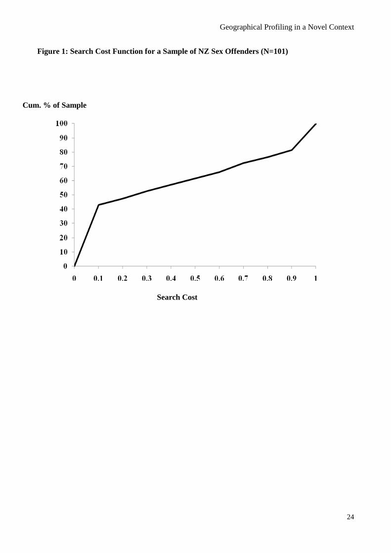
Zealand sex offenders using Dragnet7 is presented in Figure 1., below;
(Figure 1. here)
6 This comparison sample was kindly made available by the International Research Centre for Investigative Psychology
at the University of Huddersfield (www.hud.ac.uk/IRCIP).
7 A range of distance measures, decay functions and normalisation parameters may be used with Dragnet (see Canter et
al., 2000, for details). However, for simplicity, system defaults were used for this comparison analysis - Mean Interpoint
Distance for normalisation, Euclidean distance measures and a negative exponential decay function with a β-value of 1
(y = 0.5 e -β x
)
Geographical Profiling in a Novel Context
13
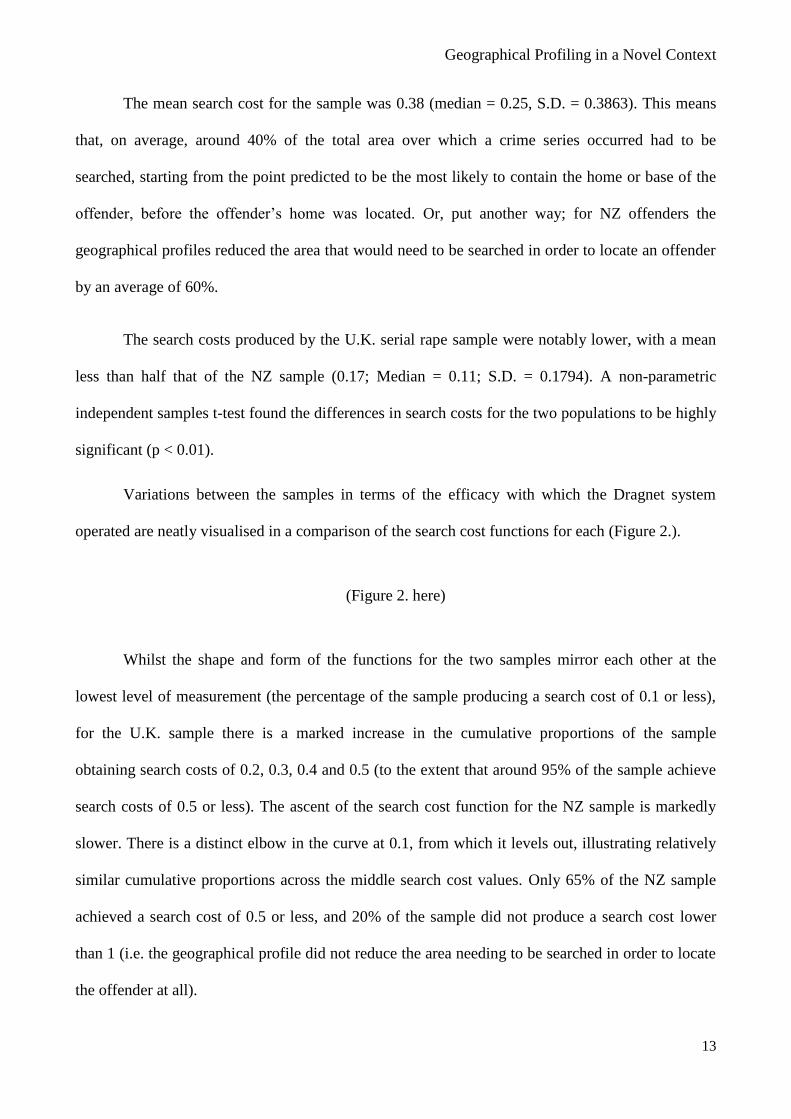
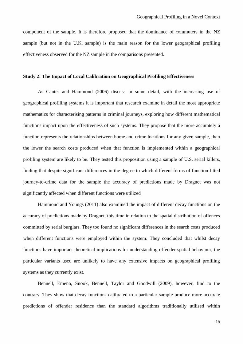
The mean search cost for the sample was 0.38 (median = 0.25, S.D. = 0.3863). This means
that, on average, around 40% of the total area over which a crime series occurred had to be
searched, starting from the point predicted to be the most likely to contain the home or base of the
offender, before the offender’s home was located. Or, put another way; for NZ offenders the
geographical profiles reduced the area that would need to be searched in order to locate an offender
by an average of 60%.
The search costs produced by the U.K. serial rape sample were notably lower, with a mean
less than half that of the NZ sample (0.17; Median = 0.11; S.D. = 0.1794). A non-parametric
independent samples t-test found the differences in search costs for the two populations to be highly
significant (p < 0.01).
Variations between the samples in terms of the efficacy with which the Dragnet system
operated are neatly visualised in a comparison of the search cost functions for each (Figure 2.).
(Figure 2. here)
Whilst the shape and form of the functions for the two samples mirror each other at the
lowest level of measurement (the percentage of the sample producing a search cost of 0.1 or less),
for the U.K. sample there is a marked increase in the cumulative proportions of the sample
obtaining search costs of 0.2, 0.3, 0.4 and 0.5 (to the extent that around 95% of the sample achieve
search costs of 0.5 or less). The ascent of the search cost function for the NZ sample is markedly
slower. There is a distinct elbow in the curve at 0.1, from which it levels out, illustrating relatively
similar cumulative proportions across the middle search cost values. Only 65% of the NZ sample
achieved a search cost of 0.5 or less, and 20% of the sample did not produce a search cost lower
than 1 (i.e. the geographical profile did not reduce the area needing to be searched in order to locate
the offender at all).

Geographical Profiling in a Novel Context
14
It is therefore clear that Dragnet was much more effective at prioritising the search for the
U.K. offenders than for the NZ sample. To enable consideration as to why this might have been the
case, the average home-crime distances for each of the samples and their relative proportions of
commuters and marauders were compared.
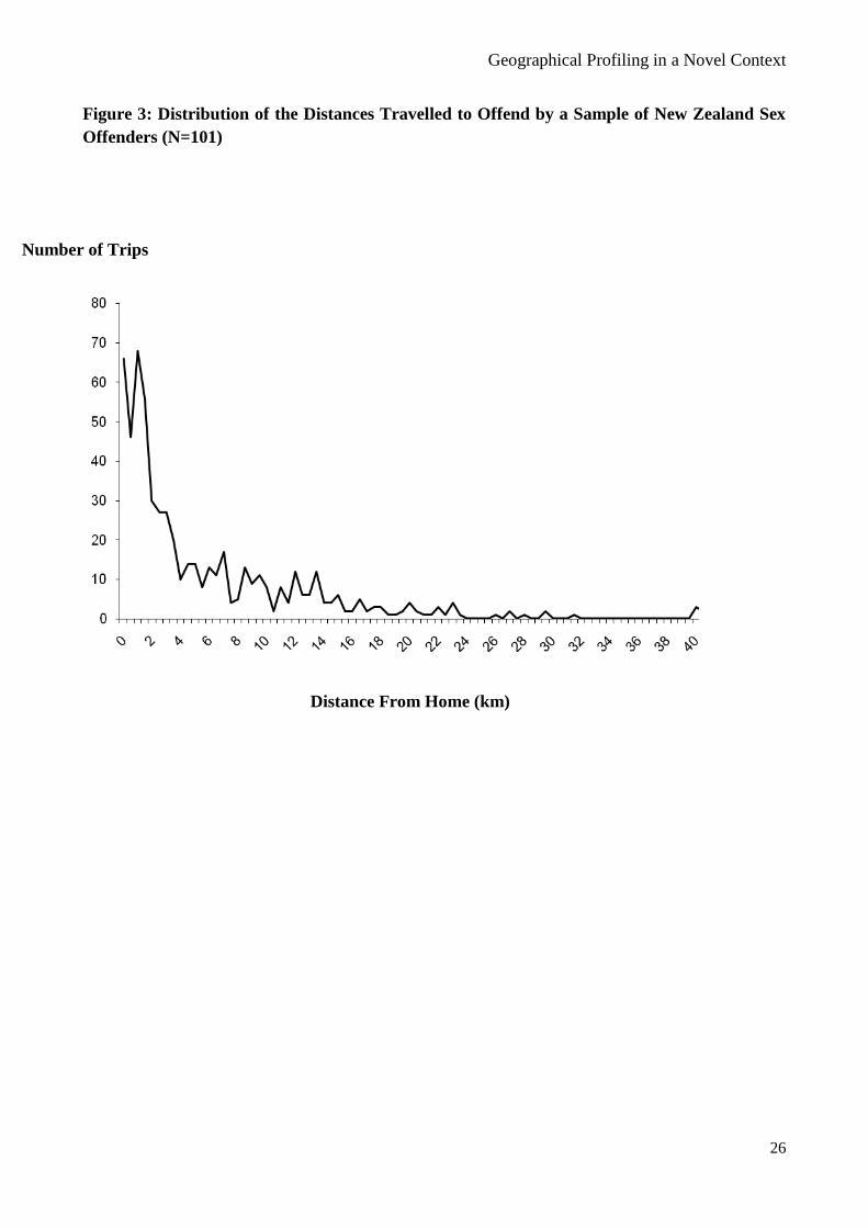
The mean home-crime distance for the NZ sample was found to be 14.77 km (Median =
2.69km; S.D. = 160.167), whereas the mean home-crime distance for the U.K serial rapists was just
7.79km (Median = 3.77km; S.D. = 16.84), significantly lower (p < 0.01, as determined using a non-
parametric t-test). These differences provide one means of explicating the variations observed in the
efficacy of Dragnet for the two samples for, as discussed above, the system operates on the
assumption that home-crime distances will tend to be short, and will follow a strong distance decay
pattern. Average distance values suggest that the U.K. sample meets these assumptions to a far
greater degree than their NZ counterparts.
More importantly though, 82% of the NZ sample displayed a commuting pattern of criminal
activity, whereas there was an equal split (50/50) of commuters and marauders in the U.K. sample.
This is likely to be the main reason for the higher search costs observed for New Zealand offenders;
As Laukkanen and Santilla (2006) have demonstrated, the more focused crime dispersion patterns
of commuters generate larger search areas and ensure that geographical profiling methods are less
efficient and accurate at predicting likely home location.
Average search costs were subsequently compared between commuters and marauders in
the NZ sample, in order to establish the basic relationship between the geometrical distribution of
offences and the reliability/accuracy of predictions made as to likely home location. Means of
0.3998 and 0.1833 were found for the two spatial groupings, respectively. A non-parametric Mann-
Whitney U test showed commuters and marauders to differ significantly in terms of the search costs
produced (p<0.001).
As would be predicted on the basis of the literature, then, the search costs produced by those
comprising the commuting sub-set of the NZ generated higher search costs than the marauding
Geographical Profiling in a Novel Context
15
component of the sample. It is therefore proposed that the dominance of commuters in the NZ
sample (but not in the U.K. sample) is the main reason for the lower geographical profiling
effectiveness observed for the NZ sample in the comparisons presented.
Study 2: The Impact of Local Calibration on Geographical Profiling Effectiveness
As Canter and Hammond (2006) discuss in some detail, with the increasing use of
geographical profiling systems it is important that research examine in detail the most appropriate
mathematics for characterising patterns in criminal journeys, exploring how different mathematical
functions impact upon the effectiveness of such systems. They propose that the more accurately a
function represents the relationships between home and crime locations for any given sample, then
the lower the search costs produced when that function is implemented within a geographical
profiling system are likely to be. They tested this proposition using a sample of U.S. serial killers,
finding that despite significant differences in the degree to which different forms of function fitted
journey-to-crime data for the sample the accuracy of predictions made by Dragnet was not
significantly affected when different functions were utilized
Hammond and Youngs (2011) also examined the impact of different decay functions on the
accuracy of predictions made by Dragnet, this time in relation to the spatial distribution of offences
committed by serial burglars. They too found no significant differences in the search costs produced
when different functions were employed within the system. They concluded that whilst decay
functions have important theoretical implications for understanding offender spatial behaviour, the
particular variants used are unlikely to have any extensive impacts on geographical profiling
systems as they currently exist.
Bennell, Emeno, Snook, Bennell, Taylor and Goodwill (2009), however, find to the
contrary. They show that decay functions calibrated to a particular sample produce more accurate
predictions of offender residence than the standard algorithms traditionally utilised within
Geographical Profiling in a Novel Context
16
geographical profiling systems. They argue that calibrated functions capture the unique
characteristics of the sample (e.g. with respect to offence, offender, and/or environmental
characteristics) on the basis of which predictions are made to a greater extent than uncalibrated
functions and are therefore likely to produce more accurate predictions than uncalibrated functions
(and human judges) that do not take such characteristics into account.
The literature is thus presently divided as to the benefits of using decay functions that are
calibrated to local conditions within current geographical systems, and it is clear that further
research is required to determine the extent to which different forms of function impact upon the
accuracy of predictions made.
The present NZ sample provides an ideal means of testing the impacts of calibrated
functions, given that the series display very different spatial characteristics (in terms of home-crime
distances and spatial distribution patterns, as illustrated above) to those from which the standard
decay functions employed within geographical profiling systems were derived.
One of the inherent values of the Dragnet geographical profiling system is that the user is
able to define the mathematical functions that the system employs in its prioritisations. It is
therefore possible to delineate the function that provides the best fit to the distance distribution of
any given sample and utilise this in constructing geographical profiles, thus calibrating the system
to that particular sample.
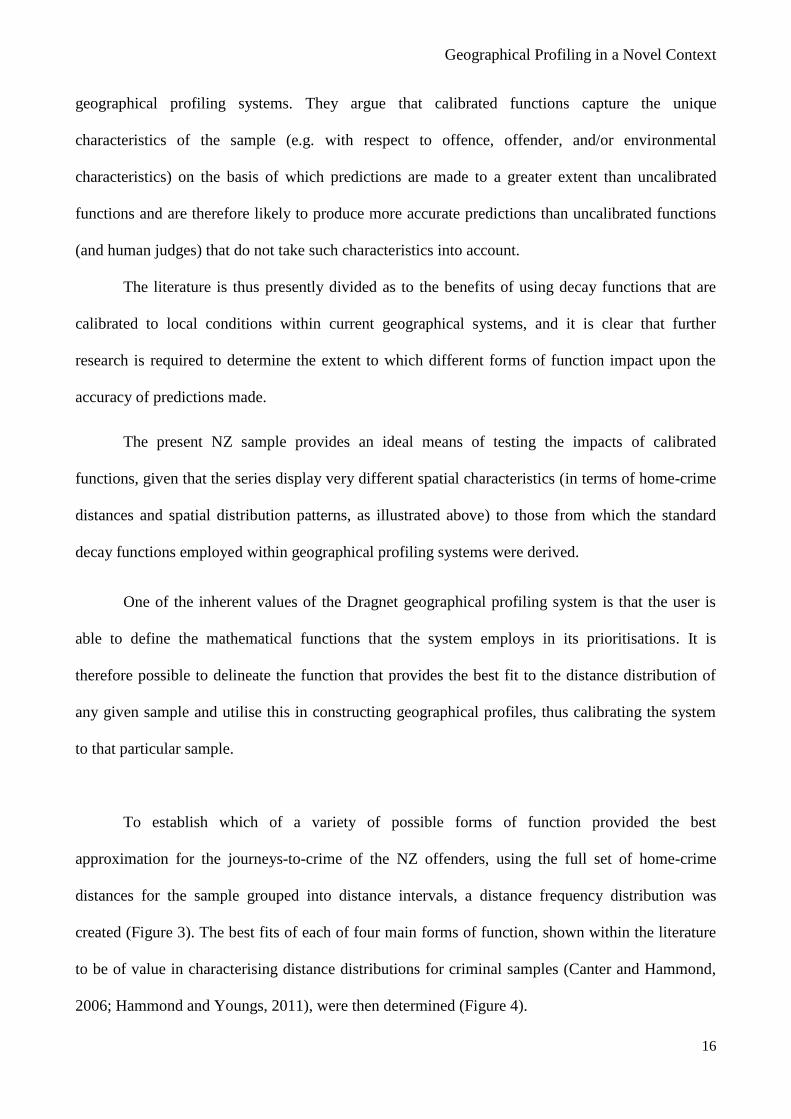
To establish which of a variety of possible forms of function provided the best
approximation for the journeys-to-crime of the NZ offenders, using the full set of home-crime
distances for the sample grouped into distance intervals, a distance frequency distribution was
created (Figure 3). The best fits of each of four main forms of function, shown within the literature
to be of value in characterising distance distributions for criminal samples (Canter and Hammond,
2006; Hammond and Youngs, 2011), were then determined (Figure 4).
Geographical Profiling in a Novel Context
17
(Figure 3. here)
(Figure 4. here)
The fits of the different functions were measured using R2 values; the higher the R
2 value,
the better approximation of the shape of the distribution the function was taken to be (for detailed
discussion of the use of R2 values as a measure of function fit see Kent, 2003; p.68). The R
2 values
for each of the four functions, and the formulae representing their best-fit forms, were as follows:
LOGARITHMIC
y = 35.5531 + (-10.2676). In x R2 = 0.87
QUADRATIC
y = 0.0103x2 + (-1.1896) x + 25.7324 R
2 = 0.71
NEGATIVE EXPONENTIAL
y = 5.8958 e – (-0.0614) x
R2 = 0.59
LINEAR
y = -0.3025 x + 14.2803 R2 = 0.46
The logarithmic function thus provided the closest approximation to the distribution of the
distances travelled by the NZ offenders, followed by the quadratic function. The linear function
and, surprisingly, the exponential function which has previously been found to be a good fit to such
distributions (Canter & Hammond, 2006; 2007), both provided relatively poor approximations of
the sample’s home-crime distance patterns.
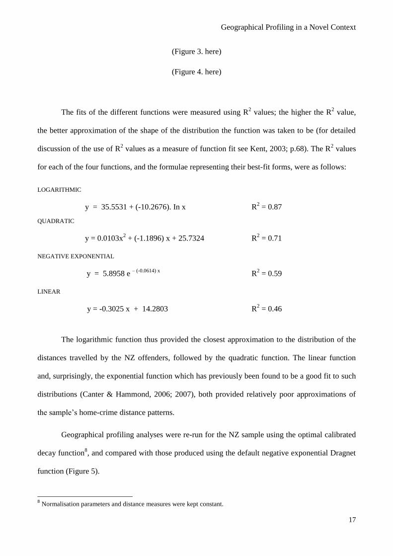
Geographical profiling analyses were re-run for the NZ sample using the optimal calibrated
decay function8, and compared with those produced using the default negative exponential Dragnet
function (Figure 5).
8 Normalisation parameters and distance measures were kept constant.
Geographical Profiling in a Novel Context
18
(Figure 5 here)
Whilst the search costs produced when an optimal function was employed were slightly
lower than those generated by the default function (a mean of 0.38 was found for both, but the
optimum function produced a median search cost of 0.22 and the default function a median of 0.25),
the differences in the search costs produced by the default and optimal functions were not found to
be significant (p > 0.5). Thus, calibrating the system to fit patterns of spatial behaviour generated by
the NZ context did not enhance the efficacy or efficiency of the system to any notable extent.
Discussion
The present findings on the use of the Dragnet geographical profiling system within the New
Zealand context and its efficacy in prioritizing the search for NZ sex offenders have obvious
implications for the practical utility of such systems. They show that whilst geographical profiling
methodologies may be valuable to a degree when applied outside of their previous domains, they
are likely to be less effective in novel contexts than with the samples for and upon which they were
created, highlighting the need for the development and refinement of such methods in order to
enhance their broader applicability.
Indeed, what the present findings are most demonstrative of are the inherent weaknesses of
geographical profiling systems in their current form, illustrating how impoverished the models upon
which such systems are based actually are (Canter, 2005). Block and Bernasco (2009) argue that
geographical profiling systems downplay environmental influences on criminal spatial behaviour,
with limited consideration of the target backdrop and opportunity structure within which the
offences are taking place. The present work supports this proposition by demonstrating that search
costs produced by Dragnet for NZ offenders are significantly higher than those for a British sample,
the system and its mathematical functions being evidently far more suited to the environmental
context afforded in the U.K. (effectively the base context for the system) than that of New Zealand.
Geographical Profiling in a Novel Context
19
Weaknesses in current geographical profiling systems are further exemplified by the lack of
impact of calibration observed in the present work. This may, in part, have been a function of a lack
of precision in the data employed and the low numbers of offences incorporated in some of the
series. Tests of the system with other samples would help to extrapolate such findings. It is also
likely that the normalization of more extreme values as well as the averaging processes that take
place within the software helped negate the impact of calibration (Canter and Hammond, 2006).
Nonetheless, the fact that calibrating the decay function to the NZ sample did not significantly
improve the accuracy of the predictions that the system made illustrates limitations in the reliability
and robustness of decay-based models for simulating offender travel patterns, suggesting that a
single decay function cannot capture the degree of variation in criminal spatial patterns displayed by
the present sample. Indeed, it would be rather naive to presume that it could; the extensive research
into criminal spatial behaviour that has been presented over the years has shown that criminals
display a large range of different offending patterns, operating over ranges of different sizes (e.g.
Canter and Larkin, 1993), with different degrees of offence dispersion (e.g. Goodwill and Alison,
2005; Hammond, 2009), and a range of temporal and sequential patterns (e.g. Lundrigan and
Canter, 2001). The failure of models to adequately account for such variations in crime series
distribution will of course impose limits on geographical profiling effectiveness.
As illustration of this point, Dragnet did work well for some of NZ cases - however, this was
only for those series displaying a simple, generic marauding distribution with the crimes centred
around the home of the offender. In instances where the offender was commuting away from their
home to commit their crimes, covering greater distances with more geographically dispersed
offences (as was more frequently the case for NZ sex offence series) geographical profiling
predictions were far less accurate. These findings emphasise the important role that offence
morphology plays in determining the amenability of offence series to geographical profiling.

Geographical Profiling in a Novel Context
20
In summary, then, the current findings emphasise the need for further empirical research to
both elucidate the range of forms that crime distributions can take and to account for the measurable
influences on criminal spatial behaviour that generate these different forms of distribution. It might
then be possible to delineate a fuller range of spatial behavioural models, and to determine when
and under what circumstances each is most likely to be of value in characterising home-crime
relationships for any given series or sample. Some tentative steps have been taken in this direction.
Hammond (2009), for example, explores the relationships between spatial/geometrical attributes of
crime and geographical profiling effectiveness, showing that the amenity of a series to geographical
profiling is determined by a wide range of co-occurring factors. More recently a range of
alternatives to aggregate decay functions have been proposed within the literature. The forerunner
of these is the modelling of home-crime relationships using a Bayesian approach, a process which
directly calibrates analyses to the locale or context within which an offence series occurs (e.g.
Levine, 2009). However, published research on their use and applicability is subject to the same
criticisms that apply to the vast majority of existent geographical profiling studies; it has utilised
only British and American samples drawn from localized geographical regions or particular police
jurisdictions. As such, we know little about the broader applicability and general utility of these
methods.
More reliable and robust models of criminal spatial behaviour would, in turn, enable the
development of more sophisticated and refined geographical profiling procedures that might more
effectively predict likely home location for offenders displaying a range of different crime patterns,
operating under various different contextual and environmental constraints. This is surely where the
future of geographical profiling lies if its methods and systems are to have any degree of reliable
applicability within differing and novel contexts.
Geographical Profiling in a Novel Context
21
References:
Beauregard, E., Proulx, J. & Rossmo, D.K. (2005) Spatial Patterns of Sex Offenders: Theoretical,
Empirical and Practical Issues. Aggression and Violent Behavior, 10 (5); pp.579-603.
Bennell, C. & Corey, S. (2007) Geographic Profiling of Terrorist Attacks. In R.N. Kocsis (Ed.).
Criminal Profiling: International Theory, Research and Practice. Tolowa, NJ: Humana Press.
Bennell, C., Emeno, K., Snook, B., Taylor, P.J. and Goodwill, A.M. (2009) The Precision,
Accuracy and Efficiency of Geographic Profiling Predictions: A Simple Heuristic Vs. Mathematical
Algorithms. Crime Mapping: A Journal of Research and Practice, 1 (2); 65-84.
Block, R. & Bernasco, W. (2009) Finding a Serial Burglar’s Home Using Distance Decay and
Origin-Destination Patterns: A Test of Empirical Bayes Journey-to-Crime Estimation in the Hague.
In Journal of Investigative Psychology and Offender Profiling: Special Issue on Bayesian Journey
to Crime Estimation, 6 (3); 187-211.
Canter, D. (2004). Mapping Murder. London: Virgin Books.
Canter, D. (2005). Confusing Operational Predicaments and Cognitive Explorations: Comments on
Rossmo and Snook et al. Applied Cognitive Psychology, 19(5); 663-668.
Canter, D., Coffey, T., Huntley, M. & Missen, C. (2000). Predicting Serial Killers’ Home Base
Using a Decision Support System. Journal of Quantitative Criminology, 16, 4; 457 – 478.
Canter, D. & Hammond, L. (2006) A Comparison of the Efficacy of Different Decay Functions in
Geographical Profiling for a Sample of U.S. Serial Killers. Journal of Investigative Psychology and
Offender Profiling, 3; 91-103.
Canter, D. & Hammond, L. (2007) Prioritising Burglars: Comparing the Effectiveness of
Geographical Profiling Methods. Police, Practice and Research, 8(4); 371-384.
Canter, D. & Larkin, P. (1993). The Environmental Range of Serial Rapists. In Canter, D. & Alison,
L. (Eds.). Criminal Detection and the Psychology of Crime. Aldershot, Dartmouth: Ashgate.
Canter, D. & Snook, B. (1999). Modelling the Home Location of Serial Offenders. Paper for
Expanding the Boundaries: The Third Annual International Crime Mapping Research Conference –
Orlando, December, 1999.

Geographical Profiling in a Novel Context
22
Canter, D. & Youngs, D. (Eds.) (2008a) Principles of Geographical Offender Profiling. Aldershot,
Ashgate,
Canter, D. & Youngs, D. (Eds.) (2008b) Applications of Geographical Offender Profiling.
Aldershot, Ashgate.
Edwards, M.J. & Grace, R.C. (2006) Analysing the Offence Locations and Residential Base of
Serial Arsonists in New Zealand. Australian Psychologist, 41(3); 219-226.
Goodwill, A.. & Alison, L. (2005) Sequential Angulation, Spatial Dispersion and Consistency of
Distance Attack Patterns from Home in Serial Murder, Rape and Burglary. Psychology, Crime &
Law, 11(2); 161-176.
Hammond, L.(2009) Spatial Patterns in Serial Crime: Modelling Offence Distribution and Home-
Crime Relationships for Prolific Individual Offenders. Unpublished Doctoral Thesis: University of
Liverpool, U.K.
Hammond, L. and Youngs, D. (2011) Decay Functions and Criminal Spatial Processes:
Geographical Offender Profiling of Volume Crime. Journal of Investigative Psychology and
Offender Profiling, 8 (1); 90 – 102.
Kent, J. (2003). Using Functional Distance Measures When Calibrating Journey to Crime Distance
Decay Algorithms. MSc Thesis: Louisiana State University.
Laukkanen, M. and Santilla, P. (2006). Predicting the Residential Location of a Serial Commercial
Robber. Forensic Science International, 157 (1); 71-82.
Levine, N. (2005). CrimeStat III. Crime Mapping News. 7(2), Spring. 8-10.
Levine, N. (2009) Introduction to the Special Issue on Bayesian Journey-to-Crime Modelling.
Journal of Investigative Psychology and Offender Profiling, 6 (3); 167 – 185.
Lundrigan, S. & Canter, D. (2001). A Multivariate Analysis of Serial Murderer’s Disposal Site
Location Choice. Journal of Environmental Psychology, 21; 423-432.
Lundrigan, S. & Czarnomski, S. (2006). Spatial Characteristics of Serial Sexual Assault in New
Zealand. The Australian and New Zealand Journal of Criminology. 32 (2); 218-231.
Geographical Profiling in a Novel Context
23
Wilson, R.E. and Maxwell, C.D. (2007) Research in Geographic Profiling. Police Practice and
Research, 8 (4); 313 - 319.
Paulsen, D.J. (2006a) Connecting the Dots: Assessing the Accuracy of Geographic Profiling
Software. Policing: An International Journal of Police Strategies and Management, 29 (2); 306-
334.
Paulsen, D. (2006b). Human vs. Machine: A Comparison of the Accuracy of Geographic Profiling
Methods. Journal of Investigative Psychology and Offender Profiling, 3(2); 77-89.
Paulsen, D. (2007) Improving Geographic Profiling Through Commuter/Marauder Distinction.
Police Practice and Research, 8 (4); 347-357.
Rossmo, D.K. (2000). Geographic Profiling. Boca Raton, FL. CRC Press, LLC.
Rossmo, D.K. (2001) Evaluation of Geographic Profiling Search Strategies. Paper presented at the
meeting of the American Society of Criminology; Atlanta, Georgia (November).
Rossmo, K. (2005). Geographic Heuristics or Shortcuts to Failure?: Response to Snook et al.
Applied Cognitive Psychology, 19 (5); 531-678.
Snook, B., Zito, M., Bennell, C., & Taylor, P.J. (2005). On the Complexity and Accuracy of
Geographic Profiling Strategies. Journal of Quantitative Criminology, 21 (1); 1-26.
Warren, J., Reboussin, R., Hazelwood, R.R., Cummings, A. Gibbs, N., and Trumbetta, S. (1998).
‘Crime Scene and Distance Correlates of Serial Rape’. Journal of Quantitative Criminology. 14 (1);
35-59.
Geographical Profiling in a Novel Context
24
Figure 1: Search Cost Function for a Sample of NZ Sex Offenders (N=101)
Cum. % of Sample
Search Cost

Geographical Profiling in a Novel Context
25
Figure 2: Comparison of Search Costs Functions for 101 New Zealand Sex Offenders and 24
Serial Rapists From The U.K.
0
10
20
30
40
50
60
70
80
90
100
0 0.1 0.2 0.3 0.4 0.5 0.6 0.7 0.8 0.9 1
NZ Sample
U.K. Sample
Cum. % of Sample
Search Cost
Geographical Profiling in a Novel Context
26
Figure 3: Distribution of the Distances Travelled to Offend by a Sample of New Zealand Sex
Offenders (N=101)
Number of Trips
Distance From Home (km)

Geographical Profiling in a Novel Context
27
Figure 4: Decay Functions Fitted to the Distribution of Distances Travelled to Offend by New
Zealand Sex Offenders

Geographical Profiling in a Novel Context
28
Figure 5: Comparison of Search Costs for 101 New Zealand Sex Offenders when Default and
Optimal Decay Functions Were Used in Dragnet
Cum. % of Sample
Search Cost


