
GROUND-WATER RESOURCES - RECONNAISSANCE SERIES REPORT 14
GEOLOGY AND GROUND WATER OF AMARGOSA DESERT,
NEVADA-CALI FORN IA
By
GEORGE E. WALKER
and
THOMAS E. EAKIN
Geologists
Prepared cooperatively by the
Geological Survey, U. S. Department of the Interior
MARCH 1963

View south of part of irrigated alfalfa field in the NE ~, sec. 23, T. 15 "S., R. 48 E. Light colored vegetation is dry remnants of 1962 growth. New growth is developing from recent irrigation. March 1963. Photograph by T. E. Eakin.
COVER PHOTOGRAPH
View of northwest side of Big Dune in April 1962. Main mass of dune migrates within a 3- to 4-square mile area in response to wind patterns. Note sand accumulation trailing downward from scattered bushes in foreground., Photograph by T. E. Eakin.
0~\ • !
. '~ ,
" "" }~,f ... ....

,<-I;.'/~. ,:<b ' ,,~~ ~ ,
te'," "; - ,
" ,~r,:' ':0; , .
~. " '<-
" ~
,',
--' ,
. (
/~ .. ',"
,~
,"'
..;. ...
.GROUND-WATER RESOURCES - RECONNAISSANCE SERIES , ' , .',' _.,
Report 14
GEOLOGY AND GROUND WATER OF AMARGOSA DESERT, NEVADA -CALIFORNIA
by
George E. Walker and
Thomas E. Eakin
Geologists
Prepared cooperatively by the
Geological Survey
U. S. ~epartmentof the Interior
March
1963
-,,,,'4-
'",
FOREWORD
This report is the 14th in the reconnaissance ground-water series. It covers the ground-water resources of the Amargosa Desert in Nevada and California and considers the problem of the movement of water from areas beyond the surficial boundaries of the area. The authors, George E. Walker and Thomas E. Eakin, conclude that only a small part of the ground-water of Amargosa Desert, which is defined to include Ash Meadows, derives from the precipitation which falls on the land surface within the geographical boundaries of the area. The authors suggest that much of the ground water of the area is a contribution from other areas and arrives by movement through underlying Paleozoic carbonate rocks.
This report indicates that the average annual recharge to the underground waters of Amargosa Desert and Ash Meadows is on the order of 24, 000 acre-feet. Of this amount, 17, 000 acre .. feet are discharg.ed by the springs in Ash Meadows and 7, 000 acre-feet is potentially available for pumping from the underground water in Amargosa Desert.
The report also points out that there is a very large quantity of ground water in storage in the Amargosa Desert area. While the report does not discuss the agricultura11and resources of Amargosa Desert, available information indicates that the acreage of good agrlculturalland is limited. There seems a reasonable possibility that if all of the estimated 7,000 acre -feet of the annual increment was made available, only a modest annual withdrawal of the stored water would be necessary to permit development of the total area of desirable agricultural land. The situation strongly suggests that a planned withdrawal of ground-water in excess of the estimated annual recharge may be reasonable and desirable.
As suggested in this report and in previous publications, the subject of the inter-basin movement of ground water should be investigated~. A knowledge of such inter -ba.sW movements of ground water is necessary to an understanding of the ground water resources of any area in a region in which such ground water movements occur and to the full utilization of these resources.
Hugh A. Shamberger Director
Department of Conservation and Natural Resources

::..
~, .
.,;,
CONTENTS
Summary .. . .. .. . . . .. '" .. . Introduction • • • • • .. .. • .. .. .. •
Purpose and scope of investigation .... .. Location and extent of area ............. .. Acknowledgments.. .. .. • • .. • .. .. Numbering system for wells and springs ....
. . . . . . . .. . .
.. . . .. ..
Physical environment. " • • • .. • 110 ., " • .. • • .. .. • ., '"
Surface features • Climate.
• • • • • • • ,. • .... • • " of •
. . ... . .. ........... . . Geology •. ,....."..,. It II .. 4. •
Rocks of Precambrian (? ) and Paleozoic age Volcanic rocks of Tertiary and Quaternary age Valley fill of Tertiary and Quaternary age Alluvium of Quaternary age .. .. .. • .. Structure • .. .. ... ... . Geologic history ............ .. Water .. bearing properties of the rocks
Water resources Surface water Ground water
.. • .. oil • • • •• . . . . . .. .. .. .. . . . . .... .
. . . " . .. ..
. . " . Occurrence and movement Water .. level fluctuations
.. . .. . . .
. . . .. . . . . . . . . .
. ., . ,. .. . .. .. ..
.. .. . .. . . .. .. .. . .
... ..... .. .. • • • • • .. ..
• • • • • . .. ..
Estimated average annual recharge Estimated average annual discharge Perennial yield • • .. .. .. • • .. .. .. • .. • .. .. . . Storage ...................... .. • lit- • • • •
Chemical quality ...... .. . · . . . . Development ................... .. ill • • • • •
Conclusions . .. . .. .. . . . . ..
Proposals for additional ground .. water studies " . . . "" . . . References cited • it ,. • . "" . . . . . . . . List of previously published reports .... .. . . . ., .' ill iii
1
3 3 4 4 4
5 5 6
9 10 10 10 11 11 12 13
14 14 15 15 17 17 21 28 29 32 37
40
41
42
45

.~.
Table 1.
2.
3.
4.
5.
6.
7.
8.
:
"-.' , TABLES -
Average monthly and annual precipitation for Beatty and Lathrop Wells, Nev., 1952-61 ..
Average monthly and annual temperatures for
• • 7
Beatty and Lathrop Wells, Nev., 1952-61. ... 8
Records of selected wells in the Amargosa Back of Desert, Nevada-California.. .. • .. .. • report
Drillers' logs of selected water wells in the Amargosa Desert, Nevada-California. • ..
Records of water -level measurements in selec~ed wells in the Amargosa Desert, Nevada-California. • • • . .. • • • •
• •
Estimated average annual ground-water recharge from precipitation in Amargosa Desert and tributary areas. • .. .. • • • • • • • • •
Estimated average annual ground-water dis .. charge by natural processes from the Amargosa Desert, Nevada-California. • •
Records of springs in the Amargosa Desert, Nevada-California .. .. • • • .. • • .. .. •
• •
.. ..
.. . Chemical analyses, in parts per million, of
water from selected wells and springs, in the Amargosa Desert, Nevada .. California. • • • •
Back of report
18
20
23
25
following p. 32.

:..
.'
Plate
Figure
ILL US TRA TIONS
1. Map of the tributary area of Amargosa Desert, Nevada and California. • • • . • • • • • • • in pocket
2. Generalized geologic map of the Amargosa Desert in the vicinity of Lathrop Wells, Nev., and Death Valley Junction. Calif. • •• in pocket
3. Hydrologic map of Amargosa Desert in the viCinity of Lathrop Wells, Nevada, and Death Valley Junction, California, showing locations of wells and springs and generalized water-level contours for 1962 ••.•••••
4. Map of the Amargosa Desert in the vicinity of Lathrop Wells, Nevada and Death Valley Junction, California showing diagrams representing chemical quality for water samples collected from selected wells and springs
1. Map of Nevada showing areas described in previous reports of the Ground-Water Reconnaissance Series and the area described in this report. • • . . • • • •
2.
3.
Hydrographs for eight wells in Amargosa Desert, Nye County, Nevada • • • • • •
Diagram for the elas sification of irrigation water. • . • •
. .
in pocket
in pocket
following p.3
following p. 18
follOwing p. 33
Photographs 1. View of Big Dune, Amargosa Desert, Nye County, Nevada ••• • • • . • . . . .
2. View of irrigated field of alfalfa early in growing season in sec., 23, T. 15 S •• R. 48 E., Nye County. Nevada •••• . . .
cover
inside cover
~" .• ; ", '
lJ
:.
GEOLOGY AND GROUND WATBR OF Al.1ARGOSA DESERT. NEVADA -CALIFORNIA
by George E. Walker and Thomas E. Eakin
****** SUMMARY
The Amargosa Desert is a north-northwest trending intermontane valley in the south-central part of the Basin and Range physiographic province. The climate is arid, and precipitation in the area averages less than 5 inche's annually.
The valley is surrounded by mountain ranges composed of rocks of Precambrian (?), Paleozoic, and Tertiary age, co:qsisting principally of tuff and lava, dolomite, limestone, shale. siltstone, quartzite, and slate in varyinG proportions. These mountains were uplifted by faulting and tilting during the late Tertiary and early Quaternary time. Erosion products of the surrounding mountains have filled the basin of the valley with several hundred feet of alluvium, including lake and stream deposits.
The amount of water that may be available annually is estimated to be about 17,000 a:cre-feet from the springs issuing from Paleozoic carbonate rocks in Ash Meadows, and about 7, 000 acre-feet from wells developed in the valley fill to the northwest and northeast of the springs in the Amargosa Desert. The estimated perennial yield of Amargosa Desert is the sum of the two, or 24, 000 acre-feet, and is based on the estimate of average annual ground-water discharge.
Ground-wat er pumpage by wells during the summer of 1962 is roughly estimated to be 3, 000 acre-feet. Of the 162 wells listed in this report, of which more than 100 are for irrigation, only 18 were reported to have been pumped during the summer of 196Z.
Analyses of 28 samples of water from wells and springs in the area indicate that the water commonly can be 'Q.sed for irrigation but generally is classed as medium-salinity water or poorer and may reqUire leaching of the soil. Medium- to}1igh .. sodium water occurs locally with the poorer quality water and generally is found in the southern part of the area.
Of 19 analyses for boron, 9 had concentrations less than 0.33 ppm, 9 had concentrations between 0.36 and 1.4 ppm, a.nd 1 had a concentration of 2.8 ppm. The median value of 0.36 ppm for the 19 analyses suggests that the boron concentration may offer a problem in the growing of some crops.
1.

';::-
For public supplies the ground water generally is suitable, except that the nuor.ide concentration may locally be g-reater tha,n twice the optimum recommended limits (about 1.4 ppm) of the U.S,. Public Health Service. Of 28 analyses for fluoride, 26 have concentrations greater than 0.-7 ppm, the optimum control limit recommended by U. S. Public Health Service. Of these, 14 have concentrations of more than 1.4 ppm and 10 have conc:entrations of 2.8 ppm or more.
About 1.4 million acre .. feet of ground water is estimated to be stored in the upper 100 feet of saturated alluvial deposits beneath a ·four -township area roughly enclosing the area of principal concentration of wells. Although not permissible under the present Nevada gr.ound ... water law, sorile considerar"'-tion has been given to the effects of planned over-development; that is, . regulated withdrawal in e~cess of the perennial yield. A simplified Ulustration of the effect of ov:erdevelopment on ground-water levels suggests that pumping at the rate of 60,000 acre-feet a year would lower water levels in this four township area an average of 100 feet in about 25 years and would intercept most of the recharge now moving through the valley tow.ard the area of natural discharge.
z.

" •. " :;.
~.,
•
INTRODUCTION
In r,ecent years there has been a large increase in the development oLground water in Nevada. The increase is partly due to the inter,est and efforts to bring new land under cultivation. This has created the need for more information on the ground-water resources throughout the State.
Recognizing,this need, the State Legislature enacted special legislation .(Chap_ t8l, State. t960} for beg~nninga series of reconnabsance studies of Rround-water resources ·of Nevada. ,These studies are made by the U.S. Geological Survey in cooperation with the Nevada Department of Conser~ation and Natural Resources.
A fipe'cial report series :to expedite public~tion of the results of these reconnaissance studies has been established by the Department: of Conservation and Natural ~esources. The present report is the fourteenth in this series. It describes the physical conditions of the Amargosa Desert in Nye County, Nevada, and Inyo County, California, and includes obs.er,vations and evaluations of the interrelation of,.¢lina te, geology, and hydrology as they affect the ground-water resources. ,It also.in~ludes an ,evaluation of the chemical quality of the grounc;l wa,ter a:n'd; its.s.qita'bility for irrigation and domestic use.
Figure 1 shows :the areas discus,s~di~,previous repor,ts of the reconnaissance series 'a.n.ci in·this report.
Purpose and Scope of Investigatiqn
The present re~onnaissance invel?tigation: was undertaken to appraiSE( and evaluate :groUnd-water conditions in the Ar:nargosa Desert prior to addi- . tional extensive irrigation development. The snort time available limited the scope of the investi~ation. However, much useful data were collected during this investigation and are described in ~ables 3 to 5, 8, and 9- of this report.
The senior author did~the field-wo~kduring the summer of 1962, including an inventoq;,of all irrigation wells, d'omestic wells, and springs; collection of water sa-mples for chemical analysis; and a geologic recon .. nais sance 01 the valley £.ill. He als,o p+,~pa:r~clthe major part of the report. The junior authOr prepared the sectiollsort;· storage, chemical quality, recharge, discharge, perennial:yield, and development. The authors profited by consultation with their colleagues, especially 1. J. Winograd and R. A. Young· on. several aspe.cts of 'g'round water in the area. 'Mr. Young further gave valuable assistancei;t;l the Jield- aIld, in report preparation. The investigation was made ,under the ,gen~:ia:l dir,ection'oi' G. F. Worts, Jr., district chief in-·charge ofwater-res·ourc.es s'tudies in Nevada •
3.
,".' " -'<.. ~

· ~~ . -.
, , !~ ~ , " aP I
_EXPLANA TION
,Areas described in previous reports of the' Ground-Water
: Reconnaissance Series
............... " .... . ............................. ~~l::::::::::::::::::~ ......... ....... ~ .......... .
:::::::::::::::::::::: Area described in this report
115" ___ _ 118" Ill'"' 1169
---~ .. _, _._--~ 4" •
o
( , -.-----1
L
118;"----~--~ .. ~----+_----_+~----4_----_1----_1~-----i
~fui±;~--tt-___t--\-(\---.37·
36~"~----l-----+----'l
5'!i0iiiiii2il5==iiO _iiiiiii2i:5==::J50 miles
Figure 1. Map of Nevada
showing areas described in previous reports
of the ground-water reconnaissance series
and the area described in this report
~ ..

Some data were obtained from unpublished manuscripts and published reports. Much of the geologic conditions within and surrounding the area are described ih reports by BaU(1907), Denny and Drewes (written communication, 1962), Jennings (1958), Cornwall and KIE:linhampl (196'1), and Burchfiel (written communication, 1960 and 1961).
Location and Extent of Area
The Amargosa Desert lies south of Beatty, Nevada, and extends south .. southeastward to Eagle Mountain, California, a distance of some 50 miles. It is about 30 miles across at its widest point. The total surficial drainage area of Amargosa Desert, including its tributaries Oasis Valley, Crater Flat, Fortymile Canyon, Jackass Flats, and Rock Valley, is about Z,600 square mile s (Pl. 1). However, most of the available data ar e concentrated in the southern two-thirds o'f the valley, between Lathrop Wells and Death Valley Junction" which is the principal area discussed in this report. More specifically, the principal area includes that part of Amargosa Desert between Big Dune and the Spring Mountains southward to Eagle Mountain. This restricted area is about 600 square miles and is shown on plates 2, 3, and 4.
Acknowledgements
Acknowledgment is ma'de to all the individuals who have giv:en information on their wells and especially to those who have permitted repeated access to their properties. Mr. H. V. Weimer and Mr. L. C. Cook, well drillers within ilie area, supplied a number of well logs (table 4) and other data. Most of the well logs shown in table 4 were supplied by the State Engineer's office.
Special thanks are due to C .. S. Denny and H. Drewes of the Geological Survey for permis siori 'to draw upon the draft of their report on the- geology of the Ash Ivleadows quadrangle, Nevada-California.
Numbering System for Wells and Springs
The weUoonumbering system used in the Amargosa Desert indicated the location, of wells and springs within the official rectangular subdivision of the public:::.~lands, with reference to the Mount Diablo base line and meridian in Neva:d~ and the San Bernardino base line and meridian in California. The first segment of a number designates the township. The "S" for weUs in Nevada indicates that the township is south of the Mount Diablo base line; the "N" for wells in California indicates that the township is north of the San Bernardino base line. The second segment, separated from the first by a slant, denotes the range east of the respective meridians. The third segment, separated from the second by a dash, identifies the section number, followed by a letter which designates the quarter section in which the well or spring is located. The letters a, b, c, and d designate, respectively, the northeast, northwest, southwest, and so~th~ast quarters of the section. The number folJowing the letter designates the order in which the well was recorded in the quarter
4.
-( ,' .. o· $, ..... '1..

section. Thus, we1l nwnber 17S/51-1al indicates that this well was the first well recorded in the NE 1/4 sec. 1, T. 17 S., R. 51 E.
OWing to limited space, wells and springs on.plates 3 to 5 are identified only by the quarter section and serial number. The township in which the well is located can be ascertained by the township and range numbers shown at the margin of the map. The section in which the well is located is numbered for most of the area of the map. Where the section is not Il,um
bered, as on plate I, the section number is added to the quarter section and serial number for the specific well.
Most of the wells listed in table 3 are shown on plate 3. Those outside of the area of plate 3 are shown on plate 1.
PHYSICAL ENVIRONMENT
Surface Featur~s
The Amargosa Desert is in the south-central part of the Basin and Range physiographic province. It is north-northwest trending intermountain valley. The Amargosa Desert differs from the typical basin and range intermountain valley in that it is not topographically closed and the playas within it are presently eroding. The Amargosa River and its tributaries are sho~ on plate I, which delineates the surficial drainage area north of Eagle Moun., tain.
Bare and Yucca Mountains and Pahute Mesa are prominent to the north, the Specter Range, northwest end of the Spring Mountains, and Resting Springs Range are prominent to the northeast, east, and southeast, respectively. The Greenwater Range and the Funeral Mountains are dominant topographically to the southwest and west. Pyramid Peak, altitude 6, 703 feet, in/the Funeral Mountains is the highest peak adjoining the valley. The average relief between the valley floor and the mountain crests is approximately 2, 100 feet. The surrounding mountains consist of clastic, carbonate, metamorphic, and pyroclastic rocks ranging in age from Precambrian(?) to: Tertiary. The mountains are principal areas of erosion and gen~rally are characterized by relatively steep, barren slopes.
Coalescing alluvial fans and washes form piedmont slopes between the-mountains and the lowlands. The alluvial-fan deposits intertongue with lake and playa deposits.. The alluvial-fan and wash deposits underlie the intermediate slopes between the mountains and the lower parts of Amargosa Desert. The surfaces of the fan deposits are not smooth but are cut by nwnerous washes. These washes and the Amargosa River and its tributaries in the lowlands contain alluvium of Recent age.
The gradient of the main axis of the valley is generally south-southeastward and the slope ranges from more than 17 feet per mile in the vicinity
5 ..
., ,,' .... - •• ~-.': ,. ,~ .. '-"'.<hi

i·
"'." , ::' ' ....... " f
_.,l~
of Big Dune to about 5 feet per mile southeast of Death Valley Junction.
The channel of the Amargosa River heads in Oasis Valley; it continues southeastward through Amargosa Desert past the west side of Eagle Mountain and extends .another 40 miles southward; it then turns northwestward, finally terminating in Death Valley. The chaJUlellies between a series of low bedrock outcrops on the western side of Amargosa Desert south of Big Dtme and appears to he structurally controlled. The channel carries. flood water ,following cloudbursts or high-intensity storms. Generally, however, the Amargosa River is intermittent, except for short sections of the channel which contain water from springs and areas where the ground water is at the land surface. For example, numerous springs occur along the Amargosa River in Oasis Valley between Springdale and Beatty (Malmberg and Eakin, 1962, p. 7-8), in Ash Meadows northeast of Death Valley JWlction, and near Shoshone about 25 miles south of Eagle Mountain. Ground-water discharge in these spring areas provides low flow to these segments of the Amargosa River during the winter when evapotranspiration is at a minimum. During the summer, the discharge of the springs is almost entirely lost by evapotranspiration, leaving little if any flow in the Amargosa River. During part of the year, ground-water discharges into the channel of Amargosa River near Eagle Mountain. In April 1962, a flow of about one-half a cubic foot per second was observed on the south side of Eagle Mountain.
The chief tributary of the Amarg.osa River in the Amargosa Desert is Carson Slough. It is along the eastern side of the valley and flows south ... southwest where it joins the Amargosa River near Alkali Flat, just north of Eagle Mountain. The chief source of water in Carson Slough is from springs in Ash Meadows. During the summe'r months, Carson Slough drie's up as all of the spring flow is consumed by evapotranspiration.
Climate
The climate of the Amargosa Desert is arid. The precipitation and humidity are low and summer temperatures and evaporation rates are high. Both daily and seasonally, temperature ranges are large. The U. S. Weather Bureau has only two weather stations within the Amargosa Desert, one at the extreme northwestern end of the area at Beatty, Nevada, and the other at Lathrop Wells, Nevada. The monthly and annual precipitation records at Beatty and Lathrop Wells for the 10-year period 1952-61 are given in table 1.
The average monthly and annual temperatures at Beatty and Lathrop Wells for the 10-year period 1952-61 are shown in table 2. The recorded extremes of temperature at Beatty range from UsoF, to lOF., and at Lathrop Wells, range from USoF. to 5~.
The U.S. Weather Bureau does not maintain an evaporation station within the Amargosa Desert. However. the stations most representative of the Amargosa Desert may be Caliente, or possibly Boulder City, Nevada ' (Richardson, 1962, written communication).
6.

..J ..
':". r'
,,~"," "-. ' ~..,...
.~ "'r ~ ~""
""'.' ("
\~' 'r ,~, '1
Table 1. Average monthly and annual precipitation for Beatty and Lathrop Wells, Nev. ·~,952.6l
(from published records of the U. S. Weather Bureau)
Beatty Lathrop Wells
Aver-iMonth 1952 1953 1954 1955 1956 1957 1958 1959 1960 1961 age 1952 1953 1954 1955 1956 1957 1958
, .
Jan. 1.98 • 04 1.30 .99 .02 .67 ~15 .46 .70 1.16 .75 -- -- '1.31 .. 75 .05 .69 .35
Feb. .C1 .00 .~8 .1: . T .61 1.12 .96 .47 .00 .40 -- -- .36 .32 .00 .20 .46
iMar. 2.36 .15 .70 .00 .00 .29 .59 .00 .11 .50 .47 -- -- .70 .00 .00 .59 .40
Apr. 1.48 .02 .34 .. 14 1.25 .39 1.52 T .13 .00 .53 .95 -- T .28 .91 .54 .75
May .00 .05 .00 1.04 .03 1.29 .45 T .00 .00 .29 -- -- .00 .33 .00 .83 .46
June .03 .00 .01 .00 .00 .17 .00 .07 .45 .03 .08 -- -- T .00 .00 .28 .00
July .76 .12 .86 .04 .37 T .00 .12 .09 .11 .25 -- -- .55 .24 .24 T .00
Aug. .00 .ll T 1.40 .00 .00 .39 .10 .00 .23 .22 -- -- .00 .75 .00 .00 .77
Sept. .08 .00 .45 .00 .00 .06 .05 .69 .50 .00 .18 -- , -- .00 .00 T .00 .05
Oct. .00 .12 .00 .00 T .74 .51 .00 .38 .00 .18 -- -- .T .00 .00 .85 .64
Nov. .58 .18 1.66 .26 .00 .75 .40 .00 2.29 .92 .70 -- -- 1.30 .00 .00 1.68 .62
Dec .. 1.07 .00 .89 .32 .00 .94 .00 .99 .00 .34 .46 -- -- .35 .00 .00 .46 .00
Annual 8.36 .79 6.~9 4.31 1.67 5.91 5.18 3.39 5.12 3.29 4.51 -- -- lh57 2.67 1.20 6.12 4.50 -
11 Average for 5-year period. 1954-58
,!
<, '''.
1959 1960 1961 AverM age,
-- -- .36 .63 I ,
.- -- -- .26 I
I -- -- -- .33
-- .04 -- .49
-- .00 -- .32
-- .00 -- .05
-- .00 -- .20 I
.00 .30 I -- ---- -- -- .01
-- -- -- .29 :
,
-- 1.38 -- .72 ,
-- .01 -- .16
-- -- -- 3.76 !
00 .
",
"~, .... ,,
".' ',' "
~. -.
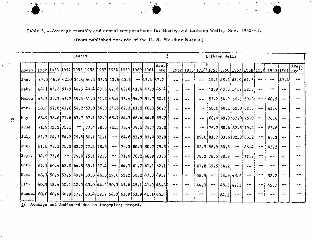
" .' " ,,,. Table 2. --Average monthly and annual temperatures for Beatty and Lathrop Wells, Nev. 1952-61.
(from published records of the U. S. Weather Bureau)
Beatty
I AverIl
Lathrop Hells = I
1955' I I I I I I I I I I Avef-
n.1onth 1952 1953 1954 1956 1957 1953 1959 1960 1961 aRe 1952 1953 lS'54 1955 1956 1957 1958 195c 1960 1961 8ge-1 I i
~an. 37.5 46.9 42.0 34.0 44.6 37.3 43.E 45.6 -- ~5.4 ~7.7 -- -- -- 40.1 48.2 41.9 47.6 -- -- 47.4 --Feb. 44'.1 46.0 51.9 40.3 40.4 49.6 47.6 42.8 43.4 47.9 45.4 -- -- -- 43.9 43.8 54.7 52.6 -- -- -- --}larch 45.1 50.7 47.7 49.4 51.0 51.8 45.4 53.4 54.7 51.7 50.1
! -- -- -- 53.2 54.9 56.3 50.8 -- 60.5 -- --Apr. 58.9 57.6 63.6 54.2 57.0 56.9 54.6 62.5 61.5 60.3 58.7 -- -- -- 58.0 60.1 60.0 62.3 -- 63.6 -- --May 68.9 58.6 71.6 63.7 67.1 62.9 68.7 64.7 66.4 64.8 65.7 -- -- -- 68.0 69.9 67.0 75.9 -- 70.4 -- --June 71.9 73.2 75.1 -- 77.4 78.5 72.5 78.4 79.5 78.7 75.8 -- -- -- 76.7 80.6 82.5 79.4 -.. 83.6 -- --July 82.3 84.5 84.2 79.8 80.1 81.1 -- 84.6 83.9 85.0 82.8 -- -- 89.0 83.7 83.6 82.8 83.2 -- 88.3 -- --Aug. 81.8 78.1 78.0 82.7 77.3 78.5 -- 78.3 80.5 80.7 79.5 -- .. - 82.5 86.9 80.5 -- 86.4 -- 83.2 -- --Sept. 74.9 75.6 -- 74.0 75.1 72.5 -- 71.0 76.2 68.9 73.5 -- -- 78.2 78.5 80.9 -- 77.8 -- -- -- --Oct. 67.5 60.4 62.8 64.8 59.1 57.4 -- 64.3 61.7 61.1 62.1 -- -- 67.8 69.5 64.2 -- -- -- -- -- --Nov. 46.7 50.9 53.5 49.4 50.8 46.0 52.0 52.2 50.2 47.3 49.9 -- -- 58.5 -- 53.9 48.6 -- -- 52.2
_ .. --Dec. 40.9 42.4 40.1 42.5 45.0 44.2 50.3 45.6 45.1 41.9 43.8 -- -- 44.8 -- 48.3 47~1 -- -- 45.7 .. - .. -Annual 60.( 60.4 60.9 57.7 60.4 59.7 54 .. 3 61.9 63.9 61.1 60.0 -- -- -- -- 64.1 -- -- -- -- -- --1:/ Average not indicated due to incomplete record.

• •• ~.I .." ,,.--~
The following evaporation figures, in inches, are from the Weather Bureau's 1961 Annual Climatological Summary for Nevada
BOULDER CITY , NEVAPA Jan. Feb. Ma:r_ Apr. May June July Aug., Sept. Oct. l'{o:v~ Dec. Year
3.474.977.07 11.26 14.16 16.90 16.00 12.82 11.29 8.18 4.62 2 • .26 113.0p
CALIENTE, NEVADA 7. 19 9.40 12.07 11.06 7.90 6.68 4.07
The Amargosa Desert lies within the Las Vegas and Pahranagat growi~g season zones as defined by Hardman and Mason (1949, p. 12). These growing seasons are based in terms of crop adaptability rather than in terms of frost~ free periods. In the Las Vegas. zone, according to Hardman and Mason (1949, p. 14), practically all temperate zone plants having a dormant period can be grown. The winter temperatures are too low for commercial production of winter vegetables_ Five cuttings of alfalfa may be obtained. In the Pahranagat zone, including the northern part of Amargosa Desert, occasional winter temperatures are too low for many of the tender plants grown in the Las Vegas zone. Three to four cuttings of alfalfa can be expected, and late maturing varieties of corn can be grown.
According to Houston (1950, p. 19-). the average growing season for the Beatty area is 184 days (April 26 to October 27). The actual growing season would vary in different parts of the Amargosa Desert, but would tend to be longer toward .the southern part of the area.
GEOLOGY
The Amargosa Desert in large. part is sur:rounded and probably underla:in at depth by rocks ranging in age frdm Cambrian to Devonian.. Most are carbonate rocks interbedded with lesser amounts of quartzite and argillite. Rocks of possible Precambrian age crop out in parts of and adjacent to the Funeral Mountains southwest of Big Dune and are mainly quartzite and argil1i~e. The rocks in·the area west of Fortymile Canyon to Bare Mountain are mostly tuff and lava flows of Tertiary age. Valley fill -of Tertiary and Quaternary age underlies most of the central part of the desert. Valley fill includes alluvialfan deposits and fresh-water or brackish-water playa deposits. Deposits of Quaternary age, including stream deposits, playa depOSits, and dune sand, occur locally. Plate 1 shows the general distribution of the valley fill and the older bedrock in the Amargosa Desert ahd its tributary areas; pI.ate 2 shows a more detailed distribution of rock types within the restricted area of this report.
9.
. ~ • I

-,eo - '
~ -.;;,... _," L
',:',\
Rocks of Precambdan{?) and Paleozoic Age
Rocks of Precambdan(?) age were mapped in the eastern hali of the Funeral Range by Noble and VTright (1958). Where examined, these rocks were mostly quartzite and argillite. Similar rocks north of the Nevada .. California State line and west of Big Dune are included with Paleozoic clastic rocks (pl. 2). The largest of these outcrops, west of Big Dune, is mostly quartzite and the smaller ones are composed, about evenly, of sandstone, quartzite, and argillite.
The rocks of Paleozoic age surrounding the Amargosa Desert have been mapped as the Johnnie(?) Formation, Stirling(?) Quartzite, Carrara, Bonanza King, and Nopah Formations of Cambrian age; the Pogonip Group, Eureka Quartzite, and Ely Springs Dolomite of Ordovician age; undifferentiated dolomite of Silurian age, and the Nevada Formation and Devils Gate Limestone of Devonian age (Ball, 1907; Nolan, 1929, Hazard, 1937; Palmer and Hazzard, 1956; Johnson and Hibbard, 1957; Cornwall and Kleinhampl, 1961; ,Burchfiel, written communication, 1961). For the purpose of this report the Paleozoic rocks shown on plate 2 are grouped into carbonate and quartzite or argillite units without regard to formation designation. Cornwall and Kleinhampl (1961) described 11 Paleozoic formations in the Bare Mountain area having a combined thickness of more than 21,000 feet. The dominant rock types are lime .. stone and dolomite. The limestone and dolomite are the principal aquifers and transmit ground water in contrast to the relatively impermeable quartzite and argillite.
Volcanic Rocks of Tertiary and Quaternary Age
Rhyolitic and dacitic tuff, including ashfalls, welded tu.!f, and some flows, constitute most of the rocks of Tertiary age. They crop out in the Yucca Mountain area between Fortymile Canyon and Bare Mountain southeast of Beatty. Cornwall and Kleinhampl (1961) described about 6,000 feet of Tel''' tiary and Quaternary volcanic rocks in the Bare Mountain area.
Undifferentiated Tertiary rocks in the southern part of the area probably are also volcanic in origin, although some of them have been deposited in water.
The younger volcanic rocks consist of several volcanic cones adjacent to Yucca Mountain, and are reported to range from Pliocene to Recent age by Cornwall and Kleinhampl (1961). Most of the cones are small and are composed of explosive debris. One, southeast of Yucca Mountain, produced a small flow of scoriaceous basalt.
Valley Fill of Tertiary and Quarternary Age
Fresh .. or brackish-water deposits occur throughout the basin of the Amargosa Desert but are most prominent south of Lathrop 'Wells. These deposits consist of several hundred feet of clay, silt, sand, gravel, and
10 ..

'0,. . i
freshwater limestone. Individual layers are of limited extent both vertically and horizontally. They also include a number of ash beds deposited in water. Basaltic debris waspenetrated between 600 and 630 feet below land surface in well l75/49-4a'l. The total thict..ness is unknown. Inspection of the cuttings indicate that the basaltic material was transported by ephermeral surface flow similar to that which occurs today.
Layers of caliche were. reported in the well above the basalt ancl relatively thin beds of limestone{? ) have been reported in a number of other well logs. The caliche and limestone ( ?) layers probably represent ancient soil zones.
Generally, marginal to the lake bed deposits discussed above and adjacent to the mountain areas are deposits of boulders, gravel, sand, and silt. Commonly these are alluvial-fan or wash deposits and in general are coarser grained than the lalee-bed deposits. At depth, however, present data do not permit separation of these two units.. They were deposited more or less contemporaneously and locally interfinger. However, in g~neral, the areas shown as alluvial-fan deposits probably are underlain by a substantially higher proportion of sand and gravel than the areas shown as lake-bed deposits.
Alluvium of Qttaternary Age
The areas mapped as Recent alluvium along the stream cOtlre;es are, in general, thin bodies of :Unconsolidated sand and gravel from which the fines have been washed by the' occasional storm runoff. The large area mapped as alluvium near Death Valley Junction is in the lower part of the basin and generally is finer grained than elsewhere; it grades laterally into the playa deposits. Recent playa deposits occur just north of Eagle Mountain and in the vicinity of the northwest quarter of T. 17 S., R. 51 E.
Windblown sand forms numerous dunes throughout the desert and is deposited against many of the Paleozoic and Tertiary outcrops, especially a!,ound the northern rim of the basin. Big Dune, covering about 4 square miles, is especially prominent in the northwestern part of the area. The prOximity of Big Dune to a number of Precambrian(?) or Paleozoic outcrops leads to the hypothesis that the dune overlies a bedrock high. The principal mass of Big Dune reportedly migrates seasonally to some extent. ' The limit .. ed migration may well be controlled by orographic effects and seasonal shifts of wind direction.
Structure
The substantial structural deformation, including several episodes of thrust and high-angle faultinG in the region, have involved the Paleozoic rocks and to a lesser exten.t the Tertiary volcanic rocks. Strong deformation is evident in most outcrops of Paleozoic rocks. Deformation and erosion of Paleozoic rocks make it difficult to project the Paleozoic rock surface beneath
11.

the valley fill. Preliminary gravity data (Healey. written communication, 1962) in the Amargosa Desert suggest that the area may be divided into three more or less distinct topographic lows in the Paleozoic surface.
A continuous line of limestone outcrops, extending from Devils Hole (pl. 1) to the Paleozoic outcrops in Skeleton Hills along a gravity high, separates the playa area in T. 17 S., R. 51 E. from the area west of It. 51 E. Another line of outcrops, extending northward from the Funeral MOWltains into the desert west of Big Dune, is alined with Paleozoic outcrops extending southward from Bare Mountain. This alinement coincides with a gravity high across the Amargosa Desert in this area. Major gravity lows occur beneath the playa in T .. 17 S., R. 51 E., the Fortymile Canyon, and along the Amargosa River northwest of T. 14 S., R. 48 E.
The actual thickness of the valley fill in these three major subbasins is unknown, as the density of the volcanic tuff is similar to that of the valley fill. The gravity lows and highs roughly a-fford gravity differentiation between the valley fill and the Tertiary tuffs and the Paleozoic rocks. Thus, gravity data provide an approximate expression of the buried surface of the Paleozoic rocks. According to Healey (written communication, 1962), the depth to the Paleozoic rock surface may be on the order of 2,500 feet below land surface in the deeper part of the area southwest of Lathrop VI ells.
Geologic History
The geologic history of the area is at present poorly understood; therefore, the following outline of events is highly generalized and approximate only.
1. During most of the Paleozoic time the area was a part of the Cordilleran geosyncline, and substantial thicknesses of limestone, dolomite, shale, ,and sandstone were deposited. In the Specter Itange during the Early Cambrian time, more than 10,000 feet of clastic sediments and thin beds of limestone were deposited in fluctuating marine and nonmarine environments. During the early Middle Cambrian, there was transition from older coarse clastic rocks to YOWlger thic1t carbonate formations. More than 12,000 feet of carbonate rocks were deposited in the Specter Range from near the middle part of the J..;liddle Cambrian through Late Devonian. Unconformities in the Paleozoic rocks indicate periods of emergence and erosion.
2. Near the end of the Paleozoic Era a period of emergence and extensive erosion occurred. This was followed by a period of oscillation between marine and continental conditions which culminated in complete emergence. Orogeny and erosion probably continued into Tertiary time. The dominant deformation was thrust and associated faulting which probably was preceded and a.ccompanied by extensive block faulting.
3. Vast quantities of volcanic rocks, predominantly tuff, were deposited during the Tertiary and early Quaternary time. Basin and range
12 ..

'~."
"..:. ' . ~:'; .
'~
normal faults developed in late Tertiary and Quaternary time. The present topographic relief of the Amargosa Desert probably was formed largely during this interval.
4. Since the late Tertiary time erosion of the surrounding mountains and deposition in the valleys has taken place. Deposition has been principally in a combination of subaerial and lacustrine environments. Deposits range from clay to very coarse gravel and locally,incIude spring and probably some evaporite deposits. Alluvial fans spread out from the highlands to an extensive playa that occupied about the southern half of the Amargosa Desert. Dissec .. tion of. the playa probably began in the late Pleistocene ..
Since the late Pleistocene. aeolian sand, alluvial detritus, and playa deposits have been deposited in topographically favorable areas in the Amargosa Desert.
Water -Bearing Propertie s of. the Rocks
Rocks of Precambrian{?), Paleozoic, and Tertiary age are exposed in the mountains surrounding the Amargosa Desert. ,They include clastic, carbonate, and volcanic rocks which have been folded, faulted~ and metamorphosed in varying degrees. As such, they are not good aquifers. However, locally developed secondary openings, due to faulting, folding, and weathering, have resulted in the development of a secondary per.meability for these rocks. Fractures in the carbonate rocks may have been enlarged by solutions and locally increased the secondary permeability.
Secondary permeability in the carbonate rocks is the principal source of ground-water supply in the adjoining area to the northeast at the Nevada Test Site (Schoff, 51. and Winograd, I. S. 1962. p. ,111 .. 113). Most of the discharge from the springs in Ash Meadows probably involves ground water moving 'through secondary openings in the Paleo~oic rocks. especially the carbona'te units. Water in Devils Hole fills solution developed caves. A sketch profile (P. M. Neely. written communication, January 9, 1955) prepared from information obtained by a group of divers from the National Speleological SOCiety indicates that caverns and connecting conduits extend more than 130 feet below water level in Devils Hole and laterally for more than 300 feet. Further, a passage which is partly above the water-level altitude of Devils Hole contains air. It is likely also that several existing wells in the Amargosa Desert obtain at least parts of their water supply from carbonate rocks that locally have secondary permeabili ty.
Fractures or solutions openings locally may transmit substantial quantities of water, partial examples of which may be several of the springs in Ash Meadows. Further, although the total volume of water moving through the bedrock may be relatively large, the proportion of fractur'es to total volume of the carbonate rocks is relatively small. Therefore, the success of a well penetrating the bedrock is dependent upon the well bore tapping enough of the
13 ..

,.
secondary water-bearing zones to yield adequate amounts of water. At present, data are insufficient to determine the chances of intercepting a sufficient oum- . ber of water-bearing zones in the bedrock underlying the valley fill.
The' Tertiary and Quaternary volcanic rocks underlying the valley fill are composed primarily of ash-fall tuffs which is generally capable of transmitting only small amounts of water through fractur·es. The specific capacity of wells developed in the tuff generally is less than a few gallons per minute per foot of drawdown (Winograd and West, written communication, 1962) and therefore. generally the yield would be inadequate for an irrigation water supply. . However, investigations at the Nevada Test Site indicate that a specific capacity of as much as 30 gallons a minute per foot of drawdown was obtained in one well. developed in fractured welded tuff.
The valley fill principally includes Pleistocene lake deposits and alluvial-fan debris which have been eroded from the surrounding mountains. Overlying them are relatively thin surficial deposits of stream alluvium and aeolian. sand. The alluvial-fan deposits of unknown thickness are unconsoHidated or weakly indurated, water-lain rock debris ranging in size from boulders to claYt Saturated zones of well-sorted sand or gravel in the alluvial-fan deposits yield: moderate to large amounts of water to wells. Of six wells in T. 16 S., R. 48 ~. ~ for which reported information is available, specific capacities ranged from . 20 to 250 gallons a minute per foot of drawdown; for four of these wells specifiC; capacities ranged from 40 to 110. The coarse deposits in the valley fill are thE[ principal source of ground water in the valley.
The lake and playa deposits consist largely of silt and clay and some lenses of sand and fine pebble gravel. The lake deposits locally contain deposits of water-lain volcanic ash and fresh .. water limestone. The sand and .gravel strata are the best water-yielding zones in the lake and playa deposits.
,The alluvium of Recent age along the courses of some intermittent streams is permeable but thin and generally above the water table, except locally in the southern part of the area. Aeolian sand deposits are found over much of the area.. They are above the water table. but their relatively high permeability permits ready absorption of precipitation on their surfaces. The Recent playa deposits are fine-grained and saturated to within a few feet of lane! surface, but are of low permeability and yield water slowly to wells.
WATER RESOURCES
Surface VI ater
Surface water flows from Oasis Valley into the northern part of Amargosa Desert through the Amargosa Narrows near Beatty only following periods of heavy precipitation.. According to Malmberg and Eakin (1962, p .. 26) some ground water moves:through the Amargosa Narrows as underflow in stream deposits. Part of the underflow is diverted by a ditch intercept ing the groundwater table 6 to 10 feet below land surface ..
14.
._"

~'
'.
Stream flow occurs at the southern end of Amargosa Desert, near Eagle Mountain, during part of the year. It is supplied largely from spring discharge in the Ash Meadows area and ground water in the vicinity of the playa during the winter when evapotranspiration is at a minimum. In April 1962 flow in the channel just south of Eagle Mountain was estimated to be about one-half a cubic foot per second. Flow may occur in any dry channels within the area for short periods after high-intensity precipitation.
Four small perennial ponds are within the Amargosa Desert. The three largest ponds are about 1 mile east of Ash Tree Spring and about 4 miles west of Crystal Spring (pl. 3). These three ponds are locally known as the "Clay Pits". All are the result of open pit clay mining in the early 1900' s. The ponds are supplied principally by ground .. water inflow. Water is discharged from the ponds by evapotranspiration. The balance between recharge to and discharge from the ponds is sufficiently close so that the ponds are maintained throughout the year.
The temperature of the water in the northernmost of the three ponds was 76°F. when measured on August 22, 1962, and the specific conductance was 1, 20l) 'micromhos; the southernmost pit had a water temperature of 70 0 F. when measured on June 16, 1962, and the specific conductance was 1~ 590 micromhos. The relatively high conductivity of the water probab~;yresults from a high evaporation rate causing an increase in concentration of salts. The differences in the water temperature probably are due to the' difference in time of year when the two measurements were made.
The fourth pond, the smallest of the four, is in the northwest quarter of sec. 21, T. 17 S., R. 51 E. The pond is in a pit which is approximately 10 f~et wide, 30 feet long, and 10 feet deep. The majority of the ponds con .. lafr(~d water when observed in February (Vlinograd, written communication, 1962); however, by July all but one pond were completely dry. From February until mid-August the water level in this pond declined less than 1 foot.
Ground Water
Occurrence and Movement: Within the principal area of this report ground water occurs in the valley fill and the underlying volcanic and Paleozoic carbonate rocks. Recharge to the ground-water system is supplied to some extent by precipitation within the surficial drainage area, including the tributaries of Oasis Valley, Crater Flat, Fortymile Canyon, Jackass Flats, Rock Valley, and the northern and western flanks of the Spring Mountains. Within the drainage area of Amargosa Desert, which covers about 2,600 square miles, recharge to the ground-water reservoir probably is derived largely from precipitation in the higher mountains. In addition to the limited amount of recharge from precipitation within the surficial drainage area, recharge to Amargosa Desert apparently is supplied by underflow through Paleozoic and possibly Tertiary rocks outside the surface drainage area. 'The principal source of this underflow may be from the higher parts of the Spring Mountains and to a"
15.
~ , ...

-.• . ,
lesser extent from the area to the northeast.
Although the ground water in Amargosa Desert is part of a single large system, elements of that system are partially separated locally. This separation may be identified by variations of head or artesian pressure between some deep and shallow wells and between some wells and springs tapping alluvium and carbonate rocks.
The water-level contours shown on plate 3 indicate that ground water in the valley fill is moving southeastward along the axis of the Amargosa Desert from north of Big Dune toward Death Valley Junction. The tributary valleys, of which Fortymile Canyon is the principal one, supply some water. Movement from the east is shown in the vicinity of T. 17 5., R. 51 E., and from the springs issuing from the carbonate rocks along the east side of Ash Meadows. The artesian head in the carbonate rocks is higher than that to the we st and north in the valley fill.
The springs and subsurface discharge from the carbonate r:ocks supplieljl water to the valley fill. The relatively steep water-level slope west of the springs in Ash Meadows closely parallels the general westward slope of the land surface. The closely spaced contours near the northwest corner of T. 18 S., R. 50 E., may reflect upward leakage which discharges from Ash Tree Spring and partial return flow to ground water in the vaUey fill.
The relatively high water levels in the eastern part of T. 16 5., R. 49 1;:. I
probably indicate upward leakage from the underlying carbonate rocks into the water-bearing zones supplying some of the d~eper wells in that area.
The area around the southeast quarter of T. 16 S., R. 48 E. shows some irregularity of contours. Part of the irregularity is caused by differences of head in de~p and shallow wells in the area, and part is caused by withdrawal of water for irrigation.
In summary, the water-level contours show the generalized features of the water surface of the ground-water reservoir. In detail, conditions are most complex, because of the merging of ground waters in two partially separal'" ted systems .. - one in the valley fill and the other in the carbonate rocks. Each enters the area under a different head. The ground-water in the carbonate rocks generally is under higher head -- some discharges from springs and moves into the valley fill; some moves upward into the ground-water system in the valley fill where permeability of the deposits permits.
The slope of the water -level surface generally conforms to the slope of the land surface. However, the gradient of the water surface commonly is somewhat less than that of the land surface. In the southern part of the area north of Death Valley Junction the water-level gradient is about 12 feet per mile compared to the land-surface gradient of about 13 feet per mile -- a ratio of 12 to 13 (1 to 1.1); in the viCinity of Big Dune the ratio of gradients is about
16.
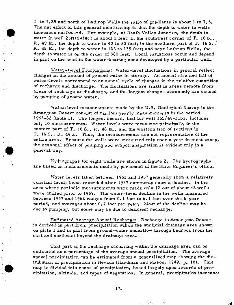
1 to 1.25 and north of Lathrop VI ells the ratio of gradients is about 1 to 7.5. The net effect of this general relationship is that the depth to water in wells increases northward. For example, at Death Valley Junction, the depth to water in well 25N/51414cl is about 2 feet; in the southwest corner of T. 16 S., R. 49 E., the depth to water is 40 to 50 feet; in the northern part of T .. 16 S.,· R. 48 E., the depth to water is 125 to 135 feet; and near Lathrop Wells, the depth to water is on the order of 360 feet. Local variations occur and depend in part on the head in the water .. bearing zone developed by ~ particular well.
Water .. Level Fluctuations: Water .. level fluctuations in general reflect changes in the amount of ground water in storage. An annual rise and fall of water .. levels correspond to an annual cycle of changes in the relative quantitie~ of recharge and discharge. The fluctuations are small in areas remote from areas of recharge or discharge, and, the largest changes commonly are caused by pu..'Uping of ground water.
Water ... level measurements made by the U.S. Geological Survey in the Amargosa Desert consist of random yearly measurements in the .period 1952-62 (table 5). The longest record, that for well 16S/49-31bl, includes only 10 measurements. Water levels were measured principally in the eastern part of T. 16 S., R. 48 E., and the western tier of sections in T. 16 S., R. 49 E. Thus, the measurements are not representative of the entire area. Because the wells were measured only once a year in most case!,>, the seasonal effect of pumping and evapotranspiration is evident only in a general way.
Hydrographs for e~ght wells are shown in figure 2. The hydrographs are based on measurements made by personnel of the State Engineer's office.
'.Yater levels taken between 1952 and 1957 generally show a relatively constant level; those recorded after 1957 commonly show a decline. In the area where periodic measurements were made only 12 out of about 42 wells were drilled prior to 1957. The water -level decline in the wells measured between 1957 and 1962 ranges from 0.1 foot to 6.1 feet over the 5-year period, and averages about 0.7 foot per year. Most of the decline may be due to pumping, but some may be due to deficient recharge.
Estimated Average Annual Rechars.e: Recharge to Amargosa Deser t is derived in part from precipitation within the surficial drainage area shown on plate 1 and in part from ground-water underflow through bedrock from the east and northeast beyond the drainage area.
That part of the recharge occurring within the drainage area can be estimated as a percentage of the average annual precipitation. The average annual precipitation can be estimated from a generalized map showing the distribution of precipitation in Nevada (Hardman and Mason, 1949, p. 10). This map is divided into zones of preCipitation, based largely upon records of precipitation, altitude, and types of vegetation. In general, precipitation increasef
17 ..

!:~~:'
~'J.'
;,. , I
:~
J-<
00
"~"~I
,~ • ' /,' l', ,
t 'j',~ ..... .' .~ f'
" ,.
• "
Table 5.--Records of water-level measurements in selected wells in the Amargosa Desert, Nevada-California.
Altitudes given are in feet above mean sea level for the land-surface datum at the well. Altitudes given in whole feet are interpolated from ,topographic maps. Altitudes given in feet and tenths were determined by plane table.
Measur~ents. All measurements were made by 'tbe U. S. Geologic~l Survey. All measurements have been adjusted to depth below land surface. Well number. See page 4 for description of well numbering systeI,ri"
Well AltitudE Depth Well AltHude Depth Well Altitude Depth Well Altitude number (feet) Date to water number, (feet) Date to water number (feet) Date to water number (feet) Date
(feet) (feet) (feet)
135/47-35al 2,788 7-15-61 282.5 165/48-25c1 2,326.6 5- 7-52 64.2 16S/48-36d2 2,304 5- 7-52 49.6 16S/49-19dl 2,362.8 2-14-55 7-12-62 282.3 10- 9-52 64.3 8-25-53 49,9 5-24-56
8-25-53 63.8 3-15-54 49,8 , 8-28-57 14S/48-l6cl 2,608 5-24-56 252.8 8-28-57 65.7 2-12-5~, 49.9 9- 3-58'
7-12-62 253.1 ,9- 3~58 64.8 8-28-57 49,9 9~15-59
9-15~59 64.8 9- 3-58 50.3 3- 7-61 15S/50-18c5 2,656.1 5- 8-52 346.7 3- 7~61 63.9 9-15-59 50.3 7- 9-62
6-22;'53 339.4 7- 9~62 67.1 3- 7-61 52.6 7- 5-62 54.1 16S/49-30bl 2,348.2 5- 7-52
16S/48-15al 2,375.5 2-14~55 95.1 16S/48-26al 2,336 5- 7-52 71.2 10- 9-52 5-23-56 96.6 10- 9-52 71. 3 16S/49-18d2 2,375.1 8-27-53 104.0 3-16-54
8-25-53 71.3 2-12-55 103.1 2-12-55 16S/48-15bl 2,373.3 2-14- 55 95.7 8-25-57 71.5 5-24-56 11)).1 8-28-57
5-23-56 95.6 9- 3-58 71.9 8-28-57 103.2 9- 3-58
Depth o water (feet)
94.4 94,7 94,8 95.3 95.9
101. 2 99.0
83.6 83.7 83.7 83.8 84,6 84.5
" "~ , f<, . '~"~
"
7-14-62 97.2 . 9-15-59 72.1 2-15-58 103.4 9-15-59 Plugged 3- 7-61 73.7 9- 4-58 ,103.7
16S/48-24 , 2,367 2M12-55 94.7 7- 4-62 75.7 9-15-59 '104.7 16S/49-31bl 2,326.3 5- 7-52 66,1 2-14-55 94.7 3- 7-61 104.4 10~ 9-'52 ' 66.3 5-24-56 94.4 165/48-36a1 2,323.7 5- 7-52 62.9 6- 28-62 108.5 8-25-53 66.5
3-14-54 63.2 3-16-54 66.3 165/48 - 24 d 1 2,357.1 2-14-55 88.8 2-12-55 63.1 16S /49-19a 1 2,373.6 2-12-55 103.7 " 2-12-55 66.4
2-14-56 88.6 8-28-57 67.4 5-24-56 103.7 8-28-57 66.4 9- 3-58 66.5 8-28-57 103.8 9- 3-58 66.5
165/48 - 25a 1 2,343.4 5- 7-52 79.2 9-15~59 67.1 9- 3-58 104.8 9-15-59 67.1 o.
0- 9-52 79.3 3- 7-61 68.0 9-15-59 105.6 3- 7-6 68.0 ''.. 8-28-57 79.6 7- 5-62 67.5 3- 7-61 Plugged 6-26-6 69.4 9- 3-58 80.3 9-15-59 81.0 165/49-19bl 2,370.8 2-12-55 104.7 3- 7-61 82.4 2~ 6-55 101. 7 7- 9-62 84.5 5-24-56 99.7
8-28-57 99.9 9- 3-58 100.5 3- 7-61 102.0 7- 9-62 106.0
- -- ,- ----

-YEARS
52
85
:: r-=~ ~================16S/'8==='2""J ==========-=-1J w u 65 ~ a: :::l
70 CI)
0 75 z « -'
~ 0 -' w <D
f- ~~ w w "-'.' 55
, ~'\l ~ -"""" '
-~.~ 16S/48 ,36<12
a: 10Q ~ w
f-~ «
~
0
105
~ ______ --_1_8S~_9'l_ru2 ________ ~.~'_====J
,f-
:r:
::~ f-n. w 0
:t
]6S/49 ' 19b1
,:: ~ 16S/49 ,19<11
-, "
~ :: f 0'
16S/.9,3Hl
Figure 2, Hydrographs for 6 wells in Amargosa Dese,,!'

with altitude, the grea,.ter amount commonly occurring on the highest mountainl3. A comparison of the precipitation map with more recent topographic maps (scale 1: 250,000) indicates that the precipitation zones suggested by Hardman and Mason roughly coincide with altitude contours, although on a state-wide basis the precipitation zones rise somewhat in altitude in the southern one-third of the State. The map suggests that in the area lying below 5,000 feet the average annual precipitation is less than 8 inche's"a:,t. altitudes between 5,000 and 6,000 feet" it ranges from 8 to 12 inches; and fr6in 6, OOO,to 7,000 feet, it'~ ranges from 12 to 15 inches.
The total average annual precipitation on each zone is computed by multiplying the average precipitation for each zone by the area of that zone. Based on these computations, the average annual precipitation within the surficial drainage area totals 87 5~ 000 acre -feet.
I
A very small percentage of precipitation that falls on the area recharge:s the ground-water reservoir. A method for crudely estimating the probable average annual recharge from precipitation has been developed by Eakin and others (1951, p. 79 ... 81). Based on this method, the recharge is estimated as a percentage for each precipitation zone in the drainage are'CV,"as follows: zone of less than 8 inches of precipitation, none; 8 ... to 12-inch zone, 1 percent; 12- to I5 ... inch zone, 7 percent; and 15- to 20-inch zone, 15 per,~ent. The ' reliability of the estimates so obtained, of course, is related to the degree to which the assigned values approximate the actual preCipitation, and the degree to which the assumed percentages represent the equivalent amount of the actual recharge. Neither of these factors is known precisely enough to assume a high. degree of reliability for anyone valley. However, experience suggests that the resulting estimates commonly are a reasonable approximation of average reCharge.
, Table 6 sUIllmarizes the computation of estimated recharge from precipi-
tation within the surficial drainage area of Amargosa Desert, as shown on ' plate 1. The approximate recharge (column 5) for each zone is obtained by mUltiplying the figures in columns 2, 3, and 4. For example, for the 12- to IS-inch zone, the estimated recharge is: 9,000 acres x 1.12 feet" • 07 (7 percent) = 700 acre ... feet. The total average annual recharge from precipita';"' tion so estimated is 1, 500 acre-feet~ most of which is derived from precipitation in the Oasis Valley and F01"tymile Canyon, which are tributary to Amargosa Desert.
19.

Table 6. --Estimated average annual ground-water recharge from precipitation in Amargosa Desert and tributary areas
Approximate Average Estimated Precipitation area of annual Percent recharge
zone zone precipitation recharged (feet) (inches) (acres) (feet) (2x3x4 .:. 100)
(1) • (2) (3) (4) (5)
12-15 9,000 1.12 7 700
8-12 96.000 .83 1 800
---\ 8 1,570,000 .5
Recharge from precipitation t,_.500
For Oasis Valley, Malmberg and Eakin (1962, p. 24) estimated that the average recharge from precipitation is about 250 acre-feet a year. Thus the estimated average recha.rge to Amargosa Desert below the Amargosa Narrows would be about 250 acre-feet a year less than the 1,500 acre-feet shown in table 6 for the entire drainage area, or roughly 1,200 acre-feet a year.
In considering the magnitude of recharge by underflow through bedrock from areas to the east and northeast beyond the surficial drainage divide, the validity of the method of estimating ground-water recharge from precipitation is handicapped by the uncer tainity of the effective tributary area.. There is a strongsl,lggestion that a large part of the water discharged from the springs in Ash Meadows ultimately is derived from precipitation in the Spring Mountains (Loeltz, 1960, p. 1917-1918).
-r
Using the same method discussed above, the average annual recharge to ground water from precipitation on the northern and western slopes of the Sprin~ Mountains, an area which may contribute recharge to Amargosa Desert~ is -estimated to be about 3,500 acre-feet. If all of this recharge reaches the groundwater reservoir in Amargosa Desert, then the combined average recharge from precipitation within the surficial tributary drainage area and the northern and western slopes of Spring Mountains would be nearly 5,000 acre-feet.
There is a definite possibility that this estimate is low because the high proportion of permeable Paleozoic carbonate rocks in the Spring Mountains may result in an above -average percentage of precipitation being recharge. At present, however, no data are available on which to. assign different values for percentage recharge for the several precipitation zones. The estimate also may be low because recharge to Amargosa Desert from the Spring Mountains may be
20.
·I~'
-•.. -
.~~.. "
derived from a much larger area than that assumed for this computation. For example, Maxey (1948, p. 117) estimated that recharge from the southwestern slopes of Spring Mountains to Pahrump Valley is on the order of 23,000 acrefeet a year. Little water is consumed by phreatophytes in Pahrump Valley, except that supplied by water discharged from the springs. If these estimates are correct, about 13,000 acre-feet might be available from the Spring Mountains as underflow to the Ash Meadows spring system, which discharged about 17, 000 acre .. feet a year (p. 40).
If an average of 13,000 acre-feet a year actually were supplied to the Ash Meadow spring system from the Spring Mountains, then the remaining 4,000 acre-feet discharged from the springs may be derived by underflow through carbonate rocks from the northeast. Additionally, some water is discharged from the carbonate rock system by upward leakage into the valley fiU, as suggested by the water-level contours on plate 3, about 7 miles south of Lathrop Wells. Thus, based on these assumptions the total estimated recharge to Amargosa Desert from precipitation within the surficial drainage area plus recharge to Paleozoic carbonate rocks from beyond the drainage area would be roughly 20,000 acre-feet a year.
The general known and inferred conditions relating to the direction of ground-water movement in Paleozoic carbonate rocks in the area north and northeast of Amargosa Desert and the favorable recharge conditions in the Spring Mountains seem to support the hypothesis that recharge from the Spring Mountains probably contributes most of the water discharged by the springs in Ash Meadows.. Assuming this to be correct, the underflow in Paleozoic carbonate rocks from the area north and northeast of Amargosa Desert may be on the order of only a few thousand acre-feet a year. The difficulty of obtaining a satisfactory estimate of ground-water recharge for Amargosa Desert, as illustrated here, demonstrates the need for special investigations that would lead to improved methods and techniques of estimating recharge for uS'e in Nevada. Such investigations have been suggested in previous reports of the Grounq ... Water Reconnaissance Series (Eakin, T .. E .. t December 1960, p. to; Eakin, T. E., January 1961, p. 29, 30).
Estimated Average Annual·.Discharge:
Natural Discharge:--Ground water is discharged from Amar.gosa Desert by the natural processes of transpir.ation of vegetation, evaporation from the soil and free-water surfaces, and to a lesser extent by stream flow and underflow from the Alkali Flat southeast of Death Valley Junction.. If the total discharge by these processes co~d be determined precisely, a highly r.eiiable estimate· .of ground-water discharge could be made. However, in the absence of precise data, annual.rates of evapotranspiration by native vegetation using ground water can only be approximated from work done in other areas. For this report rates of use are adapted from studies of evapotranspiration of certain phreatophytes made by Lee (1912) and White (1932) in the Great Basin, Robinson (1958) in the western United States, and by Young and
21.

·' ,
. ',..
Blaney ((942) in southern California. R~tes of use were a.ssigned on the basis of vegetative type,~,8.ensity, and depth to water table. The crude estimates of discharge by transpiration, evaporation, and underflow are summarized in table 7.
The principal area of phreatophytes is in ,T" 17 S., R. 50 E., and T. 18 s. I R. 51 E., along the southeastern margin of the valley. Phreatophytes in this area obtain their water primarily from spring discharge and frorn some shallow ground water. derived mainly fr·om spring discha'rgc. Other small areas of phreatophytes occur along the Amargosa River channel and in the unnamed playa in the northeastern part of the valleYb These plants obtain their water supply from shallow ground water.
There are two 'main areas of. evaporation within the valley. The largest extends from about Z. miles southwest of Ash Tree Spring to ~agle Mountain. The other smaller ar~ais in the playa in the northwestern part of T. 1'7 S., R. 51 E ..
Data are not available to make a direct estimate of the amount of grouncl,~water diSCharged by unde:rflow a.nd surface flow throu.gh the gap at Eagle Mountairi from Amargosa Desert. However, the general hydrogeologic conditions suggest that the ma.gnitude of. the outflow is on the oJ."der of 500 acre·~feet a yea.r ..
The total natural dischar,ge from AInargos~ Desert is estimated to· be about 24~ 000 acre-feet per y~ar (table 7h '
22~
J {
•~'
'.;.=-- , .. .
Table 7. --Estimate.d average annuai ground-water discharge by natural processes from the Amargosa pesert, Nevada--Catiforn,ia
Process of Ground-water discq.arge
Native vegetation:
Principally mesquite, saltgrass, rabbitbrush in varying proportions; density moderate to low but locally moderate to heavy; depth to water ranges from a few to about 20 feet, averaging about 10 feet below land surface. Average annual use
Area (acres)
about 0.5 foot. • • • • • • • • • • • • . Z, 000
Principally meadow grass, mesquite, willow, salt grass, salt cedar in varying proportions; depth to water 0 to 5 feet; largely watered by discharge from springs and shallow ground water. Includes about 1,200 acres with an estimated average annual ground-water use oiabout 1* 2S feet; and about Z, 800 acres of marsh grasses and 200 acres of pasture grass and milo which normally is flOOded by spring discharge. Average annual use about 3 feet. • • • • • .. • • • 4, ZOO
Evaporation:
Rate could approach potential evaporation rate from free-water system but is limited by amount supplied from groundwater reservoir through capillary openings; annual rate estimated at 1 foot . • • . • . 12, 000
Outflow:
Ground-water and surface-water outflow from the valley at Eagle Mountain (estimate based on general hydrogeologic conditions at the narrows by Eagle Mountain).. • . •
Approxima te discharge (acre-ft .. per year)
1,000
10, 500
12,000
500
Estimated average annual discharge. • •. • 24,000
23.

• ••• -, \
.. ' ,
-...• " . .
~~.... -
Ground-water discharge from Amargosa Desert may be estimated in another way, which affords a partial check on the discharge 'by evapotranspiration. The several springs in the Ash Me.adows area are supplied largely by ground water moving through Paleozoic carbonate rocks as discussed previously. Much of the spring discharge flows overland and is consumed by transpiration of vegetation and is evaporated, but part returns to the groundwater reservoir and is then discharged by evapotranspiration, surface flow, or underflow from the Amargosa Desert. In either case the water issuing from the springs. i~ fi'nally discharged from the area. Thus, as estima te of the spring discharge provides a partial check on the total ground-water discharged from Amargosa Desert by natural processes.
Table 8 lists miscellaneous measurements for 24 springs in the Ash Meadows area. All were measured during the summer of 1962. The combined discharge of these springs in the summer of 196Z was about 10,300 gpm, or 23cfs. Measurements made in the winter of 1953 on 17 of the larger of these springs indicated a total discharge of about 10,900 gpm, or somewhat more than 24 cfs. The measurements made during the winter of 1953 are roughly 5 percent larger than those made in the summer of 1962. The limited data suggest relatively uniform discharge from the springs as a group, although some seasonal variations are to be expected because of the effect of high rates of evapotranspiration during the s.Uffimer months. Assuming that flow from t.he springs is relatively-uniform, discharge of about 17,000 acre-feet a year is indicated.

" .:..
"
: .c
::::.;
.. -
. :".::
Table 8. -- Records of SpJ."ings;Jn the A:marsosa D~sert, Nevada-California
(See page 4 for description, of numbering system" Waterbearing linit: Lb, Lake bed; Tr. travertine. m: Measured by U. S. Geological Survey; all others reported.)
Wat.er No. '.for Name of bearing this report Spring. unit
17S/49-35dl. Ash Tree Lb
Yield Temp. (gpm) (<7. )
74
ConduC'""" tiv.ity
..... -350
Date of
Observations.
--~--~----------------------------------------.------- ---------------*--17S/50-9al. Fairbanks Lb 2357 1910
2043 7-14~23
1756 8 ... 16 .. 46 1661 m 82 2-1 ... 53 1702 6-? .. 61 171Sm 81 650 7-23-62
--------------------------~-------------------------------~-------------~ 175/50 .. 10cI. Bell;
Soda Lb(? ) 72
73 725
2 .. 1 .. 53 6-? -61 7-31-62 ______________________ ._~ ____________ M ______________________________ • ___ ~
175/50-15al. Rogers Lb 674 717m
664 736m
.. ·84
82
...... --650
12-24 .. 23 2 ... 1-53 6 .. ? -61 7 .. Z9-62
------. __ ._------------------------------------------- ------------~.----~ 175/50-22al. Longstreet Lb 1257
1239m
1271 1042m
80
82
...... _ ...
··-640
3-27-21 2-3 ... 53 6 ... ? -61 7 ... 29-62
-------------------------.--,------------------~------ -----·~---------~--r ......... Lb 94 94
_ ... 650
2-3 .. 53 7-23-62
-------~-----------~----------------------------------------------------~ 175/50-35a1. --- Lb 91
92 640 ~ _______ • ________________ w _______________________ • ____ __________________ _
17S/50-35bl. --- Lb 83 620 7 .. 23-62 _____________________ • ______________ • _________ w ____________ • ____________ _
178/50 ... 35dl. ... ...... Lb 90 94.5 620
------------------------------------.---------------.---.----------_._---
25.

\. ...
-
>re/
":..' ", .
Table 8. --Records of Springs in the Amargosa Desert, Nevada-California. (continued)
Water-No. for Name of beaTing Yield Temp. Conduc- Date of this re;eort SErin~ unit ·(spm) (oF) tivitX Observations
18S/50-3al. Crystal Lb 4266 6-? -61 Pool 3071 4-1-50
281Sm 89 1-31-53 2981 6-? -61 2824m 91 650 7-29-62
------------.--------------.-------------~.------------~--~---------.-~~-18S/:'0-11dl. Davis
Ranch
1851 50-Ild2.. Davis Ranch
Lb
Lb
74 77
74
750 2-2-53 7-25-62
2-2-53 7-25-62
------------------------------------------------------------------------185/ 50-1Id3. Davis
Ranch Lb 70
72 775 2-2-53 7-25-62
~----------------------------------------------------- ------------------IBS/50 .. 12cl ..... Lb 73
80 725 2-2-53 7-25-62
-----------.------------------------------------------------_.----------18S/51-7dl. King; Tr 2128 7-17-43
Point of 1Z47m 89.5 1-31-53 Rock 685 6-? -61
107Sm 90 675 7-25-62 __ .w~ ___ ~_~_~ ________ ~ _____________________ w _________________ ~ _________ ._
18S/51-7dZ. Indian Rock
Tr 90
92 640
3-31-50 1-31-53 6-? -61 7-25-62
------------------------------------------------------ -------------~-----18S/51-7d3. Indian
Rock Lb 90
91.5 645
1-31-53 6-? .. 61 7-26-62 __________________________ ~ ______________________________________ M_~ ____ _
18S/51-7d4. --- Lb 93 650 7-26-62
---------------~---------------.--~-----~------------- -------------------18S/51-7d5. --- Lb 93 650 7-26-62
-------------------.-~-----¥~---------------------------------~----------18S/51",18bl. Jack
rabbit; Roger's
Lb 82
675
2-1-53 6-? -61 7-27-62
------------------------._-----------------------------------------------
26.

. - ; -• "-
'"
-
'.
Table 8 .... Records of Springs inth~ Amargosa Desert, Nevada-California. (contiriued)
Vvater..; Date of No .. for Name of bearing Yield Temp. Conduc- Observa-this reEort S:eril'lS uni~ ~g;em) (oF. ) tivitr tions
l8S/5l-19al. 'Big; Lb 1122 1916 Deep; lO55m S2.5 2-2-53 Ash 107S 6-? -61 Meadows 1036nl 7-19-62
1036m 7-26-62 83 700 8-22-62
lSS/51.-29bl. Lb 72 790 7-28-62
ISS/51-30al. Lb 72 7-27-62
-------------~--~-------------------~--------~-------- -------------------ISS/5l-30dl. Last
Chance Lb 68 575 7-2S .. 62
---------~-----------~---------~---------------------- -------------------
Water -level data used in preparation of the water -level contour map (pl. 3) further suggest that ground water from the Paleozoic carbonate rocks in part leaks upward into the ground-water reservoir in the valley fill. This is indicated, for example, by the closely spaced contours in the southeastern part of T. 16 S., R. 49 E., and by the high water levels in some of the wells immediately north in the same township. The amount of this upward leakage cannot be directly estimated, but may be several thousand acre-feet a year. Collectively then, ground-water discharge from the carbonate rocks is more than 17,000 acre-feet and may exceed 20,000, if upward leakage in the ground-W..ad:er reservoir is included. This discharge accounts for most of the 24,000 acre .. £eet estimated as ground-water diSCharge by natural processes.
Because the Paleozoic carbonate rocks transmit ground water into Amargosa Desert from beyond the surficial drainage area, it may be assumed also that some ground water may leave Amargosa Desert by similar processes. Hunt and Robinson (1960, p. 273) hypothesized underflow from Amargosa Desert along a transverse fault in the Funeral Mountains to supply water to springs on the east side of Death Valley. If this is correct, and assuming that the total discharge ·of the springs on the east side of Death Valley., near-Furnace Creek, were derived from Amargosa Desert, the quantity probably would be less than 3,000 acre-feet a year. However, the water-level contours" .(pl. 3) do not indicate westward movement to the west of California Highway 127.
27.

•
Discharge from wells. --Ground-water discharge from wells is largely used for irrigation. Most of the water applied is used by crops or evaporated in the process of irrigation. Undoubtedly, however, some infiltrates to the ground-water reservoir.
Irrigation from wells has been carried on for many years, but the amount of water pumped was very small prior to about 1955, Since that time there has been an increasing amount pumped, although most of the wells drilled for irrigation are not yet in use. Eighteen wells were pumped, at least to a limited extent, for irrigation during the summer of 1962. H'owever, no measurements were made of the seasonal pumpage. As an approximation, a rough computation may be made from the irrigation requirements of the crops grown and the acreages planted.. An estimated 800 acres of alfalfa and milo maize and 600 acres of wheat and barley were irrigated during 1962.
Irrigation requirements, interpolated from Houston (1950, p. 21, 23, 24), would be about 3.4 feet for alfalfa, 1.. 8 feet for milo maize (assumed approxiximately equivalent to corn), and 1.4 feet for small grains. As the acreage of alfalfa and milo maize is not separated in the available information, it is further assumed that about 2.5 feet of water was the average requirement for the total acreage of alfalfa and milo maize. Based on these assumptions, the irrigation requirements in 1962 would have been about 3,000 acre-feet.
Pumpage for domestic or public supply by comparison was very small and probably did not exceed 100 acre-feet.·· .
Perennial Yield: The perennial yield is the maximum amount of water that can be withdrawn from the ground .. water system for an indefinite period of time without causing a permanent depletion of the stored water or causing a deterioration in the quality of the water. It is ultimately limited by the amount of water annually recharged to or discharged from the ground-water system through natural process plus that which might become available by artificial recharge and water returned to the ground-water system by infiltration of irri3aiion or waste water.
In an estimate of perennial yield, consideration should be given to the effects that ground-water development may have on the natural circulation in the ground-water system. The location of the development in the groundwater system may permit optimum utilization of available supply or at the other exteme may be ineffective in the utilization of the water supply. The location of the wells may favor improving the initial quality with time or may result in deterioration of quality under continued withdrawals.. Development by wells mayor may not induce recharge in addition to that received under natural conditions. Part of the water discharged by wells may re-enter the ground water reservoir by infiltration of excess irrigation or waste water and thus be available f(j~ re-use. Ground water discharged by wells eventually reduces the natural discharge. In practice, decreasing natural discharge by pumping is difficult, except when the wells are located where the water table can be lowered to a level that eliminates evapotranspiration in the natural area of discharge or underflow from the basin.
28.

-. f ,
. :---:" - -'":"""-.:..
Ground-water underflow from a basin further complicates the final determination of perennial yield. The numerous pertinent factors are so complex that, in effect, specific determination of the perennial yield of.a valley requires a very extensive investigation, based in part on data that can be obtained best only after there has been substantial development for a numbe.r of years.
The physical con.ditions in Amargosa Desert sugg~st th~t the estimate of discharge is the better basis on which to estimate peren.nial yield in the light of present information. Thus, the tentative per.enolal yield may be about 24~ 000 acre-feet a year.. Of this, about 17. 000 acre-feet can be optained by full development of the springs in Ash Meadows. The remaining amount would be available for development by wells largely in the area northwest and northeast of the springs. Unused disCharge from the springs that is returned to the ground-water reservoir downgradient from the springs toward Death Valley Junction could be withdrawn for use. However, the chemical quality generally becomes progressively poorer by this recycling and the suitability for the intended use should be evaluated carefully.
Storage: A large quantity of ground water is in transient storage in the valley fill in Amargosa Desert.. The total volwne in st,orage is many times the average annual recharge to the system and probably represents an accumulation over a period of several hundreds orthousands of years.
The total volume of valley fill that forms the principal groUnd-water rese;rvoir is unknown because of the variation in the thickness of the valley fill. Accordingly the total volume of water that is stored in the main ground ... water reservoir in Amargosa Desert cannot be computed from available information..
Some concept of the total amount of recoverable ground water in storage may be obtained, however, for the purpose of illustration, by estimating the
. amount of water that may be drained from the upper 100 feet of saturated deposits in a selected area and without regard to the effect on the surrounding area. A block of four townships, comprising about 92,000 acres and occupying the area in and adjacent to the principal concentration of wells, that is Tps. 15 and 16 S., and Rs. 48 and 49 E., is used for the example. If the drainable pore space intbe upper part of the saturated valley fill is assumed to be about 15 percent, the volwne of water that will drain from a given volwne of saturated deposits by gravity is equal to approximately 0.15 of the volume of the dewatered material; that is, for each hundred cubic feet of saturated deposits apprOximately 15 cubic feet of water will be released by gravity drainage. Based on these values, approximately 1.4 million acre-feet of water would drain from storage with the lowering of the water table an average of 100 feet beneath the 92, 000 acre area referred to above. This represents more than 50 times the estimated average annual ground-water discharge from Amargosa Desert.
29.

;.
The reliability of this estimate is contingent on the degree to which the assumed specific yield represents the average field specific yield. The determination of the specific yield of any large volume of unconsolidated or partlyconsolidated sediments is a complex problem. Assuming that the specific yield of samples of each grain-size group, representing definite sedimentary units, can ,be determined precisely, there still remains the problem of determining the actual volume of these sedimentary units as they occur in the area of consideration. Many laboratory studies of specific yield for different sediment sizes have been made, and a wide range of values have been' obtained for samples, particularly in the silt and clay sizes. The range in values tends to decrease with the larger sand and gravel sizes. Cohen (1961, p. 44) summarizes the specific yield of 209 sediment samples from the Humboldt River valley near VVinnemucca, Nevada, as follows:
Range of median diameter s (millimeter s) 0.004- 0.0625 .. 0.125- 0.25- 0.5-1 1-2 2' .. 4
All 4-8 sam
ples
Number of samples
Mean specific yield percent
Range of specific yield percent
0.0625 0.125 0.25 0.5
121 15
19.1 21.4
1. v- 2.5-34.1 36.3
1:7
25.9
23
25.9
7.2 ... 39.5
6
22 .. 2
10.7-35.3
19
20.8
4.6-36.2
7 1 209
17.4 17.4 20.7
4.9-27.4
1.0· 39.5
Piper and other (1939, p. 121) list a range of 0.5 to 12.2 percent for the specific yield of materials composed of very fine sand, silt, and clay. They also obtained values of 34.1 and 34.9 percent for two samples of grayel and coarse sand.
In estimating the ground-water storage capacity in the San Joaquin Valley, California, Davis and others (1959), table 5, p. 209) assigned specific ... yield values to groups of material as follows:
Gravel; sand and gravel; and related coarse gravelly deposits. . . .
Sand, medium- to coarse-grained, loose. well-sorted. • • . • • . . • • . . . . . .. . .. .
Fine sand; tight s;;Lnd; tight gravel; and related deposits. . • • • • • • . .
Silt; gravelly clay, sandy clay; sandstone; conglomerate; and related deposits
Clay and related very fine-grained deposits
30. • • • • •
25 percent
25
10
5
3

-;.
The groups listed above were based on art analysis by Davis and others (1959, p. 202-206) of nearly 6,000 drillers' logs, core records of 64 test holes, and more than 1,000 electric logs of water wells and oil wells. Because of variation in usage and many individual expressions used by drillers, some 300 drillers' terms were grouped as expressing the equivalent of the groups of material listed above. The assignment of specific yield values to the groups was based on the results of previous studies in California, adapted to condition~ in San Joaquin Valley (Davis and others, 1959, p.206,-211).
In the present study of Amargosa Desert, available time and data do not permit a similar analysis to the extent of that made for San Joaquin Valley.. However, a simplified example may be used for illustration. This requires an assumption that the local drillers' terms for groups of material can be related to specific-yield values, although actually core samples and electric logs are not available to demonstrate an actual relationship. With this limitation, a reconnaissance examination of 57 drillers' logs for wells in Tps. 15 and 16 S., Rs. 48 and 49 E. suggests about 57 percent of material falls in the gravel or sand and gravel range, 15 percent in the sand and fine sand groups, and about 28 percent in the clay and silt groups, for the 100 .. foot interval below water level in the respective wells. Specific-yield values may be assumed as 25 percent for the gravel and sand and gravel, 15 percent for the sand group, on the basis of drillers' descriptions apparently indicating a specific yield characteristic closer to the fine sand group than sand group iIi the above listing, and 3 percent for the clay group. Multiplying these as follow~.
57 x .25' = 14.25 15x.15= 2.25 28 x .03 = .84
17. 34 percent
Thus the average specific yield, for the upper 100 feet of saturated deposits, as represented by the 57 wells, is about 17 percent.
Even if the value of 17 percent actually represents the average specific yield of the upper 100 feet of saturated deposits penetrated by the 57 wells, the question still remains as to whether the value represents the average specific yield for the upper 100 feet of saturated deposits throughout the 4-township area in which the wells are located. In any case, the physical conditions of the area suggest that the average specific yield probably is not greater than 20 percent nor less than 10 percent.. The amount of stored water in the 92, OOO-acre area in the upper 100 feet of saturated deposits for the three assumed specific-yield values is:
20 percent .. 15. .. .. .. 10.. . . ..
31.
.. .. • 1.8 million acre-feet
.. • .. 1.4 do .9 do

::.
•• i." \-.... .
It seems prudent, for the purposes of this reconnaissance report, to use the intermediate value of 15 percent for average specific yield and a value of 1.4 million acre -feet for the gr ound water in storage in the upper 100 feet of saturated deposits in the 4 ... township area as a reasonable illustration of the magnitude of that storage. When mere data are available an improved estimate can be made subsequently.
This illustration of the magnitude of ground water in storage in a small part of Amargosa Desert indicates that a substantial reserve exists for maintaining a uniform annual supply through periods of deficient recharge. Moreover, even if a moderate depletion of stored water should occur during extended periods of drought, the basin can still be operated within the concept of the State ground-water law.
Chemical Quality: The chemical quality of the water in most groundwater systems in Nevada varies from place to place. In areas of recharge the dissolved-solids content normally is low. However. as the ground water moves through the system to the areas of discharge, it is in contact with rock materials which have different solubility. T he extent to which water dissolves chemical constituents from the rock materials is governed largely by the solubility. volume, and distribution of the rock materials, the time the water is in contact with the rocks, and the temperature and pressure in the groundwater system.
For the present study, samples of water from 28 wells and springs in Amargosa Desert were collected and analyzed by the Geological Survey. The analyses are listed in table 9. The chemical character of the water as determined by the several analyses is shown diagramatically on plate 4.
The chemical analyses identify the more important dissolved constituents and their concentrations in the water ~ On the basis of the chemical character indicated by the analyses, water can be classified as to its suitability for a variety of uses. For irrigation water some substances, such as calcium, magneSium, potassium, sulfate, and nitrate, are beneficial to plant growth, whereas others, such as sodium and chloride may be detrimental to both soil and vegetation. Minor constituents such as boron also may affect plant growth.
A method of classifying water for irrigation used by the U.S. Salinity Laboratory (1954) is based on the electrical conductivity, or specific conductance, of the water and the sodium-adsorption ratio (SAR). The specific conductance is an approximate measure of the concentration of the ionized constituents in the water, and the sodium-adsorption ratio is a measure of the adsorption of sodiwn by soil. Water of low conductivity and SAR value is more suitable for irrigation than water of higb conductivity and SAR value.
By plotting the calculated value of the specific conductan~ce at ZSOC, and the sodium-adsorption ratio on a diagram shown in figure. 3, water can be classed as to its suitability for irrigation. The Salinity Laboratory of the U. S. Department of Agriculture (1954, po. 79) gives the following classification of irrigation water with respect to the salinity and sodium hazards.
32.

i\
.' ." • J f. ~ ,.' .. ". I. , ... I
jq 11',. '" to"~ • Lot. ~ ...
I.able "9. --Chemica 1 analyses, in parts per million, of water from selected wells and springs in the Amargos.a Desert, Nevad.a-California
(Analyses by Denver Bnd Salt Lake City LaboTatories, Quality of Water Br.Emch, U, S, Geological Survey)
Loc.at ion Date af
-collec-tion
Depth. I Tem-of per-
..... ell .ature (feet) r (" F)
Silica ( Si02)
Aiumi-
(All
Iron (Fe)
Calciu."Tl (Ca)
Ma&ne-I Stronl I potos-I Li th-I Bic.r-I CaT-s ~,lIID qum Sorlium sium ium bonate bonatel Sulfate (rig) (Sr) (NBJ (K) (Li) (RC03) (C03) (S04)
13S /51-30d1 I 9-18 -571 1,327 I 92 6) 10.1 10.26185.01 14.0 I 0.0 1571 1b.0 102 484
14,/50- 6.11 4-2S-S8 887 I 78 26 .2 .5< I 9.6
155/49-14.11 4-24-58 570 I 82 52 .1 .091 25
ISS/50-18dl ,- 8-52 3'9j 36 1.;0 I 16
15S/50-18c5 I 0-26-59 360 I 75 45 .1..0 .67 1 21
16S/48-15.1 1 >-2.4.-56
16S/48-17.1 8-18-62
16S/48-2)bll S-19-62
16S/48-36.11 2-21-56
16S/48-36dll 8-18-62
16S/49- 9ell 8-19-62
1bS/49-35bll 8-18-62
165/50- 701 1 8-18-62
150
280 I 75
330 I 75
165 1 74
407
300 l]j
325 I 76
2011
76
7;
74
82
74
56
3L
31
16S/53- 4b1 1 7-10-621 1,953 I n 21
11 S /49-3Sd I I 5- 8 -52 Ash tree Spring
17S/50-15.1 18-18-62
17S/50-29dl 8-18-62
17S/50-36dl 1-22 C53 Devils Hole
17S/51- 1.1·1 1-10-61
17S/52- 8el 14-27 -58
18S/50- 5dl 1-ZJ -59 C.srson Slough
18S/51- 7el I 2-28-49 King Sprt~g
U3S/ 5i -19a:",'11-27 -59 · Big '.',/ · Spring
"
18S/51-30B 1 7 -21-62 · Bole
Spr'ing
14
1
80
464.61 67 23
470 .. 71 67 67
92 23
13; I 73'1 18
82 18
50 28
89 23
-- " I 8J 32
72 33
2SN/5-14el 18-29-52'1· 146 31
2SN/6-18al
2SN/6 -20el
27N/4-27b2
8-18-62
8-18-62
8-1S-62
2). 5167 I 64
8.1 081' 28
300 72 72
.22 1 12
.0 .00 I 60
.571 1.1 9.4
.2 .14 1 70
.221.D31"0
.30 I .00 1 28
.60 I .03 1.50
.<9 I .88 I 51
.03 I .03 I 47
.08 I 16
·,12 1 .16 I 50
.00 I .10 I 2.8
.04 1 51
.2 .00 I 39
.2 .00 I 34
.21 140
.02 149
.0 I .11 145
.11 .03 138
.06 I 1.9
.12 .1D 1 4.3
.43 .03 1 1.2
.14 .10 158
1.9
2,4
2.4
2.9 <.2
J.2
7.8 .6
1.0 I 1.8
3.9
8.6
3.4
17
18
21
4.8
20
.7
.9
1.0
1.2
.40
.8
2.9 1 7.7
21
20
22
26 1.8
21
lS 1.B
19 .60
1.9
3.3 .5
1.4 4.2
19 .6
461 5.2 121 24
411 5.2 145 33
1191 4.2 166 124
1031 6.0 162 122
651 3.2 166 :ib 1571 12 .20 I 302 179
661 6.8 I .06 I 156 27
621 9.0 142 107
981 11 .10 I 278 43
461 ],6 I .061142 53
1061 12 .18 1286 145
1031 13 .14 12Ha o 143
371 5.2 I 0 25& o 53
,,1 7.9 160 o 37
671 9.2 I .10 1305 79
2501 1; .14- 1494 105
661 7.2 311 79
6~1 10 350 53
611 7.2 274 63
1251 16 362 10 122
691 1.7 310 80
98 8.8 314 110
106 9.2 .17 I 306 113
3251 12 556 43 149
370 I 16 ,301542 o 256
1,060 I 88 .10 1)12 6.4- 29)
1341 19 .14 1438 107
Chloride (Cl)
FlU-I Ni- j PhOS-1 I Di£-o-ride trate phate BOTon solve~ cent
(F) (N03) (P04J (B) 'olids N. SAR RSe
20.01 0.9 1 7.4 I 0.0"-
7.01 1.8 .0 .0
8.01 1.4 I 3.5 .0
25 1.9 I 6.5 .29
18 1.4.1 6.9 .0
8.01 3.0 I 4.1 .09
69 1.2 I 1.2 .0 .57
8.81 2.0 I 3.1 .0 .15
61 1.4 117 .0
29 2.8 1 7.8 .0 .28
10 .7 t 3.3 .0 .16
29 4.4 .5 .0 .42
30 4.0 .) .0 .36
16 .9 I 1.2 .16
7.21 2.8 I 3.9 .29
23 1.2 .9 .0 .28
26 3. i I '.0 .0 I 1.4
22 1.6 .5 .38
6.0 .6 .0 .32
21 1.1 .0 .0
40 .0 .0) .68
21 1.4 .4 .1
25 1.4 .3 .08 .51
21 1.0 1.0 .0
49 7.9 .2 1.3
102 I 1,050
3.2
7.0
.5
.2
.0
.32
2.8
.2
32 1 3.6 .0 .4
{res- cium idue at Magne-180"'C} aium
893 1 270 1186 I 54 I 4.4 0.0
169 32
233 )2
4-17 50
408 64
43
800'1 182
294 30
489 1 190
506 I 137
310 85
545 I 196
581 I 203
330 I 204
293 60
447 I 209
733 28
42'1 I 214
372 I 180
342 I 176
566 I 207
425 I 209
468 186
500 173
874 12
1,119 26
2 1 891 223
640
72 I 4.1 1.45
o I '13 I 2. 2S .93
B2 I 7.47 I 1. 72
o I 76 I 5.78 I 1. 37
o 4.43 1 1.8i>
o 5.06 I 1.32
o 5.31 I 1.93
7414012.13 .0
o
o
o
o
3.141 1.83
2.17 .63
3.38 .79
3.13 .7D
1.2 .12
631 3.35 I 1.43
2.02
27 .6
39 I 2.08
. .1 5
1.72
.83
2.431 1.79 "
42 I 1.14 .98
541 4.05 1 2.12
2.21 ·:91
52 3.5 1.88
3.7 1.56
96 I 37.9 9 .. 57
31.6 8.37
123 13.6
3.90 2.73
,,'
." I" •
"":!'.' ,....- '.
.~-
Irrigation class
Specific conduct
ance (micromhOB at
25"C)
C3-S1 I 1,210
C2-S1 266
C2-S1 336
C2-52 629
C3-S1 863
C2-S1 381
C3-51 I 1,074
C2-51 346
C2-S1 700
C2-S1 6)0
C2-S1 381
CJ-Sl 796
C3-S1 821
C2-S1 544
C2-51 370
C2-S1 665
C3-S4 I 1,067
C2-S1 686
C2-S1 607
C2-S1 595
C3-S1 937
C2-S1 680
C)-51 180
C3-S1 776
C3-S4+ 1 1, 3BO
C4-S4+ I 3,241
C4-S4+1 4,730
C3-S I I 943
pH I Color
7.8 3
8.2
8.0 o
7.9
7.9 o
7.7
7.4
7.3
7.9
7.6
7.2
7.3
1.7
7.1
7.9
7.6
7.6
7.4
7.2
8.0
8.S
7.2
7.7 o
7.1
8.6
7.9
8.0
7.8

~
100 00 •• ~- ~.'
-,-, 30 b EXPLANATION . -!- a
c 28 od a 25N/5:- 14cl
.,
b 25N /6 -18al . ,,-
c 25N/6 - 20cl
d 17S/50-29dl ..: 15S/50-18el .~ ('Y') e I 24 f 15S/50 -18c5
g 168/48 - 23b1
22 h 16 S/48 -17a1
168/48-15al
20 j 188/50- 5d1
0 .-.. k 138/51- 28dl a::: 0:: <C 27N/4 -27b2 <C ~ 18 N 0 « :;:; m 138/50-34bl I ~
E c; 16 n 168/48 -36dl
,-... ::J 0 ...J ~ C\I :;:; 0 188/51 -19a1 <C a.
::E .... ~ 0 P 168/49-35b1
III ...J -0 14 <C \'I:l q 168/50- 7el '-' E :2:
::J r 178/49 - 35el '8 • :::> C/l 12 8 168/49 - 9el
.... , 0 158/49 -14a1 ,. 0 t
-0 (/)
10 u. 178;50 - 1a1
.V 188(51 - 7el j"
8 w 168/48-36a1
x 178/50 - 15a1
Y 178/52- 8el 6 z 178;50- 36d1 ~
..3 - A 168/53 - 4b1
4
-.;. 2
250 750 2250 ·Conductivity-Micromhos per centimeter (EC X 106
) at 25· Centigrade
1 2 3 4
Low Medium High Very high
SALINITY HAZARD "
Figure 3. Diagram for the classification of irrigation waters. (after Wilcox ,L. V., 1948).

,;.'. . '" .... ' ---
.::,'.', . . ~
Salinity hazarg:
1. Low-salinity water (e 1) can be used for irrigation with most crops on most 'Soils with little likelihood that soil salinity will develop. Some leaching is required, but this occurs under normal irrigation practices, except in soils of extremely low permeability.
z. Medium-salinity water (eZ) can be used if a moderate amount of leaching occurs. Plants with moderate salt tolerance can be grown in most cases without special practices for salinity control.
3. High-salinity water (e3) cannot be used on soils with res .. tricted drainage. Even with adequate drainage, -special management for salinity 'control may be required ·a·nd plants with good salt tolerance should be selected.
4. Very high salinity water (e4) is not suitable for irrigation under ordinary conditions but may be used occasionally under very special circumstances.
Sodium hazard:
1. Low .. sodium water (51) can be used for irrigation on almost all soils with little danger of the development of harmful levels of exchangeable sodium. However, sodium-sensitive crops, such as stonefruit trees and avocados, may accumulate injurious concentrations of sodium.
z~ Medium-sodium water (52) will present an appreciable sodium hazard in fine-textured soils having high cation-exchange capacity, especially under low-leaching conditions; unless gypsum is present in the soil. This water may be used on coarse-textured or organic soils with good permeability.
3. High-sodium water (53) may produce harmful levels of exchangeable sodium in most soils and will require special soil managetnent--good drainage, high leaching, and organic matter additions.
4. Very high-sodium water (54) is generally unsatisfactory for irrigation purposes, except under special circumstances.
Of the 28 analyses shown in table 9. 14 are classed as eZ-5l; 9 as e3-51; 1 as C3-S4; 1 as C3-54+; Z as C4-54+; and I as ez-sz. Figure 3 shows the classification· of the several samples. Although there is considerable local variation in the chemical quality, the poorest quality generally occurs in the water sampled in T. 25 N •• Rs. 5 and 6 E •• near the playa in the vicinity of Death Valley Junction. Water of relatively high salinity was also found in some samples between Lathrop Wells and Death Valley Junction.
'33. -~

Residual sodium carbonate is a measure of the hazard that may be involved in the use of high bicarbonate water. Using Eaton's (1950) concept of "residual sodium carbonate" (RSC) values (as described in U. S. Department of Agriculture handbook, no. 60, 1954) for the analyses of water from the 28 samples, the range is from zero for the sample from well 13S/5l-28dl to 13.6 for the sample from well 25N/6-20cl. The median value for all analyses was 1.44. According to Eaton's method of evaluation, values greater than 2.5 are not suitable for irrigation purposes. Waters h~ving values of 1. 2~ to Z. 5 are marginal and those containing less than 1.25 millequivalents per liter probably are safe. On this basis, 5 of the analyses indicate water unsuitable for irrigation; 12 of the analyses indicate water thay may be of marginal quality; and 11 of the analyses indicate water_ that probably is safe for irrigation. RSC values for the individual analyses are listed in table 9.
The quantity of boron in solution is an additional factor that must be considered in classifying water for irrigation. In small quantities boron is necessary for proper plant nutrition. but in quantities of slightly more than optimum, boron is extremely toxic. Scofield (1936) proposed permissible limits of boron concentration for several classes of irrigation water according to the following tabulation.
Sensitive Semi-tolerant Tolerant Boron class crops crops crops
(ppm) (ppm) (ppm)
1 < 0.33 / 0.67 < 1.00 ,-2 0.33 to 0.67 0.67 to 1.33 1.00 to 2.00
3 .67 to 1.00 1.33 to 2.00 2.00 to 3.00
4 1.00 to 1.25 2.00 to 2.50 3.00 to 3.75
5 » 1.25 > 2.50 -....... ".- 3.75
Of nineteen analyses for boron, nine were 1ess than 0.33 ppm, which is the lower limit for adverse affect on sensitive crops. The highest concentration of boron was 2.8 ppm in water from well 25N/6-18al, in the southern part of Amargosa Dese.rt at Death Valley Junction. The remaining nine analyses show boron concentrations ranging from 0.36 to 1.4 ppm. The median value for the nineteen analyses is 0.36 ppm of boron.
The foregoing discussion indicates that, although the chemical quality.of ground water may be suitable generally for irrigation, water of median salinity is common and water of high salinity occurs locally. Boron commonly is found in relatively small concentration.. However, the wide range in conce[Ltration in the available analyses suggests that concentration at harmful levels may be encountered locally within the area. This further suggests that the quality of water from individual wells should be checked for suitability with due -regard to soil and drainage conditions on land on which that water is to be used and also to the tolerance of the proposed crops.
34.

•.. , , . ~~,
-;·""1:P : \\..h
:- ..... ---- ---~"-
.. < =.ti.~<":;];..~:
The communities at Lathrop Wells and Death Valley.Junction together with possible increase in population in the area because of the development of irrigation and industry warrant consideration of the ground water in Amargosa Desert as to its suitability for domestic and public supply.
The presence of excessive concentrations of major constituents, such as magnesium, sodium, sulfate, and chloride, may make the water unsuitable for domestic use. Also small quantities of some substances, such as· fluoride, nitrate, arsenic, iron. and manganese, in drinking water may have adverse physiological effects on humans or otherwise impart a quality unsuitable for domestic use. Therefore, it is essential to know the concentrations of the various constituents in solution in the water •
35.
. ~ -, .... <. "
-;. .

'~'.', \
The range in concentration of several constituents, obtained from the analyses of water in Amargosa Desert and which are shown in table 9, are tabulated as follows:
Constituent
Calcium (Ca) MagneSium (Mg) Sodium (Na) Potassium (K) Bicarbonate plus carbonate
(HC03 + C03) Sulfate (504) Chloride (C 1 ) Fluoride (F) Nitrate (N03)
Range (in parts per million)
Low High
1.9 85 1.0 26
41 1,060 3.2 88
102 778 24 484 6.0 1,050
.6 7.9
.0 17
Public Health Standards
(should not exceed)
125
250 250 a/ 4S
a/ 0.8 ppm for annual average of maximum daily air temperature 79.3 to 90.SoF, according to Federal Register, Mar. 6, 1962--Title 42, para. 72.205 ..
The permissible concentration of fluoride varies according to the average annual maximum daily air temperatures, according to recent ir..formation of the U. S. Public Health Service. Pre-sumably this inverse relation reflects the fact that. with higher temperature, more water will be consumed as will the total intake of fluoride of a given concentration. Thus, the Public Health Service decreases the permissible fluoride concentration in areas of higher annual average maximum daily air temperature. At Lathrop VI ells the average Maximum temperature is 79.SoF, according to the U.S. Weather Bureau'. For this temperature average, the U. S. Public Health Service shows a recommended upper control1imit of 0.8 ppm of fluoride. They indicate that, when fluoride is naturally present in drinking water, the concentration should not average more than the recommended upper control limit.
The Public Health Service further recommends that average fluoride concentration more than twice the recommended optimum control limit, (in 1;his ca'se 0.7); that is, more than 1.4 ppm would be grounds for rejection of the water supply. Of the 28 analyses for fluoride, 26 have concentrations greater than 0.7 ppm, 14 have concentrations of more than 1.4 ppm, and 10 have concentrations of 2.8 ppm or more. The concentration of fluoride for the individual analyses is listed in table 9. Plate 4 shows fluoride concentra .. tions diagramatically.
'1'oollluch fluoride in water used for- 'drinking purposes common~y ~esu1ts in dental fl~orosis and discoloration in the teeth of children. A recent dental examination of school children in Beatty by officers of the Nevada
36.
.i ,.):

.~ .• ; '~
.;..
Department of\~ealth showed that 19 out of 20 children who lived in Beatty since birth were·affected with dental fluorosis (W. White. Director. Nevada Bur. Environmental Health, oral communication, 1962). The fluoride content of the municipal water supply for Beatty apparently averages about 4 ppm. This probably is an extreme example to apply to much of the area of Amargosa Desert where fluroide concentration generally is less than 2 ppm. Even so, problems of dental fluorosis would be expected to some extent. It is obvious then that fluoride ccncentration should be checked where ground water is to be used regularly for public supply.
For the other constituents, the concentration of sulfate exceeds Public Health Service recommended limits in water from wells 135/51-30dI, ?;5N/6-18al, 25N/6-20cl, and of chloride in well 25N/6-20cl. Throughout the main area of well development the analyses indicate that the constituents, other than fluoride, are below the limit recommended by Public Health Service.
Development:
Historical: Ground water in Amargosa Desert was used by the Indians to some extent before the white man came into the region. The big springs issuing from the Ash Meadows area undoubtedly attracted their attention because of the vegetative growth maintained by the water flowing from the springs. Subsequently prospectors and travelers passing through the Amargosa Desert also relied on these springs for water supply.
Mendenhall (1909, p. 36, 37) states that the. Franklin well (Z6N/ 5-5bl) was dug by Mr. Franklin in 1852 to supply water for parties surveying the boundary line between California and Nevada. Later other wells were dug or drilled along main travel routes between mining towns and along the alinements of the Tonopah and Tidewater and the Las Vegas and Tonopah railroads now abandoned. The T and T ranch in sec. 25, T .. 16 S., R. 48 E., was developed in about 1917 to produce crops, irrigated by wells, apparently for the mar.ket created by mining in Bullfrog, Rhyolite, and Beatty. The drilling of well 16S/48-36al and application to appropriate ground water for irrigation by the Tonopah and Tidewater Railroad Company in 1917 probably marks the beginning of irrigation from wells in the Amargosa Desert.
Present: Irrigation fr·'om wells remained at a very modest scale until recent years. Of the wells for which the year of completion is shown in table 3, 4 were drilled prior to 1950, another 4 during the period of 1951-54, 39 during the period 1955-58, and 66 during the period 1959 to September 1962. Although this represents only 113 wells out of the 162 listed in table 3, it does indicate the rapid expansion of drilling in recent years. Of the total of 162 wells listed in table 3, 90 are reported to be for irrigation use, 49 are unused or dry, 8 are test or observation wells, 8 are used for public supply, 5 for domestic use, I for stock use, and I for industry.
During the summer of 196Z, 18 wells were pumped for irrigation. Most of the remaining wells intended for irrigation are not yet in operation. Installation of pumping equipment may have been delayed in anticipation that electric
37.
-. ~ "

power will soon be available. Several wells provide water for public supply, principally at Lathrop Wells and Death Valley Junction. The springs in Ash Meadows are used principally to supply water to native pasture.
Potential: The pot~ntial for development of ground water in Amargosa Desert is limited by quantity and chemical quality. Under the concept of perennial yield, development would be limited to a quantity that is about equivalent to the estimated average natural discharge of 24,000 acre-feet a year from the ground-water system.
The present area of well development (Tps. 16 and 17 S., Ra. 48 and 49 E. ) is several miles northwest of the area of spring discharge in Ash Meadows, where 17,000 of the 24,000 acre-feet of natural discharge occurs each year. Whether pumping in the present area of well development from the valley would ever m.aterially affect. or intercept, the spring discharge from the carbonate rocks cannot be evaluated at this time. Thus, pumping from the valley fill might be limited to somewhat less than the 7, 000 acrefeet supplied by underflow from the northwestern part of the Amargosa Desert, from Fortymile Canyon area and by upward leakage from the carbonate rocks south of Lathrop Wells.
The present discharge of the springs in Ash Meadows largely supports pasture or native vegetation during the growing season, but wastes during the remainder of the year. Thus, only a small part of the average annual discharge of these springs is being utilized. Moreover, it is evident that there is a potential for a higher beneficial use of the water; that is, changes of use probably could be achieved to result in greater economic return on a year-around basis. For example, collection works and distribution systems could be installed to permit fuller control of the water for high-valued crops either in the area west and southwest of the springs or in areas where soil and drinage conditions may be better.
In many ground-water basins outside Nevada where large quantities of ground. water in storage are known to exist, the "mining" of ground water -that is, withdrawing water for many years at a rate much in excess of the average annual natural recharge or discharge--has been considered or actually has been done. Uncontrolled pumping of ground water often has resulted in overdevelopmentwith the consequent continued lowering of water levels and depletion of stored water. In some areas lowering of water levels has amounted to several hundred feet over a period of time. Overdevelopment commonly has resulted in much economic benefit and may, under the right conditions, permit raising the economic level of an area to a pointwhere it can support the cost of importation of needed water supplies, where such exist, when the cost of obtaining ground water from the local area becomes too great. However, if no sources are available for impartation, the overdevelopment of ground water impliCitly indicates that at some time in the future it will no longer be economically feasible to obtain water. One principal problem is the difficulty of predicting the economical cost limit of withdrawing ground water. The time may be extended, if under actual conditions of with .. drawal, more water is available than can be estimated, if greater efficiency of
38.
_ J

: .
--
water use is achieved with time, or if changes in use result in greater economic benefit. The time may be shortened by the reverse of the above conditions, or by a severe recession of the economy for any of several reasons. It-should be reemphasized that in Nevada, present ground-water laws are based on the concept that development should not exceed the perennial yield.
Planned over development has been used in Utah and New Mexico to achieve some of the additional economic benefits possible for limited periods of time. Planned overdevelopment is discussed herein only with respect to some of the physical problems relating to the occurrence, movement and quality of ground water to aid in obtaining a fuller understanding of the results in the Amargosa Desert. It is intended neither to support nor negate the possible use of such methods.
The physical process of planned overdevelopment of ground water involves withdrawal at a rate greater than can be supplied by natural recharge for a specified period of time. If the area of development is properly located in the ground-water system, the lowering of water levels will result in a diversion of most of the recharge into the area of development and' permit at least a one-time beneficial use of the stored water to a reasonable depth before it can be discharged by natural processes. It further permits beneficial use of a limited amount of the stored water within the area influenced by ground .. water withdrawals. For the purpose of illustration, we may refer to the four-township area of present development, previously discussed in the section on storage, where water levels in 1962 were 50 to 100 feet below land surface (table 3). After a several-year period of large withdrawals water levels would be lowered sufficiently to intercept most of the inflow moving in the valley fill from the north and northwest and upward from the underlying Paleozoic carbonate rocks ..
The magnitude of the annual pumpage required to lower water levels 100 feet beneath this 92, ODD-acre area alone can be computed by the equations:
Stored water Pumpage ;;: year s + annual recharge
or 1.4 million acre -feet Pumpage ::: years
+ < 7 tODD acre -feet
For example, if the period of planned overdevelopment were 25 years, pumpage could be at least 60,000 acre-feet per year. Of course if the lateral storage depletion were included, as it would be under actual conditions, annual putnpage could be somewhat larger ..
It is evident that with a known volume of water in storage within a definable area the time a given rate of withdrawal could be maintained with a given lowering of water levels could be reasonably forecast. The accuracy of such forecasting is dependent on having reliable geologic and hydrologic data in the area of concern. It is evident too that the problems of administration would ,be many and difficult. Sound administration of a plannedoverdevelopment
39.
, ~ ,:- ' ,-:t_. _".,

"
requires full and reliable data of the physical environment in addition to the necessary legal authority and the proper understanding and full support of the individu~ls and groups directly involved.
CONCLUSIONS
Ground-water development in the Lathrop Wells-Death Valley Junction area of Amargosa Desert is expanding rapidly. More than 100 wells now have been drilled for irrigation. The principal concentration of wells is in T. 16 S ... Rs. 48 and 49 E., and T40 17 S., R. 49 E., for which records of 106 wells were obtained in this investigation. However. during the summer of 1962 only 18 wells were reported to have been pumped for irrigation. Principal development by wells has come from sand and gravel zones in the valley fill.
Ground water in Amargosa Desert is recharged in part by infiltration of precipitation within the tributary drainage area of about 2, 600 ~quare miles. but most is supplied by underflow from beyond the tributary through Paleozoic carbonate rocks. Thus. most of the 17. 000 acre-foot discharg~ from springs in Ash Meadows is considered to be supplied largely from ground-water rechaJ"ge in the Spring Mountains. A much smaller quantity, perhaps on the order of a few thousand acre-feet a year, is supplied to the ground-water reservoir in Amargosa. Desert by underflow through Paleozoic carbonate rocks from north and northeast beyond the surficial tributary drainage area.
The average armual ground-water discharge from Amargosa Desert by evapotranspiration and outflow is estimated to be on the order of 24, 000 acrefeet. Of this, amount, about 17,000 acre-feet is available on a perennial basis from the springs in Ash Meadows. Most of the remainder is available to wells in the valley fill northwest and northeast of the springs.
As an illustration of the magnitude of ground water in storage in Amargosa Desert, about 1.4 million acre-feet was estimated to be in storage in the upper 100 feet of saturated valley fill in a 92, 000 acre area, roughly four townships, around the principal area of development. A simplified example of plarmed overdevelopment of ground water suggests that pwnpage at the rate of 60, 000 acre-feet a year probably would result in a lowering of water levels an average of 100 feet in this four-township area in about 25 years. Under the present State ground-water law, however. ground-water withdrawals are limited to the perennial yield of the ground-water basin.
40.

-.
PROPOSALS FOR ADDI'I'IONAL GROUND-WATER STUDIES
In compliance with the request of Hugh A. Shamberger, Director, Departinent of Conservation and Natural Resources, State of Nevada, suggestions for special studies ar'e listed below to obtain needed basic data and a better understanding of the factors that influence or control ground water in Amargosa Desert .and similar areas in Nevada. These proposed studies are separate from the usual areal investigations, which commonly are needed after the development of ground water in a given area become substantial.
1. Investigation of the interrelation of the ground water in the Paleozoic carbonate rocks and in the valley fill in the area around the springs in Ash Meadows.. The investigation should seek to define the distribution of the difference in head between ground water in the valley fill and the carbonate rocks, the area or areaS in which subsurface leakage occurs from the carbonate rocks to the valley fill, and the magnitude of subsurface leakage. The investigation requires additional study of available data and of wells that may be drilled in the future. Further, several test holes will be needed to obtain detailed subsurface data. Additional detailed gravity data also will be needed to supplement avail .. able data for better control and definition of the Paleozoic bedrock surface in selected areas ..
2. An investigation of physical parameters to develop improved estimates of ground water in storage. This will involve analYSis and correlation of drillers' logs and terms with electric or gamma logs, samples or cores. and further study of the geology and hydrology with respect to the distribution and range of storage and transmissibility coefficients in the area. The study should include the application of techniques for analyzing the effects of development on the ground-water system. For this purpose the possible use of an electric analog model warrants serious consideration. Potentially the electric analog model will be of much value in demonstrating the character of various groundwater systems and should be a valuable tool to aid in the management of ground-water resources in Nevada.
41.
':., .',

REFERENCES CITED
Ball, S. H., 1907, A geologic reconnaissance in southwestern Nevada and eastern California: U.S. Geol. Survey Bull. 308, 218 p.
Burchfiel, B. C., 1961, Structure and stratigraphy of the Specter Range Quadrangle, Nye County, Nev.: Doctoral Thesis, Yale University.
Cohen, Philip, 1961, Specific yield of sediments of the Humboldt River Valley, Humboldt County, Nevada: U. S. Geo!. Survey Prof. Paper 424-G.
Cornwall, H. R., and Kleinhampl, F. J., 1961 Geology of the Bare Mountain Quadrangle, Nevada: U.S. Geol. Survey Geo!. Quad. Map GQ-lS7 ..
Davis, G. H., and others, 1959, Ground-water conditions and storage capacity in the San Joaquin Valley, California: U. S. Geol. Survey Water-Supply Paper 1469, 287 p., 29 pIs., 8 figs.
Eakin, Thomas E. and others, 1951, Contributions to the hydrOlogy of eastern Nevada: Nevada State Engineer, Water Resources Bull. 12, 171 p.
Eakin, Thomas E., 1960, Ground .. water appraisal of Newark Valley, Nevada: Nevada Dept. ConserVe Nat. Resources, Ground-Water ResourcesReconnaissance Sere Rept. 1, 33 p.
Eakin, Thomas E., 1961, Ground ... water appraisal of Pine Valley, Nevada: Nevada Dept. Conserve Nat .. Resources, Ground-Water ResourcesReconnaissance Sere Rept. 2, 41 p.
Hardman, George, and Mason, Howard G •• 1949, Irrigated lands in Nevada: Nevada Univ. Agr. Expt. Sta .. Bull. 183, 57 p.
Hazzard, J. C., 1937, Paleozoic section in the Nopah and Resting Springs Mountains, Inyo County, Calif.: Calif. Jour. Mines and Geol., no. 33, p. 273-339.
Houston, Clyde, 1950, Consumptive use of irrigation water by crops in Nevada: Nevada Univ. Agr. Expt. Sta. and Div. Irrigation and Water COllserv., Soil Conserve Service, U.S. Dept. Agriculture Bull. 185, 27 p.
Jennings, c. W., Compiler, 1958, Geologic map of California, Death Valley sheet~ California Dept. Nat. Resources Div. Mines.
Johnson, M. S. and Hibbard, D. E., 1957, Geology of Atomic Energy Commission, Nevada Proving Grounds Area, Nevada: U.S. Geol. Survey Bull. no. 1021 (K), p. 333-384, plates 32-33; fig. 57.
42.

-: ~
,~
Lee, C. H., 1912, An in.tensive shv:ly of the water reS0'..ll'CeS of a pa1"t of Owens VaE.-z:y, Califol'nia: U.S. Geo!. Survey Water-Supply Paper 294, 135 p.
Loeltz, O. J .. , 1960, Source of water is suing from s.prings in Ash Meadows Valley, Nye County, Neva<la: Geol. Soc. America Bull., v. 71, p. 1917 (Abst.)
Malmberg, G. T. and Eakin, T. E., Ground-water appraisal of Sarcoha.tu5 Fht o..nd Oasis Valley, Nye and ES,t"'~T';:,)d<t Countic~s, Nevada: Nevada D(":}t. C:.'n.uf'1:'v. Na.t. Resv:..trces, Ground-Water Resoul'ces, Recolmais ... sance Ser. Rept. 10, 39 p.
Maxey, G. B. and Jameson, G. H., 1948, Geology and Water Resources of Las Vegas, Pahrump and Indian Spring Valleys, Clark and Nye Counties,. Nevada State Engineer Water Resources Bull. no. 5, 128 p.
Mendenhall, Walter C., 1909, Some desert watering places in sO\ltheastern California and southwestern Nevada: U.S. Geol. Survey Water-Supply Paper 22.4, 98 pp., 4 pis.
Noble, L. F. and Wright, L. A., 1958, Geologic map of California: Death Valley sheet, California Dept. of Nat. Resources Div. Mines.
Nolan, Thomas B., 1929, Notes on the stratigraphy and structure of the northwest portion of Spring Mountain: Am. Jour. Sci. 5th Ser., v. 17, p. 461-72.
Palmer, A.R. ~ .. and Hazzard. J .. C., 1956, Age and correlation of Cornfield Springs and Bonanza King formations in southeastern California and southern Nevada: Am. Assoc. Petroleum Geologists Bull., v. 40, No. 10, p. 2494-2499.
Piper, A. M., and others, 1939, Geology and ground-water hydrology of the Mokelumne area, California: U.S. Geol. Survey Water-Supply Paper 780, 230 p., 22 pIs ..
Robinson. T .. W .. , 1958, Phreatophytes: U.S. Geol. Survey Water-Supply Paper 1423, p. 1-84.
Schoff, S. L. and Winograd, I. J., 1962, Potential aquifers in carbonate rocks, Nevada Test Site, Nevada: U .. S. Geo1. Survey Prof. Paper 450-C, p. 111-113.
Scofield, C. S., 1936, The salinity of irrigation water: Smithsonian lnst. Ann .. Rept., 1935, p. 275-287 ..
U. S. Department of Agriculture, 1954, DiagnosiS and improvement of saline and alkali soils: Agriculture handbook no. 60, 160 p.
43.

~,.
U. S. Department of Commerce, Climatic summary of the United States, Supplement for 1931 through 1952, part 1l~12 Nevada: Weather Bureau, 27 p.
U. S. Public Health Service, 1961, Report of the advisory Committee on revision of the Public Health Service, 1946 drinking water standards Jour. Am. Water Assoc., v. 53, No.8, p. 935-945.
U. S. Public Health Service, 1962, Drinking water standards: Federal Register, Mar. 6, p. 2152-2155.
V{hite, Walter N., 1932, A method of estimating ground-water supplies based on discharge by plants and evaporation from soil: U.S. Geol. Survey Water-Supply Paper 659-A, p. 1 .. 165.
Young, Arthur A., and Blaney, Harry F., 1942, Use of water by native vegetation: California Dept. Public Works, Div. Water Resources Bull. 50, 154 p.
44.
. ".
Nevada Department of Conservation and Natural Resources
Previously Published Reports of the Ground-Water Resources Reconnaissance Series
Report No.
1 • Ground ... ·Water Appraisal of Newark Valley. White Pine Co., Nev. Dec. 1960 By Thomas E. Eakin
2. Ground-Water Appraisal of Pine Valley, Eureka and Elko Counties, Nev. Jan. 1961 By Thomas E. Eakin
3. Ground-Vlater Appraisal of Long Valley, White Pine and Elko Counties June 1961 By Thomas E. Eakin
4. Ground-Water Resources of Pine Forest Valley, Humboldt Co., Nevada. Jan. 1962 By William C. Sinclair
5. Ground-'Water Appraisal of the Imlay Area, Humboldt River Basin, Pershing County, Nevada.
Feb. 1962 By Thomas E. Eakin
6. Ground-Water Appraisal of Diamond Valley, Eureka and Elko Counties Feb. 1962 By Thomas E. Eakin
7. Ground-Vlater Resources of Desert Valley, Humboldt County, Nevada. April 1962 By William C. Sinclair
8 .. Ground-Water Appraisal of Independence Valley, Western Elko Co., Nev. May 1962 By Thomas E. Eakin
9. Ground-Water Appraisal of Gabbs Valley, Mineral and Nye Counties June 1962 By Thomas E. Eakin
10. Ground-i,'{ater Appraisal of Sarcobatus Flat and Oasis Valley, Nye Co.
11.
Oct. 1962 By G.1enn T. Malmberg and Thomas E. Eakin
Ground-Water Resources of Hualapai Flat, Washoe. Pershing and Humboldt Counties, Nevada.
Oct. 1962 By William C. Sinclair
12. Ground-'Water Appraisal of RaIson and Stonecabin Valleys, Nye County
13.
Oct. 1962
Ground-Water Appraisal of Cave Valley in Lincoln and White Pine Counties, Nevada.
1962 By Thomas E. Eakin
45.
~c .•• ---.
.. '~ ,
"'"
, :
'table 3.--Rec.oI'd of selected w~ll!l in the Am~rgo~fI Desert. Nev~da-California
We'u number .and location~ See page' 4·for description of nUlllbering system. ~pt:h ()f wed1; ~,.,!l\C&I!:,.l,l.t"~d by U.S.C,S, i CJeher. depth.~ IiIr~ rcpCJrt~d.
. Altit'ude; !.8.ud··surfl3c.e .a~L"I\le,lIIea!l se.a lev~1. Altil:ud~s giveri in .... hole feet are interpolated from topographic maps". Altitudes given in feet and. tcnths were
W&lLeI'le\lel: 11'1 feet and t~nth!l 'if mc&lJ:,;ilt"~d by U;S);,S.; in ,feet only If reporl.!ed. Yieli;!~ m, measurcd· hy U,S.G,S.; othef yields are reported. Dr<lwdown; III, mel3sur~d by U,S,G,B.; other drswdowns are reported .
determilled by plalle table. . &~'''l.lrin8 point: Ahove,lani;! surface: L, 'l.md surfacei Tc, top ot" ".asing;
£p, eCitry poiut; Dp, JIBCharg~ p1p~.
t)tatus or LIse: lr, irl'igatl0c.; Dr, JrYi 1', public lIupp1Yi Obs: ~ohservation; P, do~!";tl!.:i E, ~Xp1!;lrilt"i.oni U, I.lnu~edi S, stock; Ind, industry.
wdl number ani;! ,
lucatioCi
14s/47-24dl W. D;jle
14S/48-3~al Rose's Station
14~/50- 6011 --
15s/49-l1cl R. Washburn
1.'"1S/49-14al K. wastlburil
15S/49-22a1 J. Sha~
) 5~/~9-Z2d1 Jl" WD~hhllTn
15s/49-27dl R. washburll
15S/50-18e1 L, Pereirda
lSS/S0-lad L. P~r~iI'da
lSs/SO-Uk4 B. BussingiIslII
1,'l~/50-1jjc5 Nr.vlld~ "Righwily Dcp;:Irtment
1,Ss/:"iO-lfic6 B. Whel1()t:k
'168/48- 2bl ~&
168/48- 2dl D, Re<lth
16S/48- 4dl .8. M.ankinen
16~/:48- 5bl F.:. Wool(1ridge
)fi8/48- Sell T, & T, R.,ilr()(ld
1fi~/48- 8b1 'C, Dp.Fir. Sr.
.16s/48- %1 C. ~Fir, Jr.
165/48- gel C, Caldwell
16S/48- 9dl D. Fsdenreeht
1IiS/48-1Q;:I1 A, 1't:"lnkin~n
16s/4B-IObl W. Munro!!;
1b~/48-11cl J, P:I.crc~
16s/48-13~1 1'. 1'>ir!,;.er
16S/48-14'bl ·T. Gall.agheT
16s/48-14dl P. Perry
16S/48-15al £. MallklneD.
16S/48-15bl L. Densby
16s/4H-16;:Jj E. s~llJ .. t:h
16s/4jj-17;:J1 J, Ov~t"h;:J1 ~r.r
168/48-1Bol J. Bell
lGS/48~20dl J. Downey
16s/4B-23>il 11. Gll1e~pi~
IfrS/48-23bl H, Gillespie
168/48-23cl H. Gillespie
16s/4fi-2:-Idl V. Ci il~!;pie
16S/48~24al M. Records'
16S/48-':24,,) R, R(:t;::ord..:;
16s/4B-24dl R. Recurds
16S/48-25al G. Be:t~,les
RelI!.9.rks: A, chemical analysis; AI', I'ad1uchellli!.:111 I3n;,"llY!lil!ii Pl, drillers log, Sp, cnnd., !lpet:i f'i c Condllctan~o in TIlit::romhos/eentimeter at 25~C.
Caain eol1lt Water l~ve1
Yr.;:Jr Depth COill~ (feet)
p1et~d
OiOl- Depth Peifor- Altitude De~ Height Above (+) or 'field (gplll)
Draw- Temp- StaLu down er<lture
1961 575
meter (feet ated (feel.!) !lcrip (int:h~s) zone tion
feet
57J 453 to 493, 2788 513 to 573
'1'e.
Ucct) h~low land DOitc Remarks .'!Iurface feet) CF) (feet
. S ,_ 282,3 7-12-6? illl00 43 84 Dl
1957" 1329 12 j/4 1327 1077 to 1097i344j lZ44 to 1300
ic . .:':1.0 1046 '::\-n-57 lOS 48 9. lnd A
m484, 1 :, .• 14
m177.B .42x42 10
Zb08
2.<)42
1957 887
19S8 m243.
12 3/4 as7 79j to 8f18 3128 Te
12 2679
1953 III 77.7
1953 570 380 70 to 188 2612.2 Tc
~958· 1lI486.$ 14-11) 31 ,,00 o to :;00 2'172
1958 442 .12 3/4 433 300 to 420 2540
1952 395 8-'
19S0 m353 ·;
1955 507 10
1961 471 12
360
19S5 505 10
12
19/;11 111409,6 l4
395 :-135 I;Q J95 2li64
,73 2665
507 380 to 507 2665
471 103',6-122.4 2664 In7. 7-A71 ,0 293.2-314.0 451.3~471.0
26,%.1 Tc
505 360 to 505 2655 To
2423
422 21 i til 422 2409,7 Te
1960 ill234.6 12 3/4 .250 120 to 250 2412.3 'l'c
1961 308 12 '3/4 '308 203 to 298 I£p
19frO 250 12 3/4 250 lJO to 250 240S,S Tc
OJ 51,0 14
1q62 m272 ,6 lZ 3/4 ~1,'l 169 to 315 na2 To
19S9 2';.0 " 250 100 teo 250 2384
1959 m242.0 12 250 100 teo 250
1958 350 14 347 105 to 347 2373.1 Tc
1959 410 12 410 14~ to 410 238S,j Ep
1q61 ;;120 12 ;1/4 320 150 Lo 320 F;p
1958 300 12 3/4 300 200 to 300 2397.8 Ep
1960 ID.z8a,4 12 3/4 302 130 tu 302 1'c
1958 250 2)86.1 l!:p
19S5 m3)5,2 12 3/4 34';1 146 Co 1,'l8i 2:-181 170 to 195
To
1958 240 12
1954 IS6 14
19S4 l49 14
1958 250 12
1959 2£10 12
1961 m36 1.1 16
1961 )66
1960 330 14
1960 330 12
1961 S10 14
1'::\61 1114'/4.0 14
14
240 to' 295
240 100' to 240
150 237S.S Te
14, 2373,.) Te
250 2375
280 120 to 280 2370.3 F.p
380 140 to 218, 236'3 258 teo 380
330 80 to 330 2358
3JQ 100 to 330
485 170 to 48S 2341.2 tc
50:"! 2.70 I.!o <)03 To
2367
19hO m21:19,3 12 3/4)00 110 to JOli 234h,9 'l'e
421 14 421 2357.1 Tt:
1921 11116fl.6 16 164 60 t'o 150 2343.4 Tc.
.~.~,
J.O
.4
.9
.8
.3
L8
1.8
1,J
.4
I.J
.6
.6
.8
.4
.6
.6
.2
.4
.8
2.0
1.0
1.0
.2
.. 1.2
.,
.3
253, )
734
290.9
255.8
229
351.3
358.8
333
339.1
365.6
lJS,9
124.3
127 .4
108,0
127.6
109.2
111.9
105.2
100.4
107.8
116,6
112.3
116,1:1
102.7
92
96,6
97.2
90
100.6
90,0
6S.6
84
,4
79.1
94.,!j
84.1
88.6
84.6
7-lZ-h2 i:Il.180
10-31-S7 200
12- 7-53 300
:1-12-62 BOO 10
10-18-S8
6-12-62
6-12-62
6-22-53
7- 2-62
7- 2-62 650-900 30
7- 2-62 l,900 '0 7- 2-62
7- 2-62
7- 2-62 1;400 8-10
.7- 3-62
:1- 3-62 1,150
7-.3-62 1,550
7~ 2-62 3,000
7- J'~62
7- 4-62
7- 4-62
1-:;:6-s8
5-23-56 600
7- 4-62 700-800
8-1Sr58 1100-120
8~18-62 1200~150
7- )-b2
7- 4-62 'lS00
4- -60 1400
3-:£3-60
7- 7-62
7- '-62
5-24~56 1600
'J- 9-62
5-24-56 1100
7- 9-62
27
40
Dr
78
D~pth 1;0 WOlter rcpt, :;:'08' in U.S.G.S. 8ull. 308,
A
Dr, U D1 i A, !;lriJ-!;in;:Il depth 90'
80
Ir
Ir
74 Ir
72 lr
68 Ir
Ir
j,
.5 Ir
72 lr
Ir
Ir
75~ lr
72 Ir
lr
75 Ir
74 Ir
74
80.5 lr
74
81.5 Ir
0"'
Dl; Sp. condo 276
PI
Dl
Dl, A
01
DL
A, lor
Dl
01
01
Dl •
Dl
original dep~.h··1791
Dl
01
Dl
Dl
Dl
."1
Dl
01
Dl
Dl
DI
pl. A
Dl
Dl
PI
Dl
tl, Sp. eond. 350
Dl, A, Ar
PI
Dl
01, Sp. cond., 345
Dl
Dl, Sp. cond·.,·. 325
Dl

T",b1~ ,3,--(contlIlue.d.)
Well mlffibcr and Owner
lot:aLion
16tl/48-25d G. ~ttle!:i
16s/48-2&al G. Bettles
16S/48-27cl M.. Barr
165/48-271::2 C. Barr
168/48-27<11 M. Dolph
105/48-]681 G. Bettles
16:;;/4H-36d1 fI, W;tL~on
16s/49- 6al --
16S/49- 8al M. Meese
16S/49- 9c:l T. Sc1h!'lch
l6S/49- 9<11 NyC'. C:::ounty 1.1nJ Deve10p!llCnt C":o" In!.:,
16Si49-1()c1 "Mi11~r W~l1 #1
16s/49-12d --
~6S/49-14al w. Johns
16S/49~14bl W. Johns
16S/49-15al ·W. Johns
16S/49-18d1 --
16S/49~18d:Z U.:;;.R,1..~ •.
If18/49-19<11 1.. ,"kd~r
16S/4~-19bl L . .Heeter
16S/4~-l9r.1 R. Rct:orJ~'
16S/49-19cl1 L. 1-kr'.t~r
Ins/4~-2()Jl E. Ea!";t~r~roo\l..
16s/4':1-22b1 --
16tl/49-22dl ~-
168/49-7.).11 R, D;J1t~n
16s/4'-l-26dl D. Bilsborough
IflS/49-26d2 M. Rct:ord!:i
lfis/49-26J3 11, We1ll11!:!t"'
16s/4>;j-28al M. Wickner
165/49-28cl E. :Haaon
16S/49~28cl1 H. Wi !.:km.!T
1 flS/49-29!.: I L. G~t:n .,'
IMi/43-)Ob1 G. BdUc!:i
16s/49-31bl G. Ho.:ttles
16S/49-J2el J. H!)lI~r'.11
Jfls/4'-l-.:I~Jl M. Steph"ells
16S/49-33bl' ,N. Hocljoljr'..<;
1 fls/4':1-33Jl P. HOllig
16S/49-35.11 N, Bcrz:-y
16tl/49-35bl t:. McCoy
16Si50- 7.:::1 I .• Conk'
16~/50- 7c."l 1., Couk
.. r",:· I.,',
Y~.;,r Depth com- (feet) pl~td
Cilsin til a- Depth
met.:-r (6~!~t)
(il\(:h~6)
12
Ml:!as. Pel'for~ Altitu(le Dc-Clt~d' (fC?t) ~;cTip
zOlle tion fect,
2j26.6
uint Wt9.ter level Height Ahovc(+) or (£c-~t) btdo .... land Date
"IJrfl1c~
feet
Yield (gpm)
6'.1 '1- 9-62 500
2336 Tc '" 0 75.7
1960 m 11.4] 10k
1':1)6 w1B8.4 12
1959 407
62
1962' 350
19S8 :WO
1962 w189.8
68
l'.
16
14
12
60
il:I44S,O 12
12
236 106 tu 236 i321.6 'l'c
200' 65 to 200 2J24. 6 Ep
2323.7. TI>
407 Ifl5 to 407 2303.:3
16u to 3.')0 '2441
300 170 to 300
300 24J4
2444,2
29D 51 to 290 2450 Te
1960 m370.8 12 3/4 J90 150 to 390
1960 m390.2 12 3/4 420 150 to 420 Ep
1960 420 12 3/4 440 140 to 420 Tl:.·
2383 £p
m348 • 1 12 2375.1 Tc
1955 Tl1104,5 14 480 130 to 480 2373.6 Tc
1':155 725 100 to 725 2370.8 Ep
1960 300 12 J/4 300 100 to Joo ·Z3:;7.9 Tt:
14 ]()7 120 to j07 ~36~.fI Dp
1959 4111
11;IJ4f1.9 12
m.340,B 16
1961 m381 •7 l7
300 110 to 150 2381~
l70·to 190 220 'to 240 lflO 1..:0 300
410 l:i6 La 410 2%6
2395
,tWO 120· te!1 500 l403
300 2351
19f1l JOO 10 :i/4 3uo 140 t:o 300 2352
10 3/4 200
1'-:151.) :-100 16 300 120 to )00 :;:367
1959 m185 . 2 16 200 107 t!1 :wO 234'-l
1959 ~5fl,0 10 300 117 to 300 235/1
19S6 w 82,4 2JJ8
m fl4.6 16
'l'c:
'l'c
F.p
Te.
Ep
m152 •9 16\ 2326,3 T(:
. 1956 [li 74.0 2j2B
195fl Fll fl6 ,2 2317
1'-:15':1 111232.8 12 3/4 253
1960 [li217.1 14 300 100 to 300 23)6 To
Ep
1962
'1957 lliJ70.fl 16 200 110 to 200 2323
1959 325 14 7.23 100 to 2."l:~ 2341
17,
1961 200 200 120 Lo 200 2480
1962 335 12 21+78
... ': ......
.4
.4
.6
.3
.,
.4
.4
.1
.2
.5
J.O
1.0
.4
.5
1.0
1.1
,4
1.3
.5
.4
.8
.1.
.4
.9
lot,
.7
'.9
57,0
51:\,1:\
1i7.5
4,
54.1
7- 4-62
7- 5,..62, .I,OaO e •
6-2./)..:::;9 ~40
7- 5~d·
lA8.78 10·12·62
148.4
1~0
.160.B
173,9·
151:1,7
157.3
168.8
116.2
108,5
104,6
106,0
98.0
99.0
118.4
13J .1
112.1
105.9
82,7
lOfl.8
,12
106
92.0
97 .()
80,9
.fll,6
84.5
':I'-l.:i
85
140
112.8
6-29-62
1i-29-62
6-2':1-62 \~.OO
6~29-62
6-29-62
6-28-62
6-28-62.
7- 9-62 2,400
7- 9,:,62 1,200
7~ 9-6z"
6-21:\-62
6-26-62
6-26-62
6-20-62
3-15-59
6-26-62
6-26-62
6-26-62
9- 3-58
6-26-62
6-26-62
6~20-62
6-27-62 750
J-15-59
7-31-62
: . .-'i- ." .
J)TIlW- Tcmp- :;;t:,1tuS dolom erature or ltewrks
(fcct) CF)
18 oL.
74 Ir Dl
'Dr, U Dl, originn1 J~pch 236'
Ir Dl
76 b, lr Aj'Ar, Sp. cond" 620
70
63
7J
75
73
74
lr Dl, A, Ar, Gp, cond" 6'1:;
Ob,
Tr Dl
lr.
Dr, U Originally described in U.S.G,S, Eu11, 30B .:IS
186 1 deep al1(1 hllvj ng a water level of 183 1
Ir
Ir
Ir
Tr
Ir
Ob,
Dr
Ir
Ir
01
Dl
01, use'd by u.s.a.s. OJB
obs, well from 1955-59 • • Well cnvr'.d in 1960
lJl, 14" esg. from 0 1 to 526',8" csg. froill. 526 to 725 1
Dl
"' 60 Tr Dl
75
6';
65
70
76
Ir
Ir
Ir
Ir
Tr
1,
Dl
Dl
D1
"1
D1, Sp. ,,:,ulld. 440
Dl
Dl
D1, no C~8, hule diameter 14"
~; U Ori!olinnl cl!!pth l'ept. 180 1
ObB Kl:!as. by U.S.G.S. yeEIT1y
Dr Dl1 no csg,
D1, no !.:l:Ig.
01
Ir DJ
Tr
lr
Ir
Ir
Dl, />., AT
'."::'" -f ;-;., . .'
!,!,',
..... :
:.!:i.:'
,~ ..
.•.
".>
:- "

~: •. --.,
.r •
.'" .-
--, -'.'7 f (, ",
. ~ -
--",
Well number
lucatiol1
16S/51-28dl H.i Iler Well #2
168/51-368,1·--
17S/48- lsI D .. Hallowell, '
17S/48- lcl ~: :~Yle
l7s/48- Idl A. ~ttle.~
1?_S/~8- lrl:2 A_._~_~tlea
178/48':' Id3 ~.-:~~ttl~B ~
17S/48-qal A. ~,ttl~9
l'ls/48-lZ/jiZ A: Bet.tle.
17S/48-12dl --
17S/49~ 'Zbl --.
178/49- 2bZ H. Berry
11s/49- 2d --
179/49- 48.1 Nye County.Uind '. nE!v~lop~,o.t Co. I' lnc.
tls/49- .4dlIlYe.' County Ls.nd " - ~vc1.oplllCnt Co.> lnc.
178/49- 5al, W. Moo.re , Jr.
17S/49- 5s.2 ~. ~orel Jr.
17S/49- 5bl F. Moore
17S/49- 5b2 --
17s/49- 6s.i E. Clevels.nd
178/49- 6a2 E. Cleveland
178/49- '6bl ~.:'Tyt;!!I~,
17s/49-, 7s.1 t: '.lJaYis
178/49- 7bl B.' Davfs
17S/~9- 7c~, H. Da;viB
178/49- 7dl T. DOIvh
11s/49- Bal A. Cleveland
17s/49- Bel p. C1~uels..Ild
17S/49- Bdl A. Cleve\snd
17S/49- 9bl S. Wail, R. Gee.rs,
17s/49-11bl G. :Bi':!ttles
17S/49-11h2 i. Siegel ,- "
_17,S/49-15bl J. Steelman
17S/50-15a1 Nye cOunty L!lnd Development Co., Inc.
17S/50-29~1 Nye County Land ne.v~lop:tDent Co., Inc.
17S/51- hl W. White
17s151- 1oi2 W. White
17S/51-23bl --
,.-17S;51-24bl --
17S/52~ Bel J. naniela
17S/52- 8c2 J. DOlni;c:.ls
18S/49- lOll --
18s/49- 2cl B. Embry
i' r i i
Casin , Hell.";. pt:lint Water level 't¢;Ilt' J)t!pth Dis"· Depth
~ (fee~) meter (feet) plct:~d (i'nch~J:j)
2370.6
. 8 2444.4 C
m 0 2 3/4 2777
19/;12 1946 13 3{4 1:3.&0 800 to 1050 3154 to ,6 liS
16
1955 214 14
1959' 20) 12
1900 1Il101 . 9 .. 14
1960 ml Sa.4 14
',15155. 85 14
,~9~5_ m 85.4 12
1.962 205 14
.1957. III 82.2
m~91.2 12 .,-'] 962. : '630' ·14
.196~ 554
;p56 m 91.2:
195(1 III 49.'5
1956 ~ 51.6
1955
fI1 16',8
to 56.4
1956 III 68.6
16
135 73 to 131 2)03 To
2)4 92 to ;WS 2295.7 Tc
203 60 to 202 Dp
105 43 to ,10j To
") 30 to 197 2292.6 'rc
2284.4 Ep
205 60 to.205
2301 To
2305
2292 To
588
554 2290
2317
2302
230u .,;
2310,
195? m1l9~6 '~12 3/4 155:
2298
66 to iss' 2.305
1960 1i!.209.,). 14 210 To
1960 500
1955 61
'1960 400
1956 III. 59.4
1956 mol.)
16.
16
390 S6 1::0 38j Ep
361 54 to .360
2284.7 Ep
Ep
]956 ~ 50.3 Ep
19$9 500 16-12 480 150 to 352 2:;:8.5.5 l:p 330 to 480
1955 111 145.4 10 160 45 to 160 2274.8 Tc
1962 111274 . 5 14 300 80 to 300 Ep
10 201 55 to 200. 2264.8 Dp
1962 m470 . 6 16 514 150 to 500 2170,!,I
1959 135 135 48 to 135 2402.6 Tc
1959 103 103 240,3 To
m 22.8 2328.3 Tc
1;1122.2
16
m 84.7 10 2397.3 Tr.:
III 21.3 <p
196~ 402 12 3/4 402 303 to 402 2183.1 Tc
.2
.5
.8
.2
.5
.8
.1
.9
1.0
1.8
0.0
.2
.4
.4
1.5
.6
.4
5.0
1.4
0.0
0.0
0.0
0.0
..
.1
70 1907
99.5 8-30-62
786 7~ -62 438, 130
51.6
45.2
43._8
45.6
'43.7
42
55.0
.7- 5 ... 62 .75.0.
'7- $-62
7- ,5-62
./- .'i-62
7- 5-62
12- 6-55
6-2S-62
51.03 10-31-62
81.6
60
71 ,a
80.68 10-30-62 650
,69.38 9-14-62
84.3
68
52
5. 66.4
50.1
56.7
40.8
44
.<j'] .5
57.7
49.3
48.1
6-26-62
1-,20-56
1-1('-56
6-26-62
6-25-62
12- 3-55
6-25-62
5-11-50
6-25-62
, 6~25-02
"
60
125
89
7U
Dr i U -Watir l!!v!!L_re'pt.. 70 1 ill U.~.G.S. B~1l.,,308, 1907'
. '1 Ir
Dr; U T.D. In'1952""w£!:O 149.5; ,,"cll wA~-dry;,..,~11 ;~ow
de"stroyed .
-Tr Dl
Ir Dl·.
Ir Dl
Ir Dl
Ir PI
Jr Dl
lr
Ir
D1"; U 01, well uncased
Ir
83 IT
74
74
Dl
~r; U Dl, hole di8..ili. 16 11
Dr; ti Dl; hole'dhm. 1(111
.'Dr; U 01
'u Di;' hole diBm. lo"
Ir 'Dl
Ir 01
Ir Pl
Ir PI
D.; U 01
01, ho1~ dlaw. 16 11:
Dl, hule di8Jil. "~~"
157.1 0-20-62 800-900 M1S4.7 65 01, 16" cag. 0-352; 'i2'" r.:1l1!i. 330~4fl0; sp. cOl1d 350
59.4 6-20-62 70
52.0 6-19-62
0.0 6-14-62 67
0.0 67
59.8
60.0 6- 9-02
0.0 6- ':1-62 68
15.9 6- 9-62
10-)0-61
36.a 6- 9-62
15.1 6-16-62
71.6 7-31-62
Ir
Ir
1r
"
Tr
Tr
pl. Sr. cond., 960
Dl
Dl
Dl, A, lo" esg. 0-186; 14" cag. 175-480; DlE'€IsureQ flow 2.5 gPIll on 6~14·b2, Sp.' "cond., 700
011 A, Ar;, IDe €I s\\r",d f1.ow 5.4 I!iPIIl' 011 6-16~62; Sr. cond., 9.'i0
Dl, A
H~;:!~urcd tlow 1/6 l!iplll OD
6-9-62; Sp, - cm;d., 600
DI.1g well 5' x S'
Dl
SuppJies wntcr 1,.0 8 {",rni 1 ies
lh.Ig w!!ll, dial'il. 'I I x 4'
Dl

~ll number and
location
~
r_blc 3.--(contim.l.ed.)
25N/5-14cl E. Lc~'
25N/5-14c2· E. LeE!
25N/5-15al calif~rnia p~v. of Highw8ys
2SN/6-18l11
25N/6_-18bl
25N/6-19~1
2.5N/6-l9.1i12
25N/6-20cl
25N/6-30Id
25N/6 r 31dl
26'/5- 5hl
2&N/5- 9dl
26N/5-34cl
27W/4-2Sh1
do
00
do
do
do
do
do .
do
do
27N/4-26bl Morris {S',V_I! J)c:;",: ~l:id.QJI
27W/4-26cl ~'t'Ti!l:& .V;~:D ner .Le.il~OI1
27N/4-27 al Morris .&. Van .Dei- Lendon
27N/4-27b~
27N/4-27b2
Z7N/4-27c1
~rris f:,. Viln :oc~ Lendon
·~rri;/i.:& V4~~r Le.lld~n
Ysu Pipth f--"D'Cio:-_-+"";:";"";h",n 'r-"'P::C."'d"'o~r_---'.~ i e j t.ud~ r-;;':,':"'.~""T· '0; PH:"'~~c:;';?~;I-;:AC'bO:c,"~',,(1:'C)'"' ~:::!T·v",.",I~--'j Yio 1 (l
COIll.- '(f~et) metE!\:- (feet) ate'd (feet) scrip (feet) 'belo'w.lacd D,gt~ '(gpm)
pl~t~ ,(inchc~ . _(~:~~). l;.iQn
1935 m139. 12
III 68.6 12
160
27.5 12
7.2 3Ox30
.8
6.9 6·
f 3.4
m 8.1 12
II! 8.6 12
m 3.9
m 10.4
m 3.0
m 19.3
III 22.8 6Ox60
m39~.4 14'
300 14
19bO 300 14
1li124.0 14
1962 300 14
1961 14
100
65 to 10 "'\10.)6, i
125 'to 128 \' To
2049' Tc
2"33
Tc
Te
2.3
0.0
.9
.6
.3
2.2
:2.013.7 It; -.1
" ..
2015 Te
2011.7 Ie::
21S1.7
2231 Te
:223~,2. Tc
22~4.6 Ep
2241.9
2243.8
2244.8 Ep
.4
1.0
n.n
2,0
.2
0.0
0.0
.9
2.4
.9
5.2
+ 1.,1
4.6
1.6
0.0
+ 4.1
+ ,.5
.. 9. ~
20.7
25.2
32.0
42.6
45
40.6
6-19'·62
'6-18-62
7-31-62
~8-'24-62
6-19-62
6-.21-62
6-21-.62
8.-24-62
6-18-62
200
.. ,-'.' 6-19-62 ..
.6~1?·-62
6-1g-62.
~&1~-62 ml275
6-19-62
Dra ..... - T·e[llp~ "down ~r<1t\lr
(feet) (~F)
Status Remarks
35 14.5 P A, Sp, e::ond., 1,350
73
67
66
68
.6.
70
"".,
,-
72
."
Dri U
Sp. COLl<!-., 1.800
A. Ar. D1C..il~UT~d tlnw 2 8pm (In 6-21.-/)2; Sp. cond., 1,600
Sp .. cond., 720
Sp, e::on(l':,. 1,400
E!:;tt .... ·[·l'ow 'le~!I th • .m
l,gpt;t on. 6c-.2~-62; Sr. con(l" 2~'bOO
A. Ari mc~s·. flow 2.2 gpm on 6-21-62; ,Sp. COlld:, 5,000 .
Estimated flow I.E! sa thall .1 !lipm nn 6-21-62; Sp. cond:, 5.000
Franklin I swell ou topo
~~<1phit; !l1!JP:
Dr. U j)1,lS' d.iam,·~.5r It 5'
Dr; U
Tr
1r
u·
Ir
1r
D\lp; dill"1'. 4" x 4'i fc1l'ey!; weir on topographic map
Scr9nton well on topogr:aphic map
Sp. con(l., 1,100,
, A. At'; mE!~S. Y1E!ld 8-18-,62; Sp, cond.. 910
7
., ...
~.: .'
.'.~
.. ...
.:\;, }'
\.
,:/ ...
"~.
":- ... ,-,...
• '.' ~ ~ c
;; •. ; , . -'" "\:'
.~ . ~

.-;0'
_ .....
.-
Table 4.--Driliers' logs of selected wells in the AmArgosa Desert, NevaJa-c.allfo1'Il1a
(The \Jell legs cotltAilled hereto. were obtaic.ed frem the of£lt.:e ur th.e ,Nevada State Ellgilleer, Carsoll City, Nevada. The t(lr~ldrt0logy of the. lO!!l:1I hRS b~en Ill:i.~htly modified' for unifoIlDi.ty" lind clal"ity.)
Haterial
13S/47~35al. Nuclear £D.gic.eerillg Co., Icc,
Loam, sac.dy & - ~ & & & & - - ~ - - - - - - - ~ - - - -Boulders, sari.~, and large gravel - - - - - - - - - - - -~C:,.wcl, RIIIll, and sac.(I& - ;. - ;.,-:. - - - - - - - - - - -
.:~~i~:~:,_l~r~e_g~a~e~,,:.~:~d~b~O~Il~ ~a~d~ ~l~y_ = = = = = Cl<lY, brown - - - - - - - - ;. - -:, - - - - - - - - - - -Boulders aad large g1'.:'IY"el - - - - - - - - - - - - - - -Clli.y. brown, ~nd IJhnl,;;: ;,. - - - - - - - - - - - - ___ _ Boulders ROod 'streaks' of red ac.d oraD.ge, saD.dy clay; cored
from 181' to 206~' - - - - - - - - - - - - - - - - - -..Buu1de.rs. i1nd ~"'_r.l!ie' g1;"avel - - - - - ~ ~ ~ - - ~ _ ~ :,. ~
\ Clny, bTOWTli corGo from 275 1 to 280' - - - - - - - - - ": Clay, white :"" - - ~ - - - - - - - - '- - - ~ - - -~ ~ - ~
Cl.~y, brawn - - - - - - - - - - - - - - - - _ - - - - ~
Doulden, multicolored, and yellow clay - - - - - - - -Glay. white "- - - - - - - ~ - - - - - - - - ~ - - _ - ~ Cl",y,"b,own, an(l small gravel - - - - - - - - - - - - -
l!Jlay,:greec.ish":browtl - ~ - -'- -.- - - - - - - - - - - -CIa)', "'hit.~, Q.nd houlden ______ w _______ _
,~:~fz~~~~ :: :-~::: :,: = ='~: =: ='~ =:::: Cb.y, -r~ddU.h: nnd .OIllO boulders'- - - - - - ':"- - - - -Boulders, hard (qli..!l.rt2., gi'oinlte, Jolomlte.) - - - - - - -. Clay, red - - __ - ~ ________________ _
BO\lldcrl.", large and small; water - & - - ~ ~ - ~ ~ - - -Clay, reddish-b1'UWI'I, sh,ale. aiiJ bould~rs - - - - - - - -Clay, brown - - - - - - - - - - - - - - - - - - ___ _ BQI..lldlJ:rs - - - - - - - - - - - - - - - - ~ - ~ - - - - ~ Gravel, small; water - - - - - - - - - - - - - - - - - -Gr~vel, sm.:lll, .. nd st1;"cJl.k" of yellow clflY - - - ___ _
. ,'S<1nd,hiird,compacted -- ~~-~~----Tot.4l de.pl=h - -
15S/49-11c1. R. Washburn
S4nd, g-,;.v~l', ~nd bOl,lldfil:-r. - - - - - - - - - - - ___ _ Sand, compacted, and gravel - - - - - - - - - - - - - -
',Sand ~cd g1'4\J"~l- ~ - - - ~ - - - - - - - - ":' - - ___ _ Clay and sand - - - y ~ - - ~ ~ ~ - ~ - - - - - - - - -
:f,~:~~~e~:r~n: :l~y ~ = : = : = = : = : ~ : : : : : : : : : \ .... \Sal1d, hard. ~rav~l. Jl.nd t.:on)!;lomet'<lte - - - ~ _ ~ __ - ~
·San,d and gravel - - - - - - ;. -".: - - & - ~ ~ ~ - - - -
Boulders (hal'd, roogh drill.1ng) - - - - - - - - - - :.. -Sand, finCi watcrr - - - - - - - - - - - - - - - ___ _ Sand. gravel; and bo\}lders - ~ & :. - - ~ - - ..: - - ~ - -
Boulders (rough drilling) - - - - - - - - - - - - ~ - -Sllnd .:'Ind lilJW;1.l1 !!l:t:"4lvel - ~ ~ - - - - ~ - - ___ _
-:r:0tal depth ~ -
15S /49-14al, R, Wliillhburu
Sand and gravel ~ - - - - - - - - - - - ~ - ~ - - - - _
DOl.ll(ler!!. - - - - - - - - - - - - - - - - - - - - - - - -Boulders, br~W"c. ac.d white - ~ - - - ~ - ~ ~ ~ - - - - ~
Tot.al depth - -
158/49-22a1. J. Sha'll
Salld, grav~.l, acd ruck - - - - - - - - - - - - - - - - -
'.,..~"'I. -:~ ~ Total depth - -
Sand alld boulders - - - - - - - - - - - .: - - - - - - -Crave.l ~ " ____ - ______________ . _ ~ r -
. Sand, fine, gravel, and bOI~lde~s - - - - - -'-'- - - - -'Sand, fine - - - - ~ - - ~ - ~ - ~ - - - - & - - ~ ~ ~ & Gt'.:'Ivcl, .andi water - - - - - ~ ~ ~ ~ ~ - - - - ~ - - -Sand, gravel, and boulders - - - - - - - - - -~ - - - - -qravel; water- - - - - - - ~ - - ~ - ~ & - - - .; - - - ~ Cl4y lind bou 1 dcrs - - - - ~ - ~ - - - - - - - - - - - -
Clay, boulders. HOod gra--:el layer. - - - ;0~8. ~ ~e;t~ : :
158/49-27d1. R. Washburn
GYPSum, Bandy, i1nd gr~vel- ~ - - - - - - - - .:. - - - - -GYPlllolIUl ~ ___________ .;, ________ r __
Sand. gravel, and rocks --- - - - - - ~ ~ ,;. - - - ~ .:. -S;;lT\c;l., gr<lvcli W{ltc:r- - - - - - - - - - - - - - - - - - -Sand, gravel, ilnd rocks; 'ilsfe:l & ~ ~ - - - ~ -' - - ~ ~ -
Clay, red, B4I'ldy,'411d·gl'll.v~:i.;·"".!I.ter- - - - - - - - - - -Cl;11, .r,;;:cl _ ~ __ • __ ~ _______ ~ __ r _ w _ - _
",llay; red, and. gravel - ~ ~ - - - - .;; - ;o~; ~c;t~ : :
~~S/50-l8c1. L. Pereirda
Gravol - - - - - - - - - - - - - - - - - - - - - - - - -' TotJl.l dt!pth :.. -
Thickness Deptb (feet) (feet.)
, 31 12 89 \J
1 8 5
'4 ,0 37
6 14
" 3 21
6 22 19 11
9 22
5 16 4\
9 15 8 5 9
140 -'44 199
30 39 27
-Z14 . 11
6 - 5
75 -<
-"
15 25 50
570
22 " 26
133 14 25 55 59 15
151""
4 j
222 25 92 72 8
I.
395
, 33 45
134 147 148 156 ,., 23,» 265 302 308 322 354 357 378 384 406 42:; 436 445 467 472 488
'" 538 553 56\ 56 • 575 575
140 284 483 ,,3 552 579 793 804 810 815 890 ,9, 968
'968
15 40 90 90
,,0 570
22 48
181 195 220 275 334 >49 500 500
4 7
229 254 346 418 426 442 44"
395 395
SlJrfa~e. - - - - - - - - - - - - - - - - - - - - - - - ~
~:ta~~~;:a:~! ~'o~l~e~s: : -: : : : : : : : : : ~ ~ :~: Sand 'll-cd gravel - - - - - - - - - - - ~ - - ~ - - - - -Cla.y, harc;l.- _____ ~ ~ r _ - - - - - - - - - - - - -
S4ud, gravel, and boulders- - - - - - - - - - - - - - -Clay, hoard. - - - - - :. - - -'- - - - ~ - - - - - - - -Sand and graveli water- - - - - - - - - - - - - - - - -<:JAY, hnrd, 411d buuldel'S- - - - - - - ~ - ~ ~ ~ ~ ~ ~ -Sand and grJl.vt!1 - - - - - - - - - - - - - - - - - - - -C14Y, hard, sml boul(icrlS - - - - - - ~ - ~ - - ~ - - -Sand and gravel - - - - - - - - - - - - - - ,- - - - - -Cl ... y - - - - - - - :. - ~ - ~ ~ ~ - - - - - - - - - - -Sand and gravel - - - - ~ ~ - ~ - - - - - - - - - - - -Clay - - - - - - ~ ~ - ~ & - - - - - - - - - - - - - .;.
Sand and gravel ~ - - - ~ ~ ~ - ~ - ~ - - - - - - - - -Cl.!l.y - - - - - - - - - - - - - - - - - - - - - - - - -Clay -~----------------~-----.~
Total depth - - - -
15S/50-18c4. B. Boninghsm
Loam, sandy - - - ~ ~ - - - ~ - - - - ~ - - - - - - - -Gravel, c.oarse, snd boulders - - - - - - - - - - - - -:;iI81)d, hard, cUmpacted, add aD:l.!l.1! gravel ~ - - ~ - - ~ -Clay, brown, nndy~ - - ~ ~ - - ~ - - - - - - - - - - -Sand, coarse, gravol, and bou Ider!!.- - - - - ~ - - - - -Clliy, gr4y, sandy ~ ~ - ~ - - ~ - - - - - ;. - - - - - -Snad, coarllllc, grJl.vel. lind bQuLdel'"B- - - ~ - - ~ ~ ~ - ~
saud, hard -- - .:. - - - - - - - - - - - - - - - - - - -Cll;lY - - - ~ ~ - ~ - ~ ~ - - ~ ~ ~ - - - - - - - - - -
Totlil Jepth - - - .:.
I:iS/50-l8c6. B. Whellock
Surface - - - - - - - - - - - - - - - - - - - - - - - -Sil.nd end gr4iJel ~ ~ & ~ ~ - - - - - - - - - - - - - - -Gt:"~ ... el. sand, and boulders - - - - - - - - - - - - - -Sand _____ - ____ ~ _ ~ _ r - - - _. - - - -' - -
Cl4y, salldy - - - - - - - - - - - - - - - - - - - - - -Gr<lv~l ~nd boulderli - - - - - - - - ~ - - - - ~ - - - ~
Buulders and clay - - - - - - - - - - - - - - - - - -Gravcl, bl;lU tde1'Il, and s4cd - - - - - - - - - - - ~ - -Boulders aDd cl.ay .; _________ r ~ ~ ~ ~ - - - -
Jl.nulde.rli, 2;1'4",e1, a~ salld ~ - - ~ - - - - - - - - - -Bouldor!!. lind clay ~ ~ - - - - - - - - - - - - - - ~ ~
ClAy, hard - - - - - - - - - - - - - - - - - - - - - ~ SJl.nd, gl'avel, aD.d boulders - - - - - - - - - - - - - -Clay, ~-rd - - - - - - - - - - - - - - - - - - ~ - - -Sand, grav~!, and boulde-r. - ~ ~ ~ ~ - - - - - - - - -CL!y, hard - - - - - - - - - - - - - - - - - - - - - -Sand. gI"avei, .. nd bouldel's - - - - ~ ~ - ~ - - - - - -Cl.s.y, hard ___ .; _________ r - - ~ - ~ - - -
SJl.nd, gra .... el, and boulders - - - - - - - - - - - - - -Cl41Y, hJl.rd - - - --::- ~ - - ~ - - - - - - - - - - - - -Sand and gnvcl ..: - -' - ~ - - - - - - - - - - - ~ ~ ~ -ct.ay, salldy .. - - - - - - - - .; - - - - - - - - - - - -Sand a'nd gi~vel - - - - - - .:. - - - - - - - - - -' ~ - -Cllly, h4rd ... ~ - ~ - - - - - - - - - - - - - - - - - -
Tot~! depth - - - -
168/48-2131. p, lle.cath
TOpl!i\J"i 1 ~ ~ - - - - - - - - - - ~ -' ~ ~ - - - ~ ~ ~ ~ -
Soil, -"andy ~ - - - ~ - - - - - - - - - - - -'- ~ . ..:. - --S41ld, fine, ao(l gravel - - - - - - - ~ - - - - - - - -
~:~~,i1;~a~~:~ ;~ ;:r~v:l& = : : : ~ : : : : : : : : : : Clay ..,ith streaks of whito limo - - - - - - '- - - - - -SaT1d ... cd gr4vel - - - ~ ~ ~ ~ - - - - - - - - - - - - -Clay, rcd ~ - ~ - - - - - - - - - ~ - ~ & ~ ~ ~ & ~ -
TQt: .. l d~pth - - - -
16S/48-3.&1. F, Keefe.
SurtJl.ce sand aod gravel ~ - - - - - - - - -GIOIvel, c:04rse, aD.d sand - ~ ~ - - - - - - - - - - - -Gravel, coar.~, OInd -limey ",hJl.!e ~ - - - - - - - - - - -Shale, 1imey, and clay - - - - - - - - - - - - ~ - - -Clay .- - -' ~ - -' - .:. :.. - - - - .:. - - - - - - ~ ~ ~ ~ ~
Tota 1 d~pt.h - - ~ -
Thickness (feet)'·
2 ,126 7.
5 45 16 91 4
11
• '24 27 14 22
7 10 10 11
3 62
23. 30 I.
7 33 27 51
5
• 17 , 10 31 13 57 11 51 26
l:;ll 4 7-
• 12 -5
12 8-
12 14 31
5 24
12 46 38-40
148 78 57
3
40 95 85 20 10
Pepth (feet)
2 128 204 209 2,. 270 361 )65 376 382 406 433 447 469 47. 486 496 507 50)
" 304 334 353 360 393 420 471 471
5 -11 28 35 45 7.
}9 14.
'157 208 234 365 369 376 382 394
3" 411 419 431 445 4)6 481 50S 505
12 58 9.
136 284 362 419 422 422
40 135 220 240 250 .2..50
-;
~.~ .::
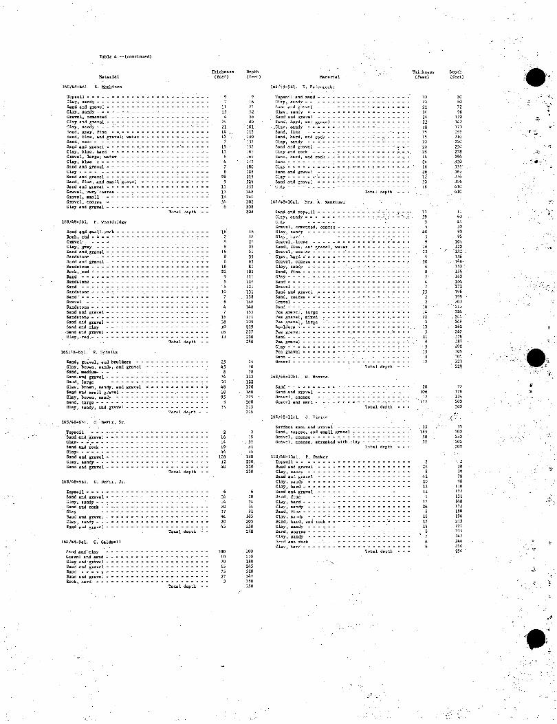
Table 4.--(continued)
Material
16S/48-4dL E. :Hankinen
Topsoil - - - - - - - - - • - - ~ - - - ~ ~ - - - - - - -ClAy, all.rtdy - - - - - ~ - - - ~ - - - _ - _ - • ____ _
Slind and gravol - - - - - - - - - - - - - - - - ~ - - - -Clay,. saIldy - - - ~ - ~ ~ - - - - - ~ - - - - - _ - _ - -G •• v~l, cl:IIlet:lte;d - - ~ • - • - - - - - - - - - - - - - -
gi:~,a~:I1~;a~e~: :,.:::::::::::::::.::: ': &!!.nd, gray, fine - -. - .. - - - - - - - - - - - - - - - -Sand, fine, and gravel; vater - ~ - - - - - - ~ ~ - - - -Sand, red- - - -. - - - - - - - ~ - - _. __ - ._ ~ • _ ~ _
Sp.nd and g:nl.vcl - - - - - - -. - - - - - - - -'- - - - - -Clay, blue, hard - - - - - - - - - - • ~ ~ ~ - ~ - - ~ -Gravel, lArge; w.ter - - - - - - - - - ~ - • - ___ - -
Clay~ bl1J.o - - - - - - - - - .. - - - - - - - - - - - - -
~~:: ~n~ ~r:ve: : : : : : : : : : : : : : : : : : : : : : Sand and gravel - - - - ~ ~ - ~ - - - - - - .:. - - - - - -&aI1d, Un!!., add SmaU S,lI.vel _ - - __ - •• r - - - ~ -
$.Dnd oud gRv81 - - - - - - - - - - - - - - - - - - - - -Gravel, very'coarse; - - - -; - • - - ~ -: - - - • ~ - - - ~. Gravel, .mall - - - - - - - - - - - - - - - - - - - - -Gravel, e.08rse ~ ~ - - - - - - - - - - - - - - - - - - -Cl.y and gravq.l - - - - - - - - - - - - - - - - - -
Tot.,d 4e;pth --
16S/48-5bl. F. Wooldridge
S~cc;l and ,flIIB.ll. ~k. - - - - - - - - - - - - - -: - - - • -Rock, red .. :. - - - - - - - - - - - - - - - - - - - - - -Gravel,,- - - ~ ~ - .:,. - - - - - - - - - - - - - - - - - -Clay, ,gray - - - - - - - - - - - - - - -' - - - - - - - -Sand .and gravq.l - - - - - - - - - - - - - - - - - - - - -Sandstol1e - - - - - ~ - - - - - - - - - - - - - - - - -S<1-dd 1Ilc.d g1"lI.vei - - - - - - - - - - - - - - - ~ - - - - ~
Silndlltone - - - - - - - - - - - - - - - - - - - - - - - -~ck.. ,red • - - - ~ - ~ - - - - - - ~ - - - - - - - - - -
Sand' - .. - - - - - - - - - - - - - - - - - - - - - - - -Sandstone - ~ • - -. - - - - - - - - - - - - - ~ - - - - -Sand - - - - - - - - - - - - - - - - - - - - - - - - - -Sandsto'ne - ~ - ~ ":' ..: ~ - - - -:-. - - - - - - - - -'- -. - -Sand" - - - - - - - - - - - - - - - - - - - - - - - - - -GraiJel - - -' - - - - - - - - - - - - - - - - - ~ _ - - -Sandstone - - - - - - - - - - - - - - - - - - - - - - - -S.nd ~c.d st:';llvel' _ - - " _ - - - - - - - - - r " ":: _ - - _
Sand_ton9 - - - - - - - - - - - - - - - - - - - - - - - -Sand and gra.vel - - - - - - - - - - - - - - - - - - - - -~rt~ II.nd day - - - - ~ - - - - - - - - - - - - - - - -' Sand and gRv~l - - - - - - - - - - - - - - - - -. - - - -Clay, <red. - - - - - - - - - - - - - - - - - - - - - - - -
Total depth --
165/48r!j;i1. E. Schultz
knd, gntvel, .aoo boull1ers - - - - - - .. - - - - - - - -Clay. brown, sandy, and gravel - - - - - - - - ~ - - ~ • '&and, ~f.u..- - _ - ~ - - - - - - - - - - - - - - - - - -
~::~a~r::~e~ : : : : : : : : : : : : : : : : : : : ~ : Clay. brovn. sandy, and gravel - - - - - - - ":' - - - - '-:-$.and .nd tall a:~vd ______ - ____ . ___ • _ " r
Clay. brovn, sandy - - - - - - - - - - - - - - - - - - -Sand, l.A:rgc - - - - - - - - - - - - - - - - - - - - - - -Clay, !landy. and gravel - - - - • - - - - - -' - - - - - -
total depth - -
16S/48-8bL C. De.F1r. Sr.
Toplloil __ . __ ._'_'_. _____ .. __________ r
'Sand and, gravel - -' - - - - - - - - - - - - - - - - - - -
~~-~~d ~ i~c~ : : = : : : : : : : : : : : : : : : : : : = Clay- - - - .. - .. .,; - - - - - - - - - - - - - - - - - - -Sand and gravel .... - - - - • - - - ~ - - - • - - - - -Cl.y, Nndy - - - - - - - • - • - ~ • - - ~ - - - - • - ~
Sand and gravel - - - - .. - - - - - - - - - - - - - - - -Total depth .-
16S/4S-9bl. C. DeFir, Jr.
'l'0p'Ql1 ____________ ' ______ •• _ r ~ - -
Sand and gravel - - - - ~ - ~ ~ - - .. - - - -.- - - - ':: -Clay, lIand:y __ ":' __________ r ~ - • - - - - - -
Sand and rock - - -. - - - - - - - - - - - - - - - - - - -CL!.y - - - ~ .. - ~ - .- - ~ ~ ~ - - - ~ - - - - - - - - -Sand snd gravel - - - - - - ~ - - ~ ~ ~ - ~ - - - - - - -Clay. sandy - - - - - - - - - - - - - - - - - - - - - - -SQ.nd and gnv!!.l - - - - - - - - - - - - - - - - - - - - ~
TQti 1 depth ;. ~
16S/48-9c1. C. Caldwell
Sand and' t:1II.y .. - - ~ ~ - ~ - - - - • - - - ~ - - - - -Gnvol and sand ________ • - - • - - ~ " _ r ~ - -
Clay aD.d· gravel' - - - - - - - - - - - - - - - - - - - - -S4I1d 4nu Sr.d."Vel ~ - - - - - - - - • ~ - ~ ~ ~ - ~ ~ - - -~nd - - - - '!' ~ - - ~ - - - ~ - - - - - - - - - - - - -
Sand and gravel - - - - - - - - - - - - - - - - - - - - -Rock. hard - - - - - - - - - - - - - - - - - - - - - - -
total depth --
'''.'
Thickness (£eet)
, 7
II 25 4
24 21 14 : is
7 15 11
6 4 7 6
" 9 II
" lB 36
6
16' 2 8 ,
16 8 6
16
" 9 5 5
10 7 6 4 7
16 38 10 16 13
25 45
8 34 10 48 10 '5 l
35
2 16 14 19, 44
103 U 40
6 14 14
'0 37 94 20 45
100 10 70 65 75 27
3
Depth (feet) Material
9 16
" 52 56 80
101 ll5 UO lJ7 152 163 169 173 160 186 Z15 224 235 246 266 302 30B ,08
16 18
" 35 51 59 65 81
102 III 116 121 131 138 144 148 155 171 20' ,19 237 250
Toplloil and :!Ia1;ld - - - - - - - - - - - - - ~ - - - - -Clay, ssndy -.. - - - - - - - - - ~ ~ - - - - - - - -Sand ;tcd grave;l - - - - - - - - - - - • ______ _
Clay, sandy - - - - - - - - - - - - - - - - - - - - -Salld alld gravel - - - - - - - - - - - - - -. - - ~ - -Sl;lnd, 1~.d, .!l.nd Rmvel - - ~ - - - - - - - - - - - - -
.Clay, sandy - - - - - - ~ - ~ ~ y - - - "- - - - - - -
Sand, fine - - - - - - - - - - - - - - - - -' .. __ ..-
~~:;: :~:; n~d_r~"~::::::::: ~.:~:'::::: Sand and gravel - - - - - - - - - - - - - - ~ - __ _ CIl;ly acd rock - _ • __ :" • - - - - - - - - - - - - ,-. Sand, hard, and rock - - - - - - - - - - ~ - ~ - - - y
SaI"l.d - - - - - - _. - - - - - - - - - - - - - - _ ~ - -
~!:~ :n~ ~r:v:l- : :.: : : : : :.: : :.: : : : : : : :
Clay - - - - - - '- - - - ~.- - - - - • - - - - - - - -Sand and gravel - - - - - - - ~ - - - - - - - - - - -ctay - - - - - - - - - - - - - - - - - - - - - - - - -
Tota 1 depth ~ - -
165/48-10a1. Mrs. A. Mankinen
~E~,::;n;;:~:::-:::::::: ::::: :::: :~-:-Gravol, cClIlcntod, coarsc- - - - - - - - - - - - - -Clay. sandy - - - - - - - - - - - - - - - - - - - - -Clay, haru - - - - - - - - - - - - - - .- - - - - - - -Gravol,lo08(1 - - - - - - - - - - - -'- - -. -'- - - -Salld, fille, alld gra .... el; \later ~ - - • - ~ - ~ - - - -Gt'iivel, COii1'Se - - - - - - -' - - - - - - - - - - - - -
Clay, hard - - • - - - - - - - - - - ,;, - - - - :" - - -Gravel, coarse .. - - - - - - - - - - - - - - - - - - ,-C1s.y, sandy - - - - - - - -'-.- ~ ~ - ~ - _. - - - - -Sand, fine - ... - - - - - - - - - - - - - - - -'- - - -Clay - ~ ~ - ~ - ~ - - ~ ~ - ~ - - - - - • - ~ - - ~ ~
Sand - - - - - - - - - - - - - - - - - - - - - - - - -Gra1l'el - - - - - - - - - - - - - - - - - - - - - - - -
~~:, a~:a~:V~I_ .. : : : : : : : : : : : : : : : .: : : :
Gravc.l __ • r ____ .; • - - - - ~ ~ - - - - - - - -Sand - - - ~ - - ~ - ~ - - - - ~ ~ - - - - - - - - - ~
Pea gI13.vcl·, large - ~ - - - - - - - .. - - - - - -'- • Pea gravel, mixed - - - - - - - - - - -.- - -. - - - -Pea grs.vel, large - '- - ~ :- ~ - ~ - - ~ ~ ~ - - - - -J!,OI,lldoJ:"1I .: • ___ ~.,~ _'~ r _ • __ - _ r ______ .
Pea gravel - - - - - - - - - -. - - - - - - - -,_'- - - -9.aI"l.d - - - - - ~ - ~ - - - - -'.- - - - - - - - - - - .-
Thickness (£Iet!t)
30 20 22 24 24 22 28 25 15 20
'20 28 16
" 16
" 12 20 16
Jl 29
5 5
40
9 16
" 4 10 4 6 2-
4 , 25
2 , 10 14 22
3 13
5 II
2..IW p~ g~vel - - - - - - - - - - - - - - - - - - - -:- - - , q
25 70 78
ll2 122 170 160 275 2.0 315 315
, 18
',- " 51 95
198 210 250 250
6 20 34 >4 91
185 205 250 250
100 110 160 245 320 047 350 350
Clay - - - - - - - - - - - - - - .. - - - - - - - -:- - -
;:~d g~a:e: : : : : : : : : : :': : ~ : : : : : : : : :
Gravel - - - - - - - - .• - - '"! ,- - - - - - - - - - - -. Total depth - - -
16S/48-10bL W. Monroe,
SandY~~----~--
Sand and gravel ___ • _ r ••• ' ~ - ... - - - -. - -
Grave I, coarse - ~ ~ ~ ~ - ~ - - - _. - - ~ - - - - -' Grav~l and 6alld ~ _;. ~ r r • - - - - - - '-'.:" - -' - -
Total.depth - - -
IbS/48-l1cL .J. Pi~rce
Surfac.:t! !!III.nU I1nd gravt!l - - - - - - - - - - - - - - -Sand, coarse, and II'op:l811 pjrnvcl ':' - - - - - - - - - - ~ Gravel. coarse· - - - - - - - - - - - - - - - ~ - ~ ~ Gr.v~l, C:I;lI!.id!!., .t.r~ked • .. ;lth· CUy - - _' - - - _ - - -
Tt;lt.l depth - - -
163/48-1341. p. P..!.ritet'
'l'0p:ioil - - - - - - - - - - - - -' - - - - - - - - - -Sand and gravel - - - - - - - - - - - - - - - - - - -Clay, ss.l"Idy - - - - ~ ~ • - - ~ - - - - - - - Y ~ ~ Y
slilcd ,ftI1d gr .. vel - - - - - - - - - - - - - - - - - - -Clay, sandy' - - - - - - - - - - - - - - - - - - - - -Clay. hard ~ - - - - - ~ - - - - - - - - - - - - - - -Sand a.nd gIl!.vel - - • " - - - - - - - - - - - ~ - - -SI!Ild, fine - ~ - ~ ~ - ~ ~ - - - - - - - - - - - - - -Clay, hard - - - - - ~ - ~ - - - - - - - - - - - - - -Clay, sandy - - - - - - - - - • - ~ - - - - - - - - -Sand, fille • - - - - - - - - - - - - _. - - - - - - - -Cl<1-Y, ol;1cdy - - - - - - - - - - - - - - - - - - - - -Sand, hard, and rock - - - - - - - - - - - - - - - - -Clay, as.nuy - - - - - - - - - • - Y - - - - '- '": - - ~ Sand, coa"("~t;: - ~ - - - - - - - - - - - - - :: - - - - -Clay, sandy - - - - - - - - - - - - - - - ... _.- - -Sand and rQc:k - - '- - - - - - - - - - - ~ - - - - - -
Clay, hard - - - - - - - - - - - - - - - - - - - - - -Total depth ~.-
5 13
3 12
20 ,106
12 162
3\ 165
50 52
, 2.
8 42 20 12 12
9 17 ,4
8 lG 17 14
8 7 4 4
Depth (feel)
30 \0 72 96
120 142 170 195 210 23O 250 278
"4 320 336 362. 374 394 410 410
)l
40 45 50 90 95
104 120 1:')2 ,
136 146" 150 . 158 160 164 171 196 198 ,00 210
. 224 _ 246 ,.,
262. 267 278 287 292 J05 .~O8
320 329
2U 126
"" 300 300
~{:.: . 35
,00 250 302 302
-, , 28 36 78 ..
110 122 131 148 172 ,"0 196 ~13
227 235 242 246 250 25U

....•. , .. :, ~'., ~
'. ..... ...
..
.,
.~
, .•. " ,
, .\
" ...
..
": ..
, 't' .. :
Table 4,--(l;ont:i.nued,)
Material
16S/48-14bl. T. Ga.l1i1gh~J:"
TOPBOi 1 - - ~ ••• - - - _____ ~ -
Sand and gravel ~ - - - - - - - - - - - - - -
~;~~ ~ri~ g~a~~~;-~t~r- ~ : :.: : : : : : : : - - - :
~:~~e~~\!;~~ ~r~v:t. : : :.: : :': : : :': ____ ~ Sand and fiDe.-gravel. - ~ ~ '- - - - - - - - - - - - -Gt'Dvel" medillm - - - -~ - .,. ~ ~ __ •• __ . ____ _ Pea gravel - - -'. - -: - ;. -'. -' ___ • ______ -
Sand, fine~ and II-mall gravel -" - - - - _ - - - - -~an(l, fine, and lignt rt!d !;b.y ~ - - - - - -'- - - -Pea gl'av~l. .and b!,luLders - - - - ___ ~ ~ _ ~ •• __ Pea gravel and sand ".- - - - - - _______ ~ _ ~ _
,Sand and 1I111.B11 gr<lvcl -' ~ - ~ - - - - - - - - - -'~ -Cla.y - - - - - -::.. _ -_ .~ : ._ • _!". ___ ''; _
Clay, fine', !landy' - - - - -'- - - - -Total depth •
16S/48~i4dl.' P.:.Pe~rY
Rock, sandy';' - - - - - - - - - __ - - - - -Cl.;\y·- - - - - _'w - - - - - - __ , ________ _
~I\d 8.nd gravel - - ~ -'-'- - & _ ;.:,':.'_'_' •• ,;. __
Sand~ hardpack - - - - ~ - ~,--" -~~ -'- - -'- - - -Cl.ay - - - -' - - - -' - - - -' - :: • _ ~ _ ~ • _. _ & _,
Sand, fine· - • - -'- - - - - ____ ,_:, __ ,,; _ ~
Clay - - - w _ ~ _ - _ - - - - ____ ""' __ .'" _, _'_ ..:. -Sand and gravel - • - - - - - -" __ -:. ____ ~ __ ~ Clay' ~ --_.- - - ~ _ ~'-" - ~ - - - - -',= _,_,,:,
Sand .and ~I''II-ve.l - - - - - - - - - - ~ - _ & •
Tota 1 depth -
lfiS/48-1Sa1. E, ~I\kitle[\
Top.oil - -' - - -'" - --~ Cla.y _ _ ____ ~ ~ .• _ r_". ~ •• ' __ Sand, red, and'gravel -'- --~':"- ~~~ __ ~~ -sand- -'':'~~-"---------'~-'-.~ Clay, ·~ed}- - - ~ • & • -,& - - - - - • - - -
Sand and gravel; water . ______ _
Tota l depth -
16S/48-15b1. L, Dansby
Top!l;oi 1 - - - - " - - - - - - - - - - - ~ ~ ~ ~ • - • Cl,.ay .~.: - -'-: - - ~ & ~ - • - - _ • _________ _
Clay ,_ - .; - - - ____ ":. _ '~. w~~ _ "'- - _ - _, __
sund <1-nd !;:lay - - - - - - '-r - '- - - - - ~ - • - - - -Sand, hard., brawn - '- -' - - - - - ____ . ___ ' __ _
~~~~~l~~:d~'- :.,:~:~:.~: = : : = : = = = = = : = = - -Clay, br~n', 8.nd sand - - • - - - ______ _
Clay,.brqwn, and sand'w ~ - - - -'- - - - - - -Silnd.,"~te.~. - - -, - - - - - - - • ~ - '. - • - - _ Si!.nd and gravei.;- - -' - - - - - ~ _____ - - - - -
~~:~:t::~:~::: .. ::~ ::: :: : :: : : :: : : : : : clay and ~t:'oivel - - - - ~..: - - ' • - • - - __ _
16S/46-16<1-l.. E. selb.ach
So~l, sandy $.ani;! and.ro~k -'- - -"- - -Clay" ~an!iY :- ~ .":'., - - - -Sand 'and rock _. - w - '~ - -
, ~:,~, a:~I\:~a~e~' : ,:': : : : Cl~y', r _ - _ '- - - ~ • ~ ~
S~l\d. ' c.oarae . - _ - - - • - -ClAy'· - - - - - - ____ _ Soind" riI'lii -
,Clay' ,_, _ -: _____ r - _
Total c;ll:p~h -
~; :
. '.;~·lbS/~8-l7d: -" 'J', ~erh.lJ,lst!r
Topsoil' - ;.- - -'-Gut,,!;!l,' c~nted Sand" fine~ • ~ -Gravel, 'ceIllCntcd
IbS/48-Ull;1. J. 8~11
TopsoU . ' Sand .;; - - '- - - - - ~ -
Tota I depth -
~:~:'a~~~;t:~e~ .: ': : :': : : =-= = = = = = : : : : s.and - - - - - - • ~ • - - - - - ________ _
Hod., broken - - - - - - - - - -Sand, red - - - - - - - - - - ~ • - - - - - - - __ _
l'cltoi1 dt!pth -
'Thickness Dl:ptn (f~et) (feet)
.2 9] , " 10 12 12 11 14 B
37 6
17 32'
6 4B
90 .
5 IS 18 'is' ,S'
.--:-16 • :.'\0
,IB 12
4 , 31
-45 8
53
J)
9 IS 22'
8 5, 7, 6 .
• 20
7
" 8 4 .
12 9] 13 46
6 38 4
16 6
" 8
4 .,. 128
2
l~~
5 10 23
202 'i2
6 8,
2 95
·104 136 146 1)8 170'
;"Ull Iq,'i
203
"0 246 46J 295 :.-101 349
, 349
90 95
110 128 146 164 IBO 410
'228 240 ,40
" 13 44
"' 97 l50
"150
" 30 45 67 75 80 87 9].
10L 122
,129 '137
145 149 149
" 12 lOS
{f!" 118
11>4 170 208 212 22B 234 242
.• 250 250
4 132 134 280 280
, IS
'" 240 292 2915
.,380 380
Material
16S/(18':20d1. .J" Ilclwney
Topsoil - •
Sand - --Roel< .: - -Soilld, brown - - " - - - - - - - - - - ~ Limes tonI! - - - - - - - _ ~ ___ .; _ r
Sand, l>i'(TWf). ~ ••• - - - ~ - - - - - - • ,".
Lilllestone, hJ:"Clk~n -Limcst'one - - - - -TJi!l1l~s tone, broken -Limestone, brok~n -Sand, hard - - - - - - -
16S/48·2)a1. II. Gi 11espil!
Salld and gravel - - - - -Pea 8r;:tv~) - - - ~ • - '. - -f:iand - ___ ~ •• __ r ~'_
Gravel C,101Y - - - .' -' - - ~ - -
)6s/48-23b1. H, Cillc.:;:pil.!
Cravl!l, coarse ~ - -, - -Gravel - ~ - - -Gr'1VI!I I:1lld clay -Clay - - -
16S/4?-23cL ,II. (Ii J le~pie
'TOp!wil - -
- - .~" & • -
rota 1 depth -
Suil, sandy, ti )l;ht - - --<:-
Sand, fine, aLld gravcl OJ"
Clay, light. s;:tndy - -Clay. red, with stl'eaks of gr.;tvr.) - - ~
Cl";l-Y, I:'ed,·sandy ..... itn ~l.!l!aks·o[ white ltmc - - ~
S8.t1d and fine l:':tavel - - - - - - - - - - - - - -,C lay, s ti c;:ky - - - - - - - - - - ~ - - - - - - -Sann, r:OOlCSt!, and .gravel f:1;lY, hard, stiC'ky - - -
TOlal Jepch -'- -
IflS/48-23dl. V. Gillcspie
Top"ni I ____ . __ •• __ r - - - - - - - ~ • - • _
Soil, sandy,· tif'>ht.- - - - - - - • - - - - - - - - - -Sand, f'inl!, ;:Slid gl:'avel • - - ~ - - - - - - -CI~y,' light. sandy- - ~ - - - - - - - • - • -.C,loiY, red, .... ith streolk.s u[ gravel - - " ~ ~ -Clay~ red, !:iOllldy, with strcak:; nf white lillle-Sand and fine gravel- - ~ -'- - - - - • ~ • Clay with stn~;;Ik~ at ",hite Ihne - - - " - -" -Pca ttt"Olvl!l - -Cloiy, sticky'-
f>nrfac::e soil - - -' - - -' - - ~ •• - - - - - -Gravel ann sand - - - - _ & ___ r - - - - - - -Clay w - - - - ~ • S;:Lnd alld'gravel -~- -~-'- -~
Clay' • .;, r - - -.
Sand and·gravel.. • - -'- - :..,..:.::' 'Clay'· • - - -,~- -Gravel and' !I.iilld" - -CJay -:.. - - - - -Sand, g'ravet, alld boulders- - -Cl{l'y' - - -"- • - '- - -.-Cravel and bou!c-lcr$' -" - - - - -
"Clay - ~ ". - - - -' - .:"~,; - - w SOlr'ld aild' gravel'r-- - - - - - -'
'Clay __ r - - - - - - - •
Sand and' gt'avel • - - - -Ciay ___ r r _ - - -
Bo\!)d~rl:l alld gravel - - - ~
Cla.y aild boulders - - - - - -Sand <lnQ Rravl!l - - - - ~ • Clay - _. _____ r _ - -
Sand, f,rav~l, ;lI'c..I In.'uldel·s --Clay - - - - - - - •• - - - - - - - - -SOlnd, gravel. and h6nld~r!i; - - - • - ' ••
" ~;.~~ a~d\~a~e~ : : : : : : - - - - - - -
'~~~~irlr.~~-a~d~c~a~'=·= :-:: - : = = : :': ·.Clay - ~ • - - .- - " - - '- - -' - - - • -Boulders and day - - - ~ •• -'- - ..:. - -clay - -, - - ~ - - - - - ~ ~ - - - - - - -Rnuldl!t'B - ~ - - - - - - - - - - .--Clay, hard - - - - - •• - -DOIIJ.dl!I"B - ~ -I~Cll.:k - • - - -
Tot;!. I depth·
Thickness ( f~(~t.)
B :22
... 4 I:il'
2 OS
G 14 II \0 10
25 7()
."80 -"155'
84 2]0
10,
10 5)
IX 77 )J
128 120
J7
" ,
y,
I' 77 32
DU 12'i J~ 71
2
JO 10 IS H
12 II J2 18
:' II 19 8
lti '7.:-1. 21 n
'23 8
14 8
I)
" 11 Il
l3 7
. l~ 5
22 )
4e .1 8
Oepth ( ICI!!.)
8 JO )4
185 IX7
~ 'J
,1,75 ;130
, )JO
.1JO
H4 114 J24 '130 J)O
IU 0';
85 I fI.~
105 32) 443 480 501 510 'ilG
l'-:lO 320 .' 445 4eO 501 51]) ';0'3
II 21 Jl 4b 51,
" 79 91
109 114 12Y 148 15' il4 10) 2lH 231 254 262 276 ' ;.>84 297 31' :-J2'J
339
"2 369 l87 :l92 IllIl
42J 4V1 472 480 (,80
'I.;,'
.'; .. ;r'
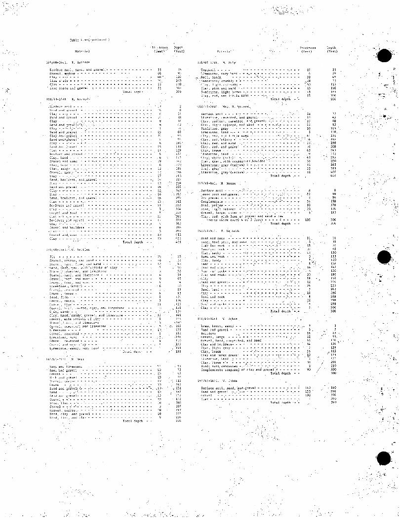
':.'''''
16S!4B-24cl. R, Records
Su(fac:e .sui 1, sallJ, al\<.\ /Orav~l
Cr,"Ivcl. medillm -. -
~~~l~ ~h~~'~': : : : : = r..I,"IY __ ~ ___ - r _
Lilli!:! s],al~ ..i11J gr::tv~1
~;~lrfa('e soil ~ -tia 11d and t,ra V4~ 1 Cl.a) - - :- - - -tiand ilnd i',<,"Iv4d Clay - - - - - ;Sand and g.ravd.'~"·, Clay - - --' :';-' -:Sand arid gr~vd' f:l,1)' ;"nd: gravel
. Sa11d 'atld~~gl-av~ I r.j.,y • _ •• '. _ •
Salld J.11d grav~ I (' l.ay • • ~ • • ~
BOllld4~r ;lnd ~:r;lv4~1
Clli). hard - - -r.r<lvcl and ~;;Ind
C l;lY, II;lrd - -Clay, S~'111~' --
~~:~~~'_S~~~Y_~: Sand, boulJC!rs, alld IOl'livel C lily - - - - - ~
Sand alld gr.·ll.vel - - - - -('1«), •• ' ...... - - - - -C'lay ___ ' ___ - - • r _
Sand, bou lders, alld gl'a v!:! ! Clay. - • • - • - ., ~ • ~
I1oulder::o and ,~r<l ve 1 .C la;:.-· - - -, - - - - - - ~
Gt'al,le! alIJ· .!l..il\d - - - -C la} -.:" -. - ,7"'~ - - -
BOlllders uncl i~r,'vcl -Ciay -' -"- ~ -' - -. - -Gravel and hOl.llders -
.C,lilY· - - 7 - - -
(,ravl!1 al\d,~al\d
Clay - - - -. -
,.
Tota 1 depth ~-
Pi t • ~ ~ \. ~
Gr;lv4~l", 4:(1ilr~;4~, ;lnd s,1[1d r - - - - ••
-~,~:~: : ~:~~ ~~~:~l~~~ 1,1::;I~ I\~ ~,:::~~:~~~ ~ l'~y-GravE:l", hard, and lilllestollC! - -Grav~'l"h'"1rd, ;'1nn s;Jncl. Cravc j, f i I\C, ;l11d ~;lnJ -LilllE:'S tOll'.! ,.:.. h8. rd (?) r.r" v(' I., ,'!'m!'nl 4~d Cr;.lVt~ I, 'Ioo:;~ -S~ llJ, fi Ile, - ~ - -. f: r" V4~ 1, r.O;l r!; 4~ - -(i['livel, [illt: - --Gr.av~l. h~rd. r:<1il<<;~ •. rt,1)" ilnd lim~stone
'C l;.Iy., .!lal\~y - - - - - - - - -Clay', hal'd, 'san'dy~ gravel, alld lim'.!stolle -Gr.:lvel, .,ith J.;t"rc"ks of Cl,lY ••. GI'avt:l, :'h;.lId, a11U limel:llunt: - - -GE"vcl. celll>:'nt('d', <Inn limestone !. im~:; I OI1t~ - - - .:: -: - - - -
Gravel, celll!:!llteJ - .- -.-1. i.m4~!;! (ln4', ha rd - - - - -Gravel, celliented • - ~ - - -Gr,'v4~1 '1nn·!;o:n4~ 4:1;1;.' -'- --
- ,
L,imeSlune, Sll.ndy, Vt:I'y llJ.IJ Total dE:pth
1.6::'/48-27..::1, .M, Hart"
~anu allu I im!:!.!lrUllt: 'Sal\J .illd gt'avel - -Gr8vr:.l. - - - - - - ~
Kod . ..illd ~['a .... el -Gr"vel, <";O.:l,!;4' - -CI"JVC 1 - ,- - - -S.ind aLld.gra'vCi', ~~ ';,1nn - ~ - ~ -" :. Salld ;1IIJ ~favel- -Gravel,=, -.' •• - ., S" nd, 'I i nt~ - -'- -Gr;I ve 1 - ":'. ~~ ,-' -(;[avt: I, l:t);.Ir'S!:! ,- -Sand, clay, and gravd • ti..iIlJ, I' in!.!, ,1Ild l:1..iy - -
Total depth •
'l'lIil:kn~!;.'; Depth (feer)-' (f~~[)
. , 6 6
14, 9 h
11 15 ,4 4
15 11 8
I" 10 12
I' 17 14 12
"" 12. 16 16 lJ d
1 5
21 I)
)5 t,l';
lJ5 2()5 i'"W 30e )06
14 i'H .17 ;,)
';4
" 4] .)";
un 118 129 1.\'/ llj) Ill;: 171, 184
'" :!13 227 2jt,l·
255 207
",:!83
299 J12 nJ .1.14 J39 '3tl ::r!8 J82
6 jHH
3 391 20 I j 11 10 421
421
,(, .)1. 12 4 j ,7 ')0
j 53 6 'it,l
(, Vi 74 RO 89
4 9J 8 101 3 lOll
?ol 1 ~ 5 3 1.28
, fl \J4 12 146 .') 155
,,16U .5 '. _";", 165 10 175 8' Ifl;l J ,,\86
lrw
.195
I" 198
'i3 ,;1 20 73 1 0 ~3 J 10 ')3 19' 112 30 14~
... 10" ' ~ 152 to "1112 1.0 1'7:!
20 192 ) () ~O~
5 2.07 10 10
~ 1 7 227 2j6
2JG
M;lLt:rial
I.GS/4R-:;'/tll, M, Dtdph
,Top.,soil -L i m~~ L(ln(~, v!~ ry h.a rn ,Soil. salldy, - - - -
';',"lnci:,;tonc,' 4:,uml;lv -"Clay, li!-'jllL'and !;,""1nd.-Clay, ]JillK. and salld ,-5,lndstone. llght 'browll - - -Clay,'r4~d, "nd little. sand •
'16S/4fl-.l!lul, Mr~;, 11, W"tson' .
Su r IIl.l:t~ ~t)i 1 ____ . ,- - - '.
~~~;:t~'~~di~~,e~~~~~t:~~ :~.~:;~~v~~~ ,." Clay, lip;~I!' r:olorcn, <Inri :;~'no Sal1dstollE:, gray - - - - - --Lim4~:;~<1n~, h.,rd -,. - -,--; Clay; t'eJ, J.Ilu lilllt: ~and -Clay. red, 'stid:Y·· ~ . Clay, l't:J, anJ Sanu -. CI.;~y, red. and gravel Clay, bruwn - - - - -Limestone, hard - - -
-~:. -'-'
C lay~ wh i lc (I il 1 r:)? -, _, Clay, g'ray,.with oc(.asi,ollal,boulJer ': LiITlcston.:,~ gray (med,iuQI) -Clay, )l;ray:-'':' - - - - ->
.: Limestolle, gray,'(OleJium).-
16s/49-B~1. H. Meese'
Surface soU - - - -L005~ rock <lnd',gravel Ury gravt!i - - - - -
;~~~~O~:i~~: : : = :: :' >= :',: . tianJ, I i.foli'!. c:ol4.lrerl ,,'
Tot"l ocptl; -
Gravel, bq;!:!; 'o/aL~r -.- - ,- - - - -~- -.- - ~ - -·Clay, red: wi(h lens of gra,vel and slilld .:1 ft:!w
inc:lI4~S t~~i.("k every 4 'or 5 fc('t,~ -'. - - .; - • ~
Silnn .:Ino r04:".k • - •. -tiillld, hanI p8.(.k, allJ rUl:k Clay and rock 5anJ:iJnd rock - -Clay, sandy - '- -tianu anu rock -ClIl.y, sa;\dy -S<lnd __ r _'_
SallJ anu day~;;Jnd ;Inn ro<";kClay ilnu rOl:k
.Clay - - - - -,S.:lnci ~nn I',rilv('lC!;JY - '- - - -Sand, hard - -Clay - -SaIIJ aud ["ul:k Clay. - - • - .•
.S,"lnci ilnd ,oc:k. Cl.ay - - -
16S/49-14al.. W, JullLls
LoallJ, browll, sauJy -Sand and grav.:l - • B!luld~r:; - - - - - --;.- - 'CravGI, l<lrr,e - - - - - -Gra .... el, harj, LUmpal:t!:!J, anJ saI"!d Clay and bOllldel"S~ - ~ ~ -' &
Cl;lY, Jit,lit ~r.:ly ~ r •
Clay, brolo'n - - - -,-f:l.:ly ilnn lilrp'~ p'T.:Iv.r:.1 ~ - - -~ .. -
~~ta i depth
~~:;~t~~~~b~~~ .: : : :,~:,: : : ,: : - - - - - -
Sanui han!., !.:ompal:L~u _, -"- ,-- - '.- ,- .- ,- -, - - - r
COllglomet';1te c:oIllposeq' of da.y and gravel': - - - - - -, Tota 1. 'depth --
Ihfl!49-14bl. w, Johns
Surface soil, slil~d ~ '~I\d:.gra\'el "<lnci ilnn ):!:ravcl - - -~
Gravel Clay· •
Tota 1 (lcptl; '-
Thjckness (f~!:!.1 )
25 4
20 26 50 15 4, 11
32 lJ 15 35 10
5 41
, 14
2 5~ 10 4J
.' 4)
:is 12 ))
12
" 82 6
S4 20 20
S"
lOS
ll. ,3
18 J7 41
)
~ :.~~, 14 .. ,-
. '8
)0
lIi 12 25
7 18
8 22
8 ,.
, 5.
lb 32 5S 14
5 06 10 ", 31 , '0
140 150 wq
D('pth (fr.r.t)
25
" '.9 7.'
12') 140
""' 200 200
" 45 60 95
10' 110, 151 16'; 190 200 24) 2'j,
295 )SO 362 )95
407 407
8 '0 96
l50 170 190 195
300 )00
II 14 32
" llO ll) 120 ~28 142 150· 18U 1'8 210 235 14:;: 260 268 290 298 )00 )00
, 7
Zl 55.
~;~ ~' 129
! ::: 171 208 210 .)00 300 .
140 2'0 J90 )90 )YO
"'". .. "'i,.
',.',
, ... , ,
.0;\;,
';:;","
, ',~
.:<,

•
•
Ta?le 4.--(continucd.
Material
IbS/49-15a I, W, Johns
Sal1d - - -Silnd ~nd gravel - - - - -Gravid - - - - - - - - - -Sand and ,gravel- - ~ -Clay, brown-Clay, gray r
Cl;IY, brown Sal1d - - -
IbS/49-18a1. W, Hanks
Surfa!..:e suil, saliJ, allJ gr~vel -SLlnd ;}.nrl pea gravel- - - -Salid, 'harJ - -Cravel - & - ~
Sand, illlrJ -Clay - - -
- - - - - -- - -
Total .;!epth
Tota 1 depth
165/49-19a1. L, M~~L~r
SlIl.'face sui 1 - - -Cravel and sand- ~ & Clay - - - - - - - -Sand and gl'avel- - -ClilY - & & ~ - ~ - -Sanrl ;1nrl jo';'[;:Ivel- - ~
Clay - - - - - - - -Sand and gravel~ - - & Cl;]y - - - - - r r - -
Sand, gravel, alid bouldet's - - -
Clay - - - & - - - - - - - - - -
SanJ', bould~r~, anJ ~ravel - -Clay - & ~ ~ - -S;:[nrl and gravel-Cl;,.y - - - - - - - - - - - -Sand and gravel~ - - & -, - ~ Clay - r r r r _ r r r __ r
S.9.nd, bouIJ~r~, anJ ~I.'svel
Clay and bOlilders- - - - -San.;! and gravel - - - - -Clay - - _ - r ~ - ~ - - -
Sand, gravel, slid boulders
Clay - - - - - - - - - - -S;]ncl, !,;r;]v(d, "-ncl hnnldr.,'; Clay - - - - - - - -Sand and gravel- - - -Cl<ty ~ r r r ____ ~
Boulders and clay- - -Clay & - - - - ~ ~ - -flolllder5 ;lnd .:;hy- -Clay - - - -Bou Iders - -Clay, hat'J -Boulders ~or,J.; _ r -
IbS/49-19hl. L. t-\cet,er
Surface soil -Hardpan - - -S;lnd - - - - - -Clay - - - - - -S<'lnd ~nd gravel Clay - - -, - - -Sand and gravel Clay' __ r ___ r _ ~ _
S.and - - - - - -Clay - - - - - ~ ~ - - -Sand and grav(l'l- - - - -Clay - - - - - - - - - -Sand, grilvel, and boulders -Clay - - - - - - - - - - - -Sa nd, grave 1. and bOlllders Clay - - - - - -Sand and gravel-Clily - - r __ r
Sand al1d gravel Clay - r - __ ~
Sand sl1d gra ... el
Clay ~ - - - - -Buuld~rs and gravel- -Clay - & & & - - -, - '=' S;tnd and erAlvr.l- -- - - -Clay - - - - - - - - - - - -
TI,lLal
Sand, gravel, and bea,dders - - - - - - - - - -G1;IY r _' _ .; .. r - _ - - - - - - - - - - - - -
Sand - - - - - - - - - - - - - - - - - - - - -
Clay, har,d - - - - - - - - - - - - - - - - - -Sand, p,TAlvcl,' Alnd boulders - - - - - - - - _ -Clay - - ~ - - - - - - & ~ - &
depth -
S;}.nd, F:ravel, Alnrl houldeJ:!l; - - - - - - - - - - - - - -Clay - - - - - -'~ - - - - - - ~ - ~ - - - - - -Sand, gravel, and 'b?ulders ________ r - - - - ~
Clay - - - - - - -' - - - - - -, - - -, & - - - - - - - -
Sand, gravel, and bou Iders - - - -C!;ly - - - - - - _. - :. - r - - - - - - - - - - - - - -
Sand, gravel, and boulders ~ - & - - - - - - - - - - -Glny - _ r - _ r r r ~. r r _ ~ _ - - - - - - - - - - -
SB..tid B..tid grB..vel - - - - - & - - - - & - ~ ~ Clay _______________ r r _____ - __
Total depth -
Thi.;;kne.:s.:o; Depth (feet) (feet)
2l ~r:i 28
114
'0' )3
28 50
80 7,HO
25
" ,0
2 9
10 10
" , 12 II
" 18
15
" S 18 2l
" 13 2l
9 13 8
13 19 II 12 23
7 18
22 7
48 ) ,
]
2 6
12
" 8 27 31 22 19
" 13
" 22
'0 21 !O 16 26 17 II ,4 15 J6 2.1 j)
IJ 17 j)
6 14
" 44 39 22 17 IS 18 22 10 7 7
23
5" 86
200 J09 342 .'no 4'0 42"
80 JliO .185 400 410 420 420
2 II
" 31 46 54 66 7. 91
109 ,114 129 148 156 174 .197 218 231 254 ,OJ 276 284
"7 316 327 D9 362 369 387 3+;/2
4111 4?,l 469 472 480 480
3 5
11 2l 41 49 76
10) 129 148 104 177 199 221 ,41 262
'" 294 )20 337 348 ,n 4
.387 403 426 4]9 452 469 482
4"" 502 521 565 604 '20 M3 nO! 679 70) 711 718 7z5 725
Thickness j. '- ~- '~(feet).
16S/49-19cl, R, Records
Sand <lnd )o;r.:ivtd - - - - - - - - - - ~ - - -
Satid aad coarse gravel- & - - - - - -Gravel, C;:QAlr~~ - - - -.- - - - - -.- - r ,r
Clay - - - - - - & - - - ~ ,- - -.- & ~ -
Clsy and gravel _ r - - - -'.Gravel _____ ,_ ,_ ' _______ r __ _
Clay and .'gravel _ r ;, - -.
Sand ",rid ,clay ,Clay alid gravel - - - - ~ -Clay and :;~ J 1 amount (If !";t"Llvtd ClAlY - - - - - - ~ ---
1&S/(19&19d1. L. Heeter
Surface soi 1- ~ -~ Sand and gr;t'vc~ ~ - - -
1L:"1rdplill - - - - - ~ -Sand and .gravd ____ r r
Clay ____ r __ - - - -
Bou Idcrs a.nd c \Sy -CL~y - - - - - -Sand ;}.nl:i p;Tave! -r.)a.y snJ SSt'lJ - - -Sand and gravel _ r
Chy ;;tnd ~Alnd - - - - -Crave) alld boulders - -C lay and sand - -Gravel ann s."1nd -Clay and ssud - - - - -Gravel and sanc! ,r r _ r
Clay ~nd gravel - .- - -SAlnd alid gravel -, - - ~
Clay and :~ilnd - - - ~.
Boulders - - & -'- - ~
Clay aad gravel - _.;'- ,Boulders ... nd !olrav~l ~ -SAlnd and gravel -' - - ~ -
r ____ ~r
Clay - - - - - - - - -Cravel r r r - _ - - -
CV~y and grs ... el - - - ,- -Gt'.8vel slid ssnd ~ - - & & Clay, hard r· _ r ___ r
~Qnd, boulders, srld gravelClay - ~ & & - -Sand and ·gr,"1vel r r ____ r r
& - ~ :~-!.
Total. depth.-
16S/49&2081. 1'1. Travis, J. Earl, ~nd P Clement
Snnd al'ld ash- - -Gravel, coar:Je .,S""nd, fine - -Sand and gravel -Gravel r _ _ --
Salid, & - - - - - -Sand, flne,~aml grav~l in layet"s- - ~ - -Sand, CO;J.["~t! - - - - - - - - - - - - - - -
HiS/49~20JI, 'E, Easterbrook
Topsoi 1 ~ & - - - - -Ssnd <Inri roc:k - - - -S;tnd, hard, and rock ~ Clay, white- ____ , r
Clay, anrl rock -, - - -S.and, h.ard, and rock -Clay & - - - :". - - -Sand, ha rd, IIlId rock CIOjlY - - - - - - ~
Satid and gravel r r' ~
Cl<lY r ~ - - .:. - -, - - -
S,::l.Iid and gravel- _.-:.:"r -Sand, h",rd, al'ld gravel -. - -: - -Clay, red --Sand .anJ rock- - - - - - ~ ~ -
)68/49-23a1. Hrs, R. Dalton
C !;,.y - - - ~ - - -Sand ilnd clay - - - - - -
,80uJdeT~- - - - - - - -
Total depth ·-t-."
ToUt 1 d~pL.:h- -
Satid and gravel - -. - - - - - - - - - -Sand - - - - - - - - - - - - - - - - -Clay, brown ~ ~ ~ - - - & & - - - - - -
Gravel with streaks of c:l<ty r r _ r - -
Clay, h,U'I'in - - - - - - - -CrAlVe 1- - - - - - - - - ~ ~
Clay, brown;- __ r - ~ ~-
Cr<lvel - - - - - - - .. -. - -: Clay, brown - - - - - - -Cravel - - - - - - - - - - - - - - - - -Cl;IY, brt+1+I1I, sandy- - ~ - - - ~ ~ - - - - - - - - -Gravel __ - - r w _____ r r
ClilY, bI'oW'a, sandy& - ~ ~ - ~ - -Gravel _ r - - - r - - - - ~ - -
Clay, bnnom, satidy - - - - - - -SAlnd, hard- ___ r ~ r ____ _
Clay, 1:1rown - - - - - - - - - - -Sand, hsrd - - - - - ~ - -Clay, brO'ol"n·-,,- - ~ _.- - -'~ - --
:Total (Iepth - -
24 30 )',.;
100 -,,20
10 10 60 20 10 - , 10
6
2 1 (, '., "
13 J. 2
t~' b,~
14 17 9
12 22
8 4
15 12 12· 15 8
18 17·
10 13, ,
7 )0
-7 12· 5, 7
- 6 ,,4
80 10 20
'8 15 ,4 57 36
, 22 18 .8
. 60
" 17
'" 25 ,2 19 J4 34 26 40
·10 30 10 13 14
)
~5 10
2 43
4' 50 27 27
J 38 , 31 J7 15 , 10
'-.'y.
Pepth (feet)
24 54
154 174 184 194 254,
274 284 294 300 300
2 )
9
" " " 33 47 64 i3 85
107
ll' 119 134 14' I), 173 181 199 216
22' 239 246 266 273 285 290 297 303
---...... ---:....., )0) 307
80 90
110 168 183 ,07 164 )00 300
, 24 42 SO
_- 110 135 152 210 ,), 257 276 310 34. 370 410 4)0
10 40
'0 10) 117 120 155 16' 167 210
2" JOS 332 359 .162 400 402 433 470 485 4'0 '00 5()Q
,-.-' ?,

.'O;..r •• i
T~bl~ 4.--(continue4.)
16S/49-26d1. D. Bilsborough
Surface soil - - '-.;- - - -.~ --Sand, gravel, lind boulders ~ ~ - ~ - - - - - ~ - - ~ -Sand - _. -':- - _.- - - - - -.- - - - ~ - - - - - - - -Gt;Qvcl .. nd. p01Jlden- - _.- - - -.- - - - - _.- - - - -Sand - - - '- - - - - ~ - ~ ~ ~ • - - - - - ~ • - - - -Sand and gravel- - - - ~ ~ - ~ - - -' - - - -. - - - - ~
Bol,llden, lOQlllc- - - - - - - - - - - - - - - - - ~ - -
~:;.~n~ .~~~V~l~. : : : : : - : : : : : : : : = = : : : Sand and gravel- ~ - ~ - - - - - - - - - -
Total depth~ -
16S/49~.26d2, H, R.eco:l;'d/i;
TopsOil: ~ ___ - - ~ ~ - _ • r • __ - - -
Tight·. soil - - - - - - - ~ - - ~"- ~ - - - -J.illlOllton., hard - - - - - - - - ;. - - ~ ~ ~ Clay, light colored. ~ -.- • - • - - - - - - - - - - -Clay, brown or reddish ~ - - .- - - - - ~ - ~ '- - - - • Clolly, ligtlt, ";!.th·.an occasional hard streak
. every ~ or .3 £e·et ~ ••• - - - • - - - - - - - -Ct..:y,·· aiht colorcd, with lens of sand and gravel- _.-Cl;it.y, l!lltieky ~. ~ .~ ~ - • - • - - - - - ~ - -
TotQl depth- -
1~S/49-2&1., K. Wick~er
Topsoil - ~ - - - - ~ - ~ -- - • ~ • - - ~ - - -. - - -Conglamornt~ with few boulders - - - ~ - - '- - - - - -Limestot't.e~ hard- - - - - ~ - - - - "! - - - - - - - - - •
Conglamen.tc wiJ;b" larger boulders- - -.- - - - - - - -S.nd; light colond- - - - - - - - - - - - - - - -. ~ -Gravel, ct!mented ~. - - ••••• ~ • - ,;, '- .- - -';' - -Grav:elj water - '- - - ~ - - - - - - - - - ~'. :.. ~. - • Groll-vel, ~ciJ:icntlDd, with red clay ° lens .- -' - - - - - ~ -
l'?t:oA:l depth-
Topsoil ~""' __ "~ - - - - - - - -.- - - ~ - ~ •• r
'Conglomerate 'with' large boulders - - - ~ ~ - - - - • -Li~.t:onc·, - ,;. - - - - - - - - - _. - - - - - - - - -'-Congl~·rB te - - ~ - - - - - - - .:. - - - - - ~ - - • ~
~::~~l~~~~~~!~~~d: : : : : : : : : : :.: : : ': : : :
::~e~,:dc!:~~!~ : : : : : :': : : = : : : : : : : : : Total depth- -
16S/49';28.d1.· M. WickcBr
" Toplloil - -~.:. -,.-- - ~ - - - ~ - ~ - ~ - - - ~ ~ - - -. C0n81Q111cratc ~1th fn bould..rt - - - - - - - - - - - -
Limestot't.1! :. __ - - - _ • _ ~ ~ _ r ~ •• - - - - - -
ConglOmera t"e - - - - - - - - - ~ ~ ~ ~ - - - - - - - -SAno" li'ght- ~lorad.- '. - - - - - -' - - - - - - - - - -,G~~~l, ~eJDi,!!D.tl!d, - ~ :, ~ - ••. -.- • - • - - - - - - -
~~:;:l,~~~~:~: '_~~~~-'"l~t~l~ ~r~v~l: ~ = = = = ~ ~ ~ : = Total depth- -
16S/49:-29cL L .. G&mell
Surface "1)1'1 - - - ~. - - - - ••• - - - - - - - - - -" SOii,' ,sandy -., - ~ - -" - - - - ~ - ~ - - - - - - - - -So~~ aiid rock.-:- - ';'. - - - _. - - - - - - - - - - - -
. ~~:~~~~!g:~~~~{~r~d:.: : : : = = : : = = = = : = -= = = ' Total depth- -
IbS/49-32bl. J. Housell
Surface .oil: I - - - \ - - ~ - - - - - - - - - - - -' - - -
~;~!~i:oll::~~'l~ ~€~~~~d':': : : : : : : : : :.: : .:~: :
, Gt~vd, 14);'8;":, cE!m~Iited - - - - ••• - ~ -
l6S/49-32c.( J. Housell
SlIrf.aie ao11 - - - - -
Total depth- -
Rock.'",nd·'lIIoil - • - - - - • - - - - - - - - - - - - -~t;'ave1 arid t'eddis.h "day - - - - - - - - - - - - - - -Gravel, fine, and' sand - - - ~ -
Total depth~ ~
16S/49-ndl'. H. Stephen I
Clay' ~ind s'and· - - - - - - • - - - - - - - - - - - - -Sao.d at't.d gravel; water'- - - - - - - - - - - - - - - -Clay,and limestone - - - - - - - - - - - - - - - - - -
l'ot:,p.l d~pth. "
Thi"ckdeu D~Pl;h
(feet) (fee;t)
2 2 98 100
7 107 11 tl6
• "124 56 ' 180 22'- 202 28 230
2 232 68 300
300
• 6 9 15 7 22
18 40 50 90
50 140 140 280
20 300 )00
8 8 30 38
2 ' 40 7~ 115 )5 150
100 250 3 253
47 300 300
7 7 3) 40
B 48 67 115 40 15~ 15 170 14 184
I' 200 200
a 8 27 35
7 42 . 78 120
40 160 120 2BO
5 285 15 300
300
15 15 17 32 13" 4S 25 70 27 97
97
15 15 17 32 33 os 23 68
88
S 5 27 32 26 60 20 80
80
70 70 48 liS
13S 253 253
/'~"2' ...... <>..
~tcrial
16S/49-33b1. M. Hodges
Surface soil - - - ~ ~ - • Sand and gravel- - - - - -Clay, sandy ~ - - - - - - - - - - - • Sand ""nd grnvcl- • - - - - ~ - ~ - ~ -Clay - - - - - - .:. -' Sand.·- - - - - - - -Gl'ave;1 and boulder~- •••• - -Clay, hard - - - - ~ - - - - - -S""nd .arid Kt:'.JI.vl!::l. - - - • - - - -Clay, sandy~ -' - - - - - - - - -sand. 'lind gravel· -Clay, s.andy_ - - ~
Tota 1 depth- - -
168/49-.)541 N, B~.ry
Soi 1 • - - - - - - - - ~ ~ - - - - - - -Clay at\d gl'4V~)- - - ••• - - -Bou Idera, la rge, .9.[\d c lay- - ~ -Clay ~ • - •• - -Boulders and day- - - - - ~ - ~
S4nd •••• - - - - - - - - - -Clay - - ~ - - • _ ~ _ • - - • -Clay and booldel's- - - - - - - -Clay - - - - - - - ~ - ~
Tota 1 u~p(b- - -
i6S/49-JSbL E. McCoy
Topsoi 1- ~ ~ ~ - - - - -C14y, yellow - - .- ~ ~
Boulders, large-, ~ - - -Clay, yellow - - - - - -BQuldcn ·and. gravel Clay, white - - - -
totA I d~pLh~ -
16S/50-7cl. L. Cook
S4r'jd - - r ~ ~ ~ ••
Boulders _______ ~ ~ • r
Gravel, fine - - - - - - - - -C l,p.y - - ~ r ~ ~ _ ••• - -.-
Gravell fine, and bouldel's ~ -Bou Iders - - - - ~ - - - ~ - - -Clay r •• _ • ____ -
Total depth~ - -
Sand - - - - - - - - - - -LirttestOd~, whit~"'I!IIQ£t, (n 01' tl,lfa· -Gravel and Band; water -Gravel •. _ r ~ ~ _ • _, - - - - - - -
Tota 1 depth- -
1/5/48-11;1. W, lloyle
Surface soil _____ - - • r
Sand· - - • - - - - - - - - -C1ay - - - - - • _ • _ " • - • -Sand and gravel - - - - - - - -Clay - - - - - - - - ~ - - ~ - ~ Boulder!!! and KX"~vel~ • - - - - • Limestode- - - - - - - - - - - -Clay with gravel - - - ~ - - - -Clay ________ • ~ r • r ~ ~ "
Sand Bnd gravel- - ~ - - - - - - - - ~ - -lW;Iulden, and g);,avd- - - - - - - - - - - ~ Clay a[\d boulders- ~ - - - ":'-- .:: -- - - -'-
Limestone - - - - - - -" - - - - ~ - - -
-,- -'- --
Clay - - - - - - - - - - :-' • - - - - ~ ••••• - • -Sand and gravel- - - - - - - - - - - ~ - ~. - - - - - -Clay and gravel- - - - - _. - - - - - - - - - ~ ~ ~ ~ ~
Cl~y •• - • - - •• Sac.d at1d gr.a \Ie 1- - - - - - - - - - -
Clay - - - - - - - • - - - - - - -Clay ;!.nd )!ira.v~ 1- ~ - - ~ - ~ • ~ -Limestone broken up wit~ gravel-
17S/48-ldl. A. Bettles
~~:;:i~;l~Q: : : : : : ' __ _
Gr;!.vel arid bouLder~- - - - -Clay, yellow _______ u
8(Ju Ide"t"$ - - - - ~ ~ ~ ~ r ~
Li~stol\e - - - - - - - - -ClRy, ycllo,w • - • - - - - -
Tot'a 1 depth- - -
Salld al'ld gl'avel- - -' - - - - - - - - - - ~ - - ~ - • -Lime8tone~ _________ ~ _ u -
Limes t(Jl\~, bard- - - - - - - ~ - - ~ - ~ -C.lay, ye llow - - - - - - ~ ~ - - - - - -Clay, Whll;~~ ~ ~
Limestone ~ ~ ~ - - ~ ~ - -' -' - - -' ~ - -Clay,whlt:~~~. ~r~·-~--_---. __ Gravel and sand ~ - -' - - - - - - -'-'~ ~
Cl<lY, brown - - -Bou1der - - - _ - -. ~ - ~ - - - - ~ ~.~ - - - - ~ •
Total depth- - -
' ..... .
Thicki\ess (feet)
, 18
5 40 , 26 )7
20 51 25 II 51
21 15 50 20 4
46 20 10
12 1)2
1I 85 18 87
23 66 15 40 40
4 .
35 30 10 . 60
3 \ , ; 1 2 7 3
21 4
• 3
I" 7 ,
10 5
12 , 14 63
6 .
18 5
13 '18 3"
6
" 8 2
iO 1I
6 23
2 20
1
\)eplh ( feet)
, 27 32 72
'" 10\ 142 162 213 2~fI 2(19 300 300
4 Z'; 40 'JO
110 114 160 180 200 ~OO .
12 I ~4 135 220
"" 32S 325
2J 89
104 144 190 194 200
)\ 65 75
13' 135
J A
13 19 II 23 ;0 33 54 58 64
" 8\
" 101 111 116 118 137 151 >14 214
6 2.
" 42 ,0 '8
104 120 118 130 140 151 157 '"0 lS2 202 203 20:-1
-, .....
' .. ..
.i'-"
.,~-
.,.,''; . , . ~.
~- -, ... ~ ....

,', , ~" "
Hat:~1:ill.l
S1Jr.t~c.t!l lIoil - - _ ~ ____ ~ __________ ~ _
SQilfol''ltb",lJrav.I~- __ ~_~~ ________ _ Li~.toQ. ~ 'riIi till .. __ ... _ :.. _ ~ _____ ~ __ ~ _ ~
Clay, p.1,nk ~olart!d. alld $n1vel _ - _ - ~ _ - - - - _ ~
!QtoAl d~pth .. -
17S/49-8dl. A.. Cleve14nd
S:u~fal!1II!: /11011 _ ~ _ w __ " _ - _ ~ - _ ~ __ " ___ _
So:l.l ~ .... ndy _ - _ - - _ - ~ - ~ ~ - ~ _ - _ - _ ~ __
Sand, C_UOI:QdI .and lJ:1Ivel - - - - - - - - - _ ~ _ TQt&1 dapth- -
17S/49-9bl. S. Walt
'topsl)il _ - ~ _ • _ ... ____ .. " __ ~ ____ ~ _ ..c _
Sa~J b..Jr,rd, .00 ~c1r: - - - - _ - ~ - - _ - _ ~ _ ~ __ Clay. aatidy- ~ - - - - _ - __ ~ _ - ___ ~ _ ... , __ _ 8"1\4 sDd gravel- - - _ ~ _ - __ w"_" ________ _ Sand. harc;l. 4'O.d roek ... - - - ~ _ ~ _ - ___ ~ ___ ~ Sand .and t'Oek - - - __ ~ _____________ _ Cl.!l)". i!4QQy - ~ - - _ - _ - ____ ~ _______ _ s.;nd .nd ro~k~ - - - __ ~ _________ ~ _ ~ __
C4y SM roc;:k- - - w ~ ~ _ ~ _ ~ _ ~ _ '<- _ ~ ___ ~ ~
Sand and roc!.;- - - - _ ~ _ - ____ ~ _______ _ l.:tn.asl;one. bard- • - " _ ~ _ ~ __________ ~ _
SaQd , !ltllY - - ~ - - - - - ~ - - - ~ - - - - - ~ _ - ~ Clay. g~y - _ - - - ~ _____ ~ _ ~ _ ~ _____ _ Clay. light c:olored- - _ ~ _ _ __ .. _____ _
Tot.1 depth- -
I7S/49 ... 11bl. G. 8o.ttlca
Surface ,oil - - - - - - - - - - ~ - - _ C'-*y _ - ~ _ - _ - ____ .. ___ ~ __ -
Cravill .. ~ ItARd- ~ - ... - ~ - ... _ - _ ~
C1.",y I:lnd b(ruldez--.- _ - ~ - ~ _ ~ _ - ~ ____ ~ ~ __ Sand iUl:d grllvQl- - - _ - _ - - ~ ~ - _ ~ __ ~ __ ~ _ l;I(luldllllr8 .aDd QU:t.y~ - ~ - - _ -" ~ ________ _ Sand .. nd sravQ!" - - - - - ~ - .. __ ~ _______ -Bnuld.el.''' snd ~lay- ~ _ - ___ , _ ~ __ ~ _____ ... _ Sand .,,00 8;riilvel - _ ~ _ ~ ____ ~ _ ~ __ ~ ___ _ :BQulde{1!l snd c14y- _ - ~ ~ _ ~ __ ~ ______ ~ _ ~ SIl.I:td a.,.t:t gravel -~, ___ .. ________ ~ ___ _
TotAl deptb~ -
!7S/49-11b2. ,~.1!-(8. 1". Shllel
Tf'P~O:l!:~':' _ _ ___ w _______ ~ __ ~ __ ~ __
k )8e ro~kll ,and 8011 ~ - - - - - - - - - - - - - - - -J....:\1MStQb.lII, b4rd, u'&ht f!olored - - - - ~ - - ~ - - ~ -
~;::!, .a:d:;::e~ : : : : :: : : : : = : : : : : : : : . Sand 4~d clsy - ~ ~ -.. - ~ - - - - - - - - - - - ~ -
Clay, \iIlite- - - - - - - - - - - w - ~ -, - - - - - - ~ Clay ~ ["(tij - - - - - - ~ - - - - - - - - - - • ~ -
TotA 1 depth- -
Top..,Qil - - ~ - - - ~ - - ~ - - - - - - ~ ~ - - - - ~
Gr.vel - ~ - - - - - ~ ~ - - - - ~ - ~ - - - - - - ~ -Calic;:he - - - - ~ - - ~ - - ~ - _.- - - - - ~ - - - -Gmve;t, ci!!!:!I.nted - -"~ - - - - - - - ~ - - ~ - - - - -S.nd .5nd gl"avd; water - - ~ - - - ~ - - - - ~ - - - -Gl';d~el, come~eQd - - - - - - ~ - - - - - ~ - - - - - ~
Qra'ofel; v.ae.r- ~ - - ~ - - ~ - - - - ~ - - ~ - - - - -C1.4y ~ - - - - ~ - - - - - - - - ~ - - - - - - - - " Clay 1fitb gruvel le~ J to 6- feet: thid~. lRlte'J; - - - ~ Ci:JnglQlMlrate - - - - - - - ~ - - ~ - - - - - - - - ~ -Grav4lll1; \,If,ter- - - - - ~ - - ~ - - - ~ - - ~ - - - - ~
I,.i,meilltone. vr:ry por:otJs; wste);,"- - ~ - - - - - - - - - ~
Sand arad grllvel. vat.r - - - - - - ~ - - - ~ - - - - -t(ltiill d~ptb~ -
'nlickneu DcIpi=h (:fe~t) (feet)
12 12 20 12
5 37 lB 65
'5
20 20 12 32 2a 60
6(1
8 8 ,. J.\ 46 80 28 lOa 44 15< 36 188 "2 210 30 240 32 272 78 350
• 35' 64 420 40 460 40 500
500
2. 2' 18 44 4 48
14 62 7 69
• 78 7 85 6 91
50 141 3 144
41 IB~
'B5
4 • 13 17 5] 70 30 100
!5B 258 ,0 278 7 28'
15 300 300
4 4 7 11
27 38 17 55
2 57
• 66 B 7. 5 7.
64 143 3 ,4.
16 164 lJ 177 2J 200
200
Ma~.ri41
1)'/50-1l<1, Nya COI,Inty Land and OeV4IIIlOpmellt
L1..JM4tOn.e. s_ll alllQunt 'olIHI!t[" - - - - - "-L,Lllle,stOI1:l!, b:r\"ikli!nj .nd )'1II1lQw cl",y- - - - -S ... and $["Olv~l; _ll al';OODt. wat~r - -I..i.Wlestonll!~ i"raYI!!, and d",y · · · · L;i.me5tlln4111 ~ gr.vel, S&.r;id ~ <nd cby · · · Grav4Jl ~ l!l!IIR4nt~d · · · - · - · · · Gravel, Slll1d; _u .-n' 'Iilt~r- - · · · · Grav*l. e~ftt:ed · · · · · - - - -
l'Q I;a 1
l7SI50-~9dl. Nya CQunty w'ftd and D~ve lopm*nt
l'Qp40U - . · · . . - - · - - -L.f,III>II.IItono, "',. - - - · -LtlMl$tone, fracr::utll!d; ""'ter · - · - · Clay, bl;."owoj s..and ~ <nd l~IlICII[DI:\Q~ - - -J.imelltone - - - - - - - · -L~.tol1~ •• d ",and; !fatel:." · - - - · LJ;1D4I!,sl:one. "'td - - - · - - · Li'lI\.e'stQii.t!I ~ f["lictl.aG'd~ - - - - - -Clay" gr.ay- - · - -- - - · - - - · -L f 'l:l6.l:one, fraetl,lred- · -- · -Clat. ... , aod ,I<y - -- · , - · - - -Sand; v4t.r · · - · - · - - · Sand, clay. and gra\l'~l- " - - - · -Sa"" and gravel " · - - - - -Crs"~l, c~Jllliinted- · · - · - · - - · -Sand, 3nv~1, aod qust't:l- · · - - · · - -Gr",,,,el. <:4!!I.et'tt<td& · - · · - - - - -Sand, water · - · · - · - - · -Clay. rll!!!d ~ and lava - · · - · - - -Clay, <.d - - · -
l'(lt"ii11
175/51-!,.1. W, WhH.
Sa.d aod clay · - - · - - - · - - · "",ka · " · · - · - - · - - - · - · -S4nd t ~O/ilral!t, aQd clay- · - - - · - -Mud, sticky. "" .. · · · · · - · Clay · - · · - · - · - - - - -Clay, .$lipp1t:1lh and bouldil!!u- - · · " Clay. white · - · - " - - - - · Clay .nd !!Iit'tlvd - · - · -
total
US/52-ScI. J, Oanhls
Cl"" · . · " - - · - - - - · - · lIou!d.u~ · - · · - · - · · - - - -Cravel. t"'rge - · - · · -- - - · · -II<HJ.ldeu- - · - - · · · - · Limct5tOIlIll. bla~k- - · · - · --
Total IBS/49 u 2d. ., Embry
Sao. and grailCtl - - - -· - - - - · -Clay, "andy · - - · - - - · - - - - -CoQgl~["ate., h4t'd~ - · - - · - - · - -Clay. gray " - - · - - - - -G.t:;;iv.t!ll. largo - · - · - - · - " - · - -Clay, gl:.".y . - · - - - · · - - -"OpIIlit..·' · · - · - - - - · Clay. b""", · - · - - - - - · - · -·'Op.litQ" - · - · · - · · - - · -Cl.4Y, hJ::QWn · · - · - · - · - -Clay. hrovn. B.!I~dy- · · - · · · C1'111Yj blue - - - - · · · - - · - - · Clay. "<Om - · - - - · - - - -l!aulde!('~ an. large ,IJ['svel - · - -Clay, brCHro., ~ndy- - - · - · - - - "
ratal
Thicki\~"'B Oe;pth (feet) (filet)
,\'
Co" In, ,. - - - 40 40 - - - - - as '" - - · · · 5 130
· · · · 112 14,
· · · tol 34, ::-.... ~ · 55 400
· · · · · ·5 405 - - ., 497
depth - 497
Co. , In¢.
- J , · - - 19 22 - - to J2 - -- II 4, - - - · - " 70 , '15
- · - 65 140
· - · - - - 60 200 · - to 210 - - · - - 17 127 · - 18 245
- - · 5 150 - - - 30 'BO
- · · 40 )'0 "
,. 338 - - - - 4 34,
7J 411 - · )5 490
- - · 35 525 5 530
depth - - 530
· - - - 10 30 - - - \ J5
· - · · · 20 55
· · - • 64 - -' · - 16 80
· - · · '2 10, - - - '0 12)
· - - - - 13 1)5 dlipth · IJ5
· · - J3 >l · - · - · 12 .. , . - · ,
" - - · 268 no · - 80 400 depth 400
- ,0 10 - - - 12 22
- · - 1 29
· · · II 40
- - - , 42
· · · 83 125
- · , \Z7 13 140
- · · 10 IlO
· - · - 50 ,00
· · - - · 4. 14. - · · - - - 45 ,91
- - - · · 13 l()4
- - - 16 120
· - - · - • 2 40 • depttt - - - 402
,(,''''-

I'h1ckI1ess ,~pc.h
M.a.terl&ll (feet) (ft:!e[)
SurfacE! IlI8.tr.·\'"l.al ~ - -1,imestone, hard - ~ ~
Li~!'it.on~, PQ,tluS, .altered -
DS/4B~lrl3. A, Be~tles
Unrt!curded - - - - - •• - - - • ~ - - . ~
Sand and rClck; lIIol1.[C,( - -
Sand, gravr.l, ,and 11.mE!stone - ~ ~ ~ ~. ~
1.1~stont: <lnd solI.l\d - • -:;;"nd .atl.d !;: lay~ ~ - - - - ~ - -Clay ",nd guvl:I Gravel, "'",ler
175/48-12a1. /I.. Bcttle~
Surfai;C aoll - - - - - _
L.ime:o;lont:!, (:t!mel\ted, .and gravel. - - - ~ - - - ~ - -Satl.ds[one, reddish, POJ:"OI.IS, wl.th gravel- • - - • - -
total d~pch- •
175/49-.2b2. H. Berry
s..nd ~n<1 s.I'av~l- ~ ~
Cl.ly .1.t'!.d und ~ - - - ~
H.a rdpan ~ - - ~ ~ - - -Sand. and ~Qme grani toll ~ - - - - ~ & ~ • - -
S~nd., grallt:!l. and ['o~k ~ • - - ~ __ - - - • ~ _ r
SaI'td and, .;o~r~t: gravrl, - • ~ - ~ ~ - ~ - - - -Sand, ~00iI\['~t! growel, aild .sQIII~ c:lay ~ ~ - • - - - - -
rotal dlJpth-
17.5/49--4.9.,1. Nyt! County Lalld and D~vt:IQpmelit Col, In~.
5.1.l'Id 4nd p~bble gr&lv~1 t'1nk and y~llQIII, tollnd.d to ~ngu~.af' and clE!al:", round",d ~o euhedral, v~ry HI'le to v~('y C05I"S~ quartz. R.ounded (0 angulOir. 'l;a.~d and pet"lb~e
gravel (tD a mS.xinmln Qf lO IM'I) fn~nls. of whlte to J:cd, br~!I. and gray ..,dded t!,lfl, G.alichl3 IoHth vt!rY tiut! to v~ry coo.r!le quartz :1I'ld !llS.gnetit'!. S~ black obaidli.ln t!l~her o1.ng\ll;t~ .;If' roun(j'!Q lIj'i~h c.alcareQ\,l~ dcpo~i~ 011 OOt::;lQI!:;. cht!l:"t, and TTl&$I'It!tite. ' s....nQ and grBvd v8.l;'1t:1I in. per~cnl,;ige, throug\1ou~ with either "'t!~c:h'i.[I8 ;!. fllJl.JC;lmum af 80 to 35 pt:!rcent. 1'Oln e~ Ught brbWtI, Silty, csic:areolJa; clay bt:!l:ween
4)
" .,
24 ' )0
30 30 2. 31 41
30 »)
20
40 10 10 ,0 40 )0 )0
J,4Q . ad 250 rrQ't __ - - ~ - - • ~ - ~ - ~ ~ - •• ~ 340 Gl<lv. tan to light br()\ol(l, !H lty, calcart:ou6.. Sullie very
II'I.~ lo very (:uar!lll! quart.: and lIoZIl!IT1el:itt!, as abQ"'~. SOime IoIhit4l, ~itl~,("~o!,l$ m;tl:er1al between )bO ;J.nd )90 '~I;!t - - - - - ~ - ~ ~ ~ • - • __ - - - ~ ~ ~ ~ _. 100
Sand and gril(\l,llr. inv~l, Pink and yellQw, rDl..1nded to angu1ar, and clear, r()\JnQ.~d to ~hedral, ... ery flne to \,let)' ~n''';:O;I:!, !l.l.lty quartz. ROIJnd~d t"o 3nl!!jular, $.;1l1d and gt.!.!'hIle gravel fr.;llttll'Cnt~ of white ro t:l3d, brovll, and gr.-.y "'~ldt:d lulL Cs.liche .... ith v~r'j Hile to !i'~ry c:~rge quart~ and IUglletH~, SOiDt! black ob ... iQ.iat\ ~Uh~l" ailgular or ,Qund~d with calcareous. dQpo:'!lt OJ:!. outside, ~ht:rt: and magllerite. Cl&lY c:ut.t1.I'ISS present thrQug;\1out, probably caving.IJ. - - - - - _ ~ _ ~ _ r
Clay, tatl. [0 light bro\oTT1, si lty, calcareous. s~ lIt!ry fine u.nd .85 ~bQve, Wh:Lte cal(;;:I.rlJO!.III TII&It.t!i,'ial bet'W'een 5-50 and bOO feet S'!lndy '-'lth very fille to (:~'I;"~e quaI't.2., Io'elded ruff, calir.ht:, ublhliian, 1I'I'If,Tl.etT.le, .:md !l.umt! vt:ry flnc to v~ry .:u.8.r!le fr.:ajj;lll.Cntll of basalt with ~J:l.1cit'l 1n M!lal 10 t~~t~ - - ~ ~ - •• - - ~ _ - -
B.a8alt, ,gray ~Q black, subrol,lodt!d ~o angular fr"'~nt$, den.:a;~, v~~:tcular, ;J,nd calcitic. SOI;IIe yellUw' m.9.terial(?) boc.h luuse and li;'i!;Q b.4salt - - ~ - ~ _
17S/49-5a1. '01. Moore, Jr.
topsoil· - - - ~ _ ~ ~ • Sed t .;1I'1d rucks - - - - __ ~ ~ _ Sol 1 j SiiDdy. - - - - - - - - - ~ Grav'll, rt!ddish, ce!l'lented- ~ -
17S/49-5~2, W. Moore.. Jr.
Surface 8011- - - - • - ~ -SQi 1 ~nQ rocks ~ - - - - - -So~ I, Saftliy- ~ - • - - - • -Gl:"avel, reddish, ct!mt!htcd·
17S/49-'ibl, lI. Moore
Total depth- -
Surface lIoi I ~ ~ - - - - - ~ ~ ~ • __ • _ S&lnd 3.nd grrlvc-l (:t;l'l'Dcn(ed loIith cLay. _ • __ ~ ~ __ Gr&lvt!l, l&1'(&e (caving) _ - - -
'rotal dt:!pth-
70
90
)0
'. l' " 49
7 23 10 43
18 42
3
43 58
lOS lOS
24 54 84
114 143 174 ,,~
215
30 OS 85 a,
40 50 60 80
120 , 150 200 lOO
)40
440
510
0(>0
630 630
4 LO 45 'l4 94
7 JO 40 81 6)
lB 60 03
"
\
Top50il - • - - -Soil.. sanQy - - -Sand aDd gravel -
Maten.-.l
17S/49-6.a2. 1:.. Cleveland
TOpSOll - - - ~ • - - • ~ - - - • - - - • ~ ~ SQi I, :!;.;iI'ldy ~ ~ - - - ~ ~ - - ~ - - - - - ~ - - - ~ - -Sand and gl;llvt!l ~ ,- ~ _ ~ _ •• _ • - _ ~ ~ r - " ~ • -
Sand, ha~d, celllent.ed, ~[Id gravt:1- _ ~ ~ r - - - - - ~ •
Toea 1 d~pfh ~ ~ ~
173/49-6bl. J. Tynan
Tu~soi 1 - ~ - - - - - - ~ - ~
Soi 1, tigiIc. ~ - - - - - . ~ ~ ~ ~ ~ - - -Soil, sandy ~ - - • - - ~ • ~ • ~ ~ - - -Clay ~ncj Ki"all~l • ~ _ ~ _ r - - - ~ ~ ~ ~
S.md, li.ght colj,ll;'~d ~ ~ • - & - • - ~ - - - - ~ - ~ - -
i...:lay, reddhh, atl.d grevt!l in l'ly~r$ - ~ ~ ~ ~ - - - - -Clay, rt!tl, 'IIi th li t t le aaod - - ~ ~ ~ ~ - - - - ~ - ••
SurfaclI! miH~rHll~ &
LimcstQnc, Mt'd ~
Lilll~':;; fQnt:, po rous -
'I'Qul depth· - -
Tota 1 Q~plh - - -
10 25 ))
15 20 3S 10
4 16
2 48
2 80
3
40 15
155
TQP.::sOi 1 - - - ~ - - ~ ~ - - - - ~ - ~ ~ ~ & - ~ - - ~ - 10 Soi t, tight ~ - - - ~ ~ ~ ~ _ • - - - ~ _ - - ~ - - - - 28
Gravel. cem~tl.ted, int~tb~dded with han!. lIilI't:ftont! - - - 97 CIa)" reddt",h, !land al1d gra .... l, lnterbedded ., 55 Clay,' light (:olored, ",nd nnd _ ~ & ~ • _ ~ - _ - • ~ - 60 Gl.-.'1, l.,i.ght .:olond - - - ~ ~ ___ • - - - - ~ 35 LiJllel:ltotl.t:!, wtll.t.t, eh.1.1ky~ - ___ ~ ~ • - - - ~ _ 13 Clay, rollddi!lh, int.erbedded whl,r~ HmE!!ltol1e and
g:t:'4Y, porous l.lRlI;!,lJtQI'Ie; - ~ ~ ~ ~ ___ ~ - ~ ~ 42 Gravel, ~o.ar ... ~, 41\d s.an.d ~ _ • r • - ~ ~ - ~ _ • )
Clay, '(cd, interbeddcrd wi.l;h 'llh1t::e lill1eatone ~ ~ ... - ~ 42 Sand al'ld gravel ~ •• ~ - - - - ". •• ~ • r ~ - - ~ • • S Clay, mostly gl"t:t!rt- - - • - __ ~ ~ - - - ~ - ~ _ ~ ~ _ 17 Clay, 'r;'~c;1, itlterb@ddlJd W1. t.1l whi te limestone ~ • - - - - 2.8 C14)" red, intlirbl!:;l;\ded ""'ith gray porOl.la lilllt:lu:Otle ~ ~.:. 4~
Sand, dark· - - - ~ • - ~ • ~ •• - - - - • ~ - ~ • • !i CIOl" Hllth~ l...o1ored - - ~ ~ .. ~ ~ ~ ... _ •• ~ - 15
Tot ... 1 d~pth ~ • -
St,lr f;sce ~ui 1- - • - ~ - - - .. - .. - - - - - - - - - ~ ~ L1dlaston.e. ccm~nted, aM gravlil ~ ~ ~ - - - ~ ~ •• - ~
Tota 1 Q.~peh .. ~ -
17S/49-7dl. 'l'. Davis
Topsoil •• r _ - - ______ ~ ~ ~ ____ ~ _ ~ - -
SOil, t1giI~, \lith gn.vol 4I'1c;1 t'ucks- - • - - ~ ~ • - - -Clay, light colon~d, with fine aand • - •• - - • - ~ -i...:1aYI ~hit~ •. - - - ~ - - ~ ~ ~ ~ ~ - - - - - ~ ~ ~
Clay, ~;l.nk, 1IiIith !ltrr",!o;~ 1,1£ !!r;';\i\d .. & - - - • - - - ~ -
Cl .... y, .light ~olol"cd - - • ~ - ~ • - • - - - - ~ - ... -Cloll.Y, rod, with gt'l:"ea~8 of ~"'otvel - - - - - - ~ - - - ~ CI.jl.Y, re;d, ~ith thin l.i1.Yt:I'S of whitlil lime.~tcDt! ~ - - -Lilnestone(?) Did. not ~:il ~lIy IllUd I:hrough thil\l
fq~r;:ion. B.il.il~r !,mh brought up Vl::l)' ~11 &BiO\IlItt\ uf litDe3tnne cUlt.iIlgS • ~ ~ ~ ~ r ~ - - - ~ _ • ~ - ~
Clay. ~~,j, ~lth ~n. ncc;;l.~!,lrull L~yer of whlt~ Umeston~· Litdeston8, ..,Inlt:, with flfnl lB.ys'[tjI. of ~tic:ky clay ~ - -Li~$eQ"~, 'Whit@!, with Qitf~'('t!D[ chal1g,e.s of h.:t:'dIl@8S- ~
Tofa 1 depth - - -
175/49·8a1, A. Cleveland
Surt<tce' soil ~ - - ~ - - - - • - • - ~ - - ~ - • - - -Soil. sandy - - ~ • ~ ~ - - - - - - - - - - & .. - -
S-oi 1, $.il.tldy, end Ki'.;\vt!l - ~ - - - - - • - ~ - - - - •• Total depth· _. ~
3L 29
10
" 33 30
'a 12 J)
25
80 20 30 )0
25 15 )8
10 )5
6. 68
15 3S 70 80 aO
• 20 2l )0 72
152 151 L55
40 j)
210 no
Hi J8
1)5 190 25O 285 298
340 34l )85 390 407 435
4~}.Q 485 ' 500 500
3L 61 61
"':'.
,0 )7 70
100 150 16!
'" 200
280 3(>0
J30 400 400
25 40
'" 78

United States Department of Interior Geological Survey
T. 11
S.
T. 13 S.
R. 44 E.
R 45 E. 117'00'
R. 45 E.
SARCOBA TUS FLAT
0:: UJ :!: o z o 0:: « z 0:: UJ
T. 8
S.
T. 9
S.
all-------...,;!.:lllLlHIlIIWll,ffilllIH!Hj.Mlffi llT-> Z « C/) R. 1 E.
EXPLANATION
D Valley Fill
DEATH VALLEY
T. 28 N.
Unconsolidated to consolidated rocks of Tertiary to Quaternary age.
Similar to Qal, Qp, Qd, QTap and QTu as shown on Plate 2. Includes
recent unconsolidated sand and gravel along channels , playa deposits
and dune sand of Quaternary age, and subaerial and water-laid deposits
of boulders, gravel, sand, si lt, and clay and fresh-water limestone of
Tertiary to Quaternary age.
lUI Bedrock
Consolidated rocks of Precambrian(?), Paleozoic to Tertiary age .
Similar to Tv, Pzc, Pzg shown on Plate 2 . Includes Paleozoic
limestone, dolomite, quartzite or sandstone, and argi ll ite, Tertiary
volcanic rocks, and locally Precambrian(?) quartzite or sandstone and argillite.
Geologic contact,
approximate
Drainage divide
Boundary of Area
included in plates 2,3,and 4
Boundary of military reservation and
Nevada Test Site
35al o
Well and Number
not shown on Plate 3 and 4
Scale 1 :250,000
5 0 5 Miles
~~=r==~~==3:==E~==r=============::j December 1962
Base: U. S. Geological Survey 1 :250,000 scale
Topographic quadrangles; Death Valley (1958),
Goldfield (1958), and Las Vegas (1959).
NATIONAL MONUMENT
T. 27 N.
T.
26 N.
T.
25 N.
T. 24
N.
T.
23 N.
R. 4 E.
116'30'
I
116'30'
) ) \ AND GUNNERY RANGE
T.
11
S.
; ( l J ~SS~~~S
M....;-~I!lII'--.,.. ____ ./-, ~f>.C'f.
I ~ '1_1111.Ill r
~I. III \ . \
6'-'1 I ?" "'" '1-<'"09 "<~s I
__ -.4!_IL----l'- __________ J
R. 6 E.
.. ../)
( R. 7 E.
T.
12
S .
T.
13 S.
T.
19
S.
T.
20 S.
R. 52 E.
T.
14
State of Nevada Department of Conservation and Natural Resources
YUCCA FLAT
FRENCHMAN
FLAT
R. 53 E.
R. 54 E.
16
S.
I I i
11I111I11111I11111 11\il:--- 36' 30'
T.
18
S.
T. 17
S.
R. 54 E.
PAHRUMP VALLEY
Geology by G. E. Walker, R. A. Young , and T. E. Eakin, 1962

Umted States Department of Interio r
Geological Survey
T 15 S
T 14 S
R 48 E
\
J \ \ \ ,
\ .,.. QTap
\' Qiap ,
-~ I • .....
I II
\}f" r I I \ , .-
T
28
N
T
27 N
R 3 E
T 26 N
T
25 N
T
24 N
-,::
'" ! FA I .~ , r'
\" "
I "
"I
R 4 E
Base U S Geological Survey 1 62500 scale Topographic quadrangles Ash Meadows (1952),
Big Dune (1952), Eagle Mountain (1951 ), Rya n (1952), and Specter Range (1952), and Lathrop Wells
(unpublished), and 1250,000 scale Topograp hic quadrangle, Death Valley (1 958)
T I , I "
QTap ., r
11> ),
"
•
1
J , ,
L
R 49 E
QTa!
I
R 5 E
R 50 E
, •
R 6 E
Qr" i I
r '1, I I'
I
J QrL f
_;".-::::§~J ----
T 14 S
R 7 E
R 51 E
i:' m t • f-
>! o N o • '" a.
C • u • 0:
~
0
T 15
S
R 5 2 E
EXPLANA TI ON
Alluvium
Slate of Nevada
Department of Conservation and Natu ral Resources
T 18
S
T
19 S
R 53 E
T
17 S
T
16 S
str
ai, unconsolidated sa nd and gravel In present drainage channels, reworked by recent ephemeral
eamflow , sand and gravel ordlnanly not satura ted, Qp, recent playa deposits, north of Eagle Mountain
d In parts of T 17 S ,Rs 50 and 51 E, partly saturated but Yie ld water slowly to well s, Q d, dune
nd, wind blown san d deposited In drift areas Indiscrete dunes, and against some steep slopes, loca lly
nes f ixed by vegetat ion, generally above the zone of saturation
an
sa
--9"
Younger vo lcanic roc ks
Ba salt flows and explos ive debris from Plio cene Pleistocene cones near Yucca Mounta in Above zone of
turatlon where exposed sa
Va lley 'ill
0 lat
Tu, predominantly subaerial and water-laid depOS its of boulders, gravel , sand, silt, and clay, undlfferent
ed , genera lly alluv ial fan detritus ad lacent to the principal outcrops of Tertiary vo lcan ic and PaleozoIc
cks QTap, lake, playa ,and spring deposits Predominantly silt and clay where exposed, but loca lly Include
ers of sand and gravel and fresh-water lim estone Sand and gravel zones In QTu and QTap where
tu rated compnse principal su pply to large-Yield wells
ro
lay
sa
Volcanic rocks
La
de
rgely vo lcanic tufi and ash fall matenal, locally welded Includes some fl ows Yields to we lls small unless
ve l oped throughout thick sec tion at satu rated tuff or In highly fractured welded tuff
p ,
sol
of
Sedim en t ary rocks
c , Limestone and dolomite of PaleOZ OIC age , trans"I'lIts water freely where highly fractured or where
utlon open in gs occur, P zg, qu artz ite or sandstone and arg ill ite of PaleOZOIC age or, southwest
Big Dun e, of Precam brian ( 7 ) age
Geologic contact ap proxImate Boundary of D eath Valley National Monument
Boundary of mi li ta ry reservatio n Boundary of plate, rn part
drainage diVIde Scale 1 125 ,000
5EE---=!='C=:JE---=!==r:=JE---=!==0i::::=======:j~ M des
1962
Geology by G E Walker, 1962
PLATE 2 GENERALIZED GEOLOGY MAP OF THE AMARGOSA DESERT IN THE VICINITY OF LATHROP WELLS, NEVADA, AND DEATH VALLEY JUNCTION, CALIFORNIA
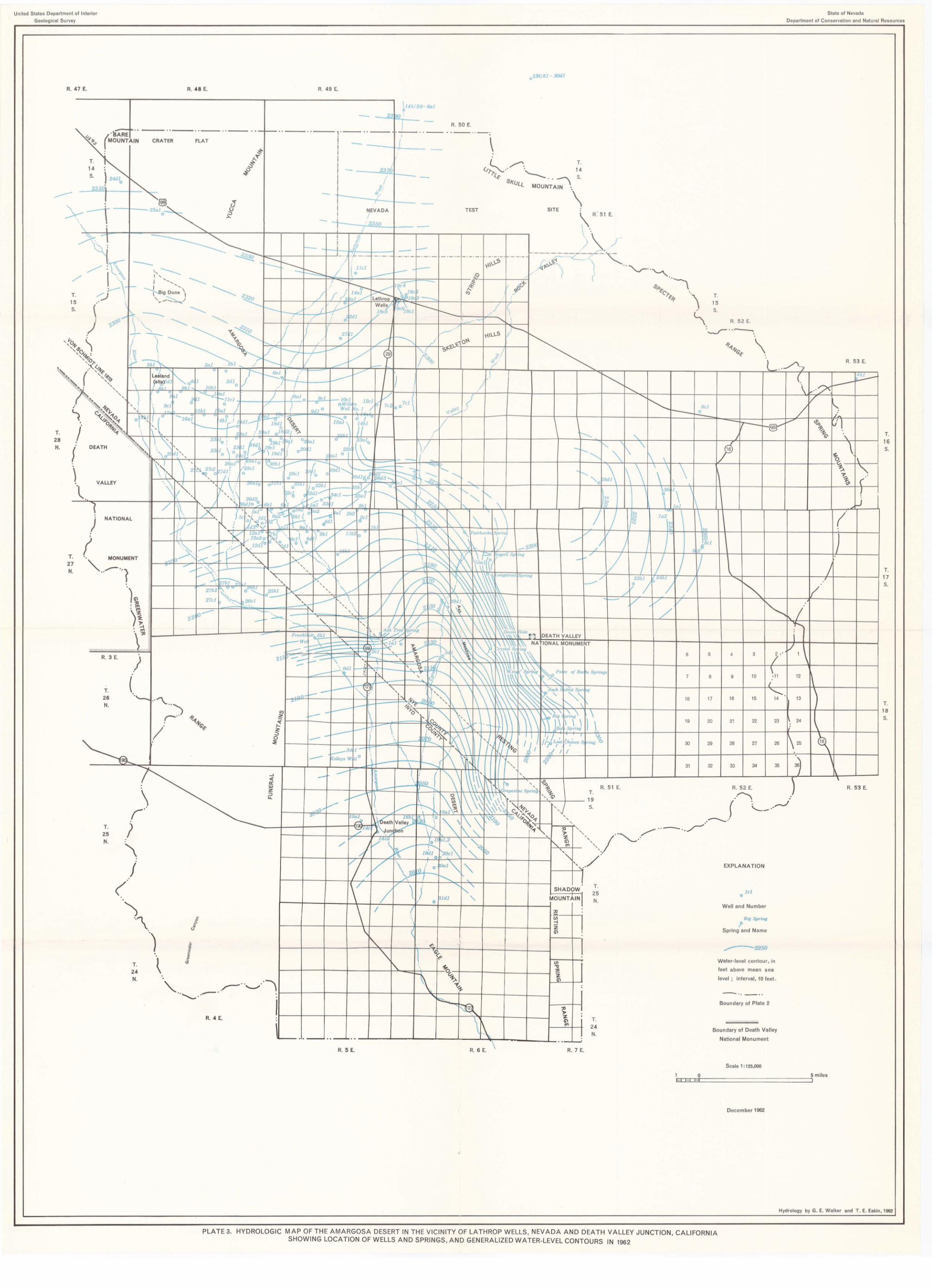
United States Department of Interior
Geological Survey
R. 47 E.
,
T. 28 N.
R, 3 E.
T, 26 N.
T. 25 N.
T.
24 N.
./
R. 48 E. R, 49 E,
- ----
R. 4 E.
R. 5 E.
-1145150- 601
23190 '
~
- ..... "",f' '\ 1\ '\ 1\ \
~r-- "0 lB~ 1\ i i \ \ ~6'\ \
1 1al :\
Bel o
I l a2 \
T, 24 N,
/
T. 15
R. 52 E.
\ 't
State of Nevada
Department of Conservation and Natural Re so urces
R, 53 E.
II
j
-w"'"
f
EXPLA NATION
leI o
Wel l and Number
Bie Spring
J Spring and Name
,----2250
Water-level conto ur, in
feet above mea n sea
level : interval , 10 feet.
- .. _ .. Boundary of Plate 2
Boun dary of Death Valley
National Monum ent
Scale 1 : 125,000
12
1\ \
/
(
! ~
T,
16
S.
T. 17 s.
1 0 5 miles EH~H~Ht=======================~1
Decem ber 1962
Hydrology by G. E. Walker and T. E. Eakin, 1962
PLATE 3. HYDROLOGIC MAP OF THE AMARGOSA DESERT IN THE VICINITY OF LATHROP WELLS, NEVADA AND DEATH VALLEY JUNCTION, CALIFORNIA SHOWING LOCATION OF WELLS AND SPRINGS, AND GENERALIZED WATER-LEVEL CONTOURS IN 1962

United States Department of Interior
Geological Survey
R. 4_7_E_. ______ ~------------R.-4-8-E.----------_r----------R-. -49-E-.--------~~,~,~'"
T 28 N
T. 15 s.
T. 27 N.
T. 14 s.
·i.
'=:, .,.
T. 26 N.
T. 25 N.
T.
24 N.
R. 5 E.
:
T. 24 N.
R. 7 E.
EXPLANA TION
' ,----" '-
Boundary of plate 2
leI o
Well and Number
Bole Spring
fl Spring and Nam e
Diagram id entification
Na - - - - - - - - CI
M9--~ ;&"---50, Ca - - - - HCO,
5 I
, o I
Scale
5 I
In equIva lents per mUllon
Pomts of diagram represent constitu ents as follows:
Na Sodium plus potassium
Mg Magnes ium
Ca Calcium
CI Chloride
50 4 Sulphate
HC03 Bicarbonate plus ca rbonate
Sc.le 1 :125,000
State of Nevada
Department of Conservation and Natural Resources
R. 53 E.
T. 16 s.
(
T.
Fluoride in parts per million
~ () 0-1.4 1.5 - 2.9
~ • 3.0-3.9 4.0-8.0
Boron in parts per million
[] 0-0.5 0.5 - 1.0
iii • 1.0 -1.5 1.5-3.0
li.IIiiiII!5Ol5Iiiiii11iO===========i~ Miles
PLATE 4. MAP OF THE AMARGOSA DESERT IN THE VICINITY OF LATHROP WELLS, NEVADA AND DEATH VALLEY JUNCTION, CALIFORNIA, SHOWING DIAGRAMS REPRESENTING CHEMICAL QUALITY FOR WATER SAMPLES COLLECTED FROM SELECTED WELLS AND SPRINGS .
December 1962
Hydrology by T. E. Eakin, 1962


