
HitchhikerHitchhiker’’s Guides GuideGlobal Position SystemGlobal Position System
Myles SutherlandMyles SutherlandCraig GreenwaldCraig Greenwald
Mike ShawMike ShawJohn RogersJohn Rogers
HitchhikerHitchhiker’’s Guides GuideGlobal Position SystemGlobal Position System
(GPS)(GPS)

Myles Sutherland Myles Sutherland -- ESRIESRICraig Greenwald Craig Greenwald –– ESRIESRIJohn Rogers John Rogers -- TrimbleTrimble
Mike Shaw Mike Shaw -- ESRIESRI

Key topics in todayKey topics in today’’s sessions session
•• Global Navigation Satellite SystemsGlobal Navigation Satellite Systems
•• GIS SolutionsGIS Solutions
•• Receiver TechnologiesReceiver Technologies
•• Data Capture Best PracticesData Capture Best Practices
•• DemonstrationsDemonstrations

Global NavigationGlobal NavigationSatellite SystemsSatellite Systems

Global Navigation Satellite SystemsGlobal Navigation Satellite Systems
•• Global Positioning SystemGlobal Positioning System
•• Differential GPS SystemsDifferential GPS Systems
•• GLONASSGLONASS
•• Galileo Positioning SystemGalileo Positioning System

Global Positioning System (GPS)Global Positioning System (GPS)
•• Unanswered question of Unanswered question of ‘‘Where am I?Where am I?’’
–– US Department of Defense projectUS Department of Defense project
–– Worldwide radioWorldwide radio--navigation systemnavigation system
–– Explosion of Civil sector adoptionExplosion of Civil sector adoption

How do these How do these ‘‘manman--made starsmade stars’’ work?work?
•• Control Segment Control Segment -- Ground stationsGround stations•• Control and position satellites in orbitControl and position satellites in orbit
•• Space segment Space segment –– SatellitesSatellites•• Broadcast radio signalBroadcast radio signal•• PRN code and orbit positionPRN code and orbit position
•• User segment User segment –– ReceiversReceivers•• Measure distance and calculate positionsMeasure distance and calculate positions

SpaceSegment
SpaceSegment
UserSegment
Control Segment
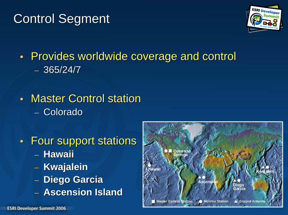
Control SegmentControl Segment
•• Provides worldwide coverage and controlProvides worldwide coverage and control–– 365/24/7365/24/7
•• Master Control stationMaster Control station–– ColoradoColorado
•• Four support stationsFour support stations–– HawaiiHawaii–– KwajaleinKwajalein–– Diego GarciaDiego Garcia–– Ascension IslandAscension Island

Space SegmentSpace Segment
•• GPS satellite constellationGPS satellite constellation–– 24 satellites24 satellites–– Replenishment occurringReplenishment occurring
• Satellite design – Lifetime 7.3 years– 16 satellites over 9 years old 28 Satellites in GPS Constellation
0
2
4
6
8
10
12
Under 3 3-4 5-6 7-8 9-10 11-12 13+
Age (Years)
Num
ber

User SegmentUser Segment
•• Equipment produced by Military and Private Equipment produced by Military and Private companiescompanies
•• Receives signal and computesReceives signal and computes–– PositionPosition–– TimeTime–– VelocityVelocity

How do we position ourselves?How do we position ourselves?
•• Simple GeometrySimple Geometry–– Velocity times travel timeVelocity times travel time
•• Determine Radio Wave Time Travel Determine Radio Wave Time Travel –– Accurate timingAccurate timing
•• Measure DistancesMeasure Distances–– Known orbit locationsKnown orbit locations
•• TrilaterationTrilateration–– Distances not anglesDistances not angles
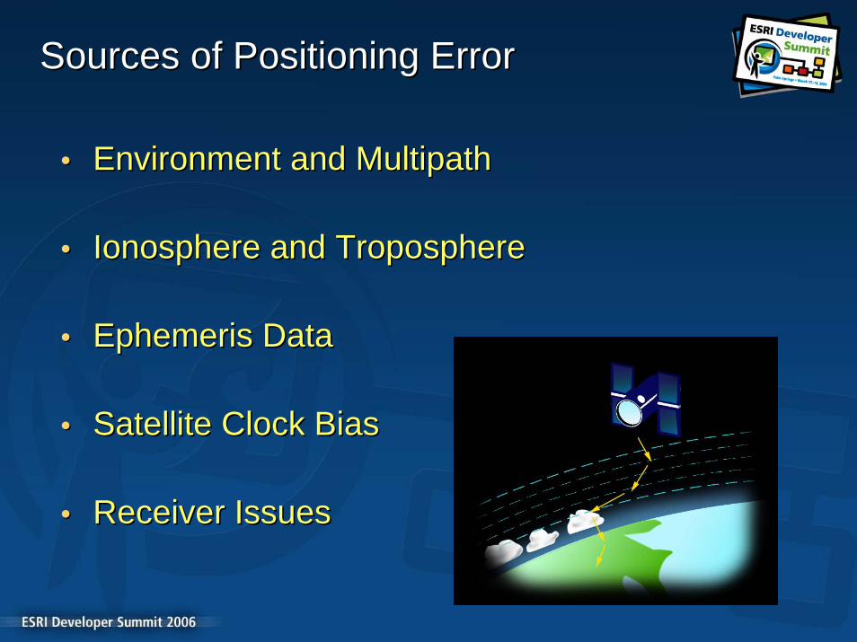
Sources of Positioning ErrorSources of Positioning Error
•• Environment and Environment and MultipathMultipath
•• Ionosphere and TroposphereIonosphere and Troposphere
•• Ephemeris DataEphemeris Data
•• Satellite Clock BiasSatellite Clock Bias
•• Receiver IssuesReceiver Issues

Differential GPSDifferential GPS
Reference station - a high performance GPS receiver placed in a fixed location whose position is accurately known.
The GPS measured position is compared sec by sec against the known position, and an error calculated.
This error is assumed to be the same error at the rover, and is sent to the rover as a ‘differential correction’.
Rover adds error to its measured position to obtain the corrected position Error data is sent to
rover with radio
Four or more satellites viewed by two receivers
Autonomous GPS = 10 metersDifferential GPS = 1 meter

Differential SystemsDifferential Systems
•• Postprocessing SystemsPostprocessing Systems–– Online File ServersOnline File Servers–– NGS CORSNGS CORS
•• Realtime SystemsRealtime Systems–– National Differential GPS ProgramNational Differential GPS Program–– SatelliteSatellite--based Augmentation Systemsbased Augmentation Systems–– TCP/IP NetworksTCP/IP Networks

NGS CORS ProgramsNGS CORS Programs

Coast Guard NDGPS ProgramCoast Guard NDGPS Program

FAA Wide Area Augmentation SystemFAA Wide Area Augmentation System

TCP/IP NetworksTCP/IP Networks
•• Virtual Reference Systems (VRS)Virtual Reference Systems (VRS)
–– Network of webNetwork of web--enabled receiversenabled receivers–– Central server processing correctionsCentral server processing corrections–– TCP/IP broadcast of correctionsTCP/IP broadcast of corrections–– Data Services over cellular networksData Services over cellular networks

Galileo Positioning SystemGalileo Positioning System
•• European Satellite Navigation SystemEuropean Satellite Navigation System–– Worldwide availabilityWorldwide availability
•• Complementary to GPSComplementary to GPS–– 27 satellites27 satellites
•• Fully operational 2008 onwardsFully operational 2008 onwards–– Free of chargeFree of charge

Advantages for Civil UsersAdvantages for Civil Users
•• Galileo + GPSGalileo + GPS
•• Double Number of SatellitesDouble Number of Satellites–– Improved Urban Canyon receptionImproved Urban Canyon reception
•• Increased Signal StrengthIncreased Signal Strength–– Improved reception under foliageImproved reception under foliage
•• Three SignalsThree Signals–– Instantaneous RTK positioningInstantaneous RTK positioning

GPS Satellite VisibilityGPS Satellite Visibility

GPS + Galileo Satellite VisibilityGPS + Galileo Satellite Visibility

GLONASSGLONASS
•• Russian Navigation SystemRussian Navigation System–– Very similar to GPSVery similar to GPS
•• In a state of disrepairIn a state of disrepair–– 11 Satellites most with lifespan of 3 years11 Satellites most with lifespan of 3 years
•• Investment plannedInvestment planned–– 24 Satellites by 201024 Satellites by 2010

GPS ProductsGPS Products

Mapping and GIS solutionsMapping and GIS solutions
•• Broad range of productsBroad range of products–– Black box receiversBlack box receivers–– Pole and Backpack receiversPole and Backpack receivers–– Integrated GPS handheldsIntegrated GPS handhelds
•• Targeted at GIS industryTargeted at GIS industry–– Moderate to High costModerate to High cost–– Designed for the fieldDesigned for the field–– Highly accurateHighly accurate

Black box receiversBlack box receivers
•• ProductsProducts•• Trimble ProXHTrimble ProXH•• Trimble ProXTTrimble ProXT
•• AccuracyAccuracy•• SubfootSubfoot to to SubmeterSubmeter•• Filter Filter multipathedmultipathed and weak signalsand weak signals•• Ensures quality positionsEnsures quality positions
•• Ruggedness and ReliabilityRuggedness and Reliability•• IP54 plusIP54 plus•• All day batteriesAll day batteries
•• GIS useGIS use--casecase•• Critical layersCritical layers•• Data collection and maintenanceData collection and maintenance•• Long term deployment strategyLong term deployment strategy

Pole and backpack receiversPole and backpack receivers
•• ProductsProducts•• Trimble ProXTTrimble ProXT•• Trimble ProXHTrimble ProXH•• Trimble Trimble ProXRSProXRS•• Topcon GMS 110Topcon GMS 110•• Sokkia Axis3Sokkia Axis3
•• AccuracyAccuracy•• SubfootSubfoot to to SubmeterSubmeter•• Filter Filter multipathedmultipathed and weak signalsand weak signals•• Ensures quality positionsEnsures quality positions
•• Ruggedness and ReliabilityRuggedness and Reliability•• IP54 plusIP54 plus•• All day batteriesAll day batteries
•• GIS useGIS use--casecase•• Critical layersCritical layers•• Data collection and maintenanceData collection and maintenance•• Long term deployment strategyLong term deployment strategy

Integrated GPS HandheldsIntegrated GPS Handhelds
•• ProductsProducts•• Trimble GeoXHTrimble GeoXH•• Trimble GeoXTTrimble GeoXT•• Trimble ReconGPSTrimble ReconGPS
•• AccuracyAccuracy•• SubfootSubfoot to to SubmeterSubmeter•• Filter Filter multipathedmultipathed and weak signalsand weak signals•• Ensures quality positionsEnsures quality positions
•• Ruggedness and ReliabilityRuggedness and Reliability•• IP54 plusIP54 plus•• All day batteriesAll day batteries
•• Operating SystemOperating System•• Windows Mobile 2005Windows Mobile 2005
•• Data StorageData Storage•• OnboardOnboard•• AddAdd--inin
•• GIS useGIS use--casecase•• Critical layersCritical layers•• Data collection and maintenanceData collection and maintenance•• Long term deployment strategyLong term deployment strategy

InIn--car navigation solutionscar navigation solutions
•• Expanding range of productsExpanding range of products–– Black box receiversBlack box receivers–– Integrated GPS handheldsIntegrated GPS handhelds
•• Targeted at inTargeted at in--car navigation marketcar navigation market–– Very inexpensiveVery inexpensive–– Designed for the carDesigned for the car

Black box receiversBlack box receivers
•• Products Products •• Holux GPSlim236Holux GPSlim236•• Garmin GPS10 Garmin GPS10 •• Many othersMany others……
•• AccuracyAccuracy•• Five to twenty metersFive to twenty meters•• Highly smoothed when in dynamic modeHighly smoothed when in dynamic mode•• Repeatedly reports same position when staticRepeatedly reports same position when static
•• Ruggedness and ReliabilityRuggedness and Reliability•• NonNon--existentexistent
•• GIS useGIS use--casecase•• NonNon--critical layer data collectioncritical layer data collection•• Inspection and incident reporting applicationsInspection and incident reporting applications•• Throw away deployment strategyThrow away deployment strategy

Integrated GPS handheldsIntegrated GPS handhelds
•• ProductsProducts•• Garmin iQueGarmin iQue•• MitacMitac Mio168Mio168•• Pharos Pharos TravellerTraveller GPS 525GPS 525•• Holux GPSmile60Holux GPSmile60
•• AccuracyAccuracy•• Five to twenty metersFive to twenty meters•• Highly smoothed when in dynamic modeHighly smoothed when in dynamic mode•• Repeatedly reports same position when staticRepeatedly reports same position when static
•• Ruggedness and ReliabilityRuggedness and Reliability•• NonNon--existentexistent
•• Operating SystemOperating System•• Windows Mobile 2003Windows Mobile 2003
•• Data StorageData Storage•• OnboardOnboard•• AddAdd--inin
•• GIS useGIS use--casecase•• NonNon--critical layer data collectioncritical layer data collection•• Inspection and incident reporting applicationsInspection and incident reporting applications•• Throw away deployment strategyThrow away deployment strategy

Receiver TechnologiesReceiver Technologies

Positioning EnginesPositioning Engines
•• Calculate and report positionsCalculate and report positions•• EndEnd--use determines how positions calculateduse determines how positions calculated
•• LowLow--end Navigation productsend Navigation products•• Smoothing of positions in a dynamic modeSmoothing of positions in a dynamic mode•• Filtering of positions in static modeFiltering of positions in static mode•• Precise data!!!Precise data!!!
•• HighHigh--end Mapping and GIS productsend Mapping and GIS products•• Filtering of Filtering of multipathmultipath signalssignals•• Filtering of weak signals (SNR)Filtering of weak signals (SNR)•• Accurate data!!!Accurate data!!!
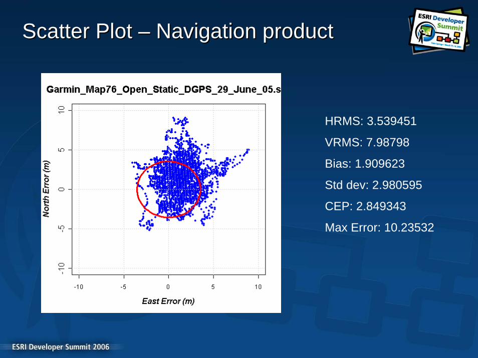
Scatter Plot Scatter Plot –– Navigation productNavigation product
HRMS: 3.539451
VRMS: 7.98798
Bias: 1.909623
Std dev: 2.980595
CEP: 2.849343
Max Error: 10.23532

Scatter Plot Scatter Plot –– Mapping and GIS productMapping and GIS product
HRMS: 0.5752918VRMS: 1.051026Bias: 0.1992346Std dev: 0.5397464CEP: 0.390636Max Error: 2.087676
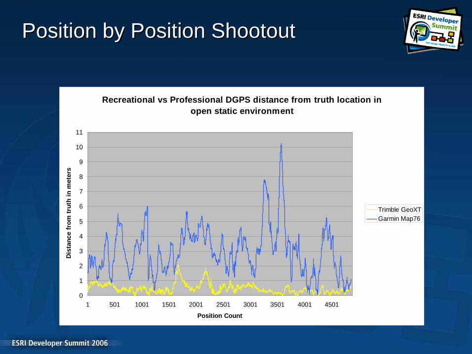
Position by Position ShootoutPosition by Position Shootout
Recreational vs Professional DGPS distance from truth location in open static environment
0
1
2
3
4
5
6
7
8
9
10
11
1 501 1001 1501 2001 2501 3001 3501 4001 4501
Position Count
Dis
tanc
e fr
om tr
uth
in m
eter
s
Trimble GeoXTGarmin Map76

Best PracticesBest Practices
Accuracy Accuracy vsvs PrecisionPrecision
•• AccuracyAccuracy–– Measurement vs. Known TruthMeasurement vs. Known Truth–– Strong dependency on environmentStrong dependency on environment
•• PrecisionPrecision–– Relative accuracyRelative accuracy–– Consistency of dataConsistency of data

Environment is a very big dealEnvironment is a very big deal
Both in accuracy...Both in accuracy...……and how accuracy improves with occupation timeand how accuracy improves with occupation time
Accuracy vs Occupation Time
0
0.5
1
1.5
2
2.5
10 40 70 100
130
160
190
220
250
280
Occupation Time (s)
RM
S Er
ror (
m)
RMS Error (Open)RMS Error (Canopy)

How is Accuracy Related to Yield?How is Accuracy Related to Yield?
•• Yield = actual positions / potential positionsYield = actual positions / potential positions
•• In poor environment you must chooseIn poor environment you must choose–– Precision / Accuracy and YieldPrecision / Accuracy and Yield
•• If you filter out lower quality positionsIf you filter out lower quality positions–– Accuracy improvesAccuracy improves–– Yield declinesYield declines
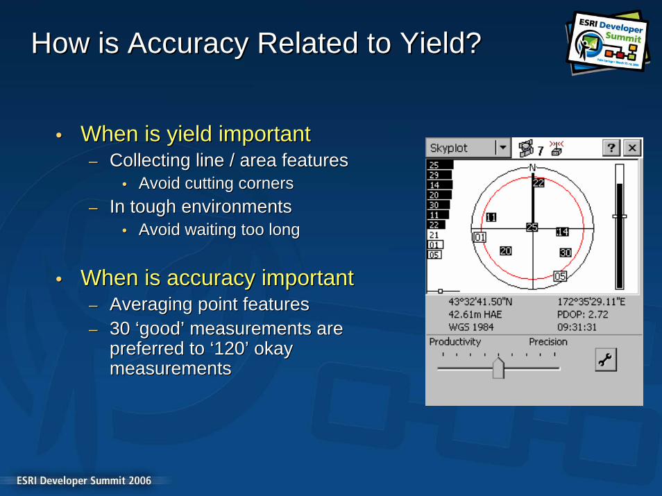
How is Accuracy Related to Yield?How is Accuracy Related to Yield?
•• When is yield importantWhen is yield important–– Collecting line / area featuresCollecting line / area features
•• Avoid cutting cornersAvoid cutting corners–– In tough environmentsIn tough environments
•• Avoid waiting too longAvoid waiting too long
•• When is accuracy importantWhen is accuracy important–– Averaging point featuresAveraging point features–– 30 30 ‘‘goodgood’’ measurements are measurements are
preferred to preferred to ‘‘120120’’ okay okay measurementsmeasurements

Is DOP an error source ? Is DOP an error source ?
•• Dilution of Precision is a metric for accessing satellite consteDilution of Precision is a metric for accessing satellite constellationllation
•• DOP is not an error source DOP is not an error source -- it is an error multiplier !!!it is an error multiplier !!!
•• Poor DOP equals decreased accuracyPoor DOP equals decreased accuracy
Accuracy vs PDOP
0123456789
0 5 10 15
PDOP
RM
S E
rror
(m)
RMS Error (Open)RMS Error(Canopy)

An Accuracy An Accuracy vsvs Yield tipYield tip
•• Use PDOP mask of 6 for 3DUse PDOP mask of 6 for 3D
•• Use HDOP mask 4 for 2D Use HDOP mask 4 for 2D –– If you donIf you don’’t care about height precision t care about height precision –– Gives better yield for similar horizontal precisionGives better yield for similar horizontal precision
•• PDOPPDOP2 2 = HDOP= HDOP2 2 + VDOP+ VDOP22
0.0%
10.0%
20.0%
30.0%
40.0%
50.0%
60.0%
70.0%
80.0%
90.0%
100.0%
PDOP yield HDOP yield
PDOP precision HDOP precision

DemonstrationsDemonstrations
ArcPadArcPad
ArcGIS GPS Analyst ExtensionArcGIS GPS Analyst Extension
ArcGIS Server Mobile ADFArcGIS Server Mobile ADF

ArcPad: Where is GPS used?ArcPad: Where is GPS used?
•• GPS support is ubiquitousGPS support is ubiquitous•• Navigation to a locationNavigation to a location
–– How far am I from my target?How far am I from my target?–– What direction do I travel to reach my What direction do I travel to reach my
destination?destination?•• TracklogTracklog
–– Where have I been?Where have I been?•• Data capture/maintenanceData capture/maintenance
–– Capture a new feature using the GPS Capture a new feature using the GPS locationlocation
–– Update an existing feature/vertex to Update an existing feature/vertex to the GPS locationthe GPS location
–– Averaging, streaming, offsetsAveraging, streaming, offsets
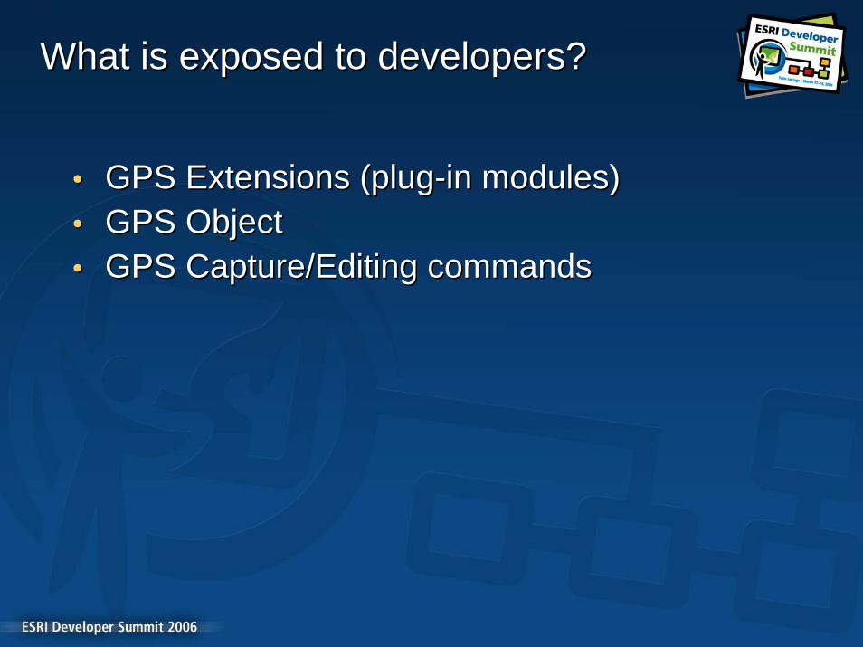
What is exposed to developers?What is exposed to developers?
•• GPS Extensions (plugGPS Extensions (plug--in modules)in modules)•• GPS ObjectGPS Object•• GPS Capture/Editing commandsGPS Capture/Editing commands

GPS ExtensionsGPS Extensions
•• Written in C/C++, compiled as Written in C/C++, compiled as DLLsDLLs
•• Support additional GPS ProtocolsSupport additional GPS Protocols–– Control the GPS port or let ArcPad Control the GPS port or let ArcPad
manage itmanage it–– Log raw data for post processing Log raw data for post processing
(DGPS) (DGPS) –– GPScorrectGPScorrect is an exampleis an example
•• Support additional NMEA Support additional NMEA sentencessentences
•• Several complete examples Several complete examples included with ArcPad Application included with ArcPad Application BuilderBuilder–– SONY IPS1000, SONY IPS3000, SONY IPS1000, SONY IPS3000,
NMEANMEA--0182, STF0182, STF
ArcPadGPSOpen(…
GPSParse(…
GPSClose(…
Extension DLLHGPS GPSOpen(…
LRESULT GPSParse(…
LRESULT GPSClose(…

GPS ObjectGPS Object
•• Exposed to scripts (VBS / Exposed to scripts (VBS / JS)JS)
•• Fires events as GPS status Fires events as GPS status changeschanges
•• Reports position and quality Reports position and quality statusstatus
•• Two way communication Two way communication with GPS receiverswith GPS receivers
•• Activation and deactivationActivation and deactivation•• Access to NMEA sentences Access to NMEA sentences
as they arriveas they arrive

GPS CommandsGPS Commands
•• GPS PointGPS Point•• GPS VertexGPS Vertex•• GPS Streaming VerticesGPS Streaming Vertices•• Select at GPS locationSelect at GPS location•• Activate / Deactivate GPSActivate / Deactivate GPS•• Center map on GPS locationCenter map on GPS location

DEMODEMO
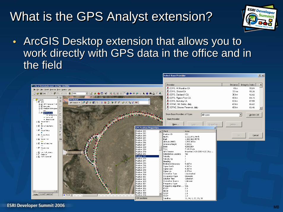
•• ArcGIS Desktop extension that allows you to ArcGIS Desktop extension that allows you to work directly with GPS data in the office and in work directly with GPS data in the office and in the fieldthe field
What is the GPS Analyst extension?What is What is the GPS Analyst extensionthe GPS Analyst extension??
MB

GPS Analyst Key FeaturesGPS Analyst Key Features
•• View, edit, and analyze GPS data inside ArcMap and View, edit, and analyze GPS data inside ArcMap and ArcCatalogArcCatalog
•• Improve productivity by eliminating extra file conversions Improve productivity by eliminating extra file conversions and processing steps outside ArcGISand processing steps outside ArcGIS
•• Improve GPS position accuracy by differentially correcting Improve GPS position accuracy by differentially correcting data from supported Trimbledata from supported Trimble®® GPS receiversGPS receivers
•• Store detailed quality information for GPS dataStore detailed quality information for GPS data
•• Set up and run validation on GPS positions to ensure Set up and run validation on GPS positions to ensure features meet the required accuracyfeatures meet the required accuracy
GPS Analyst Key FeaturesGPS Analyst Key Features
•• Collect features and GPS data directly into the Collect features and GPS data directly into the geodatabase with Trimble or NMEA receiversgeodatabase with Trimble or NMEA receivers
•• Built with Built with ArcObjectsArcObjects and GPS Analyst Objectsand GPS Analyst Objects–– customize GPS Analyst workflows and data processingcustomize GPS Analyst workflows and data processing–– develop extensions to support other GPS receiversdevelop extensions to support other GPS receivers–– develop field data collection UI to meet your needsdevelop field data collection UI to meet your needs

GPS Analyst DemoGPS Analyst Demo
BuiltBuilt--in vs. Customin vs. CustomField Data CollectionField Data Collection

Mobile ADFMobile ADF
•• Server TechnologyServer Technology–– Mobile and Desktop ClientsMobile and Desktop Clients
•• Released with ArcGIS 9.2Released with ArcGIS 9.2•• Developer KitDeveloper Kit
–– ComponentsComponents–– Object ClassesObject Classes–– SamplesSamples
•• Easy to UseEasy to Use–– Drag and DropDrag and Drop
•• SmartClientSmartClient–– Occasionally ConnectedOccasionally Connected

Mobile ADFMobile ADF
•• Pairs input from GPS receiver with a Serial Pairs input from GPS receiver with a Serial PortPort
•• Supports the NMEA standardSupports the NMEA standard•• GpsDisplayGpsDisplay buddies with the Mapbuddies with the Map
–– Current Location based on Current Location based on PdopPdop–– Number of Satellites being TrackedNumber of Satellites being Tracked–– Trail and LengthTrail and Length
•• ComponentsComponents–– FileGpsConnectionFileGpsConnection–– SerialPortGpsConnectionSerialPortGpsConnection

Mobile ADF Mobile ADF GPS DemoGPS Demo

Session Evaluations ReminderSession Evaluations Reminder
Session Attendees:Session Attendees:Please turn in your session evaluations.Please turn in your session evaluations.
. . . Thank you. . . Thank you


