2011
Nunatta Katersugaasivia
Allagaateqarfialu (NKA) –
Greenland National
Museum & Archives
Mikkel Myrup, curator
[ILUA VALLEY, NUNASARNAQ
AND KUANNERSUIT
ARCHAEOLOGY – A SURVEY] Report on archaeological survey conducted by the NKA August 2011 in the Ilua Valley, the
Nunasarnaq peninsula and the Kuannersuit mining site on the Narsaq peninsula in relation to the
Kuannersuit/Kvanefjeld multi element mining project by Greenland Minerals and Energy Ltd. The
survey was conducted on behalf of ORBICON A/S as part of their preparation of an Environmental
Impact Assessment report.
Ilua valley, Nunasarnaq and Kuannersuit archaeology – a survey
1
Executive summary
The 2011 survey of the Ilua valley, the Nunasarnaq peninsula and the Kuannersuit mining
site is a continuation of the survey conducted on the Narsaq peninsula by the NKA in 2010.
In a cultural historical context the findings of the 2011 survey generally corresponds with
those made in 2010, except for the wreck of a WWII light bomber in the Ilua valley and the
ostensible absence of prehistoric Inuit remains. The open pit mining area did not reveal any
physical remains of former or contemporary land use, except for the installations put there
in relation to exploration activities.
As for the potential conflicts between cultural heritage and mining project infrastructure,
the conclusion of the 2011 survey is identical with the 2010 survey’s ditto. Detailed
infrastructure description has not yet been made available to the NKA, leaving it pointless at
this stage to assess the scope of archaeological excavations necessary should the
construction phase of the proposed mining project be initiated. It is evident though that the
potential excavations of the Norse farms and the Inuit longhouses implies projects which
are relatively labour intensive and time consuming.
Ilua valley, Nunasarnaq and Kuannersuit archaeology – a survey
2
Introduction
The NKA conducted an archaeological survey in the Narsaq area in 2010 (see 2010 report).
However, it was decided by the project holders to extend the 2010 survey area including the
Ilua valley and the Nunasarnaq peninsula. This report is thus to be considered an addendum
to the 2010 report and therefore aspects concerning the survey area’s general cultural
historical context can be found in the 2010 report and will not be further elucidated here.
The 2011 survey was conducted by Bo Albrechtsen and Mikkel Myrup (author), both
curators at the Greenland National Museum & Archives (NKA), in the period August 11 to
August 18, 2011. The NKA team also conducted a survey of the proposed open pit mining
area.
The NKA survey team was airlifted to the central part of the Ilua valley and here a base
camp was established. The valley was surveyed by foot and for the coastal survey of the
Nunasarnaq peninsula the team was assisted by a chartered boat. The proposed
Kuannersuit mining site was reached by helicopter and surveyed by foot.
The survey of the Ilua valley and Nunasarnaq peninsula revealed a number of archaeological
structures which had not previously been recorded.
Ilua valley, Nunasarnaq and Kuannersuit archaeology – a survey
3
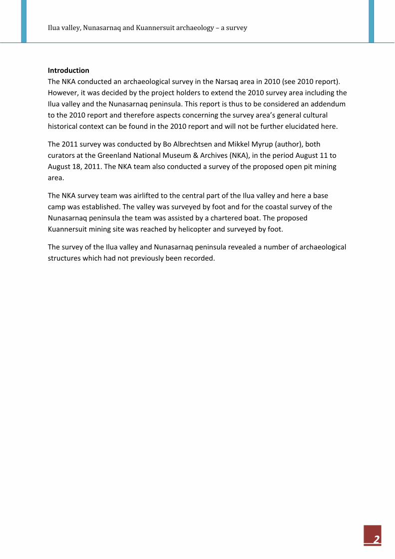
Figure 1. The 2011 archaeological survey was done in the area marked with violet. (Map by ORBICON)
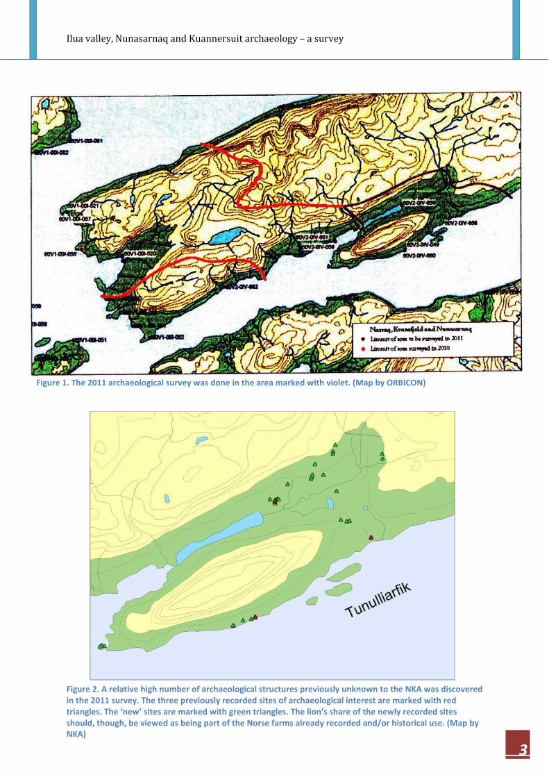
Figure 2. A relative high number of archaeological structures previously unknown to the NKA was discovered
in the 2011 survey. The three previously recorded sites of archaeological interest are marked with red
triangles. The ‘new’ sites are marked with green triangles. The lion’s share of the newly recorded sites
should, though, be viewed as being part of the Norse farms already recorded and/or historical use. (Map by
NKA)
Ilua valley, Nunasarnaq and Kuannersuit archaeology – a survey
4
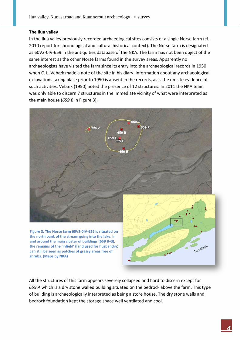
The Ilua valley
In the Ilua valley previously recorded archaeological sites consists of a single Norse farm (cf.
2010 report for chronological and cultural historical context). The Norse farm is designated
as 60V2-0IV-659 in the antiquities database of the NKA. The farm has not been object of the
same interest as the other Norse farms found in the survey areas. Apparently no
archaeologists have visited the farm since its entry into the archaeological records in 1950
when C. L. Vebæk made a note of the site in his diary. Information about any archaeological
excavations taking place prior to 1950 is absent in the records, as is the on-site evidence of
such activities. Vebæk (1950) noted the presence of 12 structures. In 2011 the NKA team
was only able to discern 7 structures in the immediate vicinity of what were interpreted as
the main house (659 B in Figure 3).
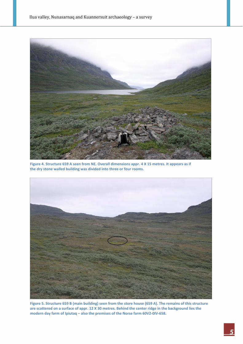
All the structures of this farm appears severely collapsed and hard to discern except for
659 A which is a dry stone walled building situated on the bedrock above the farm. This type
of building is archaeologically interpreted as being a store house. The dry stone walls and
bedrock foundation kept the storage space well ventilated and cool.
Figure 3. The Norse farm 60V2-0IV-659 is situated on
the north bank of the stream going into the lake. In
and around the main cluster of buildings (659 B-G),
the remains of the ‘infield’ (land used for husbandry)
can still be seen as patches of grassy areas free of
shrubs. (Maps by NKA)
Ilua valley, Nunasarnaq and Kuannersuit archaeology – a survey
5
Figure 4. Structure 659 A seen from NE. Overall dimensions appr. 4 X 15 metres. It appears as if
the dry stone walled building was divided into three or four rooms.
Figure 5. Structure 659 B (main building) seen from the store house (659 A). The remains of this structure
are scattered on a surface of appr. 12 X 30 metres. Behind the center ridge in the background lies the
modern day farm of Ipiutaq – also the premises of the Norse farm 60V2-0IV-658.

Ilua valley, Nunasarnaq and Kuannersuit archaeology – a survey
6
The Ilua valley is geographically situated on a natural route when travelling on foot or on
horseback between the Narsaq area, on the western tip of the Narsaq peninsula, and the
inner parts of the Tunulliarfik fjord where one find the hamlet of Qassiarsuk. This modern
day center of the area’s agricultural activities is believed to be the Norse Brattahlið, where
the renowned Eric the Red and his entourage settled around A.D. 1000 (cf., 2010 report).
The Ilua valley Norse farm 60V2-0IV-659 lies wedged in between the farms of Tunuamiut,
60V2-0IV-661 (cf., 2010 report) 5 kilometres to the WSW, and Ipiutaq, 60V2-0IV-658, 3
kilometres to the ESE.
The ‘new’ structures found in the valley is comprised by two main types. Fox traps and
cairns. The latter seems to, in some cases, have been modified and also used as a shelter or
cache. The architecture of the fox traps found in the valley corresponds rather well with the
design of fox traps found in the inner Nuuk fjord complex, also known as the Western
Settlement of the Norse (cf., 2010 report). No systematic investigation on this subject has
been made in a Greenlandic context as far as this author is informed. Consequently, one
cannot with certainty rule out the possibility of these structures being part of the Norse
economy in the valley. Most of the traps and cairns have been constructed on the north hill
side of the Ilua valley. All these structures will appear in list form in an appendix, examples
are shown in the following.
Figure 6. Fox trap from the Ilua valley.
Ilua valley, Nunasarnaq and Kuannersuit archaeology – a survey
7
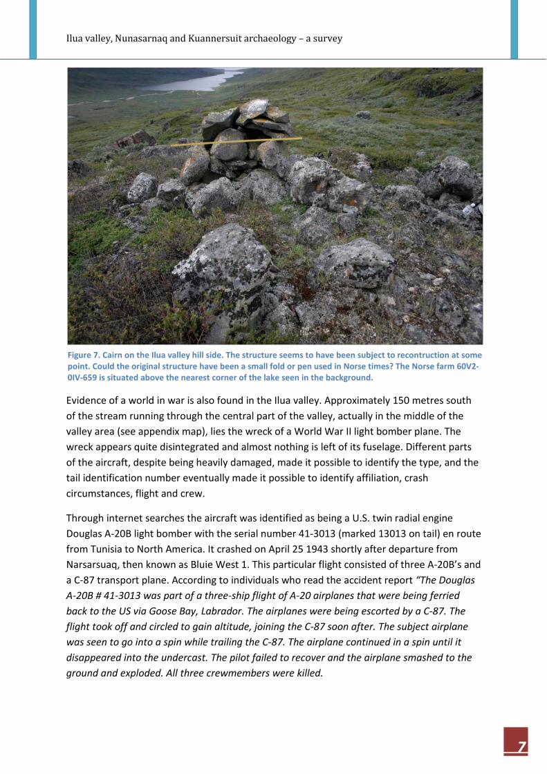
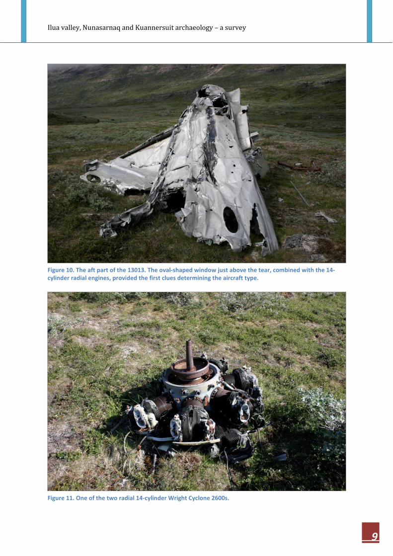
Evidence of a world in war is also found in the Ilua valley. Approximately 150 metres south
of the stream running through the central part of the valley, actually in the middle of the
valley area (see appendix map), lies the wreck of a World War II light bomber plane. The
wreck appears quite disintegrated and almost nothing is left of its fuselage. Different parts
of the aircraft, despite being heavily damaged, made it possible to identify the type, and the
tail identification number eventually made it possible to identify affiliation, crash
circumstances, flight and crew.
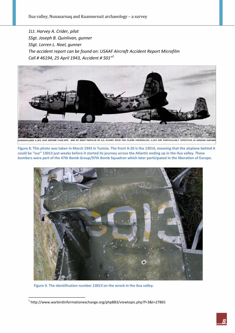
Through internet searches the aircraft was identified as being a U.S. twin radial engine
Douglas A-20B light bomber with the serial number 41-3013 (marked 13013 on tail) en route
from Tunisia to North America. It crashed on April 25 1943 shortly after departure from
Narsarsuaq, then known as Bluie West 1. This particular flight consisted of three A-20B’s and
a C-87 transport plane. According to individuals who read the accident report “The Douglas
A-20B # 41-3013 was part of a three-ship flight of A-20 airplanes that were being ferried
back to the US via Goose Bay, Labrador. The airplanes were being escorted by a C-87. The
flight took off and circled to gain altitude, joining the C-87 soon after. The subject airplane
was seen to go into a spin while trailing the C-87. The airplane continued in a spin until it
disappeared into the undercast. The pilot failed to recover and the airplane smashed to the
ground and exploded. All three crewmembers were killed.
Figure 7. Cairn on the Ilua valley hill side. The structure seems to have been subject to recontruction at some
point. Could the original structure have been a small fold or pen used in Norse times? The Norse farm 60V2-
0IV-659 is situated above the nearest corner of the lake seen in the background.
Ilua valley, Nunasarnaq and Kuannersuit archaeology – a survey
8
1Lt. Harvey A. Crider, pilot
SSgt. Joseph B. Quinlivan, gunner
SSgt. Lorren L. Noel, gunner
The accident report can be found on: USAAF Aircraft Accident Report Microfilm
Call # 46194, 25 April 1943, Accident # 501”1
1 http://www.warbirdinformationexchange.org/phpBB3/viewtopic.php?f=3&t=27865
Figure 8. This photo was taken in March 1943 in Tunisia. The front A-20 is the 13014, meaning that the airplane behind it
could be “our” 13013 just weeks before it started its journey across the Atlantic ending up in the Ilua valley. These
bombers were part of the 47th Bomb Group/97th Bomb Squadron which later participated in the liberation of Europe.
Figure 9. The identification number 13013 on the wreck in the Ilua valley.
Ilua valley, Nunasarnaq and Kuannersuit archaeology – a survey
9
Figure 10. The aft part of the 13013. The oval-shaped window just above the tear, combined with the 14-
cylinder radial engines, provided the first clues determining the aircraft type.
Figure 11. One of the two radial 14-cylinder Wright Cyclone 2600s.

Ilua valley, Nunasarnaq and Kuannersuit archaeology – a survey
10
The Nunasarnaq peninsula
There are two known Norse farms on what is described as the Nunasarnaq peninsula here.
60V2-0IV-658, Ipiutaq, also the premises of a modern sheep farm run by the couple Kalistat
Poulsen and Agathe Devisme and 60V2-0IV-660 situated on the south shore of the peninsula
approximately 3,5 kilometres west of Ipiutaq. The latter location is also designated as 60V2-
0IV-049 because of the Inuit longhouses and graves found here.
60V2-0IV-658
The Ipiutaq Norse farm is, as mentioned, also the location of a modern sheep farm. This has
resulted in a rough treatment of the Norse ruins. After decades of modern farming several
of the ruins of the original farm can no longer be identified without conducting a thourough
archaeological investigation including digging test pits etc. In 1970 the farm’s Norse remains
were sketched out by the Danish archaeologist Sven Erik Albrethsen. The farm was revisited
by archaeologists in 1993 and 2009 and here several of the structures were undiscernible.
60V2-0IV-070
An Inuit presence at Ipiutaq is manifested through graves built in the Norse ruins and
remains of a longhouse. The NKA did not make any new recordings of these in 2011.
Figure 12. Ipiutaq 60V2-0IV-658. Sketch by archaeologist Sven Erik
Albrethsen 1970. The Norse farm structures are depicted in black.

Ilua valley, Nunasarnaq and Kuannersuit archaeology – a survey
11
60V2-0IV-049 and 60V2-660
Following the coast line from Ipiutaq a few kilometres west will lead one to the Norse and
Inuit site of Saneraa. It has two designations, a Norse, 60V2-0IV-660, and an Inuit, 60V2-0IV-
049. The location has been known for long, but has not spurred any further interest from
archaeologists. One reason for this can be that the Inuit longhouses apparently have been
constructed partly on top of and partly by material deriving from the Norse structure(s).
60V2-0IV-078
About 120 metres further out by
the coast, two large Inuit slab built
graves are found. It is not possible
to see inside the graves, hence the
number of individuals in each
grave is unknown. Large graves are
common in the vicinity of the
settlements and especially so in
the Narsap Ikerasaa area.
Figure 13. Saneraa, 60V2-0IV-049 (structures A+B) and 60V2-0IV-660 (area C+structure D). The longhouses
are appr. 7 X 4 metres, with an almost 7 metre-entrance (house A) and 11 X 4 metres, with a 5 metre-
entrance (B). Apparently house A was shortened from an appr. width of 12 metres at some point in time.
Area C contains the collapsed remains of the Norse structure. The structure is very diffuse and hardly
discernible. Appr. 10 metres to the NE the remains of a wall was found.
Figure 14. The two graves, 60V2-0IV-078, are situated directly by the
fjord on a bedrock protrusion. The graves have an appr. overall
extension of 8 X 4 metres.
Ilua valley, Nunasarnaq and Kuannersuit archaeology – a survey
12
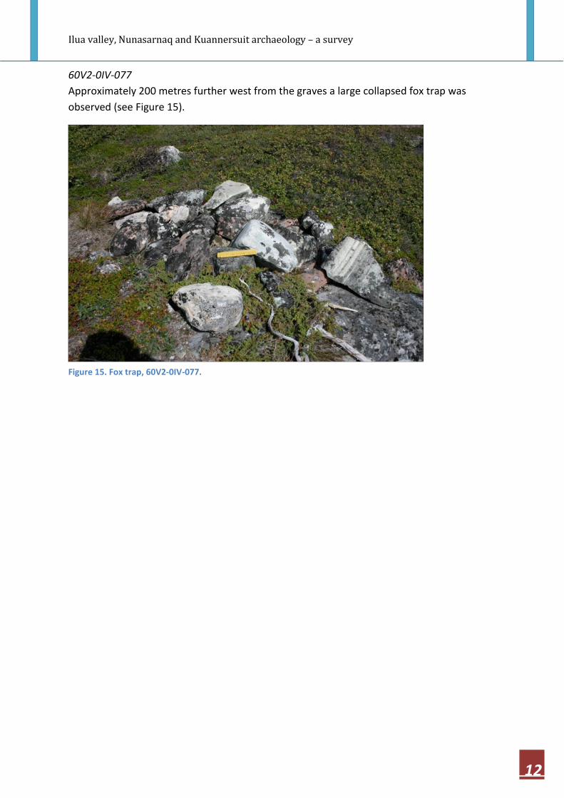
60V2-0IV-077
Approximately 200 metres further west from the graves a large collapsed fox trap was
observed (see Figure 15).
Figure 15. Fox trap, 60V2-0IV-077.

Ilua valley, Nunasarnaq and Kuannersuit archaeology – a survey
13
60V2-0IV-670
Still following the coast line, about 250 metres further to the west, two structures that were
interpreted as being of Norse origin were found. The structures does not resemble any Inuit
structures found in this area. They have been designated as 60V2-0IV-670.
Figure 16. 60V2-0IV-670. Structure A is interpreted as being of Norse origin. It is situated against the bedrock
wall and is constructed of relatively large stones. The proximity to the Saneraa farm could suggest that it
functioned as an animal pen. Dimensions appr. 3 X 4 metres.
Figure 16. 60V2-0IV-670. Structure B, appr. 2 X 3 metres appears to have been floored with stones.
Ilua valley, Nunasarnaq and Kuannersuit archaeology – a survey
14
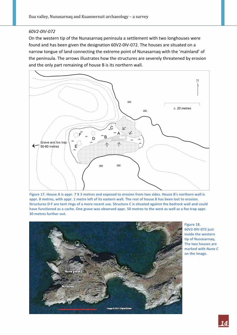
60V2-0IV-072
On the western tip of the Nunasarnaq peninsula a settlement with two longhouses were
found and has been given the designation 60V2-0IV-072. The houses are situated on a
narrow tongue of land connecting the extreme point of Nunasarnaq with the ‘mainland’ of
the peninsula. The arrows illustrates how the structures are severely threatened by erosion
and the only part remaining of house B is its northern wall.
Figure 17. House A is appr. 7 X 3 metres and exposed to erosion from two sides. House B's northern wall is
appr. 8 metres, with appr. 1 metre left of its eastern wall. The rest of house B has been lost to erosion.
Structures D-F are tent rings of a more recent use. Structure C is situated against the bedrock wall and could
have functioned as a cache. One grave was observed appr. 50 metres to the west as well as a fox trap appr.
30 metres further out.
Figure 18.
60V2-0IV-072 just
inside the western
tip of Nunasarnaq.
The two houses are
marked with Nuna C
on the image.

Ilua valley, Nunasarnaq and Kuannersuit archaeology – a survey
15
Kuannersuit
The NKA team was during its stay in Narsaq given the possibility to visit the proposed mining
site at the Kuannersuit plateau to assess the presence of archaeological structures here. The
proximity of the Narsap Ilua/Dyrnes and Narsaq Norse farms certainly presented a
possibility that the Kuannersuit and adjacent mountains were used as summer mountain
pastures.The survey of the Kuannersuit proposed mining site revealed no physical remains
suggesting any kind of former land use.
Figure 19. View from Kuannersuit towards the peaks of Talut and Qaqqarsuaq. Narsaq town is
covered by a low layer of clouds.
Figure 20. View towards the Ilimmaasaq peak.
Ilua valley, Nunasarnaq and Kuannersuit archaeology – a survey
16
Epilogue
The 2010 and 2011 archaeological surveys on the Narsaq peninsula have demonstrated that
this area’s cultural history spans over approximately four millennia of human habitation –
from Stone Age to Aluminium Age. From the Palaeoinuit evidence of stone implement
maintenance at the Nuummiut site to the aluminium built A-20B bomber from WWII in the
Ilua valley.
The surveys have resulted in a widening of our knowledge of this specific area’s cultural
history as well as were we can find the physical remains representing it. They have provided
us with a knowledge which will be important in a probable future assessment of the scope
of archaeological efforts that will be necessary to initiate if the multi element mining project
in the Narsaq area is launched.

Ilua valley, Nunasarnaq and Kuannersuit archaeology – a survey
17


