
Project Work Report, Lasmini : Malang Municipality, Indonesia 1
PROJECT WORK
IMPROVING SUSTAINABLE TRANSPORTATION
IN THE SUBURB
WITH CONSIDERING RESIDENTS PREFERENCE
Lasmini Ambarwati Brawijaya University, Malang, Indonesia
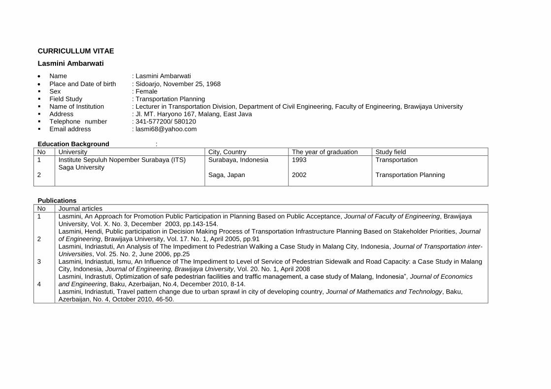
CURRICULLUM VITAE
Lasmini Ambarwati
Name : Lasmini Ambarwati
Place and Date of birth : Sidoarjo, November 25, 1968 Sex : Female Field Study : Transportation Planning Name of Institution : Lecturer in Transportation Division, Department of Civil Engineering, Faculty of Engineering, Brawijaya University Address : Jl. MT. Haryono 167, Malang, East Java Telephone number : 341-577200/ 580120 Email address : [email protected] Education Background :
No University City, Country The year of graduation Study field
1 2
Institute Sepuluh Nopember Surabaya (ITS) Saga University
Surabaya, Indonesia Saga, Japan
1993 2002
Transportation Transportation Planning
Publications
No Journal articles
1 2 3 4
Lasmini, An Approach for Promotion Public Participation in Planning Based on Public Acceptance, Journal of Faculty of Engineering, Brawijaya University, Vol. X. No. 3, December 2003, pp.143-154. Lasmini, Hendi, Public participation in Decision Making Process of Transportation Infrastructure Planning Based on Stakeholder Priorities, Journal of Engineering, Brawijaya University, Vol. 17. No. 1, April 2005, pp.91 Lasmini, Indriastuti, An Analysis of The Impediment to Pedestrian Walking a Case Study in Malang City, Indonesia, Journal of Transportation inter-Universities, Vol. 25. No. 2, June 2006, pp.25 Lasmini, Indriastuti, Ismu, An Influence of The Impediment to Level of Service of Pedestrian Sidewalk and Road Capacity: a Case Study in Malang City, Indonesia, Journal of Engineering, Brawijaya University, Vol. 20. No. 1, April 2008 Lasmini, Indrastuti, Optimization of safe pedestrian facilities and traffic management, a case study of Malang, Indonesia”, Journal of Economics and Engineering, Baku, Azerbaijan, No.4, December 2010, 8-14. Lasmini, Indriastuti, Travel pattern change due to urban sprawl in city of developing country, Journal of Mathematics and Technology, Baku, Azerbaijan, No. 4, October 2010, 46-50.
Project Work Report, Lasmini : Malang Municipality, Indonesia 2
Executive Summary Local Needs
The Sustainable transport means the transport which can contribute and
encourage the sustainable development. Last three decades, most cities in Indonesia
had rapid development that has resulted in unforeseen problems of insufficient
infrastructure. The new development has occurred in the suburb which is called
suburbanization and is depended on the center city activities. Suburbanization has
concentrated in most cities of Java Island including Malang Municipality. Malang
city has population about 789,348(2005) and area 110.06 km2.
Suburbanization has impacts such as more dense population in the periphery of
city, and high density (61 people/ha) and with similar condition as in thecity center
(71-142 people/ha) in 2003. Both Population and vehicles have had a remarkably
rapid growth, whereas transport infrastructures have only improved slightly.
Concerning individual travel, the number of tripsusing private vehicles is the
dominant transport mode such as 16.52% private car, and 47.29 % motor cycle
(Lagsita, 2004).
The number of trips from suburban areas particularly Blimbing and Singosari
Sub District to the city center are 2,614 pcu (passenger car unit) per hour within the
dominance of private car (1,233 vehicles per hour) and motor cycle (1,200 vehicles
per hour) which need average travel time 30-45 minutes (Bappeda Malang, 2005,
Lagsita,2004). As a result, there are huge traffic loads on most highway networks as
the gateway into the city center such as Raya Singosari, A.Yani, LA.Sucipto,
MT.Haryono, Supriadi Street. As a consequence, this will decrease the level of
service for each road due to unbalance between the number of traffic volume and
the capacity of the transport infrastructures. Until 2000, there were 15,400 units of
housing built in those areas to meet the needs of the residents. For this reason, it is
important to create new areas with a settlement pattern based on smart growth. It is
also important to consider the public preferences in participating to achieve
sustainability, and to promote sustainable transport. This project work has purposes
to assessresidents’ travel behavior in the suburb, and to provide improved
accessibility for their travel based ontheir preference.
Principles of Residence and Transport Development Weneger (1995) explained that land use distribution is determined by the
location of residents’ activities such as housing and job places considering distance,
cost, and time to travel to the destination. Integration of land use and transport
system is solved by understanding linkage and characteristics of activity place.
Briefly, migration of people to the suburb has some impacts in which local
government will have difficulty to supply a transportation network. One effort to
control urban sprawl is to create a city based on smart growth. The purpose is to
decrease impact of urban sprawl (MOP, 1997). One of the features of smart growth
which was established in Los Angeles is developing an alternative transport mode.
A main project for developing sustainable transport with improvement of mass
transport like bus rapid transit is required for a city in developing country such as
Malang Municipality based on the housing development pattern in the suburb.
Bus rapid as Pilot Project
Through the Urban Planning in Department of Municipality Planning and
Highway Department Project, a plan for sustainable transport within
implementationof bus rapid transit (BRT) will be started in 2012.
The development of settlements in the suburban area will have an impact on the
increase of the traffic volume. On the other hand, with the unbalanced real condition
of transportation network it will raise the vehicle operational cost, travel time, and
pollution cost. Actually, this situation shows the absence of integration between
land use and transport for big cities in Indonesia.
The analysis regarding existing travel behavior of people in the suburb reveals
that if their residential location (suburb) is far from the city center, local
government need to provide adequate facilities in terms of public transport and
thereby improvement of the service level. So the residents will consider altering
from private vehicles to public transport. If residents consider travel cost and
distance in selecting the transport mode, they tend to use the existing public
transport (paratransit).
The potential numbers of bus passengers are 698 persons (from North to South
route), 553 persons (from North to South East route), 570 passengers (from North
West to South route), 303 passenger (from North West to South East route), 15
persons (from North West to East route), one person (from East to South route), 19
Project Work Report, Lasmini : Malang Municipality, Indonesia 3
passengers (from East to South East) (Bappeda, 2005). The probability of passenger
to switch from the existing public transport and private vehicle (car and motor
cycle) to BRT is about 18-19%. The traffic volume will decrease, while the level of
service of gateway roads to the city center will improve. Most gateway roads tothe
city center have better LOS except Tumenggung Suryo, PanglimaSudirman,
GatotSubroto, Pasar Besar, MT. Haryono. For this reason, these roads should be
improved in their geometry. However, the local government has another plan,
which entails the construction of the eastern ring road with the purpose to separate
inter and intra trips and thus increase the capacity of these roads.
1. Introduction This report explains the concept of sustainable transport for
residents in big cities of a developing country, the interrelation of
residence and transportation development, preparation of a guide for
planners and local governments in planning and development of
urban infrastructures. This guide is expected to function as a tool to
control settlement development suitable in relation to transport
networks.
This project will be implemented to achieve a sustainable
transport system, bus rapid transit (BRT). The transport model is
required for the city, which covers a big area and experiences good
economic growth. The availability of BRT will satisfy the high
demand of travel considering adequate transport infrastructure supply,
the environment and safety. The presence of BRT must be
coordinated with the existing public transport system in terms of
route, linkages, connectivity and waiting time to transit, in which the
existing one will be functioning as a feeder transport mode. There
should be no gap of profit between operator of the existing public
transport and bus transit planned
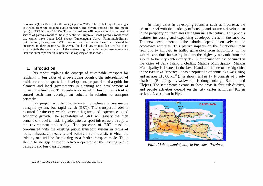
In many cities in developing countries such as Indonesia, the
urban sprawl with the tendency of housing and business development
in the periphery of urban areas is begun in20’th century. This process
features increasing and expanding developed areas in the suburbs.
The new developments in the suburbs depend intensively on the
downtown activities. This pattern impacts on the functional urban
area due to increase in traffic generation from households in the
suburb, and thus increasing load on the highway network from the
suburb to the city center every day. Suburbanization has occurred in
the cities of Java Island including Malang Municipality. Malang
Municipality is located in the Java Island and is one of the big cities
in the East Java Province. It has a population of about 789,348 (2005)
and an area 110.06 km2 (it is shown in Fig 1). It consists of 5 sub-
districts (Blimbing, Lowokwaru, Kedungkandang, Sukun, and
Klojen). The settlements expand to those areas in four sub-districts,
and people activities depend on the city center activities (Klojen
activities), as shown in Fig 2.
Fig.1. Malang municipality in East Java Province
Project Work Report, Lasmini : Malang Municipality, Indonesia 4
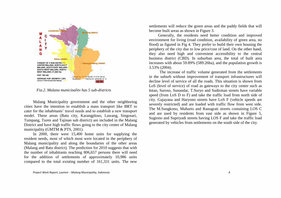
Malang Municipality government and the other neighboring
cities have the intention to establish a mass transport like BRT to
cater for the inhabitants’ travel needs and to establish a new transport
model. These areas (Batu city, Karangploso, Lawang, Singosari,
Tumpang, Turen and Tajinan sub district) are included in the Malang
District and have high traffic flows going to the city center of Malang
municipality (GMTM & PTS, 2001).
In 2000, there were 15,400 home units for supplying the
resident needs, most of which most were located in the periphery of
Malang municipality and along the boundaries of the other areas
(Malang and Batu district). The prediction for 2010 suggests that with
the number of inhabitants reaching 806,657 persons there will need
for the addition of settlements of approximately 10,986 units
compared to the total existing number of 161,331 units. The new
settlements will reduce the green areas and the paddy fields that will
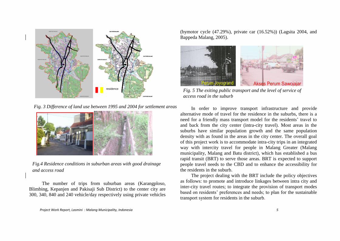
become built areas as shown in Figure 3.
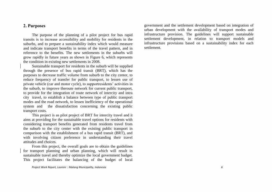
Generally, the residents need better condition and improved
environment for living (road condition, availability of green area, no
flood) as figured in Fig 4. They prefer to build their own housing the
periphery of the city due to low price/cost of land. On the other hand,
they also need high and convenient accessibility to the central
business district (CBD). In suburban area, the total of built area
increases with about 59.89% (589.26ha), and the population growth is
3.53% (2004).
The increase of traffic volume generated from the settlements
in the suburb without improvement of transport infrastructures will
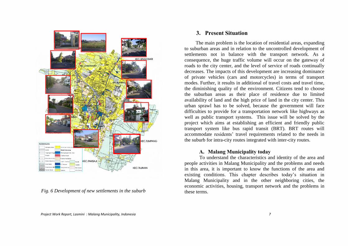
decline level of service of all the roads. This situation is shown from
LoS (level of service) of road as gateways to the city center such as
Intan, Suroso, Sunandar, T.Suryo and Sudirman streets have variable
speed (from LoS D to F) and take the traffic load from north side of
city. Gajayana and Haryono streets have LoS F (vehicle speeds are
severely restricted) and are loaded with traffic flow from west side.
The M.Sungkono, Muharto and Ranugrati streets containing LOS C
and are used by residents from east side as shown in Figure 5,
Sugiono and Supriyadi streets having LOS F and take the traffic load
generated by vehicles from settlements on the south side of the city.
Fig.2. Malang municipality has 5 sub-districts
Project Work Report, Lasmini : Malang Municipality, Indonesia 5
The number of trips from suburban areas (Karangploso,
Blimbing, Kepanjen and Pakisaji Sub District) to the center city are
300, 340, 840 and 240 vehicle/day respectively using private vehicles
(bymotor cycle (47.29%), private car (16.52%)) (Lagsita 2004, and
Bappeda Malang, 2005).
In order to improve transport infrastructure and provide
alternative mode of travel for the residence in the suburbs, there is a
need for a friendly mass transport model for the residents’ travel to
and back from the city center (intra-city travel). Most areas in the
suburbs have similar population growth and the same population
density with as found in the areas in the city center. The overall goal
of this project work is to accommodate intra-city trips in an integrated
way with intercity travel for people in Malang Greater (Malang
municipality, Malang and Batu district), which has established a bus
rapid transit (BRT) to serve those areas. BRT is expected to support
people travel needs to the CBD and to enhance the accessibility for
the residents in the suburb.
The project dealing with the BRT include the policy objectives
as follows: to promote and introduce linkages between intra city and
inter-city travel routes; to integrate the provision of transport modes
based on residents’ preferences and needs; to plan for the sustainable
transport system for residents in the suburb.
KABUPATEN MALANG
Bandungrejosari
Gadang
Tanjungrejo
Bandulan
Mulyorejo
Sukun
Bareng
Oro-oro Dowo
Gadingkasri
Karangbesuki
Sumbersari
Penanggungan
Ketawanggede
Merjosari
Tlogomas
Dinoyo
Pisang Candi
Bakalankrajan
Arjosari
Balearjosari
Purwodadi
Blimbing
Pandanwangi
Purwantoro
Bunulrejo
Sawojajar
Madyopuro
Lesanpuro
Polehan
Kedung Kandang
Cemorokandang
Buring
Bumiayu
Wonokoyo
Tlogowaru
Arjowinangun
KEDUNGKANDANG
SUKUN
KLOJEN
BLIMBING
LOWOKWARU
Sukoharjo
Klojen
Kiduldalem
Jodipan
Kotalama
Mergosono
Ciptomulyo
Kebonsari
Kemantren
Kauman
Rampalcelaket
SamaanLowokwaru
Tulusrejo
Jatimulyo
Mojolangu
Tunggulwulung
Tunjungsekar
Polowijen
Tasikmadu
KABUPATEN MALANG
KABUPATEN MALANG
KABUPATEN MALANG
Fig.4 Residence conditions in suburban areas with good drainage
and access road
residence
Fig. 3 Difference of land use between 1995 and 2004 for settlement areas
Fig. 5 The exiting public transport and the level of service of
access road in the suburb
Project Work Report, Lasmini : Malang Municipality, Indonesia 6
2. Purposes
The purpose of the planning of a pilot project for bus rapid
transits is to increase accessibility and mobility for residents in the
suburbs, and to prepare a sustainability index which would measure
and indicate transport benefits in terms of the travel pattern, and in
reference to the benefits. The new settlements in the suburbs will
grow rapidly in future years as shown in Figure 6, which represents
the condition in existing new settlements in 2008.
Sustainable transport for residents in the suburb will be supplied
through the presence of bus rapid transit (BRT), which has the
purposes to decrease traffic volume from suburb to the city center, to
reduce frequency of transfer for public transport, to lessen use of
private vehicle (car and motor cycle), to supportresidents’ activities in
the suburb, to improve theroute network for current public transport,
to provide for the integration of route network of intercity and intra
city travel, to establish a balance between type of public transport
modes and the road network, to lessen inefficiency of the operational
system and the dissatisfaction concerning the existing public
transport costs.
This project is as pilot project of BRT for intercity travel and it
aims at providing for the sustainable travel options for residents with
considering transport benefits generated from residents travel from
the suburb to the city center with the existing public transport in
comparison with the establishment of a bus rapid transit (BRT), and
with involving citizen preference in understanding their travel
attitudes and choices.
From this project, the overall goals are to obtain the guidelines
for transport planning and urban planning, which will result in
sustainable travel and thereby optimize the local government budget.
This project facilitates the balancing of the budget of local
government and the settlement development based on integration of
urban development with the availability of transport modes and
infrastructure provision. The guidelines will support sustainable
settlement development, in relation to transport models and
infrastructure provisions based on a sustainability index for each
settlement.
Project Work Report, Lasmini : Malang Municipality, Indonesia 7
3. Present Situation
The main problem is the location of residential areas, expanding
to suburban areas and in relation to the uncontrolled development of
settlements not in balance with the transport network. As a
consequence, the huge traffic volume will occur on the gateway of
roads to the city center, and the level of service of roads continually
decreases. The impacts of this development are increasing dominance
of private vehicles (cars and motorcycles) in terms of transport
modes. Further, it results in additional of travel costs and travel time,
the diminishing quality of the environment. Citizens tend to choose
the suburban areas as their place of residence due to limited
availability of land and the high price of land in the city center. This
urban sprawl has to be solved, because the government will face
difficulties to provide for a transportation network like highways as
well as public transport systems. This issue will be solved by the
project which aims at establishing an efficient and friendly public
transport system like bus rapid transit (BRT). BRT routes will
accommodate residents’ travel requirements related to the needs in
the suburb for intra-city routes integrated with inter-city routes.
A. Malang Municipality today To understand the characteristics and identity of the area and
people activities in Malang Municipality and the problems and needs
in this area, it is important to know the functions of the area and
existing conditions. This chapter describes today’s situation in
Malang Municipality and in the other neighboring cities, the
economic activities, housing, transport network and the problems in
these terms.
Sengkaling
Regency
CemaraTujuh
BumiPalapaKr
ploso Citra
GrahaS.Sari
P. Blimbing
Indah
Purwantoro
SawojajarPer
mai
Buring Indah
Gadang
Regency
SukunPermai
Bukit Dieng
Tidar
Fig. 6 Development of new settlements in the suburb
Sengkaling
Regency
Cemara Tujuh
Bumi Palapa
Krploso Citra Graha
S.Sari
P. Blimbing
Indah
Purwantoro
Sawojajar
Permai
Buring Indah
Gadang
Regency
Sukun Permai
Bukit Dieng
Tidar

Project Work Report, Lasmini : Malang Municipality, Indonesia 88 8 88
Malang Municipality has 789,348inhabitants and the area
110.06 km2. It functions as a business center and a center for
agroindustry and education.
The Malang Municipality areas have an altitude ranging from
400 to 600 m, and with slopes 0-15% for 96.3% of total areas, and the
rest of the area has slope more than 15%.
The use of the existing land according to Urban Spatial
Planning includes paddy field (1,162 ha), industry (200 ha) on north
side of city, market (14.99 ha) on Gadang, south side, tourism
(53.225ha) on west side such as Badut Temple, Brawijaya museum,
and Tlogomas swimming pool as shown in Figure 7.
The transport system is planned to develop the railway
network with a double track for the routes Surabaya-Malang, and
Blitar-Malang and rehabilitation of the route for Dampit-Malang. It
will also include the development of the primary collector roads to
Lumajang (east side), the Gempol-Malang freeway, and to increase
off road parking in the city center.
B. Social and Environment Malang Municipality has some small-sized public open spaces
and one park, which are located in the city center such as Alun-alun
and Balai Kota (KidulDalem and Klojen villages) as figured in Figure
8. Only very few people use this areas for leisure. One specific feature
for Malang is the green space or park built in1893 along certain
streets, such as on Trunojoyo, Kertanegara, Tugu, Gajahmada,
Merbabu, Ijen, and Suropati. Within developing city, nowadays there
is still less green spaces.
In the city center, there are many facilities and infrastructure
services such as 2 churches, 1 mosque, 5 shopping center, one park, 4
local government offices, three banks, one big post office, hotel, and
five favorite schools. The concentration of many activities in the city
center results in heavy traffics load on the road network around the
city center. There is a great need for improvements of the public
transport system to accommodate residents’ travel requirements, and
for the development of traffic demand management. This would
include establishing off-street parking and improvement of pedestrian
facilities, connecting with public transport stops (Lasmini, Indriastuti,
2006).
Fig. 8 Public space in the city center
Fig. 7 Tourism place in the city center
Project Work Report, Lasmini : Malang Municipality, Indonesia 9
C. Economic Malang Municipality is center for agronomics, tourism and
education. Productive areas consist of wet paddy filed (1,219 ha), and
dry field (3,328 ha). These areas are located on south and east side of
city and the production from the paddy fields amounts to about 15
million ton rice per year.
Tourist places are located in a wide spread pattern to all areas
of the city for instance the museums in the city center. Other places of
importance are the small swimming pool near city center, and a Badut
temple on Karangbesuki village (east side of city).
Industrial areas include factories for cigarette production
occupying an area of 172.8 ha. The development area of this industry
is on south side of the city (Arjowinangun village). The other business
centers consist of general markets, supermarkets, small and
intermediate shops within a total number of facilities of 3,522 units as
explained in Figure 9.
D. Housing Malang Municipality consists of 5 sub districts Klojen (center
city), Blimbing (north east), Kedungkandang (south east), Sukun
(south west), and Lowokwaru (north west). The highest number of
inhabitants 170,500 peoples live in Sukun (south side of the city), and
the lowest 119,700 peoples live in Klojen sub district (center city).
The highest density is 125.15 people/ha in Klojen (center of city).
Since 1980, housing development has changed and
development occurred primarily in the periphery of city. 78,000
households (about 50% from the total of settlements) already existed
and were located in the suburban area. Each family consists of 3-4
persons on an average. The new settlements in the suburb generally
include to the largest extent newly established families with 1-2
children and with parents in the age of 25-50 years. 70% of the
households are defined as new families, and the rest are families
established earlier
The most common house type in the suburban a single-family
house with about 45-70 m2built area within the total of land about
100-200 square meters in size. These houses are usually made from
bricks or concrete blocks with clay or concrete roof, and with the
entrance gate facing the street. In the in front or backyard, there is a
small garden. A fence is surrounding the plot. Most settlements have
an average number of 400-1,000 unit houses. Figure 10 illustrates the
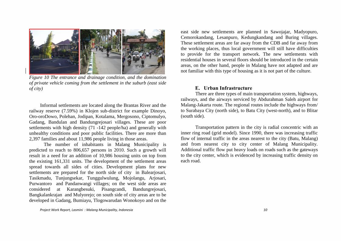
situation in this type of suburban settlement.
Each family has on average 2 vehicles; a motor cycle and a
car. This provides for high degree of mobility for households in the
suburbs, as a consequence, there are huge traffic volumes generating
from these settlements.
Fig. 9 shopping center around the city center
Project Work Report, Lasmini : Malang Municipality, Indonesia 10
Figure 10 The entrance and drainage condition, and the domination
of private vehicle coming from the settlement in the suburb (east side
of city)
Informal settlements are located along the Brantas River and the
railway reserve (7.59%) in Klojen sub-district for example Dinoyo,
Oro-oroDowo, Polehan, Jodipan, Kotalama, Mergosono, Ciptomulyo,
Gadang, Bandulan and Bandungrejosari villages. These are poor
settlements with high density (71 -142 people/ha) and generally with
unhealthy conditions and poor public facilities. There are more than
2,397 families and about 11,986 people living in those areas.
The number of inhabitants in Malang Municipality is
predicted to reach to 806,657 persons in 2010. Such a growth will
result in a need for an addition of 10,986 housing units on top from
the existing 161,331 units. The development of the settlement areas
spread towards all sides of cities. Development plans for new
settlements are prepared for the north side of city in Balearjosari,
Tasikmadu, Tunjungsekar, Tunggulwulung, Mojolangu, Arjosari,
Purwantoro and Pandanwangi villages; on the west side areas are
considered at Karangbesuki, Pisangcandi, Bandungrejosari,
Bangkalankrajan and Mulyorejo; on south side of city areas are to be
developed in Gadang, Bumiayu, Tlogowarudan Wonokoyo and on the
east side new settlements are planned in Sawojajar, Madyopuro,
Cemorokandang, Lesanpuro, Kedungkandang and Buring villages.
These settlement areas are far away from the CDB and far away from
the working places, thus local government will still have difficulties
to provide for the transport network. The new settlements with
residential houses in several floors should be introduced in the certain
areas, on the other hand, people in Malang have not adapted and are
not familiar with this type of housing as it is not part of the culture.
E. Urban Infrastructure There are three types of main transportation system, highways,
railways, and the airways serviced by Abdurahman Saleh airport for
Malang-Jakarta route. The regional routes include the highways from/
to Surabaya City (north side), to Batu City (west-north), and to Blitar
(south side).
Transportation pattern in the city is radial concentric with an
inner ring road (grid model). Since 1990, there was increasing traffic
flow of internal traffic in the areas nearest to the city (Batu, Malang)
and from nearest city to city center of Malang Municipality.
Additional traffic flow put heavy loads on roads such as the gateways
to the city center, which is evidenced by increasing traffic density on
each road.

Project Work Report, Lasmini : Malang Municipality, Indonesia 11
Malang Municipality is the center for the distribution of goods
and services to the closest area (Malang and Batu District) which are
also functioning as a buffer for the Malang Municipality. Its highway
network consists of primary and secondary artery roads (length 11.82
and 15.94 km), primary and secondary collector roads (in length 8.16
and 27.09 km), primary and secondary local roads (in length 9.66 and
27.09 km) according to Spatial Planning and Land Use Planning. The
highway network is shown in Figure 11.
High traffic volumes often occur on east side of highway
network, which is a primary artery for the traffic from the north
towards the south side (from Raden Intan, R. Panji Suroso, Letjen
Sunandar Priyosudarmo, Tumenggung Suryo, Panglima Sudirman,
Gatot Subroto, Laksamana Martadinata, Kolonel Soegiono street until
Gadang Terminal). These areas have already been developed as
business areas, shops, offices, and warehouses. The traffic flow from
the west side towards the city center also leads tocongestion
(Landungsari Terminal, Raya Tlogomas, MT. Haryono, Panjaitan,
Brigjen Slamet Riadi, Basuki Rachmad and Jakgung Suprapto Street).
This congestion is caused by huge traffic volumes from the new
settlement and also the location of the traditional market (Dinoyo
market) and the universities attracting additional traffic.
Heavy vehicles are only serviced by the road network on the
east side of the city. The roads available for heavy vehicles include
Intan, Suroso, Sunandar, Tumenggung, Sudirman, Subroto,
Martadinata and Sugiono until Gadang terminal to south of the city.
This is shown in Figure 11. As a result, the service level of these
roads is the worst reaching their capacity.
Fig.12 Location of station, terminal and sub
terminal
Fig. 11Highway network and their functions

Project Work Report, Lasmini : Malang Municipality, Indonesia 12
Malang Municipality has 3 bus terminals, (Arjosari serving
traffic from/to north side, Landungsari providing for the traffic
from/to north side, Gadang serving traffic from/to south side), and the
sub-terminals at Mulyorejo, Madyopura, and Tlogowaru.
The railway system serves two types of travel services. These
are firstly the economy class to accommodate the travel from/to
Surabaya to/from Blitar going from north to south and secondly the
travel from/ to east Malang-Banyuwang. While the other executive
class services operate to/from Jakarta. The frequency per day is 23
times. Since railway still has same level with highway, there are level
crossings where cause congestion and delays at those crossings
located at A.Yani and Laks. Martadinata, where there are high traffic
volumes. There are three stations to service passengers and goods, i.e.
Kota Baru, Kota lama, and Blimbing Station as illustrated in
Figure12.
F. Public Transport The weaknesses in the existing public transport system are:
Inefficient transit route structure, Fragmentation of routes crossing
city boundary, Lack of direct connections between certain long-
distance services, System over-capacity with load factor approaching
1 (Dishub Malang, 2003).
The transit route network in Malang City has been gradually
developed over a long time. The results are inadequate route network
coverage and no services to certain parts of city. There are several
large residential areas along the city boundary, which have no direct
routes to the CBD, although there is a substantial travel demand
between these points. A large number of commuters must use more
than one trip and different modes of transport for their journeys to
CBD. This results in inconvenient travel, increased travel cost, and
increased journey time.
Passengers traveling from outside the city boundary to CBD
are required to travel by rural transit vehicles to one of the terminals
near the boundary of city, and transfer to another intra city transport
service for the final stage of their journey. This situation is caused by
the distinction in the legislation between the two types of services,
and that separate government transport agencies have the
responsibility for the issuing of licenses to them.
Project Work Report, Lasmini : Malang Municipality, Indonesia 13
The existing public transport system has 25 routes with 2,189
units (in 16,981 trips per day) to service intracity travel
accommodated through minibuses that have a capacity about 8
passengers. In order to service intracity travel, there are 5 routes from
north to south and reverse, 5 routes to accommodate trips north to
west and reverse, 4 routes to accommodate trips south to west and
reverse, 1 route to accommodate trips north to east and reverse, 2
routes to accommodate trips east to west and reverse, the rest for the
other routes.
Another mode of public transport is provided by taxi with 300
units, and by bus for intercity trips which service trips for Surabaya
City served by big buses (174 units), for Blitar City (208 units
medium buses), and 2,315 units small buses serving Batu or Kediri
City.
G. Settlement and Transport Problematic Concerning population growth and related conditions in the
Malang Municipality, the demand for improved transport
infrastructure and alternative modes of travel also includes high
accessibility for citizens’ activities. Change of land use influences the
requirements for the transport system. Developing an area from paddy
field or green areas to become a settlement area will have an impact
on the demand for transport and in terms of travel behaviour.
The problematic issues for transport planning with many
settlement developments particularly in the suburbs are
Increasing travel demand, the public transport need must be balanced
with the number of units supplied and the improvement of service
levels. The service level includes quality of safety, comfort, waiting
time, and travel time.
The service level of public transport (PT) will influence to use the
public transport system. Good service level of PT will increase
willingness to use it, which will decrease the load on highways and
reduce traffic density. If opposite situation occurs, the number of
passengers of PT will significantly decrease, in which case the more
intensive road traffic will create friction and competition among
drivers resulting in higher speed and less safety.
The routes for PT should consider road capacity (VCR), and serve
directly the passengers from or to the center of attraction and
generation.
With the development of new settlements in the suburbs, the
people have to travel daily to the city center. The distribution on types
of transport is as follows: motor cycle (47.29%), public transit
(32.19%), private car (16.52%), and taxi (3.99%) respectively.
Generally, travelling with the use of private vehicles need 30-45
minutes, which is faster than by public transport. The length of travel
by car is about 1-10 km to the center city (Lagsita, 2004). Other
research, suggests that travelling to the CBD (central business district)
takes place using private vehicles (24%), public transport (56%), taxi
(2%), pedicab (14%), and walking (4%) (Lasmini, 2006).As a
consequence, the service level of roads as the gateways to the center
city continually decreases (VCR > 0.85), and congestions occurs
often.
Other impacts are the increase of the vehicle operational cost,
travel time, travel cost and pollution cost. Actually these conditions
indicate the lack of integration between land use and transport of all
cities in Indonesia.
With the expansion of settlements in the suburbs, huge traffic
volumes will occur on the gateway roads that lead to the city center.
There is an increase in volumes with a distribution on transport
modes, which is dominated by private vehicle (car and motor
cycle).The consequences include additional travel costs and travel

Project Work Report, Lasmini : Malang Municipality, Indonesia 14
time and diminishing quality of the environment. The citizens tend to
choose to live in the suburbs due to limited availability of land in the
city center. The urban sprawl has to be solved, because the
government will have difficulties to provide the transport network,
and the service level of roads does continually decrease as explained
in Table 1 (the problem tree of this project).
The aim of the project is to solve this issue through the
establishment of an efficient and user-friendly public transport system
based on bus rapid transit (BRT). BRT routes will accommodate
intercity travel for residents in the suburbs and will be integrated with
intercity travel serving the nearby cities (Batu and Malang District).
The responsibility of the target group (the residents) will be
the willingness to change preferred transport mode from private
vehicles to BRT. All residents within low, medium and high income
who live in the suburb should be encouraged to alter their travel
behavior. It is necessary to invite representatives of each group of
stakeholders to participate in this project and to coordinate among
them. This is particularly important due to the existing lack of
integration between the authorities involved inland use planning and
transport planning. This process is needed to provide for better Spatial
Planning and to integrate with establishing regulations for the
permission of housing developments in the suburban areas. A traffic
impact fee should be imposed to housing developers due to the
additional traffic volumes generated by the new settlements.
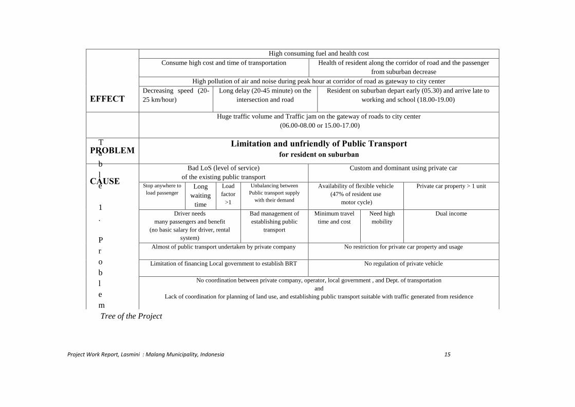
Project Work Report, Lasmini : Malang Municipality, Indonesia 15
T
a
b
l
e
1
.
P
r
o
b
l
e
m
Tree of the Project
EFFECT
High consuming fuel and health cost
Consume high cost and time of transportation Health of resident along the corridor of road and the passenger
from suburban decrease
High pollution of air and noise during peak hour at corridor of road as gateway to city center
Decreasing speed (20-
25 km/hour)
Long delay (20-45 minute) on the
intersection and road
Resident on suburban depart early (05.30) and arrive late to
working and school (18.00-19.00)
Huge traffic volume and Traffic jam on the gateway of roads to city center
(06.00-08.00 or 15.00-17.00)
PROBLEM Limitation and unfriendly of Public Transport
for resident on suburban
CAUSE
Bad LoS (level of service)
of the existing public transport
Custom and dominant using private car
Stop anywhere to
load passenger Long
waiting
time
Load
factor
>1
Unbalancing between
Public transport supply
with their demand
Availability of flexible vehicle
(47% of resident use
motor cycle)
Private car property > 1 unit
Driver needs
many passengers and benefit
(no basic salary for driver, rental
system)
Bad management of
establishing public
transport
Minimum travel
time and cost
Need high
mobility
Dual income
Almost of public transport undertaken by private company No restriction for private car property and usage
Limitation of financing Local government to establish BRT No regulation of private vehicle
No coordination between private company, operator, local government , and Dept. of transportation
and
Lack of coordination for planning of land use, and establishing public transport suitable with traffic generated from residence
Project Work Report, Lasmini : Malang Municipality, Indonesia 16
4. Analysis
4.1 Increasing the accessibility for residents in the suburbs
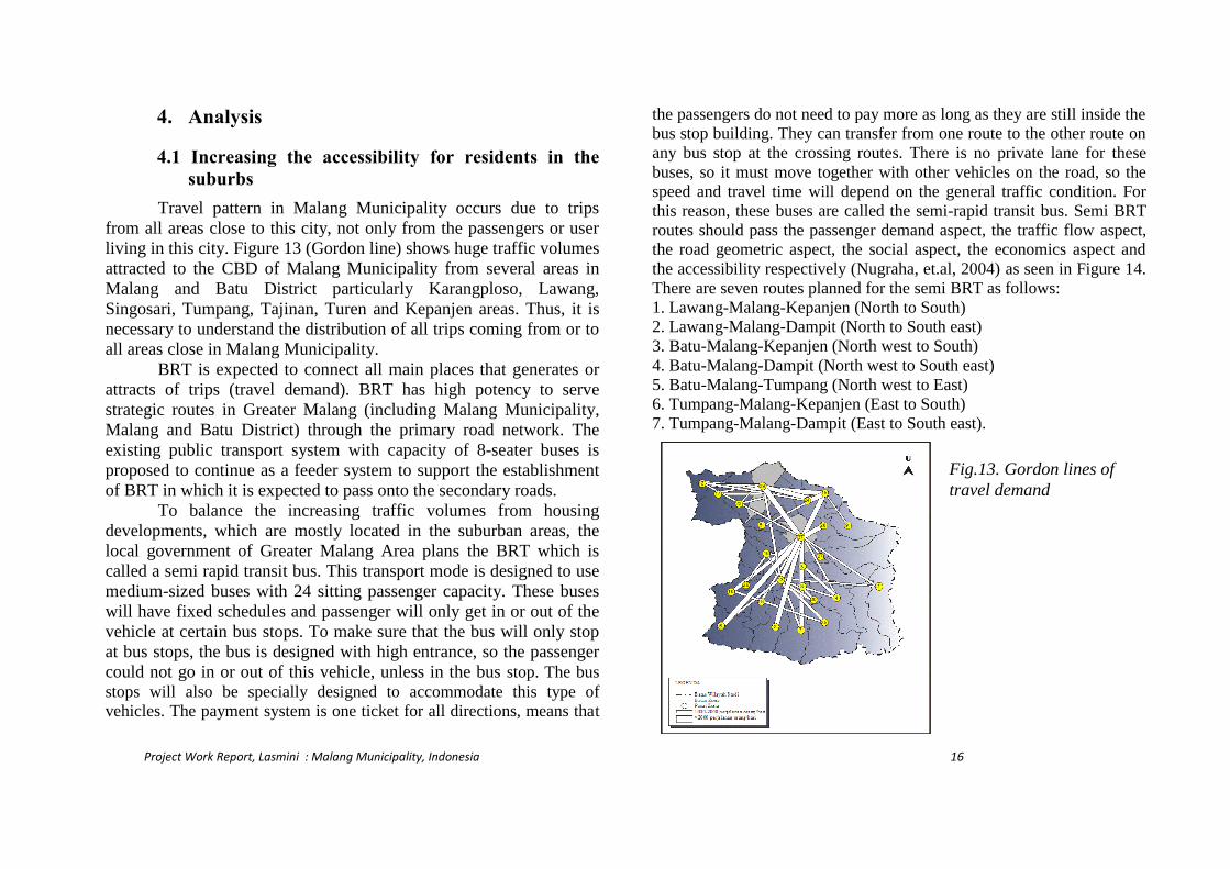
Travel pattern in Malang Municipality occurs due to trips
from all areas close to this city, not only from the passengers or user
living in this city. Figure 13 (Gordon line) shows huge traffic volumes
attracted to the CBD of Malang Municipality from several areas in
Malang and Batu District particularly Karangploso, Lawang,
Singosari, Tumpang, Tajinan, Turen and Kepanjen areas. Thus, it is
necessary to understand the distribution of all trips coming from or to
all areas close in Malang Municipality.
BRT is expected to connect all main places that generates or
attracts of trips (travel demand). BRT has high potency to serve
strategic routes in Greater Malang (including Malang Municipality,
Malang and Batu District) through the primary road network. The
existing public transport system with capacity of 8-seater buses is
proposed to continue as a feeder system to support the establishment
of BRT in which it is expected to pass onto the secondary roads.
To balance the increasing traffic volumes from housing
developments, which are mostly located in the suburban areas, the
local government of Greater Malang Area plans the BRT which is
called a semi rapid transit bus. This transport mode is designed to use
medium-sized buses with 24 sitting passenger capacity. These buses
will have fixed schedules and passenger will only get in or out of the
vehicle at certain bus stops. To make sure that the bus will only stop
at bus stops, the bus is designed with high entrance, so the passenger
could not go in or out of this vehicle, unless in the bus stop. The bus
stops will also be specially designed to accommodate this type of
vehicles. The payment system is one ticket for all directions, means that
the passengers do not need to pay more as long as they are still inside the
bus stop building. They can transfer from one route to the other route on
any bus stop at the crossing routes. There is no private lane for these
buses, so it must move together with other vehicles on the road, so the
speed and travel time will depend on the general traffic condition. For
this reason, these buses are called the semi-rapid transit bus. Semi BRT
routes should pass the passenger demand aspect, the traffic flow aspect,
the road geometric aspect, the social aspect, the economics aspect and
the accessibility respectively (Nugraha, et.al, 2004) as seen in Figure 14.
There are seven routes planned for the semi BRT as follows:
1. Lawang-Malang-Kepanjen (North to South)
2. Lawang-Malang-Dampit (North to South east)
3. Batu-Malang-Kepanjen (North west to South)
4. Batu-Malang-Dampit (North west to South east)
5. Batu-Malang-Tumpang (North west to East)
6. Tumpang-Malang-Kepanjen (East to South)
7. Tumpang-Malang-Dampit (East to South east).
Fig.13. Gordon lines of
travel demand

Project Work Report, Lasmini : Malang Municipality, Indonesia 17
4.2. Travel Characteristic for resident in the suburb Passenger Characteristic
An investigation, which was conducted by distribution of 351
questionnaires in 9 locations at CBD revealed the preferences. The
passengers who have to travel every day from the suburbs (housing
areas) to the city centre have some unique characteristics.51% are
male (20-29 years of age), the highest proportion in profession as
private employers (57%), with graduation from senior high school
(54.13%), mostly have income about 500,000–1,000,000 Rupiahs
(41.60%), holding driving license (47.01%), and up to 72% of them own
a private vehicle (car or motor cycle). From passenger characteristics, it
means that most users who live in the suburb need transport mode more
flexible like motor cycle.
Trip Characteristic Most travellers from the suburb residents that are going to the
city centre have on average a travel distance of 5.1 – 7.5 km
(33.62%).The purpose for travel is mainly for work (72.36%), the
average travel time is 15 – 30 minutes (38.46%), the average travel
cost per day is 2,000–4,000 (52.42%).The majority carry luggage
54.13%, and most travel alone with no one accompanying them
during the travel (57.55%). The travel distance, time and costs are essential variables in
determining the choice of transport mode to the city center. Since the
distance to travel is more than 5 km, most employers travel coming from
periphery of city by motor cycle which needs 0.5-1 liter gasoline.
Factor Influencing Transport Mode Choice From the questionnaires, it is found that there are three factors
affecting respondents to choose among the transportation mode options,
as follows: mode availability, travel time, and travel cost, with influential
factors 40.17%, 24.79%, and 14.53% respectively.
Thus, the proportions of transportation mode chosen from the
revealed preference survey are motorcycle (47.29%), para-transit
(32.19%), private car (16.52%), and taxi (3.99%) respectively.
Transportation mode availability is the most determining factor
in the choice of transport mode because of the flexibility due to activity
time and trip route.
From survey also reveals that passengers need 18.4 minutes
(motor cycle), 21.3 minutes (car), 32.6 minutes (paratransit), and 18.5
minutes (taxi). The travel costs are approximately Rp.1, 947 (motor
cycle), Rp 10,846 (car), Rp. 2,246 (paratransit), Rp.24, 444 (taxi)
Fig.14. Location and type of travel demand

Project Work Report, Lasmini : Malang Municipality, Indonesia 18
respectively for the travel distance of 5-7 km from the suburban area
to the city center.
4.3. Model of Transport Mode Choice To develop the model for the transport mode choice, it is
necessary to analyse the passengers’ travel behaviour. The analysis of
the questionnaires that were distributed is done by using Nominal
Logistic Regression analysis. From this analysis it is possible to
known the degree of importance of the factors, which influence the
choice of transport mode. Each respondent was asked about variables
which influence choosing transport mode for their trip. The 351
samples were used to obtain a relationship between the transport
mode choice and explanatory variables.
The variables are of socio economic characteristics, transport
chacteristics, and transport mode characteristics. From the statistical
test, it can be revealed that the variables, which affect transportation
mode choice are trip length, travel time, and travel cost.
Total cost has minimum effect in terms of the choice of
transportation mode, because consumer will choose transportation
mode, which has the minimum cost for traveling at a certain time and
for a certain distance. Concerning the distance, consumers will choose
paratransit or public transportation rather than others if the distance is
great. People who travel for a certain distance will choose
transportation mode affected by the total km of distance traveled.
From analysis of multinomial logic model, it is suggested that
the variables influencing the choice of transportation mode, such as
travel time, cost and distance for worker going to the city center are
very important. Probabilities in terms of the choice of transportation
mode are 49.9% using motor cycle, 36.5% choosing public
transportation, 12% driving car, and 1.7% choosing taxi respectively.
Since paratransit as a representation of public transport lays in
the second priority of transportation mode choice, the public transit
facilities in Malang City must be well-planned in order to fulfill
passenger’ needs. The arrangement of public transit facilities must
consider distance, time and cost spent by the commuters. The public
transit must cover the residents’ needs living in the suburb, which are
far from the city center, to encourage residents to alter from private
vehicle to public transit. The result is in line with the government’s
plan to provide for the new public transit alternative. Public transit
service quality improvement is expected to magnetize the commuters
from suburban areas to the city center. Therefore, this can reduce the
usage of private vehicle and minimize the congestion on the gateway
roads.
From analysis of the arrangements for mass transport in the
Great Malang (commuter train project) information is obtained
regarding people who routinely travel to the city center. About 72 %
don’t have private vehicles, and as a consequence, they always use
public transport (paratransit). This is because the travel costs for using
paratransit is low. With improving the public transport service quality
through the reduction of travel cost and travel time which will be the
results of the implementation of the BRT plan. While reducing travel
time is conducted from saving time of waiting time. The saving time
with the assumption that the bus waiting time is about 5 minutes at
each terminal would be about 10 minutes (for North to South route),
15 minutes (for North to South East route), 15 minutes (for North
west to South route), 20 minutes (for North west to South East route),
20 minutes (for North west to East route), 20 minutes (for East to
South route), 25 minutes (for East to South East route) in sequence.
The differences of waiting time is caused by the fact that the
paratransit arrangements for loading passenger up to 10-12 passengers
that exceeds its capacity (8 passengers).

Project Work Report, Lasmini : Malang Municipality, Indonesia 19
The semi-BRT plan is expected to accommodate the passengers’
demand. By conducting stated preference survey, the travel cost
attribute was found to be the main factor of influence in transport
mode choice. The utility functions of transport modes choice is
U(paratransit-bus) = -0.059 + 0.001travel cost. Furthermore, the
prediction of the bus passenger altering from para-transit to semi-
BRT is as follows: Lawang-Malang-Kepanjenroute approximately
89.1% within assumption Rp 7,500 of bus ticket; Lawang-Malang-
Dampit route 75 % (within Rp 9,500 of bus ticket), Batu-Malang-
Kepanjen route 99 % (within Rp 4,500 of bus ticket), Batu-Malang-
Dampit route 89.1% (within Rp 9,500 of bus ticket), Tumpang-
Malang-Kepanjen route 99 % (within Rp 4,000 of bus ticket),
Tumpang-Malang-Dampit route 83.2 % (within Rp 9,000 of bus
ticket), Batu-Malang-Tumpang route 52.5 % (within Rp 6,500 of bus
ticket).
From that model, it is assessed that the potential for number of
bus passengers are 698 persons (for North to South route), 553
persons (for North to South East route), 570 passengers (for North
west to South route), 303 passenger (for North west to South East
route), 15 persons (for North west to East route), one person (for East
to South route), 19 passengers (for East to South East).
The altering of passengers from paratransit and private vehicle
(car and motorcycle) to semi-BRT transport will decrease the traffic
volumes on the gateway roads with about 18%-19%. This condition
will increase the road level of service, as shown in Table 2.
From Table 2, it is revealed that improving transportation mode
facilities by arranging semi-BRT will decrease traffic volumes and
improve the level of service (LoS) of the gateway roads to the city
center. Most the gateway roads to the city center have better service
level, except on Tumenggung Suryo, Panglima Sudirman, Gatot
Subroto, Pasar Besar, and MT. Haryono. Since there are no
improvements of the level of services of these roads due to the
operational provisions for the semi BRT, as a consequence, there
must be a plan to develop the geometry of the roads, in order to raise
their capacity. Most of these roads are located on east side of city,
which is overloaded by mixed traffic with combinations of light and
heavy vehicles. Local government has prepared plans to build a new
ring road on east side of city, the establishment of BRT has to be
coordinated with and taken into account in the design of the new ring
road plan as seen in Figure 15.
Fig.15. Eastern ring road plan

Project Work Report, Lasmini : Malang Municipality, Indonesia 20
The new public transport provision (semi BRT) is expected to
serve passengers from the main places (settlements)of travel demand
to the city center, thus the residents are expected alter from private
vehicles to the public transport mode. The altering commuters will
reduce the traffic volumes on the gateway roads of Malang City. This
will be one of the sustainability transportation concept applied in
Greater Malang, to minimize the consequence of urban sprawl in the
Malang City.
4.4. Sustainable Index assessing from resident travel behaviour in the suburb
Based on responses to the questionnaires which are distributed
to residents in the suburb sit will be possible to obtain their
knowledge about the travel behavior. The questionnaires consist of 30
questions about the residents’ travel characteristics, satisfaction index
and the residents’ willingness to pay for transport infrastructure and
for the improved mode facilities.
From the survey, the residents in the suburbs have high mobility
in their travel to the city center due to vehicle ownership. They have
minimum one motor cycle, or 2 motor cycles, or a car and a motor
cycle. They travel alone or together with their children for different
activities such as for working or/and going to school and for
shopping.
The measurements of travel time and travel cost is needed to
assess the residents travel benefit from the different settlements of
city to the city center of each type of transport means. Another
assessment that is done by approaching the issue of residents’
preferences in terms of the willingness to pay for their travel and their
satisfaction level serves the purpose to interpret transport mode
service quality as explained in Table 3.
Note : MC=motor cycle, PT= public transport, SI= sustainable index, WTP=
willingness to pay, SL=Satisfaction Level
Table 2 Level of service (LOS) existing and with bus planning No Road Capacity
(pcu/hour)
volume
(pcu/hr)
Decre-
asing
volume
LOS
With bus
LOS of
existing
road
1 RadenIntan 5422 4012.98 3250.5 C D
2 R.PanjiSuroso 3135 3018.6 2445.07 D E
3 SunandarPriyo S
2794 2640.2 2138.4 C E
4 T. Suryo 3067 4074.25 3300.14 F F
5 P. Sudirman 3339 4598.85 3725.07 F F
6 GatotSubroto 3105 4518.23 3659.77 F F
7 Laks.
Martadinata
3105 2771.35 2244.79 C D
8 Sutoyo 5422 4719.25 3869.79 C D
9 S. Parman 5422 4248.40 3483.69 C D
10 BasukiRahmad 5080 4442.98 3598.81 C D
11 Kauman 3681 3231.45 2649.79 C D
12 AriefMargono 3101 2586.45 2095.02 C D
13 PasarBesar 2317 3409.9 2762.02 F F
14 Ade Irma 4824 871.83 714.9 A A
15 B. Katamso 2158 1856.53 1503.79 C D
16 Gajayana 1252 1396.43 1131.11 E F
17 Ranugrati 2562 1092.20 884.68 B C
18 M. Sungkono 1281 1061.03 859.43 C D
19 A. Yani 5422 4137.68 3351.52 C C
20 S. Supriadi 2208 2615.48 2118.54 E F
21 MT.Haryono 1874 3139.00 2542.59 F F
22 JA. Suprapto 5599 5108.40 4137.81 C E
23 AdiSucipto 2158 1395.35 1144.19 B C
24 Kol. Sugiono 2999 3184.15 2579.16 D F
25 SatsuitTubun 2290 1936.08 1587.59 C D

Project Work Report, Lasmini : Malang Municipality, Indonesia 21
From table 3 it can be concluded that housing areas in east and
south side of city has bad accessibility in terms of each type of
transport mode. This means that there is a need for improved devices
to allow new housing development in the certain areas. New
settlements with the existing highway network in south side of city
can be developed, on the other hand, in the east and north areas of city
there should be controlled and protected new settlements. It is also
required to build a new ring road. In the other side of the city, in the
western areas, new settlements can be developed combined with the
improvement of the highway network as seen in Figure 15.
This assessment has been useful to establish sustainable travel
options for residents in the periphery of the city in order to point out
transport benefits and to find out the preference of the inhabitants and
to understand their travel behaviors. This index is expected to provide
guidelines for planning urban transportation particularly in relation to
the expanding new settlements in the periphery, while optimizing the
local government budget.
4. Analysis of a User-Friendly Transport Mode for Malang Municipality Transport SWOT In order to analyze user-friendly public transport, it is also
necessary to assess the integrated approach based on SWOT analysis
(Strength, Weakness, Opportunities, and Threats). The SWOT
analysis cast light on the most important characteristics of the area.
i. Strength
– This project will be supported by the Regional Authority (East
Java Province) and the Department of Municipality Planning and
Developing Bureau, the Department of Transportation, and the
Local Government for surrounding cities (Greater Malang (Batu,
and Malang municipality, and Malang District to establish the
result of the project to facilitate public transport for Greater
Malang
– Passengers (70%) of the existing public transport agreed with the
planning of BRT, and the potential for altering to BRT is more
than 50% of each one of the routes.
– There are two projects which support the BRT plan namely the
new ring road plan on the east side of city (main priority) and
west side (second priority)
ii. Weakness
- This project needs much attention and participation from many
stakeholders, especially passengers and residents from the
suburbs.
- Contradictory opinions between drivers and owners of the existing
public transport facilities in terms of the establishing BRT, which
may reduce their income and overlapping their routes.
Transport Benefit
from travel time
Transport Benefit
from travel cost
SL
WTP SI
Area MC Car PT MC Car PT MC Car PT MC Car PT
East 1,696 1,935 2,106 2,800 6,750 5,000 0.76 2,650 5,000 3,000 2.25 2.30 3.14
South 970 1,070 1,524 3,500 5,437 3,750 0.78 2,986 3,437 2,875 1.91 2.42 2.34
West 1,332 1,432 2,369 3,062 4,500 3,750 0.78 2,281 3,500 2,500 2.46 2.16 3.12
North 3,377 3,659 4,735 2,500 3,375 2,500 0.80 1,875 2,500 1,750 3.92 3.52 5.17
Buring Indah
Project Work Report, Lasmini : Malang Municipality, Indonesia 22
- The driver and owner of the existing public transport facilities
disagree with BRT planning (< 30%)
- Need for partnership with private sector companies to implement
BRT
iii. Opportunity
- This project needs coordination with others: the Regional and
Local Government, the Department of Highway, the
Transportation, the Department of Housing and Infrastructure, the
Department of Tax, Environment, Land, Spatial Planning
Department
- The finance to establish BRT is supported by East Java Province
budget
- Dissemination is needed to promote BRT
- There is a coordination among the drivers and owners of the
existing public transportation as well as prospective investors
- Linkage between: Land Use Planning and the Improvement
Sustainable Public Transport, Housing and Public Transportation
Development, Rural and Urban Transport System, Intercity and
Intra city travel
iv. Threats
– The result of the sustainable index must be updated, if there are
improvements and changes of infrastructure and mode of
transport.
5. Achievement of BRT Plan of Malang Municipality
This project will be implemented in three periods 2010-2015-
2020 with the establishment of several alternative routes (two routes:
Lawang – Malang – Kepanjen (north to south, north-east-south), one
route: Lawang – Malang – Dampit (north to south east), one
route:Batu – Malang – Kepanjen (west east to south)) as shown in
Figure 16. To implement this plan, there is a need for intense
coordination and dissemination of the BRT planning. Today the
achievements include, that the local government tries to reduce
additions of the existing public transportation. The other effort related
to BRT plan, establishing pedestrian facilities, and bus stop places for
BRT will be done. Nowadays, there is a continual workshop for the
coordination of BRT planning among Regional Authority (East Java
Province), Municipality planning and Developing Bureau,
Department of Transportation, Local Government for closest city,
(Greater Malang (Batu, and Malang Municipality, and Malang
District).
The further achievements is expected to provide for agreements
in terms of the control of new housing development related to and
coordinated with the transport network plan, Enforcement of the
Legislation for New Housing Development, establishing an impact
assessment procedure for traffic and environment, introducing a
traffic impact fee which is imposed to housing developers.

Project Work Report, Lasmini : Malang Municipality, Indonesia 23
6. Conclusion • Establish alternative routes for BRT as follows two routes:
Lawang – Malang – Kepanjen (north to south, north-east-
south), one route : Lawang – Malang – Dampit (north to south
east), one route : Batu – Malang – Kepanjen (west east to
south)
• Establishing a linkage route between intercity and intra city
travel
• Linkage route between the existing public transport as a feeder
system for the BRT routes
• Residents on east and north side experience the worst situation
and by using existing transport mode and lack sustainable
transport solutions.
• By BRT plan, sustainable index for residents in the suburb
hasn’t assessed yet, it is needed dissemination about BRT plan
to accommodate their intercity trip
• Requirement to concentrate housing development in the
certain areas with considering the improvement of transport
network.
7. Reference BadanPerencanaandanPembangunan Kota Malang
(Bappeda), (2005, Train commuter for Kepanjen-Lawang
route Studi Kereta Api Komuter Jurusan Kepanjen-
Lawang. (in Indonesian)
Ben Akiva, Moshe, Stephen R. Lerman, 1985. Discrete
Choice Analysis: Theory and Application to Travel
Demand. The MIT Press Cambridge, Massachusetts
London, England.100-130 pp.
FHWA, 1999, Exploring the Application of Benefit/Cost
Methodologies to Transportation Infrastructure Decision
Making, Searching For Solution a Policy Discussion
Series. No.16. Federal Highway Administration.US
Department of Transportation, Washington D.C. 20590.
GMTM & PTS, 2001
Lagsita, M., 2004, Influence of Accessibility of Transportation
and Ability of Land to Behavior of Residence Location
Decision (Pengaruh Aksesibilitas Transportasi Dan
Kemampuan Lahan Terhadap Perilaku Pemilihan Lokasi
tempat Tinggal , Studi Kasus Perumahan Sawojajar,
Sukun Pondok Indah, dan Joyogrand di Kota Malang),
Program Studi Sipil Minat Rekayasa Transportasi,
Program Pasca Sarjana, Univeristas Brawijaya,
Fig.16. Routes and prototype of BRT
Project Work Report, Lasmini : Malang Municipality, Indonesia 24
Unpublised (in Indonesian).
Lasmini, A. & A. K.Indriastuti, 2006, Influence of Other
Activities on Sidewalks Towards the Level of Service of
Pedestrian Infrastructure and Roads
(PengaruhKegiatanLainPadaTrotoarTerhadapTingkatPel
ayanantrotoardan Karakteristik BerjalanPejalan Kaki:
Studi Kasus Di Pusat Kota Malang). Journal of FSTPT
(Jurnal Transportasi Forum Studi Transportasi Antar
Perguruan Tinggi) Vol.6, No.1 Juni 2006, pp.51-62 (in
Indonesian).
Maryland Office of Planning (MOP) 1997, Managing
Maryland’s Growth: What You Need to Know about
Smart, Growth and Neighborhood Conservation.
Baltimore, MD: Maryland Office of Planning.
Wegener, M., 1995, Accessibility and Development Impacts,
Transport and Urban Development, edited by David
Banister, London: E&FN Spon. pp. 157-161.


