
Research Article Impact Factor: 4.226 ISSN: 2319-507X S. A. Raut, IJPRET, 2015; Volume 3 (9): 690-701 IJPRET
Available Online at www.ijpret.com
690
INTERNATIONAL JOURNAL OF PURE AND APPLIED RESEARCH IN ENGINEERING AND
TECHNOLOGY
A PATH FOR HORIZING YOUR INNOVATIVE WORK
WIRELESS SENSOR NETWORK BASED LOCATION MONITORING SYSTEM
S. A. RAUT, PROF. S. R. JAJOO
Department. Of Electronics Engg., Datta Meghe College Of Engineering, Airoli, Navi Mumbai.
Accepted Date: 05/03/2015; Published Date: 01/05/2015
\
Abstract: Monitoring personal locations with a potentially untrusted server poses privacy threats to the
monitored individuals. To this end, we propose a privacy-preserving location monitoring system for wireless sensor networks. In our system, we design two in network location anonymization algorithms, namely, resource and quality-aware algorithms that aim to enable the system to provide high-quality location monitoring services for system users, while preserving personal location privacy. Both algorithms rely on the well-established k-anonymity privacy concept, that is, a person is indistinguishable among k persons, to enable trusted sensor nodes to provide the aggregate location information of monitored persons for our system. Each aggregate location is in a form of a monitored area A along with the number of monitored persons residing in A, where A contains at least k persons. The resource-aware algorithm aims to minimize communication and computational cost, while the quality-aware algorithm aims to maximize the accuracy of the aggregate locations by minimizing their monitored areas. To utilize the aggregate location information to provide location monitoring services, we use a spatial histogram approach that estimates the distribution of the monitored persons based on the gathered aggregate location information. Then, the estimated distribution is used to provide location monitoring services through answering range queries.
Keywords: Location Privacy, Wireless Sensor Network, Location Monitoring System, Spatial Histogram
Corresponding Author: MS. S. A. RAUT
Access Online On:
www.ijpret.com
How to Cite This Article:
S. A. Raut, IJPRET, 2015; Volume 3 (9): 690-701
PAPER-QR CODE

Research Article Impact Factor: 4.226 ISSN: 2319-507X S. A. Raut, IJPRET, 2015; Volume 3 (9): 690-701 IJPRET
Available Online at www.ijpret.com
691
INTRODUCTION
The advance in wireless sensor technologies has resulted in many new applications for military
and/or civilian purposes. Many cases of these applications rely on the information of personal
locations, for example, surveillance and location systems. These location-dependent systems
are realized by using either identity sensors or counting sensors[1].Wireless sensor network
(WSN) typically consists of a large number of small, multifunctional, and resource constrained
sensors that are self-organized as an ad hoc network to monitor the physical world. Sensor
networks are often used in applications where it is difficult or infeasible to set up wired
networks. Examples include wildlife habitat monitoring, security and military surveillance, and
target tracking. For applications like military surveillance, adversaries have strong incentives to
eavesdrop on network traffic to obtain valuable intelligence. Abuse of such information can
cause monetary losses or endanger human lives. For example, in the Panda-Hunter scenario, a
sensor network is deployed to track endangered giant pandas in a bamboo forest[2] Each
panda has an electronic tag that emits a signal that can be detected by the sensors in the
network. A sensor that detects this signal, the source sensor, then sends the location of pandas
to a data sink (destination) with help of intermediate sensors. An adversary (the hunter) may
use the communication between sensors and the data sinks to locate and then capture the
monitored pandas. In general, any target-tracking sensor network is vulnerable to such attacks.
As another example, in military applications, the enemy can observe the communications and
locate all data sinks (e.g., base stations) in the field[3].Disclosing the locations of the sinks
during their communication with sensors may allow the enemy to precisely launch attacks
against them and thereby disable the network. Location privacy is, thus, very important,
especially in hostile environments. Failure to protect such information can completely subvert
the intended purposes of sensor network applications. Location privacy measures, thus, need
to be developed to prevent the adversary from determining the physical locations of source
sensors and sinks.
Fig. 1 gives an example of a privacy breach in a location monitoring system with counting
sensors. There are 11 counting sensor nodes installed in nine rooms R1 to R9, and two hallways
C1 and C2 (Fig. 1a). The nonzero number of persons detected by each sensor node is depicted
as a number in parentheses. Figs. 1b and 1c give the numbers reported by the same set of
sensor nodes at two consecutive time instances tiþ1 and tiþ2, respectively. If R3 is Alice’s office
room, an adversary knows that Alice is in room R3 at time ti. Then, the adversary knows that
Alice left R3 at time tiþ1 and went to C2 by knowing the number of persons detected by the
sensor nodes in R3 and C2. Likewise, the adversary can infer that Alice left C2 at time tiþ2 and

Research Article Impact Factor: 4.226 ISSN: 2319-507X S. A. Raut, IJPRET, 2015; Volume 3 (9): 690-701 IJPRET
Available Online at www.ijpret.com
692
went to R7. Such knowledge leakage may lead to several privacy threats. For example, knowing
that a person has visited certain clinical rooms may lead to knowing the her health records.
Also, knowing that a person has visited a certain bar or restaurant in a mall building may reveal
confidential personal information.
This paper proposes a privacy-preserving location monitoring system for wireless sensor
networks to provide monitoring services. Our system relies on the well-established k-anonymity
privacy concept, which requires each person is indistinguishable among k persons [4][5][6][7].
In our system, each sensor node blurs its sensing area into a cloaked area, in which at least k
persons are residing. Each sensor node reports only aggregate location information, which is in
a form of a cloaked area, A, along with the number of persons, N, located in A, where N _ k, to
the server. A smaller k indicates less privacy protection, because a smaller cloaked area will be
reported from the sensor node; hence better monitoring services. However, a larger k results in
a larger cloaked area, which will reduce the quality of monitoring services, but it provides
better privacy protection. The definition of a small area is relative to the required anonymity
level, because our system provides better quality services for the same area if we relax the
required anonymity level. Thus, the adversary cannot infer the number of persons currently
residing in a small area from our system output with any fidelity; therefore, the adversary
cannot know that Alice is in room R3.
Fig.1: A location monitoring system using counting sensors
To preserve personal location privacy, we propose two in-network aggregate location
anonymization algorithms, namely, resource and quality-aware algorithms. Both algorithms
require the sensor nodes to collaborate with each other to blur their sensing areas into cloaked
areas, such that each cloaked area contains at least k persons to constitute a k-anonymous
cloaked area. The resource aware algorithm aims to minimize communication and

Research Article Impact Factor: 4.226 ISSN: 2319-507X S. A. Raut, IJPRET, 2015; Volume 3 (9): 690-701 IJPRET
Available Online at www.ijpret.com
693
computational cost, while the quality-aware algorithm aims to minimize the size of the cloaked
areas, in order to maximize the accuracy of the aggregate locations reported to the server.
The rest of this paper is organized as follows. Section II reports related work. Our system model
is outlined in Section III. Section IV presents proposed system which includes the resource and
quality-aware location anonymization algorithms. Section V describes the aggregrate query
processing. Section VI presents the performance of proposed algorithm. Finally Section VII
concludes the paper and outlines future work.
II. RELATED WORKS
Straightforward approaches for preserving users’ location privacy include enforcing privacy
policies to restrict the use of collected location information and anonymizing the stored data
before any disclosure. However, these approaches fail to prevent internal data thefts or
inadvertent disclosure. Recently, location anonymization techniques have been widely used to
anonymize personal location information before any server gathers the location information, in
order to preserve personal location privacy in location-based services. These techniques are
based on one of the three concepts. 1) False locations. Instead of reporting the monitored
object’s exact location, the object reports n different locations, where only one of them is the
object’s actual location while the rest are false locations.
2) Spatial cloaking. The spatial cloaking technique blurs a user’s location into a cloaked spatial
area that satisfy the user’s specified privacy requirements.
3) Space transformation. This technique transforms the location information of queries and
data into another space, where the spatial relationship among the query and data are encoded.
Among these three privacy concepts, only the spatial cloaking technique can be applied to our
problem. The main reasons for this are that 1) the false location techniques cannot provide
high-quality monitoring services due to a large amount of false location information, 2) the
space transformation techniques cannot provide privacy preserving monitoring services as it
reveals the monitored object’s exact location information to the query issuer, and
3) The spatial cloaking techniques can provide aggregate location information to the server and
balance a trade-off between privacy protection and the quality of services by tuning the
specified privacy requirements, for example, k-anonymity and minimum area privacy
requirements. Thus, we adopt the spatial cloaking technique to preserve the monitored object’s
location privacy in our location monitoring system..
Research Article Impact Factor: 4.226 ISSN: 2319-507X S. A. Raut, IJPRET, 2015; Volume 3 (9): 690-701 IJPRET
Available Online at www.ijpret.com
694
Other privacy related works include: anonymous communication that provides anonymous
routing between the sender and the receiver, source location privacy that hides the sender’s
location and identity, aggregate data privacy that preserves the privacy of the sensor node’s
aggregate readings during transmission, data storage privacy that hides the data storage
location, and query privacy that avoids disclosing the personal interests. However, none of
these previous works is applicable to our problem.
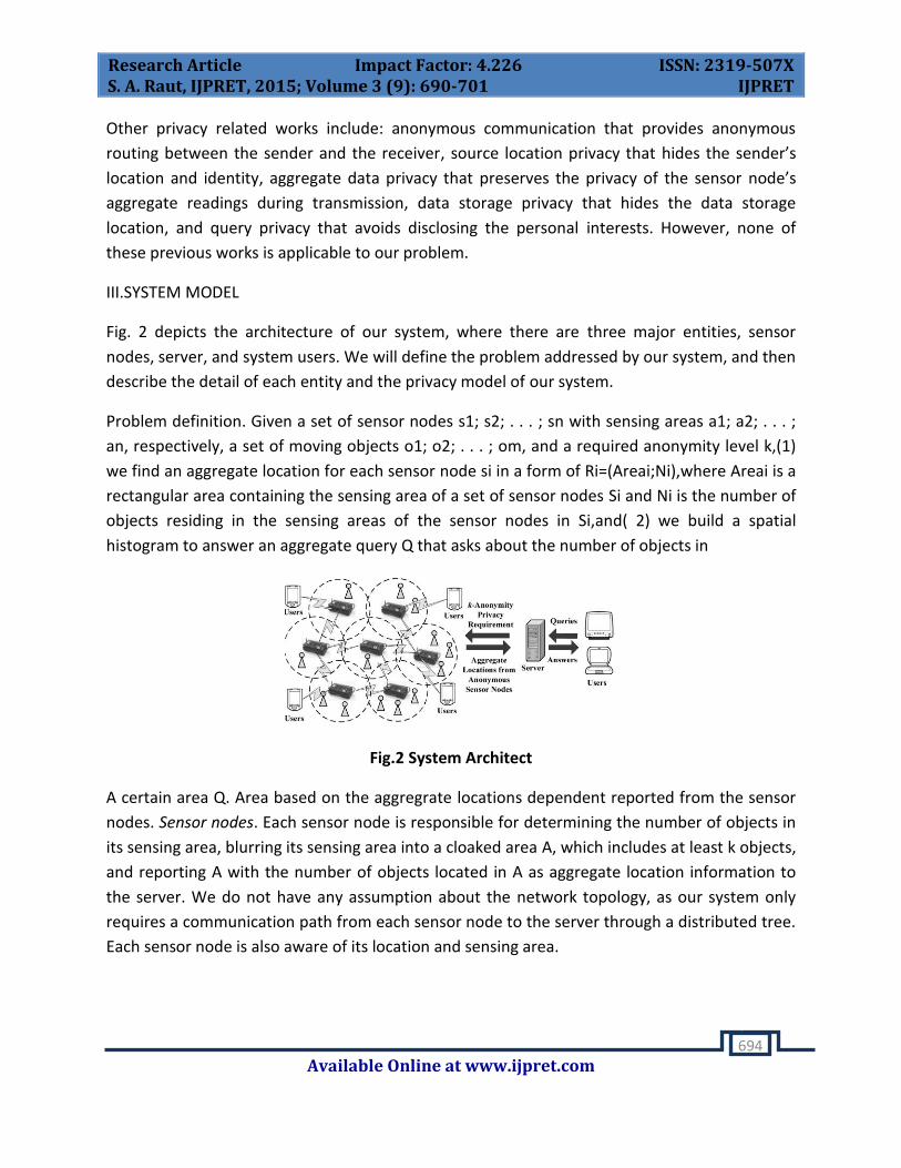
III.SYSTEM MODEL
Fig. 2 depicts the architecture of our system, where there are three major entities, sensor
nodes, server, and system users. We will define the problem addressed by our system, and then
describe the detail of each entity and the privacy model of our system.
Problem definition. Given a set of sensor nodes s1; s2; . . . ; sn with sensing areas a1; a2; . . . ;
an, respectively, a set of moving objects o1; o2; . . . ; om, and a required anonymity level k,(1)
we find an aggregate location for each sensor node si in a form of Ri=(Areai;Ni),where Areai is a
rectangular area containing the sensing area of a set of sensor nodes Si and Ni is the number of
objects residing in the sensing areas of the sensor nodes in Si,and( 2) we build a spatial
histogram to answer an aggregate query Q that asks about the number of objects in
Fig.2 System Architect
A certain area Q. Area based on the aggregrate locations dependent reported from the sensor
nodes. Sensor nodes. Each sensor node is responsible for determining the number of objects in
its sensing area, blurring its sensing area into a cloaked area A, which includes at least k objects,
and reporting A with the number of objects located in A as aggregate location information to
the server. We do not have any assumption about the network topology, as our system only
requires a communication path from each sensor node to the server through a distributed tree.
Each sensor node is also aware of its location and sensing area.

Research Article Impact Factor: 4.226 ISSN: 2319-507X S. A. Raut, IJPRET, 2015; Volume 3 (9): 690-701 IJPRET
Available Online at www.ijpret.com
695
Server. The server is responsible for collecting the aggregate locations reported from the sensor
nodes, using a spatial histogram to estimate the distribution of the monitored objects, and
answering range queries based on the estimated object distribution. Furthermore, the
administrator can change the anonymized level k of the system at any time by disseminating a
message with a new value of k to all the sensor nodes.
System users. Authenticated administrators and users can issue range queries to our system
through either the server or the sensor nodes, as depicted in Fig. 2. The server uses the spatial
histogram to answer their queries.
Privacy model. In our system, the sensor nodes constitute a trusted zone, where they behave as
defined in our algorithm and communicate with each other through a secure network channel
to avoid internal network attacks, for example, eavesdropping, traffic analysis, and malicious
Nodes. Since establishing such a secure network channel has been studied in the literature the
discussion of how to get this network channel is beyond the scope of this paper. However, the
solutions that have been used in previous works can be applied to our system. Our system also
provides anonymous communication between the sensor nodes and the server by employing
existing anonymous communication techniques .Thus given an aggregate location R, the server
only knows that the sender of R is one of the sensor nodes within R. Furthermore, only
authenticated administrators can change the k-anonymity level and the spatial histogram size.
In emergency cases, the administrators can set the k-anonymity level to a small value to get
more accurate aggregate locations from the sensor nodes, or even set it to zero to disable our
algorithm to get the original readings from the sensor nodes, in order to get the best services
from the system. Since the server and the system user are outside the trusted zone, they are
untrusted.
We now discuss the privacy threat in existing location monitoring systems. In an identity-sensor
location monitoring system, since each sensor node reports the exact location information of
each monitored object to the server, the adversary can pinpoint each object’s exact location.
On the other hand, in a counting-sensor location monitoring system, each sensor node reports
the number of objects in its sensing area to the server. The adversary can map the monitored
areas of the sensor nodes to the system layout. If the object count of a monitored area is very
small or equal to one, the adversary can infer the identity of the monitored objects based on
the mapped monitored area, for example, Alice is in her office room at time instance ti in Fig. 1.
Since our system only allows each sensor node to report a k-anonymous aggregate location to
the server, the adversary cannot infer an object’s exact location with any fidelity. The larger the
anonymity level, k, the more difficult for the adversary to infer the object’s exact location. With
Research Article Impact Factor: 4.226 ISSN: 2319-507X S. A. Raut, IJPRET, 2015; Volume 3 (9): 690-701 IJPRET
Available Online at www.ijpret.com
696
the k-anonymized aggregate locations reported from the sensor nodes, the underlying spatial
histogram at the server provides low-quality location monitoring services for a small area, and
better quality services for larger areas. This is a nice privacy-preserving feature, because the
object count of a small area is more likely to reveal personal location information. The
definition of a small area is relative to the required anonymity level, because our system
provides lower quality services for the same area if the anonymized level gets stricter.
IV.PROPOSED SYSTEM ALGORITHM
In this section, in-network resource and quality-aware location anonymization algorithms will
be presented which will be periodically executed by the sensor nodes to report their k-
anonymous aggregate locations to the server for every reporting period.
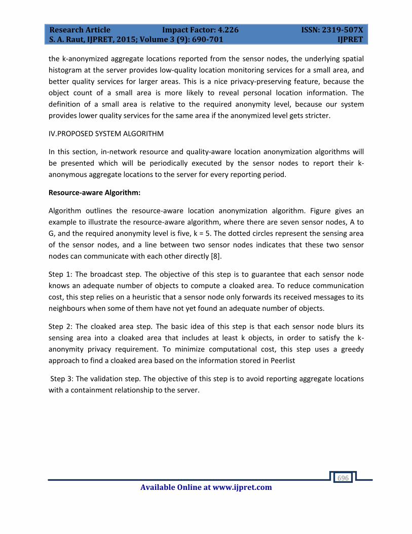
Resource-aware Algorithm:
Algorithm outlines the resource-aware location anonymization algorithm. Figure gives an
example to illustrate the resource-aware algorithm, where there are seven sensor nodes, A to
G, and the required anonymity level is five, k = 5. The dotted circles represent the sensing area
of the sensor nodes, and a line between two sensor nodes indicates that these two sensor
nodes can communicate with each other directly [8].
Step 1: The broadcast step. The objective of this step is to guarantee that each sensor node
knows an adequate number of objects to compute a cloaked area. To reduce communication
cost, this step relies on a heuristic that a sensor node only forwards its received messages to its
neighbours when some of them have not yet found an adequate number of objects.
Step 2: The cloaked area step. The basic idea of this step is that each sensor node blurs its
sensing area into a cloaked area that includes at least k objects, in order to satisfy the k-
anonymity privacy requirement. To minimize computational cost, this step uses a greedy
approach to find a cloaked area based on the information stored in Peerlist
Step 3: The validation step. The objective of this step is to avoid reporting aggregate locations
with a containment relationship to the server.

Research Article Impact Factor: 4.226 ISSN: 2319-507X S. A. Raut, IJPRET, 2015; Volume 3 (9): 690-701 IJPRET
Available Online at www.ijpret.com
697
Fig.3: The resource-aware location a anonymization algorithm(k=5)
The Quality-aware Algorithm:
The quality-aware algorithm starts from a cloaked area A, which is computed by resource aware
algorithm. Then A will be iteratively refined based on extra communication among the sensor
nodes until its area reaches the minimal possible size. For both algorithms, the sensor node
reports its cloaked area with the number of monitored persons in the area as an aggregate
location to the server[9].
Step 1: Search Space Step Since a typical sensor network has a large number of sensor nodes, it
is too costly for a sensor node m to gather the information of all the sensor nodes to compute
its minimal cloaked area. To reduce communication and computational cost, m determines a
search space, S, based on the input cloaked area computed by the resource-aware algorithm,
such that the sensor nodes outside S cannot be part of the minimal cloaked area.
Step 2: The Minimal Cloaked Area Step This step takes a set of peers residing in the search
space, S, as an input and computes the minimal cloaked area for the sensor node m. In this step
we propose two optimization techniques to reduce computational cost. The basic idea of the
first optimization technique is that we do not need to examine all the combinations of the
peers in S; instead, we only need to consider the combinations of at most four peers. Because
at most two sensor nodes defines width of MBR and at most two sensor nodes defines height
of MBR. Thus this optimization mainly reduces computational cost by reducing the number of
MBR computations among the peers in S. The second optimization technique lattice structure
and monotonicity property. In a lattice structure, a data set that contains n items can generate
2n-1 item sets excluding a null set. We generate the lattice structure from the lowest level
based on a simple generation rule. The monotonicity property of a function f indicates that if X
is a subset of Y , then f(X) must not exceed f(Y). For our problem, the MBR of a set of sensor
nodes S has the monotonicity property, because adding sensor nodes to S must not decrease
the area of the MBR of S or the number of objects within the MBR of S.

Research Article Impact Factor: 4.226 ISSN: 2319-507X S. A. Raut, IJPRET, 2015; Volume 3 (9): 690-701 IJPRET
Available Online at www.ijpret.com
698
Step 3: Validation Step This step is to avoid reporting aggregate locations with a containment
relationship to the server. We do not allow the sensor nodes to report their aggregate locations
with the containment relationship to the server, because combining these aggregate locations
may pose privacy leakage.
Fig.4: Quality-aware anonymization algorithm
V.AGGREGATE QUERY PROCESSING
Spatial Histogram
In this section, we present a spatial histogram that is embedded inside the server to estimate
the distribution of the monitored objects based on the aggregate locations reported from the
sensor nodes. Our spatial histogram is represented by a two-dimensional array that models a
grid structure G of NR rows and NC columns; hence, the system space is divided into NRX NC
disjoint equal-sized grid cells.
In each grid cell G(I,j), we maintain a float value that acts as an estimator H[I,j]
(1<i<Nc,1<j<Nr)of the number of objects within its area. We assume that the system has the
ability to know the total number of moving objects M in the system. The value of M will be used
to initialize the spatial histogram. In practice, M can be computed online for both indoor and
outdoor dynamic environments. For the indoor environment, the sensor nodes can be deployed
at each entrance and exit to count the number of users entering or leaving the system. For the
outdoor environment, the sensor nodes have been already used to count the number of people
in a predefined area. We use the spatial histogram to provide approximate location monitoring
services.
Initially, we assume that the objects are evenly distributed in the system, so the estimated
number of objects within each grid cell is H[i,j]=M/(Nr x Nc).The input of the histogram is a set
of aggregate locations R reported from the sensor nodes. Each aggregate location R in R
contains a cloaked area, R. Area, and the number of monitored objects within R: Area, R.N.
First, the aggregate locations in R are grouped into the same partition P={R1,R2,…..Rp} if their
cloaked areas are not overlapping with each other, which means that for every pair of

Research Article Impact Factor: 4.226 ISSN: 2319-507X S. A. Raut, IJPRET, 2015; Volume 3 (9): 690-701 IJPRET
Available Online at www.ijpret.com
699
aggregate locations Ri and Rj in P. Then, for each partition P, we update its entire set of
aggregate locations to the spatial histogram at the same time. For each aggregate location R in
P, we record the estimation error, which is the difference between the sum of the estimators
within R.Area, R.N^, and R.N, and then R.N is uniformly distributed among the estimators
within R:Area; hence each estimator within R:Area is set to R:N divided by the total number of
grid cells within R:Area .After processing all the aggregate locations in P, we sum up P the
estimation error of each aggregate location in P.
VI.PERFORMANCE METRIC OF PROPOSED SYSTEM
We evaluate our system in terms of five performance metrics.
1. Attack model error. This metric measures the resilience of our system to the attacker model
by the relative error between the estimated number of objects b N in a sensor node’s sensing
area and the actual one N. The error is measured as [N^_N/N], When N =0, we consider N^ as
the error.
2. Communication cost. We measure the communication cost of our location anonymization
algorithms in terms of the average number of bytes sent by each sensor node per reporting
period. This metric also indicates the network traffic and the power consumption of the sensor
nodes.
3. Cloaked area size. This metric measures the quality of the aggregate locations reported by
the sensor nodes. The smaller the cloaked area, the better the accuracy of the aggregate
location is.
4. Computational cost. We measure the computational cost of our location anonymization
algorithms in terms of the average number of the MBR computations that are needed to
determine a resource or quality-aware cloaked area. We compare our algorithms with a basic
approach that computes the MBR for each combination of the peers in the required search
space to find the minimal cloaked area. The basic approach does not employ any optimization
techniques proposed for our quality-aware algorithm.
5. Query error. This metric measures the utility of our system, in terms of the relative error
between the query answer M^, which is the estimated number of objects within the query
region based on a spatial histogram, and the actual answer M, respectively. The error is
measured as [M^-M]/M
When M= 0, we consider M^ as the error.
Research Article Impact Factor: 4.226 ISSN: 2319-507X S. A. Raut, IJPRET, 2015; Volume 3 (9): 690-701 IJPRET
Available Online at www.ijpret.com
700
For implementation of proposed system we are using Java technology as both programming
language and a platform. MYSQL is an open source relational database management system.
For internal memory Min 512MB RAM is used as hardware.
VII.CONCLUSION
In this paper, we propose a privacy-preserving location monitoring system for wireless sensor
networks. We design two in-network location anonymization algorithms, namely, resource and
quality-aware algorithms, that preserve personal location privacy, while enabling the system to
provide location monitoring services. Both algorithms rely on the well-established k-anonymity
privacy concept that requires a person is indistinguishable among k persons. In our system,
sensor nodes execute our location anonymization algorithms to provide k anonymous
aggregate locations, in which each aggregate location is a cloaked area A with the number of
monitored objects, N, located in A, where N _ k, for the system. The resource-aware algorithm
aims to minimize communication and computational cost, while the quality-aware algorithm
aims to minimize the size of cloaked areas in order to generate more accurate aggregate
locations. To provide location monitoring services based on the aggregate location information,
we propose a spatial histogram approach that analyzes the aggregate locations reported from
the sensor nodes to estimate the distribution of the monitored objects. The estimated
distribution is used to provide location monitoring services through answering range queries.
ACKNOWLEDGEMENT
I would like to thank my HOD Prof. S. M. Patil and Principal Dr. S. D. Swarkar for scientific
guidance, advice and technical discussions.
REFERENCES
1. Chi-Yin Chow, Mohamed F. Mokbel, Tian He, Member IEEE,”A Privacy Preserving Location
Monitoring System For Wireless Sensor Network ”IEEE Transactions On Mobile
Computing,vol.10,No.1,January 2011
2. Yun Li, Jian Ren, Senior Member, IEEE, and Jie Wu, Fellow, IEEE,” Quantitative Measurement
and Design of Source Location Privacy Schemes for Wireless Sensor Networks”, IEEE
Transactions On Parallel And Distributed Systems,Vol.23,No.7,July 2012
Research Article Impact Factor: 4.226 ISSN: 2319-507X S. A. Raut, IJPRET, 2015; Volume 3 (9): 690-701 IJPRET
Available Online at www.ijpret.com
701
3. Kiran Mehta, Donggang Liu, Member IEEE, and Matthew Wright, Member IEEE,” Protecting
Location Privacy in Sensor Networks against a Global Eavesdropper”, IEEE Transactions On
Mobile Computing,Vol.11,No.2,February 2012
4. Kirankumar B. Balavalad, Ajayakumar C. K. Atageri, Prithviraj. S. Patil, and Basavaraj M.
Angadi,” A Privacy-Preserving Location Monitoring System for WSNs with Blocking Misbehaving
Users in Anonymity Networks”, Journal of Advances in Computer Networks, Vol. 2, No. 4,
December 2014
5. Gayathri M, Bharathi M, Department of Computer Science and Engineering, SJCIT,“ A K-
Anonymity Privacy-Preserving Location Monitoring System for Wireless Sensor Networks with
Nymble Secure System”, International Journal of Computer & Organization Trends –Volume
2,Issue2- 2012.
6. Bandana Kumari, G. Geetha and L. Bhagyalakshmi, Dept. of CSE, Jerusalem College of
Engineering, Dept. of IT, Easwari Engineering College, Chennai, India,” K-Anonymity based
Privacy-Preserving location Monitoring Services for Wireless Sensor Networks”, International
Journal Of Computer Applications In Engineering Sciences”, Vol 3,Special issue, August 2013
7. S. Suresh Kumar¹, Mrs. Manjula.G, MTech Student, Department of ISE, East West Institute of
Technology, Karnataka, India, Assistant Professor, Department of ISE, East West Institute of
Technology, Karnataka, India,” Location Monitoring System in Wireless Sensor Networks Using
Aggregate Query Processor”, International Journal of Advanced Research in Computer Science
and Software Engineering,Vol.3,May 2013.
8. Dattatray P. Gade,Dhiraj S. Rathod, Vilas R. Khomne, Yogita R. Avhad Pune University,”
Implementing Privacy Preserving Location Monitoring System in WSN”, International Journal of
Emerging Technology and Advanced Engineering,Vol.3,Issue 3,May 2013.
9. M.B.Raghavendra1 and Dr. P.Harini, M. Tech(CSE), JNTUK, St. Ann’s College of Engineering
&Technology, Chirala, HOD-CSE, JNTUK, St. Ann’s College of Engineering &Technology, Chirala,”
Quality-Aware Location Monitoring For Wireless Sensor Network”, International Journal of Ad
hoc, Sensor & Ubiquitous Computing (IJASUC) Vol.3, No.4, August 2012.


