Akre
Zakho
Al Haditha
Khanaqin
Kfri
BaladRuz
MiqdadiyaAl Khalis
Hit
Ar Rutbah
Al Qa'im
Al Fallujah
Al Mahawil
Mahmudiya
Ali alGharbi
Al Hashimiyah
Al Kufa
As Salman
Rumaitha Al Mijar al KabirAl Miamona
Qal`atSalih
Al MadianaAl Qurnah
Al Khithir
Az ZubayrShatt Al ArabAbu al Khasib
Al Misiab
Makhmur
MergasurLower
Amedi
Soran Choman[1]
Shaqlawa
Koysinjaq
Mansour
Anah
Rusafa
AinSifne
Tilkef
Al HamdaniyahTalafarSinjar
Hatra
Bayji TouzHourmato
KalarTikrit
Al HamzaShamiya
Haweeja
Chamchamal
Ranya
Dukaro Halabja
Penjwin
Darbandikhan
Al Door
Balad
Badrah
Refai
Al Hayy
Suq ashShuyukh
Chibayish
Shatrah
Dibs
Al Aziziya
Al Noamania
As Suwayrah
Baghdad
Dahuk
Erbil
Ba`aqubah
Ramadi
Kerbala
Najaf
Amarah
Samawah
Basrah
Hilla
Mosul
Diwaniya
Sulaymaniyah
Samarra
Kut
Nassriyah
Kirkuk
ANBAR
BABYLON
BAGHDAD
BASRAH
DAHUK
DIYALA
ERBIL
KERBALA
MISSAN
MUTHANNA
NAJAF
NINEWA
QADISSIYA
SALAHAL-DIN
SULAYMANIYAHKIRKUK
THI-QAR
WASSIT
IRAN
JORDAN
KUWAIT
SAUDIARABIA
SYRIA
TURKEY
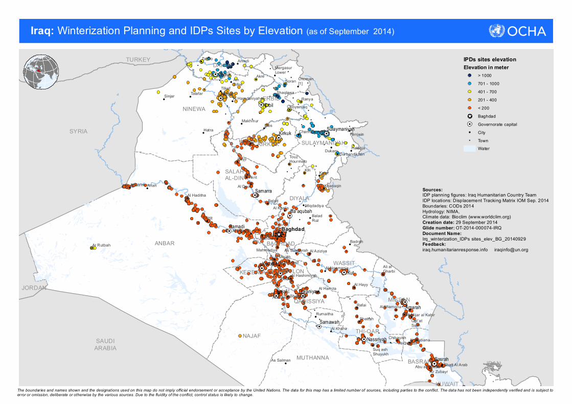
Iraq: Winterization Planning and IDPs Sites by Elevation
The boundaries and names shown and the designations used on this map do not imply official endorsement or acceptance by the United Nations. The data for this map has a limited number of sources, including parties to the conflict. The data has not been independently verified and is subject toerror or omission, deliberate or otherwise by the various sources. Due to the fluidity of the conflict, control status is likely to change.
IPDs sites elevationElevation in meter
> 1000701 - 1000401 - 700201 - 400< 200BaghdadGovernorate capitalCityTownWater
(as of September 2014)
Sources: IDP planning figures: Iraq Humanitarian Country TeamIDP locations: Displacement Tracking Matrix IOM Sep. 2014Boundaries: CODs 2014 Hydrology: NIMA, Climate data: Bioclim (www.worldclim.org)Creation date: 29 September 2014Glide number: OT-2014-000074-IRQDocument Name:Irq_winterization_IDPs sites_elev_BG_20140929Feedback: iraq.humanitarianresponse.info [email protected]

Akre
Zakho
Al Haditha
Khanaqin
Kfri
BaladRuz
MiqdadiyaAl Khalis
Hit
Al Qa'im
Al Fallujah
Makhmur
MergasurLower
Amedi
Soran Choman[1]
Shaqlawa
Koysinjaq
AbuGharaib
Adhamiyah
Rasheed
Anah
KaradahRusafa
AinSifne
Tilkef
Al HamdaniyahTalafar
Sinjar
Hatra
Bayji TouzHourmato
KalarTikrit
Haweeja
Chamchamal
Ranya
DukaroHalabja
Penjwin
Darbandikhan
Al Door
Balad
Badrah
Dibs
Baghdad
Dahuk
Erbil
Ba`aqubah
Ramadi
Mosul
Sulaymaniyah
Samarra
Kirkuk
ANBAR
BABYLON BAGHDAD
DAHUK
DIYALA
ERBILNINEWA
SALAHAL-DIN
SULAYMANIYAH
KIRKUK
WASSIT
IRAN
SYRIA
TURKEY
Iraq: Winterization Planning and IDPs Sites by Elevation
The boundaries and names shown and the designations used on this map do not imply official endorsement or acceptance by the United Nations. The data for this map has a limited number of sources, including parties to the conflict. The data has not been independently verified and is subject toerror or omission, deliberate or otherwise by the various sources. Due to the fluidity of the conflict, control status is likely to change.
Iraq
IranSyria
Turkey
Jordan
Azerbaijan
Mosul
Najaf
Erbil
Basrah
RamadiBaghdad
(as of September 2014)
Avg.Temperature of Coldest Month
Sources: IDP planning figures: Iraq Humanitarian Country TeamIDP locations: Displacement Tracking Matrix IOM Sep. 2014Boundaries: CODs 2014 Hydrology: NIMA, Climate data: Bioclim (www.worldclim.org)Creation date: 29 September 2014Glide number: OT-2014-000074-IRQDocument Name:Irq_winterization_IDPs sites_elev_KRG_BG_20140929Feedback: iraq.humanitarianresponse.info [email protected]
LegendIPDs sites elevationElevation in meter
> 1000701 - 1000401 - 700201 - 400< 200BaghdadGovernorate capitalCityTown
Coldest month average temp (deg C)High : 45
Low : -150


