1
Junior Cycle Geography
Draft Curriculum Specification
March 2017

2
March 2017

3
Contents
Introduction to junior cycle ..................................................................................................... 5
Rationale ................................................................................................................................. 6
Aim .......................................................................................................................................... 7
Overview: Links ....................................................................................................................... 8
Statements of learning ............................................................................................................ 8
Key skills ................................................................................................................................ 10
Overview: Course .................................................................................................................. 13
Expectations for students ..................................................................................................... 18
Learning outcomes ................................................................................................................ 18
Strand 1. Exploring the physical world …………………………………………………………………………….19
Strand 2: Exploring how we interact with the physical world ………………………………………… 20
Strand 3: Exploring people, place and change ………………………………………………………………...21
Assessment and reporting .................................................................................................... 19
Assessment for the JCPA ....................................................................................................... 23
Appendix A: Glossary of action verbs.................................................................................... 27
Appendix B: Glossary of terms …………………………………………………………………………………………30

4

5
Introduction to junior cycle
Junior cycle education places students at the centre of the educational experience, enabling them to
actively participate in their communities and in society and to be resourceful and confident learners in
all aspects and stages of their lives. Junior cycle is inclusive of all students and contributes to equality of
opportunity, participation and outcome for all.
The junior cycle allows students to make a greater connection with learning by focusing on the quality
of learning that takes place and by offering experiences that are engaging and enjoyable for them, and
relevant to their lives. These experiences are of a high quality, contribute directly to the physical, mental
and social wellbeing of learners, and where possible, provide opportunities for them to develop their
abilities and talents in the areas of creativity, innovation and enterprise. The learner’s junior cycle
programme builds on their learning to date and actively supports their progress in learning and in
addition, supports them in developing the learning skills that will assist them in meeting the challenges
of life beyond school.
6
Rationale
The study of geography empowers the person to explore and understand the world around them.
Engagement with the subject promotes a deep understanding of people and place. Students develop
the skills to read their environment, enabling them to interpret the physical landscape, observe climatic
events with an informed eye and discuss world events in a knowledgeable manner. Learning in
geography supports students in making informed decisions, giving the ability to make valuable
contributions to the economic, social, and cultural life of their communities, localities and countries.
Through the study of geography, people are encouraged to appreciate the processes that shape their
world and view global issues as ethical citizens. Geography provides a platform to analyse world events,
empowering young people as informed, active citizens. Studying geography enhances students’ ability
to engage with issues such as sustainable development, economic systems, hazard management and
climate change. The topics experienced help develop students’ awareness and understanding of cultural
variations fostering a respect of difference.
Students are growing up in a globalised, dynamic world. Geography provides a medium to explore
current events in our world. Students viewing events through a geographical lens are well placed to be
part of a generation which can deal effectively with, and mitigate global challenges and rise to related
opportunities.
The skills developed through the subject are transferrable and will benefit students in study and life.
Geography encourages structured inquiry: this critical thinking involves students asking questions,
gathering data, evaluating and interpreting, and presenting information. It encourages collaboration
and communication with their peers and experts in other fields.

7
Aim
The study of junior cycle geography enables students to become geographically literate. It develops
knowledge, skills, values and behaviours that allow students to explore the physical world, human
activities, and how we interact with our world. It stimulates curiosity, creating opportunities for students
to read, analyse, synthesise and communicate about their immediate environment and wider world.
8
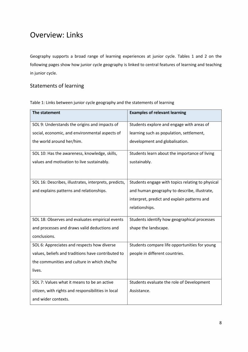
Overview: Links
Geography supports a broad range of learning experiences at junior cycle. Tables 1 and 2 on the
following pages show how junior cycle geography is linked to central features of learning and teaching
in junior cycle.
Statements of learning
Table 1: Links between junior cycle geography and the statements of learning
The statement Examples of relevant learning
SOL 9: Understands the origins and impacts of
social, economic, and environmental aspects of
the world around her/him.
Students explore and engage with areas of
learning such as population, settlement,
development and globalisation.
SOL 10: Has the awareness, knowledge, skills,
values and motivation to live sustainably.
Students learn about the importance of living
sustainably.
SOL 16: Describes, illustrates, interprets, predicts,
and explains patterns and relationships.
Students engage with topics relating to physical
and human geography to describe, illustrate,
interpret, predict and explain patterns and
relationships.
SOL 18: Observes and evaluates empirical events
and processes and draws valid deductions and
conclusions.
Students identify how geographical processes
shape the landscape.
SOL 6: Appreciates and respects how diverse
values, beliefs and traditions have contributed to
the communities and culture in which she/he
lives.
Students compare life opportunities for young
people in different countries.
SOL 7: Values what it means to be an active
citizen, with rights and responsibilities in local
and wider contexts.
Students evaluate the role of Development
Assistance.
9
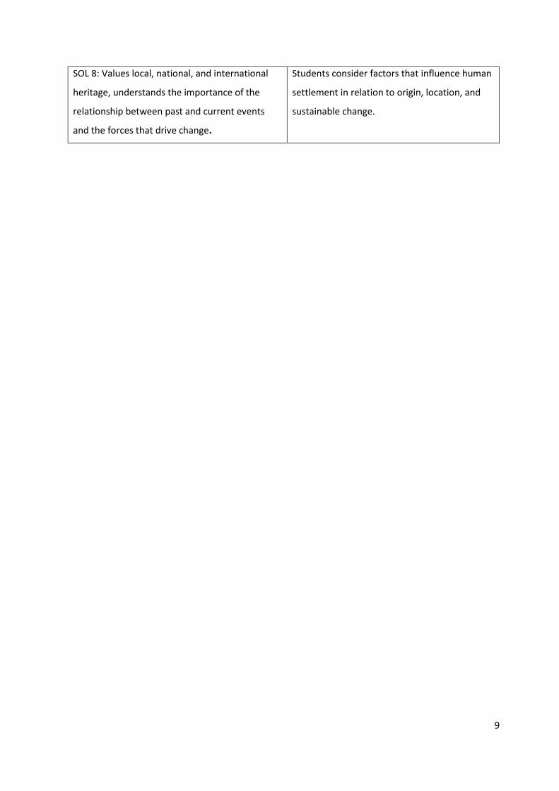
SOL 8: Values local, national, and international
heritage, understands the importance of the
relationship between past and current events
and the forces that drive change.
Students consider factors that influence human
settlement in relation to origin, location, and
sustainable change.

10
Key skills
In addition to their specific content and knowledge, the subjects and short courses of junior cycle
provide students with opportunities to develop a range of key skills. There are opportunities to support
all key skills in this course but some are particularly significant.
The junior cycle curriculum focuses on eight key skills:
Figure 1: Key skills of junior cycle
11
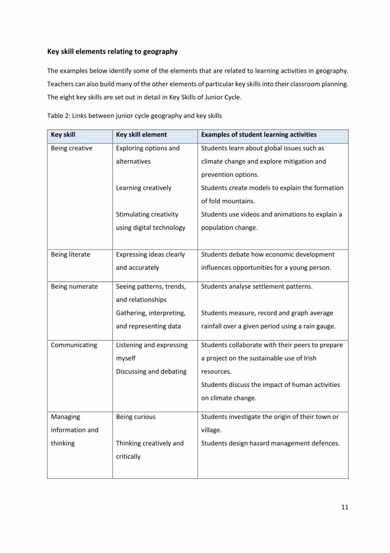
Key skill elements relating to geography
The examples below identify some of the elements that are related to learning activities in geography.
Teachers can also build many of the other elements of particular key skills into their classroom planning.
The eight key skills are set out in detail in Key Skills of Junior Cycle.
Table 2: Links between junior cycle geography and key skills
Key skill Key skill element Examples of student learning activities
Being creative Exploring options and
alternatives
Learning creatively
Stimulating creativity
using digital technology
Students learn about global issues such as
climate change and explore mitigation and
prevention options.
Students create models to explain the formation
of fold mountains.
Students use videos and animations to explain a
population change.
Being literate Expressing ideas clearly
and accurately
Students debate how economic development
influences opportunities for a young person.
Being numerate Seeing patterns, trends,
and relationships
Gathering, interpreting,
and representing data
Students analyse settlement patterns.
Students measure, record and graph average
rainfall over a given period using a rain gauge.
Communicating Listening and expressing
myself
Discussing and debating
Students collaborate with their peers to prepare
a project on the sustainable use of Irish
resources.
Students discuss the impact of human activities
on climate change.
Managing
information and
thinking
Being curious
Thinking creatively and
critically
Students investigate the origin of their town or
village.
Students design hazard management defences.
12
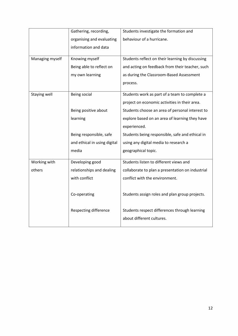
Gathering, recording,
organising and evaluating
information and data
Students investigate the formation and
behaviour of a hurricane.
Managing myself Knowing myself
Being able to reflect on
my own learning
Students reflect on their learning by discussing
and acting on feedback from their teacher, such
as during the Classroom-Based Assessment
process.
Staying well Being social
Being positive about
learning
Being responsible, safe
and ethical in using digital
media
Students work as part of a team to complete a
project on economic activities in their area.
Students choose an area of personal interest to
explore based on an area of learning they have
experienced.
Students being responsible, safe and ethical in
using any digital media to research a
geographical topic.
Working with
others
Developing good
relationships and dealing
with conflict
Co-operating
Respecting difference
Students listen to different views and
collaborate to plan a presentation on industrial
conflict with the environment.
Students assign roles and plan group projects.
Students respect differences through learning
about different cultures.

13
Overview: Course
The specification for Junior Cycle Geography focuses on developing students’ knowledge and skills to
explore and understand the world around us and our role within it. This is achieved through the three
interconnected strands: Exploring the physical world; Exploring how we interact with the physical world;
and Exploring people, place and change, with one overarching concept entitled Geoliteracy. It has been
designed for a minimum of 200 hours timetabled student engagement across the three years of junior
cycle.
Figure 2: The structure of the specification for junior cycle geography
Exploring the physical world
Exploring people, place and change
Exploring how we interact
with the physical world

14
Geoliteracy
The specification is informed by the concept of Geoliteracy. This refers to students’ ability to develop
far-reaching understandings through geographical thinking and reasoning.
The core components of Geoliteracy are the three I’s:
▪ Interactions
▪ Interconnections
▪ Implications.
Interactions refers to human-environment interactions. Interconnections refers to the linkage between
people, places, environments, and spatial patterns, either by tangible links such as roads or intangible
links such as politics. Implications relate the concept back to the individual. The concept facilitates
students’ understanding of geographical topics in an integrated manner demonstrating the
interrelationship between topics and the impact it has on the student. Geoliteracy aims to develop
cognitive, interpersonal, and intrapersonal competencies through the curriculum that are sustainable
throughout students’ lives.
Three interconnected strands
The specification sets out three interconnected strands.
Exploring the physical world
This strand focuses on facilitating students’ exploration of how the physical world is formed and
changed. Students develop knowledge and skills to understand and explain the physical world. Students
engage and interact with topics relating to physical geography and explore their interrelationships and
any implications those topics might have on students’ lives. They apply their knowledge and skills to
explain spatial characteristics and the formation of phenomena in the physical world.
Exploring how we interact with the physical world
This strand focuses on facilitating students’ understanding of how people interact with the physical
world and the implications this might have for their lives. Students explore how we depend on, adapt,

15
and change the physical world. Students apply their knowledge and skills to explain how we interact
with our physical world for economic purposes, as well as how we adapt to physical phenomena.
Exploring people, place and change
This strand focuses on students exploring people, place and change. Students engage with topics
relating to globalisation, development, population and interdependence. Students interact with topics
while exploring interrelationships and the implications those topics might have for their lives. They apply
their knowledge and skills to explain settlement patterns, urbanisation, demographics, and human
development.
The elements
These elements inform how students will experience the learning outcomes within the strands. Students
will approach the learning outcomes through the lens of each of the elements.
1. Processes, patterns, systems and scale
2. Geographical skills
3. Sustainability.
Figure 3: The elements of the contextual strands showing the integrated nature of the geography
specification
Element
Processes, patterns,
systems and scale
▪ Students learn about how geographical processes form and shape
our physical, environmental and social world.
▪ Students identify patterns and distribution of geographical
phenomena and draw conclusions based on their findings. This
includes recognising, analysing and explaining similarities or
differences in phenomena.
▪ Students analyse the components that combine to create a system.
▪ Students study topics at a variety of scales and levels.
Geographical skills Students will develop their graphicacy through using geographical skills
such as map interpretation and drawing, figure interpretation and
drawing, photo analysis and numerical calculation.

16
▪ Asking geographical questions: Where is it located? Why is it there?
What is the significance of the location?
▪ Investigating geographical data: Gathering data from diverse
sources in various ways to develop information that will inform
responses.
▪ Organising and interpreting geographical data: Different types of
data may be separated and classified in visual, graphic forms: paper
and computer-generated maps, or various geospatial images.
▪ Analysing geographical information: Geographic information
involves seeking patterns, relationships, and connections.
▪ Presenting geographical information: Students learn not only to
manage data but also to assemble it so that it is clear and concise.
The data that derives from the process can be organised in graphic
form (maps, tables, graphs, etc.) or oral and written narratives.
Sustainability ▪ Students consider sustainable approaches towards meeting the
current and future needs of society and the environment.

17
Progression from primary to senior cycle
Primary curriculum
Geography is part of Social, Environmental and Scientific Education (SESE). Geography in the primary
school is concerned with the three major themes of place, space, and environment. The essence of the
subject is understanding the world around us and developing a sense of place and space. There is a
strong emphasis on local environment and developing geographical investigation skills. Students at
primary-level geography are encouraged to actively engage with their environment to investigate,
identify interrelationships and draw conclusions. The Junior Cycle Geography specification can progress
the related learning that has taken place at primary level through a similar approach of understanding
how geographical processes form and shape our physical, environmental, and social world. The
curriculum at primary recommends an integrated approach towards topics studied; this approach
continues with the geography curriculum at junior cycle.
Senior cycle
The Junior Cycle Geography specification is developed to align with significant themes and aspects of
Leaving Certificate Geography to allow for the transfer of knowledge and skills. The strands and
elements will allow students to develop the foundations of the knowledge and skills for progression to
senior cycle and provide useful opportunities for continued learning in many subjects. The depth and
breadth of the learning at junior cycle will provide students with the experience of geographical
concepts that will be further developed at senior cycle.
18
Expectations for students
Expectations for students is an umbrella term that links learning outcomes with annotated examples of
student work in the subject specification. When teachers, students or parents looking at the online
specification scroll over the learning outcomes, a link will sometimes be available to examples of work
associated with a specific learning outcome or with a group of learning outcomes. The examples of
student work will have been selected to illustrate expectations and will have been annotated by
teachers and will be made available alongside this specification. The examples will include work that is:
▪ exceptional
▪ above expectations
▪ in line with expectations.
The purpose of the examples of student work is to show the extent to which the learning outcomes are
being realised in actual cases.
Learning outcomes
Learning outcomes are statements that describe what knowledge, understanding, skills and values
students should be able to demonstrate having studied geography in junior cycle. The learning
outcomes set out in the following tables apply to all students. As set out here they represent outcomes
for students at the end of their three years of study. The specification stresses that the learning
outcomes are for three years and therefore the learning outcomes focused on at a point in time will
not have been ‘completed’, but will continue to support students’ learning of geography up to the
end of junior cycle. A list of action verbs and glossary (Appendix B) will support understanding of what
is expected of students in each learning outcome.
The outcomes are numbered within each strand. The numbering is intended to support teacher planning
in the first instance and does not imply any hierarchy of importance across the outcomes themselves.
Junior Cycle Geography is offered at a common level. The examples of student work linked to learning
outcomes will offer commentary and insights that support different standards of student work.
19
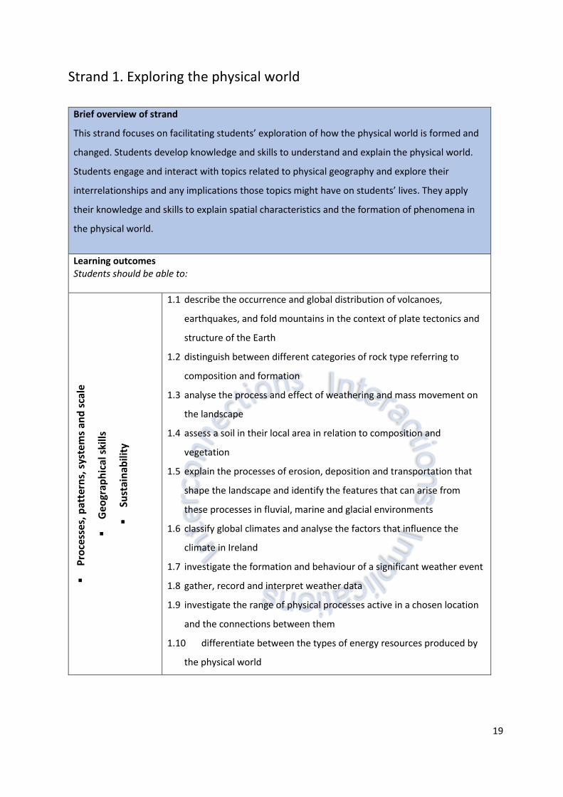
Strand 1. Exploring the physical world
Brief overview of strand
This strand focuses on facilitating students’ exploration of how the physical world is formed and
changed. Students develop knowledge and skills to understand and explain the physical world.
Students engage and interact with topics related to physical geography and explore their
interrelationships and any implications those topics might have on students’ lives. They apply
their knowledge and skills to explain spatial characteristics and the formation of phenomena in
the physical world.
Learning outcomes Students should be able to:
▪
Pro
cess
es,
pat
tern
s, s
yste
ms
and
sca
le
▪
Geo
grap
hic
al s
kills
▪
Sust
ain
abili
ty
1.1 describe the occurrence and global distribution of volcanoes,
earthquakes, and fold mountains in the context of plate tectonics and
structure of the Earth
1.2 distinguish between different categories of rock type referring to
composition and formation
1.3 analyse the process and effect of weathering and mass movement on
the landscape
1.4 assess a soil in their local area in relation to composition and
vegetation
1.5 explain the processes of erosion, deposition and transportation that
shape the landscape and identify the features that can arise from
these processes in fluvial, marine and glacial environments
1.6 classify global climates and analyse the factors that influence the
climate in Ireland
1.7 investigate the formation and behaviour of a significant weather event
1.8 gather, record and interpret weather data
1.9 investigate the range of physical processes active in a chosen location
and the connections between them
1.10 differentiate between the types of energy resources produced by
the physical world
20
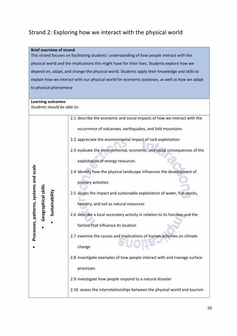
Strand 2: Exploring how we interact with the physical world
Brief overview of strand This strand focuses on facilitating students’ understanding of how people interact with the
physical world and the implications this might have for their lives. Students explore how we
depend on, adapt, and change the physical world. Students apply their knowledge and skills to
explain how we interact with our physical world for economic purposes, as well as how we adapt
to physical phenomena
Learning outcomes Students should be able to:
▪
Pro
cess
es,
pat
tern
s, s
yste
ms
and
sca
le
▪
Geo
grap
hic
al s
kills
▪
Sust
ain
abili
ty
2.1 describe the economic and social impacts of how we interact with the
occurrence of volcanoes, earthquakes, and fold mountains
2.2 appreciate the environmental impact of rock exploitation
2.3 evaluate the environmental, economic, and social consequences of the
exploitation of energy resources
2.4 identify how the physical landscape influences the development of
primary activities
2.5 assess the impact and sustainable exploitation of water, fish stocks,
forestry, and soil as natural resources
2.6 describe a local secondary activity in relation to its function and the
factors that influence its location
2.7 examine the causes and implications of human activities on climate
change
2.8 investigate examples of how people interact with and manage surface
processes
2.9 investigate how people respond to a natural disaster
2.10 assess the interrelationships between the physical world and tourism
21
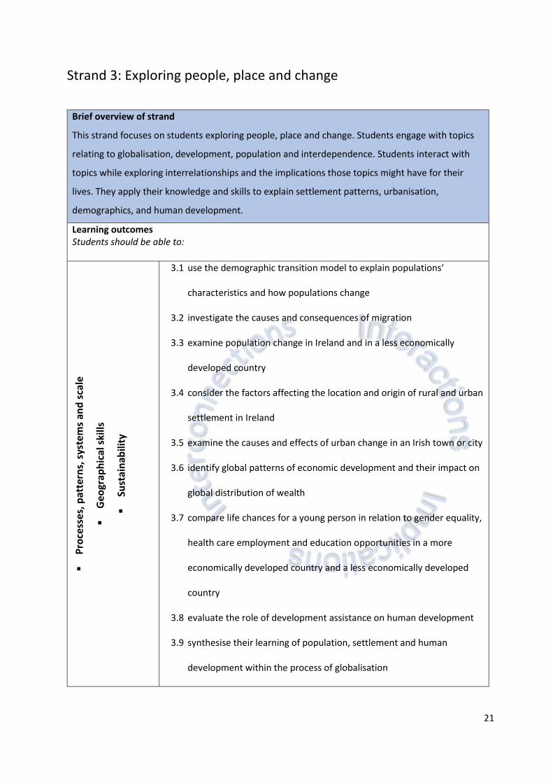
Strand 3: Exploring people, place and change
Brief overview of strand
This strand focuses on students exploring people, place and change. Students engage with topics
relating to globalisation, development, population and interdependence. Students interact with
topics while exploring interrelationships and the implications those topics might have for their
lives. They apply their knowledge and skills to explain settlement patterns, urbanisation,
demographics, and human development.
Learning outcomes Students should be able to:
▪
Pro
cess
es,
pat
tern
s, s
yste
ms
and
sca
le
▪
Geo
grap
hic
al s
kills
▪
Sust
ain
abili
ty
3.1 use the demographic transition model to explain populations’
characteristics and how populations change
3.2 investigate the causes and consequences of migration
3.3 examine population change in Ireland and in a less economically
developed country
3.4 consider the factors affecting the location and origin of rural and urban
settlement in Ireland
3.5 examine the causes and effects of urban change in an Irish town or city
3.6 identify global patterns of economic development and their impact on
global distribution of wealth
3.7 compare life chances for a young person in relation to gender equality,
health care employment and education opportunities in a more
economically developed country and a less economically developed
country
3.8 evaluate the role of development assistance on human development
3.9 synthesise their learning of population, settlement and human
development within the process of globalisation

22
Assessment and reporting
Assessment in education involves gathering, interpreting and using information about the processes
and outcomes of learning. It takes different forms and can be used in a variety of ways, such as to record
and report achievement, to determine appropriate routes for learners to take through a differentiated
curriculum, or to identify specific areas of difficulty or strength for a given learner. While different
techniques may be employed for formative, diagnostic and summative purposes, the focus of the
assessment and reporting is on the improvement of student learning. To do this it must fully reflect the
aim of the curriculum.
The junior cycle places a strong emphasis on assessment as part of the learning process. This approach
requires a more varied approach to assessment in ensuring that the assessment method or methods
chosen are fit for purpose, timely and relevant to students. Assessment in junior cycle geography will
optimise the opportunity for students to become reflective and active participants in their learning and
for teachers to support this. This rests upon the provision for learners of opportunities to negotiate
success criteria against which the quality of their work can be judged by peer, self, and teacher
assessment; and upon the quality of the focused feedback they get in support of their learning.
Providing focused feedback to students on their learning is a critical component of high-quality
assessment and a key factor in building students’ capacity to manage their own learning and their
motivation to stick with a complex task or problem. Assessment is most effective when it moves beyond
marks and grades, and reporting focuses not just on how the student has done in the past but on the
next steps for further learning. This approach will ensure that assessment takes place as close as possible
to the point of learning. Summative assessment still has a role to play, but is only one element of a
broader approach to assessment.
Essentially, the purpose of assessment and reporting at this stage of education is to support learning.
Parents/guardians should receive a comprehensive picture of student learning. Linking classroom
assessment and other assessment with a new system of reporting that culminates in the awarding of
the Junior Cycle Profile of Achievement (JCPA) will offer parents/guardians a clear and broad picture of
their child’s learning journey over the three years of junior cycle.
23
To support this, teachers and schools will have access to an Assessment Toolkit. Along with the guide
to the Subject Learning and Assessment Review (SLAR) process, the Assessment Toolkit will include
learning, teaching and assessment support material, including:
▪ Formative assessment
▪ Planning for and designing assessment
▪ Ongoing assessments for classroom use
▪ Judging student work – looking at expectations for students and features of quality
▪ Reporting to parents and students
▪ Thinking about assessment: ideas, research and reflections
▪ A glossary.
The contents of the Assessment Toolkit will include a range of assessment supports, advice and
guidelines that will enable schools and teachers to engage with the new assessment system and
reporting arrangements in an informed way, with confidence and clarity.
Assessment for the Junior Cycle Profile of Achievement
The assessment of geography for the purposes of the Junior Cycle Profile of Achievement (JCPA) will
comprise two Classroom-Based Assessments: Geography in the news; and My geography. In addition,
the second Classroom-Based Assessment will have a written Assessment Task that will be prepared and
marked, along with a final examination, by the State Examinations Commission.
Rationale for the Classroom-Based Assessments in Geography
Classroom-Based Assessments are the occasions when the teacher assesses students in the specific
assessments that are set out in the specification. Classroom-Based Assessments are similar to the
formative assessment that occurs every day in every class. However, in the case of the Classroom-Based
Assessments, the teacher’s judgement is recorded for the purpose of subject learning and assessment
review, and for the school’s reporting to parents and students. Students will experience the Classroom-
Based Assessments in geography through the lens of the three contextual elements:
1. Processes, patterns, systems and scale
2. Geographical skills
3. Sustainability.

24
Over the three years of junior cycle, students will be provided with opportunities to stimulate their
curiosity and interest in geography. The Classroom-Based Assessments link to the priorities for learning
and teaching in geography. It is envisaged that through the Classroom-Based Assessments they will
actively engage in practical and authentic learning experiences.
The Classroom-Based Assessments will provide an opportunity for students to:
▪ Research information using a range of methods
▪ Analyse data and evidence to make informed value judgements and decisions
▪ Organise information and plan logically
▪ Communicate clearly and effectively
▪ Collaborate with others on tasks
▪ Reflect on their contributions to the work and their own learning
▪ Apply their learning to current, relevant contexts
▪ Be empowered and engaged to explore areas of personal interest linking to areas of study.
Through these Classroom-Based Assessments students will develop their knowledge, understanding,
skills and values, thereby achieving the learning outcomes across the strands.
Classroom-Based Assessment 1: Geography in the news
CBA
Geography in the
news
Format Student preparation Completion of
assessment
SLAR
meeting
Structured
inquiry through a
response to a
recent
geographical
event
Reports
which may
be presented
in a wide
range of
formats
At the end of a three-week
period students will report
on their inquiry, based on a
recent media source,
relating to a geographical
event
Second term
of second year
One review
meeting

25
Classroom-Based Assessment 2: My geography
CBA
My geography Format Student preparation
Completion of
assessment
SLAR
meeting
Structured
inquiry into an
aspect of the
geography of a
local area
Reports
which may
be presented
in a wide
range of
formats
Students will, over a three-
week period, investigate an
aspect of geography in a
local area
First term of
third year
One review
meeting
Features of quality
The features of quality support student and teacher judgement of the Classroom-Based Assessments
and are the criteria that will be used by teachers to assess the pieces of student work. All students will
complete both CBAs. The features of quality will be available in Assessment Guidelines for Geography.
Assessing the Classroom-Based Assessments
More detailed material on assessment for reporting in Junior Cycle Geography, setting out details of the
practical arrangements related to assessment of the Classroom-Based Assessments, will be available in
separate Assessment Guidelines for Geography. This will include, for example, the suggested length and
formats for student pieces of work, and support in using ‘on balance’ judgement in relation to the
features of quality.
The NCCA’s Assessment Toolkit will also include substantial resource material for use and reference in
the ongoing classroom assessment of Junior Cycle Geography, as well as providing a detailed account of
the Subject Learning and Assessment Review process.
26
Assessment Task
On completion of the Classroom-Based Assessments, students will undertake an Assessment Task. This
Assessment Task will be completed after the second Classroom-Based Assessment and will be marked
by the State Examinations Commission.
The Assessment Task will assess students in aspects of their learning including:
▪ Their ability to reflect on the development of their geographical thinking
▪ Their ability to evaluate new knowledge or understanding that has emerged through their
experience of the Classroom-Based Assessment
▪ Their ability to reflect on the skills they have developed, and their capacity to apply them to
unfamiliar situations in the future
▪ Their ability to reflect on how their appreciation of geography has been influenced through the
experience of the Classroom-Based Assessment.
Final examination
There will be one examination paper at a common level, set and marked by the State Examinations
Commission (SEC). The examination will be no longer than two hours in duration and will take place in
June of third year. In any year, the learning outcomes to be assessed will constitute a sample of the
relevant outcomes from the tables of learning outcomes.
Inclusive assessment practices
This specification allows for inclusive assessment practices whether as part of ongoing assessment or
Classroom-Based Assessments. Where a school judges that a student has a specific physical or learning
difficulty, reasonable accommodations may be put in place to remove, as far as possible, the impact of
the disability on the student’s performance in Classroom-Based Assessments. The accommodations,
e.g. the support provided by a Special Needs assistant or the support of assistive technologies, should
be in line with the arrangements the school has put in place to support the student’s learning
throughout the year.

27
Appendix A: Glossary of action verbs
This glossary is designed to clarify the learning outcomes. Each action verb is described in terms of what
the learner should be able to do once they have achieved the learning outcome. This glossary will be
aligned with the command words used in the assessment.
Action verbs Students should be able to
Analyse study or examine something in detail, break down in order to bring out
the essential elements or structure; identify parts and relationships, and
to interpret information to reach conclusions
Apply select and use information and/or knowledge and understanding to
explain a given situation or real circumstances
Appreciate recognise the meaning of, have a practical understanding of
Assess judge, evaluate or estimate the nature, ability, or quality of something
Calculate obtain a numerical answer showing the relevant stages in the working
Classify group things based on common characteristics
Compare give an account of the similarities and (or) differences between two (or
more) items or situations, referring to both (all) of them throughout
Complete finish making or doing; bring to a successful conclusion
Conduct organise and carry out
Consider describe patterns in data; use knowledge and understanding to interpret
patterns, make predictions and check reliability
Construct develop information in a diagrammatic or logical form; not by factual
recall but by analogy or by using and putting together information
Convert change to another form
Debate argue about a subject, especially in a formal manner
Demonstrate prove or make clear by reasoning or evidence, illustrating with examples
or practical application

28
Describe develop a detailed picture or image of, for example a structure or a
process, using words or diagrams where appropriate; produce a plan,
simulation or model
Develop progress or improve to become more mature, advanced, or elaborate
Devise plan, create or formulate a procedure or system by careful thought
Determine ascertain or establish exactly by research or calculation
Differentiate recognise or ascertain what makes something different
Discuss offer a considered, balanced review that includes a range of arguments,
factors or hypotheses; opinions or conclusions should be presented
clearly and supported by appropriate evidence
Distinguish make the differences between two or more concepts or items clear
Evaluate (data) collect and examine data to make judgments and appraisals; describe
how evidence supports or does not support a conclusion in an inquiry or
investigation; identify the limitations of data in conclusions; make
judgments about ideas, solutions or methods
Evaluate (ethical
judgement)
collect and examine evidence to make judgments and appraisals;
describe how evidence supports or does not support a judgement;
identify the limitations of evidence in conclusions; make judgments
about ideas, solutions or methods
Explain give a detailed account, including reasons or causes
Examine consider an argument or concept in a way that uncovers the
assumptions and relationships of the issue
Identify recognise patterns, facts, or details; provide an answer from a number
of possibilities; recognise and state briefly a distinguishing fact or feature
Investigate observe, study, or make a detailed and systematic examination in order
to establish facts and reach new conclusions

29
Interpret use knowledge and understanding to recognise trends and draw
conclusions from given information
Justify give valid reasons or evidence to support an answer or conclusion
Monitor observe and check the progress of something over a period of time; keep
under systematic review
Predict give an expected result of an event; explain a new event based on
observations or information using logical connections between pieces of
information
Prepare make something ready for use or presentation
Present promote or propose an idea; deliver or illustrate evidence; show
something for others to examine
Propose put forward a plan or suggestion for consideration
Recommend put forward something with approval as being suitable for a particular
purpose
Recognise identify facts, characteristics or concepts that are critical
(relevant/appropriate) to the understanding of a situation, event,
process or phenomena
Relate associate, giving reasons
State provide a concise statement with little or no supporting argument
Suggest propose a solution, hypothesis or other possible answer
Understand have and apply a well-organised body of knowledge
Use apply knowledge or rules to put theory into practice
Verify give evidence to support the truth of a statement
30
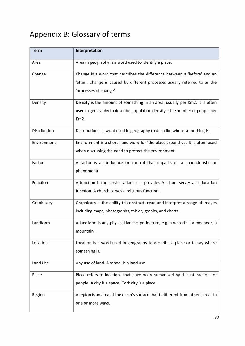
Appendix B: Glossary of terms
Term Interpretation
Area Area in geography is a word used to identify a place.
Change Change is a word that describes the difference between a 'before' and an
'after'. Change is caused by different processes usually referred to as the
'processes of change'.
Density Density is the amount of something in an area, usually per Km2. It is often
used in geography to describe population density – the number of people per
Km2.
Distribution Distribution is a word used in geography to describe where something is.
Environment Environment is a short-hand word for 'the place around us'. It is often used
when discussing the need to protect the environment.
Factor A factor is an influence or control that impacts on a characteristic or
phenomena.
Function A function is the service a land use provides A school serves an education
function. A church serves a religious function.
Graphicacy Graphicacy is the ability to construct, read and interpret a range of images
including maps, photographs, tables, graphs, and charts.
Landform A landform is any physical landscape feature, e.g. a waterfall, a meander, a
mountain.
Location Location is a word used in geography to describe a place or to say where
something is.
Land Use Any use of land. A school is a land use.
Place Place refers to locations that have been humanised by the interactions of
people. A city is a space; Cork city is a place.
Region A region is an area of the earth’s surface that is different from others areas in
one or more ways.
31
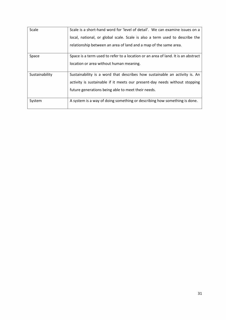
Scale Scale is a short-hand word for 'level of detail'. We can examine issues on a
local, national, or global scale. Scale is also a term used to describe the
relationship between an area of land and a map of the same area.
Space Space is a term used to refer to a location or an area of land. It is an abstract
location or area without human meaning.
Sustainability Sustainability is a word that describes how sustainable an activity is. An
activity is sustainable if it meets our present-day needs without stopping
future generations being able to meet their needs.
System A system is a way of doing something or describing how something is done.
32


