
Appendix AList of Preparers and Reviewers
Author’s Name Position Work Unit
Andy Bishop Joint venture coordinator USFWS, Rainwater Basin Joint Venture, Grand Island, NE
Jeff Drahota Wildlife biologist USFWS, Rainwater Basin Wetland Management District, Funk, NE
Nick Kaczor Planning team leader USFWS, Region 6, Planning Division, Lakewood, CO
Brad Krohn Wildlife refuge specialist USFWS, Rainwater Basin Wetland Management District, Funk, NE
Ted LaGrange Wetland program manager Nebraska Game and Parks Commission, Lincoln, NE
David Lucas Chief of planning USFWS, Region 6, Planning Division, Lakewood, CO
Gene Mack Former wildlife refuge manager USFWS, Rainwater Basin Wetland Management District, Funk, NE
Sue Oliveira Chief of realty USFWS, Region 6, Realty Division, Lakewood, CO
Garret Richason Realty specialist USFWS, Region 6, Realty Division, Lakewood, CO
Ronnie Sanchez Supervisory refuge operations specialist USFWS, Rainwater Basin Wetland Management District, Funk, NE
Meg VanNess Regional historic preservation officer USFWS, Region 6, Refuges, Lakewood, CO
Reviewer’s Name Position Work Unit
Brooke McDonald Writer/editor North State Resources, Inc.
Kathryn McDonald Writer/editor North State Resources, Inc.
Brooke Stansberry Acting field supervisor USFWS, Region 6, Ecological Services, Grand Island, NE
Jeanine Lackey Fish and wildlife biologist USFWS, Region 6, Ecological Services, Grand Island, NE
Barbara Boyle Refuge supervisor USFWS, Region 6, National Wildlife Refuge System, Lakewood, CO
Bud Oliveira Deputy assistant regional director USFWS, Region 6, National Wildlife Refuge System, Lakewood, CO


Appendix BList of Plants and Animals
Rainwater Basin Flora List for Waterfowl Production Areas, Version 2.0The U.S. Fish and Wildlife Service maintains a list of plant species (422) that occur in wetlands (http://www.fws.gov/nwi/bha/list88.html). The following list of plants for the Rainwater Basin was generated us-ing the Region 5 (1,523 plant species) map from this Web site. The USDA Plants Web site (http://plants.usda.gov) listed 9,485 plant species for Nebraska. Both the USDA Plants Web site and the Nature Serve Ex-plorer Web1 site were used to verify scientific names, common names, and habits for those species not listed on the FWS Web site.
SCIENTIFIC NAMEThe genus and species applied to the taxon were de-rived from Kaul et al. (2006) and Nature Serve Ex-plorer (2010).
COMMON NAMEThe common name is the popular name applied to the species. Common name selection generally follows com-mon names from North American Plants 2 (Kartesz and Thieret 1991), but some common names follow the current common name list maintained by the Natural Resources Conservation Service and/or NatureServe.
NATIONAL RANGE INDICATORSThe national indicators reflect the range of estimated probabilities (expressed as a frequency of occurrence) of a species occurring in wetlands versus nonwetlands across the entire distribution of the species. A frequency of, for example, 67–99 percent (facultative wetland) means that 67–99 percent of sample plots containing the species randomly selected across the range of the species would be wetland. A question mark (?) following an indicator denotes a tentative assignment based on the botanical literature and not confirmed by regional review. When two indicators are given, they reflect the range from the lowest to the highest frequency of occurrence in wetlands across the regions in which
1 http://www.natureserve.org/explorer/
2 http://www.unl.edu/agnicpls/gpcn/about.html
the species is found. A positive (+) or negative (-) sign was used with the facultative indicator categories to more specifically define the regional frequency of occurrence in wetlands. The positive sign indicates a frequency toward the higher end of the category (more frequently found in wetlands), and a negative sign indicates a frequency toward the lower end of the category (less frequently found in wetlands).
NATIONAL WETLAND INDICATOR (INDICATOR CATEGORIES):
■■ Obligate Wetland (OBL). These species almost al-ways occur under natural conditions in wetlands (estimated probability >99 percent).
■■ Facultative Wetland (FACW). Usually occur in wetlands (estimated probability 67–99 percent), but occasionally found in nonwetlands.
■■ Facultative (FAC). Equally likely to occur in wet-lands or nonwetlands (estimated probability 34–66 percent).
■■ Facultative Upland (FACU). Usually occur in non-wetlands (estimated probability 67–99 percent), but occasionally found in wetlands (estimated prob-ability 1–33 percent).
■■ Obligate Upland (UPL). Occur in wetlands in an-other region, but occur almost always (estimated probability >99 percent) under natural conditions in nonwetlands in the region specified. If a species does not occur in wetlands in any region, it is not on the national list.
The wetland indicator categories should not be equated to degrees of wetness. Many obligate wetland species occur in permanently or semipermanently flooded wet-lands, but a number of obligates also occur and some are restricted to wetlands that are only temporarily or seasonally flooded. The facultative upland species include a diverse collection of plants that range from weedy species adapted to exist in a number of envi-ronmentally stressful or disturbed sites (including wetlands) to species for which a portion of the gene pool (an ecotype) always occurs in wetlands. Both the weedy and ecotype representatives of the facultative upland category occur in seasonally and semiperma-nently flooded wetlands.

36 Land Protection Plan, Rainwater Basin Wetland Management District Expansion
REGION 5 WETLAND INDICATOR (REGIONAL INDICATOR FOR 5-CENTRAL PLAINS NE, KS, AND CO [EASTERN])The wetland Indicator status estimates the probability (likelihood) of a species occurring in wetlands rather than nonwetland areas within this region. Regional indicators reflect the unanimous agreement of the Re-gional Interagency Review Panel. If a regional panel was not able to reach a unanimous decision on a spe-cies, NA (no agreement) was recorded on the regional indicator field. An NI (no indicator) was recorded for those species for which insufficient information was available to determine an indicator status. A nonoc-currence (NO) designation indicates that the species does not occur in that region. An asterisk (*) following
a regional indicator identifies tentative assignments based on limited information from which to determine the indicator status.
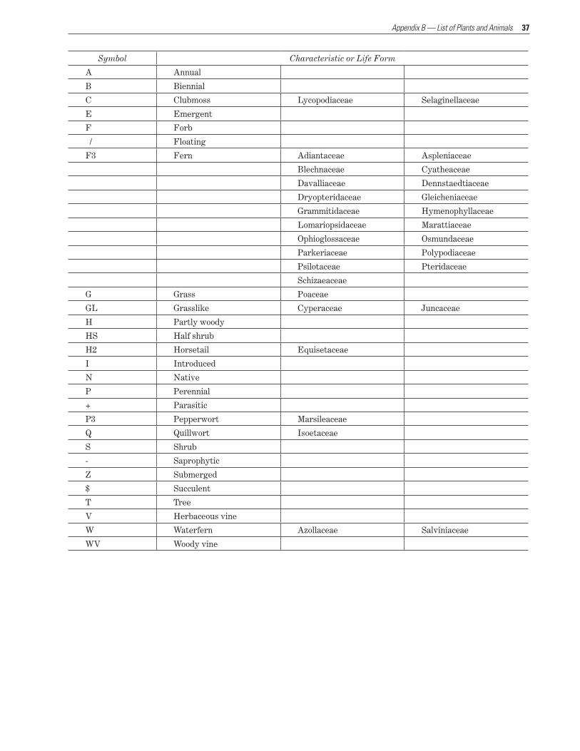
HABITThe plant characteristics and life forms assigned to each species in the National List of Scientific Plant Names3 (1982) and by the Natural Resources Conser-vation Service. Family names are listed alphabetically under specific life forms restricted to these families. The HABIT symbols are combined to describe the life form of the species (e.g., ANG means annual native grass, IT means introduced tree).
3 http://www.archive.org/stream/nationallistofsc01unit#page/n11/mode/2up
37
Symbol Characteristic or Life Form
A Annual
B Biennial
C Clubmoss Lycopodiaceae Selaginellaceae
E Emergent
F Forb
/ Floating
F3 Fern Adiantaceae Aspleniaceae
Blechnaceae Cyatheaceae
Davalliaceae Dennstaedtiaceae
Dryopteridaceae Gleicheniaceae
Grammitidaceae Hymenophyllaceae
Lomariopsidaceae Marattiaceae
Ophioglossaceae Osmundaceae
Parkeriaceae Polypodiaceae
Psilotaceae Pteridaceae
Schizaeaceae
G Grass Poaceae
GL Grasslike Cyperaceae Juncaceae
H Partly woody
HS Half shrub
H2 Horsetail Equisetaceae
I Introduced
N Native
P Perennial
+ Parasitic
P3 Pepperwort Marsileaceae
Q Quillwort Isoetaceae
S Shrub
- Saprophytic
Z Submerged
$ Succulent
T Tree
V Herbaceous vine
W Waterfern Azollaceae Salviniaceae
WV Woody vine
Appendix B — List of Plants and Animals
38 Land Protection Plan, Rainwater Basin Wetland Management District Expansion
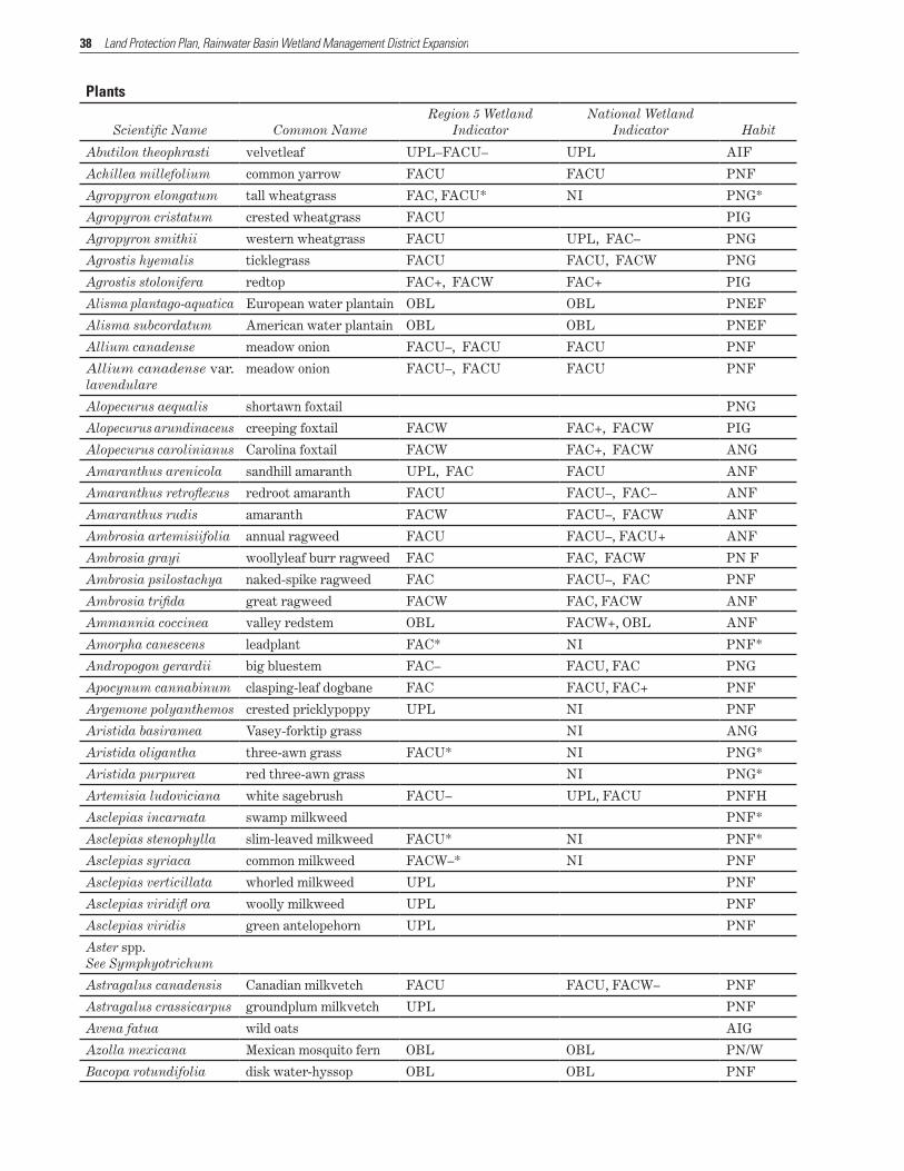
Plants
Scientific Name Common NameRegion 5 Wetland
Indicator National Wetland
Indicator Habit
Abutilon theophrasti velvetleaf UPL–FACU– UPL AIF
Achillea millefolium common yarrow FACU FACU PNF
Agropyron elongatum tall wheatgrass FAC, FACU* NI PNG*
Agropyron cristatum crested wheatgrass FACU PIG
Agropyron smithii western wheatgrass FACU UPL, FAC– PNG
Agrostis hyemalis ticklegrass FACU FACU, FACW PNG
Agrostis stolonifera redtop FAC+, FACW FAC+ PIG
Alisma plantago-aquatica European water plantain OBL OBL PNEF
Alisma subcordatum American water plantain OBL OBL PNEF
Allium canadense meadow onion FACU–, FACU FACU PNF
Allium canadense var. lavendulare
meadow onion FACU–, FACU FACU PNF
Alopecurus aequalis shortawn foxtail PNG
Alopecurus arundinaceus creeping foxtail FACW FAC+, FACW PIG
Alopecurus carolinianus Carolina foxtail FACW FAC+, FACW ANG
Amaranthus arenicola sandhill amaranth UPL, FAC FACU ANF
Amaranthus retroflexus redroot amaranth FACU FACU–, FAC– ANF
Amaranthus rudis amaranth FACW FACU–, FACW ANF
Ambrosia artemisiifolia annual ragweed FACU FACU–, FACU+ ANF
Ambrosia grayi woollyleaf burr ragweed FAC FAC, FACW PN F
Ambrosia psilostachya naked-spike ragweed FAC FACU–, FAC PNF
Ambrosia trifida great ragweed FACW FAC, FACW ANF
Ammannia coccinea valley redstem OBL FACW+, OBL ANF
Amorpha canescens leadplant FAC* NI PNF*
Andropogon gerardii big bluestem FAC– FACU, FAC PNG
Apocynum cannabinum clasping-leaf dogbane FAC FACU, FAC+ PNF
Argemone polyanthemos crested pricklypoppy UPL NI PNF
Aristida basiramea Vasey-forktip grass NI ANG
Aristida oligantha three-awn grass FACU* NI PNG*
Aristida purpurea red three-awn grass NI PNG*
Artemisia ludoviciana white sagebrush FACU– UPL, FACU PNFH
Asclepias incarnata swamp milkweed PNF*
Asclepias stenophylla slim-leaved milkweed FACU* NI PNF*
Asclepias syriaca common milkweed FACW–* NI PNF
Asclepias verticillata whorled milkweed UPL PNF
Asclepias viridifl ora woolly milkweed UPL PNF
Asclepias viridis green antelopehorn UPL PNF
Aster spp. See Symphyotrichum
Astragalus canadensis Canadian milkvetch FACU FACU, FACW– PNF
Astragalus crassicarpus groundplum milkvetch UPL PNF
Avena fatua wild oats AIG
Azolla mexicana Mexican mosquito fern OBL OBL PN/W
Bacopa rotundifolia disk water-hyssop OBL OBL PNF
39
PlantsRegion 5 Wetland National Wetland
Scientific Name Common Name Indicator Indicator Habit
Baptisia bracteata long-bract indigo UPL PNF
Bassia scoparia kochia ANF
Berula erecta water parsnip OBL OBL PIF
Bidens cernua nodding beggar-ticks OBL FACW+, OBL AIF
Bidens comosa leafy-bract beggar-ticks FACW FACW ANF
Bidens frondosa devil’s beggar-ticks FACW FACW, FACW+ ANF
Bidens vulgata beggar-ticks ANF
Boltonia asteroides white boltonia FACW FACW, OBL PNF
Bouteloua curtipendula sideoats grama FACU* NI PNG*
Bouteloua gracilis blue grama UPL* NI PNG*
Bouteloua hirsuta hairy grama UPL* NI PNG*
Brickellia eupatorioides false boneset UPL PNF*
Bromus inermis smooth brome UPL* NI PNG*
Bromus japonicus Japanese brome FACU FACU, UPL AIG
Bromus tectorum downy brome UPL* NI ANG*
Bryophyte spp. moss NI NI NI
Buchloe dactyloides buffalograss FACU FACU–, FACU PNG
Calamagrostis canadensis bluejoint reedgrass OBL FAC, OBL PNG
Calamagrostis stricta northern reedgrass PNG
Calamovilfa longifolia prairie sandreed UPL PNG
Callirhoe alcaeoides light poppymallow UPL PNF
Callirhoe involucrata purple poppymallow UPL PNF
Calylophus serrulatus yellow sundrops UPL PNF
Calystegia sepium hedge bindweed FACU, OBL FAC PIF
Cannabis sativa hemp FAC+* NI ANF*
Capsella bursa-pastoris common shepherd’s purse FACU FACU, FAC AIF
Cardus nutans musk thistle UPL B/PIF*
Carex bicknellii Bicknell’s sedge FACU, FACW FACU PNGL
Carex brevior short-beak sedge FAC UPL, OBL PNEGL
Carex cristatella crested sedge FACW FAC, FACW+ PNGL
Carex eleocharis needle leaf sedge FACW PNGL
Carex gravida heavy sedge OBL* PNGL
Carex laeviconica smooth-cone sedge OBL OBL PNEGL
Carex lanuginosa woolly sedge OBL OBL PNGL
Carex tribuloides blunt broom sedge FACW, OBL FACW PNGL
Carex vulpinoidea fox sedge OBL OBL PNEGL
Carex × stipata stalk-grain sedge OBL OBL PNGL
Cassia chamaecrista showy partridge pea UPL ANF
Ceanothus americanus New Jersey tea UPL PNF
Ceanothus herbaceus Jersey tea UPL PNS
Celtis occidentalis hackberry PNT
Celtis occidentalis common hackberry UPL PNT
Cenchrus longispinus sandbur FAC* NI ANG*
Chenopodium album lambsquarters FAC FACU, FAC AIF
Appendix B — List of Plants and Animals
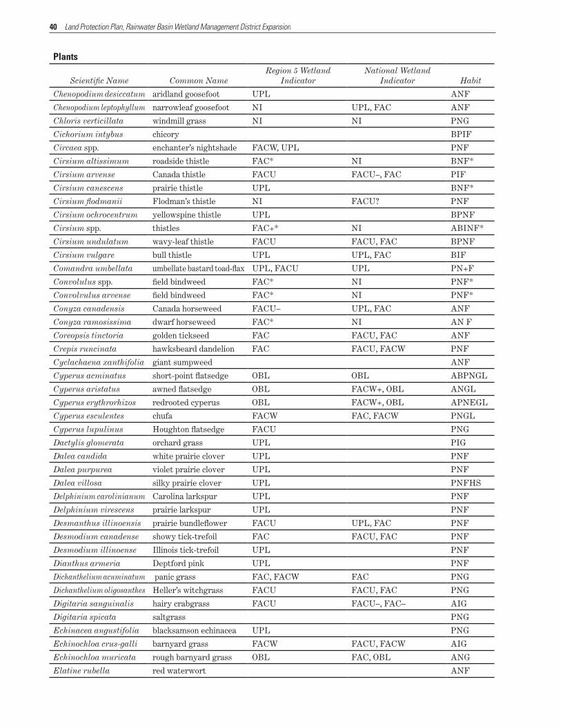
40 Land Protection Plan, Rainwater Basin Wetland Management District Expansion
Plants
Scientific Name Common NameRegion 5 Wetland
Indicator National Wetland
Indicator Habit
Chenopodium desiccatum aridland goosefoot UPL ANF
Chenopodium leptophyllum narrowleaf goosefoot NI UPL, FAC ANF
Chloris verticillata windmill grass NI NI PNG
Cichorium intybus chicory BPIF
Circaea spp. enchanter’s nightshade FACW, UPL PNF
Cirsium altissimum roadside thistle FAC* NI BNF*
Cirsium arvense Canada thistle FACU FACU–, FAC PIF
Cirsium canescens prairie thistle UPL BNF*
Cirsium flodmanii Flodman’s thistle NI FACU? PNF
Cirsium ochrocentrum yellowspine thistle UPL BPNF
Cirsium spp. thistles FAC+* NI ABINF*
Cirsium undulatum wavy-leaf thistle FACU FACU, FAC BPNF
Cirsium vulgare bull thistle UPL UPL, FAC BIF
Comandra umbellata umbellate bastard toad-flax UPL, FACU UPL PN+F
Convolulus spp. field bindweed FAC* NI PNF*
Convolvulus arvense field bindweed FAC* NI PNF*
Conyza canadensis Canada horseweed FACU– UPL, FAC ANF
Conyza ramosissima dwarf horseweed FAC* NI AN F
Coreopsis tinctoria golden tickseed FAC FACU, FAC ANF
Crepis runcinata hawksbeard dandelion FAC FACU, FACW PNF
Cyclachaena xanthifolia giant sumpweed ANF
Cyperus acminatus short-point flatsedge OBL OBL ABPNGL
Cyperus aristatus awned flatsedge OBL FACW+, OBL ANGL
Cyperus erythrorhizos redrooted cyperus OBL FACW+, OBL APNEGL
Cyperus esculentes chufa FACW FAC, FACW PNGL
Cyperus lupulinus Houghton flatsedge FACU PNG
Dactylis glomerata orchard grass UPL PIG
Dalea candida white prairie clover UPL PNF
Dalea purpurea violet prairie clover UPL PNF
Dalea villosa silky prairie clover UPL PNFHS
Delphinium carolinianum Carolina larkspur UPL PNF
Delphinium virescens prairie larkspur UPL PNF
Desmanthus illinoensis prairie bundleflower FACU UPL, FAC PNF
Desmodium canadense showy tick-trefoil FAC FACU, FAC PNF
Desmodium illinoense Illinois tick-trefoil UPL PNF
Dianthus armeria Deptford pink UPL PNF
Dichanthelium acuminatum panic grass FAC, FACW FAC PNG
Dichanthelium oligosanthes Heller’s witchgrass FACU FACU, FAC PNG
Digitaria sanguinalis hairy crabgrass FACU FACU–, FAC– AIG
Digitaria spicata saltgrass PNG
Echinacea angustifolia blacksamson echinacea UPL PNG
Echinochloa crus-galli barnyard grass FACW FACU, FACW AIG
Echinochloa muricata rough barnyard grass OBL FAC, OBL ANG
Elatine rubella red waterwort ANF

41
PlantsRegion 5 Wetland National Wetland
Scientific Name Common Name Indicator Indicator Habit
Eleusine indica goosegrass AIG
Eleocharis acicularis least spikerush OBL OBL PNEGL
Eleocharis compressa flat-stem spikerush FACW FACW, FACW+ PNEGL
Eleocharis engelmannii annual spikerush OBL OBL ANGL
Eleocharis erythropoda bald spikerush OBL OBL PNGL
Eleocharis palustris creeping spikerush OBL OBL PNEGL
Elymus canadensis nodding wild rye FACU FACU, FAC+ PNG
Elymus elongatus tall wheatgrass PIG
Elymus hispidus intermediate wheatgrass FACU FACU, FAC+ PNG
Elymus repens quackgrass PIG
Elymus smithii western wheatgrass FACU PNG
Elymus trachycaulus slender wheatgrass FACU PNG
Elymus virginiana Virginia wild rye FAC FAC, FACW PNG
Eragrostis cilianensis stinkgrass AIG
Eragrostis hypnoides teal lovegrass FACU ANG
Eragrostis pectinacea Carolina lovegrass ANG
Eragrostis spectabilis purple lovegrass FACU UPL, FACU PNG
Eragrostis spectabilis purple lovegrass FACU UPL, FACU PNG
Erigeron annuus white-top fleabane FACU FACU, FAC ANF
Erigeron philadelphicus Philadelphia fleabane FACU FACU, FAC ANF
Erigeron strigosus prairie fleabane FAC FACU, FAC ANF
Eriochloa contracta prairie cupgrass ANG
Eupatorium perfoliatum common boneset OBL FACW+, OBL PNF
Euphorbia cyathophora fire-on-the-mountain UPL NAPF
Euphorbia esula leafy spurge UPL PIF
Euphorbia glyptosperma UPL ANF
Euphorbia dentata toothed spurge UPL AIF
Euphorbia maculata spotted spurge FACU– UPL, FACU ANF
Euphorbia marginata snow-on-the-mountain UPL, FACU FACU ANF
Euphorbia prostrata ANF
Euphorbia nutans eyebane broomspurge FACU–, FACU FACU– AIF
Euphorbia serpens round-leafed spurge ANF
Euphorbia spathulata ANF
Festuca arundinacea Kentucky fescue FACU UPL, FACW– PIG
Festuca saximontana Rocky Mountain fescue NPG
Fragaria virginiana Virgina strawberry UPL, FAC FACU PNF
Fraxinus pennsylvanica green ash FAC, FACW NT
Gaillardia pulchella blanket flower UPL PNF
Galium aparine catchweed bedstraw FACU FACU, FAC– ANF
Gaura coccinea scarlet gaura UPL PNS/F
Gaura parviflora velvet-leaf butterfly-weed FACU? NI ANF
Gleditsia triacanthos honey-locust FAC FACU, FAC NTS
Glyceria striata fowl mannagrass OBL OBL PNEG
Glycine max soybean UPL* NI AI*
Appendix B — List of Plants and Animals

42 Land Protection Plan, Rainwater Basin Wetland Management District Expansion
Plants
Scientific Name Common NameRegion 5 Wetland
Indicator National Wetland
Indicator Habit
Glycyrrhiza lepidota American licorice FACU UPL, FAC+ PNF
Grindelia squarrosa curly-cup gumweed FACU– UPL, FACU ABPNF
Gutierrezia sarothrae broom snakeweed UPL PNS/F
Hedeoma hispida rough false pennyroyal UPL ANF
Helianthus annuus common sunflower FACU FACU, FAC ANF
Helianthus grosseserratus saw-tooth sunflower FACW FAC, FACW PNF
Helianthus maximiliani Maximilian’s sunflower UPL UPL, FACU PNF
Helianthus petiolaris prairie sunflower UPL ANF
Helianthus rigidus stiff sunflower UPL PNF
Hesperis matronalis dame’s rocket IBPF
Heteranthera limosa blue mud-plantain OBL OBL ANEF
Heteranthera multiflora bouquest mud-plantain OBL ANF
Heterotheca villosa hairy goldaster UPL PNF
Hieracium longipilum hairy hawkweed FACU PNF
Hordeum jubatum fox-tail barley FACW FAC, FACW PNG
Hordeum pusillum little barley FAC FACU, FAC ANG
Hypoxis hirsuta eastern yellow stargrass FAC, FACW FACW PNF
Ipomoea hederacea ivyleaf morning-glory FACU, FAC FACU AIV
Ipomoea leptophylla bush morning-glory UPL PNF
Ipomoea pandurata wild sweet-potato vine FACU, FAC– FAC– PNF
Ipomoea purpurea common morning-glory UPL, FAC FACU AIV
Juncus dudleyi Dudley rush PNGL
Juncus interior inland rush FAC FACU, FACW PNGL
Juncus torreyi Torrey’s rush FACW, FACW+ FACW PNGL
Juniperus virginiana eastern red cedar FACU– FACI–, FACU NT
Kochia scoparia Mexican summer-cypress FACU UPL, FAC AIF
Koeleria macrantha prairie Junegrass UPL PNG
Kuhnia eupatoriodes false boneset FAC, FACU* NI PNF*
Lactuca canadensis tall yellow lettuce FACU FACU–, FAC+ ABNF
Lactuca ludoviciana biannual lettuce FAC UPL, FAC BPNF
Lactuca serriola prickly lettuce FAC FACU, FAC ABIF
Lactuca tatarica blue lettuce FAC BPNF
Lamium amplexicaule henbit AIF
Leersia oryzoides rice cutgrass OBL OBL PNG
Lemna minor lesser duckweed OBL OBL PN/F
Lemna trisulca star duckweed OBL OBL PN/F
Lepidium densiflorum common pepperweed FAC ABNF
Lepidium virginicum Virginia pepperweed UPL, FAC– FACU ABNF
Leptochloa fusca (fascicularis) bearded sprangletop OBL FACW, OBL ANG
Lespedeza capitata round-head bushclover UPL UPL, FACU PNF
Liatris punctata dotted gayfeather FACU PNF
Liatris pycnostachya cattail gayfeather FAC FACU, FAC+ PNF
Limosella aquatica northern mudwort OBL OBL APNEF
Lindernia dubia yellowseed false pimpernel OBL ANF
43
PlantsRegion 5 Wetland National Wetland
Scientific Name Common Name Indicator Indicator Habit
Linum compactum bushy flax ANF
Linum rigidum stiffstem flax UPL, FAC UPL PNF
Linum sulcatum grooved flax ANF
Lippia cuneifolia wedgeleaf fogfruit FAC, FACW FAC PNF
Lippia lanceolata northern fogfruit FACW, OBL OBL PNF
Lithospermum incisum narrow-leaved puccoon UPL PNF
Lolium arundinaceum tall fescue UPL PIG
Lolium perenne perennial ryegrass UPL PIG
Lomatium foeniculaceum wild parsley UPL PNF
Lonicera morrowii Morrow’s honeysuckle PIS
Lotus corniculatus bird’s-foot trefoil FACU FACU–, FAC PIF
Lotus purshianus prairie trefoil FACU* NI ANF*
Lotus unifoliolatus American bird’s-foot trefoil ANF
Ludwigia palustris marsh seedbox OBL OBL PNEF
Lycopus americanus American bugleweed OBL OBL PNF
Lygodesmia juncea rush skeletonplant UPL PNF
Lythrum salicaria purple loosetrife FACW+, OBL OBL PIF
Marsilea vestita hairy water fern OBL OBL PNEP3
Medicago sativa alfalfa APIF
Melilotus alba white sweetclover FACU FACU–, FACU+ ABIF
Melilotus officinalis yellow sweetclover FACU FACU–, FACU+ ABIF
Mentha arvensis field mint FAC, FACW FACW PNF
Mirabilis linearis narrowleaf four o’clock PNFHS
Mirabilis nyctaginea heartleaf four o’clock UPL UPL, FACU PNF
Mollugo verticillata green carpet-weed FAC FAC–, FAC ANF
Monarda fistulosa wild bergamot UPL, FAC+ FACU– PNF
Morus alba white mulberry UPL, FAC FAC IT
Morus rubra red mulberry FACU FACU, FAC NT
Muhlenbergia asperifolia Parodi scratchgrass PNG
Muhlenbergia mexicana wirestem muhly FACW FAC, FACW PNG
Muhlenbergia racemosa green muhly FACW FACU, FACW PNG
Myosurus minimus tiny mouse-tail FACW FACW–OBL ANF
Nepeta cataria catnip FACU FACU–, FACW– PIF
Oenothera biennis common evening-primrose FACU FACU–, FACU+ BIF
Oenothera villosa hairy evening-primrose FAC FACU, FACW BPNF
Oligoneuron rigidum goldenrod UPL PNF
Oxalis dillenia gray-green woodsorrel FACU* NI PNF*
Oxalis stricta yellow woodsorrel FACU* PNF
Oxalis violacea violet woodsorrel UPL PNF
Panicum capillare witchgrass FAC FACU, FAC ANG
Panicum dichotomiflorum fall panic grass FAC FAC, FACW ANG
Panicum oligosanthes Scribner panicum PNG
Panicum virgatum switchgrass FAC FAC, FACW PNG
Paspalum setaceum paspalum PNG
Appendix B — List of Plants and Animals

44 Land Protection Plan, Rainwater Basin Wetland Management District Expansion
Plants
Scientific Name Common NameRegion 5 Wetland
Indicator National Wetland
Indicator Habit
Parientaria pensylvanica Pennsylvania pellitory FAC FACU–, FACW– ANF
Penstemon grandiflorus large-flower beardtongue UPL PNF
Phalaris arundinacea reed canarygrass FACW+ FACW, OBL PI*G
Phleum pratense timothy FACU FACU PIG
Phragmites americanus australis reed FACW-OBL PNG
Phragmites australis reed FACW-OBL PI*G
Physalis heterophylla clammy groundcherry UPL PNF
Physalis longifolia longleaf groundcherry UPL PNF
Physalis virginiana Virginia groundcherry UPL PNF
Poa annua tufted bluegrass FACU, FACW- FACU AIG
Poa compressa Canada bluegrass FACU FACU–, FAC PIG
Poa pratensis Kentucky bluegrass FACU FACU, FAC– PIG
Polygala alba white milkwort PNF
Polygonum arenastrum knotweed UPL* NI APNF*
Polygonum bicorne pink smartweed FACW+ FACW–, OBL ANEF
Polygonum coccineum water smartweed OBL OBL PNE/F
Polygonum convolvulus black-bindweed AIVF
Polygonum hydropiper swamp smartweed OBL OBL PNEF
Polygonum hydropiperoides mild water-pepper OBL OBL PNEF
Polygonum lapathifolium curlytop knotweed OBL FAC, OBL ANF
Polygonum pensylvanicum Pennsylvania FACW+ FACW–, OBL ANEF
Polygonum persicaria spotted ladysthumb OBL FAC, OBL AIF
Polygonum minus pygmy smartweed OBL APIF
Polygonum punctatum dotted smartweed OBL FACW, OBL PNEF
Polygonum ramosissimum bushy knotweed FAC FACU–, FACW ANF
Polygonum scandens climbing false buckwheat PNVF
Polypogon monspeliensis rabbitfoot grass FACW, OBL OBL AIG
Populus deltoides eastern cottonwood FAC FAC, FACW NT
Portulaca oleracea common purslane FAC FACU, FAC ANF
Potamogeton gramineus variable pondweed OBL OBL PNZF
Potamogeton nodosus longleaf pondweed OBL OBL PNZF
Potentilla arguta tall cinquefoil FACU UPL, FACU+ PNF
Potentilla norvegica Norwegian cinquefoil FAC FACU, FAC ABPNF
Potentilla recta sulphur cinquefoil FACU* NI PNF*
Prenanthes racemosa glaucous rattlesnake-root FAC FACU–, FACW PNF
Prunella vulgaris heal-all FAC FACU, FACW PIF
Prunus americana American plum UPL UPL, FACU NST
Prunus virginiana chokecherry FACU FACU–, FAC NST
Psoralea argophylla silver-leaf scurfpea FACU* NI PNF*
Psoralea tenuifl ora few-flowered scurfpea UPL PNF
Psoralidium lanceolatum lemon scurfpea UPL PNF
Pulsatilla patens pasqueflower UPL PNF
Ranunculus cymbalaria shore buttercup OBL OBL PNEF
Ranunculus flabellaris yellow water buttercup OBL OBL PNEF

45
PlantsRegion 5 Wetland National Wetland
Scientific Name Common Name Indicator Indicator Habit
Ranunculus longirostris white water buttercup OBL OBL PNZ/F
Ranunculus pensylvanicus Pennsylvania buttercup FACW, OBL OBL APNEF
Ranunculus sceleratus cursed buttercup OBL OBL APNEF
Ratibida columnifera upright prairie coneflower UPL PNF
Rhus glabra smooth sumac UPL NT
Robinia pseudoacacia black locust UPL UPL, FAC IT
Rorippa palustris bog yellowcress OBL FAC, OBL ANEF
Rorippa sessiliflora stalkless yellowcress OBL FACW+, OBL ANEF
Rorippa sinuata spreading yellowcress FACW FAC+, FACW PNF
Rosa arkansana wild prairie rose NI FAC? NSH
Rosa multiflora multiflora rose UPL, FACU UPL IS
Rosa woodsii Woods’ rose UPL, FAC– FACU NS
Rudbeckia hirta black-eyed susan FACU–, FACU FACU BPNF
Rumex altissimus pale dock FAC FAC, FACW+ PNF
Rumex crispus curly dock FACW FACU, FACW PIF
Sagittaria brevirostra shortbeak arrowhead OBL OBL PNEF*
Sagittaria calycina hooded arrowhead OBL OBL PNEF
Sagittaria cuneata arumleaf arrowhead OBL OBL PNEF*
Sagittaria graminea grassy arrowhead OBL OBL PNEF
Sagittaria latifolia broadleaf arrowhead OBL OBL PNEF*
Sagittaria longiloba longbarb arrowhead OBL OBL PNEF
Sagittaria rigida sessilefruit arrowhead OBL OBL PNEF
Salix amygdaloides peach-leaf willow FACW FACW NT
Salsola kali Russian thistle FACU–, FACU+ FACU AIF
Salvia azurea blue sage UPL PNF
Schedonnardus paniculatus tumblegrass PNG
Schizachyrium scoparium little bluestem FACU FACU–, FACU+ PNG
Schoenoplectus fluviatilis river bulrush OBL OBL PNEGL
Schoenoplectus heterochaetus slender bulrush OBL OBL PNEGL
Schoenoplectus pungens three-square bulrush FACW+, OBL OBL PNEGL
Scirpus acutus hard-stem bulrush OBL OBL PNEGL
Scirpus validus soft-stem bulrush OBL OBL PNEGL
Scutellaria parvula small skullcap UPL, FACU FACU PNF
Securigera varia crown-vetch UPL PIF
Senecio plattensis prairie groundsel UPL, FACU FACU BPNF
Setaria pumila yellow bristle grass FAC FACU, FAC AIG
Setaria verticillata bristly foxtail FACU, FAC FAC AIG
Setaria viridis green foxtail FAC* NI AIG
Silene antirrhina sleepy silene UPL ANF
Silphium integrifolium wholeleaf rosinweed UPL PNF
Silphium laciniatum compassplant UPL PNF
Silphium perfoliatum cup-plant FACU, FACW FAC PNF
Sinapis alba white mustard UPL AIF
Sinapis arvensis corn mustard AIF
Appendix B — List of Plants and Animals
46 Land Protection Plan, Rainwater Basin Wetland Management District Expansion
Plants
Scientific Name Common NameRegion 5 Wetland
Indicator National Wetland
Indicator Habit
Sisyrinchium campestre blue-eyed grass UPL PNF
Sisyrinchium montanum strict blue-eyed grass FACU, FACW FAC PNF
Solanum carolinense Carolina nightshade UPL, FACU UPL NSF
Solanum interius inland nightshade ANF
Solanum ptycanthum black nightshade FAC+* NI ANF*
Solanum rostratum buffalobur nightshade FAC* NI ANF*
Solidago canadensis Canada goldenrod FACU FACU, FACU+ PNF
Solidago gigantea giant goldenrod FAC, FACW FACW PNF
Solidago graminifolia flat-top goldenrod UPL PNF
Solidago missouriensis Missouri goldenrod FACU* NI PNF
Solidago rigida stiff goldenrod FACU UPL, FACU PNF
Sonchus arvensis field sowthistle UPL, FAC FAC PIF
Sonchus oleraceus common sowthistle UPL, FACU FACU AIF
Sorghastrum nutans Indiangrass FACU UPL, FACW PNG
Sorghum bicolor milo UPL* NI AIG*
Sparganium eurycarpum giant burreed OBL OBL PNEF
Spartina pectinata prairie cordgrass FACW FACW, OBL PNG
Sphaeralcea coccinea false red mallow BPNFHS
Sphenopholis obtusata prairie wedgegrass FAC–, FACW+ FACW APNG
Spirodela polyrrhiza greater duckweed OBL OBL PNF
Sporobolus compositus (asper)
rough dropseed UPL, FACU FACU PNG
Sporobolus cryptandrus sand dropseed FACU– UPL, FACU PNG
Sporobolus neglectus poverty grass FACU UPL, FACU ANG
Sporobolus vaginiflorus poverty dropseed FACU UPL, FACU ANG
Stachys palustris marsh hedgenettle FACW, OBL OBL PIF
Stipa comata needle and thread UPL PNG
Stipa spartea porcupine grass UPL PNG
Stipa viridula green needlegrass UPL PNG
Strophostyles leiosperma slickseed fuzzybean ANFV
Symphoricarpos occidentalis western snowberry PNS
Symphoricarpos orbiculatus coralberry UPL, FAC– FACU– NS
Symphyotrichum divaricatum annual saltmarsh aster ABNF
Symphyotrichum ericoides white heath aster FACU UPL, FACU PNF
Symphyotrichum lanceolatum panicled aster FACW FACW PNF
Tamarix ramosissima saltcedar FAC, FACW FACW IT
Taraxacum officinale common dandelion FACU FACU–, FACU+ PIF
Teucrium canadense American germander FACW FAC+, FACW PNEF
Thalictrum dioicum early meadow-rue FACU+, FACW FAC PNF
Thinopyrum intermedium intermediate wheatgrass UPL PIG
Thlaspi arvense field pennycress FACU? NI AIF
Toxicodendron radicans poison ivy FACU, FACW FACU NWVS
Toxicodendron rydbergii Rydberg poison ivy FACU, FACW FAC NHS
Tradescantia bracteata longbract spiderwort UPL, FAC FAC PNF

47
PlantsRegion 5 Wetland National Wetland
Scientific Name Common Name Indicator Indicator Habit
Tragopogon dubius goatsbeard FACU* NI BIF*
Tribulus terrestris puncturevine UPL AIF
Trifolium pratense red clover FACU FACU–, FAC BPIF
Trifolium repens white clover FACU FACU–, FAC PIF
Triodanis perfoliata claspleaf Venus’ looking-glass UPL, FAC FAC ANF
Tripsacum dactyloides eastern gamagrass FAC, FACW FAC PNG
Triticum aestivum wheat AIG
Typha angustifolia narrowleaf cattail OBL OBL PNEF
Typha latifolia broadleaf cattail OBL OBL PNEF
Typha × glauca hybrid cattail OBL OBL PNEF
Ulmus americana American elm FAC, FACW FAC NT
Ulmus pumila Siberian elm FACU* NI IT*
Utricularia vulgaris bladderwort OBL OBL PNZF
Verbascum thapsus common mullein UPL PNF
Verbena bracteata prostrate vervain FACU UPL, FACW APNF
Verbena hastata blue vervain FAC, FACW+ FACW PNF
Verbena urticifolia white vervain UPL, FAC+ UPL APNF
Verbena stricta hoary vervain FAC, FACU* NI PNF*
Vernonia baldwinii Baldwin’s ironweed UPL, FACW– FACW– PNF
Vernonia fasciculata prairie ironweed FAC FAC, FACW PNF
Veronica peregrina purslane speedwell FACU–, OBL OBL ANEF
Vicia americana American purple vetch FAC? NI PNFV
Viola pedatifi da prairie violet UPL, FACU FACU PNF
Viola pratincola blue prairie violet FACU, FAC FAC– PNF
Vulpia octoflora sixweeks-fescue UPL ANG
Wolffia columbiana Columbian watermeal OBL OBL PN/F
Xanthium strumarium rough cocklebur FAC FAC–, FAC+ ANF
Yucca glauca soapweed UPL NI NT
Zea mays corn FAC NI AIF
Appendix B — List of Plants and Animals

48 Land Protection Plan, Rainwater Basin Wetland Management District Expansion
MammalsScientific Name Common Name
Blarina brevicauda northern short-tailed shrew
Blarina brevicauda short-tailed shrew
Canis latrans coyote
Castor canadensis American beaver
Chaetodipus hispidus hispid pocket mouse
Corynorhinus townsendii Townsend’s big-eared bat
Cryptotis parva least shrew
Cynomys ludovicianus black-tailed prairie dog
Didelphis virginiana Virginia opossum
Dipodomys ordii Ord’s kangaroo rat
Eptesicus fuscus big brown bat
Geomys bursarius plains pocket gopher
Lasionycteris noctivagans silver-haired bat
Lasiurus borealis eastern red bat
Lasiurus cinereus hoary bat
Lepus californicus black-tailed jackrabbit
Lepus townsendii white-tailed jackrabbit
Lontra canadensis northern river otter
Lynx rufus bobcat
Marmota monax woodchuck
Mephitis mephitis striped skunk
Microtus ochrogaster prairie vole
Microtus pennsylvanicus meadow vole
Microtus pinetorum woodland vole
Mus musculus house mouse
Mustela frenata long-tailed weasel
Mustela nivalis least weasel
Mustela vison American mink
Myotis ciliolabrum western small-footed myotis
Myotis lucifugus little brown bat
Myotis septentrionalis northern myotis
Myotis thysanodes fringed myotis
Myotis volans long-legged myotis
Nycticeius humeralis evening bat
Odocoileus hemionus mule deer
Odocoileus virginianus white-tailed deer
Ondatra zibethicus muskrat
Onychomys leucogaster northern grasshopper mouse
Oryctolagus cuniculus European rabbit
Perognathus fasciatus olive-backed pocket mouse
Perognathus flavescens plains pocket mouse
Perognathus flavus silky pocket mouse
Peromyscus leucopus white-footed mouse
Peromyscus maniculatus deer mouse
Pipistrellus subflavus eastern pipistrelle

49
MammalsScientific Name Common Name
Procyon lotor northern raccoon
Rattus norvegicus Norway rat
Reithrodontomys megalotis western harvest mouse
Reithrodontomys montanus plains harvest mouse
Scalopus aquaticus eastern mole
Sciurus niger eastern fox squirrel
Sigmodon hispidus hispid cotton rat
Sorex haydeni prairie shrew
Sorex merriami Merriam’s shrew
Spermophilus franklinii Franklin’s ground squirrel
Spermophilus tridecemlineatus thirteen-lined ground squirrel
Spilogale putorius eastern spotted skunk
Sylvilagus floridanus eastern cottontail
Synaptomys cooperi southern bog lemming
Tadarida brasiliensis Brazilian free-tailed bat
Tamias minimus least chipmunk
Taxidea taxus American badger
Thomomys talpoides northern pocket gopher
Urocitellus elegans Wyoming ground squirrel
Vulpes velox swift fox
Vulpes vulpes red fox
Xerospermophilus spilosoma spotted ground squirrel
Zapus hudsonius meadow jumping mouse
Appendix B — List of Plants and Animals

50 Land Protection Plan, Rainwater Basin Wetland Management District Expansion
AmphibiansScientific Name Common Name
Spea bombirons plains spadefoot toad
Anaxyrus americanus American toad
Anaxyrus cognatus Great Plains toad
Anaxyrus woodhousii Woodhouse’s toad
Acris crepitans northern cricket frog
Acris blanchardi Blanchard’s cricket frog
Hyla chrysoscelis Cope’s gray treefrog
Pseudacris maculata Boreal chorus frog
Gastrophryne olivacea Great Plains narrowmouth toad
Rana blairi plains leopard frog
Rana catesbeiana bullfrog
Ambystoma texanum smallmouth salamander
Ambystoma mavortium eastern tiger salamander
51
ReptilesScientific Name Common Name
Apalone spinifera spiny softshell turtle
Chelydra serpentina common snapping turtle
Chrysemys picta painted turtle
Kinosternon flavescens yellow mud turtle
Terrapene ornata western box turtle
Aspidoscelis sexlineatus six-lined racerunner
Holbrookia maculata lesser earless lizard
Ophisaurus attenuatus slender glass lizard
Plestiodon fasciatus five-lined skink
Plestiodon multivirgatus many-lined skink
Plestiodon obsoletus Great Plains skink
Plestiodon septentrionalis prairie skink
Sceloporus consobrinus prairie lizard
Coluber constrictor eastern racer
Crotalus viridis prairie rattlesnake
Diadophis punctatus ringneck snake
Heterodon nasicus western hognose snake
Heterodon platirhinos eastern hognose snake
Lampropeltis calligaster prairie kingsnake
Lampropeltis triangulum milk snake
Liochlorophis vernalis smooth green snake
Nerodia sipedon northern water snake
Pituophis catenifer sayi gopher snake
Storeria dekayi brown snake
Storeria occipitomaculata redbelly snake
Tantilla nigriceps plains black-headed snake
Thamnophis proximus western ribbon snake
Thamnophis radix plains garter snake
Thamnophis sirtalis common garter snake
Tropidoclonion lineatum lined snake
Nerodia sipedon northern water snake
Pituophis catenifer sayi gopher (bull) snake
Regina grahamii Graham’s crayfish snake
Storeria dekayi brown snake
Storeria occipitomaculata redbelly snake
Tantilla nigriceps plains black-headed snake
Thamnophis elegans western terrestrial garter snake
Thamnophis proximus western ribbon snake
Thamnophis radix plains garter snake
Thamnophis sirtalis common garter snake
Tropidoclonion lineatum lined snake
Appendix B — List of Plants and Animals

52 Land Protection Plan, Rainwater Basin Wetland Management District Expansion
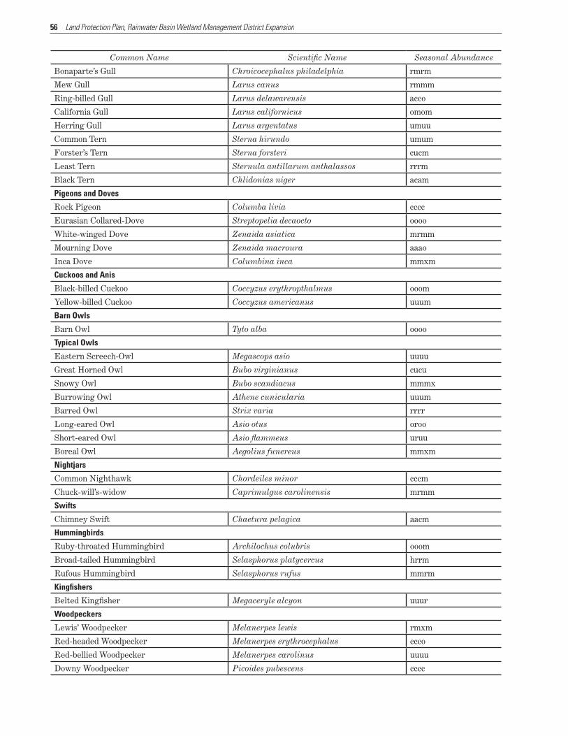
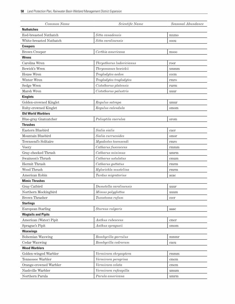
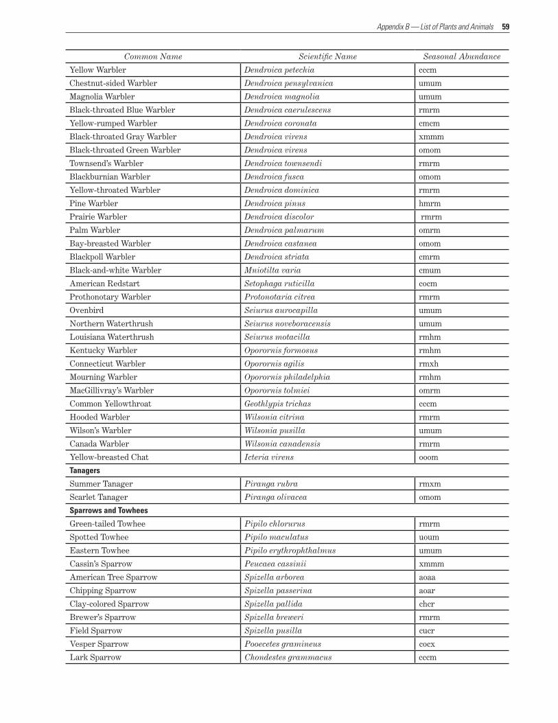
Taxonomic List of Birds That Have Occurred in the Rainwater Basin(Order follows the A.O.U. Check-list of North American Birds, 7th ed. Sept. 1998)
Birds of the Rainwater Basin Wetland Management District After each species name, one space is entered, then the seasonal abundance codes. The letter “m” was used to indicate that the species is not present during a particular season. For example, “American coot acar” (abun-dant in spring, common in summer, abundant in fall, rare in winter) or “California gull omom” (occasional in spring, not present in summer or winter, occasional fall).
Nesting species documented in WPAs (waterfowl production areas) are marked with an asterisk (*) in front of the species name. Species accounts may indicate presence during the nesting season, but may not be marked as nesting. For example, frequent nesters in the area such as northern rough-winged swallow are not marked as nesters because WPAs do not provide preferred nesting habitat. For the most part, cavity nesters are excluded (the red-bellied woodpecker prefers mature, natural woodlands) due to the absence of mature or dying trees that typically provide cavities. The Rainwater Basin WPAs are managed as grassland-playa lake ecosystems. Non-native trees and shrubs have been removed on most WPAs. Due to remaining shelter belts on WPAs, a few woodland nesters are marked as nesting if they are known to use shelter belts.
Seasonal Abundance Definitions Seasons are listed below. Seasonal abundance codes for some species such as shorebirds may be misleading because their fall migration starts in July or August (summer season). For example: “pectoral sandpiper cccm” (common in spring, common in summer due to peak migration occurring from mid-August through fall, not present in winter). A. Seasons:
Spring (March–May) Summer (June–August) Fall (September–November) Winter (December–February)
B. Seasonal Abundance: a = abundant: occurring in large numbers c = common: certain to be seen in suitable habitat u = uncommon: present, but not certain to be seen o = occasional: seen only a few times during the season r = rare: seen at intervals of 2–5 years h = hypothetical: within normal range, but never documented or has
been extirpated x = outside normal range, but has been documented
Updated May 4, 2011
Common Name Scientific Name Seasonal Abundance
Swans, Geese, and Ducks
Black-bellied Whistling-Duck Dendrocygna autumnalis xxxm
Bean Goose Anser fabalis xmmm
Greater White-fronted Goose Anser albifrons arao
Emperor Goose Chen canagica xmmm
Snow Goose Chen caerulescens aoao
Ross’ Goose Chen rossii crco
Canada Goose Branta canadensis auac
Brant Branta bernicla rmrm
Trumpeter Swan Cygnus buccinator hxmh
Tundra Swan Cygnus columbianus omrm
Wood Duck Aix sponsa cucm
Gadwall Anas strepera cuco
Eurasian Wigeon Anas penelope rmrm
American Wigeon Anas americana aoao
American Black Duck Anas rubripes rmrr
Mallard Anas platyrhynchos acac
Blue-winged Teal Anas discors acar
Cinnamon Teal Anas cyanoptera uoum
Northern Shoveler Anas clypeata acar
Northern Pintail Anas acuta auao
53
Common Name Scientific Name Seasonal Abundance
Garganey Anas querquedula xmmm
Green-winged Teal Anas crecca aoao
Canvasback Aythya valisineria umum
Redhead Aythya americana cucm
Ring-necked Duck Aythya collaris crum
Greater Scaup Aythya marila umrm
Lesser Scaup Aythya affinis cocm
White-winged Scoter Melanitta fusca xmmm
Black Scoter Melanitta americana xmmm
Bufflehead Bucephala albeola cmcm
Common Goldeneye Bucephala clangula omum
Barrow’s Goldeneye Bucephala islandica mmxm
Hooded Merganser Lophodytes cucullatus urum
Common Merganser Mergus merganser omoo
Ruddy Duck Oxyura jamaicensis cucm
Gallinaceous Birds
Ring-necked Pheasant Phasianus colchicus cccc
Sharp-tailed Grouse Tympanuchus phasianellus rhro
Greater Prairie-Chicken Tympanuchus cupido ooou
Northern Bobwhite Colinus virginianus cccc
Wild Turkey Meleagris gallopavo cccc
Loons
Common Loon Gavia immer omrm
Grebes
Clark’s Grebe Aechmophorus clarkii xmrm
Western Grebe Aechmophorus occidentalis rmrm
Pied-billed Grebe Podilymbus podiceps cccm
Horned Grebe Podiceps auritus uhrm
Red-necked Grebe Podiceps grisegena hmrm
Eared Grebe Podiceps nigricollis cocm
Pelicans
American White Pelican Pelecanus erythrorhynchos cocm
Cormorants
Double-crested Cormorant Phalacrocorax auritus cucm
Bitterns, Herons, and Egrets
American Bittern Botaurus lentiginosus ucum
Least Bittern Ixobrychus exilis uuom
Great Blue Heron Ardea herodias cccr
Great Egret Ardea alba omom
Snowy Egret Egretta thula uuum
Little Blue Heron Egretta caerulea orrm
Tricolored Heron Egretta tricolor hrrm
Cattle Egret Bubulcus ibis uoum
Green Heron Butorides virescens cucm
Black-crowned Night-Heron Nycticorax nycticorax cocm
Yellow-crowned Night-Heron Nyctanassa violacea rmrm
Appendix B — List of Plants and Animals

54 Land Protection Plan, Rainwater Basin Wetland Management District Expansion
Common Name Scientific Name Seasonal Abundance
Ibises and Spoonbills
White Ibis Eudocimus albus hxxm
Glossy Ibis Plegadis falcinellus xmmm
White-faced Ibis Plegadis chihi uurm
Roseate Spoonbill Ajaja ajaja mxmm
New World Vultures
Black Vulture Coragyps atratus mxmm
Turkey Vulture Cathartes aura cucm
Osprey, Kites, Hawks, and Eagles
Osprey Pandion haliaetus omom
White-tailed Kite Elanus leucurus xmxm
Mississippi Kite Ictinia mississippiensis xmxm
Bald Eagle Haliaeetus leucocephalus cmco
Northern Harrier Circus cyaneus cucu
Sharp-shinned Hawk Accipiter striatus uruu
Cooper’s Hawk Accipiter cooperii umur
Northern Goshawk Accipiter gentilis rmrr
Red-shouldered Hawk Buteo lineatus mrrx
Broad-winged Hawk Buteo platypterus mxmm
Swainson’s Hawk Buteo swainsoni cuur
Red-tailed Hawk Buteo jamaicensis cucu
Ferruginous Hawk Buteo regalis uxuo
Rough-legged Hawk Buteo lagopus uhuu
Golden Eagle Aquila chrysaetos omoo
Falcons and Caracaras
American Kestrel Falco sparverius cccc
Merlin Falco columbarius umuo
Gyrfalcon Falco rusticolus mmmr
Peregrine Falcon Falco peregrinus omor
Prairie Falcon Falco mexicanus omou
Rails
Yellow Rail Coturnicops noveboracensis rmrm
Black Rail Laterallus jamaicensis xxmm
King Rail Rallus elegans rrmm
Virginia Rail Rallus limicola uuum
Sora Porzana carolina cccm
Purple Gallinule Porphyrio martinica xmmm
Common Moorhen Gallinula chloropus uurm
American Coot Fulica americana acar
Cranes
Sandhill Crane Grus canadensis crum
Common Crane Grus grus xmmm
Whooping Crane Grus americana omom
Plovers
Black-bellied Plover Pluvialis squatarola umum

55
Common Name Scientific Name Seasonal Abundance
American Golden-Plover Pluvialis dominica umum
Snowy Plover Charadrius alexandrinus rrmm
Semipalmated Plover Charadrius semipalmatus umum
Piping Plover Charadrius melodus rhrm
Killdeer Charadrius vociferous cccm
Stilts and Avocets
Black-necked Stilt Himantopus mexicanus rrrm
American Avocet Recurvirostra americana urum
Sandpipers and Phalaropes
Greater Yellowlegs Tringa melanoleuca cocm
Lesser Yellowlegs Tringa flavipes cucm
Solitary Sandpiper Tringa solitaria ccum
Willet Tringa semipalmata uoum
Spotted Sandpiper Actitis macularius cccm
Upland Sandpiper Bartramia longicauda uuum
Eskimo Curlew Numenius borealis hmhm
Whimbrel Numenius phaeopus omrm
Long-billed Curlew Numenius americanus rmrm
Hudsonian Godwit Limosa haemastica umxm
Marbled Godwit Limosa fedoa umrm
Ruddy Turnstone Arenaria interpres rmrm
Red Knot Calidris canutus xmrm
Sanderling Calidris alba omom
Semipalmated Sandpiper Calidris pusilla aucm
Western Sandpiper Calidris mauri room
Least Sandpiper Calidris minutilla cccm
White-rumped Sandpiper Calidris fuscicollis coom
Baird’s Sandpiper Calidris bairdii acum
Pectoral Sandpiper Calidris melanotos cccm
Sharp-tailed Sandpiper Calidris acuminata mmxm
Dunlin Calidris alpina umum
Curlew Sandpiper Calidris ferruginea mxmm
Stilt Sandpiper Calidris himantopus accm
Buff-breasted Sandpiper Tryngites subruficollis uuum
Ruff Philomachus pugnax xmxm
Short-billed Dowitcher Limnodromus griseus uurm
Long-billed Dowitcher Limnodromus scolopaceus aucm
Wilson’s Snipe Gallinago delicata cocm
American Woodcock Scolopax minor rmrm
Wilson’s Phalarope Phalaropus tricolor aocm
Red-necked Phalarope Phalaropus lobatus rmrm
Red Phalarope Phalaropus fulicarius mxmm
Skuas, Jaegers, Gulls, and Terns
Laughing Gull Leucophaeus atricilla xmmm
Franklin’s Gull Leucophaeus pipixcan arcm
Appendix B — List of Plants and Animals
56 Land Protection Plan, Rainwater Basin Wetland Management District Expansion
Common Name Scientific Name Seasonal Abundance
Bonaparte’s Gull Chroicocephalus philadelphia rmrm
Mew Gull Larus canus rmmm
Ring-billed Gull Larus delawarensis acco
California Gull Larus californicus omom
Herring Gull Larus argentatus umuu
Common Tern Sterna hirundo umum
Forster’s Tern Sterna forsteri cucm
Least Tern Sternula antillarum anthalassos rrrm
Black Tern Chlidonias niger acam
Pigeons and Doves
Rock Pigeon Columba livia cccc
Eurasian Collared-Dove Streptopelia decaocto oooo
White-winged Dove Zenaida asiatica mrmm
Mourning Dove Zenaida macroura aaao
Inca Dove Columbina inca mmxm
Cuckoos and Anis
Black-billed Cuckoo Coccyzus erythropthalmus ooom
Yellow-billed Cuckoo Coccyzus americanus uuum
Barn Owls
Barn Owl Tyto alba oooo
Typical Owls
Eastern Screech-Owl Megascops asio uuuu
Great Horned Owl Bubo virginianus cucu
Snowy Owl Bubo scandiacus mmmx
Burrowing Owl Athene cunicularia uuum
Barred Owl Strix varia rrrr
Long-eared Owl Asio otus oroo
Short-eared Owl Asio flammeus uruu
Boreal Owl Aegolius funereus mmxm
Nightjars
Common Nighthawk Chordeiles minor cccm
Chuck-will’s-widow Caprimulgus carolinensis mrmm
Swifts
Chimney Swift Chaetura pelagica aacm
Hummingbirds
Ruby-throated Hummingbird Archilochus colubris ooom
Broad-tailed Hummingbird Selasphorus platycercus hrrm
Rufous Hummingbird Selasphorus rufus mmrm
Kingfishers
Belted Kingfisher Megaceryle alcyon uuur
Woodpeckers
Lewis’ Woodpecker Melanerpes lewis rmxm
Red-headed Woodpecker Melanerpes erythrocephalus ccco
Red-bellied Woodpecker Melanerpes carolinus uuuu
Downy Woodpecker Picoides pubescens cccc

57
Common Name Scientific Name Seasonal Abundance
Hairy Woodpecker Picoides villosus cccr
Northern Flicker Colaptes auratus cccc
Tyrant Flycatchers
Olive-sided Flycatcher Contopus cooperi omom
Eastern Wood-Pewee Contopus virens ooom
Yellow-bellied Flycatcher Empidonax flaviventris rmrm
Acadian Flycatcher Empidonax virescens rmrm
Alder Flycatcher Empidonax alnorum rmrm
Willow Flycatcher Empidonax traillii orom
Least Flycatcher Empidonax minimus umum
Hammond’s Flycatcher Empidonax hammondii mmxm
Eastern Phoebe Sayornis phoebe uuum
Say’s Phoebe Sayornis saya urrm
Great Crested Flycatcher Myiarchus crinitus cocm
Western Kingbird Tyrannus verticalis cccm
Eastern Kingbird Tyrannus tyrannus cccm
Scissor-tailed Flycatcher Tyrannus forficatus rxrm
Shrikes
Loggerhead Shrike Lanius ludovicianus cccc
Northern Shrike Lanius excubitor mmuu
Vireos
White-eyed Vireo Vireo griseus rmmm
Bell’s Vireo Vireo bellii uoum
Yellow-throated Vireo Vireo flavifrons rxrm
Warbling Vireo Vireo gilvus cucm
Philadelphia Vireo Vireo philadelphicus umum
Red-eyed Vireo Vireo olivaceus urum
Crows, Jays, and Magpies
Blue Jay Cyanocitta cristata cccc
Pinyon Jay Gymnorhinus cyanocephalus mmmx
Black-billed Magpie Pica hudsonia uuuu
American Crow Corvus brachyrhynchos aoac
Larks
Horned Lark Eremophila alpestris acaa
Swallows
Purple Martin Progne subis cucm
Tree Swallow Tachycineta bicolor cocm
Violet-green Swallow Tachycineta thalassina xmmm
Northern Rough-winged Swallow Stelgidopteryx serripennis cccm
Bank Swallow Riparia riparia uuum
Cliff Swallow Petrochelidon pyrrhonota ccam
Barn Swallow Hirundo rustica aaam
Titmice and Chickadees
Black-capped Chickadee Poecile atricapillus cccc
Tufted Titmouse Baeolophus bicolor xxxm
Appendix B — List of Plants and Animals
58 Land Protection Plan, Rainwater Basin Wetland Management District Expansion
Common Name Scientific Name Seasonal Abundance
Nuthatches
Red-breasted Nuthatch Sitta canadensis mxmo
White-breasted Nuthatch Sitta carolinensis ooou
Creepers
Brown Creeper Certhia americana mooo
Wrens
Carolina Wren Thryothorus ludovicianus roor
Bewick’s Wren Thryomanes bewickii xmmm
House Wren Troglodytes aedon cccm
Winter Wren Troglodytes troglodytes rmro
Sedge Wren Cistothorus platensis rurm
Marsh Wren Cistothorus palustris uuur
Kinglets
Golden-crowned Kinglet Regulus satrapa umur
Ruby-crowned Kinglet Regulus calendula omom
Old World Warblers
Blue-gray Gnatcatcher Polioptila caerulea orom
Thrushes
Eastern Bluebird Sialia sialis cucr
Mountain Bluebird Sialia currucoides omor
Townsend’s Solitaire Myadestes townsendi rmro
Veery Catharus fuscescens rmmm
Gray-cheeked Thrush Catharus minimus umrm
Swainson’s Thrush Catharus ustulatus cmum
Hermit Thrush Catharus guttatus rmrm
Wood Thrush Hylocichla mustelina rmrm
American Robin Turdus migratorius acac
Mimic Thrushes
Gray Catbird Dumetella carolinensis uuur
Northern Mockingbird Mimus polyglottos uuum
Brown Thrasher Toxostoma rufum cccr
Starlings
European Starling Sturnus vulgaris aaac
Wagtails and Pipits
American (Water) Pipit Anthus rubescens cmcr
Sprague’s Pipit Anthus spragueii omom
Waxwings
Bohemian Waxwing Bombycilla garrulus mmmr
Cedar Waxwing Bombycilla cedrorum cucu
Wood Warblers
Golden-winged Warbler Vermivora chrysoptera rmmm
Tennessee Warbler Vermivora peregrina cmcm
Orange-crowned Warbler Vermivora celata cmcm
Nashville Warbler Vermivora ruficapilla umum
Northern Parula Parula americana umrm
59
Common Name Scientific Name Seasonal Abundance
Yellow Warbler Dendroica petechia cccm
Chestnut-sided Warbler Dendroica pensylvanica umum
Magnolia Warbler Dendroica magnolia umum
Black-throated Blue Warbler Dendroica caerulescens rmrm
Yellow-rumped Warbler Dendroica coronata cmcm
Black-throated Gray Warbler Dendroica virens xmmm
Black-throated Green Warbler Dendroica virens omom
Townsend’s Warbler Dendroica townsendi rmrm
Blackburnian Warbler Dendroica fusca omom
Yellow-throated Warbler Dendroica dominica rmrm
Pine Warbler Dendroica pinus hmrm
Prairie Warbler Dendroica discolor rmrm
Palm Warbler Dendroica palmarum omrm
Bay-breasted Warbler Dendroica castanea omom
Blackpoll Warbler Dendroica striata cmrm
Black-and-white Warbler Mniotilta varia cmum
American Redstart Setophaga ruticilla cocm
Prothonotary Warbler Protonotaria citrea rmrm
Ovenbird Seiurus aurocapilla umum
Northern Waterthrush Seiurus noveboracensis umum
Louisiana Waterthrush Seiurus motacilla rmhm
Kentucky Warbler Oporornis formosus rmhm
Connecticut Warbler Oporornis agilis rmxh
Mourning Warbler Oporornis philadelphia rmhm
MacGillivray’s Warbler Oporornis tolmiei omrm
Common Yellowthroat Geothlypis trichas cccm
Hooded Warbler Wilsonia citrina rmrm
Wilson’s Warbler Wilsonia pusilla umum
Canada Warbler Wilsonia canadensis rmrm
Yellow-breasted Chat Icteria virens ooom
Tanagers
Summer Tanager Piranga rubra rmxm
Scarlet Tanager Piranga olivacea omom
Sparrows and Towhees
Green-tailed Towhee Pipilo chlorurus rmrm
Spotted Towhee Pipilo maculatus uoum
Eastern Towhee Pipilo erythrophthalmus umum
Cassin’s Sparrow Peucaea cassinii xmmm
American Tree Sparrow Spizella arborea aoaa
Chipping Sparrow Spizella passerina aoar
Clay-colored Sparrow Spizella pallida chcr
Brewer’s Sparrow Spizella breweri rmrm
Field Sparrow Spizella pusilla cucr
Vesper Sparrow Pooecetes gramineus cocx
Lark Sparrow Chondestes grammacus cccm
Appendix B — List of Plants and Animals

60 Land Protection Plan, Rainwater Basin Wetland Management District Expansion
Common Name Scientific Name Seasonal Abundance
Lark Bunting Calamospiza melanocorys ouom
Savannah Sparrow Passerculus sandwichensis cmch
Grasshopper Sparrow Ammodramus savannarum cccm
Baird’s Sparrow Ammodramus bairdii umum
Henslow’s Sparrow Ammodramus henslowii rrrm
Le Conte’s Sparrow Ammodramus leconteii umcm
Nelson’s Sharp-tailed Sparrow Ammodramus nelsoni rmum
Fox Sparrow Passerella iliaca omor
Song Sparrow Melospiza melodia cucu
Lincoln’s Sparrow Melospiza lincolnii crcm
Swamp Sparrow Melospiza georgiana uoum
White-throated Sparrow Zonotrichia albicollis cour
Harris’ Sparrow Zonotrichia querula cocu
White-crowned Sparrow Zonotrichia leucophrys cruo
Golden-crowned Sparrow Zonotrichia atricapilla rmrm
Dark-eyed Junco Junco hyemalis cmca
McCown’s Longspur Rhynchophanes mccownii rmrm
Lapland Longspur Calcarius lapponicus amaa
Smith’s Longspur Calcarius pictus omur
Chestnut-collared Longspur Calcarius ornatus omom
Snow Bunting Plectrophenax nivalis rmro
Cardinals, Grosbeaks, and Allies
Northern Cardinal Cardinalis cardinalis cccc
Rose-breasted Grosbeak Pheucticus ludovicianus uurm
Black-headed Grosbeak Pheucticus melanocephalus crcm
Blue Grosbeak Pheucticus ludovicianus uuum
Lazuli Bunting Passerina caerulea xmxm
Indigo Bunting Passerina cyanea uuum
Painted Bunting Passerina ciris rmxm
Dickcissel Spiza americana cacm
Blackbirds and Orioles
Bobolink Dolichonyx oryzivorus cccm
Red-winged Blackbird Agelaius phoeniceus acao
Eastern Meadowlark Sturnella magna uuuo
Western Meadowlark Sturnella neglecta acac
Yellow-headed Blackbird Xanthocephalus xanthocephalus aocr
Rusty Blackbird Euphagus carolinus cour
Brewer’s Blackbird Euphagus cyanocephalus cuco
Common Grackle Quiscalus quiscula aaao
Great-tailed Grackle Quiscalus mexicanus cccr
Brown-headed Cowbird Molothrus ater acar
Orchard Oriole Icterus spurius cccm
Baltimore Oriole Icterus galbula cccm
Scott’s Oriole Icterus parisorum mxmm

61
Common Name Scientific Name Seasonal Abundance
Finches
Pine Grosbeak Pinicola enucleator xmxm
Purple Finch Carpodacus purpureus umuo
House Finch Carpodacus mexicanus cccc
Red Crossbill Loxia curvirostra mrmo
Common Redpoll Acanthis flammea ormo
Pine Siskin Spinus pinus uouu
American Goldfinch Spinus tristis cccc
Evening Grosbeak Coccothraustes vespertinus rmrr
Old World Sparrows
House Sparrow Passer domesticus aaaa
Appendix B — List of Plants and Animals


Appendix CEnvironmental Assessment
SECTION 1 — PURPOSE OF AND NEED FOR ACTION
The Rainwater Basin was once covered by native prai-rie and was largely isolated from streams and natural drainages. Heavy rains or snow melts would fill the numerous shallow depressions scattered throughout the region. Its geographic location in the mid portion of the central flyway made the Rainwater Basin an oasis of food and rest for millions of birds making their northward migration to their breeding grounds. Wa-terfowl, shorebirds, and grassland birds would domi-nate the skies, with raptors following the migration.
Today, the landscape is dramatically changed. The expansive grasslands and numerous wetlands have been replaced with fields of corn and soybeans. Roads traverse the landscape at 1-mile intervals, and small rural communities are scattered within a 10-mile radius of one another. Many of the wetlands have been filled or drained, and their numbers have been reduced to only about 16 percent of their historical level.
The remaining wetlands play an increasingly im-portant role in providing resting and feeding areas for the millions of birds that continue to use the central flyway each spring and fall. However, their function as wetlands has been diminished by sedimentation, nutrient runoff, and reduced water runoff within the watersheds. Waterfowl and shorebirds are forced to crowd into fewer areas and compete for the limited amount of natural food provided by the wetlands.
The proposed Rainwater Basin Expansion Project (Rainwater Basin Wetland Management District Ex-pansion Project) would contribute to the conservation efforts described in such plans as the North Ameri-can Waterfowl Management Plan, the United States Shorebird Conservation Plan, Partners in Flight, the North American Waterbird Conservation Plan, and the Nebraska Natural Legacy Plan.
24,000 acres of wetland habitat within the Rainwater Basin region. To date, 22,023 acres have been acquired. An additional 4,505 acres have been gifted, primarily from other Federal agencies including the Farmers Home Administration. Although the Service owns and manages these gifted properties, they were not acquired under the authority of the National Wildlife Refuge System and therefore are not considered part of the total acreage.
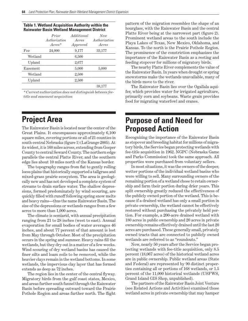
The Service proposes to strategically acquire an additional 9,177 acres in fee title and 5,000 acres in conservation easements (table 1). All purchases would be from voluntary sellers. These 14,177 acres represent 0.36 percent of the total land area of the Rainwater Basin.
Fee-title acquisition would focus on lands that meet one of two criteria: wetland portions that adjoin properties already partially held in fee title by the Service and larger semipermanent wetlands located within a wetland complex of smaller seasonal wet-lands. These properties would be managed as WPAs (waterfowl production areas). Management practices would include prescribed burning, livestock grazing, limited haying, and periodic resting (USFWS 2007). The areas would be open to public recreation, includ-ing hunting, wildlife viewing, photography, and envi-ronmental interpretation and education.
Conservation easements would be purchased on privately owned property containing smaller wetlands. The easements would protect the wetlands from be-ing drained or filled. Surrounding upland buffer areas under easement would be planted with native grasses and protected from commercial and residential develop-ment, although haying and grazing would be allowed.
Proposed ActionThe Service (U.S. Fish and Wildlife Service) is propos-ing the Rainwater Basin Expansion Project to expand the number of acres in Nebraska’s Rainwater Basin that it can own in fee title or hold in easements. Cur-rently, the Service has been authorized to purchase
64 Land Protection Plan, Rainwater Basin Wetland Management District Expansion
Table 1. Wetland Acquisition Authority within the Rainwater Basin Wetland Management District
Prior Authorization
Acres*
Additional Acres
Approved
New Authorization
Acres
Fee 24,000 9,177 33,177
Wetland 6,500
Upland 2,677
Easement 5,000 5,000
Wetland 2,500
Upland 2,500
38,177
* Current authorization does not distinguish between fee-title and easement acquisition
Project AreaThe Rainwater Basin is located near the center of the Great Plains. It encompasses approximately 6,100 square miles, covering portions or all of 21 counties in south-central Nebraska (figure 1) (LaGrange 2005). At its widest, it is 160 miles across, extending from Gosper County to central Seward County. The northern edge parallels the central Platte River, and the southern edge lies about 10 miles north of the Kansas border.
The topography ranges from flat to gently rolling loess plains that historically supported a tallgrass and mixed-grass prairie ecosystem. The area is geologi-cally new and has not developed a complete system of streams to drain surface water. The shallow depres-sions, formed predominately by wind scouring, are quickly filled with runoff following spring snow melts and heavy rains—thus the name Rainwater Basin. The size of the depressions or wetlands ranges from a few acres to more than 1,000 acres.
The climate is semiarid, with annual precipitation ranging from 21 to 28 inches (west to east). Annual evaporation for small bodies of water averages 46 inches, and about 77 percent of that amount is lost from May through October. Most of the precipitation occurs in the spring and summer. Heavy rains fill the wetlands, but they dry out in a matter of a few weeks. Wind scouring of dry wetland basins has caused the finer silts and loam soils to be removed, while the heavier clays remain in the wetland bottoms. In some wetlands, the impervious clay layer that has formed extends as deep as 72 inches.
The region lies in the center of the central flyway. Migratory birds from the gulf coast states, Mexico, and areas further south funnel through the Rainwater Basin before spreading outward toward the Prairie Pothole Region and areas further north. The flight
pattern of the migration resembles the shape of an hourglass, with the Rainwater Basin and the central Platte River being at the narrowest part (figure 2). Prominent wetland areas to the south include the Playa Lakes of Texas, New Mexico, Oklahoma, and Kansas. To the north is the Prairie Pothole Region. The prominence of the constriction emphasizes the importance of the Rainwater Basin as a resting and feeding stopover for millions of migratory birds.
The nearby Platte River complements the value of the Rainwater Basin. In years when drought or spring snowstorms make the wetlands unavailable, many of the birds move to the river.
The Rainwater Basin lies over the Ogallala aqui-fer, which provides water for irrigated agriculture, primarily corn and soybeans. Waste grain provides food for migrating waterfowl and cranes.
Purpose of and Need for Proposed ActionRecognizing the importance of the Rainwater Basin as stopover and breeding habitat for millions of migra-tory birds, the Service began protecting wetlands with fee-title acquisition in 1962. NGPC (Nebraska Game and Parks Commission) took the same approach. All properties were purchased from voluntary sellers.
In most situations, it was the owners of the deeper, wetter portions of the individual wetland basins who were willing to sell. Many surrounding owners of the remaining portion of a wetland chose to retain owner-ship and farm their portion during drier years. This split ownership greatly reduced the effectiveness of the publicly owned portion of the wetland. This is be-cause if a drained wetland has only a small portion in private ownership, the wetland cannot be effectively restored without purchasing the privately held por-tion. For example, a 200-acre drained wetland with 180 acres in public ownership and 20 acres in private ownership remains effectively drained until the last 20 acres are purchased. These generally small, privately owned tracts that are connected to publicly owned wetlands are referred to as “roundouts.”
Now, nearly 50 years after the Service began pro-tecting wetlands with fee-title acquisition, only 8.5 percent (18,067 acres) of the historical wetland acres are in public ownership. Public wetland areas (State and Federal) are represented by 90 distinct proper-ties containing all or portions of 168 wetlands, or 1.5 percent of the 11,000 historical wetlands (USFWS, Grand Island GIS Shop, unpublished).
The partners of the Rainwater Basin Joint Venture (see Related Actions and Activities) examined those wetland acres in private ownership that may hamper

65 Appendix C — Environmental Assessment
etla
nd M
anag
emen
t Dis
tric
t.Fi
gure
1. R
ainw
ater
Bas
in W

66 Land Protection Plan, Rainwater Basin Wetland Management District Expansion
the ability to manage wetlands owned by the Service or NGPC. The partners also examined the nutritional and energetic needs of all waterfowl while staging in the region. The number of total additional acres need-ing protection in the Rainwater Basin is based on this collaborative work.
Figure 2. Central flyway’s spring migration route.
FEE TITLE Taking into consideration the factors described above, the Rainwater Basin Joint Venture projected that an additional 7,790 wetland acres need to be purchased in fee title by all partners. The Service would strive to acquire 6,500 of these wetland acres. The required upland buffer around these wetlands is estimated to be 2,677 acres. Ownership of properties purchased with the authorization of this proposal would be held by the Service as part of the National Wildlife Refuge System. The properties would be managed as WPAs.
Fee-title acquisition would focus on two types of wetland properties. The primary focus would be on portions of privately owned wetland roundouts that share a boundary with wetlands already owned by the Service. The secondary focus would be on large wetlands that can serve as a core wetland within a complex of smaller, privately owned wetlands.
Currently, 38 WPAs need additional acquisition to complete ownership of the properties’ hydric or wetland soil. Adjoining roundout property, which represents a significant portion of the total wetland area, would need to be purchased in fee title to allow full manage-ment of the wetland. Adjoining wetland portions that represent a small portion of the wetland and do not sig-nificantly impact management on the Service’s portion could be protected with conservation easements. Most
properties that could serve as core wetlands within a wetland complex are currently drained and would be more difficult to purchase. Both of these acquisition approaches would have a positive effect on bird use within the local area.
CONSERVATION EASEMENTS The Joint Venture determined that an additional 9,239 acres of wetlands need to be protected by perpetual easements (Andy Bishop, coordinator, Rainwater Basin Joint Venture, Nebraska; personal communication; May 12, 2010). The Service would strive to acquire 2,500 wetland acres and 2,500 upland buffer acres through conservation easements.
Easements purchased by the Service would be grassland-wetland easements that would require the upland to be in permanent grassland. The easement would restrict commercial and residential development, but would allow the landowner to use the property for haying, grazing, and recreation. Allowing access to the property will remain a landowner’s right.
The Rainwater Basin Wetland Management Dis-trict has administered 31 conservation easements within the region since before 2009. Eight of these easements are within the Rainwater Basin, but only one has significant wetland habitat for migratory birds. Since 2009, the Service has acquired five additional grassland-wetland conservation easements within the Rainwater Basin. Those easements, acquired under the current land acquisition authority, follow the same guidelines proposed in this document.
The NRCS (Natural Resources Conservation Ser-vice) is expected to be the dominant partner with the Service in obtaining perpetual easements under its WRP (Wetlands Reserve Program). In 2010, the WRP launched a pilot project that allows landowners to sell a WRP easement, with the buyer retaining the right to graze the property with only minimal restrictions. The reason for allowing grazing is that it helps to keep wetlands in an early successional, seed-producing state, making it more valuable to migrating birds.
WATERFOWL NUTRITIONAL NEEDS The Rainwater Basin is internationally recognized for its importance as a migration stopover. Birds in migration have additional nutrient demands, not only for the actual migration but to reach a body condition needed for egg production (Devries et al. 2008).
Historically, the Rainwater Basin has provided migrating birds with natural foods from thousands of shallow wetlands. It is impossible to estimate how much food these wetlands provided for waterfowl hundreds of years ago, but recent research into the nutrient value of common native wetland plants docu-ments their high value.
The Rainwater Basin Joint Venture has used data on energetic needs and the number of bird-use days in

67
the Rainwater Basin to estimate that migratory wa-terfowl need a total of 15.6 billion Kcal (kilocalories) during their stay in the region from both natural and agricultural sources (Rainwater Basin Joint Venture, unpublished report, 2010).
The conversion of wetlands and grassland to crop-land has caused migrating waterfowl to feed heavily on waste grain (top chart in figure 3). Although waste grain meets the caloric requirements of waterfowl, it does not provide the amino acids and minerals re-quired in their diet.
One of the goals of the Rainwater Basin Joint Ven-ture is to increase the amount of available energy for waterfowl from natural, nonagricultural foods to 4.4 billion Kcal, or 28 percent of their diet (Rainwater Basin Joint Venture, unpublished report). A 2004 GIS (geographic information system) assessment of available wetland habitat and food indicated that, given their current number and condition, the region’s wetlands are capable of only providing 13.6 percent of the birds’ dietary needs (USFWS, Grand Island GIS Shop, unpublished).
In addition to loss of wetlands, remaining wetlands with altered hydrology or no active management for wildlife are more prone to developing dense stands of late-successional plants such as reed canary grass, cattail, and bulrush. Research suggests that wetlands dominated by late-successional plants can provide only about one-tenth of the kilocalories (0.025 million Kcal/acre) of wetlands in an early-successional stage (USDA, NRCS 2008).
The proposed action would contribute to meeting the nutritional needs of migratory birds determined by the Rainwater Basin Joint Venture. Better vegetation management in existing wetlands and an increase in the number of wetlands providing natural foods are required. The bottom chart in figure 3 shows where future wetland foods will come from. Acquisition and management of additional wetlands would increase the projected contribution from public wetlands from 5.8 to 21.3 percent. This action would provide the great-est amount of increased nutrition with the fewest number of acres.
Easement purchases and associated management would need to be increased to provide 10.2 percent of needed calories. Short-term wetlands are those that have less than 99-year easements or land use con-tracts. These wetlands would be expected to provide almost 5 percent of needed calories. Privately owned wetlands that have no protection would be expected to continue to provide 6 percent of the wetland foods.
Decisions to Be MadeThe Service’s planning team (see appendix B) will complete an analysis of the alternatives. Based on the analysis documented in this environmental as-sessment, the Service’s Regional Director of Region 6, with the concurrence of the Director of the U.S. Fish and Wildlife Service, may make two decisions:
■■ Determine whether the Service should expand the acquisition authority for the Rainwater Basin Wetland Management District; and,
■■ If yes, determine whether the selected alternative would have a significant impact on the quality of the human environment. The National Environ-mental Policy Act of 1969 requires this decision. If the quality of the human environment would not be significantly affected, a finding of no significant impact will be signed and made available to the public. If the alternative would have a significant impact or impacts, completion of an environmen-tal impact statement would be required in order to address those impacts.
Issues Identified and Selected for AnalysisTwo public scoping meetings were held in Clay Cen-ter and Holdrege, Nebraska, in January 2011. Public comments were taken at these scoping meetings to identify issues to be analyzed for the proposed action. Approximately 33 landowners, citizens, and elected representatives attended the meetings. Additionally, 16 letters providing comments and identifying issues and concerns were received.
The Service’s field staff contacted local govern-ment officials, other public agencies, and conserva-tion groups that have expressed an interest in and a desire to provide a sustainable future for wetlands in the Rainwater Basin region. Approximately 170 fact sheets were mailed out, and project information was also made available at the Rainwater Basin Wetland Management District and regional planning Web sites.
Many of the comments were related to the bio-logical needs of waterfowl and socioeconomic issues. Comment topics are summarized below.
BIOLOGICAL ISSUES■■ Concern about past and future loss of wetlands within the Rainwater Basin
■■ Concern about providing adequate habitat for spring migration
Appendix C — Environmental Assessment

68 Land Protection Plan, Rainwater Basin Wetland Management District Expansion
Figure 3. Sources of nutrients for migrating waterfowl.

69
■■ Concern about the value of the region for migrat-ing birds and the need to protect declining species
■■ Concern that farm programs and increased inter-est in biofuels may cause loss of the remaining un-protected wetlands
■■ Concern that the energetics model used to deter-mine the number of proposed acquisition acres is not a valid or accurate model
■■ Concern that wetlands in public ownership are not being managed for the benefit of all wildlife, including pheasants
SOCIOECONOMIC ISSUES■■ Concern that land protection discourages or nega-tively affects economic activity in the area
■■ Concern about the loss of taxes paid to the county, and that these lost taxes will place a greater bur-den on local taxpayers
■■ Concern that acquisition may drive up land prices■■ Concern that transition from privately owned farmland to public ownership will decrease the human population and support for schools, roads, and other services
■■ Concern that local governments should be given more authority to approve or disapprove land acqui-sitions and to determine the use of public property
■■ Concern that funding should be made available to compensate landowners for their privately owned wetlands
■■ Concern that the Service should work with land-owners to enhance wetlands on private property
Issues Not Selected for Detailed AnalysisAt one of the scoping meetings, the accuracy of the energetics models was called into question. No de-tailed analysis of this issue was performed for this en-vironmental assessment. This model clearly assumes that the data used to estimate the energetic needs of waterfowl within Rainwater Basin came from a large amount of research not specific to this area. For ex-ample, the energetic value (Kcal) of a particular wet-land plant studied in another part of the country is assumed to have an energetic value similar to that of the same plant species within the Rainwater Basin. The validity of this assumption is currently unknown and would require site-specific research. The energetic value given to plants in the Rainwater Basin, however, represents the best information available. Informa-tion from the energetic model has helped the Service better understand the importance of the Rainwater
Basin for migratory waterfowl, not just as a resting area but also as a source of amino acids and minerals.
The issue of land management on WPAs is ad-dressed only in general terms in this document. Land management actions depend on a large number of vari-ables, including existing vegetative conditions, site-specific objectives, past management actions, seasonal weather conditions, and other planned management actions. In addition, the wetland management district in 2007 developed a CCP (comprehensive conserva-tion plan) (USFWS 2007) for Service lands within the Rainwater Basin that outlined and analyzed land management actions.
A common concern expressed by the public per-tains to wetland grazing and pheasant habitat. The Rainwater Basin Wetland Management District com-monly receives comments that the Service does not do as much as it could to increase pheasant popula-tions. Although pheasants are recognized as part of the diversity provided by WPAs, the pheasant is a State-managed species and not a Service responsibil-ity. The purpose of the wetland management district, as described in the Migratory Bird Hunting and Con-servation Stamp Act, is to manage migratory birds.
National Wildlife Refuge System and AuthoritiesThe mission of the National Wildlife Refuge System is to administer a national network of lands and wa-ters for the conservation, management, and, where appropriate, restoration of fish, wildlife, and plant resources and their habitats within the United States for the benefit of present and future generations of Americans.
Lands acquired under the proposed action would be administered as part of the Refuge System in ac-cordance with the National Wildlife Refuge System Administration Act of 1966 and other relevant leg-islation, Executive orders, regulations, and policies.
Conservation of additional wildlife habitat in the Rainwater Basin region would also continue to be consistent with the following laws, policies, and man-agement plans:
■■ Migratory Bird Treaty Act (1918)■■ Migratory Bird Conservation Act (1929)■■ Migratory Bird Hunting and Conservation Stamp Act (1934)
■■ U.S. Fish and Wildlife Act (1956)■■ Land and Water Conservation Fund Act (1965)■■ North American Wetlands Conservation Act (1968)■■ Endangered Species Act (1973)
Appendix C — Environmental Assessment

70 Land Protection Plan, Rainwater Basin Wetland Management District Expansion
■■ North American Waterfowl Management Plan (1994)■■ National Wildlife Refuge System Biological Integ-rity, Diversity, and Environmental Health (2001)
■■ Migratory Non-Game Birds of Management Con-cern in the U.S. (2002)
Related Actions and ActivitiesThe Service is working with other public and private entities to maintain wildlife habitat within the Rain-water Basin region. Many organizations in Nebraska have recognized the ecological significance of the re-gion and the need to promote conservation in concert with production agriculture. Wetland acquisition and restoration in the area have been done by the NGPC, NRCS, Ducks Unlimited, and The Nature Conservancy. Local natural resource districts have worked closely with conservation partners to maintain a balance be-tween wetland habitats and agriculture.
In 2007, the wetland management district developed a CCP (Comprehensive Conservation Plan) (USFWS 2007) for Service lands within the Rainwater Basin. The document identifies land management activities planned by the Service through 2022. The need for ad-ditional land acquisition was identified as important in the draft CCP sent out for public comment and the subsequent final document.
RAINWATER BASIN JOINT VENTURE The Rainwater Basin was identified as a habitat of major concern by the North American Waterfowl Management Plan, establishing it as a focus area for a joint venture (NAWMP 1986). Partners involved in the formation of the joint venture included the Ser-vice, the NGPC, Ducks Unlimited, the NRCS, Little Blue Natural Resource District, and the National Audubon Society. Its current partners include many of these same organizations as well as other natural resource districts, The Nature Conservancy, and pri-vate landowners.
The Rainwater Basin Joint Venture is currently in the process of rewriting its Implementation Plan (Gersib et al. 1992). The newer version is expected to identify a need to acquire an additional 20,000 acres (about 60 percent of which would be perpetual ease-ments). One proposed strategy is developing working landscapes, which would involve the purchase and res-toration of wetlands and grasslands, with the property being resold to the private sector once a conservation easement has been established. The easement would allow livestock grazing and dryland haying, but no farming. The right to allow public access would also remain with the landowner. This approach would
protect wetlands, restore grasslands, and provide agricultural income to the landowners.
PARTNERS FOR FISH AND WILDLIFE PROGRAMPFW (Partners for Fish and Wildlife Program) is ad-ministered by the Service; it provides financial and technical assistance, and works cooperatively with landowners to voluntarily restore and enhance wild-life habitat on private land. The program was imple-mented in Nebraska in 1991 and has been growing ever since. Since the early 1990s, approximately 400 projects have been accomplished statewide, result-ing in a substantial amount of habitat restored for Federal trust species such as migratory birds and threatened and endangered species. In Nebraska, the predominant wetland restoration and enhancement techniques involve restoring the natural hydrology through the blocking of drains, breaking tiles, filling in concentration pits, removing sediment, installing grass buffers, installing fences along stream corridors, and addressing problems throughout the watershed. Wetland enhancement activities include working with the landowners to better manage the wetland through the use of grazing, haying, discing, and burning. Up-land and riparian areas are restored and enhanced through installing cross fencing, providing alternative sources of water, and developing grassland/grazing management plans. Prairie restoration along the cen-tral Platte River involves the conversion of cropland to a high-diversity mixture ranging from 100 to 200 species of locally harvested native grasses and forbs.
DUCKS UNLIMITED Ducks Unlimited has long recognized the Rainwater Basin as a focus area for wetland conservation efforts. Its goal is to secure a base of wetland complexes to restore the region’s function for waterfowl. In 2002, it began acquiring the Verona Complex in the central portion of the Rainwater Basin. Much of the property, including both the wetland and the surrounding upland, has required restoration. Ducks Unlimited’s Rainwater Basin initiative uses multiple approaches, consisting of land acquisition, wetland restoration, wetland man-agement, and affecting public policy. The land acquisi-tion portion involves the purchase of land containing existing or restorable wetland habitat. Once Ducks Unlimited has restored the wetlands, the property may be sold to a public agency or to a private buyer with a conservation easement in place. The proceeds from the sale are then used to repeat the process.
NEBRASKA GAME AND PARKS COMMISSION NGPC continues to work toward acquisition, restora-tion, and management of Rainwater Basin wetlands. Currently, it owns approximately 6,700 wetland acres. Its philosophy of acquisition, restoration, and management of its lands mirrors that of the Service.
71
NGPC also faces the problems of split ownership and is working toward acquiring roundouts to improve the functionality of its wetlands.
NGPC developed the Nebraska Legacy Plan (Schneider et al. 2005), which is Nebraska’s “Compre-hensive Wildlife Conservation Strategy.” Such plans are required by Congress for all States. The plan was developed by a partnership team made up of 20 Federal and State agencies, nongovernmental organizations, and the Ponca Tribe of Nebraska. This document has become the guiding document for conservation groups throughout the State.
The plan identifies the Rainwater Basin as a bio-logically unique landscape. Key concerns identified for this region include the spread of invasive species, conversion of natural habitats, alteration of grazing and burning regimes, and drainage and sedimentation of existing wetlands.
NATURAL RESOURCES CONSERVATION SERVICE The NRCS is one of the major partners in wetland conservation in the region. Most of its recent work has been associated with the national Wetlands Reserve Program, a voluntary program to restore wetlands. The program has three options for landowners: permanent conservation easements, 30-year conservation ease-ments, or a simple cost-share restoration agreement. Lands enrolled in a conservation easement have both the wetlands and the surrounding upland restored. Within the Rainwater Basin, Wetlands Reserve Pro-gram contracts scattered across the Rainwater Basin Wetland Management District have restored and pro-tected approximately 7,077 acres (Randy Epperson, program manager, Natural Resource Conservation Service, Nebraska; personal communication; 2011).
Recently, the NRCS granted a variance to the Wet-lands Reserve Program within Nebraska. The vari-ance will allow the sellers of conservation easements to retain grazing rights. The basis of the variance is that grazing is a critical, natural process in sustaining shallow, playa wetlands.
In addition, because of the intense agriculture and history of wetland drainage within the Rainwater Ba-sin, the Nebraska office of NRCS in 2010 approved an application that requested a variance to allow center pivot irrigation equipment to traverse portions of wet-lands and uplands protected under the Wetlands Re-serve Program. However, numerous wetlands remain drained and without conservation protection because farmers need to run one or more pivot wheels across a wetland, which is generally not allowed under the Wetlands Reserve Program.
The Farm Service Agency, with technical assistance from the NRCS, administers the CRP (Conservation Reserve Program), which emphasizes support for working livestock-grazing operations, enhancement of plant and animal biodiversity, and protection of
grassland under threat of conversion to other uses for 10 to 15 years. Participants voluntarily limit fu-ture development and cropping uses of the land. At the same time, participants retain the right to conduct common livestock-grazing practices and operations re-lated to the production of forage and seeding, subject to certain restrictions during nesting seasons of bird species that are in significant decline or are protected under Federal or State law.
NEBRASKA ENVIRONMENTAL TRUST By a vote of the people, the Nebraska Environmental Trust was established in 1992 to use 44.5 percent of the State’s lottery proceeds for the purpose of conserving, enhancing, and restoring natural physical and biologi-cal environments across the State. During its 19-year existence, millions of dollars have been provided to-ward conservation of wetlands within the Rainwater Basin region. The projects funded by the trust have included fee and easement acquisition, restoration, research, monitoring, and public outreach projects.
TRI-BASIN NATURAL RESOURCE DISTRICT The Tri-Basin Natural Resource District, located in the western portion of the Rainwater Basin, currently owns and manages a large wetland and two conserva-tion easements that protect privately owned wetlands. In addition, an imposed moratorium on groundwater development has prompted the district to begin explor-ing ways to reduce groundwater use and to increase groundwater recharge. One such program would be water banking, in which water allocation in one area would be transferred to another area. This type of program leads the way to having drained wetlands restored as marginal farm lands are taken out of ir-rigation. Other natural resource districts within the Rainwater Basin are also looking at ways to better manage groundwater use for agriculture.
Habitat Protection and the Acquisition ProcessWetland habitat protection would occur through the purchase of fee-title and conservation easements. It is the long-established policy of the Service to acquire minimum interest in land from willing sellers to achieve habitat acquisition goals.
The acquisition authorities for the proposed expan-sion are the Migratory Bird Hunting and Conservation Stamp Act of 1934, also known as the Duck Stamp Act (16 U.S.C. 718-718h; 48 Stat. 51, as amended); the North American Wetlands Conservation Act (16 U.S.C. Sec. 4401); and the Land and Water Conservation Fund Act of 1965 (P.L. 88-578, Title 16). The Migratory Bird Hunting and Conservation Stamp Act money used to
Appendix C — Environmental Assessment

72 Land Protection Plan, Rainwater Basin Wetland Management District Expansion
acquire property is received from Federal Duck Stamp revenue. The North American Wetlands Conserva-tion Act funds are from congressional appropriations, Migratory Bird Treaty Act fines, and various Federal accounts. The Land and Water Conservation Fund is derived primarily from oil and gas leases on the Outer Continental Shelf, motorboat fuel tax revenues, and sale of surplus Federal property.
There could be additional funds to acquire lands, waters, or interest therein for fish and wildlife con-servation purposes through congressional appropria-tions, donations from nonprofit organizations, and other sources.
The basic considerations in acquiring interest in property are the biological significance of a wetland, the feasibility of restoring wetland habitat, and landowner
interest in the program. Fee-title acquisition would focus on two areas: wetland portions that adjoin prop-erties in fee title by the Service, and larger semiper-manent wetlands located within a wetland complex of smaller seasonal wetlands. These properties, once acquired, would be managed as WPAs.
Conservation easements would be purchased in perpetuity on privately owned property containing smaller wetlands located in cropland and grassland. The easements would protect the wetlands from be-ing drained or filled. Surrounding upland buffer areas under easement would be planted and remain in grass. All other property rights, including grazing, haying, and public access, would remain with the landowner.
Purchases would occur from willing sellers only and would be subject to available funding.
A waterfowl production area in late spring.
US
FW
S

73
SECTION 2 — ALTERNATIVES, INCLUDING THE PROPOSED ACTION
This section describes the two alternatives identi-fied for this project that were developed according to NEPA (National Environmental Policy Act) § 102(2)(E) requirements to “study, develop, and describe ap-propriate alternatives to recommended courses of ac-tion in any proposal which involves unresolved conflicts concerning alternative uses of available resources.” In addition, alternatives that were eliminated from detailed study are briefly discussed, including the reasons they were not further examined. The follow-ing alternatives were analyzed:
■■ the no-action alternative ■■ the proposed action, which gives the Service the authority to expand its acquisition authority from its current level of 24,000 acres to 38,177 acres
The alternatives consider the effects of expanding land acquisition within the wetland management district boundary identified in this environmental assessment.
Alternative A (No Action)Under alternative A, wetland acquisition would continue until the Service has reached its current authorization of 24,000 acres. After the authorization level has been reached, any additional acres that would come under Service ownership within the Rainwater Basin would come from donations or gifts from landowners, conser-vation organizations, and other government agencies. Wetland habitat management and restoration would continue on lands owned by the Service to help meet the needs of migratory birds. Refuge revenue shar-ing payments would continue to be made to counties with Service lands.
Under this alternative, many of the privately owned wetlands that are vulnerable to drainage or other destruction may be lost. The burden to protect wetlands without compensation would lie more heav-ily on private landowners, and a majority of marginal cropland would not be restored.
Alternative B (Proposed Action)Under alternative B, the Service would increase its land acquisition goal from 24,000 acres to 38,177 acres within the Rainwater Basin Wetland Management District. All lands would be acquired from willing
sellers, with acquisition occurring over as many years as necessary to reach the new goal.
The Service would seek to purchase an additional 9,177 acres in fee title and 5,000 acres in conservation easements over the existing goal. Lands targeted for acquisition would be according to a prioritization sys-tem established by the Rainwater Basin Joint Venture. This system was developed by biologists from differ-ent agencies and organizations to identify and ensure protection of those wetlands that best meet the bio-logical needs of migratory waterfowl and shorebirds.
Within the rating system, fee-title acquisition will meet one of two criteria: privately owned portions of wetlands adjoining existing WPAs and large wetlands that are part of a complex of numerous small wetlands. Conservation easements purchased from willing sell-ers would focus on small wetlands that are part of a large complex of wetlands.
Lands purchased in fee title would be managed as WPAs and be open to public use.
Conservation easements purchased from willing sellers would prohibit destruction of wetland habi-tat. In addition, the surrounding upland included in the easement would be required to be maintained as grassland. The landowner would retain access, graz-ing, and haying rights. Easements would be managed by the Watershed Management District. Monitoring would include periodic reviews of land status through correspondence and meetings with landowners or land managers to ensure that the stipulations of the con-servation easement are being met. Photographs would be taken at the time the easements are established in order to document baseline conditions.
Refuge revenue sharing would be paid to counties for Service lands in fee-title ownership. Taxes on lands containing a conservation easement would continue to be paid by the landowner.
Alternatives Considered but Not StudiedThere was no further analysis conducted for the follow-ing two alternatives for the reasons described below.
WETLAND PROTECTION AND ENHANCEMENT THROUGH PARTNERSHIPSOne alternative that was considered was developing a program similar to CRP that would pay landowners for protecting their wetlands from being altered or
Appendix C — Environmental Assessment

74 Land Protection Plan, Rainwater Basin Wetland Management District Expansion
destroyed for a period of 10 years. The contract would be available for renewal every 10 years. This alterna-tive would not ensure the protection of wetlands for the long term. Like CRP lands, wetlands would be-come vulnerable to drainage when crop prices make it profitable to convert such wetlands to cropland. Furthermore, the Service has an active Partners for Fish and Wildlife Program in the area, which can be used if selling the land is not an option for a landowner.
COUNTY ZONINGIn a traditional approach used by counties and mu-nicipalities, the local government would use zoning as a means of designating what type of development could occur in an area. Nebraska law grants cities and counties the authority to regulate land use, and en-gaging in planning and zoning activities is therefore optional. However, zoning may be subject to frequent changes and would not ensure the long-term protec-tion of wetlands.

75
SECTION 3 — AFFECTED ENVIRONMENT
Biological EnvironmentCLIMATEThe region’s climate is semiarid, with annual precipi-tation ranging from 21 to 28 inches (west to east). An-nual evaporation for small bodies of water averages 46 inches; about 77 percent of that amount is lost from May through October. Most of the precipitation occurs in the springtime and during summer thunderstorms. Heavy rains fill the wetlands, but quickly dry in a mat-ter of a few weeks. Wind scouring of wetland bottoms has removed the finer silts and loam soils, while the heavier silt clays remain in the wetland bottoms. In some wetlands, the impervious clay layer that has formed extends as deep as 72 inches.
CLIMATE CHANGE Current climate change projections for the Great Plains are for warmer temperatures and increased precipitation. The increase in precipitation is expected to be quite variable across the Great Plains, but will be less than what is needed to offset the increase in temperatures. The result will likely be warmer, drought-like conditions. Intense precipitation events are projected to increase, causing more runoff, pollu-tion, and soil erosion problems. Droughts and floods are expected to occur more frequently. The problems caused by climate change will be further compounded by invasive species that will be able to adapt quickly to fluctuating extreme water conditions.
ADAPTATION, MITIGATION, AND ENGAGEMENTThe Service’s strategic response to climate change involves three core strategies: adaptation, mitigation, and engagement (USFWS 2009). Through adapta-tion, the impacts of climate change on wildlife can be reduced by conserving habitats that are expected to be resilient. The Rainwater Basin Expansion Project would provide an anticipatory, rather than a reactive, response. As preserving migratory corridors becomes increasingly important, the Rainwater Basin will con-tinue to provide a stopover area for shorebirds and waterfowl within the central flyway.
Under the expected changes in climate, waterfowl use of the area may increase significantly because most precipitation occurs in early spring and because pre-cipitation events are expected to be more intense in the future. Another factor that may play a significant role in bird use will be the anticipated decline in pre-cipitation and wetlands in other portions of the country.
Carbon sequestration forms one of the key elements of mitigation. The Rainwater Basin Expansion Project
would have a mitigating effect on climate change by capturing carbon. Wetlands that are currently drained and being farmed at the time of purchase would be restored to wetland habitat. Surrounding upland buf-fer areas would be restored to native warm-season grasses and forbs. Prairie vegetation stores carbon in its deep fibrous roots, with approximately 80 percent of the plant biomass located below ground. Since the land would no longer be farmed, a large amount of carbon is expected to be sequestered.
Engagement involves cooperation, communication, and partnerships to address the conservation chal-lenges presented by climate change (USFWS 2009). The Rainwater Basin Expansion Project would serve as a model for engagement by working with farmers and landowners; nongovernmental organizations such as The Nature Conservancy, Ducks Unlimited, and Pheasants Forever; State and local agencies such as the NGPC and local natural resource districts; and Federal agencies including the NRCS.
GEOLOGIC RESOURCESThe Rainwater Basin lies in the flat to gently rolling, mixed-grass, loess plains of south-central Nebraska. This area is geologically new and has not developed a complete system of streams to drain surface water. It is from this characteristic that the area received its name: Rainwater Basin.
Wind-deposited Peorian Loess occurs extensively across the basin and has been stable for about 10,000 years (Keech and Dreezen 1959). Upland soils that formed in wind-deposited material include Crete, Hastings, Holdrege, Hord, and Uly (Kuzila 1984). The soils are suitable for farming, with about 80 percent of the land being planted with crops. The shallow, flat depressions formed predominantly by wind scouring are often referred to as playa wetlands because of their formation process and ephemeral (water levels lasting for a brief time) nature. Radiocarbon dating indicates that the wetlands were created near the end of the ice age, 20,000 to 25,000 years ago. Some depressions may have been enlarged and new ones created as recently as 3,000 years ago (Farrar 1996). Over thousands of years, minute clay particles accu-mulated in the bottoms of the depressions, allowing water to pond above the soil surface. The impervious clay layers are 6 to 72 inches thick. The wetland soils are predominantly Butler, Fillmore, Scott, and Massie (Kuzila and Lewis 1993, Kuzila 1994).
Appendix C — Environmental Assessment
76 Land Protection Plan, Rainwater Basin Wetland Management District Expansion
HABITAT
History of Land Development In contrast to the thick clay in the depressions, the upland soils are very productive silts and loams used for agriculture. At the end of the 1800s, the rich soil was being cultivated, and by the 1910s, larger wet-lands were being converted to cropland. In the 1950s, irrigation canals and large-volume wells expanded gravity-flow irrigation, causing smaller wetlands to be filled and their watersheds to be reshaped.
Water concentration pits were constructed to col-lect irrigation runoff at the lowest parts of the fields in areas that would normally be wetlands. The pits were an effective way to both drain a wetland and gain excavated material to fill the remaining portion of the wetland. The use of concentration pits was ex-tensive. The Service identified 11,859 concentration pits totaling 7,506 acres within the Rainwater Basin in 2004 (USFWS, Grand Island GIS Shop, unpub-lished). Their water storage capacity is estimated to be about two-thirds of the region’s historical wetland storage capacity.
A 1984 (Schildman and Hurt 1984) wetland survey estimated that approximately 4,000 wetlands once ex-isted that covered over 100,000 acres. More recent soil surveys, however, estimate that the original number of wetlands was much higher and covered about twice that number of acres.
In the early 1970s, the loss of wetlands further in-creased with the development of center pivot irriga-tion technology. Pasture ground containing wetlands was broken up, drained, and combined with other cropland to form large (160-acre) fields that would support center pivots. The 2004 assessment estimated that only 16 percent (1,693) of the historical wetlands retained some wetland function. Those wetlands total about 38,500 acres.
Many of the former wetlands were intentionally leveled or have been filled with culturally accelerated sediment. Nearly all the remaining wetlands have been affected by surrounding land use. The greatest effect has been the reduction of the watershed’s ability to provide enough water to allow the wetlands to func-tion naturally. As more upland has been converted to cropland, sedimentation caused by runoff has in-creased. In the last 40 years, the use of chemicals and fertilizers in crop production has brought pesticides and high levels of nutrients into the wetlands.
Wetlands in larger watersheds used to retain water on a semipermanent basis. Now with the reshaping of the landscape, creation of roads and ditches, sedi-mentation, and cultivation practices, even unaltered wetlands cannot function properly and most of them have become more ephemeral.
The loss of pastureland not only affected water quality from runoff, it effectively reduced livestock
available for grazing remaining wetlands. Wetlands that once supported livestock grazing and remained open for waterfowl became choked with cattail and bulrush.
Past Wetland Protection and Land Use within Watersheds Many of the problems that are affecting the wetlands go beyond what is actually happening within each wetland to the surrounding land uses. These problems include intense cultivation, land leveling, large live-stock confinement areas, and lack of grazing livestock.
Cultivation of upland areas increases soil erosion and sedimentation of wetlands, a process that has been going on in some areas for more than 150 years. Runoff and erosion also transport pesticides and ex-cessive levels of nutrients to the wetlands. In some larger watersheds, seasonal heavy rains are known to occur with enough intensity that residual cornstalks are transported to ditches and waterways. Restora-tion work on these wetlands often includes sediment removal, especially near the fluvial area of waterways.
Land leveling, as discussed earlier, began with the conversion from dryland farming to gravity flow ir-rigation. Effective gravity-flow irrigation requires a uniform, gentle slope across the field to allow water released on the upper end of the field to flow gently down toward the lower end. Any wetland or depres-sion in the middle of the field that pooled water was filled. The common practice was to dig large water concentration pits to collect any water that reached the lower end of the field. Soil material removed from the pit was used to fill the remaining portion of the wetland to allow more area to be farmed. The result of this practice was that only the larger wetlands that could not be economically filled or drained remained as wetlands.
Both economic conditions and the availability of cheap corn for feed encouraged large livestock con-finement facilities. Many of these were built on poorer, steeper land—often in close proximity to a wetland. Although State regulations control most of the con-taminant concerns, large runoff events and operator violations sometimes place these contaminants in wetlands.
The ability of many of the remaining wetlands to function has deteriorated. Sedimentation has re-sulted in reduced water depth, loss of portions of the watershed’s runoff has shifted wetlands toward more seasonal water retention, aquatic vegetation has in-creased, and, with the absence of grazing livestock, the wetlands have become choked with monotypic stands of cattail, bulrush, and reed canarygrass.
Wetland drainage and conversion is the main threat to the Rainwater Basin wetlands. Over the past de-cade, wetland loss from drainage and filling has been extensive. Wetland drainage was widespread even

77 Appendix C — Environmental Assessment
before efforts were made to determine the number of wetlands that existed in the region.
Estimates of the number of historical wetlands are based primarily on soils maps, which show the extent of hydric soils on the landscape. That estimate is 11,000 historical wetlands totaling 204,000 acres (USFWS, Grand Island GIS Shop, unpublished). GIS analysis and high-resolution aerial photography allow for an accurate measure of wetland acres. Current estimates are that 38,500 acres of wetlands remain. The number of functional wetlands has declined to 1,693 (2004 data, USFWS, Grand Island GIS Shop, unpublished). This is about 16 percent of the historical number.
Each year, the slow degradation of wetlands con-tinues. Shallow depressions that are being farmed are slowly filling with sediment from the adjacent upland. Years of farming and pesticide application have ad-versely affected native vegetation and invertebrates. Farming practices such as no-till farming reduce the amount of soil erosion, but may also reduce the amount of water runoff reaching the depression.
Most of the larger wetlands have been fully or partially drained. Those that have retained some functionality are slowly being subjected to the same forces as the smaller depressions: sedimentation, agricultural chemical runoff, and decreased surface water running into the wetland. Years of no farming or grazing encourages invasion by reed canarygrass, cattail, bulrush, and trees. In general, lack of grazing, burning, and disturbance greatly reduces the value of the wetland for migratory birds. Wetlands that retain a higher level of functionality still capture enough of the watershed’s runoff to provide aquatic vegetation, invertebrates, and water for migrating birds, but these remaining wetlands are being subjected to the same adverse effects as the more disturbed wetlands.
An additional threat to some of the wetlands is nutrient and waste runoff from large livestock con-finement areas. Animal waste in feedlots is hauled to surrounding fields. Although State regulations are in place to control runoff, heavy rain events can cause rapid runoff carrying waste and chemicals that reach wetlands. Since the wetlands are within a closed drain-age, the nutrients and pollutants are not flushed out but accumulate within the wetlands.
There are many factors driving the continued conversion of wetlands within the Rainwater Basin. The assumption is that the wetlands that were easy and economically feasible to drain have already been drained and converted. Each year, however, additional wetlands are lost. Some of the common causes for the continuing loss of wetlands are changes in Farm Bill regulations, commodity prices, increased crop insur-ance subsidies, and new irrigation and farming tech-nologies. Commodity prices and crop insurance serve as a safety net for farming the more risky lands. New irrigation technologies allow for chemigation, control
of water delivery, and easier access across wet areas and steeper slopes. No-till farming allows for more eco-nomical farming in more arid areas than were possible in years past. In recent years, impending moratoriums on groundwater development have stimulated devel-opers and producers to convert more land to cropland.
Property taxes, low livestock prices, and low pro-duction rates from dryland farming cause landown-ers to continually look for ways to make every acre financially productive, reducing the incentive to keep a privately owned wetland.
The conversion of wetlands and grassland has also caused birds to concentrate into fewer areas, increas-ing the risk of disease outbreaks and competition for natural foods. Waste grain has replaced much of the natural foods in waterfowl diets. Although corn meets the caloric requirements, it is deficient in many of the nutrients found in natural foods (Baldassare and Bolen 1994, Krapu et al. 2004).
Current Protection StatusService acquisition has focused on purchase and pro-tection of the larger wetlands. Over the decades, as the smaller surrounding wetlands have been lost, the wetlands purchased by the Service have become isolated. In some portions of the Rainwater Basin, acquisition needs to focus on protecting the smaller wetlands that make up a complex, while in other por-tions, a larger core wetland needs to be restored to create a complex. Figure 4 shows the change in spatial distribution of wetlands throughout the region (US-FWS, Grand Island GIS Shop, unpublished).
From 2000 to 2008, aerial surveys were conducted every spring by the station biologist to document the amount of migratory bird habitat available. A total of 17,984 acres of public wetlands was surveyed. Of that total, the average amount of suitable habitat (described as any habitat containing water) was 5,582 acres. This means that an average of 32 percent of the public wet-land acres was suitable migration habitat. Some of those wetlands were supplemented with groundwater pumped by the Rainwater Basin Wetland Management District and the NGPC.
Groundwater Most of the groundwater in the Rainwater Basin
area has little or no influence on maintaining wetland water levels. The majority of the groundwater is lo-cated more than 50 feet underground, and in some areas the groundwater is more than 400 feet deep. One area east of the Tri-County canal has groundwater levels that are less than 50 feet deep due to artificial groundwater mounds that have developed near the surface (Ekstein and Hygnstrom 1996).
The development of center pivot irrigation in the last third of a century has placed a great demand on the groundwater underlying Rainwater Basin. Irriga-tion, compounded by extensive drought, has caused

78 Land Protection Plan, Rainwater Basin Wetland Management District Expansion
Figure 4. Historical (top) and current (bottom) wetland distribution and abundance (blue area) within the Rainwater Basin.

79 Appendix C — Environmental Assessment
the State legislature to pass legislation to help control groundwater declines. Only the extreme western edge of the Rainwater Basin Wetland Management District lies within an over-appropriated natural resource dis-trict. Some of the natural resource districts located within the Rainwater Basin, however, have placed a moratorium on new wells and are requiring stricter monitoring of pumping.
There is some groundwater recharge below Rain-water Basin wetlands. Percolation occurs as macropore flow through desiccation cracks that form during dry conditions (Wilson 2010). However, soil percolation de-creases as clays expand and fill the desiccation cracks (Wood 2000, Wilson 2010). Research from playa lakes in Texas and New Mexico has shown similar recharge characteristics (Wood 2000).
Artificially pumping groundwater into the wetlands has made a dramatic difference in amount of habitat on WPAs. The average suitable habitat for WPA wet-lands not pumped was 22 percent of the total wetland acres. For WPA wetlands pumped, the average suit-able habitat was 39 percent of the total wetland acres.
WILDLIFERainwater Basin serves as a critical resting and feed-ing stopover area for millions of waterfowl during spring migration. It is estimated that waterfowl using the area each spring include 7.5 million ducks and 2.1 million geese. Gersib et al. (1989) documented that 50 percent of the mid-continent mallards and 30 percent of the continental northern pintails migrate through during spring migration. Nearly 90 percent of the mid-continent population of greater white-fronted geese has been documented to use this region during their spring migration.
A total of 329 species of birds have been observed within the Rainwater Basin, including 41 species of shorebirds and 35 species of waterfowl. Between 200,000 and 300,000 shorebirds migrate through in the spring. Common grassland species include northern harrier, northern bobwhite, ring-necked pheasant, greater prairie-chicken, dickcissel, western meadow-lark, bobolink, field sparrow, and grasshopper sparrow.
Spring migration usually starts with a buildup of Canada geese on the Platte River until the Rainwater Basin wetlands begin to thaw. Snow geese, greater white-fronted geese, and mallards begin to peak by mid- to late February. In early March, northern pintail numbers peak, followed by Ross’s geese and green-winged teal. The remaining divers and puddle ducks usually peak during mid- to late March.
Most shorebirds pass through between April 15 and May 15. According to Jorgensen (2004), the most common spring shorebird migrants are black-bellied plover, American golden-plover, semipalmated plover, greater yellowlegs, lesser yellowlegs, willet, upland sandpiper, Hudsonian godwit, dunlin, white-rumped
sandpiper, Baird’s sandpiper, semipalmated sandpiper, least sandpiper, stilt sandpiper, short-billed dowitcher, long-billed dowitcher, buff-breasted sandpiper, Wil-son’s snipe, and Wilson’s phalarope. Rainwater Basin has the largest known concentration of buff-breasted sandpipers during spring migration (Jorgensen 2007). Common late-summer migrants are greater and lesser yellowlegs, solitary sandpiper, upland sandpiper, pectoral sandpiper, semipalmated sandpiper, least sandpiper, stilt sandpiper, long-billed dowitcher, and Wilson’s snipe.
Rainwater Basin is identified as a landscape of hemispheric importance by the Western Hemisphere Shorebird Reserve Network. It also lies within the Geo-graphic Framework of Bird Conservation Region #19.
Peregrine falcons frequent wetlands during peak shorebird migration periods. Prairie falcons, on the other hand, are most numerous in late winter when horned larks and meadowlarks are common. Merlin are primarily winter visitors and spring migrants (Johnsgard 1997). Bald eagles are most common dur-ing peak waterfowl migration. Burrowing owls nest on isolated prairie dog towns.
Threatened and Endangered SpeciesThree species listed under the Federal Endangered Species Act and the Nebraska Nongame and Endan-gered Species Conservation Act use the Rainwater Basin wetlands during migration: the State and Fed-erally endangered whooping crane and least tern, and the State and Federally threatened piping plover.
Forty-two percent of confirmed whooping crane observations in Nebraska have been at Rainwater Basin wetlands (Richert 1999). Most of these sightings occur during the first 2 weeks of April or from late October through mid-November. Piping plovers are rarely seen on Rainwater Basin wetlands due to their size and the number of other shorebirds that would be using mudflat habitats in late April through mid-May (Johnsgard 1997). Least terns have been documented at some wetlands, although their occurrence in the Rainwater Basin is rare.
Other species that are proposed or are candidates for listing under the State and Federal Endangered Species Acts or are species of concern that use the Rainwater Basin include northern harrier, Swainson’s hawk, ferruginous hawk, long-billed curlew, black tern, short-eared owl, and Sprague’s pipit.
Mammals Large mammals common to the region are those as-sociated with grasslands of the Great Plains. They include white-tailed deer, coyote, raccoon, striped skunk, eastern cottontail, American badger, and Vir-ginia opossum. Mule deer have occasionally been seen in the western portion. Muskrat and mink may occur during wetter years but their populations have dropped dramatically with changes in land use and wetlands.

80 Land Protection Plan, Rainwater Basin Wetland Management District Expansion
Isolated prairie dog towns are scattered throughout the region, with most of them smaller than 40 acres and located on public lands. Common small mammals include thirteen-lined ground squirrel, northern and plains pocket gopher, Ord’s kangaroo rat, meadow jumping mouse, meadow vole, northern grasshopper mouse, and white-footed mouse. Less common mam-mals are red fox, black-tailed jackrabbit, woodchuck, Franklin’s ground squirrel, and eastern fox squirrel.
Reptiles and Amphibians Semipermanent wetlands provide habitat for painted and snapping turtles. Ornate box turtles may be found in grassland areas. Western garter snakes, bull snakes, and eastern yellowbelly racers are fairly common. Western hog-nosed snakes are less common and prefer dry sandy prairies. Smooth green snake and redbelly snake are rare in the region. The lesser earless lizard may occur in open sandy soil with sparse vegetation, while the six-lined racerunner can be found in both lowland and upland sites.
Amphibians that occur in the Rainwater Basin in-clude plains spadefoot toad, Woodhouse’s toad, Great Plains toad, Blanchard’s cricket frog, boreal chorus frog, bullfrog, gray treefrog, plains leopard frog, and tiger salamander.
Fisheries Due to the hydrologic nature of the wetlands within the Rainwater Basin, there currently are no viable fisheries. Two native Missouri River basin cyprinids, the shoal chub and plains minnow, are of concern but have no legal protected status in Nebraska. Catfishes, sunfishes, darters, catastomids, and other minnows are part of the fish communities in this region that are also of concern and of interest to the National Fish Habitat Action Plan partnerships.
Cultural ResourcesArchaeological and Native dwelling remains represent-ing 12,000 years of human occupation have been found in the Rainwater Basin. Although there have been few formal investigations done in the area, evidence from the earliest paleo-Indian occupation through the rural and agricultural development of the early 20th century has been located in a variety of geographical settings. Although these sites exhibit a wide range of artifacts and features, definite trends in site types and changes through time are apparent.
Current archaeological evidence indicates that the earliest humans, called paleo-Indians, migrated to the region near the close of the ice age approximately 12,000 years ago. These people had a highly mobile lifestyle that depended on the hunting of big game, in-cluding mammoths and a species of huge, now-extinct
bison. The hallmark of most paleo-Indian sites are the beautiful but deadly spear points that are generally recovered from animal kill and butchering sites and small temporary camps. Three late paleo-Indian sites in Frontier County, just to the west of the Rainwater Basin, date from 10,000 to 8,000 years ago and have provided the best evidence of actual living areas. An-other well-known paleo-Indian site, the Meserve site, dating to approximately 9,400 years ago, is located in Hall County within the Rainwater Basin.
There was a gradual but definite shift in the pat-tern of human use of the area beginning about 8,000 years ago. The changes were due to a combination of climatic fluctuations and an increasing population, coupled with tremendous social change and techno-logical innovation. This stage is referred to as the Ar-chaic stage and it lasted until about 1,500 years ago. Although the Archaic stage is better represented in the archaeological record than the preceding paleo-Indian stage, interpretation of the remains is difficult. Evidence of a greater diversity of tools and increased use of native plants is found on many sites, but the remains also suggest a more localized and less mobile population.
By 2,000 years ago, the populations of the area became increasingly influenced by the woodland cul-tures to the east. This period, referred to as the Plains Woodland period (2,000 to 1,000 years ago), brought great changes and innovation, including the advent of pottery, the bow and arrow, and semipermanent dwellings. Small villages began to be established, and evidence of early agriculture has been found along some of the waterways.
Evidence of an increasingly sedentary population from approximately 1,000 years ago until approxi-mately 400 years ago is found at many of the sites. This adaptation is referred to as the Central Plains vil-lage tradition and amplifies many of the trends began during the Plains Woodland period. Small villages of earthen structures with associated agricultural fields became more common. The increased use of pottery in conjunction with the construction of food storage pits reflect a population that was spending increasing amounts of time in one location.
Early postcontact occupation of the area (400 to 100 years ago) included the Pawnee with the Arikara, Arapaho, Cheyenne, Lakota, Oto, and Kansas peoples. Their settlements tended to be large villages with extensive agricultural fields and were often located along the major waterways. Bison hunting, fishing, and Euro-American trade were also primary compo-nents of the economy. Beginning in the early 1700s, Euro-American explorers began to make incursions into the area and by the mid-1800s, there was a regu-lar stream of emigrants passing through on the way west. Many of these travelers chose to stay and settle in the area referred to today as the Rainwater Basin.
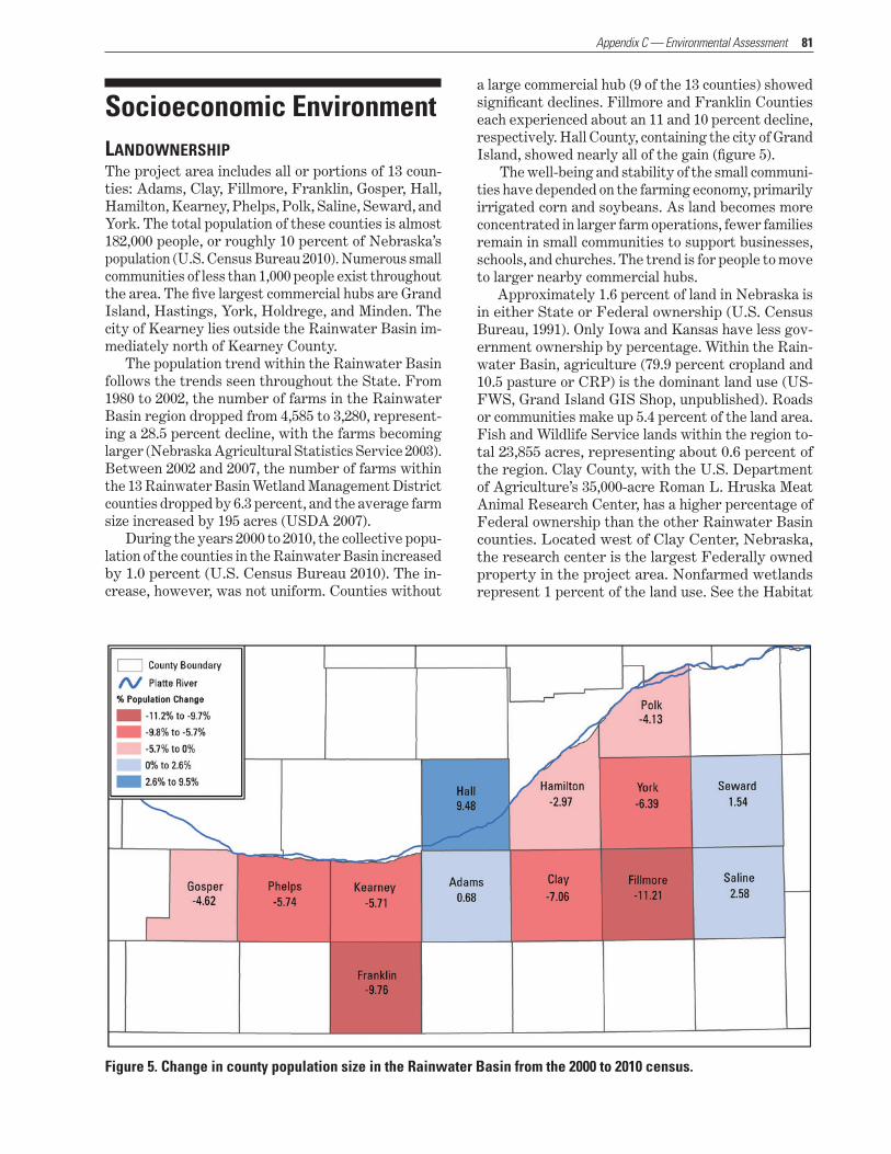
81
Socioeconomic EnvironmentLANDOWNERSHIPThe project area includes all or portions of 13 coun-ties: Adams, Clay, Fillmore, Franklin, Gosper, Hall, Hamilton, Kearney, Phelps, Polk, Saline, Seward, and York. The total population of these counties is almost 182,000 people, or roughly 10 percent of Nebraska’s population (U.S. Census Bureau 2010). Numerous small communities of less than 1,000 people exist throughout the area. The five largest commercial hubs are Grand Island, Hastings, York, Holdrege, and Minden. The city of Kearney lies outside the Rainwater Basin im-mediately north of Kearney County.
The population trend within the Rainwater Basin follows the trends seen throughout the State. From 1980 to 2002, the number of farms in the Rainwater Basin region dropped from 4,585 to 3,280, represent-ing a 28.5 percent decline, with the farms becoming larger (Nebraska Agricultural Statistics Service 2003). Between 2002 and 2007, the number of farms within the 13 Rainwater Basin Wetland Management District counties dropped by 6.3 percent, and the average farm size increased by 195 acres (USDA 2007).
During the years 2000 to 2010, the collective popu-lation of the counties in the Rainwater Basin increased by 1.0 percent (U.S. Census Bureau 2010). The in-crease, however, was not uniform. Counties without
a large commercial hub (9 of the 13 counties) showed significant declines. Fillmore and Franklin Counties each experienced about an 11 and 10 percent decline, respectively. Hall County, containing the city of Grand Island, showed nearly all of the gain (figure 5).
The well-being and stability of the small communi-ties have depended on the farming economy, primarily irrigated corn and soybeans. As land becomes more concentrated in larger farm operations, fewer families remain in small communities to support businesses, schools, and churches. The trend is for people to move to larger nearby commercial hubs.
Approximately 1.6 percent of land in Nebraska is in either State or Federal ownership (U.S. Census Bureau, 1991). Only Iowa and Kansas have less gov-ernment ownership by percentage. Within the Rain-water Basin, agriculture (79.9 percent cropland and 10.5 pasture or CRP) is the dominant land use (US-FWS, Grand Island GIS Shop, unpublished). Roads or communities make up 5.4 percent of the land area. Fish and Wildlife Service lands within the region to-tal 23,855 acres, representing about 0.6 percent of the region. Clay County, with the U.S. Department of Agriculture’s 35,000-acre Roman L. Hruska Meat Animal Research Center, has a higher percentage of Federal ownership than the other Rainwater Basin counties. Located west of Clay Center, Nebraska, the research center is the largest Federally owned property in the project area. Nonfarmed wetlands represent 1 percent of the land use. See the Habitat
Figure 5. Change in county population size in the Rainwater Basin from the 2000 to 2010 census.
Appendix C — Environmental Assessment

82 Land Protection Plan, Rainwater Basin Wetland Management District Expansion
section in section 3 for additional information about agricultural development.
PROPERTY TAXProperty tax is assessed on each property owner within each county. The amount is derived from the value of each parcel of land, based on the reasonable highest and most probable use. The assessed value of agricultural land is no more than 75 percent of market value (NEDOR 2011).
The inflation in land value in recent years has caused taxes on agricultural land to go up disproportionately compared with nonagricultural property, such as homes within communities. For counties with low populations and few commercial properties, agricultural lands may represent well over half of the county’s total assessed value. As costs in low-population counties continue to go up, populations go down, and because no new in-dustries are being created, agricultural land claims a higher percentage of the county’s total assessed value, placing more of the burden of financing the county on the shoulders of farmers.
The Refuge Revenue Sharing Act provides for payments to counties by the Service in lieu of taxes. Revenues for these payments are derived from the sale of products from refuges, including animals, timber, and minerals, or from leases and other privi-leges. If there is not enough money in the National Wildlife Refuge Fund to cover payments, Congress is authorized to appropriate money to make up the dif-ference. If the amount that Congress appropriates is not enough, the units of local government receive a pro-rata share. Payment is calculated three different ways, with the amount due being the highest of the
three methods. The three methods are 0.75 percent of the appraised property value, 25 percent of the net receipts produced on the property, or $0.75 per acre. If the funds in the special Treasury account fall short of 100 percent payment, each county receives payment at a lower percentage. In 2009, refuge revenue-sharing payment to Rainwater Basin counties averaged only 32.3 percent ($90,983) of full payment.
PUBLIC USE AND WILDLIFE-DEPENDENT RECREATIONAL ACTIVITIESFor much of the past century, access to private prop-erty was relatively easy to obtain. Most of Nebraska’s population was somehow connected to the land, either by family or by acquaintances. Hunting was seen as recreation that provided little opportunity for reve-nue to the landowner, and access was freely granted as a neighborly gesture. In the past few decades, this trend has changed. Urban populations are no longer closely connected to the land, and access to private land is more commonly being denied or allowed only on a fee basis.
The result is that the public is relying more on public lands for wildlife-dependent recreation. Within Rainwater Basin, 32 wildlife management areas are managed by the NGPC, and the Service manages 59 WPAs. A total of 31,823 acres is available for public use (USFWS, Grand Island GIS Shop). Pheasant hunting is the most common recreational activity, followed by waterfowl hunting and birdwatching. It is estimated that 81,880 use-days are spent annually on waterfowl and upland bird hunting on State and Federal proper-ties in the Rainwater Basin (Mark Vrtiska, biologist, NGPC; personal communication; May 12, 2010).

83
SECTION 4 — ENVIRONMENTAL CONSEQUENCES
This section assesses the environmental impacts ex-pected to occur from the implementation of alterna-tives A and B, as described in section 2. Environmental impacts are analyzed by issues for each alternative and appear in the same order as discussed in section 2.
Effects on the Biological EnvironmentThis section describes the effects on wildlife habitat and water and soil resources of carrying out alterna-tives A and B.
WILDLIFE HABITAT—ALTERNATIVE A (NO ACTION)Under alternative A, land acquisition by the Service would continue until the original authorization level of 24,000 acres is reached. At that time, future wet-land acquisition would depend on other conservation agencies and nongovernmental organizations. Since the existing authorization limits only the purchase of property, the Service would continue to accept gifts from other entities. For example, the Service could enter into an agreement with a donor to accept own-ership of a piece of property to be managed as part of the Refuge System.
Most of the Rainwater Basin wetlands have been determined to be nonjurisdictional wetlands under the Clean Water Act as it is currently being adminis-tered. The U.S. Department of Agriculture’s Swamp-buster Act does not prohibit alteration of wetlands, but it withholds Federal farm program benefits from any person who plants a commodity crop in a wet-land that has been converted. Changes in agricultural economics will continue to influence the existence of privately owned wetlands. Over a period of time, to-tal wetland acres and quality are expected to decline under alternative A.
Migratory waterfowl use the numerous shallow, temporary wetlands for feeding and resting, but pre-fer the larger nearby wetlands for roosting. As the presence of temporary wetlands declines, the value of larger wetlands located in a wetland complex would decline due to fewer food resources.
Wetlands with ownership split between the Service and private landowners would likely remain unrestored because complete restoration would be less likely due to conflicting land uses. These wetlands could also be undermanaged, because in many cases the portion of wetlands in private ownership would remain idle and become dominated by late-successional wetland
plants that provide little to no benefit to migratory waterfowl. The Service would continue to work with neighboring landowners to manage these areas for waterfowl. Participation level, however, would be expected to remain low.
Waterfowl nutritional needs derived from natu-ral wetland foods would remain unmet. As little as 14 percent of the waterfowl diet, as estimated by the Rainwater Basin Joint Venture, would come from wetlands under this alternative. The remainder would continue to come from waste grain, which does not provide needed amino acids and minerals. Over time, as more wetlands are lost, the percentage of natural foods in waterfowl diets would be expected to decline even further.
Because any decline in roosting areas would cause bird populations to become more concentrated on the remaining wetlands, the potential for a major avian disease outbreak would remain high and would be expected to increase over time. Groundwater pump-ing would be expected to play a more critical role in keeping birds dispersed throughout the region.
WILDLIFE HABITAT—ALTERNATIVE B (PROPOSED ACTION)Under alternative B, the expansion of land acquisition across the Rainwater Basin would ensure that critical wetlands are protected in perpetuity. It would allow the Service greater flexibility to consider fee-title or easement acquisition as potential land management strategies. GIS modeling would help to identify wet-lands with key biological characteristics that are best suited for fee-title and easement acquisition. This ap-proach would help to ensure that funding is directed to where it can provide the most benefit to priority species.
Purchase of roundout properties would in many ways multiply the benefits of the wetlands beyond what they currently provide in split ownership. It would be easier to use management strategies such as grazing, prescribed burning, restoration, and water management. The Service would continue to partner with neighboring landowners to enhance privately owned wetlands for the benefit of migratory birds.
Natural foods from wetlands would increase, bring-ing the Rainwater Basin Joint Venture closer to its goal of having 28.2 percent of waterfowl energetic needs met by natural foods rather than waste grain. Birds would be expected to leave the Rainwater Basin region in better body condition, which would in turn mean better production on their northern nesting grounds.
The potential for a major avian disease outbreak would be reduced as more wetlands would be bet-ter managed for waterfowl migrations. Pumping and
Appendix C — Environmental Assessment

84 Land Protection Plan, Rainwater Basin Wetland Management District Expansion
other forms of water management would remain as management options.
Acquisition and protection of wetlands within the Rainwater Basin would indirectly provide improved water quality to the headwaters of several streams, such as the Big Blue and Little Blue rivers, that cur-rently provide fish habitat.
WATER AND SOIL RESOURCES—ALTERNATIVE A (NO ACTION)Under alternative A, water quality and quantity would decline and sedimentation would increase over time. It is expected that future wetland loss would increase agricultural and sediment runoff. Runoff flowing out of watersheds would increase, thereby increasing ero-sion and nutrient loading. The ability of altered wet-lands to contribute to groundwater recharge would also decline.
WATER AND SOIL RESOURCES—ALTERNATIVE B (PROPOSED ACTION)Under alternative B, wetlands that are protected in perpetuity would exist for the long term, providing many of the benefits attributed to wetlands, includ-ing entrapment of agricultural fertilizers, chemicals, and sediment. Wetland plants would help convert fertilizers and other farm chemicals into nonpollut-ing forms. The preserved wetlands would continue to provide groundwater recharge to a currently declin-ing groundwater table.
Alternative B, which would increase the land base of the Service in the Rainwater Basin, would likely reduce long-term management costs; therefore, short- term acquisition costs would likely be made up over the long term by reducing the cost of per acre manage-ment. Having management control of a full wetland would allow the Service to restore natural hydrologic function, thereby reducing management costs by al-lowing the wetland to flood and dry out on its own. In addition, full management of a wetland would re-duce potential conflict with neighbors who could have different management plans for use of that wetland.
Effects on the Socioeconomic EnvironmentThe socioeconomic impact of land acquisition within the Rainwater Basin counties is hard to measure with a high degree of certainty. What is known is that there would be reduction in agricultural production and tax revenue associated with Federal acquisition. What is poorly determined or immeasurable are the environ-mental and social benefits provided by wetlands, es-pecially those located in close proximity to each other
or near a community. Economists often refer to these benefits as nonexcludable (available to all) goods that have a value to the public that exceeds their value to the landowner. For Rainwater Basin wetlands, this value extends beyond the local residents to a much larger area. For example, the birds that use the Rain-water Basin during spring migration are of interna-tional value for birdwatching and hunting.
Some local residents perceive themselves as having to unfairly shoulder the burden of maintaining these wetlands for the benefit of others. Their concerns are expressed in the belief that Service acquisition of wetlands contributes to declining county populations, leading to increased land prices and taxes.
POPULATION DECLINEA review of population changes within counties located in the Rainwater Basin between 2000 and 2010 shows that the greatest decline has been in counties with low (<10,000) populations (U.S. Census Bureau 2010).
Fillmore County, which does not have a large commercial hub, showed the greatest reduction in population (11 percent), declining by 744 people from 2000 to 2010. In contrast, those counties with a larger commercial hub showed an increase in population. Hall County, which includes the community of Grand Island, showed over a 9 percent increase during the same period, increasing by 5,073 people. This trend in population shift among counties was common through-out the State, where counties with small populations and small commercial hubs showed a decrease while counties with larger populations and larger commer-cial hubs showed an increase.
Even though some residents are concerned that Federal acquisition may lead to a decrease in popu-lation, there does not appear to be a correlation be-tween the two. Clay County, for example, showed a population decline of over 7 percent between 2000 and 2010. During that period of time, only 32.5 acres were acquired by the Service. A comparison of Clay County with a nearby county of similar population without Federal lands would help determine if Service ownership may be a contributing factor to population declines. Antelope County, which is comparable to Clay County, does not have a large commercial hub or Federal lands, and it showed a decline of 11 percent. Other Nebraska counties that met the same criteria as Antelope County showed similar trends.
RISING LAND PRICESRegarding the concern that Service acquisition drives up land prices, a 2010 UNL (University of Nebraska, Lincoln) survey reported that agricultural land values in the Rainwater Basin region increased an average of 2.6 percent annually between 2005 and 2010 (Johnson et al. 2010). During those same 5 years, only 513 acres were acquired in fee title by the Service. In 2009, 74

85 Appendix C — Environmental Assessment
percent of agricultural lands sold in the Rainwater Basin region were purchased by active farmers, 21 percent were purchased by nonfarming Nebraska residents, and 5 percent were purchased by nonfarm-ing out-of-state buyers.
UNL’s survey asked 150 land-market observers to rank the importance of 16 factors in determining land prices. The top three factors listed were purchasing for farm expansion, the limited amount of land offered for sale, and the financial health of the current own-ers. Property tax levels were ranked 15th out of 16.
In 2009, 68 percent of land purchases in the Rain-water Basin area were cash purchases and 27 percent involved a mortgage; 5 percent of ownership changes involved other types of transactions (e.g., gift, inheri-tance, etc.). During the last decade, the average rate of return on assets of agricultural land in the Rain-water Basin region dropped from 5.5 to 4.9 percent.
Nationally, farmland values rose throughout much of the post-World War II period, and from 1969 to 1978, farmland prices increased 73 percent as agricultural producers responded to high returns and various Federal policies that increased incentives for invest-ing in agriculture. In 1980, farmland prices began to decline in response to Federal monetary policy that raised interest rates to help resolve high inflation. In
addition to rapidly rising interest rates, higher energy prices contributed to a significant financial crisis in the farm sector during the 1980s, leading to farm bank-ruptcies and bank failures. Since the farm crisis of the mid-1980s, farmland real estate values (including land and buildings) have been rising in both nominal and real (i.e., inflation-adjusted) terms. Between 1994 and 2004, real values increased between 2 and 4 percent annually (figure 6) and in 2005 and 2006 experienced sharp annual increases of 16 percent and 11 percent, respectively, before slowing to 7 percent and 6 per-cent annual growth in 2007 and 2008 (USDA 2011).
Figure 6. Funds distributed from the National Revenue Sharing program in comparison to national land values, 1972–2009.
INCREASING PROPERTY TAXESTax increases are a very contentious issue across the State, including in the Rainwater Basin. While land brought into Federal ownership is no longer on the tax roll, it does not result in an increase in personal property taxes paid to the counties.
For counties with low populations and no com-mercial hub, agricultural lands represent well over half of the county’s total assessed value (Johnson et al. 2006). When county costs continue to go up, popu-lations go down, and no new industries are being cre-ated, agricultural land claims a higher percentage of the county’s total assessed value, shifting the burden

86 Land Protection Plan, Rainwater Basin Wetland Management District Expansion
of financing the county to the shoulders of farmers. A contrast that demonstrates this concept is that 57 percent of the total assessed value in Clay County is agricultural land, but it is only 22 percent in adjoin-ing Adams County.
The Refuge Revenue Sharing Program has in-creased payments made to local governments over the long-term; these rates have actually increased at a faster rate than inflation (figure 6). However, payments due to the local governments have risen substantially more, primarily due to increasing land prices, as described in the prior section. This is par-ticularly evident in the period from 2004 to 2008, when land prices rose approximately 10 percent annually, but receipts from the National Wildlife Refuge Fund rose at a substantially lower rate (figure 6). However, the difference between what is paid by the revenue sharing program and what is due does result in lower revenue for local governments. Nonetheless, substan-tive social benefits are provided by public lands to local communities and economies (see below).
SOCIAL BENEFITSAlthough Service lands do not provide the same prop-erty tax revenue to the counties that the land would generate in private ownership, there are goods and ser-vices produced by these lands that benefit the general public. Some benefit the local community directly in terms of flood control, groundwater recharge, increased water quality, and sediment or fertilizer entrapment. Recreation, aesthetics, and health and production of wildlife may serve the local community as well as a much larger society. Other benefits include reduced need for water and sewer services and increased law enforcement in the local area, thereby reducing costs to local communities.
It is difficult to assign dollar values to these pub-lic benefits. The social and environmental benefits provided by the wetlands have very little economic value to an individual buyer; in comparison, the as-sessed value reflects the land’s value for agricultural production. In addition, each wetland provides a spe-cific level of benefits, depending on its unique charac-teristics, location in the watershed, and proximity to larger communities. For example, WPAs located in the more populated eastern portion of the Rainwater Basin receive much more use, and therefore provide a greater recreational benefit to the local area, than those in the western portion.
Studies exist, however, that suggest some of the value wetlands provide to the public. In 1978, the Little Blue Natural Resources District hired an engineering firm to provide a cost-benefit analysis of a watershed plan in Clay County. The analysis reported that a 650-acre impoundment would have an estimated annual benefit value of $97.37 per acre. This value was based on only three benefits: $52.75 per acre for groundwater
recharge, $41.14 per acre for flood control, and $3.46 per acre for recreation. The $97.37 in 1978 is equiva-lent to approximately $320 in today’s economy. The estimate did not include the value of other services provided, such as capturing and transforming agricul-tural runoff or sustaining migratory bird populations.
A limited amount of agricultural benefit is provided by WPAs. In 2009, approximately 12,600 animal-unit months of grazing were provided. An additional 1,150 acres were hayed.
Publicly owned wetlands within the Rainwater Basin bring many hunters and birdwatchers to the region. The 2006 National Survey of Fishing, Hunt-ing, and Wildlife-Associated Recreation reports that the average hunter in Nebraska spends about $25 per day on trip expenses (food, lodging, and fuel). For birdwatchers, that number is $31.50 per day. The Service estimates that there are approximately 80,000 visitor-days within basin WPAs each year. Using the $25 per visitor-day figure, that number of visitor-days brings $2 million of commerce to the region. NGPC estimates that upland game and waterfowl hunting provides $2,374,520 of economic activity to the Rain-water Basin (Mark Vrtiska, biologist, NGPC; personal communication; 2011).
These figures demonstrate that the value of ben-efits provided by WPAs is significant.
LANDOWNERSHIP AND LAND USE—ALTERNATIVE A (NO ACTION)Under alternative A, many of the wetlands targeted for acquisition under this proposal would remain in private ownership and on the county tax rolls. An un-known number of them would be converted to cropland during drier conditions, but there could be significant variations in production between wet and dry years.
LANDOWNERSHIP AND LAND USE—ALTERNATIVE B (PROPOSED ACTION)Under alternative B, 14,177 additional acres of land (0.36 percent of the Rainwater Basin region) would be permanently protected. The adjoining upland and drained portions of wetlands would be converted from cropland back to grassland and wetlands. Agricultural income from the 5,000 acres of easements would be derived from livestock grazing and haying.
The 9,177 acres purchased in fee title would be taken off the county tax rolls with the counties receiv-ing refuge revenue sharing funds to help compensate for the loss of tax money.
Lands with a conservation easement would re-main on the tax rolls, and the taxes would be paid by the landowner. Land use on these properties would be limited to the terms of the easement, which would allow haying, grazing, and control of public access.
87
PUBLIC USE—ALTERNATIVE A (NO ACTION)Under alternative A, public use would remain rela-tively unchanged. Public access to wetlands targeted for acquisition under this proposal would be limited, with the property owner deciding the level of access. Public pressure on those wetlands currently in public ownership would increase, potentially affecting wild-life use of wetland areas.
PUBLIC USE—ALTERNATIVE B (PROPOSED ACTION) Under alternative B, additional fee-title properties would be open to public recreation, including hunt-ing, birdwatching, and environmental education. An increase in direct and indirect revenue from recre-ation would increase. Public pressure on and wildlife disturbance to individual wetlands would lessen as more areas would be available for use.
Properties with conservation easements would remain in private ownership. Access to the property would be at the discretion of the landowner since the easement would not include public use.
VALUE OF THE RAINWATER BASIN ECOSYSTEM—ALTERNATIVE A (NO ACTION)Under alternative A, the level of wetland protection would remain relatively unchanged. Wetlands with split ownership between the Service and private landowners would continue to have limited benefits, especially for waterfowl. Over time the number of wetlands regionwide would be expected to continue to decline both in numbers and functionality.
VALUE OF THE RAINWATER BASIN ECOSYSTEM—ALTERNATIVE B (PROPOSED ACTION)Alternative B would not completely restore the Rain-water Basin ecosystem, but it would help to reduce the threat of further wetland losses in the area. Nearly 90 percent of the region’s wetlands would remain lost. Wetlands that are permanently protected would help ensure that the region continues to play a criti-cal role in the migration of millions of ducks, geese, shorebirds, and other birds. The wetland values of the acquired areas would continue to provide better water quality, quality of life, and wildlife habitat for many generations.
Unavoidable Adverse ImpactsAny adverse effects that may be unavoidable while carrying out alternatives A and B are described below.
ALTERNATIVE A (NO ACTION)Under alternative A, the adverse impact of habitat degradation and fragmentation would be expected to be more widespread and prevalent.
ALTERNATIVE B (PROPOSED ACTION)Under alternative B, the expansion of land acquisition would cause a direct decline in taxes paid to counties.
Irreversible and Irretrievable Commitments of ResourcesAny commitments of resources that may be irrevers-ible or irretrievable as a result of carrying out alter-natives A and B are described as follows.
ALTERNATIVE A (NO ACTION)Under alternative A, there would be no additional commitment of resources by the Service. Wetlands converted to cropland, especially irrigated cropland, would be irretrievable because their natural function would be lost, contributing to the overall loss of mi-gration habitat.
ALTERNATIVE B (PROPOSED ACTION)Under alternative B, there would be an irretrievable and irreversible annual commitment of funds to protect and manage these lands. The potential for properties to be used for crop production by private landowners would be removed in perpetuity, unless the Service divested interest in such lands in the future.
Short-Term Use versus Long-Term ProductivityThis section describes the effects of short-term use versus long-term productivity of alternatives A and B.
ALTERNATIVE A (NO ACTION)Under alternative A, landowners would be able to convert wetlands to cropland, which would boost ag-ricultural production but would also have a long-term negative effect on migratory bird habitat.
ALTERNATIVE B (PROPOSED ACTION)Under alternative B, land acquisition would preserve wetlands and adjoining grasslands in perpetuity. The loss of direct tax revenue to the affected counties would have a long-term impact.
Appendix C — Environmental Assessment
88 Land Protection Plan, Rainwater Basin Wetland Management District Expansion
Cumulative ImpactsCumulative impacts are defined by NEPA as the im-pacts on the environment that result from the incre-mental impact of the action when added to the other past, present, and reasonably foreseeable future actions regardless of what agency (Federal or non-Federal) or person undertakes such other actions (40 CFR § 1508.7)
PAST ACTIONSPast land acquisition by the Service and the NGPC has included 31,823 acres of wetland and grassland. The Wetlands Reserve Program administered by NRCS has added 7,077 acres in conservation easements. The total of these acres represents approximately 1.0 per-cent of the Rainwater Basin. These lands are managed primarily for the social benefits that wetlands provide, especially habitat for wetland and grassland birds.
PRESENT ACTIONSThe Service’s proposed action to expand land acquisi-tion authority to 38,177 acres would add an additional 14,177 acres to the Refuge System, 5,000 of which would be conservation easements. Land acquisition by NGPC is limited and is driven by available funds and willing sellers. The Wetland Reserve Program contin-ues to be an active program. The Wetlands Reserve Program areas, however, are not open for public use. Ducks Unlimited is actively seeking willing sellers and is obtaining both fee-title and easement proper-ties. Its acquisitions are directed toward purchasing property, restoring the wetland and upland, protecting the property with a conservation easement, and then selling the property. Present actions by conservation groups support the goals of the Service and the Rain-water Basin Joint Venture.
REASONABLY FORESEEABLE FUTURE ACTIONSReasonably foreseeable actions are actions and activi-ties that are independent of the proposed expansion addressed in this document. They are anticipated to occur regardless of which alternative is selected. In-creased production of ethanol and demand for corn and soybeans are expected to encourage increased acreage of, and production from, farmland. A signifi-cant portion of that increased acreage can be expected to come from the conversion of wetland to farmland. Future wetland conservation will be done primarily by the U.S. Department of Agriculture and nongov-ernmental conservation organizations.
Wind energy development is currently being con-sidered for the region. The potential for this develop-ment is speculative at this time.
Development—Alternative A (No Action)Much of the development within the Rainwater Basin has been and would continue to be related to agricul-ture. Since 90 percent of the historical wetlands have already been converted or lost, the number of wetlands that would be affected by additional development would be small, but would significantly affect the wetlands that remain. For example, over 2,300 acres of grass-land were converted to cropland in just four counties within the basin in 2009. The long-term, cumulative effect would likely be the continuation, and possible acceleration, of the decline in waterfowl, shorebird, and other migratory bird populations.
Development—Alternative B (Proposed Action)The proposed action would restore and protect an ad-ditional 14,177 acres of wetland and grassland areas for the benefit of the public and wildlife.
Conservation Efforts—Alternative A (No Action)Under alternative A, current Service programs such as Partners for Fish and Wildlife would continue. The Service would continue to work cooperatively with landowners to voluntarily improve habitat on pri-vate land through various conservation means, such as prescribed fire or native plantings. Landowners wishing to sell off unproductive wetland acres would have fewer options for selling.
Conservation Efforts—Alternative B (Proposed Action)Alternative B would allow for the protection of an additional 14,177 acres of wetland and grassland habitats. These acres would be added to the 23,855 acres currently owned and managed by the Service. The action would have a long-term positive impact on wildlife habitat, significantly add to the management capability for existing wetlands, and help the Service meet the goals in the North American Waterfowl Plan.

89
SECTION 5 — COORDINATION AND ENVIRONMENTAL REVIEW
Agency CoordinationThe Service has discussed the proposal to expand land acquisition in the Rainwater Basin with landowners; conservation organizations; other Federal agencies; tribal, State, and county governments; and other in-terested groups and individuals.
The Service held two public meetings, in Holdrege and Clay Center, Nebraska, in January 2011 to provide information and discuss the proposal with landowners and other interested citizens. Information on the pro-posal has been made available to county commissioners in each of the 13 counties included in the project area.
The Service released the draft EA and LPP on May 31, 2011, for a 30-day public review period. This period was extended 2 weeks until July 15, 2011, al-lowing a 45-day public review period. In total, the Ser-vice received 7 letters from agencies, organizations, and other entities; 58 general public comments; and 3 phone calls. After all comments were received, each was reviewed and incorporated into the administrative record (appendix D). A separate request for further discussion with the Clay County Board of Supervisors was met on August 16, 2011.
At the Federal level, information was provided to the Congressional delegation, as well as to repre-sentatives from the U.S. Department of Agriculture (NRCS). At the State level, information was provided to Governor Heineman’s staff and Nebraska’s State senators. Information was also provided to tribes within the State.
Nongovernmental conservation groups are vital to the success of the proposed project. Service staff has coordinated with partner organizations such as The Nature Conservancy, natural resource districts, and Ducks Unlimited.
Contaminants and Hazardous MaterialsSurveys for contaminants would be conducted before any land interests are acquired. Field work for the preacquisition surveys would be conducted on a tract-by-tract basis. Any suspected problems or contami-nants requiring additional surveys would be referred to a contaminant specialist located in the Service’s Ecological Services office in Grand Island, Nebraska.
National Environmental Policy ActAs a Federal agency, the Service must comply with the provisions of NEPA. An EA is required under the act to evaluate reasonable alternatives that will meet stated objectives and to assess the possible impacts to the human environment. The EA serves as the basis for determining whether implementation of the pro-posed action would constitute a major Federal action that would significantly affect the quality of the hu-man environment and the need for an environmental impact statement.
The analysis for, and development of, this EA fa-cilitated the involvement of government agencies and the public in the decision-making process.
Strategic Habitat Conservation and Landscape Conservation Cooperatives SHC (strategic habitat conservation) is a means of ap-plying adaptive management across large landscapes. LCCs (landscape conservation cooperatives) facilitate strategic habitat conservation (USFWS 2008).
STRATEGIC HABITAT CONSERVATIONThe Rainwater Basin expansion proposal would apply the SHC framework outlined in the National Ecological Assessment Team report (National Ecological Assess-ment Team 2006). SHC involves an ongoing cycle of biological planning, conservation design, conservation delivery, outcome-based monitoring, and assumption-based research (figure 7). It is the process by which the Service continues to develop and apply science in a way that is focused on improving the ability to apply conservation delivery actions and create landscapes that are capable of supporting populations of prior-ity species at desired levels. Additionally, SHC pro-vides the framework by which the Service develops and applies science to inform and continually improve conservation delivery by addressing landscape-level population-limiting factors in an adaptive manner.
The Service’s Region 6 Refuges Program has es-tablished a GIS office in Grand Island that works closely with the Rainwater Basin Joint Venture and the Rainwater Basin Wetland Management District
Appendix C — Environmental Assessment

90 Land Protection Plan, Rainwater Basin Wetland Management District Expansion
to provide support for the biological planning, conser-vation design, conservation delivery, and monitoring/research elements of SHC necessary to implement the proposed action. This EA addresses the four key SHC elements: planning, design, delivery, and moni-toring and research.
Figure 7. The elements of strategic habitat conservation.
BIOLOGICAL PLANNINGPriority resources were described in earlier sections of this document. Biological planning requires the iden-tification of priority species, development of popula-tion objectives, and identification of landscape-level limiting factors that keep the populations of priority species below desired levels. Initial biological planning was done using dabbling ducks and a subset of goose populations as focal species. This approach was based on the assumption that protection and management of wetlands in a manner that meets the biological needs of the focal species will also adequately meet the needs of other wetland species.
Conceptual and quantitative models have been developed to identify specific wetlands and wetland complexes. Priority species would continually be de-fined and updated throughout the implementation of the proposed action, and additional landscape mod-els would be developed for priority species. Biologi-cal planning will continue into the future, engaging partners in the population objectives and developing biological models that will be directly linked to con-servation delivery actions.
CONSERVATION DESIGNLand acquisition is most effectively completed using biologically driven, spatially explicit models. During
the past decade, the Service, in cooperation with the Rainwater Basin Joint Venture, has used GIS to ex-tensively map the Rainwater Basin region. This mod-eling has enabled the Service to identify and rank each hydric soils area, including both drained and existing wetlands. Key spatial and biological characteristics of each area were scored to determine which wetlands are cost effective to acquire and restore. The analysis considered the impacts of geographic features, such as the proximity of other wetlands, roads, and power lines to individual wetlands. Color-coded maps reflect an individual wetland’s priority for fee-title acquisition, easement, and other types of conservation programs.
The information obtained from the models was also used in conjunction with the management history of existing WPAs to identify where roundout acquisi-tion is most needed.
CONSERVATION DELIVERYThe Rainwater Basin Wetland Management District has worked with neighboring landowners, conservation organizations, and government agencies for almost 5 decades to preserve and enhance wetlands through-out the region. Beginning in the early 1990s, Partners for Fish and Wildlife biologists have worked with the same partners to bring conservation programs to wet-land owners regardless of their proximity to existing Service properties. Application of the SHC frame-work will build on existing partnerships and support the development of new partnerships for delivering conservation throughout the region.
It is recognized that the past practice of oppor-tunistic acquisition will not result in the best use of conservation dollars. The function of some wetlands can best be used or enhanced by short-term conser-vation programs. Computer modeling of waterfowl energetic needs as well as wetland priority mapping allow for greater flexibility, increased responsiveness, and improved efficiency in meeting Service and part-ner conservation delivery needs.
Conservation design will continue to involve the development of spatially explicit decision support tools for targeting conservation delivery actions. Research and monitoring will help update the modeling param-eters used to develop conservation priorities.
MONITORING AND RESEARCHThe success of the proposed action would depend on its ability to adapt to new and better information gathered through monitoring and research. Currently, monitoring and research are being done on a variety of subjects to provide for better decision making in the future. At the end of each growing season, wet-lands are examined to assess the response of plant communities and seed production to different man-agement actions. This information is being used to develop a strategic decision-making matrix to guide
91
future management. Bird use associated with wetland juxtaposition is being analyzed to confirm if our cur-rent understanding of wetland complexes aligns with what occurs in the field. A study of the relationship between groundwater recharge and wetland charac-teristics was recently completed. Research related to grazing intensity and its impact on the control of reed canarygrass is beginning its final year. Informa-tion from these studies and future work on landscape ecology will be incorporated into the SHC process to further refine biological planning.
LANDSCAPE CONSERVATION COOPERATIVESThe Service will use LCCs as a means of implementing strategic habitat conservation. LCCs will be formal scientific and management partnerships between the Service, the U.S. Geological Survey, other Federal agencies, States, tribes, nongovernmental organiza-tions, universities, and others to increase the capac-ity for applied conservation science in support of fish and wildlife management in specific landscapes (Sec-retarial Order Number 3289). The tools developed by the LCCs will allow Service offices, and our many partners, to implement on-the-ground actions in the most effective locations to meet conservation goals.
The Rainwater Basin Expansion Project is part of the Great Plains LCC, which was recently developed. The project meets the criteria of the LCC initiative: cooperation among private landowners and other agencies (Federal, State, local, and nongovernmental organizations). In addition to fostering partnerships, the LCCs provide science support to managers.
The Secretary of the Interior recently outlined the importance of LCCs as a response to climate change (USFWS 2009). LCCs reach across broad landscapes, involve many partners, and function at a scale necessary to address wildlife adaptation in response to climate
change. The Rainwater Basin Expansion Project would contribute to the wetland protection projects of Ducks Unlimited, NGPC, natural resource districts, and the U.S. Department of Agriculture.
These cooperatives will continue to grow as a means of delivering strategic habitat conservation. The Service and the U.S. Geological Survey have signed a memorandum of understanding to strengthen the science–management relationship in landscape-level conservation. This further commitment to strategic habitat conservation improves the basis for the type of landscape conservation being proposed.
Distribution and Availability Copies of this EA were sent to Federal and State legislative delegations, tribes, agencies, landowners, private groups, and other interested individuals.
Additional copies of the document are available from the following offices and Web sites:
U.S. Fish and Wildlife ServiceRainwater Basin Wetland Management DistrictP.O. Box 8Funk, Nebraska 68940308 / 263 3000http://rainwater.fws.gov
U.S. Fish and Wildlife Service Region 6, Division of Refuge PlanningBranch of Land Protection PlanningP.O. Box 25486–DFCDenver, Colorado 80225 303 / 236 4345303 / 236 4792 faxhttp://mountain-prairie.fws.gov/planning/lpp.htm
Appendix C — Environmental Assessment


Appendix DComments and Responses
SummaryThe Service released the draft Environmental As-sessment (EA) and Land Protection Plan (LPP) on May 31, 2011. for a 30-day public review period. This period was extended 2 weeks until July 15, 2011, al-lowing a 45-day public review period. In total, the Ser-vice received 7 letters from agencies, organizations, and other entities; 58 general public comments; and 3 phone calls. After all comments were received, each was reviewed and incorporated into the administrative record. A large majority of comments received were supportive (>88 percent) and highlighted the impor-tance of the Rainwater Basin to migrating birds and secondary uses such as hunting and bird watching. One letter requested further information and discussion with the local county government. That request was honored by the Service on August 16, 2011.
Comments were reviewed for substantive infor-mation that should be incorporated into the analysis. Comments were considered substantive if they met one of the following criteria:1. Questions, with reasonable basis, the accuracy of
information in the EA;2. Questions, with reasonable basis or facts, the ad-
equacy of, methodology of, or assumptions used for the environmental analysis;
3. Presents reasonable alternatives other than those presented in the EA;
4. Or prompts the Service to consider changes or re-visions in one or more of the alternatives.
The following numbered comments were considered substantive comments from the general public; letters from agencies or organizations containing comments follow the letters from the general public. All com-ments received on the Service’s NEPA documents become part of the official public record. Requests for information contained in comments are handled in accordance with the Freedom of Information Act, NEPA (40 CFR § 1506.6(f)), and other Department of the Interior and Service policies and procedures. In compliance with Service policy about disclosure of personal information, the Service will not publish in this document the name, address, or other personal information about an individual who commented unless
that information was spoken in a public meeting; this non-disclosure policy does not apply to agencies or organizations.
Public Comments and Service ResponsesComment 1.1. “From what I understand the goal of the increased land base is to focus on “rounding out” exist-ing WPAs so the WMD can have full management con-trol of the wetland. Obtaining full management control over entire wetland footprints through ownership or easements will allow the WMD to better manage the properties for waterfowl, shorebirds, and whooping cranes. This plan increases the land base of the WMD but will likely reduce long term management costs - therefore short term acquisition costs will likely be made up over the long term by reducing the cost of per acre management. Having management control of a full wetland will allow the WMD to restore natural hydrologic function, therefore letting the wetland help manage itself by naturally flooding and drying out on its own. Also, without having to work around neighbors, remnant hydrologic modifications, and other manage-ment impediments the entire wetland can likely be managed with the same staff time and management cost as a partially controlled & unrestored wetland.”
Response 1.1. The Service agrees with this comment and has modified the EA (Section 4 – Water and Soil Resources) to reflect this point.
Comment 1.2. “The WMD owning the entire wetland footprint will likely help improve public relations with local residents and the general public. Owning the en-tire wetland may help reduce potential conflict with neighbors that may have different management/use priorities of the wetland. The general public will see a more aesthetically pleasing and better managed prop-erty. Hunters will have more and better public access.”
Response 1.2. The Service agrees with your analysis and has modified the EA (Section 4 – Social Benefits) to reflect this point.
Comment 1.3. “The economic impact the acquisitions may have on the local tax base should be minimal. Wetlands

94 Land Protection Plan, Rainwater Basin Wetland Management District Expansion
likely targeted for expansion are not productive agri-cultural land likely do not currently contribute much in the way of local tax revenue due to the land being classified as marginal, pasture, or waste land. Using easements on the more productive land and acquisi-tion of the least productive could help keep as much land on the tax roles. Increasing local government aid payments on FWS owned land would go a long way to help improve relations with local government entities and offset the minimal economic loss.”
Response 1.3. The Service has developed prioritiza-tion models in partnership with the Rainwater Basin Joint Venture and uses those models in connection with the Strategic Habitat Conservation model out-lined in section 5 of the EA.
Comment 2. “My only specific comment is about “Irre-versible and Irretrievable Commitments of Resources”. I’m not sure either alternative result in absolutely irreversible consequences. Under Alternative A, No action, though unlikely, wetlands converted to crop-land may still be restorable by a future owner if the hydrology alteration would be a rather simple ditch, pipe, and/or pit that could be closed. Wetlands oblit-erated by earth fill are much more irreversibly gone. Under Alternative B, Proposed Action, you assume management of these lands as habitat is perpetual. Availability for use as cropland would be changed, but not capability. The designation of land as habitat is a paper exercise of ownership and easements that could change in the distant future, if priorities in our society change. The land is not physically changed, therefore capable of possible conversion to cropland any time in the future if made available. Rather than irreversible habitat designation, I see this as passing choices to future generations in hopes that keeping some of these special habitat areas will remain a pri-ority for them.”
Response 2. The Service agrees that hydrology of a disturbed wetland can be restored in certain circum-stances, which were identified. Language in the EA (section 4 – Irreversible and Irretrievable Commit-ments of Resources) has been modified to reflect this point. In regards to easement terms, it is the Service’s policy that easement terms and conditions cannot be modified without coordination and just compensation to the private landowner.
Comment 3.1. “The gifted acres (4,505) are not listed in the accounting of the land owned or its type. How are these acres used and why aren’t they part of the accounting?”
Response 3.1. The Service has added clarification to section 1 of the EA regarding gifted acres. The management of these properties was transferred from other Federal agencies, primarily the Farmers Home Administration. Although the Service owns and
manages these properties, there were not acquired under the authorities of the National Wildlife Refuge System and therefore are not considered part of the total acreage.
Comment 3.2. “I agree that wetland habitat is important, TOO important to delay management of wetlands as in this example 90% of the wetland is owned by US-FWS. Management of land already owned should be first priority. Find a way to do it. Turn over a new leaf and figure out how it CAN be done. Acquiring more property is not the answer, when you cannot find a way to manage what you already have.”
Response 3.2. Waterfowl production areas are cur-rently managed according to the Rainwater Basin Wetland Management District Comprehensive Con-servation Plan (CCP) that was approved in 2007. This plan, which incorporated public input and ideas, guides the direction and management of all properties within the District. The CCP identified land acquisition as one of the implementation strategies to properly manage wetlands in the Rainwater Basin.
Comment 3.3. “I am concerned about the ability and commitment of owners (local and absentee) to provide future management. Arranging for haying or grazing, fencing, control of weedy species and other invasive species and overall management. What happens when the money is all gone? Will taxes continue to be paid? Will management be done? Will it become a burden to the county? I see too many examples of owners who do not control noxious weeds. Who is going to monitor these properties for compliance with their contract? Who is going to pay the costs of this monitoring? Those who own the easements would like to turn those re-sponsibilities over to the local government, but make no mention of paying the costs.”
Response 3.3. The Service assumes this comment is directed toward purchase and future management of conservation easements. Conservation easements purchased by the Service typically prohibit the al-teration of wildlife habitat and/or wetland hydrology. Property taxes remain a responsibility of the private landowner, and landowners defaulting on property taxes would be handled by the appropriate agency. The Service monitors each easement for compliance with easement terms on an annual basis. If a situa-tion such as a noxious weed invasion is documented, the Service will attempt to work with that landowner through the Partners for Fish and Wildlife Program to enhance the easement property. However, the Ser-vice can only legally enforce the terms set forth in the easement contract.
Comment 3.4. “Meeting wildlife nutritional needs. What practices need to be implemented? Improved man-agement is a pretty broad term, and I use it myself

95 Appendix D — Comments and Responses
without defining my intentions. The only identifiable action suggested, is the acquisition of more wetlands. If we don’t understand the practices needed on current wetlands, how do we know what to do in the future? Are there practices that I could apply to my wetland? How does current management score in a critical re-view of implementation and success of practices being applied? Is USFWS meeting management goals on all properties now under its control?”
Response 3.4. The CCP mentioned in Response 3.2 outlines the detailed management direction, imple-mentation strategies, and course to monitor the ef-fectiveness of those strategies. The CCP outlines various actions outside of wetland acquisition to im-prove wetland condition and health. In regards to the commenters question about what can be done on the commenter’s wetland, the CCP and the Partners for Fish and Wildlife Program offer several management scenarios that can be developed for a particular wet-land. The Service has recently expanded its Inventory and Monitoring Program to look at refuge manage-ment practices across the nation and effectiveness of various techniques.
Comment 3.5. “This draft downplays the opportunities that exist through shorter contracts. In short USFWS wants ownership or permanent easements. It misses the opportunity to get a landowner started on the right path to wetland improvement. It may or may not be successful for long term protection. But not starting to protect the wetland is worse. If the landowner had enough interest in habitat to enter the initial contract, there is a chance he will be willing to continue. It will depend on his experience with the contract. That land-owner will be responsible for ongoing management and taxes, in return he will receive annual payment.”
Response 3.5. The LPP developed for this project is designed to be one of several options for willing private landowners. The Service’s Partners for Fish and Wildlife Program is a private lands program that works with landowners to evaluate the many differ-ent conservation projects that are available, some of which have term contracts. Conservation easements or fee-title acquisition are just one of the tools that are available to willing landowners in the Rainwater Basin.
Comment 3.6. “Does Antelope County have a government owned facility comparable to the U.S. Meat Animal Research Station?”
Response 3.6. No, the purpose of comparing Antelope County to Clay County was to illustrate that many rural areas in Nebraska are unfortunately showing
population declines, even without the presence of Federal land ownership such as Antelope County.
Comment 3.7. A comment was received showing an analysis of taxes paid by private landowners in Clay County versus the Refuge Revenue Sharing Act. To paraphrase, their analysis showed that $99,882 in taxes was made up by Clay County taxpayers in 2009, versus that land being in private ownership. The commenter further states that $1,200,000 is lost in agricultural pro-duction and that the Refuge Revenue Sharing funds are inadequate to meet obligations as landowners.
Response 3.7. The Service understands that the Revenue Sharing Act does not typically provide funds similar to those that private landowners would pay. Refuge revenue sharing funds are obtained from the net income the Service receives from products or privileges like timber sales, grazing fees, and right-of-way permit fees, which are deposited in the National Wildlife Refuge Fund for revenue sharing payments. If there is not enough money in the National Wildlife Refuge Fund to cover payments, Congress is autho-rized to appropriate money to make up the difference. If the amount Congress appropriates is not enough, the units of local government receive a pro-rata share. The Service is also mandated to provide habitat for and protect migratory bird species for the greater hu-man environment. Although agricultural lands may produce more economic revenue than wildlife habitat, section 4 of the EA (Social Benefits) outlines the social benefits of wildlife habitat, many of which are difficult or impossible to assign dollar amounts to. These in-clude groundwater recharge, flood control, increased water quality, sediment and nutrient entrapment, recreation, aesthetics, and health and production of wildlife, all of which are important and necessary for the American public.
Comment 4.1. “There is no scientific proof which docu-ments a ‘need.’ ”
Response 4.1. The Service respectfully disagrees with this comment and encourages the commenter to thoroughly review section 1 (Purpose and Need for the Proposed Action) of the EA. This section outlines ex-tensive waterfowl energetic models that show energy sources are highly dependent upon agricultural fields. The proposed action attempts to reduce the heavy use of agricultural fields by waterfowl by shifting them to public wetlands. Furthermore, the EA identifies a large loss in wetland numbers and function that are extremely important for migrating birds.
96 Land Protection Plan, Rainwater Basin Wetland Management District Expansion
Lette
r #1—
Duc
ks U
nlim
ited
Serv
ice
Resp
onse
to L
ette
r #1
Tha
nk y
ou fo
r yo
ur c
omm
ents
.

97Appendix D–Comments and Responses
Lette
r #2—
Iow
a Tr
ibe
of O
klah
oma
Serv
ice
Resp
onse
to L
ette
r #2
Tha
nk y
ou fo
r yo
ur c
omm
ents
.

98 Land Protection Plan, Rainwater Basin Wetland Management District Expansion
Lette
r #3—
The
Nat
ure
Cons
erva
ncy
(pag
e 1
of 2
)
Serv
ice
Resp
onse
to L
ette
r #3
1 Tha
nk y
ou fo
r yo
ur c
omm
ents
. .3
3 .1

99Appendix D–Comments and Responses
Lette
r #3—
The
Nat
ure
Cons
erva
ncy
(pag
e 2
of 2
)
3 .2
3 .3
3 .4 .
3 .53 .2 3 .3 3 .4 3 .5
The
Ser
vice
agr
ees
wit
h ac
tion
1 a
nd w
ill c
oord
inat
e w
ith
entu
re o
n pr
iori
tiza
tion
of
land
net
ildlif
e R
efug
e F
und
for
reve
nue
shar
ing
paym
ents
. If t
here
is n
ot e
noug
h m
oney
ild
life
Ref
uge
Fun
d to
cov
er p
aym
ents
,
be -
the
from
is a
utho
rize
d to
app
ropr
iate
mon
ey t
o
land
s w
ill
etla
nd M
anag
e
obta
ined
acqu
ired
B
asin
W
are
fund
s sh
arin
g in
com
e th
e S
ervi
ce r
ecei
ves
from
pro
duct
s or
pri
vile
ges
like
tim
ber
sale
s, g
razi
ng f
ees,
and
rig
ht-o
f-w
ay p
erm
it f
ees,
mak
e up
whi
ch a
re d
epos
ited
in t
he N
atio
nal W
the
diff
eren
ce. I
f th
e am
ount
Con
gres
s ap
prop
riat
es is
not
en
ough
, the
uni
ts o
f lo
cal g
over
nmen
t re
ceiv
e a
pro-
rata
-
biol
ogic
al
, and
fo
r fr
amew
ork
and
of e
xist
ing
land
s un
der
the
Rai
nwat
er
s C
ompr
ehen
sive
Con
serv
atio
n P
lan.
Thi
s
Serv
ice
Resp
onse
to L
ette
r #3
prov
ides
a
the
Rai
nwat
er B
asin
Joi
nt V
reve
nue
acqu
isit
ions
.
Ref
uge
in t
he N
atio
nal W
EA
th
e
Con
gres
s
shar
e
Man
agem
ent
adm
inis
tere
d m
ent
Dis
tric
t’pl
an w
as a
ppro
ved
in 2
007
wit
h a
15-y
ear
revi
sion
tim
e
2 4 T
he
Str
ateg
ic H
abit
at C
onse
rvat
ion
mod
el o
utl
ined
in
of
C
hapt
er 5
fram
e.
plan
ning
, con
serv
atio
n de
sign
, con
serv
atio
n de
liver
ym
onit
orin
g an
d re
sear
ch.
3 5 . . . .3 3 3 3
100 Land Protection Plan, Rainwater Basin Wetland Management District Expansion
Lette
r #4—
Neb
rask
a G
ame
and
Park
s Co
mm
issi
on (p
age
1 of
2)
1
Com
men
ts o
n th
e U
SFW
S’s
Rai
nwat
er B
asin
Wet
land
Man
agem
ent D
istr
ict
Prel
imin
ary
Proj
ect P
ropo
sal
Sub
mitt
ed b
y th
e N
ebra
ska
Gam
e an
d Pa
rks
Com
mis
sion
June
30, 2
011
Con
tact
per
son:
Ji
m D
ougl
as,D
eput
y D
irect
orP
.O. B
ox 3
0370
Linc
oln,
NE
685
03P
hone
: (4
02) 4
71-5
436
e-m
ail:
jim.d
ougl
as@
nebr
aska
.gov
The
Neb
rask
a G
ame
and
Park
s C
omm
issi
on(“C
omm
issi
on”)
appr
ecia
tes
the
oppo
rtuni
ty to
com
men
t on
the
U.S
. Fis
h an
d W
ildlif
e Se
rvic
e’s
Dra
ft E
nviro
nmen
tal
Ass
essm
ent a
nd L
and
Pro
tect
ion
Pla
n fo
r the
pro
pose
d R
ainw
ater
Bas
in W
etla
nd
Man
agem
ent D
istri
ct E
xpan
sion
dat
ed A
ugus
t 201
1.
Our
Age
ncy
reco
gniz
es th
e in
tern
atio
nal i
mpo
rtanc
e of
Rai
nwat
er B
asin
wet
land
s in
su
ppor
ting
milli
ons
of m
igra
tory
wat
erfo
wl,
shor
ebird
s, a
nd o
ther
wat
erbi
rds,
incl
udin
g W
hoop
ing
Cra
nes
and
Buf
f-bre
aste
d Sa
ndpi
pers
, bot
h de
sign
ated
as
Tier
I sp
ecie
s by
th
e N
ebra
ska
Nat
ural
Leg
acy
Pro
ject
.M
any
of th
ebi
rd s
peci
esus
ing
Rai
nwat
er B
asin
w
etla
nds
are
also
inde
ntifi
ed a
s be
ing
in n
eed
of c
onse
rvat
ion
in th
e N
orth
Am
eric
an
Wat
erfo
wl M
anag
emen
t Pla
n, U
nite
d S
tate
s S
hore
bird
Con
serv
atio
n P
lan,
Nor
th
Am
eric
an W
ater
bird
Con
serv
atio
n P
lan,
ort
he N
orth
Am
eric
an L
andb
ird C
onse
rvat
ion
Pla
n. R
ainw
ater
Bas
inw
etla
nds
and
thei
r sur
roun
ding
upl
ands
als
opr
ovid
e im
porta
nt
habi
tat f
or re
side
nt w
ildlif
e an
d ov
eral
l reg
iona
l bio
-div
ersi
ty.
Thes
e w
ildlif
e re
sour
ces
attra
ct m
any
hunt
ers
and
wild
life
wat
cher
s w
ho s
pend
tim
e an
d m
oney
in th
e R
ainw
ater
B
asin
. In
add
ition
, Rai
nwat
er B
asin
wet
land
s ha
ve re
cent
ly b
een
dem
onst
rate
d to
pr
ovid
e im
porta
nt g
roun
d-w
ater
rech
arge
and
wat
er q
ualit
y be
nefit
s.
The
Com
mis
sion
, alo
ng w
ith th
e U
.S. F
ish
and
Wild
life
Ser
vice
, is
a pa
rtner
in th
e R
ainw
ater
Bas
in J
oint
Ven
ture
(RW
BJV
)tha
t is
wor
king
to a
chie
ve la
ndsc
ape
cons
erva
tion
obje
ctiv
es fo
r the
Rai
nwat
er B
asin
. W
e ha
ve s
igne
d th
e ex
istin
g R
WBJ
V
Impl
emen
tatio
n P
lan,
and
are
wor
king
clo
sely
with
the
RW
BJV
in u
pdat
ing
the
exis
ting
plan
.W
e re
cogn
ize
the
need
to p
rovi
de e
noug
h ha
bita
t in
the
right
pla
ces
and
cond
ition
in o
rder
to m
eet p
lan
obje
ctiv
es.
The
acre
age
targ
ets
prop
osed
in th
e D
raft
Env
ironm
enta
l Ass
essm
enta
re in
line
with
the
cons
erva
tion
need
s of
the
Rai
nwat
er
Bas
in.
We
belie
ve th
at th
e fo
cus
on “r
ound
-out
” acq
uisi
tions
is a
ppro
pria
te a
nd th
at th
is
has
the
pote
ntia
l to
incr
ease
man
agem
ent e
ffici
ency
and
cap
abilit
ies.
In
addi
tion,
we
reco
gniz
e th
at n
umer
ous
tool
s ar
e ne
eded
to a
chie
ve c
onse
rvat
ion,
and
that
bot
h fe
e-tit
le a
nd e
asem
ent a
cqui
sitio
n ar
e to
ols
that
sho
uld
be a
vaila
ble,
alo
ng w
ith o
ther
tool
s su
ch a
spr
ivat
e la
nds
proj
ects
and
impr
oved
man
agem
ent,
to m
eet b
oth
cons
erva
tion
and
land
owne
rnee
ds.
4 .1
our
lett
er c
onfi
rms -
Serv
ice
Resp
onse
to L
ette
r #4
Th
ank
you
for
you
r co
mm
ents
. Y
that
, to
get
her
wit
h o
ur
Sta
te p
artn
ers,
we
are
wor
kin
g i
n c
once
rt t
o p
rote
ct t
hos
e re
sou
rces
nec
essa
ry
for
the
use,
ben
efit,
and
enj
oym
ent
of t
he p
eopl
e w
ithi
n th
ese
stat
es a
nd
to
thos
e w
ell
bey
ond
ou
r b
ord
ers.
1 .4

101Appendix D–Comments and Responses
Lette
r #4—
Neb
rask
a G
ame
and
Park
s Co
mm
issi
on (p
age
2 of
2)
2 W
e re
cogn
ize
loca
l con
cern
sab
out t
he a
mou
nt o
f lan
d un
der f
eder
al o
wne
rshi
p in
som
e co
untie
s, a
nd th
e im
pact
that
this
may
hav
e on
loca
l pro
perty
taxe
s. W
ear
e w
illing
to
assi
stth
e S
ervi
ce in
exp
lorin
g w
ays
to a
ddre
ss th
isis
sue,
as
we
have
exp
erie
nce
mak
ing
in li
eu o
f pro
perty
tax
paym
ents
to th
e lo
cal c
ount
ies
for C
omm
issi
on o
wne
d pr
oper
ties.
How
ever
, the
val
ue th
at th
e co
nser
vatio
n of
wet
land
s ca
n pr
ovid
e to
war
dth
eov
eral
l qua
lity
of li
fe, i
n ge
nera
ting
tour
ism
dol
lars
, and
con
tribu
ting
to g
roun
dwat
er
rech
arge
and
wat
er q
ualit
y im
prov
emen
t sho
uld
not b
e ov
erlo
oked
.
Fina
lly, w
e re
cogn
ize
the
need
for i
nten
sive
man
agem
ent o
f Rai
nwat
er B
asin
wet
land
s to
achi
eve
mig
rato
ry w
ater
bird
hab
itat b
enef
its.
The
Com
mis
sion
als
o su
ppor
tsm
anag
emen
t of a
ssoc
iate
d up
land
s to
ben
efit
gras
slan
d so
ngbi
rds
and
upla
nd g
ame
bird
s, w
hich
als
o re
quire
perio
dic
and
at ti
mes
inte
nsiv
e m
anag
emen
t act
iviti
es.
We
will
cont
inue
to p
artn
er w
ith th
e S
ervi
ce a
nd th
e R
WBJ
V in
the
futu
re to
eva
luat
e m
anag
emen
t effe
ctiv
enes
s,an
d to
mak
e re
com
men
datio
ns o
n w
ays
to im
prov
e m
anag
emen
t of t
he w
etla
nds
and
asso
ciat
ed u
plan
ds.

102 Land Protection Plan, Rainwater Basin Wetland Management District Expansion
Lette
r #5—
Neb
rask
a Fa
rm B
urea
u Fe
dera
tion
(pag
e 1
of 2
)
5 .1
5 .2
-p
rod
uct
ion
is
the
par- -
vi
and bu
t
Sys
tem
th
e com
mun
itie
s
diffi
cult
are
impo
rtan
t an
d
agri
cult
ura
l ta
lly
im
por
tan
t to
th
e n
atio
n,
and
fee
ls c
onse
rvat
ion
ea
sem
ents
pro
vid
e a
via
ble
par
tner
ship
wh
ere
agri
cul-
tura
l p
rod
uct
ion
an
d w
ild
life
con
serv
atio
n c
an c
oex
-ild
life
Ref
uge
Sys
tem
Im
prov
emen
t A
ct p
rovi
des
clea
r di
rect
ion
to t
he S
ervi
ce t
o “p
lan
and
dir
ect
the
con
tin
ued
gro
wth
of
the
Sy
stem
in a
man
ner
th
is i
s b
est
des
ign
ed t
o ac
com
pli
sh t
he
mis
sion
of
the -
or im
poss
ible
-gr
ound
wat
er r
e, s
edim
ent
and
for
loca
l
supp
ort in
The
se in
clud
e
of w
hich
Serv
ice
Resp
onse
to L
ette
r #5
Tha
nk y
ou fo
r yo
ur c
omm
ents
.
of w
hich
are
Th
e S
erv
ice
agre
es t
hat
only
to.
wild
life,
all
ist.
The
Nat
iona
l W incr
ease
not
amou
nts
to
prod
ucti
on
and
tici
pat
ion
fro
m c
onse
rvat
ion
par
tner
s an
d t
he
pu
bli
c.”
dolla
r as
sign
1
Sys
tem
,
The
Ser
vice
und
erst
ands
and
rec
ogni
zes
the
impo
rtan
ce o
f ag
ricu
ltur
al
nati
on a
s a
who
le. T
he S
ervi
ce is
man
date
d to
pro
vide
hab
ita
t fo
r an
d pr
otec
t m
igra
tory
bir
d sp
ecie
s fo
r th
e gr
eate
r hu
man
env
iron
men
t. A
ltho
ugh
agri
cult
ural
land
s m
ay p
rodu
ce m
ore
econ
omic
rev
enue
tha
n w
ildlif
e ha
bita
t, c
hapt
er
4 of
the
EA
(S
ocia
l Ben
efits
) ou
tlin
es t
he s
ocia
l ben
efits
of
wild
life
habi
tat,
man
y to
ch
arge
, floo
d co
ntro
l, in
crea
sed
wat
er q
ualit
ynu
trie
nt e
ntra
pmen
t, r
ecre
atio
n, a
esth
etic
s, a
nd t
he h
ealt
h an
d pr
oduc
tion
of
nece
ssar
y fo
r th
e A
mer
ican
pub
lic.
2 3 . . .5 5 5 5 .3
5 .1 5 .2 5 .3
103Appendix D–Comments and Responses
Lette
r #5—
Neb
rask
a Fa
rm B
urea
u Fe
dera
tion
(pag
e 2
of 2
)
5 .4
net
the
mak
e up
- -
and
can
prov
ide -
for
cons
erva
land
owne
r -
ac
from
a pr
opos
ed
ildlif
e P
ro-
. Con
serv
aw
illin
g
loca
l tax
rol
es.
obta
ined
on t
he
are
inco
me
the
Ser
vice
rec
eive
s fr
om p
rodu
cts
or p
rivi
lege
s lik
e ti
mbe
r sa
les,
gra
zing
fee
s, a
nd r
ight
-of-
way
per
mit
fee
s,
ildlif
e R
efug
e F
und
for
reve
nue
shar
ing
paym
ents
. If t
here
is n
ot e
noug
h m
oney
ild
life
Ref
uge
Fun
d to
cov
er p
aym
ents
, is
aut
hori
zed
to a
ppro
pria
te m
oney
to
whi
ch a
re d
epos
ited
in t
he N
atio
nal W
the
diff
eren
ce. I
f th
e am
ount
Con
gres
s ap
prop
riat
es is
not
en
ough
, the
uni
ts o
f lo
cal g
over
nmen
t re
ceiv
e a
pro-
rata
sh
are.
The
Ser
vice
res
pect
fully
dis
agre
es t
hat
econ
omic
im
pact
to
loca
l com
mun
itie
s ha
s be
en d
ism
isse
d in
the
EA
. to
ana
lyze
ti
on a
nd d
eter
min
e if
sig
nific
ant
impa
cts
to t
he h
uman
en
viro
nmen
t ex
ist.
Thi
s an
alys
is w
as e
xpla
ined
tho
roug
hly
in C
hapt
er 4
(E
nvir
onm
enta
l Con
sequ
ence
s) o
f th
e E
A.
The
Ser
vice
doe
s ha
ve a
Par
tner
s fo
r F
ish
and
Wth
e R
ainw
ater
Bas
in
land
owne
rs
any
to
open
to
fund
s
is d
esig
ned
Serv
ice
Resp
onse
to L
ette
r #5
Tha
nk y
ou fo
r yo
ur c
omm
ents
.
fund
ing
is
shar
ing
prog
ram
proc
ess
reve
nue
Thi
s
A is a
ctiv
e in
an
d as
sist
ance
pr
ojec
ts.
R
efug
e
in t
he N
atio
nal W
Con
gres
s
The
NE
P
4 5 gr
am t
hat
tech
nica
l ti
on
if a
cqui
siti
on is
not
an
opti
on f
or t
hat
land
owne
rti
on e
asem
ents
(pa
rt o
f th
e pr
opos
ed a
ctio
n) d
o ke
ep la
nd in
th
e ha
nds
of p
riva
te c
itiz
ens
and
land
6 . . .5 5 5
5 .5
5 .6
5 .5 5 .6

104 Land Protection Plan, Rainwater Basin Wetland Management District Expansion
Lette
r #6—
Rain
wat
er B
asin
Joi
nt V
entu
re
Serv
ice
Resp
onse
to L
ette
r #6
Tha
nk y
ou fo
r yo
ur c
omm
ents
.
105Appendix D–Comments and Responses
Lette
r #7—
Neb
rask
a Ch
apte
r, Th
e W
ildlif
e So
ciet
y
Serv
ice
Resp
onse
to L
ette
r #7
Tha
nk y
ou fo
r yo
ur c
omm
ents
.

Appendix EFinding of No Significant Impact

108 Land Protection Plan, Rainwater Basin Wetland Management District Expansion

109 Appendix E — Finding of No Significant Impact

110 Land Protection Plan, Rainwater Basin Wetland Management District Expansion
Appendix FEnvironmental Action Statement


Appendix GEnvironmental Compliance Certificate

114 Land Protection Plan, Rainwater Basin Wetland Management District Expansion

115 Appendix G — Environmental Compliance Certificate

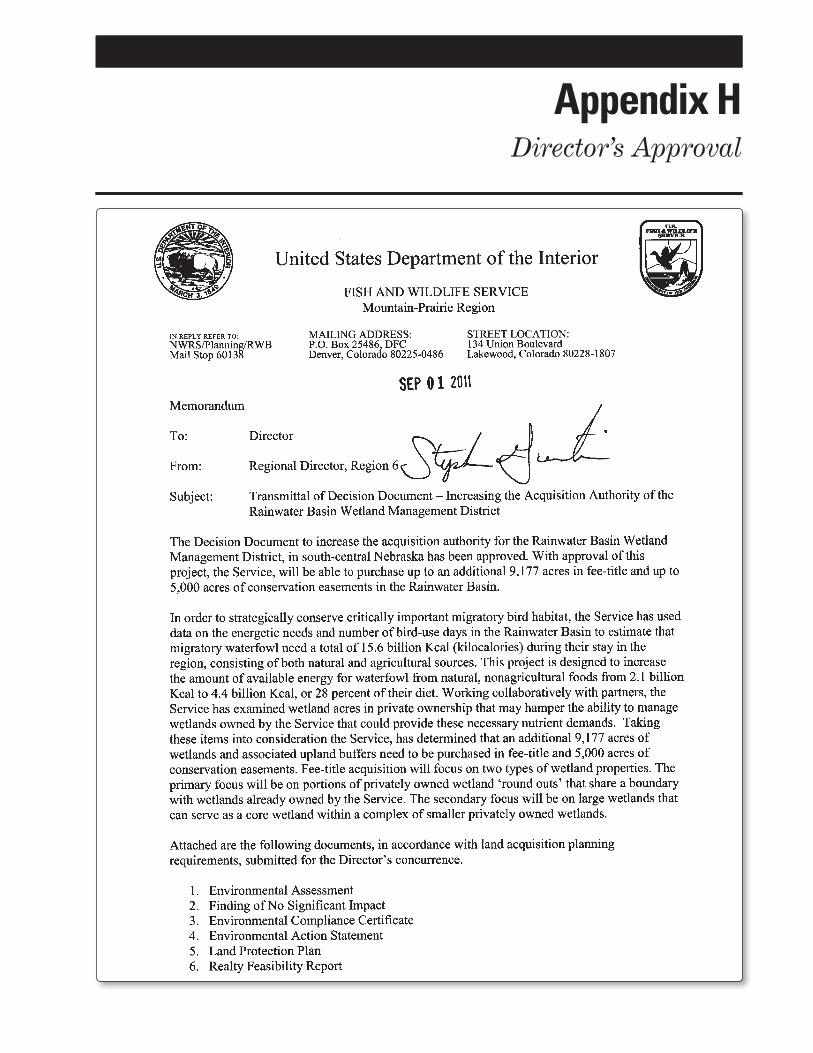
Appendix HDirector’s Approval

118 Land Protection Plan, Rainwater Basin Wetland Management District Expansion

119 Appendix H — Director’s Approval

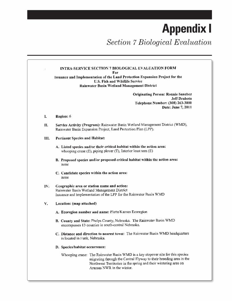
Appendix ISection 7 Biological Evaluation

122 Land Protection Plan, Rainwater Basin Wetland Management District Expansion

123 Appendix I — Section 7 Biological Evaluation
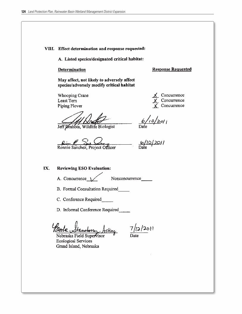
124 Land Protection Plan, Rainwater Basin Wetland Management District Expansion

Bibliography
Baldassare, G.A.; Bolen, E.G. 1994. Waterfowl ecology and management. New York: John Wiley. 567 p.
Devries, J.H.; Brook, R.W.; Howerter, D.W.; Ander-son, M.G. 2008. Effects of spring body condition and age on reproduction in mallards (Anas platy-rhynchos). The Auk 125:618 –628.
Ekstein, J.D.; Hygnstrom, S.E. 1996. Fate of wetlands associated with the Central Nebraska Irrigation Canal System. Great Plains Research 6:41–60.
Farrar, J. 1996. Nebraska’s Rainwater Basin. NE-BRASKAland. March. Nebraska Game and Parks Commission. pp. 18–35.
Gersib, R.A.; Dinan, K.F.; Kauffeld, J.D.; Onnen, M.D.; Gabig, P.J.; Cornely, J.E.; Jasmer, G.E.; Hyland, J.M.; Strom, K.J. 1992. Looking to the future: An implementation plan for the Rainwater Basin Joint Venture. Lincoln, NE: Nebraska Game and Parks Commission. 56 p.
Gersib, R.A.; Elder, B.; Dinan, K.F.; Hupf, T.H. 1989. Waterfowl values by wetland type within Rain-water Basin wetlands with special emphasis on activity time budget and census data. Lincoln, NE: Nebraska Game and Parks Commission; and Grand Island, NE: U.S. Department of the Interior, Fish and Wildlife Service. 105 p.
Johnsgard, P.A. 1997. The birds of Nebraska and ad-jacent plains states. Lincoln, NE: Nebraska Game and Parks Commission. Nebraska Ornithologists’ Union Occasional Papers, No. 6.
Johnson, B.B.; Blomendahl, B.; Overturf, K. 2006. Nebraska Farm Real Estate Market Highlights 2005–2006. Lincoln, NE: University of Nebraska, Lincoln, Department of Agriculuture Econom-ics. 56 p.
Johnson, B.B.; Lukassen, R.; Rosener, T. 2010. Nebraska Farm Real Estate Market Highlights: 2009–2010. Lincoln, NE: University of Nebraska, Lincoln, De-partment of Agriculuture Economics. 33 p.
Jorgensen, J.G. 2004. An overview of shorebird mi-gration in the eastern Rainwater Basin, Nebraska. Nebraska Ornithologists’ Union Occasional Pa-pers, No. 8.
Jorgensen, J.G.; McCarty, J.P.; Wolfenbarger, L.L. 2007. Landscape and habitat variables affecting buff-breasted sandpiper (Tryngites subruficol-lis) distribution during migratory stopover in the Rainwater Basin, Nebraska, USA. Wader Study Group Bulletin 112:45–51.
Kartesz, John T.; Thieret, John W. 1991. Common names for vascular plants: Guidelines for use and application. Sida 14:421–434.
Kaul, R.B.; Sutherland, D.; Rolfsmeier, S. 2006. The flora of Nebraska. Lincoln, NE: University of Ne-braska, Lincoln, School of Natural Resources. 966 p.
Keech, C.F.; Dreeszen, V.H. 1959. Geology and ground-water resources of Clay County, Nebraska. Wash-ington, DC: U.S. Department of the Interior, U.S. Geological Survey. U.S. Geological Survey Water Supply Paper 1468. 57 p.
Krapu, G. L.; Brandt, D.A.; Cox, R.R, Jr. 2004. Less waste corn, more land in soybeans, and the switch to genetically modified crops: Trends with impor-tant implications for wildlife management. Wildlife Society Bulletin 32:127–136.
Kuzila, M.S. 1984. Genesis and morphology of soils in and around large depressions in Clay County, Nebraska. [Ph.D. dissertation.] Lincoln, NE: Uni-versity of Nebraska. [Pages unknown].
Kuzila, M.S. 1994. Inherited morhpologies of two large basins in Clay County, Nebraska. Great Plains Re-search 4:51–63.
Kuzila, M.S.; Lewis, D.T. 1993. Properties and genesis of loessial soils across a south central Nebraska basin. Soil Science Society of America Journal. 37:155–61.
LaGrange, T.G. 2005. A guide to Nebraska’s wetlands and their conservation needs. 2nd edition. Lincoln, NE: Nebraska Game and Parks Commission. 59 p.
National Ecological Assessment Team. 2006. Strategic Habitat Conservation: Final report of the National Ecological Assessment Team. <http://www.fws.gov /science/shc/index.html> [access date unknown].
NatureServe Explorer. 2010. An online encyclopedia of life. <http://www.natureserve.org/explorer/> ac-cessed April 2011.
NAWMP. 1986. North American waterfowl manage-ment plan. Canadian Wildlife Service; and Wash-ington, DC: U.S. Fish and Wildlife Service.
Nebraska Agricultural Statistics Service. 2002. Ne-braska agricultural statistics, 2003. USDA, National Agricultural Statistics Service. <http://www.nass.usda.gov/Statistics_by_State/Nebraska/index.asp> accessed 2005.
[NEDOR] Nebraska Department of Revenue. 2011. [Chapter 22. Measurement of Special Valuation Regulations]. <http://www.revenue.ne.gov/index.html> accessed May 2, 2011.

126 Land Protection Plan, Rainwater Basin Wetland Management District Expansion
Richert, A. 1999. Multiple scale analyses of whoop-ing crane habitat in Nebraska [master’s thesis]. Lincoln, NE: University of Nebraska.
Schildman, G.; Hurt, J. 1984. Update of Rainwater Basin wetland survey. Survey of habitat work plan K-83. W-15-R-40. [Place of publication unknown]: Nebraska Game and Parks Commission. 13 p.
Schneider, R.; Humpert, M.; Stoner, K.; Steinauer, G. 2005. The Nebraska Natural Legacy Project: A comprehensive wildlife conservation strategy. Lincoln, NE: Nebraska Game and Parks Commis-sion. 245 p.
U.S. Census Bureau. 1991. Statistical Abstract of the United States: 1991. 11th edition. Washington, DC: U.S. Census Bureau. p. 201.
U.S. Census Bureau. 2010. <http://quickfacts.census.gov/qfd/states/31000.html> accessed January 12, 2011.
[USDA] U.S. Department of Agriculture. 2007. Census of Agriculture: Nebraska State and County Data, <http://www.agcensus.usda.gov/Publications/2007/Full_Report/Volume_1,_Chapter_2_County_Level/Nebraska/st31_2_008_008.pdf> accessed January 2011.
[USDA] U.S. Department of Agriculture. 2011. Land use, value, and management: Agricultural land
values, <http://www.ers.usda/Briefing/LandUse/aglandvaluechapter.htm> accessed July 2011.
[USDA, NRCS] U.S. Department of Agriculture, Natural Resources Conservation Service. 2008. The Wetlands Reserve Program supports migrating waterfowl in Nebraska’s Rainwater Basin Region. CEAP Conservation Insight. September 2008. 7 p.
[USFWS] U.S. Fish and Wildlife Service. 2007. Com-prehensive Conservation Plan: Rainwater Basin Wetland Management District. U.S. Department of the Interior. 198 p.
———. 2008. Strategic habitat conservation hand-book: A guide to implementing the technical ele-ments of SHC. Washington, DC: U.S. Department of the Interior. 22 p.
———. 2009. Strategic plan for responding to accel-erating climate change in the 21st century. Wash-ington, DC: U.S. Department of the Interior and U.S. Fish and Wildlife Service. 41 p.
Wilson, R.D. 2010. Evaluating hydroperiod response in the Rainwater Basin wetlands of south-central Nebraska [master’s thesis]. Lincoln, NE: Univer-sity of Nebraska. 163 p.
Wood, W.W. 2000. Ground-water recharge in the southern high plains of Texas and New Mexico. Frontiers in Ecology and the Environment 1:65–72.


