
www.sfplanning.org
Memo to the Planning Commission HEARING DATE: AUGUST 6, 2015
Date: July 30, 2015 Case No.: 2011.0409 Project Address: 925 Mission Street and various parcels (aka “5M”) Existing Zoning: C-3-S (Downtown Support) District RSD (Residential Service) District 40-X/85-B; 160-F Height and Bulk Districts SOMA Youth and Family Special Use District Block/Lot: Multiple Staff Contact: Kevin Guy – (415) 558-6163: [email protected] Recommendation: None - Informational Only
SITE DESCRIPTION AND PRESENT USE The project site consists of multiple parcels measuring approximately four acres. The site is generally bounded by Mission Street to the north, Fifth Street to the east, Howard Street to the south, and Mary Street to the west, along with several additional parcels further to the west along Mary Street. The site is currently occupied by eight buildings with approximately 318,000 square feet of office and cultural uses, as well as several surface parking lots. The site has been the long-time home of the San Francisco Chronicle, and recently incorporated new tenants in anticipation of the redevelopment, many of who will remain in the final development. The site is located at the nexus of the Downtown, SOMA, and Mid-Market areas, within a context characterized by intense urban development and a diverse mix of uses. The Westfield San Francisco Centre located at the southeast corner of Market and Fifth Streets, which defines the entry into the major retail shopping district around Union Square. The Fifth and Mission Parking Garage and the University of the Pacific School of Dentistry are located immediately to the east across Fifth Street, with the Metreon shopping center, Yerba Buena Gardens, and Moscone Center situated further to the east. The 340-foot Intercontinental Hotel is immediately to the east of the site, while the Pickwick Hotel and the Hotel Zetta are located along the 5th Street corridor. The Old Mint is situated immediately to the north of the site across Mission Street. Existing buildings to the west and the south of the site tend to be lower in scale, and contain a wide variety of uses, including residential hotels, older and newly-constructed residential buildings, offices, retail establishments, and automotive repair. The transit spine of Market Street is situated one block to the north, while the alignment of the future Central Subway is located one block to the east along Fourth Street. The Planning Department began conversations with the project sponsor in 2008, identifying the subject property as an opportunity site that should both reference the lower-scaled environment to the west by emphasizing the existing historic buildings on the site and adding much needed open space to this part of SOMA, and should add density and a mix of uses that relate to the high-rise environment to the east. The proposed project pre-dates the draft Central SOMA Plan, but supports many of the goals of the Plan, such as supporting transit oriented growth, providing extensive open space, and shaping the area’s urban form with recognition of both the City and neighborhood context.

Executive Summary CASE NO. 2011.0409 Hearing Date: August 6, 2015 “5M” Project – Informational Item
2
PROJECT DESCRIPTION The project proposes to demolish surface parking lots and several existing buildings (926 Howard Street, 912 Howard Street, 409-411 Natoma Street, and 190 Fifth Street), retain the Dempster, Camelline, Chronicle, and Examiner (portion) buildings, and construct three new towers on the project site, with occupied building heights ranging from approximately 200 feet to 450 feet. The project includes approximately 821,300 square feet of residential uses (approximately 690 units), 807,600 square feet of office uses (including active office uses at or below the ground floor), and 68,700 square feet of other active ground floor uses (a mix of retail establishments, recreational and arts facilities, restaurants, workshops, and educational uses). The project would also include vehicular parking, bicycle parking, and loading facilities, an extensive program of private- and publicly-accessible open space, and streetscape and public-realm improvements. The northerly portion of Mary Street between Minna and Mission Streets would be converted into a pedestrian alley lined with active uses and enhanced with seating, landscaping, and pedestrian-scaled lighting. Another significant open space would be situated on the rooftop of the Chronicle building, including a deck, sloping lawn, and an urban agriculture demonstration space with greenhouses and outdoor gardens. INFORMATIONAL HEARINGS On November 20, 2014, the Planning Commission held an informational hearing regarding the Project, which included a broad overview of the design and regulatory approach being proposed for the site. On July 23, 2015, the Planning Commission held a second informational hearing for the Project, which focused on the Design for Development document proposed as part of the overall project entitlements. The D4D articulates a vision for the character of the overall project, and provides specificity on aspects of architecture and massing, streetscape improvements, landscaping and greening, lighting, circulation and transportation facilities, public art, open space programming and design, activation and enhancement of the pedestrian realm, and sustainability features. The hearing also included discussion of the proposed Development Agreement, which specifies details of vesting, project phasing, delivery of public realm improvements, and public benefits. At that hearing, members of the public and the Planning Commission cited several issues for further discussion, mainly related to the interaction between the project and its surrounding context. Staff from the Planning Department, the Office of Economic and Workforce Development, and other agencies, along with technical experts associated with the project, will be available for further discussion of these issues at the hearing on August 6, 2015. In order to facilitate discussion of several specific items (wind and shadow effect, circulation design and transportation, and street improvements), the project sponsor has submitted a summary packet of informational materials which is attached to this memo. At the same hearing on August 6, 2015, the Planning Commission will also consider initiation of General Plan Amendments associated with the project. These requested amendments are described by a separate staff report.
RECOMMENDATION: None - Informational Item Only
Attachments: 5M Project – Informational Materials packet dated July 30, 2015

Mr. Rodney Fong, President San Francisco Planning Commission 1650 Mission Street, Suite 400 San Francisco, CA 94103 Re: Fifth and Mission (5M) Project Dear President Fong and Members of the Commission: We are writing to provide you with the following material to assist in understanding how the 5M Project responds to several of the larger concepts raised in Commissioners' comments at the Commission's July 23, 2015 information hearing:
The project’s wind effects The project’s shadow effects on major open spaces Circulation design and overall transportation effects Planned street improvements
We think this material will be helpful in understanding the comprehensive vision that this Project is fully committed to achieving. The 5M Project is proposed on four contiguous acres under unified control, of which the majority is currently under downtown zoning. The site’s proposed Special Use District affords 5M the unique ability to make cohesive, project-wide design decisions that would provide many benefits to the immediate community while also enabling a successful project. We remain, of course, pleased to respond any questions or to expand upon these summary materials. Best regards,
Audrey Tendell Development Director, Forest City Cc: San Francisco Planning Commissioners Mr. Dan Sider, San Francisco Planning Department Mr. Kevin Guy, San Francisco Planning Department Mr. Ken Rich, Office of Economic and Workforce Development

5M PROJECT/ INFORMATIONAL MATERIALSJULY 30, 2015

2
COMMUNITY BENEFITS
5M PROJECT SAN FRANCISCO

3
HOUSING
AFFORDABLE: 212 UNITSMARKET RATE: 630 UNITS
UP FROM 25% AFFORDABLE HOUSING PROPOSED SUMMER 2014
≥
33% AFFORDABLE HOUSING
1
2
3
168-186 EDDY FAMILY HOUSINGFAMILY HOUSING
SENIOR HOUSING FUNDLAND DEDICATION
M2 BUILDINGON-SITE RENTAL BUILDING
1/4 MILE = 5 MIN. WALK
168-186 EDDY STREET71 UNITS OF FAMILY HOUSING
M2 BUILDING58 AFFORDABLE HOUSING UNITS
LAND DONATION (967 MISSION ST)83 UNITS OF SENIOR HOUSING
1
3
2
5M PROJECT SAN FRANCISCO 65M PROJECT SAN FRANCISCO

4
HOUSING212 affordable units
ARTS + CULTUREDedication and restoration of 12,000 sq ft historic Dempster Building, arts program endowment, and $600K to arts facilities fund
TRANSPORTATIONTDM + TIDF citywide
YOUTH + FAMILIES71 units of family housing, local capital fund to stabilize neighborhood youth organizations, Bessie wrap around program, nonprofit facilities fund, and Gene Friend Rec Center
Q1 2015
UPDATED COMMUNITY BENEFITS PROPOSAL
AFFORDABLE HOUSING
AFFORDABLE OFFICE
SMALL BUSINESS SUPPORT /
MICRO-RETAIL
ACCESS TO JOBS
PROGRAMMEDOPEN SPACE
BASED ON FULL PROJECT BUILDOUT (OFFICE SCHEME)
WORKFORCE1,200 construction jobs, 3,150 new full-time jobs, First Source hiring, Project Labor Agreement
COMMUNITY BENEFITS
SENIORS83 units of senior housing and ped safety improvements around Mint Mall
COMPLETE STREETS AND PEDESTRIAN SAFETYImplementation of complete streets and extension to surrounding community through additional transit funding
HISTORIC PRESERVATIONRetention of Chronicle, Camelline, and Dempster buildings, and funding for Old Mint
PARKS AND OPEN SPACE50,000 sq ft total public open space. 37,000 sq ft in excess of City requirement for public open space. Gene Friend Rec Center and open space fee paid.
COMMUNITY FACILITIESAND NONPROFIT SPACEDempster Building dedicated to nonprofit office and arts uses. Arts + nonprofit endowment fund.
5M PROJECT SAN FRANCISCO 75M PROJECT SAN FRANCISCO

5
TECHNICAL DATA
5M PROJECT SAN FRANCISCO

6
EXISTING SITE — WIND HAZARDS
5M SITE BOUNDARY WIND HAZARD LOCATION AND HOURS EXCEEDED PER YEAR
4 HOURS A YEAR
74 HOURS A YEAR
1 HOUR A YEAR 5th/Tehama (EAST)
79 TOTAL HAZARD EXCEEDANCE HOURS A YEAR
Reference: Draft EIR
5M PROJECT SAN FRANCISCO

7
5M PROJECT (REVISED) — WIND HAZARDSNote: data to be published as part of Response to Comments / Final EIR
1 HOUR A YEAR 5th/Tehama (WEST)
2 HOURS A YEAR
1 HOUR A YEAR
WIND HAZARD LOCATION AND HOURS EXCEEDED PER YEAR
4 TOTAL HAZARD EXCEEDANCE HOURS A YEAR
5M PROJECT SAN FRANCISCO

8
5M PROJECT (REVISED) — SHADOW EFFECTS
BOEDDEKER PARKNET NEW SHADOW AS PERCENTAGE OF THEORETICAL ANNUAL SUN: 0.00418%
DATES OF OCCURRENCE: Oct 18–Nov 29, and Jan 11–Feb 22TIMES: Always before 8:40 amDURATION: 5–23 minutes
YERBA BUENA GARDENS NORTHNET NEW SHADOW AS PERCENTAGE OF THEORETICAL ANNUAL SUN: 0.08775%
DATES OF OCCURRENCE: Nov 1–Feb 8TIMES: Starts in late afternoon (no earlier than 2:45)DURATION: 5–58 minutes
YERBA BUENA CHILDREN’S PLAY AREANET NEW SHADOW AS PERCENTAGE OF THEORETICAL ANNUAL SUN: 0.167%
DATES OF OCCURRENCE: Sept 20–Nov 22, and Jan 18–March 22TIMES: Starts in late afternoon (no earlier than 3:20 pm)DURATION: 5–70 minutes
Note: data to be published as part of Response to Comments / Final EIR. Effects similar to Draft EIR Project.
5M PROJECT SAN FRANCISCO

OCCURS IN EARLY MORNING, when park is gated shut.
LANDSCAPED AREALocation of new shadow
LOCATION OF BOEDDEKER PARK SHADOW
9
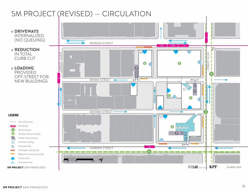
10
5M PROJECT SAN FRANCISCO 20 APRIL 2015
CIRCULATION & LOADING PLAN
6th street sidewalks were movedslightly
N
MISSION STREET
MINNA STREET
NATOMA STREET
HOWARD STREET
FIFTH
STR
EET
SIX
TH
STR
EET
MA
RY S
TR
EET
P
P
P
BB
BB
B
GG SM 14
27
GG
14
N1
H1
M2
14
P
B
Parcel Boundary
Bus Routes
Bicycle Routes
Off-Street Bicycle Parking
Private Parking Access
Off Street Loading
Vehicular Flow
Passenger Loading Only
Metered Commercial Loading
Primary Entry
Secondary Entry
LEGEND
5M PROJECT (REVISED) — CIRCULATION
DRIVEWAYS INTERNALIZED (NO QUEUING)
REDUCTION IN TOTAL CURB CUT
LOADING PROVIDED OFF-STREET FOR NEW BUILDINGS
>
>
>
5M PROJECT SAN FRANCISCO

11
5M PROJECT (REVISED) — TRANSPORTATION IMPACTSNote: data to be published as part of Response to Comments / Final EIR. Effects similar to / less than Draft EIR Project.
TRANSITProject driveways and off-street loading designed to be internal to site, avoiding queuing onto major streets.
BICYCLEBicycle parking supply consistent with latest Planning Code requirements
PEDESTRIANWidening of east sidewalk of Fifth Street between Mission and Minna, including removal of right-turn lane and widening of east crosswalk at Fifth / Mission
LOADINGProject utilizes combination of off-street and on-street loading spaces
5M PROJECT SAN FRANCISCO

PUBLIC REALM ENHANCEMENTS
EXISTING PROPOSED
18’ total
SIDEWALK WIDENED (+8’ to existing)
MISSION STREET
MINNA STREET
NATOMA STREET
HOWARD STREET
FIFTH
STR
EET
SIX
TH
STR
EET
MA
RY S
TR
EET
0’ 25’ 75’ 175’N
5TH STREET (WEST SIDEWALK)
125M PROJECT SAN FRANCISCO

EXISTING PROPOSED
STREET TREES LINE MISSION
STREET
MISSION STREET
MINNA STREET
NATOMA STREET
HOWARD STREET
FIFTH
STR
EET
SIX
TH
STR
EET
MA
RY S
TR
EET
0’ 25’ 75’ 175’N
MISSION STREET (SOUTH SIDEWALK)
PUBLIC REALM ENHANCEMENTS
135M PROJECT SAN FRANCISCO

PORK CHOP REMOVED; BULBOUT ADDED
SIDEWALK WIDENED (+10-15’ to existing)
25’ TOTAL
EXISTING PROPOSED
MISSION STREET
MINNA STREET
NATOMA STREET
HOWARD STREET
FIFTH
STR
EET
SIX
TH
STR
EET
MA
RY S
TR
EET
0’ 25’ 75’ 175’N
5TH STREET (EAST SIDEWALK)
CROSSWALK WIDENED on east crosswalk of
5th and Mission
TRAFFIC & PEDESTRIAN SIGNAL UPGRADES
at 5th and Mission
PUBLIC REALM ENHANCEMENTS
145M PROJECT SAN FRANCISCO


