ToDow
ntownM
inneapolis
Minnehaha
Ave.
West River Parkway
Nawada Blvd.
G dfrey Parkway
46thAve. S.
SouthMinnehahaParkDr. HiawathaAve.
MinnesotaV
TFortSnellingStateTrail
alleyStateTrail
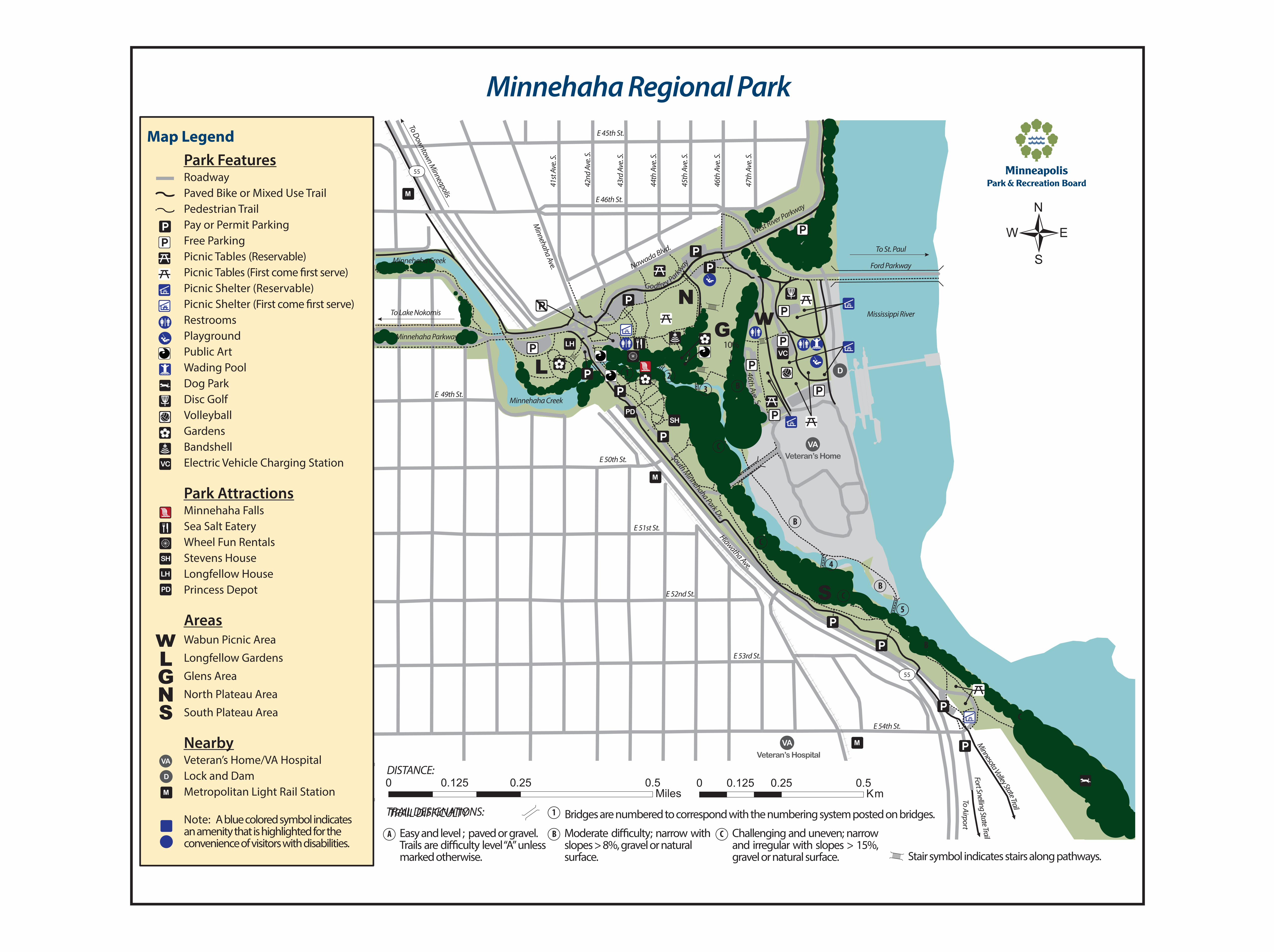
Minnehaha Regional Park Map Legend
Park Features55
M
E 45th St.
RoadwayPaved Bike or Mixed Use Trail
41st
Ave
. S.
42nd
Ave
. S.
43rd
Ave
. S.
44th
Ave
. S.
45th
Ave
. S.
46th
Ave
. S.
47th
Ave
. S.
Picnic Shelter (First come ÿrst serve)Restrooms
Picnic Tables (Reservable)Picnic Tables (First come ÿrst serve)Picnic Shelter (Reservable)
Pedestrian TrailPay or Permit ParkingFree Parking
E 46th St.
Minnehaha Creek To St. Paul
PlaygroundPublic Art
o
NTo Lake Nokomis Mississippi River
G w Minnehaha Parkway
10%
Ford Parkway
Dog ParkE 49th St.Disc Golf Minnehaha Creek
PDVolleyball SH
GardensBandshell
Wading Pool L LH
VC
1 2 D
3 B
VC Electric Vehicle Charging Station
Park AttractionsM
Minnehaha Falls
E 50th St.
C VA
Veteran’s Home
SH
Sea Salt Eatery E 51st St.
Wheel Fun RentalsStevens House
B
C
Longfellow HousePrincess Depot E 52nd St. CS
4LH
PD
Areasw Wabun Picnic Area
L Longfellow Gardens
G E 53rd St.
Glens Area
North Plateau AreaNS South Plateau Area
VA MNearbyVeteran’s Hospital
VA Veteran’s Home/VA HospitalDISTANCE:
D Lock and Dam 0 0.125 0.25 0.5 0 0.125 0.25 0.5M Metropolitan Light Rail Station Miles Km
Note: A blue colored symbol indicatesan amenity that is highlighted for the convenience of visitors with disabilities.
A
TRTRAIL DESIGNATIONS:AIL DIFFICULTY 1 Bridges are numbered to correspond with the numbering system posted on bridges.
B
marked otherwise.
Easy and level ; paved or gravel.Trails are di°culty level“A”unless
Moderate di°culty; narrow with C Challenging and uneven; narrowslopes > 8%, gravel or natural and irregular with slopes > 15%,surface. gravel or natural surface.
Aipo
or
rt
CE 54th St.
B
5
B
55
Stair symbol indicates stairs along pathways.


