Environmental Study Report for Newberry Park Wetland Restoration Project
October 2007
Prepared under the MNR Class Environmental Assessment for Resource Stewardship and Facility Development Projects, 2003.
Project Partners:
The Great Lakes Sustainability Fund is a component of the Government of Canada’s Great Lakes Program. The Sustainability Fund provides resources to demonstrate and implement technologies and techniques to assist in the remediation of Areas of Concern and other priority areas in the Great Lakes. The report that follows was sponsored by the Great Lakes Sustainability Fund and addresses fisheries issues in the Humber River Area of Concern in Toronto, Ontario. Although the report was subject to technical review, it does not necessarily reflect the views of the Sustainability Fund or the Government of Canada.
Project Team:
Siobhan Neil Project Coordinator Ontario Streams
Doug Forder Field Supervisor Ontario Streams
Mark Heaton Project Manager OMNR
Tracy Steele Project Manager Town of Richmond Hill
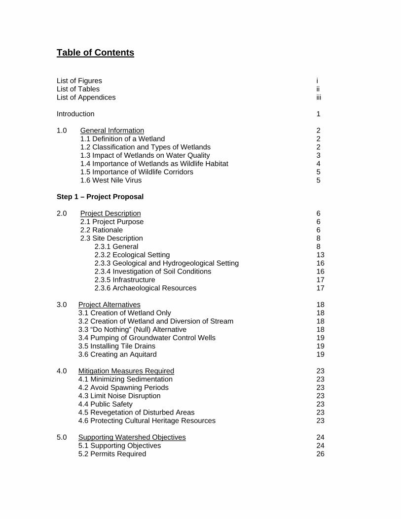
Table of Contents
List of Figures i List of Tables ii List of Appendices iii Introduction 1 1.0 General Information 2 1.1 Definition of a Wetland 2 1.2 Classification and Types of Wetlands 2 1.3 Impact of Wetlands on Water Quality 3 1.4 Importance of Wetlands as Wildlife Habitat 4 1.5 Importance of Wildlife Corridors 5 1.6 West Nile Virus 5 Step 1 – Project Proposal 2.0 Project Description 6 2.1 Project Purpose 6 2.2 Rationale 6 2.3 Site Description 8 2.3.1 General 8 2.3.2 Ecological Setting 13 2.3.3 Geological and Hydrogeological Setting 16 2.3.4 Investigation of Soil Conditions 16 2.3.5 Infrastructure 17 2.3.6 Archaeological Resources 17 3.0 Project Alternatives 18 3.1 Creation of Wetland Only 18 3.2 Creation of Wetland and Diversion of Stream 18 3.3 “Do Nothing” (Null) Alternative 18 3.4 Pumping of Groundwater Control Wells 19 3.5 Installing Tile Drains 19 3.6 Creating an Aquitard 19 4.0 Mitigation Measures Required 23 4.1 Minimizing Sedimentation 23 4.2 Avoid Spawning Periods 23 4.3 Limit Noise Disruption 23 4.4 Public Safety 23 4.5 Revegetation of Disturbed Areas 23 4.6 Protecting Cultural Heritage Resources 23 5.0 Supporting Watershed Objectives 24 5.1 Supporting Objectives 24 5.2 Permits Required 26
6.0 Project Category 26 7.0 Preliminary Evaluation of Alternatives 27 8.0 Project Evaluation 28 Step 2 – Environmental Analysis 9.0 Environmental Concerns Associated with the Construction of a Wetland – Excavation and Channel Alteration 30 9.1 Potential Impacts to Water Quality 30 9.2 Disruption to Fish and Wildlife Habitat 30 9.3 Changes in Channel Morphology and Flow Dynamics 30 9.4 Natural and Cultural Heritage Features 31 9.5 Resource Use Conflicts 31 9.6 Noise 31 9.7 Degradation of Scenic Quality 31 9.8 Dust 31 9.9 Public Safety 32 9.10 Hydraulic Impacts 32 10.0 Environmental Checklist 32 11.0 Determination of Significance of Effects 33 12.0 Environmental Analysis Summary 33 13.0 Environmental Analysis 34 13.1 Creation of Wetland Only 34 13.2 Creation of Wetland and Diversion of Stream 36 13.3 “Do Nothing” (Null) Alternative 40 Step 3 – Public Consultation Process & Selection of Preferred Alternative 14.0 Opportunity to Inspect the Draft ESR & Public Information Centre 46 15.0 Evaluation of Alternatives 46 15.1 Evaluation of Alternatives and Project Selection Process 46 15.2 The “Null” Alternative 47 15.3 Evaluation of Alternatives 47 16.0 Selection of Preferred Alternative 48 Step 4 – Project Plan 17.0 Design Details 48 18.0 Construction 49 18.1 Construction of Wetland and Stream Channel 49 18.2 Potential Environmental Effects Associated with Construction 50 18.3 Proposed Schedule of Construction Phase 50
19.0 Operation and Maintenance 50 20.0 Abandonment 50 21.0 Mitigation Measures 50 22.0 Assessment of Project to Meet Intended Purpose 51 23.0 Monitoring 51 Bibliography 53
i
List of Figures
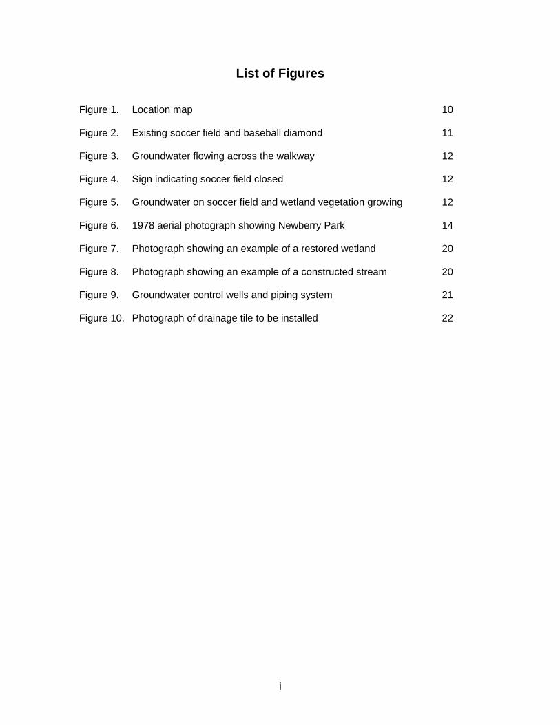
Figure 1. Location map 10 Figure 2. Existing soccer field and baseball diamond 11 Figure 3. Groundwater flowing across the walkway 12 Figure 4. Sign indicating soccer field closed 12 Figure 5. Groundwater on soccer field and wetland vegetation growing 12 Figure 6. 1978 aerial photograph showing Newberry Park 14 Figure 7. Photograph showing an example of a restored wetland 20 Figure 8. Photograph showing an example of a constructed stream 20 Figure 9. Groundwater control wells and piping system 21 Figure 10. Photograph of drainage tile to be installed 22
ii
List of Tables
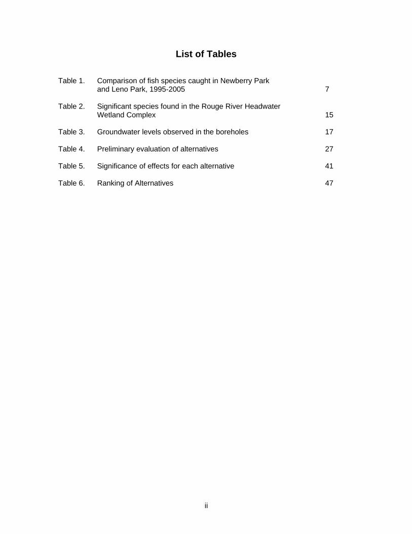
Table 1. Comparison of fish species caught in Newberry Park and Leno Park, 1995-2005 7 Table 2. Significant species found in the Rouge River Headwater Wetland Complex 15 Table 3. Groundwater levels observed in the boreholes 17 Table 4. Preliminary evaluation of alternatives 27 Table 5. Significance of effects for each alternative 41 Table 6. Ranking of Alternatives 47
iii
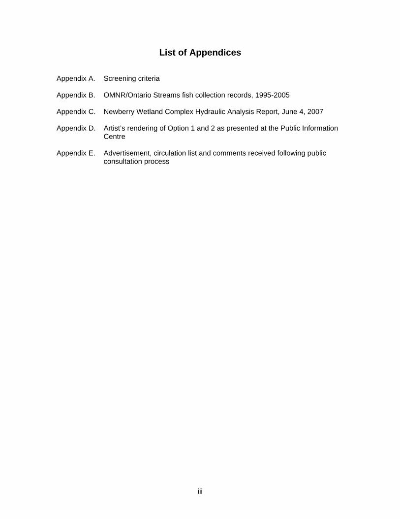
List of Appendices Appendix A. Screening criteria Appendix B. OMNR/Ontario Streams fish collection records, 1995-2005 Appendix C. Newberry Wetland Complex Hydraulic Analysis Report, June 4, 2007 Appendix D. Artist’s rendering of Option 1 and 2 as presented at the Public Information Centre Appendix E. Advertisement, circulation list and comments received following public consultation process
1
Introduction Wetlands are among the most important and productive ecosystems in the world. They serve as essential habitat for countless species of flora and fauna. In addition to this, they play an important role in various ecological processes. They function as chemical “sinks”, absorbing excess nutrients and pollutants from the surrounding environment. They act as natural filters to cleanse polluted waters, as well as trap sediments and reduce erosion. Wetlands also act to store surface water thus, reducing the impact of flooding. All of these wetland functions are essential to maintaining the health of our fresh water resources. Canada is home to nearly 25% of all the wetlands on earth (Ducks Unlimited Canada, 2005). Unfortunately, this wetland area continues to decrease as it becomes increasingly threatened by land development. Of the country’s total wetland area, approximately 41% is found in Manitoba and Ontario. Southern Ontario, in particular, has experienced the most extensive wetland loss with an over 80% reduction in some areas. (Mitsch & Gosselink, 2000) Previously, wetlands had been seen as “wastelands” (Mitsch & Gosselink, 2000) and were destroyed to make room for more “productive” or economically valuable land uses. They were commonly drained and filled to be converted to agricultural land, developed for commercial and residential land uses, or mined for peat or mineral extraction. However, as the importance and value of wetland ecosystems continues to gain widespread recognition, efforts are being focussed on protecting and restoring existing wetlands, and creating or re-establishing additional wetland habitat. This document is an Environmental Study Report completed under the Ministry of Natural Resources Class Environmental Assessment for Resource Stewardship and Facility Development Projects, 2003. This report presents the proposal to rehabilitate a portion of Newberry Park in the Town of Richmond Hill to a more natural state, and examines alternative options for this proposal.
2
1.0 General Information 1.1 Definition of a Wetland
A wetland is defined as: “land that has the water table at, near, or above the land surface or which is saturated for a long enough period to promote wetland or aquatic processes as indicated by poorly drained soils, hydrophytic vegetation, and various kinds of biological activity that are adapted to the wet environment” (Mitsch and Gosselink, 2000).
1.2 Classification and Types of Wetlands
The Canadian Wetland Classification System (National Wetlands Working Group, 1997) recognizes five classes of wetlands which are:
1) Bog – A peat-accumulating wetland that has a water table at or near the surface. Main source of water is from precipitation and there are no significant inflows or outflows. Dominant vegetation is generally acidophilic mosses, particularly Sphagnum. 2) Fen – A peat-accumulating wetland that has a fluctuating water table at or near the surface. The water table is not stagnant but rather moves through the peat by seepage or in open channels. They usually support marshlike vegetation. 3) Swamp – Area with stagnant or slow flowing pooled water, dominated by trees or shrubs. 4) Marsh – A frequently or continually inundated wetland characterized by emergent herbaceous vegetation adapted to saturated soil conditions. 5) Shallow water – Wetlands with open water less than 2 meters deep. Includes basins, pools and ponds, as well as wetlands adjacent to rivers, coastlines and shorelines. Dominated by submerged vegetation and floating leaved plants.
These classes are based on natural features of the wetlands, hydrological processes, and the nature of the wetland environment. In addition to these classifications, wetlands can be further assessed on the basis of their position on the landscape. There are four types of wetlands based on this criteria which are:
1) Lacustrine – wetlands associated with lakes. They can be located at the mouth of a river, at the shoreline of the lake but separated by a beach, or exposed to the lake.
3
2) Riverine – wetlands adjacent to streams. They can be located within the channel, adjacent to the stream, or on the flood plain. 3) Palustrine – wetlands that occur upslope of riverine or lacustrine wetlands. They may or may not have an inflow, and have permanent or intermittent outflow. 4) Isolated – wetlands that receive nutrients from precipitation, overland flow, and groundwater.
1.3 Impact of Wetlands on Water Quality
Wetlands are known to positively influence many aspects of water quality. They can reduce sedimentation as well as absorb and transform excess nutrients, pathogens, and contaminants. Wetlands act as natural water filters, playing an important role in purifying our water resources. Sedimentation Sedimentation is a major water quality concern affecting our lakes and rivers. Increased sediment load from erosion of surrounding lands causes turbid water conditions. This affects many fishes ability to feed and can clog their gills, inhibiting their ability to breath. Turbidity also reduces light penetration into the water, causing diminished plant growth and thus decreasing a major food source for fish and other aquatic organisms. Increased sediment into a stream or lake also causes bottom substrates, such as rock and gravel, to become buried by silt. This eliminates essential reproductive habitat for many species of fish, as well as many other benthic organisms. Wetlands can greatly reduce the impacts of sedimentation on downstream water supplies. As water flows into a wetland, the vegetation acts to slow the velocity of water. This allows fine sediments time to drop out of the water column and thus, reduces the sediment load travelling downstream. Pathogens Fecal contamination of surface and ground water can create a serious risk to human health if excessive amounts build up in the water. Some of the waterborne pathogens that can be transmitted through fecal contamination include Escherichia coli and Salmonella typhi, both of which can cause extreme sickness and even death. Up to 90% of the bacteria found in water can be removed by passing through a wetland (Ducks Unlimited Canada, 2005). More vegetated wetlands have been found to be more effective at removing pathogens from the water than less vegetated ones. This is because the vegetation associated with wetlands, is very effective at removing and transforming pathogens in the water. The plants can retain nutrients and oxygenate the water, as well as provide a surface for microbes, which conduct most of the pollutant transformations.
4
Excess Nutrients Excess nutrients, such as nitrogen and phosphorus, can contaminate surface water through runoff or can leach into groundwater supplies. One of the main causes of nutrient contamination is from natural and chemical fertilizers. Drinking water contaminated with nitrate, for example, can be toxic to humans and lead to methylglobanemia, whereby the oxygen carrying capacity of the blood is blocked, leading to suffocation. High nitrate levels have also been linked to stomach cancer and reproductive problems (Government of Alberta, 2004). Phosphorus contamination in lakes and rivers can lead to the destruction of fish and wildlife habitat through the process of eutrophication. Increased nutrient loading causes excessive plant growth, particularly algae. These large algal blooms reduce the amount of light penetrating the water and thus, inhibit the growth of plants deeper in the water column. This leads to low oxygen levels in the water which suffocates fish and other aquatic organisms (Mackie, 2001). Wetlands act as nutrient “sinks” by retaining excess nutrients, such as nitrogen and phosphorus, in plants and sediments. Phosphorus retention is considered one of the most important attributes of wetlands (Mitsch and Gosselink, 2000). Furthermore, microbial transformations are important for the removal of nitrogen. The process of denitrification is typically the key mechanism for reducing nitrogen in wetlands (Gabor et al., 2004). Contaminants Wetlands also have a significant ability to remove and degrade metals, pesticides and landfill leachate, all of which can have serious adverse effects to human health. Removal of these contaminants generally occurs through oxidation and precipitation from the water column (Pries, 1994). In summary, natural wetlands are complex ecosystems dominated by a diversity of plant life and microbes. This high biological productivity allows wetlands the ability to remove and transform many pollutants from the water.
1.4 Importance of Wetlands as Wildlife Habitat
Wetlands are extremely productive habitats and often sustain more life than any other ecosystem. They are home to hundreds of species of wildlife and they provide critical breeding, rearing and feeding grounds for a wide diversity of species. In Canada, it is estimated that wetlands are home to approximately 200 species of birds, 50 species of mammals, and numerous other species of insects and fish. In addition to this, almost all of Canada’s 87 reptile and amphibian species call wetlands home for at least part of their life cycle. Amphibians, particularly frogs and salamanders, live part of their lives under water and thus, wetlands provide essential habitat for feeding, reproduction, and shelter over the winter. Many Canadian turtle species live only in wetland habitats and many mammals, such as muskrat, beaver, rabbits, and dear use wetlands for food,
5
cover, and for breeding. Wetlands also serve as extremely important habitat for birds. Hundreds of bird species in Canada require wetlands to survive. They provide critical habitat for breeding, nesting, and wintering and the high diversity of plants and invertebrates in wetlands provides excellent feeding grounds.
1.5 Importance of Wildlife Corridors
Wildlife corridors connect otherwise fragmented habitats and serve as habitat themselves. They allow the movement of animals from one area to another which increases foraging area, shelter, species diversity, and may provide escape from predators or other disturbances. Furthermore, wildlife corridors can also serve to connect fragmented populations. The resulting benefits may be increased population size, increased reproductive success, and increased genetic diversity among species.
1.6 West Nile Virus
West Nile Virus is spread by mosquitos biting infected birds and then subsequently biting humans. There are 74 known species of mosquitos in Canada. Not all species of mosquitos feed on humans and only the females feed on blood. The species most commonly associated with spreading the West Nile Virus are Culex pipiens and Culex restuans. These species are found in urban and suburban areas, particularly Culex pipiens, which is referred to as the “common house mosquito”. These species breed exclusively in small, stagnant pools of water. They primarily feed on birds, making them susceptible to infection. Although wetlands are often thought to be associated with stagnant water and breeding mosquitos, a healthy functioning wetland poses little risk of West Nile Virus. Marshes consisting of shallow pools will provide habitat for juvenile fishes and frogs. These animals are predators of mosquitos and their larvae, and thus would help control their population. Furthermore, the pools within flowing wetlands do not provide the required habitat for Culex pipiens and Culex restuans to breed effectively.
6
Step 1 – Project Proposal 2.0 Project Description 2.1 Project Purpose
The primary purpose of this project is to rehabilitate the portion of Newberry Park, currently consisting of the soccer and baseball fields, to a naturalized state and, in doing so, provide educational opportunities. The objectives associated with rehabilitating Newberry Park are to:
1) maximize the benefits to water quality in the Rouge River headwaters 2) improve fish habitat conditions in Tributary B of the Rouge River 3) increase overall wetland habitat in the Rouge River headwaters 4) re-connect smaller fragmented wetlands
2.2 Rationale
Newberry Park is a recreational park with an existing playground, tennis court, baseball diamond and soccer field. It was constructed in the late 1980’s as part of the Elgin East Development in the Town of Richmond Hill. Prior to this development, Newberry Park existed as a Rouge River headwater swamp. It is located in an area of upward groundwater movement from the Oak Ridges Moraine aquifer and for this reason, Newberry Park has been affected by operational problems from the beginning. Groundwater seepage has been, and is presently, a problem on the soccer field as well as the baseball field. In order to try to solve these problems, the Town of Richmond Hill Parks, Recreation and Culture department have made a number of attempts at remediation. Drainage tiles and french drains have been installed beneath both the soccer field and baseball diamond. However these solutions did not resolve the natural upward groundwater discharge conditions. During the development of Newberry Park, light standards were installed in the northeast corner of the soccer field and have since been removed as they had encountered flowing groundwater conditions. These conditions have also caused damage to remaining light standards and other infrastructure. The light standards along the trail are cracked as a result of water moving up the posts and freezing, and nearly all the lights surrounding the baseball diamond are leaning. In addition to this, the soccer bleachers and baseball benches have been damaged due to heaving. For safety reasons, the Town of Richmond Hill has already removed the soccer bleachers and other damaged infrastructure. Water can be seen bubbling up to the surface at several locations on the soccer field as well as several locations on the baseball diamond. This groundwater seepage has rendered the soccer and baseball fields unusable for organized sports in the community and they have since been retired. There are also obvious groundwater seepage problems along the walkways. These flowing water conditions result in a hazardous trail system and unstable ground surfaces
7
throughout the fields. As a result of these unsafe conditions, the Town of Richmond Hill has decided to remove the soccer field and baseball diamond. Tributary B of the Rouge River runs through Newberry Park in a south easterly direction, just south of the soccer and baseball fields. It is a cold water tributary and is recommended to be managed as a cold water production zone for salmonids, as identified in the Rouge River Fisheries Management Plan (OMNR & TRCA, 1992). However, this portion of Tributary B has undergone channel modifications which have resulted in degraded fish habitat and reduced species diversity. Also, discharge of untreated storm water from surrounding residential areas has degraded water quality. During the construction of the park and the Elgin East Development, Tributary B was channelized throughout Newberry Park. The stream channel was straightened and lined with limestone boulders, and the stream bed was lined with rock rip rap. This channelization resulted in degraded fish habitat and a faster flowing stream with greater erosive potential. In an attempt to mitigate the effects of increased flow velocity, energy dissipation structures had been put in the stream at the upstream, or west end, of the park. In turn, however, this also created barriers to fish movement. In order to improve fish movement through the area, a series of step-pool fishways were installed in 1997 to facilitate passage beyond the barriers. However, fish habitat conditions within the portion of Tributary B running through Newberry Park remain unfavourable to many species. The substrate is dominated by limestone rip rap and round stone, which was added by Ontario Streams as part of a previous project to enhance habitat conditions. However, this portion of Tributary B receives increased loading of fine sediments, such as silt, from numerous upstream storm water outlets. Therefore, substrates often become buried by fine sediments and the water becomes very turbid during rainfall events. Fish species diversity within this section of Tributary B remains abnormally low due to unsuitable habitat. Table 1 compares the diversity of fish species captured during annual surveys of Newberry Park and Leno Park further downstream on the same system, from 1995 to 2005.
Table 1. Comparison of fish species caught in Newberry Park and Leno Park, 1995 - 2005
Newberry Park Leno Park Mottled sculpin Blacknose dace Johnny darter Atlantic salmon (stocked)
Rainbow trout (stocked) Brook stickleback Creek chub White sucker Mottled sculpin Longnose dace Blacknose dace
Johnny darter Northern redbelly dace Common shiner Brook trout Pumpkinseed Atlantic salmon (stocked)
(OMNR/Ontario Streams fish collection records, 1995-2005) Appendix B There is a total of 13 fish species known to inhabit the waters in and around Leno Park compared to only 4 species upstream in Newberry Park. Important to note is that the capture of Atlantic salmon in Newberry Park occurred in 1999 and coincided with Atlantic salmon stocking shortly before. Atlantic salmon stocking within Newberry Park was discontinued due to unfavourable habitat conditions and since then Atlantic salmon have not been found in Newberry Park. Also important
8
to note is that only one sediment sensitive species, the mottled sculpin, has been caught during sampling conducted in Newberry Park from 2001-2005. The high number of salmonids, particularly rainbow trout, found downstream in Leno Park, along with a greater diversity of species, indicates much more suitable habitat conditions and better water quality in this portion of Tributary B. It also suggests the potential for Tributary B through Newberry Park to be improved should water quality and habitat be enhanced.
Newberry Park is located within the provincially significant Rouge River Headwater Wetland Complex. Within this complex, the park was previously part of a larger wetland area (64 ha), which has since been reduced to less than half its original size (31 ha) and fragmented due to urban development (OMNR, 2002). Returning this portion of Newberry Park to wetland habitat would assist in restoring natural heritage features to the area. It would also assist in reconnecting smaller, fragmented wetlands to increase overall wetland area and improve wildlife corridors. Furthermore, utilizing the groundwater sources and creating a new headwater tributary through the proposed wetland would significantly improve fish habitat conditions through the park. The new tributary would potentially provide clear cold water spawning and nursery habitat for coldwater fish species such as brook trout. The provincially threatened redside dace is known to inhabit Tributary B further downstream, south of Elgin Mills Rd. Therefore, this project would also serve to create habitat for this sensitive species.
2.3 Site Description
2.3.1 General
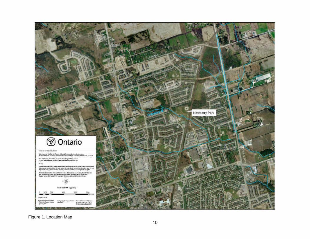
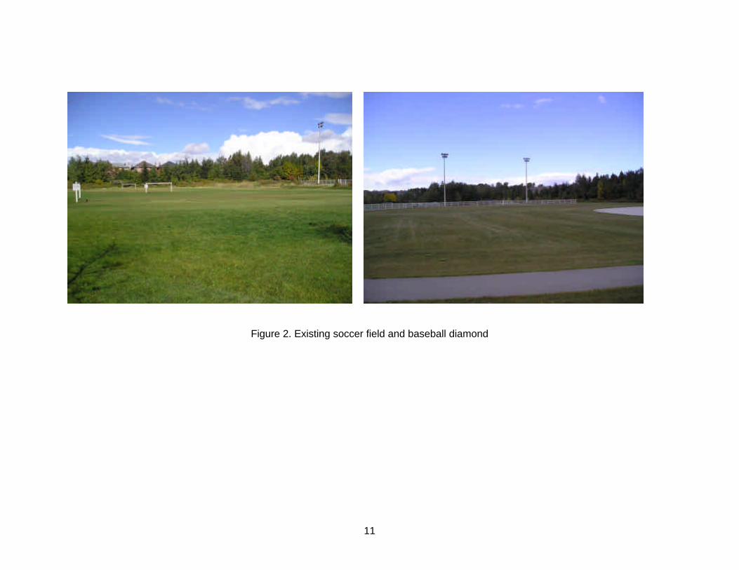
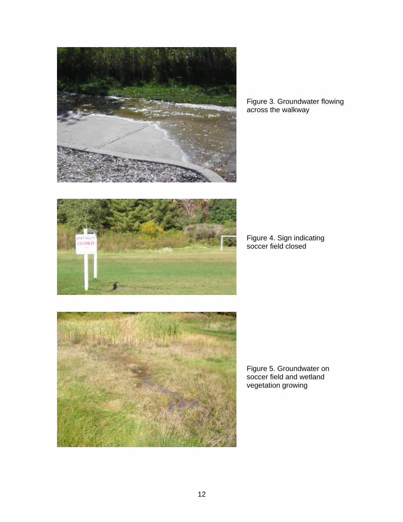
The project site is located in Newberry Park in the Town of Richmond Hill. The proposed wetland is to encompass the area of the soccer field and the baseball diamond within the park, north of the existing walkway and creek. This would create approximately 1 hectare of wetland habitat. (Figure 1 & 2) Newberry Park was built in the late 1980’s as part of the Elgin East Development, which is bordered by 19th Ave. to the north, Elgin Mills Rd. to the south, Yonge St. to the west, and Bayview Ave. to the east. The park is situated on valley land and was designed with the intention of functioning as a storm water storage facility. The original topography in the park was excavated to a lower elevation in order to provide a stormwater ponding area for flood water quantity control in the event of a major storm. Tributary B of the Rouge River runs through the park south of the soccer and baseball fields. The creek is part of the Rouge River Headwaters and begins flowing north of Jefferson Sideroad in a south easterly direction. Newberry Park is situated on the Oak Ridges Moraine Aquifer in an area of upward groundwater movement and therefore, there are several locations throughout the soccer and baseball field where groundwater is at the surface. In particular, groundwater can be seen flowing through the soccer field, across the walkway and to the creek (Figure 3).
9
Both the soccer field and baseball diamond have been retired due to unsafe conditions and permits for their use have not been issued since 2001 (Figure 4). Neither the soccer field nor baseball diamond is being maintained, and any use of these areas is informal and unauthorized. Several locations on the soccer field now consist of wetland vegetation, primarily long grasses and sedges (Figure 5). Tributary B running through Newberry Park is currently channelized and underlain with rip rap and limestone boulder lining each bank. The creek remains mostly shaded with a thin strip of riparian vegetation approximately 5 – 10 meters wide. This surrounding vegetation is mostly dominated by long grasses, shrubs and some trees. At the west end of the park, the creek had a series of energy dissipating structures installed, which have since been mitigated by step-pool fishways. To the east, the creek flows out of the park through a culvert underneath the CNR railway tracks. There are also a number of storm sewer outlets discharging into Tributary B upstream of Newberry Park.
10
Figure 1. Location Map
11
Figure 2. Existing soccer field and baseball diamond
12
Figure 3. Groundwater flowing across the walkway
Figure 5. Groundwater on soccer field and wetland vegetation growing
Figure 4. Sign indicating soccer field closed
13
2.3.2 Ecological Setting
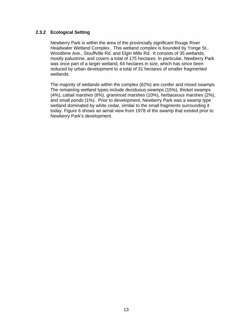
Newberry Park is within the area of the provincially significant Rouge River Headwater Wetland Complex. This wetland complex is bounded by Yonge St., Woodbine Ave., Stouffville Rd. and Elgin Mills Rd. It consists of 35 wetlands, mostly palustrine, and covers a total of 175 hectares. In particular, Newberry Park was once part of a larger wetland, 64 hectares in size, which has since been reduced by urban development to a total of 31 hectares of smaller fragmented wetlands. The majority of wetlands within the complex (62%) are conifer and mixed swamps. The remaining wetland types include deciduous swamps (15%), thicket swamps (4%), cattail marshes (6%), graminoid marshes (10%), herbaceous marshes (2%), and small ponds (1%). Prior to development, Newberry Park was a swamp type wetland dominated by white cedar, similar to the small fragments surrounding it today. Figure 6 shows an aerial view from 1978 of the swamp that existed prior to Newberry Park’s development.
14
Figure 6. 1978 aerial photograph showing Newberry Park
15
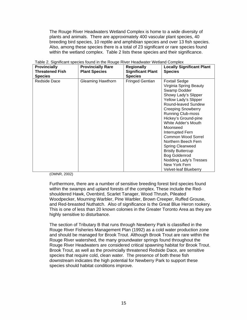
The Rouge River Headwaters Wetland Complex is home to a wide diversity of plants and animals. There are approximately 400 vascular plant species, 40 breeding bird species, 10 reptile and amphibian species and over 13 fish species. Also, among these species there is a total of 23 significant or rare species found within the wetland complex. Table 2 lists these species and their significance.
Table 2. Significant species found in the Rouge River Headwater Wetland Complex Provincially Threatened Fish Species
Provincially Rare Plant Species
Regionally Significant Plant Species
Locally Significant Plant Species
Redside Dace Gleaming Hawthorn Fringed Gentian Foxtail Sedge Virginia Spring Beauty Swamp Dodder Showy Lady’s Slipper Yellow Lady’s Slipper Round-leaved Sundew Creeping Snowberry Running Club-moss Hickey’s Ground-pine White Adder’s Mouth Moonseed Interrupted Fern Common Wood Sorrel Northern Beech Fern Spring Clearweed Bristly Buttercup Bog Goldenrod Nodding Lady’s Tresses New York Fern Velvet-leaf Blueberry
(OMNR, 2002) Furthermore, there are a number of sensitive breeding forest bird species found within the swamps and upland forests of the complex. These include the Red-shouldered Hawk, Ovenbird, Scarlet Tanager, Wood Thrush, Pileated Woodpecker, Mourning Warbler, Pine Warbler, Brown Creeper, Ruffed Grouse, and Red-breasted Nuthatch. Also of significance is the Great Blue Heron rookery. This is one of less than 20 known colonies in the Greater Toronto Area as they are highly sensitive to disturbance. The section of Tributary B that runs through Newberry Park is classified in the Rouge River Fisheries Management Plan (1992) as a cold water production zone and should be managed for Brook Trout. Although Brook Trout are rare within the Rouge River watershed, the many groundwater springs found throughout the Rouge River Headwaters are considered critical spawning habitat for Brook Trout. Brook Trout, as well as the provincially threatened Redside Dace, are sensitive species that require cold, clean water. The presence of both these fish downstream indicates the high potential for Newberry Park to support these species should habitat conditions improve.
16
2.3.3 Geological and Hydrogeological Setting
The project area is located on the southern edge of the Oak Ridges Moraine. This area has near surface geology ranging from sands/silts to clay glacial till. The sands and silts are remnants of lakes that existed following the recession of the last ice sheet. The main surface deposit found at or near the surface is the Halton Till. This is dominated by silt but also consists of a mixture of sand, clay and stones. The Halton Till is underlain by a predominantly sand aquifer approximately ranging from 1 to 15 meters thick. Beneath this aquifer there is another layer of clay silt till of either Halton Till or Newmarket Till origin. Beneath this there is an extensive lacustrine deposit of gravel, sand and silt. This deposit is known as the Thorncliffe Formation and has been found from Pickering to Mississauga and from beneath the Oak Ridges Moraine to the Scarborough Bluffs. There are several groundwater seepage areas throughout Newberry Park particularly within the soccer field and baseball diamond. There are also a number of springs within the adjacent Tributary B that provide cold clean groundwater to the creek. These seepage areas occur as the area is located below the crest of the moraine where spring development is common. Throughout most of the area, the groundwater level occurs near the ground surface. This upward groundwater movement is driven by the hydraulic head of the moraine. Furthermore, the overlying Halton Till consists of a significant level of sand lenses. These are thought to be the main sources of artesian pressure in Newberry Park as well as in the adjacent Tributary B (Morrison Environmental Limited, 2004).
2.3.4 Investigation of Soil Conditions
Trow Associates Inc. (2005) conducted an investigation of the subsurface soil and groundwater conditions at the site and provided guidelines for the construction of a wetland. A total of five sample boreholes were taken at various locations on the site and examined for soil type, moisture content and chemical composition. The boreholes continued down to a depth of approximately 6.6m below existing grade. The soil stratigraphy at the site is generally comprised of fill and topsoil fill over a major stratum of native clayey silt till. The thickness of the fill material ranges from 0.6 to 1.4 meters and is comprised of a range of topsoil to clayey silt with organics to sand and gravel material. The moisture content of the fill ranges from 9 to 13%, and up to 150% for the topsoil fill. Below the fill is a major deposit of clayey silt till comprised of grey clayey silt, trace sand and gravel, with scattered wet fine sand seams, cobbles and boulders. The general consistency of the clayey silt till is very stiff and moisture content ranged from 10 to 17%. During investigation, boreholes 3, 4, and 5 were terminated within the clayey silt till at a depth of 6.6 meters however, boreholes 1 and 2 encountered deposits of brown and grey fine to medium sand or sand and gravel at depths of approximately 4 meters. These deposits were generally dense and saturated with

17
moisture contents ranging from 14 to 25%. Artesian water condition was observed from these granular deposits. Following the completion of drilling, groundwater levels were observed in the boreholes. The groundwater levels ranged from 0 to 5.4 meters below the surface. These findings are presented in Table 3 below. The full results of the study, including borehole locations are presented in the Geotechnical Investigation, Proposed Wetland Habitat Newberry Park (Trow Associates Inc., 2005). Table 3. Groundwater levels observed in the boreholes.
Borehole 1 Borehole 2 Borehole 3 Borehole 4 Borehole 5 Depth to Groundwater (m)
0.3
above surface
1.8
dry
5.4
The soil samples were tested for the generation of flammable gases and analysed for chemical content. No flammable gases, particularly methane, were detected in the borehole samples. Furthermore, of the three borehole samples tested for chemical content, all met the standards for agricultural/residential/parkland and industrial/commercial/community property uses under Part XV.1 of the Environmental Protection Act, dated March 9, 2004. Therefore, based on the results of the chemical testing, both the fill and native soils at the site can be disposed of at any land-based sites.
2.3.5 Infrastructure
There are currently a series of light standards in place around the perimeter of the playing fields. These light standards are damaged due to the groundwater seepage and therefore, will be removed by the Town of Richmond Hill in the spring of 2006 due to safety concerns. Similarly, the benches on both fields are significantly heaved and will also be removed by the Town of Richmond Hill. Previous attempts at controlling the groundwater seepage have left a series of tile drains and french drains throughout the fields, which have proved to be ineffective. These systems would be removed during grading of the wetland area. There are five groundwater control wells that have been installed in the northern portion of the soccer and baseball fields. In addition to this, there are three monitoring wells installed around the baseball diamond. These wells were installed by Morrison Environmental Limited, to evaluate the cost and feasibility of a gravity based drainage solution. This solution was deemed not feasible and therefore, these wells are not being operated.
2.3.6 Archaeological Resources
The Newberry Park site, and the Elgin East Development in general, has undergone extensive excavation and filling during the development of this area. It was confirmed in the soil investigation by Trow Associates Inc. (2004) that the thickness of the fill material ranged from 0.6 to 1.4 meters.
18
Also, Tributary B through the park has undergone extensive channel modifications and therefore, the site is considered highly disturbed. For this reason, there are no anticipated effects to archaeological resources.
3.0 Project Alternatives
Presented in this section is a general description of each alternative considered for this project. In depth evaluation of the effects of each selected alternative will be provided in subsequent sections.
3.1 Restoration of Wetland
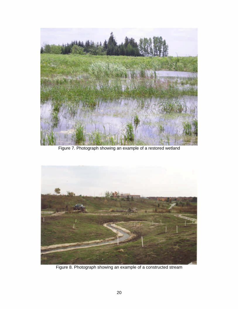
Rehabilitating the soccer and baseball fields into a wetland would see the creation of approximately 1 hectare of wetland habitat. The created wetland would be a marsh and would be planted with marsh vegetation. Pockets of cedar trees would be planted in slightly elevated areas throughout the wetland. Also incorporated into the design would be boardwalks within the wetland with interpretive signage. This would provide wildlife viewing opportunities and an educational component. Figure 7 is a photograph showing an example of a restored wetland. This option would help restore natural heritage and ecological features to the area, reconnect fragmented wetlands, improve wildlife corridors, and increase wildlife habitat. Although this option would have benefits to water quality, there would be no improvements to fish habitat within Tributary B.
3.2 Restoration of Wetland and Creation of Stream
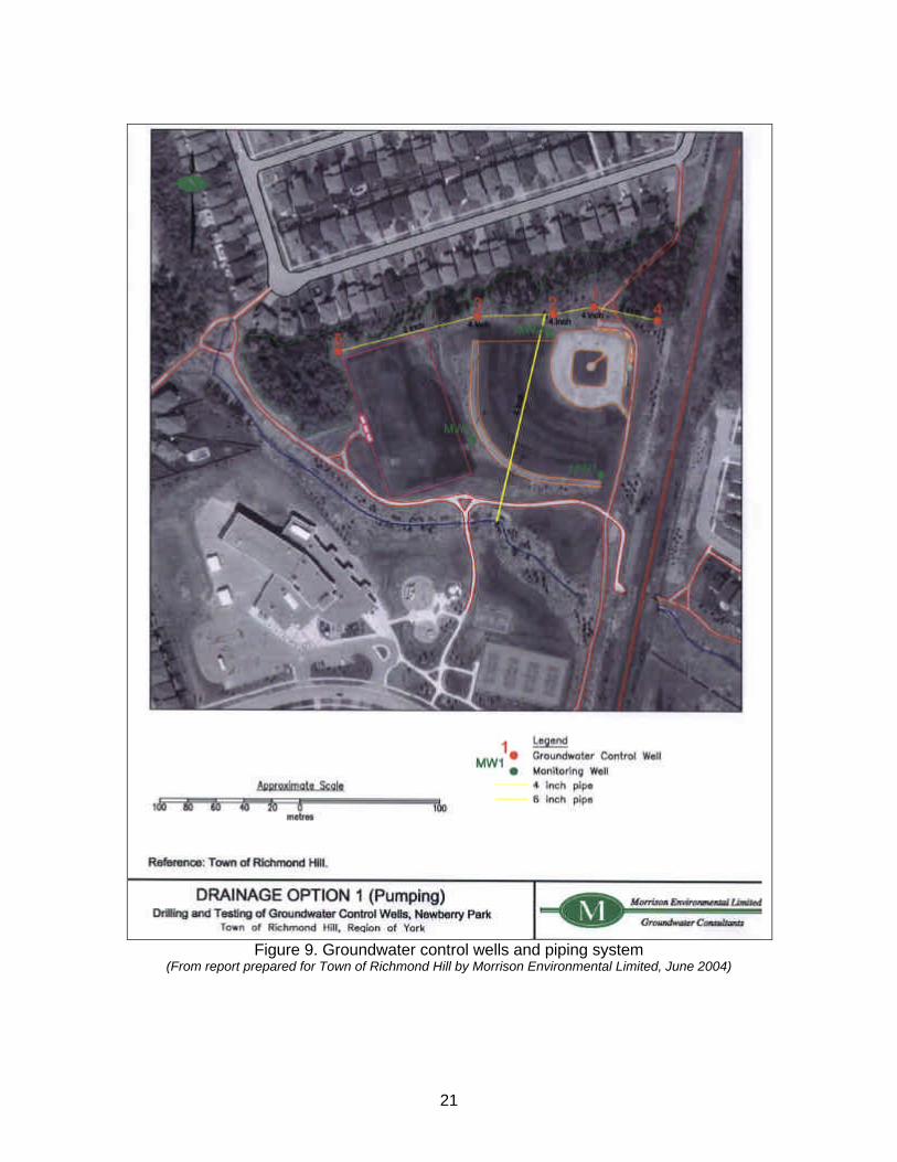
As is mentioned in section 3.1, the existing soccer and baseball fields would be rehabilitated into approximately 1 hectare of wetland habitat. This would serve to restore natural heritage and ecological features to the area, reconnect smaller previously fragmented wetlands, improve wildlife corridors, and increase wildlife habitat. Also, this option would involve the creation of a new headwater tributary that would flow through the wetland and discharge into Tributary B. This new tributary would be fed naturally by groundwater sources, and would serve to create viable cold water fish habitat. The resulting wetland would be a marsh and planted with marsh vegetation. The stream banks would be planted with native shrubs and, pockets of cedar trees would be planted in slightly elevated areas throughout the wetland. Figure 8 is a photograph showing an example of a constructed stream Furthermore, incorporated into the design would be boardwalks within the wetland and interpretive signage. This would provide wildlife viewing opportunities and an educational component.
3.3 “Do Nothing” (Null) Alternative
This option would see the Newberry Park fields remain unchanged. The groundwater seepage conditions would continue to render the soccer and baseball fields unusable. The infrastructure (light standards, benches) would be removed and the park would be left to regenerate on its own. This would lead to an ecologically poor vegetation community as a result of an influx of invasive species.
19
There would be no improvement to water quality, fish habitat, or fish productivity within Tributary B. In addition to this, continued unauthorized use of the fields would result in ongoing safety concerns such as uneven ground surfaces, sink holes, and hazardous trail conditions. Therefore, this option should be evaluated in terms of social, economical and environmental effects.
3.4 Pumping of Groundwater Control Wells
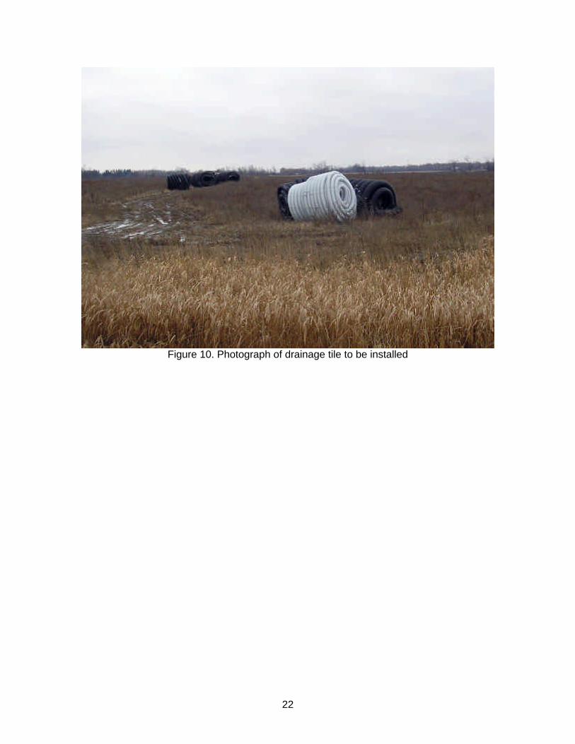
This alternative requires the continuous pumping of five groundwater control wells located throughout the soccer and baseball fields. This will lower the groundwater table and reduce the seepage conditions on the fields thus, making them usable for their intended purpose. Following the results of a study conducted by Morrison Environmental Limited (2004), the recommended groundwater control system is to install submersible pumps in each of the five wells and connect those pumps to an automatically controlled electric clock. The wells would then be pumped on a five day sequence whereby, three wells would be pumped per day in different combinations over the five day period and then the cycle would repeat. In this sequence, each well would pump for three days and rest for two. Figure 9 illustrates the locations of the groundwater control wells and piping system previously installed by Morrison Environmental Limited.
3.5 Installing Drain Tiles
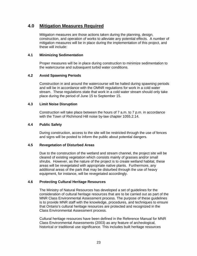
This alternative involves the installation of a series of drain tiles (or pipes) under the fields in order to collect and drain excess water. This water would then be deposited into nearby Tributary B. Figure 10 is a photograph of drainage tile to be installed.
3.6 Creating an Aquitard
This alternative would involve the import of a non-permeable clay material. The fields would be filled with clay to create a cap or aquitard, thus preventing the passage of water to the surface. However, this option would also reduce infiltration capacity, and overall flood retention.
20
Figure 7. Photograph showing an example of a restored wetland
Figure 8. Photograph showing an example of a constructed stream
21
Figure 9. Groundwater control wells and piping system
(From report prepared for Town of Richmond Hill by Morrison Environmental Limited, June 2004)
22
Figure 10. Photograph of drainage tile to be installed
23
4.0 Mitigation Measures Required
Mitigation measures are those actions taken during the planning, design, construction, and operation of works to alleviate any potential effects. A number of mitigation measures will be in place during the implementation of this project, and these will include:
4.1 Minimizing Sedimentation
Proper measures will be in place during construction to minimize sedimentation to the watercourse and subsequent turbid water conditions.
4.2 Avoid Spawning Periods
Construction in and around the watercourse will be halted during spawning periods and will be in accordance with the OMNR regulations for work in a cold water stream. These regulations state that work in a cold water stream should only take place during the period of June 15 to September 15.
4.3 Limit Noise Disruption
Construction will take place between the hours of 7 a.m. to 7 p.m. in accordance with the Town of Richmond Hill noise by-law chapter 1055.2.14.
4.4 Public Safety
During construction, access to the site will be restricted through the use of fences and signs will be posted to inform the public about potential dangers.
4.5 Revegetation of Disturbed Areas
Due to the construction of the wetland and stream channel, the project site will be cleared of existing vegetation which consists mainly of grasses and/or small shrubs. However, as the nature of the project is to create wetland habitat, these areas will be revegetated with appropriate native plants. Furthermore, any additional areas of the park that may be disturbed through the use of heavy equipment, for instance, will be revegetated accordingly.
4.6 Protecting Cultural Heritage Resources The Ministry of Natural Resources has developed a set of guidelines for the
consideration of cultural heritage resources that are to be carried out as part of the MNR Class Environmental Assessment process. The purpose of these guidelines is to provide MNR staff with the knowledge, procedures, and techniques to ensure that Ontario’s cultural heritage resources are protected and recognized in the Class Environmental Assessment process. Cultural heritage resources have been defined in the Reference Manual for MNR Class Environmental Assessments (2003) as any feature of archeological, historical or traditional use significance. This includes built heritage resources
24
such as buildings or structures which are important to the community, and cultural heritage landscapes which are areas valued by the community that are of significance to the understanding of the history of a people or place.
Under these guidelines, projects are screened as to their potential to affect cultural heritage resources. The project is first screened for known cultural heritage resources that are already registered, designated, or identified. If there are no known cultural heritage resources, the project area will be screened for the potential for discovery of cultural heritage resources. Where the area is found to have known cultural heritage resources or a high potential for discovering such resources, the project will undergo a cultural heritage assessment by a qualified professional who will then confirm the existence of cultural heritage resources, determine their significance, assess the vulnerability of these resources to the proposed project, and recommend mitigation measures. Based on these findings, the project may either proceed, proceed with conditions, or be rejected. Where the area is found to have low or no cultural heritage potential, the project is approved, possibly with cautionary conditions.
Where there is any potential for discovery of cultural heritage resources, a monitoring plan will be developed and carried out during the implementation phase of the project. This will involve the presence of a qualified archeologist on site to evaluate the effectiveness of mitigation measures. Furthermore, if cultural heritage resources are discovered during grading for example, the archeologist will ensure that the resource is adequately assessed and protected. The project site is located in an area which has been highly disturbed through previous development. Therefore, there are no anticipated effects to cultural heritage resources.
5.0 Supporting Watershed Objectives 5.1 Supporting Objectives
The Rouge River Fisheries Management Plan (1992) was developed under the context of provincial fisheries management plans and the Strategic Plan for Ontario Fisheries II (SPOF II). The goal of SPOF II is to achieve: “Healthy aquatic ecosystems that provide sustainable benefits, contributing to society’s present and future requirements for a high quality environment, wholesome food, employment and income, recreational activity and cultural heritage.” The long term objective for the Rouge River watershed as identified in the RRFMP is to:
“Protect, rehabilitate and enhance the Rouge River watershed so that it will support healthy, self-sustaining fish populations consisting of cold and warmwater fish communities, where appropriate.”

25
Within the RRFMP, the watershed has been divided into seven management zones that correspond to sub-drainage basins. The project site is located within the Upper Rouge River which is classified as Management Zone 1. Management Zone 1 has been further divided into two Sub-Zones 1A and 1B with the project site located in Sub-Zone 1A. The indicator species selected for Management Sub-Zone 1A is brook trout and therefore, should be managed for all life stages of the brook trout. Also, the project site is located in an area that has been identified by the RRFMP as a cold water production zone. The long term management goal of Sub-Zone 1A is to focus rehabilitation activities to barrier removal and channel re-naturalization. “Channel re-naturalization activities must include re-creation of channel form, enhancement of instream diversity, removal of barriers and planting of woody vegetation to the stream edge.” This project will also assist in the restoration goals under the Canada-Ontario Agreement through the rehabilitation of aquatic and riparian habitat leading to the reestablishment of fish and wildlife populations. Furthermore, this project will assist in reaching the goals of the Metro Toronto Remedial Action Plan, specifically goals 2b and 2c as outlined in the RAP Stage 2 Document “Clean Water, Clear Choices”. These goals are as follows: “Opportunities to sustain and create fish and wildlife habitat throughout the Metro Toronto and Region watersheds should be pursued in parallel with water quality initiatives.” ;
and “Within the waterfront, watershed and headwaters, protection of the remaining wetlands should be a primary concern. A priority for any development or remedial measure should be, where possible, to avoid effects on existing wetlands, and where possible to provide increases in wetland habitat.” The project will help achieve these goals by working towards the recommended actions outlined in the RAP, particularly Action 21: Protect and Restore Fish and Wildlife Habitat. These recommendations are as follows: “The RAP further recommends that degraded habitat be enhanced. Streams should have sufficient shading using appropriate native plant species. Renaturalization of streams and parkland should be encouraged.” ;
and “The RAP further recommends the creation of new fish and wildlife habitat…including wetlands, riparian habitat and fish reefs.”
26
5.2 Permits Required
Before beginning any instream/wetland construction work, regulatory approvals may need to be obtained from OMNR, TRCA, Town of Richmond Hill and the Department of Fisheries and Oceans.
6.0 Project Category
Based on the results of the screening criteria (Appendix A), the project was determined to be Category “C” as defined in the MNR Class Environmental Assessments Reference Manual for Resource Stewardship and Facility Development Projects (2003). The rationale for assigning a Category “C” to the proposed project, as identified in the MNR Class Environmental Assessments Reference Manual for Resource Stewardship and Facility Development Projects (2003) are as follows: (i) The appropriate type of management direction is in place for the project, but
does not fully define the project, or the plan suggests that alternatives should be considered or additional evaluation be carried out.
(ii) Effects require mitigation techniques tailored to the project. (iii) Consultation and consideration of the proposal and reasonable alternatives
may reveal appropriate solutions and common understandings. (iv) Potential to reduce net negative effects or increase public understanding by
examining alternatives.
27
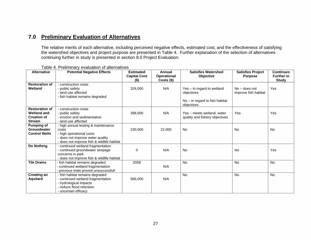
7.0 Preliminary Evaluation of Alternatives The relative merits of each alternative, including perceived negative effects, estimated cost, and the effectiveness of satisfying the watershed objectives and project purpose are presented in Table 4. Further explanation of the selection of alternatives continuing further in study is presented in section 8.0 Project Evaluation.
Table 4. Preliminary evaluation of alternatives Alternative Potential Negative Effects Estimated
Capital Cost ($)
Annual Operational
Costs ($)
Satisfies Watershed Objective
Satisfies Project Purpose
Continues Further in
Study Restoration of Wetland
- construction noise - public safety - land use affected - fish habitat remains degraded
326,000
N/A
Yes – in regard to wetland objectives No – in regard to fish habitat objectives
No – does not improve fish habitat
Yes
Restoration of Wetland and Creation of Stream
- construction noise - public safety - erosion and sedimentation - land use affected
398,000
N/A
Yes – meets wetland, water quality and fishery objectives
Yes
Yes
Pumping of Groundwater Control Wells
- high annual testing & maintenance costs - high operational costs - does not improve water quality - does not improve fish & wildlife habitat
230,000
22,000
No
No
No
Do Nothing - continued wetland fragmentation - continued groundwater seepage concerns in park - does not improve fish & wildlife habitat
0
N/A
No
No
Yes
Tile Drains - fish habitat remains degraded - continued wetland fragmentation - previous trials proved unsuccessfull
2058 N/A
No No No
Creating an Aquitard
- fish habitat remains degraded - continued wetland fragmentation - hydrological impacts - reduce flood retention - uncertain efficacy
566,000
N/A
No No No
28
8.0 Project Evaluation
Refer to section 7.0 Preliminary Evaluation of Alternatives. The following alternatives have been selected for further study: 1) Restoration of Wetland
This alternative partially satisfies the watershed objective by restoring and increasing wetland habitat within the watershed. It will connect formerly fragmented wetlands and increase overall wildlife habitat. However, there will be no improvement to fish habitat conditions within Tributary B. Therefore, this option does not satisfy the watershed fisheries objectives of renaturalizing the stream channel with the overall goal of rehabilitating the Rouge River watershed to support self-sustaining fish populations. Similarly, this alternative partially satisfies the project purpose by increasing overall wetland habitat within the Rouge River headwaters and reconnecting fragmented wetlands. However, this alternative will not improve fish habitat conditions.
2) Restoration of Wetland and Creation of Stream
This alternative satisfies both the watershed objectives and project purpose. Restoration of wetland habitat will increase overall wetland area, reconnect fragmented wetlands and increase wildlife habitat. Creating an additional headwater stream will provide good quality spawning and nursery habitat for coldwater species such as brook trout.
3) “Do Nothing” (Null) Alternative
This alternative is selected for further study as a requirement of the Environmental Assessment process. It does not satisfy the watershed objectives or project purpose. There would be no improvement to water quality, no improvement to fish habitat, no increase in wetland area, and no increase in wildlife habitat. In addition, the existing small wetlands will remain fragmented and there would be no change to the existing groundwater seepage concerns within Newberry Park.
The following alternatives have been rejected for further study: 1) Pumping of Groundwater Control Wells
This alternative does not satisfy the project purpose or watershed objectives. In addition to this, there are very substantial operating costs associated with this type of groundwater control system. In order to restore the existing playing fields to a usable state, continuous pumping of the aquifer is expected. This would require a continuous supply of electrical power resulting in significant annual operational costs.
29
In addition to this, there will be high maintenance costs incurred with this alternative. Maintenance activities will include maintenance on the pumps and piping system, control of iron bacteria in the wells, and control of iron and/or calcium encrustation in the wells and pumps. Due to the iron-rich water in the area, it is to be expected that each well will need to be rehabilitated on a regular three year cycle. For example, it is reasonable to assume that in Year 1 two of the wells will need to be rehabilitated, in Year 2 two more wells will need to be rehabilitated, and in Year 3 the fifth well will need to be rehabilitated along with the three observation or monitoring wells (Morrison Environmental Limited, 2004). Overall, the costs associated with implementing this system would be $230,000.00 with an annual operating cost of $22,000.00 at minimum. In addition to this, the wells have a relatively short life expectancy and may require new wells to be installed or major maintenance of the system, which these costs do not include. Furthermore, continuous pumping of the groundwater would have potential negative effects to the aquifer and would alter flow dynamics in Tributary B. There may be effects to water levels, water temperatures, and subsequent impacts to the biological community. Therefore, this option would actually have impacts that are contrary to the objectives. The Town of Richmond Hill has determined that this option is not feasible and was rejected by Town Council in July 2004 due to the associated costs.
2) Tile Drains
This alternative does not satisfy the project purpose or watershed objectives. The Town of Richmond Hill has previously had a series of tile drains and French drains installed in attempt to drain water from the fields and make them usable for sports activities. However, these attempts have failed at effectively removing water from the fields. Therefore, this option has been rejected as it has already proved to be ineffective. 3) Creating an Aquitard
This alternative does not satisfy the project purpose or watershed objectives. Constructing a clay cap with a minimum depth of 1m to prevent the upward movement of water would require importing approximately 25,000 m3 of clay material. The estimated cost of importing this material is $566,000.00. This is strictly the cost for bringing the material to site. This figure does not include the cost of constructing the cap. In addition to the exorbitant costs, there is uncertainty that this option would effectively work at preventing the pooling of water on the playing fields. Furthermore, the site is designated as a floodwater storage facility. Filling the area with 25,000 m3 of clay will reduce the flood retention capacity. This could cause significant adverse effects to the surrounding communities in the event of a major storm.
30
Step 2 – Environmental Analysis 9.0 Environmental Concerns Associated with the Construction
of a Wetland - Grading and Channel Alteration 9.1 Potential Impacts to Water Quality The act of excavating and filling, and particularly the alteration of a watercourse
can have negative impacts to water quality. Water quality changes may include alteration of water temperature, reduction of dissolved oxygen, increased turbidity and sedimentation, and resuspension of dissolved solids and nutrients.
Effects such as sedimentation, turbidity, and the release of nutrients are generally
short-term and are a result of the excavation itself. Disturbing the soil profile can cause soils to become unstable and increase the risk of erosion and subsequent sedimentation and increased turbidity if those soils enter the water. Also, excavation can cause the immediate release of nutrients or other dissolved solids that may have been stabilized or buried in the soil profile. An alteration of the nutrient budget in a stream may cause increased plant growth and changes in the biological community.
Improper design of a channel can also influence water temperatures. For
instance, if a channel is built too wide or too shallow, the velocity of the water may decrease making the water more susceptible to daytime heating. This will cause an increase in the water temperature. Stream temperatures are also influenced by the vegetation surrounding them. The removal of vegetation during excavation and channel alteration may increase stream temperatures. However, this is short term for the duration of construction and can be easily mitigated.
9.2 Disruption of Fish and Wildlife Habitat Grading will result in the removal of vegetation. This could displace wildlife
species that may live in that particular area. Also, the noise generated by construction equipment could disturb wildlife in the vicinity and cause them to seek shelter elsewhere.
The alteration of a watercourse and any resulting impacts, such as sedimentation
or other water quality parameters, could disrupt fish habitat. Depending on the extent of the impact, fish may return to the area following construction or be permanently displaced.
9.3 Changes in Channel Morphology and Flow Dynamics Changes in channel morphology could ultimately alter the flow dynamics of the
watercourse. Any such change in flow dynamics could influence the pattern of erosion and deposition. Deepening and widening a channel reduces flow velocities which could lead to increased deposition of fine sediments. These effects can be mitigated through proper project design.
31
9.4 Natural and Cultural Heritage Features Any excavation work has the potential to affect natural and cultural heritage
features. These features could include important wildlife areas, historic features, or potential archaeological resources. However, this can be easily mitigated through proper project design and construction.
Disruption to archaeological resources is not expected to be an issue as this park
has been designed as a storm water storage facility and, as such, has undergone extensive excavation and fill during its construction.
9.5 Resource Use Conflicts The project site is located in a public park allowing free access to the area. The
creation of a wetland may attract an additional number of people to the park for various reasons such as wildlife viewing, education, and research.
On-site effects resulting from increased park use include: a) vandalism b) accumulation of litter c) disturbance of fish and wildlife d) trampling of the stream bed and/or vegetation e) risk to public safety f) increased use of trails/pathways Off-site effects resulting from increased park use include: a) increased traffic flow b) parking congestion 9.6 Noise Park patrons and local residents may be disturbed by noise resulting from the use
of equipment during construction. Local wildlife and fish populations may also be disturbed.
9.7 Degradation of Scenic Quality Degradation of the scenic quality of the local park may result from construction
activities such as land clearing, excavation, stockpiling of construction materials, erecting fences, and the accumulation of waste materials around the construction site.
However, the resulting naturalized wetland area could increase scenic quality and
potential wildlife viewing. 9.8 Dust Dust resulting from construction activities such as excavation and heavy
equipment moving over an area could be irritating to local residents and park patrons.
32
9.9 Public Safety
The introduction of a construction site into a public park could pose public safety risks. Children playing in the park may become curious and want to enter the construction area. Anyone entering into a construction site, who is not informed or supervised, and where there are excavation activities and heavy equipment involved could be at risk of injury. Mitigation measures such as the use of construction fencing and signage should be in place to limit access and inform park patrons of the risk. The formation of ice within the wetland is also a potential public safety hazard. A wetland containing a significant area of open water will subsequently freeze over during the winter and appear like a safe area for skating. However, due to the extent of the groundwater upwelling at this site, the ice may not get thick enough to be safe. In order to mitigate this concern, the wetland will be designed to avoid these large areas of open water. Also, signs will be posted in the winter to advise park patrons of potentially unsafe ice conditions.
9.10 Hydraulic Impacts
A hydraulic analysis of the existing conditions at Newberry Park as well as for the proposed wetland alternatives was completed by consulting engineers Totten Sims Hubicki Associates. The purpose of the analysis was to determine the impact, if any, of implementing either of the two wetland options. Particularly, impacts to water levels in Tributary B, both upstream and downstream were examined to determine if hydraulic impacts would result from land grading associated with wetland construction. The existing conditions were used as a basis for comparison with the proposed wetland options. The results of this hydraulic analysis indicate that there would be no significant impact to water levels in Tributary B should either of the two wetland options be implemented. Please see Appendix C for the full hydraulic analysis report.
10.0 Environmental Checklist
The definition of each category has been derived from the Reference Manual for MNR Class Environmental Assessments (2003). For each identified concern, one of the following levels of significance will be assigned and entered into the appropriate category in the checklist.
High A “high” net effect may reflect a high level of certainty that a significant effect will occur, or a low level of certainty about one or more effects and a need for further evaluation and exploration of mitigation measures. One or more “high” negative net effects may result in a decision to seek other ways of resolving a problem or meeting program objectives.
Medium
33
A “medium” net effect may be based on reasonable certainty, and may be significant in combination with other medium and high net effects.
Low A “low” net effect would be assigned where there is a high degree of certainty as to the effect, and where the effect has minimal significance.
Nil A “nil” effect would be assigned where a criterion clearly does not apply.
Unknown An “unknown” designation would be assigned where the effects are unknown.
A negative net effect refers to a change to the environment so as to seriously disturb the integrity, distribution, operation or abundance of the environmental component as a result of implementing the project.
11.0 Determination of Significance of Effects
The significance of effects for each alternative are presented in Table 5. The Environmental Screening Criteria from the Reference Manual for MNR Class Environmental Assessments (2003) has been used to determine the significance of effects for each of the alternatives listed. As a matter of clarity, each of the criteria should be prefaced with the phrase: “This project has the potential to effect…”.
12.0 Environmental Analysis Summary
An environmental analysis summary has been completed for each selected alternative. The analysis is based on the Environmental Screening Criteria outlined in the Reference Manual for MNR Class Environmental Assessments (2003). The following information will be included in each analysis summary:
1. An estimation of the effectiveness of the alternative to meet its intended
purpose; 2. An identification of the environmental effects and their estimated
significance; 3. An indication of the potential for mitigation of the environmental effects; 4. An estimation of the cost and feasibility of carrying out the alternative; 5. The monitoring requirements associated with the alternatives.
34
13.0 Environmental Analysis 13.1 Restoration of Wetland Effectiveness of Alternative to Meet Intended Purpose:
This alternative partially meets the project purpose and watershed objectives. Restoring wetland habitat will satisfy the project objectives to increase the overall wetland habitat in the Rouge River headwaters and reconnect smaller fragmented wetlands. However, this alternative will not improve the fish habitat conditions in Tributary B. This alternative will work towards meeting the RAP goal of increasing and improving wetland habitat. However, this option will not assist in the watershed restoration goals outlined in the RRFMP (1992) to “rehabilitate and enhance the Rouge River watershed so that it will support healthy, self sustaining fish populations…”. Environmental Effects and Significance: There are few negative effects that may occur as a result of constructing a wetland in Newberry Park. These effects are considered minor as they are limited to the construction phase and are therefore temporary in nature. Negative effects to noise and aesthetics are classified as having low significance as they are temporary and a result of the construction. Furthermore, following the completion of the wetland, a positive impact to aesthetics may ensue as a result of introducing native vegetation and improving wildlife habitat. A negative effect of erosion, as indicated in Table 5, refers to the soil erosion that could occur if the area were not revegetated. Bare soils are more susceptible to wind erosion and/or rainfall erosion. Unstable soils could then be washed into the nearby stream causing sedimentation. However, this effect is considered of low significance as the area will be adequately revegetated following construction in order to stabilize the soils and provide habitat. Furthermore, proper erosion control measures will be in place during construction. Also important to note is the potential to create a negative impact through the release of contaminants in soils during excavation. However, previous soil testing has determined that there are no significant contaminant levels in the soils and therefore, this is classified in Table 5 as having no significance. Additional negative effects are in regard to displacing people or public facilities as seen in Table 5. This refers to limiting access to the immediate site during construction and interfering with the use of trails. Therefore, this impact is seen as having low significance due to the temporary nature of the effect. There would be no significant effect resulting from the displacement of the playing fields as the Town of Richmond Hill has indicated that the fields are going to be removed due to safety concerns.
35
Furthermore, negative effects to public health and/or safety may result from the construction phase. Introducing a construction site into a public park, where there will be excavation activities and heavy equipment on site, inherently poses public safety risks. There is a potential for injury to members of the public who enter the site. Also, there is potential for injury to the construction crew and equipment operator if they are not properly trained. However, these effects to public health and/or safety are considered of low significance as mitigation measures will be implemented to address these issues. An additional safety issue could be created when large areas of open water within a wetland freeze over during the winter. The groundwater upwelling at this site could potentially create unsafe ice conditions. However, this public safety hazard can be mitigated by reducing the amount of open water within the wetland and by posting signs to warn of this danger. Conversely, in its current state, the playing fields in Newberry Park still attract unpermitted use. This causes a public safety concern due to the flooding and unstable ground conditions throughout the fields. The flooding on the trail system also results in dangerous slipping hazards. Converting this area to wetland will address both of these safety issues and result in a positive benefit. There are a number of positive benefits expected as a result of the restoration of a wetland in Newberry Park. These include benefits to water quality, wildlife habitat, vegetation linkages and wildlife corridors, and overall improvement of ecological integrity. The proposed wetland at Newberry Park will be a marsh type wetland with open water for at least part of the year and marsh vegetation throughout. Wetlands, particularly marshes, are very effective at purifying our water resources. They naturally filter the water by absorbing and transforming excess nutrients and contaminants. The main benefits to water quality as a result of this type of wetland system will be direct improvements to the quality of water that has entered the wetland, mainly overland flow and precipitation. Furthermore, Table 5 indicates a positive benefit to “lands subject to natural or human made hazards”. This refers to the fact that Newberry Park was designed to function as a storm water storage facility in the event of a major storm. Restoring the wetland here may improve this function as it will serve to absorb and slow the flow of flood waters, reducing potential damage to surrounding communities. Restoring the wetland will also help restore natural heritage features to the area as the site was historically part of a larger wetland complex. This will benefit the overall ecological integrity of the area by creating and enhancing wildlife habitat such as breeding grounds and wintering habitat for birds, amphibians, and mammals. There will also be improvements to wildlife corridors and natural vegetation linkages by reconnecting fragmented wetlands. A wetland may also improve the recreational potential, and add to community character and enjoyment of the park. In its current state, a large portion of Newberry Park, encompassing the soccer and baseball fields is out of commission. Constructing a wetland with the addition of boardwalks will create
36
wildlife viewing opportunities as well as add to the overall enjoyment of the park. This will also lead to the creation of educational opportunities for both the public and for nearby schools. Mitigation Measures Required: Mitigation of potential negative effects will be achieved through:
a) Restricting construction activities to between the hours of 7 a.m. and 7 p.m. in order to minimize disturbance to nearby residents and to comply with the Town of Richmond Hill by-law chapter 1055.2.14;
b) Limiting access to the construction site through the use of safety fences and posting public notices to advise park patrons of the risk;
c) Ensuring work crew and equipment operator are properly trained and adhering to appropriate safety measures;
d) Limit the area of open water to reduce the potential for hazardous ice conditions and post signs in the winter to advise public of the risk;
e) Using standard erosion control practices during construction; f) Revegetation of any areas that have been disturbed during
construction;
Estimated Cost and Feasibility: The estimated cost to construct a wetland at Newberry Park is approximately $326,000 including the planting of native plants. Due to the existing conditions at the site, it is very feasible that a wetland can be successfully restored at this location. Monitoring Requirements: Monitoring of the vegetation will take place to determine initial success of the planted material and additional planting will be done as needed. Photo-monitoring of the vegetation will be conducted over a 3 year period following completion of the wetland in order to determine the rate of progress. Wildlife monitoring will include amphibian monitoring using the Marsh Monitoring Protocol and the use of “Frog Loggers” which record frog calls over a defined period of time. This will be done over a 3 year period also, to monitor progress. In addition to this, any wildlife observed within the wetland during visits will be recorded.
13.2 Restoration of Wetland and Creation of Stream Effectiveness of Alternative to Meet Intended Purpose:
This alternative effectively meets both the project purpose and watershed objectives. Restoring the area to wetland will satisfy the project objectives by increasing the overall wetland habitat in the Rouge River headwaters and reconnecting smaller fragmented wetlands. Creating a stream channel through the wetland will maximize the benefits to water quality and also facilitate improvements to fish habitat in the stream.
37
This alternative will also effectively work towards meeting the watershed objectives outlined in the RRFMP (1992) to enhance the Rouge River watershed to support healthy, self sustaining fish populations. Furthermore, this option will work towards meeting the Metro Toronto RAP goals 2b and 2c by creating fish and wildlife habitat and increasing and improving wetland habitat. Environmental Effects and Significance: There are few potential negative effects that may occur as a result of constructing a wetland and diverting the stream channel. These potential effects are limited to the construction phase and are therefore considered relatively minor. Firstly, Table 5 identifies a potential negative impact resulting from noise. This noise is temporary and a result of the construction. For this reason the effect is considered of low significance. Similarly, negative effects in relation to aesthetics are considered of low significance. The aesthetic value of the park may be temporarily compromised during the construction however; creating wetland habitat may ultimately result in a positive impact following its completion. Table 5 identifies negative effects in relation to displacing people or public facilities. This impact may be twofold. Firstly, during construction, access to the immediate project site will be limited and the use of some trails will be temporarily affected. Also, restoring a wetland at the site will result in the removal of the existing soccer and baseball fields. However, this effect is considered to be of no significance as the current playing fields are considered retired and will be removed by the Town of Richmond Hill due to safety concerns. Furthermore, negative effects to public health and/or safety may result from the construction phase. Introducing a construction site into a public park, where there will be excavation activities and heavy equipment on site, inherently poses public safety risks. There is a potential for injury to members of the public who enter the site, and there is potential for injury to the construction crew and equipment operator if they are not properly trained. However, these effects to public health and/or safety are considered of low significance as mitigation measures will be implemented to address these issues. An additional safety issue could be created when large areas of open water within a wetland freeze over during the winter. The groundwater upwelling at this site could potentially create unsafe ice conditions. However, this public safety hazard can be mitigated by reducing the amount of open water within the wetland and by posting signs to warn of this danger. Conversely, in its current state, the playing fields in Newberry Park still attract unpermitted use. This causes a public safety concern due to the flooding and unstable ground conditions throughout the fields. The flooding on the trail system also results in dangerous slipping hazards. Converting this area to wetland will address both of these safety issues and result in a positive benefit.
38
Potential negative effects of erosion and sedimentation may result from unstable bare soil conditions during construction. Bare soils are more susceptible to wind erosion and/or rainfall erosion. These unstable soils could then be washed into the nearby stream causing sedimentation. Also, when working in and around flowing streams there is a potential for unstable stream banks to erode causing sedimentation issues to arise. However, these effects are temporary and considered of low significance as proper erosion control measures will be implemented during construction. Furthermore, the area will be adequately revegetated following construction in order to stabilize the soils and provide habitat. Also important to note is the potential to create a negative impact through the release of contaminants in soils during excavation. However, previous soil testing has determined that there are no significant contaminant levels in the soils and therefore, this is classified in Table 5 as having no significance. There are a number of positive benefits anticipated as a result of restoring the wetland and creating a stream channel. These include benefits to water quality, fish and wildlife habitat, vegetation linkages and wildlife corridors, and overall improvement of ecological integrity. This alternative includes all the positive benefits identified for the previous alternative but also has added benefits to fish habitat. The restored wetland will filter excess nutrients, contaminants, and sediments from the water passing through the wetland. This will not only benefit the water quality on site in Tributary B but will also improve the water quality in the receiving waters downstream. In addition to this, creating a headwater stream channel within the wetland will improve fish habitat conditions and provide viable spawning and nursery habitat for coldwater fish species. Improving habitat conditions will improve instream diversity and fish productivity, potentially leading to increased fishing opportunities on site and downstream. Furthermore, the redside dace is known to inhabit downstream portions of Tributary B. Improving water quality and habitat conditions will benefit this species at risk. Table 5 indicates a positive benefit to “lands subject to natural or human made hazards”. This refers to the fact that Newberry Park was designed to function as a storm water storage facility in the event of a major storm. Restoring the wetland here would improve this function as it will serve to absorb and slow the flow of flood waters, reducing potential damage to surrounding communities. Restoration of the wetland will help restore natural heritage features to the area as the site was historically part of a larger wetland complex. This will benefit the overall ecological integrity of the area by creating and enhancing wildlife habitat such as breeding grounds and wintering habitat for birds, amphibians, and mammals. There will also be improvements to fish and wildlife corridors and natural vegetation linkages by reconnecting fragmented wetlands. A wetland may also improve the recreational potential, and add to community character and enjoyment of the park. In its current state, a large portion of
39
Newberry Park, encompassing the soccer and baseball fields is out of commission. Constructing a wetland with the addition of boardwalks will create wildlife viewing opportunities as well as add to the overall enjoyment of the park. This could also lead to the creation of educational opportunities for both the public and for nearby schools. Mitigation Measures Required: Mitigation of potential negative effects will be achieved through:
a) Restricting construction activities to between the hours of 7 a.m. and 7 p.m. in order to minimize disturbance to nearby residents and to comply with the Town of Richmond Hill by-law chapter 1055.2.14;
b) Limiting access to the construction site through the use of safety fences and posting public notices to advise park patrons of the risk;
c) Ensuring work crew and equipment operator are properly trained and adhering to appropriate safety measures;
d) Limit the area of open water to reduce the potential for hazardous ice conditions and post signs in the winter to advise public of the risk;
e) Using standard erosion control practices during construction; f) Revegetation of any areas that have been disturbed during
construction;
Estimated Cost and Feasibility: The estimated cost to construct a wetland and new headwater channel at Newberry Park is approximately $398,000. Due to the existing conditions, it is very feasible that a wetland and headwater tributary can be successfully built at this site. Although there is an additional cost of $72,000 to create a stream channel through the wetland, this option will result in benefits to fish habitat and help in meeting watershed goals. Monitoring Requirements: Monitoring of the vegetation will take place to determine initial success of the planted material and additional planting will be done as needed. Photo-monitoring of the vegetation will be conducted over a 3 year period following completion of the wetland in order to determine the rate of progress. Wildlife monitoring will include amphibian monitoring using the Marsh Monitoring Protocol and the use of “Frog Loggers” which record frog calls over a defined period of time. This will be done over a 3 year period also, to monitor progress. In addition to this, any wildlife observed within the wetland during visits will be recorded. Biological monitoring of the stream, including fish and benthic invertebrates, will also be conducted to determine changes in water quality and the biological community.
40
13.3 “Do Nothing” (Null) Alternative
Effectiveness of Alternative to Meet Intended Purpose: This alternative does not meet the project purpose or watershed objectives. There will be no improvement or increase in wetland habitat in the Rouge River headwaters, no improvement to water quality, and continued degradation of the stream channel and fish community within Tributary B. Environmental Effects and Significance: The identified effects are a result of the inability of this alternative to meet the goals and objectives of the Rouge River Fisheries Management Plan and the Metro Toronto Remedial Action Plan. If this alternative is chosen as the preferred alternative, there will be continued sedimentation of Tributary B and no improvement to water quality. As a result, there will be continued degradation of fish habitat, fish diversity, and loss of fish productivity. This lack of water quality and fish habitat improvements may also lead to continued degradation of redside dace populations. The present groundwater seepage and flooding problems experienced by the park would remain unchanged. The playing fields will remain unusable for their intended purpose resulting in a continued lack of recreational potential and inefficient use of park space. The unstable ground surfaces throughout the fields will continue to pose a public safety risk, and the trails near the playing fields will continue to experience flooding resulting in hazardous conditions. Additional negative effects of this alternative are in relation to a continued lack of wildlife habitat and continued lack of vegetation linkages and/or wildlife corridors as a result of the existing wetlands remaining fragmented. This can be summed up as a continued lack of overall ecological integrity. If the area is left to regenerate on its own, a potential negative effect would be the poor ecological quality of the vegetation community resulting from influx of invasive species. Mitigation Measures Required: N/A Estimated Cost and Feasibility: The estimated cost to implement this alternative would be zero capital expenses. However, this does not take into account the costs of continued lack of fish and wildlife habitat, degradation of water quality and the costs associated with lost recreational potential. Monitoring Requirements: N/A
41
Table 5. Significance of effects for each alternative. Level of Significance High
(-ve) Medium
(-ve) Low (-ve)
Nil Unknown Positive
Criteria Restoration of
Wetland
Restoration of Wetland & Creation
of Stream
“Do Nothing”
Natural Environment: 1. air quality
2. water quality and/or quantity
3. species at risk or their habitat
4. significant earth or life science features
5. fish or other aquatic species and habitat
6. lands subject to natural or human made hazards
7. recovery of a species under special management program
8. ecological integrity
9. terrestrial wildlife
10. natural vegetation and terrestrial linkages
11. permafrost
12. soils and sediment quality
13. drainage or flooding

42
Table 5 (cont.) Significance of effects for each alternative. Level of Significance High
(-ve) Medium
(-ve) Low (-ve)
Nil Unknown Positive
Criteria Restoration of
Wetland
Restoration of Wetland & Creation
of Stream
“Do Nothing”
Natural Environment cont: 14. sedimentation or erosion
15. release of contaminants in soils, sediments
16. natural heritage features
Land Use, Resource Management:
1. access to trails or inaccessible areas
2. obstruct navigation
3. other resource management projects
4. traffic patterns or infrastructure
5. recreational importance – public or private
6. create excessive waste materials
7. commit a significant amount of a non-renewable resource
8. noise levels
9. views or aesthetics
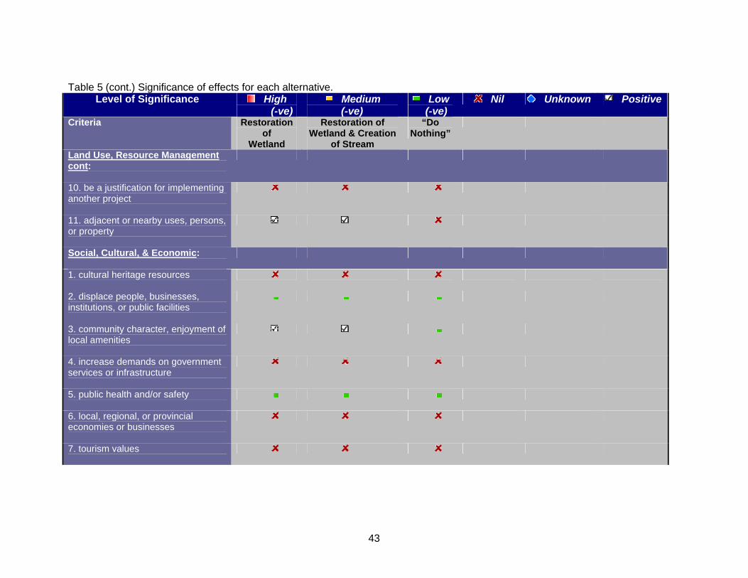
43
Table 5 (cont.) Significance of effects for each alternative. Level of Significance High
(-ve) Medium
(-ve) Low (-ve)
Nil Unknown Positive
Criteria Restoration of
Wetland
Restoration of Wetland & Creation
of Stream
“Do Nothing”
Land Use, Resource Management cont:
10. be a justification for implementing another project
11. adjacent or nearby uses, persons, or property
Social, Cultural, & Economic:
1. cultural heritage resources
2. displace people, businesses, institutions, or public facilities
3. community character, enjoyment of local amenities
4. increase demands on government services or infrastructure
5. public health and/or safety
6. local, regional, or provincial economies or businesses
7. tourism values
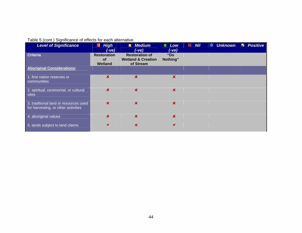
44
Table 5 (cont.) Significance of effects for each alternative.
Level of Significance High (-ve)
Medium (-ve)
Low (-ve)
Nil Unknown Positive
Criteria Restoration of
Wetland
Restoration of Wetland & Creation
of Stream
“Do Nothing”
Aboriginal Considerations:
1. first nation reserves or communities
2. spiritual, ceremonial, or cultural sites
3. traditional land or resources used for harvesting, or other activities
4. aboriginal values
5. lands subject to land claims
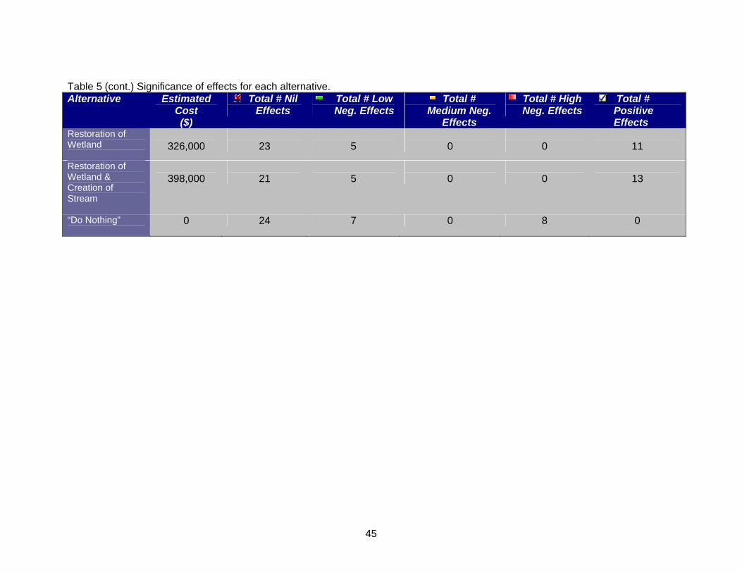
45
Table 5 (cont.) Significance of effects for each alternative. Alternative Estimated
Cost ($)
Total # Nil Effects
Total # Low Neg. Effects
Total # Medium Neg.
Effects
Total # High Neg. Effects
Total # Positive Effects
Restoration of Wetland
326,000
23
5
0
0
11
Restoration of Wetland & Creation of Stream
398,000
21
5
0
0
13
“Do Nothing”
0 24 7 0 8 0
46
Step 3 - Public Consultation Process & Selection of Preferred Alternative 14.0 Opportunity to Inspect the Draft ESR & Public Information Centre A Notice of Opportunity to Inspect the Draft Environmental Study Report was advertised in The Liberal, a local Richmond Hill newspaper, on April 17, 2007. Within this notice was also an invitation to attend a Public Information Centre on April 25, 2007. The notice was also sent to known government and non- government agencies, as well as 485 local residents. There was a 30-day comment period whereby interested parties were invited to comment on the Draft ESR. The deadline for receiving comments was May 17, 2007. The public open house was held at Richmond Green Sports Centre Lounge on April 25, 2007. The open house displayed poster boards depicting artist’s rendering of each option as well as the survey plan, context map, photographs of previous wetland restoration projects, and cross-sections of the wetland features. Also available at the open house were copies of the Draft Environmental Study Report. Representatives from Ontario Streams, Town of Richmond Hill and Harrington & Hoyle Landscape Architects were in attendance to answer questions. Refer to Appendix D for the artist’s rendering of Option 1 and 2 as presented at the Public Information Centre. Comment sheets were provided at the open house for residents to make comments on the proposed project and indicate which alternative they prefer. A total of 12 residents attended the open house and comments were received back from 8. When asked which option was preferred; restoration of wetland, restoration of wetland and creation of stream, or “Do Nothing”, all preferred the option to restore the wetland and create a new tributary stream. There was some concern over the loss of organized sports facilities however, the majority of the comments were positive responses in regard to the incorporation of the educational component, and the benefits to local wildlife and overall biodiversity of the area. Refer to Appendix E for a copy of the advertisement, circulation list, and comments received. 15.0 Evaluation of Alternatives 15.1 Evaluation of Alternatives and Project Selection Process The selection of preferred alternatives takes into account the evaluation of potential
environmental effects, mitigation measures, feasibility, effectiveness in meeting the project goals and objectives, cost, and issues raised during public and agency consultation. It is important to note that not all identified effects are considered
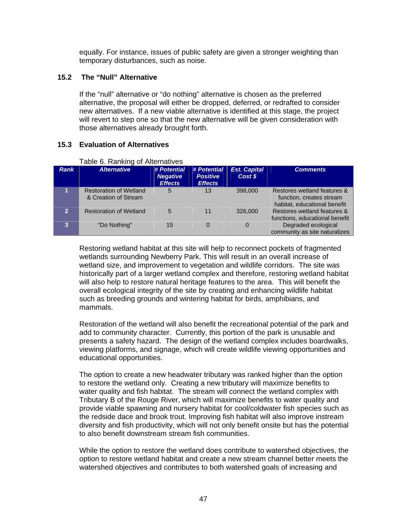
47
equally. For instance, issues of public safety are given a stronger weighting than temporary disturbances, such as noise.
15.2 The “Null” Alternative If the “null” alternative or “do nothing” alternative is chosen as the preferred
alternative, the proposal will either be dropped, deferred, or redrafted to consider new alternatives. If a new viable alternative is identified at this stage, the project will revert to step one so that the new alternative will be given consideration with those alternatives already brought forth.
15.3 Evaluation of Alternatives Table 6. Ranking of Alternatives Rank Alternative # Potential
Negative Effects
# Potential Positive Effects
Est. Capital Cost $
Comments
1 Restoration of Wetland & Creation of Stream
5 13 398,000 Restores wetland features & function, creates stream
habitat, educational benefit 2 Restoration of Wetland 5 11 326,000 Restores wetland features &
functions, educational benefit 3 “Do Nothing” 15 0 0 Degraded ecological
community as site naturalizes
Restoring wetland habitat at this site will help to reconnect pockets of fragmented wetlands surrounding Newberry Park. This will result in an overall increase of wetland size, and improvement to vegetation and wildlife corridors. The site was historically part of a larger wetland complex and therefore, restoring wetland habitat will also help to restore natural heritage features to the area. This will benefit the overall ecological integrity of the site by creating and enhancing wildlife habitat such as breeding grounds and wintering habitat for birds, amphibians, and mammals. Restoration of the wetland will also benefit the recreational potential of the park and add to community character. Currently, this portion of the park is unusable and presents a safety hazard. The design of the wetland complex includes boardwalks, viewing platforms, and signage, which will create wildlife viewing opportunities and educational opportunities. The option to create a new headwater tributary was ranked higher than the option to restore the wetland only. Creating a new tributary will maximize benefits to water quality and fish habitat. The stream will connect the wetland complex with Tributary B of the Rouge River, which will maximize benefits to water quality and provide viable spawning and nursery habitat for cool/coldwater fish species such as the redside dace and brook trout. Improving fish habitat will also improve instream diversity and fish productivity, which will not only benefit onsite but has the potential to also benefit downstream stream fish communities. While the option to restore the wetland does contribute to watershed objectives, the option to restore wetland habitat and create a new stream channel better meets the watershed objectives and contributes to both watershed goals of increasing and
48
enhancing wetland area, and improving and creating fish habitat. In addition, this option better meets the project purpose by maximizing benefits to water quality and fish habitat.
16.0 Selection of Preferred Alternative The preferred alternative for Newberry Park is to restore the wetland and create a
new headwater tributary. This alternative has been chosen for the following reasons:
1) Reconnects fragmented wetlands to increase overall wetland area; 2) Improves/increases fish and wildlife habitat; 3) Improves wildlife and vegetation corridors; 4) Improves the overall ecological integrity; 5) Maximizes benefits to water quality; 6) Satisfies watershed objectives and project purpose. The following mitigation measures are recommended:
a) Restrict construction activities to between the hours of 7 a.m. and 7 p.m. in order to minimize disturbance to nearby residents and to comply with the Town of Richmond Hill by-law chapter 1055.2.14; b) Limit access to the construction site through the use of safety fences and post public notices to advise park patrons of the risk; c) Ensure work crew and equipment operator are properly trained and adhere to appropriate safety measures; d) Limit the area of open water to reduce the potential for hazardous ice conditions and post signs in the winter to advise public of the risk; e) Use standard erosion control practices during construction; f) Revegetate any areas that have been disturbed during construction.
Step 4 – Project Plan 17.0 Design Details
The constructed wetland will be comprised of four shallow open marsh cells. Each cell will be separated by berms but connected through spillways to facilitate and direct the movement of water between cells during times of overflow. The wetland area will be planted with marsh vegetation, and adjacent berms will be planted with shrubs for stability. Furthermore, a portion of the wetland complex will be reforested with cedar trees in order to restore that portion to cedar swamp. There are a number of habitat features which will be incorporated into the wetland in order to enhance wildlife habitat. These features include nesting stumps, sunning logs, basking rocks, and a snake hiburnaculum. These features will encourage wildlife such as frogs, turtles, snakes and birds to move into the area and thus enhance potential wildlife viewing opportunities and overall diversity of the wetland.
49
The design of the wetland also includes the creation of a new headwater tributary stream that will link the wetland with the existing Tributary B of the Rouge River. This will provide additional spawning and nursery habitat for cool/coldwater fish species. The project design also provides for educational opportunities. An observation deck in the centre of the wetland complex provides a vantage point to observe the wetland and its inhabitants. The observation deck will also contain interpretive signage to provide educational benefit. In addition, there will be another lookout point in the north east corner of the complex, as well as benches along the paths. A raised grassy section in the south east corner will provide an area of open space for general recreation activities such as picnicking, flying a kite etc. The final detailed design drawings will be stamped by a qualified Landscape Architect and Professional Engineer.
18.0 Construction 18.1 Construction of Wetland and Stream Channel Construction of the wetland and stream channel will be undertaken by qualified
contractors on behalf of the Town of Richmond Hill and Ontario Streams. Construction of the wetland will begin by fencing off the affected area of the park.
Sediment fences will be erected around the construction site of the outlet area for the new channel in order to protect the existing Tributary B from potential sedimentation.
With sediment fence in place, the new stream channel will be excavated and
contoured. Filter fabric will be laid along the bottom of the channel to reduce downcutting, and covered with rock to provide substrate. The banks will be seeded with grass to stabilize soils.
Wetland construction will be implemented using the balance cut and fill method and
therefore no material will be leaving the site. The site will be regraded to develop lower depressional areas which will become open water marsh, as well as raised areas for berms and other uses.
Once the site is regraded, the berms will be seeded with grass, and later planted
with shrubs to help stabilize the soils. Shrubs will also be planted along the banks of the stream channel to stabilize the soils, provide shade, and create habitat.
Upon completion of the regrading and once the soils are stabilized, water will be
flushed through the new stream channel until it runs clear of excess sediment. At that time the filter fabric will be removed from the confluence of the new channel with Tributary B and the new stream channel will be open.
50
18.2 Potential Environmental Effects Associated with Construction Potential environmental effects resulting from construction of the wetland and
stream channel include:
a) Erosion and sediment production b) Increased noise disturbance to nearby residents c) Reduced aesthetic value of construction site
d) Disturbance to park patrons e) Safety around construction site
18.3 Proposed Schedule of Construction Phase Construction of the wetland and stream channel will take approximately one month
with construction to start at the end of October or beginning of November 2007.
19.0 Operation and Maintenance
The wetland complex is designed to be self sustaining and therefore, is not expected to require regular maintenance. In the one or two years following completion of the wetland and stream, some maintenance may be required, however any maintenance is expected to be minimal and may include additional plantings to compensate for possible die offs during the initial year. Long term maintenance will be required for infrastructure within the park such as viewing platforms and pathways, as well as features such as bird boxes and signs. Maintenance to the newly created stream channel may include further stabilization of banks and clearing of debris or sediment, both in the channel or at the inlet/outlet for the channel. Operation and maintenance activities will be conducted on an “as needed” basis and will be the responsibility of the Town of Richmond Hill to undertake.
20.0 Abandonment N/A 21.0 Mitigation Measures
A number of mitigation measures will be in place during construction of the wetland and stream channel. These mitigation measures are as follows:
1) Restrict construction activities to between the hours of 7 a.m. and 7 p.m. in order to minimize disturbance to nearby residents and to comply with the Town of Richmond Hill by-law chapter 1055.2.14; 2) Limit access to the construction site through the use of safety fences and post public notices to advise park patrons of the risk;
51
3) Ensure work crew and equipment operator are properly trained and adhere to appropriate safety measures; 4) Limit the area of open water to reduce the potential for hazardous ice conditions and post signs in the winter to advise public of the risk; 5) Use standard erosion control practices during construction, including sediment fence to protect Tributary B while the new stream channel is constructed; 6) With sediment fence in place, flush new channel with water to remove excess sediment and ensure water is running clear prior to opening the outlet to Tributary B; 7) Revegetate any areas that have been disturbed during construction.
22.0 Assessment of Project to Meet Intended Purpose
Once completed, the restoration of wetland habitat in Newberry Park will assist in achieving the watershed goals of increasing overall wetland habitat in the Rouge River watershed, as well as creating and enhancing fish and wildlife habitat. Completion of the project will aid in reconnecting smaller fragmented wetlands resulting in an increase in overall wetland size and function. The project will benefit the overall ecological integrity of the site by creating and enhancing wildlife habitat such as breeding grounds and wintering habitat for birds, amphibians, reptiles, and mammals. Creation of the new stream channel will provide viable spawning and nursery habitat for fish species such as the redside dace and brook trout. Improving fish habitat will also improve instream diversity and fish productivity, which will not only benefit onsite but also has the potential to benefit downstream fish communities. Overall, completion of the wetland restoration project with the creation of a new stream channel in Newberry Park will achieve the intended project purpose of increasing overall wetland habitat, improving fish habitat conditions and maximizing benefits to water quality.
23.0 Monitoring
Monitoring activities will be carried out by Ontario Stream staff. The newly restored wetland will be monitored in terms of vegetation succession, wildlife usage, and fisheries impact. Visual inspection of the vegetation will be conducted to determine initial success of the planted material in the year following completion. Based on the results, additional planting will be completed as required. Photo monitoring of the vegetation will also be conducted over a 3 year period following completion of the project in order to determine the rate of succession. Wildlife monitoring will also be conducted over a 3 year period following completion of the wetland. Wildlife monitoring will include amphibian monitoring using the Marsh Monitoring Protocol and the use of “Frog Loggers”, which record frog calls over a given period of time. During each site visit, observational surveys of wildlife, including birds, will be recorded.

52
Biological monitoring of the stream channel will also be conducted over a 3 year period. This will include fisheries monitoring using a backpack electrofisher, as well as benthic invertebrate monitoring. This type of monitoring will also be done in Tributary B to assess any resulting impacts.
53
Bibliography Ducks Unlimited Canada. Accessed 2005. Wetland and Waterfowl Conservation: Values and Benefits of Wetland Habitats. http://www.ducks.ca/conserve/wetland_values/index.html. Downloaded October 19, 2005 Gabor, T.S. and A.K. North, L.C.M. Ross, H.R. Murkin, J.S. Anderson, M. Raven. 2004. Natural Values – The Importance of Wetlands and Upland Conservation Practices in Watershed Management: Functions and Values for Water Quality and Quantity. Ducks Unlimited Canada. Barrie, Ontario. Government of Alberta. 2004. Agricultural Impacts on Surface Water Quality in the Irrigated Areas of Alberta. Dept. of Agriculture, Food and Rural Development. http://www1.agric.gov.ab.ca/$department/deptdocs.nsf/all/irr4451?opendocument Mackie, G.L. 2001. Applied Ecosystem Concepts. Kendall/Hunt Publishing Company. Iowa. Metro Toronto and Region Remedial Action Plan. Clean Waters, Clear Choices. Recommendations for Action. Mitsch, W.J. and J.G. Gosselink. 2000. Wetlands. Third Edition. John Wiley and Sons Inc. New York, NY. Morrison Environmental Ltd. 2004. Drilling and Testing of Groundwater Control Wells, Newberry Park. Morrison Environmental Ltd. Mississauga, Ontario. National Wetlands Working Group. 1997. The Canadian Wetlands Classification System. Second Edition. Edited by B.G. Warner and C.D.A. Rubec. Wetlands Research Centre, University of Waterloo. Waterloo, Ontario. Ontario Ministry of Natural Resources and Toronto and Region Conservation Authority. 1992. Rouge River Fisheries Management Plan. Ontario Ministry of Natural Resources. 2002. Provincially Significant Rouge River Headwater Wetland Complex. OMNR, Aurora District. Ontario Ministry of Natural Resources. 2003. A Class Environmental Assessment for MNR Resource Stewardship and Facility Development Projects. Queen’s Printer for Ontario. Pries, J.H. 1994. Wasterwater and Stormwater Applications of Wetlands in Canada. Sustaining Wetlands Issues Paper, No. 1994-1. North American Wetlands Conservation Council Canada. Ottawa, Ontario. Trow Associates Inc. 2005. Geotechnical Investigation: Proposed Wetland Habitat, Newberry Park, Bernard Ave., Richmond Hill. Ontario. Trow Associates Inc. Markham, Ontario.
Appendix D Artist’s rendering of Option 1 and 2 as presented at the Public
Information Centre