Newport Resilience Tour Technical Report #2 1
Newport Resilience Assessment Tour:
Newport Waterfront Overview Summary
Coastal Resources Center/Rhode Island Sea Grant
Graduate School of Oceanography, University of Rhode Island
March 2015
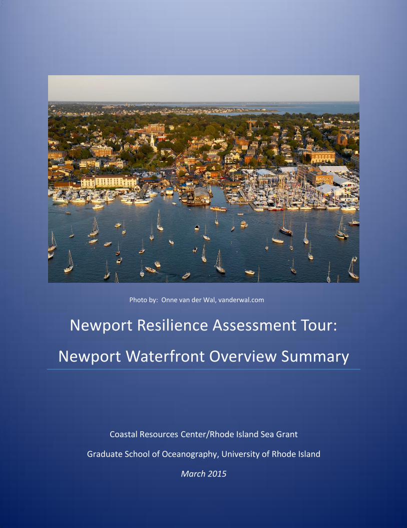
Photo by: Onne van der Wal, vanderwal.com
Newport Resilience Tour Technical Report #2 2
Participants
Teresa Crean, University of Rhode Island Coastal Resources Center / RI Sea Grant
Monica Allard Cox, RI Sea Grant
Bill Coulbourne, Coulbourne Consulting
Eli Dana, Newport Shipyard
Michelle Duga, Seamen’s Church Institute
Mohamad Farzan, NewPort Architects
Grover Fugate, RI Coastal Resources Management Council
Kim Hapgood, Sail Newport
Dan Goulet, RI Coastal Resources Management Council
James Houle, The University of New Hampshire Stormwater Center
Helen Manning, University of Rhode Island Coastal Resources Center / RI Sea Grant
Chuck Miccolis, Insurance Institute for Business and Home Safety (IBHS)
Amber Neville, University of Rhode Island Coastal Resources Center / RI Sea Grant
Brad Read, Sail Newport
Clara Rubin, University of Rhode Island Coastal Resources Center / RI Sea Grant
Pam Rubinoff, University of Rhode Island Coastal Resources Center / RI Sea Grant
Resource People
Julia Forgue, City of Newport Utilities
Matt Gineo, Oldport Marine
Jennifer McCann, University of Rhode Island Coastal Resources Center / RI Sea Grant
Ryan Miller, Newport Waterfront Commission
Dennis Nixon, Rhode Island Sea Grant
Bill Patenaude, Department of Environmental Management Wastewater Division
Samantha Richter, RI Emergency Management Agency
Jessica Stimson, RI Emergency Management Agency
Citation: Rubinoff, P., & Rubin, C. (2015). Newport Resilience Assessment Tour: Newport Waterfront
Overview Summary. Coastal Resource Center, University of Rhode Island, Narragansett, RI. Available
at www.beachsamp.org
The Newport Resilience Assessment Tour was supported by
11th Hour Racing, van Beuren Charitable Foundation, and Prince Charitable Trusts

Newport Resilience Tour Technical Report #2 3
Project Description and Objectives
Newport, like other waterfronts in Rhode Island and globally, is experiencing increased risks from sea
level rise, extreme tides, and storms. In order to assist Newport’s waterfront businesses with making
decisions and taking initial steps towards becoming more resilient, a team was assembled to participate
in a rapid Newport Resilience Assessment Tour (NRAT) on July 29 – 31, 2014 and evaluate the
vulnerabilities of waterfront businesses to sea level rise and extreme storms, and to identify
opportunities to increase their resilience. The NRAT team consisted of members with a variety of
engineering and design expertise - a structural engineering consultant, a stormwater specialist from
University of New Hampshire Stormwater Center, an engineer from the Rhode Island Coastal Resources
Management Council (CRMC), an engineer from the Insurance Institute for Business & Home Safety, a
local historical preservation specialist, an architect - and specialists in coastal planning, policy, and
regulations. The team was led by staff from the University of Rhode Island’s Coastal Resources Center
and Rhode Island Sea Grant at the Graduate School of Oceanography.
Figure 1. NRAT collaborators discuss and opportunities Newport, RI (Photo P. Rubinoff).
The NRAT team toured Newport harbor by boat to observe the workings of the marine waterfront, the
surrounding topography, and existing structures. Rapid risk assessments were also done at three key
sites around the harbor: the Newport Shipyard, Sail Newport, and the Seamen’s Church Institute. These
individual site and building assessments were based primarily on visual inspection and concealed
construction details were not known nor were mitigation measures assessed for these unknowns. The
team also discussed the design, plans, and location of the new Sail Newport building that is scheduled to
begin construction in September 2015.
The goal of this project was to begin to understand how storms and sea level rise impacts are affecting
waterfront business, and to assess site-based issues and identify potential actions towards resilience for
different types of marine related business. Scaling this up, the team identified practices and approaches
that may be transferable to other businesses in Newport and other waterfront communities.
This document provides an overview of risks and vulnerabilities of the Newport waterfront and
identifies a set of best risk management practices and actions that can reduce the vulnerability and
increase resiliency of Newport’s harbor and shoreline facilities.

Newport Resilience Tour Technical Report #2 4
Contents Project Description and Objectives .............................................................................................................. 3
Background and Context of the Project ....................................................................................................... 6
Climate Change in Rhode Island .................................................................................................................. 7
Description of Waterfront and Harbor ........................................................................................................ 9
Vulnerability to Tides, Storm Inundation, Flooding, and Sea Level Rise .................................................. 10
Vulnerability to Wind ................................................................................................................................. 11
Best Management Practices to Reduce Risk ............................................................................................. 12
General Considerations .......................................................................................................................... 12
Structural Practices .................................................................................................................................... 13
Tidal Flooding, Storm Surge Inundation, and Sea Level Rise ................................................................ 13
Marine Infrastructure ......................................................................................................................... 13
Building Retrofits ................................................................................................................................ 14
Stormwater, Wastewater, and Portable Water Management ......................................................... 14
Wind ........................................................................................................................................................ 16
Roofing and Ventilation Units ............................................................................................................ 16
Openings: Doors and Windows ......................................................................................................... 17
Building Improvements ...................................................................................................................... 17
Marine Infrastructure ......................................................................................................................... 17
Loss of Power ...................................................................................................................................... 17
Non-structural Practices ............................................................................................................................. 18
Emergency Preparedness ....................................................................................................................... 18
Emergency Planning ........................................................................................................................... 18
Written Emergency Plan Components .............................................................................................. 18
Emergency Kit ..................................................................................................................................... 19
Emergency Planning Keys to Success ................................................................................................. 19
Outreach ............................................................................................................................................. 19
Special Considerations ....................................................................................................................... 19
Outreach and Communication ................................................................................................................... 19
Pilot Projects ............................................................................................................................................... 21
Business Preparedness ........................................................................................................................... 21
Waterfront and City Areas ..................................................................................................................... 21
Newport Resilience Tour Technical Report #2 5
References .................................................................................................................................................. 23
Figures: Figure 1. NRAT collaborators discuss and opportunities Newport, RI. ........................................................ 3
Figure 1. Newport’s waterfront provides a mix of businesses and attractions ........................................... 6
Figure 2. Sea Level Rise projections of 1’, 3’, and 5’ (turquoise) and the 1938 surge height (orange) for focus sites...................................................................................................................................................... 7
Figure 3. Sea level rise projection curves developed by the U.S. Army Corps of Engineers and NOAA showing relative Sea Level Rise Change (RSLC) in feet ................................................................................. 8
Figure 4. This snapshot of a map displays sea level rise and storm surge overlays available on the StormTools model. ........................................................................................................................................ 8
Figure 5. Boating access in Newport is a valued amenity. ........................................................................... 9
Figure 6. Superstorm Sandy flooded Bowen’s Warf with a 4-foot storm surge ........................................ 10
Figure 7. Illustration of elevations of utilities and use of opening that allow floodwaters to enter to reduce flooding damage to buidlig structure ............................................................................................. 12
Figure 8. Several marinas have increased pile heights around Newport. ................................................. 14
Figure 9. Permeable pavers in Charlestown, RI parking lot reduce stormwater runoff.. .......................... 15
Figure 10. Illustration of use of backflow prevention devise. .................................................................... 16
Figure 11. Roof mounted equipment retrofits can help secure units to reduce potential impact ........... 17
Figure 12. Tree filters installed along the streets of Portsmouth New Hampshire help reduce stormwater impacts. ....................................................................................................................................................... 22

Newport Resilience Tour Technical Report #2 6
Background and Context of the Project
The Newport Resilience Assessment Tour (NRAT) builds and expands on previous projects and studies in
Newport and around the state of Rhode Island. Climate change impacts and effects on the state are a
major focus of these projects and studies, including general impacts examined by the Rhode Island
Executive Climate Change Coordinating Council in the (EC4) Action Plan (2014) and Climate Change and
Rhode Island’s Coasts (2012) produced by Rhode Island Sea Grant. The state of Rhode Island has revised
and updated its Hazard Mitigation Plan (2014) to include actions cities and towns can take to reduce
their risk of damage from major storms. Newport’s updated Hazard Mitigation Strategy (2014) lays out
the city’s plans and strategies for minimizing its risk of impacts. Additionally, increasing focus is being
placed on the economic impacts and opportunities presented by climate change in Rhode Island. The
Rhode Island Commerce Corporation presented the report Understanding the Economic Development
Opportunity and Impact of Climate Change (2014) to the Rhode Island Climate Change Commission,
which includes discussion of the specific impacts and opportunities available for different economic
sectors including marine trades and businesses. The RhodeMap RI Economic Development Plan includes
some discussion of climate change economic impacts and addresses opportunities for improving the
state’s resilience. In 2010 the Newport Waterfront Economic Study clearly illustrated the high value of
the city’s waterfront businesses and properties, highlighting the importance of increasing the resilience
of these vital waterfront businesses. The NRAT tour, findings, and recommendations tie together these
reports and studies to examine the climate change vulnerabilities, potential impacts, and resiliency and
adaptation opportunities available to Newport’s waterfront businesses.
Figure 1. Newport’s waterfront provides a mix of businesses and attractions (Photo A. Desbonnet)
Newport Resilience Tour Technical Report #2 7
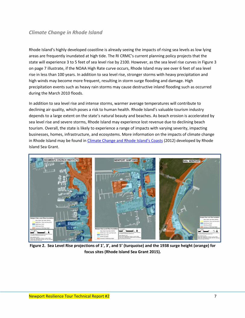
Climate Change in Rhode Island
Rhode Island’s highly developed coastline is already seeing the impacts of rising sea levels as low lying
areas are frequently inundated at high tide. The RI CRMC’s current planning policy projects that the
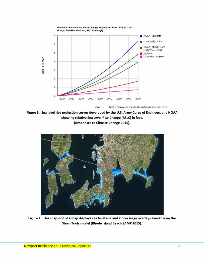
state will experience 3 to 5 feet of sea level rise by 2100. However, as the sea level rise curves in Figure 3
on page 7 illustrate, if the NOAA High Rate curve occurs, Rhode Island may see over 6 feet of sea level
rise in less than 100 years. In addition to sea level rise, stronger storms with heavy precipitation and
high winds may become more frequent, resulting in storm surge flooding and damage. High
precipitation events such as heavy rain storms may cause destructive inland flooding such as occurred
during the March 2010 floods.
In addition to sea level rise and intense storms, warmer average temperatures will contribute to
declining air quality, which poses a risk to human health. Rhode Island’s valuable tourism industry
depends to a large extent on the state’s natural beauty and beaches. As beach erosion is accelerated by
sea level rise and severe storms, Rhode Island may experience lost revenue due to declining beach
tourism. Overall, the state is likely to experience a range of impacts with varying severity, impacting
businesses, homes, infrastructure, and ecosystems. More information on the impacts of climate change
in Rhode Island may be found in Climate Change and Rhode Island’s Coasts (2012) developed by Rhode
Island Sea Grant.
Figure 2. Sea Level Rise projections of 1’, 3’, and 5’ (turquoise) and the 1938 surge height (orange) for
focus sites (Rhode Island Sea Grant 2015).
Newport Resilience Tour Technical Report #2 8
Figure 3. Sea level rise projection curves developed by the U.S. Army Corps of Engineers and NOAA
showing relative Sea Level Rise Change (RSLC) in feet.
(Responses to Climate Change 2015).
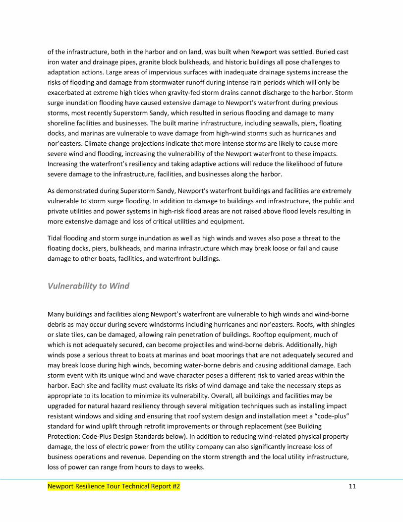
Figure 4. This snapshot of a map displays sea level rise and storm surge overlays available on the
StormTools model (Rhode Island Beach SAMP 2015).

Newport Resilience Tour Technical Report #2 9
Description of Waterfront and Harbor
Newport is one of Rhode Island’s most popular tourist destinations and a world-renowned center for
sailing and boating activities. The city’s active harbor and waterfront area includes numerous marine
businesses as well as restaurants, shops, and marinas. The waterfront, with its high value for tourism,
historic value, and municipal revenues, estimated at approximately $9.7 million in 2009, warrants a
closer look as its businesses are increasingly vulnerable to damage from current major storm events as
well as future climate change related impacts.
Figure 5. Boating access in Newport is a valued amenity (Photo A Desbonnet).
It is evident that many Newport businesses, residents, and local and state leaders recognize the
potential impact extreme storms and rising seas can have on this coastal community. Superstorm Sandy
with its 4 feet of storm surge and high winds caused significant property damage, and stakeholders
understand that risk assessment and adaptation measures are needed to ensure that Newport
businesses remain operational and intact. Newport realizes that while there are various hurdles and
economic impacts to natural hazards mitigation, there are greater consequences if nothing is done. The
efforts undertaken by local and state leaders exemplify the community-based approach to increasing
resiliency and should serve as a model to other coastal communities and states across the nation.
The team’s rapid assessment focused on high wind, storm surge, flooding, storm water runoff, and
coastal erosion hazards associated with severe storm events such as tropical storms, hurricanes, and
nor’easters. Sea level rise also was considered as it is a significant concern for developed waterfronts
like Newport. According to the sea level data collected from the Newport tide gauge, sea levels in Rhode
Island have been increasing an average of one inch per decade since 1930. However, in recent decades
the rate of rise has increased, resulting in a rise of six inches over the past 40 years.

Newport Resilience Tour Technical Report #2 10
Figure 6. Superstorm Sandy flooded Bowen’s Warf with a 4-foot storm surge (Photo D. Hansen,
Newport Daily News).
Accelerated sea level rise is projected to increase in the future and much more rapid increases in sea
levels must be expected and planned for accordingly. Sea level rise is contributing to the exacerbation of
Newport’s exposure to the risks addressed above.
Newport’s harbor has numerous water-dependent users including marine trades, tourists, and the
cruise ship port. Surrounding the harbor are a variety of waterfront properties housing businesses,
restaurants, retail shops, multi-story hotels and condominiums, marinas, piers, parks, a visitor center,
yacht club, Sail Newport facilities, the Newport Shipyard, Fort Adams, and the International Yacht
Restoration Society. These properties include multiple types of building construction with Historic
Districts to the north and south of the downtown district. Some properties are recognized as historic
buildings dating back to the early 1900s and earlier. Numerous roof types are also found, including steep
slope with slate tiles or asphalt shingles, low sloped roofs with single-ply membranes, and pre-
engineered all-metal buildings with metal panel roofs. Given the interest in potential wind damage, the
team observed several steep sloped roofs during the tour that have gable end-type construction which
is more vulnerable to high winds.
The variety of buildings and construction types and uses for the harbor and waterfront area necessitates
a varied approach to increasing resiliency in Newport. There is not one solution or one set of actions
that will work well for all buildings and all sites, thus each location must select the actions and strategies
that will work best for its specific situation, together with its level of risk tolerance and requirements.
Vulnerability to Tides, Storm Inundation, Flooding, and Sea Level Rise
Newport’s highly developed waterfront buildings, businesses, facilities and infrastructure are exposed to
impacts from wave action, storm surge and tidal flooding, stormwater runoff, high winds, and long term
sea level rise inundation. RI CRMC established policy projects 3 to 5 feet of sea level rise by 2100, which
provides a guide for Newport with an estimate of how much sea level rise it needs to anticipate. Much
Newport Resilience Tour Technical Report #2 11
of the infrastructure, both in the harbor and on land, was built when Newport was settled. Buried cast
iron water and drainage pipes, granite block bulkheads, and historic buildings all pose challenges to
adaptation actions. Large areas of impervious surfaces with inadequate drainage systems increase the
risks of flooding and damage from stormwater runoff during intense rain periods which will only be
exacerbated at extreme high tides when gravity-fed storm drains cannot discharge to the harbor. Storm
surge inundation flooding have caused extensive damage to Newport’s waterfront during previous
storms, most recently Superstorm Sandy, which resulted in serious flooding and damage to many
shoreline facilities and businesses. The built marine infrastructure, including seawalls, piers, floating
docks, and marinas are vulnerable to wave damage from high-wind storms such as hurricanes and
nor’easters. Climate change projections indicate that more intense storms are likely to cause more
severe wind and flooding, increasing the vulnerability of the Newport waterfront to these impacts.
Increasing the waterfront’s resiliency and taking adaptive actions will reduce the likelihood of future
severe damage to the infrastructure, facilities, and businesses along the harbor.
As demonstrated during Superstorm Sandy, Newport’s waterfront buildings and facilities are extremely
vulnerable to storm surge flooding. In addition to damage to buildings and infrastructure, the public and
private utilities and power systems in high-risk flood areas are not raised above flood levels resulting in
more extensive damage and loss of critical utilities and equipment.
Tidal flooding and storm surge inundation as well as high winds and waves also pose a threat to the
floating docks, piers, bulkheads, and marina infrastructure which may break loose or fail and cause
damage to other boats, facilities, and waterfront buildings.
Vulnerability to Wind
Many buildings and facilities along Newport’s waterfront are vulnerable to high winds and wind-borne
debris as may occur during severe windstorms including hurricanes and nor’easters. Roofs, with shingles
or slate tiles, can be damaged, allowing rain penetration of buildings. Rooftop equipment, much of
which is not adequately secured, can become projectiles and wind-borne debris. Additionally, high
winds pose a serious threat to boats at marinas and boat moorings that are not adequately secured and
may break loose during high winds, becoming water-borne debris and causing additional damage. Each
storm event with its unique wind and wave character poses a different risk to varied areas within the
harbor. Each site and facility must evaluate its risks of wind damage and take the necessary steps as
appropriate to its location to minimize its vulnerability. Overall, all buildings and facilities may be
upgraded for natural hazard resiliency through several mitigation techniques such as installing impact
resistant windows and siding and ensuring that roof system design and installation meet a “code-plus”
standard for wind uplift through retrofit improvements or through replacement (see Building
Protection: Code-Plus Design Standards below). In addition to reducing wind-related physical property
damage, the loss of electric power from the utility company can also significantly increase loss of
business operations and revenue. Depending on the storm strength and the local utility infrastructure,
loss of power can range from hours to days to weeks.
Newport Resilience Tour Technical Report #2 12
Best Management Practices to Reduce Risk
The following list of best management practices, actions may be applied to buildings, facilities, and sites
around the Newport waterfront to reduce risk. Not all recommendations will be practical or applicable
to all locations, but they provide an outline of potential actions and opportunities that may be taken.
These were compiled from NRAT members and site visits, building upon tools and techniques provided
by FORTIFIED™, CRMC, National Flood Insurance Program, UNH Stormwater Center, among others.
General Considerations
o During the planning and construction of capital improvement projects and general facility
maintenance, waterfront businesses should consider upgrading facilities and infrastructure to
be more resilient to likely impacts by flood-proofing buildings, raising utilities, increasing the
elevation of pilings and bulkheads, and upgrades to stormwater drainage infrastructure.
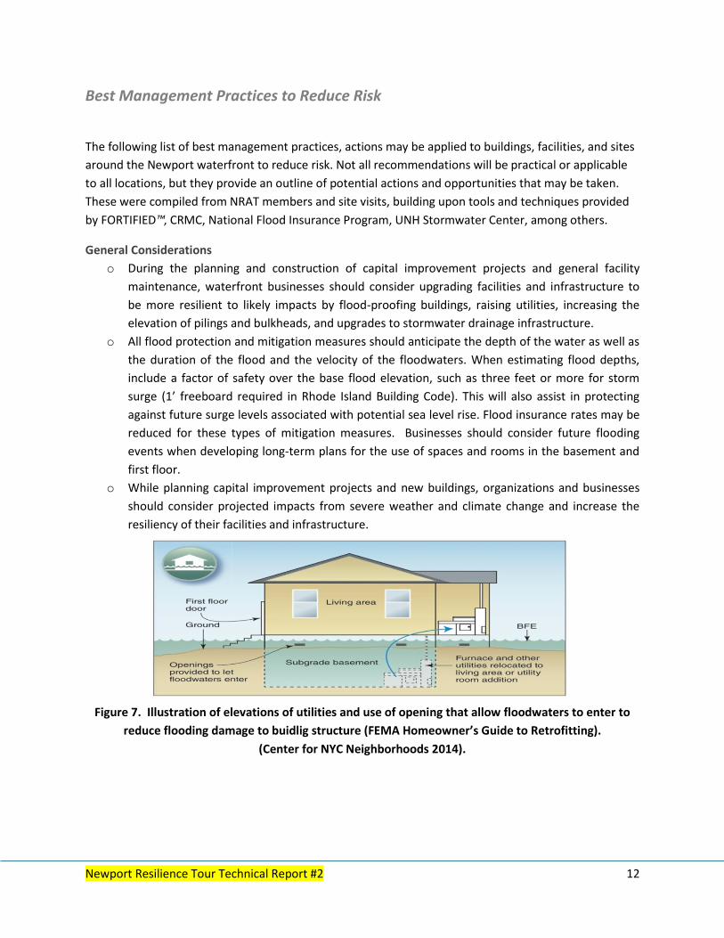
o All flood protection and mitigation measures should anticipate the depth of the water as well as
the duration of the flood and the velocity of the floodwaters. When estimating flood depths,
include a factor of safety over the base flood elevation, such as three feet or more for storm
surge (1’ freeboard required in Rhode Island Building Code). This will also assist in protecting
against future surge levels associated with potential sea level rise. Flood insurance rates may be
reduced for these types of mitigation measures. Businesses should consider future flooding
events when developing long-term plans for the use of spaces and rooms in the basement and
first floor.
o While planning capital improvement projects and new buildings, organizations and businesses
should consider projected impacts from severe weather and climate change and increase the
resiliency of their facilities and infrastructure.
Figure 7. Illustration of elevations of utilities and use of opening that allow floodwaters to enter to
reduce flooding damage to buidlig structure (FEMA Homeowner’s Guide to Retrofitting).
(Center for NYC Neighborhoods 2014).
Newport Resilience Tour Technical Report #2 13
Structural Practices
Tidal Flooding, Storm Surge Inundation, and Sea Level Rise
In order to reduce the waterfront’s vulnerability and risks of damage, several hazard mitigation and
adaptation actions may be taken and adaptive planning may be implemented for the future.
Marine Infrastructure
As pilings become damaged and worn and need maintenance consider replacing to higher elevation
to account for increasing storminess, surge and rising sea levels.
As bulkheads are replaced and/or maintained, review options to upgrade and elevate to account for
increasing climate change impacts.
When storing vessels on land, either for the off seasons or for evacuation purposes, they should be
secured to the ground to prevent them from being swept upland due to flooding or storm surge.
Code-Plus Design Standards
State building codes provide the baseline level of safety for all of Rhode Island communities.
Since building codes are the minimum acceptable standards for life safety and public welfare,
they may not provide businesses with sufficient property protection. Given increased exposure
to natural hazards, and demand for increased natural hazard resiliency, new and existing
building construction should consider a “code-plus” systems approach. The Insurance Institute
for Business & Home Safety (IBHS) has a suite of free “code-plus” standards for residential and
commercial structures available to the public, including FORTIFIED for Safer Business™,
FORTIFIED Home™, and FORTIFIED COMMERCIAL: Hurricane.
The FORTIFIED for Safer Business™ program is designed to help businesses and building
owners reduce their potential for property damage from natural disasters and protect their
physical assets including buildings, equipment, inventories, and business records. In addition,
businesses that use FORTIFIED standards increase the likelihood of reopening immediately
post-disaster, thus contributing to community recovery and minimizing loss of revenue. Even if
a business is not ready to take all the steps to meet FORTIFIED standards, they may use the
standards as a guide for increasing their resilience and preparedness one step at a time. As a
business considers additions or renovations they may incorporate aspects and components of
the FORTIFIED standards in a manner best suited to their vulnerabilities and needs. A full
description of FORTIFIED programs may be found at www.disastersafety.org/fortified-main/.

Newport Resilience Tour Technical Report #2 14
Figure 8. Several marinas have increased pile heights around Newport (Photo P. Rubinoff).
Building Retrofits
o Installing flood vents around office and buildings would allow flood water to exit the
building, thereby reducing damages to facilities from tidal, storm surge, and stormwater
runoff flooding.
o Raising the utilities, connections, and power systems (including back-up power) above
estimated flood levels will minimize the cost of damages to utilities and greatly reduce the
loss of business operations due to power loss and system repairs from future flooding
events.
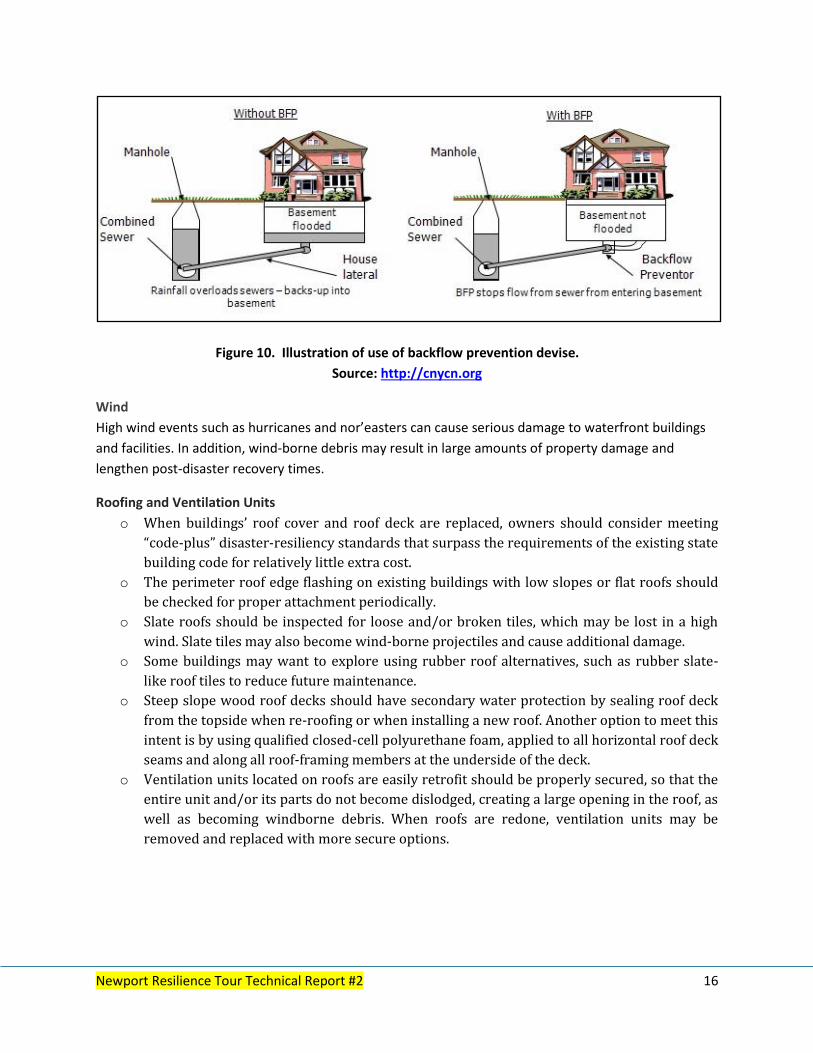
o For buildings located in a flood zone, wastewater systems must be elevated to ensure that
sewage does not backup into a building’s lower floors if electricity is lost. Placing a backflow
prevention device on the main sewage lines can mitigate this issue.
o Buildings located in a FEMA-designated high-risk flood hazard zone should anticipate the
depth of floodwaters as well as the duration of flooding and velocity of the floodwaters
when designing their flood protection and mitigation measures.
Stormwater, Wastewater, and Portable Water Management
o Managing stormwater runoff will reduce the business’ risks of flooding during extreme
rainfall events. Managing stormwater runoff would also provide a public good by reducing
potential runoff pollution to the harbor and flooding in other waterfront areas.
o Stormwater issues may be addressed using Low Impact Development (LID) strategies and
solutions, which promote ways to increase stormwater storage capacity, use natural
vegetation, and promote ways to filter runoff into the ground.
Redesigning impervious surface areas to use green infrastructure.
Promoting infiltration of stormwater into the ground.
Collecting rainwater using a roof collection system and reusing collected stormwater for
non-potable water needs.
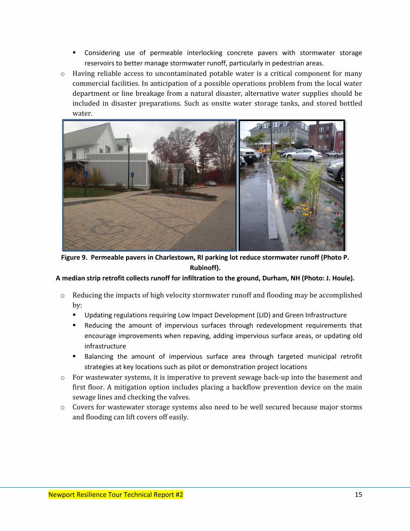
Newport Resilience Tour Technical Report #2 15
Considering use of permeable interlocking concrete pavers with stormwater storage
reservoirs to better manage stormwater runoff, particularly in pedestrian areas.
o Having reliable access to uncontaminated potable water is a critical component for many
commercial facilities. In anticipation of a possible operations problem from the local water
department or line breakage from a natural disaster, alternative water supplies should be
included in disaster preparations. Such as onsite water storage tanks, and stored bottled
water.
Figure 9. Permeable pavers in Charlestown, RI parking lot reduce stormwater runoff (Photo P.
Rubinoff).
A median strip retrofit collects runoff for infiltration to the ground, Durham, NH (Photo: J. Houle).
o Reducing the impacts of high velocity stormwater runoff and flooding may be accomplished
by:
Updating regulations requiring Low Impact Development (LID) and Green Infrastructure
Reducing the amount of impervious surfaces through redevelopment requirements that
encourage improvements when repaving, adding impervious surface areas, or updating old
infrastructure
Balancing the amount of impervious surface area through targeted municipal retrofit
strategies at key locations such as pilot or demonstration project locations
o For wastewater systems, it is imperative to prevent sewage back-up into the basement and
first floor. A mitigation option includes placing a backflow prevention device on the main
sewage lines and checking the valves.
o Covers for wastewater storage systems also need to be well secured because major storms
and flooding can lift covers off easily.
Newport Resilience Tour Technical Report #2 16
Figure 10. Illustration of use of backflow prevention devise.
Source: http://cnycn.org
Wind
High wind events such as hurricanes and nor’easters can cause serious damage to waterfront buildings
and facilities. In addition, wind-borne debris may result in large amounts of property damage and
lengthen post-disaster recovery times.
Roofing and Ventilation Units
o When buildings’ roof cover and roof deck are replaced, owners should consider meeting
“code-plus” disaster-resiliency standards that surpass the requirements of the existing state
building code for relatively little extra cost.
o The perimeter roof edge flashing on existing buildings with low slopes or flat roofs should
be checked for proper attachment periodically.
o Slate roofs should be inspected for loose and/or broken tiles, which may be lost in a high
wind. Slate tiles may also become wind-borne projectiles and cause additional damage.
o Some buildings may want to explore using rubber roof alternatives, such as rubber slate-
like roof tiles to reduce future maintenance.
o Steep slope wood roof decks should have secondary water protection by sealing roof deck
from the topside when re-roofing or when installing a new roof. Another option to meet this
intent is by using qualified closed-cell polyurethane foam, applied to all horizontal roof deck
seams and along all roof-framing members at the underside of the deck.
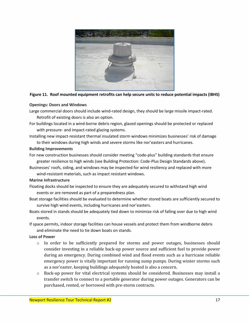
o Ventilation units located on roofs are easily retrofit should be properly secured, so that the
entire unit and/or its parts do not become dislodged, creating a large opening in the roof, as
well as becoming windborne debris. When roofs are redone, ventilation units may be
removed and replaced with more secure options.
Newport Resilience Tour Technical Report #2 17
Figure 11. Roof mounted equipment retrofits can help secure units to reduce potential impacts (IBHS)
Openings: Doors and Windows
Large commercial doors should include wind-rated design, they should be large missile impact-rated.
Retrofit of existing doors is also an option.
For buildings located in a wind-borne debris region, glazed openings should be protected or replaced
with pressure- and impact-rated glazing systems.
Installing new impact-resistant thermal insulated storm windows minimizes businesses’ risk of damage
to their windows during high winds and severe storms like nor’easters and hurricanes.
Building Improvements
For new construction businesses should consider meeting “code-plus” building standards that ensure
greater resilience to high winds (see Building Protection: Code-Plus Design Standards above).
Businesses’ roofs, siding, and windows may be inspected for wind resiliency and replaced with more
wind-resistant materials, such as impact resistant windows.
Marine Infrastructure
Floating docks should be inspected to ensure they are adequately secured to withstand high wind
events or are removed as part of a preparedness plan.
Boat storage facilities should be evaluated to determine whether stored boats are sufficiently secured to
survive high wind events, including hurricanes and nor’easters.
Boats stored in stands should be adequately tied down to minimize risk of falling over due to high wind
events.
If space permits, indoor storage facilities can house vessels and protect them from windborne debris
and eliminate the need to tie down boats on stands.
Loss of Power
o In order to be sufficiently prepared for storms and power outages, businesses should
consider investing in a reliable back-up power source and sufficient fuel to provide power
during an emergency. During combined wind and flood events such as a hurricane reliable
emergency power is vitally important for running sump pumps. During winter storms such
as a nor’easter, keeping buildings adequately heated is also a concern.
o Back-up power for vital electrical systems should be considered. Businesses may install a
transfer switch to connect to a portable generator during power outages. Generators can be
purchased, rented, or borrowed with pre-storm contracts.

Newport Resilience Tour Technical Report #2 18
Non-structural Practices
Emergency Preparedness
Due to the highly vulnerable nature of the shoreline area, Newport’s waterfront businesses and
organizations should have well-developed Emergency Plans, including actions to take prior to and during
an emergency, organized and documented evacuation routes, and instructions for employees, clients,
and visitors to follow in the event of a major storm or natural disaster.
Emergency Planning
Waterfront businesses need to have a written emergency preparedness plan and an evacuation plan
in the event that individuals need to be evacuated from the building.
Taking the previously addressed actions to flood-proof and increase the wind-resistance of the
structure and establishing an emergency power source are all factors contributing to emergency
preparedness. These actions may be phased in over time, proactively increasing resilience and
preparedness incrementally.
The business or organization’s evacuation plans should follow the fastest and easiest route to safe
locations such as the city emergency shelters. Mobility considerations must also be taken into
account in case individuals with special needs or disabilities need to be evacuated as well.
Businesses should review their emergency preparedness plan and evacuation plan with the local
Emergency Management Director and the Newport Fire Department if possible.
Written Emergency Plan Components
Instructions for employees, visitors, and clients to follow during an emergency.
Written procedures outlining the actions to take prior to a major storm or natural disaster to secure
the facilities and minimize damages including which actions to take at which times.
Clearly written evacuation procedures for employees, visitors, and clients including evacuation
routes and safe shelter areas.
Posted signs describing emergency preparedness requirements and procedures (for example, signs
indicating evacuation routes).
Business Continuity and Emergency Planning
Protection of the building continues after the construction phase. In addition to preventative
maintenance and proper building up-keep, business continuity and severe weather emergency
planning should be included in every business’ overall plans to protect physical assets and
quickly return to operations following a severe weather event. Creating a business continuity
plan can assist with this goal. Several programs are available to assist with creating a plan,
including IBHS’ OFB-EZ™ (Open For Business-EZ) toolkit. OFB-EZ is a free streamlined business
continuity tool designed to help small businesses focus on planning for any type of business
interruption, so they can quickly re-open and resume operations following a disaster. The IBHS
website includes a full description of the OFB-EZ™ toolkit
(www.disastersafety.org/disastersafety/open-for-business-ez).
Newport Resilience Tour Technical Report #2 19
The organization’s evacuation plans should follow the fastest and easiest route to safe locations
such as the city emergency shelters. Mobility considerations must also be taken into account in
case individuals with special needs or disabilities need to be evacuated as well.
Emergency Kit
Consider having on hand sufficient food and water for employees and visitors for three days, a first
aid kit, flashlights and extra batteries, and an emergency radio. Additional information about
emergency preparedness kits may be found at www.ready.gov
Emergency Planning Keys to Success
Maintain a documented and up-to-date written plan with designated personnel responsibilities,
with back-ups for all shifts.
Include wind, flood, and severe winter weather preparations and recovery plans for building
envelope, physical assets, business functions, and critical utilities.
Include Alert Levels that trigger planning activities for impending storms (e.g. 72, 48, 24, 12 hours
prior to arrival).
For hurricanes and tropical storms, prepare for one storm category greater than the weather service
forecast.
Conduct periodic training and exercises.
Include offseason activities (materials procurement, training, asset inspections/repairs).
Develop material supply checklist.
Feedback process after extreme weather events.
Outreach
Businesses should ensure that all employees understand and are familiar with the Emergency Plan
and procedures and are adequately trained to perform their responsibilities during an
emergency.
Review business emergency preparedness plan and evacuation plan with the local Emergency
Management Director and the Newport Fire Department as well as other relevant state agencies
if possible.
Special Considerations
Consider how to deal with contaminated materials during a severe weather event. For example, if
contaminated materials are stored in tanks consider adding additional tie downs to secure the
storage vessels or removing tanks to higher ground prior to a storm event.
Outreach and Communication Newport’s historic and picturesque harbor and waterfront area is one of Rhode Island’s top tourist
destinations and hosts thousands of visitors every summer. Due to the city’s large number of visitors
from around Rhode Island, New England, and the world the waterfront area is highly visible and thus
may serve as an example of proactive coastal resilience that may be followed by other places. Resiliency
and adaptive actions that businesses and organizations are taking may be attractive to new business
development. Additionally such examples can be incorporated into visitor information materials and
tours of the harbor and waterfront, thus informing visitors of the steps Newport is taking to reduce its
vulnerability and increase resilience. Educational plaques and displays may be placed in highly
Newport Resilience Tour Technical Report #2 20
vulnerable popular destinations such as Bowen’s Warf, Perrotti Park, Sail Newport, and the Newport
Shipyard.
Engaging business in discussion on these issues is crucial. The Chamber of Commerce and the Newport
Maritime Alliance can play an important role in facilitating discussion and motivating action. Sharing
information and lessons learned is valuable for the waterfront business community. As the City of
Newport continues its leadership in resiliency efforts, it can engage with waterfront businesses and
organizations to disseminate information related to its vulnerabilities and opportunities to improve its
resilience. Previous projects and studies have engaged other stakeholders within the City and this
project provides an opportunity to build on previous work. By incorporating resiliency and adaptation
into the City’s overall approach to development and growth, Newport may become an example of a
resilient waterfront city.
Newport Resilience Tour Technical Report #2 21
Pilot Projects
Pilot projects provide an excellent opportunity for learning and doing. Listed below are several activities
that were identified by the NRAT team as potential candidates to jumpstart efforts to support a more
resilient Newport Waterfront business community.
Business Preparedness
Tabletop Exercise with members of the Newport Maritime Alliance, Chamber of Commerce and
others.
Debris reduction & management plan – define debris reduction and management – private property
& public property.
Emergency Preparedness Planning template prepared and shared in work sessions.
Waterfront and City Areas
Utilize tree trenches for stormwater– replanting street trees, linking with the concept as Newport as
a Tree City USA.
Target shoreline access areas to convert to pervious pavement for stormwater storage.
Install green infrastructure demonstration site at City Yard/Halsey Street Public Works complex.
“They thought of this place as a big boat.”
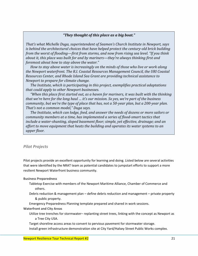
That’s what Michelle Duga, superintendent of Seamen’s Church Institute in Newport, says is behind the architectural choices that have helped protect the century-old brick building from the worst of flooding—first from storms, and now from rising sea level. “If you think about it, this place was built for and by mariners—they’re always thinking first and foremost about how to stay above the water.”
How to stay above water is increasingly on the minds of those who live or work along the Newport waterfront. The R.I. Coastal Resources Management Council, the URI Coastal Resources Center, and Rhode Island Sea Grant are providing technical assistance to Newport to prepare for climate change.
The Institute, which is participating in this project, exemplifies practical adaptations that could apply to other Newport businesses.
“When this place first started out, as a haven for mariners, it was built with the thinking that we’re here for the long haul … it’s our mission. So yes, we’re part of the business community, but we’re the type of place that has, not a 50-year plan, but a 200-year plan. That’s not a common model,” Duga says.
The Institute, which can lodge, feed, and answer the needs of dozens or more sailors or community members at a time, has implemented a series of flood-smart tactics that include a water-shunting, sloped basement floor; simple, yet effective, drainage; and an effort to move equipment that heats the building and operates its water systems to an upper floor.
“When you live on the sea, you know that change happens—it’s just part of life,” Duga says. “Mariners think of themselves in terms of the water, so adapting to nature, to the water, is just what’s always been done here … The one thing I would tell everyone is that you’re going to have to adapt to the environment, and you’re going to need a plan for that. It’s totally doable, but you have to plan.”
Newport Resilience Tour Technical Report #2 22
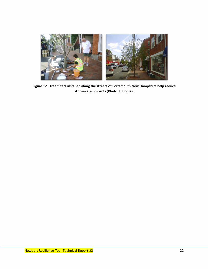
Figure 12. Tree filters installed along the streets of Portsmouth New Hampshire help reduce
stormwater impacts (Photo: J. Houle).

Newport Resilience Tour Technical Report #2 23
References
Center for NYC Neighborhoods. October 1, 2014. Coping with Big Flood Insurance Changes in NYC, Part
IV: Mitigation. http://cnycn.org/2014/10/coping-with-big-flood-insurance-changes-in-nyc-part-iv-
mitigation/ as of 15 June 2015.
Responses to Climate Change. 2015. Climate Change Adaptation: Comprehensive Evaluation of Projects
with Respect to Sea-Level Change. http://www.corpsclimate.us/ccaceslcurves.cfm as of 15 June 2015.
Rhode Island Beach SAMP. 2015. The Shoreline Change Management Plan. http://www.beachsamp.org
as of 15 June 2015.
Rhode Island Sea Grant. 2015. Newport: Waterfront Future. Newport, RI.
http://seagrant.gso.uri.edu/projects-2/newport-waterfront-future/ as of 15 June 2015.

1
Coastal Resources Center/Rhode Island Sea Grant
Graduate School of Oceanography, University of Rhode Island
March 2015


