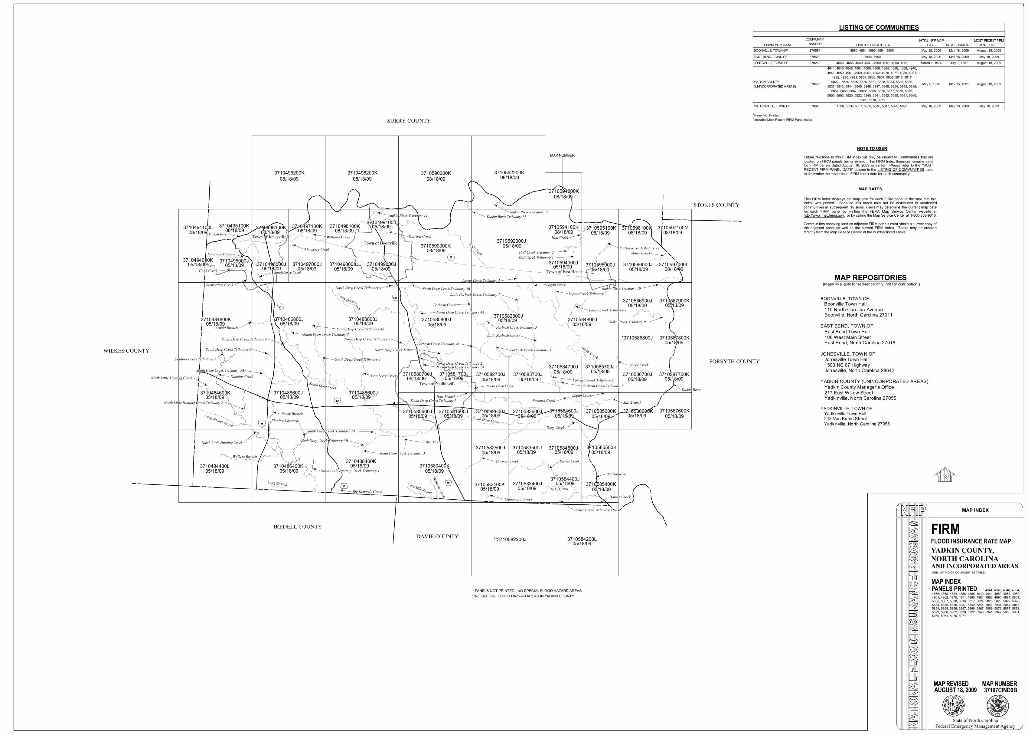
YADKIN COUNTY,NORTH CAROLINA
MAP INDEX
FIRMFLOOD INSURANCE RATE MAP
MAP INDEX(SEE LISTING OF COMMUNITIES TABLE)
MAP REVISED MAP NUMBER37197CIND0B
State of North CarolinaFederal Emergency Management Agency
PANELS PRINTED:
WILKES COUNTY
4844, 4846, 4848, 4864, 4866, 4868, 4884, 4886, 4888, 4940, 4941, 4950, 4951, 4960, 4961, 4962, 4970, 4971, 4980, 4981, 4982, 4990, 4991, 5804, 5806, 5807, 5808, 5816, 5817, 5824, 5825, 5826, 5827, 5828, 5834, 5835, 5836, 5837, 5842, 5844, 5845, 5846, 5847, 5848, 5854, 5855, 5856, 5857, 5866, 5867, 5869, 5876, 5877, 5878, 5879, 5900, 5902, 5920, 5922, 5940, 5941, 5942, 5950, 5951, 5960, 5961, 5970, 5971
IREDELL COUNTY
SURRY COUNTY
FORSYTH COUNTY
DAVIE COUNTY
3710484400L 3710486400K3710488400K 3710580400K
**3710582200J
3710582400K
3710582500J
3710583400J
3710583500J
3710584200L
3710584400J
3710584500J
3710585400K
3710585500K
3710582600J
3710582700J
3710582800J
3710583600J
3710583700J
3710584600J
3710584700J
3710584800J
3710585600K
3710585700J
3710586600K
3710586700J
*3710586800J
3710586900J
3710587600K
3710587700K
3710587800K
3710587900K
3710486600J
3710486800J
3710488600J
3710488800J
3710580600J
3710580700J
3710580800J
3710581600J
3710581700J
3710484600K
3710484800K
3710494000K
3710494100L
3710495000J
3710495100K
3710496000J
3710496100K
3710496200K
3710497000J
3710497100K
3710498000J
3710498100K
3710498200K
3710499000J
3710499100J
3710590000K
3710590200K
3710592000J
3710592200K
3710594000J
3710594100K
3710594200K
3710595000J
3710595100K
3710596000J
3710596100K
3710597000L
3710597100M
Deep Creek<
Harmon Creek
<
South Deep Creek
South Deep Creek Tributary 1<
Fisher Creek
<
South Deep Creek Tributary 3
<
South Deep Creek Tributary 3A <
South Deep Creek Tributary 3B<
Cranberry Creek
<South Deep Creek Tributary 4
<
South Deep Creek Tributary 4A
<
South Deep Creek Tributary 7
<
Arnold Branch<
South Deep Creek Tributary 6<
South Deep Creek Tributary 5<
South Deep Creek Tributary 5A<
North Deep Creek<
Haw Branch <
North Deep Creek Tributary 2A< North Deep Creek Tributary 2
<
North Deep Creek Tributary 1<
North Deep Creek Tributary 3<
North Deep Creek Tributary 4 <
North Deep Creek Tributary 4A<
North Deep Creek Tributary 4B
<
Forbush Creek <
Forbush Creek Tributary 1
< Forbush Creek Tributary 2
<
Forbush Creek Tributary 3
<
Forbush Creek Tributary 5
<
Forbush Creek Tributary 4<
Logan Creek Tributary 1
<
Logan Creek Tributary 2
<
Logan Creek Tributary 3 <
Little Forbush Creek Tributary 1<
Mill Branch
<
Logan Creek <
Loney Creek<
Yadkin River Tributary 9<
Yadkin River Tributary 10 <
Miller Creek<
Yadkin River Tributary 27
<
Hall Creek <
Hall Creek Tributary 1 <
Hall Creek Tributary 2 <
Yadkin River Tributary 15
<
Yadkin River Tributary 17
<
Tanyard Creek
<
Yadkin River Tributary 11
<
Williams Creek
<
Lineberry Creek
<
Sandyberry Creek
<
Jonesville Creek<
Beaverdam Creek<
Cobb Creek <
Town of JonesvilleTown of Boonville
Town of Yadkinville
Town of East Bend!(
-77
P67
1421
121
121
1601
1601
Yadkin River
<
* PANELS NOT PRINTED - NO SPECIAL FLOOD HAZARD AREAS
Logan Creek
South Deep Creek
Dobbins Creek
<Dobbins Creek Tributary
<
North Little Hunting Creek<
North Little Hunting Creek Tributary 2<
Long Branch North
North Little Hunting Creek
<
Walkers Branch
Rocky Branch<
Flat Rock Branch
<
North Little Hunting Creek Tributary 1
<
Long BranchBig Kennedy Creek
<
Cain Mill Branch
Steelman Creek
Chinquapin Creek
<
Turner Creek
<
Roby Creek
Turner Creek Tributary 1
<
Hauser Creek
<
STOKES COUNTY
COMMUNITY NAMECOMMUNITY
NUMBER LOCATED ON PANEL(S)INITIAL NFIP MAP
DATE INITIAL FIRM DATEMOST RECENT FIRM
PANEL DATE 2BOONVILLE, TOWN OF 370551 4980, 4981, 4990, 4991, 5900 May 18, 2009 May 18, 2009 August 18, 2009EAST BEND, TOWN OF 370560 5848, 5950 May 18, 2009 May 18, 2009 May 18, 2009JONESVILLE, TOWN OF 370260 4848, 4868, 4940, 4941, 4950, 4951, 4960, 4961 March 1, 1974 July 1, 1987 August 18, 2009
YADKIN COUNTY, (UNINCORPORATED AREAS) 370400
4844, 4846, 4848, 4864, 4866, 4868, 4884, 4886, 4888, 4940, 4941, 4950, 4951, 4960, 4961, 4962, 4970, 4971, 4980, 4981,
4982, 4990, 4991, 5804, 5806, 5807, 5808, 5816, 5817, 58221, 5824, 5825, 5826, 5827, 5828, 5834, 5835, 5836,
5837, 5842, 5844, 5845, 5846, 5847, 5848, 5854, 5855, 5856, 5857, 5866, 5867, 58681, 5869, 5876, 5877, 5878, 5879,
5900, 5902, 5920, 5922, 5940, 5941, 5942, 5950, 5951, 5960, 5961, 5970, 5971
May 5, 1978 May 15, 1991 August 18, 2009
YADKINVILLE, TOWN OF 370640 4886, 5806, 5807, 5808, 5816, 5817, 5826, 5827 May 18, 2009 May 18, 2009 May 18, 2009
LISTING OF COMMUNITIES
**NO SPECIAL FLOOD HAZARD AREAS IN YADKIN COUNTY
Yadkin River<
Yadkin River<
Fall Creek
Logan Creek<
North Creek
DeepForbush Creek <
Little Forbush Creek<
AUGUST 18, 2009
NOTE TO USER Future revisions to this FIRM Index will only be issued to Communities that are located on FIRM panels being revised. This FIRM Index therefore remains valid for FIRM panels dated August 18, 2009 or earlier. Please refer to the “MOST RECENT FIRM PANEL DATE” column in the LISTING OF COMMUNITIES table to determine the most recent FIRM Index date for each community.
MAP DATES
This FIRM Index displays the map date for each FIRM panel at the time that this Index was printed. Because this Index may not be distributed to unaffected communities in subsequent revisions, users may determine the current map date for each FIRM panel by visiting the FEMA Map Service Center website at http://www.msc.fema.gov, or by calling the Map Service Center at 1-800-358-9616. Communities annexing land on adjacent FIRM panels must obtain a current copy of the adjacent panel as well as the current FIRM Index. These may be ordered directly from the Map Service Center at the number listed above.
MAP REPOSITORIES (Maps available for reference only, not for distribution.) BOONVILLE, TOWN OF: Boonville Town Hall 110 North Carolina Avenue Boonville, North Carolina 27011 EAST BEND, TOWN OF: East Bend Town Hall 108 West Main Street East Bend, North Carolina 27018 JONESVILLE, TOWN OF: Jonesville Town Hall 1503 NC 67 Highway Jonesville, North Carolina 28642 YADKIN COUNTY (UNINCORPORATED AREAS): Yadkin County Manager’s Office 217 East Willow Street Yadkinville, North Carolina 27055 YADKINVILLE, TOWN OF: Yadkinville Town Hall 213 Van Buren Street Yadkinville, North Carolina 27055
MAP NUMBER
<
08/18/09 08/18/09 08/18/09 08/18/09
08/18/09
08/18/09 08/18/09 08/18/09 08/18/09
08/18/0905/18/0905/18/0905/18/09
05/18/09
05/18/09 05/18/09
05/18/09
05/18/0905/18/09
08/18/09
05/18/09
05/18/0905/18/09
08/18/09 05/18/0908/18/09
05/18/0905/18/09
08/18/0908/18/0908/18/09
05/18/09 05/18/09
05/18/09 05/18/09
05/18/09 05/18/09 05/18/09
05/18/09
05/18/09
05/18/09
05/18/09
05/18/09
05/18/09
05/18/09
05/18/09 05/18/09
05/18/09 05/18/09
05/18/09
05/18/09
05/18/09
05/18/09
05/18/09
05/18/0905/18/0905/18/09
05/18/0905/18/09
05/18/09
05/18/09
05/18/09
05/18/09
05/18/0905/18/09
05/18/0905/18/09
AND INCORPORATED AREAS
05/18/09
1Panel Not Printed2 Includes Most Recent FIRM Panel Index


