PUBLIC HEALTH RISK MAPPING AND
CAPACITIES ASSESSMENT IN GHANA
Prepared for GHS/MoH with support from WHO
JULY 2016

REPUBLIC OF GHANA
PUBLIC HEALTH RISK MAPPING AND
CAPACITIES ASSESSMENT IN GHANA
Prepared for GHS/MoH with support from WHO
JULY 2016

i
Table of Contents
LIST OF FIGURES AND TABLES ...................................................................................................... iv
List of Figures .................................................................................................................................... iv
List of Tables ..................................................................................................................................... iv
ACKNOWLEDGEMENTS .................................................................................................................... v
ACRONYMS ......................................................................................................................................... vi
GLOSSARY OF TERMS .................................................................................................................... viii
EXECUTIVE SUMMARY ................................................................................................................... ix
CHAPTER ONE - INTRODUCTION .................................................................................................... 1
1.1 Introduction ............................................................................................................................. 1
1.2 Structure of the Report ............................................................................................................ 1
1.3 Rationale ................................................................................................................................. 1
CHAPTER TWO – COUNTRY PROFILE ............................................................................................ 2
2.1 Geography ............................................................................................................................... 2
2.2 Political History and Administration ...................................................................................... 3
2.3 Demography ............................................................................................................................ 4
2.4 Socio-economic status............................................................................................................. 4
2.5 Health status ............................................................................................................................ 4
2.6 Health System ......................................................................................................................... 4
2.7 Ecological Zones ..................................................................................................................... 5
2.7.1 Northern Savannah Zone ................................................................................................ 5
2.7.2 Forest Zone ..................................................................................................................... 6
2.7.3 Coastal Zone ................................................................................................................... 7
2.8 International Health Regulations (2005) ................................................................................. 7
CHAPTER THREE – PUBLIC HEALTH RISK MAPPING ................................................................ 9
3.1 Introduction ............................................................................................................................. 9
3.2 Objectives ............................................................................................................................. 11
3.3 Description of the Methodology ........................................................................................... 12
3.4 Hazard Analysis .................................................................................................................... 12
3.4.1 Hazard Identification ..................................................................................................... 12
3.4.2 Hazard Description ....................................................................................................... 15
3.4.2.1 Cholera ..................................................................................................................... 15

ii
3.4.2.2 Meningitis ................................................................................................................. 16
3.4.2.3 Yellow Fever ............................................................................................................. 18
3.4.2.4 Avian and Pandemic Influenza ................................................................................. 20
3.4.2.5 Viral Haemorrhagic Fevers ....................................................................................... 22
3.4.2.6 Flood ......................................................................................................................... 24
3.4.2.7 Drought ..................................................................................................................... 26
3.4.2.8 Earthquake ................................................................................................................ 27
3.4.2.9 Land (Road) Transport Accidents ............................................................................. 29
3.4.2.10 Air Transport (Aviation) Accidents .......................................................................... 31
3.4.2.11 Water Transport Accidents ....................................................................................... 31
3.4.2.12 Structural Collapse .................................................................................................... 32
3.4.2.13 Nuclear and Radiological Emergency ....................................................................... 32
3.4.2.14 Fire ............................................................................................................................ 34
3.4.2.15 Oil and Natural Gas Emergency ............................................................................... 35
3.4.2.16 Chemical ................................................................................................................... 36
3.4.2.17 Civil Disorder ............................................................................................................ 37
3.4.2.18 Terrorism ................................................................................................................... 37
3.5. Risk Analysis ........................................................................................................................ 38
3.5.1 Cholera ................................................................................................................................. 38
3.5.2 Meningitis ............................................................................................................................ 40
3.5.3 Yellow Fever ........................................................................................................................ 42
3.5.4 Avian and Pandemic Influenza ............................................................................................ 44
3.5.5 Ebola Virus Disease and Other Viral Haemorrhagic Fevers ................................................ 45
3.5.6 Flood .................................................................................................................................... 46
3.5.7 Drought ................................................................................................................................ 47
3.5.8 Earthquake ........................................................................................................................... 48
3.5.9 Road Traffic Injuries ............................................................................................................ 48
3.5.10 Aviation or Air Transport Accident ................................................................................... 49
3.5.11 Water Transport Accident .................................................................................................. 49
3.5.12 Structure Collapse .............................................................................................................. 50
3.5.13 Nuclear and Radiological ................................................................................................... 50
3.5.14 Fire ..................................................................................................................................... 50
3.5.15 Oil and Gas Spillage .......................................................................................................... 50

iii
3.5.16 Chemical ............................................................................................................................ 51
3.5.17 Civil Disorder ..................................................................................................................... 51
3.5.18 Terrorism ............................................................................................................................ 51
3.6 Ranking of Risks ................................................................................................................... 53
3.7 Conclusion ............................................................................................................................ 54
3.8 Recommendations ................................................................................................................. 54
CHAPTER FOUR - CAPACITIES ASSESSMENT ............................................................................ 55
4.1 Introduction ........................................................................................................................... 55
4.2 Methodology ......................................................................................................................... 55
4.3 Findings and Discussions ...................................................................................................... 55
4.3.1 Legislation, policy and financing .................................................................................. 55
4.3.2 Coordination and partnership ........................................................................................ 57
4.3.3 Surveillance ................................................................................................................... 58
4.3.4 Laboratory ..................................................................................................................... 59
4.3.5 Preparedness and Response .......................................................................................... 60
4.3.6 Risk communication ..................................................................................................... 62
4.3.7 Points of entry ............................................................................................................... 62
4.3.8 Human resources ........................................................................................................... 64
4.3.9 Zoonotic Events ............................................................................................................ 65
4.3.10 Food Safety Events ...................................................................................................... 65
4.3.11 Chemical Events ................................................................................................................ 65
4.3.12 Radiological and Nuclear Events ................................................................................. 66
4.4 Conclusion ............................................................................................................................ 66
4.5 Recommendations ................................................................................................................. 67
REFERENCES ..................................................................................................................................... 69
ANNEXES ............................................................................................................................................ 73
Annex 1: Scoring chart for Potential to cause Public Health Emergency ......................................... 73
Annex 2: Ranking Scores of Hazards Risk using SMAUG Criteria ................................................. 74

iv
LIST OF FIGURES AND TABLES
List of Figures
Figure 1: Map of West Africa showing location of Ghana ..................................................................... 2
Figure 2: Map of Ghana showing 10 Regions ........................................................................................ 3
Figure 3: Map of Ghana showing 216 Districts ...................................................................................... 3
Figure 4: Map of Ghana showing Ecological zones ............................................................................... 6
Figure 5: Annual Trend of Cholera Cases, Ghana, 1980 – 2015 .......................................................... 15
Figure 6: Annual Trend of Meningitis Cases, Ghana, 1980 - 2015 ...................................................... 17
Figure 7: Yearly Trend of Yellow Fever Cases in Ghana, 1950 - 2015 ............................................... 19
Figure 8: Reported Yellow Fever Outbreaks in Ghana by Region by Year, 1901 - 2015 .................... 20
Figure 9: Districts Reporting Avian Influenza (AI) in Poultry in Ghana, 2007 and 2015 .................... 21
Figure 10: Ebola Affected Countries in West Africa, 2014-2015 ........................................................ 23
Figure 11: Floods in Ghana by Region, 1968 - 2015 ............................................................................ 25
Figure 12: District Drought hazard map, Ghana ................................................................................... 27
Figure 13: Hazard Map for Road Traffic Accidents ............................................................................. 30
Figure 14: Pattern of Yearly Incidence of Fire in Ghana, 2000 - 2013 ................................................ 35
Figure 15: Cholera Risk Level by District ............................................................................................ 39
Figure 16: Meningitis Risk Map ........................................................................................................... 41
Figure 17: Yellow Fever Immunization Coverage, Ghana, 2000 – 2015 ............................................. 43
Figure 18: Yellow fever District Risk Map, Ghana, 2016 .................................................................... 44
Figure 19: Drought Risk Map - 2010 ................................................................................................... 47
Figure 20: Earthquake Risk zones in Ghana ......................................................................................... 48
Figure 21: Volta Lake Boat Accident Risk Districts ............................................................................ 49
Figure 22: Location of Laboratories* Supporting Public Health Emergency Response in Ghana ....... 60
Figure 23: Designated Points of Entry, Ghana ..................................................................................... 63
List of Tables
Table 1: Ranking of Hazards by Risk in Ghana, 2016 ............................................................................ x
Table 2: Summary of Strengths and Weakness of Core Capacities ...................................................... xii
Table 3: Hazards and their Public Health Impact, Ghana, 2016 ........................................................... 13
Table 4: Cholera Cases and Deaths by Region, Ghana 2010 - 2015 .................................................... 16
Table 5: Meningitis Cases and Deaths by Region, Ghana, 2010 - 2015 ............................................... 18
Table 6: Distribution of Districts by Flood Hazard Level .................................................................... 26
Table 7: Distribution of Districts by Drought Hazard Level ................................................................ 26
Table 8: Earthquakes in Ghana, 1615 - 2002 ........................................................................................ 28
Table 9: Average Annual Incidence of Road Traffic Injuries by Region, Ghana, 2011 - 2015 ........... 30
Table 10: Cholera Risk Level, Ghana, 2016 ......................................................................................... 39
Table 11: Meningitis Risk Level by District by Zone, Ghana, 2016 .................................................... 41
Table 12: Public Health Risk Level by Hazard by Zone in Ghana, 2016 ............................................. 52
Table 13: Ranking of Hazards by Risk in Ghana, 2016 ........................................................................ 53

v
ACKNOWLEDGEMENTS
A number of individuals and organizations contributed to the risk mapping and capacities assessment
with their knowledge, publications and financial support.
We would like to thank the Incident Commander and members of the Emergency Operation Centre
(EOC) and the IHR National Focal Point for leadership and initiation of this activity.
To those who were interviewed to elicit information and those who participated in stakeholders’
dissemination meeting and made invaluable inputs we wish to thank them all.
Furthermore, we would like to thank the World Health Organization (WHO) for their financial and
technical support.
Finally, we would like to commend the hard work, dedication, and the untiring efforts of Dr Lawson
Ahadzie, the lead consultant, and the field officers.

vi
ACRONYMS
APHEF African Public Health Emergency Fund
AU-IBAR African Union Inter Bureau for Animal Resources
CDC Centers for Disease Control and Prevention
CHO Community Health Officer
CHPS Community Health Planning and Services
CZ Coastal Zone
EOC Emergency Operations Centre
EPA Environmental Protection Agency
EVD Ebola Virus Disease
FAO Food and Agriculture Organization
FDA Food and Drug Authority
FELTP Field Epidemiology and Laboratory Training Program
FZ Forest Zone
GDP Gross Domestic Product
GHS Ghana Health Service
GLIDE Global unique disaster Identifier system
GoG Government of Ghana
GPHA Ghana Ports and Harbours Authority
GSS Ghana Statistical Service
HF Health Facility
HPAI Highly Pathogenic Avian Influenza
IDSR Integrated Disease Surveillance and Response
IHR International Health Regulations
IHR NFP International Health Regulations National Focal Point
ILI Influenza-Like Illness
IMC Inter-Ministerial Committee
IOM International Organization for Migration
IPC Infection Prevention and Control
JICA Japan International Cooperation Agency
KCCR Kumasi Centre for Collaborative Research in Tropical Medicine
KIA Kotoka International Airport
LI Legislative Instrument
MEST Ministry of Environment Science and Technology
MoF Ministry of Finance
MoFA Ministry of Food and Agriculture
MoH Ministry of Health
NADMO National Disaster Management Organization
NCC National Coordinating Committee
NGO Non-Governmental Organization
NMIMR Noguchi Memorial Institute for Medical Research

vii
NPHRL National Public Health and Reference Laboratory
NSZ Northern Savannah Zone
NTCC National Technical Coordination Committee
OIE World Organization for Animal Health
PH Port Health
PHA Public Health Act
PHE Public Health Emergency
PHEIC Public Health Emergency of International Concern
PHEM Public Health Emergency Management
PHEMC Public Health Emergency Management Committee
PHEPR Public Health Emergency Preparedness and Response
PHL Public Health Laboratory
PHU Public Health Unit
PoE Point of Entry
PPE Personal Protective Equipment
RCC Regional Coordinating Council
RDT Rapid Diagnostic Test
RRT Rapid Response Team
UG University of Ghana
UNCCD United Nations Convention to Combat Desertification
UN DHA United Nations Department of Humanitarian Affairs
UNDP United Nations Development Programme
UNISDR United Nations International Strategy for Disaster Reduction
USAID United States Agency for International Development
UST University of Science and Technology
VSD Veterinary Services Directorate
WARDS West Africa Regional Disease Surveillance Capacity Strengthening
WCO World Health Organization Country Office
WHO World Health Organization
WHO AFRO World Health Organization Regional Office for Africa

viii
GLOSSARY OF TERMS
Capacity: The combination of all the strengths, attributes and resources available within a
community, society, organization or a system that can be used to achieve agreed goals or
reduce disaster risks (UNISDR, 2009).
Coping Capacity: The ability of people, organizations and systems using available skills and
resources, to face and manage adverse conditions, emergencies and disasters (UNISDR 2009).
Hazard: Dangerous phenomenon, substance, human activity or condition that may cause loss of life,
injury or other health impacts, property damage, loss of livelihoods and services, social and
economic disruption, or environmental damage (UNISDR, 2009).
Risk: The probability of harmful consequences, or expected losses (deaths, injuries, property,
livelihoods, social and economic activities disrupted or environment damaged) resulting from
interactions between natural or human-induced hazards and vulnerable conditions (UNISDR,
2009).
Risk Map is a map of a community or geographical zone that identifies the places and the structures
that might be adversely affected in the event of a hazard.
Public Health Emergency is any situation or event whose health consequences, particularly those
whose scale, timing, or unpredictability threatens to overwhelm routine capabilities (RAND Health,
2008)
Secondary Hazard: A hazard that occurs as a result of another hazard or disaster, i.e., fires or
landslides following earthquakes, epidemics following famines, food shortages following drought or
floods. (UN DHA)
Vulnerability: Characteristics and the circumstances of a community, system or asset that make
it susceptible to the damaging effects of a hazard (UNISDR, 2009).

ix
EXECUTIVE SUMMARY
Ghana has been exposed to periodic pandemics and major epidemics including Avian and Pandemic
Influenza, Cholera, Meningitis, Yellow fever and Viral Haemorrhagic Fevers in addition to other
hazards and events of public health concerns such as flood, drought, transport accidents and
environmental pollution. The public health impact from these hazards has far reaching implications on
individuals and the country at large. The protracted cholera epidemic in the country in 2014 that
spilled over to 2015 and the Ebola outbreak that ravaged the West African sub-region in 2014,
especially Guinea, Liberia and Sierra Leone and threatened the security of many countries in the sub-
region including Ghana, have brought to the fore the urgent need for the country to adequately prepare
and respond to public health emergencies of national and international concern.
As part of efforts to strengthen the emergency preparedness and response systems, risk mapping of
public health emergencies in Ghana as well as assessment of existing capacities to respond to these
emergencies and other public health threats was undertaken from March to May 2016. A draft report
of the risk mapping and capacity assessment was presented to a large group of experts, and
stakeholders from MOH, GHS, Development Partners (DPs), regions, academia, NGOs in the first
week of July to solicit further input, and validate the findings and scoring of risks, vulnerability and
coping mechanism. This final report which is the product of these processes is expected to guide
prioritization of public health interventions to support the implementation of International Health
Regulations (2005) and the overall response to public health emergencies and other public health
threats.
Public Health Risk Mapping
Public health risk mapping is a graphical representation of specific adverse health effects the
population of a community or geographical zone might experience as a result of exposure to a hazard.
It helps inform on the location of major hazards and communicate to policy makers and other
stakeholders a better understanding of the country’s public health risk profile and facilitates
prioritization in planning for response interventions.
The main objective of the risk mapping exercise described in this document is to provide an overview
of hazards that can lead to public health emergencies in Ghana and the level of risk they pose in the
three ecological zones of the country.
Historical data on hazards was reviewed from sources such as the Ghana Health Service/Ministry of
Health, National Disaster Management Organization (NADMO) and other agencies to identify
hazards that have health consequences. These hazards were analysed to establish those that have the
potential to result in public health emergencies. Risk analysis was done using as a guide the pseudo
equation, Risk (R) = Hazard (H) x Vulnerability (V)/Coping Capacity (C). In order to guide
prioritization of the response interventions to the public health risks, the hazards were ranked by the
public health risk they pose using the criteria of Seriousness, Manageability, Acceptability, Urgency
and Growth (SMAUG).

x
Assigning scores by an individual to mostly qualitative variables is subjective. This is the major
limitation in the methodology used in the risk assessment and mapping presented in this document.
The influence of subjectivity in the results can be minimised through consensus if the assessment is
conducted by stakeholders in group discussions. The results presented here are therefore to be used as
a guide for further national, regional and district level risk mapping.
Hazards identified as having the potential of resulting in public health emergencies include:
1. Biological – Epidemics - Cholera, Meningitis, Yellow Fever, Avian and Pandemic Influenza,
Viral Haemorrhagic Fevers (e.g. Ebola Virus Disease (EVD), Lassa Fever)
2. Physical – Flood, Drought, Earthquake
3. Technological - Transport accidents (Road, Air, Water), Structure failures, Fire, Oil and Gas
Spillage, Chemical, Nuclear and Radiological accidents
4. Societal Hazards – Civil Disorders, Terrorism
These hazards may occur alone or in combination or as secondary hazard (hazard that occur as a result
of another hazard e.g. cholera outbreak following flooding).
The top three ranked hazards posing major public health risks are biological hazards (Table 1).
Although EVD has not been confirmed in Ghana it ranked highest because of the propensity to cause
devastating outbreaks with high case fatality rate due to difficulty in recognizing and quickly
diagnosing it in its early stages as presenting symptoms are similar to common prevalent infectious
conditions such as malaria; rapid spread; vulnerability of health care workers and absence of an
approved vaccine and effective cure. In addition to EVD, the top public health risk hazard in northern
savannah zone is meningitis, whilst those for the forest and coastal zones are road traffic accident and
cholera respectively.
Table 1: Ranking of Hazards by Risk in Ghana, 2016
Rank Hazards
National Northern Savannah Zone Forest Zone Coastal Zone
1 EVD EVD EVD EVD
2 Cholera Meningitis Road Traffic Accidents Cholera
3 Meningitis Pandemic Influenza Pandemic Influenza Flooding
4 Pandemic Influenza Drought Fire Pandemic Influenza
5 Road Traffic Accidents Road Traffic Accidents Water Transport Accident Terrorism
6 Flood Water Transport Accident Failure of Structures Road Traffic Accidents
7 Terrorism Fire Civil Disorders Aviation Accidents
8 Yellow Fever Civil Disorders Cholera Failure of Structures
9 Fire Cholera Meningitis Oil/Gas spillage
10 Avian Influenza YF YF Fire
11 Aviation Accidents Flooding Flooding Civil Disorders
12 Water Transport Accident Aviation Accidents Earthquake Avian Influenza
13 Structure Failures Failure of Structures Aviation Accidents Earthquake
14 Drought Oil/Gas spillage Oil/Gas spillage Water Transport Accident
15 Earthquake Terrorism Chemical Chemical
16 Oil/Gas spillage Avian Influenza Terrorism Meningitis
17 Civil Disorders Earthquake Avian Influenza YF
18 Chemical Chemical Drought Drought
19 Radio nuclear Accidents Radio nuclear Accidents Radio nuclear Accidents Radio nuclear Accidents

xi
The risk mapping document is important in enhancing the focus of public health emergency
management in determining prevention, preparedness, and mitigation, response and recovery
activities based on risk.
The goal of the risk analysis in public health emergency management is to reduce risk level by
targeting interventions aimed at reducing vulnerability and increasing the coping capacities. The
hazards listed as posing high risk are those that must be very high priority for prevention,
preparedness, and mitigation, response and recovery programmes in the country and in the specific
zones; attempts should be made to minimize the risks of those hazards. The hazards that are listed as
medium are those that should be addressed after the hazards with high risk.
The main vulnerability factors cutting across all the ecological zones are geographical location, poor
access to water, sanitation and hygiene (WASH) facilities, and climate change. Not much can be done
about some of the factors such as geographic location and climate change. The focus should be on
reducing the other vulnerabilities and increasing the coping capacities.
The following recommendations are made to reduce the risks posed by the identified hazards:
Reducing vulnerabilities:
1. Increase access to WASH facilities
2. Enforce all laws relating public health and safety of the populace.
Increasing Coping Capacity:
1. Establish early warning systems for all identified hazards likely to lead to public health
emergency
2. Strengthen surveillance to ensure early detection of events
3. Intensify risk communication and social mobilization to ensure that the population is
adequately informed about various hazards and action to prevent or mitigate the risks at
personal, household and community levels
4. Strengthen and enforce good infection prevention and control practices in the health facilities
5. Build and equip isolation wards, treatment centres for infectious diseases across the country
Since occurrences of hazards vary depending on factors such as location, scale and topography, it is
necessary for the various regions and districts to conduct regional and district level risk mapping
tailored to their own location to determine the hotspots for identified hazards for targeted local
preparedness and response interventions.
Capacities Assessment
Certain minimum capacities are required to ensure adequate response to public health emergencies and
other health threats. The status of existing capacities was assessed. Desktop review of documents and
key informant interviews at selected national, regional and district level institutions, laboratories and
health facilities were undertaken using structures questionnaire to assess the capacities; summarizing
the strengths and weaknesses of each core capacity. The following capacities were assessed:
legislation, policy and financing; coordination and partnership; surveillance; laboratory; preparedness
and response; risk communication; points of entry; human resources; and special events including
food safety, zoonotic, chemical, nuclear and radiological events. The assessment findings are
summarised in table 2 below:

xii
Table 2: Summary of Strengths and Weakness of Core Capacities
Capacity Strengths Weaknesses
1. Policy,
Legislation and
Financing
• Public Health Act, 2012 (Act 851)
consolidates all the laws relating to public
health and provides the policy and legal
framework to prevent disease, promote,
safeguard, maintain and protect the health of
humans and animals.
• IHR (2005) provides the legal and policy
framework for notification, verification and
containment at source internationally.
• Legislative Instrument (LI) for Public Health
Act not ready
• There are no dedicated funds to finance
public health emergencies, especially funds
to support preparedness activities and Rapid
Response Teams (RRTs) for immediate
investigation and initial response to
emergencies.
2. Partnership
and
Coordination
• Various coordinating and stakeholder
committees and forum in place
- Inter-ministerial committee (IMC)
- National Technical Coordination
Committee (NTCC),
- Emergency Operations Centre (EOC)
- Health Partners Forum
- Public Health Emergency Management
Committee (PHEMC) at Regional and
District levels
- IHR Steering committee
• Non-representation at the highest level of
other sectors in IMC
• The terms of reference (ToR) for some of the
committees are not well defined
• Line of communication, reporting and
exchange of information and engagement
between NADMO and MoH not defined
3. Surveillance
• Integrated Disease Surveillance and
Response (IDSR) established since 1998
- Indicator based (IBS), Event based (EBS),
and Community-based (CBS) surveillance
systems
• Influenza sentinel surveillance
• A contact tracing software for EVD has been
developed. Software to be adapted for use in
the investigation and contact tracing of other
infectious diseases such as cholera and
meningitis.
• A weekly epidemiological bulletin (GWEB)
for dissemination of surveillance information
• Late case detection
• Clinicians involvement in the surveillance
system is minimal
• Case definitions are not applied
• Non-application of the IHR Decision
Instrument to determine whether an event is
a potential PHEIC
4. Laboratory
• Network of Laboratories
- District, Regional and Teaching Hospitals
- National Public Health and Reference Lab
(NPHRL) and Zonal Public Health Labs
(PHL)
- Labs with Biosafety 3 level facilities
Noguchi Memorial Institute for Medical
Research (NMIMR) and Kumasi Centre for
Collaborative Research in Tropical
Medicine (KCCR) to diagnose highly
infectious pathogens
• Introduction of Cholera Rapid Diagnostic
Test (RDT)
• Irregular supply of reagents and other
laboratory supplies
• There is no national regulatory legislation or
policy that defines the role and
responsibilities of laboratories at different
levels in the health sector.
• No policy to monitor antimicrobial resistance

xiii
Capacity Strengths Weaknesses
5. Preparedness
and Response
• Health sector preparedness and response
plans for biological hazards are available at
all levels.
• Laboratory protocols for specimen collection
and shipment have been developed.
• Case management guidelines are available
for infectious diseases hazards.
• National stockpiling of logistics exists for
infectious diseases.
• RRTs have been formed to investigate and
conduct initial response to public health
emergencies at all levels.
• Infection Prevention and Control (IPC)
policy and guidelines have been developed.
• Training of trainers haven been conducted
and IPC training is being rolled out to all
health facilities.
• Irregular meeting of NTCC to provide
technical input to IMC
• There is no approved PHE strategic plan for
use by all partners and agencies that would
guide response in a coordinated manner and
with strategic focus.
• Case management guidelines are not
available for other hazards (including
guidelines for mass casualty management)
apart for biological hazards.
• Mapping of available resources and their
location has not been conducted.
• Directory or roster of experts for potential
hazards has not been compiled.
• RRTs have not been trained or oriented as
teams
• There are no facilities to quarantine humans
exposed to infections.
• Most health facilities do not have adequately
equipped isolation wards
6. Risk
Communication
• Communication plans developed for some
hazard such as pandemic influenza H1N1,
EVD and cholera
• The Health Promotion Department (HPD) of
GHS is leading the efforts in communication
activities, supported by communication sub-
committee of the NTCC.
• The HPD has focal persons at the regional
level and there is an ongoing process to have
focal persons at the district level.
• Little or no public awareness, information,
education, and communication materials on
chemical, food safety, and radiological and
nuclear emergencies.
• Non-availability of written and agreed
protocols or SOPs defining the roles and
responsibilities of various stakeholders
including clearing house for risk
communication messages
• No guidelines for designated spokespersons
identified for communication during
emergencies
7. Points of
Entry (PoEs)
• 22 out of 56 approved PoEs are manned by
Port Health staff and 13 are designated as per
IHR (2005)
• The PoEs have contingency plans
• Screening for early detection of infectious
public health events instituted at the PoEs.
• Walk through scanners installed at major
PoEs – Kotoka International Airport (KIA),
Elubo and Aflao
• Prefabricated holding rooms at 4 major PoEs
• Good collaboration among key stakeholders
(Port Health, Immigration and Customs staff)
• Communication established between PoEs
and identified first referral health facilities
where ill travellers could be further
investigated and treated.
• Inadequate staff and premises for Port health
activities
• There is lack of quarantine facilities
• Inadequate IPC logistics (gloves, sanitizers
etc.) for PH staff
• Apart from KIA, no vehicles readily
available to transport ill travellers to referral
health facilities
• There are no written protocols or memoranda
of understanding on port health issues among
agencies at border crossings, internally and
with the counterparts of the neighbouring
countries.

xiv
Capacity Strengths Weaknesses
8. Human
Resource
• A number of pre-service and post graduate
training institutions producing public health
practitioners
- Kintampo College of Health and Well being
- Schools of Public Health - MPH, Field
Epidemiology and Laboratory Training
Program (FELTP)
- Veterinary degree programmes by
University of Ghana (UG) and University of
Science and Technology (UST)
- A number of private schools or colleges of
public health have also been established
• In-service training support from WHO, CDC
and West Africa Regional Disease
Surveillance Capacity Strengthening
(WARDS) programme.
• Maldistribution of health staff with most
health staff concentrated in urban areas,
particularly Accra and Kumasi
• No training needs assessment
• No regular update of skills of health staff in
public health emergency response
9. Zoonotic
Events
• Veterinary Services Directorate (VSD) of
Ministry of Food and Agriculture (MoFA)
has been involved in surveillance and
outbreak response of zoonotic diseases in
animals.
• Increasing collaboration between human and
animal health sectors since the emergence of
Avian Influenza in the country in 2007
• Inadequate human resources in the VSD
• Inadequate training of both human and
animal health practitioners on zoonotic
diseases
• Slow pace of collaboration between the MoH
and MoFA.
• Inadequate financial and logistics support for
VSD
10. Food Safety
• Food and Drug Authority (FDA) regulates
and provides technical support to the food
industry to promote the production of safe
and quality food.
• Ghana adopted a Food Safety Policy on 27
April 2015
• Little risk communication on food safety
11. Chemical
Events
• GHS working hand in hand with the Ministry
of Environment, Science and Technology
(MEST) and MoFA to train health workers,
farm workers and agricultural extension
officers in safe handling of chemicals,
prevention and recognition of poisoning.
• Poison Information Centre established by
GHS in 2003 to facilitate the prevention,
recognition and management of chemical and
other poisonings.
• No surveillance system for chemical events
• No or little risk communication for chemical
events
12. Radiological
and Nuclear
Events
• Ghana Atomic Energy Commission (GAEC)
identified major installations with potential
radiation exposure sources
• GAEC with NADMO developed National
Nuclear and Radiological Emergency
Response Plan (NNRERP) to cope with
nuclear and radiological emergencies
• Drills were conducted in 2015 on handling of
radiological and nuclear events.
• There is little or no risk communication for
nuclear and radiological events.

xv
In conclusion, the assessment has documented the strengths and weaknesses of each of the core
capacities. Currently, adequate policy and legal framework for the preparedness and response to
public health emergencies exist, but what is needed is translation of these policies into guidelines,
protocols, standard operating procedures and job aids to guide those who are actually involved in the
implementation of the public health emergency preparedness and response activities, supported by
regular updating of their knowledge and the necessary logistics.
The following recommendations are made:
1. Expedite action on completion of the LI for the Public Health Act.
2. Set up Ghana Public Health Emergency Fund (GPHEF) similar to the African Public Health
Emergency Fund (APHEF) established by the Regional Committee of the World Health
Organization, African Region.
3. Strengthen surveillance at all levels.
a. Sensitize clinicians and involve them in surveillance activities.
b. Institutionalize Public Health Units (PHU) in hospitals.
c. Institute induction courses on surveillance for new staff and regular refresher courses for
health staff at all levels.
4. Establish/ strengthen early warning systems for all hazards.
5. Ensure adequate, timely supply of diagnostic kits and reagents to all laboratories in the laboratory
network for public health emergencies.
6. Compile and distribute to all stakeholders a roster of experts for all hazards.
7. Develop guidelines, SOPs, protocols and job aids for preparedness and response on all prioritized
hazards, particularly for mass casualty management.
8. Stockpile adequate and appropriate logistics for response to identified hazards and prioritize their
prepositioning based on level of risk.
9. Make Infection Prevention and Control (IPC) the cornerstone of preparedness and response to
public health emergencies.
a. Roll out the planned IPC trainings and enforce compliance with standard IPC practices in
health facilities.
b. Accelerate the building and equipping of isolation wards or treatment centres for
infectious diseases.
10. Institutionalize regular update of skills of health staff in public health emergency response
11. Develop communication plans for all identified hazards.
12. Develop protocols and SOPs defining the roles and responsibilities of various stakeholders in risk
communication including clearing house for risk communication messages.
13. Develop guidelines for designated spokesperson for communication during public health
emergencies.
14. Increase risk communication activities on IPC practices at personal, household and community
levels.
15. Provide adequate staff and premises at the designated PoEs
16. Sign memorandum of understanding between MoH and other agencies at the PoEs to enhance
collaboration and facilitate the work of Port Health staff.

xvi
17. Strengthen all coordinating structures and ensure their functionality.
a. Review and formally approve the terms of reference (ToRs) of all coordinating
committees and technical sub-committees at the highest level of the health sector to guide
the activities of these committees to avoid duplication of efforts and maximize their
potentials to synergy and efficiency.
b. Define the power and mandate of EOC including control over resources and
accountability.
c. Clarify the line of communication, reporting and exchange of information and
engagement between the health sections of NADMO and the public health emergency
coordination structures in the MoH.
d. Reconstitute various coordinating committees based on ToRs.
e. Orientate all members of committees on their ToRs.
f. Establish linkages with other relevant stakeholder committees outside the MoH
g. Provide adequate resources to support the committees.
18. Establish institutional structures for one-health concept - steering committee and secretariat
19. Develop a strategic plan for public health emergencies, and incorporating it within the Health
Sector Medium Term Development Plan (HSMTDP). This would ensure in-built mechanisms for
implementation, monitoring, evaluation and building the systems and capacities. If this starts with
the next HSMTDP (2018 onwards), it would be a very big step to institutionalize public health
emergency preparedness and response in Ghana.
Furthermore, since the recommended actions are meant to strengthen the core capacities to ensure
early detection and prompt and effective response to public health emergencies, it is suggested that
the following under listed recommended activities should be implemented within a short-term period
of three months whilst the remaining are implemented within a period of 18 months (medium-term)
from the receipt of this report; and where an activity has an end point it should completed during the
suggested time period.
1. Expedite action on completion of the LI for the Public Health Act.
2. Ensure adequate, timely supply of diagnostic kits and reagents to all laboratories in the
laboratory network for public health emergencies.
3. Stockpile adequate and appropriate logistics for response to identified hazards and prioritize
their prepositioning based on level of risk.
4. Review the terms of reference of all coordinating committees.
5. Define the power and mandate of EOC including control over resources and accountability.
6. Reconstitute various coordinating and technical committees based on terms of reference.
7. Orientate all members of committees on their terms of reference.

1
CHAPTER ONE - INTRODUCTION
1.1 Introduction
Ghana has been exposed to periodic pandemics and major epidemics including Avian and Pandemic
Influenza, Cholera, Meningitis, Yellow fever and Viral Haemorrhagic Fevers in addition to other
hazards and events of public health concerns such as flood, drought, transport accidents and
environmental pollution. The public health impact from these hazards has far reaching implications
for individuals and the country at large. The protracted cholera epidemic in the country in 2014 that
spilled over to 2015 and the Ebola virus disease (EVD) outbreak that ravaged West Africa in 2014,
especially Guinea, Liberia and Sierra Leone and threatened the security of many countries in the sub-
region including Ghana have brought to the fore the urgent need for the country to adequately prepare
and respond effectively to these public health emergencies of national and international concern.
As part of efforts to strengthen the emergency preparedness and response systems, risk mapping of
public health emergencies in Ghana as well as assessment of existing capacities to respond to these
emergencies and other public health threats was undertaken from March to May 2016. A draft report
of the risk mapping and capacity assessment was presented to a large group of experts, and
stakeholders from MOH, GHS, Development Partners (DPs), regions, academia and NGOs in the first
week of July 2016 to solicit further input, and validate the findings and scoring of risks, vulnerability
and coping mechanism. This final report is the product of these processes.
1.2 Structure of the Report
The report is presented in four chapters: chapter one is the introduction including the rationale;
chapter two deals with background information on Ghana; chapter three discusses the public health
risk mapping whilst chapter four focusses on the capacities assessment.
1.3 Rationale
The purpose of the public health risk mapping is to provide at a glance the geographical distribution
of specific adverse health effects the country might experience as a result of exposure to various
hazards. This helps to communicate to policy makers and other stakeholders a better understanding of
the country’s public health risk profile so that interventions can be prioritized. The capacities’
assessment provides an overview of the current available capacities to respond to public health
emergencies and threats. These two processes form an integral part of the prevention, surveillance and
response systems in the management of public health emergencies and their product will inform
prioritization of public health interventions to support the implementation of International Health
Regulations (2005) and the overall response to public health emergencies and other public health
threats.

2
CHAPTER TWO – COUNTRY PROFILE
2.1 Geography
Ghana is located in the West African sub-region and extends inlands from the Gulf of Guinea and
bordered on the south by the Atlantic Ocean, on the north by Burkina Faso, on the east by Togo, and
on the west by la Côte d’Ivoire (Figure 1). It has an area of 238,537 square kilometres and a coastline
of 560 kilometres.
Figure 1: Map of West Africa showing location of Ghana
Ghana is a lowland country except for a range of highlands on the eastern border. The country
can be divided into three ecological zones: the low, sandy coastal plains, with several rivers and
streams; the middle and western parts of the country, characterised by a heavy canopy of semi-
deciduous rainforests, with many streams and rivers; and northern savannah, which is drained by
the Black and White Volta Rivers.
The country lies entirely within the northern tropics between latitudes 4oN and 12
oN, and longitudes
4oW and 2
oE and has a tropical climate with temperatures and rainfall patterns that vary according to
distance from the coast and elevation. The eastern coastal area is comparatively dry, the
southwestern corner is hot and humid, and the north of the country is hot and dry. The average annual
temperature is about 26ºC. There are two distinct rainy seasons in the southern and middle parts of the
country, from April to June and September to November. The n o r t h is, however, characterised

3
by one rainfall season that begins in May, peaks in August, and lasts until September. Annual
rainfall ranges from about 1,015 millimetres in the north to about 2,030 millimetres in the southwest.
The harmattan, a dry dusty desert wind, blows from the northeast and covers much of the country
between December and March, lowering the humidity and visibility, and also creates very warm
days and cool nights in the north. In the south, the effects of the harmattan are felt mainly in January
(GSS, GHS and ICF International, 2015).
2.2 Political History and Administration
Ghana is divided into 10 administrative regions (Figure 2) that are further sub-divided into 216
administrative districts (Figure 3). The government administrative machinery is decentralized to the
region and district levels.
The country’s fourth attempt at democratic rule since independence in 1957 started in 1992 after
previous attempts were interrupted by military interventions. There is an executive presidency with its
cabinet, parliament and an independent judiciary. Each region is headed by a Regional Minister
appointed by the President, and who is supported by a Regional Coordinating Council (RCC) to
coordinate and formulate integrated district plans and programmes within the framework of approved
national development policies and priorities. Each district is headed by a District Chief Executive,
who is nominated by the President and approved by the District Assembly. The District Assembly is
the highest political and administrative authority in the district. The districts are also divided into unit
areas and are headed by elected executives.
Figure 2: Map of Ghana showing 10 Regions
Figure 3: Map of Ghana showing 216 Districts
4
2.3 Demography
The 2010 population and housing census put the population of Ghana at 24.7 million with a
population growth rate of 2.5% per annum, although there are regional variations. The Ashanti region
has the highest population with Upper West with the least. The population density was 103 persons
per square kilometres and ranged from 35.2 persons per km2 in Northern region to 1235.8 persons per
km2 in Greater Accra region. There has been increasing proportion of urban population over the years,
from 23.1% in 1960 to 50.9% in 2010 (GSS, 2012). The estimated population for the year 2016
(projected from the 2010 population census figure) is 28.6 million.
2.4 Socio-economic status
Ghana's economy has seen a competitive business environment, and sustained reductions in poverty
levels. In late 2010, Ghana was re-categorized as a lower middle-income country. The structure of the
Ghanaian economy has seen minimal changes over the past two decades. The agriculture sector,
previously the largest contributor to the Ghanaian economy, has been overtaken by the service and
industry sectors. By 2014, the service sector was the fastest growing sector of the economy,
contributing 52 percent of the gross domestic product (GDP), followed by the industry sector,
at 27 percent, and the agriculture sector, at 22 percent. About 45 percent of the economically active
population is engaged in agriculture, and 41 percent provide services. A high proportion of the
employed population of Ghana works in the informal sector, the majority being self-employed (GSS
2015). The leading export commodities of Ghana are cocoa, gold, and timber. Oil production began
in 2010 and the growing oil industry is expected to boost economic growth.
2.5 Health status
The overall epidemiological picture of Ghana is that of a developing country at the onset of health
transition. It is characterized by predominance of communicable disease conditions, with emerging
importance of non-communicable diseases such as cancers, diabetes and cardiovascular diseases and
injuries, especially those due to road traffic accidents. In general, the health of Ghanaians is
improving. Between 1998 and 2014, infant mortality dropped from 57 to 41 deaths per 1,000 live
births (GSS, GHS and ICF International, 2015). Life expectancy increased from 55 years for males
and 60 years for females in 2000 to 60 and 63 years respectively in 2010 (GSS, 2013).
2.6 Health System
The Ministry of Health (MoH) has the overall responsibility of health care delivery in the country.
The goal of the health sector is to ensure a healthy and productive population that reproduces itself
safely by ensuring that people live long, healthy and productive lives and reproduce without an
increased risk of injury or death; reducing the excessive risk and burden of morbidity, mortality and
disability (MoH, 2014).

5
The health sector in Ghana is both public and private. The public sector is run by the Ghana Health
Service (GHS) and Teaching Hospitals. The private sector is made up of faith-based and private-for-
profit health institutions. The public sector is a three-tier health delivery system of primary, secondary
and tertiary levels. The primary level is the district and sub-district levels up to the community level.
In some sub-districts are Community Health Planning & Services (CHPS) zones where Community
Health Officers (CHOs) work with community volunteers to increase access to health care. A typical
district with a population of 100,000 has one hospital, 5 health centres and 10-15 CHPS zones.
The regional hospitals receive referrals from districts and provide outreach support to the districts.
Korle-Bu, Komfo Anokye, Tamale and Cape coast are the current Teaching Hospitals providing
tertiary care and training of doctors. There were about 2,173 doctors in Ghana as of 2010 (1 per
11,480 population) with many of them concentrated in Greater Accra and Ashanti regions to the
detriment of the three northern regions (MoH, 2011). There were about 11,000 Community Health
Nurses and 11,800 professional nurses on MoH payroll as of June 2013 (MoH, 2013b). The human
resource problem in the health sector, although can be partially attributed to inadequate numbers, the
main challenge is maldistribution with majority of health staff concentrated in the urban areas,
especially Accra and Kumasi.
2.7 Ecological Zones
There is a strong link between human health, hazards and ecosystem. Most of the risk factors for
health are influenced by the elements of the ecological system. Keith Smith states that natural hazards
are best seen in an ecological framework in order to distinguish between natural events and natural
hazards. He says "natural hazards, therefore, result from the conflict of geophysical processes with
people and they lie at the interface of what has been called the natural events system and the human
interface system." He says that "this interpretation of natural hazards gives humans a central role.
Firstly through location, because it is only when people and their possessions get in the way of natural
processes that hazard exists" (Smith Keith, 2001). According to Andrés Izeta, an ecological zone is a
landscape unit that unites certain interrelated animal and plant communities with a particular social
formation and environmental conditions as part of an integrated system. Rainfall, humidity, altitude,
temperature, climate and vegetation are key elements that define ecological zones (Izeta, 2016). The
risk analysis was therefore discussed per the three ecological zones of the country, namely Northern
Savannah, Forest and Coastal (Figure 4).
2.7.1 Northern Savannah Zone
The Northern Savannah zone (NSZ) consists typically of a ground cover of grasses of varying heights
interspersed with fire resistant, deciduous, broad-leaved trees at the forest margins in the south. The
northern savannah is hot and dry, characterised by one rainfall season that begins in May, peaks in
August, and lasts until September. Annual rainfall averages 1,015 millimetres in the zone. The
harmattan, a dry dusty desert wind, blows from the northeast between December and March, a n d
creates very warm days and cool nights in the zone. The predominant occupation is agriculture with
grain and cattle production being the major economic activities.

6
This zone covers 56 (26%) districts of the country including all districts in Upper West (11), Upper
East (13) and Northern (26) regions, 3 districts of Brong Ahafo region bordering southern part of
Northern region and 3 districts of the Volta region bordering south-eastern part of Northern region. It
covers almost half (47.1%) of the entire area of Ghana and has the least population (19%) of the three
zones and therefore the lowest population density (48 persons /km2), although Upper East region in
the zone has above average population density in the country.
Figure 4: Map of Ghana showing Ecological zones
2.7.2 Forest Zone
The Forest Zone (FZ) is characterised by rain and deciduous forests broken by heavily forested hills
and many streams and rivers. There are two distinct rainy seasons in this zone, from April to June
and September to November. There are drier months in between these periods. Generally,
temperatures are between 21o and 31
o. The predominant occupations of this zone are agriculture and
mining.
The forest zone covers the largest number, 134 (62%) of districts, including all the districts in the
Ashanti (30) and Eastern (26) regions and most of the districts in Brong Ahafo (24), Volta (19)
Western (16), Central (12) regions, and 7 districts from the Greater Accra region. Over half of the
population (58%) of the country lives in this zone (population density of 144 persons /km2).

7
2.7.3 Coastal Zone
The Coastal Zone (CZ) is the smallest of the zones. This is a narrow strip of grassy and scrubby coast,
intersected by several rivers and streams. The 560 kilometre coastline is mostly a low, sandy shore
most of which are navigable only by canoe. The land is flat with some of the areas below sea level.
There are two distinct rainy seasons in this zone, from April to June and September to November.
The eastern coastal area is comparatively dry; the southwestern corner is hot and humid. The
Earth's natural processes, particularly sea level rises, waves and various weather phenomena have
resulted in erosion and reshaping of coast as well as flooding. The human influence on climate change
is thought to contribute to an accelerated trend in sea level which threatens coastal habitat. The
predominant occupation of the coastal inhabitants is fishing by dug-out canoe.
This zone includes only districts with coastline and therefore has its southern boundary as the Gulf of
Guinea. There are 26 (12%) districts in this zone from 4 regions, Western (6), Central (8) Greater
Accra (9) and Volta (3). It has about a fourth (23.3%) of the population and the highest population
density (615 persons/ km2). The capital of the country and the capitals of three of the four regions that
contribute districts to this zone are located in this zone and also endowed with more health human
resources than the other zones.
2.8 International Health Regulations (2005)
International Health Regulations (2005) or IHR (2005) are international laws which help countries
working together to save lives and livelihoods caused by the international spread of diseases and other
health risks. It is a legally binding text with rights, obligations and procedures that Ghana and other
member countries of the World Health Organization (WHO) must comply with.
International Health Regulations (IHR) was first adopted by the World Health Assembly in 1969, and
initially covered six diseases. The regulations were amended in 1973 and 1981 to cover 3 diseases
(Cholera, Yellow fever and Plague). Due to increase in international travel and trade, and the
emergence and re-emergence of international disease threats, a substantial revision of the IHR was
carried out and the revised regulations, IHR (2005) was adopted by the 58th World Health Assembly
in 2005 and entered into force on 15 June 2007. The purpose of IHR (2005) is ‘‘to prevent, protect
against, control and provide a public health response to the international spread of disease in ways
that are commensurate with and restricted to public health risks, and which avoid unnecessary
interference with international traffic and trade’’. IHR (2005) has a broadened scope to include any
event of international public health concern and not limited to communicable diseases with epidemic
and pandemic potential but may include emergencies due to contamination with toxins, chemicals or
radioactive materials due to industrial leaks or intentional release. It uses unofficial information
sources and reports to trigger verification processes. The notification to the World Health
Organization marks the beginning of a confidential dialogue between a State and WHO to assess the
potential serious public health implications of the event.

8
Member countries or State Parties are required to develop certain minimum core public health
capacities to enable them detect and to notify WHO and respond to all events which may constitute a
public health emergency of international concern (PHEIC). The core capacities required are
legislation and policy, coordination and partnership, surveillance, preparedness, response, laboratory,
risk communication, points of entry, human resources, logistics and other resources. (WHO, 2008)
In the WHO African region and for that matter Ghana, IHR is being implemented within the context
of Integrated Disease Surveillance and Response (IDSR) since the IDSR serves as a vehicle for
implementation of IHR while IHR serves as driving force for IDSR.

9
CHAPTER THREE – PUBLIC HEALTH RISK MAPPING
3.1 Introduction
Public health risk mapping is a graphical representation of specific adverse health effects the
population of a community or geographical zone might experience as a result of exposure to a hazard.
It helps inform and communicate to policy makers and other stakeholders a better understanding of
the geographical distribution of hazards and the country’s public health risk profile; and facilitates
prioritization in planning for response interventions. Risk mapping involves hazard analysis to
identify hazards that have major public health impact and then risk analysis to understand the
likelihood and consequences of these hazards occurring and leading to public health emergencies
depending on the vulnerability of the population and the ability to cope in the various geographic
zones of the country.
A hazard is a dangerous phenomenon, substance, human activity or condition that may cause loss of
life, injury or other health impacts, property damage, loss of livelihoods and services, social and
economic disruption, or environmental damage (UNISDR, 2009). This includes but not limited to
microbial pathogens, motor vehicles, nuclear power plants, pesticide and X-rays. Hazards could be
classified as biological, technological, physical or societal.
Biological hazard is a process or phenomenon of organic origin or conveyed by biological vectors,
including exposure to pathogenic micro-organisms, toxins and bioactive substances that may
cause loss of life, injury, illness or other health impacts, property damage, loss of livelihoods and
services, social and economic disruption, or environmental damage. Examples of biological hazards
include outbreaks of epidemic diseases, plant or animal contagion, insect or other animal plagues
and infestations caused by bacteria (e.g. cholera, meningitis), viruses (e.g. yellow fever, pandemic
influenza, viral haemorrhagic fevers) etc.
A technological hazard is one originating from technological or industrial accidents, dangerous
procedures, infrastructure failures or specific human activities that may cause the loss of life or injury,
property damage, social and economic disruption or environmental degradation. Examples of
technological hazards include industrial pollution, nuclear radiation, toxic wastes, structure failures,
transport, industrial or technological accidents (explosions, fires, chemical spills etc.).
A physical hazard is a naturally occurring process that has the potential to create loss or damage.
Physical hazards include floods, tornadoes, earthquakes, coastal erosions tsunamis, and drought.
Physical hazards often have both human and natural elements.
Societal hazards are ones which result from direct human action or inaction, either intentional or
unintentional. These include civil disorders, ethnic conflicts and terrorism.
Risk is defined as the probability that exposure to a hazard will lead to a negative consequence. A
hazard poses no risk if there is no exposure to that hazard. David Alexander thus defined risk as the
likelihood or probability of a given hazard of a given level causing a particular level of loss or
damage and further outlined the elements of risk as populations, communities, the built environment,
10
the natural environment, economic activities and services which are under threat of disaster or are
vulnerable in a given area (Alexander, 2000).
Vulnerability is the characteristic and circumstances of a community, system or asset that make it
susceptible to the damaging effects of a hazard (UNISDR, 2009). Alexander further distinguishes
between risk and vulnerability saying that “vulnerability” refers to the potential for casualty,
destruction, damage, disruption or other form of loss in a particular element whilst risk combines this
with the probable level of loss to be expected from a predictable magnitude of hazard (which can be
considered as the manifestation of the agent that produces the loss).
As per WHO guidelines, health sector risk mapping and management are based on the following key
assumptions:
Vulnerability elements are those elements which predispose the health system,
individual or community to the impact of hazards while coping capacity elements are those
elements which enhance the ability of the health system, individual or community to
respond to or cope with hazards.
The public health of any area comprises of its health system and the health of the
community, hence health vulnerabilities, coping capacity and risks are considered from this
perspective.
The general political and socio-economic context of a community may also influence their
health vulnerabilities.
In the context of public health, risk assessment is the process of characterizing the nature and
likelihood of a harmful effect to individuals or populations from certain human activities. Health risk
assessment can be mostly qualitative or can include statistical estimates of probabilities for specific
populations. To determine the level of risk a hazard poses in area, the intensity of the hazard, the
vulnerability of the population including the coping mechanisms can be summed up in the Risk
formula, R = H * V/C. The risk (R), hazard (H) vulnerability (V) and coping capacity (C) are the
factors or elements which are being considered in the formula or pseudo equation (WHO, 2013).
Each of the variables in this formula is made up of smaller elements, the summation of which results
in actual value of the variable.
The variables for measuring hazards levels include
Probability - Number of episodes of the event over a period of time e.g. number of
outbreak over period of five years
Exposure - Average length between episode
Impact - Average case fatality rate or number of people displaced
The variables for measuring health vulnerability include:
The geographic location, architectural or structural safety and critical systems, equipment
and infrastructural safety of health facilities
The health status of the community including health service coverage, community herd
immunity, disease prevalence etc.
Social determinants of health such as access to good housing, water, sanitation and hygiene,
education, food security and behaviour and challenges including food culture, sanitation and
hygiene practices that may have implications on transmission and carriage of certain diseases.

11
The variables for measuring health coping capacity include:
The capacity of the health system to implement disaster risk management programmes
The functional capacity of health facilities, ports, veterinary services and facilities, food
marketing and storage companies, meteorological agencies, and regulatory agencies, agencies
for disposal and management of chemical waste etc.
Community knowledge, attitude and practice of preventive and healthy lifestyle such as
hand washing, first aid, hygiene education, health seeking behaviour, food culture, food
marketing situation, systems for industrial food and chemical products storage, quarantine,
disposal and regulation. (WHO, 2013)
The SMAUG approach designed by Benjamin Tregoe and Charles Kepner provides an effective
means of prioritizing hazard risks based upon selected criteria in order to address the risks posed by
the hazards to the avail of effecting effective interventions (Lunn, 2003). SMAUG stands for
Seriousness, Manageability, Acceptability, Urgency and Growth and are the criteria used for
prioritization of hazard risks.
Seriousness - The relative impact including the potential for lives to be lost and potential for injury as
well as the physical, social and economic losses that may be incurred
Manageability - The relative ability to mitigate or reduce the hazard (through managing the hazard,
or the community or both).
Acceptability - The degree to which the risk of hazard is acceptable in terms of political,
environmental, social and economic impact
Urgency - This is related to the probability of risk of hazard and is defined in terms of how imperative
it is to address the hazard
Growth - This is the potential for the hazard or event to expand or increase in either probability or
risk to community or both. Should vulnerability increase, potential for growth may also increase.
3.2 Objectives
The main objective of the risk mapping described in this document is to provide an overview of
hazards that can lead to public health emergencies in Ghana and the level of risk they pose.
The Specific Objectives are to
1. identify hazards that may negatively impact on health in the country
2. describe the physical characteristic of the hazards
3. analyse and describe the public health risks that the identified hazards pose
4. rank the hazard risks
5. map the public health risks across the three ecological zones of the country

12
3.3 Description of the Methodology
Historical data on hazards were reviewed from sources such as the Ghana Health Service/Ministry of
Health, National Disaster Management Organization (NADMO) and other agencies to determine the
occurrence of these hazards.
The hazards were analysed to establish which of them have the potential to lead to public health
emergencies and then further analysed for the risk they pose. Variables were selected and indicators
developed for the elements in each hazard identified for risk analysis and scores apportioned where
possible to determine the aggregate summation of the elements in each of the components - Hazard
(H), Vulnerability (V) and Coping capacity (C) in the Risk formula: R=H * V/C. The risk level was
then determined for each hazard using the scale - Low, Medium or High. The risks of the hazards
were prioritised (ranked) using the criteria - seriousness, manageability, acceptability, urgency and
growth (SMAUG model). The public health risks were also mapped by the three ecological zones.
Data analysis and mapping was done using Microsoft Excel and Epi Info soft wares.
Limitation
Assigning scores by an individual to mostly qualitative variables is subjective. This is the major
limitation in the methodology used in the risk assessment and mapping presented in this document.
The influence of subjectivity in the results can be minimised through consensus if the assessment is
conducted by stakeholders in group discussions. The results presented here are therefore to be used as
a guide for further national, regional and district level risk mapping.
3.4 Hazard Analysis
The results of the hazard analysis were the identification and description of the characteristics of
hazards that can lead to public health emergencies in Ghana. The key questions that were answered in
the hazard analysis were:
1. What are the hazards the country has experienced in the past and what are the potential hazards
the country is likely to experience?
2. What are the health consequences (direct and indirect)?
3. Which of these hazards are likely to lead to public health emergency?
4. What is the extent of the problem the hazard poses in terms of person place and time?
a) What is the geographic coverage of the hazard?
b) When does the event occur (period, seasonality and frequency?
c) Who are usually affected and number of people affected?
3.4.1 Hazard Identification
NADMO identified natural hazards that might occur in Ghana as pest and insect infestation, disease
epidemics, fires, hydro-meteorological, geological and man-made hazards such as ethnic conflicts,
aviation and lake/maritime accidents, pollution of water bodies, industrial accidents, failure of structures

13
(collapse of buildings, dams and mines), nuclear and radiological accidents, oil spillage (NADMO,
2010). Public health practitioners from the ten regions of the country identified cholera, meningitis,
yellow fever, avian and pandemic influenza, Ebola virus disease and other viral haemorrhagic fevers,
rabies, anthrax, road traffic accidents, flood, drought, and oil spillage as the main public health threats
the country may encounter. Almost all the identified hazards have either direct or indirect health
consequences. Those with the potential to lead to public health emergency (PHE) are prioritised
(Table 3) using the criteria - scale, timing, unpredictability and likelihood to overwhelm routine
capabilities, the key elements in the definition of PHE (RAND Health, 2008) and discussed in the
next section (hazard description).
Table 3: Hazards and their Public Health Impact, Ghana, 2016
Hazard Direct Health Consequences
Potential for
Public
Health
Emergency*
Biological Hazard
Cholera High morbidity
Mortality ++
Meningitis High morbidity
High mortality ++
Yellow Fever High morbidity
Mortality ++
Avian Influenza Morbidity
High mortality ++
Pandemic Influenza High morbidity
High mortality +++
Viral haemorrhagic
fevers e.g. Ebola,
Lassa Fever
High Morbidity
High mortality
+++
Physical Hazards
Floods
Minor trauma from debris
Post-traumatic stress syndrome
Damage to health facilities with interruption of health service
delivery
Increased risk of respiratory and droplet infections, due to poor
living conditions resulting from population displacement
Increased risk of water-borne diseases due to contamination of
water sources resulting from destruction of sanitary facilities
Increased risk of vector-borne diseases such as malaria
++
Drought
Malnutrition, micronutrient deficiencies caused by food shortage
due to decline in soil fertility
Disease outbreaks (water-borne diseases) due to decline in water
availability and quality
Population displacement
++

14
Hazard Direct Health Consequences
Potential for
Public
Health
Emergency*
Earthquake
Severe trauma
Dust inhalation, asphyxiation and respiratory distress
Mental and psychosocial problems
Damage to health facilities with interruption of health service
delivery,
Increased risk of respiratory and droplet infections, due to poor
living condition resulting from population displacement
Increased risk of water-borne diseases due to contamination of
water sources resulting from destruction of sanitary facilities
Increased risk of vector-borne diseases such as malaria
+++
Technological Hazard
Transport Accidents
(Road, Air, Water)
Severe trauma
Mortality
Disability
Post-Traumatic Stress Syndrome
++
Failure of structures
Severe trauma
Mortality
Disability
Post-Traumatic Stress Syndrome
++
Fires
Burns (skin and lungs), Gas and fume inhalation resulting in
asphyxiation and acute respiratory distress
Minor trauma and crush injuries due to explosions
Post-traumatic stress syndrome
++
Oil/Gas spillage Gas and fume inhalation resulting in asphyxiation and acute
respiratory distress ++
Chemical Burns
Chronic illness – leukaemia, cancers ++
Nuclear and
radiological
accidents
Radiation sickness
Teratogenic effects
Cancers
++
Societal Hazards
Civil Disorders
Mild to moderate trauma,
Increased risk of respiratory and droplet infections due to poor
living condition resulting from population displacement
Increased risk of water-borne diseases due to contamination of
water sources resulting from destruction of sanitary facilities
Hospitals and clinics may be inaccessible if the civil disorder
incident is nearby or they may be overwhelmed by a sudden
increase in people requiring medical care.
+
Terrorism
Severe trauma
Mortality
Disability
Post-Traumatic Stress Syndrome
++
* Potential for resulting in public health emergency +++ = High, ++ = Medium, + = Low

15
3.4.2 Hazard Description
3.4.2.1 Cholera
Cholera is an acute intestinal infection caused by ingestion of food or water contaminated with the
bacterium, Vibrio cholera (V. cholera). After ingestion of an infectious dose of V. cholera, the
bacteria produce entero-toxin which attaches itself to the lining of the gut, especially the small
bowels. The entero-toxin causes the secretion of chlorine (Cl-) radicals from the bowels and this leads
to reduced re-absorption of water and sodium (Na+) resulting in diarrhoea and dehydration. Loss of
sodium and chlorine is followed by loss of bicarbonate (HCO3-) and potassium (K
+). This then leads
to acidosis and hypokalaemia. Death results if treatment is not given promptly. Case fatality rate in
untreated cases may reach 30-50%. However, if treated promptly and appropriately, case fatality rate
can be below 1% (WHO, 2015a). The disease spreads by other persons taking in water or food
contaminated by pathogen excreted in the diarrhoea stool or vomitus of a cholera patient and to lesser
extent faeces of carriers of the vibrio cholera.
Since cholera was introduced into Ghana in 1970 following the seventh pandemic, the disease has
spread across the country (Ashitey, 1994). Cholera is becoming endemic in Ghana with cyclical
epidemics every 4 to 6 years. However, in recent years outbreaks have become more frequent and
protracted (Figure 5). In 2014, Ghana was hit by a massive cholera outbreak which recorded the
highest number of cases in the past 30 years claiming many lives and was reported from all the 10
regions and 130 out of the 2016 districts of the country. During this outbreak a total of 28,975 cases
(Figure 5 and Table 4) including 243 deaths (case fatality rate of 0.8%) were reported (GHS DSD,
2015). The outbreak spilled over into 2015. Cholera outbreaks tend to occur during the rainy season
(May to July) usually precipitated by occurrence of flood and at times during the dry season when
there is scarcity of water.
Figure 5: Annual Trend of Cholera Cases, Ghana, 1980 – 2015
Data Source: Disease Surveillance Department, GHS
0
5000
10000
15000
20000
25000
30000
35000
198
0
198
11
98
21
98
31
98
41
98
5
198
61
98
7
198
81
98
91
99
01
99
11
99
2
199
31
99
4
199
51
99
61
99
71
99
8
199
92
00
02
00
1
200
22
00
32
00
42
00
5
200
62
00
72
00
8
200
92
01
02
01
12
01
2
201
32
01
42
01
5
Case
s
Years

16
Table 4: Cholera Cases and Deaths by Region, Ghana 2010 - 2015
Region 2010 2011 2012 2013 2014 2015
C D C D C D C D C D C D
Ashanti 37 4 56 2 528 6 0 0 287 3 15 0
Brong Ahafo 0 0 7 0 544 12 2 0 1,056 26 44 2
Central 163 2 285 1 44 6 0 0 3,868 60 14 0
Eastern 238 1 491 7 593 8 0 0 1,875 6 200 0
Greater Accra 0 0 8,160 55 6,609 47 16 0 20,197 121 310 5
Northern 0 0 31 0 55 3 0 0 282 2 0 0
Upper East 0 0 0 0 144 5 0 0 294 9 9 0
Upper West 0 0 9 1 0 0 0 0 36 1 2 0
Volta 0 0 87 3 652 9 0 0 651 8 45 0
Western 0 0 244 5 393 4 0 0 429 7 53 1
Total 438 7 9,370 74 9,562 100 18 0 28,975 243 692 8
C - Cases D - Deaths
Data Source: Disease Surveillance Department, GHS
The almost yearly occurrence of the outbreaks and the wide geographical spread in recent times, in
particular the 2014 outbreaks affecting all 10 regions and 60% of the districts of the country causing
high levels of morbidity and mortality within a short period of time, usually overwhelm the routine
capacities of the existing facilities and constitute real public health emergency.
3.4.2.2 Meningitis
Meningitis is inflammation of the meninges, the covering of the brain and spinal cord. It is most often
caused by infection (bacterial, viral, or fungal). The meningitis of public health concern is meningitis
caused by bacteria. Several different bacteria can cause meningitis. However, three main bacteria are
usually responsible for most of the cases - Neisseria meningitides (N. meningitides), Haemophilus
influenzae (H. influenzae) and Streptococcus pneumoniae (S. pneumoniae). Meningococcal
meningitis is caused by N. meningitides and has the potential to lead to large epidemics. It can cause
severe brain damage and is fatal in 50% of cases if untreated. The bacteria are transmitted from
person-to-person through droplets of respiratory or throat secretions from carriers. Meningococcal
disease epidemics begin in the dry season when the absolute humidity is low especially during the
harmattan, often associated with frequent dust storms. The extended meningitis belt of sub-Saharan
Africa, stretching from Senegal in the west to Ethiopia in the east (26 countries including Ghana), has
the highest rates of the disease (WHO, 2015b).
In Ghana, meningitis cases occur throughout the year in all regions. However, yearly meningococcal
epidemics have occurred mostly in the northern savannah zone of the country which lies in the
meningitis belt. The meningitis epidemic season begins in November and ends in May with the peak
period in February-March. Since 1980, about 400 - 1500 cases have been reported each year with a
major epidemic in 1997 which affected over 19,000 people with 1,200 deaths in the three northern
regions of the northern savannah zone (Figure 6).

17
Figure 6: Annual Trend of Meningitis Cases, Ghana, 1980 - 2015
Data Source: Disease Surveillance Department, GHS
Since the year 2000, the districts outside the meningitis belt began experiencing yearly focal
outbreaks. The most unexpected was a focal outbreak of meningitis in November 2008 in a
community located in the forest zone (Asante-Akim South district of Ashanti region) with
unacceptably high case fatality rate of 64.3% (14 cases with 9 deaths). The causative agent was N.
meningitides type C. In 2010 there were focal outbreaks from sero-group N. meningitides W135
instead of the classical sero-group of N. meningitides A in Jirapa and Bongo districts of Upper West
and Upper East regions respectively. Most of the outbreaks of N. meningitides have been preceded by
the occurrence of many cases due to S. pneumoniae.
With the introduction of meningitis A conjugate vaccine in 2010, it appears the disease incidence has
reduced considerably but it remains a potential threat (Table 5). In late 2015 to early 2016 outbreaks
have been experienced in Brong Ahafo region in the Forest zone due to a mixture of S. pneumoniae
and N. meningitides. There were also outbreaks in Upper West and Northern regions.
Meningitis had caused high levels of morbidity and mortality and with S. pneumoniae emerging as
one of the pathogens causing outbreaks; the disease will continue to be one of the hazards likely to
cause a public health emergency, especially in the northern savannah zone of the country.
0
5000
10000
15000
20000
25000
Ca
ses
Years
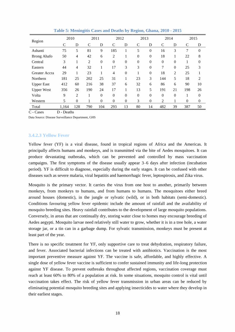
18
Table 5: Meningitis Cases and Deaths by Region, Ghana, 2010 - 2015
Region 2010 2011 2012 2013 2014 2015
C D C D C D C D C D C D
Ashanti 75 5 81 9 185 1 5 0 16 3 7 0
Brong Ahafo 50 4 42 6 2 1 0 0 18 1 22 8
Central 3 1 2 0 0 0 0 0 0 0 1 0
Eastern 44 4 32 1 17 3 3 0 7 0 25 3
Greater Accra 29 1 23 1 4 0 1 0 18 2 25 1
Northern 181 25 202 25 31 1 23 3 144 5 18 2
Upper East 412 60 216 38 37 6 32 6 86 6 90 10
Upper West 356 26 190 24 17 1 13 5 191 21 198 26
Volta 9 2 1 0 0 0 0 0 0 0 1 0
Western 5 0 1 0 0 0 3 0 2 1 0 0
Total 1,164 128 790 104 293 13 80 14 482 39 387 50
C - Cases D - Deaths
Data Source: Disease Surveillance Department, GHS
3.4.2.3 Yellow Fever
Yellow fever (YF) is a viral disease, found in tropical regions of Africa and the Americas. It
principally affects humans and monkeys, and is transmitted via the bite of Aedes mosquitoes. It can
produce devastating outbreaks, which can be prevented and controlled by mass vaccination
campaigns. The first symptoms of the disease usually appear 3–6 days after infection (incubation
period). YF is difficult to diagnose, especially during the early stages. It can be confused with other
diseases such as severe malaria, viral hepatitis and haemorrhagic fever, leptospirosis, and Zika virus.
Mosquito is the primary vector. It carries the virus from one host to another, primarily between
monkeys, from monkeys to humans, and from humans to humans. The mosquitoes either breed
around houses (domestic), in the jungle or sylvatic (wild), or in both habitats (semi-domestic).
Conditions favouring yellow fever epidemic include the amount of rainfall and the availability of
mosquito breeding sites. Heavy rainfall contributes to the development of large mosquito populations.
Conversely, in areas that are continually dry, storing water close to homes may encourage breeding of
Aedes aegypti. Mosquito larvae need relatively still water to grow, whether it is in a tree hole, a water
storage jar, or a tin can in a garbage dump. For sylvatic transmission, monkeys must be present at
least part of the year.
There is no specific treatment for YF, only supportive care to treat dehydration, respiratory failure,
and fever. Associated bacterial infections can be treated with antibiotics. Vaccination is the most
important preventive measure against YF. The vaccine is safe, affordable, and highly effective. A
single dose of yellow fever vaccine is sufficient to confer sustained immunity and life-long protection
against YF disease. To prevent outbreaks throughout affected regions, vaccination coverage must
reach at least 60% to 80% of a population at risk. In some situations, mosquito control is vital until
vaccination takes effect. The risk of yellow fever transmission in urban areas can be reduced by
eliminating potential mosquito breeding sites and applying insecticides to water where they develop in
their earliest stages.

19
Ghana has had a long history of YF well documented by several authors. David Scott described in
detail the sequence of yellow fever epidemics from 1901-1960 in his book entitled “Epidemic
diseases in Ghana” (Scott D, 1965). From 1901-1960 the country experienced nearly five major
epidemic periods scattered throughout most of the country. YF outbreaks had been experienced from
all the three zones of the country in approximately 10-year cycles since 1920 (although no outbreaks
were reported from northern savannah zone between 1931 and 1954) leading to high morbidity and
mortality. Mass immunization campaigns conducted in southern part of the country in the early 1950s
and in the northern part in late 1970 and early 1980s have disrupted these 10-year cycles without
completely interrupting transmission of YF virus (Agadzi et al, 1984). The disease is however
endemic in the country and of epidemic potential. The most recent severe outbreaks had occurred in
1993/1994 in Upper West region and in 1996/1997 where the Upper East and Northern regions were
the regions affected. The inclusion of the YF vaccination into the routine Expanded Programme on
Immunization (EPI) since 1992 and the selective mass vaccination campaigns in response to
outbreaks have limited YF epidemics from the year 2000 up to date to few sporadic outbreaks with
very few cases being recorded during these outbreaks (Figures 7 and 8).
Figure 7: Yearly Trend of Yellow Fever Cases in Ghana, 1950 - 2015
Data Source: Disease Surveillance Department, GHS

20
Figure 8: Reported Yellow Fever Outbreaks in Ghana by Region by Year, 1901 - 2015
Data Source: Disease Surveillance Department, GHS
3.4.2.4 Avian and Pandemic Influenza
Influenza is a viral infection that affects mainly the nose, throat, bronchi and, occasionally the lungs.
Infection usually lasts for about a week, and is characterized by sudden onset of high fever, aching
muscles, headache and severe malaise, non-productive cough, sore throat and rhinitis. The virus is
transmitted easily from person to person via droplets and small particles produced when infected
people cough or sneeze. Influenza tends to spread rapidly in seasonal epidemics. In temperate
climates, seasonal epidemics occur mainly during winter while in tropical regions, influenza may
occur throughout the year, causing outbreaks more irregularly (WHO, 2014). In Ghana there is
increase influenza incidence during the dry months of November to March.
There are 3 types of seasonal influenza viruses – A, B and C. Type A influenza viruses are further
classified into subtypes according to the combinations of various virus surface proteins. Among many
subtypes of influenza A viruses, influenza A(H1N1) and A(H3N2) subtypes are currently circulating
among humans. There are three types of influenza virus circulating in Ghana, namely
A(H1N1)pdm09, A(H3N2) and B. (MMIMR, 2016).

21
Avian Influenza (AI)
Avian influenza (“bird flu”) is an infectious disease of birds caused by type A strains of influenza
virus. The infection can cause a wide spectrum of symptoms in birds, ranging from mild illness,
which may pass unnoticed, to a rapidly fatal disease that can cause severe epidemics.
Avian influenza viruses do not normally infect humans. However, there have been instances of certain
highly pathogenic strains, such as A(H5N1) and A(H7N9) having caused severe respiratory disease in
humans. In most cases, the people infected had been in close contact with infected poultry or with
objects contaminated by their faeces (WHO, 2014). The major public health concern of AI outbreaks
in poultry is their effect on poultry populations, the potential of the virus to mutate to become more
easily transmissible between humans, raising the possibility of an influenza pandemic.
Ghana experienced a total of three separate Highly Pathogenic Avian Influenza (HPAI) H5N1
outbreaks in poultry in 2007, at approximately one month intervals that commenced in April and
affected three districts, Tema, Ketu South and Sunyani (Figure 9). No human cases were detected.
How the disease was introduced or why the disease was not more widely disseminated remains to be
answered (FAO, WHO, OIE, AU-IBAR 2008). In 2015, there were 34 outbreaks of A(H5N1) in
poultry in Ghana with no human case reported. The outbreaks which started in April in Kpone-
Katamanso district of Greater Accra region later spread to farms in 18 districts in 5 regions, Greater
Accra (12), Ashanti (1), Volta (2), Western (2) and Central (1) (Figure 9), (VSD, 2015 and OIE,
2015).
Figure 9: Districts Reporting Avian Influenza (AI) in Poultry in Ghana, 2007 and 2015
Source of Data: VSD and OIE

22
Influenza Pandemic
An influenza pandemic is a rare but recurrent event. A pandemic occurs when a new influenza virus
emerges and starts spreading as easily as seasonal influenza – by coughing and sneezing. Because the
virus is new, the human immune system will have no pre-existing immunity. This makes it likely that
people who contract pandemic influenza will experience more serious disease than that caused by
normal seasonal influenza. Three pandemics occurred in the previous century: “Spanish influenza” in
1918, “Asian influenza” in 1957, and “Hong Kong influenza” in 1968. The 1918 pandemic killed an
estimated 40–50 million people worldwide. That pandemic, which was exceptional, is considered one
of the deadliest disease events in human history. Subsequent pandemics were much milder, with
estimated 2 million and 1 million deaths in 1957 and 1968 respectively. The latest was the H1N1
(2009) which killed over 18,000. The H1N1 virus that caused that pandemic, A(H1N1)pdm09 is now
a regular human flu virus and continues to circulate seasonally worldwide.
3.4.2.5 Viral Haemorrhagic Fevers
Viral haemorrhagic fever (VHF) is a general term for a severe illness or diseases, sometimes
associated with bleeding, that may be caused by a number of viruses. These include Ebola Virus
Disease, Marburg, Lassa fever, Crimean-Congo haemorrhagic fever, Rift Valley Fever and Dengue.
Ebola Virus Disease (EVD) and Lassa Fever (LF) are the VHFs of major public health concern in
Ghana following the massive EVD outbreaks in the West African sub region in 2014 and reported LF
endemicity in West Africa with 2 cases confirmed in Ghana in 2011.
Ebola Virus Disease
Ebola Virus Disease (EVD), formerly known as Ebola haemorrhagic fever, is a severe, often fatal
disease in humans caused by Ebola virus. The average EVD case fatality rate is around 50%. Case
fatality rates have varied from 25% to 90% in past outbreaks (WHO, 2016a).
It is thought that fruit bats are natural hosts for Ebola virus. Ebola is introduced into the human
population through close contact with blood, secretions, organs or other bodily fluids of infected
animals such as chimpanzees, gorillas, fruit bats, monkeys, forest antelope and porcupines found ill or
dead in the rainforest. Ebola then spreads through human-to-human transmission via direct contact
(through broken skin or mucous membranes) with the blood, secretions, organs or other bodily fluids
of infected people, and with surfaces and materials (e.g. bedding, clothing) contaminated with these
fluids. Health-care workers have frequently been infected while treating patients with suspected or
confirmed EVD. This has occurred through close contact with patients when infection control
precautions are not strictly practised.
Ebola Virus Disease EVD first appeared in 1976 in 2 simultaneous outbreaks, one in what is now,
Nzara, South Sudan, and the other in Yambuku, Democratic Republic of Congo. Between 1976 and
2012 there had been 20 outbreaks recording 2,389 cases and 1570 deaths (case fatality rate of 65.7%).
The outbreak in West Africa which started in Guinea in 2014 is the largest and most complex Ebola
outbreak since the Ebola virus was first discovered, with concurrent rural and urban transmission
unlike the previous ones which were mainly rural. There have been more cases and deaths in this
outbreak than all others combined with unusually high number of health care workers affected. It has

23
also spread between countries starting in Guinea then spreading across land borders to Sierra Leone
and Liberia and also by air to Nigeria and United States of America. On 8 August 2014, the WHO
Director-General declared the West Africa outbreak a Public Health Emergency of International
Concern (PHEIC) under the International Health Regulations (2005). As of 27 March 2016 a
cumulative total of 28,616 cases and 11,310 deaths (CFR 39.5%) have been reported from the three
most affected countries, Guinea, Liberia and Sierra Leone (Figure 10). On 29 March 2016, WHO
lifted the PHEIC related to EVD in West Africa because all transmission chains have been identified
and countries have demonstrated the ability to respond effectively to avert international spread.
(WHO, 2016c)
Fortunately, no case of EVD had been confirmed in Ghana although 150 suspected cases were
investigated across the country. However, the disease remains a major public health threat to Ghana
due to the country’s proximity to the recently affected countries; difficulty in recognizing and quickly
diagnosing it in its early stages as presenting symptoms are similar to common prevalent infectious
conditions like malaria; rapid spread in communities and health facilities with poor infection
prevention and control practices; absence of an approved vaccine and effective cure; and high case
fatality rate.
Figure 10: Ebola Affected Countries in West Africa, 2014-2015
Source of data: WHO, 2016c
24
Lass Fever
Lassa Fever (LF) is an acute zoonotic viral haemorrhagic illness that occurs in West Africa. The Lassa
virus is transmitted to humans via contact with food or household items contaminated with rodent
urine or faeces. The animal reservoir, or host, of Lassa virus is a rodent of the genus Mastomys,
commonly known as the “multimammate rat.” Mastomys rats infected with Lassa virus do not
become ill, but they can shed the virus in their urine and faeces. Person-to-person infections and
laboratory transmission can also occur, particularly in hospitals lacking adequate infection prevention
and control measures. About 80% of people who become infected with Lassa virus have no
symptoms. 1 in 5 infections result in severe disease, where the virus affects several organs such as the
liver, spleen and kidneys. The overall case-fatality rate is 1%. Observed case-fatality rate among
patients hospitalized with severe cases of Lassa fever is 15%. Early supportive care with rehydration
and symptomatic treatment improves survival. The antiviral drug, ribavirin seems to be an effective
treatment for Lassa fever if given early in the course of clinical illness.
Lassa fever is known to be endemic in Benin, Ghana, Guinea, Liberia, Mali, Sierra Leone, and
Nigeria, but probably exists in other West African countries as well (WHO, 2016b). Ghana diagnosed
its first two cases in Amansie West district of Ashanti region in the Forest zone in 2011 (Dzotsi et al,
2012).
The disease is a public health threat due to the fact that it is endemic in the country and other
countries in the West African sub-region, difficulty in diagnosis especially early in the course of the
disease as presenting symptoms are similar to common prevalent infectious conditions like malaria
and typhoid fever and can spread in communities and health facilities with poor infection prevention
and control practices and absence of an approved vaccine. As recommended by Dzotsi et al, studies
are required to identify the geographical prevalence of the host Mastomys rodent and the presence of
LF in the animal to help determine the risk factors and geographical areas at risk for disease
transmission in Ghana.
3.4.2.6 Flood
A flood is an overflow of water that submerges land which is usually dry (Flood - Wikipedia).
Floods are dominated by two aspects: the presence of (excessive) water and the topographical
characteristics of the area. Water collects in low areas. Flat surfaces close to a river are more prone to
flooding and heavy rainstorms can cause sudden floods (flash flood).
Floods often cause damage to homes and businesses if they are in the natural flood plains of rivers.
Direct health effect of flood includes loss of life through drowning, trauma from debris, increased risk
of electrical shock (in urban areas) and snake bite (in rural areas), Mental and psychosocial problems
including post-traumatic stress syndrome. Indirect health effect may result from loss of drinking water
or severe water contamination and loss of sewage disposal facilities. The lack of clean water
combined with human sewage leads to risk of water borne diseases such as cholera and typhoid fever.
The damage to health facilities leads to interruption of health service delivery. Floods can also
damage roads and transport infrastructure therefore making it difficult to mobilize aid to those
affected or to provide emergency health treatment.

25
Whether flood hazard really occurs depends on the rainfall, reservoir spills, the surface type and the
drainage system. In Ghana there is a high variability of rainfall amounts and intensity; there is also
spilling from reservoirs. Two areas in the country are known to suffer from regular flooding due to
spilling of upstream reservoirs, the Northern White Volta, threatened by spilling from the Bagre dam
in Burkina Faso and the Southern White Volta, due to spilling from the Akosombo dam. In areas
where there is hardly any infiltration (e.g. hard rock, paved areas), response times are increased and
floods will occur more quickly and frequently compared to areas where infiltration is possible. This is
the case for example in Accra.
Almost all regions have experienced flooding in the past 5 decades (Figure 11). In recent times
flooding has become a serious phenomenon in Ghana, especially in urban areas. The problems stem
from a number of factors such as poor drainage systems and the physical development of flood prone
areas. The few existing drains tend to be badly built and clogged by rubbish and silt. Unapproved and
haphazard development causes flooding in built–up areas. Since the year 2010 there has been flooding
in Accra every year between May and July. Usually if there is continuous heavy rain for more than
two hours the capital is flooded.
Figure 11: Floods in Ghana by Region, 1968 - 2015
Source of data: Daily Graphic 5 June 2015

26
According to hazard mapping done by UNDP in 2010, about a third (35%) of the districts in Ghana is
classified as ‘high hazard, another third as medium hazard (Table 6) (UNDP, Ghana 2014).
Table 6: Distribution of Districts by Flood Hazard Level
Hazard Level Number of Districts %
High 76 35
Medium 69 32
Low 71 33
Data Source: UNDP, Ghana: Risk Assessment and Mapping – Technical Report, 2014
3.4.2.7 Drought
Drought is the naturally occurring phenomenon that exists when precipitation has been significantly
below normal recorded levels, causing serious hydrological imbalances that adversely affect land
resource production systems” (UNCCD, 1994). Drought is dominantly influenced by the weather,
especially rainfall and evapotranspiration. Whether areas suffer from drought depends on the spatial
variability of these meteorological variables as well as on the physical properties of the land surface.
The most important variable used for mapping is the cumulative rainfall deficit (evapotranspiration
minus rainfall). Drought is a slow process as compared to flood.
The health consequences of drought include malnutrition; micronutrient deficiencies caused by food
shortage due to decline in soil fertility, disease outbreaks (water-borne diseases) due to decline in
water availability and quality. Ghana has experienced drought mainly in the Northern savannah zone
of the country.
According to the hazard mapping by UNDP, 37 (17%) of districts in Ghana are high level hazard
(Table 7). All 37 districts are located in the Northern savannah ecological zone. All the 56 districts in
the zone are either high level or medium level for drought hazard (Figure 12) (UNDP, Ghana 2014).
Table 7: Distribution of Districts by Drought Hazard Level
Hazard Level Number of Districts %
High 37 17
Medium 46 21
Low 34 16
No 99 46
Data Source: UNDP, Ghana: Risk Assessment and Mapping – Technical Report, 2014

27
Figure 12: District Drought hazard map, Ghana
Data source: UNDP, Ghana: Risk Assessment and Mapping – Technical Report, 2014
3.4.2.8 Earthquake
Earthquake is a shaking or trembling of the earth that is volcanic or tectonic in origin causing any type
of damage or negative effect on communities or properties (GLIDE). An earthquake occurs when
there is slip along a fault in the earth. Energy is released during an earthquake in several forms as
heat, and as seismic waves that radiate out from the "source" in all directions and cause the ground to
shake, sometimes hundreds of kilometres away (Natural Resources Canada, 2009). Earthquakes are
caused by the movement and deformation of the tectonic plates caused by the heating and cooling of
rock underneath them. The stress on the rocks accumulates until it is suddenly released in a rapid
burst of movement. Although most earthquakes are natural, human activities have caused small
earthquakes. These include mining activities (such as underground collapses and rock bursts), oil
recovery and the filling of reservoirs behind large dams. Underground nuclear explosions are also
known to have caused minor earthquakes near the test site.
Earthquakes are measured by their consequence, ‘a measure of the amount of energy released during
an earthquake’. While the first magnitude scale was the Richter scale, currently there are several
different regional magnitude scales, of which the most universal today is the moment magnitude
scale, which assesses the amount of energy released by an earthquake.

28
The amount and type of damage depends on the magnitude of the earthquake, the distance from the
earthquake epicentre (the origin point of the earthquake), the depth of the earthquake, the frequency of
the ground motion, the kind of faulting and the soil and rock type of an area (Natural Resources
Canada, 2009). A powerful earthquake could cause buildings and structures such as bridges to
collapse, trapping people in the debris. People can also be killed or injured by falling debris such as
glass, chimneys, book cases and roof tiles. Further fatalities and injuries may occur during aftershocks
if buildings compromised by the original earthquake are re-entered. Fires caused by ruptured gas
mains etc., may also pose a risk.
Although Ghana is far away from the major earthquake zones that mark the present day lithospheric
plate boundaries, the country has been struck by damaging earthquakes in the past (Table 8), and
recently has been experiencing minor tremors regularly. The tremors that occurred on 14 February
and 6 March 1997 and other recent microseismic activities were very threatening registering more
than 4.0 on the Richter scale. Accra, the capital city, with a growing number of large industrial
activities is located in the earthquake-prone zone. Microseismic studies in the country indicate that the
seismic activity is associated with active faulting, particularly near the intersection of the two major
fault zones, the coastal boundary fault and Akwapim fault zone. Most of the located earthquakes have
their epicentres near the junction of these faults (Paulina Amponsah, 2004).
Table 8: Earthquakes in Ghana, 1615 - 2002
Year Type Areas Magnitude Impact
1615 Earthquake Elmina
First earthquake in Ghana. Fortress of Sao Jorge at
Elmina was destroyed.
1636 Earthquake Axim 5.7 MS
Earliest recorded earthquake in Ghana. Buildings and
underground workings of a gold mine at Aboasi,
northeast of Axim collapsed burying many of the
miners
1858 Minor tremor Accra No damage
1862 Earthquake Accra 6.5ML 3 deaths, considerable infrastructure damage. Osu
Castle was destroyed. Effects also in Togo and Benin
1871 Minor tremor Accra 4.6 ML No damage
1872 Minor tremor Accra 4.9 ML No damage
1883 Minor tremor No damage
1906 Earthquake Ho 6.2 ML Severe damage - collapsed buildings, no casualties
were reported. Event also felt in Togo and Benin
1907 Minor tremor Accra No damage
1911 Minor tremor Accra No damage
1939 Earthquake Accra 6.5 MR
Most destructive earthquake in Ghana’s history. The
event lasted about thirty seconds and killed 17 and
injured 133.
1964 Minor tremor Accra No damage
1969 Minor tremor Accra No damage
1997 Minor tremors All regional
capitals 4.8 MR No damage
1998-
2002 Minor tremors 1.0–3.0 MR No damage
MS – Surface wave magnitude, ML – Local magnitude, MR – Richter scale magnitude
Data Source: Paulina Amponsah. Seismic activity in Ghana: Past, present and future Annals of Geophysics, Vol 47, 2004

29
3.4.2.9 Land (Road) Transport Accidents
Road traffic emergency is a crash, collision or incident, of large scale, involving land or road
transportation. An increase in average speed is directly related both to the likelihood of a crash
occurring and to the severity of the consequences of the crash. Drinking and driving increase both the
risk of a crash and the likelihood that death or serious injury will result. There are many types of
distractions that can lead to impaired driving, but recently there has been a marked increase around
the world in the use of mobile phones by drivers that is becoming a growing concern for road safety.
Text messaging also results in considerably reduced driving performance, with young drivers at
particular risk of the effects of distraction resulting from this use. In Ghana, over speeding, over
loading and disregard to road signs or regulations have been identified as the first-three main road
traffic accidents (RTA) causing factors (Nyamuame et al, 2015). Wearing a motorcycle helmet
correctly can reduce the risk of death by almost 40% and the risk of severe injury by over 70%.
Wearing a seat-belt reduces the risk of a fatality among front-seat passengers by 40–50% and of rear-
seat passengers by between 25–75% (WHO, 2015c).
Road traffic crashes are the leading cause of death globally and the main cause of death in those aged
15 - 29 years. Road traffic injuries cause considerable economic losses to victims, their families, and
to nations as a whole. One of the new Sustainable Development Goals (SDG) targets is to halve the
global number of deaths and injuries from road traffic crashes by 2020 (WHO 2015). Ninety percent
of the world's fatalities on the roads occur in low- and middle-income countries, even though these
countries have approximately half of the world's vehicles. Even within high-income countries, people
from lower socioeconomic backgrounds are more likely to be involved in road traffic crashes. Half of
those dying on the world’s roads are “vulnerable road users”: pedestrians, cyclists and motorcyclists.
Thousands of small-scale road accidents occur annually, although, large-scale road transportation
emergencies are uncommon. Few are severe enough that they exceed routine local emergency
capacity.
In Ghana, available data from the Ghana Health Service indicate that overall the number of reported
road traffic injuries increase from 2011 to 2013 and then start to decrease with the highest average
annual incidence recorded for the period in Ashanti and Greater Accra regions (Table 9). Nyamuame
et al (2015) in their study of road traffic accident trends in Ghana reported that road traffic accidents
and fatalities a r e on the increase with progression in the year and population growth with highest
incidence of accidents and fatalities being recorded in Greater Accra and Ashanti regions respectively, the
two most populous regions and with the most economic activities. The study also showed that the three
regions in the northern savannah zone (Northern, Upper East and Upper West) recorded the lowest
number of RTA cases. This could be attributed to their remote location relative to Accra where
most economic activities occur and low number of vehicles in these regions. The high hazards areas
for road transport accidents are the major towns including the regional capitals and big commercial
towns (Figure 13). The number of accidents tends to increase during periods of festivities such as
Christmas and Easter when most people travel to their home towns and drivers tend to over speed to
make so many trips to accommodate the increase in volume of passengers.

30
Table 9: Average Annual Incidence of Road Traffic Injuries by Region, Ghana, 2011 - 2015
Region 2011 2012 2013 2014 2015 Total
Ashanti 14,450 15,261 14,366 12,221 11,046 67,344
Brong Ahafo 10,686 13,598 13,315 11,783 10,739 60,121
Central 7,965 9,590 9,518 7,485 7,943 42,501
Eastern 13,159 15,200 13,061 11,873 8,950 62,243
Greater Accra 13,055 14,380 16,702 14,187 12,775 71,099
Northern 10,622 12,932 15,023 11,565 8,360 58,502
Upper East 7,439 9,577 11,708 12,586 10,493 51,803
Upper West 5,501 5,869 6,764 5,655 5,901 29,690
Volta 12,114 14,323 14,366 9,966 6,464 57,233
Western 10,274 11,394 11,216 8,645 8,651 50,180
Ghana 105,265 122,124 126,039 105,966 91,322 550,716
Source of Data: DHIMS, CHIM, GHS
Figure 13: Hazard Map for Road Traffic Accidents
Road traffic injuries can be prevented. Action is needed to address road safety in a holistic manner,
that requires involvement from multiple sectors (transport, police, health, education) and that
addresses the safety of roads, vehicles, and road users themselves. Effective interventions include
designing safer infrastructure and incorporating road safety features into land-use and transport
planning; improving the safety features of vehicles; and improving post-crash care for victims of road
crashes. Interventions that target road user behaviour are equally important, such as setting and
enforcing laws relating to key risk factors, and raising public awareness.

31
3.4.2.10 Air Transport (Aviation) Accidents
Transportation emergencies involving aircrafts may arise from the following circumstances: an
aircraft colliding with another aircraft in the air; an aircraft crashing or being in imminent danger due
to mechanical problems, or human error; an aircraft crashing while in the take-off, cruising or landing
phases of a flight; an aircraft colliding with an object on the ground or at any stage during the flight,
two or more aircraft colliding on the ground during staging or taxi operations. A transportation
emergency involving aircraft may result in secondary hazards such as fires and explosions. If a
structure is impacted, it may result in building/structural collapse.
Despite the high volume of air traffic, serious air transportation incidents involving large numbers of
people are fairly rare. However, when they do occur, they can result in a large number of injuries and
even fatalities. The number of people affected depends on the size of the aircraft, the number of
passengers and crew, the speed at which it is travelling and the area (and the population) in which the
incident occurs. Serious property damage can occur if the incident occurs in an area with a large
number of buildings and/or structures. Damage can be very severe, resulting in the complete
destruction of the building/structure. Critical infrastructure may also be damaged. However, due to the
size of aircraft and the amount of fuel aboard, air transportation incidents are usually localized.
Ghana has experienced very few aviation accidents in the past. On 5 June 2000, a Ghana Airlink
Fokker F-27 from Tamale to Accra crashed on approaching Kotoka International Airport. Six people
were killed. On 2 June 2012, an Allied Air Boeing 727 cargo aircraft operating from Lagos to Accra
on behalf of DHL with 4 crew members overshot the runway while landing in heavy rain. At least 12
people on the ground (passengers on a minivan on the 37 Military Hospital-Burma Camp road at El-
Wak) were killed. All the 4 crew members survived (KIA-Wikipedia).
3.4.2.11 Water Transport Accidents
Transportation emergencies involving marine vehicles may arise from the following circumstances: a
collision with another marine vehicle or object, the marine vehicle capsizing, floundering, sinking, a
marine vehicle encounters severe weather which causes damage or flooding, a fire and/or explosion
aboard the marine vehicle; the marine vehicle striking land, rocks and becoming damaged or
grounded, a marine vehicle suffers structural damage that compromises its safety, flooding of a
marine vehicle. Therefore water transport accident areas are along the sea and rivers where most
people use water transportation as their main means of transport.
Ghana has experienced boat accidents, particularly on the Volta Lake in recent years, the latest of
which was the one that occurred on 29 May 2016 in which 25 people, including children, died when a
boat carrying about 60 people capsized on the lake in Yeji in the Pru district of Brong Ahafo region.

32
3.4.2.12 Structural Collapse
Structure collapse is the loss of integrity in a structure that results in the structure losing shape, caving
in, flattened or reduced to debris. Structures, such as buildings and bridges collapse if the load-
carrying capacity within the structure or of the structure as a whole is exceeded and the building
material is stressed beyond its limit. Structures may exceed their load-carrying capacity due to the
stresses of different causes. These include design and construction flaws, material flaw, high wind,
earthquake, fire, explosion, deterioration, the lack of strict building codes and the non-availability of
proper construction materials. Structures may experience a complete or partial collapse; and the
collapse may be sudden or delayed. Collapse usually begins with fractures and deformations of the
structure but may occur quickly so that these are not noticeable in time to evacuate.
A building/structural collapse is usually an isolated occurrence, unless it occurs as a secondary hazard
due to an event such as an earthquake. The immediate building is affected, as well as any other
structures that are within the collapse zone that is likely to experience falling debris.
In Ghana, between 2012 and 2014, Accra officially recorded four major building collapses that
claimed a total of 19, the most serious one being the Melcom supermarket building near Achimota
that collapsed in 2012 and claimed 14 lives (Mark Bediako 2015).
3.4.2.13 Nuclear and Radiological Emergency
Nuclear accident
Nuclear hazard results from ionizing radiation whose source is a major nuclear installation. Nuclear
generating stations produce electricity created by nuclear fission. Nuclear fission generates heat which
is used to boil water to produce steam which can then be used to power turbines which generates
electricity (OPG, 2010). A nuclear facility emergency could occur if a substantial amount of
radioactive material is released into the environment. Advances in technology and safety procedures
have decreased the probability of a nuclear facility emergency significantly. A nuclear facility
emergency could be triggered by fire or explosion, technological malfunction, intentional or
unintentional human activity (EMO, 2005). The release of radioactive materials depends on the
characteristics of the event and the type and response of the containment system. These systems are
designed to prevent the release of radioactive materials in the event of an accident. Sudden releases
(i.e. within a few hours) can only occur if the system malfunctions or it is bypassed. In the extremely
unlikely event of a nuclear facility emergency that results in the release of high levels of radioactive
material, the most likely ways in which people can be exposed to radiation are: external
contamination – the contamination of the skin and/or clothing; direct Exposure – exposure to the
source of the radiation and internal contamination – the inhalation of radioactive material or the
ingestion of contaminated food or water (EMO, 2009).
Exposure and contamination can be minimized in the event of a nuclear facility emergency through
the use of specific protective measures. The type of protective measures that should be used depends
on the type of radioactive material, the amount released, the size of the affected area, land use and the
population. The protective measures include restricting access to the affected area to essential
personnel, ingestion of Potassium Iodide (KI) – this blocks radioactive iodine from entering the

33
thyroid (it is only useful in an emergency that involves the release or potential release of iodine-131);
and remaining indoors, with windows and doors closed and external ventilation systems turned off.
Radiological accident
A radiological emergency occurs when ionizing radiation from radioactive material is unintentionally
emitted outside of protective spaces, at levels high enough that it presents a threat to people or the
environment. There are three basic types of ionizing radiation: Alpha particles, Beta particles, Gamma
rays. A device that contains radioactive material and could result in exposure is referred to as a
‘source’. Radiation sources are commonly used in universities, industry and government facilities. A
source can be classified as being dangerous if uncontrolled exposure could result in severe health
effects. A source may be considered to be uncontrolled if it is abandoned, lost, stolen or otherwise
outside of regulatory control. Radiological emergencies may also arise from the misuse or
malfunctioning of industrial and medical sources and transportation accidents carrying radioactive
materials and from unknown origins. While radiological incidents may occur from time to time, (these
are usually small and are cleaned up very quickly without any negative effects) radiological
emergencies are rare.
There are several different ways in which people and animals can be exposed to radiation. These
include direct exposure (being near or in contact with an uncontrolled source); inhalation of
radioactive particles; ingestion of foods or liquids contaminated with radiation.
Health effects may not appear for days, weeks or even years depending on the length, type of
radioactive material and form of exposure. Negative health effects can be divided into two categories:
chronic and acute. Chronic health effects are related to long-term exposure to radiation. The energy
level of the radioactive material is not sufficient to cause immediate health effects. Negative health
effects may not show up until months or years after exposure. The primary chronic health effect
related to radiation exposure is cancer. Teratogenic mutations of foetuses are also possible if pregnant
women are exposed to radiation sources over the long-term (EPA, 2010). Acute health effects are
caused by exposure to high levels of radiation. These effects may appear quickly, within a matter of
hours or days. The principal acute health effect is radiation sickness. Radiation sickness can induce
symptoms such as weakness, hair loss, nausea, damage to the organs and skin burns. If the dose of
radiation received from exposure is high enough, radiation sickness can be lethal with death usually
occurring within two months of exposure (EPA, 2010). Another potential negative effect of a
radiological emergency involving a dangerous source could be ground contamination. Depending on
the level of contamination, clean-up of the site may be necessary. If the contamination is severe, any
inhabitants of that site may require relocation.
Ghana, for the past three decades, has been using various types of radiation emitting devices and
radioactive sources. The practices in Ghana cover the following main areas: medicine, industry and
research and teaching. There are 158 authorised facilities in Ghana that use radiation emitting devices
and/or radioactive sources. Major practices in Ghana are research reactor, Co-60 gamma irradiator,
Co-60 radiotherapy source and Ir-192 source for non-destructive material testing. (NADMO and
GAEC, 2010)

34
According to the International Atomic Energy Agency (IAEA) emergency planning categorization of
radio-nuclear practices in Ghana fall into Category III and IV.
Emergency Planning Category III: Facilities without significant off-site risk but with the potential for
accidents resulting in deterministic health effects on-site. According to the Ghana Atomic Energy
Commission (GAEC), the following practices fall in this category:
• 30kw Research Reactor at the Ghana Atomic Energy Commission
• 18.5 PBq Co-60 Gamma source for radiation Processing centre
• 18.5 PBq Co-60 gamma source for radiation therapy at Korle-Bu Hospital Radiotherapy
Centre
• 22.2PBq therapy at Komfo Anokye Hospital Radiotherapy Centre
• 18.5TBq Cs-137 Gamma source for brachytherapy at Korle Bu Radiotherapy Centre
• 22.2TBq Gamma Source for brachytherapy at Komfo Anokye Hospital Radiotherapy Centre
• 27TBq Ir-192 source for non-destructive material testing
• 37TBq Co-60 gamma source for destination inspection at Tema port
• 37TBq Co-60 gamma source for destination inspection at Takoradi port
Emergency Planning Category IV: Areas with little or no known threat. This is the minimum for all
countries because accidents involving lost or stolen sources or the transportation of radioactive
material are possible anywhere. All the rest of practices in Ghana fall into that category.
Emergency Planning Category V: Is less likely for Ghana since at present the nearest nuclear power
plant, Koeberg, near Cape Town, South Africa, is situated more than 4000 km from Ghana’s borders.
3.4.2.14 Fire
Fire is uncontrolled and/or potentially destructive burning caused by the ignition of a fuel or material,
combined with oxygen, which gives off heat and light, with or without an open flame.
Fires require three elements in order to propagate, a fuel source (e.g. bedding, wood), oxygen and a
source of ignition. Sources of ignition include: heat, static electricity and chemical reactions (IRP,
2006). The persistent and spread of a fire depends on the type of fuel source, the amount of fuel
source, the source, type and location of initial ignition, the size and layout of the
building/surroundings, air turbulence caused by the interaction of fire and/or burning gases with
obstacles, the type of vents and their locations, additional fuel sources, the presence of prevention and
mitigation systems.
Fires can occur outdoors or within structures such as houses. The most common type of fire is outdoor
fires. Structure fires can have one of several causes including heating/cooling, cooking,
cigarette/lighters, faulty electricity wiring and arson. Different types of buildings are more likely to
experience fires resulting from different causes.
Structure fires can result in fatalities, injuries and significant property damage. Fire fatalities result
from direct effect of the fire (e.g. burns), secondary complications from fire injuries (e.g. pulmonary
oedema), damage caused by the fire (e.g. roof collapse), being involved in fire control (e.g. a rescue
attempt). Fire prevention measures include use of smoke alarms, use of fire resistant building
materials, sprinkler systems, fire extinguishers and improvement in fire-fighting technology.

35
In Ghana, Addai et al reported in their study on trend of fire outbreaks in Ghana from 200 to 2013 that
the rate of fire incidence increased each year (Figure 14). This increase was attributed to several
factors: rate of population growth and industrialization, unstable electricity, urbanization, negligence,
illegal electrical connection, etc. The cause of fire was categorized into domestic, industrial,
vehicular, institutional, electrical, commercial, bush, and others. Among these causes, domestic fire
accounted for 41% of the total number of fire incidents in the country. Most of the fire incidents
occurred in the populated cities of Ghana. Most of the recent fire outbreaks have taken place in state
facilities that are of great strategic value, thereby making fires an issue of public concern. For
example, the Kumasi Central Market suffered fire outbreaks on 28 May 2009, 2 January 2010 and on
30 December 2012. Other important places that were destroyed by fire include the Ministry of
Information, the loading gantry of Tema Oil Refinery, offices of the Electoral Commission, and the
Ridge residence of former President Rawlings (Addai E. K et al, 2016)
Figure 14: Pattern of Yearly Incidence of Fire in Ghana, 2000 - 2013
Source: Addai E. K. et al - Trend of Fire Outbreaks in Ghana and Ways to Prevent These Incidents, 2016
However, the fire (secondary hazard) that occurred in Accra on 3 June 2015 following heavy rain and
flooding and fuel leakage from a petrol filling station on to the top of flood waters that was ignited by
a naked flame nearby was a typical example of public health emergency. Many people were burnt to
death beyond recognition and others sustained various degrees of severe burns.
3.4.2.15 Oil and Natural Gas Emergency
Oil and gas emergency is an event that poses a threat to public safety, property, the environment,
critical infrastructure or the economy from the uncontrolled release of oil and/or natural gas from: 1) a
pipeline; 2) oil/natural gas wells; 3) storage facilities and/or distribution systems.

36
Oil and natural gas are natural resources that were produced from the carbon and hydrogen molecules
of decayed organic matter. Decayed organic matter built up in layers over millions of years within
geological formations. Over time, heat, pressure and anaerobic bacteria altered the organic matter into
oil and gas. Oil and natural gas can be found in many different geologic formations. They can be
retrieved by drilling wells to the deposit. Oil has many uses including gasoline, diesel fuel, synthetic
rubber and fibres, plastic and pesticides whilst natural gas is used for heating, plastics and fertilizers.
The term ‘natural gas’ refers primarily to methane and other gas types such as ethane, propane,
butane, pentanes and heavier hydrocarbons. It does not naturally have an odour, so the odorant,
mercaptan is added (during processing) in order to give it a distinct smell and make it easier to detect.
Some of the hazards associated with natural gas are: asphyxiation, ignition and explosion. Natural gas
containing high levels of hydrogen sulphide is referred to as ‘sour gas’. Hydrogen sulphide is very
toxic to humans.
Oil or liquid petroleum is made up of a mixture of liquid hydrocarbons. It is referred to as ‘crude oil’
if it has not been refined. Some of the hazards associated with oil are: spills contaminating land and
waterways and have severe impacts on wildlife and natural ecosystems; fire – oil fires in oil wells,
pipeline or storage facilities can be extremely difficult to extinguish due to the abundance of fuel. The
smoke produced by these fires may contain many chemicals and particulates that are harmful to
human health if proper safety precautions are not taken. If it is ignited and explosions occur can result
in fatalities, injuries, property damage, critical infrastructure failure and environmental damage.
Perhaps the greatest risk is environmental contamination.
There has not been major oil and gas spillage in Ghana. However with the discovery of oil and its
exploration, the establishment of the gas plant and the oil refinery, the likelihood of occurrence of oil
and gas spillage accidents in the country cannot be ignored.
3.4.2.16 Chemical
A chemical can be considered a hazard if by virtue of its intrinsic properties it can cause harm or
danger to humans, property, or the environment. Some harmful chemicals occur naturally in certain
geological formations, such as radon gas or arsenic. Other sources of chemical pollution include
agriculture, manufacturing and chemical industries.
Studies have shown that exposure to agro-chemicals (notably pesticides and fertilizers) is as a result
of practices such as non-adherence to re-entry intervals of these chemicals, inappropriate
handling of chemicals during mixing, application, the practice of tasting to ascertain potency, storage
of chemicals at home, indoor locations like bedroom and kitchen where inhalation is likely to be
pronounced, and lastly the practice of non-utilization of personal protective equipment (Jeyaratuam J,
1992).
In the manufacturing sector, a wide range of chemicals pose health hazards. These include aromatic
solvents like benzene which can cause cardiac arrest, burns in acute exposure situations while chronic
effects like leukaemia occur much later. Chemicals like isocyanates used in the plastics industry are
potent sensitizing agents and may evoke asthmatic attacks. Acids and alkalis important in
manufacturing have the potential of causing serious burns.

37
Wastes from industries are potential sources of pollution. A number of small to medium scale
industries are located within unplanned areas including residential neighbourhoods and even in
houses. Many of these industries dispose of their wastes into drains which are subsequently
transported to water bodies during heavy rains. Activities of small-scale and illegal artisanal
mining (popularly called Galamsey) have polluted several communities’ water sources with arsenic
and mercury. Significant cyanide spills which occurred in 2001, 2002 and 2003 in the Tarkwa mining
areas resulted in high pollution of rivers and wetlands. There is also seepage from indiscriminate
dumping of waste as a result of deficient urban services such as well engineered landfill and proper
chemical treatment facilities.
Chemicals can also contaminate food. There are reported cases of use of chemicals and pesticides for
fishing and game hunting in Ghana. Available evidence shows that there are high amounts of
chemicals and pesticides residues in food (including meat) sold on the local market (Adu-Kumi et al.,
2010) and even certain imported food substances.
3.4.2.17 Civil Disorder
A group or groups of people intentionally not observing a law, regulation or rule in order to disrupt a
business, organization or community to bring attention to their cause, concern or agenda.
Some of the potential causes include: resource shortages, a victory or defeat of a sports team, hostile
labour disputes, local, national or international events, the implementation of controversial laws
polices or court rulings, disagreements between special interest groups over a particular issue or cause
e.g. chieftaincy disputes and ethnic conflicts. Civil disorder can take many forms including, small or
large groups that cause the disruption of normal public services and activities, groups that
intentionally block or impede access to buildings, roads or other sites, assaults on public figures,
police or security personnel, a riot in which property is destroyed and the public threatened.
Civil disorder incidents can have significant impacts on the health sector. Hospitals and clinics may
be inaccessible if the civil disorder incident is nearby or they may be overwhelmed by a sudden
increase in people requiring medical care. As a result, the health sector requires significant
contingency planning for civil disorders.
In Ghana, the May 2001 stadium disaster and the numerous chieftaincy disputes, notably the murder
of Dagbon chief and 40 others in 2002 are some of the civil disorders with grave consequences the
country has encountered in the recent past.
3.4.2.18 Terrorism
Terrorism is the intentional poisoning, infecting or otherwise targeting through means such as planned
explosions of an individual or small group for non-political reasons. This involves the use of materials
such as chemical, biological, radiological, nuclear and explosive (CBRNE) intentionally released with
the intent to cause harm to humans, property, business or the environment. These materials can be
weaponized or non-weaponized. The impact includes risk of mass casualties or fatalities and illnesses,
chronic health, psychosocial problems, and creation of a hazardous environment.
38
The impact of the incident depends on the type of material used, amount of material used, dispersal
method, number of different materials used, the location (open or closed), the weather conditions, the
population density, the length of exposure, the length of time in which symptoms appear, the length of
time in which the material is identified. (CDC, 2010)
The most likely type of CBRNE incident is explosive. Explosive devices do not have to be
particularly sophisticated in order to cause a significant amount of damage. Instructions for building
explosive devices can be found on the internet. Many ingredients for an explosive device have
common, daily uses and are easy to obtain. High volume purchases of these ingredients may raise
suspicion. However, numerous purchases at different locations and over a period of time may go
undetected.
Cities with a high volume and high reliance on public transportation may have their transportation
infrastructure at risk. An attack against a public transportation system which a large number of the
local population relies on for transit may paralyze a city.
Although Ghana has not experienced any terrorist act, the recent attacks in Mali (November 2015),
neighbouring Burkina Faso (January, 2016) and La Cote d’Ivoire (March 2016) must put the country
on high alert.
3.5. Risk Analysis
The results of analysis of various contributing factors including the extent of exposure to the hazard,
the vulnerability of the population and their coping capacities that help to determine the likelihood
and adverse health consequences resulting in a public health emergency are presented in this section.
3.5.1 Cholera
The occurrence of Cholera is influenced by the presence of the causative agent and its ability to cause
the disease in the host and the ease of spread of the disease. The risk factors for spread of the disease
include inadequate supply of safe water, poor food and personal hygiene, poor liquid and solid waste
disposal, urban slums characterized by poor sanitation and open defaecation, floods leading to
contamination of domestic water sources.
The parameters used for the categorization of cholera hazard level is the number of years the area has
experienced outbreaks in the past 5 years (2011 – 2015) and the impact of the outbreak (average
annual incidence and the fatality)
Variables for cholera vulnerability assessment include
Populations with unsafe water supply and poor sanitation
Living in slums (urban and peri-urban)
Living in flood prone areas

39
Coping capacity variables include
Ability to detect cases early
Availability of rapid response team to provide community interventions
Awareness of public about the prevention and control measures
Availability of case management facilities
Analysis by district shows that 7 (3%) of the districts in the country are at high risk of cholera
outbreak, whilst 65 (30%) are medium risk and the remaining 144 (67%) are at low risk. Six (86%) of
the high risks districts are located in the coastal zone. All the districts in the coastal zone are either at
high risk or medium risk of the cholera disease (Table 10 and Figure 15). Analysis by zone indicates
that the coastal zone is at high risk whilst the forest and northern savannah zones are at medium risk
for cholera.
Table 10: Cholera Risk Level, Ghana, 2016
Ecological Zone Number of Districts
Low Risk Medium Risk High Risk Total
Northern Savannah 45 11 0 61
Forest 99 34 1 129
Coastal 0 20 6 26
Ghana 144 65 7 216
Figure 15: Cholera Risk Level by District

40
In the coastal zone, the location of the national capital (Accra) and regional capitals, Sekondi and
Cape Coast, and points of entry (Tema and Takoradi seaport, Aflao and Elubo border crossings) with
large daily population movements in this zone puts more pressure on the already existing poor water,
sanitation and hygiene (WASH) facilities and thereby increasing vulnerability to cholera outbreaks. In
addition, internal rural-urban migration had created slums in these areas with poor WASH facilities
which facilitate the spread of cholera. The coastal zone is also low lying, and compounded by poor
drainage systems, is prone to flooding which may destroy sanitary facilities resulting in contamination
of water sources and consequently leading to cholera outbreaks.
Accra metropolis and the two districts carved out of it in 2008, Ledzokuku-Krowor and La-Dade-
Kotopon, are considered hotspots for cholera (regular high attack rate, often coinciding with the rainy
season, persistence of cholera cases beyond the usual seasonal peak and high case fatality rate) and
tend to serve as the epicentre of most cholera outbreaks.
The institution of enhanced acute watery diarrhoea (AWD) surveillance including the introduction of
cholera rapid diagnostic tests has improved early detection of cholera outbreaks. Recently the GHS
has adopted the strategy of training rapid multidisciplinary response teams and deploying them to
investigate cholera cases and provide WASH interventions in households and communities where
cases occur. There has also been an increase in education and awareness creation by the media on
cholera prevention and control. Efforts are being made to build more treatments centres,
supplementing permanent structures with tents, particularly in Accra. In May 2016 one of such
treatment centres was commissioned in Accra. Cholera treatment logistics are also being
prepositioned at treatment centres. These increased coping capacities will reduce the risk of cholera in
the country as a whole.
3.5.2 Meningitis
Risk factors for Meningococcal meningitis epidemics include immunological susceptibility of the
population (loss of herd immunity, prevalent strain etc.), dry season when the absolute humidity is
low, as during the harmattan, often associated with frequent dust storms, crowded living conditions,
low socioeconomic status, concurrent upper respiratory infections, and poor nutritional status.
The vulnerability variables used in the risk analysis include
Location - being in the African meningitis belt
The prevalent strain of meningitis causing bacteria
Crowded living conditions
Area(s) with important population movements (border, market hub, etc.)
The coping capacities include
Ability to detect outbreaks early (Enhanced surveillance)
Easy access to vaccine
Access to treatment
Awareness about disease and health seeking behaviour

41
The frequency of outbreaks, the impact in terms of annual incidence and fatality from 2011 to
2015 were used to define the hazard level. Risk analysis showed that 15 (7%) of 216 districts are
classified as high risk for meningitis while 25 (12%) are at medium risk, and 176 (81%) are at low
risk. All the 15 high risk level districts are located in the northern savannah zone (Table 11 and
Figure 16). By zone the northern savannah zone is classified as being at high risk whist the forest
zone is at medium risk and the coastal zone is at low risk for meningitis.
Table 11: Meningitis Risk Level by District by Zone, Ghana, 2016
Ecological Zone Number of Districts
Low Risk Medium Risk High Risk Total
Northern Savannah 21 20 15 56
Forest 129 5 0 134
Coastal 26 0 0 26
Ghana 176 25 15 216
Figure 16: Meningitis Risk Map

42
The northern part of the northern savannah zone comprising the districts in the Upper East, Upper
West and some districts in Northern region lies in the meningitis belt which has one rainfall season
(May to September) and continues to experience long dry weather condition. As a result of climate
change the meningitis belt is extending southwards with the districts in the upper part of the forest
zone also experiencing focal outbreaks e.g. Tain, Wenchi, Nkoranza South, Techiman and Jaman
North districts of Brong Ahafo region experienced outbreaks from latter part of 2015 to early part of
2016.
In the past the pathogen responsible for meningitis outbreak is N. meningitides for which there are
vaccines for prevention and for response. However, the emergence of S. pneumonae, for which there
are no vaccines yet available for mass vaccination response, increases the risk of meningitis outbreaks
in and outside the meningitis belt. Although Northern and Upper West regions which are the most
sparsely populated regions in the country are in this zone most of the population live in crowded
households which promote spread of the disease. In addition, the zone has the poorest nutritional
indicators in the country (GSS, GHS and ICF, 2015).
3.5.3 Yellow Fever
Risk factors for Yellow fever include low level population immunity, presence of the vector, and
failure of local surveillance systems to detect cases early. An area is considered at risk for an
epidemic of yellow fever if it has experienced yellow fever epidemics in the past; people visit or work
in large forested areas with monkeys where sylvatic yellow fever is likely to occur.
The vulnerability variables used to assess YF risk are
Visiting or working in forested areas with monkeys
Presence of mosquitoes which transmit YF
A long rainy season or long dry season
Large proportion of the population not vaccinated.
The coping capacity variables include
Ability to detect epidemics p r o mp t l y
Availability of YF vaccine stock for an immediate response
Capacity to organise an immunization campaign within a very short time.
The whole country is situated in the YF ecological risk zone (latitudes 15N and 10S) with districts in
the forest zone in particular having large forested areas with monkeys. People still visit these forests
to hunt and for other economic activities. The rainfall pattern in the country favours epidemic of YF.
The 2010 population and housing census indicate that there is increasing urbanization with more
people living in the cities (GSS, 2012). On the edge of these cities, shanty towns and slums with no
access to basic sanitation (running water and waste disposal) are also developing rapidly. The
living environment of these new urban populations promotes widespread contact between people
and A. aegypti, the YF vector. Domestic water containers and all manner of refuse littering the
streets (tin cans, old tyres, etc.) favour the multiplication of breeding sites for mosquito larvae.
Also the phenomenon of new urban dwellers returning regularly to their rural communities of
origin increases the risk of infection of non-immune persons travelling in areas where infected

43
vectors persist and, conversely, favours the introduction of the disease into previously YF-free
zones. Although the above mentioned vulnerability factors exist, the increasing high YF
vaccination coverage since YF was incorporated into the EPI in 1992 (Figure 17), and the many
preventive mass YF response campaign over the years has led to a decrease in the proportion of
non-immunized population in the country and ultimately decreasing vulnerability to YF.
Figure 17: Yellow Fever Immunization Coverage, Ghana, 2000 – 2015
Data Source: EPI, GHS
The institution of an enhanced surveillance system since 2002 by which each district in the country is
expected to detect and investigate with blood specimen collected for laboratory confirmation of at
least one suspected case of YF in a year coupled with immediate response with mass immunization of
a whole district and neighbouring districts if a case is confirmed has reduced the risk of YF
considerably. Risk categorization by zone showed that all the zones are at medium risk of YF
outbreaks.

44
Figure 18: Yellow fever District Risk Map, Ghana, 2016
3.5.4 Avian and Pandemic Influenza
The risk factors for Pandemic Influenza include the emergence of new virus strain, underlying chronic
conditions, crowded living conditions, poor nutritional status, areas with important population
movements (e.g. at the borders, markets).
The vulnerability variables used to assess avian and pandemic influenza risk are
intrinsic mutability of influenza virus leading to emergence of new strain
Poor biosecurity in poultry farms and free range poultry
Staging posts for Migratory birds for Avian Influenza (AI)
Live bird markets
Coping capacities include
Ability to detect cases early
Access to influenza vaccines
Access to medicines including antibiotics and Tamiflu
Compliance with infection prevention and control practices
Wild waterfowls are considered the natural reservoir of all influenza A viruses and usually carry the
low pathogenic form. Migratory birds can introduce low pathogenic viruses to poultry flocks, which
then change to the highly pathogenic form. There are a number of staging posts for migratory birds in

45
Ghana such as: Keta Lagoon complex, Songor, Sakumo, Densu Delta, Muni-Pomadze, Amuzuri and
Owabi Ramsar Sites. The areas around the ramsar sites are vulnerable to AI outbreaks. Majority of the
ramsar sites are located along the coast and this makes the districts in the coastal zone high risk of
avian influenza outbreaks. Out of the 19 districts that have reported AI in the country (in 2007 and
2015), 17 (89%) are in the coastal zone where almost all the ramsar sites (staging posts) for migratory
birds are located. The other 2 districts are in the forest zone. Although avian influenza viruses do not
normally infect humans, one of the highly pathogenic strains, A(H5N1) which has been noted to cause
severe disease in humans is the one responsible for all the outbreaks in poultry in Ghana. Therefore
avian influenza A(H5N1) can be regarded as a strain with pandemic potential, since it might
ultimately adapt into a strain that is contagious among humans. The coastal zone of the country is at
medium risk for avian influenza in humans while the risk level is low in the forest and northern
savannah zones.
With regard to pandemic influenza, once a fully contagious virus emerges anywhere in the world, its
global spread is considered inevitable. Given the speed and volume of international air travel today,
the virus could spread more rapidly, possibly reaching all continents and countries including Ghana in
less than 3 months. Because most people will have no immunity to the pandemic virus, infection and
illness rates are expected to be higher than during seasonal epidemics of normal influenza. Supplies of
vaccines and antiviral drugs – the two most important medical interventions for reducing illness and
deaths during a pandemic – will be inadequate at the start of a pandemic especially access to vaccines
since it will take some time to develop vaccine for the new strain of the virus. Death rates are largely
determined by four factors: the number of people who become infected, the virulence of the virus, the
underlying characteristics and vulnerability of affected populations, and the effectiveness of
preventive measures. Accurate predictions of mortality cannot be made before the pandemic virus
emerges and begins to spread. Therefore the risk level for pandemic influenza is high across the three
zones of the country.
3.5.5 Ebola Virus Disease and Other Viral Haemorrhagic Fevers
According to Paulo Francesconi et al (2003) the important risk factor for EVD is direct repeated
contact with a sick person’s body fluids, as occurs during the provision of care. The risk is higher
when the exposure took place during the late stage of the disease at home. The risk is reduced when
the patient stayed in a hospital, probably because of the use of gloves, even before strict barrier
nursing was implemented. The risk tended to increase with the increasing number of different types of
direct contact. The risk is higher among persons who were exposed through two or three different
types of direct contact compared with the risk for those who had no direct contact. Other risk factors
include sleeping in the same room and sleeping on the same bed apparently transmission through
contaminated fomites.
Vulnerabilities variables for EVD and other haemorrhagic fevers include
People visit or work in large forested areas with bats, monkeys and other primates,
Cultural practices including practices at funerals and other social gatherings
Mobile populations within densely populated urban areas
Non-adherence to routine standard IPC practices in health care facilities

46
Coping Capacity variables include
Capacity for early detection of outbreaks
Awareness of general public about the disease
Functional health system - isolation wards, well trained staff with adequate supply of Personal
Protective Equipment (PPE) and other logistics, strict adherence to standard IPC practices in
health care settings
There has not been any confirmed EVD case reported in Ghana though there were suspected cases
investigated in the wake of the epidemic that ravaged the West African sub-region in 2014. However,
the country is still vulnerable. The intense traffic between Ghana and neighbouring countries as well
as other countries far from Ghana’s borders could facilitate the importation of the virus and trigger an
outbreak in the country. It is estimated that an average of 30 flights land at and depart from the
Kotoka International Airport (KIA) on a daily basis, transporting between 4,000 and 10,000
passengers on a daily basis. Land and sea border crossings are frequent. An estimated 56 approved
entry points are used daily, and the number of unauthorized crossing points is estimated to be higher
than the approved ones. There are numerous bus terminals that transport people from within and
outside Ghana on a daily basis. Swift cross travel around the world further complicates surveillance of
passengers’ from original country of departure. Initial symptoms of EVD are similar to common
endemic diseases in Ghana, such as malaria. Health workers are at risk if caring for viral
haemorrhagic fever patients in the absence of adherence to proper barrier nursing and standard
infection prevention and control practices.
All zones of the country are at high risk of EVD especially in urban areas where the population
density is high with many economic activities, high population movement and in health facilities that
do not adhere to routine standard infection prevention and control practices.
3.5.6 Flood
Two parameters are used to determine flood vulnerability. These are land use and population density.
Urban areas are classified as highly vulnerable to flood. Forest, shrub land and grassland represent
natural environments with hardly any housing or economic activity, the impact of flooding is very low
and therefore vulnerability of these areas to flooding is low. Areas with high population density are
more vulnerable to flooding. Flood vulnerability is likely to increase in future due to the continuous
increase in built up areas, together with the increase of the population density.
Accra and other urban areas where buildings are springing up with concrete floors and poor drainage
facility with people building in water ways thus preventing the free flow of water are at high risk of
flooding. By zone, the coastal zone is at high risk, the northern savannah at moderate risk whilst the
forest zone is at low risk.

47
3.5.7 Drought
Drought vulnerability is determined solely by land use. However, increase in population affects the
rate of land use. Areas that are close to surface water bodies (rivers, lakes) are less vulnerable to
drought. The same applies to areas with a shallow groundwater level. Drought vulnerability will
increase in the future, mainly due to the increase in land used for agricultural purposes (UNDP Ghana,
2014).
As per the drought hazard and risk mapping done by UNDP, Ghana’s high and medium level drought
risk districts are located in the northern savannah zone especially in the Upper East region (Figure
19). By zone, the northern savannah is at high risk with the coastal and forest at low risk.
Figure 19: Drought Risk Map - 2010
Source: UNDP, Ghana: Risk Assessment and Mapping – Technical Report, 2014

48
3.5.8 Earthquake
Earth quake vulnerable areas are in the coastal and forest zones in the Western, Central, Greater
Accra, Eastern, and Volta Regions (Figure 20). The epicentres of the earthquake zones are located in
Axim, Elmina, Nyanyanor, Weija, Accra and Ho (Jacob M. Kutu, 2013). The coastal zone is at high
risk whilst the forest and northern savannah zones are medium and low risk respectively for
earthquake hazard.
Figure 20: Earthquake Risk zones in Ghana
Source: Jacob M Kutu, 2013
3.5.9 Road Traffic Injuries
The high hazards areas for road transport accidents are the major towns including the regional capitals
and big commercial towns. The risk factors include drink driving, over speeding, and not wearing seat
belts, and travelling during periods of festivities such as Christmas and Easter. The vulnerability
variables are travelling long distances along the roads linking major commercial towns in the country
especially at night. The drivers feel tired and sleepy during their journeys. Most of the vehicles also
do not have seat belts and therefore when accidents do occur the fatalities are high. All the zones of
the country are at high risk of road traffic accidents. The risk can be reduced by the driver stopping
and resting for some time (for at least one hour) during long distance journeys, and having two drivers
to alternate the driving. The enforcement of the law on installation and wearing of seatbelts in all
vehicles and all other traffic regulations will help further reduce the risk of road traffic emergencies in
the country.

49
3.5.10 Aviation or Air Transport Accident
Risk factors for air transport accidents include bad weather conditions such as rainstorm, and terror
attacks. Since the take-off and landing phases account for a high percentage of airline crashes,
developed areas adjacent to major airports and in airport flight paths are more vulnerable to this
hazard (EMO, 2005). In Ghana apart from the Kotoka International Airport (KIA) the other major
domestic airports at risk are the Kumasi and Tamale airports which have seen increase in domestic
traffic in recent times. The plan to upgrade these airports to international status makes them likely to
see increase in volume of air traffic and also the risk of terror attacks. The coastal zone in which the
KIA is located is at high risk whilst the forest and northern savannah zones in which the Kumasi and
Tamale airports respectively are located are at medium risk.
3.5.11 Water Transport Accident
Vulnerability to water transport accidents include non-availability of alternative means of transport,
bad weather condition such as rainstorm, night travels, travelling in small boats, long distance across
the lake. High risk areas for water transport accidents in Ghana are areas along the Volta Lake where
there are no alternatives to water transport and the use of small boats (Figure 21). Traders and market
women are particularly at risk especially on market days when they have to travel across the lake to
transact their trading activities. The boats are likely to be overloaded on these days, especially in the
evening when it is getting dark and most people want to reach their destinations before night fall. For
water transport accidents, the high risk zones are the northern savannah and forest whilst the coastal
zone is at moderate risk.
Figure 21: Volta Lake Boat Accident Risk Districts
50
3.5.12 Structure Collapse
Factors leading to collapse of structures include use of inferior building materials, non-adherence to
building codes, and exposure of structures to loads far exceeding what they were designed. In Ghana,
storey buildings which were designed for offices but converted into commercial outlets are
particularly vulnerable to collapse. They have not been designed to carry such loads as heavy
machinery put on second or third floor of the buildings. These heavy loads of equipment coupled with
the weight of the large number of people who patronize the commercial activities in these buildings at
a time put a lot of strain on these structures and with time start developing cracks and eventually
collapse. These buildings are usually located in big commercial towns. The coastal and forest zones
where most of these buildings are located are at high risk of structure collapse whilst the northern
savannah zone is at moderate risk.
3.5.13 Nuclear and Radiological
The likely nuclear and radiological risk Ghana faces is ionizing radiation from an unshielded
radioactive material source either lost, stolen or uncontrolled resulting in lethal doses and
considerable contamination above the intervention levels. The country is not at risk from severe
nuclear accident emanating from a nuclear power plant since at present the nearest nuclear power
plant is near Cape Town, South Africa, which is more than 4000 km from Ghana’s borders. On the
whole all the zones are at low risk of nuclear and radiological hazard. Risk levels will increase when
Ghana acquire a nuclear plant.
3.5.14 Fire
Urbanization and population density are key vulnerability factors for fires. The fires that can lead to
public health emergency are usually industrial or commercial fires where many people are involved.
However, most of the fires that occur in the country are domestic fires. In the study by Addae et al,
domestic fires accounted for 41% of the total number of fire incidents in the country. The areas of
greatest risk are the capital Accra, Tema and Takoradi where most of the industries are located. In all
the zones the likelihood of fires is very high and the impact will be very severe. All the zones are at
high risk for fire disasters.
3.5.15 Oil and Gas Spillage
With the discovery of oil and its exploration in Ghana, the establishment of the gas plant and the oil
refinery, the likelihood of oil and gas spillage is high. The leakage may come from oil/natural gas
wells, a pipeline or storage facilities and/or distribution systems. The areas of greatest risk are
Western region coast districts of Jomoro, Ellembele and Axim where the oil wells are located; Tema
district where the oil refinery is located; and the route along the West African gas pipeline from

51
Nigeria to Ghana. The proliferation of many filling stations in highly populated urban centres, some
located close to very busy commercial houses are also high risk areas for oil spillage.
The coastal zone is at high risk whilst the forest and northern savannah zones are at medium risk of
public health emergency resulting from oil or gas spillage.
3.5.16 Chemical
Most of the medium and small scale industries that discharge their industrial waste into drains are
located in the major urban towns, especially in the coastal zone. These industrial wastes and the
seepage from indiscriminate dumping of chemical waste are subsequently transported to pollute water
bodies during heavy rains. The activities of small-scale and illegal artisanal mining (popularly called
Galamsey) have been polluting communities’ water sources with chemicals such as arsenic and
mercury. These activities are on the increase in all the three zones of the country, especially the forest
and northern savannah zones. All the three zones are classified as being at medium risk of adverse
health effects from chemical hazards.
3.5.17 Civil Disorder
The vulnerable areas for civil disorders are where many chieftaincy and ethnic conflicts frequently
occur in the country leading to loss of life and property. These areas include the Dagbon and
Bunkpurugu traditional areas in the Northern region and the Alavanyo-Nkonya conflict areas of the
Volta region. All the three zones are at medium risk of health emergencies emanating from civil
disorder hazards.
3.5.18 Terrorism
In Ghana terrorist attacks are not likely to be aimed at Ghanaians in particular but the fact that the
country collaborates in fighting terror, the terrorists my attack the interests of western countries (the
main targets of terrorists) in Ghana. The vulnerable areas include embassies, international airport,
five-star hotels and large shopping malls where expatriates are likely to patronize. Most of these
places are located in Accra, in the coastal zone. The coastal zone is therefore at high risk for terrorism
hazard whilst the forest and the northern savannah zone are at moderate risk.
Below (Table 12) is the summary of the Public Health Risk level of the identified hazards by the three
ecological zones.

52
Table 12: Public Health Risk Level by Hazard by Zone in Ghana, 2016
Northern Savannah
High Risk Medium Risk Low Risk
Meningitis Cholera Avian Influenza
EVD YF Earthquake
Drought Flooding Nuclear and
Radiological Accidents
Pandemic Influenza Air Transport Accidents
Road Transport Accidents Failure of Structures
Water Transport Accident Oil/Gas spillage
Fire Terrorism
Civil Disorders Chemical
Forest Zone
High Risk Medium Risk Low Risk
EVD Cholera Avian Influenza
Pandemic Influenza Meningitis Drought
Road Transport Accidents YF Nuclear and
Radiological Accidents
Water Transport Accident Flooding
Failure of Structures Earthquake
Fire Air Transport Accidents
Civil Disorders Oil/Gas spillage
Chemical
Terrorism
Coastal
High Risk Medium Risk Low Risk
Cholera Avian Influenza Meningitis
EVD Earthquake YF
Pandemic Influenza Water Transport Accident Drought
Flooding Chemical Nuclear and
Radiological Accidents
Road Transport Accidents
Air Transport Accidents
Failure of Structures
Oil/Gas spillage
Fire
Civil Disorders
Terrorism

53
3.6 Ranking of Risks
In order to guide prioritization of the response interventions to public health risks, hazards were
ranked (Table 13) by the level of risk they pose in causing public health emergencies using the
SMAUG criteria: seriousness, manageability, acceptability, urgency and growth (Detail scores in
Annex 2).
Table 13: Ranking of Hazards by Risk in Ghana, 2016
Rank Hazards
National Northern Savannah Zone Forest Zone Coastal Zone
1 EVD EVD EVD EVD
2 Cholera Meningitis Road Traffic Accidents Cholera
3 Meningitis Pandemic Influenza Pandemic Influenza Flooding
4 Pandemic Influenza Drought Fire Pandemic Influenza
5 Road Traffic Accidents Road Traffic Accidents Water Transport Accident Terrorism
6 Flood Water Transport Accident Failure of Structures Road Traffic Accidents
7 Terrorism Fire Civil Disorders Aviation Accidents
8 Yellow Fever Civil Disorders Cholera Failure of Structures
9 Fire Cholera Meningitis Oil/Gas spillage
10 Avian Influenza YF YF Fire
11 Aviation Accidents Flooding Flooding Civil Disorders
12 Water Transport Accident Aviation Accidents Earthquake Avian Influenza
13 Structure Failures Failure of Structures Aviation Accidents Earthquake
14 Drought Oil/Gas spillage Oil/Gas spillage Water Transport Accident
15 Earthquake Terrorism Chemical Chemical
16 Oil/Gas spillage Avian Influenza Terrorism Meningitis
17 Civil Disorders Earthquake Avian Influenza YF
18 Chemical Chemical Drought Drought
19 Radio nuclear Accidents Radio nuclear Accidents Radio nuclear Accidents Radio nuclear Accidents
The top three hazards are biological hazards. Although confirmed cases of EVD and other viral
haemorrhagic fevers (except Lassa fever) have not been reported in Ghana, they ranked highest
because of the propensity to cause devastating outbreaks with high case fatality rate due to difficulty
in recognizing and quickly diagnosing it in its early stages as presenting symptoms are similar to
common prevalent infectious conditions like malaria; rapid spread; vulnerability of health care
workers and absence of an approved vaccine and effective cure. In addition to EVD, the top three
public health risk hazards in northern savannah zone are meningitis, pandemic influenza and drought
whilst those for the forest zone are road traffic accidents, pandemic influenza and fire, and for coastal
zone are cholera, flood and pandemic influenza.

54
3.7 Conclusion
Ghana has experienced significant impacts from various types of hazards in the past and this will
continue to be impacted in the future. The risk mapping document is important in enhancing the focus
of public health emergency management in determining prevention, preparedness, and mitigation,
response and recovery activities based on risk. The risk levels are not static. Increasing vulnerability
in future will increase the risk while strengthening the coping capacities will reduce the risk level.
The goal of the risk analysis in public health emergency management is to reduce risk level by
targeting interventions aimed at reducing vulnerability and increasing the coping capacities. The
hazards listed as posing high risk are those that must be very high priority for prevention,
preparedness, and mitigation, response and recovery programmes in the country and in the specific
zones; attempts should be made to minimize the risks of those hazards. The hazards that are listed as
medium are those that should be addressed after the hazards with high risk.
The main vulnerability factors cutting across all the ecological zones are geographical location, poor
access to water, sanitation and hygiene (WASH) facilities, and climate change. Not much can be done
about some of the factors such as geographic location and climate change. The focus should be on
reducing the other vulnerabilities and increasing the coping capacities.
3.8 Recommendations
The following recommendations are made to reduce the risks posed by the identified hazards:
Reducing vulnerabilities
1. Increase access to WASH facilities
2. Enforce all laws relating public health and safety of the populace.
Increasing Coping Capacity
1. Establish early warning systems for all identified hazards likely to lead to public health
emergency
2. Strengthen surveillance to ensure early detection of events
3. Intensify risk communication and social mobilization to ensure that the population is
adequately informed about various hazards and action to prevent or mitigate the risks at
personal, household and community levels
4. Strengthen and enforce good infection prevention and control practices in the health facilities
5. Build and equip isolation wards, treatment centres for infectious diseases across the country
Overall Recommendation
Since occurrences of hazards vary depending on factors such as location, scale and topography, it is
necessary for the various regions and districts to conduct regional and district level risk mapping
tailored to their own location to determine the hotspots for identified hazards for targeted local
preparedness and response interventions.

55
CHAPTER FOUR - CAPACITIES ASSESSMENT
4.1 Introduction
Capacities assessment was undertaken to determine the existing capacities available to respond to
public health emergencies and other health threats as part of efforts in strengthening public health
emergency management (PHEM) in the country. Certain minimum capacities are required to ensure
adequate response to public health emergencies. These core capacities are well defined in the
International Health Regulations (2005).
The main objective of the capacities assessment is to determine the ability of existing structures and
resources to respond to public health emergencies and other health threats.
Specific objectives are to
1. determine the strength of each core capacity
2. determine the weaknesses of each capacity
3. recommend appropriate interventions to strengthen the core capacities
4.2 Methodology
Desktop review of documents and key informant interviews at selected national, regional and district
level institutions, laboratories and health facilities were undertaken using structures questionnaire to
assess the capacities, summarizing the strength and weaknesses of each core capacity. The following
capacities were assessed: legislation and policy; coordination and partnership; surveillance;
laboratory; preparedness and response; risk communication; points of entry; human resources; and
special events including food safety, zoonotic, chemical, nuclear and radiological events.
4.3 Findings and Discussions
4.3.1 Legislation, policy and financing
There are a number of legal frameworks and policies which provide guidance for Public Health
Emergency Preparedness and Response (PHEPR) in Ghana.
Constitution of Ghana
Article 35 (2) of the directive principles of state policy in the 1992 constitution of the Republic of
Ghana states that “The State shall protect and safeguard the independence, unity and territorial
integrity of Ghana, and shall seek the wellbeing of all her citizens.” Seeking the wellbeing of its
citizens includes protecting them from all hazards including those leading to public health
emergencies (GoG, 1992).

56
National Disaster Management Organization (NADMO)
NADMO which was established by ACT 517 of 1996 with the responsibility to manage disasters and
similar emergencies in the country has its mission “to manage disasters by coordinating the resources
of government institutions and non-governmental agencies, develop the capacity of voluntary
community-based organisations to respond effectively to similar emergencies and improve livelihood
through social mobilisation, employment generation and poverty reduction projects (NADMO, 2010).
IHR (2005)
IHR (2005) which entered into force in 2007 are international laws which help countries working
together to save lives and livelihoods caused by the international spread of diseases and other health
risks. It is a legally binding text with rights, obligations and procedures that Ghana and other member
countries of the World Health Organization (WHO) must comply with. The purpose of IHR (2005) is
‘‘to prevent, protect against, control and provide a public health response to the international spread of
disease in ways that are commensurate with and restricted to public health risks, and which avoid
unnecessary interference with international traffic and trade’’ (WHO, 2008). IHR (2005) provides the
legal and policy framework for notification, verification and containment at source internationally.
IDSR Technical Guidelines
The second edition guidelines (2011) of the Integrated Disease Surveillance and Response (IDSR)
strategy proposed by WHO which was adopted by Ghana in 1998, provides policy direction for early
detection and response to public health threats (GHS, 2011)
Radiation and Protection Instrument and Nuclear and Radiological Plan
The Radiation and Protection Instrument, LI 1559 of 1993 and the national nuclear and radiological
emergency response plan prepared by NADMO and the Ghana Atomic Energy Commission (GAEC)
in 2010 provides legal and policy direction for preparedness and response to nuclear and radiological
emergencies (GoG, 1993), (NADMO and GAEC, 2010).
Food and Drug Authority
The Food and Drugs Authority (FDA), formerly the Food and Drugs Board (FDB), was established in
August 1997. It is the National Regulatory Authority mandated by the Public Health Act, 2012 (Act
851) to regulate food, drugs, food supplements, herbal and homeopathic medicines, veterinary
medicines, cosmetics, medical devices, household chemical substances, tobacco and tobacco products.
Public Health Act, 2012
The Public Health Act (PHA), 2012 (Act 851) enacted by the Parliament of Ghana consolidates the
laws relating to public health and provides the policy and legal framework to prevent disease,
promote, safeguard, maintain and protect the health of humans and animals. It makes provision for the
declaration of emergencies of infectious nature in humans and animals and the management of such
public health emergencies. It includes emergency powers in respect to such situations (GoG, 2012).
However, the development of the legislative instrument (LI) which serves as the standard operation
procedures is still in progress.
The weaknesses in this core capacity include
Development of the LI to support the implementation of the PHA is yet to be completed
There is no policy defining the implementing structure and roles and responsibilities of
various administrative levels and stakeholders in IHR implementation.

57
Legal status and arrangements to support the activities of IHR focal person are not well
developed.
No budget line has been allocated to support the implementation of IHR activities
No policy or strategic plan to strengthen surveillance and response to public health
emergencies due to chemical events.
There are no dedicated funds to finance public health emergencies, especially funds to
support preparedness activities and Rapid Response Teams (RRTs) for immediate
investigation and response to emergencies.
4.3.2 Coordination and partnership
There is a high level Inter-Ministerial Committee (IMC) made up of sector Ministries whose
mandates have bearing on health and chaired by the Minister of Health. This committee was
established in the wake of the Ebola Virus Disease (EVD) that ravaged the West African sub-region
in 2014, initially to provide high level political support for the development and implementation of
the national EVD preparedness and response plan. The committee has been transformed to be the
highest national body, with the support of development partners, to provide policy direction and
ensure involvement of all sectors, coordinate and provide the enabling environment and resources for
effective and efficient implementation of all public health emergency plans. Corresponding
committees, the Regional Public Health Emergency Management Committee (RPHEMC) and the
District Public Health Emergency Management Committee (DPHEMC) exist at regional and district
levels chaired by the Regional Ministers and the District Chief Executives respectively. There is also
the National Technical Coordination Committee (NTCC) to provide technical support to the Inter-
ministerial committee. The NTCC has 4 subcommittees, namely surveillance (epidemiological and
laboratory); case management; risk communication; and finance and logistics. The response to all
public health emergencies is coordinated by the Emergency Operation Centre (EOC). There also exits
the International Health Regulations Steering Committee (IHRSC), made up of various institutions
responsible for ensuring that the core capacities as spelt out in the IHR 2005 for State Parties are
being met.
The weaknesses of this core capacity include the inadequate representation at the highest level of
other sectors in IMC; irregular meetings of the NTCC and its technical sub-committees to collate
information and provide technical input to guide the IMC, especially during the period when there are
no running emergencies. The terms of reference (ToR) for some of the committees are not well
defined in terms of mandate, composition, and frequency of meetings, relationship and linkages with
other committees within and outside the health sector to guide the activities of these committees. The
line of communication, reporting and exchange of information and engagement between the health
sections of NADMO and the PHE coordination structures in the MoH is not clear and therefore there
is lack of clarity in harmonization of response between the health sector and NADMO. It is necessary
to develop and formally approve ToRs at the highest level of the health sector to guide the EOC,
NTCC, technical sub-committees, RPHEMC, DPHEMC activities to avoid duplication of efforts and
maximize potentials to synergy and efficiency. The ToRs should detail the linkages between the MoH
structures and NADMO in public health emergency preparedness and response. The power and
mandate of EOC including control over resources and accountability also need to be well defined.

58
4.3.3 Surveillance
Ghana has a relatively efficient surveillance system in place. In 1998 the country adopted the
Integrated Disease Surveillance and Response (IDSR) strategy proposed by WHO AFRO to
strengthen disease surveillance in the WHO African region (WHO, 2000). The goal of IDSR is to
improve the ability of districts to detect and respond to diseases, conditions and events that cause high
levels of morbidity, mortality and disability in the district’s catchment areas. The surveillance system
involves both indicator-based surveillance (IBS) and event-based surveillance (EBS).
As part of the IBS system, if an immediately reportable disease, condition or other public health event
is suspected, an initial report is made by the fastest possible means (e.g. telephone) to provide
information about the patient through the hierarchical system to the national level. The initial verbal
report is followed by a written report on the case-based report form. After immediately notifying the
next level about instances of immediately reportable diseases, conditions or events, weekly summary
information about the priority events are then collated and reported, including zero reporting, to the
next higher level. If necessary, specimens are taken for laboratory confirmation of cases using
appropriate specimen collection containers. There are guidelines, manuals and standard operating
procedures available for infectious surveillance events including action thresholds.
EBS system is the organized and rapid capture of information about events that are potential risk to
public health. This information can be rumours and other ad-hoc reports transmitted through formal
channels (i.e. established routine reporting systems as in IBS) and informal channels including the
media, health workers and non-governmental organizations. The EBS system involves events related
to the occurrence of disease in humans, such as clustered cases of a disease or syndromes, unusual
disease patterns or unexpected deaths as recognized by health workers and other key informants in the
country; and events related to potential exposure for humans, such as events related to diseases and
deaths in animals, contaminated food products or water, and environmental hazards including
chemical and radio-nuclear events.
An important component of the surveillance system in Ghana is the community-based surveillance
where community trained agents (including volunteers, community health workers) report the
occurrence of selected health events using very sensitive community case definitions and also report
unusual health events to the health authorities at the sub-district and district levels.
There is also sentinel surveillance system to monitor the influenza virus circulating in the country
under the auspices of Noguchi Memorial Institute for Medical Research (NMIMR) in collaboration
with the Ghana Health Service and the Ghana Armed Forces. There are currently 24 sentinel sites in
the country, but about 10 of these sites are inactive. Reagents for laboratory confirmation of influenza
virus are provided from the US Naval Army Medical Research Unit (NAMRU) to NMIMR.
A contact tracing software for EVD has been developed but is yet to be rolled out for use in the
districts. It is anticipated that the software would be adapted for use in the investigation and contact
tracing of other infectious diseases such as cholera and meningitis.
A weekly epidemiological bulleting (GWEB) for dissemination of surveillance information to the
regions and districts within the Ghana Health Service and partners has been in existence since 2003.

59
Since 2015 the recipients of the bulletin have been expanded to include the Veterinary Services
Directorate. Some regions are also producing weekly bulletins to disseminate surveillance
information.
Cross-border collaboration had been vibrant with regular meetings held in the past, especially
between Upper East regional and district teams with their counterparts from Burkina Faso to discuss
issues relating to disease outbreaks and other public health events of national and international
concern but has not been in operation recently due to lack of funds and commitment. Since the
outbreak of EVD in West Africa in 2014 efforts are being made by the GHS with support from WHO
to revive this important activity.
The major challenge identified in the surveillance system is late detection of cases. Case detection
usually starts in the health facilities where the clinicians are the key stakeholders. However, the
involvement of clinicians in detection of public health emergencies is very minimal. Case definitions
are not applied and scanty clinical notes are written making record reviews very difficult. A strategy
of establishing public health units in all major health facilities to facilitate this process has not been
successfully implemented. This strategy needs to be aggressively pursued with regular clinician
sensitisation on surveillance issues to ensure their involvement and participation in public health
surveillance. The other weaknesses include non-application of the IHR Decision Instrument to
determine whether an event is a potential PHEIC and inadequate documentation of surveillance
activities.
4.3.4 Laboratory
Laboratory support is one of the pillars of surveillance and response system. The laboratory is
essential for confirmation of pathogens and other causative agents causing public health emergencies
and also to monitor the response interventions. Ghana has a network of laboratories from district
hospitals to the national level for these functions. District hospitals can perform rapid tests using rapid
diagnostic kits, and regional and teaching hospitals can culture for confirmation of key bacterial
organisms. The introduction of cholera rapid diagnostic test kits will help in early detection of cholera
outbreaks. The National Public Health & Reference Laboratory (NPHRL) located in Accra (Korle-bu)
has oversight responsibility over zonal Public Health Laboratories (PHL) strategically located in each
of the three zones (Takoradi in Coastal, Kumasi in Forest and Tamale in Northern Savannah) of the
country (Figure 22).
The NPHRL and PHLs support IDSR in the diagnosis and confirmation of infectious agents causing
disease outbreaks. Currently the three PHLs have the capacity to perform Polymerase Chain Reaction
(PCR) diagnostic test. The NPHRL supports capacity building of laboratory staff, conducts research
including evaluation of new test kits. The NPHRL and the PHLs are supported by the Noguchi
Memorial Institute for Medical Research, (NMIMR) based at the University of Ghana, Legon near
Accra, an internationally recognized laboratory (Biosecurity level 3) that has capacity and
accreditation to perform diagnosis and confirmation of highly infectious pathogens like Polio,
Influenza, Ebola and other Viral Haemorrhagic Fevers (VHFs). The NMIMR has highly qualified
staff and also provide training for laboratory scientists from other countries in the West African sub-
region. The recent commissioning of a Bio-Safety Level 3 laboratory at the Kumasi Centre for

60
Collaborative Research in Tropical Medicine (KCCR) provides an additional support for the diagnosis
of highly infectious pathogens.
Figure 22: Location of Laboratories* Supporting Public Health Emergency Response in Ghana
*Excluding district hospital laboratories
The biggest challenge facing the laboratories is irregular and untimely availability of diagnostic test
kits including reagents, especially in the PHRL and PHL. There is also no national regulatory
legislation or policy that defines the role and responsibilities of laboratories at different levels in the
health sector. Though a draft National Health Laboratory Strategic Plan (2013-2017) has been
developed, this has not been adopted yet for implementation (Gyampomah 2015) and there is no
policy for national laboratory to monitor antimicrobial resistance for priority pathogens. Laboratory
protocols, although produced by the national level, are not generally available at the district and health
facility levels for use.
4.3.5 Preparedness and Response
All levels of the health sector have developed emergency preparedness and response plans for public
health emergencies. However, most of these plans are targeted at infectious diseases, such as cholera,
meningitis, yellow fever, avian and pandemic influenza and recently EVD. Some of these plans have

61
been tested through actual response to outbreaks that had occurred or through simulation exercises
e.g. for EVD following the outbreak of EVD in the West African sub-region. Laboratory protocols for
specimen collection and shipment have been produced. Case management guidelines are available for
infectious diseases hazards. National stockpiling exists for infectious diseases. Rapid Response teams
(RRT) have been formed to investigate and conduct initial response to public health emergencies.
The emergence of EVD in the West African sub-region has strengthened emergency preparedness
planning. There is capacity to gather, analyse and interpret information to coordinate surveillance
activities. Some levels have prepositioned essential response supplies at vantage points. There is also
capacity to procure equipment (such as PPE, drugs etc.) during a public health emergency. The
completed and the planned EVD treatment centres are now to serve as isolation centres for all highly
infectious diseases. IPC has been recognized as the cornerstone of the control of infectious hazards.
IPC policy and guidelines have been developed. Training of trainers haven been conducted and IPC
training is being rolled out to all health facilities.
The key challenges or weaknesses in preparedness and response include preparedness and response
plans largely focus on infectious disease hazards and do not cover other potential health threats; there
is no approved PHE strategic plan for use by all partners and agencies that would guide response in a
coordinated manner and with strategic focus. As a result the focus has been on event specific
response.
Mapping of available resources and their location has not been conducted. There is no inventory of
chemical hazard sites or facilities which could be the source of public health emergencies. A directory
or roster of experts for potential hazards has not been compiled at any of the levels. Although
members of RRTs have been brought together as individual technical experts to respond to public
health emergencies, they have not been trained or oriented as teams to be able to effectively
complement each other as team members. Rapid communication systems are in place for alert and
rapid deployment of the RRTs as evidenced by some cases investigated, but these are not
documented. The non-availability of checklist of materials required for rapid response hampers
adequate preparation by RRTs before going to the field. There are no facilities to quarantine humans
exposed to infections. Most of the health facilities do not have adequately equipped isolation wards.
Out of the three EVD treatment centres planned to be constructed in the wake of the EVD outbreak in
the West African sub-region, only the Tema one in the coastal zone has been completed and ready for
use. The one in Tamale in the Northern Savannah zone is almost complete. However, the one to be
located in Kumasi, in the forest zone, is yet to start. Each health facility, especially the regional
hospitals is expected to have isolation wards and holding rooms. It must be noted that a holding room
is more or less a mini isolation ward and therefore must have the minimum IPC structures but most
facilities currently do not meet such specifications.
There are no guidelines for mass casualty management. There are also no case management
guidelines for food borne diseases, chemical, nuclear & radiological events. National stockpiling
exists only for infectious diseases and not for other hazards.

62
4.3.6 Risk communication
Risk communication is an important integral part of public health emergency management. Effective
risk communicant is aimed at equipping the public with knowledge to understand the characteristics
of a hazard or event and appreciate why particular behaviour is required for the prevention and
mitigation and response to the event. Communication plans were developed for avian influenza,
H1N1 and EVD and cholera. There is the need to develop a communication plan using the all-hazard
approach. The designated unit for risk communication for Public Health Emergency is the Health
Promotion Department (HPD) of the Ghana Health Service. The HPD is leading the efforts in
communication activities, supported by the other members of the communication sub-committee of
the National Technical Coordination Committee, made up of communication representatives from the
Ministry of Food and Agriculture (MoFA), National Disaster Management Organization (NADMO),
UNICEF, WHO, Office for the Coordination of Humanitarian Affairs (OCHA), and Information
Services Department under the Ministry of Communication. The HPD has focal persons at the
regional level. There is an ongoing process to have focal persons at the district level.
As part of the pandemic preparedness and response plan for H1N1 outbreak, a needs assessment for
risk communication was undertaken in Ghana in November 2011 to develop effective tools for
information exchange at entry-points during pandemics/epidemics (GIZ, 2011). Some of the findings
include most of the information received come from the media, notably television and FM radio.
Respondents wanted to receive all the information from only one reliable source which most of them
mentioned as the Health Authorities through the Ministry of Health.
Weaknesses in this capacity include no public awareness, information, education, and communication
materials on chemical, food safety, and radiological/nuclear events; unavailability of written and
agreed protocols or standard operating procedures (SOPs) defining the roles and responsibilities of
various partners and stakeholders including a clearing house for risk communication messages. There
are no guidelines for designated spokespersons for communication during emergencies.
4.3.7 Points of entry
There are numerous points of entry (PoEs) into Ghana of which 56 are approved but only 22 are
manned by Port Health (PH) staff. Thirteen (13) of these are designated as per International Health
Regulations (IHR) requirements. The following are the main PoEs: Kotoka International Airport
(KIA) in Accra, the sea ports of Tema and Takoradi in the Greater Accra and Western Region
respectively; the land borders of Aflao (Volta region) to the east with Republic of Togo, and Elubo
(Western region) to the west with La Cote d’Ivoire, Hamile (Upper West region) to the north west
with Burkina Faso; Paga and Kulungugu (Upper East Region) to the north and north east respectively
with Burkina Faso. Other land-crossing PoEs include Sampa (Brong Ahafo Region) to the west with
La Cote d’Ivoire (Figure 23).
The PoEs have contingency plans although some have not been tested. One of the key health activities
at the PoEs is screening for early detection of public health events. There are several methods through
which a suspected case passing through the points of entry may be identified. There is the
temperature screening and filling of health screening forms in which symptoms and potential

63
exposures of arriving passengers are recorded. Additionally, at the Kotoka International Airport
(KIA), there is the early warning system where the airplane crew reports a sick individual on board an
arriving aircraft to the control tower. Ghana Airport Company Limited had procured 5 walk-through
scanners for KIA. Three additional ones were procured by JICA for the KIA. JICA also installed
one scanner each for Elubo and Aflao PoEs. International Organization for Migration (IOM) has
provided tremendous support in terms of training and logistics to 8 of the 13 designated PoEs,
namely KIA, Tema, Takoradi, Elubo, Aflao, Sampa, Paga and Hamile. IOM has also donated a
prefabricated holding unit to Elubo, Sampa, Paga and Hamile PoEs. There is good collaboration among key stakeholders (Port Health staff, Immigration and Customs
staff) at the PoEs. Communication has also been established between PoEs and identified first referral
health facilities where ill travellers could be further investigated and treated.
Figure 23: Designated Points of Entry, Ghana
It must be noted that the Ebola threat has helped in strengthening capacity at the PoEs. As noted by
the Collaborative Arrangement for the Prevention and Management of Public Health Events in Civil
Aviation (CAPSCA) project assistance visit to the KIA, 25-26 June 2015, the Port Health s taff at
the Kotoka International Airport are well informed of the WHO IHR (2005) requirements for
management of public health emergencies at the PoE, but the personnel are not aware of procedures
to be followed in case of public health emergency other than Ebola (CAPSCA 2015).

64
The key challenges facing the PoEs include inadequate staff, equipment and premises for port health
staff. There is lack of quarantine facilities, inadequate IPC logistics (gloves, sanitizers etc.); and also
there are no vehicles to transport ill travellers to health facilities. Apart from the KIA which has a
stand-by ambulance, the other PoEs would have to call for ambulance stationed at locations far
from the PoEs. There are no written protocols or memoranda of understanding among agencies at
border crossing internally and with the counterparts of the neighbouring countries.
In general the ability to secure the border and prevent the entry of live animals from adjacent
countries is lacking, especially in the north. The borders are porous and in many areas the same ethnic
groups occupy both sides of the borders making the control of movement across the borders
ineffective. The flow of trade from Lagos, Nigeria in the east to Abidjan, Cote d’Ivoire in the west
forms the major corridor of the West African trade and passes through four regions in the coastal zone
of Ghana. The nature of this trade pathway has the potential to spread disease.
4.3.8 Human resources
The College of Health and Well-Being (formerly the Rural Health Training School), Kintampo and
the Master of Public Health (MPH) programme of the School of Public Health (SPH), University of
Ghana have over the years produced public health personnel who have been supporting surveillance
and response to public health emergencies in the country. SPH has also since 2007 been offering Field
Epidemiology and Laboratory Training (FELTP) at Master of Philosophy (MPhil) level to produce
highly qualified personnel for disease surveillance, outbreak investigations and response in the
country. In 2015 the school initiated basic FELTP course aimed at building capacity for disease
surveillance at the district level where 200 field officers at the district level are expected to be trained
with financial support from the World Health Organization. This was building on the training of 30 of
such category of staff in the Greater Accra region in 2014. These efforts are being complemented by
Centers for Disease Control and Prevention (CDC), Atlanta who are also supporting the Ghana Health
Service in training district staff in basic field epidemiology. In addition, the Centre for International
Cooperation in Health and Development based in Canada is currently supporting capacity building in
disease surveillance through the West Africa Regional Disease Surveillance Capacity Strengthening
(WARDS) Project in 12 districts in Ghana. A number of private schools or colleges of public health
have also sprung up. Their programmes have not been reviewed to determine the extent to which
these institutions can contribute in building the critical mass of human resources to support response
to public health emergencies.
The key challenge in the human resource for health is the maldistribution of health professionals with
most of doctors and nurses based in the urban area, especially in Accra and Kumasi. Other
weaknesses include no training needs assessment to support the development of health care workers
and other professionals in line with IHR requirements and no training plan in line with IHR
requirements has been developed.

65
4.3.9 Zoonotic Events
The Veterinary Services Directorate (VSD) of MoFA has been involved in surveillance and outbreak
response of zoonotic diseases in animals, such as Avian Influenza, Anthrax and rabies. There has also
been increasing collaboration between human and animal health sectors since the emergence of Avian
Influenza in the country in 2007 but the process is slow.
Zoonotic diseases pose problem in Ghana, particularly because of uncontrolled movement of animals
from neighbouring countries and the importation of animal products. The problem is compounded by
lack of adequate training of both human and animal health practitioners on zoonotic conditions and
slow pace of collaboration between the MoH and the Ministry of Food and Agriculture (MoFA).
There are inadequate human resources in the VSD. Currently there are only 68 Veterinary officers in
the country. However with the opening of two Veterinary Medical Schools in the country, at the
University of Ghana and the University of Science and Technology with the first batch currently
doing their internship, the human resources challenges will be addressed.
4.3.10 Food Safety Events
The Food Safety Division (FSD) of the Food and Drugs Authority's (FDA) executes the mandate of
the Authority provided in Part Seven of the Public Health Act 2012 to protect public health and safety
through the regulation of the food service industry, the control of meat production as well as assuring
the safety of genetically modified organisms for food, feed and processing. It also provides technical
support to the food industry to promote the production of safe and quality food through the
application of contemporary food safety management systems.
Ghana adopted a Food Safety Policy on 27 April, 2015. The goal of the policy is to bring coordination
into the regulation of food safety and define the role of stakeholders to ensure public health and
facilitate trade in food. The policy outlines the policy objectives and measures and strategies to
achieve the objectives. The policy also states the institutional arrangements for implementing the
policy, among them the national coordination mechanism and clearly defines the role of all relevant
stakeholders. There is not much risk communication on food safety.
4.3.11 Chemical Events
The Environmental Protection Agency (EPA) has adopted various measures to deal with hazardous
wastes including but not limited to generation, source treatment, recycling and reuse practices.
Within the health sector, based on the ‘polluter pays’ principle, the Ministry of Health has put in
place a Health Care Waste Management policy and guidelines, to facilitate effective and safe
management of wastes in the sector (MoH, 2006)
Currently, there is a pilot programme on-going in the Ashanti and Brong-Ahafo regions aimed at
identification of severely hazardous pesticides formulations under the Rotterdam Convention on Prior
Informed Consent (PIC) procedures for certain chemicals and pesticides in international trade. It is
envisaged that this project would create awareness among farming communities on how to
identify and report on incidents associated with hazardous pesticides under normal conditions of use.
66
The GHS has been working hand in hand with the environment and agricultural sectors to train health
workers, farm workers and agricultural extension officers in safe handling of chemicals, prevention
and recognition of poisoning.
The weaknesses include no surveillance system for chemical events and there is virtually no or very
little risk communication on chemical events.
4.3.12 Radiological and Nuclear Events
According to the Ghana Atomic Energy Commission (GAEC), due to socio-economic development in
Ghana, there has been widespread use of radiation sources in medicine, industry, research and
teaching. GAEC has identified major installations which can give rise to potential radiation exposure likely
to lead to deterministic health effects. In response to the potential hazards the existence of these
facilities pose, GAEC and NADMO developed the National Nuclear and Radiological
Emergency Response Plan (NNRERP) to cope with nuclear radiological emergencies. The NNRERP
outlines the roles and responsibilities of ministries, other organisations and facilities involved in a
response and summarized competencies, responsibilities, scope of co-operation and relation of
different state organizations as well as emergency organizations, resources and response missions at
national level (NADMO and GAEC, 2010). Drills were conducted in 2015 on handling of radiological
and nuclear events.
There is little or no risk communication for nuclear and radiological events.
4.4 Conclusion
The assessment has documented strengths and weaknesses of each of the core capacities. Currently,
adequate policy and legal framework for the preparedness and response to public health emergencies
exist, but what is needed is translation of these policies into guidelines, protocols, standard operating
procedures and job aids to guide those who are actually involved in the implementation of the public
health emergency preparedness and response activities, supported by regular updating of their
knowledge and the necessary logistics.

67
4.5 Recommendations
The following recommendations are made to strengthen the core capacities to ensure early detection
and prompt and effective response to public health emergencies.
Legislation, Policy and Financing
1. Expedite action on completion of the LI for the Public Health Act.
2. Set up Ghana Public Health Emergency Fund (GPHEF) similar to the Africa Public Health
Emergency Fund (APHEF).
Surveillance
3. Strengthen surveillance at all levels
a. Sensitize clinicians and involve them in surveillance activities.
b. Institutionalize Public Health Units in Hospitals.
c. Institute induction courses on surveillance for new staff and regular refresher courses
for health staff at all levels.
4. Establish/ strengthen early warning systems for all hazards.
Laboratory
5. Ensure adequate, timely supply of diagnostic kits and reagents to all laboratories in the
laboratory network for public health emergencies.
Preparedness and Response
6. Compile and distribute to all stakeholders a roster of experts for all hazards.
7. Develop guidelines, SOPs, protocols and job aids for preparedness and response on all
prioritized hazards, particularly for mass casualty management.
8. Stockpile adequate and appropriate logistics for response to identified hazards and prioritize
their prepositioning based on level of risk.
9. Make Infection Prevention and Control (IPC) the cornerstone of preparedness and response to
public health emergencies.
a. Roll out the planned IPC trainings and enforce compliance with standard IPC
practices in health facilities.
b. Accelerate the building and equipping of isolation wards or treatment centres for
infectious diseases.
10. Institutionalize regular update of skills of health staff in public health emergency response
Risk Communication
11. Develop communication plans for all identified hazards
12. Develop protocols and SOPs defining the roles and responsibilities of various stakeholders in
risk communication including clearing house for risk communication messages.
13. Develop guidelines for designated spokesperson for communication during public health
emergencies.
14. Increase risk communication activities on IPC practices at personal, household and
community levels.

68
Points of Entry
15. Provide adequate staff and premises at the designated PoEs.
16. Sign memorandum of understanding between MoH and other agencies at the PoEs to enhance
collaboration and facilitate the work of Port Health staff
Coordination and Partnership
17. Strengthen all coordinating structures and ensure their functionality.
a. Review and formally approve the terms of reference (ToRs) of all coordinating
committees and technical sub-committees at the highest level of the health sector to
guide the activities of these committees to avoid duplication of efforts and maximize
their potentials to synergy and efficiency.
b. Define the power and mandate of EOC including control over resources and
accountability.
c. Clarify the line of communication, reporting and exchange of information and
engagement between the health sections of NADMO and the public health emergency
coordination structures in the MoH.
d. Reconstitute various coordinating committees based on ToRs.
e. Orientate all members of committees on their ToRs.
f. Establish linkages with other relevant stakeholder committees outside the MoH.
g. Provide adequate resources to support the committees.
18. Establish institutional structures for one-health concept - steering committee and secretariat
19. Develop a strategic plan for public health emergencies, and incorporating it within the Health
Sector Medium Term Development Plan (HSMTDP). This would ensure in-built mechanisms
for implementation, monitoring, evaluation and building the systems and capacities. If this
starts with the next HSMTDP (2018 onwards), it would be a very big step to institutionalize
public health emergency preparedness and response in Ghana.
Furthermore, since the recommended actions are meant to strengthen the core capacities to ensure
early detection and prompt and effective response to public health emergencies, it is suggested that
the following under listed recommended activities should be implemented within a short-term period
of three months whilst the remaining are implemented within a period of 18 months (medium-term)
from the receipt of this report; and where an activity has an end point it should completed during the
suggested time period.
1. Expedite action on completion of the LI for the Public Health Act
2. Ensure adequate, timely supply of diagnostic kits and reagents to all laboratories in the
laboratory network for public health emergencies
3. Stockpile adequate and appropriate logistics for response to identified hazards and prioritize
their prepositioning based on level of risk
4. Review the terms of reference of all coordinating committees
5. Define the power and mandate of EOC including control over resources and accountability.
6. Reconstitute various coordinating and technical committees based on terms of reference
7. Orientate all members of committees on their terms of reference
69
REFERENCES
Adu-Kumi S. et al, 2010. Chemosphere 81 (2010) 675–684
Alexander, D.E., 2000. Confronting catastrophe: New Perspectives on National Disasters,
Harpenden, UK and New York: Terra and Oxford University Press.
Andrés D. Izeta, 2016. Ecological Zones in Encyclopaedia of geography Edited by Barney Warf.
SAGE Publications
Ashitey GA, 1994. An epidemiology of disease control in Ghana, 1901–1990. Ghana Universities
Press; 1994
Christopher Nelson, Nicole Lurie, Sarah Zakowski, Kristin J. Leushner, 2008
Conceptualizing and Defining Public Health Emergency Preparedness RAND Health WR-
543 May 2008
Collaborative Arrangement for the Prevention and Management of Public Health Events in
Civil Aviation (CAPSCA), 2015. Report of CAPSCA Assistance Visit to Ghana and Kotoka
International Airport, Accra, 25 - 26 June 2015
Daily Graphic, 2015. Flood disaster profile of Ghana since 1968, Graphic online 5 June 2015
Dzotsi EK, Ohene S-A, Asiedu-Bekoe F, Amankwa J, Sarkodie B, Adjabeng M, Thouphique,
Ofei A, Oduro J, Atitogo D, Bonney JHK, Paintsil SCN and Ampofo W, 2012. First Cases of
Lassa fever in Ghana Med J. 2012 Sep; 46(3): 166–170.
Emergency Management Ontario (EMO), 2005. The Ontario Provincial Hazard Identification and
Risk Assessment. Ministry of Community Safety and Correctional Services.
Emergency Management Ontario (EMO), 2009. Provincial Nuclear Emergency Response Plan
(PNERP). Government of Ontario.AR
Emmanuel K. Addai, Samuel K Tulashie, Joe-Steve Annan, Isaac Yeboah, 2016. Trend
of Fire Outbreaks in Ghana and Ways to Prevent These Incidents Published by Elsevier Inc.
Environmental Protection Agency (EPA), (2010). Radiation Emergencies.
ttp://www.epa.gov/rpdweb00/rert/whatyoucando.html. U.S. Government
FAO, WHO, OIE, AU-IB, 2008. Rapid Assessment Mission Report, Ghana 2008
Flood – Wikipedia. https://en.wikipedia.org/wiki/Flood
Ghana Health Service (GHS), 2011. Integrated Disease Surveillance and Response 2nd
Edition 2011
Ghana Health Service Disease Surveillance Department (GHS DSD), 2015. Surveillance Report,
2015
Ghana Statistical Service (GSS), 2012. 2010 Population & Housing Census: Summary Report of
Final Results

70
Ghana Statistical Service (GSS), 2013. 2010 Population and Housing Census: National Analytical
Report. Accra, Ghana: GSS
Ghana Statistical Service (GSS), 2015 Revised 2014 Annual Gross Domestic Product. Accra,
Ghana: GSS
Ghana Statistical Service (GSS), Ghana Health Service (GHS) and ICF International,
2015. Ghana Demographic and Health Survey 2014. Rockville, Maryland, USA: GSS, GHS, and ICF
International.
GIZ, 2011. Risk Communication during pandemics/Epidemics – Developing tools for information
exchange at border entry-points in Ghana. Pandemic II project. 2011
Government of Ghana (GoG), 1992. Constitution of the Republic of Ghana. Article 35 (2) of the
Directive Principles of State Policy.
Government of Ghana (GoG) 1993. Radiation and Protection Instrument 1993, LI 1559
Government of Ghana, 2012. Public Health Act, 2012 Act 851
Gyampomah T. K, 2015. Memo from President of GABMLS to Health Summit dated 14 May 2015
IRP, 2006. Fire and Explosion Hazard Management. IRP 18 Development Committee
Jacob M Kutu, 2013. Seismic and Tectonic Correspondence of Major Earthquake Regions in
Southern Ghana with Mid-Atlantic Transform-Fracture Zones International Journal of Geosciences
Vol.4 No.10 (2013), Article ID: 41164, 7 pages DOI:10.4236/ijg.2013.41012873
Jeyaratuam J, (1992) Occupational Health in Developing Countries
Kotoka International Airport (KIA) – Wikipedia.
https://en.wikipedia.org/wiki/Kotoka_International_Airport
Lunn J. 2003. Community Consultation: The foundation of effective risk management Journal of
Emergency Management. Prime national Publishing Corporation Weston, MA 02493 U.S.A.
Mark Bediako, 2015. Common causes of building collapse in Ghana, Graphic Online 23 August
2015
Ministry of Health, (MoH) Ghana, 2006. Health Care Waste management policy and guidelines,
2006
Ministry of Health (MoH), 2011. Human Resource for Health Policy and Strategy 2012-2016
Ministry of Health (MoH), 2013a. Millennium Accelerated Framework
Ministry of Health (MoH), 2013b. June 2013 Payroll, Human Resource Development Division,
MOH.
Ministry of Health (MoH), 2014. The Health Sector Medium Term Development Plan (SMTDP)
2014-2017

71
MoH and MESTH, Ghana, 2013. Health and Environment situation analysis and needs assessment
report
National Disaster Management Organization (NADMO), 2010. National Disaster Management
Plan
National Disaster Management Organization (NADMO) and Ghana Atomic Energy
Commission (GAEC), 2010. National nuclear and radiological emergency response plan
Natural Resources Canada, 2009. Earthquakes Canada. http://earthquakescanada.nrcan.gc.ca
Nyamuame GY, Aglina MK, Akple MS, Agbeshie P, Klomega W, 2015. Analysis of Road Traffic
Accidents Trend in Ghana: International Journal of Engineering Sciences & Management Research
Paulina Amponsah, 2004. Seismic activity in Ghana: Past, present and future Annals of Geophysics,
Vol 47, 2004
Ontario Power Generation, 2010. Pickering Nuclear. http://www.opg.com/power/nuclear/pickering/
RAND Health, 2008. Conceptualizing and Defining Public Health Emergency Preparedness
ReliefWEb Project, 2008. Glossary of Humanitarian Terms, August 2008
Scott D, 1965. Epidemic Disease in Ghana, 1901-60 (Oxford Medicine Publications)
Smith, Keith, 2001. Environmental Hazards: Assessing risk and reducing disaster. New York, New
York, USA: Routledge. ISBN 0-415-22464-0
United Nations Convention to Combat Desertification (UNCCD) Drought Vulnerability and Risk
Assessment
United Nations Convention to Combat Desertification (UNCCD) in Countries Experiencing
Serious Drought and or Desertification Particularly in Africa, 1994
United Nations Development Programme (UNDP), Ghana, 2014. Risk Assessment and Mapping –
Technical Report, 2014
United Nations Chemicals
www.un.org/esa/dsd/dsd_aofw_ni/ni_pdfs/NationalReports/ghana/Chemicals.pdf
United Nations International Strategy for Disaster Reduction (UNISDR), 2009. 2009
U N I S D R Te r m i n o l o g y o n Disaster Risk Reduction
V.K. Agadzi, S. Arthur, B.A. Boaten, J.A.A. Mingle, P.A. Addy, A. Baffoe-Wilmot,
1984. Yellow Fever Epidemics in Ghana, 1977-1983
World Health Organization (WHO), 2000. An Integrated Approach to Communicable disease
surveillance, Weekly epidemiological record 2000, 75 (1): 1-8.
World Health Organization (WHO), 2005. Weekly epidemiological record 2005, 80(31):261- 268.
World Health Organization (WHO), 2006. Weekly epidemiological record 2006 81(31):297- 308.

72
World Health Organization (WHO), 2008. International Health Regulations (2005), Second Edition
World Health Organization (WHO), 2013. AFRO DRM Assessment Tools, Guidelines for
Conducting Vulnerability and Risk Assessment (VRAM) in the Health Sector of African countries
World Health Organization (WHO), 2014. Influenza Fact Sheet No 211 March 2014
WHO, GHS and IOM, 2014. Report on assessment of Ebola virus disease preparedness at points of
entry in Ghana, 17 – 26 November 2014 Unpublished report
World Health Organization (WHO), 2015a. Cholera Fact Sheet No 107 Updated July 2015
World Health Organization (WHO), 2015b. Meningitis Fact Sheet No 141 Updated November
2015
World Health Organization (WHO), 2015c. Global Status Report on Road Safety 2015
World Health Organization (WHO), 2016a. Ebola Virus Disease Fact Sheet No 103 Updated
January 2016
World Health Organization (WHO), 2016b. Lassa Fever Fact Sheet Updated March 2016
World Health Organization (WHO), 2016bc. WHO situation report Ebola Virus Disease. May 2016

73
ANNEXES
Annex 1: Scoring chart for Potential to cause Public Health
Emergency
Hazard Scale Timing Unpredict-
ability
Likely to
overwhelm
routine
capabilities
Total Score
Score
Potential
for PHE*
Cholera 3 2 1 2 8 ++
Meningitis 3 2 1 2 8 ++
Yellow Fever 3 2 1 1 7 ++
Avian Influenza 1 2 2 2 7 ++
Pandemic Influenza 3 2 2 3 10 +++
Viral haemorrhagic fevers
e.g. Ebola, Lassa Fever 3 2 3 3 11 +++
Floods 2 3 2 1 8 ++
Drought 2 1 2 2 7 ++
Earthquake 2 3 3 3 11 +++
Transport Accidents (Road,
Aviation, Maritime) 1 3 3 2 9 ++
Failure of structures 1 2 2 2 7 ++
Fires 1 3 3 2 9 ++
Chemicals 1 2 2 2 7 ++
Oil/Gas spillage 1 2 2 2 7 ++
Nuclear and radiological
accidents 1 2 2 2 7 ++
Civil Disorders 1 2 1 1 5 +
Terrorism 2 2 2 3 9 ++
* Potential for resulting in public health emergency +++ = High, ++ = Medium, + = Low

74
Annex 2: Ranking Scores of Hazards Risk using SMAUG Criteria
Hazard Rank Serious-
ness
Manage-
ability
Accept-
ability Urgency Growth
Total
Scores
Ebola Virus Disease 1 8 6 5 4 3 26
Cholera 2 8 3 4 6 3 24
Meningitis 2 8 4 4 6 2 24
Pandemic Influenza 4 8 4 4 4 3 23
Road Accidents 5 6 5 4 6 1 22
Floods 5 5 5 4 6 2 22
Terrorism 5 6 5 5 5 1 22
Yellow Fever 8 6 2 5 6 2 21
Fires 8 4 5 5 6 1 21
Avian Influenza 10 6 4 3 4 3 20
Aviation Accidents 10 6 5 4 4 1 20
Water Transport Accidents 10 5 4 4 6 1 20
Structure Failures 10 4 4 5 6 1 20
Drought 14 5 4 4 4 2 19
Earthquake 14 4 6 3 4 2 19
Oil/Gas spillage 16 4 4 5 4 1 18
Civil Disorders 16 4 3 5 5 1 18
Chemical 18 3 4 5 4 1 17
Radio nuclear accidents 18 3 4 5 4 1 17


