Reconnaissance Soil Surveyof the
CHAPLEAU-FOLEYET AREANorthern Ontario

Reconnaissance Soil Surveyof the
CHAPLEAU-FOLEYET AREANorthern Ontario
byL.J . Evans and B.H . CameronOntario Institute of Pedology
Department of Land Resource ScienceUniversity of Guelph
Published by the Ontario Ministry of Natural ResourcesPrinted by the Queen's Printer for Ontario
© 1984 Government of OntarioPrinted in Canada
AgricultureCanada
Ontario
Ministry ofNaturalResources
TABLE OF CONTENTSPage
ABSTRACT . . . . . . . . . . . . . . . . . . . . . . . . . . . . . . . . . . . . . . . . . . . . . . . . . . . . . . . . . . . . . . iii
INTRODUCTION . . . . . . . . . . . . . . . . . . . . . . . . . . . . . . . . . . . . . . . . . . . . . . . . . . . . . . . . . . 1
DESCRIPTION OF AREALocation and settlement . . . . . . . . . . . . . . . . . . . . . . . . . . . . . . . . . . . . . . . . . . . 2Topography and drainage . . . . . . . . . . . . . . . . . . . . . . . . . . . . . . . . . . . . . . . . . . .
4Climate . . . . . . . . . . . . . . . . . . . . . . . . . . . . . . . . . . . . . . . . . . . . . . . . . . . . . . . . . . . 5Vegetation . . . . . . . . . . . . . . . . . . . . . . . . . . . . . . . . . . . . . . . . . . . . . . . . . . . . . . . . 7Bedrock geology . . . . . . . . . . . . . . . . . . . . . . . . . . . . . . . . . . . . . . . . . . . . . . . . . .
8Quaternary geology. . . . . . . . . . . . . . . . . . . . . . . . . . . . . . . . . . . . . . . . . . . . . . .
14Surfieial materials. . . . . . . . . . . . . . . . . . . . . . . . . . . . . . . . . . . . . . . . . . . . . . . 16
METHODOLOGY
Existing information.
. . . . . . . . . . . . . . . . . . . . . . . . . . . . . . . . . . . . . . . . . . 21Delineation of map units . . . . . . . . . . . . . . . . . . . . . . . . . . . . . . . . . . . . . . . . . . 22Site selection and mapping criteria . . . . . . . . . . . . . . . . . . . . . . . . . . . . . . . 23Field study and analytical procedures . . . . . . . . . . . . . . . . . . . . . . . . . . . .
.24
Establishment and characterisation of soil units . . . . . . . . . . . . . . . . . . 24
DESCRIPTION OF SOIL UNITS
Aubinadong . . . . . . . . . . . . . . . . . . . . . . . . . . . . . . . . . . . . . . . . . . . . . . . . . . . . . . . . 27Aubrey . . . . . . . . . . . . . . . . . . . . . . . . . . . . . . . . . . . . . . . . . . . . . . . . . . . . . . . . . . . . 27Borden . . . . . . . . . . . . . . . . . . . . . . . . . . . . . . . . . . . . . . . . . . . . . . . . . . . . . . . . . . . . 27Chapleau . . . . . . . . . . . . . . . . . . . . . . . . . . . . . . . . . . . . . . . . . . . . . . . . . . . . . . . . . . 28Chewett . . . . . . . . . . . . . . . . . . . . . . . . . . . . . . . . . . . . . . . . . . . . . . . . . . . . . . . . . . . 28Concobar . . . . . . . . . . . . . . . . . . . . . . . . . . . . . . . . . . . . . . . . . . . . . . . . . . . . . . . . . . 28Devon. . . . . . . . . . . . . . . . . . . . . . . . . . . . . . . . . . . . . . . . . . . . . . . . . . . . . . . . . . . . 29Foleyet . . . . . . . . . . . . . . . . . . . . . . . . . . . . . . . . . . . . . . . . . . . . . . . . . . . . . . . . . . . 29Gallagher . . . . . . . . . . . . . . . . . . . . . . . . . . . . . . . . . . . . . . . . . . . . . . . . . . . . . . . . . 29Keaney . . . . . . . . . . . . . . . . . . . . . . . . . . . . . . . . . . . . . . . . . . . . . . . . . . . . . . . . . . . . 30Kormak . . . . . . . . . . . . . . . . . . . . . . . . . . . . . . . . . . . . . . . . . . . . . . . . . . . . . . . . . . . . 30Maude . . . . . . . . . . . . . . . . . . . . . . . . . . . . . . . . . . . . . . . . . . . . . . . . . . . . . . . . . . . . . 30Missinaibi . . . . . . . . . . . . . . . . . . . . . . . . . . . . . . . . . . . . . . . . . . . . . . . . . . . . . . . . 31Nemegos . . . . . . . . . . . . . . . . . . . . . . . . . . . . . . . . . . . . . . . . . . . . . . . . . . . . . . . . . . . 31Nimitz . . . . . . . . . . . . . . . . . . . . . . . . . . . . . . . . . . . . . . . . . . . . . . . . . . . . . . . . . . . . 31Organics . . . . . . . . . . . . . . . . . . . . . . . . . . . . . . . . . . . . . . . . . . . . . . . . . . . . . . . . . . 32Oscar . . . . . . . . . . . . . . . . . . . . . . . . . . . . . . . . . . . . . . . . . . . . . . . . . . . . . . . . . . . . . 32Racine . . . . . . . . . . . . . . . . . . . . . . . . . . . . . . . . . . . . . . . . . . . . . . . . . . . . . . . . . . . . 32Seaton . . . . . . . . . . . . . . . . . . . . . . . . . . . . . . . . . . . . . . . . . . . . . . . . . . . . . . . . . . . . 33Shoals . . . . . . . . . . . . . . . . . . . . . . . . . . . . . . . . . . . . . . . . . . . . . . . . . . . . . . . . . . . . 33Sultan . . . . . . . . . . . . . . . . . . . . . . . . . . . . . . . . . . . . . . . . . . . . . . . . . . . . . . . . . . . 33Wadsworth . . . . . . . . . . . . . . . . . . . . . . . . . . . . . . . . . . . . . . . . . . . . . . . . . . . . . . . . . 34Wakami . . . . . . . . . . . . . . . . . . . . . . . . . . . . . . . . . . . . . . . . . . . . . . . . . . . . . . . . . . . . 34
MAPPING UNITS. . . . . . . . . . . . . . . . . . . . . . . . . . . . . . . . . . . . . . . . . . . . . . . . . . . . . . . . . . 35
ACKNOWLEDGMENTS . . . . . . . . . . . . . . . . . . . . . . . . . . . . . . . . . . . . . . . . . . . . . . . . . . . . . . . . 36
REFERENCES . . . . . . . . . . . . . . . . . . . . . . . . . . . . . . . . . . . . . . . . . . . . . . . . . . . . . . . . . . . . . 37
APPENDIX I . . . . . . . . . . . . . . . . . . . . . . . . . . . . . . . . . . . . . . . . . . . . . . . . . . . . . . . . . . . . . 39
APPENDIX II . . . . . . . . . . . . . . . . . . . . . . . . . . . . . . . . . . . . . . . . . . . . . . . . . . . . . . . . . . . . 40
LIST OF FIGURESPage
Figure 1 .
Location of Chapleau and Foleyet map sheets . . . . . . . . . . . . . . . . . . . 2
Figure 2.
Major highways and railways in study area . . . . . . . . . . . . . . . . . . . . . 3
Figure 3. Major drainage basins and associated rivers . . . . . . . . . . . . . . . . . . . 4
Figure 4.
Generalized geology map of Chapleau area . . . . . . . . . . . . . . . . . . . . . 9
Figure 5 .
Generalized geology map of Foleyet area . . . . . . . . . . . . . . . . . . . . . . 10
Figure 6.
Location of major structural and lithological units. . . . . . . . . . 12
Figure 7 . Generalized Quaternary geology map . . . . . . . . . . . . . . . . . . . . . . . . . . . 15
Figure 8.
Surficial geology map of Chapleau area . . . . . . . . . . . . . . . . . . . . . . . 18
Figure 9 .
Surficial geology map of Foleyet area . . . . . . . . . . . . . . . . . . . . . . . . 19
Figure 10 . NOEGT study maps used in compiling resource information. . . . . . 22
LIST OF TABLES
Table 1 .
Climatological data for Chapleau . . . . . . . . . . . . . . . . . . . . . . . . . . . . . . 5
Table 2.
Climatological data for Foleyet. . . . . . . . . . . . . . . . . . . . . . . . . . . . . . . 6
Table 3 .
Climatological data for Biscotasing . . . . . . . . . . . . . . . . . . . . . . . . . . . 6
Table 4.
Climatological data for Ramsey . . . . . . . . . . . . . . . . . . . . . . . . . . . . . . . . 6
Table 5 .
Structural units within the Chapleau-Foleyet area . . . . . . . . . . . . 11
Table 6.
Soil units recognized from field study. . . . . . . . . . . . . . . . . . . . . . . 25
Appendix I. Common and scientific names of tree species . . . . . . . . . . . . . . . . 39
Appendix II . Soil legend accompanying the Chapleau sheet (41-0) . . . . . . . . . 40
and Foleyet sheet (42-B) .
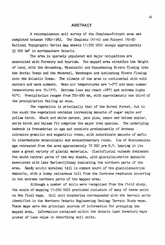
ABSTRACT
A reconnaissance soil survey of the Chapleau-Foleyet area was
completed between 1980-1982. The Chapleau (41-0) and Foleyet (42-B)
National Topographic Series map sheets (1 :250 000) occupy approximately
33 000 lane in northeastern Ontario.
The area is sparsely populated and major occupations are
associated with forestry and tourism.
The mapped area straddles the Height
of Land, with the Groundhog, Missinaibi and Kapuskasing Rivers flowing into
the Arctic Ocean and the Montreal, Wenebegon and Aubinadong Rivers flowing
into the Atlantic Ocean. The climate of the area is continental with cold
winters and warm summers. Mean air temperatures are 1-2°C and mean summer
temperatures are 15-17°C . Extreme lows may reach -48°C and extreme highs
42°C .
Precipitation ranges from 700-900 mm, with approximately one third of
the precipitation falling as snow .
The vegetation is principally that of the Boreal Forest, but to
the south the vegetation contains increasing amounts of sugar maple and
yellow birch. Black and white spruce, jack pine, aspen and balsam poplar,
white birch and balsam fir comprise the major tree species.
The underlying
bedrock is Precambrian in age and consists predominantly of Archean
intrusive granitic and migmatitic rocks, with subordinate amounts of mafic
to intermediate metavolcanic and metasedimentary rocks .
Ice of Wisconsonian
age retreated from the area approximately 10 000 yrs B .P . leaving in its
wake a great variety of glacial materials . Glaciofluvial outwash dominates
the south central parts of the map sheets, with glaciolacustrine deposits
associated with Lake Barlow-Ojibway dominating the northern parts of the
area .
Sandy acidic morainal till is common south of the glaciolacustrine
deposits, with a loamy calcareous till from the Cochrane readvance occurring
in the extreme northern parts of the mapped area .
Although a number of soils were recognised from the field study,
the scale of mapping (1 :250 000) precluded inclusion of many of these units
on the final maps . Soil unit boundaries corresponded with the terrain units
identified in the Northern Ontario Engineering Geology Terrain Study maps .
These maps were the principal sources of information for pretyping the
mapped area .
Information contained within the Ontario Land Inventory maps
proved of less value in describing soil units .

iv
Twenty three soil units developed on morainal till, glaciofluvial
outwash, glaciolacustrine deposits, eolian sands, recent alluvium and
organic materials were differentiated within the mapped area .
The soil
units were differentiated on the basis of family particle sizes - sandy,
loamy or clayey ; drainage - rapid, well, imperfect or poor ; reaction - acid
or neutral; and calcareousness class - none or strongly . The soil units
were subdivided on the basis of topography and amount of exposed bedrock.
Well drained morainal tills and glaciofluvial outwash are dominated by
Orthic Humo-Ferric Podzols and Eluviated Dystric Brunisols, glaciolacustrine
deposits by Orthic and Gleyed Gray Luvisols and eolian deposits by Eluviated
Dystric Brunisols .
Organic soils are principally associated with
glaciolacustrine deposits in the Foleyet sheet and glaciofluvial outwash in
the Chapleau sheet .
The dominant soil units within the mapped area are acidic rapidly
drained glaciofluvial sands (Sultan unit), acidic rapidly drained sandy
(Chapleau unit) and well drained loamy (Foleyet unit) morainal tills,
calcareous well drained (Seaton unit) and imperfectly drained (Wadsworth
unit) glaciolacustrine loams. Shallow soils are more abundant in the
southern parts of the mapped area, and morainal soils are generally
associated with stony surface horizons and undulating to rolling
topography .
Information included within this report will improve the soil
resource data base of a little studied part of northern Ontario and should
aid in making broad scale land management decisions within the
Chapleau-Foleyet area .

RECONNAISSANCE SOIL SURVEY OF THECHAPLEAU-FOLEYET AREANORTHERN ONTARIO
byL.J . Evans and B.H . Cameron
INTRODUCTION
At present there is little information on soil distribution for
much of northern Ontario, except for soil surveys conducted in agricultural,
or potentially agricultural, areas as part of the Canada Land Inventory, or
by the Ontario Ministry of Natural Resources as part of their forest
inventory program. Information on the properties and distribution of soils
in northern Ontario is urgently required to aid in making long term
decisions related to forest management, land use allocation and impact
assessment of potentially harmful environmental hazards such as acid rain .
Since the time that elapses between the initiation of a typical
soil survey and the publication of the final report is of necessity
considerable, it is advantageous to use resource information already
published at a scale suitable for the soil survey under consideration to
speed the compilation of the soil information . The purpose of this study
was to conduct as quickly and as inexpensively as possible a reconnaissance
soil survey, at a scale of 1 :250 000, of the Chapleau-Foleyet map sheets and
to provide soil information that would be useful for making decisions
appropriate to that scale . Extensive use was made of information contained
within the Northern Ontario Engineering Geology Terrain Study (NOEGTS) maps
produced for much of northern Ontario at a scale of 1 :100 000.
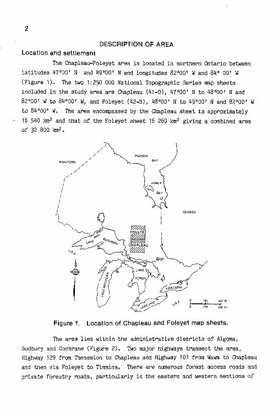
DESCRIPTION OF AREALocation and settlement
The Chapleau-Foleyet area is located in northern Ontario between
latitudes 47°00' N and 49°00' N and longitudes 82°00' W and 84° 00' W
(Figure 1) . The two 1 :250 000 National Topographic Series map sheets
included in the study area are Chapleau (41-0), 47°00' N to 48°00' N and
82°00' W to 84°00' W, and Foleyet (42-B), 48°00' N to 49°00' N and 82°00' W
to 84°00' W.
The area encompassed by the Chapleau sheet is approximately
16 540 km2 and that of the Foleyet sheet 16 260 km2 giving a combined area
of 32 800 tune.
Figure 1 .
Location of Chapleau and Foleyet map sheets .
The area lies within the administrative districts of Algoma,
Sudbury and Cochrane (Figure 2) . Two major highways transect the area,
Highway 129 from Thessalon to Chapleau and Highway 101 from Wawa to Chapleau
and then via Foleyet to Timmins . There are numerous forest access roads and
private forestry roads, particularly in the eastern and western sections of

the Chapleau sheet and in the southern parts of the Foleyet sheet . Access
by road is severely restricted or non-existent in the south central part of
the Chapleau sheet and the central and northern parts of the Foleyet sheet.
The major settlement in the area is at Chapleau (population 3365), with a
small settlement at Foleyet (637) . Both the Canadian National Railway and
Canadian Pacific Railway transect the study area and there are small
settlements along these railways . The principal occupations of the
residents of the area are connected with forestry and tourism.
DISTRICT OF ALGOMA
i
Figure 2.
Major highways and railways in study area .
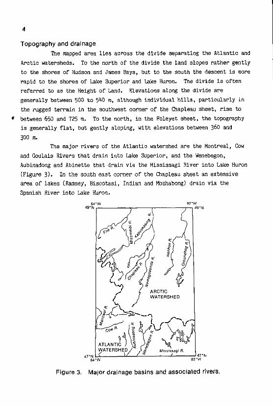
Topography and drainage
The mapped area lies across the divide separating the Atlantic and
Arctic watersheds . To the north of the divide the land slopes rather gently
to the shores of Hudson and James Bays, but to the south the descent is more
rapid to the shores of Lake Superior and Lake Huron. The divide is often
referred to as the Height of Land . Elevations along the divide are
generally between 500 to 540 m, although individual hills, particularly in
the rugged terrain in the southwest corner of the Chapleau sheet, rise to
between 650 and 725 m. To the north, in the Foleyet sheet, the topography
is generally flat, but gently sloping, with elevations between 360 and
300 m.The major rivers of the Atlantic watershed are the Montreal, Cow
and Goulais Rivers that drain into Lake Superior, and the Wenebegon,
Aubinadong and Abinette that drain via the Mississagi River into Lake Huron
(Figure 3) .
In the south east corner of the Chapleau sheet an extensive
area of lakes (Ramsey, Biscotasi, Indian and Mozhabong) drain via the
Spanish River into Lake Huron.
Figure 3.
Major drainage basins and associated rivers .
In the Arctic watershed there are a number of major rivers that
flow over the relatively flat plain north into James Bay . In the eastern
and central parts of the Foleyet sheet the Kapuskasing and Groundhog Rivers
drain the Chapleau, Nemegosenda and Ivanhoe Rivers and they themselves flow
into the Mattagami River. From the west the Missinaibi River and its
tributary, the Fire River, join the Mattagami River in the Moose River
basin. The resulting Moose River enters James Bay at Moosonee .
Climate
The climate of northern Ontario is classified as modified
continental, the modification resulting mainly from the Great Lakes to the
south and, to a lesser extent, from Hudson Bay to the north (Chapman and
Thomas 1968) .
A pattern of lower winter and higher summer precipitation
prevails . In winter, cold polar air masses produce dry, clear conditions
that persist for considerable periods of time . In summer, a continuing
succession of cyclonic storms sweeps over the area and warm, humid air
masses from the south alternate with cooler and drier air from the north.
This alternation of air masses gives two to three days of fine weather
followed by more humid weather accompanied by changeable winds and rain .
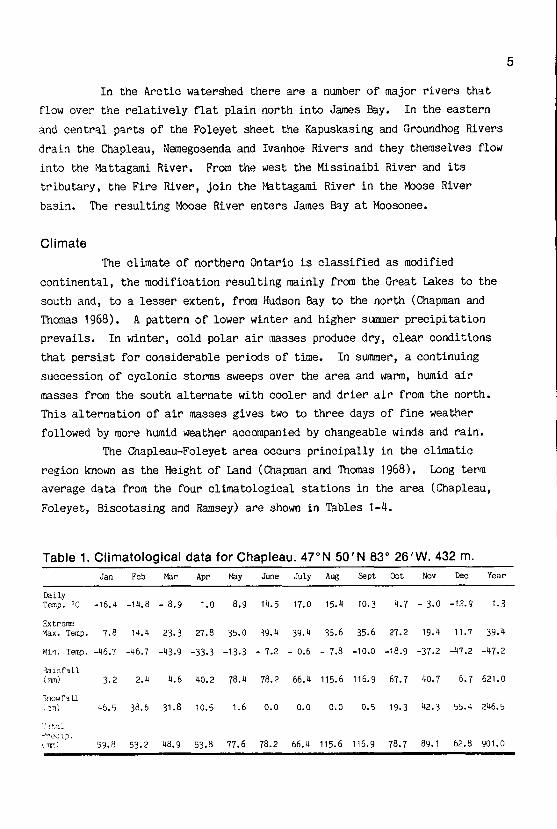
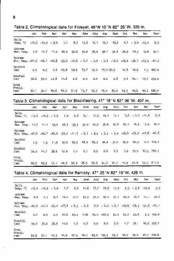
The Chapleau-Foleyet area occurs principally in the climatic
region known as the Height of Land (Chapman and Thomas 1968) .
Long term
average data from the four climatological stations in the area (Chapleau,
Foleyet, Biscotasing and Ramsey) are shown in Tables 1-4 .
Table 1 . Climatological data for Chapleau . 47°N 50'N 83° 26'W. 432 m.
Jan Feb Mar Apr May June July Aug Sept Oct Nov Dee Year
DailyTemp . °C -16 .4 -14 .8 - 8 .9 1 .0 8 .9 14 .5 17 .0 15 .4 10.3 4 .7 - 3 .0 -12.9 1 .3
Extreme'+lax . Temp . 7 .8 14 .4 23 .3 27 .8 35 .0 39 .4 39 .4 35 .6 35 .6 27.2 19 .4 11 .7 39 .4
Min . Temp . -46 .7 -46 .7 -43 .9 -33 .3 -13 .3 - 7 .2 - 0 .6 - 7 .8 -10.0 -18 .9 -37 .2 -47 .2 -47 .2
Rainfall(;nn) 3 .2 2 .4 4 .6 40 .2 78 .4 78 .2 66 .4 115 .6 116 .9 67.7 40 .7 6 .7 621 .0
inodfa ll;2m) 46 .5 38 .6 31 .8 10 .5 1 .6 0 .0 0 .0 0 .0 0 .5 19 .3 42 .3 55 .4 246 .5
',,I :'recio .,.n~1 59 .8 53 .2 48 .9 53 .8 77 .6 78 .2 66 .4 115 .6 116 .9 78 .7 89 .1 62 .8 901 .0
6
Table 2. Climatological data for Foleyet. 48°N 15'N 82° 26'W. 329 m.
Table 3 . Climatological data for Biscotasing . 47° 18'N 82° 06'W. 407 m .
Table 4 . Climatological data for Ramsey . 47° 25'N 82° 191W. 426 m.
Jan Feb Mar Apr May June July Aug Sept Oct Nov Dec Year
DailyTemp . °C -15.6 -14 .2 - 7 .5 1 .9 9 .6 15 .1 17 .5 16 .1 11 .1 5 .8 - 2 .0 -11 .8 2 .2
ExtremeMax . Temp . 11 .7 11 .1 23 .9 28.3 33 .3 35 .0 42 .2 35 .6 32 .8 26 .1 18 .3 13 .9 42 .2
ExtremeMin . Temp . -47 .2 -46 .7 -44 .4 -39 .4 -11 .7 - 6 .1 - 2 .2 - 3 .3 - 9 .4 -20 .6 -33 .9 -47 .8 -47 .8
Rainfall(mm) 1 .3 1 .3 11 .6 32 .0 65 .2 88 .4 83 .5 94 .6 91 .0 70 .9 26 .3 6 .0 572 .1
Snowfall(cm) 54 .9 41 .7 38 .9 12 .9 1 .1 0 .1 0 .0 0 .0 0 .7 7 .0 35 .5 47 .3 240 .1
TotalPrecip .(mm) 56 .2 43 .2 51 .1 44 .8 66 .4 88 .5 83 .5 94 .6 91 .7 77 .9 61 .8 53 .3 813 .0
Jan Feb Mar Apr May June July Aug Sept Oct Nov Dec Year
DailyTemp . °C -17 .2 -15 .2 - 9 .0 1 .1 8 .0 13 .9 16.1 15.1 10 .2 4 .7 - 3 .4 -13 .4 0 .9
ExtremeMax . Temp . 7 .2 11 .7 17 .2 25 .0 32 .8 35 .6 35 .0 36 .1 32 .8 28 .9 18 .3 12 .8 36 .1
ExtremeMin . Temp . -47 .2 -46 .1 -42 .8 -33 .9 -12.8 - 6 .7 - 3 .9 - 3 .9 -10.0 -15 .6 -36 .7 -43 .3 -47 .2
Rainfall(mm) 0 .5 0 .2 5 .4 25 .8 59 .6 73 .7 72 .2 75 .4 82 .2 47 .8 18 .8 1 .3 462 .9
Snowfall(can) 38 .6 39 .0 43 .8 14 .8 2 .6 0 .0 0 .0 0 .0 0 .8 5 .6 40 .1 47 .7 233 .0
TotalPrecip .(mm) 39 .1 39 .1 45 .9 40 .0 61 .9 73 .7 72 .2 75 .4 83 .0 53 .3 59 .6 45 .2 688 .4
Jan Feb Mar Apr May June July Aug Sept Oct Nov Dec Year
DailyTemp . °C -15.4 -14 .0 - 7 .6 1 .7 9 .6 14 .6 17 .2 15 .9 11 .0 5 .3 - 2 .6 -12 .0 2 .0
ExtremeMay . Temp . 4 .4 11 .7 16 .7 24 .4 31 .7 33 .3 33 .3 39 .4 31 .1 25 .0 16 .7 11 .1 39 .4
ExtremeMin . Temp. -40 .0 -41 .1 -34 .4 -27.8 - 8 .3 - 2 .2 2 .2 - 2 .2 - 6 .1 -15 .6 -28 .3 -37 .8 -111 .1
Rainfall(mm) 2 .7 0 .5 0 .5 27 .8 63 .3 7 .60 63 .0 100 .3 93 .3 53 .2 23 .5 3 .3 507.4
Snowfall(cm) 49 .0 35 .2 36 .9 14 .0 1 .6 0 .0 0 .0 0 .0 0 .0 4 .7 35 .1 46 .2 222 .7
TotalPrecip .(mm) 52 .0 37 .1 47 .3 41 .6 67 .9 76 .0 63 .0 100 .3 93 .2 58 .2 56 .0 48 .2 740 .8
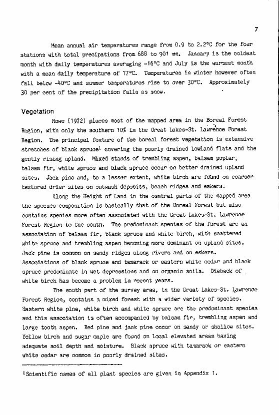
Mean annual air temperatures range from 0 .9 to 2.2°C for the four
stations with total precipations from 688 to 901 mm. January is the coldest
month with daily temperatures averaging -16°C and July is the warmest month
with a mean daily temperature of 17°C .
Temperatures in winter however often
fall below -40°C and summer temperatures rise to over 30°C. Approximately
30 per cent of the precipitation falls as snow .
Vegetation
Rowe (1972) places most of the mapped area in the Boreal Forest
Region, with only the southern 10% in the Great Lakes-St . Lawrence Forest
Region . The principal feature of the boreal forest vegetation is extensive
stretches of black spruces covering the poorly drained lowland flats and the
gently rising upland . Mixed stands of trembling aspen, balsam poplar,
balsam fir, white spruce and black spruce occur on better drained upland
sites. Jack pine and, to a lesser extent, white birch are foland on coarser
textured drier sites on outwash deposits, beach ridges and eskers .
Along the Height of Land in the central parts of the mapped area
the species composition is basically that of the Boreal Forest but also
contains species more often associated with the Great Lakes-St . Lawrence
Forest Region to the south. The predominant species of the forest are an
association of balsam fir, black spruce and white birch, with scattered
white spruce and trembling aspen becoming more dominant on upland sites .
Jack pine is common on sandy ridges along rivers and on eskers .
Associations of black spruce and tamarack or eastern white cedar and black
spruce predominate in wet depressions and on organic soils . Dieback of
white birch has become a problem in recent years .
The south part of the survey area, in the Great Lakes-St . Lawrence
Forest Region, contains a mixed forest with a wider variety of species .
Eastern white pine, white birch and white spruce are the predominant species
and this association is often accompanied by balsam fir, trembling aspen and
large tooth aspen . Red pine and jack pine occur on sandy or shallow sites.
Yellow birch and sugar maple are found on local elevated areas having
adequate soil depth and moisture. Black spruce with tamarack or eastern
white cedar are common in poorly drained sites .
1 Seientific names of all plant species are given in Appendix 1 .
8
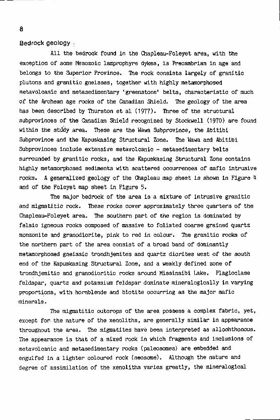
Bedrock geology
All the bedrock found in the Chapleau-Foleyet area, with the
exception of some Mesozoic lamprophyre dykes, is Precambrian in age and
belongs to the Superior Province .
The rock consists largely of granitic
plutons and granitic gneisses, together with highly metamorphosed
metavolcanie and metasedimentary 'greenstone' belts, characteristic of much
of the Archean age rocks of the Canadian Shield .
The geology of the area
has been described by Thurston et al (1977) . Three of the structural
subprovinces of the Canadian Shield recognized by Stockwell (1970) are found
within the stddy area . These are the Wawa Subprovince, the Abitibi
Subprovince and the Kapuskasing Structural Zone .
The Wawa and Abitibi
Subprovinces include extensive metavolcanic - metasedimentary belts
surrounded by granitic rocks, and the Kapuskasing Structural Zone contains
highly metamorphosed sediments with scattered occurrences of mafic intrusive
rocks.
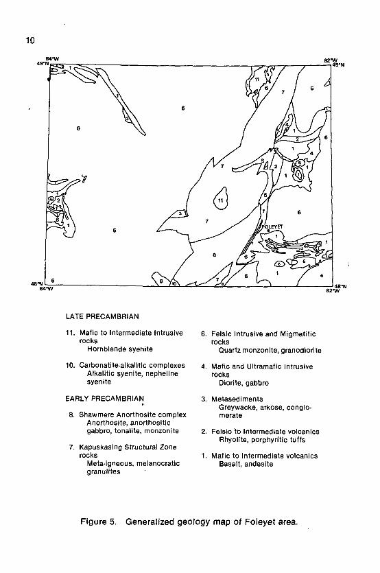
A generalized geology of the Chapleau map sheet is shown in Figure 4
and of the Foleyet map sheet in Figure 5 .
The major bedrock of the area is a mixture of intrusive granitic
and migmatitee rock .
These rocks cover approximately three quarters of the
Chapleau-Foleyet area .
The southern part of the region is dominated by
felsic igneous rocks composed of massive to foliated coarse grained quartz
monzonite and granodiorite, pink to red in colour . The granitic rocks of
the northern part of the area consist of a broad band of dominantly
metamorphosed gneissic trondhjemites and quartz diorites west of the south
end of the Kapuskasing Structural Zone, and a weakly defined zone of
trondhjemitic and granodioritic rocks around Missinaibi Lake . Plagioclase
feldspar, quartz and potassium feldspar dominate mineralogically in varying
proportions, with hornblende and biotite occurring as the major mafic
minerals .
The migmatitec outcrops of the area possess a complex fabric, yet,
except for the nature of the xenoliths, are generally similar in appearance
throughout the area . The migmatites have been interpreted as allochthonous.
The appearance is that of a mixed rock in which fragments and inclusions of
metavolcanic and metasedimentary rocks (paleosomes) are embedded and
engulfed in a lighter coloured rock (neosome) .
Although the nature and
degree of assimilation of the xenoliths varies greatly, the mineralogical
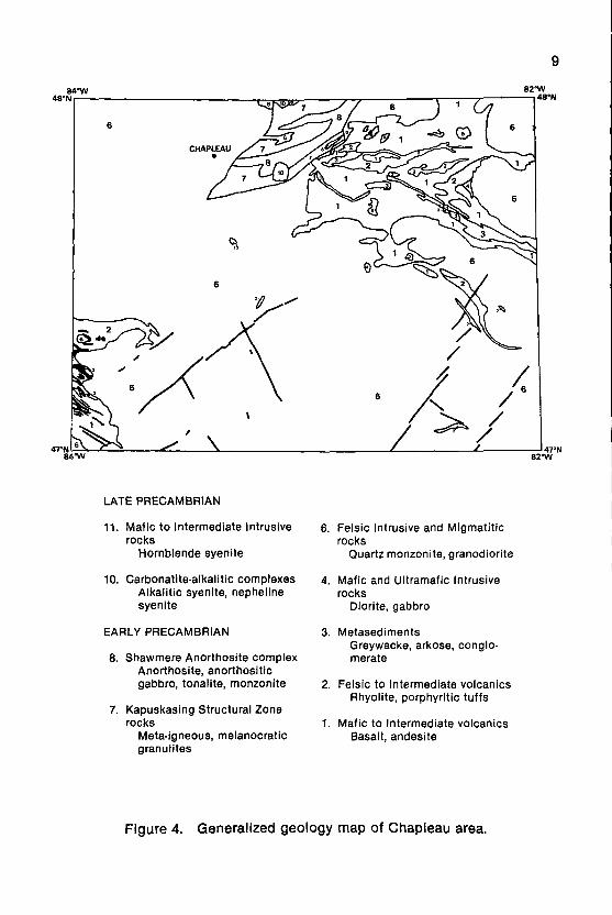
LATE PRECAMBRIAN
11 . Mafic to Intermediate Intrusive
6. Felsic Intrusive and Migmatiticrocks
rocksHornblende syenite
Quartz monzonite, granodiorite
10. Carbonatite-alkalitic complexes
4. Mafic and Ultramafic IntrusiveAlkalitic syenite, nepheline
rockssyenite
Diorite, gabbro
EARLY PRECAMBRIAN
3. MetasedimentsGreywacke, arkose, conglo-
8 . Shawmere Anorthosite complex
merateAnorthosite, anorthositicgabbro, tonalite, monzonite
2. Felsic to Intermediate volcanicsRhyolite, porphyritic tuffs
7 . Kapuskasing Structural Zonerocks
1. Mafic to Intermediate volcanicsMeta-igneous, melanocratic
Basalt, andesitegranulites
Figure 4 .
Generalized geology map of Chapleau area .
9
1 0
LATE PRECAMBRIAN
11 . Mafic to Intermediate Intrusive
6. Felsic Intrusive and Migmatiticrocks
rocksHornblende syenite
Quartz monzonite, granodiorite
10 . Carbonatite-alkalitic complexes
4. Mafic and Ultramafic IntrusiveAlkalitic syenite, nepheline
rockssyenite
Diorite, gabbro
EARLY PRECAMBRIAN
3. MetasedimentsGreywacke, arkose, conglo-
8 . Shawmere Anorthosite complex
merateAnorthosite, anorthositicgabbro, tonalite, monzonite
2. Felsic to Intermediate volcanicsRhyolite, porphyritic tuffs
7 . Kapuskasing Structural Zonerocks
1 . Mafic to Intermediate volcanicsMeta-igneous, melanocratic
Basalt, andesitegranulites
Figure 5 .
Generalized geology map of Foleyet area .
composition of metavolcanic xenoliths remains consistently close to 50 to 60percent hornblende, 20 to 30 percent plagioclase feldspar and the remainder
as quartz . The mineralogical composition and colour of the neosome varies
with the degree of assimilation of the xenoliths .
'Greenstone' belts and other prominent structural and lithological
units within the subprovinces have been informally named by Thurston et al
(1977), except for the Batchawana complex which was not included in theirstudy area. The location of these units is shown in Figure 6 and the
subprovinces to which they belong in Table 5.
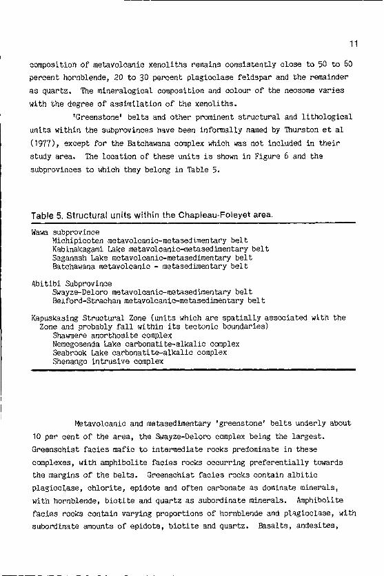
Table 5 . Structural units within the Chapleau-Foleyet area .
Wawa subprovinceMichipicoten metavolcanic-metasedimentary beltKabinakagami Lake metavolcanic-metasedimentary beltSaganash Lake metavolcanic-metasedimentary beltBatchawana metavolcanic - metasedimentary belt
Abitibi SubprovinceSwayze-Deloro metavolcanic-metasedimentary beltBelford-Strachan metavolcanic-metasedimentary belt
Kapuskasing Structural Zone (units which are spatially associatedZone and probably fall within its tectonic boundaries)
Shawmere anorthosite complexNemegosenda Lake carbonatite-alkalic complexSeabrook Lake carbonatite-alkalic complexShenango intrusive complex
with the
Metavolcanic and metasedimentary 'greenstone' belts underly about10 per cent of the area, the Swayze-Deloro complex being the largest.
Greenschist facies mafic to intermediate rocks predominate in these
complexes, with amphibolite facies rocks occurring preferentially towardsthe margins of the belts. Greenschist facies rocks contain albitic
plagioclase, chlorite, epidote and often carbonate as dominate minerals,
with hornblende, biotite and quartz as subordinate minerals .
Amphibolite
facies rocks contain varying proportions of hornblende and plagioclase, with
subordinate amounts of epidote, biotite and quartz .
Basalts, andesites,
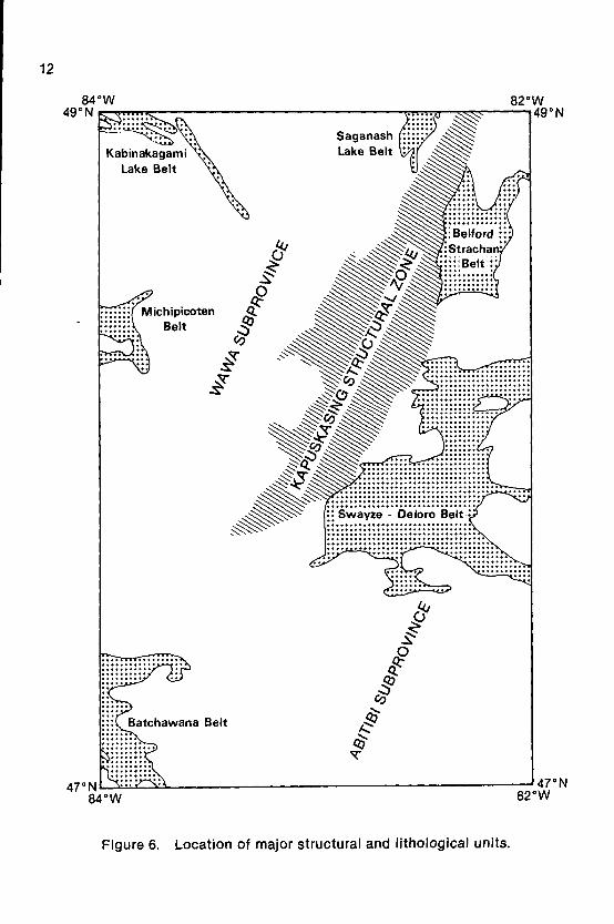
Figure 6.
Location of major structural and lithological units.

1 3
amphibolites and hornblende schists are the major mafic and intermediate
rocks found in these complexes .
Felsic to intermediate metavolcanics of greenschist facies grade
are also found appreciably associated with the Swayze-Deloro, Michipicoten
and Belford-Strachan belts. Rhyolite is the major felsic rock in the
Swayze- Deloro complex with potassium feldspar, quartz and plagioclase
feldspar as the major minerals . The felsic to intermediate rocks of the
Michipicoten complex are typically porphyritic tuffs with a composition more
albitic than the rocks of the Swayze-Deloro complex. Metasediments make up
approximately 10 per cent of the Swayze-Deloro complex and consist largely
of greywacke, arkose and conglomerate .
The Kapuskasing Structural Zone is the major structural feature
within the mapped area . It is characterized by structural trends running
nearly at right angles to the adjacent 'greenstone' belts, a higher grade of
metamorphism of granulite facies, and abrupt changes in lithology throughout
the zone . The major rock types encountered are meta-igneous rocks,
melanocratic, pelitic and psammitic granulites and metasedimentary and
metavolcanic gneisses . Plagioclase feldspars, quartz and hornblende
dc-iinate the mineralogy, with lesser amounts of pyroxene, biotite and
garnet .
The Shawmere anorthosite complex has an areal extent of 1200 km2
and lies adjacent to the Kapuskasing Structural Zone. Anorthosite and
anorthositic gabbro are the major rock types with occurrences of tonalite
and monzonite separating the complex into two distinct highly metamorphosed
units. The common minerals of the anorthositic rocks are bytownite An70-74and hornblende .
Other rocks of importance to soil distribution within the mapped
area are some mafic and ultramafic rocks associated with the 'greenstone'
belts, other mafic to intermediate rocks associated with the Kapuskasing
Structural Zone (Shenango complex), and Late Precambrian carbonatite-alkalic
complexes at Lackner Lake, Nemegosenda Lake and Seabrook Lake .
1 4
Quaternary geologyThe glacial history of northeastern Ontario has been discussed by
Boissonneau (1966, 1968) and summarized by Prest (1970) . Detailed
discussions for the Chapleau-Foleyet area have been provided by Thurston et
al . (1977) and further information is provided, to a greater or lesser
extent, in the NOEGT studies of the Wenebegon, Biscotasing, Chapleau,
Ridout, Missinaibi Lake, Foleyet, Fire River and Elsas map sheets
(1 :100 000) . The following discussion has largely been taken from these
sources .
Deglaciation began (- 11 000 yrs B.P .) in the Chapleau-Foleyet
area when the ice front retreated to the position now marked by the Chapleau
I series of moraines .
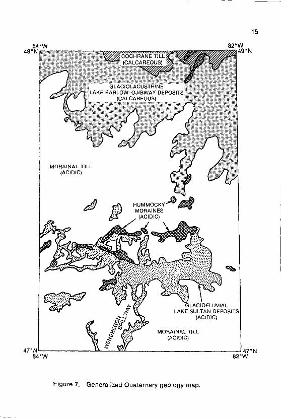
Proglacial Lake Sultan was formed when meltwaters
were ponded in a broad depression, lying between this ice front and the
bedrock uplands to the south (Figure 7) . Boissonneau (1968) believes that
the ice then readvanced to the position marked by the Chapleau II morainic
belt, overriding the Chapleau I moraines and the northern part of Lake
Sultan .
Roed and Hallett (1979a,b) however believe that it is more likely
that this belt of moraines in the northern parts of the Chapleau and Ridout
sheets represents a major standstill of the Laurentide ice within the study
area .
They have termed this belt of moraines the Sultan scarp and believe
that the scarp formed during a halt in the recession of the glacier rather
than during a readvance. The scarp is bounded on the south by an extensive
glaciofluvial outwash plain representing a substantial outflow of water from
a wide front. Modification of the scarp by wave action indicates that some
of the meltwater channels may have been blocked, resulting in ponding for a
brief period . Much of the meltwater escaped southwest and west through the
valleys of the Cow and Montreal rivers and to the south through the valley
of the Wenebegon river (Roed and Hallett 1980) . In the extreme south of the
study area the Wenebegon spillway emptied into the Mississagi valley where
it eroded older valley train deposits . The presence of vast tracts of
hummocky moraine and pitted outwash plains suggests that deglaciation in the
northern parts of the Chapleau sheet occurred by mass disintegration of the
ice sheet.
Local ponding occurred, but most of the outwash sand exhibits
features that suggest deposition in slowly moving water (Roed and Hallett
1979b) .
71,COCHRANE TILL(CALCAREOUS)
Figure 7 .
Generalized Quaternary geology map.
GLACIOLACUSTRINELAKE BARLOW-OJIBWAY DEPOSITS
(CALCAREOUS)
82* W
1 5
1 6
The major glacial feature of the Foleyet area is the extensive
glaciolacustrine deposits of Lake Barlow-Ojibway .
This lake formed between
the ice front and the Height of Land and at its greatest extent extended
approximately 960 km in an east-west direction and 240 km in a north-south
direction. The most extensive deposits formed by this lake are the sheet,
like bodies of rhythmites which extend uninterrupted across the Height of
Land (Agterberg and Banerjee 1969) .
In the study area, Lake Barlow-Ojibway deposits are confined
largely to the Fire River and Elsas NOGET map sheets and to the Groundhog
and Ivanhoe river basins of the Foleyet NOGET map sheet. The extensive
glaciolacustrine deposits consist largely of lake plain banded silt and
sand, and lake beach sand .
Bedrock areas often have a capping of washed
till and on some high hills above the level of Lake Barlow-Ojibway original
acidic till may be found (Lee and Scott 1980b) . To the south of the glacio-
lacustrine area an acidic bouldery sandy till was laid down by melting ice.
The final glacial episode of importance in the study area was a
major readvance of the ice (the Cochrane Readvance) which overrode Lake
Barlow-0jibway deposits and deposited a fine textured till over
glaciolacustrine and glaciofluvial deposits . This Cochrane till is found
only in the northern portions of the Fire River and Elsas NOGET map sheets .
Glacial ice finally retreated from the area approximately 9000 yrs B.P .
Eolian activity has since modified some of the glaciofluvial outwash and
tills, and extensive deposits of organic soil have developed in poorly
drained depressions, particularly over glaciolacustrine deposits associated
with Lake Barlow-Ojibway .
Surficial materialsRetreat of the ice from the area some 11 000-9000 yrs B.P . has
left a complex mosaic of glacial materials in which the soils of today have
developed .
Because of the coarse textured nature of most of the Precambrian
bedrock, much of the surficial material covering the central and southern
parts of the mapped area is sandy in nature . In contrast, areas covered by
Lake Barlow-Ojibway are generally finer textured, reflecting the
glaciolacustrine origin of the materials and the fact that much of the
deposit has been derived from Paleozoic sedimentary rocks of the Hudson Bay-
James Bay Lowland . These latter materials also differ from the former in

1 7
t~~~t they contain significant amounts of carbonates .
These carbonates are
probably derived largely from the limestones and dolostones of the Paleozoic
rocks, but may also be derived in part from marl deposits formed in the
glacial lake .
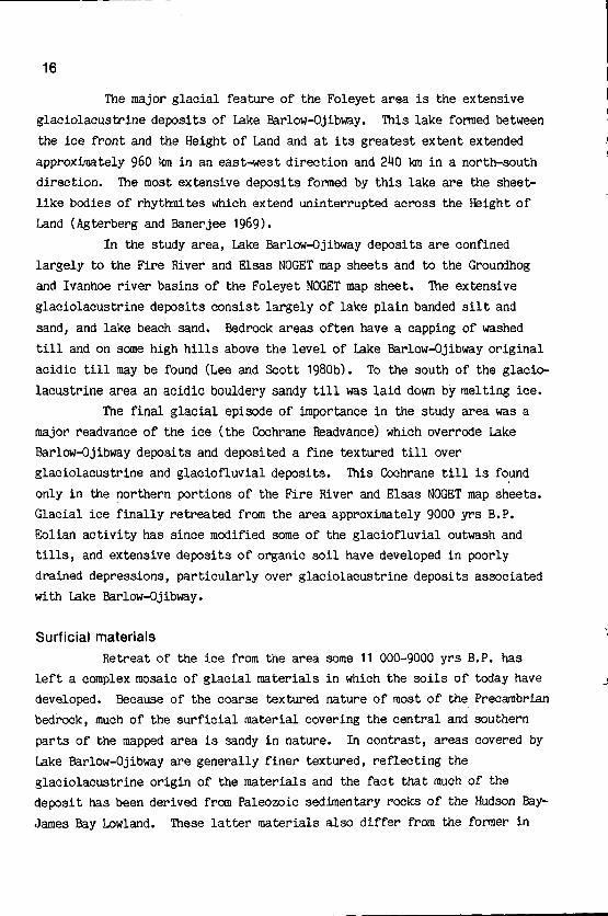
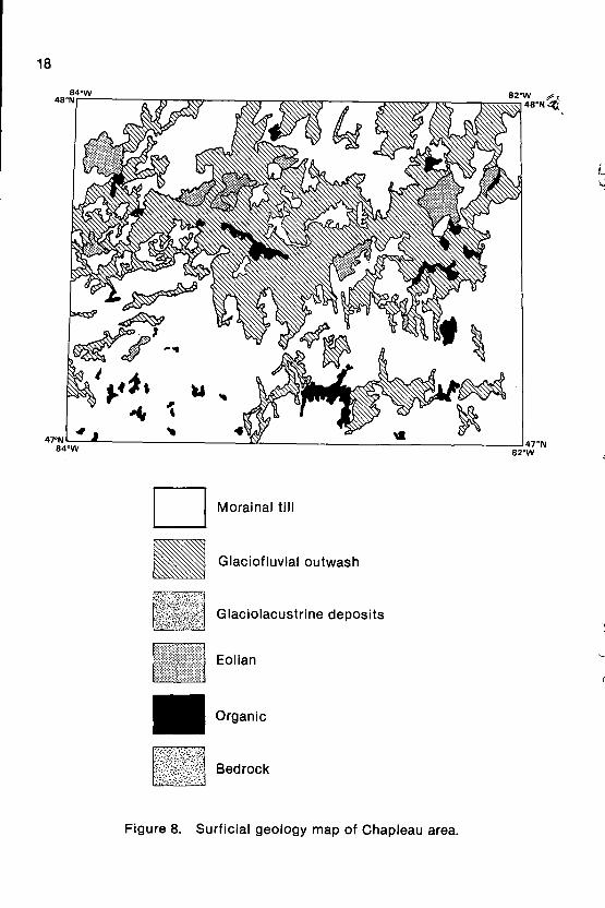
Generalized surficial geology maps of the Chapleau area are shown
in Figure 8 and for the Foleyet area in Figure 9.
These maps were generated
from the NOEGTS maps of Roed and Hallett (1979a,b,c and 1980) and Lee and
Scott (1980a,b,c and d) .
The most extensive deposit of the area is sandy glacial till,
generally as ground moraine (basal till), but also in the form of
recessional moraines . In much of the area the till is associated with large
areas of bedrock outcrops and is often drumlinized.
In most of the Chapleau
sheet and the southern part of the Foleyet sheet the till varies in depth
from 1 to 7 m and is associated with a low to moderate undulating to
slightly knobby landform (Roed and Hallet 1979a) . Sandy till in hummocky
terrain, formed by the mass disintegration of glacial ice, may be up to 30 m
in thickness . The till is generally considerably thinner in areas of
frequent bedrock exposure .
In the northern part of the Foleyet map sheet
a silty clay till is found with a low undulating relief . This till is
believed to have formed by overiding of Lake Barlow-Ojibway deposits during
the Cochrane readvance. This till often differs from the acidic tills to
the south in that carbonates are generally present in the parent material .
The next major surficial material found in the mapped area is
glaciofluvial outwash.
Although found throughout all of the area,
glaciofluvial outwash sands and gravels are particularly extensive in the
northern part of the Chapleau sheet.
They are believed to have been laid
down by slowly running water, in what was termed Lake Sultan by Boissonneau
(1968) .
These deposits are generally fine to coarse sands up to 2 m in
thickness underlain by gravel. Thicknesses of up to 40 m have been inferred
by Roed and Hallett (1979a) .
In the Foleyet sheet outwash sands and gravels
are often associated with eskers . Eskers throughout the area range in
height from 15 to 60 m (Lee and Scott 1980a,b) .
Kame deposits occur in the
Chapleau sheet, particularly around Chapleau itself .
1 8
LI Morainal till
Glaciofluvial outwash
Glaciolacustrine deposits
Eolian
Organic
Bedrock
Figure 8.
Surficial geology map of Chapleau area.
ea°w
LI Morainal till
Glaciofluvial outwash
Glaciolacustrine deposits
Eolian
Organic
Bedrock
Figure 9 .
Surficial geology map of Foleyet area .
az°w
1 9
20
Eolian deposits of fine sand occur to any great extent only in the
northern part of the Chapleau sheet. They are believed to be derived mainly
from glaciofluvial sand and occur as U-shaped domes, small hills and ridges
(Roed and Hallett 1979a) .
Much of the eolian deposits occur as a blanket,
with a thickness up to 1 m.
Glaeiolacustrine deposits occur only in the Foleyet sheet, being
particularly extensive in the northern and eastern parts of the sheet.
Tongues of glaciolacustrine material do however extend almost into the
Chapleau sheet.
Most of the deposits are lake plain sands and silts, with
some clays, and lake plain sands and raised beaches . Their relief is
generally low and the topography flat to gently undulating .
Organic deposits, composed mainly of sphagnum moss, occur
throughout the area in poorly drained depressions or flat low lying terrain .
They are commonly found associated with glaciolacustrine deposits in the
northeast section of the Foleyet sheet, but extensive areas also occur along
rivers and around lakes in much of the area . In the Chapleau sheet the most
extensive areas occur along the Abinette River, north of Lake Ramsey and
south of Chapleau adjacent to Highway 129.
The final surficial deposit of the mapped area is alluvium that
occurs along most of the major rivers . The most extensive areas are
adjacent to the Woman, Nemegosenda, Cow, Wenebegon, Abinette, Greenhill,
Ivanhoe and Groundhog Rivers . Alluvial materials are generally sand and
silt but organic deposits are often present .

METHODOLOGY
21
Existing information
At the start of this survey there was no published soil
information available for the Chapleau (41-0) and Foleyet (42-B) map sheets .
Soil information for the adjacent Timmins, Kapuskasing, Cochrane and Gogama
map sheets was collected as part of the Canada Land Inventory program, with
the emphasis on surveying those areas with the greatest agricultural
potential.
Consequently in Ontario more effort was put into mapping soils
of the Northern Clay Belt than into soils associated with the coarser,
shallower materials elsewhere on the Precambrian Shield .
Both the Chapleau and Foleyet map sheets were included in the
Ontario Land Inventory (OLI) studies. The OLI maps were produced at a scale
of 1 :250 000 and the map units were established on the basis of reccurring
patterns of physical features related to the degree of 'brokenness' of the
land, soil texture, soil depth and moisture regime (Ontario Land Inventory
1976) . Much use was made of the information contained within these studies
at the start of the survey reported here . However, experience gained in the
field convinced us that the information contained within the OLI reports was
either not fully appropriate for our needs or was sometimes in error.
Subsequently the maps and reports of the OLI studies did not contribute much
to the information contained within this report .
Reconnaissance Quaternary geology maps of northeastern Ontario
have been published at a scale of 1 :500 000 (Boissonneau 1965a;b) and these
provided us with a broad orientation to the area .
Considerable use was made
of the eight surficial geology reports within the Chapleau-Foleyet area
which were available as part of the Northern Ontario Engineering Geology
Terrain Study (Gartner, Mollard and Roed 1981) . The 1 :100 000 maps
accompanying these reports are shown in Figure 10.
The principal technique for obtaining terrain information for the
NOEGT studies was stereoscopic airphoto interpretation .
Delineation of
terrain units was performed on contact prints of airphotos and the
intepretations then transferred manually onto photo mosaics at a scale of
1 :100 000. The field work conducted in support of photointerpretation was
generally of a reconnaissance nature .

22
47°00'N
82'00'W
WENEBEGONLAKE410/SW
BISCOTASING410/SE
Figure 10 . NOEGT study maps used in compiling resource information.
Delineation of map unitsIn our study the terrain unit delineations on the NOEGTS maps were
checked using 1 :50 000 aerial photographs and the Ontario Land~Inventory
maps . Because of the scale at which the NOEGTS maps were produced and the
validity of boundary locations, it was decided to use these lines as the
basis for the soil unit delineations shown in this report . The terrain unit
boundaries produced at a scale of 1 :100 000 in the NOEGTS maps were thus
transferred to the 1 :250 000 topographic base maps for both the Chapleau and
Foleyet map sheets .
84°00'49°00'N
W 83°00' W
FIRE RIVER ELSAS4213/NW 42B/NE
MISSINAIBI FOLEYETLAKE 4213/SE
4213/SW
48°00'N
CHAPLEAU RI DOUT410/NW 410/NE

Site selection and mapping criteriaAs an initial step in planning our field work a 2.5 x 2 .5 em grid
was placed over both the Chapleau (41-0) and Foleyet (42-B) sheets .
This
grid gave approximately 430 grid line intersections on the Chapleau sheet
and 370 on the Foleyet sheet, each intersection being considered a potential
sampling location . These potential sampling locations were then transferred
to the appropriate 1 :50 000 topographic sheets . Because a primary objective
of the survey was to produce a soil survey map and report as inexpensively
as possible, only grid intersections within walking distances of roads were
selected for actual sampling .
The following site characteristics were chosen to be recorded at
each sampled location - mode of deposition of parent material, lithologic
modifier, surface expression, local relief, surface stoniness, rockiness,
moisture regime and drainage .
A field card was designed to aid in the
noting, compiling and standardisation of field observations . Guidelines for
the description of these observations are given by the Ontario Institute of
Pedology (1982) and Expert Committee on Soil Survey (1983) . However the
criteria classes were modified for use in our study to accommodate firstly
the scale of mapping and secondly the requirements imposed by forest
management at this scale of mapping.
The criteria classes finally chosen were :
1 . mode of deposition of parent material ; fluvial (alluvial), eolian,
glaciofluvial, glaciolacustrine, morainal and organic .
2. coarse fragment lithologic modifier ; a) igneous, sedimentary,
metamorphic, b) coarse acid, coarse basic, fine acid, fine basic .
3 . surface expression ; level, inclined, undulating, rolling, hummocky,
ridged .
4. local relief ; < 15 m, 15-60 m, > 60 m.
5 . surface stoniness ; < 0.01%, 0 .01-3%, 3-15%, > 15% .
6. rockiness (amount of exposed bedrock) ; < 1%, 1-10%, 10-50%, 50-90%, >90% .7 . moisture regime ; dry, fresh, moist, wet.
8. drainage ; rapid (includes very rapid), well (includes moderately well),
imperfect, poor (includes very poor) .
In addition, texture, thickness and coarse fragment descriptions
were made on each soil horizon recognized in the field .
23

24
Field study and analytical proceduresIn the summers of 1981 and 1982 detailed site description cards
were completed for 436 sites.
Because of varying road access, the field
observations were not equally distributed throughout the study area .
Observations were particularly scarce in the northern part of the Foleyet
sheet and in the south central portion of the Chapleau sheet.
Samples were taken of all parent materials (C or Ck horizons) .
Stones and fine earth were separated using a 2 mm sieve, and pH and texture
determined on all C horizons .
For all sites showing podzolic or brunisolic
characteristics, composite samples of B horizons (the top 10 cm if the B
horizon was thicker than 10 cm) were taken. Colour, organic carbon and
sodium pyrophosphate extractable Fe and Al were measured on these horizons .
The soils were then classified according to the Canadian System of Soil
Classification (Canadian Soil Survey Committee 1978) . For any C horizon
having pH >6.5 the contents of calcite and dolomite were determined by the
method of Zwarich and Mills (1971) .
Establishment and characterisation of soil unitsData for all sampled sites were entered into a computer file and
hierarchical sorts of the soil and landscape data were made .
From these
sorts a total of twenty three soil units were distinguished in the Chapleau
and Foleyet map sheets .
The soil units were characterized with respect to
mode of deposition of parent material, family partice size, drainage,
reaction class and calcareousness class . Family particle sizes were
grouped into clayey, loamy or sandy . The sandy class was modified-where
appropriate as skeletal when more than 35% of the soil material consisted of
material larger than 2 mm . Three reaction classes for characterising the
parent material were also recognized - acid = pH < 5.5, neutral = pH 5 .5-7.4
and alkaline = pH > 7 .4, and three calcareousness classes - weakly = CaCO3
equivalent less than 6%, strongly = 6-40% and extremely = > 40%.
Each soil
unit was given a unique geographical name and symbol corresponding to where
the soil commonly occurs .
The soil units are summarized in Table 6.
Three soils units (Gallagher, Nimitz and Racine) occur in areas
too small to delineate at 1 :250 000 scale and thus are not shown on the map
or its accompanying legend . The associated mapped soil units are given in
the description of map units .

Table 6 . Soil units recognized from field study .
Calcareousnessclass
Strongly
Strongly
B. Glaciofluvial
Soil Name Particle size Drainage Reaction
A . Morainal
Aubinadong(Ag) Sandy-skeletal Rapid Acid
Chapleau(Cu) Sandy Rapid Acid
Borden(Bn) Sandy Imperfect Acid
Gallagher(Gr) Sandy Poor Acid
Foleyet(Ft) Loamy Well Acid
Racine(Re) Loamy Imperfect Acid
Concobar(Cr) Loamy Well Neutral
Maude(Me) Loamy Imperfect Neutral
Aubrey(Ay) Sandy-skeletal Rapid Acid
Sultan(Sn) Sandy Rapid Acid
Kormak(Kk) Sandy Imperfect Acid
Nimitz(Nz) Sandy Poor Acid
Keaney(Ky) Loamy Well Acid
Chewett(CO Loamy Imperfect Acid

26
Soil Name Partible size Drainage Reaction Calcareousnessclass
C. Glaciolacustrine
Oscar(Or) Clayey Imperfect Neutral Strongly
Seaton(St) Loamy Well Neutral Strongly
Wadsworth(Wh) Loamy Imperfect Neutral Strongly
D. Eolian
Wakami(Wi) Sandy Rapid Acid
Devon(Dn) Loamy Well Acid
E. Eolian over glaciofluvial
Shoals(Ss) Sandy Rapid Acid
F. Morainal over glaciofluvial
Missinaibi(Ms) Sandy Rapid Acid
G. Alluvial
Nemegos(Ns) Variable Variable Variable Variable
H. Organic
Organic(0g) Mesic Poor Acid
Aubinadong
DESCRIPTION OF SOIL UNITS
The Aubinadong soil unit is developed on rapidly drained sandy-
skeletal morainal till . Textures of surface horizons are generally loamy
sands, often overlying sands, moisture regimes predominantly dry and pH's
strongly to extremely acidic. Surface expressions are generally undulating
to rolling, and sometimes hummocky, and local relief is medium to high .
Bedrock exposures are generally less than ten percent and shallow phases of
the unit are rarely encountered. Surface stones are usually in excess of
fifteen percent. Equal proportions of Orthic Humo-Ferric Podzols and
Eluviated Dystric Brunisols comprise the unit .
AubreyThe Aubrey soil unit is developed on rapidly drained, sandy-
skeletal, glaciofluvial outwash. Textures range from loamy fine sands to
coarse sands and pH's from strongly to extremely acidic. Surface
expressions are level to undulating and local relief low to medium.
Moisture regimes are predominantly dry. Surface stoniness is variable,
but is usually over fifteen percent. Bedrock exposures within the unit are
rare and shallow soils seldom encountered . The unit consists of equal
proportions of Orthic Humo-Ferric Podzols and Eluviated Dystric Brunisols .
27
BordenThe Borden soil unit is the imperfectly drained member of the
Chapleau catena and is developed on sandy morainal till .
The textures are
predominantly loamy sands, but can range from very fine sandy loans to
coarse sands.
Moisture regimes are mostly moist but include some fresh .
pH's are very strongly to extremely acidic . Local relief is low to high and
surface expressions undulating to rolling, and often hummocky . Bedrock
exposures are variable within the unit and can range up to fifty percent .
Shallow phases account for about thirty per cent of the unit and surface
stones often cover fifteen percent of the soil surface. Gleyed Eluviated
Dystric Brunisols and Gleyed Humo-Ferric Podzols are equally distributed
within the unit .

28
ChapleauThe Chapleau soil unit is developed on rapidly drained sandy
morainal till .
Textures are predominantly loamy sands, but may range from
loamy very fine sands to fine sands. Moisture regimes range from dry to
fresh and pH's are strongly to extremely acidic .
Local relief is medium to
high and surface expression is undulating to rolling, and often hummocky .
Bedrock exposures within the unit are very variable, ranging from none to up
to fifty percent. Shallow phases of the Chapleau unit are estimated to
occupy approximately forty percent of the unit.
Surface stoniness is often
in excess of fifteen percent. Taxonomically the unit consists of
approximately equal amounts of Eluviated Dystric Brunisols and Orthic Humo-
Ferric Podzols.
Chewett
The Chewett soil unit is the imperfectly drained member of the
Keaney catena and is developed on loamy textured glaciofluvial outwash .
Textures range from silt loams to fine sands . Moisture regimes are fresh
and pH's very strongly to extremely acidic .
Local relief is generally low
and surface expressions level to undulating . Bedrock exposures within the
unit are rare and shallow soils encountered infrequently .
Coverage by
surface stones is generally less than three percent. Gleyed Eluviated
Dystric Brunisols and Gleyed Hiumo-Ferric Podzols are the soils that make up
the unit in a ratio of approximately two to one. . Although areas belonging
to this unit were delineated on the soil maps, they could also be expected
to occur as inclusions within the Keaney-Organic (Ky + Og) map unit .
ConcobarThe Concobar soil unit is developed on well drained loamy
calcareous morainal till .
Textures range from silt loams to sandy clay
loams to fine sandy looms. Moisture regimes are fresh and pH's range from
very strongly acid in surface horizons to neutral in strongly calcareous Ck
horizons . Local relief is low to medium and surface expressions undulating .
Bedrock exposures occupy up to ten percent of the unit, although shallow
soils are rarely encountered. Surface stones are common and cover
approximately three to fifteen percent of the soil surface.
Taxonomically
the soils are classified as Orthic Gray Luvisols .
29
DevonThe Devon soil unit is developed on well drained loamy textured
eolian sands.
Textures are predominantly silt loams, loamy very fine sands
and very fine sands. Moisture regimes are fresh and pH's very strongly to
extremely acidic .
Local relief is low to medium and surface expressions are
undulating to rolling. Bedrock exposures in the unit are rare, although
shallow soils constitute about twenty five percent of the unit .
Surface
stones are rarely encountered. Eluviated Dystric Brunisols and Orthic
Humo-Ferric Podzols are distributed equally within the unit .
Foleyet
The Foleyet soil unit is developed on well drained loamy morainal
till . Family particle sizes include both coarse silty and coarse loamy and
textures range from silts to sandy loams . Moisture regimes are fresh and
pH's strongly to extremely acidic . Surface expressions are generally
rolling to undulating, but can sometimes be hummocky, and local relief is
low to high . Bedrock exposures are variable but are generally not in excess
of fifty percent. Bedrock occurs within 1 m of the surface in about fifty
percent of the unit ; particularly in areas with a coarse silty family
particle size . Surface stones are often in excess of fifteen percent. Two
thirds of the soils are classified as Orthic Humo-Ferric Podzols and one
third as Eluviated Dystric Brunisols. Podzolic soils are particularly
common on silty and silty loam textures .
GallagherThe Gallagher soil unit is the poorly drained member of the
Chapleau catena and is developed on sandy morainal till .
The textures are
predominantly loamy sands and the moisture regime moist . pH's are extremely
acidic . Local relief is low to medium and surface expressions undulating to
rolling. The amount of bedrock outcrop in the unit is variable and may
reach fifty percent.
Shallow phases occupy about thirty percent of the unit
and coverage of the soil surface by stones is generally fifteen percent .
Orthic Humic Gleysols and Gleyed Humo-Ferric Podzols are equally distributed
throughout the unit . No soils belonging to this unit were mapped at a scale
of 1 :250 000 owing to insufficient acreage but they could be expected to
occur within the Chapleau-Organic (Cu + Og) map unit .
30
KeaneyThe Keaney soil unit is developed on well drained loamy
glaciofluvial outwash. Textures range from silt loams to fine sands with
the sand, loamy sands and sandy loams containing sands that are very fine or
fine in size. Moisture regimes are fresh and pH's strongly to extremely
acidic . Local relief is mostly low and surface expressions level to
undulating and rarely hummocky . Little, if any, bedrock is exposed within
the unit and shallow soils are rarely encountered. The content of surface
stones is generally low, but may sometimes reach fifteen percent.
Two
thirds of the unit is made up of Eluviated Dystric Brunisols and one third
of Orthic Humo-Ferric Podzols .
KormakThe Kormak soil unit is the imperfectly drained member of the
Sultan catena and is thus developed on sandy glaciofluvial outwash. The
unit has a low to medium local relief with a level to gently undulating
surface expression .
Moisture regimes range from fresh to moist and textures
from loamy very fine sands to coarse sands . pH's are very strongly to
extremely acidic . Surface stones are generally less than three percent .
Gleyed Eluviated Dystric Brunisols predominate within the unit with some
Gleyed Humo-Ferric Podzols .
Although areas belonging to this soil unit were
delineated on the soil maps, they could also be expected to occur within the
Sultan-Organic (Sn + Og) map unit .
MaudeThe Maude soil unit is the imperfectly drained member of the
Concobar catena and is developed on loamy textured calcareous morainal till .
Textures are predominantly silt loams. Moisture regimes are moist and pH's
very strongly acid in surface horizons and neutral in strongly calcareous Ck
horizons . Local relief is low to medium and surface expressions undulating .
Bedrock exposures occupy ten percent of the unit, although shallow soils are
rarely encountered . Surface stones are common and usually cover between
three to fifteen percent of the soil surface.
Taxonomically the soils
consist of Gleyed Gray Luvisols .

Missinaibi
The Missinaibi soil unit is developed on rapidly drained morainal
till overlying sandy glaciofluvial outwash .
Generally the textures of the
upper horizons are loamy fine sands and loamy sands overlying sands and
coarse sands. Moisture regimes are dry to fresh and pH's strongly to
extremely acidic . Local relief varies from low to high and surface
expression from undulating to rolling.
Bedrock exposures within the unit
are rare and shallow soils seldom encountered. Surface stones are generally
in excess of three percent but rarely exceed fifteen percent.
Two thirds of
the unit consist of Orthic Humo-Ferric Podzols and one third Eluviated
Dystric Brunisols .
Although a considerable nunber of sites belonging to the
Missinaibi soil unit were examined in the field, only a few areas occurred
in sufficient extent to be mapped at a scale of 1 :250 000.
NemegosThe Nemegos soil unit is developed on recent alluvial deposits
associated with some of the major rivers, particularly the Woman,
Nemegosenda, Cow, Wenebegon, Abinette, Greenhill, Ivanhoe and Groundhog .
Textures are highly variable and organic inclusions frequently encountered.
Moisture regimes range from dry to wet and pH's from medium to extremely
acidic . Local relief is generally low and surface expressions level .
Surface stoninesses are very variable and are greater in the Chapleau
sheet.
31
Nimitz
The Nimitz soil unit is the poorly drained member of the Sultan
catena .
It is developed on sandy glaciofluvial outwash with textures
similar to the Sultan and Kormak soil units. Topography is level to
undulating and local relief low to high .
Moisture regimes are moist and
pH's strongly to extremely acidic . Surface stones are generally less than
three percent. Orthic Humic Gleysols with some Gleyed Humo-Ferric Podzols
are the major soils of the unit . No soils belonging to the Nimitz soil unit
were mapped at a scale of 1 :250 000 owing to insufficient acreage, but could
be expected to occur within the Sultan-Organics (Sn + Og) map unit .
32
OrganicsOrganic soils are not widely distributed in the Chapleau sheet but
become increasingly abundant north into the Foleyet sheet. Organic soils
constitute less than two percent of the Chapleau sheet and approximately
fifteen percent in the Foleyet sheet.
The major organic units in the
Chapleau sheet are developed either on glaciofluvial outwash ascribable to
Lake Sultan or in the morainal areas at the headwaters of major rivers .
In
the Foleyet sheet organic soils are chiefly associated with glaciolacustrine
deposits . The organic soils have been classified as Typic Mesisols and are
associated with both Terric and Lithic great groups .
OscarThe Oscar soil unit is developed on moderately well to imperfectly
drained clayey glaciolacustrine deposits .
Textures range from silty clays
to heavy clays and varving is often observed in subsurface horizons .
Moisture regimes are fresh to moist and pH's range from medium acid in
surface horizons to neutral in strongly calcareous Ck horizons . Local
relief is low and surface expressions undulating to level .
Bedrock
exposures, shallow phases and surface stones are not encountered in this
soil unit . Orthie and Gleyed Gray Luvisols comprise the unit .
RacineThe Racine soil unit is the imperfectly drained member of the
Foleyet catena and is developed on loamy textured morainal till.
Family
particle sizes include both coarse silty and coarse loamy classes and
textures range from silts to fine sandy loams, with clay contents generally
less than a few percent. Moisture regimes are moist to fresh and pH's
strongly to extremely acidic . Surface expressions are undulating to
rolling, and sometimes hummocky . Local relief is low to medium . The amount
of bedrock outcrop in the unit is variable, but is usually around ten
percent, and approximately half the unit has bedrock within 1 m of the
surface. Surface stones cover up to fifteen percent of the soil surface .
Gleyed Humo-Ferric Podzols and Gleyed Eluviated Dystric Brunisols occur in
approximately equal proportions.
No soils belonging to the Racine soil unit
were mapped at a scale of 1 :250 000 owing to insufficient acreage, but could
be expected to occur within the Foleyet-Organics (Ft + Og) map unit .

SeatonThe Seaton soil unit is developed on well drained loamy
glaciolacustrine deposits . Textures range from fine sandy loams to silty
clay loams . Moisture regimes are fresh and pH's range from very strongly
acidic in surface horizons to neutral in strongly calcareous Ck horizons .
Local relief is low to medium and surface expressions undulating to level .
Bedrock exposures are rarely encountered and shallow phases of the unit
uncommon .
Surface stones are generally absent .
Taxonomically the unit
consists of Orthic Gray Luvisols .
33
ShoalsThe Shoals soil unit is developed on sandy glaciofluvial outwash,
with the upper horizons of the solum modified by eolian action .
Textures of
the unit are generally sandy loams overlying coarse sands . Moistures
regimes are dry and pH's strongly to extremely acidic .
Local relief is
generally low and surface expressions level to hummocky .
Surface stones are
rare to up to three percent and bedrock exposures rarely encountered.
Shallow soils are however frequently encountered. The soils are classified
as Eluviated Dystric Brunisols .
SultanThe Sultan soil unit is one of the most extensive of the soil
units mapped in the Chapleau-Foleyet area . It is developed on sandy
glaciofluvial outwash and is rapidly drained, with moisture regimes ranging
from dry to fresh.
Local relief is generally low to medium and surface
expressions are level to undulating . Bedrock exposures within the unit are
uncommon and shallow phases of this soil are rarely encountered.
Surface
stones are normally less than three percent .
Textures of the soils range from fine to coarse sands and from
loamy fine sands to loamy coarse sands . Stratification is often encountered
within the soil profile . pH's are very strongly to extremely acidic .
Eluviated Dystric Brunisols are the major soils of the unit, with up to
twenty five percent of the unit being classified as Orthic Humo-Ferric
Podzols.
34
WadsworthThe Wadsworth soil unit is the imperfectly drained member of the
Seaton catena and is developed on loamy glaciolacustrine deposits .
Textures
range from fine sandy loams to silty clay loams and moisture regimes from
fresh to moist.
pH's range from very strongly acidic in surface horizons to
neutral in the strongly calcareous Ck horizons . Local relief is low and
surface expressions level to undulating . Bedrock exposures are rarely
encountered as are shallow phases of this unit . Surface stones are
generally absent .
Taxonomically the unit consists of Gleyed Gray Luvisols .
WakamiThe Wakami soil unit is developed on rapidly drained eolian sands .
Textures are predominantly fine sands with some sands and loamy fine sands.
Moisture regimes are largely fresh and pH's very strongly to extremely
acidic . Local relief is low to medium and surface expressions undulating to
rolling and often hummocky . Bedrock exposures in the unit are rare and
shallow soils seldom encountered. Surface stones are negligible . Soils
within the unit are classified as Eluviated Dystric Brunisols.
MAP UNITS
On the maps published by the NOEGT study, each map delineation has
been described by a terrain unit letter code (TULC) comprising four
components - landform, material, topography and drainage . The landforms
recognised were morainal, glaciofluvial, glaciolacustrine, glaciomarine,
alluvial, collovial, eolian, organic and bedrock. Eight terms (sand, silt,
clay, boulders, gravel, rubble, peat and till) to describe the parent
material were added to the landform descriptors . The topography was
described in terms of local relief and surface expression . Drainage was
described as wet, dry or mixed.
The next stage in our mapping procedure was to correlate the units
described in the soil legend with the TULC depicted on the NOEGTS maps .
Because the purposes of, and hence the criteria used in, the NOEGTS maps
were different from those of the present study, some classes of the NOEGTS
TULC components were grouped to satisfy the purposes and scale of mapping of
the present study .
A comparison was made between the unique TUCL's occurring in the
eight NOEGTS maps used in this study with the soil units found as part of
the field survey . The agreement between the TULC's and information from our
sampled locations was sufficient to allow each unique TULC code to be
assigned a soil unit code . This methodology allowed soil unit symbols to be
allocated to any NOEGTS delineations that were not visited in the present
survey .
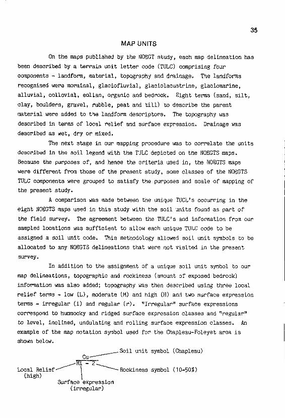
In addition to the assignment of a unique soil unit symbol to our
map delineations, topographic and rockiness (amount of exposed bedrock)
information was also added; topography was then described using three local
relief terms - low (L), moderate (M) and high (H) and two surface expression
terms - irregular (i) and regular (r) . "Irregular" surface expressions
correspond to hummocky and ridged surface expression classes and "regular"
to level, inclined, undulating and rolling surface expression classes . An
example of the map notation symbol used for the Chapleau-Foleyet area is
shown below.
Local Relief(high)
Soil unit symbol (Chapleau)
_ 2Rockiness symbol (10-50%)
Surface expression(irregular)
35
36
ACKNOWLEDGEMENTS
This survey was conducted under contract by the University of
Guelph for the Ontario Ministry of Natural Resources, and was financed by
funds from the Canada-Ontario Forest Management Subsidiary Agreement
originally administered through the Department of Regional Economic
Expansion.
We would like to thank Geoffrey Pierpoint of the Ontario Ministry
of Natural Resources, Maple, for overseeing the project and editing the
final report ; Ingrid Kessel, Janet Mews and Debra Abbott for conducting the
field work ; Glen Wilson for collecting the analytical data ; D .E . Irvine
and J .A . McLennan for cartography, art work and layout of final report ; and
Kelly Beitz and Sheree Henry for typing the numerous drafts of the final
report .
REFERENCES
Agterberg, F.P . and Banerjee, I .1969 :
Stochastic model for the deposition of varves in glacial LakeBarlow-Ojibway, Ontario, Canada ; Canadian J. Earth Sci ., Vol .6, p. 625-652.
Boissonneau, A .N .1965a: Algoma-Cochrane, Surficial geology ; Map 5365, scale 1 inch to 8
miles . Ontario Dept . Lands and Forests, Toronto.1965b : Algoma, Sudbury, Timiskaming and Nipissing, Surficial geology,
Map 5465, scale 1 inch to 8 miles .
Ontario Dept . Lands andForests, Toronto.
1966 :
Glacial history of northeastern Ontario I. The Cochrane-Hearstarea . Canadian J. Earth Sci ., Vol. 3, p. 559-578.
1968 :
Glacial history of northeastern Ontario II . The Timiskaming-Algoma area .
Canadian J. Earth Sci., Vol. 5, p . 97-109 .
Canadian Soil Survey Committee1978 :
The Canadian System of Soil Classification . Subcommittee onsoil classification . Canadian Dept . Agric. Publ ., 1646, supplyand Services Canada, Ottawa . 164 p .
Chapman, L.J . and Thomas, M.K .1968 :
The Climate of Northern Ontario, Climatological Studies No . 6,Dept . of Transport, Toronto, 58 p .
Expert Committee on Soil Survey1983 :
The Canada Soil Information System (CanSiS) . Manual fordescribing soils in the field. 1982 revised. AgricultureCanada, Ottawa, 97 p .
Gartner, J.F., Mollard, J .D . and Roed, M.A .1981 :
Ontario Engineering Geology Terrain Study Users' Manual .Northern Ontario Engineering Geology Terrain Study 1 . OntarioMinistry of Natural Resources, Toronto. 51 p .
Lee, H.A . and Scott, S.A .1980a:
Missinaibi Lake Area (NTS 42B/SW), Districts of Algoma andSudbury. Northern Ontario Engineering Geology Terrain Study74 . Ontario Ministry of Natural Resources, Toronto. 12 p .
1980b: Elsas Area (NTS 42B/NE), Districts of Algoma and Cochrane.Northern Ontario Engineering Geology Terrain Study 64 . OntarioMinistry of Natural Resources, Toronto. 15 p .
1980c: Foleyet Area Ws 42B/SE), Districts of Algoma, Cochrane andSudbury. Northern Ontario Engineering Geology Terrain Study75 .
Ontario Ministry of Natural Resources, Toronto. 17 p .1980d: Fire River Area (NTS 42B/NW), District of Algoma .
NorthernOntario Engineering Terrain Study 76 . Ontario Ministry ofNatural Resources, Toronto. 18 p .
37
Ontario Institute of Pedology1982 :
Field manual for describing soils. 2nd edition.
Publ. No .82-1 . Ontario Institute of Pedology, University of Guelph, Ont .
38 p .

38
Ontario Land Inventory1976 :
Land Classification, Chapleau 41-0, Edition 2 MCE, Series A501 .Ontario Centre for Remote Sensing, Ontario Ministry of NaturalResources, Toronto.
Prest, V .K .1970 : Quaternary Geology of Canada ; p. 675-764 in Geology and
Economic Minerals of Canada, ed . R .J.W . Douglas, Econ . Geol .Rept., No . 1 . Geological Survey of Canada . 38 p.
Roed, M.A . and Hallett, D.R .1979a : Chapleau Area (NTS 410/NW), Districts of Algoma and Sudbury .
Northern Ontario Engineering Geology Terrain Study 80 . OntarioMinistry of Natural Resources, Toronto . 20 p .
1979b:
Ridout Area (NTS 410/NE), District of Sudbury.
NorthernOntario Engineering Geology Terrain Study 81 . Ontario Ministryof Natural Resources, Toronto . 16 p .
1979c: Biscotasing Area (NTS 410/SE), Districts of Algoma and Sudbury .Northern Ontario Engineering Geology Terrain Study 87 . OntarioMinistry of Natural Resources, Toronto. 15 p.
1980 :
Wenebegon Lake Area (NTS 410/SW), Districts of Algoma andSudbury . Northern Ontario Engineering Geology Terrain Study86 .
Ontario Ministry of Natural Resources, Toronto . 16 p .
Rowe,
J.S.1972 :
Forest Regions of Canada, Canadian Forestry Service Public.,No . 1300 . Supply and Services Canada, Ottawa .
172 p.
Stockwell, C.H .1970 :
Geology of the Canadian Shield - introduction ; p . 44-54 inGeology and Economic Minerals of Canada, ed . R.J.W . Douglas,Econ . Geol . Rept., No . 1 . Geological Survey of Canada, Ottawa .838 p .
Thurston, P.C ., Sage, R.P . and Siragusa, G.M.1977 :
Geology of the Chapleau area, Districts of Algoma, Sudbury andCochrane . Report 157, Ontario Geological Survey, OntarioMinistry of Natural Resources, Toronto. 293 p .
Zwarich, M.A . and Mills, J.G .1971 :
An evaluation of three methods for the determination of calciteand dolomite in soils and geological sediments.
Canadian J.Earth Sci . Vol . 8, p . 967-972.
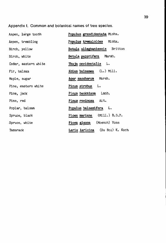
Appendix I. Common and
Aspen, large tooth
Aspen, trembling
Birch, yellow
Birch, white
Cedar, eastern white
Fir, balsam
Maple, sugar
Pine, eastern white
Pine, jack
Pine, red
Poplar, balsam
Spruce, black
Spruce, white
Tamarack
botanical names of tree species.
Populus grandidentata Michx.
Populus tremuloides
Michx.
Betula alleghaniensis
Britton
Betula papyrifera
Marsh.
Thu a occidentalis
L.
Abies balsamea
(L .) Mill .
Acer saccharum
Marsh.
Pinus strobus
L.
Pinus banksiana
Lamb.
Pinus resinosa
Ait.
Populus balsamifera
L.
Picea mariana
(Mill .) B.S .P .
Picea glaua
(Moench) Voss
Larix laricina
(Du Roi) K . Koch
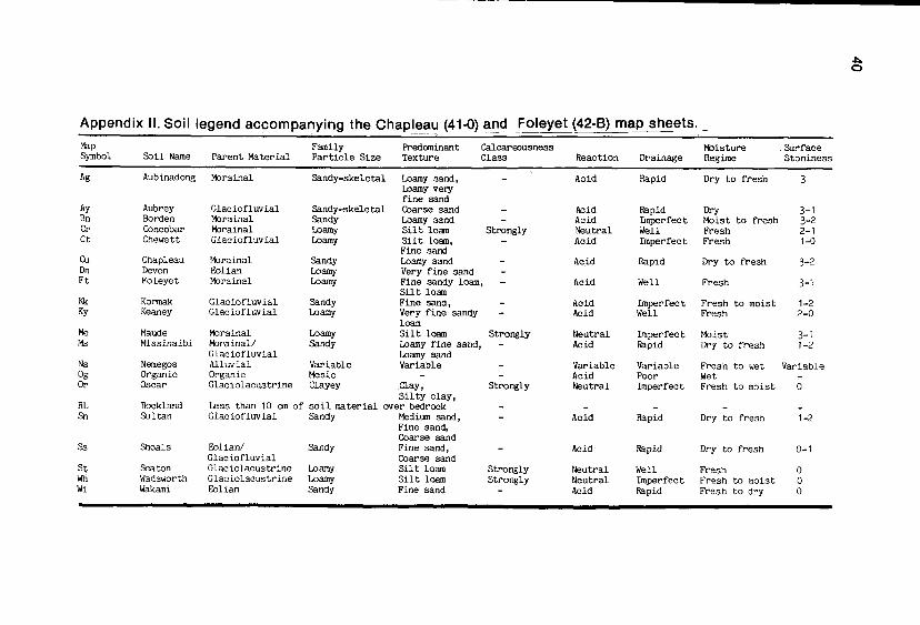
Appendix II . Soil legend accompanying the Chapleau (41-0) and Foleyet (42-B) map sheets .MapSymbol Soil Name
FamilyParent Material Particle Size
Predominant CalcareousnessTexture Class Reaction Drainage
MoistureRegime
SurfaceStoniness
Ag Aubinadong Morainal Sandy-skeletal Loamy sand, - Acid Rapid Dry to fresh 3Loamy veryfine sand
Ay Aubrey Glaciofluvial Sandy-skeletal Coarse sand - Acid Rapid Dry 3-1Bn Borden Morainal Sandy Loamy sand - Acid Imperfect Moist to fresh 3-2Cr Concobar Morainal Loamy Silt loam Strongly Neutral Well Fresh 2-1Ct Chewett Glaciofluvial Loamy Silt loam, - Acid Imperfect Fresh 1-0
Fine sandCu Chapleau Morainal Sandy Loamy sand - Acid Rapid Dry to fresh 3-2Do Devon Eolian Loamy Very fine sand -Ft Foleyet Morainal Loamy Fine sandy loam, - Acid Well Fresh 3-1
Silt loanIWc Kormak Glaciofluvial Sandy Fine sand, - Acid Imperfect Fresh to moist 1-2Ky Keaney Glaciofluvial Loamy Very fine sandy - Acid Well Fresh 2-0
loamMe Maude Morainal Loamy Silt loam Strongly Neutral Imperfect Moist 3-1Ms Missinaibi Morainal/ Sandy Loamy fine sand, - Acid Rapid Dry to fresh 1-2
Glaciofluvial Loamy sandNs Nemegos Alluvial Variable Variable - Variable Variable Fresh to wet VariableOg Organic Organic Mesic - - Acid Poor Wet -Or Oscar Glaciolacustrine Clayey Clay, Strongly Neutral Imperfect Fresh to moist 0
Silty clay,RL Rockland Less than 10 cm of soil material over bedrock - - - - -Sn Sultan Glaciofluvial Sandy Medium sand, - Acid Rapid Dry to fresh 1-2
Fine sand,Coarse sand
Ss Shoals Eolian/ Sandy Fine sand, - Acid Rapid Dry to fresh 0-1Glaciofluvial Coarse sand
St Seaton Glaciolacustrine Loamy Silt Loam Strongly Neutral Well Fresh 0Wti Wadsworth Glaciolacustrine Loamy Silt loam Strongly Neutral Imperfect Fresh to moist 0Wi Wakami Eolian Sandy Fine sand - Acid Rapid Fresh to dry 0


