Download - Reporte de Arabia Saudita Petroleo
GEOLOGY OF THE
ARABIAN PENINSULA
Sedimentary Geology of Saudi Arabia
U.S. GEOLOGICAL SURVEY PROFESSIONAL PAPER 560-D
Geology of the Arabian PeninsulaSedimentary Geology of Saudi Arabia
By R. W. POWERS, L. F. RAMIREZ, C. D. REDMOND, and E. L. ELBERG, JR.
U.S. GEOLOGICAL SURVEY PROFESSIONAL PAPER 560-D
A review of the sedimentary geology of
Saudi Arabia as shown on USGS Miscellaneous
Geologic Investigations Map I 2JO A j" Geologic
Map of the Arabian Peninsula
UNITED STATES GOVERNMENT PRINTING OFFICE, WASHINGTON : 1966
DEPARTMENT OF THE INTERIOR
DONALD PAUL HODEL, Secretary
U.S. GEOLOGICAL SURVEY
Dallas L. Peck, Director
First printing 1966 Second printing 1985
For sale by the Distribution Branch, U.S. Geological Survey 604 South Pickett Street, Alexandria, VA 22304
FOREWORDThis volume, "The Geology of the Arabian Peninsula," is a logical consequence of the
geographic and geologic mapping project of the Arabian Peninsula, a cooperative venture between the Kingdom of Saudi Arabia and the Government of the United States. The Arabian- American Oil Co. and the U.S. Geological Survey did the fieldwork within the Kingdom of Saudi Arabia, and, with the approval of the governments of neighboring countries, a number of other oil companies contributed additional mapping to complete the coverage of the whole of the Arabian Peninsula. So far as we are aware, this is a unique experiment in geological cooperation among several governments, petroleum companies, and individuals.
The plan for a cooperative mapping project was originally conceived in July 1953 by the late "William E. Wrather, then Director of the U.S. Geological Survey, the late James Terry Duce, then Vice President of Aramco, and the late E. L. deGolyer. George Wadsworth, then U.S. Ambassador to Saudi Arabia, and Sheikh Abdullah Sulaiman, then Minister of Finance of the Government of Saudi Arabia, lent their support to the plan. In November of the follow ing year, 1954, Director Wrather approved the U.S. Geological Survey's participation and designated G. F. Brown responsible for the western Arabian shield region in which he had previously worked under U.S. foreign-aid programs. In January 1955 F. A. Davies, Chairman, Board of Directors, Arabian-American Oil Co., approved Aramco's participation and appointed the late R. A. Bramkamp, chief geologist, responsible for compilation of the area within the Kingdom where the sediments crop out. This responsibility fell to L. F. Ramirez following the death of R. A. Bramkamp in September 1958.
R. A. Bramkamp and G. F. Brown met in New York in February 1955 and planned the program, including scales of maps, areas of responsibility, types of terrain representation, and bilingual names. Thus there was established a cooperative agreement between the King dom of Saudi Arabia, the U.S. Department of State, and the Arabian-American Oil Co. to make available the basic areal geology as mapped by Aramco and the U.S. Geological Survey.
The agreement specified publication of a series of 21 maps on a scale of 1:500,000, each map covering an area 3° of longitude and 4° of latitude. Separate geologic and geographic versions were to be printed for each of the quadrangles; both versions were to be bilingual in Arabic and Enblish. A peninsular geologic map on a scale of 1:2,000,000 was to conclude the project.
High-altitude photography, on a scale of 1:60,000, of the Kingdom of Saudi Arabia was initiated during 1949 by the Aero Service Corp. and completed in 1959. Both third-order vertical and horizontal control and shoran were utilized in compiling the photography. This controlled photography resulted in highly accurate geographic maps at the publication scale which then served as a base for the geologic overlay. The topography of the sedimentary areas was depicted by hachuring and that of the shield region by shaded relief utilizing the airbrush technique.
The first geographic quadrangle was published in July 1956 and the last in September 1962. While preparation of the geographic sheets was in progress, a need arose for early publication of a l:2,000,000-scale peninsular geographic map. Consequently, a preliminary edition was compiled and published in both English and Arabic in 1958. The second edition, containing additional photography and considerable new topographic and cultural data, was published in 1963. The first of the geologic map series was published in July 1956 and the final sheet in early 1964. The cooperative map project was completed in October 1963 with
m
IV FOREWORD
the publication of the 1:2,000,000-scale "Geologic Map of the Arabian Peninsula" (Miscel laneous Geologic Investigations Map 1-270 A).
As work on the quadrangles progressed, geologist, companies, and governments working in areas adjacent to the Kingdom of Saudi Arabia were consulted by Aramco and invited to participate in the mapping project. The number of cooperating participants was expanded to 11, which included the operating oil companies in the peninsula and which are identified elsewhere in this text; the Overseas Geological Surveys, London; the Government of Jordan; F. Geukens, who had worked in Yemen; and Z. R. Beydoun, who had studied the Eastern Aden Protectorate. With the close cooperation of the authors, the new data were added to data already plotted on the base map of the Arabian Peninsula.
As the geological coverage of the peninsular map grew, the need for a text to accompany the map became apparent to both the U.S. Geological Survey and the Aramco geologists. Exploratory conversations were begun by Aramco with companies working in the other countries of the Arabian Peninsula for their participation in the preparation of a monograph on the geology of the Arabian Peninsula. Each author prepared a description of the geology of the area for which he was responsible, as shown in the sources of geologic compilation diagram on the peninsular map. The U.S. Geological Survey undertook the publishing of the volume as a professional paper, and the Government of Saudi Arabia was to finance its printing. It was early agreed that there would be no effort to confine the contributions to a standard format and that no attempt would be made to work out an overall correlation chart other than shown on the "Geologic Map of the Arabian Peninsula." Thus, the individual style of authors of several nationalities is preserved.
Cooperation and relations have been of the highest order in all phases of the work. The project would not have been possible without the full support of the U.S. Department of State, the Kingdom of Saudi Arabia, and all contributors. In fact, the funds which made publi cation of this volume possible were contributed the Saudi Arabian Government.
The data provided by the maps and in the professional paper provide information for an orderly scientific and economic development of a subcontinent.
0. A. SEAGER, Arabian-American Oil Co. (Retired).
W. D. JOHNSTON, JR., Former Chief, Foreign Geology Branch,
Z7.S. Geological Survey,.
CONTENTS
Foreword._________________________________________Abstract ___________________________________________Introduction. ______________________________________
History of exploration in Saudi Arabia ____________History of Arabian map project._________________Acknowledgments _-------___-____---____________
Stratigraphy.--_--_-------_______________________-_Outline of major stratigraphic divisions.___________
General features--_----___-__-_-_____-______Lower Paleozoic clastic rocks.._______________Permian and Triassic clastic rocks.___________Lower and Middle Jurassic clastic and carbonate
rocks.___________________________________Upper Jurassic and early Lower Cretaceous car
bonate rocks.------_-__-__-_________--__-Late Lower Cretaceous clastic rocks_________Middle Cretaceous clastic rocks__--_______.___Upper Cretaceous to Eocene carbonate rocks.__ Miocene and Pliocene clastic rocks..__________
Paleogeography__. _ ___________________________Early Paleozoic.__________________________
Cambrian ______________________________Ordovician, Silurian, and Devonian. ______
Permian and Triassic_________-______________Late Permian._________________________Triassic..__-_--__-________-___-_____-
Early and Middle Jurassic.__________________Early Jurassic._________________________Middle Jurassic. ________________________
Late Jurassic and lower Early Cretaceous--___- Late Jurassic_..____.______._________.Lower Early Cretaceous.--.----------.--
Upper Early Cretaceous__-_-_-----___-_---_-Middle Cretaceous__________________________Upper Cretaceous.__________________________Paleocene and Eocene._-______-_--___-______Miocene and Pliocene-_---____-----___._--_-
Cambrian and Ordovician Systems._______________Saq Sandstone and equivalent units Siq,
Quweira, Umm Sahm, and Ram Sandstones..Ordovician, Silurian, and Devonian Systems _______
Tabuk Formation rLower Ordovician to Lower Devonian._______________________________
Devonian System.____-__-_________-_-__-__-____Jauf Formation Lower Devonian ____________
Permian and older(?) Systems-__--_---__________-Wajid Sandstone Lower Permian and older (?)
Permian System._______________________________Khuff Formation Upper Permian ____________
Permian and Triassic Systems__________________Sudair Shale Upper Permian and Lower
Triassic _ _ _ _____________________________Triassic System. _______________________________
Jilh Formation Middle and Upper(?) Triassic. _ Minjur Sandstone Upper Triassic.________
Jurassic System. _______________________________Marrat Formation Lower Jurassic._._____..Dhruma Formation Middle Jurassic__ _ __
Pageiii
Dl22455556
91010121313131314141415151515161617171819192020
2022
2226262727292932
32353537393942
Page
Stratigraphy ContinuedJurassic System Continued
Tuwaiq Mountain Limestone Upper Jurassic. . D49Hanifa Formation Upper Jurassic.____--_--- 53Jubaila Limestone Upper Jurassic ______ 57Arab Formation Upper Jurassic _ _ _ - 60Hith Anhydrite Upper Jurassic.____________ 65
Jurassic and Cretaceous Systems - ___------- 66Sulaiy Formation Upper Jurassic(?) and Lower
Cretaceous(?) __ _______-_--------_---- 66Cretaceous System. _ ____________-__-_-__-------- 70
Yamama Formation Lower Cretaceous - 70Buwaib Formation Lower Cretaceous _ _ _. 72Biy adh Sandstone Lower Cretaceous ______ 74Wasia Formation Middle Cretaceous _ _ _ _ _ 77Aruma Formation Upper Cretaceous.__-_--_ 79
Tertiary System_____-----------_--------------- 84Umm er Radhuma Formation Paleocene and
Lower Eocene.___.___-____---_---_------- 84Rus Formation Lower Eocene._______-_---- 87Dammam Formation Lower and Middle
Eocene._______________----------_------- 88Hadrukh, Dam, Hofuf, and Kharj Formations
Miocene and Pliocene.______--__--_------- 91Tertiary and Quaternary Systems _________---- 97
Gravel--.----.---------------------------- 97Terrace sand and gravel. __-___--__-_-------- 98Marl and sandstone.________________-------- 98Basalt __-_.--------.-------------------- 98Calcareous duricrust.________________-_---_- 98Terrace, mud flat, and gypsum deposits. ------ 99
Lake terraces__.________-_____._----- 99Marine terraces and raised beaches. ____ 99Deltaic and tidal mud flats_____________ 99Gypsum deposits._._____________-__---_ 99
Quaternary deposits..--------------------------- 99Terrace gravel_____._________-_____------_ 99Sheet gravel.._______------_____-__--_ 99Gravel remnants...--________._--_---------_ 99Gravel, sand, and silt.____-____-____.----_-. 100Sabkhah deposits--.....-------------------- 100Eolian sand_____________-_-___---___-----_- 100
Structure. __.__________.____-_____---__-_- .. 100General features._______________________________ 100Stable region._______------_-----_-------------- 101
Arabian Shield----------------------------- 101Western Arabian Shield-___-_--__-----__ 101Yemen-Western Aden Plateau.-____--_--_ 101Southern Arabian Shield....______--_--__ 101
Arabian Shelf------------------------------ 101Interior Homocline.___-_____----------- 102
Central Arabian arch defined by north ern and southern Tuwayq segments. 102
Ha'il arch_____.____-_--__._-------. 102Widyan basin margin. _ _____________ 104Hadramawt Plateau_______________ 105Hadramawt segment._________----__ 105
VI CONTENTS
Page Structure Continued
Stable region ContinuedArabian Shelf Continued
Interior Platform._.-_-______.__-_..-. D105Basins_ -_______-____-_-____---___-__- 105
Rub' al Khali basin---------..-.---- 105Northern Persian Gulf basin _________ 108Dibdiba basin_____--_._________._-_ 106Sirhan-Turayf basin___-_----___--_ 106
Mobile belt mountains and forelands___________ 106Mountains. ________________________________ 106
Zagros Mountains...-___________._.____ 106Oman Mountains.___--__--_______--_--. 106
Forelands.-._-_---___--_----_--__------____ 107Zagros Mountains foreland_____________ 107Oman Mountains foreland_______________ 107
Huqf-Haushi swell._________________________ 107Central Arabian graben and trough system__. _ _ _ _ 107
Nisab graben_____________________________ 107Sahba' trough-----___---__-____-.__________ 107Mughrah structural trough_________..___-_ 108Awsat graben._____________________________ 108Durmd graben-_-__________________.________ 108Qaradan graben____________________________ 109Barrah graben____________________________ 109Majma'ah graben___________________________ 109
Khawr Umm Wu'al graben._____________________ 110
Page Stratigraphic sections.--__-_________.____.---__-____ DUO
Tabuk Formation_____________________________ 110Jauf Formation_-_---___-_-_-----.-_--------__ 113Khuff Formation.______________________________ 115Sudair Shale--._____-____________... 117Jilh Formation.-..----.._______---___-_--____-_ 118Mmjur Sandstone___-________.-_-_-_______-.__ 120Marrat Formation__-_-_________-_-___-_-_-_____ 121Dhruma Formation-____________--__-___________ 123Tuwaiq Mountain Limestone____----__-__-_____ 132Hanifa Formation.----------------------.------ 133Jubaila Limestone._--_.__-_____________-__-_.__ 134Arab Formation._______________________________ 135Hith Anhydrite ------__--_------_-_-_-_-_-.__ 139Sulaiy Formation_-----_-_-----------__-_-_-___- 139Yamama Formation..-.-___-__-_______._-____.-_ 140Buwaib Formation..__-_____---__-___________-__ 141Biyadh Sandstone.__--_-.-_-__-__-_-.---_____._ 142
.-......__..._.. 142
.-__-..._-__.-__ 143
...-...--_..._.. 143
.___._-_-_.--..- 145
.-_-_--_.____.__ 145
.-.--._-_-....-- 145
.--....---__---_ 146
.--.--._----._._ 146Bibliography.________--______-_-_--__-______-__ 146
Wasia Formation.__---___-_- Aruma Formation.-_-.-____. Umm er Radhuma Formation. Rus Formation.____-__-____.Dammam Formation_.____.Hadrukh Formation..---.---. Dam Formation________-___.Hofuf Formation.---_-_____.
ILLUSTRATIONS
[Plates are In pocket]
PLATE 1. Regional stratigraphic section, Ash Sharawrah to Tabuk.2. Map showing structural provinces, Saudi Arabia and adjacent areas.3. Tabuk Formation type section.4. Jauf Formation type section.5. Jilh Formation type section.6. Minjur Sandstone type section.7. Dhruma Formation reference section.8. Tuwaiq Mountain Limestone reference section.9. Biyadh Sandstone type section.
10. Umm er Radhuma Formation reference section.Page
FIGURE 1. Schematic section showing Cretaceous surface-subsurface relationships_-________-___-______--___---------- Dll2. Khuff Formation reference section__-___-_____ ________3. Sudair Shale type section._____________________________4. Marrat Formation reference section.____________________5. Hanifa Formation reference section _____________________6. Jubaila Limestone reference section _____________________7. Arab Formation type and reference sections_____-_-____8. Sulaiy Formation type section________________________9. Buwaib and Yamama Formations reference sections__ __
10. Aruma Formation type section _________________________11. Dammam and Rus Formations type and reference sections.12. Hadrukh Formation type section.______________________13. Dam Formation type section_________________________14. Hofuf Formation type section._________________________
30344155596267728189949596
TABLE
TABLE 1. Saudi Arabian outcrop sequencePage D7
GEOLOGY OF THE ARABIAN PENINSULA
SEDIMENTARY GEOLOGY OF SAUDI ARABIA
ByR. W. POWERS, L. F. RAMIBEZ, C. D. REDMOND, and E. L. ELBEBG, JR. 1
ABSTRACT
Systematic mapping of the sedimentary geology of Saudi Arabia by Arabian-American Oil Co. (Aramco) began in 1933. By 1959, exploration parties of one type or another had surveyed more than 1,300,000 square kilometers (500,000 square miles) of sedimentary outcrop.
The foundation for sedimentary deposition is the Arabian Shield a vast Precambrian complex of igneous and metamorphic rocks that occupies roughly one-third of the Arabian Peninsula in the west and crops out sporadically along the southern coast. Since the outset of the Paleozoic Era the shield has been amaz ingly stable, subject only to gentle, epeirogenic movement. On this rigid land mass was deposited an aggregate total of nearly 5,500 meters (18,000 feet) of sedimentary rocks ranging in age from presumed Cambrian to Pliocene(?).
Paleozoic, Mesozoic, and lower Tertiary strata are magnifi cently exposed in central Arabia where they crop out in a great curved belt bordering the shield. Here the landscape is domi nated by a series of essentially parallel west-facing escarpments, each supported by a resistant limestone cap. Exposures are unusually good, and many rock units can be traced without significant interruption for 500 to nearly 1,000 km. Beds reflecting buried basement configuration dip gently and uniformly away from the escarpment region into the Persian Gulf and Rub' al Khali basins.
East of the escarpment belt is a broad expanse of relatively low-relief terrain in which Tertiary and younger deposits effec tively mask older units. Clues to the character of pre-Tertiary rocks in this large area, which includes the Rub' al Khali desert and most of northeastern Arabia, are afforded only by widely scattered bore holes and oil wells.
In extreme northwestern Arabia, largely lower Paleozoic sedimentary rocks are exposed, although a basinal area bordering the Paleozoic rocks on the north is characterized by thick Upper Cretaceous to Tertiary strata. Tertiary to Recent volcanic rocks cover substantial parts of the area.
In general the older sedimentary rocks are exposed in north- central and northwestern Arabia near the Precambrian basement where as much as 2,000 m of lower Paleozoic rocks are present. Although unfossiliferous, the lower 600 m can be equated, at least in part, to rocks of certain Cambrian age in Jordan. Higher beds contain intervals confidently dated as Lower Ordovician, Silurian, and Lower Devonian. Lower Paleozoic rocks are chiefly coarse-grained sandstone of terrestrial origin, although marine shale occurs at several levels and the upper 300 m is mainly shale with thin beds of limestone.
Lower Paleozoic strata are succeeded in the central escarpment region by a thick sequence (about 1,000 m) of Upper Permian
1 Of the Arabian-American Oil Co.
and Triassic sedimentary rocks. The initial deposit, the Khuff Formation, is mostly shallow-water limestone; overlying beds are nonmarine elastics except for thick carbonate units in the middle part of the section.
Above the Triassic System is some 200 to 500 m of Lower and Middle Jurassic rocks which, near the middle of the escarpment region, are interbedded marine shale and shelf limestone. These grade to sandstone, in part continental, in the northern and southern areas of outcrop. The Middle Jurassic is overlain by a great sequence-of nearly pure carbonate rocks, highly fossilif- erous and accurately dated as Upper Jurassic and early Lower Cretaceous.
The Jurassic System is spectacularly displayed in central Arabia where it forms the backbone of the escarpment region the Tuwayq Mountains. Carbonate sedimentation was inter rupted several times in the closing stages of the Jurassic b^ the onset of evaporite conditions which gave rise to cyclic deposits of anhydrite and calcarenite. The resulting sequence the Arab Formation is of prime importance for its porous car bonate members contain billions of barrels of proved oil reserves.
The carbonate sequence is succeeded by a thick body cf late Lower and Middle Cretaceous sandstone. (The Middle Creta ceous Series and Epoch, as defined by European geologist-, are used in this report.) Late Lower Cretaceous rocks are non- marine and appear only in the middle and southern parts of the escarpment region. Middle Cretaceous rocks, nonmarine in the south, become progressively more marine in the north where they follow a transgressive path northwest across older beds as far as Jordan.
Upper Cretaceous and Eocene rocks, almost exclusively in limestone and dolomite facies, are extensively exposed alorc the eastern edge of the escarpment belt and continue northwest into Iraq. The sequence, with an average thickness of about 5^0 m, includes rocks of Upper Cretaceous, Paleocene, lower Eocene, and middle Eocene ages.
The stratigraphic sequence above the Eocene consists of 200 to 600 m of Miocene and Pliocene rocks, mostly of nonn^arine origin. These deposits a heterogeneous assemblage of marly sandstone, sandy marl, and sandy limestone blanket the Rub' al Khali and northeastern Arabia.
Above the Miocene and Pliocene rocks are unconsolHated Quaternary deposits which comprise great sand deserts and widespread gravel sheets. Sand of the Rub' al Khali Desert alone covers about 600,000 sq km (230,000 sq mi) or most of southern Arabia.
Two major structural provinces are recognized within the Arabian Peninsula and adjacent areas. One is the comparatively stable interior region whose rigidity is controlled by the Pre cambrian basement. The other is the great mobile belt of Taurus, Zagros, and Oman Mountains, bordering the stable
Dl
D2 GEOLOGY OF THE ARABIAN PENINSULA
region on the north and east. Saudi Arabia falls entirely within the stable region.
The interior stable region contains the Arabian shield as well as the Arabian Shelf an extension of the basement thinly veneered with little-disturbed sedimentary rocks. Widespread structural events, presumably related to epeirogenic movement within the basement, have divided the Arabian Shelf into several distinct and significant structural elements the Interior Homocline, the Interior Platform, and several basinal areas.
Bordering the shield is a great belt of sedimentary rocks whose dip basinward is so slight and uniform as to be impreceptible to the eye. This Interior Homocline has an average width of about 400 km and a persistent dip varying from slightly more than 1°00' in older units to less than 0°30' in the youngest. One structural feature of the homocline the central Arabian arch has greatly influenced the present surface distribution of sedimentary rocks in the interior escarpment region. The arch, which affects all rocks from the basement up, marks the area of maximum curvature of the homocline in central Arabia. Although the arch has a varied history, it is apparently a residual high between the periodically sinking Persian Gulf and Rub' al Khali basins rather than a true independent positive feature. Support for this concept conies from the presence of a great arc of tensional structures the central Arabian graben and trough system near the crest of the arch and along the hinge line between the Persian Gulf basin and the stable western block.
Bordering the homocline is the Interior Platform, a remarkably flat area of varying width in which systematic dip off the crystal line core no longer prevails. Superimposed on the platform are several major north-south anticlinal trends which include the great oil fields of Arabia.
Adjacent to the platform are several basinal areas that have from time to time received thick sedimentary deposits. Such basinal sags have developed on the shelf in the northeastern Rub' al Khali, northern Persian Gulf, Dibdibah and Sirhan- Turayf areas.
INTRODUCTION
An impressive amount of geological information on Saudi Arabia has been collected during Arabian- American Oil Co. (Aramco) operations, in the last 30 years. Most of the data are included in company reports; much of what appears in this paper has largely been anticipated in articles by Steineke and Bramkamp (1952 a, b), Thralls and Hasson (1956), Steineke and others (1958), Bramkamp and Powers (1958), and Powers (1962).
The objective of this report is twofold: (1) To bring together in a single document a comprehensive summary of what is now known of the sedimentary rocks exposed in Saudi Arabia and (2) to describe the sedimentary geology of Saudi Arabia as depicted on the recently published 1:2,000,000-scale map of the Arabian Peninsula (U.S. Geological Survey ^Arabian- American Oil Co., 1963). Much of the text is devoted to a systematic account of the stratigraphic and paleontologic record in the Kingdom. Within indi vidual stratigraphic units, local rock sequences are described in considerable detail. These local sections are related to each other and to equivalent rock se
quences outside Saudi Arabia to depict the distri bution, lateral change, age, and gaps in the stratigraphic record, somewhat tedious but necessary prerequisites to unraveling the geologic history of the subcontinent. Much less space is devoted to structure, and orly the major tectonic elements of Saudi Arabia and adjacent areas are considered in any detail.
This report is fundamentally a compilation e.nd, as such, presents the findings of the Aramco geologic group as a whole. A few of the ideas and basic data are new; most are not, although a number of the rela tively broad generalizations have been reached but recently. Many of the concepts presented here origi nated with individuals, particularly the late Max Steineke and the late R. A. Bramkamp, former /ramco chief geologists. Still other fundamental idear origi nated spontaneously with the group rather than with individuals. The writers, of course, take responsibility for the manner in which the concepts are presented and supported here.
HISTORY OP EXPLORATION IN SAUDI ARABIA
References to the geology of Saudi Arabia prior to the start of oil search in 1933 are scarce. Camel trips across the interior escarpment by Philby, during World War I and later years, provided the fir*t con crete evidence that marine rocks are extensively exposed in central Arabia, (Philby, 1922, 1928 1933, 1939). Collections made on these early travels in dicated the presence of lower Kimmeridgian (Newton, 1921) and Callovian (Cox in Philby, 1933) carbonates. Little else specific was known of the geology of this vast region.
On May 29, 1933, the Saudi Arabian Government granted an oil concession to Standard Oil Co. of California. Less than four months after the cor cession agreement was signed, the first geologists, R. P. Miller and S. B. Henry, arrived at the seaport of Al Jubayl, and systematic surface mapping of the coastal area started. Soon these geologists were followed by others, including Max Steineke (Sidney Powers Memorial Medalist, 1951). By 1935, two-man reconnaissance parties had penetrated south as far as Yabrln (lat 23°15' K, long 49°00/ E.), northwest to £Tafar al Batin (lat 28°26/ N., long 45°58/ E.), and west across Ad Dahna' to the Precambrian basement.
Structure drilling began late in 1936 in the Al Qatlf-Al 'Alah area; seismograph was first used at Abu Eadrlyah early in 1937. By this time the initial objective of getting a general picture of the concession had been achieved the succession of geologic strata had largely been worked out, the broad geologic pattern of the area deciphered, the major uncon-
SEDIMENTARY GEOLOGY OF SAUDI ARABIA D3
formities recognized, and most of the rock units named.
Dammam Dome, a salt dome, was the first prospect to be tested by deep drilling. Dammam well 1 was spudded on April 30, 1935. Results were disappoint ing, and the well was abandoned after reaching the Middle Cretaceous. Nine more wells were later drilled at Dammam; although some of these were promising, none proved out on sustained testing. Thus, the Mid dle Cretaceous zones, productive at nearby Bahrain Island, had proved a disappointment in ten wells. Dammam well 7 was the first well programmed to test deeper strata. Drilling of well 7, suspended while the Middle Cretaceous was tested, was resumed in late 1937. This well encountered first gas and then large quantities of oil in the Arab Formation (late Upper Jurassic). The first test to yield oil was made on March 4, 1938, and Dammam 7 was completed in the C Member of the Arab Formation later the same month.
Geological exploration was carried forward steadily, and by the fall of 1937 nine field parties were working in the concession. Surface mapping, seismograph stud ies, and structure drilling continued, and in 1939 a gravimeter-magnetometer survey was started in the coastal area. This same general level of activity con tinued until 1940 when work was gradually curtailed with the advent of World War II. When the war forced a general suspension of operations, Aramco geologists had mapped in detail some 50,000 square miles and had completed reconnaissance surveys over an additional 175,000 sq mi. They had penetrated into the northern portions of the Rub' al Khali, southwest as far as Wadi ad Dawasir, west across the Tuwayq Mountains in several areas, and northwest to Wadi as Sirl^an adja cent to the Jordan border. During this period oil was discovered at Abu JJadrryah in 1938 and Abqaiq in 1940, unsuccessful wildcats were drilled at Al 'Alah in 1937 and Ma'qala' in 1940, and a triangulation network was started to provide accurate control for the various surveys then under way.
Exploratory work was sharply limited during the war years, although surface mapping and structure drilling continued on a small scale until 1942. An unsuccessful wildcat well was started at Jauf (Al Ju'uf) in 1943, and from late 1944 to mid-1945, two surface-mapping parties were in the field.
After the war, exploration once again increased nearly to its former level, and eight field parties of various kinds were in operation. Two of these were surface- mapping parties which, by the end of 1954, had sur veyed much of the concession, in part by reconnaissance traverses but mostly in considerable detail. Only limited investigations of special outcrop problems have been carried out since that time. High-altitude photog
raphy was of particular help in this phase. Between 1949 and 1958, 1:60,000-scale photographs cf all Aramco's concession and much of the remaining parts of the Arabian Peninsula became available.
By 1959, subsurface geological exploration of one kind or another had reached even the remotest parts of the remaining concession, including the offshore area, and party strength was reduced accordingly. Full gravimeter-magnetometer coverage had been achieved in 1958. Two land seismic crews, supplemented for a short period by a marine unit, were in operation until early 1963; three land parties have been active since that tune.
An especially interesting feature of the seismic program is that in 1958 Aramco embarked on a refrac tion survey which was to eventually result in a network blanketing the entire concession. The fortuitous arrangement of a nearly concession-wide, competent, anhydrile refractor immediately above the main producing interval in the Arab Formation made this method of structural mapping highly effective.
The relatively expensive and shallow-penetration structure drills were gradually phased out, and the last hole of this type was completed in 1961. Deep stratigraphic drilling was substituted. Wells 5,COO to 10,000 feet deep were spaced uniformly around the margin of the concession and scattered through the interior of the operating area. Information provided by these wells has proved invaluable, bearing heavily on regional correlation, presence and amount of truncation of unconformities, facies changes, and distribution of favorable reservoir rocks. In addition the deep holes provide critical velocity control for the seismic refraction network. Two such stratigraphic drills were active until mid-1963; one was still in operation in 1965.
During the early postwar period, wildcat drilling discovered oil at Qatif (Al Qa^lf) in 1945, at Ain Dar ('Ayn Dar) in 1948, and at Haradh (IJaratf) and Fadhili (Al Fatfili) in 1949. Aramco's first of?hore discovery came in 1951 with the drilling of the Safaniya (As Saffamyah) structure in the northwestern Persian Gulf. Further discoveries in 1951, 1952, and If 53 at 'Uthmaniyah (Al TTthmanfyah), Shedgum (Shadqam), and Hawiyah (Al IJawryah) established Ghawer (Al Ghawar) field, a single anticline oil-filled from Haradh to Ain Dar and Fazran, a distance of nearly 250 kilometers. Other wells on untested structures and major exploratory wells in known fields followed in quick succession and resulted in commercially im portant finds at Khursaniyah (Al Khursaniyah) in 1956, Khurais (Khurays) in 1957, Manifa (Manlfah) in 1957-58), Abu Hadriya (Abu gadriyah) in 1959, Fadhili in 1962, Abu §a'fah in 1963, and Qatif in 1963.
D4 GEOLOGY OF THE ARABIAN PENINSULA
Wildcats not finding commercial oil were drilled at Al 'Ubaylah in the central Rub' al Khali in 1953-55 and El Haba (Al Lihabah) in 1963.
At the end of 1963, Aramco had discovered productive oil in eleven widely scattered fields and sixteen dif ferent reservoirs. Total estimated remaining proved reserves of crude oil were about 55 billion barrels at the close of 1963.
HISTORY OF ARABIAN MAP PROJECT
Aramco's exploration entered a particularly inter esting phase in 1954 when the U.S. Geological Survey and Aramco began work on a series of geologic- geographic maps covering all the concession and most of the Peninsula. The cooperative effort was spon sored jointly by the Kingdom of Saudi Arabia and the U.S. Department of State. The purpose of the program was to make readily available for scientific and economic application the geologic data collected by Aramco and U.S. Geological Survey during the course of their many years' work in the Kingdom.
Saudi Arabia is one of the few countries in the world that has been completely covered by high-altitude aerial photography. Aerial mapping began in 1949, and 250,000 sq mi of eastern Arabia had been photo graphed by 1951. Remaining parts of the Kingdom involving some 550,000 sq mi were covered from 1954 to 1959. All photography was flown under strict photogrammetric specifications with the necessary forward and sidelap to give complete stereoscopic coverage.
While aerial mapping was in progress, Aramco was busy on an extensive survey network to provide accurate horizontal and vertical control. A third- order triangulation net and a second-order level net were extended over most of the Eastern Province and southward into the central Rub'al Khali. Elsewhere, high-order astronomical observations using meridian transit stars, recording chronograph, and chronometer were established. Over much of the central outcrop area this work was augmented with stadia and ba rometer traverses; control developed over a 15-year period to accurately tie down the extensive geologic field work. All previously established control points and geologic field stations were identified on photo graphs. The points thus recovered provided the basic topographic and geologic control needed to map the Najd-Tuwayq area. A shoran trilateration net ex tending southward from the Saudi Arabia-Jordan border through northwestern Arabia and into the western Arabian Shield provided control over this area. Photography of the eastern Rub'al Khali was also shoran controlled.
The first step in the preparation of the 1:500,000- scale maps was compilation of a topographic base. Each base was later to be overprinted with the geology. Basic control was provided over most of the area of Aramco responsibility by the slotted-template method of laydown firmly tied to horizontal control points identified on photographs. In the eastern Rub'al Khali, control was established by computing geographic coordinates from shoran readings. Prior to trans ferring the data to the geographic base, topographic features were outlined on individual photographs. In marking the photographs, maximum detail was preserved to show relief, escarpments, drainage, culture, and other features. Sand-covered areas were c^fined, and dune crestlines were delineated. This material was then transferred by sketchmaster to the Isydown base. Hachures were used to represent relief in areas of outcrop, and bodies of sand were shown by stippling to depict trends and different types of sand ter-ain.
Throughout the many years of exploration, an important function of the field parties was to gather place names. Aramco's Arabian Affairs Division, Government Relations Organization, played a major role in evaluation of the data collected and in the selection and proper placement of names used in the map series. Saudi Arabians from all parts of the Kingdom were consulted by Aramco's Arabists to assure accuracy of transliteration and to evaluate old names and obtain new ones. All name^1 were reviewed by the Board on Geographic Names in Washington, D.C. for conformance with the BGN/ PCGN system of transliteration.
The geologic map series was compiled in almost the same manner as the geographic series. The great amount of field data collected over the years had to be compiled, and in the process plane-table traverses, car traverses, and geologic stations had to be identified on photographs and adjusted to the new maD base. Elevations were reviewed, adjusted, and tied to later level lines. Stratigraphic contacts were identified and traced on photographs across areas not covered by ground traverses.
After completion of the l:500,000-scale geologic sheets and the revised l:2,000,000-scale geographic map, Aramco personnel began work on their portion of a l:2,000,000-scale geologic map of the Arabian Peninsula. Contributor geology was generalized on the geographic base in close collaboration with the authors. In addition, hand-colored proof was returned to each contributor for review and comments before publication. Concurrently, members of the U.S. Geological Survey were moving ahead with comDilation of the geology of the western Arabian Shield.
SEDIMENTARY GEOLOGY OF SAUDI ARABIA D5
ACKNOWLEDGMENTS
As stated before, this paper basically represents a compilation of many geologists' work over a period of 30 years. During that time 77 individuals studied the Arabian outcrop sequence and were involved in the collection and processing of the data and the formu lation of the ideas expressed here. Each of these Aramco geologists is cited individually. Other mem bers of Arameo's geologic staff made significant con tribution in the form of paleontologic determinations, photogeologic mapping, and other work. It is not possible to acknowledge separately each contribution but it should be noted that the following Aramco specialists have added to our knowledge of Arabian geology: P. R. Aswerus, G. R. Ball, T. C. Barger, H. S. Bennett, Jr., E. L. Berg, S. Bevan, B. Beverly, Jr., G. W. Blakslee, H. W. Blodget, L. E. Bogle, F. Bourgeois, S. D. Bowers, R. A. Bramkamp, A. B. Brown, C. W. Brown, H. L. Burchfiel, R. B. Carr, A. E. Clements, M. C. Coffield, J. S. Cruse, W. DeU'Oro, W. C. Dimmock, J. J. Donohue, D. B. Eicher, C. R. Farquhar, O. B. Fenner, F. J. Frank- ovieh, W. M. Furnish, R. D. Gierhart, T. F. Harriss, D. O. Hemer, S. B. Henry, B. B. Hill, W. H. Hoag, Jr., D. A. Holm, R. W. Holt, J. W. Hoover, B. R. Hudson, R. C. Kerr, H. A. Kimball, T. W. Koch, R. P. Kopp, N. M. Layne, Jr., R. L. Maby, Jr., R. D. MacDougall, H. L. McAlister, H. A. McClure, L. B. Milam, R. P. Miller, C. S. Morse, R. L. Myers, O. W. Nine, J. W. Northrup, L. D. Owens, K. R. Parsons, A. F. Pocock, R. W. Powers, L. F. Ramirez, C. D. Redmond, D. O. Reese, W. H. Reiss, S. J. Roach, C. W. Rock, N. J. Sander, R. M. Sandford, H. W. Schneider, J. R. Schultz, J. B. Sheehan, A. M. Short, W. T. Short, Max Steineke, J. W. Thomas, F. R. Waldron, J. C. Wells, A. A. Weymouth, J. S. Williams, and M. P. Yackel.
Two of the Aramco geologists Max Steineke and R. A. Bramkamp should be singled out for special mention. Both were pioneers in the study of the geology of Saudi Arabia. Steineke arrived in the field September 20, 1934, almost one year after oil exploration had commenced. Bramkamp arrived in mid-September of 1936. Most of the work on which this report is based was either done by them personally or under their guidance, for Steineke and Bramkamp were Aramco's chief geologists respectively from 1936 to 1947 and 1947 to 1958. Both men were true scientists and outstanding geologists, and it was during their tenure that the framework of the stratigraphy and structural geology of Arabia evolved in much its present form. A large amount of new work, much of it detailed, has done little to modify their basic
concepts; indeed, such data have usually servei to strengthen their predictions.
This acknowledgment would be incomplete without mention of S. D. Bowers who read much of the man uscript and offered many useful suggestions and cr'ticisms. Thanks are also due James P. Mandaville, Jr., Geographical Analyst, Aramco's Arabian Affairs Division, for his painstaking research and reading and correcting of all Arabic place names appearing in this paper. The manuscript was typed by Mary E. Archer who, in addition, thoroughly edited the manuscript for place names and technical errors. For all her help the writers are most grateful. The manuscript is published by permission of Aramco.
STRATIGRAPHY
OUTLINE OF MAJOR STRATIGRAPHIC DIVISIONS GENERAL FEATURES
The foundation for sedimentary deposition in £ Arabia can readily be generalized into two positive structural elements on the west, the western Arabian Shield, a vast dominantly Precambrian complex of igneous and metamorphic rocks; on the south, the Arabian part of a crystalline massif extending northeast from the horn of Africa.
The western Arabian Shield must be regarded as a continuation of the adjacent African shield ar*i is now separated from it by the Red Sea rift. The time of initial separation is still controversial; however, the Red Sea appears to be primarily a late Tertiary feature. Western shield rocks can be clearly dated as Pre cambrian by their unconformable position ber°-ath unaltered sediments which in Jordan have furnished Cambrian fossils. The oldest identifiable fossils so far discovered in Saudi Arabia proper are Early Ordo- vician, but a substantial sequence of rocks correlative with the Cambrian units in Jordan intervene between these and the basement. Age of the southern Arabian complex in Yemen, the Aden Protectorates, and Dhufar also appears to be Precambrian for the most part, although the presence of some early Paleozoic elements has been determined by radioactive da.ting.
Since Precambrian time the massifs have been amazingly stable, subject only to gentle, epeiroj?enie movement. On these rigid peneplaned land masses was deposited a thick sequence of continental and shallow-water shelf sediments that dip gently into the Mediterranean, Persian Gulf, and Rub' al Khali basins. The opposite flank of the Mediterranean-Persian Gulf geosyncline is formed by the Russian Platform far to the northeast. Presumably the Rub* al Khali basin is a reflection of the broad northeast-plunging syuoline connecting the western Arabian and southern Arabian Shields.
D6 GEOLOGY OF THE ARABIAN PENINSULA
Field work in Saudi Arabia in connection with oil search has now been in progress for 30 years. During this time, Aramco geologists have identified, measured, and mapped in considerable detail an aggregate total of nearly 5,500 meters (18,000 ft) of sedimentary rocks ranging in age from presumed Cambrian to Pliocene (?) (table 1, pi. 1). The main rock units have been blocked out, and their limits have been tested widely enough to assume that they will stand in essentially their present form. As always, much work remains to be done particularly so far as paleogeography, regional litho- facies, and more precise dating of some parts of the section are concerned. It is expected, however, that additional work will affect only the detail and that the major framework as now defined will survive.
Paleozoic, Mesozoic, and lower Tertiary sedimentary rocks are magnificently exposed in central Arabia. Here, rocks crop out in a great curved belt flanking the eastern margin of the shield. Beds certainly reflecting buried basement configuration dip gently and uniformly northeast, east, and southeast. Rate of dip changes progressively from slightly more than 1°00' in older units to less than 0°30/ in the Upper Cretaceous and Eocene. Low dip of such remarkable constancy gives rise to one of the fundamental structural provinces of the Arabian Peninsula a wide Interior Homocline bordering the Arabian Shield (pi. 2). Dominating the exposed part of the homocline is a series of essentially parallel, west-facing, strike escarpments, each supported by a resistant limestone cap. Sandstone and shale, less resistant at least so far as arid weathering is concerned, floor intervening valleys and plains. The west-facing scarps offer fine opportunity for studying the sequence in that exposures are unusually good and some rock units can be traced without significant interruption over a distance of 500 to nearly 1,000 km. As the softer formations between cuestas are very often only partially masked by late gravels and sands, even these units are fairly well known.
East of the homocline is a broad expanse of relatively low-relief terrain in which older rocks are buried by Tertiary and other late deposits. Paleozoic and Mes ozoic strata do not reappear at the surface until the Oman Mountains in the easternmost part of the penin sula and Iran on the far side of the Persian Gulf are reached. In this broad area, which includes the Rub' al Khali desert and much of northeastern Arabia, specific information on pre-Tertiary rocks is available only from a few widely scattered stratigraphic holes and fields where oil wells have been concentrated sparse control when the size of the area involved is considered.
In extreme northwestern Saudi Arabia, largely lower Paleozoic sedimentary rocks are exposed. Gentle dip
of Paleozoic units off the Arabian Shield to tin east, northeast, and north outlines the continuation of the Interior Homocline west of An Nafud. A basinal area bordering the homocline on the north is characterized by a thickened Upper Cretaceous to Tertiary seiimen- tary section. In addition, Tertiary to Recent volcanic rocks cover substantial parts of the area.
The sedimentary section exposed above tin Pre- cambrian in Saudi Arabia falls naturally into eight major divisions. Dominated by a characteristic lithol- ogy and separated by significant breaks in the geologic record, the divisions are:1. Lower Paleozoic clastic rocks Cambrian (?) through
Lower Devonian; dominantly coarse clastic rocks but with some Ihin, carbonate beds in uppermost part.
2. Permian and Triassic clastic rocks Upper Permian through Upper Triassic; alternating nonriarine- marine units, dominantly clastic but wit! thick calcareous sections at base and in middle.
3. Lower and Middle Jurassic clastic and carbonate rocks Toarcian to Callovian(?); in central Arabia marine shale interbedded with carbonate grades to sandstone in northern and southern ar^as of outcrop.
4. Upper Jurassic and early Lower Cretaceous car bonate rocks Callovian through Valantunian; mostly carbonate but with alternating evsDorite- normal marine cyclic deposits near end of Jurassic.
5. Late Lower Cretaceous clastic rocks Hauterivian through Aptian; dominantly coarse clastic rocks with thin basal carbonate unit.
6. Middle Cretaceous clastic rocks Cenomarian to Turonian(?); dominantly coarse clastic rocks.
7. Upper Cretaceous to Eocene carbonate rocks Cam- panian through Lutetian; carbonate units but in subsurface lower Eocene includes evaporite Faction.
8. Miocene and Pliocene clastic rocks dominantly sandy limestone and sandstone.
LOWER PALEOZOIC CLASTIC ROCKS
OCCURRENCE AND CHARACTER
In northwestern Saudi Arabia at least 1,900 m of Lower Devonian and older Paleozoic rocks are eroosed. Exposures extend southeast from the Jordan border, form a gently curving arc parallel to the northern mar gin of the shield, and disappear eastward unc^r the blanket sands of An Nafud. Shallow dips progressively shift from northeast to north and northwest to outline a separate embayment of Paleozoic platform sedimen tary rocks west of the 5a'il arch (long 41°30/ E.). Equivalent sedimentary rocks again crop out south of An Nafud. Here they are gradually overlapped by Permian beds and wedge out completely near lat
SEDIMENTARY GEOLOGY OF SAUDI ARABIA D7
TABLE 1. Saudi Arabian outcrop sequence
Age
CENOZOIC
MESOZOIC
) PALEOZOIC
QUATERNARY AND TERTIARY
TERTIARY
Eocene i Miocene and ( Pliocene
o a>
2§
j CRETACEOUS
1 i
CJ
v'^^^S-*"^*^*'
CJ
t
cL C
^-s~* '
~^~s
\L
t 5u i_ JE
" -^^S^S.
J ~
o » z =
11
-^^-^ ^^ ̂ ^^^
Lutetian
Ypresian
ThanetianMontian(?)
Maestrichtian
Campanian ^^*^ -^^^^^^^.Turonian(?)
Cenomanian AptianBarremian
Hauterivian ^^^^^^^^-^^
Valanginian
Berriasian
Tithonian
Kimmeridgian
Oxfordian
Callovian
Caljpvian(?)_ BathonianBajocianToarcian
l^S^^f*^*^^***
Upper "Middle"
Lower
Upper **~*^~^"^S^*^*
Lower
undated^^^^^^"^'N^^
^^^^^^ ̂^^>^
Lower
Formation
Surficial deposits
Kharj
Hofuf
Dam
Hadrukh ^Nw^^N^^*_^^^>^^^^_-N
Dammam
Rus
Umm er Radhuma
Aruma
"^XS^^W***^ " i"*^**-***
Wasia (Sakaka Sandstone of
northwest Arabia)
Biyadh
Buwaibt'*^S*^S**~f**-ii**-*f*** v^ta^Nw^N,
Yamama
Sulaiy
Hith
Arab
Jubaila
Hanifa
Tuwaiq Mountain
Dhruma
Marrat Minjur
Jilh
Sudair
Khuff^**^»*^S*~s**^^~<**~s****~**
Wajid
^s*~~~~-~-~~~-^Pnc'*-S****S***l>*<**S+**^i****^S*+^***r*'
Jauf
Tabuk
( Umm Sahm Ram Quweira Siq
Generalized lithologic description
Gravel, sand, and silt
Limestone, lacustrine limestone, gypsum, and gravelSandy marl and sandy limestone; subordinate cal careous sandstone. Local gravel beds in lower partMarl and shale; subordinate sandstone, chalky lime stone, and coquinaCalcareous, silty sandstone, sandy limestone; local chert
*~*^**^~S^^^+^S^*^S* ̂ '^-'^ ̂S_X^*-S_X^**^"
Limestone, dolomite, marl, and shaleMarl, chalky limestone, and gypsum; common chert and geodal quartz in lower part. Dominantly an hydrite in subsurfaceLimestone, dolomitic limestone, and dolomite
Limestone; subordinate dolomite and shale. Lower part grades to sandstone in northwestern and southern areas of outcrop
Sandstone; subordinate shale, rare dolomite lenses^^^ ^^^^-^ >»^^^s^«w'N-'^^>^^^-*^^-^-'''^-''s-^^~^-x>
Sandstone; subordinate shale
Biogenic calcarenite and calcarenitic limestone in- terbedded with fine sandstone in upper partt^****^ ̂ s^ ̂̂̂̂^^^^^-^^^^^
Biogenic-pellet calcarenite; subordinate aphanitic limestone and biogenic calcarenitic limestoneChalky aphanitic limestone; rare biogenic calcarenite and calcarenite limestoneAnhydriteCalcarenite, calcarenitic and aphanitic limestone, dolomite and some anhydrite. Solution-collapse carbonate breccia on outcrop due to loss of inter- bedded anhydriteAphanitic limestone and dolomite; subordinate cal carenite and calcarenitic limestone. Lower part sandstone between 20° H. and 22" N.Aphanitic limestone, calcarenitic limestone, and cal careniteAphanitic limestone; subordinate calcarenitic lime stone and calcarenite. Abundant corals and stroma- toporoidsin upper partAphanitic limestone and shale; subordinate calcar enite. Dominantly sandstone south of 22" H. and north of 26° H.Shale and aphanitic limestone; subordinate sandstone-^ *v
Sandstone; some shaleSandstone, aphanitic limestone, and shale; subordi nate gypsumRed and green shaleLimestone and shale; dominantly sandstone south of 21°N.
*"S_ ̂ Si^^ «^_-^«^.^^^^ i*Sh^^^« ̂ ^ ^N.
Sandstone, gravel, and basement erratics (Recognized only in southwestern Saudi Arabia and northern Yemen)
imbrian basement complex -~-~^-~~ ̂ -^-~^^->- ̂
Limestone, shale, and sandstone
Sandstone and shale
Sandstone
Thickness (Type or reference section)
28m
95m
91m
84m
56m
243m
142m
42m^s^XS^^^^^^**^
425m
18m*~>^**-S*l-s***>**-s
46m
170m
90m
124m
±118 m
113m
203m
375m
103m^S^N^^SW^**^-^
315m
±326 m
116m
171m|XS_XNfc^SMX>M^S-,
950m
calculated
299m
1,072 m
+ 600m
Major stratigraphic divisions
Miocene and Pliocene Clastic Rocks
Upper Cretaceous to Eocene Carbonate Rocks
Middle Cretaceous Clastic Rocks
Late Lower Cretaceous Clastic Rocks
Upper Jurassic and early Lower Cretaceous Carbonate Rocks
Lower and Middle Jurassic Clastic and Carbonate Rocks
Permian and Triassic Clastic Rocks
Lower Paleozoic Clastic Rocks
Precambrian basement complex Compiled by R. W. Powers and L. F. Ramirez, June 3, 1963
D8 GEOLOGY OF THE ARABIAN PENINSULA
24°20' N. Intervals within this sequence have been dated by graptolites and brachiopods as Lower Ordo- vician (Arenig), Silurian, and Lower Devonian. Cam brian fossils have not been found, although recent photo- geological work shows the lower part of the section to be equivalent to Jordanian units of certain Cambrian age. Major internal unconformities have not been detected, but their absence cannot be assumed on the basis of sparse field work so far done.
Silicate clastic rocks dominate the entire lower Paleo zoic succession. The lower one-third is almost exclu sively white, buff, and red, medium- to coarse-grained, crossbedded sandstone. A thick section of graptolite- bearing shale alternating with light-colored, micaceous, commonly crossbedded sandstone follows. Capping the sequence is nearly 300 m of shale with subordinate stringers of sandstone and carbonate.
In southwestern Arabia a thick sandstone intervenes between basement and Upper Permian carbonate rocks. Unfortunately, this unit has proved barren, and com plete or even partial equivalency to Paleozoic clastic rocks in the northwest has not been established. Flora from adjacent bore holes does suggest, however, that Lower Permian as well as Carboniferous and even Devonian may be represented. The possible presence of still older Paleozoic rocks is not disproved. Exposed in northern Yemen as outliers on the eroded Precam- brian surface, the massive sandstone, in Saudi Arabia, forms a wedge of nearly continuous outcrop as far north as Wadi ad Dawasir (lat 20°30' N.). At this point the sandstone pinches out between basement and over lapping Permian limestone. Calculated to be more than 900 m thick, the postbasement wedge is mainly coarse-grained sandstone including common gravel beds and some zones of basement erratics.
RELATIONSHIP TO ADJACENT UNITS
Precambrian elements of the Arabian Shield were buckled, firmly stabilized, and had undergone at least one and possibly several periods of erosion and pene- planation before the first Paleozoic sediments were deposited. Marked nonconformity is everywhere evi dent between basement and overlying sediments.
The lower Paleozoic sequence is terminated at the top by definite unconformity. South from An Nafud, pre- Permian erosion progressively eliminates Devonian, Silurian, Ordovician, and Cambrian (?) beds, eventually bringing Permian rocks into contact with basement near the latitude of Ad Dawadimi (lat 24°29' N.). From here the erosion surface can be traced south across the basement arch of central Arabia and again effects the southern wedge of Paleozoic clastic rocks.
Beneath An Nafud other unconformities come in. First, pre-Middle Cretaceous erosion eliminated the
Permian, probably north of BEa'il, and cut into Lower Devonian. West of Al Jawf, the .Middle Cretaceous is, in turn, truncated by pre-Upper Cretaceous erosion that eventually cut deep enough to completely remove the Lower Devonian.
Time represented between basement stabilization and the beginning of presumed Cambrian sedimentation is unknown. However, fair dating of units bracketing the upper unconformity shows approximately Middle Devonian through middle Permian time unrecorded in outcrop. Until recently, rocks of these ages had not knowingly been found anywhere in Saudi Arabia. Now, however, spore and pollen analyses show that one well in northern Arabia (near lat 29°50' N., long 41°50' E.) penetrated shale of Mississippian and PennsyJvanian age (Visean to Westphalian). Other wells contain Upper Devonian, Carboniferous, and Lower and middle Permian rocks, thus filling out the Paleozoic record.
PERMIAN ANJ> TRIASSIC COLASTIC ROOKS
OCCURRENCE AND CHARACTER
Nearly 1,000 m of Permian and Triassic sediir«mtary rocks are exposed in a wide belt that curves around the eastern margin of the Arabian Shield. The sequence falls naturally into four subequal units which apparently represent alternating marine and nonmarine deposition. At the base limestone and dolomite alternate with red and green gypsiferous shale. Next above is unfossil- iferous brick-red and green shale, presumably non- marine. A thick section of limestone interbedded with light-colored sand and some gypsiferous shale follows. At the top are highly colored clastic beds containing petrified wood as the only recognizable organic con stituents, characteristics that suggest the unit is mainly continental. As a whole, the Permian and TMassic appear to be mixed marine and continental clast; °s, the latter predominating.
Only the sketchiest time framework has been supplied to the outcrop by marine fossils. The lower carbonate unit contains molluscs which have been assi-imed a probable Late Permian age. Higher carbonate stringers contain fragments of ammonites considered to be Middle Triassic. Fortunately, nearby bore holos have yielded rich suites of diagnostic spore and pollen from equivalent beds. On the basis of these, it is safe to say that the outcrop contains an almost complete Upper Permian through Upper Triassic (Keuper) sequence.
RELATIONSHIP TO ADJACENT UNITS
Regionally important unconformities above end be low set the Permian and Triassic strata off from b^acket- ing units. The lower contact is marked by Upper Permian beds discordantly on rocks as widely vrried in age as: Precambrian (across the central Arabian arch); Cambrian through Early Devonian (north of the arch);
SEDIMENTARY GEOLOGY OF SAUDI ARABIA D9
and middle Permian and older (in the south). At the top, Upper Triassic is overlain by beds of Toarcian age (upper Liassic), and lower Liassic is missing over the length of outcrop. In the extreme southern part of the outcrop, upper Liassic rocks are overlapped and Middle Jurassic rests directly on Triassic.
LOWER AND MIDDLE JURASSIC CLASTIC AND CARBONATEROCKS
OCCURRENCE AND CHARACTER
The Lower and Middle Jurassic are typically repre sented in central Arabia by about 500 m of shallow-water shale and carbonate. In the Riyadh-Purmd area, a thin unfossiliferous basal sandstone is followed by alter nating limestone and shale all highly fossiliferous. The lowermost carbonate bears Toarcian ammonites (uppermost Lower Jurassic) and above it, definite Bajocian and Bathonian and possible Callovian beds have been identified.
Thin members of clean, current-washed carbonate occur at various levels, often as units of high lateral persistence that are useful in setting up a framework of correlation. Lithologic changes to the south along outcrop consist primarily of gradual replacement of shale and carbonate by sandstone. The transition first takes place in the lower beds just south of lat 24° N. and progressively affects higher units so that at lat 21° N. sandstone, apparently continental, makes up the entire sequence. Hints of similar replacement can be seen to the north before interbedded sandstone and shale disappear beneath Recent cover. Although the trend toward a continental enviroment in this direction is obvious, it is likely that a considerable part of the unit is marine where last seen in the vicinity of Az Zilfi (lat 26°18' N.), and the actual strand line must have been even further north.
RELATIONSHIP TO ADJACENT UNITS
Beds of definite Toarcian age rest disconformably on Upper Triassic nonmarine sandstone throughout the length of outcrop. Although unconformity at this level cannot be proved by surface relationships, bore holes show extensive truncation immediately downdip and, in some places, the entire Upper Triassic is miss ing only a short distance basinward. South of lat 22° N. the Toarcian itself pinches out in response to progressive Middle Jurassic overlap.
The transition from Middle to Upper Jurassic, long considered to be unconformable, now is thought to take place without interruption or at the most involves only slight disconformity. Misleading was the fact that basal Upper Jurassic rocks do indeed rest with definite discordance on older units around the southern margin of the Rub* al KEali basin. Now, however,
good faunal control shows that uppermost Middle Jurassic beds are laterally persistent and are without evidence of truncation. Rather than elimination at the top by erosion, it seems more likely that the Middle Jurassic pinches out to the south by progressive CTilap and loss of successively younger beds at the base. Eventually, elimination is effected by complete Upper Jurassic marine overlap.
UPPER JURASSIC AND EARLY LOWER CRETACEOUS CARBONATE ROCKS
OCCURRENCE AND CHARACTER
Upper Jurassic and early Lower Cretaceous ricks, almost entirely in shallow-water limestone facie's, are spectacularly exposed in central Arabia where they stand up as a series of scarps subparallel to the eastern edge of the shield. More than 850 m of section has been measured near the latitude of Riyadh. CaJcar- enitic limestone (lime sand admixed with lime-mud matrix) predominates, although thick, often laterally persistent beds of calcarenite (clean-washed lime sand and gravel) are common at many levels. Lime sands are of various origins, but skeletal debris and aggregate pellets are most common.
The basal 200 m of Upper Jurassic section, composed of abundantly coralliferous and stromatoporoidal 1'tho- graphic limestone, is a massive cliff former. This unit stands up in sharp relief for more than 1,000 km to form the dominant scarp of Jabal T\iwayq, ore of the major topographic features of the Arabian Penin sula. Exposed at the base of the cliff-forming unit is a zone rich in fossils considered to be middle Ollo- vian. Strata representing remaining Upper Jurassic stages and the early Lower Cretaceous through Val- anginian are deposited above without apparent interruption. The only significant change in deposi- tional environment throughout is reflected by the exposure of massive Kimmeridgian Tithonian anhy drite in a solution sink, Dabl Hit (lat 24°39'18" N.; long 47°00'06" E.). Laterally, little is known of the true evaporite rock sequence owing to extensive removal by solution. Most of the area in which these beds would be expected to crop out is a nearly hopeless jumble of low hills representing complexly settled rocks. The collapse breccia can be traced from lat 20°45' N. to nearly lat 26° N., a distance of about 550 km. Only in the southern part of the solution-collapse zone is anhydrite present and then only in small amount. Equivalent rocks are extensively known in the sub surface where they comprise the Hith-Arab evaporite- carbonate complex.
Some lithologic differentiation is apparent in the southern part of the lower Kimmeridgian outcrop, including the appearance of a large marine sandstone
D10 GEOLOGY OF THE ARABIAN PENINSULA
lens in the middle part of the sequence. The sand grades to limestone north of lat 22° N. and south of lat 20° N. Limited exposures in a downdip direction, that is, to the southeast, also show sandstone giving way to carbonate. In this same general area, much of the lower Kimmeridgian above the sandstone is replaced by thickly bedded dolomite. Below the sand stone Upper Jurassic carbonates show a marked buildup of clean, current-washed, shelf calcarenite. Progres sive increase in calcarenite continues to the south until, between lat 18° N. and 19° N., Callovian through lower Kimmeridgian rocks are dominantly lime sand and lime gravel; presumably all mud-size particles were removed from the scene by turbulent water.
RELATIONSHIP TO ADJACENT UNITS
The contact between Upper Jurassic and older beds, apparently conformable north of about lat 19° N., becomes unconformable to the south. In this direction, Callo vian limestone first laps over Lower Triassic and then successively transgresses older Paleozoic units.
The contact between the Upper Jurassic-early Lower Cretaceous carbonate succession and overlying strata involves two unconformities. Maximum section is preserved near lat 24° N. South of this parallel, pre- Hauterivian erosion uniformly cuts successively older beds until, at the southern limit of exposure near lat 18° N., lower Kimmeridgian is affected. North of lat 24° N., only a limited amount of section was removed by this unconformity before pre-Cenomanian trunca tion took over and rapidly eliminated i emaining Lower Cretaceous to Upper Jurassic beds. The last vestige of the Tiiwayq escarpment (Callovian limestone) passes under Cenomanian sandstone near lat 28° N.
LATE LOWER CRETACEOUS CLASTIC ROCKS
OCCURRENCE AND CHARACTER
Except for a thin, albeit persistent, basal limestone, late Lower Cretaceous rocks in central Arabia are mainly continental sandstone. The basal carbonate unit with a measured thickness nowhere greater than 20 m, crops out as a discontinuous scarp from lat 25°30' N. nearly to the southern limit of exposure (lat 20°35' N.); elastics overlying the basal unit form a broad, flat, alluvium (gravel)-covered plain. The surface of the plain is commonly broken by hills of coarsely crossbedded sandstone elevated slightly above the alluvium floor. The belt of sandstone, a feather- edge near lat 26° N., rapidly widens to the south and then maintains a uniform width from lat 24° N. to 20°30' N., where it passes under Neogene and Recent cover. Further south, it appears again in windows at Al Jaladah and Ash Sharawrah. Incomplete exposure prohibited accurate measurement of a full section,
although compositing of several sections indicate^1 maxi mum sandstone thickness to be about 700 m.
Recently an intense search and sampling of the basal carbonate unit resulted in a fine collection of rock samples, larger fossils, and foraminifera. The characteristic lithology is calcarenite and calcr.renitic limestone, the sand- and gravel-size grains mostly being molluscan debris. Fine-grained sandstone is interbedded with carbonate in the upper part, r.nd the unit shows gradational contact with the overlying continental series.
Although the megafossils have not yet been studied, relationships established by means of Forminifera indicate that the limestone is probably Hautcrivian. It is undated on outcrop, but comparison with equiva lent subsurface strata shows the sandstone to be mostly if not entirely Barremian and Aptian (fig. 1).
RELATIONSHIP TO ADJACENT UNITS
Both the upper and lower surfaces of late Lower Cretaceous strata are demonstrable unconformities. Pre-Hauterivian erosion removed a small sectior in the north but southward cut progressively deepe~ until lower Kimmeridgian was involved. The uppe~ sand stone limit was effected by pre-Cenomanian truncation. Accordingly, Albian strata are apparently not present on outcrop (as they are a short distance dovndip), and between lat 24° N. and 26° N. the entir** Hau- terivian to Aptian section is cut out.
MEDDLE CRETACEOUS CLASTIC ROCKS
OCCURRENCE AND CHARACTER
The Middle Cretaceous Series and Epoch, as defined by European geologists, are used in this report. In central Arabia the Middle Cretaceous is represented by a thin but highly persistent unit, mainly sandstone. Shale is commonly interbedded, and thin dolomite and limestone layers are present locally. Most of the sandstone is brown, and crossbedded; interbedded shale and siltstone is varicolored red, purple, an<? green being most common.
The sandstone forms a narrow curved band exposed with few breaks from Wadi ad Dawasir north to the eastern edge of An Nafud, a distance of nearly 1,100 km. Large patches of undifferentiated Middle and Lower Cretaceous clastic rocks have been mapped in the southwestern Rub* al Khali at Al Jaladah and Ash Sharawrah. These exposures are the southernmost in Saudi Arabia proper. In the north, bore holes show that the sandstone continues under An Nafud and again crops out around Sakakah. Relatively small outliers also occur southwest of Sakakah. Until recently, age of the clastic section exposed in the north west was the subject of considerable controversy.
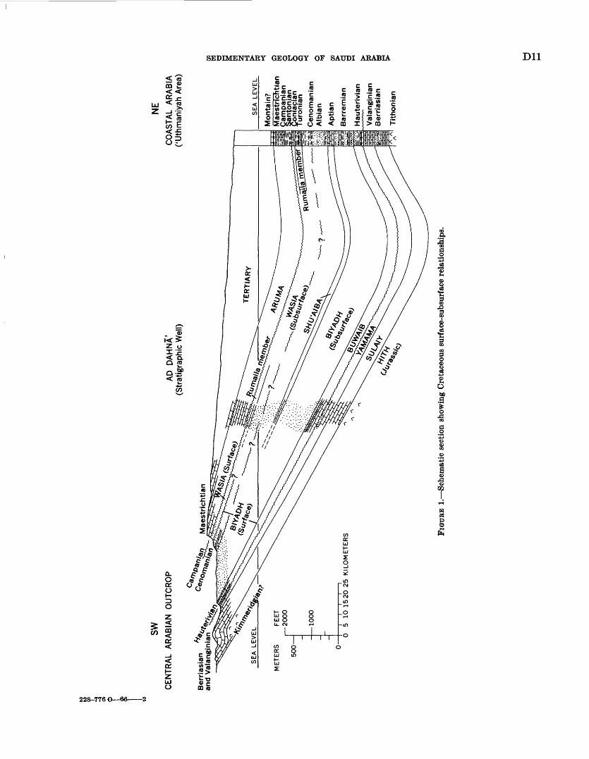
SEDIMENTARY GEOLOGY OF SAUDI ARABIA Dll
<f -C05
o228-776 O 66 2
D12 GEOLOGY OP THE ARABIAN PENINSULA
Now, however, lateral relationships established by wells show the sequence to be, with little doubt, equivalent to Middle Cretaceous rocks of Najd.
Thickness of the Middle Cretaceous rocks south of lat 26° N. is remarkably uniform averaging about 40 m. The unit thickens gradually to the northwest, and at Sakakah incomplete measurement suggests as much as 250 to 300 m of section.
So far as age of the sandstone-shale sequence is con cerned, few fossils have been found on outcrop and these only in central Najd where thin limestone lenses occur. Here, rare ammonites have been dated as Cenomanian. Downdip in well sections, where more faunal control is available, equivalent beds are mainly Cenomanian. A thin scum of Turonian may reach the surface as well, al though proof of this possibility is lacking.
RELATIONSHIP TO ADJACENT UNITS
Middle Cretaceous relationship to adjacent units, so far as outcrop is concerned, is fairly well understood; downdip the situation is less clear. The lower contact on outcrop is one of marked unconformity. South of about lat 25° N. Cenomanian sandstone rests on what is believed to be Aptian sand. North of this latitude, rapid truncation at least in Saudi Arabia where region al unconformities commonly eliminate beds at the rate of less than 1 m per km superimposes Middle Creta ceous on all older units down to and including Lower Devonian. At the top, Cenomanian or Turonian(?) is apparently in disconformable contact over most of the length of outcrop with Campanian(?) limestone.
Relationship to the subsurface sequence is still incom pletely understood. There is considerable evidence that surface type sections of Middle and Lower Creta ceous sandstone formations do not properly match sub surface units bearing the same names (fig. 1). Difficulty of detecting uncomformities and lack of fossils within the sandstone sequence play a major role in the uncertainty and inability to resolve the problem. Basi cally, the difficulty revolves around the "pre-Cenoman- ian" unconformity, so evident on Arabian outcrop, and its accurate identification in coastal wells. So far this unconformity has not been pinpointed in the subsur face, although it certainly falls much higher in the section than the upper surface of Aptian carbonate rocks with which it was previously equated. As is so often the case, recognition of a problem is one thing; its solution is another. The unconformity separating Mid dle and Lower Cretaceous (each a single formation) on outcrop cannot be identified in the subsurface. By the same token, the boundary as now designated between subsurface formations cannot be located in terms of the surface sequence.
UPPER CRETACEOUS TO EOCENE CARBONATE ROCKS
OCCURRENCE AND CHARACTER
Upper Cretaceous to Eocene rocks are widely exposed in Saudi Arabia. In the south where its width is rela tively constant, the belt of outcrop follows the trend of older units. North of lat 24° N. it almost exactly paral lels the Middle Cretaceous transgressive sandstone which cuts diagonally across the strike of older units. The shift in strike is accompanied by a gradual widening of the outcrop belt and introduction of progressively younger beds at the top. For example, south of Wadi as Sahba', Campanian(?) to Thanetian rocks are ex posed across a width of 85 km. A short distance north, width of outcrop has expanded to 110 km as Ypresian and Lutetian rocks are introduced. Still further north, pro gressive reduction in rate of dip is reflected in continued widening of 'outcrop until, at Sakakah, Upper Creta ceous rocks alone are exposed across 160 IOP, and younger units lap over into Iraq.
Although the Cretaceous rocks are not exposed east of the main outcrop belt, the Paleocene and (or) Eocene rocks surface again near Abqaiq, at Dammam Dome, south of Qatar, and in the southeastern Rub' al Khali. Upper Cretaceous to Eocene rocks exposed in Saudi Arabia are, for the most part, limestone and dolomite with a few very thin interbeds of marl and shale. Sev eral of these clay-bearing units show remarkable lateral persistence both on outcrop and in the subsurface, and a few have been traced without appreciable change over northeastern Arabia and large parts of the B.ub' al Khali.
South from lat 24° N., the Upper Cretaceous section is progressively replaced from the bottom up br sand stone; complete replacement is effected just north of lat 22° N. A similar relationship exists in the extreme northwest near Sakakah where sandstone appears at the base.
RELATIONSHIP TO ADJACENT UNITS
The Upper Cretaceous to Eocene carbonate succes sion is separated from beds above and below by hiatus. At the base, Campanian(?) is in disconformable contact with Cenomanian and Turonian (?) elastics throughout almost the entire length of outcrop. Near Sakakah, the unconformity becomes angular; Cenomanian bods are eliminated near long 39° E., and to the west Upper Cretaceous beds rest on Lower Devonian.
Although lower Upper Cretaceous stages (Coniacian and Santonian) are not present on outcrop, tHy are extensive in the coastal area. Even here, however, pre-Upper Cretaceous unconformity manifests itself, primarily by truncation of beds on the crests of indi vidual folds. While strong angular discordance is present on some structures, others show no sig;n of a
SEDIMENTARY GEOLOGY OF SAUDI ARABIA D13
break at this level. It is likely that no important time gap is involved in off-structure areas, and the uncon formity fades to a time line possibly falling near or on the Turonian-Coniacian boundary.
The upper limit of the Upper Cretaceous through Eocene sequence involves widespread and persistent unconformity. On outcrop and in wells drilled basin- ward, Miocene and Pliocene sand and sandy limestone rest on lower middle Eocene or older rocks. Extensive drilling throughout Saudi Arabia has failed to detect upper Eocene or Oligocene strata except possibly in the SirJian-Turayf basin near Jordan.
MIOCENE AND PLIOCENE CLASTIC ROCKS
OCCURRENCE AND CHARACTER
In northeastern Arabia, the stratigraphic sequence above the Eocene consists of a relatively thin succession (200-300 m) of Miocene and Pliocene rocks, mostly of nonmarine origin. These deposits a heterogeneous assemblage of sandy limestone, calcareous sandstone, sandy clay, and sandstone blanket the Eastern Pro vince. Much of the section contains only sparse fresh-water fossils that are of no use in dating. In limited parts of the coastal area, however, marine molluscs and echinoids have been found through the middle part of the sequence. The fauna indicates approximate correlation with Lower Fars of Iraq- Kuwait and is presumably middle Miocene. Because of apparent continuity and stratigraphic position, the closing succession of Arabian Tertiary deposits is considered to be early Miocene to Pliocene (?).
A lithologically similar, although much thicker, Miocene and Pliocene sequence covers the Rub' al Khali. Here, as much as 600 m of sandstone, sandy marl and sandy limestone filled and leveled the Rub' al Khali depression. Only rare nonmarine fossils have so far been recovered from this clastic section in spite of a relatively uniform network of bore holes through the area.
RELATIONSHIP TO ADJACENT UNITS
Miocene and Pliocene rocks everywhere rest un- conformably on Eocene or older beds; Oligocene de posits are unknown. Unconsolidated sand and gravel, presumably for the most part Quaternary and Recent, are erratically superimposed on the Miocene and Pliocene sequence.
PALEO GEO GRAPH YEARLY PALEOZOIC
Data on Middle East Cambrian to Devonian rocks are too incomplete to furnish any satisfactory picture of the paleogeography of those times. The problem is further complicated by the fact that occurrences of these systems are largely inadequately dated and hence equivalencies are usually uncertain.
CAMBRIAN
Rocks of proved or presumed Cambrian age occur only sparsely in areas immediately adjacent to Saudi Arabia. Cambrian strata have been described from southwestern Jordan where they are exposed in a thin belt bordering the Dead Sea rift. Much of this section is sandstone and gravel, although, opposite to the Dead Sea, it includes a thin shale-carbonate unit contain ing Middle Cambrian trilobites. Almost certainly, the Jordan sequence is a continuation of the chiefly continental, but also in part littoral, sandstone exposed in Saudi Arabia.
A complex of strongly folded sediments including conglomerate, sandstone, shale, tuffaceous rocks and two well-defined carbonate units with some gypsum occurs in southwest Ha^ramawt. The sequence is believed to pass westward into metamorphic rocks; eastward, the complex has been tentatively equated to a thick series of contorted elastics (including graywacke) in Dhufar and questionable Lower Cambrian elastics and dolomites in Al Buqf area of south Oman.
North of Al Suqf, in the featureless Oman I issert, are several salt domes with salt of presumed Cambrian age. These domes expose a varied assortment o* rock types, including some igneous debris, which suggest correlation with the Middle and Upper Cairbrian Hormuz Series of southern Iran-Persian Gulf-T^cial coast salt domes.
Cambrian rocks are widely known in southwestern Iran; many of the occurrences are associated with intrusive salt masses. The salt intrusions ard re lated rocks of the Hormuz Complex contain frag ments ranging in age from Lower Cambrian to Jurassic. Cambrian rocks have also been found in normal outcrop along the northeastern margin of the Zagros Mountains as well as within the area of salt plugs. Red shale and sandstone accompanied by subsidiary gypsum and traces of salt represent the Lower and Middle Cairbrian in the northeast, and mainly salt prevails in the routh. In both areas, Upper Cambrian rocks are red and green shale and sandstone with thin limestone and dolomite beds.
References to the main occurrences of Cambrian salt have been given in the preceding discussion. Ror^hly, the area involved is southwestern Iran, islands of the Persian Gulf north of the Trucial coast, the Tmcial coast, anil southern Oman. A possible outlier is found in Jabal Sanam in southern Iraq where rocks of Hcnnuz type are associated with a strong negative gravity anomaly. In Saudi Arabia itself, one structural feature, Dammam Dome, offers strong evidence of salt p^erce- ment origin. Other features, although salt movements may have been involved in their formation, do not
D14 GEOLOGY OF THE ARABIAN PENINSULA
show sufficiently clear evidences of this origin to use them to outline the extent of underlying salt.
Outcrop sections in central Arabia are of little aid in outlining the original extent of the saline basin. As the dated portion of the Paleozoic is Ordovician to Lower Devonian and no slumping has been reported below this level, it is likely that saline deposits were not originally present. Thus, the limit of the area underlain by salt probably lies between Dammam Dome and the Paleozoic rocks exposed in the interior, the latter probably representing a marginal nonmarine and littoral clastic f acies bordering the evaporite basin. The Lower(?) Cambrian clastic and carbonate beds (with some gypsum) exposed along the southern fringe of the Arabian Peninsula may also be marginal to and represent the opening phase of the Cambrian evaporite cycle so well recorded to the north.
ORDOVICIAN, SILURIAN, AND DEVONIAN
So far as the Ordovician in Saudi Arabia is concerned, about 400 m of elastics has been assigned to this system. Units of purple, olive-green, and gray graptolitic shale alternate with massive beds of reddish-brown to gray, in part crossbedded, and commonly micaceous sand stone. Cruziana tracks, none of which have been col lected from the Ordovician, are found in abundance both above and below. The Arabian sequence extends without significant lithologic change into southern Jordan.
Nearly identical sandstone and shale containing Cruziana constitute the reported Ordovician lithologic units exposed in northern Iraq and Oman. In addition, one well in Oman near Wadi al Ghabah (lat 21°20' N., long 57°19' E.) drilled about 2,000 m of Lower Ordovi cian clastic rocks containing graptolites and Cruziana; other deep wells in Syria penetrated graptolite-bearing clastic rocks defined only as lower Paleozoic.
Described Ordovician lithologic units certainly reflect extensive shallow-water conditions in which several marine transgressions are recorded by graptolite-bearing shales, trilobites reported from Jordan, and occurrences of Orthoceras sp. in Saudi Arabia and Iraq. Nonfos- siliferous crossbedded sandstone and other massive sands containing abundant pelecypod molds record intermittent emergence and near-shore conditions.
Silurian and Devonian rocks in Saudi Arabia are dominantly clastic and include some thin beds of lime stone in the Lower Devonian. Graptolites and brachio- pods attest to the marine nature of some of the section; other parts are certainly continental and transitional. With the exception of Jordan, equivalent or partially equivalent rocks are not exposed elsewhere. In most other areas immediately adjacent to Saudi Arabia such as Iraq, Yemen, the Aden Protectorates, and Oman,
the time interval is represented on outcrop by uncon formity. Even in southwestern Iran, middle Paleozoic time is poorly represented by sediments, although Monograptus, a genus usually considered to be Silurian, has been reported from this area.
PERMIAN AND TRIASSIC
Permian and Triassic time is fairly well represented in outcrop and bore-hole sections of the Middle East. Actually, it is within these periods that clues to the outline of the major Mesozoic (Tethys) basin to the north and east of the Arabian massif begin to emerge. Roughly, the center of the Tethys trough (marked by maximum subsidence, thickest sedimentation, and deeper water deposition) forms a great arc around the Arabian Shield. It passes east through Lebanon, Syria, and Turkey; southeast across Iraq; and then, in southwestern Iran, parallels the modern Persian Gulf trend. Older Paleozoic rocks may also hav? been deposited, possibly in considerable thicknesses, in an ancestral basin of similar position and configuration, although evidence for this deposition is now lacking.
LATE PERMIAN
Late Permian time marks a significant change in sedimentation from dominantly clastic to mostly carbonate. During this epoch, the sea spread over much of the Arabian foreland and there deposited a sheet of shallow-water limestone that extends from northern Iraq and Turkey to Oman. In each area, the relationship to underlying units is unconformable, and the transgression initiates a period of gradual subsi dence which continued with periodic interruptions into the Cenozoic.
In central and northern Najd, the Permian is domi nantly limestone interbedded with shale and dolomite. The carbonate units are gradually replaced by sand stone and shale in southern Najd, most of the change taking place between lat 22° N. and 21° N. Through out the length of outcrop a thin unit of massive brick- red and rarely green shale caps the carbonate-sand stone part of the Permian.
The subcrop of apparent-strand-line and near- strand-line clastic beds seen on outcrop between lat 18° N. and 21° N. has been traced eastward under the Rub* al Khali by deep drilling. Roughly north of lat 21°15' N., from the Arabian Shield to Oman and south western Iran, Upper Permian sediments are almost exclusively carbonate; to the south clastic bed^1 pre dominate. Contrary to this generalization, s well near lat 30° N., long 42° E. found the Upper Permian in full shale facies, certainly marginal to limestone deposition to the northeast.
Dolomite, replacing shallow-water clastic limestone, dominates many of the well sections of central and
SEDIMENTARY GEOLOGY OF SAUDI ARABIA D15
coastal Arabia and the central Rub* al Khali and also is exposed in significant amounts in sections in the Oman Mountains. Included evaporite deposits in northern Iraq and Saudi Arabia attest to the periodic existence of barred-basin conditions.
TRIASSICLower and Upper Triassic rocks exposed in Saudi
Arabia are respectively red and green, and commonly consist of gypsiferous shale and sandstone with vari colored shale. Fossil wood is present at several levels in the Upper Triassic, and presumably the series is mainly, if not entirely, continental. Systematic lat eral variation in lithology is recognized only in the Middle Triassic. Southernmost exposures are mainly sandstone, probably in large part nonmarine. The proportion of limestone steadily increases northward (from lat 23°30' N), and carbonate rocks dominate the sequence near lat 27° N. This regional pattern is interrupted near lat 26° N. by the appearance of a major lens of bedded gypsum in the upper part. Therefore, in Arabia, rocks of continental and near- shore facies dominate the Triassic, although at least one more or less persistent marine transgression is recorded by Middle Triassic limestone.
Marginal clastic deposits also prevail in Jordan where Triassic rocks crop out near the Dead Sea, although here also thin limestone and evaporite beds also occur sporadically through the section. The Jorda nian-Arabian exposures almost certainly block out in rough form the southwestern and western edges of the Triassic sea.
With recent palynological correlations, it now seems safe to extend Triassic units from outcrop into the coastal and Rub' al Khali areas of Arabia. Similarities in lithology and stratigraphic relations offer strong sup port for this usage. Some reservations should be held on the age of sediments just below the pre-Jurassic unconformity because we cannot be certain that beds equivalent to the Upper Triassic on outcrop are fully represented to the east. In fact, there is some evidence that Upper Triassic rocks are entirely removed at least over the southern half of the Rub' al Khali basin and much of the coastal province as well.
In all coastal and Rub' al Khali wells so far drilled, the lithologic composition of the Triassic is dolomite complexly interbedded with anhydrite, limestone, shale, and some sandstone. Similar conditions must have persisted overmuch of the Arabian foreland for, even though details of the sequence vary, like rocks are found in the Oman Mountains, southwestern Iran, and north ern Iraq. Wells drilled intermediately between the Arabian coast and the outcrop belt penetrated the same complex of rock types, although shale predominates in the south, and anhydrite, in the north.
There is little doubt that the limestone, now abun dantly dolomitized, is of shallow-water origin. Original clastic textures are commonly preserved even though dolomite replacement is complete. The commor oc currence of thin evaporite units throughout, as well as fetid dolomite and dark shale, attests to the fact that restricted conditions prevailed or constantly threatened. It is believed that throughout the period the basm of deposition occupied a relatively constant area with sills cutting circulation from time to time between certain parts.
EARLY AND MIDDLE JURASSIC
EARIY JURASSIC
So far as known, the passage from Triassic to Jurassic is everywhere represented either by unconformity or nonmarine sedimentation. Around the margins o* the Arabian Shield, dated marine Jurassic beds are sepa rated from undoubtedly Triassic or older units by generally unfossiliferous sandstone. These nonmarine elastics tentatively assigned to the Liassic(?) or the Liassic and Middle(?) Jurassic occur in Jordan ea^t of the Dead Sea and on the opposite side of the rift vr.lley, in Yemen and in the Aden Protectorates.
Although pre-Toarcian Liassic marine strata have been reported in Iraq, Kuwait, southwestern Iran, and Oman, it is with the Toarcian that widespread Jurassic transgression begins. The relative position of non- marine Liassic (?) and marine Toarcian rocks indicates that an expanded Tethys sea covered the norther^ tip of Sinai, northwestern Jordan, Lebanon, much of north ern Syria and eastern Iraq, and eastern Arabia (a^ far south as lat 22° N.) and extended eastward into Iran and across northern Oman.
Some lithologic differences between Lower and Mid dle Jurassic are retained over much of the basin be cause the Toarcian is partly sandstone and shale in Rub' al Khali and Eastern Province wells and contains significant anhydrite in Kuwait-Iraq. Included lime stones, commonly finely fragmental and oolitic, further attest to the neritic and lagoonal conditions in which Toarcian deposition took place.
MIDDLE JURASSIC
Bajocian and Bathonian time witnessed further expansion of the Tethys sea. This expansion is par ticularly evident in southern Arabia where the basal contact of the Middle Jurassic and succeeding Upper Jurassic carbonate units is markedly transgrersive. Successively younger horizons rest on older rod's as the distance from the deeper part of the basin of deposition increases. Data from outcrops around the shield areas also show a landward shift of the mid- Jurassic shoreline relative to that defined by Toarcian sediments.
D16 GEOLOGY OF THE ARABIAN PENINSULA
Two facies of the Middle Jurassic are recognizable in the coastal area of Saudi Arabia. From Abu 5adriya south, aphanitic limestone, in part dark and argil laceous, dominates. Variable amounts of lime sand, usually having lime-mud matrix, are interbedded. Northward, at Jauf and Safaniya, darker, more argil laceous, presumably deeper water limestone and gray- black shale occur. In this area, few lime-sand beds are present, and these beds are admixed with dark impure mud matrix. These basinal, argillaceous limestones and gray-black shales can be traced north into north eastern Iraq and across the Persian Gulf into south western Iran.
Updip, the darker sediments rapidly give way to lighter colored, commonly coarsely clastic, clean- washed shelf limestone. This neritic facies has been recognized in northwestern Jordan and central Iraq; it probably passes under the Saudi Arabia-Iraq Neutral Zone, includes Khurais, extends south into the western Rub' al Khali, and then swings east across the Oman Mountains.
A somewhat thinned group of partly impure lime stones with some interbedded calcarenite represents the Middle Jurassic in a central Rub' al Khali well. Although of relatively shallow-water deposition, the facies represents somewhat deeper water deposition than that of central Najd.
As indicated earlier, Middle Jurassic units are conti nental elastics in southwestern Arabia, Yemen, and the Aden Protectorates. Wells along the southern margin of the Rub' al Khali show Upper Jurassic directly on Permian or older strata. Presumably, Lower and Middle Jurassic rocks in marginal facies are overlapped a short distance north.
LATE JURASSIC AND LOWER EARLY CRETACEOUS
Marine Upper Jurassic and early Lower Cretaceous rocks, dominantly in shallow-water carbonate facies, are extensively exposed in the Middle East. The carbonate succession cropping out in central Arabia is only a small part of a great belt of limestone that extends from north Africa across northern Sinai and Lebanon, covers large parts of Syria, Iraq, Iran, Oman, Yemen, and the Aden Protectorates, and continues into east Africa.
LATE JURASSIC
The episode of subsidence, expansion, and infilling of the Tethys trough that began in the Early Jurassic continued without apparent interruption into the Late Jurassic. Low-relief landmasses adjacent to the shelf contributed almost no terrestrial debris. Lime sand, derived from local sources, served as a hydraulic sub stitute for quartz grains, and as a result calcarenite was concentrated along the beach, piled up to form
offshore bars, and spread out in sheets over higl' parts of the bottom lands of the Arabian foreland. Lime mud, substituting for clay particles, came to rest in sheltered areas or below effective wave base and there formed tight, aphanitic limestone or the matrix of calcarenitic carbonate rock.
During Callovian to early Kimmeridgian time, the Tethys was a broad shallow sea depositing clastic limestone from central Arabia east to Iran and Oman and south across Yemen and the Aden Protectorates. Similar neritic limestone extends north through central Iraq. In these areas extensive calcarenite fornation and abundant remains of shallow-water organisms attest to the fact that shoaling of the sea floor was widespread and persistent.
Perhaps the most significant facies change occurs in central Iraq where the upper part of the Callovian(?) is represented by massive anhydrite. This change is of particular importance for it marks the beginning of evaporite conditions that were eventually to spread over much of the basin of deposition. It is assumed that conditions essential to the precipitation of calcium sulphate restricted basin where evaporation rtceeds precipitation and runoff obtained first over central Iraq and then spread progressively south to include Kuwait. Here, massive salt is interbedded with sub ordinate amounts of anhydrite. Deposition of evap orite in Saudi Arabia did not begin until near the end of early Kimmeridgian time.
With the approach of evaporite condition, the Tethys shoaled, and widespread deposition of cal carenite began. In addition to covering much of Saudi Arabia, calcarenite deposited at this time has also been recognized in southwestern Iran, Qatar,and Oman. Essentially equivalent current-washed deposits may occur elsewhere (for example Yemen and the Aden Protectorates), but available descriptions are too vague to be certain. The clastic limestone represents the transition from continuous carbonate deposition to precipitation of nearly pure anhydrite. It also initiated widespread cyclic sedimentation which resulted in four main cycles, each starting at the base with normal marine limestone and closing with an evaporite member. The sequence culminated with the deposition of a massive Tithonian(?) anhydrite over much of tb^ area. Recognized in most wells so far drilled in Aral ?a- and also present at Qatar and Bahrain, each anhydrite may represent separate expansions along a similar route from the north where a more-or-less permanent evaporite basin persisted.
Conditions sufficiently restricted to bring about precipitation of calcium sulphate occurred first over a broad lagoon generally including the area of outcrop and extending east over southern Ghawar. The evap-
SEDIMENTARY GEOLOGY OF SAUDI ARABIA D17
orite basin continued to expand, eventually blanketing the Arabian coastal area and extending at least as far east as southwest Iran. Presumably one or more of the incursions reached Oman where a limestone breccia- conglomerate occupies an equivalent stratigraphic interval. The breccia probably represents residual carbonate after removal of interbedded anhydrite. Major exposures of Upper Jurassic gypsum-anhydrite in northeastern Yemen and adjacent parts of the Aden Protectorates show that an arm of the saline basin(s) extended southwest into this area as well. Thicknesses of the evaporite-limestone sequence deposited here are similar to those found in wells near the Saudi Arabian outcrop.
In Saudi Arabia and Qatar, carbonate members introducing the four evaporite cycles are, of course, of prime importance because of their oil content. The lowest of these is by far the most important reservoir; it contains productive oil in eight widely scattered fields.
Owing to intense interest prompted by oil search, enough data are now available to reconstruct, on a regional scale, conditions associated with the deposition of the lower limestone member. The general picture to emerge is that of sedimentation on a broad shelf. On the west, bordering the present area of Upper Jurassic outcrop, mainly clean-washed calcarenite and calcirudite accumulated. Presumably these mud-free deposits record littoral and near-littoral deposition around the edges of a carbonate-covered platform. Presence of wide belt of generally finer calcareous sediment immediately to the east suggests lagoonal conditions. The lagoonal sediments are in turn limited by a relatively unbroken sheet of clean calcarenite that blankets northern Ghawar-southern Abqaiq and extends north probably as far as Manifa.
These lime sands are interpreted here as representing an offshore bar, or more likely, a group of offshore bars. The absence of reefs cannot be assumed from the present widely scattered data, although the marked lateral continuity of individual beds, uniform thickness of the unit, and uniform sorting of the component grains suggest that large features of this type are not likely to be found. Calcarenites here, as well as those near outcrop, contain abundant dasycladaceous algae which certainly mark widespread and persistent shoaling of the sea floor into the zone of vigorous photosynthetic activity. The more muddy limestone of the Dammam-Qatif-Bahrain area is presumed to have been deposited in water of deeper but unknown depth. It is tempting to think that this area lay slightly east of the mud line of the time; however, regional considerations indicate that these sediments collected in a rather localized depression.
Carbonate deposition closed earlier in the west where precipitation of anhydrite first began. Saline conditions moved progressively east and eventually terminated carbonate sedimentation over most of the Persian Gulf area.
The same general carbonate-evaporite cycle ws to be repeated at least three more times before the close of the Jurassic and open marine conditions again prevailed.
IOWEB EAEIY CRETACEOUS
With the influx of fresher water and termination of anhydrite deposition, shallow-water clastic limestones were once again deposited limestones which are generally indistinguishable from those laid down during the Late Jurassic. These early Lower Ceta ceous rocks maintain a high degree of uniformity over much of the foreland area. Particularly noteworthy is the lateral extent of some of the calcarenite units which must have been deposited literally as great sheets of lime sand. One such Bemasian lime sand can be traced from Khurais to the Persian Gulf and from the southern end of Ghawar into Kuwait and Iraq. Even though continuity over the entire area is not proved, concentration of sand on this scale must assuredly reflect a huge, remarkably flat, submarine platform only just below sea level. Although cal carenite is the most striking lithologic component, the larger part of the Bemasian and Valanginian section is aphanitic limestone and calcarenitic limestone.
Similar neritic carbonates occur in the central Rub' al Khali, Qatar, Oman, coastal Iran, Kuwait, and central Iraq. More basinal calcareous mudstone and radiolarian shale, marl, and limestone cover eastern Iraq. Presumably these indicate approach to the deeper part of the basin. The axis of the Tethyan trough at this time apparently fell near the northeast border of Iraq and extended southeast into Iran along the Zagros Mountains.
Early Lower Cretaceous rocks do not occur along the southern margin of the Arabian Peninsula. The limitation may, however, be the result of truncation rather than nondeposition. Bemasian and Valangin ian rocks are, for all practical purposes, elimirated south of lat. 20° N. by pre-Hauterivian erosion. What is probably an equivalent and still active surface of unconformity is recognizable far to the south.
UPPER EARLY CRETACEOUS
The upper Early Cretaceous shows rather marked paleogeographic differentiation. The thin basal lime stone so persistent on outcrop gives way to shale only a short distance downdip, and this facies prevails over much of the coastal area. The overlying conti nental, deltaic, and lagoonal sandstones grade east-
D18 GEOLOGY OF THE ARABIAN PENINSULA
ward into limestone. Sandstone occurs in western Jordan, western Iraq, Yemen and the western part of the Aden Protectorates, as well as in Saudi Arabia.
The eastern boundary of the area where sandstone is dominant follows approximately the Tigris River north of Baghdad, passes close to Basra, just east of Kuwait, west of Safaniya and Abu Hadriya, across northern Ghawar, and thence trends south toward Al Mukalla on the Arabian Sea. To the east, across Oman and the Persian Gulf, neritic, and possibly some deeper water, limestone dominates. Shale, commonly dark, is dominant and transitional between sandstone and limestone in a thin band, in general including northern Ghawar, Fadhili, Abu Hadriya, Khursaniyah, Manifa, Safaniya, Basra, and probably some parts of eastern Iraq. Radiolarian marl, shale, and limestone occur along the eastern border of Iraq and suggest basinal conditions prevailed in the area. Other radiolarian limestones of this age are known in northern Oman. The axis of the Hauterivian to Aptian basin reproduces that of the lower Early Cretaceous, the deeper part falling near or just beyond the north eastern Iraq boundary and along the Zagros Mountains of Iran.
In summary, deposition of a thin Hauterivian carbonate-shale was followed by widespread emergence. Continental and transitional continental-marine con ditions obtained in the west over a belt almost 200 to 300 km. wide that extends from Yemen to northern Iraq. To the east, normal marine limestones and shales were deposited on a shelf gently sloping into the deeper part of the basin. Maximum subsidence, along a northwest-southeast trend, occurred in south western Iran and near northeastern Iraq. There is some indication that subsidiary but large depressions existed west of the main basin.
MIDDLE CRETACEOUS
As seen on outcrop, Middle Cretaceous rocks are mainly sandstone with interbedded shale, at least in part marine in the central and northern area, and probably nonmarine in the south. The iron content of the rocks gives relatively strong colors in contrast to the unoxidized drab colors that prevail in coastal well sections, where the series falls naturally into two lithogenetic units.
The upper unit of the coastal sequence, probably the time equivalent of the thin marine-nonmarine beds cropping out in the interior, is usually shale and limestone with little sandstone. The lower unit, primarily sandstone with subordinate shale, is a thick, widespread complex of deltaic, littoral, and other shallow-water deposits. Similar alternating sandstone and shale reflecting a fluctuating shoreline also occur
in Qatar and Bahrain. Shale begins to predominate over sandstone in an easterly and northerly direction. The elastics extend north into Kuwait, where sand is still dominant, and on into southern Iraq where shale is the major constituent. Sand is entirely replaced by limestone, anhydrite, and shale in northern Iraq. Beds of probable Albian age, equivalent to th°s lower unit of the coastal Middle Cretaceous, apparertly are not exposed in central Arabia.
From such data it can be inferred that CenoTianian seas transgressed older beds and onto areas that were emergent during Albian time. Continued subsidence and oscillation of the shoreline led to deposition of thin marine stringers far up on the foreland. Greatest subsidence occurred from the latitude of Riyadh northward, bringing Middle Cretaceous across the beveled edges of progressively older units to eventually cap Lower Devonian strata in the vicinity of Sf.kakah. During this submergence, littoral and shelf sani, with rare thin carbonate intertongues, was spread over the northern area of Arabian outcrop; coarse elastics of probable marine origin continued downdip far enough to blanket Ma'qala' and Khurais and extended across the southern tip of Jordan and the southwest border of Iraq.
South of Riyadh, the marine sand grades laterally into continental deposits, still mainly sandstone. Presumably, the continental beds originally ertended north to border the marine sands on the west. The nonmarine facies persists to the southern limit of exposures near Wadi ad Dawasir. Even further south, in Yemen, it is quite likely that a thick conti nental-type Cretaceous sandstone includes equivalent beds, although this has not definitely been established.
East of the nonmarine beds and near-shore elastics, progressively more lagoonal and neritic section was introduced at the expense of the sandstone. PHale is the main rock type over a large area including tH Rub* al Khali and much of central and northeastern Arabia. Similar politic rocks probably extended into south western Iraq and southern Jordan. Further basin- ward, neritic limestone, in part in rudistid reef facies and commonly Orbitolina-be&rwg, becomes dominant. Such shelf carbonates were deposited in a bro«.d belt extending from southern Arabia to Jordan. More precisely, slow subsidence during Cenomanian and Turonian time permitted accumulation of shallow- water carbonate deposits over southern Arabia generally east of Al Mukalla and south of the Rub* al Khali. The limestone belt continues north across the Oman Mountains, flares out to cover the Trucial coast, Qatar, Persian Gulf, and southwestern Iran, and then swings inland to include Kuwait, southwestern Iraq, and most of Jordan. Even deeper water glob^erinal
SEDIMENTARY GEOLOGY OF SAUDI ARABIA D19
marls were being deposited at the same time in north eastern and eastern Iraq. Presumably these continue into Iran, but proof of this is lacking.
In summary, widespread emergence of the Arabian foreland during the upper Early Cretaceous was followed by renewed subsidence in Cenomanian time. Northern Arabia was particularly active in this respect. Continued subsidence of the area between the central Arabian and Ha'il arches permitted widespread Cenomanian transgression over the beveled edges of older units.
UPPER CRETACEOUS
When viewed only in terms of Saudi Arabia, Upper Cretaceous paleogeography is relatively simple. Domi- nantly shallow-water carbonates blanket the area of outcrop, and deeper water shale and limestone come in as distance from the basin margin increases. Placed in the framework of adjacent areas, the picture becomes significantly more variable.
Emergence, possibly beginning in the Turonian, mainly affected coastal parts of the basin and isolated interior structures. Renewed transgression began in the Campanian and reached a maximum during Mae- strichtian time. Marginal areas of the basin are defined by sandstones in southwestern Arabia, the Aden Pro tectorates, and Yemen. Presumably those sandstones in Yemen are exclusively continental, passing east and northeast through deltaic and shallow-water facies. Similar sandstones occur in northwestern Arabia near Sakakah and southern Jordan.
Along the southern fringes of the Rub* al Khali, shale is the major lithologic component almost to the exclusion of all other rock types. Shale persists into the central Rub' al Khali and coastal Arabia but is there confined mainly to the lower part of the Upper Cretaceous. The upper part (Campanian and Mae- strichtian) is dominantly shallow-water limestone of the blanket type. Locally, rudistids as well as other heavy-shelled molluscs are abundant. The limestone sheet covers the central Rub* al Khali, northern out crop area, coastal Arabia and Qatar, Kuwait, south western Iraq, and Jordan. In Jordan, large amounts of chert are interbedded. In northeastern Iraq, and presumably southwestern Iran as well, more basinal conditions are reflected by the deposition of a thick succession of globigerinal marls.
Tectonic development during upper Late Cretaceous time also played a significant role in basin architecture and sediment patterns. Major uplift, generally along the northeastern side of the Zagros Mountains, con tributed great volumes of flysch-like detritus to a long, linear trough rapidly developing on the southwest. Flysch-type sediments continued to pour in and gradu
ally displaced the area of globigerinal marl sedimenta tion to the southwest.
In the Oman mountains, deposition of a thick r^dio- larite-chert series was followed by large-scale extrusions of ophiolite. Orogenic movements, initiating the for mation of the now complex Oman geanticline, began during this time. Concurrently, volcanic activity ap parently commenced in Yemen and the Western Aden Protectorate.
PAUEOCENE ANT> EOCENE
Definite disconformity between Cretaceous and Paleocene can be demonstrated in several areas1 ad jacent to Saudi Arabia. Work with planktonic Fo- raminifera suggests equivalent hiatus in Arabia as well, although this has not been definitely proved. In any event, Paleocene transgression was widespread and resulted in a thick succession of neritic limestone and more basinal marls. Marginal sandstones of this epoch are unknown, carbonates alone being exposed alon^ the landward edges of outcrop. Abundantly fossiliferous limestone documents Paleocene submergence of the southern half of the Arabian Peninsula generally east of long 47° E. One exception to this is the Oman Mountains where Paleocene and Eocene limestone overlaps both flanks of the range but does not reach the crest. Al 5uqf itself was also incompletely cohered although the remainder of the Oman-Dhufar foreland apparently was submerged.
North of lat 24° N., the belt of carbonate rocks, extending from Arabian outcrop to southwestern Iran, swings northwest and continues into Iraq. Mo^t of Iraq was covered by globigerinal marl except near the northeast border. Here, flysch-type deposits accumu lated in considerable thickness in a trough slightly offset southwest relative to the Late Cretaceous fore- deep. Paleocene carbonate rocks also covered much of Jordan.
The Ypresian Age of the early Eocene witnessed the introduction of persistent and widespread evaporite precipitation. Anhydrite in considerable thickness was deposited over the Eastern Aden Protectorate and Dhufar, in the Rub' al Khali basin, across Qatar, the western Persian Gulf, and northeastern Arabia and continued on into Kuwait and southern Iraq. Normal marine conditions prevailed in nearby areas except for red-bed deposition along the northeastern flank of the still subsiding Iraq-Iran trough.
Invasion of fresher sea water in the middle Eocene again brought about widespread deposition of carbon ates, both nummulitic and globigerinal. For the most part, pre-anhydrite sedimentation patterns and overall distribution of carbonate were reestablished. In north eastern Iraq, however, clastic deposition ceased, and a carbonate-depositing sea once again covered the area.
D20 GEOLOGY OF THE ARABIAN PENINSULA
MIOCENE AND PLIOCENE
Widespread emergence of the Arabian platform in the middle Eocene reduced the Tethys to a relic sea, probably much as it is now. Since then emergence has persisted, and continental conditions have obtained over Saudi Arabia, with the exception of minor inter mittent flooding of the present coastal area in middle Miocene time. The fauna of these marine beds indi cate approximate correlation with the Lower Fars For mation of Kuwait, Iraq, and Iran. The Miocene sequence in Arabia probably represents in effect a thin wedge of lacustrine, fluvial, and coastal plain deposits peripheral to the main area of subsidence in Iran and Iraq where evaporite-forming conditions prevailed.
Marine sedimentation persisted in Iraq and Iran for a brief period following the Lower Fars evaporitic phase, but this was brought to a close with the start of large-scale deformation northeast of the main trough. Rising mountain folds shed great volumes of clastic debris into adjacent synclines first red-bed (Upper Fars) material and then, with accelerated deformation, coarse sand and conglomerate (Bakhtiari). Combined thickness of these two units in some places reached as much as 4,000 m.
In spite of the intensity of diastrophism across the Persian Gulf, little trace of tectonic activity has been found in Arabia. In fact, rocks of presumed Pliocene (Bakhtiari) age have a low average dip of 1 to 2 m per km toward the Persian Gulf. How much of this is the result of tilting and how much is to be regarded as initial dip is unknown. Vast lava fields in the shield areas and in northwestern Arabia do attest, however, to considerable volcanic activity at this and later times.
With the Quaternary formation of great sand deserts and sheet gravels, the landscape of Saudi Arabia took on its present aspect.
CAMBRIAN AND OBDOVICIAN SYSTEMS
SAQ SANDSTONE AND EQUTVAJLENT UNITS SIQ, QUWEIRA UMM SAHM, AND RAM SANDSTONES
DEFINITION
The Saq Sandstone was named by H. L. Burchfiel and J. W. Hoover in 1935 for Jabal Saq (lat 26°16'02" N., long 43°18'37" E.) where the upper part of the formation is exposed. As originally defined, the Saq was the lower member of the now obsolete Uyun Formation. R. A. Bramkamp raised the Saq to for- mational status in 1952; formal recognition followed in 1956 (Thralls and Hasson), and type section details were published in 1958 (Steineke and others). Out crop suitable for detailed continuous measurement is lacking, and, as a result, only the upper part of the formation has been adequately described.
The type locality of the Saq Sandstone occurr along a traverse from the base of Jabal al 5anadir (lat 26°27'24" N., long 43°30'11" E.) to Jabal Saq (lat 26°16/02" N., long 43°18'37" E.) and then southwest to the Precambrian basement (lat 26°15'14" N., long 43°06'21" E.). Calculations indicate that more than 600 m of sandstone is exposed here.
So far as equivalent units in northwestern Arabia are concerned, the Siq Sandstone was first described and assigned formational status during preparation of U.S. Geological Survey Miscellaneous Geologic Investigations Map 1-200 A (Bramkamp and others, 1963). The type section, just northwest of lat 28°00/ N., long 36°00/ E., is about 25 km east of Sba'lb as Siq, from which the formational name is derived.
The lower limit of the Siq is marked by obvious contact between Precambrian basement and sandstone; the upper boundary is not clearly defined. Much additional work needs to be done to properly define the vertical and lateral extent of this formation and to determine its relationship to overlying sandstone units.
Type localities of Quweira, and Umm Sahm, Ram Sandstones are in southwestern Jordan where they were measured and described by Quennell (1951). These formations were reliably traced southward into Saudi Arabia and mapped there by photogeologic interpretation. Although the Umm Sahm an°l Ram Sandstones could have been accurately separated, the two massive sandstone units were grouped for convenience and then traced on photographs into Arabia.
The base of the Saq and equivalent sandstones is at the sharply defined unconformity with the under lying crystalline complex. The top is at the contact between massive sandstone and overlying grcDtolitic shale (basal member of the Tabuk Formation).
OCCUBENCE AND THICKNESS
The Saq Formation and equivalent units crop out in a narrow band along the northern margin of the Arabian Shield. Except for a short sand-covered interval west of 5a'il, exposures are continuous from the latitude of Riyadh to the Jordan border, a distance of nearly 1,200 km. Width of the outcrop belt expands from a few kilometers at its southern limit to more than 100 km near the 39th meridian. The outcrop belt again narrows to the northwest and is only 30 km wide where it passes into Jordan.
The outcrop surface is a rough, hummock^ plain which rises imperceptibly toward the basemert com plex. The plain is covered with erratic, wind-scooped basins and wind-sculptured hills, usually with low relief, although a few isolated, precipitous hills rise
SEDIMENTARY GEOLOGY OF SAUDI ARABIA D21
abruptly from the plain. Jabal Saq, 152 m high, and Jildiyah, 330 m high, are two of the more prominent features.
Thickness of the Saq, only a few meters near lat 24°22' N., uniformly increases to the northwest. At the type section thickness of more than 600 m is in dicated by calculation. As fieldwork south and west of the Great Nefud is sparse, section thicknesses in that area are unknown. Quennell (1951) gives a com posite thickness of 850 m for the Quweira, Umm Sahm, and Ram Sandstones at the type locality in south western Jordan.
LITHOLOGIC CHARACTER
Saq lithology is strikingly uniform both vertically and laterally. The dominant rock type is buff to gray and white, commonly crossbedded, poorly to well-sorted quartz sandstone that is often friable and commonly case hardened to a black, ferruginous quartzite surface. Color varies locally to mustard yellow or a pale brick red. In places a few thin part ings of sericitic siltstone are present. Concentrations of iron along a well-developed set of north-south joints and a slightly less prominent set of east-west joints frequently produce low, spinelike ridges which stand a foot or two above the main rock surface.
At Jildiyah, 68 m of upper Saq is exposed. The section here is mainly off-white to purple, fine- to medium-grained, poorly indurated, subrounded, well- sorted quartz sandstone with streaks of quartz pebbles. Some intervals weather brown to black to red black, and many are casehardened. The sandstone is strongly crossbedded throughout and extensively jointed in two directions approximately at right angles to each other. A clean contact between the Saq Sandstone and over lying Hanadir member of the Tabuk Formation is exposed at Jildiyah. At Jibal a$ Tawal, to the north west, about 120 m of Saq is exposed; it is chiefly white to purple to yellow, fine-grained, semifriable, massively crossbedded sandstone and is capped by beds of the Tabuk Formation. Sandstone with the same charac teristics of crossbedding and peculiar weathering per sists southward to the featheredge of Saq outcrop.
West of Jibal a^ Jawal, Saq outcrop is obscured for a short distance by Nafiid sand cover. As a result, direct outcrop connection between Saq and equivalent units to the west has not been observed. However, there is little doubt regarding equivalency for Saq, and overlying Tabuk units can be traced without break around the sharpest part of the ^Ja'il arch. In addition, there is substantial evidence that the Ua'il arch is a relatively recent feature and apparently does not affect Paleozoic sedimentation patterns.
West of An Nafiid the upper part of the Umm Sahm and Ram is buff, light-gray, red, and brown, weathering
to dark-brown and purple, crossbedded sandstone with common quartz pebble zones and locally interbeided red, ferruginous, sandy shale. The lower part cor^ists of buff, tan, purple, massive quartz sandstone. Pre sumably continental in the lower part, thin lenses of purple shale with Cruziana indicate that the upper part is at least partly marine. Further west, near BLarrat al 'Uwayri$, lenses and nodules of secondary chert, hydrated iron, and manganese oxide are common. In this area, the upper sandstone weathers to pinnacles and spires (Umm Sahm terrain). Below, a cliff - forming, eolian crossbedded sandstone (Ram terrain) is intricately jointed and on weathering forms bosses and stacks having vertical and overhanging walls.
NATURE OF CONTACT WITH ADJACENT FORMATIONS
The Saq Sandstone Ijes with marked unconformity on a mature surface of Precambrian crystalline rocks. The contact has been observed at several localities, although it is usually obscured by a cover of v^hite quartz gravel. Where the contact can be seen, the basal Saq is conglomeratic, containing boulders, cobbles, and pebbles derived from underlying basement rock. The conglomeratic bed shows steep dip in several places, but whether the dip is a result of initial deposit'onal processes or subsequent basement tilting is unknown.
The basement surface on which sedimentation first began is remarkably flat a peneplain in the strictest sense of the word. East and southeast of 5a'il, ero- sional relief seldom exceeds 10 m. Here the surface dips uniformly northeast under the sedimentary blanket at a rate of approximately 1.5°. The few observations that have been made west of 5a'il indicate that the peneplain extends across this area and on into Jordan as well.
Throughout almost the entire length of outcrop, the upper Saq limit coincides with a sharp lithologic and topographic break between massive cliff -forming sand stone below and soft, easily eroded shale above. The contact, apparently gradational, persists from Jordan to just south of lat 26°00' N., where pre-Permian erosion eliminates the overlying shale and brings Upper Per mian limestone into unconformable contact with the Saq. Southward, pre-Permian truncation cuts pro gressively deeper into the Saq and, near lat 24°22' N., has completely eliminated the formation.
PALEONTOLOGY AND AGE
Age of the Saq Sandstone, previously published as Cambrian(?), has been revised to Cambrian and Odo- vician. The unit, in Saudi Arabia, is essentially bsrren although tracks of questionable trilobite origin were discovered at §afra' Baqil as early as 1947. ^hey were also observed on the slopes of Jabal Saq and in other localities northwest. Later, similar molds and
D22 GEOLOGY OP THE ARABIAN PENINSULA
casts were collected from the Umm Sahm-Ram se quence. The tracks, apparently confined to the upper part of the Saq and Umm Sahm-Ram sequence, occur in local thin lenses of red-purple shale. Some of these forms were forwarded to Preston E. Cloud, Jr., for identification. He referred the specimens (written commun, Oct. 6, 1960) to the genus Cruziana (con sidered to be tracks of arthropods) and identified Cruziana cf. C. furdfera d'Orbigny and C. huberi (Meunier) of probable Early Ordovician age (about Arenig of the British standard succession).
The lower part of the sandstone sequence (Siq and Quweira) can be assigned to the Cambrian with con fidence. Near the Dead Sea in Jordan, a limestone- shale unit well up in the section contains Middle Cambrian trilobites. Thus, the Saq (Siq, Quweira, Umm Sahm and Ram equivalent) may well record Early Cambrian to Early Ordovician sedimentation.
ECONOMIC ASPECTS
GROUND WATER
Throughout the vast outcrop area of combined Saq and Umm Sahm, Ram, Quweira, and Siq Sandstones only one significant concentration of population occurs; that is in the district of Al Qasim near lat 26°00' N. Here a number of wells withdraw water from the Saq aquifer.
Outside the area of outcrop, several settlements use water derived from the Saq. At Tabuk, an estimated 20 to 30 flowing artesian wells have been completed in the Saq within the last two years. Average depth of these wells is about 245 m, and water quality is re ported as good. At Tayma', three wells, ranging in depth from 107 to 122 m, produce from the Saq. The static water level is 4.5 m, quality being about 1,300 parts per million of total dissolved solids. Elsewhere, there are a few widely separated, shallow, hand-dug wells whose productivity varies directly with the annual rainfall. These wells produce from Quaternary allu vium, and the water level fluctuates with the local rise and fall of the water table.
ORDOVICIAN, SILURIAN, AND DEVONIAN SYSTEMS
TABUK FORMATION LOWER ORDOVICIAN TO LOWER DEVONIAN
DEFINITION
R. A. Bramkamp and others (unpub. data) in 1954 proposed the name Tabuk Formation to include the thick sequence of sandstone, siltstone, and shale crop ping out in the vicinity of Tabuk (lat 28°23' N., long 36°34 / E.). The Tabuk at that time included all beds between the Saq Sandstone and the coarse, crossbedded sandstone of the Tawil Formation. Following formal definition of the Tabuk and Tawil Formations by Steineke and others (1958), new field work resulted in
an increase in Tabuk Formation thickness and inclusion of the overlying Tawil Sandstone as a member within the Tabuk Formation.
The name Tawil Sandstone was originally proposed in 1944 by E. L. Berg and others to include the more than 200 m of section exposed in the north-facing escarpment of At Tawil (lat 29°29' N., long 39 C ?0' E.). Unfortunately, neither the upper nor lower parts of the unit are exposed at the type section. The lower contact was designated concurrently with establishment of the Tabuk type section, nearly 250 km west of At Tawfl. The upper limit was defined by work in the vicinity of Al Jawf (about 60 km northeast of At Tawil) where the Tawil-Jauf contact is clearly exposed. Whe^i aerial photography became available in 1958, the Tawil out crop was photogeologically mapped where possiHe, and, in recognition of type section shortcomings, a more complete sequence at Ash Sha'ib (lat 28°59'28" N., long 37°06'42" E.) was designated a reference section. At the same time, the Tawil was reduced to member status, for both field and photogeologic work indicated accurate separation from older beds of similar lithology was possible in only a few places.
The basal 104.9 m of the Tabuk type sectior as now defined (pi. 3) was measured on a traverse between lat 28°33'12" N., long 36°03'17" E. and lat 28°34'10// N., long 36°14'33// E. To the east, an estimated 212.7 m of section is concealed by gravel cover. An eq^iivalent interval was studied in a supplemental section southeast of Tabuk near lat 28°19'30" N., long 37°04'03// E. A minor structural disturbance prevents completely filling the gap, although there is good reason tc believe that only a few meters at the top remain unmeasured. The succeeding 159.8 m was composited from eroosures at two locations namely, lat 28°21'00// N., long 37°07'- 00" E. and lat 28°21'12// N., long 37°05'24// E. Another 314.3 m was measured at lat 28°44'54" N., long 36°34'39" E., and the remaining 102.8 m of pre- Tawil beds was described in the vicinity of Ash Sha'ib at lat 28°59 /39" N., long 37°02'36" E. A supplemental measurement for the upper 177 m (Tawil Member reference section) was obtained at lat 28°59 /39" N., long 37°02'36// E. (31.0 m) and lat 28059'28" N., long 37°06/42// E. (146.0m).
The base of the Tabuk Formation is at the sh<\rp con tact between Didymograptits-besanng shale and. under lying, coarse grained, crossbedded Saq Sandstone. The top is the apparently conformable contact of massive Tawil Sandstone Member with shale and limestone of the Jauf Formation.
OCCURRENCE AND THICKNESS
The Tabuk Formation crops out in four main areas separated from each other by the Great Nefud sand
SEDIMENTARY GEOLOGY OP SAUDI ARABIA D23
belt. The first area, extending southeast from An Nafud, discontinuously exposes Tabuk beds from Baq'a' to Buraydah, a distance of 280 km. Available thick ness data is limited to two sections, each composited from several measured increments. At Baq'a', the formation is slightly more than 700 m thick. So far as known, the thickness remains nearly constant to lat 27°00' N. Near this parallel the pre-Permian erosion surface intersects the Tabuk and, southward, progressively cuts deeper into the formation. At Buraydah, the remaining Tabuk passes under the Nafud ash Shuqayyiqah, and final Tabuk truncation takes place somewhere under these sands, probably near the southern edge.
Tabuk exposures, southeast of the Great Nefud, form a complex topography consisting of alluvium- filled basins and intervening plains. Topographic expression is controlled largely by extensive duricrust formation and gravels concentrated during a post- Eocene erosional cycle.
The second and most extensive Tabuk outcrop area, roughly rectangular in shape, extends from the western edge of the Great Nefud to the southern Jordan bound ary. In this area (about 340 km long and 240 km wide) the Tabuk is for all practical purposes unmapped. Two sections, pieced together from isolated measure ments, indicate that average formation thickness is between 1,000 and 1,100 m. These figures are in doubt, however, as the monotonous nature of the sediments often obscures exact correlation between individual sections. The picture is further complicated by some faulting and the fact that unconformities, not yet recognized, probably occur at several levels.
The Tawil Sandstone Member is exposed in a wide band along the northeastern margin of the area. Contact between Tawil and pre-Tawil beds is clearly marked along the southern edge of the Al Sufrah plain by a rough, irregular escarpment. West of long 38°00' E., the contact scarp breaks down and loses its sharp topographic expression. As a result, the Tawil exposed between Wadi Fajr and At Tubayq cannot readily be separated from underlying strata. This area is indicated on the "Geologic map of the Arabian Peninsula" (U.S. Geological Survey Arabian-American Oil Co., 1963) by fractional symbol and approximate contact.
The extensive Tabuk exposure west of the Great Nefud forms a broad planar surface, in places broken by northwest-southwest structural ridges and drainage channels. Differential relief averages about 50 m, individual hills rising somewhat higher above the general ground level. In some areas, flat-lying, well- bedded sandstone is intricately dissected into mesa and butte topography, channels being controlled by local
structural trends. Alternating hard and soft elastics of the pre-Tawil part of the Tabuk weather to a relatively smooth surface in comparison with the rough, hummocky surfaces formed by the strongly crossbrdded sandstones of the Saq below and Tawil Member above.
The third main Tabuk outcrop occurs at At Tawu< where the upper part of the formation (Tawil Member) is exposed in a precipitous range of black sandstone hills, some more than 200 m high. West of At Tawfl> the upper Tabuk is exposed in a sharply dissected area fringing the southern edge of the Al Burayta' gravel plain.
The smallest area of Tabuk outcrop is a few kilometers northwest of Al Jawf where the Tawil Sandstone Member is exposed hi the slopes of hills and scarps. Here the massive sandstone is protected by caps of resistant Cretaceous and Eocene limestone.
UTHOIOGIC CHARACTER
The pre-Tawil part of the Tabuk Formation con sists essentially of two major types of cyclic deposits. The first is thin-bedded (less than 1 to 2 inches thick) sandstone, shaly sandstone, sandy shale, siltstone. and shale. Ironstone, hematite, and gypsum occur loyally, usually representing authigenic mineralization along bedding planes. Color ranges from off white to light purple, buff, brown, and brick red. Vertical tubular structures, Scolithus, and worm trails (?) parallel to bedding planes are extremely common. The second type of cyclic deposit consists of relatively thick bedded, (usually more than 5 to 10 ft thick), variably cemented, massive sandstone that locally is nomally crossbedded or gradationally bedded. Streaks of g"avel- size grains (4 mm and larger), usually rounded quartz fragments, occur locally. Some units host Scolithus.
Because of the cyclical nature of the pre-Tawil, outcrop characteristics may be expressed in terras of thin-bedded and massive units only or with reference to thin-bedded, slope-forming units capped, underlain, or sandwiched by massive, ledge-forming sandstone units. Additionally, surface exposures of the massive sandstone units can be described in terms of weatl ^ring characteristics that is, "pinnacle" or rounded "sugar loaf," mainly controlled by degree of induration and cementation (iron or silica) and high-angle frf.ture system.
The Tawil Member, on the other hand, is char acterized by medium- to coarse-grained sandstone with common gravel and conspicuous large-scale crossbedding.
The type section of the Tabuk Formation affords one of the most complete and representative de^crip- tions of Tabuk rocks (pi. 4, section 1, p. 110). The entire interval was pieced together from several sec-
D24 GEOLOGY OF THE ARABIAN PENINSULA
tions within an 85 km radius of Tabuk. A complete Tabuk section was measured and computed between Tayma' and Al Huj approximately along long 38° 30' E. Poor exposures and complexly interbedded lithologic units make meaningful subdivisions difficult; however, five major rock divisions can be recognized (section 2, p. 112).
The most complete exposure of Tabuk beds south of the Great Nefud occurs in the Qusayba' section approximately along lat 26° 55' N. (section 3, p. 113). The dominant lithology is crossbedded sandstone, shale, siltstone and complexly interbedded sandstone and shale. Occurrence of graptolites is widespread; and vertical tubular casts, Scolithus, are common. Three shale members within the section form roughly parallel escarpments near the top, middle, and at the base. Using these shales as dividers, the Qusayba' section can be separated into six informal units. Although the middle and upper shales cannot be traced laterally with any degree of certainty, the basal shale (Hanadir member) can be recognized along the entire length of Tabuk outcrop.
A. F. Pocock and R. P. Kopp in 1949 measured a second set of sections across the Tabuk just south of the Great Nefud. The line of traverse ran generally between Jildiyah and Ash Shu'aybah (section 4, p. 113). At this latitude four main subdivisions were recognized, including an upper sandstone unit that may be equivalent to the Tawil Member further northwest.
What is possibly an igneous plug intruding Tabuk strata was observed during the photogeologic delinea tion of formation contacts. Although the "plug" (near lat 27°30' N., long 37 W E.) has not been visited on outcrop, the central, presumably igneous core, is characteristically weathered and fractured. Radial drainage is well developed on beds dipping sharply away from the "intrusive" mass. If this feature is, in fact, an igneous plug, it is the only such occurrence known within the sedimentary area of Saudi Arabia.
An experimental study to determine the usefulness of heavy minerals for correlation within the Saq-Tabuk complex was completed in 1961. The survey indicated that index minerals were present in sufficient number and variety to permit some regional correlation. As the study was concerned mainly with Tabuk zonation, the results are summarized here. The more important generalizations include:1. Abundant heavy minerals having distinctive charac
ter and frequency were recorded for each formation sampled.
2. Type and frequency of heavy minerals alternate in direct response to changes in sediment texture
that is, with cyclic deposition of thin-Vedded, fine-grained sandstone-siltstone and thick-bedded, coarser grained sandstone-gravel.
3. A "stable" heavy-mineral suite consisting of zircon, rutile, B-tourmaline, G-tourmaline, and indicolite is common to all samples analyzed.
4. With the exception of certain authigenic index miner als, all heavy-mineral suites were derived from preexisting, sedimentary deposits. Accordingly, the provenance of these sandstones consisted of yet older sandstones and (or) unconsolidated sediments.
5. The sandstones sampled yielded fractions of very fine sand and silt. These provided most of the usable heavy minerals.
Petrological descriptions summarizing the analytical results for each formation studied follow.
Aruma Formation (sandstone fades). In the eastern part of At Tubayq, Upper Cretaceous Aruma sandstone unconfonnably overlies the Tawil Member of the Tabuk Formation. Essential Aruma minerals include quartz with an accessory heavy-mineral suite consisting of apatite, biotite, chlorite, rutile, titanite, tournaline, zircon, black opaques, brown resinous opaques, and the index mineral apatite-H. Frequent occurrence of apatite-H characterizes the Aruma Formation.
Apatite-H is colorless and euhedral, having extremely well developed hexagonal bipyraminds and basal pina- coid or thin hexagonal prism plates. Becaus** basal hexagonal sections are optically isotropic, ar exact mineral species identification has not been made
Tawil Member. Essential minerals include well- rounded quartz grains and an accessory heavy-mineral suite consisting of apatite, biotite, muscovite, chlorite, rutile, titanite, tourmaline, indicolite, zircon, leu°.oxene, black opaque authigenic aggregates, D-anatase-X, and D-anatase-Y. High-frequency presence of D-anatase-X and D-anatase-Y is characteristic of the Tawil Member.
D-anatase-X is green or brown, thick, tabular, worn euhedral crystal fragments of anatase.
D-anatase-Y is light-yellow and brown, thick, tabular, worn, euhedral crystal fragments of rnatase. D-anatase-Y exhibits a striking geometric patterning significantly different from that of D-anatase-X.
Tabuk Formation (pre-Taunl). The essential miner als include fine-grained and silt-sized quartz particles with possible presence of several clay minerals. The pre-Tawil part of the Tabuk hosts a clearly identifiable mineral suite consisting of apatite, biotite, chlorite, muscovite, rutile, tourmaline, indicolite, zircon, leuco- xene, authigenic aggregates, and A-anatase. High-fre quency presence of extremely well developed A-anatase serves as an index mineral for the thin-bedded Tabuk sandstone units. Locally there is a high frequency
SEDIMENTARY GEOLOGY OF SAUDI ARABIA D25
occurrence of sericite. Tawil-type sandstone (massively crossbedded) is intercalated with thin-bedded sandstone in certain parts of the pre-Tawil section. Where this occurs, proportion of A-anatase to D-anatase-X in creases with descending stratigraphic position.
A-anatase is colorless, light-green or light-brown, authigenically zoned, thin, tabular euhedral crystal frag ments predominantly restricted to the 0.062- and 0.031-millimeter fractions. A-anatase also occurs as crystal composites associated with authigenic aggregate material.
Saq Sandstone and equivalent units. The essential minerals include medium- to coarse-grained quartz par ticles and an accessory heavy-mineral suite consisting of biotite, muscovite, rutile, tourmaline, zircon, leuco- xene, A-tourmaline and D-anatase-Z. These heavy minerals separate the Saq Sandstone from the overlying Tabuk by a relatively improverished heavy-mineral content, and a high-frequency ratio of zircon with the presence of D-anatase-Z and A-tourmaline.
D-anatase-Z is yellow, reddish-brown, corroded, worn, sometimes euhedral fragments of octahedral crystals. D-anatase-Z exhibits a persistently worn, octahedral form which distinguishes it from D-anatase-X and D-anatase-Y.
A-tourmaline is light- to dark-green, highly rounded to subhedral crystal grains of tourmaline exhibiting extremely well developed to fairly well developed authi genic terminations. The .fragility of the authigenic terminations precludes any development other than Saq in situ.
NATURE OF CONTACT WITH ADJACENT FORMATIONS
Throughout the length of Tabuk exposure, the base of the formation is marked by sharp but apparently conformable contact between graptolitic shale above and massive, crossbedded Saq Sandstone below.
Tabuk relationship to overlying units is considerably more complex. In two areas west of the Great Nefud Al Huj and Al Jawf the contact is conformable and upper Tabuk is directly overlain by Jauf Formation shale. Elsewhere, upper Tabuk beds are missing or covered. In southern Jordan and along the northern edge of At Tawil, Cretaceous and Tertiary units cut across strike to overlap the entire Tabuk sequence. However, a down-dropped block near Umm Nukhaylah has preserved a small patch of Jauf and Tawil, possibly in conformable sequence.
Southeast of the Great Nefud, Tabuk is in apparently conformable contact with Jauf limestone as far south as lat 27°40' N. At lat 27°10' N. the Jauf has been removed, presumably by pre-Permian erosion, and Khuff Formation limestone (Upper Permian) rests
directly on Tabuk. The Tabuk itself is cut out some where under the Nafud ash Shuqayyiqah.
PALEONTOLOGY AND AGE
Steineke and others (1958) considered the age of the Tabuk Formation to be Ordovician and Silurian. Fossils discovered since that time indicate the upper part is Lower Devonian. A summary of the criteria upon which present dating is based follows.
Ordovician. The lowermost part of the Tabuk For mation (Hanadir member) is characterized by the com mon occurrence of graptolites. Graptolites collected in 1947 were identified by A. A. Weymouth as Didymo- graptus cf. D. bifidus Hall. In 1960 Reuben J. Foss, Jr., U.S. Geological Survej, reidentified the same s">eci- mens as Didymograptus protobifidus Elles. Wide lateral persistence of this fossil serves to date the lower part of the Tabuk Formation as Lower Ordovician (Areiig). Diplograptus? sp. and Climacograptus cf. C. brevis Elles and Wood, of Upper Ordovician age, occur near the middle of the formation.
Silurian. Several samples collected from the Tabuk, but without specific locality information, were iden tified by Reuben J. Ross, Jr. (written commun., 1961), as definitely Silurian on the basis of contained Mono- graptus. Other graptolites and some pelecypods also suggest a Silurian age although, in this case, other periods are not precluded.
Devonian. A single collection from about 501 m above the Tabuk base consisted of molds of brachiopods, pelecypods, and gastropods. With regard to the gas tropods, Ellis L. Yochelson, U.S. Geological Survey (written commun., 1961) states, "The seven gastropod specimens are all referred to the genus Plectonotus. To the best of my knowledge, Plectonotus is limited to the Devonian * * *." The pelecypods and brachiopods also tend to give a general impression of Devonian according to J. T. Dutro, Jr., and Ellis L. Yochelson (written commun., 1961).
As brachiopods from the upper part of the overMng Jauf Formation have been tentatively determined as Lower Devonian by G. A. Cooper, U.S. National Museum, it is likely that the upper one-half of the Tabuk can be assigned to this epoch.
A comprehensive listing of Tabuk Formation fossils includes: Bottia sp., "Camarotoechia", Coelospiral , Leveneat, Lingula, Machaeraria (cf. "Rhynchonetta" formosa Hall), Amplexograptust, Olimacograptus c*. C. brevis Elles and Wood, Climacograptus sp., Didymo graptus protobifidus Elles, Diplograptus, Glyptogrcptus sp., Monograptus, Orthograptus aff. 0. calcaratus Lap- worth var. priscus, Rastrites, Colpomyat, Endoceras?, Goniophorat, Modwmorphat, Orthoceras, Paleoneilo?,
D26 GEOLOGY OF THE ARABIAN PENINSULA
Plaesiomya?, Plectonotus, tracks and burrows [Scolithus (=Tigittites), Arihrophycus, Cruziana].
ECONOMIC ASPECTS
GROUND WATER
West of the Great Nefud, ground-water potential of the thick Tabuk elastics is virtually unexplored. Con sidering its wide lateral extent, comparatively few watering spots exist, although there are shallow, hand-dug wells at Bi'r Fajr, Al Qalibah, and Tayma'. Some local water has been developed in the "Tabuk Valley" along the route of the abandoned Al Sijaz railroad. Agricultural development is notably lacking except for limited areas in and near the city of Tabuk.
Population concentration hi the Al Qasim region (near lat 26°00/ N., long 44W E.) has resulted in extensive water search. An estimated 300 flowing artesian wells produce appreciable quantities of water from Tabuk aquifers. Similar agricultural sites are found at Qusayba', Al 'Uyun, Baq'a', Al Quwarah and Ash Shu'aybah. The prime water source in these areas is local hand-dug and shallow drilled wells, all producing from alluvial fill. Water accumulation in alluvium of larger channels and depressions varies with annual ram fall. At Buraydah and 'Unayzah, increased rain and consequent flow through Wadi ar Rimah is immediately reflected by higher water levels in the local wells. The water in this area, although plentiful, is extremely variable in quality and is com monly restricted to agricultural use because of high ion concentration.
DEVONIAN SYSTEM
JAUF FORMATION IA>WER DEVONIANDEFINITION
The Jauf Formation was named by E. L. Berg and others (unpub. data) in 1944 for the town of Al Jawf (lat 29°49' N., long 39°52' E.) near where the entire formation is exposed. The formation was originally defined by generalized section measurements hi the vicinity of Al 'Abd syncline, 15 km northwest of Al Jawf, but detailed plane-table mapping by A. F. Pocock and others in 1950 resulted hi a substantially improved measurement and description. To obtain a complete succession these geologists pieced together 10 isolated measurements within a 30-km radius north and west of Al Jawf. The resulting composite (pi. 4) was adopted as the type section by Steineke and others (1958). The type locality remains as published except for addition of 27.1 m of calcareous shale and sandstone at the top. Previously these beds were considered to be of Wasia (Middle Cretaceous) age; but Devonian fossils were recently discovered, and the unit is now included with the Jauf.
The base of the Jauf Formation is at the contact between lower Jauf shale and silty limestor^ and underlying crossbedded sandstone of the Tabuk For mation (Tawil Member). The top is at the uncon formity between fossiliferous Jauf limestone and overlying siltstone and sandstone of the Sakaka Sandstone (Wasia Formation).
OCCURRENCE AND THICKNESS
In comparison with other Arabian units, Jruf ex posures are small. Significant outcrops occur only in three areas. The first is around Al Jawf where the .complete sequence is cleanly laid out. Her% the formation forms a series of northwest-southeast es carpments, each with a scree-covered face of soft, silty shale capped by a thin bed of flat-lying limestone.
The scarps are generally less than 50 m high al though some are as much as 100 m high. T" ^ few sandstone units present commonly form moderate ledges hi the scarp faces, but are not sufficiently resistant to support large mesas. Structural events have seriously disrupted areas of Al Jawf exposures, and fault and flexure scarps are everywhere consp *cuous.
In the region of Al Huj (lat 29°00' N., long 38C30'E.), Jauf exposures form a northwest-trending rectangle roughly 40 by 80 km. Here, flat-lying beds form conspicuous scarp and bench topography and a few isolated hills. At places the beds are disrupted by tensional faulting and isolated down-dropped blocks.
Main Jauf exposures in Najd (east of lors 42°) form two parallel escarpments, Jal al Hayla' r.ud Jal ash Shu'aybah. Each scarp, capped by a thin bed of resistant dolomitic limestone, has an average relief of less than 20 m along the entire 50 km of outcrop. Jauf exposures, hi the bottom of channels, can be traced south from the escarpments almost to lat 27°25' N. where Quaternary duricrust completely covors the formation.
Formational thickness ranges from 185 m in Najd to about 300 m at the type locality. A 206-m section was measured at Al IJalwat in the Al Huj region. I .educed thicknesses occur hi other areas where pre-Cre*aceous and younger erosion cycles have removed upp^r Jauf beds.
1ITHOIOGIC CHARACTER
The lithologic character of the Jauf Formation changes little throughout the area of outcrop. The few complete sections that have been measured indicate that the unit is mainly varicolored silty shale. Numer ous thin beds of limestone and dolomite occur in the upper one-third of the formation, and a few carbonate stringers are present near the base. Very thin beds of fine-grained sandstone occur at several levels. Data from the three complete sections so far measured indi-
SEDIMENTARY GEOLOGY OP SAUDI ARABIA D27
cate that, on the average, about 50 percent of the formation is silty shale, 25 percent is sandstone, and the remainder, carbonate. Significant variations in shale to sand ratio between sections do occur, and these are, no doubt, related to lensing and complex interbedding.
One of the most accessible and best known sections of the Jauf Formation is that pieced together in the vicinity of Al Jawf (pi. 4). As this section was measured in detail and later designated as the type locality, a complete description is given in section 5 (p. 113).
A complete Jauf sequence (section 6, p. 115) was measured in the vicinity of Al JJalwat (lat 28°50' N., long 38°42' E.). The so-called transition beds of the type section as well as the upper part of the Ham- mamiyat member are apparently missing, owing to pre-Wasia erosion. Although some facies changes are evident, lower units are still recognizable.
Cursory examination of Jauf Formation exposures in the At Tubayq-At Tawu< plateau region suggests that the gross lithologic features of the type locality extend into this area as well. Some variations within members were observed; however, on the basis of the limited data available they do not seem significant enough to warrant separate description.
A. F. Pocock and R. P. Kopp were the first to recog nize Jauf exposures southeast of the Great Nefud. Although 185 m of section was measured near Ash Shu'- aybah, the sequence is incompletely known, for Nafud sand and other late sediments mask the upper and middle parts. Described lithologic components include red-brown, impure dolomitic limestone and gray-green, gypsiferous, silty shale in the lower 30 m and white to gray, fine-grained, crossbedded sandstone with a 1-m limestone cap in the upper 85 m.
NATURE OF CONTACT WITH ADJACENT FORMATIONS
In all outcrop areas so far studied the Jauf Formation directly overlies Tabuk elastics. Definite evidence of discordance between the two units is lacking, although shift from continental (Tabuk) to marine (Jauf) sedimentation would presumably involve hiatus.
At the top, the Jauf is in unconformable contact with overlying units. Middle Cretaceous Wasia (Sakaka) sandstone caps Jauf exposures in the eastern part of the Al Jawf area, along the northwestern margin of the At Tawll plateau, and in isolated Al Huj hills. In other areas, such as the western part of the Al Jawf exposures, and north and west of At Tawll, pre-Late Cretaceous erosion brings Aruma Formation sandstone in contact with the Jauf.
Southeast of the Great Nefud, a single small exposure shows Upper Permian limestone resting on Jauf.
228-776 O 66 3
Elsewhere in this area Jauf beds are overlain by relatively recent duricrust and eolian sand.
PALEONTOLOGY AND AGE
Meager faunas have been collected from various levels in the Jauf Formation. Brachiopods in the upper part, including Anathyris and Rensselaeria, have been tenta tively determined as Lower Devonian by G. A. Cooper. Uppermost beds have yielded ostracods and fish remains. Knoxietta and fish dermal scutes were con sidered in 1960 by R. W. Morris, Aramco, to be definitely Devonian and probably Lower or Miidle Devonian.
The lower part of the Jauf Formation was origirally suspected to be Silurian. However, the discovery of Devonian (probably Lower Devonian) forms in the underlying Tabuk Formation precludes a Silurian age for any part of the Jauf. Thus the Jauf can be assigned a Devonian age with confidence and probably is Lower Devonian. A comprehensive fossil list includes: "Bythocypris" sp., Knoxietta sp., Anathyris, Linoula, Plectambonites? sp., cf. Pleurothyris, Rensselaeria, Schizophoria spp., Schuchertella spp., Schuchertetta? spp., Spirifer spp., indeterminate strophomenid brrohi- opod, Cyaihophyllum? sp., Favosites (s.l.) sp., Favosites? cf. Orthoceras, Tentacidites sp., Valvata, crinoid rtem fragments, spongiostromatids, crustacean and arachnid fragments, fish dermal scutes.
ECONOMIC ASPECTS
GROUND WATER
Jauf water potential is for all practical purposes unknown. Several wells have been drilled in the Al Jawf area, but information on these is lacking.
PERMIAN AND OLDEB(P) SYSTEMS
WAJID SANDSTONE IX>WER PERMIAN AND OU>EB(?)
DEFINITION
The Wajid Sandstone was named in 1948 by R. D. Gierhart and L. D. Owens for Jibal al Wajid. Here, the lower part of the type section (Steineke and otl <?.rs, 1958) was measured in a series of hills and mesas generally along lat 19°51 / N. and between long 44°25' E. and 44°35/ E. The upper part of the type section is exposed in the vicinity of Ban! Rubayyah (lat 19°50/ N., long44°46'E.).
The base of the Wajid is at the nonconformable contact of sandstone with igneous and metamor^hic rocks of the basement complex. The upper limit is placed at the disconformable contact between sandstone below and basal Khuff (Upper Permian) carbonate above.
OCCURRENCE AND THICKNESS
Wajid Sandstone is continuously exposed from Wadi ad Dawasir (lat 20°30/ N.) south almost to Najran
D28 GEOLOGY OF THE ARABIAN PENINSULA
(lat 17°35' N.), a distance of more than 300 km. The eastern edge of outcrop closely follows long 44°45' E.; the western margin is convex against Precambrian basement. Maximum outcrop width of 100 km is reached near the 19th parallel.
Smaller isolated remnants capping Precambrian basement occur to the southwest and extend into Yemen. In addition, part of the upper Wajid crops out at the base of the Bam Kha^mah escarpment (lat 18°10' N., long 45°23' E.).
The main area of Wajid outcrop south of Wadi ad Dawasir forms a rather extensive pediment which maintains nearly the same gradient as gravel cover to the east. Isolated sandstone hills and dissected sandstone plateaus and mesas rise about 150 m above the pediment level. Spectacular hills occur at BanI Mu§ayqirah, BanI Sanamah, Jibal al Wajid, and Bam Khurb.
Thickness of the Wajid for sometime was considered to be in excess of 300 m (Steineke and others, 1958). Calculations based on new data indicate maximum outcrop thickness may be as great as 950 m.
UTHOIOGIC CHARACTER
The intricately dissected Wajid plateau results from erosion of a remarkably homogeneous continental sandstone. Detailed measurement and description of the sequence has not been possible because of limited field work and lack of correlative marker beds. Lithologies characteristic of various parts of the section have been described from isolated localities, however, and a discussion of them follows.
The basal unit of the Wajid, a conglomerate im mediately above Precambrian basement, has been studied near lat 19°30' N., long 44°00' E., where a typical sequence is clearly exposed. Here, the unit is 11 m of crossbedded sandstone and poorly consolidated, quartz gravel conglomerate.
In 1949, R. D. Gierhart and L. F. Ramirez measured 150 m of lower Wajid at BanI Sanamah (near lat 20° 15' N., long 44°18/ E.). The interval is mainly lightgray, poorly to moderately sorted, crossbedded sandstone grading upward into a well-sorted, friable sandstone with some limonite and hematite concretions and a few dolomite fragments. Erratic bands of quartz- pebble conglomerate occur near the bottom, and thin quartzitic hematite bands are present throughout. A thin bed of white to tan sugary dolomite occurs near the top.
A 365-m section, representing middle Wajid, was pieced together in the south-facing scarp at Bani Khurb (lat 19°43' N., long 44°41' E.). The section is almost entirely sandstone, mainly poorly sorted, subangular, crossbedded, and friable. Many red and purple
hematitic bands and some thin quartzitic layers are included. Conglomeratic beds, some containing lime stone pebbles, occur in the middle part
In 1950, S. B. Henry and R. A. Bramkamp measured 120 m of Wajid at Khashm Khatmah (lat 18°10' N., long 45°23' E.) where the uppermost part of the forma tion is exposed. The upper 50 m is dominantly gray- green to red silty shale with subordinate, interbedded, tan to purple, fine-grained sandstone. White, poorly ce mented, medium-grained sandstone with pink and white quartz pebbles occurs near the top. The lower 70 m is chiefly off-white to yellow, coarse-grained, poorly cemented, crossbedded sandstone. Erratics derived from granitic and metamorphic rocks occur in two zones the lower, 30 m above the base, and the upper, about 70 m above. The boulders of basement rocks, commonly less than 1 ft in diameter, may be es much as 5 ft across. Continuous sand and gravel cover separates Bani Kha^mah (upper Wajid) and Bani Khurb (middle Wajid) exposures. As a result, strati- graphic relationship between the two areas is uncertain, although lithologic similarity and position relative to overlying beds suggest at least partial equivalency.
NATURE OF CONTACT WITH ADJACENT FORMATIONS
Observations along the western margin of Wajid outcrop indicate that the Wajid Sandstone wav" depos ited on a gently undulating basement surface. Invari ably, a basal quartz conglomerate fills low ar^as and depressions; basement highs are covered by coarse grained crossbedded sandstone.
Outliers of Wajid occur west and southwest of the main sediment-basement contact. The largest of these cap high mountains in the vicinity of Najran and extend into Yemen. Few such isolated remnants have been visited, and, as a result, they are little known. Conversely, inliers of igneous rock have been observed as much as 10 to 15 km east of the main basement mass. At several places granite pedestals protrude through Wajid cover and rise several tens of meters above the surrounding sandstone. These inliers, in each instance capped by Wajid, are believed to repre sent presedimentation monadnocks. A striking ex ample of such an isolated hill occurs at IJima (lat 18°14' N., long 44°27' E.) where a large outcrop of pink granite protrudes from the wad! floor and reaches the height of flanking sandstone valley walls.
Contact between Wajid Sandstone and overlying units is visible in only two areas. In the first, near lat 20°00' N., long 44°45' E., small patches of Khuff Forma tion (Upper Permian) limestone rest directly or Wajid. Although contact is certainly uncomformable, it is not possible to determine whether angular discordance is involved. The second area of upper Wajid exposure

SEDIMENTARY GEOLOGY OF SAUDI ARABIA D29
is in the west-facing escarpment at Bam Khatmah. Along most of the scarp, Khuff sandstone disconform- ably overlies Wajid shale. At Jabal al Qasjbah, however, Tuwaiq Mountain Limestone (Upper Jurassic) has overlapped the Khuff and lies unconformably on Wajid. Alluvial cover prohibits tracing the contact much beyond Jabal al Qa§bah, but bore holes far to the southeast still show Tuwaiq Mountain resting on Wajid.
PALEONTOLOGY AND AGE
For many years, stratigraphic position afforded the only clue to the age of the Wajid Sandstone that is, pre-Khuff and postbasement. Recently, a bore hole at Ash Sharawrah (lat 17°30' N., long 47°06' E.) recovered Lower Permian spores from beds probably equivalent to the upper Wajid of outcrop. Other southern Arabian wells have penetrated Lower Devoni an through Carboniferous spore zones in strata that are probably, at least in part, equivalent to outcrop Wajid. Age of the Wajid Sandstone is therefore considered to be Lower Permian and older(?).
ECONOMIC ASPECTS
GROUND WATBK
Subsurface water potential is virtually unexplored except for a single penetration at Ash Sharawrah. The well at this locality was bottomed in the Wajid and now produces potable water from these sands.
PERMIAN SYSTEM
KHUFF FORMATION UPPER PERMIAN
DEFINITION
The Khuff Formation was named for Khuff ('Ayn Khuff) (lat 24°55' N., long 44°43' E.) near the Riyadh- Jiddah road. As defined by Max Steineke in 1937, the formation included the lowermost carbonate sequence cropping out in central Arabia and was the basal unit within the Mustawi Group a now discarded subdivi sion. Although the Khuff was first recognized in publi cation by Steineke and Bramkamp (1952b), it was not until later that the succession exposed near Khuff was formally designated as type section (Steineke and others, 1958).
The type Khuff was measured along a traverse south west from lat 24°58'36" N., long 44°41'48" E. to lat 24°53'12" N., long 44°32/48" E. The base is at the unconformable contact between a lower sandy phase of the Khuff and the underlying massive sandstone of the Saq. The top is placed at the level where Khuff lime stone and dolomite are in sharp contact with red and green gypsiferous shale of the overlying Sudair Shale.
OCCURRENCE AND THICKNESS
Khuff exposures can be traced from. Ban! Kha^nah Gat 18°00' N.) north to the Great Nefud (lat 28°10' N.), a distance of more than 1200 km. Between the Great Nefud and Qu§ayba' (lat 27°00' N.), only snail outliers of Khuff are exposed. These are isolated from the main outcrop area to the south by duricrust cover. From Qu§ayba' south to lat 21°30' N., the Khuff crops out in a nearly continuous band. Width of the outcrop belt throughout this distance (about 650 km) is amazingly uniform, averaging about 25 km. South of lat 21°30' N., the Khuff is exposed in patches isolated by Quaternary sand and gravel. In this area, the best and most persistent exposures occur in the Al 'Ariel and BanI Khatmah escarpments.
Thickness of the Khuff Formation shows little vari ation when length of outcrop is taken into consideration. Five measurements between lat 27°00' N. and 24°00' N. recorded a minimum thickness of 235 m and a m axi- mum of 292 m. South to Wadi ad Dawasir (lat 20°00' N.), some thinning is evident and the unit range-* in thickness from 195 to 230 m. The southernmost ex posure of a full Khuff sequence (154 m) occurs in the Al 'Ariel scarp near lat 19°00' N. The reduced sections (100 to 0 m) measured further south at BanI Khatnaah represent truncated rather than true depositional ttick- nesses.
LETHOLOGIC CHARACTER
The lithology of the Khuff Formation changes gradu ally along strike. Generally north of lat 24°00' N., the section is characterized by a natural tripartite subdi vision, the lower and upper parts being mostly l:me- stone and the middle dominantly shale. South of the 24th parallel, distinction between the three units be comes less clear as the shale is largely replaced by lime stone and much of the section is dolomitized. The Khuff, mostly limestone at lat 23°00' N., becomes pro gressively more clastic to the south. At the southern end of the Al 'Ari$ escarpment, the formation is almost exclusively in sandstone facies.
In 1945, R. A. Bramkamp and others measured and described in detail the Khuff section near Ar Rayn (lat 23°33' N.). Exposures are much more complete than at the type locality, and, as a result, the Ar Rayn ir<?.as- urement has been designated Khuff reference section (fig. 2). A complete description of the Ar Rayr se quence is given in section 7 (p. 115).
A three-fold division of the Khuff Formation was rec ognized (section 8, p. 116) at the type locality itself (near lat 24°56' N.) in the vicinity of Wadi Maghfb.
During 1948 and 1949, the Khuff was mapped nc^th- ward from the type locality. At lat 26°30' N. the Khuff is partly obscured by duricrust, and no complete outcrop occurs north of this point. A. F. Pocock and
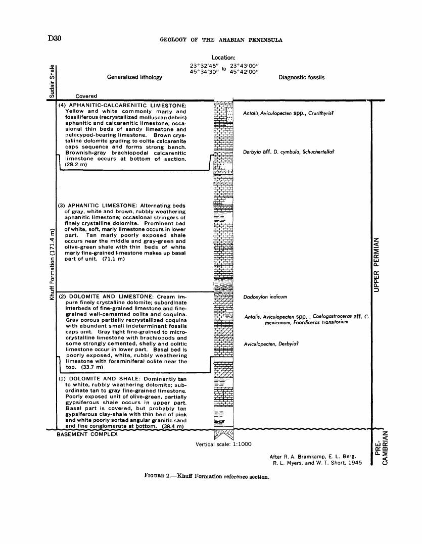
D80 GEOLOGY OF THE ARABIAN PENINSULA
Generalized lithology
Location:23°32'45" 23°43'00" 45°34'30" ° 45°42'00"
Diagnostic fossils
Covered
(4) APHANITIC-CALCARENITIC LIMESTONE: Yellow and white commonly marly and fossiliferous (recrystallized molluscan debris) aphanitic and calcarenitic limestone; occa sional thin beds of sandy limestone and pelecypod-bearing limestone. Brown crys talline dolomite grading to oolite calcarenite caps sequence and forms strong bench. Brownish-gray brachiopodal calcarenitic
J limestone occurs at bottom of section. (28.2 m)
(3) APHANITIC LIMESTONE: Alternating beds of gray, white and brown, rubbly weathering aphanitic limestone; occasional stringers of finely crystalline dolomite. Prominent bed of white, soft, marly limestone occurs in lower part. Tan marly poorly exposed shale occurs near the middle and gray-green and olive-green shale with thin beds of white marly fine-grained limestone makes up basal part of unit. (71.1 m)
(2) DOLOMITE AND LIMESTONE: Cream im pure finely crystalline dolomite; subordinate interbeds of fine-grained limestone and fine grained well-cemented oolite and coquina. Gray porous partially recrystallized coquina with abundant small indeterminant fossils caps unit. Gray tight fine-grained to micro- crystalline limestone with brachiopods and some strongly cemented, shelly and oolitic limestone occur in lower part. Basal bed is
_ poorly exposed, white, rubbly weathering 1 limestone with foraminiferal oolite near the
top. (33.7 m)
(1) DOLOMITE AND SHALE: Dominantly tan to white, rubbly weathering dolomite; sub ordinate tan to gray fine-grained limestone. Poorly exposed unit of olive-green, partially gypsiferous shale occurs in upper part. Basal part is covered, but probably tan gypsiferous clay-shale with thin bed of pink and white poorly sorted angular granitic sand and fine conglomerate at bottom. (38.4 m)
Anfa//s,Avicu/opecfen spp., Crurithyris?
Derbyia aff. D. cymbu/a, Schucherte/fa?
Dadoxylon indicum
jH Antalis, Avicu/opecten spp. , Coe/ogash-oceras aff. C mex/conum, Foordiceras transitorium
Avicu/opecten, Derby/a?
BASEMENT COMPLEX
Vertical scale: 1:1000
After R. A. Bramkamp, E. L. Berg, R. L. Myers, and W. T. Short, 1945
Z<
UJCTcrmQ-S
<o
FIGURE 2. Khuff Formation reference section.
SEDIMENTARY GEOLOGY OF SAUDI ARABIA D31
R. P. Kopp pieced together a section as far north as Qu§ayba'; but much of the sequence is covered, and many of the interval thicknesses were calculated. The composite section indicated 255 m of Khuff with 76 m of Khartam limestone, 63 m of Midhnab shale, and 116 m of lower Khuff limestone.
Northern area Khuff is best characterized by the section exposed about 30 km north of Buraydah near lat 26°30' N. Here, Pocock and Kopp described an almost complete succession (section 9, p. 117).
South of the Riyadh-Jiddah road, the Midhnab shale passes laterally into carbonate. With loss of the shale separator, the three-fold subdivision can no longer be recognized at the Ar Rayn reference section. About 100 km south of Ar Rayn, other significant changes in Khuff lithology can be observed. Near Al Mulayb (lat 22°36' N.), sand and shale intertonguing with car bonate give the first hint of the complete replacement by sandstone that occurs farther south. R. D. Gier- hart and others in 1949 traversed and composited the poor Khuff plains exposures in the Al Mulayb area; a summary of their description is given in section 10 (P- 117).
From Al Mulayb south to the Al 'Ari$ escarpment, a distance of about 350 km, the Khuff is largely obscured by surficial sand and gravel. Because of its low relief in this area, the Khuff probably is mostly shale and sandstone. Investigation of partial exposures west of Al Haddar (lat 22°00' N.) tends to confirm this assump tion, and further support is offered by outcrops of basal Khuff elastics near lat 20°00' N., long 44°50' N.
At Al 'Ari$, the Khuff sequence is not fully exposed at any one locality because of partial scree cover, but a complete section has been obtained by moving later ally along the scarp. In 1950, S. B. Henry and R. A. Bramkamp measured the upper and middle parts of the formation respectively 11 and 22 km south of Khashm Sudayr (lat 19°12' N.); the lower part was described by R. D. Gierhart and L. D. Owens in 1948 at Jabal Umm Ghiran (near lat 18°42' N.). A summary of this de scription is given in section 11 (p. 117).
A recent reconnaissance traverse near 'Unayzah (just south of Buraydah), revealed discrete evaporite units within the Khuff. The lowest unit, consisting of 6 m of gypsum, is 28 m above the base of the formation. A second bed of gypsum (4 m thick) is exposed some 90 m above the base. Two other thin beds of gypsum were also observed further south in the area of the type section.
The three major lithologic units identifiable north of the Riyadh-Jiddah road strongly influence Khuff topog raphy. The lower Khuff limestone forms a prominent 20- to 40-m-high west-facing scarp, the back slope of which has been weathered to a series of well-developed
strike ridges. This feature the Khuff escarpment is the first of several distinctive benches to be seen in the region. The upper limestone supports a somewhrt less prominent ridge the Khartam escarpment. Between the Khuff (i^afraV as Sark) and Khartam escarpments, the surface of the Midhnab member is characterized by a number of small, shinglelike benches. Each beich is supported by a thin carbonate bed in an otherwise comparatively soft gypsum-shale sequence. Taken as a whole, the Midhnab has been eroded into a broad asymmetric valley sandwiched between the two larger scarps. The valley is the site of numerous date gardens from Khuff to Buraydah. Sandstone and shale occur in the truncated Khuff section at Bam Khatmah.
NATURE OF CONTACT WITH ADJACENT FORMATIONS
Geometric relationships between the Khuff and underlying units suggest that epeirogenic uplift and massive erosion preceded Khuff deposition. Region ally, it can be demonstrated that the lower Khuff contact is everywhere unconformable. From north to south the Khuff (1) rests successively on Lower Devonian through Cambrian (?), (2) is in nonconformable contact with Precambrian basement between lat 24°20' N. and 20°30' N., and (3) disconformably(?) overlies Wajid south of lat 20°30' N. The contact between Khuff and older sedimentary units is most commonly limestone on sandstone. In the general area where Saq Sandstone is overlain, however, the basal Khuff is a clastic usually sandstone facies. South of the 19th parallel the contact is also sandstone on sandstone.
The top of the Khuff is sharply defined along most of the outcrop belt by conformable contact between limestone below and red and green Sudair Shale above. South of lat 19°00' N., Sudair is cut out and Tuwaiq Mountain Limestone (Upper Jurassic) rests unconfor- mably on Khuff Sandstone. The pre-Tuwaiq Moun tain erosion surface cuts progressively deeper into the Khuff until the formation is removed entirely ne^r the south end of Bam Kha^mah (lat 18°00' N.). There is little doubt that elimination of Khuff in northern Arabia is brought about by pre-Wasia truncation, although sands of the Great Nefud cover the area where this occurs.
PALEONTOLOGY AND AGE
The Khuff Formation was considered by Stemeke and others (1958) to be of probable Late Permian age. As the only diagnostic fossils found on outcrop had been a few poorly preserved nautiloids and brachic^ods, some uncertainty was attached to this age assignment. Other fossils are not uncommon, but most are nondes cript pelecypods and gastropods.
Microfossils derived from recently drilled wellr sup port a Late Permian age for the Khuff. L. G. Henbest
D32 GEOLOGY OF THE ARABIAN PENINSULA
in 1957 (written commun.) examined a Khuff core from Dammam well 43 (lat 26°20' N., long 50°10' E.). Several Foraminifera including Colanietta parva? (Co- lani) were identified. Henbest states "Permian is indicated with fair assurance. According to the present, rather meager knowledge of the range of Colanietta parva? (Colani) the lower part of the Upper Permian is indicated, but question even of Permian versus Pennsylvanian age must remain until this evidence is verified with other information."
Additional core material from well 43 was sent to Richard Rezak for study. He reported (1959) "Algal assemblage dates the Khuff Formation as late middle Permian or late Permian."
A shallow hole drilled in 1961 at the base of the Khuff escarpment (near lat 22°00' N.) yielded Upper Permian spores and pollen. Another Upper Permian (Thuringian) spore and pollen suite was collected in 1962 from a deep bore hole drillled near lat. 21°50' N., long 48°00/ E.
On outcrop, the lower Khuff fossils (shown on fig. 2) were collected between 40 and 72 m above the base of the formation. Those listed in the upper Khuff were collected from 2 to 28 m below the formation top. Although the faunas of the lower and upper Khuff differ somewhat in species, the two assemblages are essentially similar generically. Both collections in clude genera that axe not known to occur above the Paleozoic. A comprehensive listing of fossils collected from Khuff outcrop includes: Crurithyris? sp., Derbyia cf. D. cymbula, Derbyia spp., Derbyia?, Meekella? sp. cf. Orthotetes, cf. Rhipidomella, Schuchertetta? sp., Antalis, Antalisl, Aviculopecten spp., Bellerophon spp., Betterophon?, Botulus? sp., Cardinia? sp., Circulopecten sp., Coelogastroceral aff. C. mexicanum (Girty), Cym- polia, "Dentalium" sp., Dimyopsis sp., Dimyopsisl sp., Foordiceral transitroium (Waagen)?, Hyolithes sp., Nautilus spp., Oxytoma? sp., Pleuromya? sp., Pleuro- tomaria? sp., Taenioceras? sp., indeterminate pectinids, cerithids, and loxonemids, Dadoxylon indicwn, Lepido- dendron sp., indeterminate amphineuran impressions, bryozoa, echinoid fragments, and ostracodes.
ECONOMIC ASPECTS
GROUND WATER
Shallow hand-dug water wells occur only sporadically through the area of Khuff outcrop. Villages in the northern area are concentrated along the Midhnab shale trough where surface runoff from the lower Khuff limestone collects.
HYDROCARBONS
Few deep wells have penetrated the Khuff Forma tion, and petroleum potential of this unit has not
been fully evaluated. Some promise is indicated by the fact that gas has been fourd at several localities.
PERMIAN AND TRIASSIC SYSTEMS
SUDAIR SHALE UPPER PERMIAN AND I^OWER TBIASSIC
DEFINITION
The Sudair Shale is named for Khashm IT idayr (lat 19°12' N., long 45°06' E.) where the lower part of the unit is well exposed. A complete discussion of the development of present-day Permian and Tiassic nomenclature is included in the definition of tt^ Jilh Formation (p. 35).
The Sudair was first separated out as a d^crete unit in 1945 by R. A. Bramkamp. who designated it the lower member of the now obsolete Es Sirr Forma tion. In 1951, R. D. Gierhart and R. A. Bramkamp raised the rank of the Sudair to formation and estab lished the Al' 'Ari$ escarpment as the type locality. Formal publication followed in 1952 (Steineke and Bramkamp, 1952b), and the type section was described by Steineke and others (1958). The total type section (116 m) was pieced together from three measured sequences: the lower 27.1 m is exposed at K>ashm Ghutfayy (lat 19°17'42" N., long 45°06'27" E.), another 23.1 m was picked up 12 km further north (lat 19°23'23" N., long 45 WOO" E.), and the upper 65.8 m occurs at Khashm Abu Ramatfah (lat 19°36'09" N.,long45°07'21"E.).
The base of the Sudair is placed at the top of 8 platy sandstone unit believed to be equivalent to tl ^ top of the Khuff Formation in its type section. The upper limit is at the contact between red Sudair shale below and Middle Jurassic sandstone above.
OCCURRENCE AND THICKNESS
There are few good exposures of the Sudair. How ever, original extent of the formation can be inferred from isolated outcrops and, in areas of cover, from the Sudair's characteristically depressed topographic ex pression. Using these criteria, the Sudair c<m be traced from lat 27°10' N. almost to lat 19°00' N., a distance of 850 km. Along most of its length, the erosional valley is flanked by more resistant units the upper Khuff (Khartam) limestone on the weH and lower Jilh sandstone and limestone on the east. Trapped Quaternary sand and gravel now fill much of the trough.
The northernmost outcrop of Sudair is in a small mud flat, Mudarraj (lat 27°10/ N., long 43°4f' E.). To the south, isolated remnants of lower Sudair occur in a thin band between the Nafud as Sirr and Khuff limestone. Near the south tip of Nafud as Sirr (lat 24°20' N.) the pattern shifts and only upper Sudair is exposed, protected in this case by the overlyir*?1 Jilh
SEDIMENTARY GEOLOGY OF SAUDI ARABIA D33
as far south as lat 23°45' N. Between lat 23°45' N. and 19°45' N., a distance of nearly 450 km, Sudair rocks are exposed only in small windows in Quaternary cover. Outliers of this type occur near Al Juwayfah. Al Haddaar, Khashm Mishlaii, Khashm TTaryan1 and Khashm Kumdah. The most southerly and best exposures of the Sudair are in the northern part of the Al 'Ari$ escarpment.
Poor exposure has permitted accurate measurement of Sudair thickness only in two places near Buraydah and at Al 'Ari$. Some idea of regional changes can be obtained, however, by supplementing these figures with calculated data. Generally speaking, the for mation thins southward. A maximum thickness of 198 m was pieced together from exposures north of Buray dah; a minimum (116 m) was obtained at the type section near lat 19°30' N. An anomalous interval of about 180 m occurs between lat 22°00' N. and 23°00' N. Whether this represents actual reversal in the regional trend or results from error in calculation and measurement is uncertain.
IFTHOLOGIC CHARACTER
Sudair lithology is dominantly brick-red and green shale with subordinate red siltstone, sandstone and gypsum. Several thin lenses of carbonate are inter- bedded in the extreme northern and southern parts of the outcrop.
The type Sudair section, composited from several measurements at Al 'Ari$, is the most complete sequence available (fig. 3). The upper part of the formation (65.8 m) was measured by R. D. Gierhart and L. D. Owens in 1948; the remainder, by Gierhart and R. A. Bramkamp in 1950. Their description of the Sudair is given in section 12 (p. 117).
Because of poor exposures, the Sudair north of the type locality has not been described in detail. Partial measurements and limited field observations do suggest, however, that the lithology of the formation is re markably uniform. In most areas, dark-brick-red shale predominates. Siltstone, sandstone, and gypsum occur in nil sections, but substantial amounts are present only in the north.
D. A. Holm, A. F. Pocock, and L. F. Ramirez in 1948 pieced together numerous poor exposures south of Wad! ar Rimah. The composite measurement gives some idea of lower Sudair rock types in this area. A white to tan, friable, poorly sorted, silty, and very fine to medium-grained sandstone directly overlies the Khuff. Weathered outcrops of this unit are often permeated with a white, gypsiferous powder, and slabs of satin spar litter the scree surface. Erosion commonly cuts the sandstone into a complex of narrow gullies and sharp, low-relief hills reminiscent of badlands
topography. Dark-brick-red gypsiferous shale if the main component above the basal sandstone. Some gray-green shale is present, and three thin, iso^ted beds of light-gray, finely crystalline dolomite (with some evaporite laminations) are included withir the brick-red sequence. N. M. Layne, Jr., and F. L. McAlister in 1957 studied several short intervals of Sudair in the same general area. Beds of msssive gysum from 8 to 13 m thick were observed within the succession of red and purple gypsiferous shale.
Outcrops north of Buraydah were investigate! by A. F. Pocock and R. P. Kopp in 1949. A combination of measured sections and calculated intervals indicates a thickness of 198 m of Sudair in this area. Most exposures are gray, rarely yellow, red, and green, friable, in part crossbedded, moderately sorted, fine- to medium-grained sandstone with common thin interbeds of red and gray-green shale and gypsiferous siltstone. Several thick beds of red and green shale and thin beds of red, impure limestone are present in the middle part of the formation.
NATURE OF CONTACT WITH ADJACENT FORMATIONS
Surface relationships, supported by subsurface data, indicate that the Sudair Shale conformably overlies the Khuff Formation along the entire length of outcrop. North of lat 22°00' N., the contact is usually shale on limestone. To the south, Sudair shale rests on sandstone.
Between lat 28°10' N. and 22°00' N. the Sudair is conformably overlain by the Jilh Formation (Middle Triassic). The contact is commonly marked by gradation upward from red and gray silty shale through ferruginous siltstone to mottled, fine-grained sandstone. Quaternary gravel masks events south of lat 22°00' N., but regional geometrical interpretation shows that the Jilh should be completely overlapped by Dhruma Formation (Middle Jurassic) in the vicinity of lat 21°00' N. At Khashm Kumdah Gat 20°17' N.) and in the northern part of Al *Ari$, Dhruma c'm be seen directly on Sudair.
Exposures in the face of the Al 'Ari^. escarpment show the unconformable Sudair-Dhruma contact rising uniformly to the south at a rate of 00°08' to OC°10'. At this rate, the Dhruma is cut out and the Sudan is intersected by the overlapping Tuwaiq Mountain Limestone (Upper Jurassic) just north of Khasbm az Zifr (lat 19°30' N.). Continued pre-Tuwaiq Moun tain truncation eliminates the Sudair a few kiloireters south of Khashm Sudayr.
PALEONTOLOGY AND AGE
No fossils have been found in Sudair outcrops. Solely on the basis of stratigraphic position, the Sudair
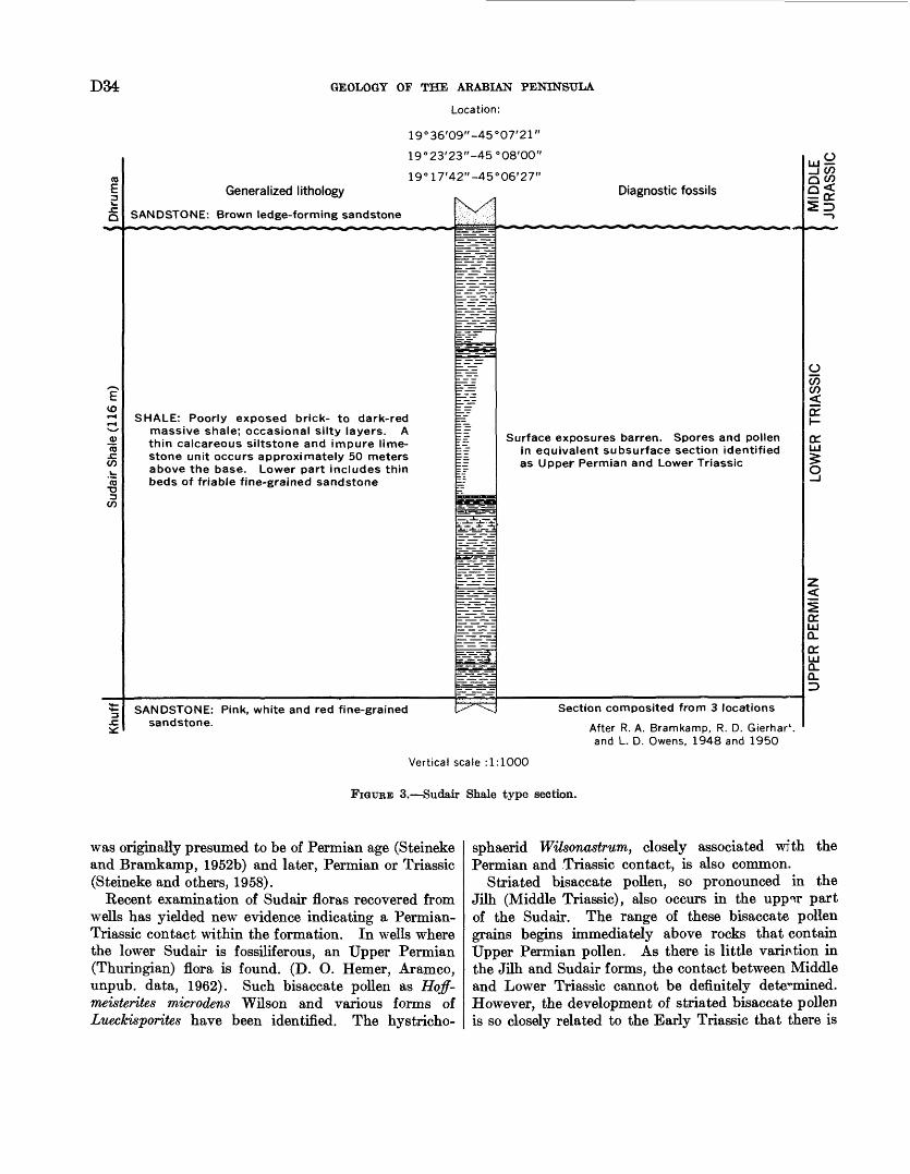
D34 GEOLOGY OF THE ARABIAN PENINSULA
Location:
19°36'09"-45°07'21"
19°23'23"-45°08'00"
19°17'42"-45°06'27"
Generalized lithology
SANDSTONE: Brown ledge-forming sandstone
SHALE: Poorly exposed brick- to dark-red massive shale; occasional silty layers. A thin calcareous siltstone and impure lime stone unit occurs approximately 50 meters above the base. Lower part includes thin beds of friable fine-grained sandstone
Diagnostic fossils
Surface exposures barren. Spores and pollen in equivalent subsurface section identified as Upper Permian and Lower Triassic
-IQOO
II
o
SANDSTONE: Pink, white and red fine-grained sandstone.
Section composited from 3 locations
After R. A. Bramkamp, R. D. Gierhar v . and L. D. Owens, 1948 and 1950
Vertical scale : 1:1000
FIGTTKE 3. Sudair Shale type section.
was originally presumed to be of Permian age (Steineke and Bramkamp, 1952b) and later, Permian or Triassic (Steineke and others, 1958).
Recent examination of Sudair floras recovered from wells has yielded new evidence indicating a Permian- Triassic contact within the formation. In wells where the lower Sudair is fossiliferous, an Upper Permian (Thuringian) flora is found. (D. O. Hemer, Aramco, unpub. data, 1962). Such bisaccate pollen as Hoff- meisterites microdens Wilson and various forms of Lueckisporites have been identified. The hystricho-
sphaerid WUsonastrum, closely associated with the Permian and Triassic contact, is also common.
Striated bisaccate pollen, so pronounced in the Jilh (Middle Triassic), also occurs in the upp°ir part of the Sudair. The range of these bisaccate pollen grains begins immediately above rocks that contain Upper Permian pollen. As there is little variation in the Jilh and Sudair forms, the contact between Middle and Lower Triassic cannot be definitely determined. However, the development of striated bisaccate pollen is so closely related to the Early Triassic that there is
SEDIMENTARY GEOLOGY OF SAUDI ARABIA D35
little doubt that the upper Sudair is assignable to this epoch.
ECONOMIC ASPECTS
GROUND WATER
For all practical purposes, the ground-water potential of the Sudair Shale is unknown. A number of shallow, hand-dug wells do exist in the Sudair outcrop belt, but nothing is known of their quality, productivity, or actual water source.
TRIASSIC SYSTEM
JILH FORMATION MIDDLE AND UPPER (?) TRIASSIC
DEFINITION
The Jilh Formation is named for Jilh al 'Ishar, a low escarpment across which the type section was meas ured. Beds now assigned to the Jilh were first de scribed by Max Steineke in 1937 (unpub. data) but were then included as part of a much larger sequence the Es Sirr Member. At that time the Es Sirr and Khuff Members combined formed the Mustawi Forma tion. Later, in 1945, R. A. Bramkamp raised the Es Sirr and Khuff to formational status, separated the Jilh limestone from bracketing strata, and designated the Jilh the middle of three members within the Es Sirr. From top to bottom the three members were:(1) Upper Es Sirr Sandstone (now Minjur Sandstone),(2) Jilh Limestone (now Jilh Formation), and (3) Lower Es Sirr Member (now Sudair Shale). Con currently, Mustawi was raised to group rank. In 1951 R. D. Gierhart and Bramkamp changed the three Es Sirr Members to formations and, at that point, allowed the terms Es Sirr and Mustawi to lapse.
A list of the Permian and Triassic formational names now in use was published by Steineke and Bramkamp (1952b). Formal publication of Jilh and other type section particulars followed in 1958 (Steineke and others). The type Jilh section was measured and described on a nearly straight-line traverse from lat 24°03'48" N., long 45°46'00" E., northeast to lat 24°11'06" N., long 45°51 /30// E.
The base of the formation is covered at the type locality, but the contact can be seen 3 km northwest where friable sandstone and green shale of the Jilh rests conformably on red shale of the Sudair. The top is at the contact between yellow-brown, slabby-weathering, fine-grained limestone below and tan, massive, com monly crossbedded sandstone of the overlying Minjur.
OCCURRENCE AND THICKNESS
Outcrops of the Jilh Formation form a narrow, arcuate band from Al Haddar (lat 22°00' N.) to the northern edge of Shamat al Akbad (lat 28°10/ N.), a distance of about 770 km. For all practical purposes
the Jilh is exposed continuously between Wadl Birk (lat 22°15' N.) and 'Irq al Ma?hur (lat 26°20' N.). To the north and south however, surficial deposits cover all but a few, thin, isolated patches. Throughout most of its outcrop, width of the Jilh ranges from 8 to 20 km.
The Jilh landscape, for some 70 to 80 km north of Wadl Birk, is dominated by a pair of steep, west-facing scarps. Near lat 24°00' N. these scarps break down and merge imperceptibly into a broad belt of low, multiple benches with a persistent regional stride of N. 29° W. This series of ragged, sand-drifted benches persists north to the Riyadh-Jiddah road and then gradually rises to a bold scarp whose steplike outer profile reaches a relief of 100 m at Ad Duwayjiirah (lat 26°13' N.). The scarp continues north in bold relief until breached by the wide sand-filled channel of Wadl ar Rimah. North of the wadi, it become? pro gressively less precipitous and all but looses its topo graphic identity before passing under sands of Trq al Ma?hur. Jilh rocks can be picked up within the 'Irq where they appear as low benches of slumped ool ; te in a broad sand-free area Shamat al Akbad.
Regional change in thickness of the Jilh is fairly well established by sections uniformly spaced along the out crop. From the 26th parallel north there is little variation from an average thickness of about 2^0 m. The formation gradually thickens southward to a maxi mum of 326 m at the type section (near lat 24°00' N.). About 35 m of thinning occurs between the type local ity and a section measured north of Wadl Birk. JTouth of the wadi, the Jilh thins abruptly, and at the southern most outcrop near Al Haddar, calculations show only 130 m of strata sandwiched between the Sudair Shale and Minjur Sandstone.
LITHOIOGIC CHARACTER
A characteristic feature of the Jilh Formation is marked vertical and lateral change in lithology. The picture is further complicated by the fact that softer units are often obscured by blocky talus derived from limestones capping individual benches. This is par ticularly true in the central area where differential relief between individual benches is seldom more than a few meters and the absence of crosscutting channels makes it difficult to get a true idea of the rock sequence.
At the type locality, near lat 24°00' N., the J; '.h is chiefly a sandstone and shale unit with prominently exposed, but nonetheless subordinate, limestone. Con centration of the carbonate beds at the top and just below the middle of the section do help to subdivide the Jilh into smaller, more natural units (pi. 5).
South of the type locality the formation grades rapidly to sandstone. The isolated outcrop at lat 22°05' N. is the last one in which the Jilh can be sep-
D36 GEOLOGY OF THE ARABIAN PENINSULA
arated with some certainty from the overlying sandstone of the Minjur.
Proportions of shale, sandstone, and limestone remain relatively constant from the type section north to Ad Duwaybirah, although some increase in calcareous con tent is evident. The succession does not, however, fall into any rough grouping similar to the type section, as various rock types are intimately interbedded through out.
Significant change in Jilh lithology takes place north of Wadi ar Rimah as shale and sandstone in the lower two-thirds of the formation are progressively replaced by limestone. In connection with this, the sequence near the north end of §afra' al Asyab appears to be mostly carbonate. Of particular interest are thick gypsum beds found in the tipper one-third of the unit near 'Ayn Ibn Fuhayd (lat 26°46' N.). Beds of gypsum as much as 13 m thick are intercalated with rubbly marl and shale through an interval of 70 m. Lack of ex posures does not permit tracing of the gypsum to the northwest; however, the fact that the interval is occu pied by a string of silt flats is, in itself, suggestive that evaporites and (or) other soft beds do extend along the northeastern edge of §afra' al Asyab.
There is little doubt that Jilh deposits are, for the most part, continental, with limestones representing individual marine incursions. The general pattern in dicates that the succession becomes increasingly cal careous and more marine to the north. This gradation is exaggerated by the surficial appearance of the out crop itself. Black iron staining tends to emphasize the sandstone in the south at the expense of other rock components. Conversely, sandstone from Wadi ar Rimah north seldom weathers dark, and this, coupled with the blocky limestone talus from numerous low- relief benches, accents the carbonate content.
A section measured across the Jilh al 'Ishar by Max Steineke and others in 1945 was, later the same year, selected by R. A. Bramkamp to serve as the type Jilh. As this sequence (pi. 5) remains the most complete and best description of the Jilh Formation available, a detailed description is given in section 13 (p. 118).
In 1949, Bramkamp and S. B. Henry traversed the Jilh Formation west of Khashm al Manjur (lat 23° 31 ' N.). Their work, coupled with limited reconnais sance mapping south of Wadi Birk, shows that south of the type locality the Jilh is mainly in sandstone facies. A summary of their description is given in section 14 (p. 119).
The cleanest exposures of the Jilh Formation, other than at the type locality, occur in Al Qasim (near lat 26°15' N.) and §afra' al Asyab. Rock types exposed in the Qasim closely resemble those at the type section. On the other hand, a distinctive facies shift to increased
carbonate can be seen along Safra' al Asyab. A meas urement and description of the Al Qasim sequence was made near Ad Duwaybirah by A. F. Pococv and R. P. Kopp in 1949. The same year, they also compiled other representative Jilh sections near 'Ayn Ibn F ihayd and Pidah (lat 27°06' N.). Generalized descriptions for these measurements are given consecutively in sections 15, 16, and 17 (p. 119-120).
NATURE OF CONTACT WITH ADJACENT FORMATION
Surface-subsurface relationships show the Jilh For mation to be conformable with Sudair Shale belcw and Minjur Sandstone above. Uppermost Sudair is visible on outcrop at only a few localities, and, as a conse quence, the base of the Jilh is commonly taken at the lowest Jilh limestone bed. In this case, the contact falls within a gradational zone of sandstone, shale, and a few thin layers of red marly limestone. As the zone usually does not exceed 15 m in thickness, the accuracy of the pick probably varies no more than a few meters from the precise contact.
The upper Jilh contact is most often marked by a strong topographic break between sandy, commonly oolitic, cliff-forming limestone (Jilh) and medium- to coarse-grained, plains-forming sandstone (Minjur). In some areas, a thin, poorly exposed interval of platy marl, gypsiferous shale, and gypsiferous siltstone is sandwiched between the uppermost Jilh bench and the coarse sandstone of the Minjur.
The Jilh is the lowest of a series of formatiors that thin to the south and transgressively overlap each other onto the Sudair Shale. This transgressive relationship can still be seen in beds well up in the Jurassic. The decrease in Jilh thickness may be due to thinning ? gainst the margins of the basin, truncation by succeeding strata, or a combination of both. The absence of obvious unconformity adjacent to or within tH Jilh is puzzling; however, conditions of deposition near the shield were remarkably constant, so that breaks within the stratigraphic section would be difficult to detect.
PALEONTOLOGY AND AGE
Fossils collected from Jilh exposures, mostly poorly preserved, include Ca,rdinw,7 , Myophoria spp., Pseudo- monotis sp., fragments and nuclei of ammonites, a few amphibian (?) bone fragments, and indeterminate pelec- ypods. Fossil wood has been observed at several levels, but the material has not been positively identified.
About 40 fragments and nuclei of ammonite^1 (col lected between 45 and 55 m below the top of tl ?- Jilh and near the Marah-Buraydah road) were referred by Arkell (1952) to the Paraceratites fauna of Middle Tri- assic age. The same specimens were later examined in 1961 by N. J. Silberling (written commur.); he recognized most of them as clionititids and clydonitids
SEDIMENTARY GEOLOGY OF SAUDI ARABIA D37
and their age as Late Triassic. Silberling states his "best guess as to a more refined stratigraphic assign ment is Norian ((upper Upper Triassic) based on the resemblance of some of the fragments to such genera as Clydonites, Sandlingites, Steinmannites, and Allocliomtes. However, assignment to an older part of the Upper Triassic is not precluded."
Other evidence on the age of the Jilh comes from bore holes where spores and pollens have been recovered from equivalent strata. The flora of the upper part of the Jilh contains such forms as Cuneatisporites radialis Leschik, Pitysporites neomundanus Lesehik, Unatexttisporites mohri, Leschik, EUipsovelatisporites plicatus Klaus, Ovcdipollis lunzensis Klaus, Enzonala- sporites sp., thordasporites sinallichorda Klaus, and Taeniaesporites sp. In the lower part of the Jilh striated bisaccate pollen grains become dominant and include Striatites jacobii Jansonius, Striates richteri (Klaus) Jansonius, Platysaccus sp., Veryhacium sp., Lueckisporites spp., and Taeniaesporites interruptus Jansonius. According to D. O. Hemer, Aramco, (writ ten commun., February 10, 1963), the bisaccate pollens found in the Jilh equivalent in bore holes have pub lished ranges from middle Keuper through Early Tri assic (Scythian). Logical interpretation places the varied flora in the Middle Triassic.
Although the Jilh is considered here to be Middle Triassic, it is possible that at least part of the unit is Upper Triassic.
ECONOMIC ASPECTS
GROUND WATER
Aside from a few scattered shallow, hand-dug wells there has been no development of Jilh ground water.
MINJUR SANDSTONE UPPER TRIASSIC
DEFINITION
The Minjur Sandstone is named for Khashm al Manjur (lat 23°31 / N.) where the upper part of the formation is exposed. Max Steineke (unpub. data, 1937) did nor originally set the Minjur apart from other Triassic units but included it, along with beds now assigned to the Jilh and Sudair, in the Es Sirr Member (obsolete). Subsequent subdivision of the Es Sirr and evolution of Triassic nomenclature is described in de tail under the definition of the Jilh Formation (p. 35).
The type section of the Minjur extends from the eastern edge of the dip slope formed by the top bed of the Jilh Formation (lat 23°34'33" N., long 46°07'15" E.) up to the base of the Marrat Formation in the face of Khashm al KhaHa' (lat 23°35'24" N., long 46° 10'36" E.).
The base of the Minjur is at the contact between brown, sandy, oolite calcarenite with marine fossils
below (Jilh) and tan, commonly crossbedded, non- marine sandstone above. The upper limit is tta un- conformable contact of this sandstone with red shale of the Marrat.
OCCURRENCE AND THICKNESS
Outcrops of Minjur Sandstone have been idertified over a distance of 820 km; that is, between lat 21°32' N. and 28°07/ N. The southernmost occurrence is an isolated patch in front of the 'JMwayq escarpment near Al Ji'lan (lat 21°30' N.). From Al Haddar (lat 22°00/ N.) north to 'Irq al Mashur (lat 27° 14' N.) the Minjur is continuously exposed except for breaks at Wadi Birk and Wadi ar Rimah. Minjur rocks again appear in an outlier north of 'Irq al Ma?hur between lat 27°56' N. and 28°07' N.
The Minjur outcrop measures some 33 km across at its widest point near lat 24°30' N. Narrowing to the north and south, the last complete section are less than 10 km wide.
North of the latitude of Khashm adh Dhiti (lat 24° 13' N.) the Minjur typically weathers to a broad gravel plain with scattered black hills and low d^con- tinuous benches. Relief is somewhat more pronounced toward the northern end of Safra' al Mustawi where Jibal Ar Rukhman (lat 26°15' N.; long 44°29' E.) and Burmah (lat 26°19' N., long 44°27' E.) rise 30 m above the surrounding gravel-covered surface. Wa/ii ar Rimah marks the northern limit of the $afra' al Mus tawi plain, and beyond, the Minjur forms a broad trough filled with silt flats. From Khashm adh Dhibl south the band of Minjur narrows; the upper part is exposed in a steep slope at the foot of Jabal fuwayq, and the lower part mostly obscured by gravel cover.
The Minjur Formation is 315 m thick at KHshm al Khal^a, the type locality. There is little change in thickness as far south as Khashm Mawan (lat 22°50/ N.) where 326 m were measured. South of Khashm Mawan some thinning is apparent, presumably owing to truncation and overlap by Lower and Middle Juras sic units. Thicknesses and relationships in this area are obscured, however, because of strong littologic similarity of Minjur with bracketing strata.
The Minjur Formation shows definite thinning north of the type locality. About 290 m of section was measured at Khashm adh Dhibl, 195 m was measured and computed near Ar Rukhman and 185 m was cal culated north of Wadi ar Rimah.
UTHOLOGIC CHARACTER
The Minjur Formation is essentially a littoral- continental sandstone with small amounts of corglom- erate and shale. The lithologic character of the unit as a whole is remarkably persistent along strike.
D38 GEOLOGY OF THE ARABIAN PENINSULA
It is typically a white to tan to brown, medium-grained, poorly sorted, crossbedded quartz sandstone that weathering commonly alters to jet-black quartzite masses. The sand is often friable, crushing readily in the hand. Lenses of conglomeratic sandstone occur at a number of levels, and some thin beds of red, purple, and green shale are intercalated. Ripple marks, mud cracks, and sandbar structures are common, and fossil dunes occur in the upper part of the section. No marine fossils have been found, but several forms of fossil plant material are present throughout. These include crude stem impressions and molds of limbs and trunks of trees as well as silicified wood.
The most detailed description and measurement of the Minjur is that made at Khashm al Khalta' in 1951 by R. A. Bramkamp and others (pi. 6). This section, now designated as the type Minjur, is given in section 18 (p. 120).
The lower and upper parts of a complete Minjur section (327 m) were measured in the face of Khashm Mawan (near lat 22°50' N.) respectively by R. D. Gierhart and L. D. Owens in 1947 and R. A. Bramkamp and H. A. Kimball in 1950. The lithology at this latitude, as well as in the localities studied further south, is mainly sandstone with subordinate shale. The sandstone is off-white to tan to brown, red and black weathering, generally crossbedded, medium to coarse grained, and commonly friable. The shale, occurring as thin interbeds throughout the sequence, is gray, purple and red, and commonly silty or sandy. Maximum thickness of any individual shale bed seldom exceeds 5 m. Several thick beds of quartz-pebble conglomerate occur, one at the top of the Minjur and others near the base.
Traverses north of the type locality also show little variation in lithology. A. F. Pocock and R. P. Kopp in 1949 pieced together a typical section from intervals measured and computed near lat 26°15' N. Most outcrops, through the 196-m succession, are light- colored, in part black-weathering, fine- to coarse grained, poorly sorted, crossbedded sandstone. Thin beds of varicolored gypsiferous shale are scattered through the section, and two weak benches of thin- bedded, platy marl occur in the middle part of the formation.
In summary, Minjur lithology both vertically and laterally is a monotonous succession of light-colored, crossbedded sandstone with perhaps 10 percent shale occurring at various levels. Lenses of conglomeratic material are common.
NATURE OF CONTACT WITH ADJACENT FORMATIONS
The contact between the Minjur and underlying Jilh Formation is generally marked by a strong topographic
break from cliff-forming, sandy and oolitic limestone capping the Jilh to deeply weathered, crossbedded sandstone of the Minjur. There is commonly a very- thin, poorly exposed gradational zone of platy-wrather- ing marl and gypsiferous shale. This contact is con formable and can be traced with few interruptions throughout the length of outcrop.
The top of the Minjur represents an unconformity. From Khashm adh Dhibi north this contact is between maroon siltstone or gray to black-weathering sand stone of the Minjur and gray to tan, tight limestone of the basal Marrat. South of Khashm adh Dhibi the basal Marrat grades to shale, siltstone, and evertually sandstone near lat 23°00' N., where, because of litho- logic similarity, the break can no longer be recognized with certainty. The Minjur south of lat 22°00' N. is obscured by cover; however, geometrical interpreta tion of bracketing units suggests that complete wedge- out occurs near lat 21°00' N. At least part, and probably most, of the cutting takes place at tie top. In connection with this, Dhruma beds (Middle Jurassic) overlap th.e Marrat (Lower Jurassic) just south of Khashm Mawan, transgress the Minjur and Jilh, and butt against Sudair (Permian and Triassic) near Wad! ad Dawasir.
Obvious thinning of the Minjur can be seen between Khashm adh Dhibi and Wadi ar Rimah. Thero is no evidence to indicate whether pre-Marrat eros; on or depositional thinning is involved. The last vestiges of the Minjur are beveled and disappear beneath the Wasia Formation (Middle Cretaceous) near the south ern edge of At Taysiyah plateau (lat 28°05' N.).
PALEONTOLOGY AND AGE
Only fossil wood has been found in surface exposures of the Minjur Sandstone. On its basis of the strati- graphic position, Steineke and others (1958) considered the Minjur to be Upper Triassic or Lower Jurassic.
Palynological investigation of Minjur sediments re covered from deep bore holes has recently shec1 more definitive light on the age of these beds. The lower part of the Minjur contains a predominance of the pollen grains Sulcatisporites interpositus Leschik de scribed from the middle Keuper of Switzerland and Pityosporites ruttneri Klaus as described from the Carnian (or middle Keuper) of Austria. Directly above these forms, Minjur strata contain an entirely different monosaccate flora. These in turn are overlain sharply by a Lower Jurassic flora falling within the 1 larrat Formation dated by ammonites as Toarcian (Early Jurassic). If the middle Keuper dating of the very small bisaccates is correct, it can be assumed the monosaccate flora represents a zone of late Keuper age. That they are Late Triassic is fairly certain. Using
SEDIMENTARY GEOLOGY OF SAUDI ARABIA D39
these data, the Minjur can now be dated as Late Triassic with some confidence.
ECONOMIC ASPECTS
GROUND WATER
In the vicinity of Eiyadh several deep wells penetrate the Minjur Sandstone. These now produce large quanti ties of potable water from this aquifer. Elsewhere only a few hand-dug wells exist, and the ground-water potential is virtually unknown.
JURASSIC SYSTEM
MARRAT FORMATION LOWER JURASSIC
DEFINITION
The Marrat Formation takes its name from the town of Marah (lat 25°04 / N., long 45°29' E.) near where the type section was pieced together. Marrat strata were at first considered by Max Steineke to be the basal member of the Tuwaiq Formation. In 1945 the Marrat was raised to formational status by R. A. Bramkamp and Steineke, and, concurrently, the Tuwaiq was re- designated a group. The Tuwaiq Group included the Marrat, Dhruma, Tuwaiq Mountain, Hanifa, and Jubaila Formations. Formal publication of forma tional names followed (Steineke and Bramkamp), 1952b), and, at about the same time, usage of the term Tuwaiq Group was discontinued. Finally, Steineke and others in 1958 published particulars of the Marrat type section.
The lower part of the type section was measured in the escarpment (at lat 25°03'00" N., long 45°25/42// E.) about 5 km southwest of Marah; the middle part, in Jabal Kumayt (lat 25°04'48" N., long 45°28'18" E.) immediately north of Marah; and the upper beds, southeast of Marah (near lat 25°01'30" N., long 45°33'00"E.).
At the type locality, the base of the Marrat Formation is at the contact between tan, thin-bedded limestone above and gray, angular sandstone below. The top is at the change from Marrat gray (golden-brown- weathering) limestone to olive-green, occasionally gyp- siferous shale of the overlying Dhruma.
OCCURRENCE AND THICKNESS
Discontinuous exposures of the Marrat Formation can be traced from Khashm Mawan (lat 22°50' N.) to the At Taysiyah plateau (lat 28°03 / N.), a distance of more than 650 km. The outcrop band reaches its maximum width, about 15 km, in the vicinity of Marah. From Khashm adh Dhibi (lat 24°13' N.) south, the formation narrows and loses topographic distinctiveness as it dips under the protective ledge of the ^uwayq escarpment. In the area immediately north of Khashm adh Dhibi, isolated remnants of
Marrat can be seen within and along the nortHrn margin of Nafud Qunayfidhah. The erratic outcrop pattern is, at least in part, related to local fractures and flexures splayed offshoots from the central Arabian graben system.
Marrat is again cleanly exposed north of the fault zone where two continuous, though low-relief, scrips are readily recognizable. The benches become pro gressively more prominent to the north and, in the vicinity of Marah and Shaqra' (lat 25°15 / N.), form a pair of steep west-facing cuestas that dominate the landscape. The upper escarpment, 55 m in height, is formed by erosion of soft red shale under a resistant cap of upper Marrat limestone. The lower scarp, 40 m high, is held up by rough, blocky-weathering, lower Marrat limestone.
North of Shaqra', the escarpments gradually break down. The upper bench disappears under the sand of Nafud ath Thuwayrat near lat 25°27' N. and does not crop out again. The basal escarpment, progressively decreasing in height, persists to the northwest (along the §afra' al Mustawl), passes under a thin veneer of sand near lat 25°45' N., and emerges a short distance north as a low, intensely weathered bench of reddish- gray limestone the Sharabith escarpment. Dunes of Nafud ath Thuwayrat again completely overlap the lower Marrat at lat 26°17' N. Further north, along strike, interdune hollows within the 'Irq al Ma?hur are floored with highly weathered basal Marrat 1'me- stone. Another outlier of this limestone, the most northerly occurrence of Marrat known, has been identified on the far side of the 'Irq near lat 28°00' N.
The Marrat Formation reaches a maximum thickness of 111 m near Marah, the type locality. Uniform thinning occurs to the north and south. A section composited 15 km north of Shaqra', near where the last complete Marrat sequence is exposed, showed the formation to be slightly less than 90 m thick. South of the type locality, sections measured at lat 24°13' N. (Khashm adh Dhibi), 23°57' N. (Khashm al Jufr.yr), 23°40' N., 23°31' N. (Khashm al Manjur), and 23°12' N. (WadlBirk) were respectively 102, 92, 70, 50, and 41 m thick. The gradual southward reduction in tl ick- ness defined by these measurements apparently con tinues beyond Wadi Birk, but here unit boundaries are uncertain.
1ITHOIOGIO CHARACTER
In the northern area of exposure, where the M^rat was first studied, three natural topographic-lithe?ogic subdivisions are readily visible. Basically the pattern is a soft red shale bracketed by resistant limestones. In spite of significant facies changes, the three members can be traced without difficulty south to Khashra al Jufayr.
D40 GEOLOGY OF THE ARABIAN PENINSULA
The lower limestone member is typically exposed in the Sharabith escarpment west of Nafud ath Thuway rat. South of Sharabith, the member crops out almost continuously to the §afra' al Mirakah (lat 24°36' N.) disappears under Nafud Qunayfidhah, reappears at Khashm Dhuwayban, and is again exposed below the Dhibi escarpment from Khashm adh Dhibi south to Khashm Mawan. Mostly limestone in the north, the lower part of the member is mainly sandstone and shale at Khashm Dhuwayban (24°28/ N.). The upper part of the member grades to elastics just south of Khashm al Jufayr.
The Marrat red shale member is thickest between Shaqra' and Khashm adh Dhibi. Northwest of Sha qra', sandstone and conglomerate displace shale before the sequence passes under Nafud ath Thuwayrat (lat 25°27' N.). South of Khashm adh Dhibi, the fed shale member maintains lithologic identity to Khashm al Jufayr though a thick wedge of red, silty sandstone appears in the upper part. Beyond this point, pro gressively more sandstone is added at the expense of shale.
The upper Marrat limestone, which caps a strong escarpment, can be traced with few interruptions from Nafud ath Thuwayrat to Khashm Qaradan (lat 24°45' N.). The limestone again crops out in the face of Khashm adh Dhibi. South of Khashm adh Dhibi, limestone is gradually replaced from the bottom up by shale until, at Wadl Birk, there remains only a thin limestone bed capping the sequence. Significant amounts of sandstone also occur here, and immediately south of the wadi, sandstone replacement is complete.
The "typical" Marrat is best illustrated by the reference sequence measured in front of Khashm adh Dhibi. Changes to the north and south are demon strated by other selected sections.
In 1962, Powers and McClure sampled in detail a complete Marrat sequence in the face of Khashm adh Dhibi (along lat 24°13' N.). Samples collected at 1-m intervals were later cut, polished, and described according to the Aramco carbonate rock classification (Bramkamp and Powers, 1958; Powers, 1962). Since this measurement affords the most complete data on the Marrat, it has been designated a reference section (fig. 4). The section was measured in two increments: (1) Lower 21.5 m in front of Khashm adh Dhibi from lat 24°13 / 11 // N., long 46°05/ 53 // E., to lat 24°13 /06// N. long 46°05/58// E., and (2) upper 81.0 m in the face of the Dhibi escarpment from lat 24°13 / 15// N., long 46°06'20" E. to lat 24°13 /20// N., long 46°06'41" E.. The Marrat reference sequence is given in section 19 (p. 121).
Several complete traverses and measurements of the Marrat have been made south of the reference section.
One such measurement, by Max Steineke and others in 1945 hi the vicinity of Khashm al Jufayr (lat 23°57' N.), shows gradual introduction of shale at the expense of limestone and sandstone at the expense of shale. The sequence is summarized hi section 20 (p. 122).
Still further south, R. A. Bramkamp and others in 1945 measured the Marrat at Khashm al Hanjur. At this point substantial changes in lithology can be observed; most of the section is sandstone and shale, only a vestige of the basal limestone is present, and the lower and middle Marrat can no longer \^ sepa rated. The sequence is summarized in section 21 (p. 122).
Definite Marrat is identifiable as far south as Khashm Mawan. The upper formation boundary cannot, however, be placed with certainty, as the contact involves sandstone on sandstone. Bramkamp and H. A. Kimball described the entire Mawan sequence in 1950 and assigned about 37 m to the Mar-at. A summary of their notes is given in section 22 (p. 122).
The Marah area affords the best exposures"1 of the Marrat Formation northwest of the reference section. It was there, in fact, that the type Marrat wa-* pieced together. The whole sequence does not crop out at a single locality but must be composited from several sections generally along lat 25°02' N. There, the three informal niembdrs of the Marrat are typically de veloped. The lower and middle members w<?.re de scribed by D. A. Holm and A. F. Pocock in 1948; the upper, by Bramkamp and others hi 1949. The succession is summarized hi section 23 (p. 122).
A partial section, covering the middle red-shale mem ber, was measured north of Shaqra' (near lat 25°20' N.) by Holm and Pocock in 1948. At this latitude the middle unit has thinned to 37.3 m, the upper one-half is in massive, buff to red, crossbedded sandstone facies, and the lower part is maroon, in part sandy, si ale. A short distance north, recent sand blankets the middle and upper Marrat, but outcrops of the lower limestone persist along strike. Pocock and R. P. Kopp hi 1949 calculated a thickness of 39 m for the lower member near lat 26°10' N. Sporadic exposures at this latitude suggest the sequence is mainly brown to gra^, tight, aphanitic limestone. Outcrops of lower Marrat, still in carbonate facies, have been traversed further north, but detailed data on these outliers is lacking.
NATURE OF CONTACT WITH ADJACENT FORMATIONS
Regional beveling of underlying strata and absence of lower and middle Liassic stages show tb«. lower Marrat contact to be unconfonnable. In the rorthern area of outcrop, the boundary between Marrat and Minjur is placed at the contact of tan and brom lime-
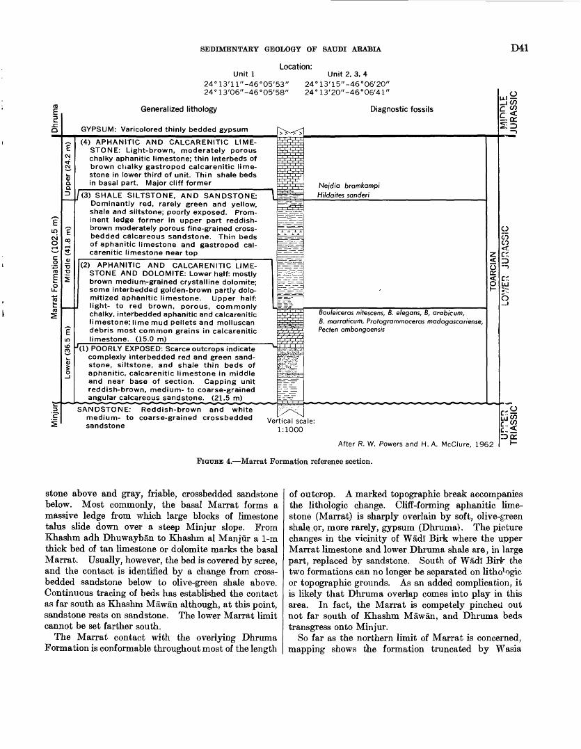
SEDIMENTARY GEOLOGY OF SAUDI ARABIA D41
Unit 1Location:
24°13'11"-46°05'53" 24°13'06"-46°05'58"
2424
Unit 2, 3, 413'15"-46°06'20" 13'20"-46°06/41"
Generalized lithology
GYPSUM: Varicolored thinly bedded gypsum
Diagnostic fossils
(4) APHANITIC AND CALCARENITIC LIME STONE: Light-brown, moderately porous chalky aphanitic limestone; thin interbeds of brown chalky gastropod calcarenitic lime stone in lower third of unit. Thin shale beds in basal part. Major cliff former
(3) SHALE SILTSTONE, AND SANDSTONE: Dominantly red, rarely green and yellow, shale and siltstone; poorly exposed. Prom inent ledge former in upper part reddish- brown moderately porous fine-grained cross- bedded calcareous sandstone. Thin beds of aphanitic limestone and gastropod cal carenitic limestone near top
(2) APHANITIC AND CALCARENITIC LIME STONE AND DOLOMITE: Lower half: mostly brown medium-grained crystalline dolomite; some interbedded golden-brown partly dolo- mitized aphanitic limestone. Upper half: light- to red brown, porous, commonly chalky, interbedded aphanitic and calcarenitic limestone; lime mud pellets and molluscan debris most common grains in calcarenitic limestone. (15.0 m)
'(I) POORLY EXPOSED: Scarce outcrops indicate complexly interbedded red and green sand stone, siltstone, and shale thin beds of aphanitic, calcarenitic limestone in middle and near base of section. Capping unit reddish-brown, medium- to coarse-grained angular calcareous sandstone. (21.5 m)
SANDSTONE: medium- to sandstone
Reddish-brown and white coarse-grained crossbedded
Nejdia bramkampi Hildaites sanderi
j. a. a. j.
Bou/eiceras nitescens, B. elegans, B, arableum,B. marraticum, Profogrammoceras macfagascar/ense,Pecten ambongoensis
cr.
o
Vertical scale: 1:1000
After R. W. Powers and H. A. McClure, 1962ID DC
I-
FIGUEE 4. Marrat Formation reference section.
stone above and gray, friable, crossbedded sandstone below. Most commonly, the basal Marrat forms a massive ledge from which large blocks of limestone talus slide down over a steep Minjur slope. From Khashm adh Dhuwayban to Khashm al Manjur a 1-m thick bed of tan limestone or dolomite marks the basal Marrat. Usually, however, the bed is covered by scree, and the contact is identified by a change from cross- bedded sandstone below to olive-green shale above. Continuous tracing of beds has established the contact as far south as Khashm Mawan although, at this point, sandstone rests on sandstone. The lower Marrat limit cannot be set farther south.
The Marrat contact with the overlying Dhruma Formation is conformable throughout most of the length
of outcrop. A marked topographic break accompanies the lithologic change. Cliff-forming aphanitic lime stone (Marrat) is sharply overlain by soft, olive-green shale^or, more rarely, gypsum (Dhruma). The picture changes in the vicinity of Wadl Birk where the upper Marrat limestone and lower Dhruma shale are, in large part, replaced by sandstone. South of Wadl Birlr the two formations can no longer be separated on lithologic or topographic grounds. As an added complication, it is likely that Dhruma overlap comes into play in this area. In fact, the Marrat is competely pinched out not far south of Khashm Mawan, and Dhruma beds transgress onto Minjur.
So far as the northern limit of Marrat is concerned, mapping shows the formation truncated by Wasia
D42 GEOLOGY OF THE ARABIAN PENINSULA
(Middle Cretaceous) sandstone just beyond lat 28°00 /N.
PALEONTOLOGY AND AGE
The Marrat Formation has been dated confidently as Toarcian by ammonites (Arkell, 1952). Nejdia bram- kampi Arkell and Hilda/ties sanderi Arkell were collected from the upper member, the middle member is barren, and lower Marrat beds have yielded Bouleiceras nitescens Thevenin, B. elegans Arkell, B. arabicum Arkell, B. marraticum Arkell, and Protogramm&ceras madagascar- iense Thevenin. The Bouleiceras fauna is considered by Arkell to be lower Toarcian; the Nejdia fauna is dated by him as early upper Toarcian.
Palynological determinations (D. O. Hemer, unpub. data, 1963) of surface samples obtained by air drilling indicate that the Marrat-Minjur contact also marks the Jurassic-Triassic boundary. The Lower Jurassic flora consists primarily of the form Classopollis and associated trilete spores. Marine microflora are rare, although a small number of dinoflagellates and hystrichosphaerids are present. Abundant Upper Triassic monosaccate pollen grains immediately underlie this flora.
These data, taken collectively, indicate that early and middle Liassic time is not represented on outcrop.
A rather impressive and varied collection of mega- fossils was made during early field work, particularly in the vicinity of Khashm adh Dhlbl. These brought about the early recognition of a Liassic (Early Jurassic) age for the Marrat, a determination refined by the later work of Arkell. A complete list of identified fossils includes: "Rhynchonetta" sp., Spiriferina spp., "Tere- bratula" spp., Anabacia sp., Monttivaltia sp., Acrosalenia cf. A. somaliensis Currie, Hemipedina? spp., Bouleiceras nitescens Thevenin, B. arabicum Arkell, B. marraticum Arkell, B. elegans Arkell, Hildaites sanderi Arkell, Nejdia bramkampi Arkell, Nejdia Jurnishi Arkell, Protogrammoceras madagascariense Thevenin, Ampul- letta sp., Cardium (s.l.) sp., Ceratomya spp., Ceratomya? sp., Ceromyopsis arabica Cox, Chlamys sp., Discoehlix sp., Eligmus sp., Globularia cf. 6. hemisphaerica Roemer, Gryphaea spp., Jibula? sp., Lima cf. L. gigantea (Sower- by), Lima cf. L. harronis Dacque, Lopha sp., Modiolus (Inoperna) sp., My a sp., Mytilus (ArcomytUus) sp., Mytilus, Arcomytilus somaliensis Cox, Mytilusf sp., NautUus sp., Nerinea sp., Neritaf sp., Ostrea spp., Oxytoma sp., Pholadomya spp., Pholadomya (Homomyd) inornata Sowerby, Pholadomya lirata (Sowerby), Pleu- romya? sp., Protocardium sp., Pseudotrapeziumt sp., Pseudomelania sp., Pteria (s.l.) Purpuroidea? sp., Quenstedtia sp., Thracia sp., Turbinaf sp., Turbo (s.l.); indeterminate lucionids, nautiloids, indeterminate molluscs, ostracodes.
ECONOMIC ASPECTS
GROUND WATER
In the vicinity of Shaqra', deep water wells are currently producing from the Minjur Sandstone. The holes are probably open to the Marrat as we1 !; how ever, the quantity of water, if any, being withdrawn from this unit is unknown. No other data on Marrat water potential is available.
DHRUMA FORMATION MIDDLE JURASSIC
DEFINITION
The Dhruma Formation is named for the town of Durma (lat 24°36' N.; long 46°07' E.) near the middle of the outcrop belt. Max Steineke in 1937 first defined the Dhruma as a member of the Tuwaiq Formation along with the Marrat, Tuwaiq Mountain, Hanifa, Jubaila, Arab, and Hith members. In 1945, R. A. Bramkamp raised each member to formation and raised the Tuwaiq to group. Formal publication of formational names followed (Steineke and Branakamp, 1952b), and, concurrently, the term Tuwaiq Group was dropped. Type section particulars were published by Steineke, Bramkamp, and Sander (1958).
The type sequence was composited from a reries of successive measurements at Khashm adh Dhibi (lat 24°12'24" N.; Iong46°07'30" E.) and between Fhashm adh Dhibi and Khashm al Mazru'i (lat 24°19/00// N.; long 46°19'36" E.). This succession in the face and on the back slopes of Khashm adh Dhibi is on°- of the most accessible and best exposed.
At the type section, the base of the formation is at the contact between the gypsum and interbedded shale and limestone and the underlying cliff-forming Marrat limestone; the top is placed at the contact between olive-green shale of the upper Dhruma and light-brown, soft, chalky limestone of the Tuwaiq Mountain Limestone.
The major subdivisions of the Dhruma Foination defined by Steineke, Bramkamp, and Sander (1958) are retained in this report. These are (1) upper Dhruma here divided into two members, (2) middle Dhruma containing the ammonite zones Dhrumaites, Micromphalites, Tulites, and Thambites, and (?) lower Dhruma with the Ermoceras zone at top, two unnamed units in the middle, and the Dorsetensia zone at the base (pi. 7).
The upper Dhruma is divided on lithologic and fauna! evidence into two distinct members the Hisyan above and the 'Atash below. The definition of these members is published here for the first time.
The Hisyan Member is named for Wadi al IJisyan (near lat 24°50/ N.), a major drainage chanrel that cuts directly across the unit. Holm, who first proposed
SEDIMENTARY GEOLOGY OF SAUDI ARABIA D43
the member in 1947, did not designate a type locality, although it is known that some beds he placed at the top of this unit are not now included within it.
Type locality for the Hisyan Member is designated as Khashm al 'Atash (lat 24°10'50" N., long 46°27'53" E.) where the complete section (46.5 m) is cleanly exposed. The upper limit is at the lithologic change from shale with thin interbeds of limestone below to limestone with thinly interbedded shale above. Litho- logically, the upper contact is somewhat gradational; faunally, it is sharp. The lower limit of the member is firmly fixed at the break from yellow-gray shale above to yellow-brown calcarenite of the 'Atash Member below.
The 'Atash Member is named for Khashm al 'A^ash (lat 24°10/50// N., long 46°27/53// E.) where the upper 14.1 m is cleanly exposed. The lower 12.2 m was described from samples from a shallow air-drilled hole, T-80, spudded in at the base of the section used to define the upper 'Atash. The lower limit of the member is at the change from chalky calcarenitic limestone above to impure calcarenitic limestone and calcarenite of the Dhrumaites zone below.
Considerable economic importance is attached to the 'Atash Member as it is equivalent, both lithologic- ally and faunally, to the subsurface Fadhili reservoir an important oil-bearing interval in eastern Arabia.
OCCURRENCE AND THICKNESS
Beds of the Dhruma Formation form a boomerang- shaped arc extending from Al 'Ari$l (near lat 19°20' N.) to 'Iraq al Mazhur (near lat 27°05/ N.), a distance of more than 900 km. The outcrop belt reaches a maximum width of 20 to 25 km in the vicinity of Wadi Birk-Khashm adh Dhibi and narrows irregularly to the north and south.
Dhruma topography in the vicinity of Khashm adh Dhlbl is dominated by three prominent limestone benches. The lowermost of these is capped by the Dhibi limestone which supports the high outer escarp ment of Jabal Tuwayq. Just north of Khashm adh Dhibi, the central Arabian graben system breaks the topographic continuity of the scarps, but beyond, the benches can again be accurately identified.
Dhruma outcrops north of the grabens are generally poor exposures of intensely weathered shale under capping ledges of limestone or, more rarely, sandstone. Many interbench areas are floored with long broken ribbons of yellow silt. While this makes detailed lithologic description difficult, it has a decided advan tage so far as precise segregation of fossil horizons is concerned. The benches become progressively more subdued until they are covered near Al Qas.ab (lat 25°18/ N.) with a flood of silt and gravel from the
228-776 O 66 4
mouth of Wadi al 'Atk. North of the wadi only a single bench, probably the middle one, remains as a traceable topographic feature, and the Dhruma forms a lowland of banded mud flats and low benches1 sand wiched between the Tuwaiq Mountain Limestone escarpment and the Nafud ath Thuwayrat, The Nafud effectively covers the lower part of the forma tion throughout most of the area; middle and upper beds are commonly disrupted and blanketed by a flood of outwash from the Tuwayq front.
From Al Furuthl (lat 25°46 / N.) to Az Zilfi (lat 26°18/ N.), the Dhruma appears only in a few gravel- strewn windows in surficial deposits. The formation is completely overlapped by sands of Nafud ath Thuwayrat about 20 km north of Az Zilfi. Small patches reappear near lat 27°00/ N. as yellow silt flats and sandy-marly benches in hollows within the 'Irq al Mazhur.
From Khashm adh Dhlbl south, the Dhruma is remarkably well exposed in a steplike series of high, limestone-capped scarps and broad dip slopes. Of the three benches identified by Holm, only the lower or Dhibi bench has been traced south, and it can be recognized with certainty at Al Haddar (lat 22°OY N.). Immediately south of Al Haddar, Dhruma limestone is largely replaced by shale and sandstone. As a conse quence massive scarps fade, and the Dhruma retreats under a protective cap of Tuwaiq Mountain Limestone.
Maximum thickness of the Dhruma Formation is at the Khashm adh Dhlbl reference section where 375 m was recorded. Southward the formation thin" uni formly to 264 m at Wadi Birk and about 20C m at Khashm al Juwayfah (lat 22°32' N.). Thicknesses are uncertain beyond this point, as lower Dhruma sand stone is indistinguishable from sandstone of the under lying Marrat, Minjur, and Jilh Formations. Tb^s gen eral picture, however, is one of continued southward thinning through progressive loss of beds at the base by overlap. Finally the Dhruma wedges out agairst the Sudair Shale near Khashm az Zifr (lat 19°30' N.).
The few Dhruma sections available north of the reference locality indicate less drastic thinning in this direction. Intervals measured and computed near lat 25°02/ N., 25°32' N., and 26°02' N., and calculated across the 'Irq al Ma^hur give thicknesses of about 375, 350, 330, and 250 m respectively.
LITHOLOGIC CHARACTER
In the area between Wadi al Eawtah (lat 23°33' N.) and Ar Raghbah (lat 25°09/ N.), the upper and lower benches mapped by D. A. Holm in 1947 separate the Dhruma into three natural units corresponding to the upper, middle, and lower Dhruma as defined by Stoineke, Bramkamp, and Sander (1958) and as used in this re-
D44 GEOLOGY OF THE ARABIAN PENINSULA
port. Basically, the pattern from bottom to top is: (1) lower Dhruma shale with some limestone that near Khsahm adh Dhibi contains a thin layer of gypsum at the base and that has an upper bed of massive, cliff- forming Dhibi limestone, (2) middle Dhruma limestone containing beds of clean, current-washed calcarenite at various levels, many as units with high-lateral per sistence, and an upper oolite bed that forms a prom inent cliff, and (3) upper Dhruma shale (Hisyan Member), with some limestone in lower part ('Atash Member).
The most important lateral change in the Dhruma Formation is the southward replacement of limestone and shale by sandstone. The first change is in the lower Dhruma which becomes dominantly sandstone in the vicinity of Khashm al Khalta' (lat 23°36/ N.); the the middle and upper members give way to sandstone near Al Haddar (lat 22°00/ N.). Change from lime stone to sandstone takes place abruptly in individual beds, usually without passing through a shaly phase. The southward change in facies represents transition from marine to continental deposition.
In the north beyond Ar Raghbah the proportion of shale in the Dhruma gradually increases until it domi nates the sequence near Al Jurayfah (lat 25°31 / N.). A few thin beds of sandstone also occur here; progres sively more are added northward. Although the trend toward shoreline conditions is obvious, marine beds still make up a considerable part of the sequence just before the Dhruma passes under the Nafud ath Thuwayrat.
Selected sections give a more detailed picture of lateral lithologic changes in the Dhruma. The ex cellent exposures at Khashm adh Dhibi are charac teristic of the sequence in the central area of outcrop. R. W. Powers and H. A. McClure measured this section in 1962 and prepared a detailed description of the lithologies from polished sections of samples collected at intervals of 1 m or less. The new measurement, pieced together in the same general area as the type section (Steineke, Bramkamp, and Sander, 1958), is herewith designated a reference section (pi. 7). A com plete succession was composited from three increments (1) the lower 120.8 m was measured in the face of the Dhibi escarpment between lat 24°11 / 17 // N., long 46°11 / 10 // E. and lat 24°11'53" N., long 46°11'30" E.,(2) the middle 63.7 m on the back slope of the Dhibi limestone between lat 24°11 /04// N., long 46°17 / 14' / E. and lat 24°11 / 12 // N., long 46°17 / 17// E., and (3) the upper 190.0 m in the face of the Tuwaiq Mountain Limestone scarp between lat 24°11 / 19 // N., long 46°18/ 50" E. and lat 24°12/34// N., long 46°19/03// E. A full description is given in section 24 (p. 123).
South of the reference locality the lower Dhruma is
the first to undergo significant change. The Dhibi limestone persists but underlying beds show slight re placement by sandstone as far north as Al Jufayr (lat 24°01 / N.). However, most of the replacement occurs between Faridat Bal'um (lat 23°42' N.) and Khashm al Khalta' (lat 23°36' N.).
The next complete traverse of the Dhruma was made at Wadl Birk (lat 23°12/ N.) where the lower part of the formation is mostly sandstone and upper units show little change from the reference section. In 1945, R. A. Bramkamp and C. W. Brown described the lower Dhruma; the middle and upper members were covered by R. D. Gierhart and P. R. Aswerus in 1947. The sequence is summarized in section 25 (p. 129).
Dhruma lithology at Khashm al Juwayfah (lat 22°32' N.) is similar to the Wad! Birk sequence but does exhibit some differences. Notable changes in clude: (1) an increase in shale at the expense o.^ lime stone, probably involving beds equivalent to the 'Atash Member, (2) introduction of considerable crossb adding and fossil wood in the lower sandstone, and (3) loss of definition of the Marrat-Dhruma contact, although bracketing markers permit approximate placement. Further south the contact is lost completely.
The Al Juwayfah section was pieced togethe1* from two isolated measurements. Gierhart and L. D. Owens described the lower Dhruma in the face of the Khashm in 1947; Bramkamp measured the middle and upper units opposite Khashm 'Ushayrah (lat 22 °36' N.) in 1951. The section is summarized in section 26 (p. 130).
Sections at Khashm Khar^am and along the northern edge of Sha'ib al Haddar (near lat 22°00/ N.) show small but significant changes relative to the Al Juv^ayfah sequence described above. For example: (1) a thick lense of impure limestone and calcarenite has been introduced, presumably in the lower part of the Fisyan Member in bracketing sections the interval is occu pied by shale, (2) interbeds of sandstone occur near the probable level of the 'Atash Member, (3) the Dhibi limestone is present at both localities but has lost its cliff-forming character in the Haddar section, and just to the south it is replaced by sandstone, and (4) beds below the Dhibi are sandstone which cannot H dis tinguished from underlying Triassic units.
Major lithologic variations are evident about 5 km south of Al Haddar and at Khashm ash Shajarl (lat 21°46/ N.). South of Al Haddar, shale dominates the post-Micromphalites interval; remaining section exposed (only above the Dhibi) is limestone. At Khasbm ash Shajari, sandstone is the main constituent, only the lower half of the Micromphalites zone being in carbonate facies. The two sequences are summarized in sections 27 and 28 (p. 130), respectively.
SEDIMENTARY GEOLOGY OP SAUDI ARABIA D45
South of Khashm ash Shajari the Dhruma Formation is, with the exception of a several-meter-thick limestone at the base of the Micromphalites zone, made up of sandstone and minor shale interbeds. The above- mentioned limestone has been partly replaced by shale at Khashm Mishlafr (lat 21°08' N.) and completely replaced by shale at Khashm faryam (lat 20°37' N.); at Khashm Kumdah (lat 20°17' N.) the equivalent interval is entirely represented by sandstone. South ward from this point the Dhruma continues in sand stone facies, eventually wedging out between Tuwaiq Mountain Limestone and Sudair Shale near Khashm azZifr (lat 19°30' N.).
North of the reference section the middle Dhruma is the first unit to show perceptible change. By the time Khashm al IJaysfyah is reached (lat 24°51' N.) sig nificant amounts of shale have been added at the expense of limestone. Essentially the same limestone- shale ratio is maintained in the better exposed outcrops in front of Khashm at Turab (lat 25°03' N.).
The closest possible approach to a complete Dhruma sequence (in the northern area) was composited from three individual sections measured approximately along lat 25°02' N. Here, D. A. Holm and A. F. Pocock described the upper Dhruma in 1948; R. A. Bramkamp and others described the middle and lower Dhruma in 1949. The sequence is summarized in section 29 (p. 131).
Progressive addition of shale to the north results in almost complete replacement of limestone in the vicinity of Al Jurayfah (lat 25°31' N.). An almost full succession, except for the basal part, can be pieced together from measurements of the upper Dhruma made by Bramkamp and others in 1951 and the middle and lower Dhruma by Pocock and R. P. Kopp in 1948. The sequence is summarized in section 30 (p. 131).
Dhruma exposures in the vicinity of Al Ghat (lat 26°02' N.), the northernmost area studied in detail, are poor but do suggest some significant shifts in facies. The 66.4 m of upper Dhruma, measured by S. J. Roach in 1952, is distinctly typical in that most of the Hisyan beds are greenish-gray, impure, nodular-weathering limestone in the upper part and reddish-brown, impure, sandy, fossiliferous, oolitic-detrital calcarenitic lime stone in the middle. The probable equivalent of the lower Hisyan and 'Atash is olive-green, silty and sandy shale with rare thin interbeds of greenish-gray sand stone and coquinoid limestone.
The middle and lower Dhruma interval was examined by Pocock and Kopp in 1948. Brown, greenish-brown to black-weathering, medium, to coarse-grained, ripple- marked sandstone in beds 1 to 2 m thick crops out as ledges at 5, to 30-m intervals throughout the upper 156 m. Interledge intervals are usually masked, but
some shale was discovered in the lower 40 m. An estimated 108 m of covered section intervenes between the last sandstone ledge and the projected top cf the Marrat Formation. Therefore, the approximate total thickness of the Dhruma Formation near Al Gl a$ is 330 m. Essential details of Dhruma lithology are unknown to the north.
NATURE OF CONTACT WITH ADJACENT FORMATIONS
In the central area from Wadi Birk to lat 25°00' N., the Dhruma contact with the underlying Marrat For mation is a sharp but conformable lithologic t^eak, a break from shale (or gypsum in the vicinity of Khashm adh Dhibi) above to limestone below. The contact is nowhere exposed north of this area. From Wadi Birk south, the lower limit becomes less clear as the contact disappears in a monotonous sandstone-shale sequence. Apparently, the Dhruma unconfornably overlaps the Marrat near Khashm Mawan (lat 22°50' N.), then rests on progressively older beds of the Minjur and Jilh Formations, butts eventually against the Sudair (near lat 20°00' N.), and wedges out compVtely between Tuwaiq Mountain and Sudair near Khashm az Zifr (lat 19°30' N.). Loss of Dhruma beds south ward over this distance almost certainly takes place at the base as successively younger Dhruma strata lap over progressively older rocks. Further data (from tracing of surface beds and detailed faunal correlations in nearby bore holes) show conclusively that beds are not removed at the top.
The contact with the overlying Tuwaiq Mountain Limestone represents a conformable transition from shale to limestone. The upper Dhruma limit is placed at the change from shale, thin interbeds of calcar<mite, and calcarenitic limestone (Dhruma) to soft aphanitic and calcarenitic limestone with shale partings (Tuwaiq Mountain). No topographic break marks the contact, but it consistently occurs 30 to 40 m below the base of the massive, cliff-forming phase of the Tuwaiq Moun tain Limestone. Relationship to the two formations along strike is maintained with remarkable uniformity. The change from the predominantly clay lithology of the Dhruma to the soft, marly limestone of the basal Tuwaiq Mountain has been mapped from Az ZilfI to Al Haddar. From Al Haddar south, the contact, altl ough traceable, is obscured as a thin basal Tuwaiq Mountain unit, and most of the Dhruma is replaced by sandstone.
The actual elimination of Dhruma beds north of Az Zilfi is masked by the Nafud ath Thuwayrat an'i the 'Irq al Mazhur. Geometry of adjacent units, hovrever, indicates that the Dhruma is, in fact, cut out bv pre- Wasia erosion near the northeastern edge of 'Irq al Mazhur (presumably somewhere between long 43°35' E. and44°10'E.).
IMG GEOLOGY OF THE ARABIAN PENINSULA
PALEONTOLOGY AND AGE
LOWER DHRUMA
Arkell (1952) unhesitatingly places the lower part of the lower Dhruma in the middle Bajocian on the basis of the Dorsetensia fauna. His assignment of the Ermo- ceras-bearing beds in the upper Dhibi limestone is some what less definite, namely "Early-Upper or late-Middle Bajocian."
This placement of the entire lower Dhruma within the Bajocian presents certain problems when viewed in relationship to the contained foraminiferal faunas. Those faunas of the lower part of the lower Dhruma are rich in members of the Lagenidae; while not as yet worked out in detail, they carry the typical aspect of published faunas from Bajocian and older beds through out the world. On the other hand, the foraminiferal faunas of the upper part of the Dhibi limestone intro duce many of the genera and even a few of the species which characterize the overlying middle Dhruma.
Among the forms which appear in the Dhibi lime stone are the following: Dhrumella evoluta Redmond, Haurania amiji Henson 1948, Haurania deserta Henson 1948, NautUoculina spp., PJenderina inflate, Redmond, Pseudomarssonetta primitive, Redmond, Riyadhella elon- gata Redmond (Redmond, 1965).
All the above genera make their first appearance at this point, some of them to persist through lengthy ranges. On the species level the situation is even more striking because Pseudomarssonetta primitiva is abun dant in the lower part of the middle Dhruma and Dhrumella evoluta and Riyadhella elongata range even higher, completely through the lower two zones of the middle Dhruma.
Hudson and Chatton (1959) report the entrance of the genus NautUoculina in the group b beds of the Musandam Limestone, together with Haurania amiji Henson and a Haurania of. H. deserta Henson. After suggesting a correlation between the lower part of the Dhruma Formation and the group b beds on the basis of comparable microfossils and similar stratigraphic position, Hudson and Chatton go on to remark that the type locality of Haurania amiji and Haurania deserta in Iraq is now considered to be Bathonian in age. In ad dition to this they correlate the overlying Haurania amiji-be&riag group c beds with the middle Dhruma.
It would thus appear that the relationship between the group b beds and the group c beds is exactly anal ogous to the relationship between the lower Dhruma and the middle Dhruma. The lower unit in each in stance carries in its upper part fauna! elements which range on up into overlying beds of undoubted Bathonian
Since the Ermoceras faunas of the Dhibi limestone do not appear to range completely to the top of the unit
(see Steineke and Bramkamp, 1952b), and in view of the foregoing discussion, it is highly probable that the
,Bathonian-Bajocian boundary does not coincide exactly with the top of the escarpment-forming lithographic limestone on the uppermost Dhibi but falls somewhere a short distance below.
MIDDLE DHRUMA
Arkell (1952) lists the following succession of middle Dhruma ammonite faunas and gives age references.
Top:Middle (and upper?) Bathonian:
Dhrumaites fauna Micromphalites fauna Tulites fauna
Lower Bathonian?:Thambites fauna
Bottom.
There are at least three major foraminiferal zo^ies in in the middle Dhruma, but the exact relationship of these zones to the ammonite faunas is not yet com pletely clear. It is known, however, that Dhrumaites occurs within the upper foraminiferal zone and Tham bites, within the lower zone, but the placement of the middle ammonite zones within the foraminiferal zones has yet to be established.
In the following lists detailing the more conspicuous microfaunal elements of the middle Dhruma the words "upper", "middle", and "lower" are used purely in the spatial sense and are intended neither as formal zonal designations nor as litbic subdivisions.
The lower part of the middle Dhruma contains Dhrumella evolv-ta Redmond, NautUoculina spp., Pfen derina sp., Pseudomarssonetta mcclurei Redmond, Pseudo marssonetta primitiva Redmond, Riyadhetta elongata Redmond.
The middle part of the middle Dhruma contains Dhrumella evoluta Redmond, NautUoculina spp., Pseudo marssonetta reflexa Redmond, Riyadhella elongata Red mond, Riyadhetta arabica Redmond, Virgulina spp.
The upper part of the middle Dhruma contains Flabettammina sp., NautUoculina spp., Pseudcmars- sonetta biangulata Redmond, Pseudomarssonetta bipar- tita, Redmond, Riyadhetta inflata Redmond, Riyadhella nana Redmond, Riyadhella rotundata Redmond. (See Redmond, 1965.)
UPPER DHRUMA
To date no ammonites have been reported from accurately placed positions within the upper Dhruma. Arkell (1952) listed such forms as Gryphaea cos^ttata Douville, Eligmus rollandi Douville, Eligmus rollandi Douville var. jabbokensis Cox, Eudesia cardium Lamarck and Eudesia cardioides Douville from this part of the section and assigned a questioned late Bathoniau age to it.
SEDIMENTARY GEOLOGY OP SAUDI ARABIA D47
P. M. Kier, E. G. Kaufmann, and others of the Smithsonian Institute are currently studying much more complete megafossil collections obtained in the recent past. The outcome of their work is expected to clear up much of the present uncertainty over the correct age assignment of the various segments of the upper Dhruma, and it would be profitless to debate the matter here. It can be noted, however, that the rich foraminiferal faunas in the upper part of the Hisyan Member are so closely related to those of the immediately overlying middle Callovian lower part of the Tuwaiq Mountain Formation as to suggest a break of less than stage magnitude at the contact. This is particularly true of the highly evolved and closely related Kurnubias occurring on both sides of the contact. In view of these relationships it is sus pected that at least the upper part of the Hisyan Member will prove to be no older than Callovian.
A partial list of the Foraminifera occurring within the upper Dhruma (Redmond, 1964a, 1965) is as follows:'Atash Member ("Indicates occurrence only in lower part of
member):Kurnubia variabilis Redmond* Nautiloculina spp. Pfenderella arabica Redmond* Pfenderina gracilis Redmond
neocomiensis (Pfender) Smout and Sugden trochoidea Smout and Sugden*
Pseudomarssonella maxima Redmondplicata Redmond
Sanderella laynei Redmond*Trocholina spp. (including a large, high-spired form with
an acute initial end)
In the foregoing list the large, high-spired Trocholina represents the lowest occurrence of this type of Trocho lina in Saudi Arabia. The genus is sparingly represented below this point, but all forms seen to date are small and low spired. Likewise, Kumubia variabilis is the stratigraphically lowest known representative of the genus Kurnubia.Hisyan Member:
Upper part:Conicospirillina sp.Kurnubia bramkampi Redmond
spp.Pseudomarssonella media Redmond Riyadhella sp. Steinekella crusei Redmond Trocholina palastiniensis Henson (1948)
cf. T. palastiniensis Henson, "high spired variant"(Henson, 1948, pi. 13, fig. 10)
Lower part:Kurnubia spp.Praekurnubia crusei Redmond Riyadhella hemeri RedmondTrocholina sp. (small, flat form with prominent marginal
band on ventral surface)
A comprehensive fossil list of the Dhruma Formation includes the following:Brachiopoda:
Bihenithyris barringtoni Muir-Wood Burmirhynchia gregoryif Wier Charltonithyris bihenensisl Weir Daghanirhynchia daghaniensis Muir-Wood Loboidothyris jubaensisl Weir Parathyrisl sp. "Rhynchonella" spp. Somalirhynchia bihenesis Muir-Wood Somalithyris aflf. S. macfadyeni Muir-Wood Terebratula respolit Stefanini
superstes Douville"aflf. T. saemanni Oppel
Coelenterata:Amphiastraeaf sp. Anabacia spp. Isatraea? sp. Isastrocoenial. sp. Milleporidium sp. Montlivaltia sp. Stylinal sp. Thamnastraea sp. colonial corals undetermined
Echinodermata:Acrosalenia somaliensis Currie
smelliei Curriespp.
Apiocrinus aff. A. roissyanus d'Orbigny Bothriopneustes somaliensis Currie
cf. B. orientalis Fourtausp.
Clypeobrissus sp. Holectypus spp. Polycyphus sp. Recrosalenia sp. cidaroid radioles crinoid plates and stems
Foraminifera:Ammobaculites sp. Bolivina sp. Conicospirillina sp. Dhrumella evoluta Redmond Flabellammina sp. Guttulina sp. Haplophragmoides sp. Haurania amiji Henson
deserta Henson Kurnubia bramkampi Redmond
variabilis Redmondspp.
Lenticulina sp. Marginulina sp. Marginulinopsis spp. Nautiloculina spp. Opthalmidium sp. Pfenderella arabica Redmond Pfenderina gracilis Redmond
inflata Redmondneocomiensis Smout and Sugdentrochoidea Smout and Sugdensp.
Praekurnubia crusei Redmond

D48 GEOLOGY OF THE ARABIAN PENINSULA
Pseudocyclammina sp. Pseudomarssonella biangulata Redmond
bipartita Redmondmaxima Redmondmcclurei Redmondmedia Redmondplicata Redmondprimitive Redmondreflexa Redmond
Pseudovirgulina sp. Riyadhetta elongata Redmond
hemeri Redmondinflata Redmondnana Redmondarabica Redmondrotundata Redmondsp.
Sanderella laynei Redmond Spiroloculina sp. Steinekella crusei Redmond Trocholina palastiniensis Henson
cf. T. palastiniensis Hensonspp.
Valvulina sp. Virgulina sp.
Mollusca:Acteonina sp.Ampullella sp.Anchura (Pietteia)! sp.Anisocardia sp.Aporrhais sp.Area sp.Arcomytilus laitmairensis de Loriol
somaliensis Coxsp.
Astarte scytalis Holdhaus Bakewellia wattoni (Lycett) Bramkampia steinekei ArkeTl Bullarial sp. Camptonectes cf. C. brovmi Cox
sp. Ceratomya wimmisensis (Gillieron)
cf. C. excentrica (Roemer)cf. C. wimmisensis (Gillieron)sp.
Ceromyopsis arabica Coxcf. C. somaliensis Weirsp.
Chlamys curvivarians Dietrichmacfadyeni Coxcf. C. macfadyeni Coxsp.
Clydoniceras pseudodiscus Arkell Cochleochilust sp. Corbula sp. Crassatellites'! sp. Cylindrites cf. C. striatus (Lissajous)
plicifer Cossmansp.
Cylindrites^ sp.Dhrumaites cardioceratoides Arkell Discohelix douvillei Cossman
elegantulumcf. D. elegantulum Douville"
Discohelixt sp.
Dorsetensia arabica ArkellEligmus polytypus (Eudes-Deslongchamps)
rollandi Douville"rollandi var. jabbockensis Coxweiri Coxcf. E. aualites (Stefanini)
Ermoceras coronatiforme Arkellcoronatoides (H. Dou villa")elegans H. Douville"magnificum Arkellreineckeoides Arkellruncinatum Arkellsplendens Arkellstrigatum Arkellcf. E. mogharense H. DouvillScf. E. runcinatum Arkell
Eudesia cardiddes Douville"cardium (Lamark)sp.Ghbularia spp.
Goniomya? sp. Gryphaea balli Stefanini
costettata Douville Gryphaeat sp. Homomya inornata (J. de C. Sowerby)
cf. H. gibbosa (J. Sowerby)sp.
Isocyprinal sp. Leda sp. Lima gigantea (Sowerby)
harronis Dacquesp.
Limatula cf. L corallina Arkellcf. L. elliptica (Whiteaves)
Lopha eruca Coxgregaria (Sowerby)solitaria (J. de C. Sowerby)sp.
Lucinal sp.lucinoids undetermined Mactromya aequalis Agassiz
cf. M. crassa Agassizsp.
Micromphalites clydocromphalus Arkellelegans Arkellintermedius Arkellpustuliferus (H. Douville')vertebralis Arkellcf. M. busqueti (de Grossouvre)sp.
Modiolus imbricatus (Sowerby)(Inoperna) plicatus (J. Sowerby)cf. M. imbricatus (Sowerby)sp.
Mytilus somaliensis Coxsp.
Nautilus spp. Nerinea (Ptygmatis) aff. brevivoluta Huddleston
somaliensis Weircf. N. bathonica Rigaux and Sauvagesp.
Nucleolites sp. Nucula cuneiformis J. de C. Sowerby
cf. N. tenuistriata J. de C. Sowerby
SEDIMENTARY GEOLOGY OF SAUDI ARABIA D49
Opis sp.Ostrea dubiensis Contejean
sp.Oxytoma inequivalve (Sowerby)
sp.Oxtomaf sp.Paracenoceras sp.Pholadomya aubryi Douville
lirata (J. Sowerby) somaliensis Cox spp.
Pholadomya? sp.Pinna sp.Pinna? sp.Pleurotomaria sp.Pleurotomaria? sp.Protocardia somaliensis Cox
sp.Pseudisocardia macfadyeni CoxPseudotrapezium sp.Pteria sp.Pteroperna sp.Purpuroidea aff. P. perstriata CossmanStephanoceras arabicum Arkell
cf. 5. psilicanihus WermbterStrungia arabica ArkellTeloceras cf. T7. labrum BuckmanThambites mirabile Arkell
oxynotus Arkell planus Arkell
Thamboceras mirabile ArkellThraciaf sp.Trigonia sp.Trochus sp.Tulites arabicus Arkell
erymnoides Arkell tuwaiqensis Arkell
Vastites? sp. Ostracoda:
Argillaecia sp. Bairdia spp."Brachycythere" sp. Bythocypris sp. Cytherella sp. Cytherelloidea spp. "Cytheridea"' sp. Cytheropteron spp. Cytherura sp. Darwinulal sp. Eocytheropteron? spp. Eucytherura sp. "Haplocytheridea" spp. Hutsonia spp. "Hutsonia" sp. Klieana sp. Leguminocytherist sp. Monoceratina sp. Paracypris spp. Paraschuleridea spp. Polycope sp. Polycopsis sp. Pontocyprist sp. Procytheridea spp.
Miscellaneous:calcareous sponges undertermined algal balls
ECONOMIC ASPECTS
GROUND WATER
Only negligible information has been gathered or the ground-water characteristics of the Dhruma Formation. The most promising area appears to be in the southwest where the formation is in porous sandstone facies A bore hole downdip from Wadl ad Dawasir yielded large quantities of fresh water from the Dhruma.
PETROLEUM
The few widely scattered wells that have so far penetrated the Middle Jurassic have passed through potentially favorable reservoir units at several levels. The most attractive and widespread of these is the 'Atash Member which is usually found to be at least partly in porous calcarenitic facies. The 'Atash Mem ber (Fadhili reservoir) contains commercial quantities of oil in Fadhili, Khurasis, and Qatif fields. Significant shows have been detected in other structures. In addition, the 'Atash is oil bearing in several other f <?,lds in the Middle East.
TDWAIQ MOUNTAIN UMESTONE UPPER JURASSIC
DEFINITION
The Tuwaiq Mountain Limestone is named for Jabal Tuwayq, the spectacular, nearly parallel sequence of west-facing scarps developed in the Jurassic rocks of central Arabia. The Tuwaiq Mountain Limestone itself supports the largest and most persistent of these escarpments and, as such, constitutes the backbore of Jabal Tuway<l-
Max Steineke in 1937 described and defined the Tuwaiq Mountain Limestone as a member of his Tuwaiq Formation. In 1945 R. A. Bramkamp raised the Tuwaiq Formation to group and elevated the limestone member to formation. The first published reference to Tuwaiq Mountain Limestone was in Arkell (1952) where the type locality was described. These data were repeated without significant change by Stein°.ke, Bramkamp and Sanders (1958).
The type section occurs along the old Darb al IJijaz (Riyadh-Jiddah road) through "IJisyan Pass" between lat 24°51'56" N. long 46°07'10" E. and lat 24°56'30" N., long 46°13/32 // E. A total of 215 m of section was measured and calculated.
At the type area, the base of the Tuwaiq Mountain Limestone is at the contact between soft calcarenitic limestone and underlying olive-green shale of the Dhruma. The upper limit is the contact of massive coral-bearing limestone with overlying marl and soft limestone of the Hanif a Formation.
D50 GEOLOGY OF THE ARABIAN PENINSULA
OCCURRENCE AND THICKNESS
The Tuwaiq Mountain Limestone has been mapped from Huwaymil (near lat 17°30' N.) to lat 27°30 / N., a distance of more than 1,200 km. Exposures are almost continuous except for sand cover at 'Irq al Mazhur, Al Mundafan, and south of Ban! Khat-mah. From a width of 20 km in central Najd, the outcrop band narrows irregularly to about 10 km at the northern and southern extremities. Although strike of the beds shifts gradually along the outcrop belt, dip remains relatively constant, averaging about 00°40'.
Tuwaiq Mountain Limestone dominates both the stratigraphy and topography of central Arabia. Over most of its extent the limestone forms a precipitous west-facing cuesta, gently bowed in the center and concave toward the west. Differential relief from the top of the scarp to the valley floor in front is more than 500 m in the central area of outcrop. Away from this area, the height of the escarpment diminishes gradually until a low weathered bench of a few meters remains in the extreme north and south at Qiba' and Huwaymil, respectively. The true elevation of the scarp remains relatively constant (about 1,000 m) in the southern and central areas. In the north, however, the top of the limestone cliff uniformly loses elevation and reaches a low of 640 m just before passing under 'Irq al Mazhur (atlat26°30 / N.).
For all practical purposes, the western boundary of the formation is marked by a vertical limestone cliff which in many places exposes 100 m or more of lower Tuwaiq Mountain strata. An additional 30 to 40 m of Tuwaiq Mountain rocks occurs below the cliff-former, but this is more argillaceous and simply weathers as an extension of the gentle slope established in the under lying Dhruma strata. The upper part of the formation forms a strong plateau surface tilted gently eastward. This surface is not a true dip slope but is slightly beveled so that successively younger beds are present downdip. The eastern margin of the formation is usually marked by a wide flat valley eroded in front of the Hanifa Formation.
In addition to its occurrence in the Tuwayq scarp, Tuwaiq Mountain Limestone is preserved in Awsat, Durmd, Qaradan, Barrah, and Majma'ah grabens as prominent ridges and erosional remnants. In general, only the upper part of the formation is exposed in these structures, the main exceptions being Barrah, where the basal beds crop out at the ends of the graben, and at the west end of Awsat*.
Thickness of the Tuwaiq Mountain Limestone reaches a maximum in the Darb al Hijaz (type locality)- Wadi Nisat (lat 24°15 / N.) area where between 200 and 215 m was measured and calculated. The forma tion thins uniformly away from this region; to the north,
sections near Al Ghat (lat 26°02 / N.), Az Zilfi (lat 26°18 / N.), and Qiba' (lat 27°24' N.) measured respectively 130, 80, and 45 m; and to the south the limestone measured about 150 m at Wadi Birk, 100m at Al Haddar, 80 m in Wadi ad Dawasir, and 60 m at the southern end of Bam Khatmah.
LTTHOIOGIC CHARACTER
Steineke, Bramkamp, and Sander (1958) described the Tuwaiq Mountain Limestone asa great plate of coral-bearing, dense, pure limestone, at the base of which is a thin noncoraliferous well-bedded chalky unit * * *. In typical Tuwaiq Mountain limestone, coral heads are scattered, commonly in position of growth, but ordinarily they make up only a small proportion of the rock as a whole. Several small reefs up to 15 meters high and about 50 meters in diameter are present just west of Riyadh, but aside from these the unit is thickly, but well, bedded. To the north as far as its most northerly known outcrops near Aqibba [Qiba'] (about Latitude 27° 15' North), the Tuwaiq Mountain limestone shows increased inclusion of soft limestone. To the south of the latitude of Riyadh, the unit progressively thins, the proportion of calcare- nite increases, and corals become more and more concentrated into rubbly beds in which coral remains make up a substantial proportion of the rock. Branching stromatoporoids, few in the central area, increase in abundance and, in places in tl e south, become rock forming.
The marked lithologic continuity of the Tuwaiq Mountain Limestone is one of the most spectacular features of the geology of Arabia. In central Najd, the formation is a massively bedded aphanitic limestone with some calcarenitic limestone and calcarenite in the upper part. The lower 25 to 40 m is well-bedded, highly fossiliferous, soft, chalky limestone with some soft calcarenitic limestone, calcarenite, and shale. The lower chalky unit is gradational from Dhruma shale below to massive limestone at the top and fcrms an even talus slope at the foot of the vertical clip. The base of the cliff-forming limestone is not a stratigraphic plane. Tracing the "notch" weathered at the junction of the hard and soft beds confirms this observation. Where the basal beds of the limestone become more argillaceous and calcarenitic, the "notch" rises- in the section, and vice versa. The typical litholog^-topo- graphic pattern of a shale slope at the base, a limestone cliff above, and a broad, bench-ridden back slope cut in the upper limestone beds maintains itself throughout the outcrop belt.
Because of the limestone's tendency to form sheer cliffs, the only easily accessible full sections of Tuwaiq Mountain Limestone are found along the courses of transverse channels which breach the Tuwayq front at nearly regular intervals. In these, erosion usually re duces the vertical cliff to steplike talus slopes of about 40°. Complete sections have been measured at each gap, and a few of these have been selected to illustrate
SEDIMENTARY GEOLOGY OF SAUDI ARABIA D51
the lateral changes taking place in Tuwaiq Mountain lithology.
Samples from Riyadh water well 1 (lat 24°36/43 // N., long 46°40/38// E.) provide the most complete record of Tuwaiq Mountain rocks, and the interval between 217.6 and 420.6 m in depth in this well is herein designated as a reference section (pi. 8). A detailed description and lithologic breakdown made by N. M. Layne and R. W. Powers in 1957 is given in section31 (p. 132).
The first important change north of the reference locality is detected in the Al Ghat section where shale appears in the upper part and massive calcarenite beds in the lower. As a result of the introduction of softer beds, the sharp contact with the overlying Hanifa is lost. In 1952 S. J. Roach described and measured the Al Gha^ sequence approximately along lat 26°02 / N. The succession is summarized in section32 (p. 132).
Farther north, in the vicinity of Qiba', the formation is 45 m thick and can be divided into two units. The upper 20 m is mainly soft, chalky limestone containing a difinitive Tuwaiq Mountain fauna. The highest beds are calcarenitic limestone with abundant silicified coral heads. The lower 25 m consists of platy lime stone, sandy marl, and a small amount of greenish- yellow shale and, in the lower part, considerable interbedded sandstone. This unit grades rapidly northward to an argillaceous and arenaceous facies.
South of the reference locality, the first basic change in Tuwaiq Mountain rocks is seen just beyond Sha'ib al Haddar (lat 22°00' N.) where the basal few meters of limestone is replaced by sandstone. The sand, with some irregularity in thickness but averaging about 10 m, persists to the southern limit of exposure.
The first significant change in beds above the sand is the appearance of a thick dolomite-calcarenite lens in sections immediately adjacent to Wadl ad Dawasir. R. A. Bramkamp, B. Beverly, and S. B. Henry in 1954 described a typical sequence in the area at Khashm Fardah (lat 20°12 / N.). The succession is summarized in section 33 (p. 132).
Flanking traverses show that the dolomite-calcarenite lens is restricted to the vicinity of Wadi ad Dawasir and is replaced to the north and south by fine-grained carbonate rocks.
Another major lens of calcarenite, grading in both directions to typical massive aphanitic limestone, occurs in the Al Mundafan area. A section described by Bramkamp and H. A. Kimball in 1950 at the southern tip of the Al 'Ari$ escarpment (lat 18°33" N.) is characteristic. The sequence is summarized in section 34 (p. 132).
The Tuwaiq Mountain beyond Al Mundafan is again typically aphanitic limestone with a basal unit of sandstone, although important concentratiors of calcarenite do occur at several levels.
NATURE OF CONTACT WITH ADJACENT FORMATIONS
The placement of the lower limit of the Tuwaiq Mountain Limestone has evoked as much spirited discussion as any other aspect of Arabian geoT ogy. In Max Steineke's original description of the formation in 1937, he did not precisely define the Dhruma-Tuwaiq Mountain contact, although it appears that he con sidered it to fall at the base of the massive cliff-foming limestone.
R. A. Bramkamp in 1945 found that the fauna for at least some distance below this point was similar to that above. On faunal evidence, he lowered the contact to the upper limit of clay shale which appeared to coincide with the upper limit of Gryphaea costettata. In the central fuwayq this results in the inclusion of 25 to 40 m of soft, argillaceous limestone (below the main cliff-forming member) within the Tuwaiq Mountain Limestone.
Later work by D. A. Holm and others in 1947 showed the upper range of Gryphaea costellata to be erratic. Holm then proposed the Hisyan Member (of the Dhruma) to include all beds between the base of the cliff-forming limestone and the top of what is now defined as the 'Atash Member. A detailed lithologic-paleontologic analysis of the problem by J. S. Cruse in 1961 led to the conclusion that Bram kamp's placement of the contact (as defined in Steineke and others, 1958) was the most logical choice, and no redefinition was necessary. The break is apparent both on surface and in deep wells. Examination of the contact from Az Zilfl in the north to Sha'fb al Haddar in the south has shown it to be mapp^ble. Although the contact is not knife sharp, the trans; tion from upper Dhruma clay to lower Tuwaiq Mountain Limestone takes place in a very narrow zone, anc1 the break can be placed within a few meters with a fair degree of certainty. Consequently, the contact pro posed by Bramkamp in 1945 and formalized by Steineke and others (1958) is retained here.
Immediately south of Sha'ib al Haddar, the b^.sal beds of the Tuwaiq Mountain Limestone are replaced by sandstone, a direct reflection of the shift to sandstone in the underlying Dhruma. Thickness of the l^,sal clastic beds never exceeds 17 m and is usually about one-half this figure. Interbeds of calcareous sandstone and sandy limestone and numerous fossils (mostly Nerinea) serve to separate the Tuwaiq Mourtain from the Dhruma and other sandstones all the way to Al Mutabattitat (lat 17°47' N.).
D52 GEOLOGY OF THE ARABIAN PENINSULA
The Dhruma-Tuwaiq Mountain contact is conform able from Qiba' to Al Haddar. Presumably the contact becomes disconformable between Al Haddar and lat 19°24 / N., where the Dhruma pinches out and Tuwaiq Mountain rests with low angular discordance on the Sudair Shale. Continued transgression carries the Tuwaiq Mountain Limestone across the beveled edges of the Sudair and Khuff Formations, and finally brings the formation into contact with the Wajid at Bam Khat>mah.
The Tuwaiq Mountain contact with the overlying Hanifa Formation appears to be conformable although there is some evidence, at least on a local scale, that an unconformity separates the two units. Subsurface data support this possibility as pre-Hanifa erosion is demonstrable over several structures in coastal Arabia.
On outcrop, the upper limit of the Tuwaiq Moun tain is placed at the change from light-colored, massive, resistant, coral-bearing aphanitic limestone below to brown, softer, thin-bedded, noncoraliferous, aphanitic and calcarenitic limestone above. South of Wadi ad Dawasir, coral heads extend up into the lower Hamifa, but bed tracing, lithologic character, and topographic expression permit placement of the formation boundary. In central and northern Najd, the basal Hanifa lime stone is more argillaceous and even contains shale at various localities. The contact is readily recognizable as a white band below brown slopes, the bottom of the white band coinciding with the break. The contact is excellently exposed on either side of Wadi Hanifah near Jabal al Abakkayn (lat 24°58' N.).
The Tuwaiq Mountain Limestone is abruptly terminated about 20 km north of Qiba' where it inter sects the pre-Wasia erosion surface.
PALEONTOLOGY AND AGE
The lower beds of the Tuwaiq Mountain Limestone were assigned to the middle Callovian coronatum zofte by Arkell (1952) on the basis of contained ammon ites. They also contain fairly abundant foraminiferal faunas including Trocholina palastiniensis Henson and several undescribed species of Kurnubia.
The middle and upper parts of the Tuwaiq Mountain Limestone are lacking in ammonites but contain two distinctive Foraminifera: Kurnubia wellingsi (Henson) and Steineketta steinekei Redmond (Redmond, 1964a). As yet, there is no record of the latter form outside of Saudi Arabia, but Kurnubia wellingsi was described from the Kurnub anticline where it occurs in beds which Hudson and Chatton (1959) consider to be of Oxfordian (Argovian) age.
Where the Tuwaiq Mountain is present in full development, Steinekella steinekei and Kurnubia well ingsi do not range to the top of the formation. The
uppermost beds are poor in Foraminifera but carry fragments of a Kurnubia which very possibly represents Kurnubia jurassica (Henson).
A comprehensive list of fossils recovered from the Tuwaiq Mountain Limestone includes:
BrachiopodaRhynchonella sp.Somalirhynchia bihenensis Muir-WoodTerebratula cf. T. bicanaliculata Schloth
spp.Coelenterata:
Anabacia sp. Milleporidiumt sp. Thamnastraea sp.colonial and solitary corals undetermined
Echinodermata: Apiocrinus sp. crinoid stems and plates
Foraminifera:Conicospirillina sp. Guiiulina sp. Haplophragmoides sp. Kurnubia jurassica? (Henson) wellingsi (Henson)
spp.Lenticulina sp. Marginulina sp. Marginulinopsis sp. Nautiloculina spp. Steinekella steinekei Redmond Trocholina palastiensis Henson
sp.Valvulina sp.
Mollusca:Acteonia sp.Aequipecten macfadyeni CoxAmpullella sp.Anisocardia sp.Aporrhais sp.Arcomytilus"Cardium" sp.Ceratomya wimmisensis (Gillieron)
spp.cf. C. plicata (Agassiz)
Ceromyopsis arabica Coxsp.
Chlamys curvivarians Dietrichmacfadyeni Coxsp.
Cylichna sp.Cylindrites plicifer Cossman Discohelix douvillei Cossman
sp. Eligmus rollandi var. jabbokensis Cox
sp. Erymnoceras philbyi Arkell
cf. E. philbyi Arkellcf. E. jarryi (R. DouvillS)aff. E. triplicatum (Till)
Exogyra nana (Sowerby)sp.
Globularia hemisaperica Roemersp.
SEDIMENTARY GEOLOGY OF SAUDI ARABIA D53
Gryphaea balli (Stefanini)sp.
Homomya inornata Sowerbysp.
Lima harronis Dacquesp.
Lopha solitaria (J. de C. Sowerby)eruca Coxsp.
Modiolus imbricatus (Sowerby)(Inoperna) plicatus (J. de C. Sowerby)sp.
Mytilus (Ar corny tilus) somaliensis Coxcf. M. imbricatus (Sowerby)sp.
Nerinea cf. N. bathonica Rigaux and Sauvagespp.
Ostrea spp.Oxytoma inequivalve (Sowerby) Pachyceras cf. P. schloenbachi (Roman) Paracenoceras sp. Pholadomya aubryi Douvill6
lirata (J. de C. Sowerby)somaliensis Coxspp.
Pinna sp. Pleurotomaria? sp. Pseudomelaniaf sp. Stylina cf. S. macfadyeni Thomas
sp.Stylosmilia cf. S. octoradiata Subgrossouvriaf sp.
Ostracoda:Bairdia spp. Cytherella sp. Cytherelloidea sp. "Hutsonia" spp. Paracyprisf sp. Paraschuleridea sp. Procytheridea spp.
Plant remains:Bennettitales sp. Ginkoales sp.
Miscellaneous:calcareous sponges, echinoids undetermined, cidaroid radioles, corals undetermined
ECONOMIC ASPECTS
PETROLEUM
Commercial quantities of oil has been discovered at two levels within the Tuwaiq Mountain Limestone. At Abu Hadriya, oil occurs in the upper 160 ft of the formation in a porous limestone-calcarenite sequence the Hadriya reservoir. In addition, the basal part of the formation contains oil on the crestal part of Fadhili field and at Qatif where some porosity develops through the introduction of calcarenitic limestone and cal- carenite. This porous buildup forms the upper part of the Fadhili reservoir, a zone falling mainly within the upper Dhruma.
HANIFA FORMATION UPPER JURASSIC
DEFINITION
The Hanifa Formation takes its name from Vradi IJanifah where the type section was measured (near lat 24°56' N.).
Max Steineke in 1937 first defined the Hanifa as a member of the Tuwaiq Mountain Limestone. The member was raised to formational status by R. A. Bramkamp in 1945 and included in the Tuwaiq Moun tain Group. With formal publication of Arabian stratigraphic nomenclature in 1952, the term "Tuv^aiq Mountain Group" was discarded, and the term "Hanifa" was retained at formational rank. Detailed definition appeared later the same year and in 1958 in articles respectively by Steineke and Bramkamp (1952b) and Steineke and others (1958).
The 101 m of Hanifa designated as the type section was measured over an 8-km traverse along the north side of Wadi IJanlfah (from lat 24°57'24" N., long 46°12'48" E. to lat 24°55'12" N., long 46°17'12" E.).
At the type locality, the base is at the contact be tween massive, resistant, coral-bearing Tuwaiq Moun tain Limestone below and soft, chippy-weathering, calcareous(?) shale of the Hanifa above. The top i^ at the break from clean-washed, tightly cemented, ooUte- pellet calcarenite of the Hanifa below to slalby- weathering, aphanitic and calcarenitic limestone of the Jubaila Limestone above.
OCCURRENCE AND THICKNESS
The Hanifa Formation crops out in a narrow, gently curving belt from Nafud ath Thuwayrat (lat 26°32 / N.) to Bam Kha^mah (lat 17°50' N.). Over this 1,100- km distance, width of outcrop varies from 0 to 25 km but averages about 10 km. Exposures are almost continuous north of Wadi al Faw (lat 19°53' N.). Below the wadi, however, sand ridges on the back slope of the Tuwayq escarpment and a major concentration of sand at Al Mundafan break the outcrop pattern into a series of isolated strike patches.
Continuity of the Hanifa is disrupted in the Wadi urma area and again near Al Majmr.'ah
(lat 25°50' N.) by elements of the central AraHan graben system. In the central area, prominent lir^ar channels of the Nisafr, Awsat; and J)urma grat^ns slice through the backbone of Jabal Tuwayq and offset the various Jurassic units. In the region of Al Majma'ah (lat 25°55' N.), the persistent trough of the Majma'ah graben disrupts the Hanifa as well as bracketing formations. This structure cuts through the Tuwayq escarpment due east of Al Jurayfah and forms a series of en echelon valleys across the upland surface. The valleys, about 60 m deep in the TwuayQ area, become gradually shallower after breaking through
D54 GEOLOGY OF THE ARABIAN PENINSULA
the main scarp and lose their topographic distinctive- ness in the Cretaceous northeast of Az Zilfi.
The Hanifa is a unit of relatively soft rocks plastered on the resistant Jabal Tuwayq plateau and protected above by harder rocks of the Jubaila Formation. In the central area, the lower part of the unit weathers to a long shallow trough. The east flank of the trough is marked by a steep scarp in which most of the for mation is exposed; the west edge is commonly limited by a low irregular scarp cut in basal Hanifa beds. Rounded outliers of Hanifa are scattered on the Tuwaiq Mountain Limestone surface west of the valley. From JJuraymila (lat 25°07/ N.) northward, the topography is no longer dominated by a single Jubaila-capped scarp but gives way to more intricately dissected multiple benches. In the south, the more prominent Hanifa benches break down in the vicinity of Wadi al IJamr (lat 22°21 / N.) and grade beyond to a steplike series of low-relief cuestas.
Thickness of the Hanifa Formation remains remark ably constant throughout and is, without doubt, the most consistent of all Jurassic units. In the 400 km from Wadi al <Atk (lat 25°25/ N.) to Sha'lb al Haddar (lat 21°55 / N.), the formation shows only a 10-m variation in thickness from 106 to 116 m. Some thinning is evident to the north and south, but even this is limited to a very few meters.
In the vicinity of Al Ghat; the upper Hanifa limit cannot be definitely placed; however, at least 60 m of section can be assigned to the formation with cer tainty. South of Sha'ib al Haddar, thickness is grad ually reduced to 75 m at Wadi ad Dawasir. Beyond, there is apparently no appreciable change as measure ments vary only from 75 to 82 m.
UTHOLOGIC CHARACTER
Lithologically, the Hanifa Formation is somewhat more variable than the underlying Tuwaiq Mountain Limestone; basically, it is another nearly pure car bonate unit. The Hanifa is made up of alternating aphanitic and calcarenitic limestone, much of it oolitic. Beds of golden-brown, oolite calcarenite occur at several levels and become increasingly prominent in the upper part of the formation. In fact, the top of the Hanifa is marked by a massive bed of oolite-pellet calcarenite that can be traced without interruption almost the entire length of the outcrop. In some sections in the north and south calcarenite increases in amount until it becomes the dominant type present. Argillaceous limestone units and some shale are pre sent, particularly in the northern area; dolomite is common in the south. A few coral-bearing beds occur in the central area and become increasingly prominent southward.
The golden-brown calcarenite beds, although thin, are ordinarily resistant and form obvious benhes or weather to slabby debris. Generally the Hanifa is sufficiently covered with fragments of this calcarenite so that the entire interval appears brown from a dis tance, in strong contrast to the lighter colored forma tions above and below.
Accessibility to Hanifa sections is limited, for the most part, to areas where Jabal Ttrw^yq has been breached by through-cutting channels such f.s Wadi ad Dawasir, Wadi al Faw, Sha'ib al Haddar, Wadi Birk, Wadi Nisab, Wadi IJamfah, and Wadi al 'Atk. Full Hanifa sequences have been measured at each of these cuts and at a few other places where terrain permits.
Characteristics of the Hanifa can be adequately de monstrated by only a few sections because of the small changes in lithology and thickness along strike. In the cental area, Jabal al Abakkayn affords the cleanest and most accessible place to study the formation in its entirety. Here, contacts with adjacent formations are clearly visible. Jabal al Abakkayn, immediately north of the original type locality, was worked in detail by R. W. Powers and others in 1953, and the resulting measurement has been designated a reference section for the Hanifa Formation (fig. 5). TT 9- mea surement was made in a continuous traverse between lat 24°57'48" N., long 46°ll /28// E. and lat 24°57'54" N., long 46°13/41 // E. A detailed description of the sequence is given in section 35 (p. 133).
The Hanifa at Wadi al 'Atk shows virtually the same proportion and distribution of rock types as the reference section. Further north, however, in the vicinity of Al Gha^, some lateral variation toward increasing calcarenite and addition of dolomite can be observed. S. J. Roach measured the Hanifa approxi mately along lat 26°03' N. in 1952; the succession is summarized in section 36, (p. 133).
Between Jabal al Abakkayn and Wadi al Faw (lat 19°53' N.), the Hanifa undergoes little change except for variation in the ratio of clean-washed calcarenite to mud-based carbonate rock and the replacement of some limestone by dolomite at Wadi ad Dawasir. Below Wadi al Faw there is a decided buildup in cal carenite, the maximum occurring at the southern end of the Al 'Aritf, escarpment. A section measured by R. A. Bramkamp and others in 1950 near Kbashm al Fara'id (lat 18°36 / N.) typifies this increase in clean, current-washed carbonate. The Hanifa sequence here is summarized in section 37 (p. 134).
The introduction of dolomite near the top of the Khashm al Fara' id section is accompanied by the almost complete loss of the calcarenite unit that so d^tinctly marks the upper contact to the north. South, of Al
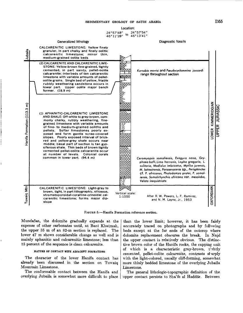
SEDIMENTARY GEOLOGY OF SAUDI ARABIA D55Location:
2446
'57'48"t0
24°57'54" 46°13'41"
Generalized lithology Diagnostic fossils
CALCARENITIC LIMESTONE: Yellow finely granular, in part chalky and finely oolitic calcarenitic limestone; minor thin, medium-grained oolite beds
(2) CALCARENITE AND CALCARENITIC LIME STONE: Yellow-brown fine-grained, tightly cemented, in part sandy, pellet-oolite calcarenite; interbeds of tan calcarenitic limestone with variable amounts of pellet- oolite grains. Single bed of yellow, friable rubbly weathering sandstone occurs in lower part. Upper oolite major bench former. (18.9 m)
(1) APHANITIC-CALCARENITIC LIMESTONE AND SHALE: Off-white to gray-brown, com monly chalky, rubbly weathering, fine grained limestone with variable amounts of fine- to medium-grained ooliths and pellets. Softer limestones poorly ex posed and form gentle scree-covered slopes. Poorly exposed interval of brick- red and yellow-gray shale occurs near middle; basal part of section is tan gyp- siferous shale. Thin beds of brown tightly cemented pellet-oolite calcarenite occur at number of levels. Colonial corals common in lower part. (94.4 m)
Kurnubia morrisi and Pseudocyc/ommina /'accord! range throughout section
Ceromyops/s somaliensis, Exogyra ncrncr, Gry- phaea bo/li, Lima harronis, Lopha gregarra, L solitaria, Modiolus imbricafus, Mytilus /urensis, M. laitmairensis, Paracenoceras sp., Perisphinctes Cf. P. africanus, Pho/adomya profei, P. somal iensis, Soma//rhyncru'a afr/cana var. meso/oba, Velata inequistriata
CALCARENITIC LIMESTONE: Light-gray to brown, tight, in part lithographic, siliceous, stromatoporoidal-coralline-crinoidal cal carenitic limestone; forms major dip- slope
Vertical scale: 1:1000 After R. W. Powers, L. F. Ramirez,
and N. M. Layne, Jr., 1953
FIGURE 5. Hanifa Formation reference section.
Mundafan, the dolomite gradually expands at the expense of other carbonates until, at Ban! Kha^mah, the upper 35 m of an 82-m section is replaced. The lower 47 m shows considerable change as well and is mainly aphanitic and calcarenitic limestone; less than 15 percent of the sequence is clean calcarenite.
NATURE OF CONTACT WITH ADJACENT FORMATIONS
The character of the lower Hanifa contact has already been discussed in the section on Tmvaiq Mountain Limestone.
The conformable contact between the Hanifa and overlying Jubaila is somewhat more difficult to place
than the lower limit; however, it has been fairly accurately traced on photographs and by following beds except at the far ends of the outcrop where dolomite replacement obscures the break. In Najd the upper contact is relatively obvious. The distinc tive brown color of the Hanifa rocks, the capping unit of which is a characteristic gray-brown, tf?htly cemented, pellet-oolite calcarenite, contrasts sharply with the light-colored, usually cliff-forming, somewhat more thinly bedded limestone of the overlying Jubaila Limestone.
The general lithologic-topographic definition of the upper contact persists to Sha'lb al Haddar. Between
D56 GEOLOGY OF THE ARABIAN PENINSULA
Al Haddar and Wadi ad Dawasir, a major lens of marine sandstone appears in the lower part of the Jubaila. Consequently, in this area the contact is sharply marked by a change from gray-brown, pellet- oolite calcarenite below to brown, medium-grained, moderately cemented, fossiliferous, calcareous quartz sandstone above. South of Wadi ad Dawasir, the contact is once again pellet-oolite calcarenite overlain by muddy limestone of the Jubaila. This lithologic sequence gives way from Khashm al Fara'id southward where dolomite replaces both upper Hanifa and lower Jubaila strata and the contact can only be approx imately placed by continuous bed traces.
Presumably, the Hanifa is terminated on the north by pre-Wasia erosion, although the actual line of cutting is masked by the Nafud ath Thuwayrat.
PALEONTOLOGY AND AGE
Both Kurnubia morrisi Redmond (Redmond, 1964a) and Pseudocydammina, jaccardi (Schrodt) (=Pseudo- cydammina sequana of authors) range throughout the Hanifa Formation and into the lower part of the over lying Jubaila Limestone. The biozone of Pseudocy- cyclammina jaccardi has been established by Maync (1960) as upper Oxfordian through lower Kimmerid- gian. At first glance this would appear to fit well with Arkell's lower Kimmeridgian determination for am monites in the lower part of the Jubaila outcrop and with Hudson and Chatton's (1959) assignment of their Musandam Limestone group f beds (which they con sider equivalent to the Hanifa Formation) to the lower part of the upper Oxfordian.
Although there does not seem to be any reason for challenging Hudson and Chatton's correlation (1959) of the group f beds with the Hanifa Formation, there is some reason to reexamine the evidence which led them to assign the group f beds to the Oxfordian. As noted by Hudson and Chatton, the evidence for this age assignment was entirely indirect; it was based upon a supposed occurrence of Kurnubia wettingsi (Henson) in the group f beds and a consequent correla tion with Kurnubia weWmpsi-bearing beds of known Oxfordian age in the Kurnub anticline.
Hudson and Chatton also list Pseudocydammina jaccardi (as Pseudocydammina sequana ) from the group f beds. Inasmuch as the ranges of Pseudo cydammina jaccardi and Kurnubia wettingsi do not overlap each other in the Saudi Arabian section, the former occurring no lower than the base of the Hanifa Formation and the latter occurring no higher than the top of the Tuwaiq Mountain Limestone, the identity of the supposed Kurnubia wettingsi in the group f beds becomes somewhat suspect. In this respect it may be pointed out that transverse sections of Kurnubia
morrisi closely resemble similarly oriented sections of Kurnubia wellingsi, and since Kurnubia morrisi and Pseudocydammina jaccardi occur together in the Saudi Arabian section, there is a strong possibility that they do so also in the group f beds and that the reported Kurnubia wellingsi occurrences in reality represent Kurnubia morrisi.
This situation would remove the necessity for placing the Hanifa Formation within the Oxfordian and open the way for a different correlation derived from deep- well information.
Recent work has demonstrated the presence of both lower Jubaila and upper Hanifa beds at FadhiP field. These are underlain in turn by a series of black shales and black impure limestones which carry an ammonite fauna unanimously identified as lower Kimmeridgian by W. J. Arkell, R. W. Imlay, and Mueller (ratten commun. in 1951, 1961, and 1960, respectively). There appears to be no question that the black shale and limestone unit represents a facies variant from the normal lower Hanifa lithology and that much if not all of the Hanifa Formation must be placed within the lower Kimmeridgian.
A comprehensive faunal list for the Hanifa Formation includes:Brachiopoda:
"Rhynchonella" sp.Somalirhynchia bihenensis Muir-Wood
africana Weir var. mesoloba Muir-Wood"Terebratula" spp.
Coelenterata:Milleporidium sp.
Echinodennata:Acrosaleniat smelliei CurrieGoniopygus? sp.Recrosaleniat sp.
Foraminifera:Arenobulimina sp.Cyclammina spp."Haplophragmoides" sp.Trochammina sp.Pseudocydammina jaccardi (Schrodt)Kurnubia morrisi Redmond
Mollusca:Aequipecten macfadyeni Cox"Area" sp.Ampullella sp.Ceratomya spp.
cf. C. telluris (Lamark) CoxCeromyopsis somaliensis Weir
spp.Chlamys macfadyeni CoxCosmoserist sp.Diplodontat sp.Discohelix sp.Exogyra nana (Sowerby)Globularia hemisphaerical RoemerGryphaea batti (Stefanini)Homomya sp.
SEDIMENTARY GEOLOGY OF SAUDI ARABIA D57
Latomeandra sp.Lima harronis DacqueLopha solitaria (3. de C. Sowerby)
gregaria (Sowerby) Meandrarea somalica! Thomas Mactromya aequalis Agassiz
sp.Modiolus imbricatus (Sowerby) Mytilus jurensis Roemer
somaliensis Coxspp.
Nerinea spp. Ostrea sp. Paracenoceras sp. Pholadomya protei (Brongniart)
sp.Pleurotomaria? sp. Pteropema sp.Stylina? cf. macfadyeni Thomas Stylosmilia sp. Velata inequistriata (d'Orbigny)
ECONOMIC .ASPECTS
GROUND WATER
Shallow, hand-dug wells occur sporadically through out the Hanifa outcrop belt. For the most part, these wells produce from surficial alluvial deposits, but, in some instances, near-surface permeability caused by weathering has permitted the storage and production of meteoric water.
PETROLEUM
The upper 200 to 300 ft of the Hanifa Formation contains commercial quantities of oil at Abqaiq, Abu Hadriya, Khurais, and Khursaniyah. In each locality, the reservoir is porous calcarenitic limestone and calcarenite. Originally referred to as the "mid-Jubaila zone," the productive interval has now been identified as uppermost Hanifa.
JUBAILA UMESTONE UPPER JURASSIC
DEFINITION
The Jubaila Limestone derives its name from the town of Al Jubaylah (lat 24°53 / N.) near the type locality.
Steineke in 1937 proposed the name to cover the relatively resistant limestone between the softer beds of the Hanifa Formation below and the lower Kiyadh Formation (obsolete) above. He designated the Jubaila as a member of the Tuwaiq Formation of Burchfiel and Hoover. In 1945, Bramkamp advanced the rank of the Jubaila and Tuwaiq to formation and group respectively. Names of many of the Arabian rock units, including the Jubaila, were first published in 1952 (Steineke and Bramkamp, 1952a). At this time, the term Tuwaiq Group was dropped from the nomen clature. Particulars of the type section appeared almost immediately thereafter (Steineke and Bram
kamp, 1952b). They were again published without significant change by Steineke, Bramkamp, and Sender (1958).
The lower part of the type section (about 85 m) was measured along Wadi IJanlfah from lat 24°53 /48// N., long 46°19 /36" E. to lat 24°53/ 12// N., long 4C>°26 / 42" E., a point near the town of Al Jubaylah. The upper 25 m was studied in Wadi IJanlfah between Al Jubaylah and Kiyadh.
At the type locality the base of the Jubaila is placed at the level where cream to tan, dense limestone gives way downward to the gray-brown pellet-oolite calcar enite of the underlying Hanifa Formation. The top is at the change from brown, ledge-forming limestone below to gray, softer, rubbly-weathering dolomite and limestone of the Arab Formation above.
OCCURRENCE AND THICKNESS
The Jubaila Limestone conforms perfectly to the outcrop pattern of older Jurassic units; that r>, it forms a gently curving arc wrapped around the central Arabian arch, reversing itself south of Wadi ad Dawasir to define the southwest margin of the Hub' al Fhall basin. Kocks of the Jubaila have been mapped over a distance of nearly 1,100 km from Al Muntatib (lat 17°41' N.) to Nafud ath Thuwayrat (lat 26°27' N.). South of Wadi al Faw (lat 19°57/ N.), the Jubaila forms a series of patches isolated by tongues of sand encroach ing from the Hub' al Khali; northward, exposures are almost continuous, although sharply interrupted where the Nisab, Awsat, and Majma* ah grabens cut through.
Width of the Jubaila outcrop belt varies from a few kilometers at each end to more than 40 km in the central area. Changes in width away from the central area are irregular but nonetheless show unmistakable tapering overall.
The Jubaila Limestone, an extremely resistant lime stone sandwiched between two softer units, typically weathers to a series of high, talus-free steps. Lower beds form a prominent scarp, often more than 75 m high, capping the Hanifa. The upper Jubaila breaks away to a gently eastward-tilted plateau which is a slightly beveled upland surface rather than a true dip slope. Consequently, the western margin of the for mation is a sharp scarp; the eastern boundary is less regularly defined by patches of the Arab Formation erratically scattered on the strong Jubaila slope.
A short distance north of the type locality, the strong western scarp and high relief is somewhat modified as the Jubaila breaks down into two or three Icwer benches. The highest of these has an elevation of 31 m at Wadi al 'Atk. From here, relief within the forma tion diminishes gradually to the northwest. In the south, the Jubaila forms low benches with intervening
D58 GEOLOGY OF THE ARABIAN PENINSULA
wide, slightly eastward-dipping slopes. Scarps are relatively subdued, usually less than 5 m high, although a fairly bold escarpment occurs at Wadi ad Dawasir (that is, Khashm ash Shidad, lat 20°26 / N.).
The Jubaila Limestone shows some more drastic variations in thickness than other Jurassic units. Maximum thickness of 130 to 145 m occurs in the Sha'Ib al Haddar-Wadi ad Dawasir area; about 85 and 55 m were recorded respectively at Wadi al Faw and in a bore hole at lat 18°08' N., long 46°05' E. North of Sha'Ib al Haddar the Jubaila thins to about 90 m at Wadi Birk, expands to nearly 130 m at Wadi Nisafr and Riyadh, and then gradually reduces to 110 m at Jabal al Abakkayn (lat 24 °58' N.) and 72 m at Wadi ljuraymila (lat 25°07' N.). Partial sections measured beyond this point indicate only slight depositional thin ning to the northwest; however, in the vicinity of Al Majma'ah (lat 25°55' N.), pre-Wasia truncation comes into play and upper layers of the Jubaila are planed off. The northernmost measurement near Al Ghat (lat 26 °02 / N.) shows but 40 m of section between the presumed top of the Hanifa and the Wasia Formation (Middle Cretaceous).
LITHOLOGIC CEARACTEB
The Jubaila Limestone, like the underlying Tuwaiq Mountain and Hanifa Formations, is basically a shallow- water carbonate unit. Though it is mostly aphanitic and calcarenitic limestone, some highly persistent layers of clean-washed lime sand (calcarenite) are present, particularly in the central and northern areas. Corals and stromatoporoids, few in the Riyadh-£)unna area, become abundant to the north and south. Marked lateral changes in the Jubaila to the south consist of a sudden shift from limestone to dolomite in the upper part of the formation and limestone to sandstone and back to limestone again in the lower part. Similar, but less abrupt, limestone transition to dolomite and sandstone also takes place to the north.
Jubaila lithology shows relatively little change from Sha'ib al Haddar nearly to ljuraymila. Over this 370- km distance, the Jubaila is well exposed in many areas, but one of the most accessible and best sections is that at Wadi Nisafr, herewith designated as a reference section (fig. 6) to supplement less detailed work at the type locality. The whole sequence, however, was not measured at a single locality but must be pieced to gether from three sections. The lower 21.5 m was described (at lat 24°13/22 // N., long 46°41'55" E.) by E. L. Berg and R. L. Myers in 1945, the middle 30.8 m was covered (at lat 24°14'55" N., long 46°44'39// E.) by R. A. Bramkamp and S. B. Henry in 1948, and the upper 68.5 m was measured (at lat 24°13"24// N., long 46°48'59" E.) by R. W. Powers and H. A. MoClure in
1961. A complete description of the Jubaila sequence in Wadi Nisafr is given in section 38 (p. 134).
Significant changes in Jubaila lithology north of the reference section first appear in the vicinity of Wadi IJuraymila (lat 25°07 / N.). At this latitude, the upper part of the formation is mostly replaced by dolomite, and some clean sandstone occurs near the middle. In 1952, R. A. Bramkamp and S. J. Roach measured the Jubaila in the wadl; their description is summarized in section 39 (p. 134).
Little additional change takes place between Wadi Uuraymila and Wadi al 'Atk, but beyond there is a decided increase in sandstone; dolomite makes- up the remainder of the sequence. About 50 m of Jubaila is present a few kilometers south of Al Ghat. The lower one-third and a capping 5- to 10-m bed consists of reddish-brown dolomite; the rest of the section is mainly tan to brown, coarse-grained, calcareous cemented sandstone.
South x)f the reference locality, the first notable change in Jubaila rocks takes place near Sha'ib al Haddar. The shift can first be seen just north of the sha'ib where a few sandstone interbeds are present near the middle of the formation. South of the sha'ib, near lat 21 "50' N., sandstone dominates the lower part of the Jubaila; the upper one-half is partly replaced by thick- bedded dolomite. Almost complete dolomite replace ment of the upper limestone of the Jubaila occurs in the vicinity of Wadi ash Shutbah (lat 21°30/ N.). The lithologic pattern of dolomite above and sandstone below, that persists for at least 150 km, may be charac terized by a section measured along lat 20°37/ N. The sequence here is summarized in section 40 (p. 135).
The dolomite-sandstone facies can be traced without interruption beyond Wadi ad Dawasir, but near Al 5asl (lat 20 "OS' N.) all sandstone is abruptly replaced by aphanitic limestone. From this point to where the Jubaila disappears under the Rub' al Khali sard, dolo mite and aphanitic limestone are the only rock types. Dolomite does shift stratigraphically downward along strike, however, replacing the upper Jubaila in the north and the lower part of the sequence in th°- south.
NATURE OF CONTACT WITH ADJACENT FORUATIONf
Characteristics of the conformable contact between the Jubaila Limestone and the underlying Hanifa Formation have been described in connection with the Hanifa.
The upper limit of the Jubaila is a sharp lithologic and topographic boundary. A pattern which maintains itself for more than 700 km starts at the base with a thin calcarenite (unit 3, fig. 6) overlain by 6 to 10 m of gray, tight, chippy-weathering aphanitic limestone
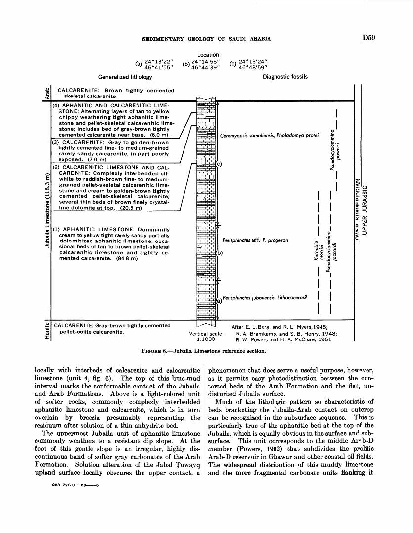
SEDIMENTARY GEOLOGY OF SAUDI ARABIA D59
/a x 24°13'22" l°' 46°41'55"
Generalized lithology
CALCARENITE: Brown tightly cemented skeletal calcarenite
(b)
Location: 24°14'55" 46°44'39"
24°13'24' 46°48'59'
Diagnostic fossils
(4) APHANITIC AND CALCARENITIC LIME STONE: Alternating layers of tan to yellow chippy weathering tight aphanitic lime stone and pellet-skeletal calcarenitic lime stone; includes bed of gray-brown tightly cemented calcarenite near base. (6.0 m)
(3) CALCARENITE: Gray to golden-brown tightly cemented fine- to medium-grained rarely sandy calcarenite; in part poorly exposed. (7.0 m)
(2) CALCARENITIC LIMESTONE AND CAL CARENITE: Complexly interbedded off- white to reddish-brown fine- to medium- grained pellet-skeletal calcarenitic lime stone and cream to golden-brown tightly cemented pellet-skeletal calcarenite; several thin beds of brown finely crystal- line dolomite at top. (20.5 m)_______
(1) APHANITIC LIMESTONE: Dominantly cream to yellow tight rarely sandy partially dolomitized aphanitic limestone; occa sional beds of tan to brown pellet-skeletal calcarenitic limestone and tightly ce mented calcarenite. (84.8 m)
Ceromyopsis somaliensis, Pholadomya protei
c)
Perisphinctes aff. P. progeron 015'
E '
I I I I I I
.Perisphinctes /ubai/ensis, Lifhacoceras?
Q < U CC
1=
CALCARENITE: Gray-brown tightly cemented pellet-oolite calcarenite.
After E. L Berg, and R. L. Myers,1945; Vertical scale: R. A. Bramkamp, and S. B. Henry, 1948;
1:1000 R. w. Powers and H. A. McClure, 1961
FIGURE 6. Jubaila Limestone reference section.
locally with interbeds of calcarenite and calcarenitic limestone (unit 4, fig. 6). The top of this lime-mud interval marks the conformable contact of the Jubaila and Arab Formations. Above is a light-colored unit of softer rocks, commonly complexly interbedded aphanitic limestone and calcarenite, which is in turn overlain by breccia presumably representing the residuum after solution of a thin anhydrite bed.
The uppermost Jubaila unit of aphanitic limestone commonly weathers to a resistant dip slope. At the foot of this gentle slope is an irregular, highly dis continuous band of softer gray carbonates of the Arab Formation. Solution alteration of the Jabal TuwaV(l upland surface locally obscures the upper contact, a
phenomenon that does serve a useful purpose, however, as it permits easy photodistinction between the con torted beds of the Arab Formation and the flat, un disturbed Jubaila surface.
Much of the lithologic pattern so characteristic of beds bracketing the Jubaila-Arab contact on outcrop can be recognized in the subsurface sequence. This is particularly true of the aphanitic bed at the top of the Jubaila, which is equally obvious in the surface and sub surface. This unit corresponds to the middle Ar^b-D member (Powers, 1962) that subdivides the prolific Arab-D reservoir in Ghawar and other coastal oil fields. The widespread distribution of this muddy limestone and the more fragmental carbonate units flanking it
228-776 O 66
D60 GEOLOGY OF THE ARABIAN PENINSULA
attest to changes that must have influenced sedimen tation over much of the basin so far studied.
PALEONTOLOGY AND AGE
Arkell (1952) places the Jubaila Limestone in the lower Kimmeridgian on the basis of the perisphinctid ammonites Perisphinctes jubailensis Arkell and Peri sphinctes aff. P. progeron von Ammon.
Kumubia morrisi Redmond and Pseudocyclammina jaccardi (Schrodt) occur at the same level as the am monites. The presence of Pseudocyclammina jaccardi fits in well with Arkell's determination since this fo- raminifer is known to range from the upper Oxfordian into the lower Kimmeridgian.
Pseudocyclammina powersi Redmond occurs in the upper part of the formation, above the range of Pseudo cyclammina jaccardi. The beds carrying Pseudocyclam mina powersi likewise fall within the lower Kimmer idgian, if Hudson and Chatton (1959) are correct in equating the stratigraphically higher group g Ashab limestone with the Cidaris glandarius beds of the Lebanon and Kurnub areas.
A comprehensive fossil list of Jubaila includes: Mil- leporidium, indeterminate colonial coral, Kurnubia spp., Kurnubia morrisi Redmond, Pseudocyclammina powersi Redmond, Pseudocyclammina jaccardi (Schrodt), Am- puUeUat sp., Avicula sp., Brachidontes sp., Ceratomya spp., Ceromyopsis somaliensis Weir, Ceromyopsis sp., Globularia hemisphaerica Roemer, Gryphaea ballif (Stefanini), Lithacocerasf sp., Lucina sp., Mytilus (Arcomytilus) laitmairensis de Loriol, Nautilus? sp., Nerinea sp., Parattelodon? sp., Perisphinctes jubailensis Arkell, Perisphinctes aff. P. progeron von Ammon, Pholadomya spp., Terebratula spp., and indeterminate ostreids.
ECONOMIC ASPECTS
GROUND WATER
A number of drilled wells in and near the capital city of Riyadh have penetrated the Jubaila Limestone. Several of these produce from thick Triassic sand, others derive water from channel fill; the amount actually obtained from the Jubaila is unknown.
For many years Riyadh obtained its water from the channel gravels in Wadi Hanlfah. This source has now been supplemented by shallow wells in Wadi Nisafr and other nearby channels and deep drilling near the city itself. Limited data indicate that hand-dug wells in the vicinity of Riyadh are bottomed both in the Arab and Jubaila Formations. These two units are relatively tight here, but weathering extends to a considerable depth and jointing is fairly well developed. Ap parently, Jubaila water is mainly derived from openings resulting from weathering and jointing, rather than from porosity inherent in the rocks themselves.
PETROLEUM
Porous beds within the upper part of the Jubaila Limestone contain prolific amounts of oil in eight widely scattered fields Dammam, Abqaiq, Ghawar, Qatif Abu §a'fah, Khursaniyah, Fadhili, and Khurais. Stratigraphically, the top of the Jubaila falls near the middle of the well-known Arab-D reservoir.
Areas of maximum oil accumulation and highest pro ductivity correspond rather closely to areas of maximum calcarenite deposition. Pores, now oil filled, are essen tially those formed between lime sand grains at tl ^ time of deposition and have since undergone little modifica tion. Little or no pore space is contributed to the Jubaila part of the reservoir by dolomite.
ARAB FORMATION UPPER JURASSIC
DEFINITION
Lack of suitable exposures precluded choice of a sur face type locality and the coupling of a geographic name to the economically important rock sequence that has come to be known by the general term Arab Formation.
Beds now assigned to the Arab were originally in 1937 included by Max Steineke as part of the Riyadh Member, the uppermost member of the Tuwain For mation. In 1938, R. A. Bramkamp and T. C. Barger studied the upper part of the Riyadh Formation and defined members within it. From bottom to top these were lower Riyadh (now Arab) Formation, Hith Anhy drite, Sulaiy Limestone, and Yamama detrital member.
The finding of presumed Lower Cretaceous (Neoco- mian) fossils in the Sulaiy led Steineke in 1940 to re strict the Riyadh Formation to include only the lower Riyadh formation and Hith Anhydrite and throw the Sulaiy and Yamama members into a new formation the Thamama shown to be at least mainly of Lower Cretaceous age. In 1945, Bramkamp raised the P.iyadh to group and its members to formation; that is. Arab and Hith Formations.
Formal publication of most names of Arabian rock units came in 1952b (Steineke and Bramkamp). This paper substituted the term Arab Formation for lower Riyadh Formation (obsolete), but retained the P.iyadh Group. Later this too was dropped (Steinel'e and others, 1958), and Arabian stratigraphic nomenclature assumed its present form.
At first the type locality of the Arab Formation was taken as a general area around the city of Riyadb. Ex tensive loss of beds and subsequent slumping along the entire outcrop prevented accurate measurement of sec tion, however, and forced selection of a subsurface se quence to best represent the unit. Detailed correla tions, carried east from the outcrop, have defined the limits of the Arab Formation in coastal wells. These limits are probably accurate within a few meterr
SEDIMENTARY GEOLOGY OF SAUDI ARABIA D61
Because of excellent sample and core coverage, the interval from 1,371.6 to 1,499.1 m depth in Dammam well 7 (lat 26°19'04" N., long 50°07'38" E.) was chosen as the type section. The base of the Arab Formation is at the contact of clean-washed calcarenite with the tighter, more muddy rocks of the underlying Jubaila. The top of the formation falls at the change from tan aphanitic limestone below to massive anhydrite of the Hith above.
Subdivision of Arab rocks on outcrop is impossible, but in the subsurface alternating carbonate and anhydrite very naturally separate the formation into lithologically and economically significant members. In the subsurface the Arab consists of four normal marine carbonate units, each separated by thin, laterally persistent beds of anhydrite. Earlier publi cations (Steineke and others, 1958; Powers, 1962) informally designated the carbonate units from top to bottom as the A, B, C, and D members of the Arab Formation; the anhydrite separators were unnamed. Since the carbonates, together with their overlying anhydrite, represent four main cycles of deposition and each of these cycles approximates a time-strati- graphic unit, it now seems logical to redefine the lower three members to include their anhydrite caps (fig. 7). The much thicker upper or closing anhydrite unit (500 ft in Ghawar) is still considered a separate formation the Hith Anhydrite.
Dammam well 7 is herewith designated as the type locality for the four members of the Arab Formation The A Member, between 1,371.6 and 1,388.4 m depth; the B Member, between 1,388.4 and 1,399.1 m depth; the C Member, between 1,399.1 and 1,440.6 m depth; and the D Member, from 1,440.6 to 1,499.1 m depth. In each instance, the contact between members is marked by change from carbonate to evaporite.
OCCURRENCE AND THICKNESS
Rocks of the Arab Formation form a thin, essentially unbroken belt from Al IJasi (lat 20°08 / N.) to Juwayy (lat 25°49' N.), a distance of nearly 700 km. Width of the outcrop over this distance is relatively uniform, averaging about 10 km.
The area of Arab exposure is mainly a broad, gently undulating plain. A few low, isolated hills ("haystack jibal") stand above the general ground level. Effects of slumping are everywhere evident a phenomenon that can be readily attributed to the removal of anhy drite beds and the subsequent collapse of the carbonate units left behind.
No satisfactory estimate of the total thickness of the Arab has been made because of the complex slumping. Only the basal 15 to 25 m has been meas ured with any assurance, and even this interval con
tains a persistent brecciated zone that suggests some loss of section due to anhydrite solution.
Between the Jubaila near Riyadh and the Hit escarpment, east of which slumping dies out, it is estimated that roughly 150 m of beds should be present. A similar estimate between Dabl Hit (lat 24°2S'18" N., long 47°00'06" E.) and Al IJa'ir (lat 24°23' N.) to the west would suggest about 100 m. Obviously these estimates are of limited value, but they do serve to indicate that the Arab in this area originally H.d a thickness approximating that in coastal Arabia.
UTHOIOGIC CHARACTER
Lack of good Arab exposures, except for the lower 15- to 25-m interval, has prevented working out a precise lithologic sequence. The little that is known o* the basic rock types indicates they are similar to those found in wells to the east. As a result, most informa tion on the Arab has been obtained from bore 1 oles. In fact, subsurface units, probably not differing greatly from the original outcrop sequence, have been tak^n as the type and reference sections.
The description of the A, B, and C Members of the Arab and the capping anhydrite of the D member in Dammam well 7 by R. A. Bramkamp and H. A. Kimball in 1955 is still the best account of the stratigraphic interval. Considerable new information has-been ob tained on the D Member carbonate through thin-se".tion analysis (Powers, 1962). Consequently, the better understood sequence in Abqaiq well 71 (lat 26°lg'28" N., long 49°45'45" E.) between a depth of 2,223.C and 2,260.0 m is herewith designated as a reference section for this unit. A detailed description of the Arab For mation type-reference section is given in section 41 (p. 135).
Thicknesses of individual members change little from the coastal area toward outcrop. Each anhydrite bed does, however, thicken considerably, a change compen sated for by thinning of the underlying carbonate unit. There is little doubt that, to the west, carbonate beds are progressively replaced from the top down by facies change to anhydrite. In fact, regional lithofacies studies show that maximum evaporite development, presumably mainly or entirely anhydrite, occurred rlong a north-south line near the longitude of Riyadh, \rhere the amount of carbonate rocks remaining in the solution- collapse zone is small and the interval was apparently mostly soluble anhydrite.
Steineke, Bramkamp, and Sander (1958), in their concise description of Arab outcrop characteristics, point out thatonly a basal unit of carbonate rocks 15-25 meters thick regains, and even within this, along nearly the entire length of its outcrop, a persistent brecciated zone suggests that at least one thin,
D62 GEOLOGY OF THE ARABIAN PENINSULA
A. B.Type Section Reference section
Dammam well 7 Abqaiq well 71 Location:
26° 19'04"-50°07'38" 26° 18'28"-49°45'45"
Generalized lithology Diagnostic fossils
ANHYDRITE: White massive anhydrite
E q *tCVJ
2«j <
APHANITIC LIMESTONE: Tan to brown compact aphanitic limestone; thin inter- beds of brown calcarenite; minor anhydrite near top. (16.8 m)______________
(2) ANHYDRITE: White, massive anhydrite; thin interbeds of tan partly dolomitized aphanitic limestone. (4.6 m)________
(1) APHANJTIC LIMESTONE: Tan compact aphanitic limestone; thin interbeds of brown medium-grained calcarenite.
(6.1 m)_______________________(2) ANHYDRITE: White to tan massive
anhydrite; minor streaks of brown dolo mite and limestone. (12.8 m)_______
(1) CALCARENITE: Tan to brown generally fine-grained moderately to strongly cemented partially dolomitized calcar enite; some anhydrite blebs. Rare thin beds of tan partially dolomitized aphanitic and calcarenitic limestone. (28.7 m)
(2) ANHYDRITE AND DOLOMITE: White massive anhydrite complexly interbedded with dark-brown finely crystalline dolo mite with relic clastic texture and strongly dolomitized calcarenite. (18.0 m)
(1) CALCARENITIC LIMESTONE, CALCAR ENITE, AND DOLOMITE: Complexly inter- bedded gray-brown to brown tight to moderately porous dominantly algal debris-pellet calcarenitic limestone and brown weakly cemented fine-grained to gravel-size clean-washed well-rounded to angular mainly algal debris-pellet cal carenite. Occasional thin beds of brown weakly cemented gravel-size, "algal" nodule-stromatoporoid coarse carbonate (calcirudite). Sand-and-gravel-size grains are mainly aggregate pellets, algal debris, stromatoporoid fragments, "algal" nod ules, "fecal" pellets, and Foraminifera; very rare ooliths occur near top. Brown moderately porous to tight, finely crystal line dolomite is present in upper part and near base. Some thin stringers of brown tight partially dolomitized aphanitic lime stone occur mostly in upper part. (37.0 m)
7T.T
r, i
oi o
cr
o:UJ Q_ Q_
C/ype/ncr jurassica, C cf. hanabatensis, Cy/indro- porella arabica, Polygonella incrustata, Kurnubia Spp., Naufiloculma Spp.
Vertical scale 1:1000
ccUJ
CC UJ
I
LIMESTONE: Brown fine-grained compact limestone, finely detrital and oolitic at top
(After R. A. Bramkamp andH. A. Kimball,(l955)
After R. W. Powers, 1960
FIGURE 7. Arab Formation type and reference sections.
SEDIMENTARY GEOLOGY OF SAUDI ARABIA D63
highly persistent evaporite layer was included * * * Above the basal carbonate unit, little is known of the true rock sequence as good exposures are few and fragmentary because extensive solution-collapse phenomena have almost entirely eliminated outcrops of the anhydrite. * * * Dropped masses of the younger Cretaceous rocks occupy the eastern part of the solution-collapse zone, and dolomite and other carbonate rocks representing thin carbonate members, possibly equivalent to the "A," "B," or "C members" of the Arab of the Eastern Province, show at the surface in the western part.
The basal unit of carbonate rocks referred to by Steineke, Bramkamp, and Sander (1958) has been measured and studied at several localities between Al IJasi (lat 20°08/ N.) and Wadi al 'Atk (near 25°30/ N.). Over this entire distance there is little major variation in lithologic content except for increased dolomitization in the north and south. A section measured at Wadi Nisak is characteristic of the interval. The lithologic sequence here is summarized in section 42 (p. 139).
There is every reason to believe that the basal Arab carbonate unit described above is equivalent to the lower part of the type D Member at Dammam; it may well represent the total D Member not replaced by anhydrite in wells as far west as Khurais and Ma' qala'.
Only at the southern end of the solution-collapse zone have beds been found in place above the basal unit. Between Sha'ib al Haddar and Al Ijjasi, outcrops of anhydrite rest directly on the laterally persistent calcarenite that marks the top of the basal sequence. These overlying beds have an average thickness of about 14 and are mainly white anhydrite and gypsum with thin interbeds and caps of brown dolomite. Little is known of the Arab sequence on outcrops above this stratigraphic level.
NATURE OF CONTACT WITH ADJACENT FORMATIONS
Characteristics of the Jubaila-Arab contact have already been described in connection with the Jubaila Limestone. The upper contact with the Hith An hydrite is exposed only at a single locality that is, in Datil Hit (lat 24°29/ 18// N., long 47°00'06" E.), a solution cavity at the foot of the Hit escarpment. The contact here, as in the subsurface sequence, is at the relative sharp break from carbonate of the Arab-A Member below to massive, white, and blue-gray anhy drite of the Hith above.
Where Hith Anhydrite is preserved, as in Dafrl Hit, the upper Arab contact is conformable. At all other places along outcrop, however, evaporates of the Arab- Hith sequence have been dissolved, presumably bring ing residual Arab carbonate rocks into contact with slumped limestone of the Sulaiy Formation. As very thin stringers of limestone occur locally within the Hith, it is possible that some of these are present but
are as yet unrecognized on outcrop. It is urUkely, however, that any great thickness is involved. The problem is further complicated by the probable occur rence of Sulaiy rocks that dropped down and admixed with the older rocks.
Because of these complications, the surface juncture between the Arab-Hith sequence and the Sulaiy rocks cannot be precisely defined. The contact shewn on the various geologic maps is only approximate.
Somewhere in the vicinity of Wadi al 'Atk, the upper surface of the Arab Formation intersects the pre- Wasia erosion surface. Although this unconfo~mable contact cannot be traced northward, it is reasonable to assume that the Arab is progressively truncated and finally overlapped completely near Al Majma'ah (lat25°55/ N.).
PALEONTOLOGY AND AGE
The rather limited fauna so far recorded from surface exposures of the Arab Formation has not proved diagnostic. Except for Diceras, identifiable forms range down into the Jubaila below. Consequently, the subsurface sequence provides the only means of dating Arab rocks.
Kurnubia spp. Nautiloculina, spp., Clypeina juras- sica Farre, C. cf. hanabatensis Yabe and Toyama, Oylindroporella ardbica Elliott, Polygonetta incrustata Elliott and Salpingoporetta sp. range throughout the Arab-D Member (Powers, 1962). Although some elements of this assemblage extend on into the A Member, it is only the beds of the D Member that have been reliably dated. These can be equated to at least part of Hudson and Chatton's (1959) group g beds through the No. 4 Limestone of Dukhan oil field in Qatar, the direct equivalent of the D Menrber of Saudi Arabia.
Hudson and Chatton (1959) also list Calpionetta alpina Renz, Pseudocyclammina sp., and Buryurdier steinerae Hudson from group g and equivalent beds. By comparison with the Alam Abyadh limestones of southwestern Arabia, ddaris glandarius beds of the Lebanon and Kurnub, and with other formation, they conclude that the faunas are Sequanian (early Kim- meridgian) in age, a dating compatible with other lines of evidence.
The post-D Member of the Arab Formation and the Hith Anhydrite have not yet been dated. However, as these beds occur between known lower Kimmerid- gian and presumed Berriasian (Lower Cretaceous), it may be assumed that they are, at least in part, Tithonian.
ECONOMIC ASPECTS
GROUND WATER
Many of the wells around Riyadh derive water from rocks of the Jubaila and Arab Formations, but present
D64 GEOLOGY OF THE ARABIAN PENINSULA
data are too sparse to estimate the importance of one unit relative to the other. The general character of the Jubaila-Arab aquifer near the capital city is described more fully in connection with economic aspects of the Jubaila Limestone.
Agricultural development of the Al Kharj area, around the towns of As Sulaymaniyah and Al Yama- mah, has largely been supported by water derived from the Arab Formation. Earlier cultivation of this valley was apparently dependent on Quaternary aquifers. Three large solution pits Sampan (lat 24°07/ N., long 47°16' E.), 'Ayn ad DiT (lat 24°07' N., long 47°16' E.), and Umm Khlsah (lat 24°07' N., long 47°15' E.) supply great quantities of water for the Al Kharj project. Sampan and 'Ayn ad Dil* have furnished most of the water in the past and will probably continue to do so. These two sinkholes, with nearly vertical sides, are situated at the toe of the low Hit escarpment. Their depth and diameter, which are essentially the same, are slightly more than 100 m. The origin of Umm Khlsah is no doubt similar to the other solution cavities, although its margins are less abrupt and con siderable vegetation has succeeded in getting a foothold on its banks.
Geologically, the origin of these pits is relatively simple. They occur at the toe of a badly slumped escarpment which involves mainly Sulaiy rocks but which at places also involves the lowest beds of the Yamama Formation. The slumping is reasonably regular with rocks draped down over the face of the scarp and increasing in dip to the base of the slope. On the plateau surface above, and very near the hinge line, prominent tensional cracks, some still open as far down as 10 m, indicate the mechanism by which Sulaiy beds have adjusted to the slumping. At the base of the scarp, as well as in the walls of the pits themselves, the beds are badly jumbled and brecciated. There is little doubt that the slumping has resulted from solution of supporting anhydrite layers. The Al Kharj pits fit well into this general picture and represent solution openings which succeeded in stoping their way upward to the surface.
The water-bearing member which feeds the Al Kharj pits cannot be demonstrated conclusively, although it seems likely that it is the Arab Formation. Depth of the Al Kharj pits (about 100 m) is only slightly less than the normal thickness of the Sulaiy in this region, and, as the Hith Anhydrite has been removed, the Arab can logically be considered the aquifer. In addition, there is reason to suspect that considerable filling of the pits with debris has occurred and that the actual source of the water may be somewhat deeper than their present bottoms.
A notable feature of the water is its high saturation
with calcium sulfate, a characteristic entirely consistent with its supposed origin. The chloride content of the water is low. Water levels at Sampan and 'Ayn a$ Pil' rise and fall very nearly together, and it is there fore assumed that fairly efficient interconnection exists between the two pits.
Khafs Daghrah (lat 23°50' N., long 47°12' E.), another solution pit similar to those at Al Kharj, is somewhat smaller. A less extensive agricultural de velopment has been undertaken using water pumped from this sinkhole.
Dabl Hit (lat 24°29.4' N., long 47°00.1 / E.) ir also much like the Al Kharj pits in character and geologic setting except that the elevation is higher and ^ater occurs only in the very bottom. Here again, the Arab Formation is the apparent source as the uppermost beds are exposed in the pit. In 1961 a two-stage pump was installed in the dafrl. The water is now us**d to irrigate the alluvium-covered plain in front of tita Hit escarpment.
Solution pits are also well developed in the vicinity of Layla (near lat 22° 15' N.) in Al Aflaj. For unknown reasons, only limited use has been made of the water. Analysis shows high calcium sulfate and low chloride- ion concentration and, here again, Arab beds are the probable source.
Quantitative estimates of Arab Formation recharge are not available; however, a great drainage area dis charges across its outcrop. Since the latter is of large extent and is characterized by complicated topography there should be ample opportunity for the dowrward percolation of the infrequent flood waters. Large areas of closed drainage in the Arab Formation slump zone also greatly aid water to reach the main underground accumulation. Excluding the water which may be derived from areas west of Jabal fuwayq, the watershed which is on, or must escape across, the outcrop of the Arab is of the order of 20,000 sq km. In view of this, although the amount of water entering the Arab is not known, it can be assumed to be large.
PETBOLBUM
Although all members of the Arab Formation contain oil, accumulation in the upper, thinner A, B, and C carbonates is much less extensive than in the basal D Member carbonate. Oil occurs in the A and B Mem bers of the Arab in Abu Hadriya, Dammam, T^hur- saniyah, Manifa, and Qatif and in minor accumulations in northern Ghawar and Abqaiq. Arab-D Member oil has been found at Abqaiq, Dammam, Fadhili, Gbawar, Khurais, Khursaniyah, Qatif, and Abu §a'fah. In all these fields, the 25- to 40-m-thick D Member as w41 as approximately the upper 45 m of the Jubaila Limestone are oil saturated.
SEDIMENTARY GEOLOGY OF SAUDI ARABIA D65
Sparse information on the upper three Arab carbonate units indicates that the dominant lithology in each is admixed calcarenite and aphanitic limestone. The C Member, however, appears to have a much higher con centration of clean-washed calcarenite in comparison with the more muddy, often dolomitic rocks of the over lying A and B units. Arab-D rocks are characterized by a high percentage of lime sand, commonly skeletal and commonly in the form of massive clean-washed calcarenite beds. Calcarenitic limestone is the next most frequent rock type; pure aphanitic limestone and dolomite are quite rare. Reef structures have not yet been found, and the wide continuity, uniform thickness, and regularly bedded nature of the Arab-D suggest that large structures of this type are unlikely.
Specific particle types contributing to rock formation of the Arab-D reservoir include calcareous algae, stro- matoporoids, and Foraminifera as the main skeletal elements and aggregate pellets, "algal" nodules, and "fecal" pellets as the most important nonskeletal grains.
The major oil deposits in the Arab-D accompany maximum development of porous calcarenite. It is certain that intergranular pore space associated with the rocks at the time of deposition almost exclusively controls present distribution of oil. To be sure, dia- genetic changes including recrystallization, dolomiti- zation, and cementation have all modified the original pore pattern to some extent, but, in each case, the effect has not been drastic.
Several of the Arab units also carry oil outside of Saudi Arabia. Most notable among these is the Dukhan oil field in Qatar which produces from lime stones equivalent to the C and D Members.
MTTH ANHYDRITE UPPER JURASSIC
DEFINITION
The Hith Anhydrite is named for Dafcl Hit (lat 24°29'18" N., long 47°00/06" E.), a solution pit in which the type section was measured and which is still the only known outcrop.
Evolution of Hith-Arab nomenclature, from the original concept of Max Steineke in 1937 to its present form, is fully described in the definition of the Arab Formation. Both units followed the same steps from unnamed beds within the much larger Tuwaiq Forma tion to their modern status of separate formations.
An apparently complete Hith sequence is visible in the walls of Dafrl Hit. The section here was origin ally measured by R. A. Bramkamp and T. C. Barger in 1938 and designated the type locality. As defined by Steineke, Bramkamp, and Sander (1958), the Hith is 71.2 m of bluish-gray anhydrite. The top was placed at the contact between this anhydrite and fragmental
limestone presumed to be basal Sulaiy. Ne^ well data show that the fragmental limestone is in fact collapse breccia resulting from loss of relatively thick interbeds of anhydrite. As such, it is properly part of the Hith and is so considered here, raising the total formation thickness to 90.3 m.
The top of the Hith is at the contact (possil^y dis- conformable) of limestone breccia with evenly bedded oolite calcarentie of the overlying Sulaiy Formation. The base is taken at the sharp break from anhydrite above to calcarenitic limestone and dolomite of the Arab Formation below.
OCCURRENCE AND THICKNESS
The only definitely known exposure of the Hith Anhydrite is in Dal^l Hit, a deep, steep-walled, solution cave about 32 km southeast of Riyadh. Patches of gypsum (possibly hydrated anhydrite of the Hith) occur below the Sulaiy in the vicinity of Laj'la (lat 22°17' N.) and can be traced as far as lat 20°45/ N. In addition, about 5 m of primary bedded anhydrite has been reported about 14 km northwest of Qasr Eiman (lat 20°49' N.).
Except for the anhydrite at Dajil Hit, the r.rea on outcrop where the Hith should occur is a rather broad zone of badly slumped beds. The belt of collapsed rocks can be traced over a distance of some 550 l~m and involves mostly Sultiiy strata. Slump effects extend beyond the edge of the Sulaiy, but this is attributed to solution of anhydrite beds within the Arab Formation. Slu'mping in the eastern part of the zone, on th°, other hand, is probably mainly due to the loss of the thicker, more massive anhydrite of the Hith itself.
Undoubtedly, the Hith is present in the subsurface over a considerable north-south distance just a few kilometers east of the solution-collapse zone. Certainly the Hit escarpment, a monoclinal flexure of Sulaiy beds between lat 23°00/ N. and 25°00' N., marks the western edge of undissolved anhydrite. Drilling sup ports this assumption and suggests in addition that Hith beds flanks the solution-collapse zone nearly throughout its length.
At the type locality the Hith Anhydrite is about 90 m thick. Elsewhere, slumping makes accurate meas urement impossible.
LTTHOLOGIC CHARACTER
The Hith, both at Dafcl Hit and in the subeurface, is mainly massive anhydrite. Well sections usually contain some interbedded dolomite and limestor e, par ticularly in the upper part.
R. A. Bramkamp and T. C. Barger in 1938 first described the Dafcl Hit section and recognized it as
D66 GEOLOGY OF THE ARABIAN PENINSULA
the type sequence. The full exposure in the dalpl, as well as in the overlying Sulaiy cliff, was again measured in detail by S. J. Roach in 1952. His description of the succession is given in section 43 (p. 139).
So far as the Hith found in downdip wells is concerned, a generalized section from top to bottom is as follows:Aphanitic limestone and calcarenite of the Sulaiy
Formation (Upper Jurassic? and Lower Cretaceous?). Thickness Hith Anhydrite: (meters)
Anhydrite with associated limestone and dolomite. 6-15 Calcarenite, limestone, and anhydrite.__________ 15- 18Largely massive anhydrite in upper part, anhydrite
interbedded with aphanitic limestone, dolomite or calcarenite in lower part__.________________ 90-120
Total thickness of Hith Formation.. ________ 111 -153Arab Formation.
NATURE OF CONTACT WITH ADJACENT FORMATIONS
Contacts of the Hith Anhydrite with bracketing units are visible only at Dabl Hit. The lower contact with limestone of the Arab Formation (A Member) is sharp but apparently conformable. Subsurface relationships bear this out.
The highly irregular contact in Dabl Hit between massive anhydrite and limestone breccia has led some investigators to postulate a disconformity at this level a disconformity separating the Hith and Sulaiy Formations. Extensive bore-hole data fail to confirm this concept; in fact, well sections show smooth grada tion from one formation to the other as thin carbonate stringers are introduced in alternation with thicker anhydrite layers. This zone of transition now appears to correspond to the brecciated limestone interval now included at the top of the formation in Dabl Hit. It is likely that the disconformable appearance of the contact in the dabl is due to solution effects.
PALEONTOLOGY AND AGE
The age of the Hith Anhydrite cannot be determined on direct evidence, but it obviously represents the climaxing phase of anhydrite deposition that begins in the Arab Formation (lower Kimmeridgian). As there is little likelihood of a significant stratigraphic break within the Hith-Arab sequence, at least some part of the Arab above the D Member and possibly the Hith as well must have been deposited during Late Jurassic tune.
In addition, regional considerations suggest that the overlying Sulaiy Formation is of Tithonian to Berri- asian(?) age. If these relationships are valid, the Hith-Arab sequence can be dated as early Kimmeridgian and Tithonian with some confidence.
ECONOMIC ASPECTS
PETROLEUM
Over much of eastern Arabia the uppermost beds of the Hith Anhydrite are commonly in porous calcarenite facies. Recently, oil was discovered in this interval in the offshore field of Manifa, and, as a result, it has been appropriately named the Manifa reservoir. Non commercial quantities of oil were also detected in the same unit at Abu Hadriya.
As a matter of historical interest, a tar seep was discovered at Dabl Hit in 1938. The tar occurs in vugs and large pores in a 0.8-m limestone ledge at the base of the Hith. This seepage was extremely interest ing as its exact position with respect to both the surface and subsurface sequence was immediately recognized. Aramco geologists realized at once the great regional significance of the discovery as it showed the probable widespread distribution of this petroliferous group of rocks, a conclusion strikingly borne out by later events.
JURASSIC AND CRETACEOUS SYSTEMS
SULAIY FORMATION UPPER JURA8SIC(?) AND LOWER CRETACEOUS<?)
DEFINITION
The Sulaiy Formation is named for Wadi as Sulayy, a gravel-filled channel at the foot of the Hit escarpment.
As originally defined by H. L. Burchfiel and F. W. Hoover in 1935, all beds between the post-Marrat and pre-Wasia unconformities were assigned to the Tuwaiq Formation. In the northern sequence studied by them, the Jubaila is the highest unit present below the Y^asia.
Max Steineke in 1937, following the early definition, included in the Tuwaiq Formation a number of yormger beds that underlie the "Nubian Sandstone" (thatis, Biyadh plus Wasia) in the central area but that cut out to the north. The additional beds above the Jubaila were referred to simply as "Riyadh chalks and limestone, including Yamama detrital member at top."
In 1938, R. A. Bramkamp and T. C. Barger, after studying the upper part of the Tuwaiq Formation, separated out the Riyadh chalks and limestones, raised this sequence to formational rank, and defined members within it. At this stage, the Riyadh Forma tion included from the top down, the Yamama detrital, Sulaiy limestone, Hith Anhydrite and Lower Riyadh members.
On the discovery of what was then believed to be Lower Cretaceous fossils in the Sulaiy, the Sulaiy and Yamama detrital members were broken out of the Riyadh Formation and placed in a new formation, the Thamama. In addition to the Sulaiy and Yamama
SEDIMENTARY GEOLOGY OF SAUDI ARABIA D67
Location:24°29'18"-47°00'06'
Generalized lithologyPELLET CALCARENITE: Brown poorly
sorted tightly cemented pellet calcarenite; common foraminiferal and molluscan debris
Diagnostic fossils
E eg O
jo3
CO
APHANITIC-CALCARENITIC LIMESTONE AND CALCARENITE: Complexly interbedded light grayish-tan compact rubbly weather ing, in part dolomitic aphanitic limestone, pellet-oolite-detrital calcarenitic lime stone, pellet-oolite-detrital calcarenite, and strongly recrystallized molluscan coquina. Scattered quartz sand grains are present near base. (170.2 m)
D/ceros?, Milleporidium
CLO. D W .£ . D
* - | I iip j> |j|_P p p
Si
£.22-8 S £
1=9 Z § -g'-e
P 9*OQ
Aporrhais sp., Ostrea sp., Nen'neo sp.
O
oct:LU
I
+-> if
LIMESTONE BRECCIA: Gray-tan thin to platy angular blocks recemented in fine grained marl matrix Vertical scale :
1:1000
After S. J. Roach, 1952
FIGURE 8. Sulaiy Formation type section.
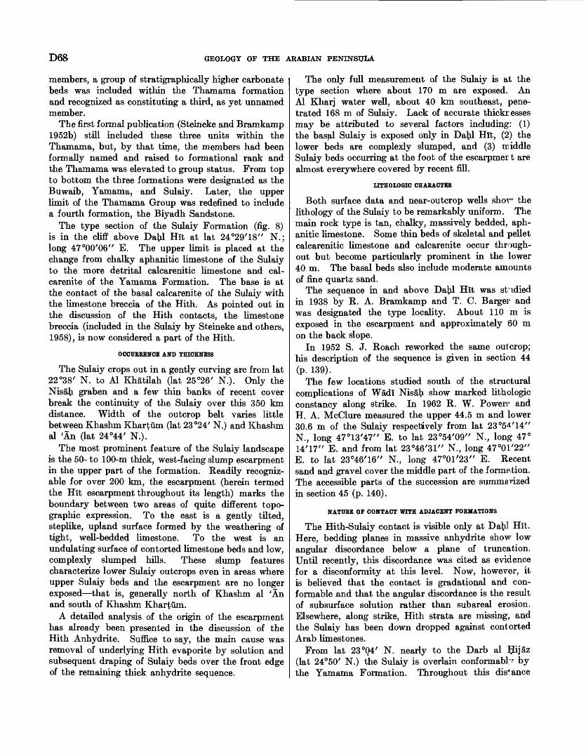
D68 GEOLOGY OF THE ARABIAN PENINSULA
members, a group of stratigraphically higher carbonate beds was included within the Thamama formation and recognized as constituting a third, as yet unnamed member.
The first formal publication (Steineke and Bramkamp 1952b) still included these three units within the Thamama, but, by that time, the members had been formally named and raised to formational rank and the Thamama was elevated to group status. From top to bottom the three formations were designated as the Buwaib, Yamama, and Sulaiy. Later, the upper limit of the Thamama Group was redefined to include a fourth formation, the Biyadh Sandstone.
The type section of the Sulaiy Formation (fig. 8) is in the cliff above Dafcl Hit at lat 24°29'18" N.; long 47W06" E. The upper limit is placed at the change from chalky aphanitic limestone of the Sulaiy to the more detrital calcarenitic limestone and cal- carenite of the Yamama Formation. The base is at the contact of the basal calcarenite of the Sulaiy with the limestone breccia of the Hith. As pointed out in the discussion of the Hith contacts, the limestone breccia (included in the Sulaiy by Steineke and others, 1958), is now considered a part of the Hith.
OCCURRENCE AND THICKNESS
The Sulaiy crops out in a gently curving arc from lat 22°38' N. to Al Khatilah (lat 25°26' N.). Only the Nisafr graben and a few thin banks of recent cover break the continuity of the Sulaiy over this 350 km distance. Width of the outcrop belt varies little between Khashm Khartum (lat 23°24' N.) and Khashm al 'An (lat 24°44/ N.).
The most prominent feature of the Sulaiy landscape is the 50- to 100-m thick, west-facing slump escarpment in the upper part of the formation. Readily recogniz able for over 200 km, the escarpment (herein termed the Hit escarpment throughout its length) marks the boundary between two areas of quite different topo graphic expression. To the east is a gently tilted, steplike, upland surface formed by the weathering of tight, well-bedded limestone. To the west is an undulating surface of contorted limestone beds and low, complexly slumped hills. These slump features characterize lower Sulaiy outcrops even in areas where upper Sulaiy beds and the escarpment are no longer exposed that is, generally north of Khashm al 'An and south of Khashm Khartum.
A detailed analysis of the origin of the escarpment has already been presented in the discussion of the Hith Anhydrite. Suffice to say, the main cause was removal of underlying Hith evaporite by solution and subsequent draping of Sulaiy beds over the front edge of the remaining thick anhydrite sequence.
The only full measurement of the Sulaiy is at the type section where about 170 m are exposed. An Al Kharj water well, about 40 km southeast, pene trated 168 m of Sulaiy. Lack of accurate thickr esses may be attributed to several factors including: (1) the basal Sulaiy is exposed only in Day. Hit, (2) the lower beds are complexly slumped, and (3) middle Sulaiy beds occurring at the foot of the escarpmer t are almost everywhere covered by recent fill.
UTHOLOGIC CHARACTER
Both surface data and near-outcrop wells shovr the lithology of the Sulaiy to be remarkably uniform. The main rock type is tan, chalky, massively bedded, aph anitic limestone. Some thin beds of skeletal and pellet calcarenitic limestone and calcarenite occur through out but become particularly prominent in the lower 40 m. The basal beds also include moderate amounts of fine quartz sand.
The sequence in and above Datil Hit was studied in 1938 by R. A. Bramkamp and T. C. Barger and was designated the type locality. About 110 m is exposed in the escarpment and approximately 60 m on the back slope.
In 1952 S. J. Roach reworked the same outcrop; his description of the sequence is given in section 44 (p. 139).
The few locations studied south of the structural complications of Wadi Nisafr show marked lithologic constancy along strike. In 1962 R. W. Powers- and H. A. McClure measured the upper 44.5 m and lower 30.6 m of the Sulaiy respectively from lat 23°54'14" N., long 47°13'47" E. to lat 23°54/09// N., long 47° 14'17" E. and from lat 23°46/31 // N., long 47°01'22" E. to lat 23°46/ 16 // N., long 47°01 /23 // E. Recent sand and gravel cover the middle part of the formation. The accessible parts of the succession are summarized in section 45 (p. 140).
NATURE OF CONTACT WITH ADJACENT FORMATIONS
The Hith-Sulaiy contact is visible only at Dafrl Hit. Here, bedding planes in massive anhydrite show low angular discordance below a plane of truncation. Until recently, this discordance was cited as evidence for a disconformity at this level. Now, however, it is believed that the contact is gradational and con formable and that the angular discordance is the result of subsurface solution rather than subareal erosion. Elsewhere, along strike, Hith strata are missing, and the Sulaiy has been down dropped against contorted Arab limestones.
From lat 23°04' N. nearly to the Darb al IJijaz (lat 24°50/ N.) the Sulaiy is overlain conformable by the Yamama Formation. Throughout this distance
SEDIMENTARY GEOLOGY OF SAUDI ARABIA D69
the contact is marked by a change from tan, chalky aphanitic limestone below to massive beds of clean- washed Yamama calcarenite above. Although the contact is covered north of the road, conformable re lations between the units probably extend nearly to Al Khatilah. At about this latitude, Middle and Upper Cretaceous rocks swing across Yamama and Buwaib beds, truncate the Sulaiy, and come in contact with the underlying Arab Formation.
On the southern end of the outcrop, below lat 23°04' N., pre-Buwaib erosion cuts progressively deeper into Sulaiy strata. The formation is completely cut out near lat 22°35' N., where Buwaib rocks rest directly on Arab.
Recent sampling of the type Yamama and bracketing strata by R. W. Powers and H. A. McClure hi 1962 permits accurate placement within the type sequence of faunal horizons recognized in adjacent shallow air- drilled holes. Placement of these horizons affects not only Sulaiy-Yamama-Buwaib surface correlations but sheds considerable light on their subsurface relationships as well.
C. D. Redmond also in 1962 demonstrated that the top of the Sulaiy in the area of the type Yamama should be revised upward approximately 4 m so as to include the basal member of the type Yamama. This member represents a thinned-down equivalent of the uppermost 9 to 18 m of the "Yamama detrital limestone" of deep wells. Concurrently with this the designation "Yamama detrital limestone" as used in deep-well terminology is changed to Sulaiy For mation. The advantages of these two related changes are as follows:1. The top of the Sulaiy Formation coincides with the
top of a major faunal division. Pseudocydammina sulaiyana Redmond (Redmond, 1964b), which appears in the Sulaiy Formation and ranges upward to the top of the present "Yamama detrital" of the deep-well subsurface section, is thus confined to the Sulaiy Formation. The same conditions apply at outcrop where Pseudo- cyclammina sulaiyana ranges to the top of the basal member of the type Yamama, now redefined as uppermost Sulaiy.
2. In most deep-well sections, the tip of the revised Sulaiy Formation coincides with a major lithologic break accompanied by a marked electric-log signature pattern; a point corresponding to the older Sulaiy top would have to be picked on faunal evidence alone.
3. The proposed modification of existing stratigraphic terminology reconciles surface and deep-well usage. Prior to the recent findings, Lower Cretaceous stratigraphic relationships between
outcrop and subsurface were uncertain. Deep- well nomenclature, originally based on tentative comparison with the surface beds, can now be shown to be inexact and misleading. For ex ample, "Yamama detrital" of deep wells in reality almost entirely falls within the Sulaiy of outcrop. Other correlations permit accurate subs^irface definition of the Buwaib and Yamama, and these names will be carried into the subsurface as well.
PALEONTOLOGY AND AGE
A partial list of Foraminifera occurring H the Sulaiy Formation is given below. All the forms listed range to within a few feet of the top of the form ation. Their lower limits are not so clear, however, with the exception of that of the Everticyclammina sp., which is known to range through all but the uppermost beds of the formation.
Foraminifera of the Sulaiy Formation include: Bramkampella arabica Redmond (Redmond, 1964b), Everticyclammina sp., Iberina lusitanica (Egger), Nau- tiloculina sp., Pseudocydammina sulaiyana Redmond, Trocholina sp. 1 (a large, high-spired form with a strongly protruding base and blunt apex), Trocholina sp. 2 (a medium-sized, low-spired form with radial fluting hi the inner side of the marginal band).
Presence of a common NautUoculina sp. gives the Sulaiy faunas a Jurassic aspect although this genus is known to extend into the Lower Cretaceous.
Recent work by Maync (1959) has demonstrated that Iberina lusitanica has a somewhat extended vertical range, first appearing in the lower Kimmerdgian and extending upward across the Jurassic-Lower Cretaceous boundary into the lower Valang-;man. Its presence in the Sulaiy Formation of Saudi Arabia is helpful only insofar as it limits the possibilities for age assignment to either Late Jurassic or earliest Cretaceous.
Psevdocyclammina sulaiyana Redmond was discussed and figured by Henson (1948) as Pseudocydammina aff. litus (Yokoyama) from Qatar Dukhan well 2, presumably in beds equivalent to the Sulaiy Formation. Henson listed a stromatoporoid, Cladocoropsis sp., as occurring at the same level and considered tbe age of the beds to be Late Jurassic.
Until such time as more definite evidence is obtained it seems best to leave the age assignment of the P^laiy Formation open, listing it as Tithonian to early Valanginian.
A comprehensive list of fossils found in the Pulaiy Formation includes: Chaetetes sp., Mitteporidiur> sp., Aporrhais sp., Diceras? sp., Exogyra couloni d'OrMgny Nerinea aff. N. blancheti Pictet and Campiche, Nerinea sp., Ostrea sp., and miscellaneous cidaroid racUoles.
D70 GEOLOGY OP THE ARABIAN PENINSULA
ECONOMIC ASPECTS
GROUND WATER
Because of their generally aphanitic and tight char acter, Sulaiy rocks appear unfavorable as water reser voirs. This impermeability does serve a useful purpose, however, in that water falling on the back slope of the Hit escarpment drains into and recharges both the Wadi Nisafr-Wadi as Sahba' channel system and the Biyadh-Wasia sandstone aquifer.
PETROLEUM
Porous Sulaiy rocks contain oil in one Saudi Arabian field that is, the offshore field of Manifa. Here, the producing interval or Lower Ratawi reservoir is about 250 ft of calcarenite and calcarenitic limestone. As is true of most Arabian carbonate reservoirs, oil ac cumulation is directly related to development of clean- washed lime sand (calcarenite). Other Middle East fields outside of Saudi Arabia also presumably have discovered productive oil in the Sulaiy.
CRETACEOUS SYSTEM
YAMAMA FORMATION LOWER CRETACEOUS
DEFINITION
The Yamama Formation is named for the town of Al Yamamah (lat 24°11' N.) about 20 km north of the type section and on line with the strike of outcrop. Development of Yamama nomenclature from an un named part of the Tuwaiq Formation to a formation within the Thamama Group is described in detail in the definition of the Sulaiy Formation.
The Yamama type section was pieced together from a number of short exposures on the Al' Qu§ay'a' upland surface between lat 24°00/24" N., long 47°15/42 // E. and lat 24°00/24// N., long 47°20/54" E.
As defined by Steineke, Bramkamp, and Sander (1958), 58 m of section between the dense Sulaiy limestone below and pre-Buwaib unconformity above was assigned to the type Yamama. As already men tioned in connection with the Sulaiy, recent work has shown that the basal 4 m of the Yamama type sequence belongs logically with the Sulaiy. The lower limit of the Yamama is herewith redefined to account for this change.
The picture is further complicated by the fact that many beds assigned to the lower part of Buwaib at its type locality further north were also included in the Yamama type sequence. In addition, it is certain that the "pre-Buwaib unconformity" was somewhat misplaced in both areas. To straighten out the re lationships between the Yamama- and Buwaib-type sequences and adhere as far as is feasible to older concepts, the upper limit of the Yamama has been adjusted in the outcrop and subsurface to coincide
with the now accurately placed "pre-Buwaib" surface of unconformity. At the Yamama type locality this involves lowering the Yamama-Buwaib contact r.bout 8 m. The effect on the Buwaib-type sequence has been to include the lower 23 m in the Yamamr. and restrict the Buwaib to approximately the upper 10 m. Evidence for these changes is as follows:
1. Analysis of the type Buwaib microfaunas by means of recently developed species keys shows that Cyclammina greigi sensu strictu does not range below the top 10 to 12 m of the formation. Also, forms which appear in samples immediately be low that level are those which are known elsewhere only from the Yamama Formation. Further more, the echinoids from the type Buwai? are associated with these lower forms and appear to fall below the lower limit of Cyclammina sreigi.
2. Specimens of Pygurus cf. P. rostratus from the type Buwaib came from a position high in the forma tion, as originally defined. This species can now be accurately placed within the type Yamama microfaunal sequence and can be demonstrated to fall below the range of Cyclammina. qreigi here as well.
There is no possible doubt that at least the lower 23 m of the type Buwaib is equivalent to a ronghly comparable interval in the lower part of the type Yamama and that the echinoid occurrences in the two areas fall very nearly at the same level in time.
Redefinition of the Yamama now places 45.5 m of strata in this unit at the type locality. The base is at the contact of chalky aphanitic and calcarenitic limestone of the Sulaiy below with golden-t^own calcarenite of the Yamama above. The top is placed at the unconformable break from golden-brown pellet- calcarenite below to molluscan calcirudite of the Buwaib above.
OCCURRENCE AND THICKNESS
Outcrops of the Yamama form a very thin, ciirved band from lat 23°04' N. to the northern end of Jal Buwayb (lat 25°24' N.), a distance of nearly 300 km. In the central area the band reaches a maximum width of about 9 km. Yamama rocks are continuously exposed from their southern limit to Wad! ?Tisafr where the beds are covered by younger deposits. The formation reappears north of the wadi, then per sists to the northern edge of the Al Jubayl plateau where it passes under Quaternary cover. It is again exposed for about 25 km at Jal Buwayb in the steep face of the Al 'Aramah escarpment.
Except for the clifflike exposures at Jal Buv^ayb, Yamama rocks usually weather to a gently tiUed, steplike series of dip slopes and low parallel benches
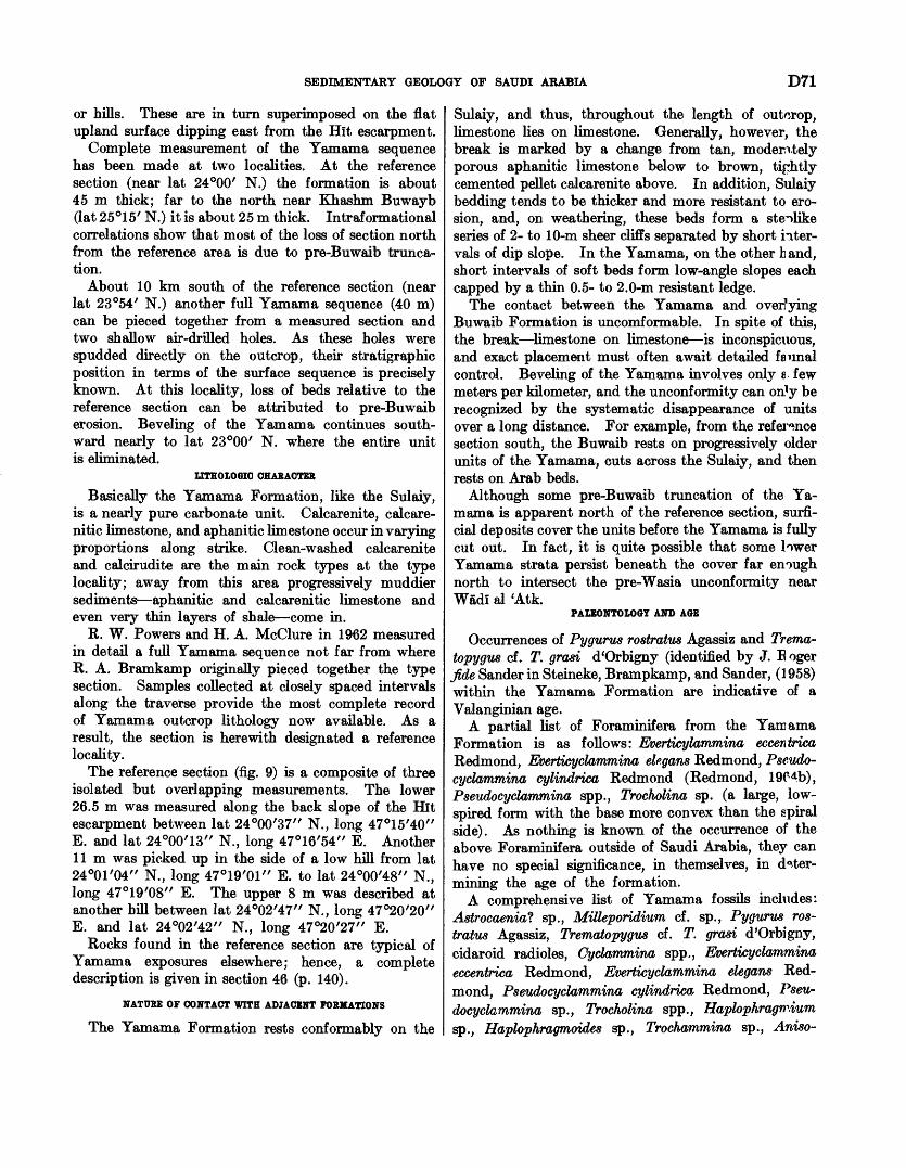
SEDIMENTARY GEOLOGY OF SAUDI ARABIA D71
or hills. These are in turn superimposed on the flat upland surface dipping east from the Hit escarpment.
Complete measurement of the Yamama sequence has been made at two localities. At the reference section (near lat 24°00/ N.) the formation is about 45 m thick; far to the north near Khashm Buwayb (lat 25°15' N.) it is about 25 m thick. Intraformational correlations show that most of the loss of section north from the reference area is due to pre-Buwaib trunca tion.
About 10 km south of the reference section (near lat 23°54' N.) another full Yamama sequence (40 m) can be pieced together from a measured section and two shallow air-drilled holes. As these holes were spudded directly on the outcrop, their stratigraphic position in terms of the surface sequence is precisely known. At this locality, loss of beds relative to the reference section can be attributed to pre-Buwaib erosion. Beveling of the Yamama continues south ward nearly to lat 23°00' N. where the entire unit is eliminated.
IITHOLOGIC CHARACTER
Basically the Yamama Formation, like the Sulaiy, is a nearly pure carbonate unit. Calcarenite, calcare- nitic limestone, and aphanitic limestone occur in varying proportions along strike. Clean-washed calcarenite and calcirudite are the main rock types at the type locality; away from this area progressively muddier sediments aphanitic and calcarenitic limestone and even very thin layers of shale come in.
R. W. Powers and H. A. McClure in 1962 measured in detail a full Yamama sequence not far from where R. A. Bramkamp originally pieced together the type section. Samples collected at closely spaced intervals along the traverse provide the most complete record of Yamama outcrop lithology now available. As a result, the section is herewith designated a reference locality.
The reference section (fig. 9) is a composite of three isolated but overlapping measurements. The lower 26.5 m was measured along the back slope of the Hit escarpment between lat 24°00'37" N., long 47°15'40" E. and lat 24°00'13" N., long 47°16'54" E. Another llm was picked up in the side of a low hill from lat 24°01'04" N., long 47°19/01" E. to lat 24°00'48" N., long 47°19'08" E. The upper 8 m was described at another hill between lat 24°02'47" N., long 47°20'20" E. and lat 24°02'42" N., long 47°20'27" E.
Rocks found in the reference section are typical of Yamama exposures elsewhere; hence, a complete description is given in section 46 (p. 140).
NATURE OF CONTACT WITH ADJACENT FORMATIONS
The Yamama Formation rests conformably on the
Sulaiy, and thus, throughout the length of outcrop, limestone lies on limestone. Generally, however, the break is marked by a change from tan, moderately porous aphanitic limestone below to brown, tightly cemented pellet calcarenite above. In addition, Sulaiy bedding tends to be thicker and more resistant to ero sion, and, on weathering, these beds form a steilike series of 2- to 10-m sheer cliffs separated by short inter vals of dip slope. In the Yamama, on the other h and, short intervals of soft beds form low-angle slopes each capped by a thin 0.5- to 2.0-m resistant ledge.
The contact between the Yamama and overfying Buwaib Formation is uncomformable. In spite of this, the break limestone on limestone is inconspicuous, and exact placement must often await detailed faunal control. Beveling of the Yamama involves only $ few meters per kilometer, and the unconformity can on'y be recognized by the systematic disappearance of units over a long distance. For example, from the refei^nce section south, the Buwaib rests on progressively older units of the Yamama, cuts across the Sulaiy, and then rests on Arab beds.
Although some pre-Buwaib truncation of the Ya mama is apparent north of the reference section, surfi- cial deposits cover the units before the Yamama is fully cut out. In fact, it is quite possible that some lower Yamama strata persist beneath the cover far enough north to intersect the pre-Wasia unconformity near Wadi al 'Atk.
PALEONTOLOGY AND AGE
Occurrences of Pygurus rostratus Agassiz and Trema- topygus cf. T. grasi d'Orbigny (identified by J. E oger fide Sander in Steineke, Brampkamp, and Sander, (1958) within the Yamama Formation are indicative of a Valanginian age.
A partial list of Foraminifera from the Yamama Formation is as follows: Everticylammina eccentrica Redmond, Evertieyclammina ele.gans Redmond, Pseudo- cydammina cylindrica Redmond (Redmond, 19C4b), Pseudocyclammina spp., Trocholina sp. (a large, low- spired form with the base more convex than the spiral side). As nothing is known of the occurrence of the above Foraminifera outside of Saudi Arabia, they can have no special significance, in themselves, in deter mining the age of the formation.
A comprehensive list of Yamama fossils includes: Astrocaeniat sp., MUleporidium cf. sp., Pygurus ros tratus Agassiz, Trematopygus cf. T. grasi d'Orbigny, cidaroid radicles, Oyclammina spp., Evertieyclammina eccentrica Redmond, Evertieyclammina elegans Red mond, Pseudocyclammina cylindrica Redmond, Pseu docyclammina sp., Trocholina spp., Haplophragmium sp., Haplophragmoides sp., Trochammina sp., Aniso-
D72 GEOLOGY OF THE ARABIAN PENINSULA
CO
Locations: (a), (b), (c): Yamama (d): Buwaib
(a) 24°00'37"-47°15'40" 24°00'13"-47°16'54"
(b) 24°01'04"-47°19'01" 24°00'48"-47°19'08"
(C) 24°02'47"-47°20'20" 24°02'42"-47°20'27"
23°53'51"-47°18'53" 23°53'52"-47°19'53"
Generalized lithology Diagnostic fossils
SANDSTONE: Red medium-grained ferru ginous, black weathering sandstone
diei caicarerme, * aphanitic lime- r
}ds of molluscan )dstone. (17.7 m) ( V^'-*--" »> * '
SHALE, DOLOMITE, CALCARENITE AND APHANITIC LIMESTONE: Complexly in- terbedded blue-green and olive-green shale, reddish-brown medium-grained crystalline dolomite, golden-brown, in part sandy, well-cemented pellet calcarenite, and tan to brown chalky aphanitic stone. Occasional thin beds calcirudite and quartz sandstone.
(3) CALCARENITE AND APHANITIC LIME STONE: Golden-brown usually medium- grained and well-sorted tightly cemented pellet-Foraminifera calcarenite; poorly ex posed chalky aphanitic limestone inter- bedded in upper part. Single thin bed of golden-brown fine- to medium-grained calcareous quartz sandstone present near middle of unit. (16.0 m)__________
(2) APHANITIC AND CALCARENITIC LIME- STONE: Tan moderately porous chalky, sparsely sandy aphanitic limestone inter- bedded with tan to brown molluscan cal- carenitic limestone. Occasional thin beds of golden brown well sorted tightly cemented Foraminifera-pellet calcarenite. (10.1 m)_____________________
(1) CALCARENITE AND COARSE CAR- BONATE: Brown to golden-brown poorly to moderately well-sorted tightly cemented clean washed fine-grained to gravel-size pellet-molluscan-Foraminifera calcarenite and calcirudite. Several intervals poorly exposed, probably chalky aphanitic lime stone. (19.4 m)
Cyclamm/ncr greigi Everficyc/amm/'na hensoni bedsrfterf^rffcrf^rf^rf^rf^^^^^*^*^^^^^^^^^^^^^^^*^^^Everficyc/am miner eceenfr/co Pseudocyc/ammina cy/indrica horizon
Pygurus rosfrafus Tremafopygus Cf. T. grasi
Everficyc/amminc e/egans
Pseudocyc/ammina su/a/'yana horizon
Vertical scale: 1:1000
CALCARENITIC LIMESTONE: Brown and tan sparsely sandy molluscan and foraminif- eral calcarenitic limestone After R. W. Powers and H. A. McClure, 1962
FIGURE 9. Buwaib and Yamama Formations reference sections.
cardia sp., Aporrhais sp., Cerithium (s.l.) sp., Corbis sp., Corbula sp., Chione cf. sp., Cuculaeal sp., Exogyra spp., Gyrodesf sp., Gryphaea balli (Stefanini), Homomya sp. Lima, sp., Modiolusf, Natica sp., Nwulana sp., Ostrea sp., Paphia sp., Pholadomya cf. P. decussata, Pleuroto- maria? sp., Siligua sp., Stmparolust sp., Tellina sp., Trigonia sp., Trochus sp., Venus sp., unidentified am monite genus showing affinities with Knemiceras and Hypengonoceras, and unidentified small molluscs.
ECONOMIC ASPECTS
The offshore field of Manifa contains productive oil in the Yamama Formation (Upper Ratawi reservoir).
This is the only occurrence in this formation within Saudi Arabia, but other Middle East fields presumably have accumulations at this level as well. At Manifa, the effective thickness is small and limited to calcrtrenite development in a dominantly aphanitic interval.
BUWAIB FORMATION LOWER CRETACEOUS
DEFINITION
The Buwaib Formation is named for Khashm Buwayb (lat 25°15' N.) near where the type section was measured. Development of Thamama Group (including Buwaib Formation) nomenclature from its
SEDIMENTARY GEOLOGY OP SAUDI ARABIA D73
inception to modern usage is covered in detail under the definition of the Sulaiy Formation (p. 66).
Recent work has shown that some modification of the type Buwaib as defined by Steineke, Bramkamp, and Sander (1958) is necessary. It can now be demon strated that the lower two-thirds of the 33.8-m interval previously assigned to the type Buwaib is, in fact, equivalent to the lower part of the type Yamama and, in addition, falls below the pre-Buwaib unconformity. Supporting evidence has already been cited as part of the discussion on the Yamama Formation (p. 70).
Based on the new data, it now seems logical to restrict the name Buwaib Formation to the upper 11.2 m of the type section at Khashm Buwayb and throw the lower 22.6 m with the Yamama. Thus, the Buwaib would take in all beds carrying Cyclammina greigi and would put the base of the formation at the stratigraphic break that elsewhere has been called the "pre-Buwaib unconformity" in both surface and subsurface reports.
The section measured in the face of Jal Buwayb at lat 25°15'03" N., long 46°38'52" E. is held as the type locality for the Buwaib (restricted). The base is at the unconfonnable contact of cream-colored aphanitic limestone above with quartzose sandstone and aphanitic limestone of the Yamama below. The top is at the highest limestone below the sandstone of the overlying Biyadh.
OCCURRENCE AND THICKNESS
Outcrops of the Buwaib Formation have been mapped in a narrow irregular band from Khashm al Bazum (lat 20°38/ N.) to the northern end of Jal Buwayb (lat 25°24' N.), a distance of nearly 600 km. South of Khashm al Khufaysah (near lat 23°00' N.) average width of the outcrop is about 18 km; to the north, it is about 2 km.
Continuity of the Buwaib is broken at several places notably, at Al Aflaj (lat 22°10' N.) where a 50 km wide sheet of gravel cuts through the Lower Cretaceous, again at Wadi Nisafr where the central Arabian graben system funnels through, and finally just north of lat 25°00' N. where exposures are covered for 30 km by surficial deposits.
In addition to the main belt of outcrop, several small outliers of Buwaib are preserved in the slumped and brecciated zone just west of the Hit escarpment. The most prominent of these occur in front of Khashm Khartum (lat 23°23 / N.) and Khashm Fazra' (lat 23°38/ N.) and west of 'Irq Banban (in the vicinity of lat 25°00' N.). Certainly Buwaib rocks are down dropped in other areas as well, but structural complica tions and lithologic similarity have so far prevented accurate sorting of the various units involved.
Except for the steep cliff face at Jal Buwayb, the
unit weathers to a relatively low-relief plain. The generally flat surface is broken, however, by several small discontinuous benches that crop out at various levels through the section.
In the southern area of outcrop generally between Wad! ad Dawasir and Wadi Birk Buwaib Formation thickness is relatively constant at 40 to 45 m. There is considerably more fluctuation in sections measured to the north for example, 18 m at the reference section (lat 23°54' N.), 33 m near lat 24°00' N., about 20 m near the Darb al IJijaz (lat 24°52' N.), and 11 m at the type section near Khashm Buwayb (lat 25°15' N.).
LITHOLOGIC CHARACTER
Although the Buwaib contains several rock types, the general lithologic character changes but little 8 long strike. Aphanitic limestone and calcarenitic limestone are most common, but invariably the sequence is broken with thin intervals of calcarenite, sandstone, and shale. Beds of clean quartzose sandstone appear to be confined to the upper part of the formation.
One of the most complete sections of the BuwaJb so far studied is a few kilometers northeast of Khafs Daghrah (lat 23°50 / N.). Here R. W. Powers and H. A. McClure in 1962 measured and sampled the entire sequence which is herewith designated as a reference section (fig. 9). The formation was studied on a continuous traverse from lat 23°53 /51 // N., long 47°18 /53// E. to lat 23°53 /52 // N., long 47°19 / 53 // E. A full description is given in section 47 (p. 141).
Sections at the extreme northern and southern end's of the outcrop belt fail to show any significant differences in the lithologic pattern seen at the ref- ference locality. For example, the type sequence at Khashm Buwayb may be summarized as follows: At the base 3.8 m of aphanitic limestone with thin interbeds of calcarenitic limestone and calcarenite, overlain in turn by i.7 m of friable sandstone, 3.7 m unexposed but probably shale, and 2.0 m of tl inly interbedded sandstone and sandy calcarenitic Pme- stone.
Southerly exposures are characterized by a section just north of Qasr IJimam (lat 20°49' N.). The sequence here may be summarized as given in section 48 (p. 142).
NATURE OF CONTACT WITH ADJACENT FORMATIONS
The Buwaib Formation rests unconformably on all underlying units with which it comes in contact. From the vicinity of Jal Buwayb nearly to lat 23°00' N., the Buwaib rests tfn different beds of the Yam ama Formation. Southward, the Buwaib progressively over lies the Sulaiy and finally comes in contact with Arab strata about 20 km north of Layla.
D74 GEOLOGY OF THE ARABIAN PENINSULA
The upper contact with the Biyadh Sandstone is everywhere conformable and gradational. It is ex pressed as a low discontinuous bench of Buwaib limestone capped by a thin veneer of reddish-black, ferruginous sandstone of the Biyadh.
At the southern end of the outcrop, the Buwaib disappears under gravels dispersed by the Wadi ad Dawasir drainage system, and its ultimate limit is unknown. Surficial cover also obscures events on the northern end of the outcrop belt beyond Jal Buwayb. In this place, however, regional geometry suggests that the Buwaib persists to Wadi al 'Atk and is there truncated by pre-Wasia erosion.
PALEONTOLOGY AND AGE
Surface exposures of the Buwaib Formation carry Cyclammina greigi Henson, Everticyclammina hensoni Redmond, a#d several other lituolids.
As the Buwaib unconformably overlies the Val- anginian Yamama Formation along the outcrop and underlies the lowermost occurrences of Orbitolina cf. 0. discoidea Gras, 0. discoidea Gras var. delicata Hen- son, and Chqffatetta dedpiens Schlumberger in sub surface, its position would be within the Hauterivian.
Buwaib fossils include: Ammobaculitesf sp., Cy clammina greigi Henson, Everticyclammina hensoni Redmond, unidentified lituolids, and unidentified small molluscs.
BIYADH SANDSTONE LOWER CRETACEOUS
DEFINITION
The Biyadh Sandstone is named for Al Biya$, an extensive gravel-covered plain that marks the area of outcrop. Beds now assigned to the Biyadh were first included by T. W. Koch and C. W. Brown in 1934 as part of a larger unnamed clastic series of presumed Cretaceous age. H. L. Burchfiel and J. W. Hoover applied the name "Nubian Sandstone" to this unit in 1935 because of similarity to the Cretaceous section in Lebanon.
Max Steineke in 1938 pointed out that the Nubian Sandstone is primarily a facies term with no strati- graphic significance. It had been used in Egypt, Sinai, Lebanon, and Palestine as a "catch-all" for arenaceous sediments of widely differing ages. The Arabian sandstone, on the other hand, occupied a definite stratigraphic position and could only be correlative with the upper part of the succession in Egypt. For that reason, the loose term Nubian Sandstone was replaced by the name Wasia Formation. The Wasia was bracketed at the top by limestone of the Aruma Formation and at the base by limestone that is now Buwaib. The Wasia as thus defined
appeared in publication in 1952 (Steineke and Bramkamp, 1952b).
Truncation and overlap within the Wasia as first defined had long been recognized. The exact surface of unconformity, however, was only recently pinpointed by detailed field and aerial photomapping. With these data, it could be demonstrated that the Wasir, con tained two sand units separated by a major uncon formity. Consequently, in 1952 Bramkamp tents tively removed the beds below the unconformity from the Wasia and assigned them to a new formation the Biyadh Sandstone. The Biyadh, because of its con sidered Lower Cretaceous or Neocomian age, wr s and still is the upper formation of the Thamama Group. Concurrently, the beds remaining above the uncon formity were assigned to the Wasia (restricted). The new terminology first appeared in a paper by Thralls and Hasson (1956), and formal publication of strati- graphic limits followed in 1958 (Steineke and others).
The definition of the Biyadh and Wasia Formations noted by Steineke, Bramkamp, and Sander (195S) has been retained in this paper. There is considerable evidence, however, that the Biyadh-Wasia boundary on outcrop does not coincide stratigraphically with the subsurface contact. In fact, there seems little doubt that strata assigned to the upper Biyadh at the surface are included within the Wasia in deep-well sections (fig. 1). At least one and possibly several unconformities, obscured by sand-on-sand relationship, complicate the picture.
The Biyadh section was measured along a two-part traverse: (pi. 9) (1) the lower part from the b^.se of the sandstone at lat 24°06'38" N., long 47°23'53" E. (near Ath Thulayma') east to lat 24°05/28// N., long 47°38'07" E. and (2) the upper part from a pcmt at lat 24°00'03" N., long 47°35'09" E. (the same strati- graphic level as the top of unit 1) southeast to lat 23°58/38// N., long 47°41 /37// E. Recalculations based on new dip data show the Biyadh at the type locality to be about 425 m thick.
The base of the Biyadh is at the top of the highest thin marine limestone beds of the Buwaib Formation. The top is at the unconformable contact of coarse quartz sand with quartz pebbles and the overlying ferruginous silty sandstone of the Wasia Formation.
OCCURRENCE AND THICKNESS
Sandstone of the Biyadh can be traced rlmost continuously from Wadi ad Dawasir to Wadi al 'Atk, a distance of nearly 650 km. Only two breaks of any significance occur, and these are the synclinal area of Wad! as Sahba' where Wasia and Aruma sedimentary rocks effectively mask the Biyadh and the gravel sheet at Al Aflaj (about lat .22°10' N.). Nearly 50 kir wide
SEDIMENTARY GEOLOGY OF SAUDI ARABIA D75
at Wadi ad Dawasir, the Biyadh narrows persistently northward to Khashm Khanasir al Khafs (lat 25 °35' N.) where it pinches out in the face of the Al 'Aramah escarpment. Southward, the Biyadh disappears be neath alluvial gravel and eolian sand of the Rub* al Khali. Scattered exposures of combined Biyadh and Wasia are known within the sand-covered area; the most prominent are at Al Jaladah (near lat 18°30' N.) and Ash Sharawrah (near lat 17°15' N.).
From Wadi as Sahba' south, weathering of the Biyadh results in a characteristic landscape made up of numerous small dark-colored to black hills between which are gently rolling white, gravel-covered plains. The Arabs refer to this belt as Al Biyaol which roughly translated means "the white country." The same gen eral topography picks up again north of Wadi as Sahba', but here the terrain is somewhat rougher and more difficult to traverse.
Gravel littering the Biyadh surface is apparently residual and is composed almost wholly of white, well- rounded quartz pebbles and lesser amounts of quartzite and fossil wood. Some igneous and metamorphic grains also occur, but these are generally concentrated near major channels that originate west of Jabal Tuway<L breach this barrier, and extend across Lower Cretaceous units.
The maximum thickness of the Biyadh so far calcu lated is 625 m in the vicinity of Ban! Labab (lat 20° 42' N.). Northward, definite though irregular thinning takes place. Intervals of 515, 510, 425, and 360 m were computed respectively near Wadi al Maqran (lat 21°20/ N.), Wadi Birk, the type locality, and latitude 24°40/ N. Beyond, pre-Wasia truncation is rapid and the formation wedges out completely within about 140km.
Bore holes in the southwest Rub' al Khali penetrated Biyadh sections which, although incomplete, give some idea of formation thicknesses in this area. About 490 m was recorded at Al Jaladah and some 375 m is present at Ash Sharawrah.
IITHOIOGIC CHARACTER
The lower three-fourths of the Biyadh is mostly light- colored, often black-weathering and crossbedded quartz- ose sandstone with some interbeds of varicolored shale. Conglomeratic layers and thin beds of ironstone occur at several levels. From the area of Wadi as Sahba' north, this lower sequence is capped by a prominent 10- m interval of complexly interbedded marl, limestone, shale, sandstone, and reddish-brown siderite-dolomite.
Above the calcareous unit the remainder of the Biyadh is coarse-grained, crossbedded quartz sandstone containing abundant quartz pebbles. This conspicuous band of gravels is known informally as the "Biyadh
Gravel Stripe." It is distinct both on the ground and aerial photographs and can be traced south for several hundred kilometers, even far beyond where the under lying calcareous member gives out. The upper limit of this white gravel stripe is taken as the Biyadh-Wasia contact.
The bulk of the Biyadh appears to be of nonmarine origin, except for the thin carbonate stringer wMch contains poorly preserved marine molluscs and a poorly preserved nondiagnostic marine microfauna found 25 to 30 m below the carbonate stringer. C. D. Redmond in 1962 suggested that the lower marine lithology may represent a western extension of the environment recog nized in the subsurface as the Mauddud Limestone Member of the Wasia Formation. Unfortunately, p^oof is lacking; if this could be demonstrated, much of the uncertainty regarding Biyadh-Wasia surface-subsur*ace relationships would be eliminated.
The type section of the Biyadh is considered to be that measured about 20 km south of Wadi as Sahba' by D. A. Holm and N. M. Layne in 1949. Their de scription of the rocks exposed (section 49, p. 142) at this locality serves as an excellent summary of Biyadh rocks all along the outcrop belt.
NATURE OF CONTACT WITH ADJACENT FORMATION
The contact with the underlying Buwaib is conform able and gradational and is placed at the top of the highest limestone bed of the Buwaib. Througl out the outcrop area this consistent horizon follows the top of a half-meter bed of reddish limestone or dolomite. Immediately above is the typical ferruginous bbck- weathering sandstone of the Biyadh.
The Biyadh Sandstone is unconformably overlain by the Wasia. The contact is marked by a chr.nge from coarse quartz sandstone with abundant pebbles to ferruginous silty sandstone of the basal Wasia. A marked color change occurs at the break. Bolow is the laterally persistent white "Biyadh Gravel Stripe"; above is the varicolored siltstone, sandstone, and shale of the Wasia.
PALEONTOLOGY AND AGE
There is considerable uncertainty regarding the exact stages represented by the Biyadh surface se quence as now defined. Definite outside limits are known, however, as the underlying Buwaib is def initely Hauterivian and the overlying Wasia is con fidently dated on ammonites as Cenomanian.
Some help comes from the subsurface where the "Biyadh" is bracketed by Buwaib (Hauterivian) below and Shu'aiba (Aptian) above. Choffatella de- cipiens Schlumberger, Dictyoconous arabicas Hen^on, and Orbitolina discoidea Gras are limited to the Biyrdh;
228-770 O C
D76 GEOLOGY OF THE ARABIAN PENINSULA
the presence of any one of these species is sufficient to indicate a position within the formation. Based on contained forms and regional considerations, the subsurface Biyadh is probably Barremian and lower Aptian. As presently interpreted, these beds would equate approximately to the lower 200 to 250 m of Biyadh at the type locality.
In connection with this, there is some suggestion that the interval from about 275 to 325 m above the base of the type Biyadh may be of late Albian to early Cenomanian age. Several species of Am- mobaculites of the type generally associated with brackish-water deposits were discovered when this interval was penetrated by shallow air-drill holes. None of the distinctive genera and species that usually distinguish the Wasia in deep wells are present here, and possible comparison of these beds with parts of the subsurface Wasia can be justified only on two lines of indirect evidence. The first of these is litho- logic. In general, and particularly toward the west, the Wasia is characterized by ferruginous elements such as siderite, concentrically layered ferruginous pellets, and ironstone concretions as well as ferruginous shales. The correlation point based on the occurrence of Ammobaculites falls within the lower part of a series of beds manifesting just such a lithology. The other point of indirect evidence lies in the fact that toward the west both the Wasia and Biyadh beds tend to become less and less marine, to the point where only marine microfaunas are found at the level of the basal Ahmadi Member (lower Cenomanian) of the Wasia and, more sparingly, in beds immediately underlying the Mauddud Limestone Member (lowermost Ceno manian). Bearing this in mind, it is possible to theorize that the Ammobaculites and zone of marine molluscs just above represent the westerly extension of this marine environment.
It is possible that the Biyadh as now defined on outcrop could include beds ranging in age from Hauterivian or Barremian to Cenomanian. Such age assignment would be in sharp conflict with the much better known subsurface sequence where upper Aptian to Turonian strata are included within the Wasia. Unfortunately, however, east-to-west gra dation from marine shale and limestone to nonmarine sand and gravel is accompanied by facies changes of such magnitude and rapidity that it has proved impossible to recognize any widespread marker hori zons. Because of this, there is little likelihood that the Biyadh-Wasia contact in the subsurface can ever be placed with certainty in terms of the surface se quence, and vice versa. The widespread usage, ease of recognition, and economic importance of the subsurface division throughout the Persian Gulf area
makes it seem most logical to carry the Biyadh as Barremian and lower Aptian. Clearly, this dating may not involve the upper 200 m of the type section.
ECONOMIC ASPECTS
GROUND WATER
In the outcrop area the Biyadh and Wasia sands, and to a small degree Quaternary alluvium, cor<?titute a single intake area and hydraulic unit. A short distance downdip, fluid communication between the Wasia and Biyadh is restricted, and each operates as an isolated hydrogeologic system.
Recharge occurs primarily from precipitation by means of direct percolation into the intake ar°-a and channel subsurface' inflow from the runoff area. The major channels that drain the runoff area act as a recharge mechanism throughout the year.
Three basic types of water are recognized: (1) Fresh meteoric, (2) mixture of fresh meteoric and connate, and (3) near-connate. The fresh meteoric waters contain as much as about 4,000 ppm (parts per million) of total solids and occur largely in the west toward outcrop. Mixed water, which ranges from about 4,000 to 35,000 ppm of total solids, results from incomplete flushing of connate water and occurs generally east of the meteoric belt. The connate water contains about 35,000 ppm of total solids and is known only at a few isolated localities within the mixed- water belt. Presumably these areas are residual original water somehow bypassed and undiluted by newer meteoric recharge.
Nonpotable Biyadh water is being injected into the oil reservoir at the Ain Dar area. Biyadh vrater is also used for irrigation only at Al Bijadlyah, r.n agri cultural development in Wadi as Sahba' generally across the Biyadh-Wasia outcrop belt. A totrl of 54 nonartesian wells have been drilled. Except for three wells completed in Quaternary gravel to tho west, all the wells are completed in the Biyadh-Wasir, sands. The number of permanent pump installations is un certain; probably less than 30 have been made
The Al Bijadiyah area is underlain by 300 m of highly productive water-saturated sediment that is constantly recharged by fresh meteoric water slowly seeping downward through channel fill. To tbe west, on the south side of Wadi as Sahba' where tta water table rises above the base of the Quaternary alluvium, the shallow, subsurface, highly permeable gravel channel(s) which act as conduits for movement of water down the wadi, can be developed as well.
PETROLEUM
The main economic interest of the Biyadl is its equivalence to the Zubair zone which is productive in
SEDIMENTARY GEOLOGY OP SAUDI ARABIA D77
southeastern Iraq. Within Saudi Arabia proper, the only significant show of Biyadh-Zubair oil is a minor accumulation in Safaniya.
WASIA FORMATION MIDDLE CRETACEOUS
DEFINITION
The Wasia Formation is named for Khashm Was!' (lat 24°23' N.), where a complete section is exposed. Changes leading to the present definition of the Wasia have been discussed in connection with the Biyadh Sandstone (p. 74).
Stratigraphic details of the Wasia as now defined were first published by Steineke, Bramkamp, and Sander (1958). The type section is in the lower slope of Al 'Aramah escarpment, extending from the pre- Wasia unconformity (at lat 24°23'04" N., long 47°45/ 12" E.) southeast to low hills near Was!' (lat 24°22'38" N., long 47°45'49" E.). The base is at the contact of varicolored fine-grained sandstone and silt- stone of the Wasia with underlying light-colored, pebbly, coarse-grained sandstone of the Biyadh. The top is at the disconformable contact of Wasia sandstone with dolomite and limestone of the Aruma Formation above.
Relationship of the Wasia to a thick clastic unit in northwestern Arabia the Sakaka Sandstone has long been controversial. Variously dated as upper Paleo zoic and Middle Cretaceous, the only rigid limits were imposed by the underlying Lower Devonian Jauf Formation and overlying Upper Cretaceous Aruma beds. Recently drilled bore holes have, however, now bridged the gap between the two units and extended the Wasia northward to where there is little doubt that it is laterally continuous with the Sakaka. Hence, the Sakaka is herein described simply as a prolongation of the Wasia. The term Sakaka, first applied by R. M. Sandford in 1950 to cover the doubtful unit, is herewith considered obsolete.
OCCURRENCE AND THICKNESS
The southernmost occurrence of definite Wasia is near Wadi Dawasir. From here, the formation con tinues northward in a great arc to where it passes under the western edge of An Nafud (near lat 28°25' N.). The unit again emerges around Sakakah (lat 30°00' N.) where it has been mapped as the Sakaka Sandstone. Total linear distance of Wasia exposure to this point is nearly 1,450 km. A number of small outliers also occur west and southwest of Sakakah, for example: (1) In hills which stand up along the north side of the At Tawil fault (near lat 29°22' N.), (2) on the tops of hills rising above Al Huj plateau, and (3) around Umm Nukhaylah (lat 29°30/ N., long 38°33' E.) where
the sandstone is preserved in sturcturally disturbed blocks.
From An Nafud to Ar Rub' al Khali the Was;a is interrupted only by such through-cutting channel" as Al Ba^in, Wadi al 'Atk and Wadi as Sahba'. Patches of sandstone bedrock cropping out in windows in the Rub' al Khali sand mantle have been described as Biyadh and Wasia undivided; Al Jaladah and Ash Sharawrah are exposures of this type. Actually, however, there is some doubt that the Wasia extends that far southwest.
The strike of Wasia beds changes sharply in two places that is, Wadi as Sahba' and Wadi al 'Atk. In each case Wasia exposures turn almost due west, and the wadis cut abruptly down through the section. Presumably in both cases structural happenings, possibly also related to wadi formation, are respons;ble.
In the central and northern areas of outcrop, Wasia beds typically weather to an upward-steepening s^pe that terminates in an almost sheer face beneath the scarp-forming limestone of the Aruma Formation. In the southern area, beginning about 40 km south of Wadi as Sahba', the Aruma progressively loses its cliff-forming ability as the formation is replaced from the bottom up by softer sandstone. Complete re placement is effected near lat 22°30' N., and, with this change, the surface of the Aruma and Wasia breaks down to about the same general level as the adja^-ent Biyadh plain.
Near Sakakah, the formation crops out as a rough, maturely dissected plateau with scattered hills that follow no particular topographic pattern. Channels cutting the plateau are short, poorly developed, and debouch into small mud flats. West and southvest, outliers of Wasia (Sakaka) form small plateaus or cap isolated hills.
Sparse measurements indicate that the thickness of the Wasia increases irregularly but persistently f~om south to north. Some 25 to 30 m thick near Wadi ad Dawasir, the section expands to about 40 m at V^adi as Sahba', 60 m near Khashm Khafs, 80 to 100 m east of Al Majma' ah (lat 25°55' N.), 90 m at T'ba' (lat 27°24' N.), and reaches a maximum thickness of 285 m near Sakakah. Exposures west and southwest of Sakakah are incomplete, and the thickest interval measured at Al galwat (lat 28°50' N., long 38°42' E.) is somewhat less than 90 m.
LTTHOIOGIC CHARACTER
The Wasia (Sakaka) Formation is a relatively thin sandstone and shale unit which is at least in part marine in the central and northern areas and probably nonmarine in the south. In the vicinity of Wasi', a lenticular bed of red sandy dolomite and a local lens
D78 GEOLOGY OF THE ARABIAN PENINSULA
of soft nodular limestone containing marine fossils occur 25 m below the top of the formation. South of Wadi Sahba' similar lenticular beds of carbonate are known in the same part of the section. Several inter- beds of dolomite have also been observed in the se quence at Qiba'.
Wasia rock types south of An Nafud are character ized by the type succession at Was!' a succession measured by R. A. Bramkamp and S. J. Roach in 1955. Their description of the interval is given in section 50 (p. 142).
A substantial thickness of Wasia (Sakaka) crops out in northwestern Arabia. Here again, sandstone, siltstone, and shale are the main rock types present. The 285-m interval exposed in the vicinity of Sakakah was summarized by D. A. Holm and S. D. Bowers in 1952 as given in section 51 (p. 143).
In Al Huj plateau, 88 m of Wasia (Sakaka) cap Al IJalwat (lat 28°50/ N., long 38°42/ E.), and 71 m are at the top of Barud (lat 29°03' N., long 38°24/ E.). At both places lower beds are conspicuously crossbedded, but the upper part is massive bedded and weathers to heavy ledges; at Al 5alwat, the sandstone is slightly calcareous toward the top, and there is a mud-pellet conglomerate 11 m below the summit.
NATURE OF CONTACT WITH ADJACENT FORMATIONS
At the base of the Wasia is a profound unconformity that cuts into progressively older beds from south to north around the arc of outcrop. From Wadi ad Dawsir to Rufcayyat al Samra* (lat 24°50' N.) trunca tion of rocks, in this case the Biyadh, takes place at a rate of up to 1 m per km. Northwestward, the rate of truncation increases to about 3 m per km and the Biyadh is completely overlapped near Wadi al 'Atk. From there, the Wasia progressively transgresses and finally truncates and overlaps the entire Mesozoic section and west of Sakakah rests on Lower Devonian rocks.
The Wasia Formation is everywhere in discon- formable contact with the overlying Aruma. From Wadi as Sahba' nearly to Sakakah, the break is clearly marked by a change from sandstone below to reddish- brown, coarsely crystalline dolomite and dolomitic limestone above.
Around the rim of the Sakakah basin (starting near lat 30 °00' N., long 40"SO' E.) most of the lower part of the Aruma limsestone is replaced by sandstone. As a consequence, the top of the Wasia is somewhat more difficult to pick, but fortunately, a very thin bed of limestone marks the basal Aruma over much of the area. In fact, it is the geometry of this bed that shows the Wasia (Sakaka) to be truncated by pre-Aruma erosion near long 38"SO' N.
Aruma happenings in the north are almost perfectly mirrored by events in the south. Just below Vadi as Sahba', Aruma limestone is replaced from the bottom up by sandstone, thus masking the lower contact. Diligent tracing of beds, including phototracirT, has, however, permitted accurate placement of the Wasia- Aruma unconformity south to the termination of Aruma outcrops (at Wadi ad Dawasir).
PALEONTOLOGY AND AGE
Comments on the ammonite fauna have been supplied by W. M. Furnish (written commun., July 25, 1953). A dolomite bed about 25 m below the top of the Wasia carries the ammonite Neolobites vibmyeanus d'O'Mgny. A single specimen was collected near Was!'; several others were found near Qiba'. According to Basse (1937), this species is known from many localities around the Mediterranean and is a fair index for upper Cenomanian.
Fossils collected just north of Wadi al 'Atk on an extensive low bench formed by the upper dolomite bed of the Wasia consisted almost entirely of poorly preserved small gastropods, simple pelecypods and a solitary coral. None have direct counterpart in any collection from the overlying Aruma. Tw> frag mentary, poorly preserved ammonites were also col lected from this locality. The ammonites sho^ some differences when compared with Libycoceras from the overlying Aruma Formation, and they are not close to the Neolobites found elsewhere in the Wasia. The worn suture, however, appears to show a relationship to the genus Knemiceras s.L, and on this basis the logical deduction would be a Middle Cretaceous age assignment.
Surface-subsurface relationships are not entirely clear (see discussion of Biyadh Sandstone, p. 74) but it seems certain that beds now assigned to the T^asia in central Arabia correspond approximately to the middle part of the coastal Wasia well succession, an interval that roughly involves the Ahmadi and Pnmaila Members which are confidently dated on contained microfossils as Cenomanian. It is uncertain whether the overlying Mishrif Member (Turonian) extends as far as the outcrop area, but it is possible that at least part of it does. Consequently, the surface sequence is now dated as Cenomanian and Turonian(?\
ECONOMIC ASPECTS
GROUND WATER
The Wasia aquifer is a thick, widespread hydraulic unit of Middle Cretaceous age that crops out in central Najd and dips gently eastward, maintaining its' water bearing characteristics at least as far as Pahrain. It is composed primarily of permeable, unindurated
SEDIMENTARY GEOLOGY OP SAUDI ARABIA D79
sand which throughout most of the Eastern Province is considered a single hydraulic unit. Lithologically and hydraulically, the aquifer becomes more complex toward the Persian Gulf and in the coastal area is separated into two distinct major and possibly several minor units. The Wasia has an established hydraulic gradient which ranges from water-table conditions at and near the outcrop to flowing artesian conditions along the Persian Gulf.
The catchment area consists of: (1) an approximately 25,000-sq km intake belt, a lowland hydrophysio- graphic province which includes the Wasia and Biyadh outcrop and overlying Tertiary and Quaternary sed iments and (2) a nearly 75,000-sq km runoff belt, a highland hydrophysiographic province which is underlain by relatively impermeable pre-Biyadh car bonates. Recharge occurs by two methods that is, direct percolation in the intake area and subsurface inflow through the channel systems which primarily drain the limestone highlands. The sand- and gravel- filled channels which cross the intake area act as a recharging mechanism during the entire year.
Wasia water ranges in quality from excellent at or near the outcrop where it is freshly meteoric to brine toward the northeast where it represents post-de- positionally modified connate water. Oil-field struc tural features along the coast have a marked effect upon the gentle, east-dipping hydraulic gradient and upon water quality. Restricted permeability on the flanks of structures tends to divert regional flow and restricts flushing by fresher meteoric water, with the result that the older connate water is partially retained. In a converse manner, recharge funneled along the projected axis of the Wadi as Sahba' trough favorably affects the regional gradient and water quality.
Extraction of Wasia water is confined to three small areas: (1) At and near the outcrop for irrigation and limited domestic uses, (2) at Khurays for domestic and drilling water supply, and (3) at North Abqaiq for injection of nonpotable water into the oil reservoir.
The aquifer has a large potential for development as a source of supply for domestic use and irrigation, except where it is poor in quality in the northeastern area, along the Persian Gulf coast, and on structure. The most favorable areas for development are those areas where the aquifer will produce good quality water and the intake area, especially in the vicinity of the transintake channels.
PETROLEUM
The Wasia Formation contains commercially pro ductive oil at several levels in the offshore field of Safaniya. Here Wasia rocks apparently record the growth of a great delta, and thin, laterally persistent
sheets of limestone are sandwiched between thick bodies of complexly lenticular sandstone, siltstor^, and shale. Individual limestone layers are roughly contemporaneous across the structure and over lar:»e parts of northeastern Saudi Arabia. They serve to subdivide and correlate the intervening, often barren, clastic sequences. Although friable sandstone serves as the main reservoir rock, significant quantities of oil have also been discovered in porous limestone beds.
In addition to the Safaniya accumulation, gas occurs in the Wasia at Dammam field and a minor amount of low-gravity oil was detected at Khursaniyah. The Wasia is a highly important producing interval outsiie of Saudi Arabia as well, particularly in Bahrain, Kuwait, and Iraq.
ARUMA FORMATION UPPER CRETACEOUS
DEFINITION
The Aruma Formation was named for its occurrerce in the Al 'Aramah plateau, a broad upland surface related to the easternmost of the Najd escarpments. Limits of the formation stand essentially as they wr^e originally described by H. L. Burchfiel and J. W. Hoover in 1935.
First formal reference to the Aruma appears in Steineke and Bramkamp (1952b). This was followed in 1958 (Steineke and others) by a detailed description of the type locality. The type sequence was compos ited from several sections measured along a traverse from Khashm Khanasir (lat 25°38'12" N., long 46°£2' 29" E.) northeast to a point on the back slope of Al 'Aramah escarpment (lat 25°39/ 18" N., long 46°23'30" E.), thence northeast to a promontory (at lat 25°44'35" N., long 46"SOW E.) in which the top of the formation is exposed.
The base is at the contact of Aruma carbonate rocks with underlying varicolored clastic sediments of the Wasia Formation. The upper limit is taken at the change from yellow-brown dolomitic shale below to gray crystalline Lockhartia-b&anng dolomite of the Umm er Radhuma Formation above.
OCCURRENCE AND THICKNESS
Rocks of the Aruma Formation crop out from Wadi ad Dawasir to beyond the Iraq-Saudi Arabia border, a distance of more than 1,600 km. Over this distar^-e the strike of the outcrop belt changes gradually.from northeast to north to northwest, describing a great arc wrapped around the central Arabian arch. As the belt approaches Iraq it again swings gently nor*h, probably in response to another positive basement and Paleozoic feature the Qa'il arch.
Width of the Aruma outcrop band is somewl at erratic, but from a regional point of view it persistently

D80 GEOLOGY OF THE ARABIAN PENINSULA
increases from south to north. About 20 km wide at Wadi ad Dawasir, the formation is spread out over nearly 200 km where it passes into Iraq.
In addition to the main belt of outcrop described above, the Aruma can be traced around the northwest margin of the Jawf-Sakakah basin and then almost continously along a south-facing escarpment from lat 29°57' N., long 39°44' E. to lat 29°56' N., long 39°18' E. This scarp roughly outlines the northern limit of the A$ Tawfl-At Tubayq plateau. Exposures are again picked up in the face of the escarpment between lat 29°41' N., long 39°23' E. and lat 29°32' N., long 39°19' E. Following the scarp around, Aruma beds come in once again and can be mapped almost con tinuously from lat 29°26' N., long 38°30' E. to where the formation crosses into Jordan near Thanlyat fiirayf (lat 29°41' N.). Aruma remnants are also preserved in down-dropped blocks at Umm Nukhaylah and Jabal ar Ri'atayn (lat 30°05' N., long 39°41' E.).
It should be pointed out that the two patches of Aruma shown in the Al Harrah lava field (U.S. Geologi cal Survey-Arabian-American Oil Co., 1963) lat 30° 46' N., long 39°13' E. and lat 30°40' N., long 39°20' E. are in error. These areas are, in fact, gravel-covered, and there is no evidence that Aruma rocks were de posited here.
The Aruma outcrop belt is breached at only a few places by surficial cover. In the south, exposures are masked by gravel outwash from Wadi al Maqran and Wadi al Jadwal (lat 22°00/ N.). In the central area, Aruma beds are down dropped into the Wadi as Sahba' structural trough and covered by channel fill. Struc tural complications also appear to be responsible for interruptions at Wadi al 'Atk and along Al Bu^ayn (roughly from Wadi al 'Atk to Umm al Jamajim, lat 26°52' N., long 45°18' E.). In the latter, a wide, northwest-trending sheet of locally derived gravel is banked on the east against a sharp monocline involving Aruma rocks. Sand of An Nafud severs the outcrop belt along lat 28°50' N. where it encroaches east nearly far enough to merge with sand of Ad Dahna'.
The western edge of Aruma limestone is charac teristically a steep cliff that can be recognized around Sakakah and south from An Nafud to Wadi Jabaliyah (lat 22°25' N.). Generally the scarp is coincident with the western limit of the formation, but south of Wadi as Sahba' it becomes progressively lower and moves eastward diagonally across the outcrop band as the limestone is replaced from the bottom up by less resistant sandstone.
The back slope of the APAramah escarpment forms the great plateaus of Al 'Aramah, At Taysiyah, and Al Widyan north from Wadi as Sahba' and of Huraysan
to the south. As a whole, the Al 'Aramah plateau is well dissected by channels cut perpendicualr to the face of the main scarp. This is particularly true in the areas of At Taysiyah and Al Widyan where il°> surface is broken by an intricate drainage complex.
A series of small faults break through tin Aruma around the structurally active Jawf-Sakakr.h basin. The faults routinely strike about N. 20° W. and appear to be either vertical or dip at very high angles. Most show low-order vertical displacement (probably less than 15 m); horizontal movement is not apparent as drag folds, shear fractures, and offset features are lacking. The faults are apparently related to adjust ments in older beds.
The Aruma Formation is calculated to be about 60 m thick near where the unit passes under the Rub' al Khali sand. This same approximate thickness is main tained northward nearly to lat 22°30' N. and then the formation progressively thickens to about 130 m at Wadi as Sahba' and 140 m at the type locality (lat 25°40' N.). The same approximate thickness is ap parently maintained to the north, as an interval meas ured west of Sakakah indicates about 145 m of Aruma in this area. Some thinning is apparent around the margin of the Jawf-Sakakah basin, and intervals meas ured along the northern edge of the A$ TawIkA $ fubayq range from about 5 to 35 m.
UTHOLOGIC CHARACTER
In the extensive area from Wadi as Sahbf.' to Sak akah, the Aruma Formation is mainly shallow-water limestone, in part replaced by massive dolomite. Sub ordinate shale and impure dolomite are present, partic ularly in the upper 25 to 35 m. Locally, rudHtids and other heavy-shelled molluscs are abundant enough to to form biostromes.
The rock types and lithologic sequence of the Aruma Formation throughout the Wadi as Sahba' -Sakakah belt are characteristically displayed at the typ*. locality. This sequence (fig. 10) was measured just south of Wadi al 'Atk by Roach in 1952. He recognized two units that served to group most of the shale and impure carbonate into a single member the Lina overlying a somewhat cleaner carbonate sequence the Atj mem ber. This subdivision, never formally adopted, has some merit, as Redmond has demonstrated a discon- f ormable contact between the two members, a contact that has widespread subsurface expression with signifi cant angular discordance. Unfortunately, the lateral continuity of the two units has never been systemat ically demonstrated beyond the limits of Al 'Aramah plateau. A detailed description of the type sequence is given in section 52 (p. 143).
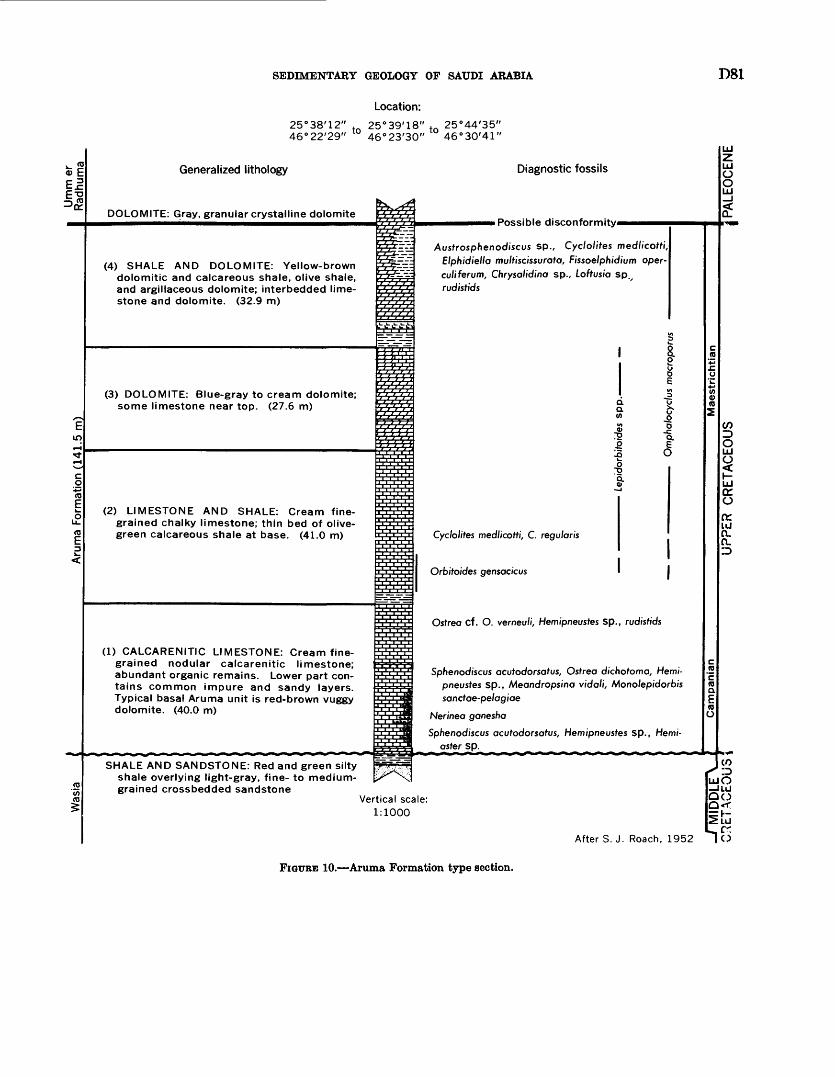
SEDIMENTARY GEOLOGY OF SAUDI ARABIA D81
I
IT)
Location:
25°38'12" . 25°39'18" t 25°44'35" 46°22'29" 46°23'30" 46°30'41"
Generalized lithology
DOLOMITE: Gray, granular crystalline dolomite
Diagnostic fossils
(4) SHALE AND DOLOMITE: Yellow-brown dolomitic and calcareous shale, olive shale, and argillaceous dolomite; interbedded lime stone and dolomite. (32.9 m)
(3) DOLOMITE: Blue-gray to cream dolomite; some limestone near top. (27.6 m)
(2) LIMESTONE AND SHALE: Cream fine grained chalky limestone; thin bed of olive- green calcareous shale at base. (41.0 m)
(1) CALCARENITIC LIMESTONE: Cream fine grained nodular calcarenitic limestone; abundant organic remains. Lower part con tains common impure and sandy layers. Typical basal Aruma unit is red-brown vuggy dolomite. (40.0 m)
i Possible disconformityi
Ai/sfrosphenodisci/s sp., Cyc/o/ifes medlicotti, Elphidiella multiscissurata, Fissoelphidium oper- culiferum, Chrysalidina sp., Loftusia spv rudisfids
;o £
Cyc/o//fes medlicotti, C. regu/an's
Orbitoides gensac/cus I
Osfrea cf. O. verneu/i, Hemipnei/sfes sp., rudistids
Sphenodiscus acutodorsatus, Osfrea dichofoma, Hemi- pneusfes sp., Meandrops/na vidali, Monolepidorbis sancfae-pe/ogiae
Nerinea ganesha
Sphenodiscus acutodorsatus, Hemipneustes sp., Hem/- asfer sp.
CC O
K. LUn. n.
SHALE AND SANDSTONE: Red and green silty shale overlying light-gray, fine- to medium- grained crossbedded sandstone
(O
Vertical scale: 1:1000
LUO-flu QO Q<
LU
After S.J. Roach, 1952 I 6
FIGTTEE 10. Aruma Formation type section.
D82 GEOLOGY OF THE ARABIAN PENINSULA
Lateral changes in the Aruma Formation south of Wadl as Sahba' consist mainly of a gradual replacement of limestone by sandstone from the bottom up. First hints of the replacement can be seen about 40 km south of the wadl; progressive transition from carbonate to sandstone continues so that in the vicinity of Wadl Jaballyah (lat 22°25' N.) the Aruma is sandstone only. This facies persists to the southern limit of outcrop.
In the northern part of the Aruma outcrop, relatively marked changes occur with the appearance of a major lens of sandstone in the lower part of the section. At Khashm Zallum (lat 30°18' N., long 40°21' E.) 61 m of sandstone overlies an 11-m-thick basal Aruma limestone unit. Some investigators have suggested that the top of this limestone corresponds to the top of the Atj member at the type locality. This relationship has yet to be proved; if it is correct, then lower beds of an expanded Lina member are involved in the limestone- to-sandstone transition. The sandstone informally termed the Zallum sandstone is locally poorly in durated, fine to medium grained, and made up of subrounded grains. Striking colors of white, gray, brown, and purple prevail, particularly on weathered surfaces. Near the base, concentrations of cobbles and pebbles of chert, quartz, and quartzite are locally common. In places, the sandstone is now an ortho- quartzite which weathers into hard, dark-gray boulders.
From Khashm Zallum the sandstone can be traced southwest in the face of Jal al Amghar to Khashm al Makhruq (lat 30°03' N., long 40°40' E.) and then east for about 15 to 20 km where it thins slightly and under goes a rapid facies change to marly dolomite, dolomite, and limestone rocks that are typical of the Aruma further south. Northeast of Khashm Zallum, the sandstone crops out in the upper reaches of Wadl (Ar 'ar directly under Aruma limestone and can be traced in the deeply incised canyons as far as Al Mu' tadil (lat 30°31' N., long 40°27' E.); it cannot be identified with certainty north of this point.
The Zallum sandstone is not exposed in the Aruma limestone escarpment northwest of Sakakah but has been identified as the caprock on Jabal Qiyal al Kabir (lat 30°06/ N., long 40°05/ E.) on the northwestern flank of the basin. Zallum sandstone again comes to the surface (at lat 29°57' N., long 39°40' E.) in an es carpment that closely parallels the unconformable con tact between Paleozoic and Eocene or Cretaceous rocks. Sporadic outcrops of Zallum, the only Aruma unit ap pearing west of long 39°40' E., have been mapped in the face of this scarp as far as the Saudi Arabian-Jordan border. With the exception of the Zallum lens, Aruma rock types and fossils in the northern Al Widyan region are very similar to those occurring further south.
NATURE OF CONTACT WITH ADJACENT FORMATIONS
Over most of the outcrop the Aruma rests discon- formably on the Wasia. Between Wadl as Sabba' and the vicinity of Sakakah, the contact is easily placed at the break from sandstone and shale below to limestone above. South of Wadl as Sahba', the Aruma ir mainly in clastic facies, and the contact is less clear. Even here, however, the contact is marked by a charge from silty sandstone and siltstone below to sandstone above.
In the vicinity of Sakakah, the Wasia (SHkaka)- Aruma contact emerges from under the blanket sand of An Nafud and can be traced along the eastern and northwestern edge of the basin. The break between the two units is definitely unconformable, and over this distance Aruma limestone rests on successive^ older parts of the Wasia (Sakaka); near Al Mur^yr (lat 30°03' N., long 39°55' E.) the Wasia (Sakaka) is over lapped, and Aruma rests directly on Lower E woman (Jauf) beds. Not far to the southwest the limestone pinches out. At the next outcrop (at lat 29°57' N., long 39 °40' E.) the Zallum sandstone facies is the only vestige of the Aruma left, and at this point it h lapped onto the Tawil Sandstone Member of the Tabik For mation. Sporadic outcrops of Zallum (to the vest and south along the Al Jayb scarp and west agaii across the northern edge of the A$ TawiUAt fubayq plateau) rest on beds of the Tawil Member and, in one area west of Umm Nukhaylah, on beds of the Jauf Formation.
Along its eastern margin, thte Aruma is everywhere overlain by the Umm er Radhuma Formation. The contact has for many years been considered conformable and gradational, but there is some subsurface paleon- tologic evidence that at least locally a disconformity separates the two. Some paleontologists (F.. Page, unpub. data, 1959) have suggested that the contact over all Saudi Arabia represents a disconfornity or more accurately, a paraconformity (contact is a simple bedding plane); for on outcrop and in deep wells, the top Aruma unit is a thin bed of blue-gray to bis ck dolo- mitic shale bearing Fissoelphidum opercutiferum Smout, Loftusia spp., and Omphalocyclus macroporus Lamark. Immediately above is limestone or dolomite with defi nite lower Paleocene microfossils. The mechanics of formation of a paraconformity of such magnitude and regularity is difficult to imagine.
North of Sakakah, the Aruma Formation is overlain by a cherty, nummulitic limestone of Paleocene or Eocene age that was apparently not directly related to the Umm er Radhuma basin of deposition. Little work has been done in this area, and the exact nature of the contact is unknown.
SEDIMENTARY GEOLOGY OF SAUDI ARABIA
PALEONTOLOGY AND AGE
There is some possibility that the lowermost beds of the Aruma outcrop could be as old as Santonian, as they contain Meandropsina vidali Schlumberger, a form originally described from the Santonian of Spain. However, the uppermost occurrence of this form in Saudi Arabia overlaps the range of Monolepidorbis sanctae-pelagiae Astre, a Campanian form likewise originally described from Spain.
The middle part of the Aruma Formation presents a problem in that it contains beds which fall below the level of the lowermost definitely Maestrichtian Foram- inifera and above the level of the uppermost definitely Campanian Foraminifera.
Immediately overlying this anomalous interval are beds which carry abundant occurrences of Orbitoides gensacicus (Leymerie) and Omphalocyclus macroporus (Lamarck), both good Maestrichtian markers with a very wide distribution in Europe.
Omphalocyclus macroporus is known to occur within a meter of the top of the formation, thus placing the uppermost beds of the Aruma within the Maestrichtian. Other forms occurring within the upper part of the Aruma are Elphidietta multiscissurata Smout, Fissoel- phidium operculiferum, Chrysalidina sp., and Lepi- dorbitoides spp. The latter appear to be limited to the middle and lower parts of the range of Omphalocyclus macroporus.
It is interesting to note that the outcrop Aruma is completely lacking in pelagic Foraminifera, though these are abundantly represented in the deep wells of the coastal area. On the basis of its Foraminifera the Aruma on outcrop is apparently Campanian and Maestrichtian, a conclusion consistent with ammonite and other fossil evidence.
A comprehensive fossil list for the Aruma Formation includes: Cyclolites medlicotti Noetling, Cyclolites reg- ularis Lamark, Cyclolites spp., Coral spp., Ooniopygus sp., Hemiaster sp., Hemipneustes spp., Holectypus sp., Parapygus aff. P. inftatus Cotteau and Gauthier, Pygurostoma aff. P. morgani Cotteau and Gauthier, cidaroid spines, Anomalina sp., Anomalinella cf. A. rostrata (Brady), Ataxophragmium sp., "Borelis" sp., Cibixides sp., Cyclammina sp., Fallotia? sp., Globigerina sp., Globotruncana spp., Haplophragmoides sp., Lepi- dorbitoides sp., Loftusia spp., Meandropsina sp., Om phalocyclus sp., Orbitoides sp., Planispirina sp., Prae- sorites? sp., Pyrgo sp., Quinqueloculina spp., Rotalia sp., cf. Valvulineria sp., miliolids, Actinophyma? sp., Agathelia sp., Alaria sp., Amauropsis sp., Ancilla sp., Anomia sp., Aporrhais sp., Area sp., Arrhoges sp., Asaphis sp., Barbatia sp., Bettardia sp., Bournonia sp., Bullaria? sp., Calliostoma cf. C. omanicus Lees, Cal-
liostoma sp., Campanile sp., cf. Campanile sp., Card'ta cf. C. beaumonti d'Archiac, Cardium sp., Cardiumf ST>., Cerastoderma? sp., Chione? sp., CMamys sp., Chlamyst dujardini (Roemer) Noetling, Corbis sp., Corbula ST>., Granisl sp., Crassatetta sp., OrassateUat sp., Gnocero^ sp., Cymatium sp., Cympolia spp., Eocypraea sp., Eu- spira sp., Faunus sp., Ficus sp., Olycimeris spp., Harpagodes? sp., Hippochrenes sp., Indoceras balusc^i- tanensis Noetling, Inoceramus sp., Keilostoma sp., Lambisl sp., Lima sp., Mitral sp., MytUus? sp., Mono- dontat sp., Morganial sp., Nautilus (Heminautilus) sp., Nautilus spp., Neithea guadricostata (Sowerby), Nemo- cardium? sp., Nerinea ganesha Noetling, Nerita cf. N. pontica (d'Archiac) Noetling, Orthechimus aff. 0. creta ceous Cotteau and Gauthier, Orthopsis sp., Ostrea di- chotoma Boyle, Ostrea cf. 0. verneuli Leymerie, Owda sp., Pecten sp., Perissolax? sp., Pholadomya cf. P. tigris, Noetling, Pholadomya sp., "Pleurotomaria" sp., Plica- tula cf. P. hirsuta Conrad, Potomides sp., Protocardium? sp., Pugnettas aff. P. orientalis Lees, Pyrazus spp., Pyrfuliferaf sp., Pyrina orientalis Cotteau and Gauthier, Pyrulaf sp., Sassia sp., Scaphetta spp., Spondylus spp., Sphenodiscus cf. S. acutodorsatus Noetling, Spheno- discus spp., Sycostoma? sp., Tegula sp., Tibia sp., Tresinus sp., Trochust sp., Tudoceras? sp., TWo sp., Turbo? sp., Turritetta cf. T. quettensis Noetling, TW- nfeWa sp., Tylostoma sp., Venericardia sp., Umboninm sp., Volvulina sp., Xenophoraf sp., ostracodes, and crib claws.
ECONOMIC ASPECTS
GROUND WATKB
The Aruma aquifer has an established hydraulic gradient ranging from water-table conditions on or near the outcrop to flowing artesian conditions in the eastern and southeastern Rub* al Khali. Conditions in northeastern Arabia are less well known. Hydraulic factors are complicated by stratigraphic changes, and water-bearing zones probably constitute only a miror part of the total section.
Aruma water has been tested for quality and quantity in only a few widely scattered areas. Such sparse information suggests that the eastern edge of potable water will pass south of IJafar al Ba^in, near Al Lihab^.h, along the western flank of the Ghawar oil field, and then south through the Rub* al Khali along the 50th meridian.
The Aruma aquifer has been developed as a per manent water supply source only in a few restricted areas. The pipeline stations at Raffia* and Badarah are supplied by wells completed in the Aruma; artesian rises are small, and yield of the wells is comparatively low.
D84 GEOLOGY OF THE ARABIAN PENINSULA
TERTIARY SYSTEM
UMM ER RADHUMA FORMATION PAJLEOCENE AND LOWEREOCENE
DEFINITION
The Umm er Radhuma Formation was named by S. B. Henry and C. W. Brown in 1935 for the Umm Ratfmah wells (lat 28°41 / N., long 44°41' E.) that draw water from the upper part of the unit. In 1936, Max Steineke and J. W. Hoover also studied the formation in this area but, because of difficulties in working out a full, sequence, designated a reference section in Wadi al Batin. Umm er Radhuma was first cited in publication by Steineke and Bramkamp (1952(b)); a later paper (Steineke and others, 1958) included reference section details.
With exception of the uppermost beds, the entire formation can be seen in the steep walls of Wadi al Batin. Here, the reference section was pieced together from many short intervals measured in a continuous 70-km traverse from the top of the Linah escarpment (lat 27°38'03" N., long 44°53 /24 // E.) northeast along Al Ba^in to lat 27°59/00// N., long 45°27/48// E.
The base of the Umm er Radhuma is at the contact of Lockhartia-be&rwg dolomite and limestone with underlying dolomitic shale of the Aruma Formation. The top is not exposed at the reference section because of overlapping Miocene and Pliocene rocks, but it is present a short distance downdip in structure holes and water wells where Umm er Radhuma dolomite containing Lockhartia hunti Ovey var. pustulosa Smout is overlain by soft chalky Rus limestone.
OCCURRENCE AND THICKNESS
Rocks of the Umm er Radhuma have been mapped in a fairly wide belt extending from just south of Wadi Jabaliyah (lat 22°25' N.) to the Iraq-Saudi Arabian border, a distance of about 1,200 km. Width of the Umm er Radhuma is highly variable, in some places because of superficial sand and gravel cover, in others because of overlapping Miocene and Pliocene beds. Prior to such cover, however, the outcrop probably was quite regular, measuring 60 km across at the south and about 120 km near Iraq, most of the expansion apparently taking place between Khurays Gat 25°05/ N.) and Ma' qala' (lat 26°32/ N.).
From Wadi al Batin south, the Umm er Radhuma is longitudinally disrupted by the great curved Ad Dahna' sand belt, a cover that effectively prevents study of any complete section throughout this distance. At the southern limit of the Umm er Radhuma, upper beds are masked. Northward the Ad Dahna' sand belt shifts, covers the middle part of the formation nearly to Al Batin, and then, as strike of the Umm er
Radhuma swings north, cuts sharply across section and overlaps the Aruma.
Umm er Radhuma exposures usually form a gently undulating but rough surface spotted with lo^ isolated hills and weak discontinuous benches. Karrt features are a prominent part of the upland surface, particularly northwest of Al Batin. This area also supports a well- developed system of through-cutting channels that follow regional dip.
In the area southwest of the Trans-Arabiar Pipeline, between Ash Shu'bah (lat 28°54/ N., long 44°42' E.) and Rafba' (lat 29°39/ N., long 43°28/ E.), the Umm er Radhuma surface is marked by numerous elevated river channels which begin at the Linah escarpment and trend northeast to the Umm er Radhuma se^rp where the majority of them are covered. Together with their tributaries they form a dendritic pattern wlich bears little relationship to the present drainage system and none to present structure. Their present elevation, from 2 to 18 m above the local base level, war probably caused by subsequent deflation of the softer irtervening rocks. Miller (1937) discussed these bas-re?ief drain age lines.
The elevated channels and tributaries, each with varying thicknesses of duricrust, are separated by low, enclosed silt basins which collect present runof*. Upper surfaces of the tributaries slope toward the main chan nels at gradients ranging from 2° to 4°, whereas beds of channel deposits making up the elevated tributaries have a more gradual dip (from 00°30' to 1°30') in the same direction. Channel deposits are most commonly marl and limestone derived from the Umm er P.adhuma, but, in the northwest, rocks of the upper Aruma are in cluded as well.
Much of the area northwest of Al Batin is character ized by a very poorly developed internal drainage sys tem related to numerous small sinks and major sharp scarps, such as Jal Nawazir-Mahshim U'ayvij, 35 km west of RafbaV, and Jal al Batm, 60 km north of Raf^a'. Within Saudi Arabia, the highest of these rionoclinal escarpments Jal al Ba$n extends between Al Liflyah (lat 30°25' N., long 43°04' E.) and Birkat al 'Aqabah (lat 30°05/ N., long 43°37' E.), roughly a distance of 65 km. Although its trend is generally northwest, the face of the flexure is quite sinuous and dips variously to the west, southwest, and south. Regional dip en the up land surface, about 00°10' NE., is maintained to the crest of the jal where it abruptly shifts to a maximum of 12° in the opposite direction along the frort-face dip slope. At the foot of the slope the rate of dip gradually slackens and merges once again with the regional. The greatest relief measured along Jal al Batn from the rim of the base of the escarpment was 85 m. A similar flexure Mahshim U'aywij-Jal Nawazir occurs about
SEDIMENTARY GEOLOGY OF SAUDI ARABIA
35 km west of Raffra'. Its strike is north-northwest with the dip slope facing southwest. In many respects it is similar to Jal al Ba^n, although its maximum relief is only 35 m. Slumping involves Umm er Radhuma as well as a few isolated patches of Miocene and Pliocene. The steepest dips on the face are 10°.
Tested by drilling, these two monoclines have proven to be superficial, primarily related to solution-collapse caused by removal of anhydrite. Shallow holes brack eting the flexure show a thick interbed of Umm er Rad huma anhydrite immediately below the surface on the structurally high side of the monocline; the anhydrite is missing on the low side.
Within the Umm er Radhuma outcrop area many Miocene and Pliocene slump features occur around or near the periphery of the larger Miocene and Pliocene bodies. Domes at Al Lifiyah, Lawqah (lat 29°49' N., long 42°45' E.), and Kharma' Karlm (lat 29°00' N., long 44°47' E.) are examples. These and other related dornal structures are characterized by concentric rings of limestone ridges about 5 m in relief and generally occurring about 100 m apart. Some such as Kharma' Karim are more than 5 km in diameter at the outside ledge. Dip on the ledges is about 4° to 8° radially away from the center of the dome, but there is no appreciable difference in the elevation of the tops of the rings. It is presumed on the basis of stratigraphic position and lithologic similarity that the limestone ridges represent repetition of beds in section rather than continuous depositional sequence. This repetition is attributed in part to solution of underlying evaporites and in part to "draping" of the Miocene and Pliocene sediments over "hills" on the overlapped Umm er Radhuma surface.
Surface mapping and structure drilling indicate that these anomalous surface features involving Miocene and Pliocene, Umm er Radhuma, and, in some instances, Aruma strata are superficial solution-collapse struc tures. Their mode of formation in Miocene and Pliocene rocks is still incompletely understood but in older beds now seems clear.
In addition to the main outcrop belt, rocks at least partly equivalent to the Umm er Radhuma (and over lying Rus and Dammam) are exposed over much of the area north of lat 29°30' N. and west of the 40th meridian. Nearly 160 km of Aruma separates the two areas of Paleocene and Eocene sedimentation. The undivided Paleocene and Eocene rocks on the west informally termed the Hibr formation are presumably a Mediterranean facies deposited in a seaway not directly connected with the Persian Gulf basin.
Maximum known thickness of the Umm er Radhuma on outcrop is at the reference section where 243 m was measured. To the south, the Ad Dahna' sand
cover and loss of beds at the top through pre-Miocene erosion prevents accurate measurement. However, partial measurements supplemented by calculated intervals show about 105 m near Wadi al 'Atk and 110 m at Wad! as Sahba'. North of the reference section, two sections have been pieced together from numerous very short increments measured along high ly circuitous traverses. The first, extending generally northeast to Ni§ab (lat 29°11 / N., long 44°43' E.), indicated about 210 m; the second (approximately along lat 30°00/ N.) showed 234 m but did not rea<?h the top of the formation. Another traverse in the extreme northwestern corner of Saudi Arabia indicated only 25 m of Umm er Radhuma below the pre-Miocene unconformity.
So far as the Hibr formation is concerned, E. L. Berg and L. D. Owens in 1946 measured 150 m of beds between IJazm al Jalamid (lat 31°18' N., long 39°54' E.) and Tall al Hibr (lat 31°51' N., long 38°08' E.). Their measurement appears short in view of the fact that a water well drilled at rJ1urayf pump station (lat 31°41' N., long 38°39' E.) penetrated nearly 485 m of Hibr beds.
In the northern part of Wadi as Sirban (near lat 31°30' N., long 37°05' E.), in 1952 D. A. Holm and others measured 110 m of section above the Hibr that is now regarded as upper Eocene and possibly is evm in part Oligocene. Lateral extent of the upper Eocene has never been determined, and it has therefore be^n necessary simply to consider it along with Hibr strata as Paleocene and Eocene undivided.
ITTHOIOQIC CHARACTER
The Umm er Radhuma everywhere consists of a repetitious series of light-colored foraminiferal aphani- tic and calcarenitic limestone, dolomitic limestone, and dolomite. Local silicification of thin, bench-capping limestones is common, and chert occurs sporadically throughout the section. Although certain distinctive beds are found at various levels, it is difficult to find any group of beds that can be set apart as a unit. The best that can be said is that calcarenitic and sili ceous beds are more common in the upper part of the formation and partially dolomitized aphanitic lirr^- stone in the lower. Regionally, there seems to be progressive replacement of limestone by dolomite from south to north although there are significant exceptions to even this pattern.
The middle part of the Umm er Radhuma is covered by eolian sand for some distance north and south of Wadi as Sahba'. Here, approximately the uppermost 50 m of the formation is exposed east of the satid blanket, and in addition approximately 30 m of basal beds crop out to the west. The missing interval covered
D86 GEOLOGY OF THE ARABIAN PENINSULA
by sand is unknown but is considered to be relatively small and is estimated to represent about 30 m of section. Throughout this area, the Umm er Radhuma is entirely limestone except for a thin laterally persistent zone of dolomite and partially dolomitized limestone at the top. In the north the dolomite crops out as a wide bench below the Rus escarpment. The bench can again be picked up to the south of Wadi as Sahba', but cap ping Rus beds are missing because of Miocene and Pliocene overlap. Below the zone of dolomite is a uniform succession of gray-green to tan, finely granu lar, somewhat leached and chalky limestone. Fossilif- erous beds occur at many levels, but the fossils have usually been leached out, their only trace being small pits on the weathered surface.
Rocks of the Umm er Radhuma north of Al Batin are accurately represented by the reference sequence measured and described in that channel. Max Steineke and J. W. Hoover in 1936 were the first to work the Al Ba^in section and define it as a reference locality. Because rates of dip of the channel bottom and of the flanking bedding are so nearly alike, only 3 to 4 m of new beds are exposed per kilometer. It is somewhat difficult to trace such low-dipping beds in a monotonous sequence and accurately tie together the many small increments making up a full section. As a result, W. H. Reiss and R. D. MacDougall in 1953 retraced the orig inal traverse and with plane-table survey remeasured the entire outcrop band (pi. 10). Their description of the reference section is given in section 53 (p. 143).
Like the Umm er Radhuma-Rus-Dammam (Paleo- cene to middle Eocene) sequence to which it most closely equates, the Hibr is also almost exclusively lime stone. The unit is composed of light-colored, thin- bedded, chalky and cher.ty limestone and marl. Partial dolomitization is common. Nummulite and other fossil zones occur at several levels, but no consistent marker beds have been observed. Much chert is interbedded with chalky limestone in the form of lenses, platy masses, flat ovoid nodules, and spheroidal concretions. Parts of the upper Hibr, for example between Tiirayf and Tall al Hibr, have been altered to tripoli, a fine powdery form of silica. On weathering, the Hibr forms a rather flat, featureless plain. Included chert often remains as residual chips after removal of surrounding softer limestone by weathering and deflation.
NATURE OF CONTACT WITH ADJACENT FORMATIONS
The Umm er Radhuma everywhere overlies the Aruma with apparent conformity. Precise character istics of the contact have already been pointed out in the discussion of the upper Aruma limit (p. 82).
The contact of the Hibr rocks with underlying units is less clear. On the east, it overlies the Aruma For
mation with the boundary generally trending north- south along long 39°50' E. The base of the Hibr has been defined as the contact with the underlying Cretaceous, which is a somewhat tenuous limit. It has been necessary to set an arbitrary base at the break between beds containing abundant dark chert and, in some areas, Nummulites and beds of ncnsiliceous carbonates of the Aruma. The problem of the Cre taceous-Eocene contact does not exist, of course, where Cretaceous beds are missing for example, 20 km north west of Al Jawf. Here Paleocene beds lap over onto Lower Devonian strata. Immediately west, however, the Aruma (Zallum sandstone facies) appearr between, and in discordant relationship with, Hibr and Pale- zoic rocks. A comparable situation prevails around the southern margin of the Hibr as far as the Jordan border; that is, Paleocene and Eocene roc^s uncon- formably overlie Zallum where it is present but other wise rest directly on Lower Devonian.
Contact between the Umm er Radhumr, and the overlying Rus Formation is visible only from Wadi as Sahba' north to lat 25°44' N., a distance of 180 km. Over this distance, dolomite and dolomitic limestone of the Umm er Radhuma is conformably overlain by typical soft, chalky limestone of the Rus Forma tion. Outside of this area, the Umm er Radhuma is unconformably terminated at the top by erratic out crops of sandy marl and sandy limestone (Miocene and Pliocene) or surficial deposits.
Western exposures of Paleocene and Eocene un divided (including Hibr facies) are discordantly over lain by sandy carbonates (Miocene and Pliocene) or by flows of Tertiary and Quaternary basalt.
PALEONTOLOGY AND AGE
The Umm er Radhuma Formation falls into three principal subdivisions on fauna! grounds, ^he upper division is early Eocene in age; it carries such species as Sakesaria cotteri Davies, Lockhartia tipperi (Davies), and Lockhartia hunti Ovey var. pustvlosa Smout. It is equivalent to the lower Eocene of Qatar described by Smout (1954) and the Laki beds of India.
The two lower subdivisions are Paleocer 0* in age, the break between them probably corresponding to the contact between Smout's Qatar Paleocene zones 4 and 5 (Smout, 1954). These lower subdivisions of the Umm er Radhuma correspond at least in part to the Ranikot of India, but exactly what p<»rt of the Ranikot is represented in the Saudi Arabian beds is not known. However, the general parallelism be tween the beds of the lowermost Umm er Radhuma and the uppermost (Maestrichtian) beds of the Aruma would not suggest any prolonged time gap at the contact.
SEDIMENTARY GEOLOGY OP SAUDI ARABIA D87
Originally considered Eocene and Oligocene, the post-Aruma sediments northwest of SakSkah are now fairly accurately dated as Paleocene to late Eocene. Nautiloids of Paleocene affinities were collected at the base of the section (according to W. M. Furnish, re ferring to Comomia sp. cf. C. kugleri Miller). Strong evidence for a Paleocene age was also given by re covery of Anomalina dorri Cole var. aragonensis Nuttall, Bulimina semicostata Nuttall, Globorotalia velascoensis (Cushman), Loxostoma applinae (Plummer), and Siphogenerina eleganta Plummer from a T?urayf water well. Higher beds in this Turayf well carry Bulimina jacksonensis Cushman and Hantkenina mexi- cana Cushman, forms indicative of either Middle or Upper Eocene age. Correlative beds on the outcrop, however, also carry abundant occurrences of Num- mulites gizehensis (Forskel), thus suggesting that most of the higher beds at rj?urayf belong within the Middle Eocene. The presence of Upper Eocene is not proved but is postulated on the occurrence of post-Hibr beds still carrying B. jacksonensis and on the occurrence of beds above the range of B. jackson ensis but within the biozone of Guembelina.
A comprehensive faunal list of the Umm er Radhuma and Paleocene-Eocene undivided (including Hibr facies) is given below.
The Umm er Radhuma Formation contains Opis- saster somaliensist, indeterminate echinoids, Anadara sp., Arcal sp., Brachiodontest sp., Buttaria sp., Carditat sp., Cerithium (s.l.) sp., Chama? sp., Corbula sp., Cympolia spp., Diplodonta? sp., Euspira cf. E. rod, Homalopoma? sp., Macomaf sp., Nautilus sp., Nemo- cardium? sp., Oliva 1? sp., Pentalium? sp., Siligua cf. sp., Strepsidura sp., Turritetta sp., indeterminate lucinoid, naticoid, cerithiid, and strombid gastropods. Foraminifera are poorly preserved and not abundant on outcrop. See plate 10 for representative subsurface forms.
The Paleocene and Eocene undivided (including Hibr f acies) contains Amphiope? sp., Echinocyamus libycusf Fourtan, Cardita cf. C. asperula, Cassis nilotica?, Chlamys, Conus, Comomia cf. C. kugleri, Lucina sp., Mesalia hofana, M. locardi, Ostrea pUcataf Solander, Turritella sp., Venericardia sp., shark teeth, Amphiso- rus?, Assilina 1?, Buliminaf, Clavulina sp., Globigerina, Nummulites curvispira d'Archiac and Haime, N. spp., Operculina cf. 0. discoidea Schwager, QuinguelocuUna, sp., Textulariaf, Uvigerina, Valvulina spp., Valmdineria.
ECONOMIC ASPECTS
GROUND WATER
The Umm er Radhuma aquifer is a single thick hydraulic unit of regional extent. It has an estab lished gradient ranging from water-table conditions on
or near the outcrop to flowing artesian conditions along the Persian Gulf and in some topographically low areas of the Rub' al Khali. The catchment area for this aquifer is the belt of Aruma and Umm er Radhuma outcrop plus the area mantled by eolian sand of Ad Dahna'.
Water from the Umm er Radhuma ranges in quality from excellent at or near the outcrop to poor generally northwest of the Trans-Arabian Pipeline. Some r.reas within the general region of potability, such as Nariya, Abqaiq, and Ras Tanura, produce poor-quality water because of the presence of dissolved hydrogen sulfide gas. In the Rub' al Khali, water with less than 4,800 ppm of total dissolved solids occurs as far east as" the 51st meridian. East of this line and generally north of the 21st parallel, total solids vary from 5,001 to 95,000 ppm.
Local structural features in the coastal area have some effect on water quality and also upon the east- dipping hydraulic gradient. A decrease in permea bility on the flanks of the features tends to divert regional flow and to restrict flushing by fresher meteoric water. This effect is not as marked, however, as it is in the Wasia.
The Umm er Radhuma aquifer has been developed by Aramco as the water supply for many of the company communities and outlying installations. Potential of the aquifer is such that it could also handily support major domestic and agricultural projects.
BUS FORMATION LOWER EOCENE
DEFINITION
The Rus Formation is named for Umm ar Eu'us (lat 26°19' N., long SOW E.), a small hill where the type section was measured. R. A. Bramkamp first applied the name in 1946 as a direct replacement for the term "Chalky Zone" which had been informally used for lower Eocene beds above the Umm er Radtuma and below the Dammam Formation. The limits have not been changed.
A table of Saudi Arabian rock units appearing in a paper by Thralls and Hasson (1956) constitutes first formal publication of the term Rus Formation. De tailed information on the type sequence was published by Steineke, Bramkamp, and Sander (1958). Addi tional stratigraphic and paleontologic data was included in Sander's (1962) discussion.
The type section of the "Chalk Zone," now the Rus Formation, was originally established by S. B. Fenry and J. W. Hoover in 1934 on the southeastern flark of Dammam Dome in and below Umm ar Ru'us (lat 26°19'04" N., long 50°07'51" E.).
The base is at the contact between brown dolomite containing Lockhartia hunti Ovey var. pustulosa Sraout
D88 GEOLOGY OF THE ARABIAN PENINSULA
below and light-colored, chalky, partially dolomitized limestone above. Common leached molds of small indeterminate molluscs is a marked characteristic of the basal Rus unit. The upper few meters of the Rus is not exposed at the type locality but can be picked up clearly in the adjacent rimrock around Dammam Dome. Here the break is at the change from light-colored, chalky calcarenite below to yellow- brown shale of the basal member of the Dammam Formation above.
OCCURRENCE AND THICKNESS
Definite exposures of Rus rocks are limited to two small areas the first, a narrow band extending some 180 km northward from Wadi as Sahba', and the second, a nearly circular patch about 10 km in diameter cropping out in the breached core of Dammam Dome.
The Rus north of Wadi as Sahba' is rather feature less, without a traceable bed or other reliable guide to stratigraphic position. For this reason the full thick ness can only be estimated as 25 to 30 m. Thickness at the type locality is 56 m.
A number of isolated patches in the far southeastern Rub* al Khali, north of Dhufar, have been mapped as Rus and Dammam undivided, but the exact makeup of these outliers is uncertain. Paleocene and Eocene rocks (Hibr) occurring northwest of Sakakah, certainly in part equivalent to the Rus, have been described in connection with the Umm er Radhuma.
LTTHOIOQIC CHARACTER
Rock types in the two areas of Rus outcrop are for all practical purposes identical. Basically, the unit is light-colored, soft, chalky limestone and marl. R. A. Bramkamp's remeasurement of the Umm ar Ru'us sequence in 1946 (fig. 11) resulted in the description given in section 54 (p. 145), which is typical for other exposures as well.
Subsurface equivalents of the middle Rus (unit 2, section 54 and fig. 11) are highly variable both in lithology and thickness. Most commonly the sequence is (1) white, compact, finely crystalline anhydrite with interbedded green shale or (2) gray marl with coarsely crystalline calcite and interbedded shale and limestone. Variations in thickness are largely caused by variations in the amount of anhydrite present. As a general rule, the middle Rus is thicker on the flanks of structures than it is on the crests. Complexly settled rocks, such as those seen around Dammam Dome, suggest some of the differences in interval are caused by solution of anhydrite. In other places, the differences seem to be related to original depositional thinning over structural highs.
NATURE OF CONTACT WITH ADJACENT FORMATIONS
The Rus in the vicinity of Wadi as Sahba' represents an unbroken transition from the Umm er Radhuma below to the Dammam above. In spite of the uni formity of section, contacts are reasonable clear cut. Brown Umm er Radhuma dolomite is overlain by off- white, chalky, porous limestone with abundant indeter minate molds and casts, which in turn gives way at the top to tan, calcareous, and gypsiferous shale and interbedded marl of the basal Dammam.
Comparable breaks mark the top and bottom of the Rus at Dammam Dome.
PALEONTOLOGY AND AGE
Diagnostic fossils are not known to occur in the Rus Formation although it is underlain and over'ain by rocks of proven early Eocene age. In terms of standard European stages the Rus is presumed to fall entirely within the Ypresian.
ECONOMIC ASPECTS
As a dominantly evaporite sequence, the Fus has few porous beds. Limestones at the base and top of the interval are porous and probably water bearing, but these have not been selectively tested. Some shows of low-gravity oil have been found in offshore wells.
DAMMAM FORMATION LOWER AND MIDDLE EOCENE
DEFINITION
The Dammam Formation was named for Dr»mmam Dome where the entire sequence crops out. R. A. Bramkamp in 1941 measured and designated the type locality along the old Dhahran-Al 'Alah road from the point where this road intersects the rimrock (lat 26°19'16" N., long 50°04'50" E.) northwest to the Eocene-Miocene contact.
The base is at the contact of calcarenite or limestone of the Rus Formation with the overlying brown shale and light-gray marl of the basal Dammam. The top is at the unconfonnable contact of pure carbonate of any part of the Dammam Formation with the overlying sandy limestone of the Hadrukh Formation.
Where present in full thickness, the Dammam is almost everywhere divisible into five members, two of which possess distinctive and laterally persistent basal marl units. Listed in descending orde", these members and their subdivisions are as follows:
Alat Member:Alat limestoneAlat marl
Khobar Member:Khobar dolomiteKhobar marl
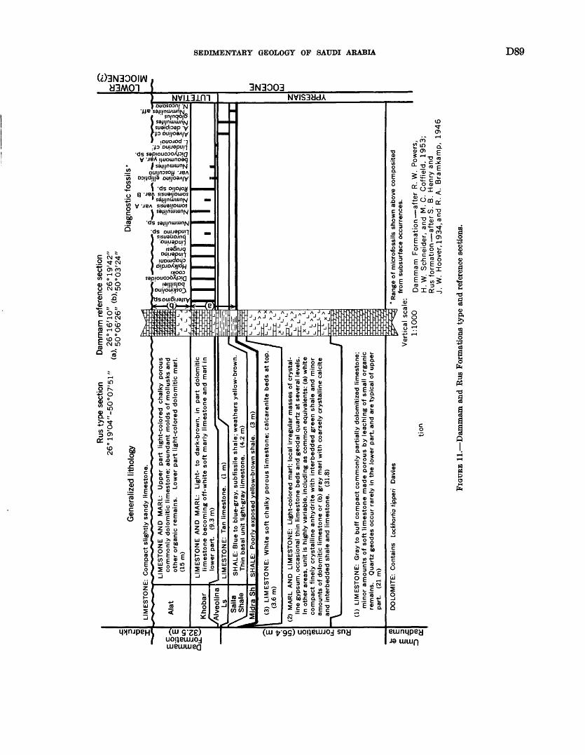
Rus
typ
e se
ctio
n 2
6°1
9'0
4"-
50
°07
'51
"D
amm
am r
efer
ence
sec
tion
26°1
6'1
0"
.. 2
6°1
9'4
2"
, .
1 ;'
50
°06
'26
"
Gen
eral
ized
lith
olog
y
LIM
ES
TO
NE
: C
om
pa
ct s
ligh
tly s
an
dy
lime
sto
ne
.
Ala
t
LIM
ES
TO
NE
A
ND
M
AR
L:
Upper
part
lig
ht-
colo
red
cha
lky
poro
us
com
monly
dolo
mitic
lim
est
one;
abundant
mo
lds
of
mo
llusk
s an
d oth
er
org
anic
rem
ain
s.
Low
er
pa
rt l
ight-
colo
red d
olo
mitic
ma
rl.
(15m
)
Kho
bar
Alv
eolin
a Ls
LIM
ES
TO
NE
A
ND
M
AR
L:
Lig
ht-
to
d
ark
-bro
wn
, in
p
art
dolo
miti
c lim
esto
ne
beco
min
g o
ff-w
hite s
oft m
arly
limesto
ne a
nd
marl i
n \
low
er
pa
rt.
(9.3
m)
LIM
ES
TO
NE
: T
an l
ime
sto
ne
. (1
m)
Sai
la
Sha
leS
HA
LE:
Blu
e t
o b
lue
-gra
y, s
ub
fissi
le s
ha
le;
we
ath
ers
yello
w-b
row
n
Thin
ba
sal
un
it lig
ht-
gra
y lim
est
on
e.
(4.2
m)
__
__
__
__
Mid
ra S
hS
HA
LE:
Po
orly
exp
ose
d y
ello
w-b
row
n s
hale
. (3
m)
(3)
LIM
ES
TO
NE
: W
hite
soft c
halk
y p
oro
us
limesto
ne;
calc
are
nite
beds
at
top
(3
.6 m
)
(2)
MA
RL
AN
D
LIM
ES
TO
NE
: L
igh
t-co
lore
d m
arl;
loca
l irre
gu
lar
mas
ses
of
crys
tal
line g
ypsu
m,
occ
asi
on
al
thin
lim
est
one b
eds
and
ge
od
al
qu
art
z at
seve
ral
leve
ls.
In o
the
r ar
eas,
un
it is
hig
hly
va
ria
ble
, in
cludin
g a
s co
mm
on e
quiv
ale
nts
: (a
) w
hite
co
mpact
fin
ely
cry
sta
llin
e a
nh
yd
rite
with
inte
rbedded g
reen s
hale
and m
ino
r am
ounts
of
dolo
miti
c lim
est
one o
r (b
) gra
y m
arl w
ith c
oars
ely
cry
sta
llin
e c
alc
ite
and
inte
rbedded s
hale
and
lim
est
one.
(31.
8)
(1)
LIM
ES
TO
NE
: G
ray
to b
uff
co
mp
act
com
monly
part
ially
do
lom
itize
d l
imest
one;
min
or
am
ou
nts
of
soft l
imesto
ne m
ad
e p
oro
us
by
leach
ing o
f sm
all
org
anic
re
main
s.
Qu
art
z g
eo
de
s o
ccu
r ra
rely
in
the
low
er
pa
rt,
and
are
typ
ica
l o
f upper
part
. (2
1 m
)
I =
DO
LOM
ITE
: C
onta
ins
Locf
c/ia
rfia
fippe
ri D
avie
s
tion
* R
ange
of
mic
rofo
ssils
sho
wn
abov
e co
mposi
ted
....
, ,
from
subsu
rface
occ
urr
en
ces.
V
ert
ica
l sc
ale
:
1:1
000
Dam
mam
F
orm
atio
n a
fte
r R
. W
. P
ower
s,
H.W
. S
chneid
er,
and
M
. C
. C
offie
ld,
1953;
Rus
form
ation a
fter
S.
B.
Hen
ry a
nd
J. W
. H
oove
r, 1
93
4,a
nd
R
. A
. B
ram
kam
p,
1946
FIG
URE
11.
Dam
mam
and
Rus
For
mat
ions
typ
e an
d re
fere
nce
sect
ions
.
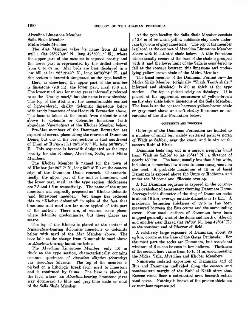
D90 GEOLOGY OF THE ARABIAN PENINSULA
Alveolina Limestone Member Saila Shale Member Midra Shale Member
The Alat Member takes its name from Al Alat well 1 (lat 26°27/49" N., long 49°50'11" E.), where the upper part of the member is exposed nearby and the lower part is represented by the drilled interval from 0 to 67 m. Alat beds are best displayed in a low hill at lat 26°19'42' / N., long 50°03'24" E., and this section is herewith designated as the type locality.
Here, as elsewhere, the upper part of the member is limestone (9.0 m), the lower part, marl (6.0 m). The lower marl was for many years informally referred to as the "Orange marl," but the name is now obsolete. The top of the Alat is at the unconformable contact of light-colored, chalky dolomitic limestone below with sandy limestone of the Hadrukh Formation above. The base is taken at the break from dolomitic marl above to dolomite or dolomitic limestone (with abundant Nummulites) of the Khobar Member below.
Pre-Alat members of the Dammam Formation are exposed at several places along the rimrock of Dammam Dome, but one of the best sections is that southwest of Umm ar Ru'us at lat 26°16 / 10" N., long 50°06'26" E. This sequence is herewith designated as the type locality for the Khobar, Alveolina, Saila, and Midra Members.
The Khobar Member is named for the town of Al Khubar (lat 26°17' N., long 50°13' E.) on the eastern edge of the Dammam Dome rimrock. Characteris tically, the upper part of the unit is limestone, and the lower part, marl; at the type section, thicknesses are 7.8 and 1.5 m respectively. The name of the upper limestone was originally proposed as "Khobar dolomite (and limestone) member," but usage has reduced this to "Khobar dolomite" in spite of the fact that limestone and marl are far more typical of this part of the section. There are, of course, some places where dolomite predominates, but these places are scarce.
The top of the Khobar is placed at the contact of Nummulites-be&rin.g dolomitic limestone or dolomite below with marl of the Alat Member above. The base falls at the change from Nummulitic marl above to Alveolina-be&riug limestone below.
The Alveolina Limestone Member, only 1.0 m thick at the type section, characteristically contains common specimens of Alveolina ettiptica (Sowerby) var. floscvlina Silvestri. The top of the member is picked on a lithologic break from marl to limestone and is confirmed by fauna. The base is placed at the level where tan Alveolina-be&rmg limestone gives way downward to blue and gray-blue shale or marl of the Saila Shale Member.
At the type locality the Saila Shale Member consists of 3.6 m of brownish-yellow subfissile clay shaJe under lain by 0.6 m of gray limestone. The top of the member is placed at the contact of Alveolina Limestone Member above with blue-tinted shale below. A thin limestone which usually occurs at the base of the shale is grouped with it, and the lower limit of the Saila is considered to fall at the contact between this limestone and under lying yellow-brown shale of the Midra Member.
The basal member of the Dammam Formation the Midra Shale Member (originally "Shark Tooth shale," informal and obsolete) is 3.0 m thick at the type section. The top is picked solely on lithology. It is placed at the uppermost occurrence of yellow-brown earthy clay shale below limestone of the Saila Member. The base is at the contact between yellow-brown shale or gray marl above and soft chalky limeston0. or cal- carenite of the Rus Formation below.
OCCURRENCE AND THICKNESS
Outcrops of the Dammam Formation are limited to a number of small but widely scattered patches north of Wadl as Sahba', near the coast, and in tH south eastern Rub* al Khali.
Dammam beds crop out in a narrow irregular band from Wadl as Sahba' to lat 25°41' N., a distance of nearly 180 km. The band, usually less than 5 km wide, includes a somewhat low discontinuous escarp raent on the west. A probable maximum of 15 m of basal Dammam is exposed above the Umm er Radhuma and under the Miocene and Pliocene overlap.
A full Dammam sequence is exposed in the conspic uous oval-shaped escarpment rimming Dammam Dome. Average inside diameter of the ring of Dammam rocks is about 10 km; average outside diameter is 1£ km. A maximum formation thickness of 32.5 m 1 as been measured between the Rus center and the surrounding cover. Four small outliers of Dammam h$we been mapped generally west of the dome and north cf Abqaiq and another near Saratf (lat 24°08' N., long 49°04' E.) at the southern end of Ghawar oil field.
A relatively large exposure of Dammam, about 20 sq km, occurs at the base of the Qatar Peninsula. For the most part the rocks are Dammam, but occasional windows of Rus can be seen in low hollows. Thickness of the section here varies from 10 to 51 m, encompassing the Midra, Saila, Alveolina and Khobar Members.
Numerous isolated exposures of Dammam and of Rus and Dammam undivided along the eastern and southeastern margin of the Rub* al Khali si ow that Eocene rocks floor a substantial area beneath eolian sand cover. Nothing is known of the precise thickness or members represented.

SEDIMENTARY GEOLOGY OF SAUDI ARABIA D91
1ITHOIOOIC CHARACTER
Rocks of the Dammam Formation are characteris tically light-colored limestone, marl, and shale. There is no significant variation from the rock types at Dam- mam Dome, even though the Dammam Formation and its individual members thicken drastically in the sub surface and extend over most of northeastern Arabia and large parts of the Rub* al Khali.
Best exposures are those of the Dammam Formation reference section which also serves as the type locality for the separate members. The section was pieced together by R. W. Powers and others in 1953 from two measurements (fig. 11): the lower covering the Midra- Saila-Alveolina-Khobar interval, the upper including Alat strata. Reference section particulars have been given in connection with member definition (p. 88). A detailed description of the rock sequence is given in section 55 (p. 145).
NATURE OF CONTACT WITH ADJACENT FORMATIONS
The base of the Dammam Formation is exposed only at Dammam Dome and in the vicinity of Wadl as Sahba'. In both areas, shale of the Midra Member rests conformably on chalky limestone of the Rus For mation. At the top, various members of the Dammam are in discordant contact with Miocene and Pliocene or with younger sediments.
PALEONTOLOGY AND AGE
From the uppermost beds of the Alat Member, which carry a very large Dictyoconus sp., to the base of the Alveolina Limestone Member with Alveolina ettiptica (Sowerby) var. flosculina Silvestri, the Dammam For mation is clearly middle Eocene (Lutetian) in age. Below this level the presence of a "Nummulites globulus Leymerie" of the type figured by Smout (1954) from the lower Eocene of Qatar strongly indicates that the remainder of the formation is lower Eocene (Ypresian).
Microfossils are usually poorly preserved on outcrop, and the diagnostic forms shown in figure 11 have been projected into the reference section from the subsurface sequence. Correlations are clear cut, and there is no doubt about surface-subsurface relationships.
ECONOMIC ASPECTS
GROUND WATER
Two carbonate members of the Dainmam Forma tion the Khobar and Alat are acquifers of regional importance. As in pre-Dammam aquifers, both hy draulic and salinity gradients are evident. Artesian conditions occur near the western outcrop band, and flowing artesian conditions obtain in the coastal area and eastern Rub* al Khali. Likewise, the breakover from potable to nonpotable water follows roughly the
same pattern as that established by the Umm er B ad- huma. Recharge to both aquifers is apparently pro vided by downward percolation through Miocene and Pliocene sands overlying the truncated outcrop.
Khobar water is used extensively in communities and agricultural areas of the Eastern Province. Al Qatlf oasis, north of Dhahran, and the towns of Al Qa^if and Al Khubar as well as adjacent communities constitute the most concentrated areas of withdrawal. A few wells have penetrated the Khobar aquifer in and near the oasis of Al Hasa.
Major withdrawals from the Alat aquifer are also limited to the Eastern Province. The member is the sole source of potable water for the townsite of Ras Tanura and the pump station at An Nu* ayrlyah. Locale of heaviest development, however, is in Al Qa^if oasis. Erratic artesian conditions prevail in this area, and it is necessary in many places to drill through the Alat and complete in the Khobar to obtain flowing water.HADRUKH, DAM, HOFUF, AND KHARJ FORMATIO] T<-J
MIOCENE AND PLIOCENE
DEFINITION
The coastal area of Saudi Arabia has been essentially a broad structural terrace, only intermittently sub merged, throughout Tertiary time. As a result, few marine sediments were deposited during that perod, and these only erratically as seas oscillated to and fro across the terrace with each invasion reaching varying distances inland. The most western margin of marine sedimentation seems to be generally less than 100 km from the present Persian Gulf shoreline.
Where marine rocks occur, the Miocene and Pliocene succession can be subdivided into three format; ons which from the bottom up are Hadrukh, Dam, and Hofuf. Toward the interior, marine marker I <sds grade to continental sediments, and coastal subdivisions can no longer be recognized. Where this happens, the above formations are treated as a single unit Tertfary sandstone, marl, and limestone. Beyond the western limit of the continental beds, distinctive patcher of lake deposits, generally plastered on the Sulaiy outcrop belt, have been named the Kharj Formation. Of pre sumed Miocene and Pliocene age, they are certainly at least in part equivalent to Tertiary marine-continental rocks to the east.
The names Hadrukh, Dam, and Hofuf were first used in 1935 by Max Steineke and T. W. Koch as phases and later formations of the coastal Miocene and Pliocene succession. In a formal sense, the names first appeared in a paper by Thralls and Hasson (1956); type section details are given in a paper by Steineke, Bramkamp, and Sander (1958).
228-776 O 6C
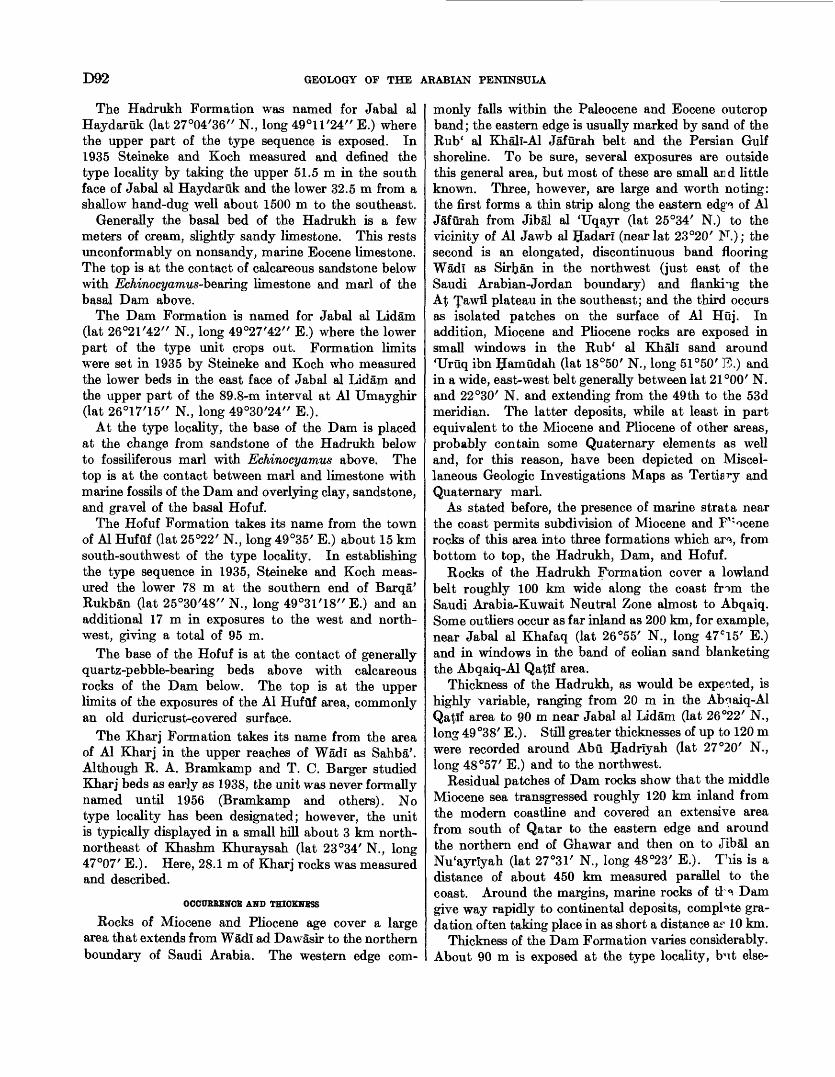
TO2 GEOLOGY OP THE ARABIAN PENINSULA
The Hadrukh Formation was named for Jabal al Haydaruk (lat 27°04'36" N., long 49°11'24" E.) where the upper part of the type sequence is exposed. In 1935 Steineke and Koch measured and defined the type locality by taking the upper 51.5 m in the south face of Jabal al Haydaruk and the lower 32.5 m from a shallow hand-dug well about 1500 m to the southeast.
Generally the basal bed of the Hadrukh is a few meters of cream, slightly sandy limestone. This rests unconformably on nonsandy, marine Eocene limestone. The top is at the contact of calcareous sandstone below with Echinocyamw-beaiing limestone and marl of the basal Dam above.
The Dam Formation is named for Jabal al Lidam (lat 26°21 /42// N., long 49°27'42" E.) where the lower part of the type unit crops out. Formation limits were set in 1935 by Steineke and Koch who measured the lower beds in the east face of Jabal al Lidam and the upper part of the 89.8-m interval at Al Umayghir (lat 26°17'15" N., long 49°30 /24" E.).
At the type locality, the base of the Dam is placed at the change from sandstone of the Hadrukh below to fossiliferous marl with Echinocyamus above. The top is at the contact between marl and limestone with marine fossils of the Dam and overlying clay, sandstone, and gravel of the basal Hofuf.
The Hofuf Formation takes its name from the town of Al Hufuf (lat 25°22' N., long 49°35' E.) about 15 km south-southwest of the type locality. In establishing the type sequence in 1935, Steineke and Koch meas ured the lower 78 m at the southern end of Barqa' Rukban (lat 25°30 /48" N., long 49°31 / 18// E.) and an additional 17 m in exposures to the west and north west, giving a total of 95 m.
The base of the Hofuf is at the contact of generally quartz-pebble-bearing beds above with calcareous rocks of the Dam below. The top is at the upper limits of the exposures of the Al Hufuf area, commonly an old duricrust-covered surface.
The Kharj Formation takes its name from the area of Al Kharj in the upper reaches of Wadi as Sahba'. Although R. A. Bramkamp and T. C. Barger studied Kharj beds as early as 1938, the unit was never formally named until 1956 (Bramkamp and others). No type locality has been designated; however, the unit is typically displayed in a small hill about 3 km north- northeast of Khashm Khuraysah (lat 23°34' N., long 47°07' E.). Here, 28.1 m of Kharj rocks was measured and described.
OCCURRENCE AND THICKNESS
Rocks of Miocene and Pliocene age cover a large area that extends from WSdi ad Dawasir to the northern boundary of Saudi Arabia. The western edge com
monly falls within the Paleocene and Eocene outcrop band; the eastern edge is usually marked by sand of the Rub* al Khali-Al Jafurah belt and the Persian Gulf shoreline. To be sure, several exposures are outside this general area, but most of these are small an d little known. Three, however, are large and worth noting: the first forms a thin strip along the eastern edg'^ of Al Jafurah from Jibal al 'Uqayr (lat 25°34' N.) to the vicinity of Al Jawb al Hadari (near lat 23°20' N.); the second is an elongated, discontinuous band flooring Wadi as Sirban in the northwest (just east of the Saudi Arabian-Jordan boundary) and flanking the A$ Jawil plateau in the southeast; and the third occurs as isolated patches on the surface of Al Huj. In addition, Miocene and Pliocene rocks are exposed in small windows in the Rub* al Khali sand around 'Uruq ibn Bamudah (lat 18°50 / N., long 51°50' E.) and in a wide, east-west belt generally between lat 21°00/ N. and 22°30' N. and extending from the 49th to the 53d meridian. The latter deposits, while at least in part equivalent to the Miocene and Pliocene of other areas, probably contain some Quaternary elements as well and, for this reason, have been depicted on Miscel laneous Geologic Investigations Maps as Tertiary and Quaternary marl.
As stated before, the presence of marine strata near the coast permits subdivision of Miocene and F1; ocene rocks of this area into three formations which ar% from bottom to top, the Hadrukh, Dam, and Hofuf.
Rocks of the Hadrukh Formation cover a lowland belt roughly 100 km wide along the coast from the Saudi Arabia-Kuwait Neutral Zone almost to Abqaiq. Some outliers occur as far inland as 200 km, for example, near Jabal al Khafaq (lat 26°55' N., long 47 C 15' E.) and in windows in the band of eolian sand blanketing the Abqaiq-Al Qafltf area.
Thickness of the Hadrukh, as would be expected, is highly variable, ranging from 20 m in the Abnaiq-Al Qatif area to 90 m near Jabal al Lidam (lat 26°22' N., long 49 °38' E.). Still greater thicknesses of up to 120 m were recorded around Abu Uadriyah (lat 27°20' N., long 48°57' E.) and to the northwest.
Residual patches of Dam rocks show that the middle Miocene sea transgressed roughly 120 km inland from the modern coastline and covered an extensive area from south of Qatar to the eastern edge and around the northern end of Ghawar and then on to Jibal an Nu'ayrlyah (lat 27°31' N., long 48°23' E.). TTiis is a distance of about 450 km measured parallel to the coast. Around the margins, marine rocks of tl Q. Dam give way rapidly to continental deposits, complete gra dation often taking place in as short a distance ar 10 km.
Thickness of the Dam Formation varies considerably. About 90 m is exposed at the type locality, fr-xt else-
SEDIMENTARY GEOLOGY OF SAUDI ARABIA D93
where as little as 30 m and as much as 100 m have been found to represent a full section.
The largest single exposure of the Hofuf Formation is superimposed on Ghawar field and almost perfectly mirrors the outline of that giant oil-filled anticline. The northern part of the structure is reflected in Hofuf beds at the surface by a prominent, dissected plateau capped by a resistant limestone layer. The preserva tion of the plateau seems to result from carbonate enrichment of its surface over the anticline, this enrich ment giving it greater resistance to erosion there than in the synclinal areas. In southern Ghawar, the resist ant cap is not as thick, and only patches of it remain. Here, Hofuf beds stand somewhat higher than the sur rounding area but are much less prominent topographi cally than in the north.
Outside the immediate Ghawar area important expo sures of the Hofuf (1) extend in a very thin band from Jibal al Kharaniq (lat 26°13' N., long 48°55' E.) north west for about 70 km, (2) follow the Al 'Uqayr escarp ment southeast from Jibal al 'Uqayr (lat 25°34' N., long 50°04 / E.) to the 24th parallel, (3) occur as small outliers north and northeast of Al Hufuf, and (4) cap Jabal al Kharma' (lat 25 "W N., long 49°38' E.) and several isolated hills to the south.
At the type locality the Hofuf Formation is 95 m thick; measurements in other areas show definite varia tion from this figure. The thinnest sequence is about 30 m, and the maximum, somewhat more than 100 m.
With the disappearance of the marine deposits of the Dam Formation toward the interior, it is impossible to subdivide the all-continental Miocene and Pliocene suc cession. Distribution of the continental series corre sponds roughly to the extensive As ^umman plateau bordering the Paleocene and Eocene outcrop north of lat 22°20' N. Southward, Miocene and Pliocene beds carry the As §umman surface across the Umm er Radhuma and overlap onto Upper Cretaceous.
In the north, bore holes indicate that continental beds form a wedge increasing from 0 m on the west to about 100 m where they merge with the marine facies. Thickening in the south is more drastic, reaching as much as 300 m before passing under the sands of the Rub' al Khali.
Irregular patches of the Kharj Formation, roughly contemporaneous with the Miocene and Pliocene units described above, dot the landscape in front of the Hit escarpment. For the most part, Kharj rocks are con fined to the Sulaiy outcrop belt between Wadi al 'Atk and lat 23°15 / N., a distance of more than 300 km.
Thicknesses of Kharj deposits measured at two locali ties are (1) 28 m exposed in a small hill a few kilometers north of Khashm Khuraysah and (2) about 9 m in the
vicinity of Ashqar Maraghah (lat 24°20' N., long 47°06' E.).
IITHOIOGIC CHARACTER
Miocene and Pliocene rocks are characteristically varicolored sandstone, sandy marl, and sandy Irne- stone. Lenses of shale and conglomerate are common, gypsum and chert are present locally.
Rocks of the Hadrukh Formation are nonmarine except in a small area outlined by Al Qa^if, Al 'Alah, Jabal Qurayn (lat 26°39' N., long 49°37' E.) and Al Jubayl al Bam Gat 26°54' N., long 49°38' E.). Oer this region, a few thin layers near the top of the forma tion contain poorly preserved marine molluscs. Ha drukh rocks are mainly green, grayish green, and gray, but red, brown, white, and pink colors are also comiron. Marly sandstone, sandy marl, sandy clay, and sandy limestone make up most of the unit; chert is common at some levels, and minor amounts of gypsum are also present.
The formation is typically exposed at Jabal al Fay- daruk, the type locality (fig. 12) established by Max Steineke and T. W. Koch in 1935. Their description is given in section 56 (p. 145).
The Dam Formation is pink, white, and gray r^arl and red, green, and olive clay with minor interbed^ of sandstone, chalky limestone, and coquina. Marine fossils are abundant throughout the unit, but the best marker zones are near the base. Of these, the "Button bed" composed of large numbers of small echindds, Echinocyamus sp., and the closely associated "Archams" sp. bed are undoubtedly the most widespread. They have been recognized throughout the area of E "Mn outcrop.
The Dam type locality selected by Steineke and Koch in 1935 serves well to characterize sediments of that formation (fig. 13). A measurement and de scription at Jabal al Lidam is given in section 57 (p. 146).
In the coastal east-facing escarpments, the marine Dam Formation is overlain by continental deposit"* of conglomerate, sandstone, sandy limestone, sandy m arl, and sandy shale assigned to the Hofuf Formation. The upper beds consist of sandy fresh-water limestone wl ; <*.h caps not only the coastal exposures but the greater part of the interior As $umman plateau region as well.
The type section measured in 1935 by Steineke and Koch north of Al Hufuf is as representative a sequence as can be expected in such a heterogeneous and lenticu lar body of rocks (fig. 14). Their description is given in section 58 (p. 146).
The most interesting feature of the Hofuf Formation is the great area! extent over which gravel deposit^ of this unit and its interior equivalent are found. Ap parently at the end of Dam time there was a general
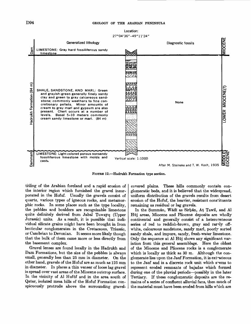
D94 GEOLOGY OF THE ARABIAN PENINSULA
Location:27°04'36"-49°11'24"
Generalized lithology
LIMESTONE: Gray hard fossiliferous sandy limestone____________________
Diagnostic fossils
SHALE, SANDSTONE, AND MARL: Green and grayish-green generally finely sandy clay and green to gray calcareous sand stone; commonly weathers to fine con cretionary pellets. Minor amounts of cream to gray marl and gypsum are also present. Chert occurs at a number of levels. Basal 5-10 meters commonly cream sandy limestone or marl. (84 m)
None
LIMESTONE: Light colored porous nonsandy fossiliferous limestone with molds and castb
UJLJ
Vertical scale: 1:1000 Ouj 00
After M. Steineke and T. W. Koch, 1935
FIGURE 12. Hadrukh Formation type section.
titling of the Arabian foreland and a rapid erosion of the interior region which furnished the gravel incor porated in the Hofuf. Usually the gravels consist of quartz, various types of igneous rocks, and metamor- phic rocks. In some places such as the type locality, the pebbles and boulders are recognizable limestone quite definitely derived from Jabal Tuwav<l (Upper Jurassic) units. As a result, it is possible that indi vidual silicate grains might have been brought in from lenticular conglomerates in the Cretaceous, Triassic, or Cambrian to Devonian. It seems more likely though that the bulk of them came more or less directly from the basement complex.
Gravel lenses are found locally in the Hadrukh and Dam Formations, but the size of the pebbles is always small, generally less than 25 mm in diameter. On the other hand, gravels of the Hofuf are as much as 125 mm in diameter. In places a thin veneer of loose lag gravel is spread over vast areas of the Miocene outcrop surface. In the vicinity of Al Hufuf and in the area south of Qatar, isolated mesa hills of the Hofuf Formation con spicuously protrude above the surrounding gravel-
covered plains. These hills commonly contain con glomeratic beds, and it is believed that the widespread, uniform distribution of the gravels results from desert erosion of the Hofuf, the heavier, resistant constituents remaining as residual or lag gravels.
In the §umman, Wad! as Sirban, A$ fawfl, and Al Hiij areas, Miocene and Pliocene deposits are wholly continental and generally consist of a heterogeneous series of red to reddish-brown, gray and rarely off- white, calcareous sandstone, sandy marl, poorly sorted sandy shale, and impure, sandy, fresh-water limestone. Only the sequence at Al Huj shows any significant var iation from this general assemblage. Here the oldest of the Miocene and Pliocene rocks is a conglomerate which is locally as thick as 30 m. Although the con glomerate lies upon the Jauf Formation, it is extraneous to the Jauf and is a discrete rock unit which sterns to represent eroded remnants of bajadas which formed during one of the pluvial periods possibly in the later Tertiary. If these conglomeratic deposits are the re mains of a series of confluent alluvial fans, then much of the material must have been eroded from hills which are
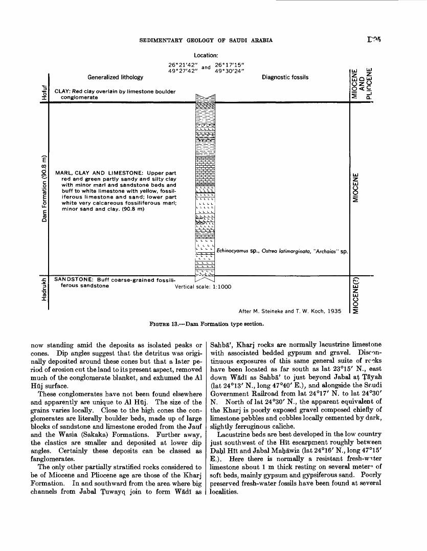
SEDIMENTARY GEOLOGY OF SAUDI ARABIA
Location:
26°21'42" _ nri 26°17'15" 49°27'42" 49°30'24"
Generalized lithology
CLAY: Red clay overlain by limestone boulder conglomerate
Diagnostic fossilsUJ I-*-!
IllCL.
MARL, CLAY AND LIMESTONE: Upper part red and green partly sandy and silty clay with minor marl and sandstone beds and buff to white limestone with yellow, fossil- iferous limestone and sand; lower part white very calcareous fossiliferous marl; minor sand and clay. (90.8 m)
O O
L I- L LL L t- L
Echinocyamus sp., Ostrea latimarginata, "Archaias" sp.
SANDSTONE: Buff coarse-grained fossili ferous sandstone Vertical scale: 1:1000
O O
After M. Steineke and T. W. Koch, 1935
FIGURE 13. Dam Formation type section.
now standing amid the deposits as isolated peaks or cones. Dip angles suggest that the detritus was origi nally deposited around these cones but that a later pe riod of erosion cut the land to its present aspect, removed much of the conglomerate blanket, and exhumed the Al Huj surface.
These conglomerates have not been found elsewhere and apparently are unique to Al Huj. The size of the grains varies locally. Close to the high cones the con glomerates are literally boulder beds, made up of large blocks of sandstone and limestone eroded from the Jauf and the Wasia (Sakaka) Formations. Further away, the elastics are smaller and deposited at lower dip angles. Certainly these deposits can be classed as fanglomerates.
The only other partially stratified rocks considered to be of Miocene and Pliocene age are those of the Kharj Formation. In and southward from the area where big channels from Jabal ^uwayq join to form Wadl as
Sahba', Kharj rocks are normally lacustrine limestone with associated bedded gypsum and gravel. Discon tinuous exposures of this same general suite of rc^ks have been located as far south as lat 23°15/ N., east down Wadl as Sahba' to just beyond Jabal at Tayah (lat 24°13 / N., long 47°40 / E.); and alongside the Sf.udi Government Railroad from lat 24°17 / N. to lat 24°30 / N. North of lat 24°30 / N., the apparent equivalent of the Kharj is poorly exposed gravel composed chiefly of limestone pebbles and cobbles locally cemented by dark, slightly ferruginous caliche.
Lacustrine beds are best developed in the low country just southwest of the Hit escarpment roughly between DaU Hit and Jabal Mabawiz (lat 24°16/ N., long 47°15' E.). Here there is normally a resistant fresh-w^ter limestone about 1 m thick resting on several meter* of soft beds, mainly gypsum and gypsiferous sand. Poorly preserved fresh-water fossils have been found at several localities.
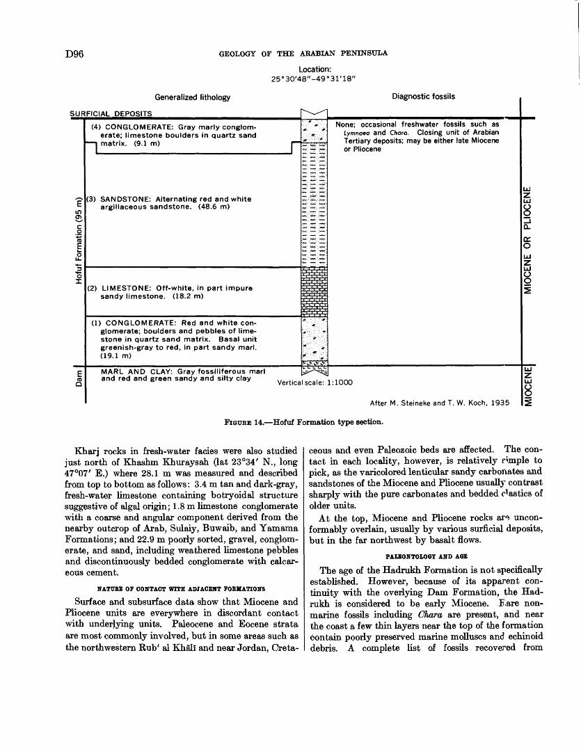
D96 GEOLOGY OF THE ARABIAN PENINSULA
Location:25°30'48"-49°31'18"
vaci id aii^Gu iiuiuiugy
SURFICIAL DEPOSITS
?in 01*^cO
' *-> (0E
£ <*-
1
E(0a
(4) CONGLOMERATE: Gray marly conglom erate; limestone boulders in quartz sand
I matrix. (9.1 m) j
(3) SANDSTONE: Alternating red and whiteargillaceous sandstone. (48.6 m)
(2) LIMESTONE: Off-white, in part impuresandy limestone. (18.2 m)
(1) CONGLOMERATE: Red and white con glomerate; boulders and pebbles of limestone in quartz sand matrix. Basal unitgreenish-gray to red, in part sandy marl.(19.1 m)
MARL AND CLAY: Gray fossiliferous marl
"̂- "-*" :- '
». '. ''-jf-'
"..'"* : --..'..a ' ' '"' :f" "
:^: -5 '£:
&5;S
S ;'£' ' S'
S>3 :5I-
i-w-.-'i' ^.. "
: .x_ III.:?:;??-,-?:'^ ^T' ;; 2
I 1 ! 1 ! I TTT.*.' :. . .*'
\f : o: ". A "'? ' ;: i'":."- ; "; :&--:''' ::-i' :: : .' " * ' .. 4f. -: :- r .:
V^>r '^t gV
^3^^
k'lM^I I\S«?IIW I\S^**U«?
None; occasional freshwater fossils such as Lymnoeo and Charo. Closing unit of Arabian Tertiary deposits; may be either late Miocene or Pliocene
and red and green sandy and silty clay Vertical scaler'l: 1000
Aftar M Qtoinolro anrl T W Knrh 1 Q^
LJZLJ
8_jCL
a:OLJZLJ
85
LJZLJ
8s:
FIGUBE 14. Hofuf Formation type section.
Kharj rocks in fresh-water facies were also studied just north of Khashm Khuraysah (lat 23°34/ N., long 47°07' E.) where 28.1 m was measured and described from top to bottom as follows: 3.4 m tan and dark-gray, fresh-water limestone containing botryoidal structure suggestive of algal origin; 1.8 m limestone conglomerate with a coarse and angular component derived from the nearby outcrop of Arab, Sulaiy, Buwaib, and Yamama Formations; and 22.9 m poorly sorted, gravel, conglom erate, and sand, including weathered limestone pebbles and discontinuously bedded conglomerate with calcar eous cement.
NATURE OF CONTACT WITH ADJACENT FORMATIONS
Surface and subsurface data show that Miocene and Pliocene units are everywhere in discordant contact with underlying units. Paleocene and Eocene strata are most commonly involved, but in some areas such as the northwestern Rub* al Khali and near Jordan, Creta
ceous and even Paleozoic beds are affected. The con tact in each locality, however, is relatively Hmple to pick, as the varicolored lenticular sandy carbonates and sandstones of the Miocene and Pliocene usually contrast sharply with the pure carbonates and bedded elastics of older units.
At the top, Miocene and Pliocene rocks ar^ uncon- formably overlain, usually by various surficial deposits, but in the far northwest by basalt flows.
PALEONTOLOGY AND AGE
The age of the Hadrukh Formation is not specifically established. However, because of its apparent con tinuity with the overlying Dam Formation, the Had rukh is considered to be early Miocene. Eare non- marine fossils including Chara are present, and near the coast a few thin layers near the top of the formation contain poorly preserved marine molluscs and echinoid debris. A complete list of fossils recovered from
SEDIMENTARY GEOLOGY OF SAUDI ARABIA D97
Hadrukh surface beds includes: Chara, Anomalocar- dial sp., Cardita cf., Cerithium (BeHardia?) sp., Chlamys cf. C. senatoria (Gmelin), dementia papyracea (Gray) ?, Diplodonta cf. D. incerta d'Archiac and Haime, cf. Natica, Ostrea latimarginata Verdenburg, Ostrea spp., Turritella gradata, Turritella sp. indeterminate venerid pelecypods, Echinocyamus!', crab claws, sharks teeth, cidaroid spines, and fossil wood.
So far as the Dam Formation is concerned, the presence of Ostrea latimarginata Vredenburg, Echino- cyamus sp., and "Archaias" sp. indicates approximate correlation with the Lower Fars Formation of Iraq. On this basis, the Dam is presumed to be about middle Miocene. A complete list of fossils recovered from the Dam Formation includes: Balanus, Agassizia cf. A. scrobiculata Valenc var. persica, Agassizia sp., Brisus latitudinensis Clegg, Echinodiscus desori Duncan and Sladen, Echinocyamus sp., Lovenia elongata Gray, Moira adamthi Clegg, Schizaster, Schizastert, Tem- nopleurus persica Clegg, Temnopleurus sp., cidaroid radicles, Archaias angutatus (Fichtel and Moll), Archa ias sp., Elphidium, Operculina sp., Peneroplis spp., Quingueloculina sp., Triloculina sp., miliolids, Anomia sp., Area sp., Bullaria sp., Bittiumt sp., Bursa? sp., Calyptraeat sp., Cardium! sp., Chlamys senatoria, Clavatula sp., dementia papyracea (Gray), Conus sp., Coralliophila, Corbiculat sp., Diplodonta cf. D. incerta d'Archiac and Haime, Epitonium, cf. Hemifusus, Mitral sp., Ostrea angulata J. de C. Sowerby, Ostrea latimarginata Vredenburg, Ostrea virleti Deshayes, Ostrea cf. 0. virleti, Ostrea spp., Paphiat sp., Placenta sp., Strombus? sp., Thais'! sp., Turritella cf. T. gradata, Turritella spp., VolseUa? sp., indeterminate corals, fossil wood, vertebrate fragments, crab claws, and ostracodes.
The Hofuf Formation is chiefly unfossiliferous although occasional nondiagnostic fresh-water fossils including Lymnaea and Chara occur. Since the Hofuf represents the closing unit of the Arabian Tertiary deposits, it may be either late Miocene or Pliocene. A comprehensive fossil list includes Chara sp., Lymnaea sp., Planorbis sp., Thiara sp., ostracodes, and inde terminate gastropods.
As Kharj deposits are obviously post-Eocene and pre- Quaternary, they are most certainly Tertiary. No direct evidence bearing on their age has been found except that, if the channel gravels in the various localities are about the same age, they may be roughly contemporaneous with the great gravel flood of the basal Hofuf Formation in the area to the east. Speci mens of Corbicula sp. and Melania sp. are the only fossils so far discovered.
ECONOMIC ASPECTS
GROUND WATBK
The water-bearing properties of the Miocene and Pliocene rocks, as might be expected, are erratic. Apparently the sequence carries water regionally, but productive capacity, storage factors, and quality vary sharply both laterally and vertically. Locally, artesian flowing conditions are found, as in a few wells ir the Rub' al Khali and in the oases of Al Hasa and Al Qat<if, but pumps are required in most areas.
One of the most extensive developments of the Miocene and Pliocene aquifer is around Al Pufuf (Al Hasa) with its many large 'ayns or springs. Great quantities of water are also withdrawn in the Al Qa^if oasis where many large springs have developed r.long the western and northwestern edge of the cultivated area. There is reason to suspect that some of these springs are in hydraulic communication with the Alat (Eocene) aquifer below. Other scattered areas ir the Eastern Province are also supplied with Nec^ene water.
TERTIARY AND QUATERNARY SYSTEMSGRAVEL
Small, widely scattered, isolated patches of late Tertiary gravel occur: (1) in Wadi Nayyal (lat 28°30/ N., long 39°03' E.), (2) 50 km east of 'Unayzah (lat 26°06/ N., long 43°59/ E.), (3) 30 km north o* Ad Dawadimi (lat 24°30' N., long 44°23' E.), (4) in and near Wadi as Sahba' between the Mughrah trough (long 47°30/ E.) and long 48°35/ E., (5) in Ad Dahna' 40 km south of Wadi as Sahba', and (6) at lat 23° N., long 47° E. where a relatively large patch is associated with deposits of the Kharj Formation.
The gravel is dominantly well-rounded white quartz pebbles as large as 10 centimeters in diameter, usually in a poorly sorted, earthy, sandy matrix. Subord; nate limestone pebbles are usually present. Thus, Ptho- logically, the gravel resembles rather closely some of the Hofuf gravels farther to the east.
The gravels, ordinarily in trains and in patches on upland surfaces, have not been studied to any extent except in the vicinity of Wadi as Sahba'. Here they increase in prominence from west to east and no cfoubt represent an old major drainage channel. It is l ; kely that the Wadi as Sahba' structural trough was the path by which the old river crossed the present area o* the Al 'Aramah escarpment. West of the escarpment channel gravels occur only in one small area, along the axis of the Mughrah trough (generally along lat 24° 18' N. and between long 47°30/ E. and 47°37' E.). Al though they have not been traced continuously and the pattern is obscured by younger fill, two small patches of gravel are present near the western edge of Ad
D98 GEOLOGY OF THE ARABIAN PENINSULA
Dahna', one 10 km and the other 25 km north of Wadi as Sahba'. These are well-defined eastward-trending gravel ridges leading east from Ad Dahna' to the gravel plains around southern Ghawar. These probable links strongly suggest that the channel gravels are remnants of a group of late Tertiary rivers which brought down the great gravel flood incorporated in the lower part of the Hofuf Formation.
The relationship of the channel gravels to fresh water deposits of the Kharj Formation is unknown even though they are in contact at one locality that is, near lat 23°16/ N. It is tempting to suggest that the channel gravels may be the result of streams that discharged overflow from lakes in which the fresh water sediments were being deposited, but this sug gestion is pure speculation.
TERRACE SAND AND QRAVEL
Terrace deposits of presumed Pliocene age are known only at the northwestern edge of 5arrat Hutaym (at lat 26°35/ N., long 39°40' E.). Here the rocks are fine grained gray sandstone and marl with a basal conglom erate. Fresh-water ostracodes are present in the upper part.
A similar deposit of light-gray marl with gastropods and fresh-water ostracodes has recently been discovered near lat 27°26' N., long 38°29' E. (not shown on Mis cellaneous Geologic Investigations Maps). The fauna is modern in aspect and can scarcely be older than late Tertiary; it is questionably assigned to the Pliocene. Relationship between this and the -Jarrat Hutaym patch is still obscure.
MARL, AND SANDSTONE
Small outliers of sandy marl, marly sandstone, and sandy limestone occurring in an east-west belt across the central part of the Rub' al Khali have already been mentioned in connection with similar Tertiary sediments which are certainly in part, if not wholly, equivalent (p. 91).
BASALT
Al Uarrah, the only volcanic complex within the sedimentary area of Saudi Arabia, extends from near Ath Thayat (lat 30°32 / N., long 39°20/ E.) north westward for almost 250 km where it crosses into Jordan. Over this distance, width of the lava field ranges from 80 to 100 km. Younger basalt components of Al Uarrah are tentatively assigned to the Quaternary; older elements, informally known as the Garaiyat lavas, are considered to be Miocene and Pliocene.
The younger lavas are chiefly olivine basalt locally with thin aplite dikes. At places they are scoriaceous and vesicular and include bedded pyroclastics, plugs, and cones. Petrographic analysis of a sample from Qitab ash Shaman (lat 31°36' N., long 37°57/ E.)
showed a phaneritic basalt with zoned pk«noclose (andesine-labradorite), augite, commonly altered oli vine, calcite, and black unidentified opaque minerals, probably ilmenite and magnetite. The thickest se quence of younger lava is at Umm Wu'al (lat 31°49' N., long 38°53' E.) where about 100 m rests directly on the eroded Eocene surface. At other places younger basalt flows thinly cover Miocene and Pliocene un divided. This fact, coupled with the fact that little weathering is evident, has led to a considered Quater nary age for the upper Al Uarrah volcanics.
Near the fort at Qurayyat al Milb (lat 31°24/ N., long 37°29' E.) there are about 35 m of older lava, a highly weathered alivine-bearing basalt, resting on Miocene and Pliocene marl. In the middle part of the succession, the lava is cut by numerous thin aplite dikes and at places an amygdaloidal phase r distin guished. In marked contrast to the younger basalts, the older lavas have been deeply weathered prior to deposition of an overlying sandstone that includes basalt boulders in the basal part. A few kilometers west of Qurayyat al Milk similar lavas are interbedded with sandstone and marl of presumed Miocene and Pliocene age and here are considered to be of the same age.
CALCAREOUS DtJRICRUST
A resistant duricrust carapace masks underlying stratigraphic and structural details over some rather extensive areas in northwestern Arabia. Although the precise chemical conditions that produce this deposit are poorly understood, it is apparently a product of a somewhat more moist, possibly semiarid, climate than exists in present-day Arabia. During the dr7 season movement of ground water is upward to the surface where soluble substances are deposited. As evapo ration proceeds, a calichelike carbonate-enriched crust is built up, mainly of the material on which it forms. Where the underlying rock is carbonate, durcrust is particularly hard and in some instances supports escarpments as much as 50 m in height. If the under lying rock is sandstone, a much less resistant calcareous, gypsiferous, and earthy deposit forms.
Duricrust is particularly well developed on Pale ozoic and Mesozoic units from Buraydah northwest to Al Widyan plateau, south of Al Jawf and ij'^kakah, in Al Huj, and on Tertiary beds south and we^t of the Saudi Arabia-Iraq Neutral Zone. Usually it is a discontinuous mantle of red, brown, gray, tan, and yellow, resistant, sandy limestone containing frag ments of the underlying rock. Thickness of the crust ranges from a few centimeters to 3 or 4 m. Coarse frosted quartz grains are often present, and aho a few fresh-water molluscs are present. In the southwest ern Rub* al Khali the few small patches of duricrust
SEDIMENTARY GEOLOGY OF SAUDI ARABIA D99
known are gray to tan, locally gypsiferous, sandy lime stone grading at places into sandstone with calcareous cement.
As duricrust is not known to have formed in rocks younger than Miocene and Pliocene, these carbonate- enriched rocks are believed to be Quaternary.
TERRACE, MUD FLAT, AND GYPSUM DEPOSITS
LAKE TERRACES
Lake beds, now cut into a steplike series of low ter races, crop out in the southwestern Rub* al Khali around lat 19°05' N., long 46°20/ E. and in the Shaqqat al Mi'ah (near lat 17°30' N., long 46°35/ E.). These fresh-water sediments are interbedded, white, tan, and brown, fine-grained quartzose sandstone with mica ceous, silty and rarely gypsiferous clay and fossiliferous silt.
A number of fragments of vertebrate teeth and bones were found within or associated with the lacustrine de posits. Age, based on these fossils, is considered to be late Pleistocene (?) to early Recent.
Elsewhere in the southwestern Rub' al Khali, Pale olithic and Neolithic sites have yielded arrow heads,fist hatchets, scrapers, and other stone implements. At one locality charcoal, presumably from a Neolithic campsite, was dated by carbon-14 as 5,090 ±200 years. Age was determined by T. A. Rafter (written commun., June 1960). Field (1958, 1960) has described the stone implements collected from these sites.
MARINE TERRACES AND RAISED BEACHES
Marine terraces and raised beaches are rather com mon along the western Persian Gulf shoreline. Within Saudi Arabia beach gravel and sand occurs on marine terraces a,nd raised beaches from north of Al Jubayl (lat 27°01' N., long 49°40' E.) to the southern tip of Dawbat Salwah. The commonest occurrence of the marine Pleistocene is in the form of sand and coquina terraces 1 or 2 m above mean high tide. These terraces form low discontinuous mesas along the coastline and a short distance inland.
Along Dawbat Salwah well-preserved marine fossils, most of which are present-day species, are found in soft, pebbly sandstone and coquina. Maximum thickness of this fossiliferous unit is about 8 in. Quaternary marine fossils also occur at Sabkhat Sawda' Nathil (lat 24°30 / N., long 51°04 / E.) about 3 m below mean high tide.
DELTAIC AND TIDAL HUD FLATS
Deposits of this type occur only in Kuwait and are described in connection with the surficial geology of that country.
GYPSUM DEPOSITS
Young bedded deposits of gypsum occur in small patches at several localities, usually in contact with
Miocene and Pliocene and with Quaternary units. Only one such deposit has been studied in sufficient detail to permit mapping, and this occurs south from Wadi al Faw along the foot of the Al 'Ari$ escarpment. Here a thin, 60-km-long band of white to tan, powdery to patchy gypsum is associated with Quaternary gravel.
QUATERNARY DEPOSITS
TERRACE GRAVEL,
Outcrops of terrace gravel are limited to two one in the bottom of Wiidi al Bu^in where several small patches occur 60 and 90 km northeast of the Trans- Arabian Pipeline and another in Wfidi as Sahbil' where a few isolated patches are present between the 47th and 48th meridians. The gravel is mainly limestone and quartz that has been concentrated in terrace deposits obviously related to present or recent drairage.
SHEET GRAVEL,
The largest single occurrence of sheet gravel blankets the Ad Dibdibah plain a. broad, flat boulder-strewn surface flanking Al Biitin and extending from south of the Trans-Arabian Pipeline into Iraq and Kuwait. The sheet represents the residue of a vast flood of rock debris derived from the basement complex and fun- neling out through the Wfidl ar Rimah-Al Bfit-in channel system. The gravel veneer is nowhere more than a single pebble thick and is chiefly quartz with varying proportions of carbonate, igneous, and metamorphic grains. The plains area around Tabuk is also littered with a similar gravel.
Another gravel sheet, the As Satin plain (around lat 30°40' N., long 42°40' E.), includes basalt pebbles probably derived from Al Harrah lava field. In addi tion, a large number of chert granules are included.
Large, coalescing, deltalike surfaces of outwash g-avel emanate from the Wadi as Sahba'-Wadi ad Dawasir- Wadi Najran drainage systems. Present distribution of exposures shows that prior to formation of the great Rub* al Khali-Al Jafurah sand desert a vast part of the area generally west of the 51st meridian was blanketed by coarse rock debris pouring out from these channels. At the same time, large quantities of the debris were diverted (u short distance from the base ment) along a shallow trough scooped in soft Permian beds, thus lining this depression with gravel from the vicinity of Wadi Najran to Khuff (near lat.25°00' N.).
GRAVEL, REMNANTS
Dissected remnants of gravel apparently unreHted to modern drainage occur in two areas: one along the foot of the Hit escarpment (between lats 24°20' N. and 24°32/ N.) and the second in front of Al 'Arf.mah escarpment near lat 25°54' N. Grains are for the
D100 GEOLOGY OF THE ARABIAN PENINSULA
most part limestone, but other rock types are included as well.
GRAVEL, SAND, AND SILT
Bottoms of channels and undrained depressions are commonly floored with a thin but often extensive layer of unconsolidated, locally derived sediment.
Gravel of this type represents: (1) a recent concen tration of coarse debris from the immediately sur rounding area, (2) a residual deposit derived from older sediment or rock by removal of intergranular fines, and (3) a lag concentrate from an earlier gravel sheet or train.
Numerous widely scattered, undrained basins have in common a flat, firm, silty surface that contrasts sharply with other crusty, brine-saturated depressions (Sabkhah deposits). The silt flats, known by various names depending on soil type, vegetation, and so forth, locally include calichelike and gypsiferous deposits.
Other surficial deposits that cannot be subdivided or classified for any of several reasons include gravel, sand, silt, gypsum, and other associated fine material.
SABKHAH DEPOSITS
Sabkhah (plural: sibakh) is an Arabic term for coastal and inland saline flats or playas built up by deposition of silt, clay, and muddy sand in shallow, albeit some times extensive, depressions. The deposits are com monly saturated with brine and often are salt encrusted. Indeed, the presence of salt is the distinguishing feature of a sabkhah. Other silt-filled areas, usually centers of centripetal drainage, contain no salt. These are more correctly called Ql'an.
MamlaiiaiL (plural: mamalib), a name often heard in the interior, refers to a sabktiah where salt is, or at one time was, mined. Strictly speaking mamlatah designates the excavation or area in the sabkhah where salt is being removed.
Sibakh are, for the most part, concentrated in a narrow belt along the coast from Kuwait to east of Qatar. Most are found within 60 km of the shoreline, but some are located far inland for example, in Wadi as Sirtian (at lat 30°50' N., long 38°10' E.), near Baq'a' (lat 27°53' N., long 42°24' E.), southeast of Buraydah (lat 26°20' N., long 43°58' E.), near Al Qasab (lat 25°18/ N., long 45°30/ E.), around Yabrin (lat 23°17/ N., long 48°56/ E.), and over a wide band along the eastern margin of the Rub' al Khali.
Origin of these saline flats is in doubt, but most workers now agree that they result from sand and silt, commonly eolian, infilling topographically low areas. Brine is nearly always to be found within 1 or 2 m of the surface. Apparently, prolonged evaporation of capillary water during dry periods concentrates and
precipitates various salts at and near the surface to form a hard saline crust. During moist periods stand ing water from tidal invasion or runoff helps recharge the sediments and also by evaporation contributes to the salt scum.
EOLIAN SAND
Approximately one-half of the sedimentary area of Saudi Arabia is blanketed by eolian sand. The Rub' al Khali contains probably the largest continuous body of sand in the world and covers nearly 600,000 sq km. Another 180,000 sq km is covered by interior nafuds and Ad Dahna'. The largest of these, An Nafud, is roughly 68,000 sq km.
R. A. Bramkamp developed a practical classification of the fundamental types of sand terrain found in Saudi Arabia. He recognized four main classes which were adopted and whose distribution was depicted on the Miscellaneous Geologic Investigations Map series. Basic characteristics of these classes are as follows:I. Transverse: Predominantly simple and compound
barchan dunes in areas of more mobile sand p.nd (or) simple rounded ridges, oriented transverse to the prevailing wind direction.
II. Longitudinal: Primarily dikakah (bush- or grass- covered sand) and various types of undulating sand sheets, in general characterized by elongation of the individual forms parallel to the prevailing wind direction, often partly stabilized by sparse vegetation.
III. 'Uruq: Various forms of long, nearly parallel, sharp-crested narrow sand ridges and dune chains separated by broad sand valleys usually ir eluding elements of Type I sand terrain. These fo^Tus are the resultant of a system of two dominart wind directions and are identical to the sayf dunes of north Africa.
IV. Sand mountains: Dominated by large sand massifs commonly cresting 50 to 300 m above the substratum, often with superimposed dune patterns consisting of various types of complex barchans. Common forms are giant barchans spanning several kilometers from horn to horn, giant sigmoidal and pyramidal sand peaks as well as other less common peak forms, and giant oval to elongate sand mounds.
STRUCTURE
GENERAL FEATURES
The structural pattern of the Arabian Peninsula was set in Precambrian time with stabilization of the Arabian shield. These ancient rocks, now lying in tangled confusion, in themselves reveal a complex and mobile history. By the outset of the Paleozoic Era, however, they had been fused into a rigid land mass, and their surface had been reduced to a nearly level plain.
SEDIMENTARY GEOLOGY OF SAUDI ARABIA D101
From the Cambrian on, vast epicontinental seas moved back and forth across the lower parts of this stable basement core and there deposited a compara tively thin succession of almost flat-lying strata. The epicontinental seas were in turn flanked on the north and east by a great sedimentary basin the Tethyan trough that occupied a relatively constant area in Turkey, northern Iraq, and southwestern Iran. The trough remained a negative feature throughout most of the Paleozoic and Mesozoic while many thousands of feet of sediment accumulated. Destruction of the ancient seaway began in the Late Cretaceous with erogenic movement recorded from Turkey through Iran and extending into Oman. The climax came, however, in the late Tertiary (Alpine orogeny) when rocks from the deeper part of the basin were folded and thrust to form the Zagros-Taurus chain of mountains. It is during this period that the great rift-fault systems of Africa and the Red Sea area also began to take on their present form, although movement on these faults may have started somewhat earlier.
Within this broad tectonic framework, two major structural provinces are recognized (pi. 2). One is the comparatively stable interior region whose rigidity is controlled by Precambrian basement. The exposed part of the shield, as well as that part thinly veneered with little-disturbed shelf sediment, make up this province. The other major province is the great mobile belt peripheral to the stable region and made up of the Taurus-Zagros-Oman Mountain systems.
Saudi Arabia falls wholly within the stable region, and it is this structural province with which we are most concerned here. Consequently, this province and its significant structural subdivisions will be discussed in some detail; those peripheral to it will be touched on but briefly. It should be emphasized that stable is a relative term used here to differentiate an area that has from Precambrian to Recent time been subjected mainly to gentle warping and tilting.
STABLE REGION ARABIAN SHIELD
Shield rocks, comparatively stable and primarily positive since Precambrian time, make up a sizable part of the Arabian Peninsula. On the west they form most of Najd and all of Al IJijaz and 'Asir; on the southwest they support the highlands of Yemen, and along the southern coast of the Arabian Peninsula they can be seen in sporadic outcrops. Until recently, the Arabian Shield was a projection of the shield of Africa but is now separated from it by Red Sea rifting.
WESTERN ARABIAN SHIELD
The western Arabian Shield is an extensive area of Precambrian rocks, mainly igneous and metamorphic,
and largely overlain by younger volcanics in the west. Though the shield has acted as a rigid land mass since the beginning of Cambrian time, consolidation was long in coming. Included within the basement complex are great belts of sedimentary rocks now contorted, intruded, and metamorphosed that record the growth and decay of former mountain systems. Presumably, through the eras of Precambrian time, the shield was subjected not once but several times to downwarping, sedimentation, orogeny, injection by plutonic rocks, and leveling before becoming immolate a complex, but little known, structural history com parable with that of other shields and former geosynclinal areas.
Likewise, the structural situation after the str.rt of the Paleozoic is obscure, but some intrusion and local faulting is likely. A number of epeirogenic movements of the shield have been clearly recorded in the sedi mentary sequence, generally in the form of regional unconformities. During the Tertiary Period, sub stantial faulting and other disturbances occurred along the margin of the Red Sea depression.
YEMEN-WESTERN ADEN PLATEAU
In the Yemen-Western Aden area, Precambrian basement supports a relatively high, substantially faulted plateau. The plateau is capped in northern Yemen by patches of flat-lying Jurassic, Cretaceous, and Tertiary sedimentary rocks. Massive extrusive volcanic rocks of Late Cretaceous to Recent age cover central and southern Yemen and enclose fault blocks of basement and Mesozoic rocks that have been up lifted through the volcanic sheet. Less stable than the western and southern part of the Arabian Shield, the plateau area apparently operated as a Hnge, absorbing differential movement between flanking massifs. Presumably, Yemen-Western Aden remained positive until the late Jurassic and then, for the first tune, was sufficiently downwarped to permit direct com munication between the Tethyan and east African seaways.
SOUTHERN ARABIAN SHIELD
The structure and configuration of the southern Arabian Shield is obscured by the Gulf of Aden; how ever, its northern margin can be roughly reconstructed from exposures preserved along the ^Jatframawt, Al Mahrah, and Dhufar coasts and in the Khuriya Muriya Islands. Like other parts of the Arabian Shield, these rocks show evidence of strong deformation, intrusion, and metamorphism followed by mature peneplaration before the first sediments were deposited.
ARABIAN SHEL.F
After solidification and mature peneplanation, the Arabian Shield was tilted slightly northeast toward
D102 GEOLOGY OF THE ARABIAN PENINSULA
the ancestral Tethys trough. As subsidence continued, shallow seas advanced across the beveled surface of crystalline rocks and buried it beneath thin sheets of almost flat-lying sediment. It is this belt of low- dipping, relatively undisturbed beds that gives rise to the second main structural province of the stable region the Arabian Shelf. It should be kept in mind that the shelf differs from the exposed part of the shield only in possessing a thin sedimentary cover.
As early as Early Qrdovician, marine water had transgressed inland nearly to the present limit of sedi mentary beds, well documenting the invasion with a thin but widespread, graptolite-rich shale. Conse quent upon successive rising and sinking of the shield, seas advanced and retreated. Because the sea floor was so flat, even gentle bending substantially moved the shoreline and altered the position of land and sea. Effects of such epeirogenic movements, clearly recorded in the interior by unconformities, disconformities, and alternating marine-nonmarine rocks, fade as the deeper part of the basin is approached. Here, subsidence apparently persisted with few interruptions from Paleozoic to relatively recent tune.
Sediments of the shelf are characteristically of shal low-water origin. Limestone, clastic-textured and me chanically sorted, is the most striking rock type. Sand stone and shale are also present in large amount. All units, regardless of lithology, are usually thin and wide spread, maintaining lithologic character over large areas. Shifts in facies do occur, but these are usually gradual. Such lithologic constancy, presumably brought about by continued sorting and reworking of the limited amount of sediment introduced into the basin, reflects prolonged stability.
Not all parts of the Arabian Shelf had the same geo logic history. Some areas were more active than others; some were depressed and some elevated either persistently or for short periods. Thus the shelf is divisible into several subprovinces namely, an Inte rior Homocline everywhere marginal to the shield, an Interior Platform bordering the homocline, and, adja cent to the platform, several basinal areas that have from tune to time collected thicker deposits. In con nection with this, the Interior Platform and adjacent basins correspond at least in a rough way to the "un stable shelf" just as the Interior Homocline appears to represent the "stable shelf."
INTERIOR HOMOCLINE
Bordering the shield is a belt of Paleozoic, Mesozoic, and Cenozoic strata whose dip basin ward is so .slight and uniform as to be imperceptible to the eye. Plane- table, structure drill, and seismograph surveys over the area have defined a remarkably constant homocline
with an average width of about 400 km and a persistent dip ranging from slightly more than 1°00' in the Per mian and Triassic to 0°20' in Upper Cretacecus and Eocene beds.
The homocline thus defined marks an area of unusual tectonic stability. To be sure, significant structural interruptions do occur, but these appear to result from blocks of different sizes and shapes moving independ ently and without disturbing adjacent parts of the homoclinal surface. Change in strike of the homocline, related to gentle flexing of the basement, tends to break the belt into several poorly defined segments.
CENTRAL ARABIAN ARCH DEFINED BY NORTHERN AND SOUTHERN
TUWAYQ SEGMENTS
One structural feature the central Arabian arch has had a profound influence on the present surface dis tribution of sedimentary rocks. The name applies to the area of changing strike between the northern ^uwayq and southern 'J'uwayq segments of the Interior Homocline. In reality, these segments are an integral part of the arch which affects all rocks from tie base ment up; its influence can still be seen as far east as Qatar. The arch, although a very gentle feature, appears to have considerable importance by marking the area of maximum curvature of the Interior Homo cline in central Arabia and by supporting the reversal between the north-dipping part of the shelf and its south-dipping part which passes uniformly under the Rub' al Khali.
Early work in Arabia led to the assumption that this great basement ridge was an ancient and pernanent positive feature. It was assumed that bands of sedi mentary rock were deposited around this swell in much their present form and original strike of deposition roughly paralleled present strike. Furthermore, it was assumed that the structural form of eastern Arabia was due to regional and uniform tilting of the shield toward the Persian Gulf and Rub* al Khali basins. Sediment distribution and geometry of rock units around the arch have shown this concept to be incorrect, and it is now known that the history of the feature is much more complex.
During early Paleozoic time, the arch was mildly positive, as pre-Permian units seem to pinch out against it. Strong upwarping occurred in the later part of the Paleozoic Era (post-Early Devonian and pre-Late Permian), older beds were beveled and stripped from the crest of the arch, and later submergence permitted deposition of Upper Permian carbonates directly on basement across the axis and for some distance north and south.
During Mesozoic time, the central part of the craton gradually subsided, and thick sequences of continental
SEDIMENTARY GEOLOGY OF SAUDI ARABIA 1103
and shallow marine sediments accumulated in a basin whose deepest part apparently fell roughly along the present axis of the arch. This relationship is par ticularly marked in the Jurassic but can also be seen in the rocks of bracketing systems. Detailed measure ments show that the Jurassic is thickest on or near the axis of the arch and thins uniformly and persistently to the north and south. Pre-Wasia (Middle Creta ceous) truncation accounts for some of the thinning in the far north, but not all, for the section is distinctly condensed when compared with an equivalent sequence near the center of the arch. There is also a correspond ing change from deeper water to shallow water and even continental sediments away from the axis. Thick intervals of limestone and shale in the high area are represented by shale and sandstone on the flanks. It seems logical to assume from these data that the shore line of Jurrassic times in central Arabia fell considerably west of the present outcrop belt and lay approximately along a line connecting Jurassic exposures on the north and south where an approach to strand-line conditions is evident.
The first traces in the sedimentary record which would indicate the origin of the central Arabian arch appear in the Wesia Formation (Middle Cretaceous). On outcrop, this formation is continental in the south where it disconformably overlies nonmarine rocks of Early Cretaceous age. On and north of the arch, however, Wasia rocks become progressively more marine and sharply transgress older strata. The best explanation of this change appears to be that the sagging, which resulted in thickened Jurassic and Lower Cretaceous deposits, was disrupted during pre- Wasia deformation with the uplift of the southern part of Arabia. At the same time, subsidence con tinued in the north. Thus, in contrast to the relatively stable conditions that prevailed in the southern Tuwayq area, the northern Tuwayq segment and adjacent parts of the shelf were sites of active depres sion. In general, the zone which separates these two areas coincides fairly well with the central Arabian arch. It is therefore considered that the arch results from its position between a stable or slightly rising province and a gradually sinking area, giving rise to a gentle swell.
During Arum a (Upper Cretaceous) time, this same general pattern of movement persisted, and the structural elements inherited from the Middle Creta ceous were still further emphasized. The southern TU way q-south western Rub' al Khali area remained emergent, and marine rocks were excluded. Con tinued subsidence in the north, quite possibly at an accelerated rate, can be assumed from a thickened rock sequence and a sharp change in strike of the
Interior Homocline during Late Cretaceous t;me. Details of this shift in strike are discussed in connection with the formation of the IJa'il arch.
Subsidence in the north continued while Paleo^ene and Eocene rocks were deposited, thus further increas ing the apparent relief of the arch. The Tertiary pic ture is complicated by the fact that the Rub' al Fhali became an area of active subsidence for the first time. Downwarping here would also tend to accentuate the basement ridge. It is this differential sag, in fact, that may be in large part responsible for the central Arabian arch, probably a residual high between the periodically subsiding Persian Gulf and Rub' al Khali basins rs ther than a true independent positive feature.
It is doubtful that the central Arabian arch was further exaggerated in Miocene and later time, though there is a reflection of the swell in the arc of the §umman terrace. Miocene sediments of the §umman are ex clusively continental, however, and as such would be much influenced by adjacent topography during their deposition. At this time the topography, even as it does today, must have shown the influence of the arch, which would exercise a primary control on the drainage as well as on the form of the surface on which the Miocene was laid down.
Support for this concept of the formation of the cen tral Arabian arch comes from the presence of the ^radi Nisafr-Wadl as Sahba' graben and trough complex along the axis of the swell. From a regional point of view, these tensional structural features form b'lt a small part of a major system of grabens that, near the western edge of the Tuwayq Mountains, swings north west in a great arc along the Tuwayq front and then again passes through the Tuwayq escarpments west of Al Majma' ah. The counterpart of the central Arabian graben and trough system can be seen far to the northwest as the Khawr Umm Wu' al graben and the plexus of faults around Al Jawf-Sakakah. Thus, these tensional features are found about in the place they would be expected if the central Arabian arch formed in the manner outlined above; that is, the faults mark the area of maximum tension along a hinge line between a stable upland block and a sinking shelf. Similarly, the age of the graben system fits well into this general concept in that it appears to have originated in mid- or Late Cretaceous time and shows evidence of continued movement during the Paleocene and Eocene.
HA'lL ARCH*
A shift in strike of the Interior Homocline around Ha'il (lat 27°32' N., long 41°43' E.) defines the IJa'il arch, a structural feature similar to the central Arabian arch. Lower Paleozoic sedimentary rocks, which have a consistent regional strike of N. 45° W. in the northern
D104 GEOLOGY OF THE ARABIAN PENINSULA
fuwayq segment of the Interior Homocline, swing gradually west in conformity with the trend of the underlying basement. At Jibal a^ f&waL, about 40 km north of Ha'il, a uniform strike of N. 70° W. was meas ured in Ordovician shale. In all probability the strike continues to parallel the basement margin, shifting first to west and then west-southwest to define the west flank of the arch, although evidence for this is hidden by An Nafud sand.
Lack of significant change in facies or thickness of sedimentary units suggests that the arch was merely a stable headland around which Paleozoic and later seas advanced. The first definite sign of movement comes in the Cretaceous Period. Middle Cretaceous rocks, in sandstone facies, were deposited uninterruptedly across the crest of the arch, essentially parallel to the strike of the Paleozoic strata. On the other hand, basal Aruma (Upper Cretaceous) rocks show sharp facies change from marine carbonate on the east flank of the swell to continental sandstone across the crest. These beds were the last to be deposited over the arch before the strike of the Interior Homocline was shifted north into Iraq by the rising basement.
Surface mapping north of An Nafud detected the prolongation of the 5a'il arch where it is a broad swell in Cretaceous and Eocene limestone, the high part passing east of Jabal 'Unazah on the Saudi Arabia- Iraq boundary. The northeast flank dips gradually toward Iraq; the southwest flank passes gently into the Sirfran-Turayf basin. At the crest of the arch is Khawr Umm Wu'al, a trough made up of a series of grabens and synclinal depressions. Its relationship to the 3a'il arch approximates the relationship between the Wadi Nisab-Wadi as Sahba' grabens and the central Arabian arch.
Structure drilling near the Trans-Arabian Pipeline also confirms the presence of the 3a'il arch at depth and has given a relatively complete transverse section of a broad arch between Badanah and Turayf, its highest point being roughly 40 km west of Al Jalamid (lat 31°19' N., long 40°03' E.). Upper Cretaceous and Eocene strata thicken and apparently represent a more complete rock sequence in both directions away from the crest. The swell is also present in the older, underlying, presumable Paleozoic rocks.
The 5a'il arch no doubt continues northward into Iraq and there joins with the Rutbah high. Infor mation is too incomplete to precisely define the axis of the arch, but it apparently passes west of JJa'il, through the Al Jawf-Sakakah area, west of Al Jalamid, and east of Jabal 'Unazah. The arch may have originated by its own growth or as a residual high flanked by one or possibly two areas of subsidence. In either event,
the time of its formation appears to have been mainly Cretaceous and early Tertiary.
One significant aspect of the ga'il arch is that all major faults in the area conform to a definite northwest- southeast trend. This trend may be related to persist ent Late Cretaceous and Eocene sinking of the Persian Gulf and Sirban-Turayf basins, which caused tensional faulting of the residual high between. The rise of the ga'il arch had a profound effect on the architecture of the Tethys seaway. Prior to appearance of the arch, strike of Paleozoic, and presumably most Mesozoic units as well, closely paralleled the northern margin of the shield. With uplift of the arch in the Cretaceous, communication across northwestern Arabia between the Persian Gulf and Mediterranean seaways was broken. Consequent upon this, the Interior Homo cline was split into two segments to the west the Tabuk segment comprised mainly of Paleozoic rocks and to the east the Widyan basin margin made up solely of Cretaceous and younger beds.
WIDYAN BASIN MARGIN
The Widyan basin is the Saudi Arabian part of a major basin of deposition. As used here, however, the name is applied to the eastern limb of the 5a'il-Putbah swell. It is an area of Upper Cretaceous and Eocene rocks having a gentle northeast dip averaging about 2.5 m per km.
Superimposed on the broad homoclinal framework are a great many of minor irregularities. The^e are primarily solution-collapse features of various types, covering a wide range of radius and amplitude from sinks and residual highs a few tens of meters across and 5 to 10 m in height to features several kilometers in diameter and 10 to 20 m or more in height. Tv e size of individual structures in any given area usually falls within a relatively restricted range, as the characteris tics of the slumping are presumably determined by the depth of the soluble unit whose removal has caused the collapse.
Larger structural features are surprisingly few, and in fact, only in the far southwestern part of the province can it be shown conclusively that faulting, originating from deep-seated causes, follows the trend of the Al Jawf area with only minor displacement and disturbance of Upper Cretaceous rocks. Evidence to th^ west suggests much larger displacements along these trends in pre-Upper Cretaceous units.
The characteristics and formation of long curved monoclines such as Jal al Ba^n and Jal Nawazir have been previously discussed in connection with the Umm er Radhuma Formation (p. 84).
The Widyan basin margin is a northwestern extension of the Interior Homocline, although it shows a certain
SEDIMENTARY GEOLOGY OF SAUDI ARABIA D105
amount of sinuosity. In broad plan, strike of Cre taceous and Paleocene beds shifts from slightly west of north near the Saudi Arabia-Iraq boundary to N. 60° W. at Darb Zubaydah (long 43°25' E.). Southward, the strike reverses to about N. 40° W., and the beds of Al Widyan merge with the northern Tuwayq segment of the Interior Homocline.
HADRAMAWT PLATEATT* *
Between the southern Arabian Shield and the sands of the Rub' al Khali is a high, dissected, generally north ward-dipping plateau of early Tertiary rocks which forms the southern margin of the Rub' al Khali basin. Basically, the plateau is a broac|, generally east-west- trending swell extending nearly from the 47th meridian to Dhufar. Superimposed on the main swell are two smaller east-west arches separated by a low syncline, the western end of which roughly corresponds with the deep channel of Wad! Hatframawt.
The area lias been affected by some east-west faulting. Such disturbances are relatively minor in the main pla teau area but are more pronounced along the coast where they give rise to a rugged fault-block topography.
HADHAMAWT SEGMENT
North of the Haolramawt Plateau and extending east to Oman is the lower part of the Interior Homocline the Hao'ramawt segment. Much of the segment is buried beneath the Rub' al Khali where structure drill and seismograph have mapped uniform north dip and defined the northern toe. Average dip of Tertiary and Quaternary rocks is about 0°20'. Underlying Mesoxoic strata have a more pronounced dip owing to thinning and probable truncation toward the Haolramawt Plateau.
East of long 4S°, strike of the homocline holds rela tively constant at slightly north of east. West of this meridian, however, strike swings rapidly west and then northwest to define the southern limb of a broad, north eastward-plunging syncline which connects the IJaolra- mawt segment of the Interior Homocline with the south ern Tuwayq segment. This bend, which in effect outlines the southwestern margin of the Rub' al Khfill basin, involves a change in strike of about 120°. Pre sumably, this area of maximum curvature also corre sponds to a hinge line or /one of adjustment between the western Arabian and southern Arabian Shields.
INTERIOR PLATFORM
Bordering the homocline is the Interior Platform, an area of varying width in which systematic dip ofl1 the crystalline core no longer prevails. The nearly Hat structural platform is sharply set ofl' from the homo cline by an abrupt break in slope a hinge line between the two structural provinces. The opposite edge of the
platform is less well defined, trending southeast from Kuwait into the Persian Gulf, far out around Qatar and possibly (in one area north of Qatar) reaching east as far as the coast of Iran, and passing inland along the western edge of Sabkhat Mat-! and around the Rub* al Khali basin before terminating against the Oman Moun tains near lat 23° N., long 56° E. Width of the p] at- form ranges from about 100 km along the southern and western sides of the Rub' al Khali basin to 400 km or more across the Qatar Peninsula. The great widtl of the platform in the vicinity of Qatar could conceivably reflect the extension of the central Arabian arch.
The deep structure of the sedimentary rocks of the platform must be inferred from structure drill and seismic results. These data indicate that the beds are unusually flat in a geological sense and irregularities are limited to low, gentle structural undulations that lack any strong orientation. Superimposed on this are several major north-south anticlinal axes that rise above the general level of the platform. One of the most notable of these is the En Nala anticline, the southern part of which includes the oil field of Ghavar. The folds of Abqaiq and Qatif are other good examples of large north-south trends. The surviving segments of the platform on the two sides of any of these major axes seem to have about the same structural elevation.
Any conclusions are highly speculative, but the flat, gently undulating parts of the structural platform are presumed to be underlain by rigid blocks of basement that resisted deformation, thus protecting the sedi mentary blanket from significant disturbance. The origin of the major anticlines is still obscure, but if local complexities are disregarded, the nearly flat crest and steep linear flanks give strong reason to suspect that these features are related to some sort of horstlike uplift at great depth. Study of gravity data further strengthens this hypothesis. Several concepts of causal stresses seem equally acceptable simple compression, deep-seated differential uplift, and horizontal torsion.
Only one sharp feature Dammam Dome departs completely from some expression of north-south elongation. Because of its complex crestal faulting, strong negative gravity anomaly, and oval shape, it is regarded as a salt-intrusion structure.
BASINS
Several depressions are superimposed on the Arabian Shelf and at one time or another have received thick deposits relative to adjacent parts of the platform. Such basinal sags have formed in the northeastern Pub' al Khali, northern Persian Gulf, Dibdibah, and Sirljuln- Turayf areas.
HUB* AL KHALI BASIN
Seismograph and structure drill work in the Fub'
D106 GEOLOGY OF THE ARABIAN PENINSULA
al Khali have outlined an elongate basin that plunges gently northeast form Bi'r Had! (lat 19°26' N., long 51°02' E.) toward the Persian Gulf. The north eastern part of the trough apparently extends across Abu Dhabi and Trucial Oman and continues into the Persian Gulf almost as far as the coast of Iran. Width of the basin is relatively uniform throughout its length, averaging about 300 km.
The Rub' al Khali basin is primarily a Tertiary feature. Paleocene, lower and middle Eocene, and upper Tertiary sedimentary rocks thicken toward the center. This thickening is moderate, however, except in the eastern part of Trucial Oman where very thick Tertiary deposition took place in the deep sedimentary trough in front of the intensely folded Oman ranges.
Mesozoic rocks show a trend toward shallower water sedimentation from the center of the basin northwest, west, and southwest toward the platform. A similar trend appears to the south and southeast although much of the pertinent evidence for this has been elimi nated by several Mesozoic unconformities. To the northeast, deposition appears to have taken place in as deep or deeper water than in the central Rub* al Khali. In general, Mesozoic sedimentation appears to be related to a basinal area much larger than the present depression. If this is true, the Rub' al Khali as an independent basin would be exclusively Tertiary, possibly with some Late Cretaceous history. Appar ently, the basin is a shallow reflection of the depressed hinge between opposing basement blocks.
NORTHERN PERSIAN GULF BASIN
Limited marine seismic work and regional relation ships show that a structurally low area covers the head of the Persian Gulf. Seismic mapping has provided some clue to the geometry of the higher part of its southwest flank which dips at a nearly constant 2° to 4° NE., a steep dip, indeed, when compared to the adjacent platform and the gentle gradient (0°20' to 1°20') of the Interior Homocline. The northeastern margin of the basin is formed by the Zagros Mountain foreland.
DIBDIBA BASIN
The term Dibdiba basin is applied to a downwarped area between the Jauf-Wafra-Burgan high and the Interior Homocline. The basin, postulated primarily on seismic work which indicates a major thickness of Cretaceous rocks, extends north between the Neutral Zones into southern Iraq.
SIRHAN-TURAYP BASIN
Structure drilling and surface mapping have delin eated in the northwestern corner of Saudi Arabia a synclinal basin filled with a thick sequence of Upper
Cretaceous and Eocene sediments. The bask opens to the north and northwest into Jordan. Volcanic rocks, representing the southern end of the major lava fields of the Syrian desert, blanket a substantial area along the low part of the trough. Small linear faults with a north-northwest trend probably reflecting dis location in older rocks are common. One structural trough-graben (Khawr Umm Wu'al) occurs in the eastern part of the area.
The southwest flank of the Sirkan-Turayf l^sin is relatively complex and may even represent a half graben that controls the present course of Wadi as Sirhan. The Sirfran depression, a broad elongate trough, is flanked on the southwest by a uniformly northeast- dipping homocline that is also the southwest flank of the much larger Sirkan-Turayf basin. A series of nor mal faults, downthrown to the southwest and largely buried under a mass of extrusive basalts, bound the Sirban depression on the northeast.
The Sirfran-Turayf basin may have resulted from growth of the IJa'il arch to the east during Lr.te Cre taceous and Eocene time. A more likely explanation, however, is that the basin developed as a sag in a struc turally flat area. This interpretation is suggested by comparable elevations of contemporaneous rocks on the two sides of the basin.
Later structural deformation of the basin rhows a dominance of tensional over compressional forces abundance of faults and grabens and rarity of folds. No thrust faults are recognized.
MOBILE BELT MOUNTAINS AND FOREL4NDS
Encircling the stable interior region is a mobile belt of young mountains and a thin foreland area deformed contemporaneously with the main ranges. The various ranges butting against the Arabian shelf the Zagros of Iran and the Oman Mountains are small links in the much longer Alpine-Himalayan system. None fall within Saudi Arabia, and only a brief description of them will be given here.
MOUNTAINS
ZAGROS MOUNTAINS
The Iranian Ranges or Zagros Mountains, the term usually used for the whole mountain belt of south western Iran, is a broad belt of northwest-southeast folded and faulted Paleozoic, Mesozoic and Cenozoic rocks. Thrusting is common in the younger sediments. Evidence for some tectonic activity is present in Upper Cretaceous rocks, but the main orogenic movements occurred in late Tertiary, mainly Pliocene time.
OMAN MOUNTAINS
Bordering the Gulf of Oman on the southwest is a complex geanticline of Paleozoic and Mesozo; c rocks
SEDIMENTARY GEOLOGY OF SAUDI ARABIA D107
with Cenozoic sediments overlapping the flanks. Oro- genic movements began at the end of mid-Cretaceous time and reoccurred between the Oligocene and Miocene.
FORELANDS
ZAOROS MOUNTAINS FORELAND
Southwest of the Zagros Mountains proper is a thin belt of gently folded rocks. Structural features within this foreland area are generally elongate, symmetrical, and are parallel and contemporaneous with the main ranges.
OMAN MOUNTAINS FORELAND
An area of gently deformed, generally west-dipping Mesozoic rocks almost entirely covered by flat-lying Tertiary sediments flank the Oman Mountains. Their formation, but to a lesser degree, resulted from the same orogenic forces which affected the Oman Mountains.
HUQF-HAUSHI SWELL.
In southeastern Oman, near the coast, is a broad, gently uplifted feature the Huqf-Haushi swell. The swell, built around a block-faulted core of Paleozoic rocks, trends north-northeast and is terminated on the west by a gently dipping scarp that exposes Mesozoic and Tertiary rocks. Paleozoic, Mesozoic, and Tertiary deposits unconformably lap over the flanks of the ancient high.
CENTRAL ARABIAN QRABEN AND TROUGH SYSTEM
A notable feature of the Interior Homocline is the central Arabian graben and trough system. This system is a series of grabens and synclinal depressions forming a broad arc concave to the northeast and extending west from JJaracJ through Ad Dahna', Al Kharj, and £>urma, swinging nearly parallel to the fuwayq front for some distance, and finally passing back through Jabal fuwayq a short distance west of Al Majma'ah. The system is actually a compound feature in which the progressive tensional readjust ments are passed from one graben to another en echelon. In some cases this passage between adjacent grabens takes place by scissors faulting and oblique synclinal folds. Six major grabens, two large troughs, and numerous small subsidiary grabens and troughs are related to this structural system which can be traced for at least 560 km.
NISAH GRABEN
A well-defined graben coincides over much of its length with the present valley of Wadi Nisab. The structure has been traced eastward with few inter ruptions from the western edge of labal Tuwav<l t° long 47°10' E., a distance of nearly 90 km.
The Nisab graben, a linear feature generally trending N. 85° W. and ranging in width from 2.0 to 3.7 km, is
bounded on the north and south by normal faults which dip under the down-dropped floor at 60° to 70°. Displacement on the Nisab border faults is hard to determine in the eastern part of the trough wher?. the picture is obscured on both sides by the badly slumped Arab and Sialaiy sequence. It is obvious, however, that movement has been at least 100 m and possibly as much as 300 m as Biyadh and Wasia rocks in the floor of the graben are in contact with Arab, Sulaiy and Yamama beds across the faults.
In the western part of the trough, the amount of displacement can be more accurately determined. Here, lower Arab is downthrown against Hanifa and upper Hanifa can be seen dropped down against upper Dhruma, which suggests between 200 and 300 m of movement. In addition to the two main bourdary faults, the floor of the graben is broken by subsidiary faults, satisfactory exposures of which occur only in a few places.
Drag effects are found in rocks on both sides of the graben. This sagging is visible as far as 1 km back from the edge of the trough. In addition to this broad, rather gentle drape, local intense drag is found in the immediate vicinity of the fault planes.
Seemingly, the first beds displaced are of Y^asia (Middle Cretaceous) age. The Wasia preserved far west in the graben, however, might conceivably repre sent a tongue of sediment deposited in a trough already in existence before Wasia deposition began. This concept of pre-Wasia movement is seriously challenged by one feature that is, the complete lack of limestone debris in Wasia rocks flooring Wadi Nisab. Pre sumably the upthrown sides of the graben would have shed considerable limestone fragements into the down- dropped trough. Such is not the case, however. Thus on present evidence it is considered likely that g-aben formation began sometime after the close of Wasia deposition.
The closing age of Nisab movement cannot be fixed directly; however, Eocene rocks are involved in the formation of the Sahba' trough, a direct extension of the Nisab graben. Thus, some movement probably took place on the Nisab faults as late as the Eocene.
SAHBA* TROUGH
Wadi as Sahba', although a much broader feature, is a direct eastward extension of Wadi Nisab and the Nisab graben. The great width of Wadi as Sahba', particularly in its upper part west of As Salamlyah (long 47°18' E.), results in an extensive area of cover that obscures the underlying structure. Exposures im prove along the wadl margin to the east wher«> the opposite flanks are formed by single monoclinal flexures dipping toward the center of the trough. A significant
228-776 O 66 £
D108 GEOLOGY OF THE ARABIAN PENINSULA
feature of this area is that Upper Cretaceous and Pale- ocene rocks are exposed along the north side of the trough; on the south side corresponding units are sharply offset and appear much further east.
The Sahba' trough continues in much the same form through Ad Dahna' to a point just west of ab IJara$, thence trends southeast until it is lost in Qua ternary sand and gravel. In Miocene and Pliocene rocks the trough is barely discernible. This east ward attenuation is apparent in lower and middle Eocene strata which show only limited sagging. This condition could result from a gradual dying out of the trough to the east or could indicate that most of the downwarping occurred before these rocks were deposited.
MUGHRAH STRUCTURAL TROUGH
The Mughrah trough is a subsidiary structural sag which roughly parallels the Sahba' trough on the north and has been traced more than 40 km from Wadi Was!' (long 47°43' E.) nearly to the Riyadh-Al Kharj road where it is lost in the Arab-Hith solution- collapse zone. The apparent continuation of the trough, although substantially offset to the north, ap pears again in front of the Hit escarpment and can be traced westward more than 35 km.
As seen in the western Mughrah hills, the trough is a low, broad syncline. Flank dips are gentle, usually less than 10°. The eastern part of the trough ap parently maintains continuity to where it merges with the Sahba' trough south of 'Ayn Wasl'. The trough plunges gently east until finally Eocene rocks are present along the axis. Eocene appears south of 'Ayn Was!' and extends some distance west along the floor of the trough. Near the Riyadh-Al Kharj road, undeformed fresh-water beds presumably of Miocene and Pliocene age cross the projection of the trough, suggesting either that the sag dies out immediately to the east or that it antedates the fresh-water rocks. From this evidence, the age of the trough is considered as post-Eocene and pre-Miocene.
An interesting aspect of the Mughrah trough is the presence along its axis of a well-defined band of channel gravels. These gravels represent the deposits of a stream whose course was determined by the trough and have since been dissected by more recent trans verse drainage.
AWSAT GRABEN
Another graben the Awsa$ has been mapped north and northwest of the western part of Wadi Nisab- The AwsaJ; graben branches off from Wadi Nisab and extends almost 90 km northwest terminating at Khashm Zabim (lat 24°32' N., long 45°59' E.). Throughout this distance strike of the graben varies little from N.
68° W. East of the main TWayq escarpment, the AwsaJ; graben is a deep trough sharply incised in the upland limestone surfaces. Alluvial fill, except in a few places, obscures outcrops in the floor of the trough. West of the main Tuwayq escarpment, however, the graben is preserved as isolated outliers of Dhruma and Marrat rocks.
Instead of a simple valley graben, the Awsat; struc ture is composed of two overlapping en echelon seg ments. The eastern segment disappears ne^r long 46°30' E. The western segment starts about 7 km east of this meridian, and for this distance the two troughs share a common boundary fault. The borders or the grabens are formed by high-angle faults with drag folds and occasional auxiliary faults.
Displacement along graben faults ranges from 50 to 300 m. The youngest formation involved in the faulting is Jubaila Limestone which appears to be faulted down against the Tuwaiq Mountain Limestone.
DURMA GRABEN
A third graben the Purmd graben about 12 km north and nearly parallel to the Awsat graben, is more than 50 km in length, from 1 to 2 km wide, and trends about N. 68° W. from the entrance of Shf.'ib IJa' to Khashm Mijtiarah (lat 24°35' N., long 46 C03' E.).
Most of the Purma graben is characteristically ex pressed as a sharp limestone ridge now broken into several segments by erratically spaced erosional gaps. Like the western part of Awsat graben, these rHges are bounded by obsequent faultline scarps. Th°s faults are simple, high-angle, and normal, occasional splinter faults occurring within the graben. Marginr of the trough are commonly warped as if by the infHence of drag.
Differential relief on the limestone ridge roaches a maximum at Khashm Mijtiarah where th". sharp spine of limestone rises more than 120 m above the surrounding silt flats. Southeastward, the ridge be comes lower and gaps more frequent. Near the main Tuwayq cliff only small hills of limestone remain. As the graben approaches the entrance of Shf.'ib IJa', the Tuwaiq Mountain Limestone escarpment converges upon it, and the margins of the down-dropped lime stone blocks coincide with the walls of the canyon breaking through the Tuwayq front. Beyond this point the graben is expressed as a sharp fault trough.
Displacement of beds in the Purma graben ranges from a few meters in the southeast to more the n 300 m at Khashm Mijtiarah. In the pass, south of the town of Punna, lower Hanifa strata are downthrown against the lower Phruma. The stratigraphic interval involved suggests a displacement of 400 m or more.
SEDIMENTARY GEOLOGY OF SAUDI ARABIA E109
QARADlN GRABEN
The Qaradan structure begins a few kilometers north of Khashm Mijfrarah and extends about 18 km N. 50° W. to Khashm Qaradan (lat 24°44' N., long 45°54' E.). This feature was formerly considered to be a northwestern continuation of the Purma graben but is now known to be separated from it by transverse faults with a strike of about N. 70° W. If it were not for these transverse dislocations, the Qaradan graben might be interpreted as an extension or an en echelon part of the Purma structure.
Qaradan graben, like the Purma, consists of an elongate, flat-topped, frequently breached limestone ridge with a relief of between 50 and 100 m. The flanks of the block are made up of a series of overlapping alluvial fans which cover the bounding faults for nearly the full length of the graben. Several low passes which appear to be synclinal sags break through the ridge of limestone.
Only the Tuwaiq Mountain Limestone is preserved in Qaradan graben. At the northeastern end of the trough this limestone is dropped beside the uppermost beds of the Marrat Formation, a relationship that shows 400 m or more of displacement.
BARRAH GRABEN
The general outline of another graben can be re constructed around a resistant limestone ridge cropping out about 25 km northwest of Khashm Qaradan. A prominent outlier of Tuwaiq Mountain Limestone, Nasilat a? Zu'aynah (lat 24°56' N., long 45°48' E.), marks the southeastern end of the ridge. The graben as identified from the block of limestone is 16 km long, averages a little more than 2 km in width, and bears N. 55° W. Its topographic expression is that of a series of deeply dissected limestone ridges separated by several passes which may be synclinal in origin. Erosion of the limestone is much more complete than in other grabens so far described. Topographic relief does not exceed 75 m.
Faults bordering the limestone ridge are covered by coalescing alluvial fans, and their location can only be inferred by the topography. The structure is a down- dropped fault block bounded by two or more normal faults, with some minor flexing along the axis. The normal faults are high angle and expressed as obsequent faultline scarps. Tuwaiq Mountain Limestone forms the greater part of the ridge. Synclines at each end of the graben expose rocks of the Hisyan Member of the upper Phrumd Formation. There is no Hanifa remaining above the Tuwaiq Mountain.
Although direct evidence is lacking here, displace ment of Tuwaiq Mountain Limestone from its normal position above is estimated to be from 200 to 300 m.
MAJMA'AH GRABEN
The northernmost, or Majma'ah graben, is not struc turally as simple as the other down-dropped blocks but rather is a system of overlapping faults and en echelon grabens. From its southern end near Al Qasab (lat 25°18' N., long 45°31' E.) the Majma'ah conplex slices N. 20° W. through the Tiiwayq front and continues along this trend approximately to the latitude of Al Ghat (lat 26°02' N.). Northward, the structure swings gradually to N. 04° W. and dies out as a gentle mono cline in Upper Cretaceous rocks at lat 26°36' N.
The possible extension of the Majma'ah graben southeastward under 'Urayq al Buldan is suggested by two outliers of Tuwaiq Mountain Limestone one immediately west of Al Qasab and the other, Jab^l al Fahdah, 12 km south-southeast of Al Qasab. Tiese outliers, remnants of down-faulted blocks, occur in line with the projection of Majma'ah graben and lie rlong the northwestern projection of Barrah graben. T1 us, the length of the Barrah and Majma'ah grabens may be greatly increased beyond the visible parts of their remnant ridges and, in fact, may represent parts of a single system now interrupted by Quaternary sand.
At the point where the Majma'ah graben intersects the fuwayq Mountains, the graben changes frcm a prominent obsequent faultline ridge to a long, straight slot about 1 km wide walled in by opposing faces of Tuwaiq Mountain Limestone. Relief along most of this trough is 50 to 60 m, lessening toward the north. East of Al Ghat the trough is a low sag containing a discontinuous ridge of hills formed of Middle and Upper Cretaceous rocks.
Along the southern part of the graben, Tuwaiq Mountain Limestone is faulted down against Dhrrima, and Hanifa is down dropped against Tuwaiq Mountain Limestone. At the northern end, a group of Cretaceous hills, Jabal 5a^tabah, stands above the dissected upland surface of Tuwaiq Mountain Limestone. Movement is calculated to be 150 to 200 m at the southern end of the graben, progressively diminishing to 0 m in the extreme north.
On the evidence available, the age of faulting cf.n be placed only as post-Late Cretaceous.
In summary, there is in central Arabia a complex of six grabens and two associated troughs that form a giant arc at least 500 km long and concave toward the north east. It appears that faulting began in Upper Ceta ceous time and continued at least through Paleocene and probably on into middle Eocene. The grabec sys tem probably marks a hinge line between a relatively stable land mass to the southwest and a periodically subsiding shelf to the northeast.
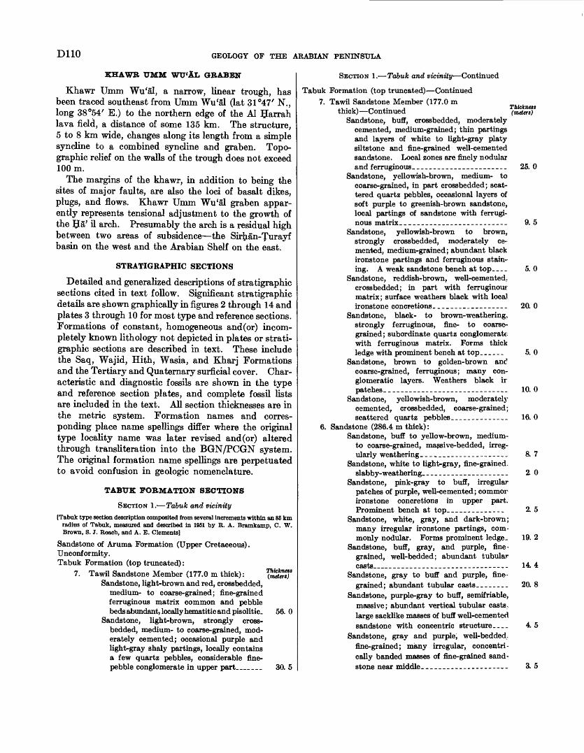
DUO GEOLOGY OF THE ARABIAN PENINSULA
KHAWR UMM WU'AL OBABEN
Khawr Umm Wu'al, a narrow, linear trough, has been traced southeast from Umm Wu'al (lat 31°47' N., long 38°54' E.) to the northern edge of the Al IJarrah lava field, a distance of some 135 km. The structure, 5 to 8 km wide, changes along its length from a simple syncline to a combined syncline and graben. Topo graphic relief on the walls of the trough does not exceed 100m.
The margins of the khawr, in addition to being the sites of major faults, are also the loci of basalt dikes, plugs, and flows. Khawr Umm Wu'al graben appar ently represents tensional adjustment to the growth of the 5a' il arch. Presumably the arch is a residual high between two areas of subsidence the Sirttan-furayf basin on the west and the Arabian Shelf on the east.
STRATIGRAPHIC SECTIONS
Detailed and generalized descriptions of stratigraphic sections cited in text follow. Significant stratigraphic details are shown graphically in figures 2 through 14 and plates 3 through 10 for most type and reference sections. Formations of constant, homogeneous and(or) incom pletely known lithology not depicted in plates or strati- graphic sections are described in text. These include the Saq, Wajid, Hith, Wasia, and Kharj Formations and the Tertiary and Quaternary surficial cover. Char acteristic and diagnostic fossils are shown in the type and reference section plates, and complete fossil lists are included in the text. All section thicknesses are in the metric system. Formation names and corres ponding place name spellings differ where the original type locality name was later revised and (or) altered through transliteration into the BGN/PCGN system. The original formation name spellings are perpetuated to avoid confusion in geologic nomenclature.
TABUS FORMATION SECTIONS
SECTION 1. Tabuk and vicinity[Tabuk type section description composited from several increments within an 85 km
radius of Tabuk, measured and described in 1051 by R. A. Bramkamp, C. W. Brown, 8. J. Roach, and A. E. Clements]
Sandstone of Aruma Formation (Upper Cretaceous).Unconformity.Tabuk Formation (top truncated):
7. Tawil Sandstone Member (177.0 m thick):Sandstone, light-brown and red, crossbedded,
medium- to coarse-grained; fine-grained ferruginous matrix common and pebble beds abundant, locally hematitic and pisolitic.
Sandstone, light-brown, strongly cross- bedded, medium- to coarse-grained, mod erately cemented; occasional purple and light-gray shaly partings, locally contains a few quartz pebbles, considerable fine- pebble conglomerate in upper part__...
Thickness (.meters)
56. 0
30.5
SECTION 1. Tabuk and vicinity Continued
Tabuk Formation (top truncated) Continued 7. Tawil Sandstone Member (177.0 m
thick) ContinuedSandstone, buff, crossbedded, moderately
cemented, medium-grained; thin partings and layers of white to light-gray platy siltstone and fine-grained well-cemented sandstone. Local zones are finely nodular and ferruginous _______________________
Sandstone, yellowish-brown, medium- to coarse-grained, in part crossbedded; scat tered quartz pebbles, occasional layers of soft purple to greenish-brown sandstone, local partings of sandstone with ferrugi nous matrix __________________________
Sandstone, yellowish-brown to brown, strongly crossbedded, moderately ce mented, medium-grained; abundant black ironstone partings and ferruginous stain ing. A weak sandstone bench at top____
Sandstone, reddish-brown, well-cemented, crossbedded; in part with ferruginous matrix; surface weathers black with local ironstone concretions._________________
Sandstone, black- to brown-weathering, strongly ferruginous, fine- to coarse grained; subordinate quartz conglomerate with ferruginous matrix. Forms thick ledge with prominent bench at top. _____
Sandstone, brown to golden-brown anc? coarse-grained, ferruginous; many con glomeratic layers. Weathers black ir patches.________________-___--_-----_
Sandstone, yellowish-brown, moderately cemented, crossbedded, coarse-grained; scattered quartz pebbles ______________
6. Sandstone (286.4 m thick):Sandstone, buff to yellow-brown, medium-
to coarse-grained, massive-bedded, irreg ularly weathering. ____________________
Sandstone, white to light-gray, fine-grained, slabby-weathering. ____________________
Sandstone, pink-gray to buff, irregular patches of purple, well-cemented; commor ironstone concretions in upper part. Prominent bench at top_____------__-
Sandstone, white, gray, and dark-brown; many irregular ironstone partings, com monly nodular. Forms prominent ledge.
Sandstone, buff, gray, and purple, fine- grained, well-bedded; abundant tubular casts___________-___________-___--.-
Sandstone, gray to buff and purple, fine grained; abundant tubular casts________
Sandstone, purple-gray to buff, semifriable, massive; abundant vertical tubular casts, large sacklike masses of buff well-cemented sandstone with concentric structure....
Sandstone, gray and purple, well-bedded, fine-grained; many irregular, concentri cally banded masses of fine-grained sand stone near middle.______--____--------
Thickness (meters)
25.0
9.5
5.0
20. 0
5.0
10.0
16.0
8.7
2.0
2.5
19. 2
144
20. 8
45
3.5
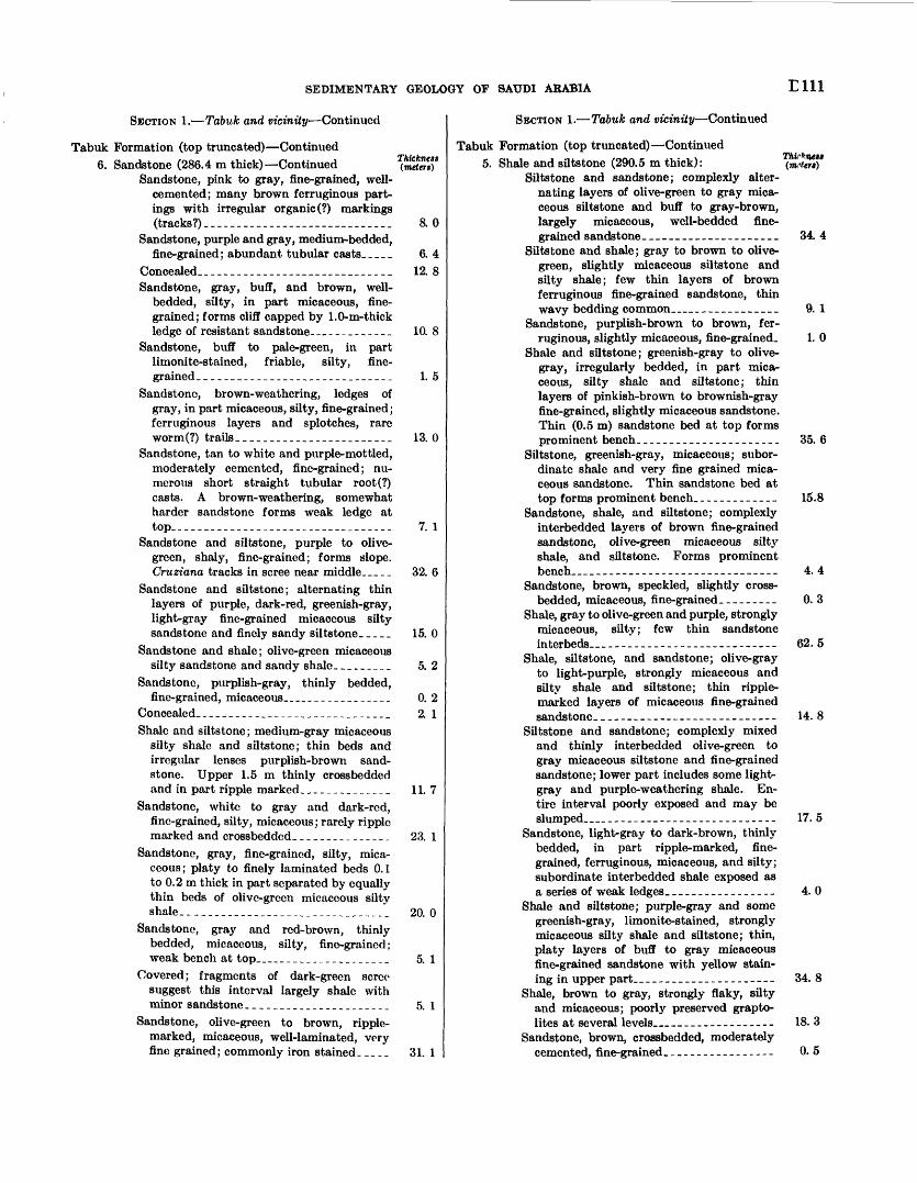
SEDIMENTARY GEOLOGY OF SAUDI ARABIA Elll
SECTION 1. Tabuk and vicinity Continued
Tabuk Formation (top truncated) Continued6. Sandstone (286.4 m thick) Continued (mete?*)
Sandstone, pink to gray, fine-grained, well- cemented; many brown ferruginous part ings with irregular organic (?) markings (tracks?)___.__._____.__...._______ 8. 0
Sandstone, purple and gray, medium-bedded,fine-grained; abundant tubular casts.-. _ _ 6. 4
Concealed..__-_._-___._-_.___-.___.._.. 12. 8Sandstone, gray, buff, and brown, well-
bedded, silty, in part micaceous, fine grained; forms cliff capped by 1.0-m-thick ledge of resistant sandstone.__-_____-_._ 10. 8
Sandstone, buff to pale-green, in part limonite-stained, friable, silty, fine grained. _____________________________ 1. 5
Sandstone, brown-weathering, ledges of gray, in part micaceous, silty, fine-grained; ferruginous layers and splotches, rare worm(?) trails___.____________________ 13. 0
Sandstone, tan to white and purple-mottled, moderately cemented, fine-grained; nu merous short straight tubular root(?) casts. A brown-weathering, somewhat harder sandstone forms weak ledge at top__-__-_-_-_____________________.__ 7. 1
Sandstone and siltstone, purple to olive- green, shaly, fine-grained; forms slope. Cruziana tracks in scree near middle_____ 32. 6
Sandstone and siltstone; alternating thin layers of purple, dark-red, greenish-gray, light-gray fine-grained micaceous silty sandstone and finely sandy siltstone_____ 15. 0
Sandstone and shale; olive-green micaceous silty sandstone and sandy shale_________ 5. 2
Sandstone, purplish-gray, thinly bedded,fine-grained, micaceous.._______________ 0. 2
Concealed._____________________________ 2. 1Shale and siltstone; medium-gray micaceous
silty shale and siltstone; thin beds and irregular lenses purplish-brown sand stone. Upper 1.5 m thinly crossbedded and in part ripple marked._____________ 11. 7
Sandstone, white to gray and dark-red, fine-grained, silty, micaceous; rarely ripple marked and crossbedded.__..--__-_____ 23. 1
Sandstone, gray, fine-grained, silty, mica ceous; platy to finely laminated beds 0.1 to 0.2 m thick in part separated by equally thin beds of olive-green micaceous silty shale.------_-_-_____________________ 20. 0
Sandstone, gray and red-brown, thinly bedded, micaceous, silty, fine-grained; weak bench at top___________________ 5. 1
Covered; fragments of dark-green scree suggest this interval largely shale with minor sandstone______________________ 5. 1
Sandstone, olive-green to brown, ripple- marked, micaceous, well-laminated, very fine grained; commonly iron stained. __._ 31. 1
SECTION 1. Tabuk and vicinity Continued
Tabuk Formation (top truncated) Continued 5. Shale and siltstone (290.5 m thick):
Siltstone and sandstone; complexly alter nating layers of olive-green to gray mica ceous siltstone and buff to gray-brown, largely micaceous, well-bedded fine grained sandstone.____________________
Siltstone and shale; gray to brown to olive- green, slightly micaceous siltstone and silty shale; few thin layers of brown ferruginous fine-grained sandstone, thin wavy bedding common______________
Sandstone, purplish-brown to brown, fer ruginous, slightly micaceous, fine-grained.
Shale and siltstone; greenish-gray to olive- gray, irregularly bedded, in part mica ceous, silty shale and siltstone; thin layers of pinkish-brown to brownish-gray fine-grained, slightly micaceous sandstone. Thin (0.5 m) sandstone bed at top forms prominent bench._____________________
Siltstone, greenish-gray, micaceous; subor dinate shale and very fine grained mica ceous sandstone. Thin sandstone bed at top forms prominent bench.____________
Sandstone, shale, and siltstone; complexly interbedded layers of brown fine-grained sandstone, olive-green micaceous silty shale, and siltstone. Forms prominent bench_ _____________________________
Sandstone, brown, speckled, slightly cross- bedded, micaceous, fine-grained---------
Shale, gray to olive-green and purple, strongly micaceous, silty; few thin sandstone interbeds.. _ __-_____-_-____-__-_-.-_-_
Shale, siltstone, and sandstone; olive-gray to light-purple, strongly micaceous and silty shale and siltstone; thin ripple- marked layers of micaceous fine-grained sandstone._________--___------_-_____
Siltstone and sandstone; complexly mixed and thinly interbedded olive-green to gray micaceous siltstone and fine-grained sandstone; lower part includes some light- gray and purple-weathering shale. En tire interval poorly exposed and may be slumped__ __________________________
Sandstone, light-gray to dark-brown, thinly bedded, in part ripple-marked, fine grained, ferruginous, micaceous, and silty; subordinate interbedded shale exposed as a series of weak ledges.________________
Shale and siltstone; purple-gray and some greenish-gray, limonite-stained, strongly micaceous silty shale and siltstone; thin, platy layers of buff to gray micaceous fine-grained sandstone with yellow stain ing in upper part___________-___-_-----
Shale, brown to gray, strongly flaky, silty and micaceous; poorly preserved grapto- lites at several levels_____---__--_----
Sandstone, brown, crossbedded, moderately cemented, fine-grained___________-_----
34. 4
9. 1
1.0
35.6
15.8
4.4
0.3
62.5
14.8
17.5
4.0
34.8
18.3
0.5
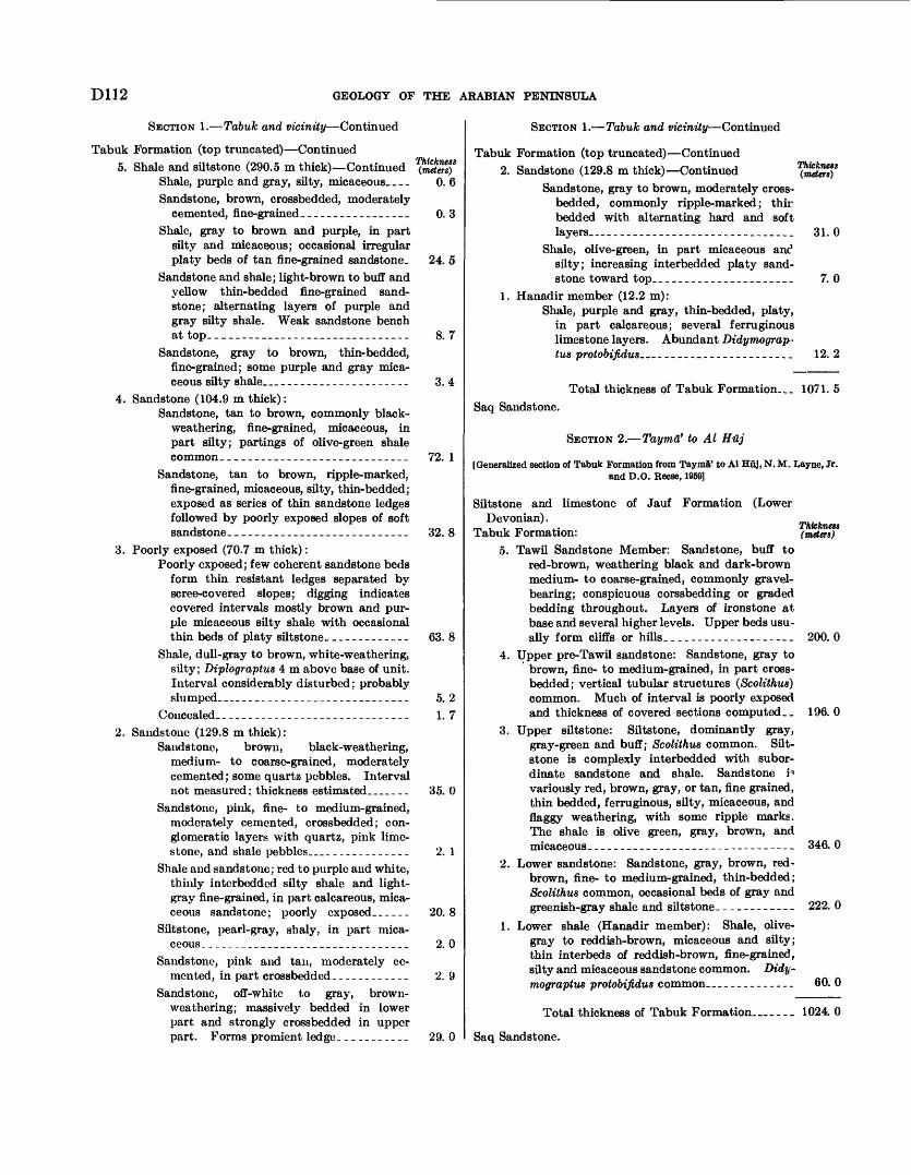
D112 GEOLOGY OF THE ARABIAN PENINSULA
SECTION 1. Tabuk and vicinity Continued
Tabuk Formation (top truncated) Continued5. Shale and siltstone (290.5 m thick) Continued
Shale, purple and gray, silty, micaceous. _ _ _Sandstone, brown, crossbedded, moderately
cemented, fine-grained. ________________Shale, gray to brown and purple, in part
silty and micaceous; occasional irregular platy beds of tan fine-grained sandstone.
Sandstone and shale; light-brown to buff and yellow thin-bedded fine-grained sand stone; alternating layers of purple and gray silty shale. Weak sandstone bench at top. ____--_____--_______.__-.____.
Sandstone, gray to brown, thin- bedded, fine-grained; some purple and gray mica ceous silty shale _ - ___________________
4. Sandstone (104.9 m thick):Sandstone, tan to brown, commonly black-
weathering, fine-grained, micaceous, in part silty; partings of olive-green shale common. _-_-__-__--_-____-_____-____
Sandstone, tan to brown, ripple-marked, fine-grained, micaceous, silty, thin- bedded; exposed as series of thin sandstone ledges followed by poorly exposed slopes of soft sandstone. ___________________________
3. Poorly exposed (70.7 m thick) :Poorly exposed; few coherent sandstone beds
form thin resistant ledges separated by scree-covered slopes; digging indicates covered intervals mostly brown and pur ple micaceous silty shale with occasional thin beds of platy siltstone. _____--_.___
Shale, dull-gray to brown, white-weathering, silty; Diplograptus 4 m above base of unit. Interval considerably disturbed; probably slumped __ __________________________
Concealed. _____________________________2. Sandstone (129.8 m thick):
Sandstone, brown, black-weathering, medium- to coarse-grained, moderately cemented; some quartz pebbles. Interval not measured; thickness estimated.......
Sandstone, pink, fine- to medium-grained, moderately cemented, crossbedded; con glomeratic layers with quartz, pink lime stone, and shale pebbles _ _____________
Shale and sandstone; red to purple and white, thinly interbedded silty shale and light- gray fine-grained, in part calcareous, mica ceous sandstone; poorly exposed..---.
Siltstone, pearl-gray, shaly, in part mica ceous., -_-_--_____._.-___-_-__-______
Sandstone, pink and tan, moderately ce mented, in part crossbedded __-_-_.___._
Sandstone, off-white to gray, brown- weathering; massively bedded in lower part and strongly crossbedded in upper part. Forms promient ledge ___________
0. 6
0. 3
24. 5
8. 7
3. 4
72. 1
32. 8
63. 8
5. 2 1. 7
35. 0
2. 1
20.8
2. 0
2. 9
29. 0
SECTION 1. Tabuk and vicinity Continued
Tabuk Formation (top truncated) Continued 2. Sandstone (129.8 m thick) Continued
Sandstone, gray to brown, moderately cross- bedded, commonly ripple-marked; thir bedded with alternating hard and soft layers. _______________________________
Shale, olive-green, in part micaceous anc1 silty; increasing interbedded platy sand stone toward top_______________________
1. Hanadir member (12.2 m):Shale, purple and gray, thin-bedded, platy,
in part calcareous; several ferruginous limestone layers. Abundant Didymograp- tus protobifidus........................ 12. 2
Thickness (meters)
31.0
7.0
Total thickness of Tabuk Formation_ 1071. 5Saq Sandstone.
SECTION 2. Tayma' to Al Huj
[Generalized section of Tabuk Formation from Tayma' to Al Huj, N. M. Layne, Jr. and D.O. Reese, 1959]
Thickness (meters)
Siltstone and limestone of Jauf Formation (LowerDevonian).
Tabuk Formation:5. Tawil Sandstone Member: Sandstone, buff to
red-brown, weathering black and dark-brown medium- to coarse-grained, commonly gravel- bearing; conspicuous corssbedding or graded bedding throughout. Layers of ironstone at base and several higher levels. Upper beds usu ally form cliffs or hills.-..-------_..._ 200.0
4. Upper pre-Tawil sandstone: Sandstone, gray to brown, fine- to medium-grained, in part cross- bedded; vertical tubular structures (Scolithus) common. Much of interval is poorly exposed and thickness of covered sections computed __ 196. 0
3. Upper siltstone: Siltstone, dominantly gray, gray-green and buff; Scolithus common. Silt- stone is complexly interbedded with subor dinate sandstone and shale. Sandstone p variously red, brown, gray, or tan, fine grained, thin bedded, ferruginous, silty, micaceous, and flaggy weathering, with some ripple marks. The shale is olive green, gray, brown, and micaceous.___________-____----_---------- 346. 0
Lower sandstone: Sandstone, gray, brown, red- brown, fine- to medium-grained, thin-bedded; Scolithus common, occasional beds of gray and greenish-gray shale and siltstone-___________ 222. 0
Lower shale (Hanadir member): Shale, olive- gray to reddish-brown, micaceous and silty; thin interbeds of reddish-brown, fine-grained, silty and micaceous sandstone common. Didy- mograptus protobifidus common ___________ 60. 0
Total thickness of Tabuk Formation__.._ 1024. 0
Saq Sandstone.
2.
1.
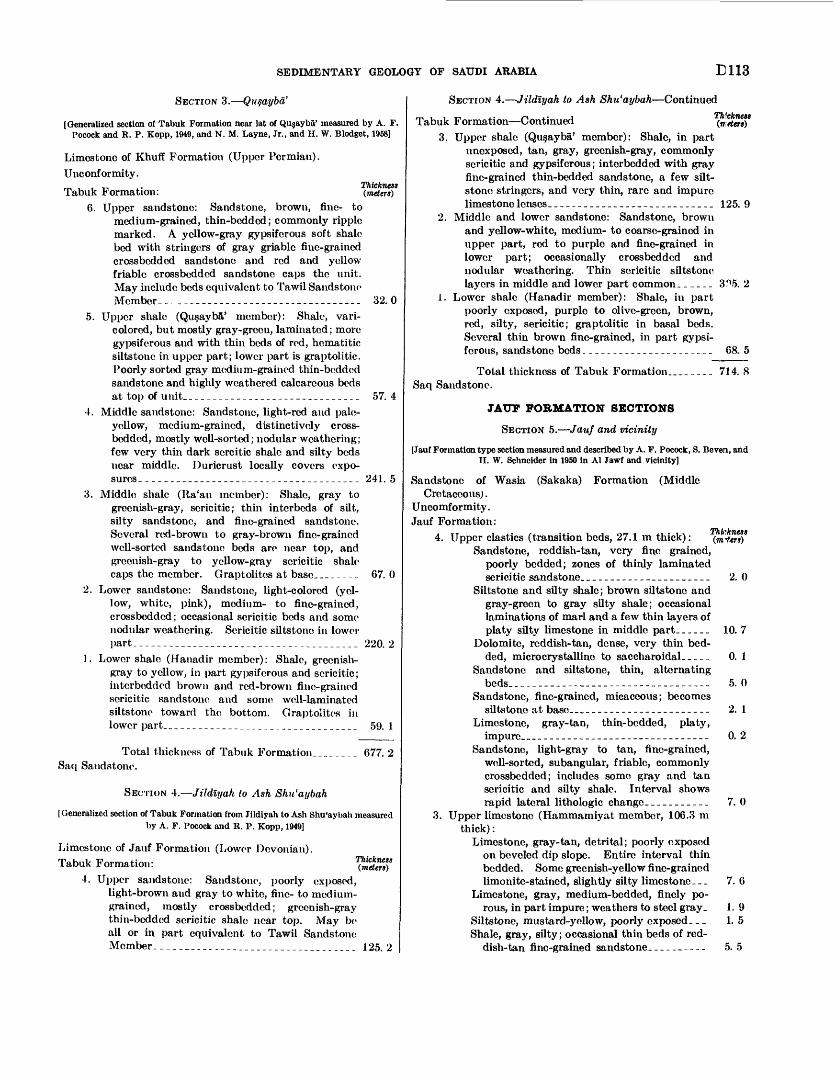
SEDIMENTARY GEOLOGY OF SAUDI ARABIA E113
SECTION 3. Qn§aybd'
[Generalized section of Tabuk Formation near lat of Qujayba' measured by A. F, Pocock and R. P. Kopp, 1949, and N. M. Layne, Jr., and H. W. Blodget, 1968]
Limestone of Khuff Formation (Upper Permian).Unconformity. , , T, ^ Thickness Tabuk Formation: (meters)
6. Upper sandstone: Sandstone, brown, fine- to medium-grained, thin-bedded; commonly ripple marked. A yellow-gray gypsifcrous soft shale bed with stringers of gray griable fine-grained crossbcddcd sandstone and red and yellow friable crossbcddcd sandstone caps the unit- May include beds equivalent to Tawil Sandstone Member.-________-__-_____------________- 32. 0
5. Upper shale (Qusayba' member): Shale, vari colored, but mostly gray-green, laminated; more gypsifcrous and with thin beds of rod, hematitic siltstone in upper part; lower part is graptolitic. Poorly sorted gray medium-grained thin-bedded sandstone and highly weathered calcareous beds at top of unit._____________________________ 57. 4
4. Middle sandstone: Sandstone, light-red and pale- yellow, medium-grained, distinctively cross- bedded, mostly well-sorted; nodular weathering; few very thin dark scrcitic shale and silty beds near middle. Duricrust locally covers expo sures, ___--_-_-_-----_____________________ 241. 5
3. Middle shale (Ila'an member): Shale, gray to greenish-gray, scricitic; thin interbcds of silt, silty sandstone, and fine-grained sandstone. Several red-brown to gray-brown fine-grained well-sorted sandstone beds are near top, and greenish-gray to yellow-gray scricitic shale caps the member. Graptolitcs at basc________ 67. 0
2. Lower sandstone: Sandstone, light-colored (yel low, white, pink), medium- to fine-grained, crossbeddcd; occasional scricitic beds and some nodular weathering. Sericitic siltstone in lower part_ _____________________________________ 220. 2
1. Lower shale (Hanadir member): Shale, greenish- gray to yellow, in part gypsiferous and sericitic; intcrbcdded brown and red-brown fine-grained scricitic sandstone and some well-laminated siltstono toward the bottom. Graptolitcs in lower part_________________________________ 59. 1
Total thickness of Tabuk Formation____ ____ 677. 2Saq Sandstone.
SECTION 4. Jildlyah to Ash Shu'aybah
[Generalized section of Tabuk Formation from Jildlyah to Ash Shu'aybah measured by A. F. Pocock and R. P. Kopp, 1949]
Thickness (meters)
Limestone of Jauf Formation (Lower Devonian).Tabuk Formation:
4. Upper sandstone: Sandstone, poorly exposed, light-brown and gray to white, fine- to medium- grained, mostly crossbedded; greenish-gray thin-bedded scricitic shale near top. May be all or in part equivalent to Tawil Sandstone Member.- -_-_---___________-____-________ 125. 2
SECTION 4. Jildlyah to Ash Shu'aybah Continued
Tabuk Formation Continued3. Upper shale (Qusayba' member): Shale, in part
unexposed, tan, gray, greenish-gray, commonly scricitic and gypsiferous; interbedded with gray fine-grained thin-bedded sandstone, a few silt- stone stringers, and very thin, rare and impure limestone lenses. ___________________________ 125. 9
2. Middle and lower sandstone: Sandstone, brown and yellow-white, medium- to coarse-grained in upper part, red to purple and fine-grained in lower part; occasionally crossbeddcd and nodular weathering. Thin scricitic siltstone layers in middle and lower part common. _____ 3^5. 2
Lower shale (Hanadir member): Shale, in part poorly exposed, purple to olive-green, brown, red, silty, sericitic; graptolitic in basal beds. Several thin brown fine-grained, in part gypsi fcrous, sandstone beds ______________________ 68. 5
i.
Total thickness of Tabuk Formation._____._ 714. 8 Saq Sandstone.
JAUF FORMATION SECTIONS
SECTION 5. Jauf and vicinity
[Jauf Formation type section measured and described by A. F. Pocock, S. Bevera, and II. W. Schneider in 1950 in Al Jawf and vicinity]
Sandstone of WasiaCretaceous) .
Uncomformity. Jauf Formation:
(Sakaka) Formation (Middle
4. Upper elastics (transition beds, 27.1 in thick):Sandstone, reddish-tan, very fine grained,
poorly bedded; zones of thinly laminated sericitic sandstone. __..____________ ____
Siltstone and silty shale; brown siltstone and gray-green to gray silty shale; occasional laminations of marl and a few thin layers of platy silty limestone in middle part______
Dolomite, reddish-tan, dense, very thin bed ded, microcrystallinc to saccharoidal. _ _ _ _
Sandstone and siltstone, thin, alternating beds.. ___..__. ..___.----....____- .
Sandstone, fine-grained, micaceous; becomes siltstone at base _ . ____________________
Limestone, gray-tan, thin-bedded, platy, impure _ - ____________________________
Sandstone, light-gray to tan, fine-grained, well-sorted, subangular, friable, commonly crossbedded; includes some gray and tan sericitic and silty shale. Interval shows rapid lateral lithologic changc___________
3. Upper limestone (Hammamiyat member, 106.3 m thick) :
Limestone, gray-tan, detrital; poorly exposed on beveled dip slope. Entire interval thin bedded. Some greenish-yellow fine-grained limonite-stained, slightly silty limestone. _.
Limestone, gray, medium-bedded, finely po rous, in part impure ; weathers to steel gray.
Siltstone, mustard-yellow, poorly exposed. _ _Shale, gray, silty; occasional thin beds of red
dish-tan fine-grained sandstone. _________
2. 0
10. 7
0. 1
5. 0
2. 1
0. 2
7. 0
7. 6
1. 9 1. 5
5. 5
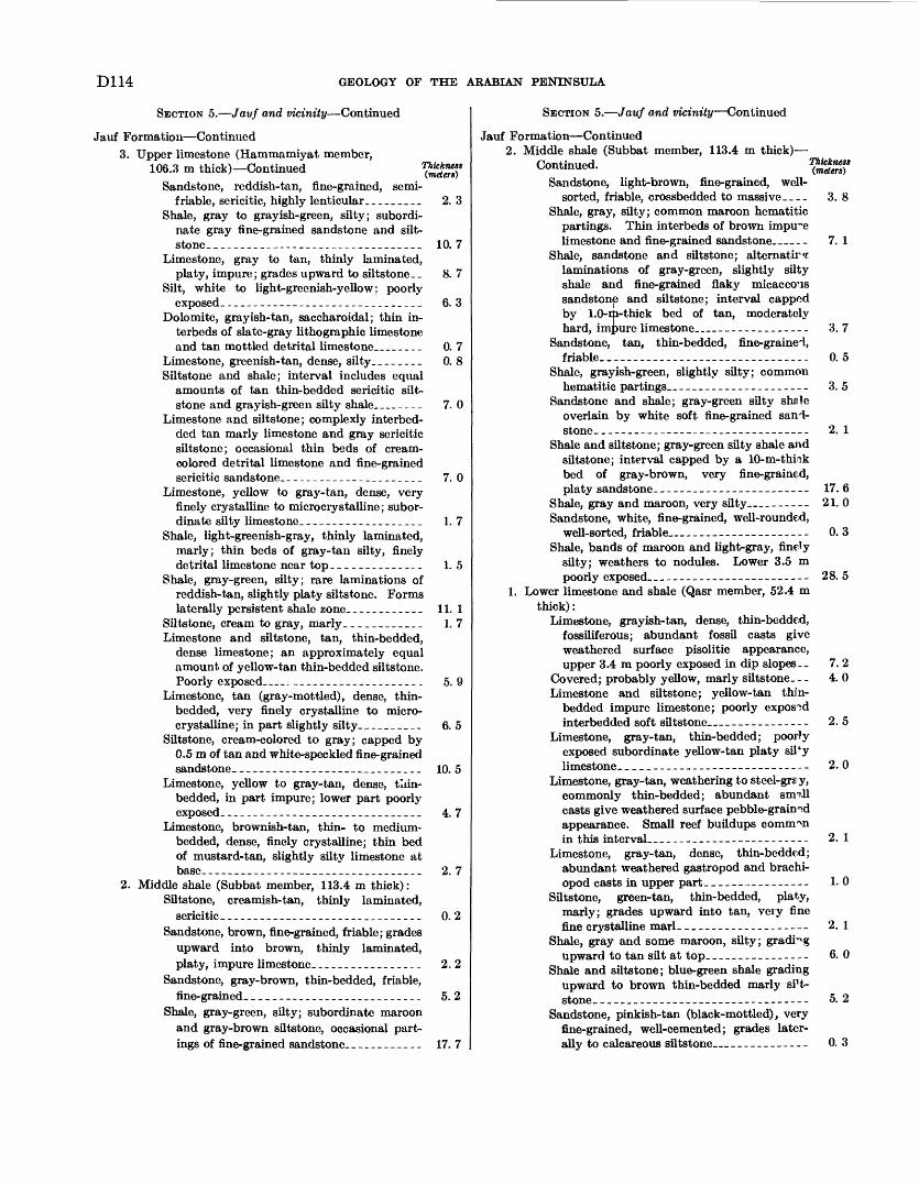
D114 GEOLOGY OF THE ARABIAN PENINSULA
SECTION 5. Javf and vicinity Continued
Jauf Formation Continued3. Upper limestone (Hammamiyat member,
106.3 m thick) ContinuedSandstone, reddish-tan, fine-grained, semi-
friable, sericitic, highly lenticular. ________Shale, gray to grayish-green, silty; subordi
nate gray fine-grained sandstone and silt- stone- ________________________________
Limestone, gray to tan, thinly laminated, platy, impure; grades upward to siltstone__
Silt, white to light-greenish-yellow; poorly exposed. __-____---_-_--_______________
Dolomite, grayish-tan, saccharoidal; thin in- terbeds of slate-gray lithographic limestone and tan mottled detrital limestone __ ____
Limestone, greenish- tan, dense, silty. _ ______Siltstone and shale; interval includes equal
amounts of tan thin-bedded sericitic silt- stone and grayish-green silty shale___----_
Limestone and siltstone; complexly interbed- ded tan marly limestone and gray sericitic siltstone; occasional thin beds of cream- colored detrital limestone and fine-grained sericitic sandstone. _____________________
Limestone, yellow to gray-tan, dense, very finely crystalline to microcry stalline ; subor dinate silty limestone. __________________
Shale, light-greenish-gray, thinly laminated, marly; thin beds of gray- tan silty, finely detrital limestone near top .__--______.__
Shale, gray-green, silty; rare laminations of reddish-tan, slightly platy siltstone. Forms laterally persistent shale zone. ___________
Siltstone, cream to gray, marly ____________Limestone and siltstone, tan, thin-bedded,
dense limestone; an approximately equal amount of yellow-tan thin-bedded siltstone. Poorly exposed __ . ____________________
Limestone, tan (gray-mottled), dense, thin- bedded, very finely crystalline to micro- crystalline; in part slightly silty. -.______.
Siltstone, cream-colored to gray; capped by 0.5 m of tan and white-speckled fine-grained sandstone. ___--_--------_-____________
Limestone, yellow to gray-tan, dense, tliin- bedded, in part impure; lower part poorly exposed. ______________________________
Limestone, brownish-tan, thin- to medium- bedded, dense, finely crystalline; thin bed of mustard-tan, slightly silty limestone at
2. Middle shale (Subbat member, 113.4 m thick):Siltstone, creamish-tan, thinly laminated,
sericitic- _-_-____---_-______--__--_____Sandstone, brown, fine-grained, friable; grades
upward into brown, thinly laminated, platy, impure limestone. ________________
Sandstone, gray-brown, thin-bedded, friable, fine-grained, __________________________
Shale, gray-green, silty; subordinate maroon and gray-brown siltstone, occasional part ings of fine-grained sandstone. ___________
2. 3
10. 7
8. 7
6. 3
0. 7 0. 8
7. 0
7.0
1.7
1.5
11. 1 1.7
5. 9
6. 5
10. 5
4. 7
2. 7
0. 2
2.2
5. 2
17. 7
SECTION 5. Jauf and vicinity Continued
Jauf Formation Continued2. Middle shale (Subbat member, 113.4 m thick)
Cnntinnpd Thickness ^ommuea. (meters)Sandstone, light-brown, fine-grained, well-
sorted, friable, crossbedded to massive____ 3. 8Shale, gray, silty; common maroon hematitic
partings. Thin interbeds of brown impure limestone and fine-grained sandstone__ _- 7. 1
Shale, sandstone and siltstone; alternators laminations of gray-green, slightly silty shale and fine-grained flaky micaceous sandstone and siltstone; interval capped by 1.0-EJa-thick bed of tan, moderately hard, impure limestone____----_-_----_ 3. 7
Sandstone, tan, thin-bedded, fine-graine'l, friable. _.______________ _----- 0.5
Shale, grayish-green, slightly silty; commonhematitic partings.._-__----_-_----_---- 3. 5
Sandstone and shale; gray-green silty shale overlain by white soft fine-grained sand stone- _------_-_------___-----_-_----- 2. 1
Shale and siltstone; gray-green silty shale and siltstone; interval capped by a 10-m-thiok bed of gray-brown, very fine-grained, platy sandstone-_----___--_---_--__---- 17. 6
Shale, gray and maroon, very silty _______ 21. 0Sandstone, white, fine-grained, well-rounded,
well-sorted, friable_______---_----------- 0.3Shale, bands of maroon and light-gray, finely
silty; weathers to nodules. Lower 3.5 m poorly exposed___________--_____----- 28. 5
1. Lower limestone and shale (Qasr member, 52.4 m thick):
Limestone, grayish-tan, dense, thin-bedded, fossiliferous; abundant fossil casts give weathered surface pisolitic appearance, upper 3.4 ra poorly exposed in dip slopes.- 7. 2
Covered; probably yellow, marly siltstone- _ - 4. 0Limestone and siltstone; yellow-tan thin-
bedded impure limestone; poorly exposed interbedded soft siltstone ___-______-_- 2.5
Limestone, gray-tan, thin-bedded; poorly exposed subordinate yellow-tan platy siTy limestone. _________________-_--__----- 2.0
Limestone, gray-tan, weathering to steel-grsy, commonly thin-bedded; abundant simll casts give weathered surface pebble-grained appearance. Small reef buildups common in this interval..___________-----_------ 2.1
Limestone, gray-tan, dense, thin-bedded; abundant weathered gastropod and brachi- opod casts in upper part-_____-__---_--- 1.0
Siltstone, green-tan, thin-bedded, platy, marly; grades upward into tan, very fine fine crystalline marl-_______---____--_-- 2. 1
Shale, gray and some maroon, silty; gradingupward to tan silt at top.___-----__----- 6. 0
Shale and siltstone; blue-green shale grading upward to brown thin-bedded marly si't- stone___-___-_-___----_--__----------- 5. 2
Sandstone, pinkish-tan (black-mottled), very fine-grained, well-cemented; grades later ally to calcareous siltstone_____________ 0. 3
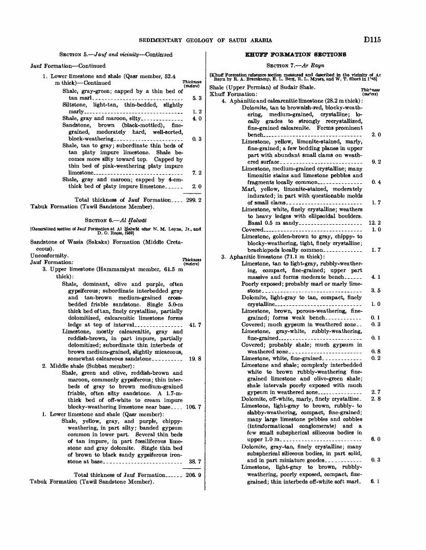
SEDIMENTARY GEOLOGY OF SAUDI ARABIA D115
SECTION 5. Jauf and vicinity Continued
Jauf Formation Continued
1. Lower limestone and shale (Qasr member, 52.4 m thick) Continued
Shale, gray-green; capped by a thin bed oftan marl._____________________________ 5. 3
Siltstone, light-tan, thin-bedded, slightlymarly_______________________________ 1. 2
Shale, gray and maroon, silty_ _____________ 4.0Sandstone, brown (black-mottled), fine
grained, moderately hard, well-sorted, block-weathering.______________________ 0. 3
Shale, tan to gray; subordinate thin beds of tan platy impure limestone. Shale be comes more silty toward top. Capped by thin bed of pink-weathering platy impure limestone____________________________ 7. 2
Shale, gray and maroon; capped by 4-cm- thick bed of platy impure limestone._____ 2. 0
Total thickness of Jauf Formation.... 299.2 Tabuk Formation (Tawil Sandstone Member).
SECTION 6. Al Halwat[Generalized section of Jauf Formation at Al Ifalwat after N. M. Layne, Jr., and
D. O. Reese, 1959]
Sandstone of Wasia (Sakaka) Formation (Middle Creta ceous) .
Unconformity. Jauf Formation:
3. Upper limestone (Hammamiyat member, 61.5 m thick):
Shale, dominant, olive and purple, often gypsiferous; subordinate interbedded gray and tan-brown medium-grained cross- bedded friable sandstone. Single 5.0-m thick bed of tan, finely crystalline, partially dolomitized, calcarenitic limestone forms ledjje at top of interval..-_____________ 41. 7
Limestone, mostly calcarenitic, gray and reddish-brown, in part impure, partially dolomitized; subordinate thin interbeds of brown medium-grained, slightly micaceous, somewhat calcareous sandstone __________ 19. 8
2. Middle shale (Subbat member) :Shale, green and olive, reddish-brown and
maroon, commonly gypsiferous; thin inter beds of gray to brown medium-grained friable, often silty sandstone. A 1.7-m- thick bed of off-white to cream impure blocky-weathering limestone near base_.__ 106. 7
1. Lower limestone and shale (Qasr member):Shale, yellow, gray, and purple, chippy-
weathering, in part silty; banded gypsum common in lower part. Several thin beds of tan impure, in part fossiliferous lime stone and gray dolomite. Single thin bed of brown to black sandy gypsiferous iron stone at base._________________________ 38. 7
Total thickness of Jauf Formation_... 206. 9 Tabuk Formation (Tawil Sandstone Member).
Thic^nest
KHUFF FORMATION SECTIONS
SECTION 7. Ar Rayn
[Khuff Formation reference section measured and described in the vicinity of Ar Rayn by R. A. Bramkamp, E. L. Berg, R. L. Myers, and W. T. Short in I'MS]
Shale (Upper Permian) of Sudair Shale. Khuff Formation:
4. Aphanitic and calcarenitic limestone (28.2 m thick):Dolomite, tan to brownish-red, blocky-weath-
ering, medium-grained, crystalline; lo cally grades to strongly recrystallized, fine-grained calcarenite. Forms prominent bench__________________________ 2. 0
Limestone, yellow, limonite-stained, marly, fine-grained; a few bedding planes in upper part with abundant small clams on weath ered surface__-__------_ -_--__-______ 9. 2
Limestone, medium-grained crystalline; many limonitic stains and limestone pebbles and fragments locally common_____________ 0. 4
Marl, yellow, limonite-stained, moderately indurated; in part with questionable molds of small clams.___________-______---__- 1. 7
Limestone, white, finely crystalline; weathers to heavy ledges with ellipsoidal boulders. Basal 0.5 m sandy_-----------_--_-_-__ 12. 2
Covered____________________________ 1. 0Limestone, golden-brown to gray, chippy- to
blocky-weathering, tight, finely crystalline; brachiopods locally common.____________ 1.7
3. Aphanitic limestone (71.1 m thick):Limestone, tan to light-gray, rubbly-weather
ing, compact, fine-grained; upper part massive and forms moderate bench._____ 4. 1
Poorly exposed; probably marl or marly lime stone. ____-_-_-_-__---__--___-_-_-__-_ 3. 5
Dolomite, light-gray to tan, compact, finelycrystalline___.______-_--_________--__ 1. 0
Limestone, brown, porous-weathering, fine grained; forms weak bench____________ 0. 1
Covered; much gypsum in weathered zone.- 0. 3Limestone, gray-white, rubbly-weathering,
fine-grained__________________________ 0. 1Covered; probably shale; much gypsum in
weathered zone.__________-___-_--____- 0. 8Limestone, white, fine-grained.____________ 0. 2Limestone and shale; complexly interbedded
white to brown rubbly-weathering fine grained limestone and olive-green shale; shale intervals poorly exposed with much gypsum in weathered zone_____________ 2. 7
Dolomite, off-white, marly, finely crystalline. 2. 8Limestone, light-gray to brown, rubbly- to
slabby-weathering, compact, fine-grained; many large limestone pebbles and cobbles (intraformational conglomerate) and a few small subspherical siliceous bodies in upper 1.0m.__________________________ 6. 0
Dolomite, gray-tan, finely crystalline; many subspherical siliceous bodies, in part solid, and in part miniature geodes.___________ 0. 3
Limestone, light-gray to brown, rubbly- weathering, poorly exposed, compact, fine grained; thin interbeds off-white soft marL 6. 1
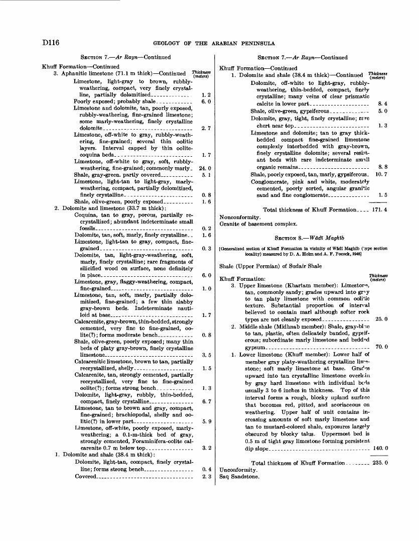
D116 GEOLOGY OF THE ARABIAN PENINSULA
SECTION 7. Ar Rayn Continued
Khuff Formation Continued3. Aphanitic limestone (71.1 m thick) Continued
Limestone, light-gray to brown, rubbly- weathering, compact, very finely crystal line, partially dolomitized__ ____________
Poorly exposed ; probably shale ____________Limestone and dolomite, tan, poorly exposed,
rubbly- weathering, fine-grained limestone; some marly-weathering, finely crystalline dolomite_-------------_---____________
Limestone, off-white to gray, rubbly-weath- ering, fine-grained; several thin oolitic layers. Interval capped by thin oolite- coquina beds. _________________________
Limestone, off-white to gray, soft, rubbly- weathering, fine-grained; commonly marly.
Shale, gray-green, partly covered. __ ________Limestone, light-tan to light-gray, marly-
weathering, compact, partially dolomitized, finely crystalline. ______________________
Shale, olive-green, poorly exposed __________2. Dolomite and limestone (33.7 m thick) :
Coquina, tan to gray, porous, partially re- crystallized; abundant indeterminate small fossils _ -_.____-_ __________________
Dolomite, tan, soft, marly, finely crystalline __Limestone, light-tan to gray, compact, fine
grained. ______---____-____.____-____-_Dolomite, tan, light-gray-weathering, soft,
marly, finely crystalline; rare fragments of silicified wood on surface, none definitely in place. ______________________________
Limestone, gray, flaggy-weathering, compact, fine-grained __ ________________________
Limestone, tan, soft, marly, partially dolo mitized, fine-grained; a few thin slabby gray-brown beds. Indeterminate nauti- loid at base __ ________________________
Calcarenite, gray-brown, thin-bedded, strongly cemented, very fine to fine-grained, oo- lite(?) ; forms moderate bench__ _ _________
Shale, olive-green, poorly exposed; many thin beds of platy gray-brown, finely crystalline limestone __ __________________________
Calcarenitic limestone, brown to tan, partially recrystallized, shelly. ____ _______________
Calcarenite, tan, strongly cemented, partially recrystallized, very fine to fine-grained oolite(?) ; forms strong bench. ___________
Dolomite, light-gray, rubbly, thin-bedded, compact, finely crystalline. ______________
Limestone, tan to brown and gray, compact, fine-grained; brachiopodal, shelly and oo- litic(?) in lower part. ___________________
Limestone, off-white, poorly exposed, marly- weathering; a 0.1-m-thick bed of gray, strongly cemented, Foraminif era-oolite cal- carenite 0.7 m below top. _______________
1. Dolomite and shale (38.4 m thick) :Dolomite, light-tan, compact, finely crystal
line; forms strong bench_______________._Covered ___ ____-_----____--_-___-_____-
1.2 6. 0
2. 7
1. 7
24. 0 5. 1
0. 8 1.6
0. 2 1. 6
0. 3
6. 0
1. 0
1. 7
0. 8
3. 5
1. 5
1.3
6.7
5. 9
3. 2
0. 4 2. 3
SECTION 7. Ar Rayn Continued
Khuff Formation Continued1. Dolomite and shale (38.4 m thick) Continued
Dolomite, off-white to light-gray, rubbly- weathering, thin-bedded, compact, finely crystalline; many veins of clear prismatic calcite in lower part. ___________________ 8. 4
Shale, olive-green, gypsif erous _____________ 5. 0Dolomite, gray, tight, finely crystalline; r_re
chert near top. ________________________ 1.3Limestone and dolomite; tan to gray thick-
bedded compact fine-grained limestone complexly interbedded with gray-brown, finely crystalline dolomite; several resist ant beds with rare indeterminate sim.ll organic remains. _______________________
Shale, poorly exposed, tan, marly, gypsif erous.Conglomerate, pink and white, moderately
cemented, poorly sorted, angular granitic sand and fine conglomerate. _____________
8. 8 10. 7
1.5
Total thickness of Khuff Formation. _ _ _ 171. 4 Nonconformity. Granite of basement complex.
SECTION 8. Wadl Maghib
[Generalized section of Khuff Formation in vicinity of W5di Maghib (Vype section locality) measured by D. A. Holm and A. F. Pocock, 1948]
Shale (Upper Permian) of Sudair Shale
*r, ,- -n ,. Thickness Khuff Formation: (meters)
3. Upper limestone (Khartam member): Limestone, tan, commonly sandy; grades upward into gr>y to tan platy limestone with common oolitic texture. Substantial proportion of interval believed to contain marl although softer rock types are not cleanly exposed-_-_______-_-___ 25. 0
2. Middle shale (Midhnab member): Shale, gray-bHe to tan, plastic, often delicately banded, gypsif- erous; subordinate marly limestone and bedd<xi gypsum___________________--_--_--_---_--- 70. 0
1. Lower limestone (Khuff member): Lower half of member gray platy-weathering crystalline liir°- stone; soft marly limestone at base. Grac*"?s upward into tan crystalline limestone overlr.iu by gray hard limestone with individual bc^ls usually 3 to 6 inches in thickness. Top of this interval forms a rough, blocky upland surface that becomes red, pitted, and scoriaceous on weathering. Upper half of unit contains in creasing amounts of soft marly limestone and tan to mustard-colored shale, exposures largely obscured by blocky talus. Uppermost bed is 0.5 m of tight gray limestone forming persistent dip slope._-__--___-_-_-_-----_------------ 140. 0
Total thickness of Khuff Formation. Unconformity. Saq Sandstone.
235.0
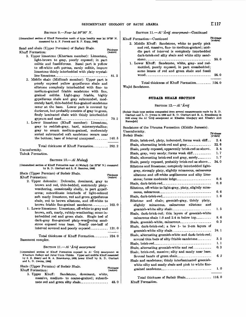
SEDIMENTARY GEOLOGY OF SAUDI ARABIA E117
SECTION 9. Near lat 26°SO' N.
[Generalized section of Khufl Formation north of type locality near lat 26°30' N. measured by A. F. Pocock and R. P. Kopp, 1949]
Thickness (meters')
Sand and shale (Upper Permian) of Sudair Shale.Khuff Formation:
3. Upper limestone (Khartam member): Limestone, light-brown to gray, poorly exposed; in part oolitic and fossiliferous. Basal part is yellow to off-white soft porous, rarely oolitic, impure limestone thinly interbedded with platy crystal line limestone.._--__-______________.___..__ 81. 5
2. Middle shale (Midhnab member): Upper part is poorly exposed yellow gypsiferous shale and siltstone complexly interbedded with fine- to medium-grained friable sandstone with fine, grained ooliths. Light-gray friable, highly gypsiferous shale and gray subrounded, mod erately hard, thin-bedded fine-grained sandstone occur at the base. Lower part is covered by duricrust, but probably consists of gray to green, finely laminated shale with thinly interbedded gypsum and marl._________________________ 70. 2
1. Lower limestone (Khuff member): Limestone, gray to reddish-gray, hard, microcrystalline; gray to cream medium-grained, moderately sorted subrounded soft sandstone occurs near the bottom; base of interval unexposed_______ 140. 5
Thickness (meters)
Total thickness of Khuff Formation. _______ 292. 2Unconformity. Tabuk Formation.
SECTION 10. Al Mulayh
[Generalized section of Khuff Formation near Al Mulayh (lat 22°36' N.) measured by R. D. Gierhart and L. F. Ramirez, 1949]
Shale (Upper Permian) of Sudair Shale.Khuff Formation:
2. Upper dolomite: Dolomite, dominant, gray to brown and red, thin-bedded, commonly platy- weathering, occasionally shelly, in part gypsif erous; subordinate interbeds of light-colored soft marly limestone, red and green gypsiferous shale, red to brown siltstone, and off-white to brown friable fine-grained sandstone. ________ 103.0
1. Lower limestone: Limestone, off-white to gray and brown, soft, marly, rubbly-weathering; some in terbedded red and green shale. Single bed of dark-gray fine-grained platy-weathering sand stone exposed near base. Nearly one-half of interval covered and poorly exposed._________ 121.0
Total thickness of Khuff Formation. _-___._ 224. 0 Basement complex.
SECTION 11. Al 'Arid escarpment[ Generalized section of Khuff Formation exposed in Al 'Arid escarpment at
Khashum Sudayr and Jabal Umm Ghiran. Upper and middle Khuff measured by S. B. Henry and R. A. Bramkamp, 1950; lower Khuff by R. D. Gierhart and L. D. Owens, 1948]
Shale (Upper Permian) of Sudair Shale.Khuff Formation:
3. Upper Khuff: Sandstone, dominant, white, massive, medium- to coarse-grained; subordi nate red and green silty shale____-------_-__- 48. 0
Thickness (meters)
SECTION 11. Al 'Arid escarpment Continued
Khuff Formation Continued 1$S£ff 2. Middle Khuff: Sandstone, white to partly pink
and red, massive, fine- to medium-grained; mid dle part of interval is complexly interbedded dark-brick-red silty shale and white silty sand stone. ____________________________________ 50.0
1. Lower Khuff: Sandstone, white, gray- and red- mottled, poorly exposed, in part crossbedded; some lenses of red and green shale and fossil wood.____________________________________ 56. 0
Total thickness of Khuff Formation._______ 154. 0Wajid Sandstone.
SUDAIR SHALE SECTION
SECTION 12. Al 'Arid
[Sudair Shale type section composited from several measurements made by R. D. Gierhart and L. D. Owens in 1948 and R. D. Gierhart and R. A. Bramkamp in 1960 along the Al 'Arid escarpment at Khashm Ghudayy and Khashn Abu Ramadah]
Th'ckness (waters)
Sandstone of the Dhruma Formation (Middle Jurassic).Unconformity.Sudair Shale:
Shale, brick-red, platy, indurated; forms weak cliff_. 2. 4 Shale, alternating brick-red and gray.______-_-_--_ 22. 6Shale, poorly exposed, apparently brick-red as above. 3. 4 Shale, gray, very sandy; forms weak cliff._________ 1.7Shale, alternating brick-red and gray, sandy ___ 1. 7 Shale, poorly exposed, probably brick-red as above. _ 34. 0 Siltstone and limestone; complexly interbedded light-
gray, strongly platy, slightly micaceous, calcareous siltstone and off-white argillaceous and silty lime stone; forms moderate ledge.-___-___---_------- 0. 6
Shale, dark-brick-red._--_-------------- _-___- 0.8Siltstone, off-white to light-gray, platy, slightly mica
ceous, calcareous.__.__-__-_______--__------_ 0. 6Shale, dark-brick-red._____.__--___-__---_------_ 1.6Siltstone and shale; greenish-gray, thinly platy,
slightly micaceous, calcareous siltstone and greenish-white silty shale._____________________ 1.5
Shale, dark-brick-red; thin layers of greenish-whitecalcareous shale 1.0 and 2.4 m below top _... 8. 6
Shale, greenish-white, calcareous._________________ 0. 3Shale, dark-brick-red; a few 1- to 2-cm layers of
greenish-white silty shale._____________________ 24. 1Shale, alternating greenish-white and dark-brick-red;
several thin beds of silty friable sandstone. _______ 3. 5Shale, brick-red.._____________________________ 1. 1Shale, alternating greenish-white and red__________ 0. 3Shale, brick-red, massive; silty and sandy near base.
Several bands of green shale. _--------------- 6. 2Shale and sandstone; thinly interlaminated greenish-
white silty and sandy shale and pink to white fine grained sandstone_ __________________________ 1.0
Total thickness of Sudair Shale. Khuff Formation.
116.0
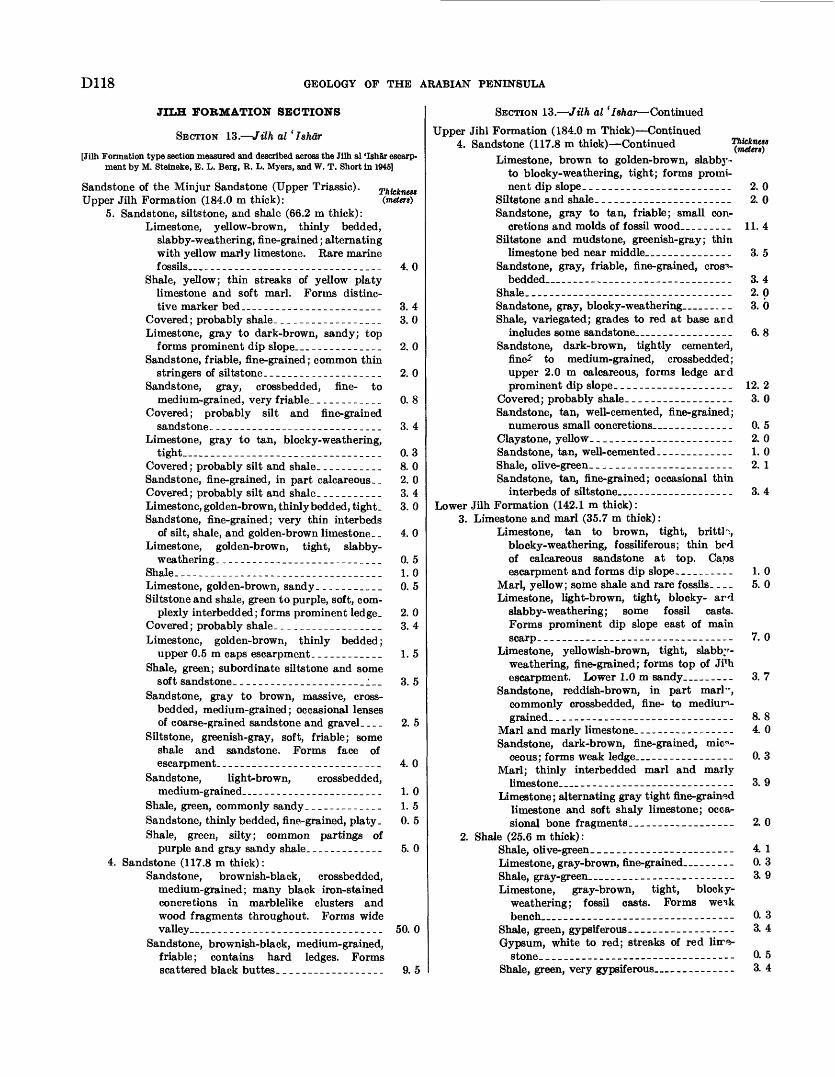
D118 GEOLOGY OF THE ARABIAN PENINSULA
JILH FORMATION SECTIONS
SECTION 13. Jilh al 1 Ishar
[Jilh Formation type section measured and described across the Jilh al 'Ishar escarp ment by M. Steineke, E. L. Berg, R. L. Myers, and W. T. Short in 1945]
Thicknas (metert)
4. 0
3. 4
Sandstone of the Minjur Sandstone (Upper Triassic). Upper Jilh Formation (184.0 m thick):
5. Sandstone, siltstone, and shale (66.2 m thick):Limestone, yellow-brown, thinly bedded,
slabby-weathering, fine-grained ; alternating with yellow marly limestone. Rare marine fossils _ _ _____________________________
Shale, yellow; thin streaks of yellow platy limestone and soft marl. Forms distinc tive marker bed_____ ___________________
Covered ; probably shale. _________________ 3. 0Limestone, gray to dark-brown, sandy; top
forms prominent dip slope.-. _ ___________ 2. 0Sandstone, friable, fine-grained; common thin
stringers of siltstone. ___________________ 2. 0Sandstone, gray, crossbedded, fine- to
medium-grained, very friable. ___________ 0. 8Covered; probably silt and fine-grained
sandstone. ____________________________ 3. 4Limestone, gray to tan, blocky-weathering,
tight_____ _____________________________ 0.3Covered ; probably silt and shale. -_-____.__ 8. 0Sandstone, fine-grained, in part calcareous. _ 2. 0 Covered ; probably silt and shale. -___--____ 3. 4Limestone, golden-brown, thinly bedded, tight. 3. 0 Sandstone, fine-grained; very thin interbeds
of silt, shale, and golden-brown limestone.- 4. 0 Limestone, golden-brown, tight, slabby-
weathering- -_-__--_.______________-___ 0. 5Shale. -----_-_-_------_._-___--_--._.._. 1.0Limestone, golden-brown, sandy _.-._______ 0. 5Siltstone and shale, green to purple, soft, com
plexly interbedded; forms prominent ledge. 2. 0 Covered ; probably shale. _________________ 3. 4Limestone, golden-brown, thinly bedded;
upper 0.5 m caps escarpment- ___________ 1. 5Shale, green; subordinate siltstone and some
soft sandstone. ---__--___________.__:__Sandstone, gray to brown, massive, cross-
bedded, medium-grained; occasional lenses of coarse-grained sandstone and gravel. ...
Siltstone, greenish-gray, soft, friable; some shale and sandstone. Forms face of escarpment. ___________________________ 4. 0
Sandstone, light-brown, crossbedded,medium-grained. ___ ____________________ 1. 0
Shale, green, commonly sandy _____________ 1.5Sandstone, thinly bedded, fine-grained, platy. 0. 5 Shale, green, silty; common partings of
purple and gray sandy shale. ____________ 5. 04. Sandstone (117.8 m thick):
Sandstone, brownish-black, crossbedded, medium-grained; many black iron-stained concretions in marblelike clusters and wood fragments throughout. Forms wide valley __ _._..._..______-___________._
Sandstone, brownish-black, medium-grained, friable; contains hard ledges. Forms scattered black buttes. _________________
3. 5
2. 5
50. 0
9. 5
SECTION 13. Jilh al 'Ishar Continued
Upper Jibl Formation (184.0 m Thick) Continued 4. Sandstone (117.8 m thick) Continued
Limestone, brown to golden-brown, slabbj*-to blocky-weathering, tight; forms prominent dip slope. _-___----_--_-_______-__
Siltstone and shale. _____-----_--__-_-__-_Sandstone, gray to tan, friable; small con
cretions and molds of fossil wood. ________Siltstone and mudstone, greenish-gray; thin
limestone bed near middle. ____-.______-_Sandstone, gray, friable, fine-grained, cross
bedded __ ________ _ ___ _ __ __ _____Shale____----_-------_------------__----Sandstone, gray, blocky-weathering __ __.__ Shale, variegated; grades to red at base and
includes some sands tone____ . ____________Sandstone, dark-brown, tightly cemented,
fine* to medium-grained, crossbedded;upper 2.0 m calcareous, forms ledge ardprominent dip slope. ___________________
Covered; probably shale. _________________Sandstone, tan, well-cemented, fine-grained;
numerous small concretions _ __________Claystone, yellow_____ .__-_-_____-___-Sandstone, tan, well-cemented. ____________Shale, olive-green. ____._-_-_-__-__--__--_Sandstone, tan, fine-grained; occasional thin
interbeds of siltstone _ _________________Lower Jilh Formation (142.1 m thick):
3. Limestone and marl (35.7 m thick) :Limestone, tan to brown, tight, brittle,
blocky-weathering, fossiliferous; thin bedof calcareous sandstone at top. Capsescarpment and forms dip slope. _________
Marl, yellow; some shale and rare fossils. ...Limestone, light-brown, tight, blocky- ard
slabby-weathering; some fossil casts.Forms prominent dip slope east of mainscarp___--_---------_----------__---_-
Limestone, yellowish-brown, tight, slabby-weathering, fine-grained; forms top of JFhescarpment. Lower 1.0m sandy. ________
Sandstone, reddish-brown, in part marl",commonly crossbedded, fine- to mediuri-grained. __________________---__-_---__
Marl and marly limestone. ________________Sandstone, dark-brown, fine-grained, mica
ceous; forms weak ledge___ _ ___-____--_-_Marl; thinly interbedded marl and marly
limestone _ _______________---__----__-Limestone; alternating gray tight fine-grained
limestone and soft shaly limestone; occasional bone fragments__________________
2. Shale (25.6 m thick):Shale, olive-green__ ______._____-___----_-Limestone, gray-brown, fine-grained ______Shale, gray-green___ _ ______________--__---Limestone, gray-brown, tight, blocky-
weathering; fossil casts. Forms wei.kbench _ ______________--__--__----_---
Shale, green, gypsiferous-_--_----_--------Gypsum, white to red; streaks of red litre-
stone__--__-_--_-_--_-----------------Shale, green, very gypsiferous __________
2. 0 2. 0
11.4
3. 5
3. 42. 03. 6
6. 8
12. 2 3. 0
0. 5 2. 01. 02. 1
3. 4
1.0 5. 0
7. 0
3. 7
8. 8 4. 0
0. 3
3. 9
2. 0
4. 1 0. 3 3.9
0. 33. 4
0. 53. 4
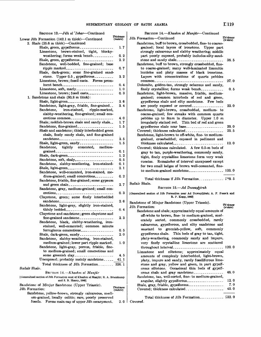
SEDIMENTARY GEOLOGY OF SAUDI ARABIA E119
SECTION 13. Jilh al 'Ishar ContinuedThickness (metert)Lower Jilh Formation (142.1 m thick) Continued
2. Shale (25.6 m thick) ContinuedShale, green, gypsiferous__________________ 1. 7Limestone, brown-stained, tight, blocky-
weathering; forms weak bench___________ 0. 2Shale, green, gypsiferous._________________ 2. 2Sandstone, well-bedded, fine-grained; base
ripple marked________________________ 0. 7Shale, dark-green; some fine-grained sand
stone. Upper 0.5 , gypsiferous__________ 3. 2Limestone, brown; fossil casts. Forms prom
inent bench__________________________ 0. 4Limestone, soft, marly-___________________ 1.0Limestone, brown; fossil casts____________ 0. 3
1. Sandstone and shale (80.8 m thick):Shale, light-green_______________________ 3. 6Sandstone, light-gray, friable, fine-grained __ 3. 4 Sandstone, iron-stained, ripple-marked,
slabby-weathering, fine-grained; small con cretions common. ______________________ 40
Shale; reddish-brown shale and sandy shale._ 1. 7 Sandstone, fine-grained.__________________ 1. 5Shale and sandstone; thinly interbedded green
shale, finely sandy shale, and fine-grained sandstone_________.___________________ 3. 5
Shale, light-green, sandy__________________ 1. 5Sandstone, tightly cemented, medium-
grained_____________-___-____-____-___ 0. 1Shale, dark-green______________________ 1. 2Sandstone, soft, shaly______-_____________- 0. 5Sandstone, slabby-weathering, iron-stained- 0. 1 Shale, light-green______________________ 2. 1Sandstone, well-cemented, iron-stained, me
dium-grained ; small concretions.___.-_.__ 0. 2 Sandstone, friable, fine-grained; some gypsum
and green shale._______________________ 2. 7Sandstone, gray, medium-grained; small con
cretions. ______________________________ 0. 3Claystone, green; some finely interbedded
sandstone.____________________________ 2. 6Sandstone, light-gray, slightly iron-stained,
thinly bedded_______-______-__-_-.-__ 0. 4Claystone and sandstone; green claystone and
fine-grained sandstone-_________________ 2. 3Sandstone, black, slabby-weathering, iron-
stained, well-cemented; common minute ferruginous concretions________________ 0. 5
Shale, dark-green, sandy__________________ 2. 0Sandstone, slabby-weathering, iron-stained,
medium-grained; lower part ripple marked. 1. 0 Sandstone, light-gray, porous, friable, fine-
to medium-grained; small concretions and some greenish clay___--_-__--___-____-_ 4 5
Unexposed; probably mainly sandstone.--__ 41. 1 Total thickness of Jilh Formation._______ 326. 1
Sudair Shale.SECTION 14. Khashm al Manjur
[Generalized section of Jilh Formation west of Khashm al Manjur; R. A. Bramkamp and S. B. Henry, 1949]
Sandstone of Minjur Sandstone (Upper Triassic).Jilh Formation:
Sandstone, yellow-brown, strongly calcareous, medi um-grained, locally oolitic; rare, poorly preserved fossils. Forms main cap of upper Jilh escarpment. 2. 0
SECTION 14. Khashm al Manjur Continued Jilh Formation Continued
Sandstone, buff to brown, crossbedded, fine- to coarse grained; local layers of ironstone. Upper part strongly calcareous and slabby weathering; middle part poorly exposed, probably includes silty sand stone and sandy shale. ________________________
Sandstone, buff to brown, strongly crossbedded, fine- to coarse-grained; many well-laminated limonitic lenticles and platy masses of black ironstone. Layers with concentrations of quartz pebbles common. ____-__---_-__________---______.____
Dolomite, golden-tan, strongly ocherous and sandy, finely crystalline; forms weak bench... _________
Sandstone, light-brown, massive, friable, medium- grained; common interbeds of red and green, gypsiferous shale and silty sandstone. Few beds are poorly exposed or covered______.__________
Sandstone, light-brown, crossbedded, medium- to coarse-grained; few streaks with common quartz pebbles up to 8mm in diameter. Upper 1.0 m irregularly stained red. Thin bed of red and green gypsiferous shale near base. ___________________
Covered ; thickness calculated .-_-______.-________Sandstone, light-brown to off-white, fine- to medium-
grained, crossbedded; exposed in pediment and thickness calculated _ _ ._____________-_--___-_
Covered; thickness calculated. A few 0.5-m beds of gray to tan, purple-weathering, commonly sandy, tight, finely crystalline limestone form very weak cuestas. Remainder of interval unexposed except for two small ledges of brown well-cemented, fine- to medium-grained sandstone __ _ ._______-___._
38. 5
27. 0
0. 5
22.0
29. 025. 5
12. 0
133. 0
Total thickness if Jilh Formation. ____________ ??9. 5Sudair Shale.
SECTION 15. Ad Duwayhirah
[Generalized section of Jilh Formation near Ad Duwayhirah; A. F. Pocork and R. P. Kopp, 1949]
Sandstone of Minjur Sandstone (Upper Triassic). m ,,.,, ,. Th'cknestJilh Formation: (rretert)
Sandstone and shale; approximately equal amounts of off-white to brown, fine- to medium-grained, mod erately sorted, commonly crossbedded, rarely calcareous, gypsiferous, and silty sandstone and mustard to greenish-yellow, soft, commonly gypsiferous shale. Thin beds of gray to tan, tight, platy-weathering, commonly sandy and impure, very finely crystalline limestone are scattered throughout interval.________--_--_-_-__-____-- 120. 0
Limestone and siltstone; approximately equal amounts of complexly interbedded, light-brown, platy, impure and sandy, rarely fossiliferous lime stone and gray, yellow and green, in part gypsif erous siltstone. Occasional thin beds of gypsif erous shale and gray sandstone._________-_---_ 48.0
Sandstone, tan, well-sorted, fine- to medium-grained,angular, slightly gypsiferous_________--_-___-_ 12. 0
Shale, gray, friable, gypsif erous. __________________ 7. 0Covered; thickness calculated.___________________ 45. 0
Total thickness of Jilh Formation_____.____- 232. 0Covered.
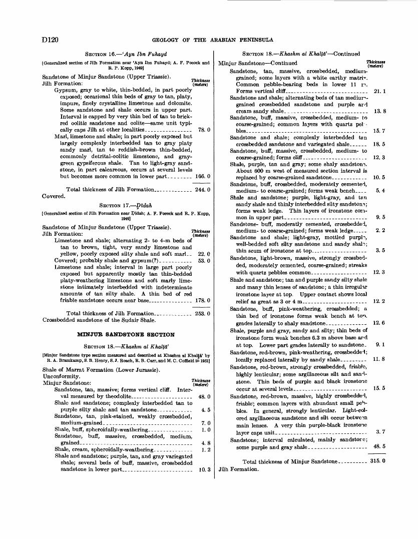
D120 GEOLOGY OF THE ARABIAN PENINSULA
SECTION 16. 'Ayn Ibn Fuhayd
[Generalized section of Jilh Formation near 'Ayn Ibn Fuhayd; A. F. Pocock and R. P. Kopp, 1949]
Sandstone of Minjur Sandstone (Upper Triassic).-.,, T-, ,. ThicknessJilh Formation: (meters)
Gypsum, gray to white, thin-bedded, in part poorly exposed; occasional thin beds of gray to tan, platy, impure, finely crystalline limestone and dolomite. Some sandstone and shale occurs in upper part. Interval is capped by very thin bed of tan to brick- red oolitic sandstone and oolite same unit typi cally caps Jilh at other localities________________ 78. 0
Marl, limestone and shale; in part poorly exposed but largely complexly interbedded tan to gray platy sandy marl, tan to reddish-brown thin-bedded, commonly detrital-oolitic limestone, and gray- green gypsiferous shale. Tan to light-gray sand stone, in part calcareous, occurs at several levels but becomes more common in lower part. _______ 166. 0
Total thickness of Jilh Formation_-____.____ 244. 0 Covered.
SECTION 17. Didah[Generalized section of Jilh Formation near Qidah; A. F. Pocock and R. P. Kopp,
1949]
Sandstone of Minjur Sandstone (Upper Triassic). Jilh Formation:
Limestone and shale; alternating 2- to 4-m beds of tan to brown, tight, very sandy limestone and yellow, poorly exposed silty shale and soft marl._ 22. 0
Covered; probably shale and gypsum(?)___________ 53. 0Limestone and shale; interval in large part poorly
exposed but apparently mostly tan thin-bedded platy-weathering limestone and soft marly lime stone intimately interbedded with indeterminate amounts of tan silty shale. A thin bed of red friable sandstone occurs near base_____________ 178. 0
Total thickness of Jilh Formation.____________ 253. 0Crossbedded sandstone of the Sudair Shale.
MINJUR SANDSTONE SECTION
SECTION 18. Khashm al Khalta'
[Minjur Sandstone type section measured and described at Khashm al Khalja' by R. A. Bramkamp, 8. B. Henry, 8. J. Roach, R. B. Carr, and M. C. Coffleld in 1951]
Shale of Marrat Formation (Lower Jurassic).Unconformity.Minjur Sandstone:
Sandstone, tan, massive; forms vertical cliff. Inter val measured by theodolite-_----_-----_--___--_ 48.0
Shale and sandstone; complexly interbedded tan topurple silty shale and tan sandstone-_-_-_-_.___ 4. 5
Sandstone, tan, pink-stained, weakly crossbedded,medium-grained______________________________ 7. 0
Shale, buff, spheroidally-weathering_______________ 1.0Sandstone, buff, massive, crossbedded, medium,
grained._-_-----___-__________________.--_-__ 4. 8Shale, cream, spheroidally-weathering. ____________ 1.2Shale and sandstone; purple, tan, and gray variegated
shale; several beds of buff, massive, crossbedded sandstone in lower part________________________ 10. 3
SECTION 18. Khashm al Khal\a' Continued
Minjur Sandstone Continued ^£85)*
Sandstone, tan, massive, crossbedded, mediun- grained; some layers with a white earthy matrix Common pebble-bearing beds in lower 11 n. Forms vertical cliff__________________________ 21. 1
Sandstone and shale; alternating beds of tan medium- grained crossbedded sandstone and purple ard cream sandy shale. _-__-_--------_____________ 13. 8
Sandstone, buff, massive, crossbedded, medium- to coarse-grained; common layers with quartz pel - bles_ -- - --- - - __-_ _- 15. 7
Sandstone and shale; complexly interbedded tancrossbedded sandstone and variegated shale______ 18. 5
Sandstone, buff, massive, crossbedded, medium- tocoarse-grained; forms cliff..__-_-__--___________ 12. 3
Shale, purple, tan and gray; some shaly sandstone. About 600 m west of measured section interval is replaced by coarse-grained sandstone.___________ 10. 5
Sandstone, buff, crossbedded, moderately cemented,medium- to coarse-grained; forms weak bench..__ 5. 4
Shale and sandstone; purple, light-gray, and tan sandy shale and thinly interbedded silty sandstone; forms weak ledge. Thin layers of ironstone com mon in upper part._____--___---_-______-_--__ 9. 5
Sandstone- buff, moderatly cemented, crossbedded,medium- to coarse-grained; forms weak ledge..___ 2. 2
Sandstone and shale; light-gray, mottled purpl?, well-bedded soft silty sandstone and sandy shaH; thin scum of ironstone at top----__---___-----__ 3. 5
Sandstone, light-brown, massive, strongly crossbed ded, moderately cemented, coarse-grained; streaks with quartz pebbles common.__-_---_______---- 12. 3
Shale and sandstone; tan and purple sandy silty shale and many thin lenses of sandstone; a thin irregular ironstone layer at top. Upper contact shows local relief as great as 3 or4m_______________-----__ 12. 2
Sandstone, buff, pink-weathering, crossbedded; a thin bed of ironstone forms weak bench at ton, grades laterally to shaly sandstone.________---_- 12. 6
Shale, purple and gray, sandy and silty; thin beds of ironstone form weak benches 6.3 m above base ard at top. Lower part grades laterally to sandstone. 9. 1
Sandstone, red-brown, pink-weathering, crossbedded; locally replaced laterally by sandy shale---.---.- 11. 8
Sandstone, red-brown, strongly crossbedded, friabJc, highly lenticular; some argillaceous silt and sand stone. Thin beds of purple and black ironstone occur at several levels------------------- ------ 15. 5
Sandstone, red-brown, massive, highly crossbedded, friable'; common layers with abundant small peb bles. In general, strongly lenticular. Light-col ored argillaceous sandstone and silt occur betwe3n main lenses. A very thin purple-black ironstone layer caps unit._____________-_---_-----_----- 3. 7
Sandstone; interval calculated, mainly sandstorc;some purple and gray shale._____-_-__--------- 48. 5
Total thickness of Minjur Sandstone. Jilh Formation.
315.0
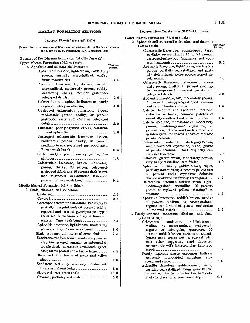
SEDIMENTARY GEOLOGY OF SAUDI ARABIA 1121
MARRAT FORMATION SECTIONS
SECTION 19. Khashm adh Dhlbl
[Marrat Formation reference section measured and sampled in the face of Khashm adh Dhlbl by R. W. Powers and H. A. McClure in 1962]
Gypsum of the Dhruma Formation (Middle Jurassic). Upper Marrat Formation (24.2 m thick) :
4. Aphanitic and calcarenitic limestone: (meter*)*Aphanitic limestone, light-brown, moderately
porous, partially re crystallized, chalky; forms massive cliff_------_--___-________ 11. 0
Aphanitic limestone, light-brown, partially recrystallized, moderately porous, rubbly- weathering, chalky; common gastropod- pelecypod debris. ______________________ 3. 0
Calcarenitic and aphanitic limestone, poorly exposed, rubbly- weathering ______________ 4. 0
Gastropod calcarenitic limestone, brown, moderately porous, chalky; 30 percent gastropod casts and common pelecypod debris____-_----__---_____________ 2. 0
Limestone, poorly exposed, chalky, calcareni tic and aphanitic_-_--_--_______________ 1. 6
Gastropod calcarenitic limestone, brown, moderately porous, chalky; 35 percent medium- to coarse-grained gastropod casts. Forms weak bench. ____________________ 0. 4
Shale poorly exposed, mainly yellow, fos-siliferous-----_-_-__--_-__-____-_._____ 1. 8
Calcarenitic limestone, brown, moderately porous, chalky; 20 percent pelecypod- gastropod debris and 10 percent dark-brown medium-grained well-rounded lime-mud pellets. Forms weak bench_____________ 0.4
Middle Marrat Formation (41.8 m thick): 3. Shale, siltstone, and sandstone:
Shale, red-__-_-_________________________ 2. 2Covered..___-_.--_._-_._______________ 0. 4Gastropod calcarenitic limestone, brown, tight,
partially recrystallized; 60 percent calcite- replaced and -infilled gastropod-pelecypod shells set in continuous original lime-mud matrix. Caps weak bench._____________ 0.2
Aphanitic limestone, light-brown, moderatelyporous, chalky; forms weak bench ________ 1.0
Shale, red; rare thin layers of green shale____ 7. 5Sandstone, reddish-brown, moderately porous,
very fine grained, angular to subrounded, crossbedded, calcareous cemented, quart- zose; forms prominent massive ledge. _ ^ _ _ _ 2. 5
Shale, red; thin layers of green and yellowshale. _________________________________ 7. 0
Sandstone, red, silty, massively crossbedded;forms prominent ledge__________________ 1.0
Shale, red; rare green shale._______________ 15. 0Covered; probably red shale.______________ 5. 0
SECTION 19. Khashm adh Dhlbi Continued
Lower Marrat Formation (36. 5 m thick) :2. Aphanitic and calcarenitic limestone and dolomite
(15.0m thick):Calcarenitic limestone, reddish-brown, tight,
partially recrystallized; 15 to 20 percent gastropod-pelecypod fragments and com mon hexacorals__-__-___--_-___-_--___-
Aphanitic limestone, light-brown, moderately porous, partially recrystallized and parti ally dolomitized; pelecypod-gastropod de bris common__-___--_----__-_---__-_-_-
Calcarenitic limestone, light-brown, moder ately porous, chalky; 15 percent medium- to coarse-grained lime-mud pellets and pelecypod debris.----------------------
Aphanitic limestone, tan, moderately porous; 5 percent pelecypod-gastropod remains and rare dolomite rhombs_______________
Calcitic dolomite and aphanitic limestone; dolomite as below; common patches of essentially unaltered aphanitic limestone. _
Calcitic dolomite, reddish-brown, moderately porous, medium-grained crystalline; 20 percent original lime-mud matrix preserved in intercrystalline spaces, ghosts of replaced pellets common. _______________________
Calcarenitic dolomite, dark-gray-brown, medium-grained crystalline, tight; ghosts of pellets common. Rock originally cal carenitic limestone _____________________
Dolomite, golden-brown, moderately porous, very finely crystalline, semifriable ________
Aphanitic limestone, golden-brown, tight, partially dolomitized; 5 percent pellets and 60 percent finely crystalline dolomite rhombs scattered uniformly through out. __
Calcarenitic dolomite, reddish-brown, tight, medium-grained, crystalline; 20 percent ghosts of replaced pellets "floating" in dolomite------------------------------
Aphanitic limestone, reddish-brown, sandy; 50 percent medium- to coarse-grained, angular to subrounded, quartz sand grains in lime-mud matrix. .___ --______-__--_-_
1. Poorly exposed; sandstone, siltstone, and shale (21.5m thick):
Calcareous sandstone, reddish-brown, medium- to coarse-grained, well-sorted, angular to subangular, quartzose; 30 percent reddish-brown carbonate cement. Quartz sand grains not in contact with each other suggesting sand deposited concurrently with intergranular lime-mud matrix. _____.________________-_-------
Poorly exposed; scarce exposures indicate complexly interbedded sandstone, silt- stone, and shale..... _-_-_-__---.-_-----
Aphanitic limestone, golden-brown, tight, partially recrystallized; forms weak bench. Lateral continuity indicates this bed defi nitely in place on scree-covered slope. _ _ __
0. 5
2. 0
2. 0
1. 5
1. 5
1.0
1.0
2. 0
1. 0
1- 0
1. 5
2. 5
7. 5
0. 5
D122 GEOLOGY OF THE ARABIAN PENINSULA
SECTION 19. Khashm adh Dhlbl Continued
Lower Marrat Formation (36.5 m thick) Continued 1. Poorly exposed; sandstone, siltstone, and shale
(21.5 m thick) ContinuedSandstone, greenish-gray, moderately porous,
well-sorted, medium- to coarse-grained, subrounded, quartzose-.----____________ 1.0
Poorly exposed; comparison with adjacent sections shows interval to be mostly green to olive-green shale..____________________ 9. 0
Sandy pellet calcarenitic limestone, golden- brown, fine- to coarse-grained; 40 percent well-rounded fine-grained lime-mud pellets and 30 percent medium- to coarse-grained, angular to subrounded quartz sand. Forms weak ledge.__--__-_--_____--____ 1.0
Total thickness of Marrat Formation. __ 102. 5 Minjur Sandstone.
SECTION 20. Khashm al Jufayr
[Qeneralized section of Marrat Formation at Khashm al Jufayr; Max Steineke, R. A. Bramkamp, E. L. Berg, R. L. Myers, and W. T. Short, 1945]
Gypsum and shale of Dhruma Formation (Middle Jurassic). Marrat Formation:
Upper Marrat (22.3 m thick):Limestone, tan, chippy-weathering; several beds
with abundant limonitic and phosphatic nod ules. Forms prominent clifif.--_______-__-__ 8.0
Poorly exposed; mainly olive-green and tan shale; well-preserved ammonites 2.0 m from base____ 7. 0
Limestone and shale; complexly interbedded golden-tan chippy-weathering fossiliferous lime stone and tan to olive-green shale. Basal shale bed contains well-rounded limestone pebbles. _ 7. 3
Middle Marrat (34.5 m thick):Shale, red and brown, rarely green; few very thin
beds of fine-grained sandstone.______________ 4. 5Sandstone, red to brown, thinly bedded, mica
ceous and silty; occasional thin beds of red shale._______-__-____-_____--_-____--_--__ 16. 5
Shale, red, silty; in part poorly exposed.________ 13. 5Lower Marrat (35.0 m thick):
Dolomite and limestone; equal amounts of inter- bedded gray to tan, tight, fossiliferous limestone and brown, impure, finely crystalline dolomite; sand grains common in lower bed. Poorly preserved fossils including ammonites, brachi- opods and echinoids common._______________ 10. 2
Shale and sandstone, complexly interbedded; red and green shale and golden-tan, ocherous, limonite-stained, poorly cemented quartz sand stone, shaly sandstone, and sandy siltstone; common gypsum veinlets in upper part__... _ _ 12. 2
Limestone, brick-red, blocky-weathering, slightly sandy, tight, aphanitic; forms weak ledge_..._ 0. 6
Shale, green to yellow, occasionally red; thin beds of tan, slightly sandy limestone near the middle. 12. 0
Total thickness of Marrat Formation....... 91. 8Minjur Sandstone.
SECTION 21. Khashm al Manjur
[Qeneralized section of Marrat Formation at Khashm al Manjur; R. A. Framkamp, E. L. Berg, R. L. Myers, and W. T. Short, 1945]
Covered; presumably shale of the Dhruma Formation (MiddleJurassic).
Marrat Formation:Upper Marrat (15.8 m thick):
Limestone, tan to yellow, rubbly-weathering, chalky, aphanitic; abundant limonitic and phosphatic nodules. Thin beds of tan marly shale cap interval. Forms prominent bencl -_ 8. 3
Shale and limestone; dominant! y green to tan shale with subordinate interbeds of golden- brown, ocherous aphanitic limestone; abundant limonitic and phosphatic ooliths in upper psrt, rare marine fossils---_-------___--_-_--.___ 7. 5
Middle and lower Marrat undifferentiated (34.1 m thick):
Sandstone, partially covered, reddish-brovn, massive, micaceous and silty, moderately ce mented; occasional beds of reddish-brown siltstone__________________________________ 23. 4
Shale; mostly covered but local exposures of red silty shale...__-___-__-_-___-__-_______-_ 8. 7
Dolomite, yellow to tan, impure, finely crystalline. 2. 0
Total thickness of Marrat Formation.._._-___ 49. 9 Minjur Sandstone.
SECTION 22. Khashm Mawdn
[Generalized section of Marrat Formation at Khashm Mawan; R. A. Bra-nkamp and H. A. Kimball, 1950]
Sandstone and Shale of Dhruma Formation (Midc"e Jurassic).
»« a. n j.. Thickness Marrat Formation: (meters)Sandstone, red to brown; alternately strongly and
weakly cemented; strongly cemented layers form prominent ledges with intervening softer beds recessed..____._____ ____________ 28. 2
Shale, light-gray, tan, dark-red, sandy.___________ 4. 0Sandstone, brick-red, friable, in part crossbedded,
fine- to coarse-grained; rare shale, quartz pebb^s in lower part________________---___--------__- 4. 7
Approximate total thickness of Marrat For mation. _--__----__---------_-----------_ 36. 9
Minjur Sandstone.
SECTION 23. Mardh and vicinity
[Generalized section of Marrat Formation in vicinity of Mar ah; D. A. Holm and A. F. Pocock, 1947 and R. A. Bramkamp, S. B. Henry and N. J. Sander, 1949]
Shale of Dhruma Formation (Middle Jurassic).Marrat Formation: _.,
TT ,_ , ,_._ _ ... , . ThicknessUpper Marrat (20.5 m thick): (meters)
Limestone, tan, chippy- to slabby-weathering,compact, in part fossiliferous and detrital.... 20. 5
Middle Marrat (57.0 m thick):Shale, reddish-brown, in part micaceous and
silty; subordinate interbeds of red-bro^n fine-grained sandstone.-________-__-__--_-- 57. 0
SEDIMENTARY GEOLOGY OF SAUDI ARABIA D123
Thickness (meters)
SECTION 23. Marah and vicinity Continued
Marrat Formation Continued Lower Marrat (33.3 m thick):
Limestone, reddish-tan, thin-bedded; formscaprock of basal Marrat scarp. _.__.._______ 4.4
Sandstone, yellowish-green, friable, limonitic.- 1. 1 Limestone, tan, thin-bedded, impure._________ 0. 8Dolomite, light-gray, medium-bedded, sandy. __ 0. 9 Sandstone and shale; interbedded tan friable,
in part calcareous sandstone and sandy shale. 1. 9 Limestone, yellow, tan, and rarely purple-red,
alternating hard- and soft-bedded, in partdolomitic; occasional shale interbeds. _______ 21. 2
Shale, gray to tan.___----_-__---______-_-__ 2. 4Limestone, tan, compact, thinly bedded.------ 0. 6
Total thickness of Marrat Formation...----- 110. 8 Minjur Sandstone.
DHRUMA FORMATION SECTIONS
SECTION 24. Khashm adh Dhlbl and eastward[Dhruma Formation reference section remeasured and described by R. W. Powers
and H. A. McClure in 1962 in the vicinity of the original type section. The new measurement was composited from three increments between Khashm adh Dhlbl and the Tuwaiq Mountain Limestone escarpment about 21 km eastward]
Limestone of the Tuwaiq Mountain Limestone (UpperJurassic).
Upper Dhruma Formation (89.0 m thick): 10. Hisyan Member (64.0 m thick)
Shale, poorly exposed, olive-tan, calcareous. 1. 8Pellet calcarenitic limestone, tan, moderately
porous, chalky; 30 percent very fine grained, well-rounded aggregate pellets, 20 percent algal (?) trash, and 10 percent calcite-replaced molluscan debris. Foram- inifera common.______________________ 0. 7
Pellet calcarenite, brown, poorly sorted, clean-washed, tightly cemented; 40 per cent fine- to medium-grained aggregate pellets, 20 percent algal (?) debris, and 10 percent calcite-replaced molluscan shell fragments._._-_._.-._---.__.__.______ 2. 0
Coarse molluscan carbonate, reddish-brown, poorly sorted, clean-washed, strongly recrystallized; 50 percent calcite-replaced tabular fragments of pelecypod and gas tropod shells admixed with 20 percent medium-grained well-rounded aggregate pellets. Foraminifera common___---___ 0.8
Shale, poorly exposed, olive-brown, calcar eous. ----___----------__--__--_______ 1.4
Calcarenitic limestone, as 1.5-m-thick lime stone below__-_--_--_--_______--_._ 0. 5
Shale, poorly exposed, olive-tan, calcareous. 2. 6Pellet calcarenitic limestone, brown, well-
bedded, well-rounded, chalky; 40 percent medium- to coarse-grained aggregate pel lets and abundant fragments of molluscan shells and older limestone set in original lime-mud matrix._____________________ 1. 5
Shale, poorly exposed, olive-tan__.--____._ 5. 4Molluscan calcarenitic limestone, as 1.4-m-
thick limestone below._________________ 0. 5
SECTION 24. Khashm adh Dhlbl and eastward Continued
Upper Dhruma Formation (89.0 m thick) Continued 10. Hisyan Member (64.0 m thick) Continued
Shale, poorly exposed, olive-tan, calcareous; possible thin interbeds of soft chalky aphanitic limestone.. __________________
Molluscan calcarenitic limestone, as 1.4-m- thick limestone below__ -_-_--__________
Shale, poorly exposed, tan to olive-tan, cal careous, some very thin interbeds of chalky aphanitic limestone _____________
Molluscan calcarenitic limestone, brown, moderately porous, chalky; 25 percent medium-grained to gravel-size, tabular fragments of pelecypod and gastropod shells. Medium-grained well-rounded ag gregate pellets common. _---___________
Shale, poorly exposed, olive-tan, calcareous.Pellet calcarenite, brown, well-sorted, very
fine to fine-grained, well-rounded, laminated, tightly cemented; composed dom-inantly of fine-grained aggregate pellets.Rare pelecypod and echinoid debris __ __
Aphanitic limestone, golden-tan, moderatelyporous, chalky; 5 percent molluscan debris and scattered, finely crystalline dolomite rhombs.. _ __-----------_-____-_--
Pellet calcarenitic limestone, tan, moder ately porous, chalky; 30 percent yellow, in part superficially coated, medium-grained well-rounded aggregate pellets. Mollus can debris and Foraminifera common. _ _ _
Aphanitic limestone, brown, moderately porous, chalky; rare molluscan debris and aggregate pellets. _____-___-____-_-_-__
Shale, poorly exposed, tan to olive-tan. .__. Pellet calcarenite, brown, well-sorted, well-
rounded, very fine grained, tightly ce mented; almost exclusively fine-grained aggregate pellets. Patches of tan chalky aphanitic limestone common. ___________
Shale, poorly exposed, olive- tan __-__-__-_- Mollusc an-pellet calcarinite, dark-red, poorly
sorted, angular to well-rounded clean- washed, tightly cemented; 30 percent re placed molluscan shells set in a strongly recrystallized matrix of red fine-grained well-rounded pellets. Common echinoid debris and fragments derived from older limestone __ _______-_____-_____-_----
Shale, poorly exposed, olive-tan. __.._.__--_ Calcarenitic limestone, brown, moderately
porous, chalky; 20 percent coarse-grained to gravel-sized, commonly calcite-replaced fragments of molluscan shells. Abundant fine- to medium-grained, well-rounded aggregate pellets. Isolated pockets of fine grained well-sorted, tightly cemented, clean-washed pellet calcarenite. Abundant Gryphaea costettata ... _ _ __-._-____._-----
Shale, poorly exposed, olive-tan. ___________
3. 6
0. 4
1. 6
1. 42. 6
0. 7
1.0
1.0
0. 7 7. 6
0.5 4. 4
0. 5 3. 3
3. 7 8. 6
228-77© G 66 9
D124 GEOLOGY OF THE ARABIAN PENINSULA
SECTION 24. Khashm adh Dhlbl and eastward Continued
Upper Dhruma Formation (89.0 m thick) Continued 10. Hisyan Member (64.0 m thick) Continued
Coarse molluscan carbonate, brown, very poorly sorted, strongly recrystallized, tightly cemented; almost exclusively pele- cypod and gastropod debris. Most original molluscan shell material now replaced by clear, coarsely crystalline calcite in crystal- lographic continuity with secondary inter- granular cement. Molluscan debris com monly preserved as internal molds of lime mud____-_______---___________________
Covered ; probably olive-tan shale __________Molluscan calcarenitic limestone, reddish-
brown, tight, partially dolomitized; 60 percent calcite-replaced, medium- to coarse grained, angular fragments of molluscan shells. Common unidentifiable fine grained organic debris. _________________
Covered ; probably olive-tan shale __________9. 'Atash Member (25.0 m thick) :
Calcarenitic limestone, tan, moderately po rous, chalky ; 20 percent medium- to coarse grained, angular, calcite-replaced mollus can shell debris. Rare aggregate pellets. _
Aphanitic limestone, light-brown, moderately porous, chalky; calcite-replaced fragments of molluscan shells common. ____________
Residual coral, brown, strongly recrystal lized; dominant constituent is in situ hexacorals. Interseptal space packed with lime mud and original calcareous shell ma terial now altered to clear crystalline calcite. Common mud-filled molluscan shells-_________-__--___-______________
Calcarenitic limestone, light-brown, moder ately porous, chalky; 15 percent fine- to medium-grained, well-rounded aggregate pellets and 5 percent algal (?) and molluscan debris __ ____________________________
Aphanitic limestone, light-brown, moderately porous, chalky; common angular, fine- to coarse-grained calcite-replaced fragments of pelecypod shells and corals. ___________
Pellet calcarenitic limestone, reddish-brown, moderately porous, chalky; 25 percent red to yellow, very fine- to coarse-grained, well- rounded aggregate pellets, 10 percent coarse-grained algal debris and pelecypod fragments. Few isolated colonial coral heads__---______-___________. _ ______
Aphanitic limestone, light-brown, moderately porous, partially recrystallized ___________
Calcarenitic limestone, light-brown, moder ately porous, chalky; 15 percent fine- to medium-grained aggregate pellets and 5 percent medium- to coarse-grained, well- rounded fragments of older aphanitic limestone, molluscan debris and algal trash _
0. 5 2. 4
0. 51.8
3. 0
1.5
1. 5
2. 0
2. 0
1. 5
1.2
1. 1
SECTION 24. Khashm adh Dhlbl and eastward Continued
Upper Dhruma Formation (89.0 m thick) Continued9. 'Atash Member (25.0 m thick) Continued (JJ80*
Oolite-detrital calcarenite, brown, poorfy sorted, tightly cemented; 30 percent me dium- to coarse-grained, well-rounded, superficial ooliths and 25 percent medium- grained to gravel-sized, angular fragments of aphanitic limestone derived from older rock. Common algal(?) debris._________ 1. 2
Pellet calcarenitic limestone, light-brow-T, moderately porous, chalky; 30 percent fine- to coarse-grained, well-rounded ag gregate pellets and 10 percent calcite- replaced molluscan debris. Rare algal(?) fragments and isolated pockets of clean, current-washed calcarenite ______________ 2. 0
Calcarenitic limestone, golden-brown, sand;', moderately porous, chalky; 10 percent medium-grained aggregate pellets ard abundant molluscan debris. Gryphava costellata. _____________________________ 2. 0
Aphanitic limestone, tan, soft, rubbl7- weathering, chalky; lenses of biogenic csl- carenitic limestone. Gryphaea costellata..- 3. 2
Calcarenitic limestone, light-brown, moder ately porous, chalky; 20 percent fine- to medium-grained, well-rounded aggregate pellets and 20 percent coarse-grained, we'l- rounded acorn-shaped algal(?) debrX Abundant molluscan shell fragments ard rare Foraminifera. Bed contains isolated patches of clean, current-washed, tightly cemented pellet calcarenite. Gryphaia costellata.............................. 2.8
Middle Dhruma Formation (164.7 m thick): 8. Dhrumaites zone (54.0 m thick):
Algal(?) calcarenite, brown, moderate^ sorted, well-bedded, fine- to coarse-grained well-rounded, tightly cemented; 30 percent acorn-shaped coarse-grained algal(?) debris 20 percent fine- to medium-grained, we11- rounded aggregate pellets, and 10 percent angular to well-rounded fragments of okhr limestone, molluscan debris and Foramhrf- era common caps prominent bench.--.-- 1. 5
Aphanitic limestone, light-brown, moderately porous, chalky; 5 percent medium-grained well-rounded pellets and molluscan debris. _ 1. 5
Poorly exposed; probably tan soft chalky aphanitic limestone and marl with thin interbeds of calcarenitic limestone._______ 13. 9
Aphanitic limestone, tan, chippy-weatherir<*,soft, chalky.....-----.-.--------------- 3. 2
Molluscan calcarenitic limestone, tan, tight; 50 percent molluscan debris and aggregate pellets. Forms weak bench.___-_____.-. 0. 4
Aphanitic limestone, tan, tight, chippy- weathering; local layers finely pelleted and littered with organic debris. A weak ledge at top formed by very thin bed of calcarenitic limestone._______-_-____---- 7. 6
SEDIMENTARY GEOLOGY OF SAUDI ARABIA E126
SECTION 24. Khashm adh Dhlbl and eastward Continued
Middle Dhruma Formation (164.7 m thick) Continued 8. Dhrumaites zone (54.0 m thick) Continued
Aphanitic and calcarenitic limestone; alter nating layers of cream-colored to tan, soft aphanitic limestone and hard pellet-mol- luscan calcarenitic limestone ; weak benches 2.3 and 4.8 m above base __ ____________
Covered_-___---____-___________._--____Poorly exposed; scree slope littered with pellet
calcarenitic limestone; probably much soft marly limestone in interval- _____________
Aphanitic limestone, reddish-brown, tight, partially recrystallized. _________________
Oolite calcarenite, tan, medium-grained, mod erately cemented; dominantly oolitic. Forms gentle slope above bench. _ ________
Oolite calcarenitic limestone, brown, tight; forms prominent bench_ ________________
Aphanitic limestone, tan, tight, partially recrystallized, brittle, fossiliferous; weathers to small irregularly shaped chips- ________
Pellet calcarenitic limestone, reddish-brown, moderately porous, chalky; 30 percent fine- to medium-grained well-rounded aggregate pellets and 10 percent medium-grained angular fragments of molluscan debris. _ _ _
Pellet-molluscan calcarenitic limestone, red dish-brown, moderately porous, well-sorted, medium- to coarse-grained; 40 percent ag gregate pellets and 30 percent molluscan debris set in partially dolomitized lime-mud matrix. Rare Foraminif era .--___-______
Pellet calcarenite, reddish-brown, poorly sorted, very fine grained to fine gravel- sized, tightly cemented; 25 percent very fine to medium-grained, well-rounded, commonly superficially coated aggregate pellets, 20 percent red coarse-grained well- rounded composite grains derived from older lithified limestones, and 15 percent fine gravel-sized tabular fragments of molluscan shells.. - _-_-_--__---__-______
Calcarenitic limestone, golden-brown, moder ately porous, chalky; 20 percent fine- to medium-grained, well-rounded, superficially coated, lime-mud pellets and 20 percent medium- to coarse-grained angular frag ments of molluscan shells. Rare Forami- nifera__ _ ______________________________
Aphanitic limestone, brown, moderately porous, chalky, rarely pelleted. __________
7. Micromphalites zone (32.3 m thick):Oolite calcarenite, golden-brown, porous,
poorly sorted, weakly cemented; 30 percent fine- to medium-grained well-rounded superficial ooliths, 20 percent medium- grained biserial Foraminif era, and 10 per cent fragments of older limestone, mol luscan debris, and echinoid spines. Top of major ledge-forming crossbedded oolite bed______-_________-__-_---__-__------
8. 7 3. 3
2. 2
0. 5
0. 8
1.0
2. 9
1. 8
1.2
1.0
0. 8
1. 7
a 5
1. 0
SECTION 24. Khashm adh Dhlln and eastward Continued
Middle Dhruma Formation (164.7 m thick) Continued 7. Micromphalites zone (32.3 m thick) Continued
Oolite calcarenite, golden-brown, moderately porous, well-sorted, medium- to coarse grained, well-rounded, moderately ce mented; almost exclusively superficial ooliths. Rare Foraminifera. ____________
Oolite-molluscan calcarenite, golden-brown, moderately sorted, medium- to coarse grained, well-rounded; 50 percent ooliths (generally superficial) and 40 percent tabular fragments of molluscan shells oriented parallel to bedding. Rare algal debris. Nuclei of ooliths almost exclu sively aggregate pellets and possibly frag ments of aphanitic limestone derived from older rock. Base of massive crossbedded ledge-forming oolite. ___________________ 1.0
Covered __ _________ _ ________________ 11. 7Aphanitic limestone, reddish-brown to light-
brown, moderately porous, chalky. _______ 11. 8Calcarenitic limestone, tan, tight, partially
recrystallized, f ossilif erous. ______________ 0. 3Aphanitic limestone, light-brown, moderately
porous, chalky; 5 percent medium- to coarse-grained well-rounded pellets and fragments of molluscan shells. ___________ 3.0
6. Tulites zone (36.1 m thick):Pellet calcarenite, golden-brown, moderately
sorted, very fine- to coarse-grained, well- rounded, tightly cemented; 50 percent very fine to fine-grained well-rounded aggregate pellets, 10 percent coarse-grained to fine gravel-sized well-rounded fragments of older aphanitic limestone, molluscan debris common. Forms prominent bench. 1. 7
Pellet calcarenitic limestone, golden-brown, tight, well-sorted, medium- to coarse grained, well-rounded; 70 percent aggregate pellets set in original lime-mud matrix. Although individual grains commonly in contact, all intergranular space is packed with lime mud. Pellets appear to be detrital fragments derived from older lime stone. Molluscan debris and Foraminifera common. _____________________________ 2. 5
Pellet calcarenitic limestone, reddish-brown, tight, partically recrystallized; 30 percent medium- to coarse-grained well-rounded ag gregate pellets commonly with superficial oolite coat, 10 percent medium- to coarse grained well-developed ooliths. Molluscan debris common __ ____________-_--___-- 1. 0
Oolite calcarenitic limestone, brown, moder ately porous, partially recrystallized, chalky; 15 percent medium- to coarse grained superficial ooliths- ̂ ---_-_------_ 1.0
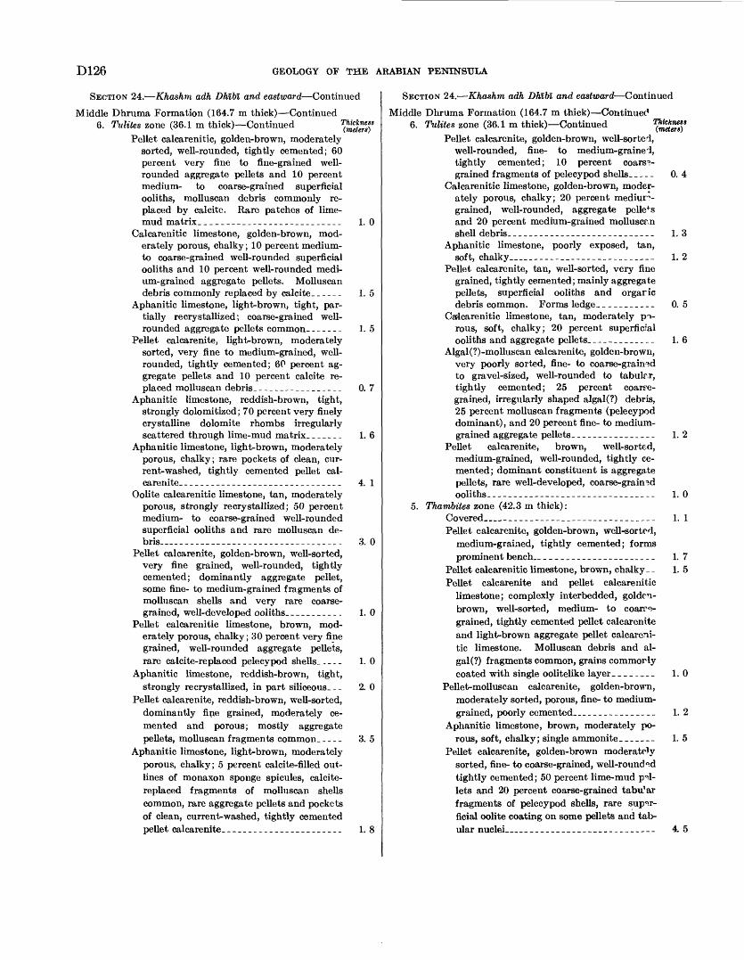
D126 GEOLOGY OF THE ARABIAN PENINSULA
SECTION 24. Khashm adh Dhlbl and eastward Continued
Middle Dhruma Formation (164.7 m thick) Continued 6. Tulites zone (36.1 m thick) Continued
Pellet calcarenitic, golden-brown, moderately sorted, well-rounded, tightly cemented; 60 percent very fine to fine-grained well- rounded aggregate pellets and 10 percent medium- to coarse-grained superficial ooliths, molluscan debris commonly re placed by calcite. Rare patches of lime- mud matrix.__________________________ 1.0
Calcarenitic limestone, golden-brown, mod erately porous, chalky; 10 percent medium- to coarse-grained well-rounded superficial ooliths and 10 percent well-rounded medi um-grained aggregate pellets. Molluscan debris commonly replaced by calcite-___-- 1. 5
Aphanitic limestone, light-brown, tight, par tially recrystallized; coarse-grained well- rounded aggregate pellets common.------ 1. 5
Pellet calcarenite, light-brown, moderately sorted, very fine to medium-grained, well- rounded, tightly cemented; 60 percent ag gregate pellets and 10 percent calcite re placed molluscan debris-.----_--_-__---- 0. 7
Aphanitic limestone, reddish-brown, tight, strongly dolomitized; 70 percent very finely crystalline dolomite rhombs irregularly scattered through lime-mud matrix.______ 1. 6
Aphanitic limestone, light-brown, moderately porous, chalky; rare pockets of clean, cur rent-washed, tightly cemented pellet cal carenite-.___- _________________________ 4. 1
Oolite calcarenitic limestone, tan, moderately porous, strongly recrystallized; 50 percent medium- to coarse-grained well-rounded superficial ooliths and rare molluscan de bris___---___----______--_.__-___.__- 3. 0
Pellet calcarenite, golden-brown, well-sorted, very fine grained, well-rounded, tightly cemented; dominantly aggregate pellet, some fine- to medium-grained fragments of molluscan shells and very rare coarse grained, well-developed ooliths.__________ 1.0
Pellet calcarenitic limestone, brown, mod erately porous, chalky; 30 percent very fine grained, well-rounded aggregate pellets, rare calcite-replaced pelecypod shells. - ... 1.0
Aphanitic limestone, reddish-brown, tight,strongly recrystallized, in part siliceous. _. 2. 0
Pellet calcarenite, reddish-brown, well-sorted, dominantly fine grained, moderately ce mented and porous; mostly aggregate pellets, molluscan fragments common. ... _ 3. 5
Aphanitic limestone, light-brown, moderately porous, chalky; 5 percent calcite-filled out lines of monaxon sponge spicules, calcite- replaced fragments of molluscan shells common, rare aggregate pellets and pockets of clean, current-washed, tightly cemented pellet calcarenite.______________________ 1. 8
SECTION 24. Khashm adh Dhlbl and eastward Continued
Middle Dhruma Formation (164.7 m thick) Continued 6. Tulites zone (36.1 m thick) Continued
Pellet calcarenite, golden-brown, well-sorted, well-rounded, fine- to medium-grained, tightly cemented; 10 percent coarse grained fragments of pelecypod shells. _ _ _ _ 0. 4
Calcarenitic limestone, golden-brown, moder ately porous, chalky; 20 percent mediurr- grained, well-rounded, aggregate pellets and 20 percent medium-grained molluscr.n shell debris.________-__-__-__---_______ 1.3
Aphanitic limestone, poorly exposed, tan,soft, chalky__________________________ 1. 2
Pellet calcarenite, tan, well-sorted, very fine grained, tightly cemented; mainly aggregate pellets, superficial ooliths and orgaric debris common. Forms ledge____________ 0. 5
Calcarenitic limestone, tan, moderately po rous, soft, chalky; 20 percent superficial ooliths and aggregate pellets.____________ 1.6
Algal (?)-molluscan calcarenite, golden-brown, very poorly sorted, fine- to coarse-grained to gravel-sized, well-rounded to tabulr.r, tightly cemented; 25 percent coarse grained, irregularly shaped algal(?) debris, 25 percent molluscan fragments (pelecypod dominant), and 20 percent fine- to medium- grained aggregate pellets._______________ 1.2
Pellet calcarenite, brown, well-sorted, medium-grained, well-rounded, tightly ce mented; dominant constituent is aggregate pellets, rare well-developed, coarse-grained ooliths--________--_-__-______-______-_ 1. 0
5. Thambites zone (42.3 m thick):Covered______________________________ 1. 1Pellet calcarenite, golden-brown, well-sorted,
medium-grained, tightly cemented; forms prominent bench_______________________ 1. 7
Pellet calcarenitic limestone, brown, chalky __ 1. 5Pellet calcarenite and pellet calcarenitic
limestone; complexly interbedded, golden- brown, well-sorted, medium- to coarre- grained, tightly cemented pellet calcarenite and light-brown aggregate pellet calcareni tic limestone. Molluscan debris and al gal (?) fragments common, grains commorly coated with single oolitelike layer________ 1.0
Pellet-molluscan calcarenite, golden-brown, moderately sorted, porous, fine- to medium- grained, poorly cemented_________________ 1. 2
Aphanitic limestone, brown, moderately po rous, soft, chalky; single ammonite------- 1. 5
Pellet calcarenite, golden-brown moderately sorted, fine- to coarse-grained, well-rounded tightly cemented; 50 percent lime-mud pel lets and 20 percent coarse-grained tabu'ar fragments of pelecypod shells, rare super ficial oolite coating on some pellets and tab ular nuclei__________________________ 4. 5
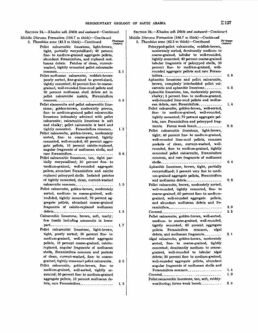
SEDIMENTARY GEOLOGY OF SAUDI ARABIA E127
SECTION 24. Khashm adh Dhibl and eastward Continued
Middle Dhruma Formation (164.7 m thick) Continued5. Tkambites zone (42.3 m thick) Continued T(mCeterl)S
Pellet calcarenitic limestone, light-brown, tight, partially recrystallized; 40 percent fine- to medium-grained aggregate pellets, abundant Foraminifera, and replaced mol- luscan debris. Patches of clean, current- washed, tightly cemented pellet calcarenite common. _____________________________ 2. 1
Pellet-molluscan calcarenite, reddish-brown poorly sorted, fine-grained to gravel-sized, tightly cemented; 40 percent fine- to coarse grained, well-rounded lime-mud pellets and 30 percent molluscan shell debris set in pellet calcarenite matrix, Foraminifera common______________________________ 0. 5
Pellet clacarenite and pellet calcarenitic lime stone; golden-brown, moderately porous, fine- to medium-grained pellet calcarenitic limestone intimately admixed with pellet calcarenite; calcarenitic limestone is soft and chalky; pellet calcarenite is hard and tightly cemented. Foraminifera common. 1. 3
Pellet calcarenite, golden-brown, moderately sorted, fine- to coarse-grained, tightly cemented, well-rounded; 60 percent aggre gate pellets, 10 percent calcite-replaced, angular fragments of molluscan shells, and rare Foraminifera-_____________________ 0. 6
Pellet calcarenitic limestone, tan, tight par tially recrystallized; 30 percent fine- to medium-grained, well-rounded aggregate pellets, abundant Foraminifera and calcite replaced pelecypod shells. Isolated patches of tightly cemented, clean, current-washed calcarenite common.___________________ 1. 5
Pellet calcarenite, golden-brown, moderately sorted, medium- to coarse-grained, well- rouhded, tightly cemented; 70 percent ag gregate pellets, abundant coarse-grained fragments of calcite-replaced molluscan debris_______________________________ 1. 5
Calcarenitic limestone, brown, soft, marly; few fossils including ammonite in lower part__________________________________ 1. 7
Pellet calcarenitic limestone, light-brown, tight, poorly sorted; 30 percent fine- to medium-grained, well-rounded aggregate pellets, 10 percent coarse-grained, calcite- replaced, angular fragments of molluscan shells, Foraminifera common and pockets of clean, current-washed, fine- to coarse grained, tightly cemented pellet calcarenite_ 2. 5
Pellet calcarenite, golden-brown, fine- to medium-grained, well-sorted, tightly ce mented; 50 percent fine- to medium-grained aggregate pellets, 10 percent molluscan de bris, rare Foraminifera__________________ 1.3
SECTION 24. Khashm adh Dhlln and eastward Continued
Middle Dhruma Formation (164.7 m thick) Continued 5. Thambites zone (42.3 m thick) Continued
Pelecypod-pellet calcarenite, reddish-brown, moderately sorted, dominantly medium- to coarse-grained, tabular to well-rounded, tightly cemented; 40 percent coarse-grained tabular fragments of pelecypod shells, 30 percent fine- to medium-grained, well- rounded aggregate pellets and rare Foram inifera- _______________________________ 0. 8
Aphanitic limestone and pellet calcarenite, brown, complexly interbedded pellet cal carenite and aphanitic limestone-________ 0. 5
Aphanitic limestone, tan, moderately porous, chalky; 5 percent fine- to medium-grained, well-rounded lime-mud pellets and mollus can debris, rare Foraminifers____________ 1. 4
Pellet calcarenite, golden-brown, well-sorted, fine- to medium-grained, well-rounded, tightly cemented; 70 percent aggregate pel lets, rare Foraminifera and pelecypod frag ments. Forms weak bench____________ 0. 6
Pellet calcarenitic limestone, light-brown, tight; 40 percent fine- to medium-grained, well-rounded lime-mud pellets, common pockets of clean, current-washed, well- rounded, fine- to medium-grained, tightly cemented pellet calcarenite, Foraminifera common, and rare fragments of molluscan shells_____-_-__-----------_-_--------- 0. 4
Aphanitic limestone, brown, tight, partially recrystallized; 5 percent very fine to medi um-grained aggregate pellets, Foraminifera and molluscan debris.__________________ 0. 8
Pellet calcarenite, brown, moderately sorted, well-rounded, tightly cemented, fine- to coarse-grained; 60 percent fine- to medium- grained, well-rounded aggregate pellets, and abundant molluscan debris and Fo raminifera___________________________ 2. 0
Covered____--_--_-----_---------------__ 3.5Pellet calcarenite, golden-brown, well-sorted,
medium- to coarse-grained, well-rounded, tightly cemented; 60 percent aggregate pellets. Foraminifera common, algal debris, and molluscan fragments.______-- 2. 1
Algal calcarenite, golden-brown, moderately sorted, fine- to coarse-grained, tightly cemented; dominantly medium- to coarse grained, well-rounded to tabular algal debris; 20 percent fine- to medium-grained, well-rounded aggregate pellets, abundant angular fragments of molluscan shells and Foraminifera common. _-________--__-- 1.4
Covered..-------------------------------- 1- 0Pellet calcarenitic limestone, tan, soft, rubbly-
weathering; forms weak bench.__________ 2. 3
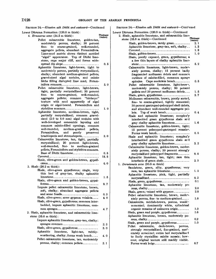
D128 GEOLOGY OF THE ARABIAN PENINSULA
SECTION 24. Khashm adh Dhlln and eastward Continued
Lower Dhruma Formation (120.8 m thick) : 4. Ermoceras zone (34.5 m thick) :
Pellet calcarenitic limestone, golden-tan, moderately porous, chalky; 30 percent fine- to coarse-grained, well-rounded, aggregate pellets, abundant Foraminifera. Lime-mud matrix shows distinct mottled "algal" appearance. Top of Dhibi lime stone, caps major cliff, and forms wide spread dip slope __ . _____---_-_________
Aphanitic limestone, light-brown, tight to moderately porous, partially recrystallized, chalky; abundant medium-grained pellets, gravel-sized algal nodules, and calcite blebs filling disrupted lime mud, Foram inifera common __ ____________________
Pellet calcarenitic limestone, light-brown, tight, partially recrystallized; 30 percent fine- to coarse-grained, well-rounded, aggregate pellets; common "birdseye" texture with mud apparently of algal origin or algal-bound. Foraminifera and stylolites common. _____________________
Aphanitic limestone, medium-brown, tight, partially recrystallized; common gravel- sized (2.0 to 8.0 mm) algal nodules with well-developed concentric layering and common calcite-filled openings, common well-rounded, medium-grained pellets, Foraminifera, and poorly preserved brachiopods and stromatopora_ __________
Calcarenitic limestone, tan, tight, partially recrystallized; 20 percent light-brown, well-rounded, fine- to medium-grained pellets, Foraminifera and stylolites common. Base of Dhibi limestone.. _ -_-_-_-_______
Covered __ __--_____-____--___-_________Shale, olive-green and golden-brown, gypsif-
erous__ _ ---_-___--____---_-____________3. Shale (20.2 m thick) :
Shale, olive-green gypsiferous; single, very thin bed of gray-tan, chalky aphanitic
0. 5
5. 0
1.0
3. 0
0. 5 18. 5
6. 0
Shale, olive-green and golden-brown, gypsi ferous __ _____________________________
Impure pellet calcarenitic limestone, brown, soft, chalky; abundant aggregate pellets and some fossils________________________
Shale, olive-green; some gypsum veinlets____Shale, olive-green, gypsiferous; common inter-
bedded, impure aphanitic limestone, com mon sponges___________________________
2. Shale, aphanitic limestone, and calcarentitic lime stone (35.6 m thick) :
Impure aphanitic limestone, gray-tan, chalky; sponges common _______________________
Shale, olive-green, gypsiferous- ____________Aphanitic limestone, light-tan, rubbly-
weathering, chalky; forms weak bench. .__Pellet calcarenitic limestone, tan, moderately
porous, chalky ; common pellets. _________
1. 5
9. 7
0. 3 4. 0
4. 7
2. 33. 0
4. 0
2. 1
SECTION 24. Khashm adh Dhlln and eastward Cont;uued
Lower Dhruma Formation (120.8 m thick) Continued 2. Shale, aphanitic limestone, and calcarentitic lim
stone (35.6 m thick) ContinuedShale, golden-brown, rarely green __________Aphanitic limestone, gray-tan, soft, chalky __ Covered __ _____________________________Shale, golden-brown __ _________________Shale, poorly exposed, green, gypsiferous; a
a few thin layers of chalky aphanitic limv stone____---_- __________________
Calcarenitic limestone, light-brown, mode1*- ately porous, chalky; 15 percent badly fragmented molluscan debris and common outlines of calcite-filled, monaxon sponpe spicules. Caps moderate bench. _________
Pellet calcarenitic limestone, light-brow^,moderately porous, chalky; 30 percentpellets and 20 percent molluscan debris. _ _
Shale, green, gypsiferous- _______ __Molluscan calcarenitic, brown, poorly sorted,
fine- to coarse-grained, tightly cemented; 30 percent gastropod-pelecypod shell debris, and abundant well-rounded aggregate pel lets. Top of weak bench_____-----_.-_-
Shale and aphanitic limestone; complexly interbedded green gypsiferous shale ard gray chalky aphanitic limestone..- _ ______
Calcarenitic limestone, golden-brown, tight; 15 percent pelecypod-gastropod remain*. Forms weak bench__-----___--------__-
Shale and aphanitic limestone; complex'y interbedded green gypsiferous shale ard gray chalky aphanitic limestone____ ______
Calcarenitic limestone, golden-brown, moder ately porous, chalky; 20 percent strongly recrystallized pelecypod fragments __ ____
Aphanitic limestone, tan, tight; rare thin interbeds of green shale_____---------__-
1. Dorsetensia zone (30.5 m thick)Sandstone, green, silty, gypsiferous; very
rare, tan aphanitic limestone.--. _________Aphanitic limestone, pink, tight, partially
recrystallized--------------------------Shale, green, gypsiferous------------------Aphanitic limestone, tan, moderately po
rous, chalky________--____--.-_--------Shale, green; veined with gypsum. _________Pellet calcarenitic limestone, brown, mode--
ately porous, fine- to medium-grained_____Calcarenite, reddish-brown, porous, weakly
cemented; dominantiy white, cylindrical organic remains of unknown origin. ______
Shale, green and purple, gypsiferous ________Aphanitic limestone, brown, moderately po
rous, chalky_________-_____-__--____-_-Shale, green and purple, gypsiferous- _______Pellet calcarenite, dark-brown, porous,
strongly recrystallized, fine-grained, moc'- erately cemented; entire bed recrystallized to finely crystalline calcite mosaic; how ever, original texture still readily visible. Forms weak ledge_----__-----_-----_--_
2. 1 1. 3 1. 3 1. 0
5. 2
0. 5
1. 52. 7
0.4
1. 6
0. 5
3. 2
0. 6
2. 3
1. 5
0. 3 0.1
2.0 2.8
1.0
1.0 1.6
0.2 1.0
0.7
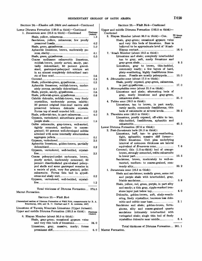
SEDIMENTARY GEOLOGY OF SAUDI ARABIA D129
SECTION 24. Kha&hm adh Dhlbl and eastward Continued
Lower Dhruma Formation (120.8 m thick) Continued 1. Dorsetensia zone (30.5 m thick) Continued
Shale, yellow, calcareous. _________________Sandstone, yellow, calcareous; few poorly
preserved fossils _ . ____________________Shale, green, gypsiferous- _________________Aphanitic limestone, brown, moderately po
rous, chalky___________________________Shale, green, gypsiferous- _________________Coarse molluscan calcarenitic limestone,
reddish-brown, poorly sorted, sandy, par tially dolomitized; 60 percent gravel- sized, gastropod-pelecypod mixture set in an almost completely dolomitized mat rix of lime mud________________________
Covered _ .. _____________________________Shale, yellowish-green, gypsiferous __ _____Aphanitic limestone, reddish-brown, moder
ately porous, partially dolo mitized __ ___Shale, purple, sandy, gypsiferous. . _________Shale, yellowish-green, gypsiferous __ _____Calcitic dolomite, reddish-brown, very finely
crystalline, moderately porous, calcitic; 20 percent original lime-mud matrix still preserved between dolomite crystals. Forms top of small rounded hill. _________
Shale, yellowish-tan, in part calcareous _ ___Gypsum, varicolored; subordinate green and
purple shale_____-_____________________Oolite calcarenite, gray-brown, well-sorted,
tightly cemented, medium- to coarse grained; 60 percent well-developed ooliths admixed with some internally structureless aggregate pellets____ __ _______________
Gypsum, varicolored __ __________________Aphanitic limestone, golden-brown, partially
dolomitized _ _________________________Gypsum, varicolored, well-bedded, crystal
line __ ________________________________Coarse pelecypod-pellet carbonate, brown,
poorly sorted, moderately cemented; 50 percent disarticulated gravel-sized pelecy- pod shells and some gastropod remains in a matrix of pink, very fine grained, pellet calcarenite. Forms thin bed in gypsif erous and shaly unit. ___________________
Gypsum, varicolored, well-bedded, crystal line _______________________________
1.3
0.2 1.0
0.1 0.5
0.6 0.5 0.3
0.1 0.6 0.6
0.2 4.0
1.8
0.1 2.5
0.2
2.3
0.2
1.2
Total thickness of Dhruma Formation. _ 374.5 Marrat Formation.
SECTION 25. Wadi Birk[Generalized section of Dhruma Formation at Wadi Birk; measurements by R. A.
Bramkamp, 1945, and R. D. Gierhart and P. R. Aswerus, 1947]
Limestone of Tuwaiq Mountain Limestone (Upper Jurassic).Upper and middle Dhruma Formation (193.5 m thick): Thicknett
(metert) 8. Hisyan Member (about 56.0 m thick):
Shale, gray-green; occasional gypsum veinsand very thin beds of limestone._________ 34. 0
Limestone, gray, massive, marly; forms prominent cliff.._______________________ 6. 0
SECTION 25. Wadi Birk Continued
Upper and middle Dhruma Formation (193.5 m thick) Continued
8. Hisyan Member (about 56.0 m thick) Con.Shale, gray-green; occasional gypsum veins
and very thin beds of limestone. Base is believed to be approximate level of 'Atash- Hisyan contact. _______________________
7. 'Atash Member (about 19.5 m thick) :Limestone and shale; complexly interbedded
tan to gray, soft, marly limestone and gray-green shale. ________------_-----_-
Limestone, gray to brown, thin-bedded,commonly marly; a few layers of hard,platy- weathering, highly fossiliferous limestone. Fossils are mostly pelecypods.----
6. Dhrumaites zone (about 17.0 m thick):Shale, poorly exposed, gray-green, calcareous,
in part gypsiferous __ __________________5. Micromphalites zone (about 21.0 m thick):
Limestone and shale; alternating beds of gray, marly limestone and gray-green, calcareous shale. _____-___-_________---_
4. Tulites zone (39.5 m thick) :Limestone, tan to brown, in part marly,
rarely sandy, commonly fossiliferous; thin beds of calcarenite at several levels.- -----
3. Thambites zone (40.5 m thick) :Limestone, poorly exposed, off-white to tan,
thin-bedded, fossiliferous, aphanitic and calcarenitic__---------_----___---------
Lower Dhruma Formation (67.6 re thick) : 2. Post- Dorsetensia beds (51.3 m thick):
Limestone, buff, tan- to gray- weathering, tight, aphanitic; massive cliff former Dhibi limestone. Unit plus underlying interval of unknown thickness are lateral equivalent of Ermoceras zone _________---
Covered; thin (1.0-m-thick) bed of orange- brown, strongly cemented, oolite calcarenite in lower part_ _________________________
Sandstone, brown, moderately to well-ce mented, medium- to coarse-grained, com monly silty__-----_-_------------------
1. Dorsetensia zone (16.3 m thick):Shale and sandstone; mainily green, some red
and purple shale with interbedded, gray, friable sandstone. _____--_-_______--.---
Shale, yellow, red, green, purple, in part silty and sandy; a thin gray, ripple-marked iron stone layer just below top. _______----__-
Dolomite, golden-brown, soft, shaly- weath ering, finely crystalline; becomes less dolo- mitic and oolitic near base __ _ - ---------
Sandstone and shale; golden-brown, ferru ginous, silty and coarse-grained quartz sandstone intimately interbedded with variegated shale; single thin bed of finely crystalline dolomite near middle __-._
16. 0
9. 5
10.0
17. 0
21. 0
39. 5
40. 5
7. 6
10. 5
33. 2
3. 8
4. 0
2. 1
6. 4
Total thickness of Dhruma Formation._ 261. 1 Marrat Formation.
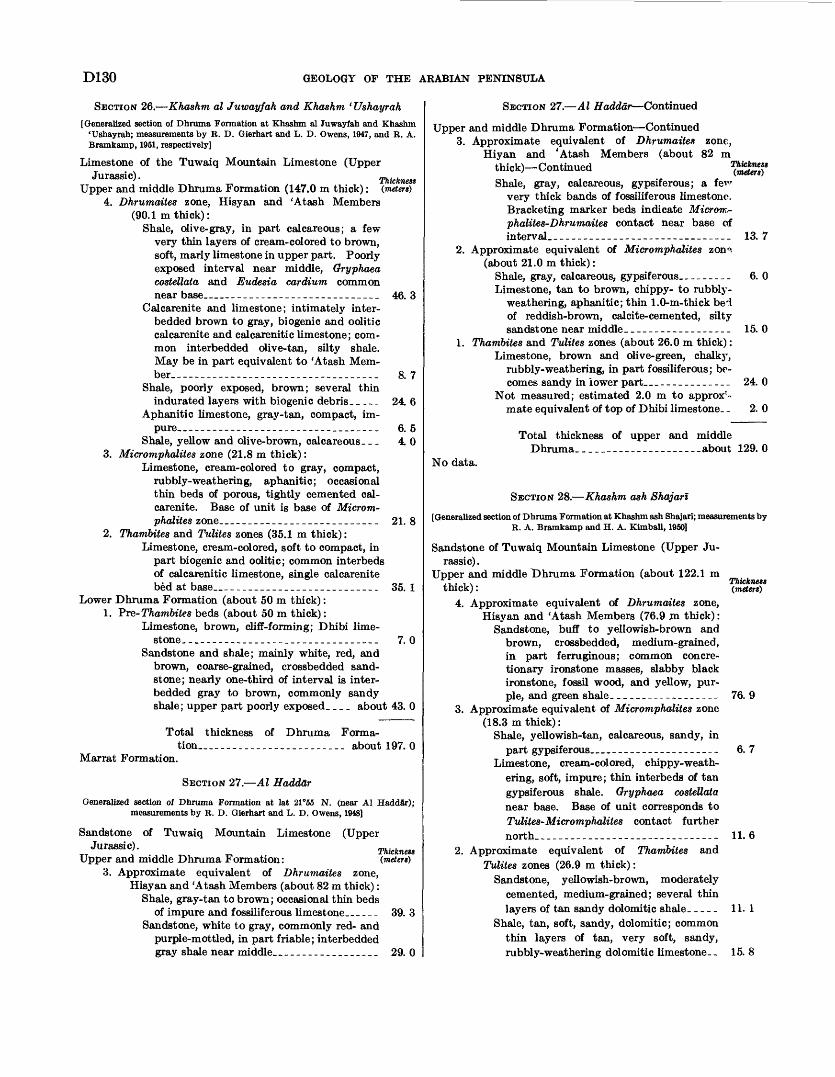
D130 GEOLOGY OF THE ARABIAN PENINSULA
SECTION 26. Khashm al Juwayfah and Khashm ' Ushayrah
[Generalized section of Dhruma Formation at Khashm al Juwayfah and Khashm 'Ushayrah; measurements by R. D. Gierhart and L. D. Owens, 1947, and R. A. Bramkamp, 1951, respectively]
Limestone of the Tuwaiq Mountain Limestone (UpperJurassic). Thickness
Upper and middle Dhruma Formation (147.0 m thick): (meters) 4. Dhrumaites zone, Hisyan and 'Atash Members
(90.1 m thick):Shale, olive-gray, in part calcareous; a few
very thin layers of cream-colored to brown, soft, marly limestone in upper part. Poorly exposed interval near middle, Gryphaea costellata and Eudesia cardium common near base____________________________ 46. 3
Calcarenite and limestone; intimately inter- bedded brown to gray, biogenic and oolitic calcarenite and calcarenitic limestone; com mon interbedded olive-tan, silty shale. May be in part equivalent to 'Atash Mem ber________________-_--._______ 8. 7
Shale, poorly exposed, brown; several thinindurated layers with biogenic debris. _ - __ 24. 6
Aphanitic limestone, gray-tan, compact, im pure.. _--____-_-_______---____________ 6.5
Shale, yellow and olive-brown, calcareous. _ _ 4. 0 3. Micromphalites zone (21.8 m thick):
Limestone, cream-colored to gray, compact, rubbly-weathering, aphanitic; occasional thin beds of porous, tightly cemented cal carenite. Base of unit is base of Microm phalites zone__-____-.-___-______--__- 21. 8
2. Thambites and Tulites zones (35.1 m thick):Limestone, cream-colored, soft to compact, in
part biogenic and oolitic; common interbeds of calcarenitic limestone, single calcarenite bed at base__________________________ 35. 1
Lower Dhruma Formation (about 50 m thick): 1. Pre-Thambites beds (about 50 m thick):
Limestone, brown, cliff-forming; Dhibi lime stone. ______________--___--_.____-__-- 7.0
Sandstone and shale; mainly white, red, and brown, coarse-grained, crossbedded sand stone; nearly one-third of interval is inter- bedded gray to brown, commonly sandy shale; upper part poorly exposed. _ . _ about 43. 0
Total thickness of Dhruma Forma tion_______________________ about 197. 0
Marrat Formation.
SECTION 27. Al Haddar
Generalized section of Dhruma Formation at lat 21°55 N. (near Al Haddar); measurements by R. D. Gierhart and L. D. Owens, 1948]
Sandstone of Tuwaiq Mountain Limestone (UpperJurassic). Thickness
Upper and middle Dhruma Formation: (meters) 3. Approximate equivalent of Dhrumaites zone,
Hisyan and 'Atash Members (about 82 m thick): Shale, gray-tan to brown; occasional thin beds
of impure and fossiliferous limestone.__ _ _ _ 39. 3 Sandstone, white to gray, commonly red- and
purple-mottled, in part friable; interbedded gray shale near middle..___--________.__ 29. 0
SECTION 27. Al Haddar Continued
Upper and middle Dhruma Formation Continued3. Approximate equivalent of Dhrumaitea zone,
Hiyan and 'Atash Members (about 82 mthick) ContinuedShale, gray, calcareous, gypsiferous; a fe^r
very thick bands of fossiliferous limestone.Bracketing marker beds indicate Microm-phalites-Dhrumaites contact near base ofinterval.______________________________ 13. 7
2. Approximate equivalent of Micromphalites zonn. (about 21.0 m thick):
Shale, gray, calcareous, gypsiferous.-------- 6. 0Limestone, tan to brown, chippy- to rubbly-
weathering, aphanitic; thin 1.0-m-thick bed of reddish-brown, calcite-cemented, silty sandstone near middle.__----_________-- 15. 0
1. Thambites and Tulites zones (about 26.0 m thick): Limestone, brown and olive-green, chalky,
rubbly-weathering, in part fossiliferous; be comes sandy in lower part.._____________ 24. 0
Not measured; estimated 2.0 m to approx'- mate equivalent of top of Dhibi limestone. _ 2. 0
Total thickness of upper and middleDhruma_-___--__----__--__-.about 129. 0
No data.
Thickness (meters)
SECTION 28. Khashm ash Shajarl
[Generalized section of Dhruma Formation at Khashm ash Shajari; measurements by R. A. Bramkamp and H. A. Kimball, 1950]
Sandstone of Tuwaiq Mountain Limestone (Upper Ju rassic).
Upper and middle iDhruma Formation (about 122.1 m thick):
4. Approximate equivalent of Dhrumaites zone, Hisyan and 'Atash Members (76.9 m thick):
Sandstone, buff to yellowish-brown and brown, crossbedded, medium-grained, in part ferruginous; common concre tionary ironstone masses, slabby black ironstone, fossil wood, and yellow, pur ple, and green shale._________________ 76. 9
3. Approximate equivalent of Micromphalites zone (18.3 m thick):
Shale, yellowish-tan, calcareous, sandy, inpart gypsiferous____________________ 6. 7
Limestone, cream-colored, chippy-weath ering, soft, impure; thin interbeds of tan gypsiferous shale. Gryphaea costettata near base. Base of unit corresponds to Tulites-Micromphalites contact further north_-__--__----------_-._-_-____-. 11. 6
2. Approximate equivalent of Thambites and Tulites zones (26.9 m thick):
Sandstone, yellowish-brown, moderately cemented, medium-grained; several thin layers of tan sandy dolomitic shale. _ _ _ _ 11. 1
Shale, tan, soft, sandy, dolomitic; common thin layers of tan, very soft, sandy, rubbly-weathering dolomitic limestone. . 15. 8
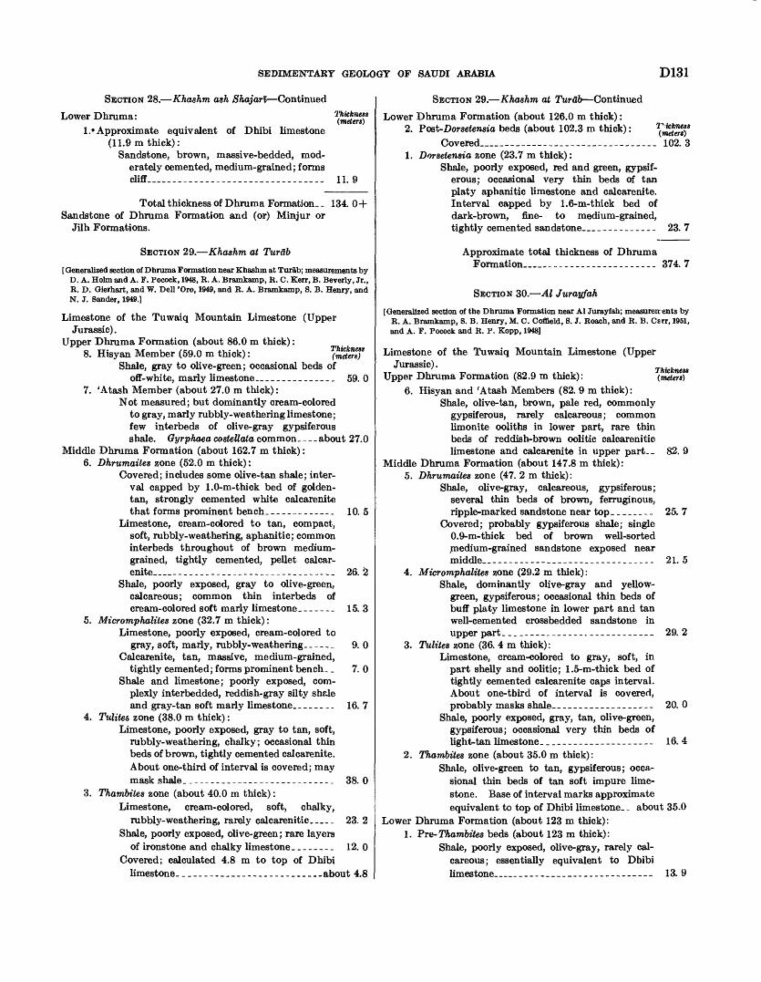
SEDIMENTARY GEOLOGY OF SAUDI ARABIA D131
Thickness (meters)
SECTION 28. Khashm ash Shajarl Continued
Lower Dhruma:l.» Approximate equivalent of Dhibi limestone
(11.9m thick):Sandstone, brown, massive-bedded, mod
erately cemented, medium-grained; forms cliff__._._-__--_.___._-. 11. 9
Total thickness of Dhruma Formation. _ 134. 0+ Sandstone of Dhruma Formation and (or) Minjur or
Jilh Formations.
SECTION 29. Khashm at Turab
[ Generalized section of Dhruma Formation near Khashm at Turab; measurements by D. A. Holm and A. F. Pocock, 1948, R. A. Bramkamp, R. C. Kerr, B. Beverly, Jr., R. D. Gierhart, and W. Dell 'Oro, 1949, and R. A. Bramkamp, S. B. Henry, and N. J. Sander, 1949.]
Limestone of the Tuwaiq Mountain Limestone (UpperJurassic).
Upper Dhruma Formation (about 86.0 m thick): 8. Hisyan Member (59.0 m thick):
Shale, gray to olive-green; occasional beds ofoff-white, marly limestone._________--_.. 59. 0
7. 'Atash Member (about 27.0 m thick):Not measured; but dominantly cream-colored
to gray, marly rubbly-weathering limestone; few interbeds of olive-gray gypsiferous shale. Gyrphaea costettata common. _ _ _ about 27.0
Middle Dhruma Formation (about 162.7 m thick): 6. Dhrumaites zone (52.0 m thick):
Covered; includes some olive-tan shale; inter val capped by 1.0-m-thick bed of golden- tan, strongly cemented white calcarenite that forms prominent bench.__._-_____-_ 10. 5
Limestone, cream-colored to tan, compact, soft, rubbly-weathering, aphanitic; common interbeds throughout of brown medium- grained, tightly cemented, pellet calcar enite__-__-___-____-_-_____-_-_-_--_ 26. 2
Shale, poorly exposed, gray to olive-green, calcareous; common thin interbeds of cream-colored soft marly limestone.___--. 15. 3
5. Micromphalites zone (32.7 m thick):Limestone, poorly exposed, cream-colored to
gray, soft, marly, rubbly-weathering- _ -. _ _ 9. 0 Calcarenite, tan, massive, medium-grained,
tightly cemented; forms prominent bench_ _ 7. 0 Shale and limestone; poorly exposed, com
plexly interbedded, reddish-gray silty shale and gray-tan soft marly limestone. _______ 16. 7
4. Tulite& zone (38.0 m thick):Limestone, poorly exposed, gray to tan, soft,
rubbly-weathering, chalky; occasional thin beds of brown, tightly cemented calcarenite. About one-third of interval is covered; may mask shale._-_---__-_____-_-_-__-__-._ 38. 0
3. Thambites zone (about 40.0 m thick):Limestone, cream-colored, soft, chalky,
rubbly-weathering, rarely calcarenitic____, 23. 2Shale, poorly exposed, olive-green; rare layers
of ironstone and chalky limestone._______ 12. 0Covered; calculated 4.8 m to top of Dhibi
limestone.________________________..about 4.8
SECTION 29. Khashm at Turab Continued
Lower Dhruma Formation (about 126.0 m thick): 2. Post-Dorsetensia beds (about 102.3 m thick):
Covered______ ____________ 102. 3 1. Dorsetensia zone (23.7 m thick):
Shale, poorly exposed, red and green, gypsif erous; occasional very thin beds of tan platy aphanitic limestone and calcarenite. Interval capped by 1.6-m-thick bed of dark-brown, fine- to medium-grained, tightly cemented sandstone____________ 23. 7
Approximate total thickness of Dhruma Formation______________________ 374. 7
SECTION 30. Al Jurayfah
[Generalized section of the Dhruma Formation near Al Jurayfah; measureir ents by R. A. Bramkamp, 8. B. Henry, M. C. Coffield, 8. J. Roach, and R. B. Carr, 1951, and A. F. Pocock and R. P. Kopp, 1948]
Thickness (meters)
Limestone of the Tuwaiq Mountain Limestone (UpperJurassic).
Upper Dhruma Formation (82.9 m thick):6. Hisyan and 'Atash Members (82. 9 m thick):
Shale, olive-tan, brown, pale red, commonly gypsiferous, rarely calcareous; common limonite ooliths in lower part, rare thin beds of reddish-brown oolitic calcarenitic limestone and calcarenite in upper part-. 82. 9
Middle Dhruma Formation (about 147.8 m thick): 5. Dhrumaites zone (47. 2 m thick):
Shale, olive-gray, calcareous, gypsiferous; several thin beds of brown, ferruginous, ripple-marked sandstone near top________ 25. 7
Covered; probably gypsiferous shale; single 0.9-m-thick bed of brown well-sorted medium-grained sandstone exposed near middle___-___-_-.._____._____.._____ 21.5
4. Micromphalites zone (29.2 m thick):Shale, dominantly olive-gray and yellow-
green, gypsiferous; occasional thin beds of buff platy limestone in lower part and tan well-cemented crossbedded sandstone in upper part.____________-_.__-----__-_- 29. 2
3. Tulites zone (36. 4 m thick):Limestone, cream-colored to gray, soft, in
part shelly and oolitic; 1.5-m-thick bed of tightly cemented calcarenite caps interval. About one-third of interval is covered, probably masks shale---.-----------.--- 20. 0
Shale, poorly exposed, gray, tan, olive-green, gypsiferous; occasional very thin beds of light-tan limestone._____________--___-- 16. 4
2. Thambites zone (about 35.0 m thick):Shale, olive-green to tan, gypsiferous; occa
sional thin beds of tan soft impure lime stone. Base of interval marks approximate equivalent to top of Dhibi limestone. _ about 35.0
Lower Dhruma Formation (about 123 m thick): 1. Pre-Thambites beds (about 123 m thick):
Shale, poorly exposed, olive-gray, rarely cal careous; essentially equivalent to Dbibi limestone_____--_____---.--_-------- 13. 9
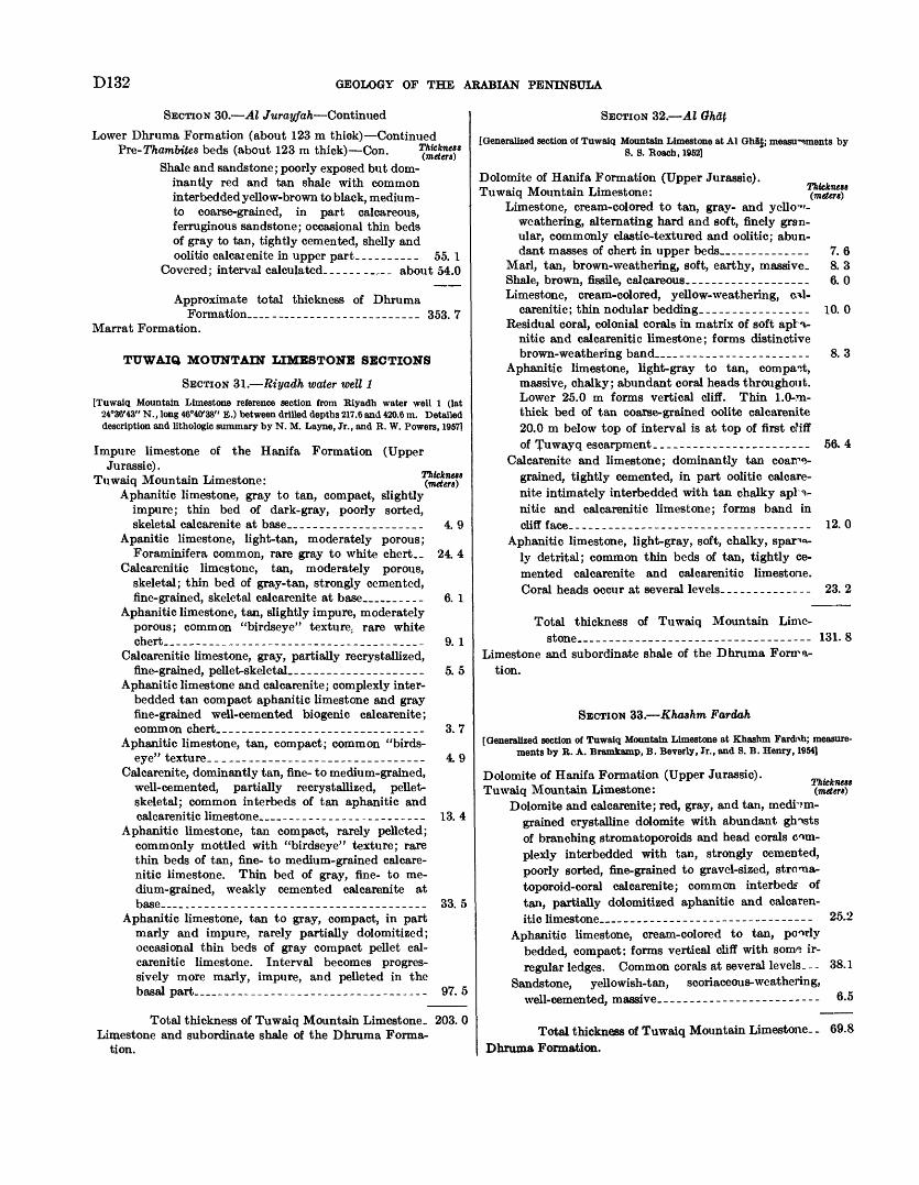
D132 GEOLOGY OF THE ARABIAN PENINSULA
SECTION 30. Al Jurayfah Continued
Lower Dhruma Formation (about 123 m thick) Continued Pre-I7iam6i.es beds (about 123 m thick) Con.
Shale and sandstone; poorly exposed but dom inantly red and tan shale with common interbedded yellow-brown to black, medium- to coarse-grained, in part calcareous, ferruginous sandstone; occasional thin beds of gray to tan, tightly cemented, shelly and oolitic calcaienite in upper part_-_-______ 55. 1
Covered; interval calculated-________ about 54.0
Approximate total thickness of DhrumaFormation_________________________ 353. 7
Marrat Formation.
TUWAIQ MOUNTAIN LIMESTONE SECTIONS
SECTION 31. Riyadh water well 1[Tuwaiq Mountain Limestone reference section from Riyadh water well 1 (lat
24°36'43" N., long 46°40'38" E.) between drilled depths 217.6 and 420.6 m. Detailed description and lithologic summary by N. M. Layne, Jr., and B. W. Powers, 19571
Impure limestone of the Hanifa Formation (UpperJurassic).
Tuwaiq Mountain Limestone:Aphanitic limestone, gray to tan, compact, slightly
impure; thin bed of dark-gray, poorly sorted, skeletal calcarenite at base..___________________ 4.9
Apanitic limestone, light-tan, moderately porous;Foraminifera common, rare gray to white chert._ 24. 4
Calcarenitic limestone, tan, moderately porous, skeletal; thin bed of gray-tan, strongly cemented, fine-grained, skeletal calcarenite at base_____.- 6. 1
Aphanitic limestone, tan, slightly impure, moderately porous; common "birdseye" texture, rare white chert______________________________________ 9. 1
Calcarenitic limestone, gray, partially recrystallized, fine-grained, pellet-skeletal.____________________ 5. 5
Aphanitic limestone and calcarenite; complexly inter bedded tan compact aphanitic limestone and gray fine-grained well-cemented biogenic calcarenite; common chert__----__-_-_-_-____.____________ 3. 7
Aphanitic limestone, tan, compact; common "birds- eye" texture.________________________________ 4. 9
Calcarenite, dominantly tan, fine- to medium-grained, well-cemented, partially recrystallized, pellet- skeletal; common interbeds of tan aphanitic and calcarenitic limestone_______-______--____-__- 13. 4
Aphanitic limestone, tan compact, rarely pelleted; commonly mottled with "birdseye" texture; rare thin beds of tan, fine- to medium-grained calcare nitic limestone. Thin bed of gray, fine- to me dium-grained, weakly cemented calcarenite at base__.--____---_----_--__-__________----.- 33. 5
Aphanitic limestone, tan to gray, compact, in part marly and impure, rarely partially dolomitized; occasional thin beds of gray compact pellet cal carenitic limestone. Interval becomes progres sively more marly, impure, and pelleted in the basal part__--__--__--____--____-__-____---- 97. 5
Total thickness of Tuwaiq Mountain Limestone. 203. 0 Limestone and subordinate shale of the Dhruma Forma
tion.
SECTION 32. Al Gh&t
[Generalized section of Tuwaiq Mountain Limestone at Al Ghat; measu-sments by S. S. Roach, 1952]
Dolomite of Hanifa Formation (Upper Jurassic). Tuwaiq Mountain Limestone:
Limestone, cream-colored to tan, gray- and yello-1"- weathering, alternating hard and soft, finely gran ular, commonly clastic-textured and oolitic; abun dant masses of chert in upper beds____________ 7. 6
Marl, tan, brown-weathering, soft, earthy, massive. 8. 3Shale, brown, fissile, calcareous.__________________ 6. 0Limestone, cream-colored, yellow-weathering, cil-
carenitic; thin nodular bedding.________________ 10. 0Residual coral, colonial corals in matrix of soft apl -v-
nitic and Calcarenitic limestone; forms distinctive brown-weathering band______________________ 8. 3
Aphanitic limestone, light-gray to tan, compact, massive, chalky; abundant coral heads throughout. Lower 25.0 m forms vertical cliff. Thin 1.0-ra- thick bed of tan coarse-grained oolite calcarenite 20.0 m below top of interval is at top of first cMff of Tuwayq escarpment._______________________ 56. 4
Calcarenite and limestone; dominantly tan coarse grained, tightly cemented, in part oolitic calcare nite intimately interbedded with tan chalky apH- nitic and calcarenitic limestone; forms band in cliff face--...--.___.......__.__-------_ 12.0
Aphanitic limestone, light-gray, soft, chalky, spar"<*- ly detrital; common thin beds of tan, tightly ce mented calcarenite and calcarenitic limestone. Coral heads occur at several levels._____._____-- 23. 2
Total thickness of Tuwaiq Mountain Lime stone - - -- 131.8
Limestone and subordinate shale of the Dhruma Fonra- tion.
SECTION 33. Khashm Fardah
[Generalized section of Tuwaiq Mountain Limestone at Khashm Fardixh; measure ments by B. A. Bramkamp, B. Beverly, Jr., and 8. B. Henry, 1954]
Thickness (mettrt)
Dolomite of Hanifa Formation (Upper Jurassic).Tuwaiq Mountain Limestone:
Dolomite and calcarenite; red, gray, and tan, medium- grained crystalline dolomite with abundant ghosts of branching stromatoporoids and head corals com plexly interbedded with tan, strongly cemented, poorly sorted, fine-grained to gravel-sized, stroicxa- toporoid-coral calcarenite; common interbedf of tan, partially dolomitized aphanitic and calcaren itic limestone.... . __ _ - _ --- -- 25.2
Aphanitic limestone, cream-colored to tan, poorly bedded, compact: forms vertical cliff with sonvi ir regular ledges. Common corals at several levels. __ 38.1
Sandstone, yellowish-tan, scoriaceous-weathering, well-cemented, massive.__._--_----------------- 6.5
Total thickness of Tuwaiq Mountain Limestone.. 69.8 Dhruma Formation.
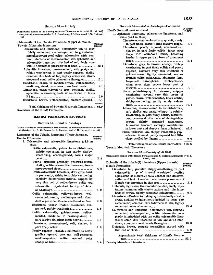
SEDIMENTARY GEOLOGY OF SAUDI ARABIA D133
SECTION 34. Al 'Arid
[Generalized section of the Tuwaiq Mountain Limestone at lat 18°33' N. (Al 'Arid escarpment); measurements by R. A. Bramkamp, 8.B. Henry, and G.W. Blakslee, 1950)
Calcarenite of the Hanifa Formation (Upper Jurassic)._, . ,_. . . T . , ThicknessTuwaiq Mountain Limestone: (meters)
Calcarenite and limestone; dominantly tan to gray, tightly cemented, medium-grained to gravel-sized, stromatoporoid- coral- oolite Calcarenite with com mon interbeds of cream-colored soft aphanitic and calcarenitic limestone; thin bed of red, finely crys talline dolomite is presently near base.___________ 32.4
Aphanitic limestone, cream-colored, soft, platy- and rubbly-weathering, in part poorly exposed, chalky; common thin beds of tan, tightly cemented, strom- atoporoid-coral-oolite calcarenite throughout ______ 15.1
Sandstone, brown to reddish-brown, well-cemented, medium-grained, calcareous; rare fossil casts------ 4.1
Limestone, cream-colored to gray, compact, chalky, aphanitic; alternating beds of sandstone in lower 3.3 m____--____-_--____--__--__----____---_-_ 6.9
Sandstone, brown, well-cemented, medium-grained. _ 3.4
Total thickness of Tuwaiq Mountain Limestone. _ 61.9 Sandstone of the Khuff Formation.
HANIFA FORMATION SECTIONS
SECTION 35. Jabal al Abakkayn[Hanifa Formation reference section was measured in a continuous traverse at Jabal
al Abakkayn by R. W. Powers, L. F. Ramirez, and N. M. Layne, Jr., in 1953]
Limestone of the Jubaila Limestone (Upper Jurassic).TT ..,-,,. ^ vr i ThicknessHanifa Formation: (meters)
2. Calcarenite and calcarenitic limestone (18.9 m thick):
Oolite calcarenite, yellow to reddish-brown, tightly cemented, in part sandy, slabby- weathering, coarse-grained; forms major bench_______________________________ 2. 5
Poorly exposed; probably yellowish-cream, chalky, oolite calcarenitic limestone; forms scree-covered slope.____________________ 4. 8
Oolite calcarenitic limestone, dark-gray, hard, in part sandy, slabby to rubbly-weathering, partially dolomitized; interval capped by very thin bed of golden-brown oolite and calcarenite. Equivalent to top of Jabal al Abakkayn_________________________ 1. 9
Oolite calcarenite, yellowish-brown, well- cemented, sandy, medium-grained; abun dant organic detritus on weathered surface. 2. 0
Sandstone, yellow, friable, calcareous, fine grained, rubbly-weathering ________---.__ 1.6
Oolite calcarenite, golden-brown, well-ce mented, medium- to coarse-grained, in part sandy; abundant fossil debris.__..___ 1.1
Limestone, cream-colored, soft, chalky, in part finely oolitic_____________________ 1. 6
Poorly exposed; probably limestone as below grading upward into tan well-cemented medium-grained oolite; marked color change at base.._--__--____-_._________ 3. 4
SECTION 35. Jabal al Abakkayn Continued Hanifa Formation Continued (neten)
1. Aphanitic limestone, calcarenitic limestone, and shale (94.4m thick):
Limestone, cream-colored to gray, soft, marly, in part finely oolitic; forms massive ledge.. 3. 0
Limestone, poorly exposed, cream-colored, chalky, in part finely oolitic; forms scree slope with abundant fossils, becoming harder in upper part at base of prominent ledge__________--. __ 16.1
Limestone, gray to brown, chalky, rubbly- weathering, in part finely oolitic and poorly exposed; common very thin interbeds of golden-brown, tightly cemented, coarse grained oolite calcarenite, abundant fossil fragments throughout. Rubbly-weath ering scree slope covers lower part of interval-------- ________ __ ____ 18. 0
Shale, yellowish-gray to brick-red, chippy- weathering; several very thin layers of golden-brown, well-cemented, finely oolitic, slabby-weathering, partly sandy calcar enite__-____________ _____ 10.1
Limestone, cream-colored to reddish-brown, soft, chalky and marly, chippy- to rubbly- weathering, in part finely oolitic, fossilifer- ous; occasional thin beds of dark-golden- brown, tightly cemented calcarenite. Limestone becomes strongly coralliferous in lower part and cherty at base of interval- 40. 6
Shale, yellowish-tan, chippy-weathering, gyp- siferous; interval poorly exposed but lith- ology verified by digging._.--____--_____ 6. 6
Total thickness of the Hanifa Formation. 113. 3 Tuwaiq Mountain Limestone.
SECTION 36. Vicinity of Al Ghat[ Generalized section of the Hanifa Formation near Al GhiJ; measurements I * S. J.
Roach, 19S2]
Dolomite of the Jubaila(?) Limestone (Upper Jurassic). Ti?cknes* Hanifa Formation: (meters)
Limestone, tan, granular, chippy-weathering, in part calcarenitic; top of interval considered possible equivalent of Hanifa-Jubaila contact but dolomiti- zation and lack of marker beds makes placement of Hanifa top uncertain in this area._______________ 3. 3
Dolomite, light-tan, thin-nodular-bedded, finely crys talline; common relic clastic texture and thin inter beds of brown, tightly cemented calcarenite-______ 9. 0
Limestone, off-white to light-gray, abundantly corallif erous, nodular to indistinctly bedded, in large part calcarenitic; common thin interbeds of tan, tightly cemented oolite calcarenite____________________ 23. 6
Calcarenite and limestone; dominantly tan, strongly cemented, coarse-grained, oolite calcarenite com plexly interbedded with tan oolite calcarenitic lime stone; some thin interbeds of tan aphanitic lime stone; abundant coral heads throughout-___-__.-- 18. 8
Dolomite, brown, coarsely crystalline; capped with thin bed of chert__________-___-___--_---__-- 5. 0
Approximate total thickness of Hanifa Forma tion.. ..___--._____--...._.___--_-----_--- 59. 7
Tuwaiq Mountain Limestone.
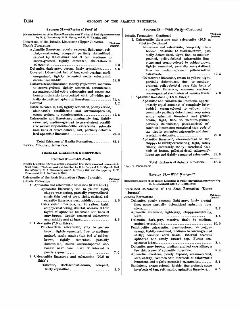
D134 GEOLOGY OF THE ARABIAN PENINSULA
SECTION 37. Khashm al Fara' id[ Generalized section of the Hanifa Formation near Khashm al Fara'id; measurements
by R. A. Bramkamp, S. B. Henry, and G. W. Blakslee, 1950]
Limestone of the Jubaila Limestone (Upper Jurassic). Thickness Hanifa Formation: (meters)
Aphanitic limestone, poorly exposed, light-gray, soft, platy-weathering, compact, partially dolomitized; capped by 0.1-m-thick bed of tan, medium- to coarse-grained, tightly cemented, skeletal-oolite calcarenite-____________________________________ 3. 6
Dolomite, dark-gray, porous, finely crystalline. _____ 4. 6Covered; 1.0-m-thick bed of tan, coral-bearing, medi
um-grained, tightly cemented oolite calcarenitic occurs near middle.--_----_---__-___-_______.__ 13. 5
Calcarenite and limestone; mainly gray-brown, medium- to coarse-grained, tightly cemented, coralliferous- stromatoporoidal-oolite calcarenite and coarse car bonate intimately interbedded with off-white, par tially dolomitized aphanitic limestone ___________ 14. 4
Covered._______________________________________ 7. 2Oolite calcarenite, tan, tightly cemented, poorly sorted,
abundantly coralliferous and stromatoporoidal, coarse-grained to conglomeratic.________________ 12. 5
Calcarenite and limestone; dominantly tan, tightly cemented, medium-grained to gravel-sized, corallif- erous-stromatoporoidal-oolite calcarenite; subordi nate beds of cream-colored, soft, partially dolomit ized aphanitic limestone._______________________ 27. 3
Total thickness of Hanifa Formation.__________ 83. 1Tuwaiq Mountain Limestone.
JUBAILA LIMESTONE SECTIONS
SECTION 38. Wadl Nisafy
[Jubaila Limestone reference section composited from three measured increments in Wadi Nisah. The lower part was described by E. L. Berg and R. L. Myers in 1945, the middle by R. A. Bramkamp and S. B. Henry 1948, and the upper by R. W. Powers and H. A. McClure in 1961]
Calcarenite of the Arab Formation (Upper Jurassic). Jubaila Formation:
4. Aphanitic and calcarenitic limestone (6.0 m thick): Aphanitic limestone, tan to yellow, tight,
chippy-weathering, partially recrystallized; single thin bed of gray, tight, skeletal cal carenitic limestone near middle._________ 1. 5
Calcarenitic limestone, tan to yellow, tight, chippy-weathering, skeletal; occasional thin layers of aphanitic limestone and beds of gray-brown, tightly cemented calcarenite near middle and at base_______________ 4. 5
3. Calcarenite (7.0 m thick):Pellet-skeletal calcarenite, gray to golden-
brown, tightly cemented, fine- to medium- grained, rarely sandy; thin bed of golden- brown, tightly cemented, partially dolomitized, coarse stromatoporoid car bonate near base. Part of interval is poorly exposed_________________________ 7. 0
2. Calcarenitic limestone and calcarenite (20.5 m thick):
Dolomite, dark-reddish-brown, compact,finely crystalline.______________________ 1.0
Thickness (meters)
SECTION 38. Wadl Nisah Continued
Jubaila Formation Continued (meten)* 2. Calcarenitic limestone and calcarenite (20.5 m
thi ck) ContinuedLimestone and calcarenite; complexly inte~-
bedded, off-white to reddish-brown, par tially dolomitized, tight, fine- to mediurr- grained, pellet-skeletal calcarenitic lime stone and cream-colored to golden-brown, tightly cemented, partially recrystallized, fine- to medium-grained, pellet-skeletal calcarenite-___________________________ 12. 5
Calcarenitic limestone, cream to yellow, tigh4;, partially dolomitized, fine- to mediurr- grained, pellet-skeletal; rare thin beds of aphanitic limestone, common scattered coarse-grained shell debris at various levels. 7. 0
1. Aphanitic limestone (84.8 m thick):Aphanitic and calcarenitic limestone, appror-
irriately equal amounts of complexly inte1*- bedded, cream-colored to yellow, tight, commonly partially dolomitized, very rarely sandy aphanitic limestone and golder- brown, tight, fine- to medium-grained, partially dolomitized, pellet-skeletal ca1- carenitic limestone; occasional thin beds of tan, tightly cemented calcarenite and fine!" crystalline dolomite__________--__-_--- 22. 0
Aphanitic limestone, cream-colored to tan, chippy- to rubbly-weathering, tight, rarely chalky, commonly sandy; occasional thin beds of brown, pellet-skeletal calcarenit>, limestone and tightly cemented calcarenite- 62. 8
Total thickness of Jubaila Limestone. _ _ 118. 3 Hanifa Formation.
SECTION 39. Wadl Huraymila
[Generalized section of the Jubaila Limestone at Wadl Huraymila; measurements by R. A. Bramkamp and 8. J. Roach, 1952]
Brecciated calcarenite of the Arab Formation (UpperJurassic).
T i- M -m - Thickness Jubaila Formation: (meters)Dolomite, poorly exposed, light-gray, finely crystal
line; some partially dolomitized aphanitic lime stone__------__-__----------_-----.------_-- 3. 7
Aphanitic limestone, light-gray, chippy-weathering, tight_...___.--__-- _______-_--_ _. 4. 5
Dolomite, dark-gray, massive, finely to medium- grained crystalline-____------_-_---_-_-----____ 10. 0
Pellet-oolite calcarenite, cream-colored to yellcw- orange, tightly cemented, medium- to coarse-grain ed shelly; common coral heads. Interval becomes aphanitic and sandy toward top. Forms con spicuous ledge..-______-_---_-__-_-_-----_-_-__ 8. 4
Dolomite, gray-brown, medium-grained crystalline; a few thin layers of aphanitic limestone____________ 8. 9
Aphanitic limestone, poorly exposed, cream-colorod, soft, chalky; common thin interbeds of calcarenitic limestone and tightly cemented calcarenite _ _ _ _ _ 5. 1
Sandstone, cream-colored, friable, fine-grained; some interbeds of tan, soft, sandy, aphanitic limestone_ 5. 5
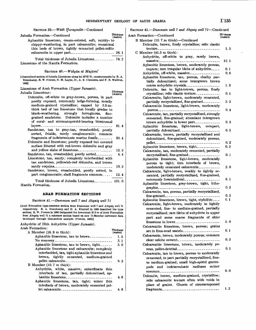
SEDIMENTARY GEOLOGY OF SAUDI ARABIA E135
SECTION 39. Wadl Huraymila Continued
Jubaila Formation ContinuedAphanitic limestone, cream-colored, soft, rubbly- to
chippy-weathering, in part calcarenitic; occasional thin beds of brown, tightly cemented pellet-oolite calcarenite in upper part______________________ 28. 1
Total thickness of Jubaila Limestone.__________ 74. 2Limestone of the Hanifa Formation.
SECTION 40. Widyan al Majami'
[Generalized section of Jubaila Limestone along lat 20°37 N.; measurements by R. A. Bramkamp, R. W. Powers, N. M. Layne, Jr., A. E. Clements, and F. R. Waldron, 1953]
Limestone of Arab Formation (Upper Jurassic). Jubaila Limestone:
Dolomite, off-white to gray-brown, porous, in part poorly exposed, commonly ledge-forming, mostly medium-grained crystalline; capped by 2.0-m- thick bed of tan limestone that locally grades to black-weathering, strongly ferruginous, fine grained sandstone. Dolomite includes a number of coral- and stromatoporoid-bearing biostromal layers.______________________________________ 81. 4
Sandstone, tan to gray-tan, crossbedded, poorly sorted, friable, rarely conglomeratic; common fragments of indeterminate marine fossils._______ 30. 4
Dolomite and limestone; poorly exposed but covered surface littered with red-brown dolomite and gray and yellow slabs of limestone...-___----________ 12. 2
Sandstone, tan, crossbedded, poorly sorted.________ 4. 4Limestone, tan, sandy; complexly interbedded with
tan sandstone, yellowish-red dolomite, and brown sandy coquina________________________________ 10. 2
Sandstone, brown, crossbedded, poorly sorted, inpart conglomeratic; shell fragments common_ _ _ _ _ 12. 4
Total thickness of Jubaila Limestone._________ 151. 0Hanifa Formation.
ARAB FORMATION SECTIONS
SECTION 41. Dammam well 7 and Abgaiq well 71
[Arab Formation type-reference section from Dammam well 7 and Abqaiq well 71 respectively. R. A. Bramkamp and H. A. Kimball in 1955 described the type section; R. W. Powers in 1960 designated the lowermost 37.0 m of Arab Formation from Abqaiq well 71 a reference section based on new D-Member carbonate data developed through thin-section analysis (Powers, 1962)]
Anhydrite of Hith Anhydrite (Upper Jurassic). Arab Formation:
A Member (16. 8 m thick):Aphanitic limestone, tan to brown.___________ 1.5No recovery______________________________ 3. 1Aphanitic limestone, tan to brown, tight_______ 3. 0Aphanitic limestone and calcarenite; complexly
interbedded, tan, tight aphanitic limestone and brown, tightly cemented, medium-grained pellet calcarenite____-.___.________________ 9. 2
B Member (10. 7 m thick):Anhydrite, white, massive; subordinate thin
interbeds of tan, partially dolomitized, ap hanitic limestone.________________________ 4. 6
Aphanitic limestone, tan, tight; minor thin interbeds of brown, moderately cemented pel let calcarenite-____________________________ 4. 6
Thickness (meters)
Th'~.knest (meters)
SECTION 41. Dammam wett 7 and Abgaiq well 71 Continued
Arab Formation ContinuedB Member (10. 7.m thick) Continued
Dolomite, brown, finely crystalline; relic clastictexture__-----_------_---------_---_----- 1.5
C Member (41.5 m thick):Anhydrite, off-white to gray, rarely brown,
massive________________________________ 12. 1Aphanitic limestone, brown, moderately porous,
impure; rare irregular blebs of anhydrite___ 0. 1Anhydrite, off-white, massive_________________ 0. 6Aphanitic limestone, tan, porous, chalky par
tially dolomitized; some intergrown brown coarse anhydrite crystals. ________________ 1. 3
Dolomite, tan to light-brown, porous, finelycrystalline; relic clastic texture _____________ 0. 1
Calcarenite, light-brown, moderately cemented,partially recry stallized, fine-grained _________ 2. 2
Calcarenitic limestone, light-brown, moderatelyporous.___-_-_-____-_-_--------______--- 0. 4
Calcarenite, tan, partially recrystallized, strongly cemented, fine-grained; abundant intergrown brown anhydrite in lower part._____________ 0. 5
Aphanitic limestone, light-brown, compact,partially dolomitized__-----__-_--_---_.__- 0. 3
Calcarenite, brown, partially recrystallized and dolomitized, fine-grained, moderately porous, pellet-____-----_-_ -_-----_---_ -_-__ 0. 2
Aphanitic limestone, brown, tight______---____ 0. 2Calcarenite, tan, moderately cemented, partially
recrystallized, fine-grained _________________ 0. 1Aphanitic limestone, ligh^-brown, moderately
porous to tight; thin interbeds of brown, moderately cemented calcarenite__________ 2. 0
Calcarenite, light-brown, weakly to tightly ce mented, partially recrystallized, fine-grained, commonly foraminiferal___________________ 8. 1
Aphanitic limestone, gray-brown, tight, litho graphic---------------------------------- 0. 2
Calcarenite, tan, porous, partially recrystallized, fine-grained____--___---_---------_------- 0.3
Aphanitic limestone, brown, tight, stylolitic.--- 0. 1Calcarenite, light-brown, moderately to tightly
cemented, fine- to medium-grained, partially recrystallized; rare blebs of anhydrite in upper part and some coarse fragments of older limestone in lower. _______________--___--- 2. 0
Calcarenitic limestone, brown, porous; grains set in lime-mud matrix.___________---_-_-- 0. 1
Calcarenite, brown, moderately porous; common clear calcite cement.___________--_---_---- 0. 3
Calcarenitic limestone, brown, moderately po rous, pellet-detrital-____--_---------------- 0. 1
Calcarenite, tan to brown, porous to moderately cemented, in part partially recrystallized, fine- to medium-grained; small high-spired gastro pods and indeterminate molluscs rather common____-__-_------------------------ 9. 0
Dolomite, brown, medium-grained, crystalline; relic calcarenite texture often with voids in place of grains. Ghosts of stromatoporoid fragments.--------.---------------------- 1- 2
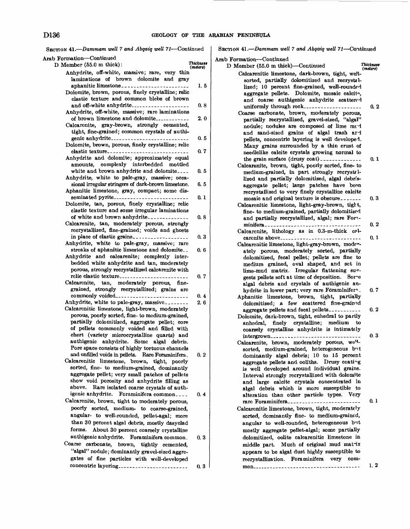
D136 GEOLOGY OF THE ARABIAN PENINSULA
SECTION 41. Dammam well 7 and Abgaiq well 71 Continued
Arab Formation ContinuedD Member (55.0 m thick): ^SSSff
Anhydrite, off-white, massive; rare, very thin laminations of brown dolomite and gray aphanitic limestone-______________________ 1.5
Dolomite, brown, porous, finely crystalline; relic clastic texture and common blebs of brown and off-white anhydrite__________________ 0. 8
Anhydrite, off-white, massive; rare laminations of brown limestone and dolomite_________ 2. 0
Calcarenite, gray-brown, strongly cemented, tight, fine-grained; common crystals of authi- genic anhydrite_________________________ 0. 5
Dolomite, brown, porous, finely crystalline; relic clastic texture.___________________________ 0. 7
Anhydrite and dolomite; approximately equal amounts, complexly interbedded mottled white and brown anhydrite and dolomite-.-. 0. 5
Anhydrite, white to pale-gray, massive; occa sional irregular stringers of dark-brown limestone. 6. 5
Aphanitic limestone, gray, compact; some dis seminated pyrite________________________ 0.1
Dolomite, tan, porous, finely crystalline; relic clastic texture and some irregular laminations of white and brown anhydrite._____________ 0. 8
Calcarenite, tan, moderately porous, strongly recrystallized, fine-grained; voids and ghosts in place of clastic grains.__________________ 0. 3
Anhydrite, white to pale-gray, massive; rarestreaks of aphanitic limestone and dolomite. _ 0. 6
Anhydrite and Calcarenite; complexly inter- bedded white anhydrite and tan, moderately porous, strongly recrystallized calcarenite with relic clastic texture_--_______-____-________ 0. 7
Calcarenite, tan, moderately porous, fine grained, strongly recrystallized; grains are commonly voided-__._____________________ 0. 4
Anhydrite, white to pale-gray, massive ________ 2. 6Calcarenitic limestone, light-brown, moderately
porous, poorly sorted, fine- to medium-grained, partially dolomitized, aggregate pellet; core of pellets commonly voided and filled with chert (variety microcrystalline quartz) and authigenic anhydrite. Some algal debris. Pore space consists of highly tortuous channels and unfilled voids in pellets. Rare Foraminifera- 0. 2
Calcarenitic limestone, brown, tight, poorly sorted, fine- to medium-grained, dominantly aggregate pellet; very small patches of pellets show void porosity and anhydrite filling as above. Rare isolated coarse crystals of auth igenic anhydrite. Foraminifera common. _ _ _ 0. 4
Calcarenite, brown, tight to moderately porous, poorly sorted, medium- to coarse-grained, angular- to well-rounded, pellet-agal; more than 30 percent algal debris, mostly dasyclad forms. About 30 percent coarsely crystalline authigenic anhydrite. Foraminifera common. 0. 3
Coarse carbonate, brown, tightly cemented, "algal" nodule; dominantly gravel-sized aggre gates of fine particles with well-developed concentric layering______________________ 0. 3
SECTION 41. Dammam well 7 and Abgaiq well 71 Continued
Arab Formation ContinuedD Member (55.0 m thick) Continued ^SSSff
Calcarenitic limestone, dark-brown, tight, well- sorted, partially dolomitized and recrystsl- lized; 10 percent fine-grained, well-rounded aggregate pellets. Dolomite, mosaic calcit 0!, and coarse authigenic anhydrite scattered uniformly through rock__________________ 0. 2
Coarse carbonate, brown, moderately porous, partially recrystallized, gravel-sized, "algal" nodule; nodules are composed of lime mrd and sand-sized grains of algal trash ard pellets, concentric layering is well developed. Many grains surrounded by a thin crust of needlelike calcite crystals growing normal to the grain surface (drusy coat)____________-_ 0.1
Calcarenite, brown, tight, poorly sorted, fine- to medium-grained, in part strongly recryst-l- lized and partially dolomitized, algal debris- aggregate pellet; large patches have been recrystallized to very finely crystalline calcite mosaic and original texture is obscure-______ 0. 3
Calcarenitic limestone, light-gray-brown, tight, fine- to medium-grained, partially dolomitized and partially recrystallized, algal; rare Fon- minifera-____---____--__----__-____--_-.-- 0. 2
Calcarenite, lithology as in 0.3-m-thick cal carenite above _______________________ 0. 1
Calcarenitic limestone, light-gray-brown, mode^- ately porous, moderately sorted, partially dolomitized, fecal pellet; pellets are fine to medium grained, oval shaped, and set in lime-mud matrix. Irregular flattening su^- gests pellets soft at time of deposition. Sor^e algal debris and crystals of authigenic an hydrite in lower part; very rare Fdraminifer*. 0. 7
Aphanitic limestone, brown, tight, partially dolomitized; a few scattered fine-grained aggrega te pellets and fecal pellets ___________ 0. 2
Dolomite, dark-brown, tight, euhedral to partly anhedral, finely crystalline; medium to coarsely crystalline anhydrite is intimately intergrown__-_----_----------_---_------- 0.3
Calcarenite, brown, moderately porous, we'i- sorted, medium-grained, heterogeneous bnt dominantly algal debris; 10 to 15 percent aggregate pellets and ooliths. Drusy coating is well developed around individual grains. Interval strongly recrystallized with dolomite and large calcite crystals concentrated in algal debris which is more susceptible to alteration than other particle types. Very rare Foraminifera___----_---__------------ 0. 1
Calcarenitic limestone, brown, tight, moderately sorted, dominantly fine- to medium-grained, angular to well-rounded, heterogeneous b'lt mostly aggregate pellet-algal; some partially dolomitized, oolite Calcarenitic limestone in middle part. Much of original mud matrix appears to be algal dust highly susceptible to recrystallization. Foraminifera very com mon_________-_-__---__-_-_-_--------- 1-2
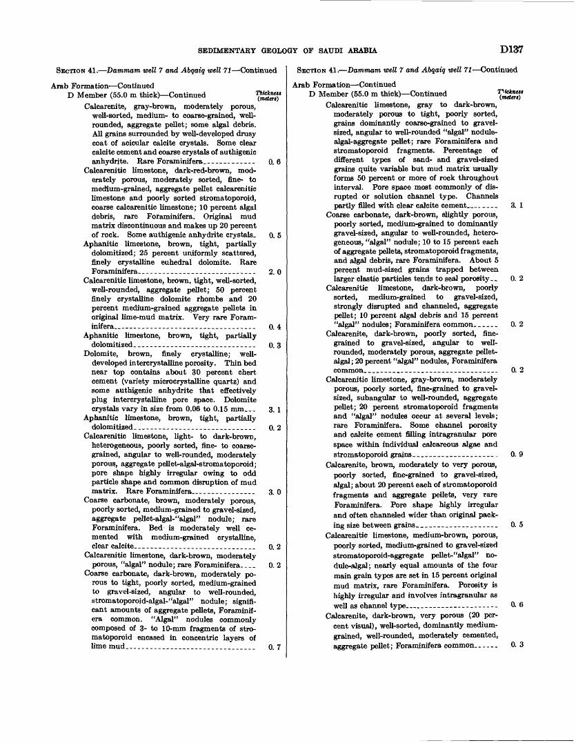
SEDIMENTARY GEOLOGY OF SAUDI ARABIA D137
SECTION 41. Dammam well 7 and Abgaiq well 71 Continued
Arab Formation ContinuedD Member (55.0 m thick) Continued ^S"'
Calcarenite, gray-brown, moderately porous, well-sorted, medium- to coarse-grained, well- rounded, aggregate pellet; some algal debris. All grains surrounded by well-developed drusy coat of acicular calcite crystals. Some clear calcite cement and coarse crystals of authigenic anhydrite. Rare Foraminifera_____________ 0. 6
Calcarenitic limestone, dark-red-brown, mod erately porous, moderately sorted, fine- to medium-grained, aggregate pellet calcarenitic limestone and poorly sorted stromatoporoid, coarse calcarenitic limestone; 10 percent algal debris, rare Foraminifera. Original mud matrix discontinuous and makes up 20 percent of rock. Some authigenic anhydrite crystals. 0. 5
Aphanitic limestone, brown, tight, partially dolomitized; 25 percent uniformly scattered, finely crystalline euhedral dolomite. Rare Foraminifera-_-___-_-_______________..-___ 2. 0
Calcarenitic limestone, brown, tight, well-sorted, well-rounded, aggregate pellet; 50 percent finely crystalline dolomite rhombs and 20 percent medium-grained aggregate pellets in original lime-mud matrix. Very rare Foram inifera..-----------_---___--_-_-_____---_ 0. 4
Aphanitic limestone, brown, tight, partiallydolomitized______________________________ o. 3
Dolomite, brown, finely crystalline; well- developed intercrystalline porosity. Thin bed near top contains about 30 percent chert cement (variety microcrystalline quartz) and some authigenic anhydrite that effectively plug intercrystalline pore space. Dolomite crystals vary in size from 0.06 to 0.15 mm___ 3. 1
Aphanitic limestone, brown, tight, partiallydolomitized-_____________________________ o. 2
Calcarenitic limestone, light- to dark-brown, heterogeneous, poorly sorted, fine- to coarse grained, angular to well-rounded, moderately porous, aggregate pellet-algal-stromatoporoid; pore shape highly irregular owing to odd particle shape and common disruption of mud matrix. Rare Foraminifera_-___-_-..___. 3.0
Coarse carbonate, brown, moderately porous, poorly sorted, medium-grained to gravel-sized, aggregate peilet-algal-"algal" nodule; rare Foraminifera. Bed is moderately well ce mented with medium-grained crystalline, clear calcite-_____________________________ o. 2
Calcarenitic limestone, dark-brown, moderately porous, "algal" nodule; rare Foraminifera---- 0. 2
Coarse carbonate, dark-brown, moderately po rous to tight, poorly sorted, medium-grained to gravel-sized, angular to well-rounded, stromatoporoid-algal-"algal" nodule; signifi cant amounts of aggregate pellets, Foraminif era common. "Algal" nodules commonly composed of 3- to 10-mm fragments of stro matoporoid encased in concentric layers of lime mud._______________________________ 0. 7
SECTION 41. Dammam well 7 and Abqaiq well 71 Continued
Arab Formation ContinuedD Member (55.0 m thick) Continued 7XSSff
Calcarenitic limestone, gray to dark-brown, moderately porous to tight, poorly sorted, grains dominantly coarse-grained to gravel- sized, angular to well-rounded "algal" nodule- algal-aggregate pellet; rare Foraminifera and stromatoporoid fragments. Percentage of different types of sand- and gravel-sized grains quite variable but mud matrix usually forms 50 percent or more of rock throughout interval. Pore space most commonly of dis rupted or solution channel type. Channels partly filled with clear calcite cement______ 3. 1
Coarse carbonate, dark-brown, slightly porous, poorly sorted, medium-grained to dominantly gravel-sized, angular to well-rounded, hetero geneous, "algal" nodule; 10 to 15 percent each of aggregate pellets, stromatoporoid fragments, and algal debris, rare Foraminifera. About 5 percent mud-sized grains trapped between larger clastic particles tends to seal porosity __ 0. 2
Calcarenitic limestone, dark-brown, poorly sorted, medium-grained to gravel-sized, strongly disrupted and channeled, aggregate pellet; 10 percent algal debris and 15 percent "algal" nodules; Foraminifera common._____ 0. 2
Calcarenite, dark-brown, poorly sorted, fine grained to gravel-sized, angular to well- rounded, moderately porous, aggregate pellet- algal; 20 percent "algal" nodules, Foraminifera common_____________________-_---_-_-__. 0. 2
Calcarenitic limestone, gray-brown, moderately porous, poorly sorted, fine-grained to gravel- sized, subangular to well-rounded, aggregate pellet; 20 percent stromatoporoid fragments and "algal" nodules occur at several levels; rare Foraminifera. Some channel porosity and calcite cement filling intragranular pore space within individual calcareous algae and stromatoporoid grains--.......__-___-_.--. 0. 9
Calcarenite, brown, moderately to very porous, poorly sorted, fine-grained to gravel-sized, algal; about 20 percent each of stromatoporoid fragments and aggregate pellets, very rare Foraminifera. Pore shape highly irregular and often channeled wider than original pack ing size between grains_____-_____-___--___ 0. 5
Calcarenitic limestone, medium-brown, porous, poorly sorted, medium-grained to gravel-sized stromatoporoid-aggregate pellet-"algal" no dule-algal; nearly equal amounts of the four main grain types are set in 15 percent original mud matrix, rare Foraminifera. Porosity is highly irregular arid involves intragranular as well as channel type ___--___-_-_-----_ 0. (5
Calcarenite, dark-brown, very porous (20 per cent visual), well-sorted, dominantly medium- grained, well-rounded, moderately cemented, aggregate pellet; Foraminifera common..____ 0. 3
D138 GEOLOGY OF THE ARABIAN PENINSULA
SECTION 41. Dammam well 7 and Abqaiq well 71 Continued
Arab Formation ContinuedD Member (55.0 m thick) Continued *$3£ff
Aphanitic limestone, brown, partially dolo mitized; some channel porosity filled with clear crystalline calcite, some stylolites, rare Foraminifera-____________________________ 0. 6
Calcarenite, dark-brown, tight, moderately to strongly cemented, moderately sorted, medium- to coarse-grained, aggregate pellet; most pore space filled with clear, coarsely crystalline calcite cement (about 30 percent). Middle part strongly altered to deeply sutured mosaic of aggregate pellets in stylolitic contact with adjoining pellets. Significant amounts of algal debris and selective recrystailization of algal fragments and stromatoporoid grains in lower part. Foraminifera common.______ 1.2
Coarse carbonate, light-gray-brown, low poros ity, moderately cemented (about 10 percent), poorly sorted, medium-grained to gravel-sized, "algal" nodule; each grain surrounded by drusy coat of acicular calcite crystals generally followed by calcite cement. Many individual particles strongly recrystallized to mosaic calcite. Rare Foraminifera-_______________ 0. 2
Calcarenite, dark-brown, very low porosity, well-sorted and rounded, medium-grained, strongly cemented (about 25 percent), aggre gate pellet; about 10 percent medium-grained, well-rounded fragments of stromatoporoid; Foraminifera common.____________________ 0. 5
Calcarenite, brown, porous, well-sorted, medium- to coarse-grained, aggregate pellet; common drusy coat around individual grains. Some stromatoporoid fragments, algal debris, and clear calcite cement, Foraminifera very common.________________________________ 1. 6
Coarse carbonate, light-gray-brown, very porous, poorly sorted, dominantly gravel-sized, stro matoporoid-"algal" nodule; small patches of aggregate pellets and algal debris, small amount of mud matrix, rare Foraminifera. Pore shape is highly irregular and in part solution channel._________________________ 0. 4
Calcarenitic limestone, dark-brown, porous, poorly sorted, fine-grained to gravel-sized, dominantly aggregate pellet; common "algal" nodules and algal debris, some molluscan frag ments and Foraminifera common. From 20 to 50 percent original mud matrix.__________ 0. 4
Coarse carbonate, brown, very porous, gravel- sized, skeletal.___-_-_--_-__________-_____ 0. 2
Calcarenitic limestone, light-brown, porous, poorly sorted, medium- to coarse-grained, aggregate pellet; Foraminifera common. _____ 0. 3
Calcarenite, light-brown, porous, well-sorted, medium- to coarse-grained, rarely angular to very well-rounded, aggregate pellet; 10 to 20 percent each of algal debris, Foraminifera, and "algal" nodules, rare stromatoporoid frag- ments_______________________________ 0. 5
SECTION 41. Dammam well 7 and Abqaiq well 71
Arab Formation ContinuedD Member (55.0 m thick) Continued
Calcarenitic limestone, light- to dark-browr, moderately to very porous, poorly sortec1 , rounded to angular, partially dolomitizec', dominantly aggregate pellet; abundant stro matoporoid fragments, "algal" nodules, an-i algal debris at several levels, very rare Foran:- inifera. Common channel porosity, som? intergranular pore shape very irregular- _____ 1. 6
Coarse carbonate, light-gray, very porous (in- tragranular), gravel-sized, stromatoporoicf; about 5 percent well-rounded aggregate pellets. Very rare Foraminifera-___________________ 0. 1
Calcarenite, light-brown, highly porous, moder ately sorted, medium-grained to gravel-sized well-rounded aggregate pellet; well-developei drusy coat around each grain, rare Forarr- inifera_._ ___________ _______ _________ 0.2
Calcarenitic limestone, dark-brown, highly po rous, moderately sorted, dominantly fine to medium-grained, aggregate pellet; 10 percent algal debris, rare Foraminifera. "Fecal" pellets occur in lower part. Irregular shape cf algal debris plus some channeling makes pore shape highly irregular-____________________ 0. 9
Calcarenite, brown, very porous, well-sorted and rounded, medium- to coarse-grained, weakly cemented, aggregate pellet; rare Fc- raminifera______________________________ 0. 2
Coarse carbonate, gray-brown, very porour, weakly cemented, moderately sorted, coarse grained to gravel-sized, algal-aggregate pellet; individual grains covered by well-developed drusy coat. Rare Foraminifera-__.____-_-_ 0. 2
Calcarenitic limestone, brown, tight, partially dolomitized, moderately sorted, dominantly fine to medium-grained, aggregate pellet; some algal debris near top, rare stromatopo roid, Foraminifera, and echinoderm fragment? throughout__ _ ________-_-_____-___-_--_- 4.0
Dolomite, light-brown, tight to porous, open euhedral to strongly sutured anhedral mosaic, finely crystalline, (average crystal size about 0.12 mm); 10 percent chert (variety micrc- crystailine quartz) and authigenic anhydrite ir upper part.______________________________ 1. 0
Calcarenitic dolomite, dark-brown, finely cry stalline, tightly sutured; small percentage ag gregate pellets, stromatoporoid fragments, and brachiopod debris as well as mud matrir visible in patches, trace authigenic anhydrite. _ 0. 1
Calcarenitic limestone, light-gray-brown, mod erately porous, tight, poorly sorted, fine grained to gravel-sized, commonly disrupted, angular to well-rounded, partially dolomitized aggregate pellets; significant amounts of algal debris, "algal" nodules, and echinoid frag ments occur at various levels, very rare Fo raminifera______________________________ 0. 5
SEDIMENTARY GEOLOGY OF SAUDI ARABIA LN 139
SECTION 41. Dammam well 7 and Abgaiq well 71 Continued
Arab Formation ContinuedD Member (55.0 m thick) Continued
Calcarenite, light-brown, compact, moderately sorted, angular to well-rounded, aggregate pellet; pore space is intergranular and clean; however, many grains appear to have been soft on deposition and later compacted and distorted. Rare Foraminifera____ .____._
Thickness (meters)
0.5
Total thickness of Arab Formation_ __._. 124, 0 Jubaila Limestone.
SECTION 42. Wadi Nisah
[ Generalized section of the basal Arab Formation at Wadi Nisah; measurements by R. W. Powers and H. A. McClure in 1961]
Carbonate of the middle and upper Arab Formation (UpperJurassic).
Basal Arab carbonate:Calcarenite, gray, tightly cemented, fine- to medium-
grained, pellet-skeletal; thin bed of gray, tight, aphanitic limestone near middle____-____--___.-_ 3. 5
Solution-collapse breccia, gray-brown, coarse lime stone breccia; fragments up to 1.0 m in diameter, usually angular, set in heterogeneous matrix of jum bled carbonate fragments.---_._____-_--___-____ 12. 0
Sandstone, yellow, fine-grained, moderately cemented, calcareous, rounded to subrounded, quartzose.. _. 1. 5
Aphanitic and calcarenitic limestone, alternating layers of tan, tight, aphanitic limestone with rare blebs of of anhydrite and reddish-brown, tight, pellet-skel etal calcarenitic limestone__---__-__.__--____-__ 3. 5
Calcarenite, yellow-brown, tightly cemented, fine- to medium-grained, sandy, pellet-skeletal___-_-_-_- 1.5
Total thickness of basal Arab carbonate unit- - - _ 22. 0 Jubaila Limestone.
HITH ANHYDRITE SECTION
SECTION 43. Dahl Hit
[Hith Anhydrite section at Dahl Hit was first described and recognized as the type sequence by R. A. Bramkamp and T. C. Barger in 1938. A detailed remeasure- ment by S. J. Roach in 1952 is given as follows]
Thickness (meters)
Oolite (Upper Jurassic?) of Sulaiy Formation.Disconformity.Hith Anhydrite:
Limestone breccia, gray-tan, thin to platy, angular blocks recemented in fine-grained marl matrix; thin bed of gray-tan aphanitic and calcarenitic lime stone occurs in lower part. May represent slumped Sulaiy beds rather than residuum of Hith carbon ates but interval originally contained at least one bed of anhydrite.._____________________________ 12. 7
Anhydrite, blue-gray, thin, regularly bedded, common color banding and lamination; some laminae of yellow clay shale in upper part. Highly irregular sinuous con tact at top with thin beds of anhydrite clearly trun cated; knobs and sharp pinnacles of anhydrite extend up to 0.5 m into the overlying breccia. _ _ _ _. 32. 0
Anhydrite, blue-gray, massive, finely nodular; few irregular lenses of white gypsum.-._.__-_____.._- 2. 0
SECTION 43. Dahl Hit Continued
Hith Anhydrite ContinuedAnhydrite, massive; contains alternating bands of
blue and white color. __________________________ 9. 5Anhydrite, blue-gray, massive; finely nodular part
ings __..- ______--__-_--_-----__---_---_.._____ 12. 0Anhydrite, blue-gray; some small nodules in a matrix
of yellow- weathering argillaceous dolomite. _______ 2. 1Anhydrite, blue-gray, massive, laminated to platy;
common sinuous partings and blue and white lam inations and banding. Wavy flow structure prom inent in parts of interval. _______________________ 20. 0
Total thickness of Hith Anhydrite. ._-____.____ 90. 3 Arab Formation.
SULAIY FORMATION SECTIONS
SECTION 44. Dahl Hit
[Sulaiy Formation exposed in Dahl Hit; clifl above and back slope were studied and designated Sulaiy type section by R. A. Bramkamp and T. C. Barger iT 1938. The same outcrop, reworked in more detail by S. J. Roach in 1952, is given as follows]
Calcarenite of the Yamama Formation (Lower Cretaceous). Sulaiy Formation: T£&"'
Aphanitic limestone, off-white to tan to gray, thinly bedded, commonly nodular-weathering, rarely sandy; common thin interbeds of pellet-skeletal calcarenitic limestone and tightly cemented calcarenitc._______---_-__-_---_----_---_-___- 14. 3
Aphanitic limestone, light-gray, cream-colorcd-weathering, thinly bedded, moderately porous. ... 7. 0
Aphanitic limestone, light-gray, cream-colored- weathering, thinly and nodular-bedded, moderately porous; occasional thin interbeds of yellow-tan, pellet-skeletal calcarenitic limestone and calcar- cnitc.--------------------------------------- 40.0
Aphanitic limestone, light-gray, cream-colored- weathering, thinly bedded, tight to moderately porous; a few thin beds of yellow-tan, pellet- skeletal calcarenitic limestone and Calcarenite. Top of interval caps escarpment above Dahl Hit- - 44. 5
Calcarenitic limestone, tan to brown, rarely sandy, pellet-skeletal; some interbeds of aphanitic lime stone and skeletal calcarenitc------------------- 20. 0
Aphanitic limestone, tan, thinly bedded, nodular,moderately porous; rare shell fragments. -------- 5. 1
Calcarenite, tan, thinly bedded and nodular, tightly cemented, pellet-skeletal; at places grades to co- quinoid calcarenitc with pellet matrix. Small pebbles of older limestone are common in calcar enitc beds. A few thin interbeds of tan, moder ately porous aphanitic limestone..__-__-_--_-_-- 12. 6
Aphanitic limestone, gray, tan-weathering, tight to moderately porous, thinly bedded and nodular; rare thin interbeds of calcarenitic limestone. All beds arc about 0.1 m thick and separated by well-defined bedding planes._-_-_-__----------- 14. 7
Calcarenitc, tan, tightly cemented, irregularly bedded,pellet-skeletal ___________.-_-----_--_-_------- 12.0
Total thickness of Sulaiy Formation. Hith Anhydrite.
170.2
228-776 <
D140 GEOLOGY OF THE ARABIAN PENINSULA
SECTION 45. Near lat 28°50r N.
[Generalized section of Sulaiy Formation near latitude 23°60/ N., measurements by R. W. Powers and H. A. McClure, 1962]
Calcarenite of Yamama Formation (Lower Cretaceous).Sulaiy Formation: (meter*)*
Aphanitic limestone, golden-brown, tight, partially dolomitized.--.-------.-.--------____.._._..__ 2. 0
Pellet calcarenite, golden-brown, moderately sorted, medium- to coarse-grained, tightly cemented; abun dant Foraminif era and pelecypod debris. _.-..____ 1.8
Calcarenitic limestone, light-brown, moderately po rous, chalky; 20 percent coarse-grained pelecypod and gastropod shell debris. Original shell material altered to clear, coarsely crystalline calcite. Lower 1.0-m-thick bed is tan aphanitic limestone_______ 3. 2
Pellet calcarenite, tan, fine-grained, well-sorted, tightly cemented; abundant Foraminifera _______________ 2. 0
Aphanitic limestone, tan, moderately porous, chalky; very rare thin beds of brown, moderately porous, chalky pelecypod calcarenitic limestone________ 35.5
Covered interval; thickness unknown_____________ ?Aphanitic limestone, tan, moderately porous, chalky;
thin beds of tan chalky, medium- to coarse-grained, pellet- molluscan calcarenitic limestone occur near top._________________________________________ 5. 1
Pellet calcarenite, dark-brown, well-sorted, fine- to medium-grained, tightly cemented; thin bed of tan chalky aphanitic limestone occurs in upper part- _ _ 4. 0
Aphanitic limestone, tan, moderately porous, rarely pelletal; common outlines of monaxon sponge spic ules. A 2.0-m-thick bed of brown, rarely sandy, chalky, pellet calcarenitic limestone occurs near middle.______________________________________ 5. 5
Pellet calcarenite, golden-brown, well-sorted, very fine grained, tightly cemented.______________________ 1.5
Aphanitic limestone, tan, moderately porous, chalky; rare scattered molluscan debris and some sponge spicules. Occasional thin beds of brown tight, fine- to medium-grained, pellet calcarenitic limestone- - _ 14. 5
Base of section probably near slump contact of Arab and Sulaiy Formations.
YAMAMA FORMATION SECTION
SECTION 46. Vicinity of lat 24°01' N..w.
Powers and H. A. McClure in 1962 near vicinity of type section about 20 km south of Al Yamamah (see pi. 17)]
Calcirudite of the Buwaib Formation (Lower Cretaceous). Unconformity.
Yamama Formation: ^^neter*)* 3. Calcarenite and aphanitic limestone (16.0 m thick):
Pellet calcarenite, golden-brown, well-sorted, fine-grained, sparsely sandy_____________ 3. 0
Covered; rare exposures of off-white, chalky, aphanitic limestone; upper 0.5 m forms cap of off-white nodular limestone__-_.______ 3.4
Aphanitic limestone, light-brown, tight; 5 per cent sponge spicules. Oyster bed 1.1 m below top._____________________________ l. 6
SECTION 46. Vicinity of lat 24°01' N. Continued
Yama ma Formation: Continued3. Calcarenite and aphanitic limestone (16.0 m thicM
PnnHrmoH Thickness uontinuea (meter*)Pellet-foraminifera calcarenite, brown, mod
erately well sorted, tightly cemented; 20 per cent tabular disarticulated pelecypod valves showing strong lineation parallel to bedding and set in matrix of medium- to coar'e- grained pellets and Foraminifera all tightly cemented with clear secondary calcite. Hill-capping unit______________________ 0. 4
Calcareous sandstone, golden-brown, tight, quartzose; 50 percent fine- to medium- grained, subrounded to angular quartz sand uniformly admixed with lime-mud matrix.. 0. 6
Covered________-_____-_----__-_____--__ 1. 0Pellet calcarenite, golden-brown, well-sortod,
fine-grained, rounded, tightly cemented; abundant calcite-replaced monaxon spor<re spicules and scattered pelecypod debris____ 1. 5
Covered_______________________________ 2. 0Pellet calcarenite, golden-brown, moderately
well sorted, medium- to coarse-grained, tightly cemented, clean-washed; 5 percent coarse pelecypod debris and Foraminifera commonly scattered through the pellet cal carenite matrix.________________________ 2. 0
Pellet calcarenite, dark-golden-brown, well- sorted, very fine grained, tightly cemented; calcarenite so uniformly sorted and tightly cemented that on outcrop appears as apl *.- nitic limestone with well-developed concl o- idal fracture. Rare chert podules. Exten sive bench former; bed caps all hills in the area.----_--------------------_-------_ 0. 5
2. Aphanitic and calcarenitic limestone (10.1 m thick):Aphanitic limestone, tan, moderately poro-'s,
chalky, slightly sandy______._______-.__ 1.5Coarse pelecypod calcarenitic limestone, tan
to medium-brown, tight, poorly sorted; 50 percent disarticulated pelecypod valves, Foraminifera and pellets in a light-cream- colored, lime-mud matrix. Isolated pockets of clean, current-washed, tightly cemented Foraminifera-pellet calcarenite. Pelecypod debris replaced by clear crystalline calcite. Echinoids rather common..______-_-_--._ 1.0
Aphanitic limestone, light-tan, moderately porous, chalky__._______-___-___--_----_ 0. 7
Foraminifera-pellet calcarenite, golden-brown, tightly cemented, well-sorted; 5 percent re- crystallized pelecypod shells______________ 0. 5
Aphanitic limestone, light-tan, moderately porous, sparsely sandy; abundant monaxon (?) sponge spicules scattered throughout; very rare molluscan debris _______________ 1.3
SEDIMENTARY GEOLOGY OF SAUDI ARABIA D141
SECTION 46. Vicinity of lot 24°01' N. Continued
Yamama Formation Continued2. Aphanitic and calcarenitic limestone (10.1 m
thick) ContinuedCalcarenite and limestone; tan, strongly ce
mented, well-sorted pellet calcarenite inti mately interbedded with coarse molluscan calcarenitic limestone as below. Gastropods and Foraminifera uniformly scattered through both rock types. Weathered bench surface contains abundant, well-preserved pelecypods, echinoids, and scarce ammonites. Pygurus cf. P. rostratus common._________ 0. 5
Coarse molluscan calcarenitic limestone, brown, tight, poorly sorted; 50 percent calcite-re- placed, gravel-sized pelecypod and gastropod shells randomly oriented in lime-mud matrix and commonly infilled with lime mud. Forms brown, biogenic limestone bench____ 2. 5
Partly covered; probably off-white, soft,chalky, aphanitic limestone_____-__.__-_ 2. 1
1. Calcarenite and coarse carbonate (19.4 m thick):Pellet-molluscan calcarenite, golden-brown,
moderately well sorted, fine-grained, strongly laminated, tightly cemented; disarticulated pelecypod valves show definite lineation par allel to laminations. Foraminifera and gastropod debris common. Very thin bed of pelecypod calcarenitic limestone near top. Upper 0.3-m-thick bed forms prominent dip slope. __________________________________ 3. 3
Coarse gastropod carbonate, brown, poorly sorted, moderately cemented; 60 percent gastropod remains commonly infilled with cream-colored lime mud. Some gravel-sized fragments of tan aphanitic limestone appar ently derived from older limestones. About 20 percent fine- to medium-grained Foram inifera..._____________________________ 1. 6
Pellet calcarenite, golden- to reddish-brown, generally well-sorted, tightly cemented, very fine to medium-grained; Foraminifera and molluscan debris common. Occasional thin beds of brown, poorly sorted, tightly ce mented, coarse-grained to gravel-sized, coarse gastropod carbonate. Single 0.3-m- thick bed of golden-tan, tight aphanitic lime stone 2.7-3.0 m below top of interval._ _ _.. 9. 5
Covered__-______----_._________________ 1. 0Pellet calcarenite, as below, top of unit forms
extensive dip slope.___._.______.._____.__ 1. 5Covered_.----__-_.___.______________... 1. 0Pellet calcarenite, brown, poorly sorted, tightly
cemented; poorly preserved arenaceous Fo raminifera common. About 20 percent of debris is of organic origin, clominantly mol luscan- -_-_-----_--__-.-_.___.____.____ 1. 5
Total thickness of Yamama Formation. _. 45. 5 Sulaiy Formation.
Th'f.knes» (meters)
BtfWAIB FORMATION SECTIONS
SECTION 47. Near Khafs Daghrah[Buwaib Formation reference section was measured and sampled in 1062 in detail by
R. W. Powers and H. A. McClure 14 km northeast of Khafs Daghrah in vic'nity of lat 24°64' N]
Sandstone of the Biyadh Sandstone Lower (Cretaceous) Buwaib Formation:
Coarse pelecypod carbonate, golden-brown, gravel- sized, poorly sorted, sandy; almost exclusively pele cypod hash. Most pelecypod shells leached or replaced by clear crystalline calcite, rare original shell material. Angular to subrounded medium- grained quartz sand common..__________________ 0. 1
Dolomite, reddish-brown, rarely sandy, medium- grained crystalline; abundant ghosts of calcite- replaced pelecypod shells.______________________ 1.9
Coarse pelecypod carbonate, reddish-brown, poorly sorted, strongly rersrystallized and partially dolo- mitized; original texture partially obliterated by recrystallization; however, still possible to recognize original textural elements including pelecypod shells, pellets, and secondary calcite cement.____________ 0. 2
Pellet calcarenite, golden-brown, moderately cemented very commonly sandy, well-sorted, fine- to medium- grained____________.___-____-__-_---____-_-___ 0. 6
Aphanitic limestone, brown, tight, partially recrystal- lized; forms soft rubbly bench.__________________ 1.0
Coarse pelecypod carboiiite, golden-brown, dominantly gravel-sized, moderately cemented; pelecypod shells replaced by coarsely crystalline calcite or leached; remaining internal molds of lime mud are most com mon gravel-sized grain________________________ 0. 2
Poorly exposed; probably olive-green shale and impure aphanitic limestone; 0.1-m-thick beds of brown, rarely sandy, tightly cemented pellet calcarenite, form weak benches 2.0, 4.0, and 4.4 m above base of intcrval.______________________________________ 6. 3
Sandstone, dark-brown, strongly weathered, quartzose. 1. 0Molluscan-foraminiferal calcarenite, golden-brown,
poorly sorted, tightly cemented, partially recrystal- lized; large amounts of indeterminate molluscan? shell debris, Foraminifera, and pellets.___________ 1.5
Dolomite, reddish-brown, medium-grained crystalline, moderately porous; 10 percent original calcitic matrix preserved in intercrystallinc areas.______________ 1.5
Pellet calcarenite, golden-brown, very fine grained, angular to well-rounded, tightly cemented, well- sorted; angular nature of many of the carbonate grains indicates possible derivation form older limestone. Top of bed forms major dip slope. _ _ __ 0. 3
Pellet calcarenitic limestone, light-brown, tight, par tially recrystallized; recrystallization of mud pellets and mud matrix tends to obscure calcarenitic nature of bed..-------------------------------------- 0.5
Aphanitic limestone, tan, porous, rarely sandy, chalky; scarce monaxon sponge spiculcs and scattered mol luscan remains and pellets.____--___--_--------- 2. 6
Total thickness of Buwaib Formation. Sulaiy Formation.
17. 7
D142 GEOLOGY OF THE ARABIAN PENINSULA
SECTION 48. Qo?r Himam
[Generalized section of Buwaib Formation near Qasr Himam; measurements by R. A. Bramkamp, S. J. Roach and S. B. Henry, 1964]
Sandstone of the Biyadh Sandstone (Lower Cretaceous). Buwaib Formation:
Sandstone, yellowish-brown, silty, fine- to medium- grained, friable; common interbeds of light-gray sandy limestone and some reddish-brown dolomite. 8. 2
Aphanitic limestone, gray to tan, soft, shelly; common thin interbeds of greenish-gray marl and shale and tan, coarsely skeletal calcarenitic limestone and tightly cemented calcarenite.-__._____-.__..____ 14. 6
Aphanitic limestone, cream to tan, fossiliferous, platy to rubbly-weathering; occasional thin beds of cal carenitic limestone and calcarenite_______________ 22. 2
Arab Formation.
BIYADH SANDSTONE SECTION
SECTION 49. Al Biya$[Biyadh Sandstone type section was measured and described by D. A. Holm and
N. M. Layne, Jr., in 1949 in Al Biyad about 20 km south of Wadi Sahba']
Sandstone of the Wasia Formation (Middle Cretaceous). Unconformity (not exposed at type locality). Biyadh Sandstone:
4. Sandstone (101.8 m thick):Covered_______________________________ 23. 8Sandstone, black-weathering, massive-bedded;
forms weak bench-_____________________ 1.0Sandstone, poorly exposed, coarse-grained to
pebbly---_-_-----__--___-__-____---._. 20.0Sandstone, gray, nodular-weathering___-_. 1. 0 Sandstone, coarse-grained, in part friable,
crossbedded; common quartz pebbles. __-- 35. 0 Sandstone, gray, sugary, hard, crossbedded-_ 7. 0 Covered; probably friable quartz sandstone;
some shale at base_____--___-_-_-.___ 14. 03. Shale, limestone, and marl (10.8 m thick):
Limestone, brown to tan, tight, bench- forming; weathers to black chips on dip slope.-___----------_____-_---________ 0. 5
Shale, green to tan, soft, gypsiferous..-----. 3. 7Marl, tan to buff; forms weak bench_._-__ 0. 3 Shale, red, sandy_______________________ 0. 9Marl, brown to yellow, sandy; forms several
weak ledges.__________________________ 3. 3Shale, red to tan to gray, in part hematitic.. 2. 1
2. Poorly exposed sandstone (205.2 m thick):Sandstone, cream-colored to gray, cross-
bedded, fine-grained, sugary, porous, friable....------_-_---------___---_--. 1.7
Sandstone, coarse-grained, conglomeratic; forms weak bench, weathers to chips of ironstone__-_-___-__---_____.__________ 1. 8
Covered_______________________________ 23. 0Sandstone, black-weathering; forms thin
ledge___------_.---__--._-----.---_..- 0. 1Covered______________________________ 37. 0Sandstone, brown, coarse-grained; forms
low bench.____________________________ 2. 0Covered; sandy plain.____________________ 40. 0Sandstone, gray, massive, tightly cemented. _ 1. 0
Jg«
8. 0 6. 0
43. 0 0. 1 6. 0
SECTION 49. Al Biydd Continued
Biyadh Sandstone Continued2. Poorly exposed sandstone (205.2 m thick)
ContinuedCovered ___ ____--__--______---____--._Sandstone, gray, tightly cemented, massive. _ Poorly exposed; soft shale and sandstone.-.. Sandstone, black- weathering, conglomeratic. Covered ___ ----- __ ___-_______._._-_-Sandstone, white, massive.-------------... 0. 5Covered; probably soft shale and sandstone. 15. 0 Sandstone, gray, massive... _ ______________ 1.0Poorly exposed; red clay shale. ____________ 19. 0
1. Sandstone (107.2 m thick):Sandstone, brown, massive, coarse-grained.. 17. 0 Covered; probably soft shale and sandstone. 34. 0 Ironstone, thin, black- weathering, nodular;
caps low hill_-------------------------- 0. 1Shale and sandstone; poorly exposed, gr..y
shale and brown friable sandstone. _______ 15. 0Sandstone, brown, platy; impressions or cas*.s
of tree trunks _ - _____-__--------_----_ 4. 0Sandstone, platy, black- weathering; forms
low bench. ______________-__-__--_---_- 0. 1Covered; probably friable sandstone; fonrs
flat plain _ __________---_-__--__------ 11. 0Sandstone, black to brown, platy, ferruginous
nodular. _____-________---_--_-__-_---- 2. 0Sandstone, brown, iron-stained, coarse
grained. -______-___-_-_---------_-__-- 4. 0Sandstone, brown, massive, coarse-grained. - 20. 0
Total thickness of Biyadh Sandstone- _ _ - 425. 0 Buwaib Formation.
WASIA FORMATION SECTIONS
SECTION 50. Wasl'
[Wasia Formation type section was measured and described by R. A. Bramkamp and S. J. Roach in 1966 at Wasl']
Thickness (meters)
Dolomite of the Aruma Formation (Upper Cretaceous).Disconfonnity.Wasia Formation:
Sandstone, brown and yellow-weathering, very fine to fine-grained, in part silty; scattered quartz pebbles. Crossbedding is usually well developed except in uppermost part. Fossil wood is present as fer-u- ginous molds.__._-----------------_----------- 19-2
Shale, red and purple, silty; some green clay shrle, and thin brown to black ironstone partings common. A single 0.1-m-thick reddish-brown sandy, siHy dolomite with white-filled vugs at base. Elsewhere nearly similar dolomite layers occur at higher levels. At one locality just east of Wasl' a local lens of cream-colored, colored, nodular, fine-grained lime stone up to 2 m in thickness, containing rare ammo nites, extends laterally for about 200 m. Neolobiles vibrayeanus, cidaroid echinoids, and pelecypods occur in carbonate lens.----------------------
Sandstone and siltstone; buff and red-banded, fine grained ; shows small-scale crossbedding --------
Shale, green, brown-weathering, silty sandy.--------
8. 1
5.3 6.4
SEDIMENTARY GEOLOGY OF SAUDI ARABIA D143
SECTION 50. Wasl' Continued
Wasia Formation Continued (meters)* Sandstone and siltstonc; gray, green, and red, rela
tively thin-bedded, silty fine-grained sandstone and coarse siltstonc_ ________________________________ 3. 0
Total thickness of Wasia Formation__________ 42. 0Biyadh Sandstone.
SECTION 51. Vicinity of Sakakah
[Generalized section of the Wasia (Sakaka) Formation near Sakakah; measurements by D. A. Holm and S. D. Bowers, 1952]
Limestone of the Aruma Formation (Upper Cretaceous). Unconformity. Approximate Wasia (Sakaka) Formation: (meters) 8
Siltstonc and sandstone; thin, alternating beds of variegated siltstone and off-white to gray, red- to tan-weathering, commonly crossbedded sand stone; some reddish-brown micaceous laminae. Thin layers of ironstone occur at several levels _ _ _ _ 100
Sandstone, off-white to gray-brown, brown- >and red-weathering, massive, crossbedded, fine- to medium-grained, micaceous; occasional lenses of mottled clay shale. ___________________________ 145
Sandstone and siltstonc; thinly interbedded red, brown, and maroon, friable, fine-grained, cross- bedded micaceous sandstone and siltstone; often lenticular.___________________________________ 40
Approximate total thickness of Wasia (Sakaka) Formation _______________________________
Jauf Formation.285
ARUMA FORMATION SECTION
SECTION 52. Wadl al 'Atk
[Aruma Formation type section was measured and described by S. J. Roach in 1952 in area just south of Wadi al 'Atk]
Dolomite of the Umm cr Radhuma Formation (Paleo-cenc and lower Eocene).
Aruma Formation:4. Shale and dolomite (Lina member, 32.9m thick:
Shale and dolomite; complexly interbedded yellow-weathering dolomitic shale and pink-, blue-, and yellow-mottled, platy, impure dolomite_______________________ 14.4
Dolomite, yellow-, pink-, and blue-mottled,thinly bedded, platy, argillaceous....-..- 7.8
Dolomite, blue-gray, sucrose crystalline, ir regular rubbly bedded; abundant forami- nifcra.-_--__----.___-_________________ 3.2
Limestone, tan, gray-weathering, fine grained; irregular nodular bedding.______ 0.5
Marl, greenish-gray, granular, silty. ________ 2.0Limestone, cream-colored- to yellow-weather
ing, granular, massively bedded; thin beds of crystalline, nodular limestone at top and bottom_________________________ _ 1.0
Shale, brown-weathering, flaky, calcareous;a few limestone nodules.___-___-____..___ 4.0
SECTION 52. Wadl al 'Atk Continued
Aruma Formation Continued Disconformity. 3. Dolomite (upper Atj member, 27.6 m thick:
Limestone, tan, brown-weathering, detrital and oolitic; a few thin beds of sucrose gran ular dolomite. Orbitoids and large gas tropods locally abundant. Upper part of interval is commonly silicified. Strong bench at top.____________-_----_--____- 5.0
Dolomite, tan, brown-weathering, sucrose granular, in part argillaceous and rubbly- weathcring; scattered patches of oolite and detrital limestone. Forms strong bench at top.__-------------_-----------_--- 22.6
2. Limestone (middle Atj member, 41.0 m thick:Limestone, cream-colored, tan-weathering,
chalky, granular, sparsely detrital, mas sively bedded, mostly rubbly-weathering; alternately forms strong and weak benches. 34.6
Limestone, cream-colored, brown-weathering, massively bedded, soft, chalky and slightly argillaceous.. __. _______...______---_-_. 3.2
Shale, green, brown-weathering, flaky, fissile; in part calcareous varying to a marl and argillaceous limestone along strike. Abun dant corals and Foraminifcra (Loftusia).-. 3.2
1. Calcarenitic limestone (lower Atj member, 40.0 m thick):
Molluscan calcarcnitic limestone, tan, brown- weathering; consists of abundant rudistids, oysters, and large gastropods set in matrix of chalky limestone. Bedding is irregular, rubbly weathering, and biostromal.._-._- G. 4
Calcarcnitic limestone, cream-colored, tan- weathering, chalky, nodular; abundant carbonate material._________--__--__--- 16 0
Calcarcnitic limestone, cream-colored, tan- weathering, chalky, nodular; abundant clastic carbonate debris. Nodules arc set in a matrix of sandy marl._______.__-_-- 16. 0
Dolomite, reddish-brown, dark-red- to brown- weathering, granular, sandy; a few small pebbles and abundant vugs, many filled with white coarsely crystalline calcite..--- 1. 6
Total thickness of Aruma Formation.--------------- 141. 5Wasia Formation.
UMM ER RADHUMA FORMATION SECTION
SECTION 53. Al Bcftin
[Umm er Radhuma Formation reference section was measured and descr'bed by W. II. Reiss and R. D. MacDougall in 1953 in the Al Batin channel]
Sandy limestone of Miocene and Pliocene age.Unconformity.Umm cr Radhuma Formation:
2. Calcarcnitic limestone, aphanitic limestone, and dolomite (140.4 m thick):
Covered.---.-.-------------------------- 2 - °Dolomite, light-brown to gray, medium-
grained to finely crystalline; upper 1.0 m shows relic clastic texture.__..--.------- 4. 5
T^'ekness (meters)
D144 GEOLOGY OF THE ARABIAN PENINSULA
SECTION 53. Al Bfyin Continued
Umm er Radhuma Formation Continued2. Calcarenitic limestone, aphanitic limestone, and
dolomite (140.4 m thick) ContinuedCovered __ ____________________________Dolomite and limestone; brown, medium to
coarsely crystalline dolomite alternating with thin beds of pellet calcarenitic lime stone and tan soft chalky limestone _ ____
Aphanitic limestone, light-gray to tan, vuggy, partially dolomized; some megafossil shell debris. Upper bed strongly dolomitized and weathers to nodular surface _ _ _-__-_
Calcarenitic limestone, gray to tan, irregu larly bedded, partially dolomitized, pellet; total interval has brecciated appearance, rare Foraminifera. ____------_-____-___.
Aphanitic limestone, gray-brown, tight, par tially dolomitized, commonly f ossiliferous ; interval capped by thin bed of fine-grained pellet calcarenitic limestone __ __________
Calcarenitic limestone, dark-gray, irregularly bedded, fine- to medium-grained, commonly f ossiliferous, pellet-detrital ; thin bed of brown, friable, coarsely crystalline dolomite at top. __---_---_-___-______________-_
Aphanitic limestone, gray, tight, rarely fos- silif erous ._-__--__-_________________.__
Calcarenitic limestone, gray, tight, partially dolomitized, pellet-f ossiliferous; red- brown to black and cherty on weathered surface.
Aphanitic limestone, gray, tight, rather com mon pelecypod shells. ______-______._--_
Calcarenitic limestone, gray, tight, in part partially dolomitized, coquinoid; thin bed of rubbly-weathering dolomite near middle.
Aphanitic limestone, gray, finely laminated, tight, hard, siliceous. ___________________
Calcarenitic limestone, gray, tight, fossilif - erous-detrital; pelecypods rather common.
Aphanitic limestone, off- white, brittle to partly chalky, slightly siliceous; capped by cherty limestone surface __ _ ____________
Marl, off-white to light-yellow, soft, dull, im pure, fine-grained. _____________________
Aphanitic limestone, light-gray, tight, sili ceous. ________________________________
Calcarenitic limestone, gray, tight, skeletal. .Dolomite, light-gray, tight, finely crystalline;
common relic clastic texture. Abundant fossil trash in upper part. _______________
Calcarenitic limestone, light-brown, tight, coquinoid- ____________________________
Aphanitic limestone, light-gray, tight, thinly laminated, chalky, slightly fossiliferous. _ _
Dolomite, brown, medium-grained crystalline; weathers dark gray__ _ __________________
Aphanitic limestone, light-gray, chalky, slightly fossilif erous, partially dolomitized-
Covered __ _____________________________Aphanitic limestone, light-gray, black-mot
tled, tight, slightly fossilif erous; some patches strongly fossiliferous, siliceous, and partially dolomitized___-____________
4. 2
8. 0
8. 5
7. 0
9. 0
7. 5
2. 8
3. 1
0. 5
9. 2
1.2
2. 5
1.0
1.0
2. 0 2. 6
2. 0
0. 5
4. 7
3. 7
1. 52. 0
1. 6
SECTION 53. Al Ba\in Continued
Umm er Radhuma Formation Continued2. Calcarenitic limestone, aphanitic limestone, and
dolomite (140.4 m thick) ContinuedCovered ___ ___________________________Aphanitic limestone, tan to gray, tight,
slightly fossiliferous, irregularly bedded, chalky, partially dolomitized; rather rare gastropods throughout and some Foram inifera near top. ___-----_--__-__-__-_._
Calcarenite, light-gray, moderately friablo, skeletal (coquina)______________________
Aphanitic limestone, off-white, tight, very thin bedded, fossiliferous; siliceous in upper part becoming chalky in lower; small pele cypods, shell debris, and Foraminifera common. ___-_-------_-_--__--___---_-
Calcarenitic limestone, light-gray, soft, po rous, slightly fossiliferous, in part siliceous pellet..-------------------------------
Aphanitic limestone, yellow, porous, fossili*- erous, thinly laminated, alternately chalky and siliceous.... _______________________
Calcarenitic limestone, gray, fossiliferou". pellet.-..-- ___ -__-_.._-- _ ______ _
Aphanitic limestone, gray, in part siliceou^- fossiliferous _ _ ________________________
Dolomite, gray, tight, finely crystalline; su~- f ace weathers to small nodules __-_-_----_
Aphanitic limestone, off-white to gray, tigl t to slightly porous, rarely fossiliferou^, partially dolomitized; large vugs lined with coarse calcitc crystals in lower part and common veinlcts of calcite in upper. _ _ . - _
Calcarenitic limestone, gray, tight, coquinoid; upper part with common pellets _ _______
Aphanitic limestone, gray, tight, common]" chalky, partially dolomitized, fossilif erou^ rarely siliceous; beds with concentrators of gastropods common _ _______________
Calcarenitic limestone, gray, tight, coquinoic' . 1. Aphanitic limestone (102.7 m thick) :
Aphanitic limestone, gray, tight, partial!^ dolomitized, chalky, commonly fossilifer ous; 4.0 m thick covered interval in lower part......----------- -----------------
Dolomite, blue-gray, tight, fossiliferous, very finely crystalline; common vugs and rare small gastropods and pelecypods. __._-__.
Covcred____-__-_-___-_-___-._------------Dolomite, gray, tight, finely crystalline;
weathers gray to black__ _ _________---..-Covered __ ______-_________._-----------Dolomite, gray, mottled black, fossiliferous,
finely crystalline; fossils completely re placed by dolomite. _______._-_____-_---
Aphanitic limestone, off-white to light-gray, thin-bedded, partially dolomitized, chalky, commonly fossiliferous; poorly exposed in lower part__ . ___________________------_
Aphanitic limestone, mostly concealed, prob ably white, chalky _ _________________
2. 0
12. 8
1. 6
2. 0
2. 6
2. 2
2. 0
4. 6
1.6
3. 3
4. 8
7. 3 1. 0
22.4
5. 7 3. 2
1.0 1. 8
1. 6
18. 2
3. 2
SEDIMENTARY GEOLOGY OF SAUDI ARABIA D145
34. 4
SECTION 53. Al Ba\in Continued
Umm er Radhuma Formation Continued 1. Aphanitic limestone (102.7 m thick):
Aphanitic limestone, off-white to light-gray, limonite stained in lower part, commonly fossiliferous, chalky, rarely siliceous; gas tropods and pclecypods at several levels, rare Foraminifera throughout. Rare vugs.
Aphanitic limestone, dark-gray, tight, vuggy, platy- weathering, strongly dolomitized, in part siliceous; conchoidal fracture ________ 3. 0
Aphanitic limestone, mottled tan and dark- gray, rubbly-weathering, tight, partially dolomitized; vermiform weathering surface in lower 2.0 m. Rare, poorly preserved Foraminifera- _________________________
Dolomite, dark-gray to yellow and white- mottled, tight, sugary, finely crystalline; off-white to tan nodular weathered surface-
7. 2
1. 0
Total thickness of Umm er RadhumaFormation______________________ 243. 1
Aruma Formation.
BUS FORMATION SECTION
SECTION 54. Umm ar Ru'us
[ Rus Formation type section was measured and described by R. A. Bramkamp in 1946 at Umm ar Ru'us]
Shale (lower Eocene) of Dammam Formation. Rus Formation: Thickness
(meters)3. Limestone, white, soft, chalky, porous; several thin
beds of calcarenite at top___________________ 3. 62. Marl and limestone; light-colored marl with local
irregular masses of crystalline gypsum and occa sional thin harder limestone beds; geodal quartz is present at several levels.___________________ 31.8
1. Limestone, gray to buff, compact, commonly par tially dolomitized; minor beds of soft limestone made porous by leaching of small organic remains. Rare quartz geodes in lower part and arc typical of uppermost beds_---___-___________________ 21. 0
Total thickness of Rus Formation.__________ 56. 4Dolomite of the Umm er Radhuma Formation.
DAMMAM FORMATION SECTION
SECTION 55. Near Dhahran
[Dammam Formation reference section was measured and described by R. W' Powers, M. C. Coffleld, and H. W. Schneider in 1953 in the vicinity of Dhahran]
Sandy limestone of the Hadrukh Formation (lower Miocene?).Unconformity.Dammam Formation:
Alat Member (15.0 m thick):Limestone, cream-colored to tan, chalky, porous,
commonly dolomitic; abundant molds of mol luscs and other indeterminate organic debris. _
Marl, light-colored, commonly cream-colored orange in subsurface locally strongly argil laceous, dolomitic; abundant discrete dolomite rhombs set in marl or clay matrix__________ 6. 0
Thickness (meters)
9. 0
SECTION 55. Near Dhahran Continued
Dammam Formation Continued Khobar Member (9.3 m thick) :
Limestone, light-brown, partially rccrystallizcd, tight, nummulitic__ _ ___---_-_____-_________
Limestone, yellow-brown, soft, marly _ ________Limestone, off-white, partially rccrystallizcd,
tight, nummulitic____--_---_-------------_-Marl, off-white to tan, dolomitic. _ _ ____________
Alvcolina Limestone Member (1.0 m thick) :Limestone, light-tan, partially rccrystallized, tight;
abundant Alveolina eliptica var. flosculina. _ _ _ _Saila Shale Member (4.2 m thick) :
Shale, dark-brownish-ycllow, subfissilc clay-shale.Limestone, gray-buff, tight, Alveolina cf. A
decipiens common. _________________________Midra Shale Member (3.0 m thick) :
Shale, yellow-brown, fissile, very thinly laminated.
3. 0 1. 2
3. G 1.5
1.0
3. 6
0. 6
3. 0
Total thickness of Dammam Formation. _ _ _ 32. 5 Rus Formation.
HADRUKH FORMATION SECTION
SECTION 56. Jabal al Haydaruk
[Hadrukh Formation type section was measured and described by Max Ste'nekc and T. W. Koch in 1935 at Jabal al Haydaruk]
ThicknessLimestone of the Dam Formation (middle? Miocene).TT i i i -n i- Hadrukh Formation:
Sandstone, buff, coarse-grained, fossiliferous; abundant calcitc crystals, fish and cchinodcrm remains. _ 3. 8
Marl, white, conglomeratic _ _ ___-_-.---____------ 0. 5Sandstone, buff to yellow-green __-___-------_-_---_ 1.5Clay, green ________-_----___------__------------ 2.8Sandstone, gray-green, medium-grained. ______-_.--- 0. 3Clay, green. _________-____------------------_--- 1. 8Gypsum and abundant chert ; becomes marly eastward. 1. 6 Sandstone, green, medium-grained ____--_____-__--- 1.8Clay, green, gypsiferous. ______----_-------_------ 1.5Sandstone, buff, fine-grained, marly ---------------- 3. 3Sandstone, buff and brown, medium-grained- __.-.-- 5. 0 Marl, white, platy- weathering. -------------------- 1.0Clay and sandstone; alternating green clay and gypsif
erous sandstone; abundant chert concretions.----- 5.0Marl, white, clayey. ----------------------------- 0- 3Clay and sandstone; alternating green clay and
medium-grained sandstone; abundant chert concretions. ---------------- ---------------------- 3. 0
Clay and sandstone; grccu gypsiferous clay and finegrained sandstone ; abundant chert. _ ------------- 1.6
Sandstone, buff and gray, medium-grained, marly _ 1. 6 Clay, green; thin bed of green fine-grained friable
gypsiferous sandstone in middle ___--_----_------ 4. 0Sandstone, green, hard --------------------------- <r>- 6Sandstone, green, fine-grained, friable; common lam
inations of green clay, gypsum, and chert. -------- 2. 5Sandstone and marl; white marly sandstone and con
glomeratic marl_____- -------------------------- 2. 0Sandstone, very coarse-grained to pebbly. ---------- 1-0
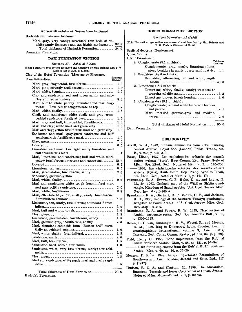
D146 GEOLOGY OF THE ARABIAN PENINSULA
SECTION 56. Jabal al Haydaruk Continued
Hadrukh Formation ContinuedMarl, gray, very sandy; occasional thin beds of off-
white sandy limestone and tan friable sandstone. __ 32. 5 Total thickness of Hadrukh Formation. -------- 84. 0
Dammam Formation.
DAM FORMATION SECTION
SECTION 57. Jabal al Liddm[Dam Formation type section measured and described by Max Steineke and T. W.
Koch in 1935 at Jabal al Lidam]Clay of the Hofuf Formation (Miocene or Pliocene). Dam Formation: (meters)*
Marl, gray, fragmental, fossiliferous-_______________ 1.0Marl, pink, strongly argillaceous.___-___--.-_____-_ 1.0Marl, white, tough_______________________________ 1.0Clay and sandstone; red and green sandy and silty
clay and red sandstone._____--__-_____-__-_____ 8. 0Marl, buff to white, pebbly; abundant red marl frag
ments. Thin bed of conglomerate at top_-------- 1. 7Marl, white, chalky.__-______-__.________--____-_ 1. 6Chalk and sandstone; white chalk and gray cross-
bedded sandstone; fossils at base_______________ 1.0Marl, gray and buff, thin-bedded, fossiliferous-______ 1. 0Marl and clay; white marl and green clay___-_----.- 1. 8Marl and clay; yellow fossiliferous marl and green clay. 1. 0 Sandstone and marl; gray-green sandstone and buff
conglomeratic fossiliferous marl._______.--_-__.__ 1.0Clay, green.____________________________________ 7. 5Covered._______________________________________ 0. 5Limestone and marl; tan tight sandy limestone and
buff fossiliferous marl._____-_---__.___-__----._ 1. 4Marl, limestone, and sandstone; buff and white marl,
yellow fossiliferous limestone and sandstone.------ 12. 6Covered.--______-___________-_--._____-__--____ 0. 5Limestone, tan, sandy.__________-_______-._-_.._- 0. 5Marl, greenish-tan, fossiliferous, sandy _ ____________ 2. 6Sandstone, greenish-yellow________________________ 1.0Marl, white, chalky.____-_____________._-__-----_ 0. 2Marl and sandstone; white tough foraminiferal marl
and gray oolitic sandstone.___-_______.-_--_---- 2. 0Marl, white, fossiliferous________________________ 8. 8Marl, off-white to yellow, chalky, sandy, fossiliferous;
Foraminifera common._________________________ 4. 8Limestone, tan, marly, fossiliferous; abundant Foram
inifera_______---___-_--__-___-__-_.-_-___--- 3. 6Marl, buff and white, tough_____________________ 1. 0Clay, green.____________________________________ 1. 8Limestone, greenish-tan, fossiliferous, sandy_...__-_- 1. 8 Marl, greenish-gray, fossiliferous, chalky__________ 7. 3Marl, abundant echinoids form "Button bed" essen
tially an echinoid coquina_____________________ 1.0Marl, white, chalky, foraminiferal_______________ 3. 5Sandstone, marly_______.__.______..___.______-__ 2. 0Marl, buff, fossiliferous-__--_____---_-_____-_-_-__ 1. 5Sandstone, hard, oolitic; few fossils_______________ 1.0Sandstone, white, very fossiliferous, marly; few echi-
noids___-_-_-_-_____---______-______-__-_-_-_- 2. 8Clay, green_____________________________________ 0. 5Marl and sandstone; white sandy marl and marly sand-
stone____-..-_._-_____---__------_--_.-----__. 0. 5
Total thickness of Dam Formation_ - _________ 90. 8Hadrukh Formation.
HOFUF FORMATION SECTION
SECTION 58. Near Al Huf-af[Hofuf Formation type section was measured and described by Max Steineke and
T. W. Koch in 1935 near Al Hufuf]
Surficial deposits (Quaternary).Unconformity.Hofuf Formation:
4. Conglomerate (9.1 m thick): '$£8%' Conglomerate, gray, marly, limestone; lime
stone boulders in marly quartz sancl matrix. 9. 1 3. Sandstone (48.6 m thick):
Sandstone, alternating red and white, argil laceous____________---__-__-____._____ 48. 6
2. Limestone (18.2 m thick):Limestone, white, chalky, sandy; weathers to
granular calcitic sand.__-_____.____-.____ 16. 2Limestone, brown, bench-forming. __________ 2. 0
1. Conglomerate (19.1 m thick):Conglomerate; red and white limestone boulder
and pebble.____________________________ 17. 1Marl, mottled greenish-gray and redd^h-
brown-._.____________-_-__-----.______ 2. 0
Total thickness of Hofuf Formation- _ _ _ _ 95. 0Dam Formation.
BIBLIOGRAPHY
Arkell, W. J., 1952, Jurassic ammonites from Jebel Tuwaiq, central Arabia: Royal Soc. [London] Philos. Trans., ser. B., v. 236, p. 241-313.
Basse, filiane, 1937, Les c6phalopodes cretacgs dcr massifs c6tiers syriens: [Syria], Haut-Comm. Rep. Franc. Syric ct Liban, Sec. fitud. Geol., Notes et M6m. v. 2, p. 165-200.
1940, Les cSphalopodes cr6tac6s des massifs c6tiers syriens: [Syria], Haut-Comm. R6p. Franc. Syric et Liban, Sec. fitud. Geol., Notes ct M6m. v. 3, p. 441-471.
Bramkamp, R. A., Brown, G. F., Holm, D. A., and Layne, N. M., Jr., 1963, Geologic map of the WadI as Sirhan quad rangle, Kingdom of Saudi Arabia: U.S. Geol. Survey Misc. Geol. Inv. Map 1-200 A.
Bramkamp, R. A., Gierhart, R. F., Brown, G. F., and Jackson, R. O., 1956, Geology of the southern Tuwayq quadrangle, Kingdom of Saudi Arabia: U.S. Geol. Survey Misc. Geol. Inv. Map 1-212 A.
Bramkamp, R. A., and Powers, R. W., 1958, Classification of Arabian carbonate rocks: Geol. Soc. America Bull., v. 69, p. 1305-1318.
Bellen, R. C. van, Dunnington, H. V., Wetzel, R., and Morton, D. M., 1959, Iraq in Dubcrtret, Louis, director, Lexiquc stratigraphique international, volume 3, Asie: Paris, Internat. Geol. Cong., Comm. Stratig., pt. lOa, 333 p. [I960].
Field, Henry C., 1958, Stone implements from the Rub' al Khali, Southern Arabia: Man, v. 58, no. 121, p. 9V94.
1960, Stone implements from the Rub' al Khali, SouthernArabia: M$m, v. 60, no. 30, p. 25-26.
Henson, F. R. VS., 1948, Larger imperforatc Foraminifera ofSouth-western Asia: London, Jarrold and Sons, Ltd., 117p. [1947].
Hudson, R. G. S., and Chatton, M., 1959, The Musandamlimestone (Jurassic and lower Cretaceous) of Oman, Arabia:Notes et Mem. Moyen-Orient, v. 7, p. 69-93.
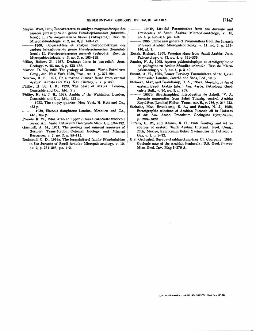
SEDIMENTARY GEOLOGY OF SAUDI ARABIA D147
Maync, Wolf, 1959, Biocaracteres et analyse morphome'trique des especes jurassiques du genre Pseudocyclammina (foramini- feres); I, Pseudocyclammina lituus (Yokoyama): Rev. de Micropale'ontologie, v. 2, no. 3, p. 153-172.
1960, Biocaracteres et analyse morphome'trique desespeces jurassiques du genre Pseudocyclammina (foramini-feres); II, Pseudocyclammina jaccardi (Schrodt): Rev. deMicropale'ontologie, v. 3, no. 2, p. 103-118.
Miller, Robert P., 1937, Drainage lines in bas-relief: Jour.Geology, v. 45, no. 4, p. 432-438.
Morton, D. M., 1959, The geology of Oman: World PetroleumCong., 5th, New York 1959, Proc., sec. 1, p. 277-294.
Newton, R. B., 1921, On a marine Jurassic fauna from centralArabia'. Annals and Mag. Nat. History, v. 7, p. 389.
Philby, H. St. J. B., 1922, The heart of Arabia: London,Constable and Co., Ltd., 2 v.
Philby, H. St. J. B., 1928, Arabia of the Wahhabis: London,Constable and Co., Ltd., 422 p.
1933, The empty quarter: New York, H. Holt and Co., 433 p.
1939, Sheba's daughters: London, Methuen and Co.,Ltd., 485 p.
Powers, R. W., 1962, Arabian upper Jurassic carbonate reservoirrocks: Am. Assoc. Petroleum Geologists Mem. 1, p. 122-192.
Quennell, A. M., 1951, The geology and mineral resources of(former) Trans-Jordon: Colonial Geology and MineralResources, v. 2, no. 2, p. 85-115.
Redmond, C. D., 1964a, The foraminiferal family Pfenderinidaein the Jurassic of Saudi Arabia: Micropaleontology, v. 10,no. 2, p. 251-263, pis. 1-2.
1964b, Lituolid Foraminifera from the Jurassic and Cretaceous of Saudi Arabia: Micropaleontology, v. 10, no. 4, p. 405-414, pis. 1-2.
1965, Three new genera of Foraminifera from the Jurassicof Saudi Arabia: Micropaleontology, v. 11, no. 2, p. 133- 140, pi. 1.
Rezak, Richard, 1959, Permian algae from Saudi Arabia: Jour. Paleontology, v. 33, no. 4, p. 531-539.
Sander, N. J., 1962, Apergu pale'ontologique et stratigraphique de palgoge'ne en Arabic Se"oudite orientale: Rev. de Micro pale'ontologie, v. 5, no. 1, p. 3-40.
Smout, A. H., 1954, Lower Tertiary Foraminifera of the Qatar Peninsula: London, Jarrold and Sons, Ltd., 96 p.
Steineke, Max, and Bramkamp, R. A., 1952a, Mesozoic ro^ks of eastern Saudi Arabia [abs.]: Am. Assoc. Petroleum Geol ogists Bull., v. 36, no. 5, p. 909.
1952b, Stratigraphical introduction in Arkell, w. J.,Jurassic ammonites from Jebel Tuwaiq, central Arabia: Royal Soc. [London] Philos., Trans., ser. B., v. 236, p. 241-313.
Steineke, Max, Bramkamp, R. A., and Sander, N. J., 1958, Stratigraphic relations of Arabian Jurassic oil in Habitat of oil: Am. Assoc. Petroleum Geologists Symposium, p. 1294-1329.
Thralls, H. W., and Hasson, R. C., 1956, Geology and oil re sources of eastern Saudi Arabia: Internat. Geol. Cong., 20th, Mexico, Symposium Sobre Yacimentos do Petroleo y Gas, v. 2, p. 9-32.
U.S. Geological Survey-Arabian-American Oil Company, 1963, Geologic map of the Arabian Peninsula: U.S. Geol. furvey Misc. Geol. Inv. Map 1-270 A.
U. S. GOVERNMENT PRINTING OFFICE : 1986 O - 22M76


