
Revised Draft Master Plan of LPA Derabassi 2031
NFInfratech Service Pvt. Ltd, New Delhi Page i
N—14, LG FLOOR, MALVIYA NAGAR, NEW DELHI-110017,
TEL: +911126673095, +911126682201
Email:[email protected]
REVISED MASTER PLAN
DERABASSI 2031
REPORT
DEPARTMENT OF TOWN AND
COUNTRY PLANNING, PUNJAB,
CLIENT
CONSUTANT

Revised Draft Master Plan of LPA Derabassi 2031
NFInfratech Service Pvt. Ltd, New Delhi Page ii
PREFACE
In today’s world where urban centres are growing at an astonishing pace, large amount
of resources are being spent on the development of various urban settlements but the
condition of these towns continues to deteriorate because of piecemeal nature of
expenditure and lack of definitive development schemes. In view of this, Department of
Town Planning, Punjab has undertaken the preparation of the Revised GIS based Master
Plans for Dera-Bassi Town for which the Department has outsourced the work to M/S
NF Infra tech Service Private Limited, New Delhi.
The studies involved in the preparation of Master Plan for Dera-Bassi (2015-2031)
concerns with the areas crucial to planning and development of the sub- region. It has
been a great privilege for M/S NF Infra tech Service Private Limited, New Delhi to
undertake the assignment of formulating the Revised Master Plan of Dera-Bassi (2015-
31). In this Master Plan, the development proposals have been framed after a detailed
study and analysis of the crucial issues related to economic development, infrastructure,
transportation, housing, environment and urban sustainability.
(Harnek Singh Dhillion)
Chief Town Planner
Town Planning Organisation, Punjab

Revised Draft Master Plan of LPA Derabassi 2031
NFInfratech Service Pvt. Ltd, New Delhi Page iii
TEAM COMPOSITION
Mr. Harnek Singh Dhillon Chief Town Planner, PUDA
Mr. Gurpreet Singh Senior Town Planner
Mrs. Gagandeep Kaur Brar District Town Planner
Mr. Jagdeep Singh Assistant Town Planner
Mr. Vinty Kaundal Draughtsman
Working Team (Consultant) NF Infratech Service Pvt. Ltd, New Delhi
Team
Mr. Manish Dahiya Senior Urban Planner
Mr. Rajat Gupta Urban Planner
Ms. Wajiha Aziz Urban Planner
Mr. Rahul Singh Manager-Urban Projects
Mr. Abhishek Singh Senior GIS Expert
Revised Draft Master Plan of LPA Derabassi 2031
NFInfratech Service Pvt. Ltd, New Delhi Page iv
TABLE OF CONTENTS
List of Figures ................................................................................................. vi
List of Tables ................................................................................................. vii
1 Introduction & Project Understanding ..................................................... 9 1.1 Background & Project Understanding ....................................................................... 9
1.1.1 Broad steps in Existing Master Plan ................................................................... 9
1.1.2 Vision .......................................................................................................... 10
1.2 Scope of work Overview ....................................................................................... 10
2 Regional Context & Setting .................................................................... 12 2.1 Introduction ........................................................................................................ 12
2.2 Location Context ................................................................................................. 13
2.3 Regional Setting and Connectivity ......................................................................... 13
2.4 GMR Regional Master Plan .................................................................................... 14
2.4.1 Residential Development ............................................................................... 16
2.4.2 Commercial & Mixed Land use development ..................................................... 17
2.4.3 Institutional/ Health Development .................................................................. 19
2.4.4 Industrial development .................................................................................. 20
2.5 Transportation .................................................................................................... 21
2.5.1 Road Connectivity ......................................................................................... 22
2.5.2 Rail connectivity ........................................................................................... 23
2.5.3 Airport ........................................................................................................ 25
3 Master Plan-2031 for local planning area Dera Bassi ............................. 27 3.1 Land use & Proposed Development ........................................................................ 27
3.1.1 Industrial ..................................................................................................... 28
3.1.2 Residential ................................................................................................... 29
3.1.3 Forest reserve, green and open space ............................................................. 29
3.1.4 Institution and recreation .............................................................................. 29
3.1.5 Transportation ............................................................................................. 29
4 Revision for the Master Plan 2008-2031 for Local Planning Area ........... 31 4.1 Vision of the revised Master Plan ........................................................................... 31
4.2 Development Goals.............................................................................................. 31
4.3 Master plan Approach for DeraBassi ....................................................................... 31
4.3.1 Approach and Methodology ............................................................................ 32
4.3.2 Detailed Methodology adopted for the preparation of revised Master
plan/Zonal/Sector plan ................................................................................................... 32
5 Existing Land use LPA Derabassi ............................................................ 36 5.1 Existing land use Derabassi .................................................................................. 37
5.1.1 Residential ................................................................................................... 37
5.1.2 Commercial ................................................................................................. 38
5.1.3 Industrial ..................................................................................................... 39
5.1.4 Institutional ................................................................................................. 40
5.1.5 Circulation ................................................................................................... 41
Revised Draft Master Plan of LPA Derabassi 2031
NFInfratech Service Pvt. Ltd, New Delhi Page v
5.1.6 Utilities ........................................................................................................ 42
5.2 Existing Urban & Rural Area .................................................................................. 44
5.3 Connectivity ....................................................................................................... 44
5.3.1 Road Connectivity ......................................................................................... 44
5.3.2 Rail Connectivity ........................................................................................... 44
5.3.3 Air Connectivity ............................................................................................ 45
5.4 Characteristics of Derabassi .................................................................................. 45
5.4.1 Climate and Physiographic ............................................................................. 45
5.4.2 Demography ................................................................................................ 45
5.4.3 Economic Base ............................................................................................. 47
6 Existing Social and Physical Infrastructure & Projections ...................... 49 6.1 Social Infrastructure ............................................................................................ 49
6.1.1 Health Facilities ............................................................................................ 49
6.1.2 Education .................................................................................................... 51
6.2 Physical Infrastructure: ........................................................................................ 52
6.2.1 Water Supply ............................................................................................... 52
6.2.2 Drainage ..................................................................................................... 53
6.2.3 Solid waste .................................................................................................. 53
6.2.4 Power Supply ............................................................................................... 53
7 Population Projection & Density ............................................................. 54 7.1 Population Projection & Density ............................................................................. 54
7.2 Revised Estimates for Population Projection 2031 .................................................... 54
7.3 Projections as per Norms and Standard .................................................................. 54
7.3.1 Planning Norms for Education Institution ......................................................... 54
7.3.2 Norms for Healthcare Facilities ....................................................................... 55
7.3.3 Norms for Fire station and security infrastructure ............................................. 55
7.3.4 Norms for Socio Cultural Facility ..................................................................... 56
7.3.5 Norms for Sports Activities ............................................................................ 56
7.3.6 Parks Open Spaces and Play Grounds .............................................................. 57
7.3.7 Other Amenities ........................................................................................... 57
7.3.8 Utility Network ............................................................................................. 58
7.4 Physical Infrastructure ......................................................................................... 58
7.4.1 Norms for water supply ................................................................................. 58
7.4.2 Norms for Sewage ........................................................................................ 58
7.4.3 Norms for solid waste.................................................................................... 59
8 Deviations in Previous Master Plan ........................................................ 60
9 Proposed Land use ................................................................................. 64 9.1 Residential ......................................................................................................... 66
9.2 Industrial ........................................................................................................... 66
9.3 Mixed land use .................................................................................................... 68
9.4 Transportation .................................................................................................... 68
Revised Draft Master Plan of LPA Derabassi 2031
NFInfratech Service Pvt. Ltd, New Delhi Page vi
9.5 Sports and Recreational ....................................................................................... 68
9.6 Green Buffer ....................................................................................................... 69
10 Controls and Detailed Controls for Dera Bassi ........................................ 70 10.1 Residential ......................................................................................................... 70
10.2 Commercial ........................................................................................................ 71
10.2.1 Intensity of Development .............................................................................. 78
10.2.2 High-Technology/ It Park Development Regulations .......................................... 79
10.3 Parking guidelines ............................................................................................... 81
10.4 Landscaping ....................................................................................................... 81
10.5 Other development controls and guidelines required ................................................ 81
10.6 Pollution Control Requirements ............................................................................. 82
10.7 Toxic Industrial Waste Control .............................................................................. 84
10.8 Control of Land Pollution and Remediation of Contaminated Sites .............................. 84
10.9 Transferable Development Rights .......................................................................... 84
List of Figures
Figure 2-1: DeraBassi regional context ................................................................................ 13
Figure 2-2: Regional Plan Land use-GMR LPA area ................................................................ 15
Figure 2-3 Proposed Residential Land use within GMR ............................................................ 16
Figure 2-4 Strategic Economic Focal Points of growth ............................................................ 17
Figure 2-5 Proposed Commercial Nodes ............................................................................... 18
Figure 2-6 Proposed Institutional Zones ............................................................................... 19
Figure 2-7 Proposed Industrial Growth ................................................................................. 20
Figure 2-8 Transportation Plan ............................................................................................ 21
Figure 2-9 Proposed road network, lane requirement and proposed interchanges ...................... 22
Figure 2-10 Regional Railway Network ................................................................................. 23
Figure 2-11 Existing Railway Network .................................................................................. 24
Figure 2-12 Existing Airport Location & Access road .............................................................. 25
Figure 2-13 New Airport Terminal Location and Proposed Access Road ..................................... 26
Figure 3-1 Proposed Land use Classification as per Master plan 2031 ...................................... 28
Figure 4-1: Broad steps involved in revised master plan ........................................................ 31
Figure 5-1 Existing residential of LPA Derabassi .................................................................... 37
Figure 5-2 Commercial areas of LPA Derabassi ..................................................................... 38
Figure 5-3 Industrial distribution in LPA Derbassi .................................................................. 39
Figure 5-4 Institutions in LPA Derabassi ............................................................................... 40
Figure 5-5 Existing road network in LPA Derabassi ................................................................ 41
Figure 5-6 Existing Utilities in LPA Derabassi ........................................................................ 42
Figure 5-7 Existing Land Use of LPA Derabassi 2015 .............................................................. 43
Figure 5-8 Total Population of the Dera-Bassi (1971-2011) .................................................... 46
Figure 5-9 Population Growth Rate % of DeraBassi 1971-2011 ............................................... 46
Figure 5-10: Urban literacy rate 2011 .................................................................................. 47
Figure 5-11 Urban Sex Ratio 2011 ...................................................................................... 47
Figure 5-12: Worker’s Classification 2011 ............................................................................ 48
Revised Draft Master Plan of LPA Derabassi 2031
NFInfratech Service Pvt. Ltd, New Delhi Page vii
Figure 8-1 Industries and Residential development against Proposed roads e.g. PR-10 in
Mubarakpur and Sauda Majra. ............................................................................................ 60
Figure 8-2 Industrial units against the proposed road hierarchy along Barwala road in Saidpura,
Kurranwala, and Haripur Hindaun. ...................................................................................... 61
Figure 8-3 Growth of Commercial, Industrial and Residential units against proposed roads in
Bakarpur, Devinagar and Haripur Kurran. ............................................................................ 62
Figure 8-4 Development of residential colonies on proposed alignment of PR-11 in Jagadhari and
Isapur Villages .................................................................................................................. 63
Figure 9-1 Proposed Landuse LPA DeraBassi 2035................................................................. 65
List of Tables
Table 2-1 Road distance of the DeraBassi town from the surrounding urban centres .................. 13
Table 2-2 Greater Mohali Region- Land Use Distribution ......................................................... 14
Table 2-3 Greater Mohali Region- Urbanisable Area Land use distribution ................................. 14
Table 3-1 Proposed Land use Classification as per Master plan 2031 ........................................ 27
Table 5-1 Existing Land use distribution of LPA Derabassi ...................................................... 36
Table 5-2 Urban Areas of LPA Derabassi .............................................................................. 44
Table 5-3 villages of LPA Derabassi ..................................................................................... 44
Table 5-4: Urban population analysis ................................................................................... 45
Table 5-5: Comparative household size analysis- India, State, District and Town ...................... 45
Table 5-6 Decadal Growth Rate 1971-2011 of DeraBassi town ................................................ 45
Table 5-7 Work Force Participation Ratio of DeraBassi town 2011............................................ 48
Table 5-8: Occupational structure of DeraBassi town ............................................................. 48
Table 6-1 Heath care Facilities in the Derabassi town ............................................................ 49
Table 6-2 Health facilities in Zirakpur LPA ............................................................................ 50
Table 6-3 Category wise number of schools in Derabassi ....................................................... 51
Table 6-4 Educational Facilities in the LPA Derabassi ............................................................. 52
Table 6-5 Water Supply Service Details ............................................................................... 52
Table 6-6 Number of Electricity connections in Derabassi ....................................................... 53
Table 7-1 Norms for Education Facilities ............................................................................... 55
Table 7-2 Norms for Healthcare Facilities ............................................................................. 55
Table 7-3 Norms for Safety Facility ..................................................................................... 56
Table 7-4 Norms for Socio-Cultural Facility ........................................................................... 56
Table 7-5 Norms for Sports Activities................................................................................... 57
Table 7-6 Requirement of Parks and open spaces .................................................................. 57
Table 7-7 Norms for petrol pumps and projected requirements ............................................... 58
Table 7-8 Norms for Milk parlour and projected requirements ................................................. 58
Table 7-9 Water supply norms and projected requirements .................................................... 58
Table 7-10 Sewage water projections .................................................................................. 58
Table 7-11 Solid waste projections ...................................................................................... 59
Table 9-1 Proposed Land use Distribution of LPA DeraBassi 2031 ............................................ 64
Table 9-2 List of “Red” industries ........................................................................................ 67
Table 10-1 Minimum Plot size ............................................................................................. 70
Revised Draft Master Plan of LPA Derabassi 2031
NFInfratech Service Pvt. Ltd, New Delhi Page viii
Table 10-2 Group Housing (outside M.C. limits) .................................................................... 70
Table 10-3 Farm House ..................................................................................................... 71
Table 10-4 Criteria for stand – alone commercial complexes (more than double storey’s) .......... 71
Table 10-5 Green & physical buffer specifications .................................................................. 75
Table 10-6 Quantum control for uses within each leased space by each individual unit in multiple-
user development ............................................................................................................. 77
Table 10-7 Intensity of development (overall) ..................................................................... 78
Table 10-8 Permitted activities in High Technology/ IT park ................................................... 79
Table 10-9 Proposed Land Use Legend & Zoning Interpretation for Dera-Bassi Local Planning Area
...................................................................................................................................... 85
Revised Draft Master Plan of LPA Derabassi 2031
NFInfratech Service Pvt. Ltd, New Delhi Page 9
1 Introduction & Project Understanding
1.1 Background & Project Understanding
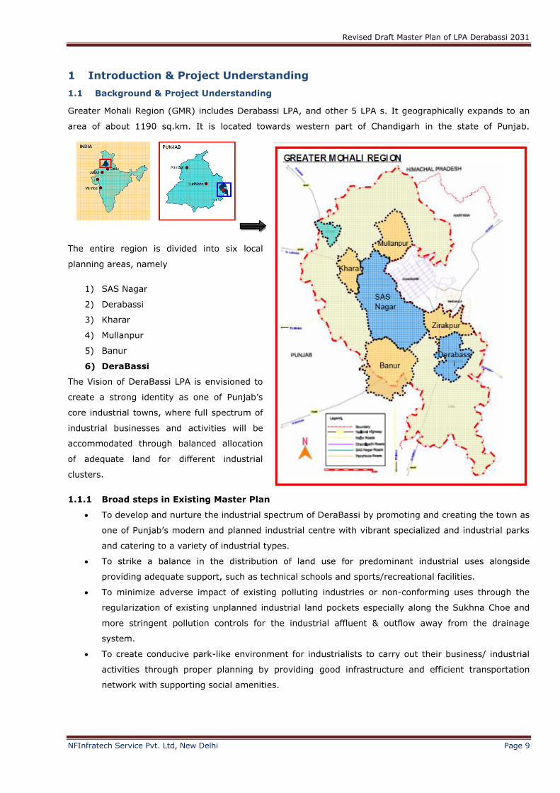
Greater Mohali Region (GMR) includes Derabassi LPA, and other 5 LPA s. It geographically expands to an
area of about 1190 sq.km. It is located towards western part of Chandigarh in the state of Punjab.
The entire region is divided into six local
planning areas, namely
1) SAS Nagar
2) Derabassi
3) Kharar
4) Mullanpur
5) Banur
6) DeraBassi
The Vision of DeraBassi LPA is envisioned to
create a strong identity as one of Punjab’s
core industrial towns, where full spectrum of
industrial businesses and activities will be
accommodated through balanced allocation
of adequate land for different industrial
clusters.
1.1.1 Broad steps in Existing Master Plan
To develop and nurture the industrial spectrum of DeraBassi by promoting and creating the town as
one of Punjab’s modern and planned industrial centre with vibrant specialized and industrial parks
and catering to a variety of industrial types.
To strike a balance in the distribution of land use for predominant industrial uses alongside
providing adequate support, such as technical schools and sports/recreational facilities.
To minimize adverse impact of existing polluting industries or non-conforming uses through the
regularization of existing unplanned industrial land pockets especially along the Sukhna Choe and
more stringent pollution controls for the industrial affluent & outflow away from the drainage
system.
To create conducive park-like environment for industrialists to carry out their business/ industrial
activities through proper planning by providing good infrastructure and efficient transportation
network with supporting social amenities.
Revised Draft Master Plan of LPA Derabassi 2031
NFInfratech Service Pvt. Ltd, New Delhi Page 10
To place greater environmental emphasis on landscaping at all important nodes and entrances in
the specialized industrial parks and industrial areas, so as to project themselves as eco-friendly,
green specialized industrial parks and introduce new planned urbanized image for DeraBassi.
To provide a variety of housing types and adequate accommodation to house the new working
population projected to work in the ‘Free Enterprise Zone’.
1.1.2 Vision
The Vision of the revised plan is to introduce strategic economic growth initiative in a sustainable manner
such that it is:
Economically Viable
Regionally Contextual
Environmentally Sustainable
Socially beneficial
Institutionally Executable
Politically Acceptable
1.2 Scope of work Overview
The scope of work of the following project is as follows:
Analysis of existing master plan proposals and to come up with recommendations to improve
the overall Master Plan;
Verification of revenue based existing land use plan and master plan for proper
implementation and ground-truthing of existing development indicating the khasra nos.
Review of already approved layout plans of different promoters in order to check the
congeniality and contiguity of the approved layout plans and to suggest measures for improving the
congeniality and contiguity across these layout plans;
Revenue based updation of Existing Land Use Plan using GIS platform;
Detailing of Proposed Land use plan indicating the detailed land use planning along with
traffic and transportation plan, infrastructure plan etc.
Preparation of detailed landscape plan including planning and design of special landscape areas;
Preparation of Sector/ Zonal Plans;
Suggesting amendments in infrastructure/ service plans if any, which will include location of STPs/
Water Works/ Electric Grid Stations etc. and design of water supply, sewerage, Storm water,
electricity networks etc.
Suggesting changes wherever require in the zoning regulations/ development controls/ density
norms for each and every pocket depicted in the Sector/ Zonal plans of the Master plan;
Incorporating all the amendments if any, suggested by the Punjab Regional and Town
Planning and Development Board after considering the objections/ suggestions received from
the general public in response to the Public notice.
A proper Implementation Schedule
The sector/ zonal plans for all zones in conformity with the proposals of the Master Plan should
provide the following details:
Revised Draft Master Plan of LPA Derabassi 2031
NFInfratech Service Pvt. Ltd, New Delhi Page 11
Every sector/ zonal plan shall be based on revenue map of the area and shall have area varying
between 150 to 200 acres.
Sector/ zonal plans shall be at the scale of 1:2500. The scale can be altered, wherever it is not
possible to make the plan on this scale but care has to be taken that the altered scale should be
suitable to depict all the details in the zonal plan clearly.
Every sector/ zonal plan shall depict the land use, road circulation, public and semi-public facilities,
utilities, green/ landscape areas, etc. as proposed in the Master Plan and as per requirements of
that particular sector/ zone. The areas proposed for public uses/ green spaces, etc. shall be
judiciously distributed in the overall sector.
The road hierarchy of the sector/ zone shall consist of sector roads, intra sector roads and intra
cluster roads having road width 200’, 100’ and 80’/ 60’ roads respectively. Every intra cluster road
should touch every 50 acre chunk of land falling anywhere in the sector, also ensure the integration
of road circulation with the adjoining sectors.
The zoning regulations/ development controls for each land use falling in the sector/ zone is to be
prepared, keeping in view the various legal provisions/ policies/ guidelines/ restrictions issued by
the Government from time to time for the regulation of various land uses/ buildings.
The road cross sections of all the roads proposed are to be prepared.
Revised Draft Master Plan of LPA Derabassi 2031
NFInfratech Service Pvt. Ltd, New Delhi Page 12
2 Regional Context & Setting
2.1 Introduction
DeraBassi is a satellite town of Chandigarh at a distance of 21 kilometres located in the Derabassi
tehsil of Sahibzada Ajit Singh Nagar (Mohali) district in the state of Punjab. DeraBassi LPA is a part of
Greater Mohali Regional planning area.
DeraBassi is a city and a municipal council in Mohali district in the state of Punjab, India. Derabassi
comes under tehsil DeraBassi. DeraBassi is located on the Chandigarh – Delhi National Highway, 20
km from Chandigarh. It is strategically located near the boundary of Haryana, Himachal Pradesh and
Union territory of Chandigarh.
DeraBassi Local Planning Area is towards the north-east of Chandigarh. It is bounded by NH22, Major
District Road - D and PR10.
Revised Draft Master Plan of LPA Derabassi 2031
NFInfratech Service Pvt. Ltd, New Delhi Page 13
2.2 Location Context
2.3 Regional Setting and Connectivity
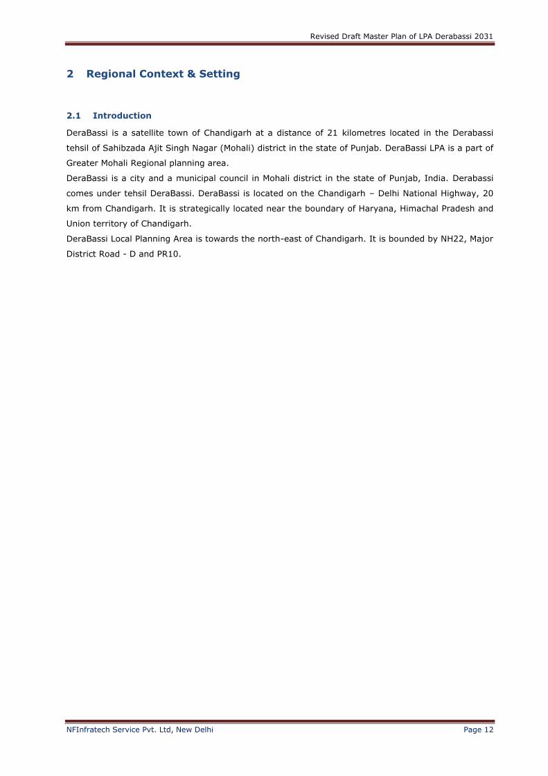
DeraBassi lies on National Highway-21, about 21 km away from Chandigarh. The town is bounded by
Panchkula in North and Ambala in South district of Haryana. It is bordered by Patiala district of
Punjab in West Side.
Table 2-1 Road distance of the DeraBassi town from the surrounding urban centres
S. No Town Distance (Km.)
1 Chandigarh (State Capital of Punjab & Haryana 21
2 Panchkula, H.R 18
3 Mohali, SAS Nagar (District Headquarter) 27
4 Derabassi 9
5 Ambala, Haryana 29
6 Patiala 49
7 Ludhiana 121
8 Shimla, H.P 122
9 Amritsar 262
Figure 2-1: DeraBassi regional context
Revised Draft Master Plan of LPA Derabassi 2031
NFInfratech Service Pvt. Ltd, New Delhi Page 14
2.4 GMR Regional Master Plan
JURONG Consultants Pte Ltd was engaged to undertake preparation of Vision plan, Regional Plan &
Master plans for the six local planning areas. The Regional Plan maps out the vision for the GMR and
long term physical development for a projected population of 4.5 million people. The master plan
identifies the land use zones to guide future development. Regional Plans also specify the ancillary,
related or compatible activities allowed within each zone.
Table 2-2 Greater Mohali Region- Land Use Distribution S. No. Use Area Percentage
1 Urbanizable area 42,740 35.9
2 Industrial 2,478 2.1
3 Rural settlements 4,567 3.8
4 Agriculture area within LPA 18,483 15.5
5 Agriculture area outside LPA 24,990 21.0
6 Recreational 4,370 3.7
7 Forests 12,281 10.3
8 Water bodies 2,890 2.4
9 Transportation 4,885 4.1
10 Restricted development zone 1,351 1.1
Total 119,036 100
Table 2-3 Greater Mohali Region- Urbanisable Area Land use distribution S. No. Land Use Area Percentage
1 Residential 22065 52%
2 Commercial 4654 11%
3 Industrial 6914 16%
4 Institutional 5213 12%
5 Recreational & Open Spaces 3894 9%
6 Total 42740 100%
Revised Draft Master Plan of LPA Derabassi 2031
NFInfratech Service Pvt. Ltd, New Delhi Page 15
Figure 2-2: Regional Plan Land use-GMR LPA area
Source: GMR Regional Plan-2056
Revised Draft Master Plan of LPA Derabassi 2031
NFInfratech Service Pvt. Ltd, New Delhi Page 16
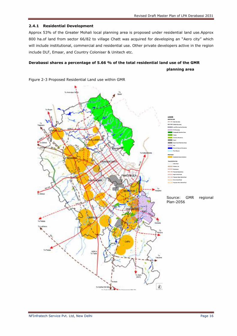
2.4.1 Residential Development
Approx 53% of the Greater Mohali local planning area is proposed under residential land use.Approx
800 ha.of land from sector 66/82 to village Chatt was acquired for developing an “Aero city” which
will include institutional, commercial and residential use. Other private developers active in the region
include DLF, Emaar, and Country Coloniser & Unitech etc.
Derabassi shares a percentage of 5.66 % of the total residential land use of the GMR
planning area
Source: GMR regional Plan-2056
Figure 2-3 Proposed Residential Land use within GMR

Revised Draft Master Plan of LPA Derabassi 2031
NFInfratech Service Pvt. Ltd, New Delhi Page 17
2.4.2 Commercial & Mixed Land use development
Figure 2-4 Strategic Economic Focal Points of growth
Source: GMR Regional Plan-2056
Revised Draft Master Plan of LPA Derabassi 2031
NFInfratech Service Pvt. Ltd, New Delhi Page 18
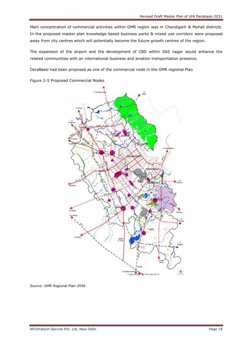
Main concentration of commercial activities within GMR region was in Chandigarh & Mohali districts.
In the proposed master plan knowledge based business parks & mixed use corridors were proposed
away from city centres which will potentially become the future growth centres of the region.
The expansion of the airport and the development of CBD within SAS nagar would enhance the
related communities with an international business and aviation transportation presence.
DeraBassi had been proposed as one of the commercial node in the GMR regional Plan
Figure 2-5 Proposed Commercial Nodes
Source: GMR Regional Plan-2056
Revised Draft Master Plan of LPA Derabassi 2031
NFInfratech Service Pvt. Ltd, New Delhi Page 19
2.4.3 Institutional/ Health Development
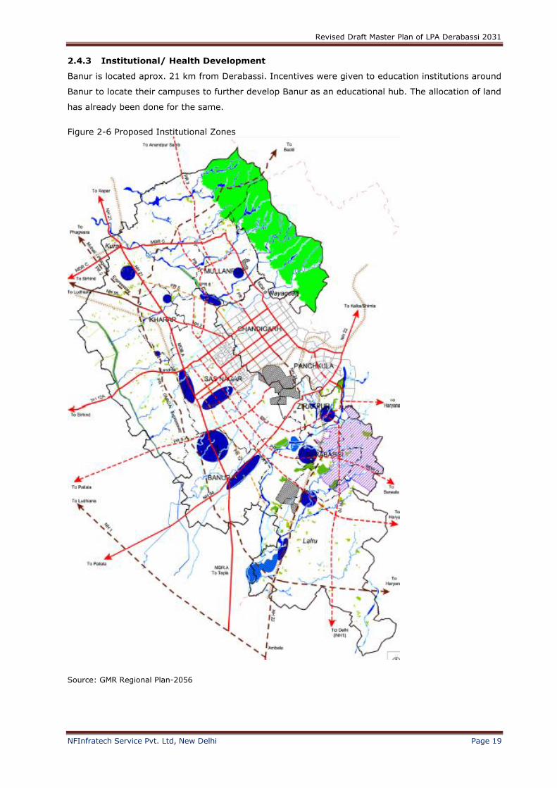
Banur is located aprox. 21 km from Derabassi. Incentives were given to education institutions around
Banur to locate their campuses to further develop Banur as an educational hub. The allocation of land
has already been done for the same.
Figure 2-6 Proposed Institutional Zones
Source: GMR Regional Plan-2056
Revised Draft Master Plan of LPA Derabassi 2031
NFInfratech Service Pvt. Ltd, New Delhi Page 20
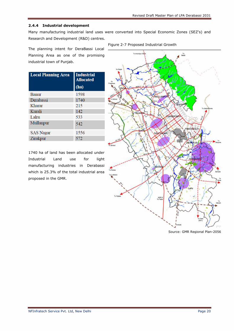
2.4.4 Industrial development
Many manufacturing industrial land uses were converted into Special Economic Zones (SEZ’s) and
Research and Development (R&D) centres.
The planning intent for DeraBassi Local
Planning Area as one of the promising
industrial town of Punjab.
1740 ha of land has been allocated under
Industrial Land use for light
manufacturing industries in Derabassi
which is 25.3% of the total industrial area
proposed in the GMR.
Figure 2-7 Proposed Industrial Growth
Source: GMR Regional Plan-2056

Revised Draft Master Plan of LPA Derabassi 2031
NFInfratech Service Pvt. Ltd, New Delhi Page 21
2.5 Transportation
Figure 2-8 Transportation Plan
Source: GMR Regional Plan-2056
The above Map shows that the DeraBassi is well connected by Road and Railway and a new road is
also proposed to enhance the road connectivity to the SAS Nagar.

Revised Draft Master Plan of LPA Derabassi 2031
NFInfratech Service Pvt. Ltd, New Delhi Page 22
2.5.1 Road Connectivity
The GMR is well connected to its hinterland through a network of National Highways, State Highways
and Major District Roads
S.No. Name of Road
1 NH-1 To Ambala and Further to Delhi
2 NH-21 To Roper
3 NH-22 To Shimla
4 NH-95 Ludhiana
PR 11: Connection to DerraBassi. This proposed major arterial road running in a south-east
direction. North of PR 8 is required to cater for the high demand flows in the south-east direction
from SAS Nagar. At Derabassi, the proposed road connects to the existing MDR -D.
Figure 2-9 Proposed road network, lane requirement and proposed interchanges
Source:
GMR Regional
Plan 2056
Revised Draft Master Plan of LPA Derabassi 2031
NFInfratech Service Pvt. Ltd, New Delhi Page 23
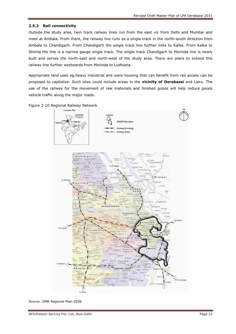
2.5.2 Rail connectivity
Outside the study area, twin track railway lines run from the east viz from Delhi and Mumbai and
meet at Ambala. From there, the railway line runs as a single track in the north-south direction from
Ambala to Chandigarh. From Chandigarh the single track line further links to Kalka. From Kalka to
Shimla the line is a narrow gauge single track. The single track Chandigarh to Morinda line is newly
built and serves the north-east and north-west of the study area. There are plans to extend this
railway line further westwards from Morinda to Ludhiana.
Appropriate land uses eg.heavy industrial and ware housing that can benefit from rail access can be
proposed to capitalize. Such sites could include areas in the vicinity of Derabassi and Lalru. The
use of the railway for the movement of raw materials and finished goods will help reduce goods
vehicle traffic along the major roads.
Figure 2-10 Regional Railway Network
Source: GMR Regional Plan-2056
Revised Draft Master Plan of LPA Derabassi 2031
NFInfratech Service Pvt. Ltd, New Delhi Page 24
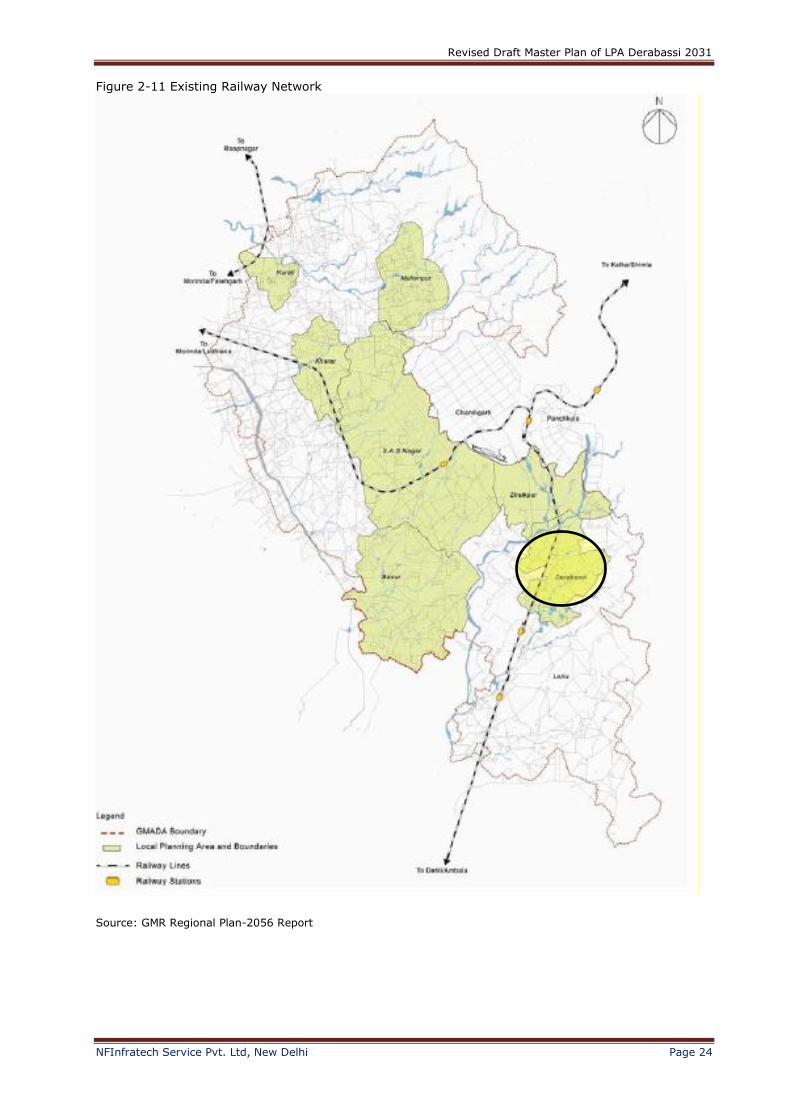
Figure 2-11 Existing Railway Network
Source: GMR Regional Plan-2056 Report
Revised Draft Master Plan of LPA Derabassi 2031
NFInfratech Service Pvt. Ltd, New Delhi Page 25
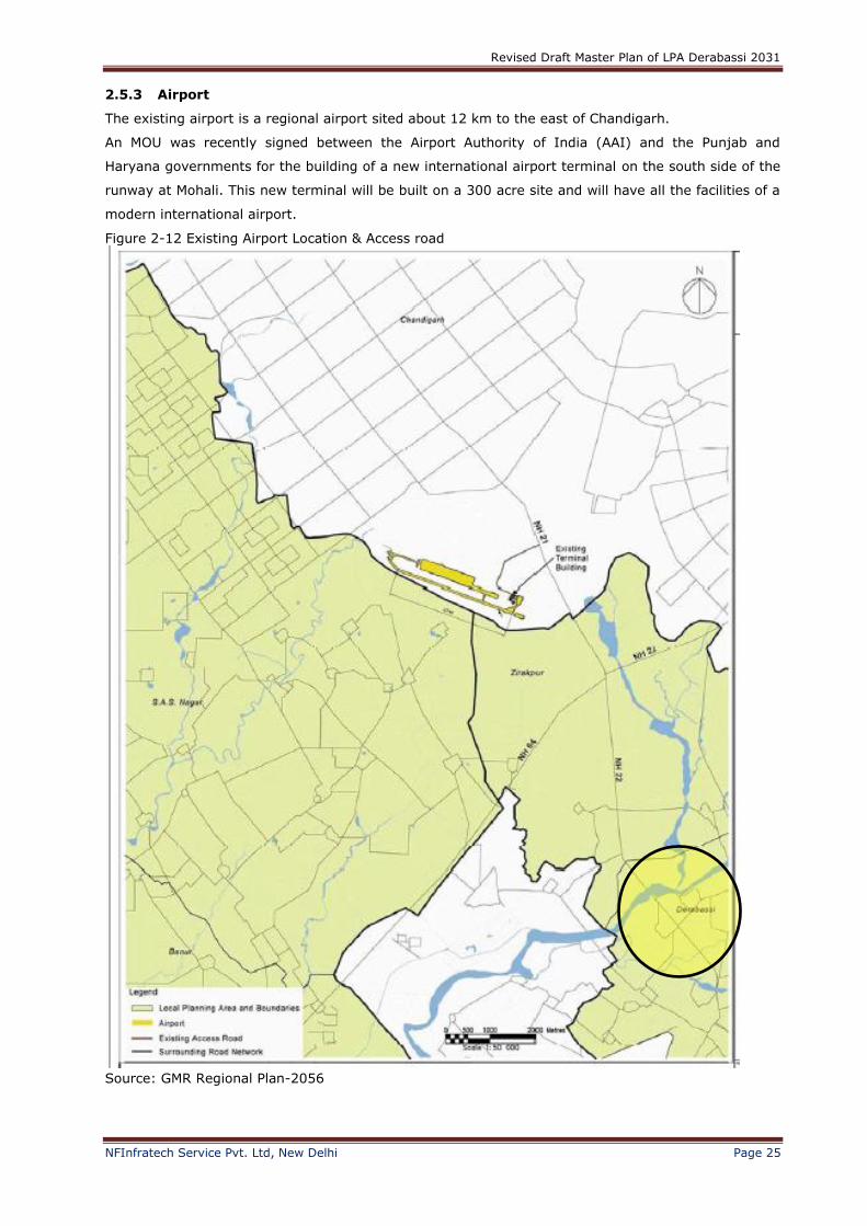
2.5.3 Airport
The existing airport is a regional airport sited about 12 km to the east of Chandigarh.
An MOU was recently signed between the Airport Authority of India (AAI) and the Punjab and
Haryana governments for the building of a new international airport terminal on the south side of the
runway at Mohali. This new terminal will be built on a 300 acre site and will have all the facilities of a
modern international airport.
Figure 2-12 Existing Airport Location & Access road
Source: GMR Regional Plan-2056

Revised Draft Master Plan of LPA Derabassi 2031
NFInfratech Service Pvt. Ltd, New Delhi Page 26
Figure 2-13 New Airport Terminal Location and Proposed Access Road
Source: GMR Regional Plan-2056

Revised Draft Master Plan of LPA Derabassi 2031
NFInfratech Service Pvt. Ltd, New Delhi Page 27
3 Master Plan-2031 for local planning area Dera Bassi
In the course of planning the LPA for Dera Bassi, planning issues were surfaced and clarified with
GMADA prior to the conceptualizing the final plan for Dera Bassi. The planning proposals for Dera
Bassi would outline the development objectives of the town. The focus of the land use proposal was
to ensure adequate and balanced spread of residential and industrial land so that sustainability could
be achieved. Active allocation of complementing land uses was displayed through seamless
integration of land uses, transport and economic activities. Land to be accommodated for the Year
2031 and 2056 will be covered in this plan.
3.1 Land use & Proposed Development
Table 3-1 Proposed Land use Classification as per Master plan 2031 Land use Classification Proposed for 2031
Area(Ha) Percentage (%)
Residential 433 8
Mixed use 0 0
Industrial 774 15
Industrial-Mixed 152 3
High Technology/IT 121 2
Forest reserve 181 3
Existing river 182 4
River reserve 213 4
Green & open space 120 2
Roads & rail 461 9
Recreational 18 less than 1 %
Institutional 42 1
Existing built-up 515 10
Utilities 35 1
Rural & agricultural 1,780 34
Development area 5,193 100

Revised Draft Master Plan of LPA Derabassi 2031
NFInfratech Service Pvt. Ltd, New Delhi Page 28
Source: Master Plan DeraBassi-2031
3.1.1 Industrial
A total land area of 295 ha had been designated for the use of Pharmaceutical & Chemical Park on
the north-eastern part of DeraBassi. On ground, there were already quite a number of established
and prominent industrial developments involved in pharmaceuticals and life sciences, such as Nectar
Life Science and HPL Additives.
About 68 ha of land had been designated for the use of the “Red” category industries. Such allocation
of land for this use will guide effective land use planning and help industrialists to select suitable
industrial premises for their businesses.
Labour intensive and unclean industrial activities such as brick kilns, sand mining and stone crushers
which generate more adverse effects to the environment could bezoned as Heavy industries.
The rest of other light industrial activities and trades which were on-going in DeraBassi would be
zoned as General industries.
About 152 ha of land near the central and along the south of DeraBassi LPA had also been proposed
for the use of Industry Mixed.
About 121 ha of land was safeguarded for the use of high technology and value-added kind of
industrial development in form of Science, R&D, IT and biotechnology parks.
This use was specifically set aside for non-pollutive industries and businesses that engage in high-
technology, research and development, high value-added and knowledge-intensive activities.
Figure 3-1 Proposed Land use Classification as per Master plan 2031

Revised Draft Master Plan of LPA Derabassi 2031
NFInfratech Service Pvt. Ltd, New Delhi Page 29
3.1.2 Residential
The residential land use quantum for the Year 2031 had been provided at 433 ha, which was about
8% of the total development area for DeraBassi.
In the plan for the Year 2031, the residential area was largely located in the central part of the town,
within and adjoining the Municipal Limits boundary.
The High Density housing was proposed along a corridor fronting the Sukna Choe with the existing
built-up areas for DeraBassi town and along the railway belt.
The Low Density residential areas were tucked away from the public where there was seclusion from
bustling activities. This was to introduce exclusivity for use of private villas and bungalow housing for
residents who prefer more exclusive and natural living environment.
The remaining land of 315 ha was for the Medium Density housing, which was planned as a transition
area between the High and the Low Density housing areas.
The residential land use quantum for EWS takes up 10% of the High Density residential land use.
3.1.3 Forest reserve, green and open space
Presently, there were already two large tracts of forest areas covering a total land area of 181 ha
within DeraBassi deemed as protected forest reserved to preserve the natural characteristic of the
town.
To preserve the natural characteristics of the town, a 120 ha of land was proposed for the use of
green linkages, buffers and open space.
3.1.4 Institution and recreation
For year 2031, 18 ha of land was proposed for recreational use and 42 ha of land for institutional
use.
3.1.5 Transportation
For proposed transportation plan for Year 2031 for DeraBassi, new road proposals had been brought
in the road network of LPA. Widen of accesses and roads to the villages had been proposed.
The following list points out the proposed road connectivity which has been adopted and planned for
DeraBassi LPA.
There would be an improvement to the alignment of PR11, where it would be diverted
north of the existing DeraBassi town centre via a flyover, instead of cutting through the
existing town centre which would lead to acquisition of private land and properties.
The existing road would be retained as a lower hierarchical road to protect the existing
businesses fronting this down-graded road.
PR10 would connect northwards to PR7 for linkage to Zirakpur and southwards to Lalru,
ultimately forming road linkage to the proposed GMADA Expressway (PR 1). PR8 which
borders the DeraBassi periphery on the south eventually links to PR10 to form an alternative
connection to the proposed GMADA Expressway (PR 1).
A new minor arterial would connect PR8 to PR7 as this route will be necessary to
provide access to the existing developments at Old Kalka Road
The existing village road through the protected forest area would be retained

Revised Draft Master Plan of LPA Derabassi 2031
NFInfratech Service Pvt. Ltd, New Delhi Page 30
A new collector road through the FEZ connecting to PR10 would also be proposed to
improve the connectivity of the FEZ as an entity and internalize the traffic movements.
Collector road, CL10 will link to NH22 as a Left-In- Left-Out (LILO)
A new collector road was proposed to provide better linkage of the industrial lands at the
north of DeraBassi (beyond DeraBassi LPA boundary).
A new collector road was introduced at the south of DeraBassi (just beyond the forest
reserve outside DeraBassi LPA) so as to provide more direct routes to connect the residential
areas in the south.
Revised Draft Master Plan of LPA Derabassi 2031
NFInfratech Service Pvt. Ltd, New Delhi Page 31
4 Revision for the Master Plan 2008-2031 for Local Planning Area
4.1 Vision of the revised Master Plan
The Vision of the revised plan will be:
1) Introducing strategic economic growth initiative in a sustainable manner
2) Promoting a comprehensive planned township that will enhance quality living, ensuring
accessibility and managing overall growth.
4.2 Development Goals
The key development goals for the preparation of revised integrated master plan for DeraBassi will be
such that it would be
• Socially beneficially
• Regionally connected
• Environmentally sustainable
• Financially Viable
• Institutionally Executable and ;
• Politically acceptable
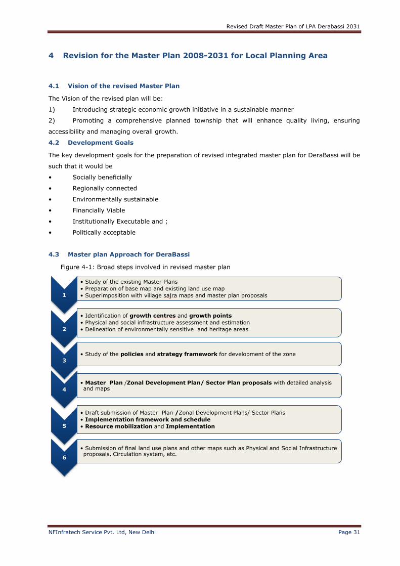
4.3 Master plan Approach for DeraBassi
Figure 4-1: Broad steps involved in revised master plan
1
• Study of the existing Master Plans
• Preparation of base map and existing land use map
• Superimposition with village sajra maps and master plan proposals
2
• Identification of growth centres and growth points
• Physical and social infrastructure assessment and estimation
• Delineation of environmentally sensitive and heritage areas
3• Study of the policies and strategy framework for development of the zone
4
• Master Plan /Zonal Development Plan/ Sector Plan proposals with detailed analysis and maps
5
• Draft submission of Master Plan /Zonal Development Plans/ Sector Plans
• Implementation framework and schedule
• Resource mobilization and Implementation
6
• Submission of final land use plans and other maps such as Physical and Social Infrastructure proposals, Circulation system, etc.
Revised Draft Master Plan of LPA Derabassi 2031
NFInfratech Service Pvt. Ltd, New Delhi Page 32
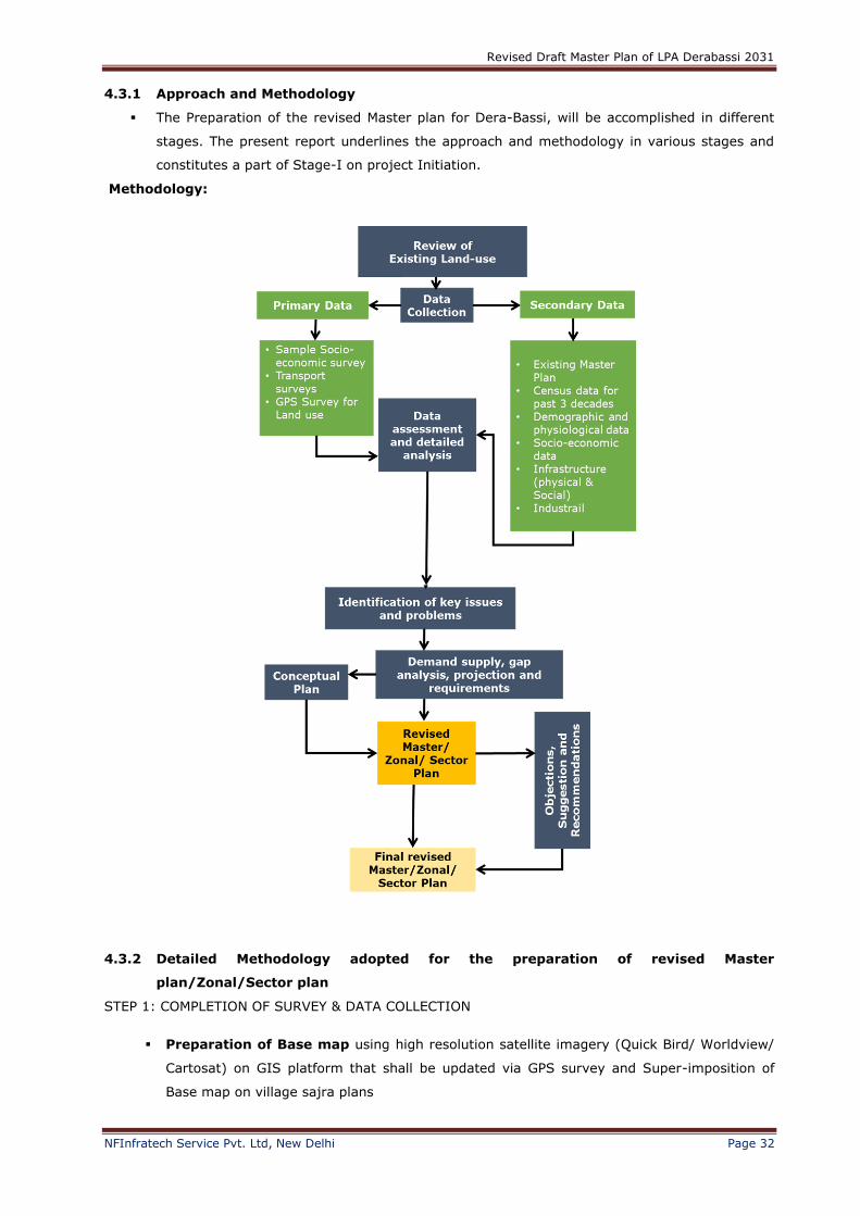
4.3.1 Approach and Methodology
The Preparation of the revised Master plan for Dera-Bassi, will be accomplished in different
stages. The present report underlines the approach and methodology in various stages and
constitutes a part of Stage-I on project Initiation.
Methodology:
4.3.2 Detailed Methodology adopted for the preparation of revised Master
plan/Zonal/Sector plan
STEP 1: COMPLETION OF SURVEY & DATA COLLECTION
Preparation of Base map using high resolution satellite imagery (Quick Bird/ Worldview/
Cartosat) on GIS platform that shall be updated via GPS survey and Super-imposition of
Base map on village sajra plans
Revised Draft Master Plan of LPA Derabassi 2031
NFInfratech Service Pvt. Ltd, New Delhi Page 33
Existing land use plan showing topography, existing vegetation, roads, built up, HT lines,
villages, Defence zone etc.
Approved Regional/Master plan: Master Greater Mohali regional plan 2056 in GIS
format, Approved Master plan Derabassi 2031in GIS format
Administrative boundaries e.g. State, Regional Plan, MC, Village and Local Planning area
in GIS format.
Revenue maps of the all villages under local planning area inn GIS format
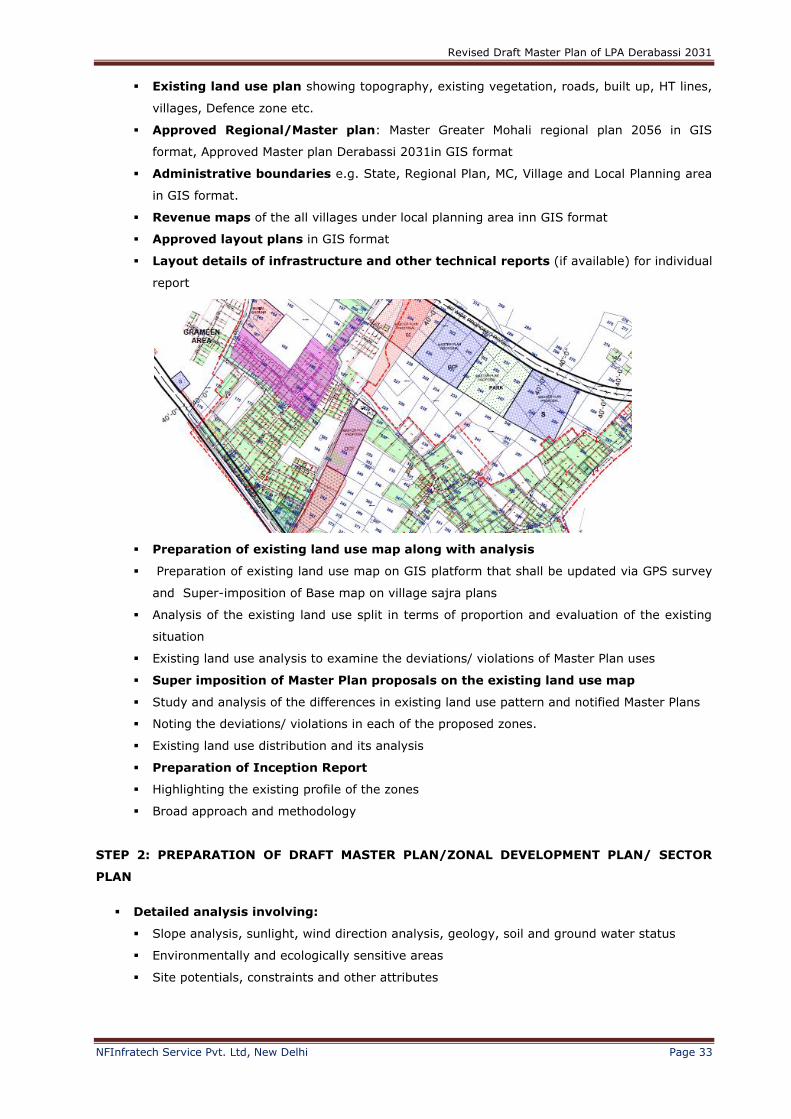
Approved layout plans in GIS format
Layout details of infrastructure and other technical reports (if available) for individual
report
Preparation of existing land use map along with analysis
Preparation of existing land use map on GIS platform that shall be updated via GPS survey
and Super-imposition of Base map on village sajra plans
Analysis of the existing land use split in terms of proportion and evaluation of the existing
situation
Existing land use analysis to examine the deviations/ violations of Master Plan uses
Super imposition of Master Plan proposals on the existing land use map
Study and analysis of the differences in existing land use pattern and notified Master Plans
Noting the deviations/ violations in each of the proposed zones.
Existing land use distribution and its analysis
Preparation of Inception Report
Highlighting the existing profile of the zones
Broad approach and methodology
STEP 2: PREPARATION OF DRAFT MASTER PLAN/ZONAL DEVELOPMENT PLAN/ SECTOR
PLAN
Detailed analysis involving:
Slope analysis, sunlight, wind direction analysis, geology, soil and ground water status
Environmentally and ecologically sensitive areas
Site potentials, constraints and other attributes
Revised Draft Master Plan of LPA Derabassi 2031
NFInfratech Service Pvt. Ltd, New Delhi Page 34
Identification of Growth Centres& Growth Points with respect to projected
population, economic growth rate, significance of transport linkages, etc.
Analysis of proposed land use, estimation of projected population and density pattern,
workforce and occupational structure in each zone
Assessment of Physical and Social Infrastructure, and estimation of future
requirements
Assessment of the existing physical infrastructure and analysis of the gap/ deficit/ surplus
Delineation of environmentally sensitive & heritage areas
Identification of environmentally sensitive areas, reserved forest areas, eco sensitive and
conserved areas such as bird sanctuaries, animal reserves etc.
Identification and assortment of existing heritage structures
Identification of polluting industries
Proposals for infrastructure facilities and introduction of Green Modules
Proposals for conservation and improvement of natural vegetation, river streams and
water-sheds
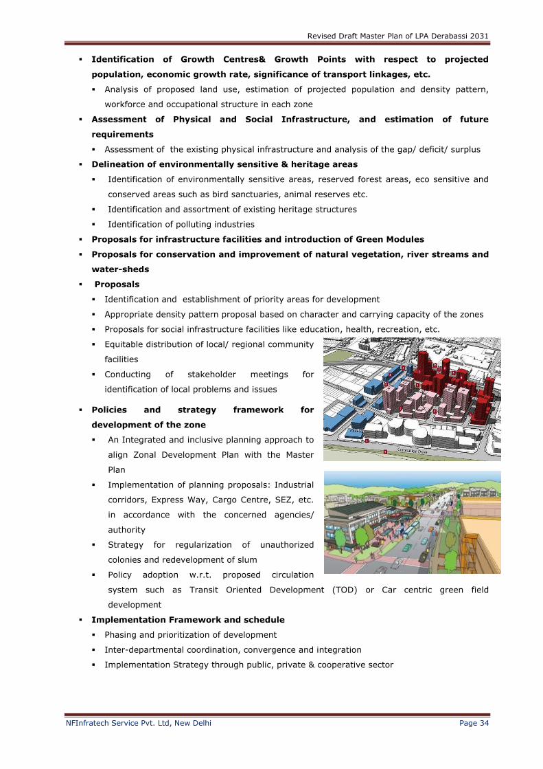
Proposals
Identification and establishment of priority areas for development
Appropriate density pattern proposal based on character and carrying capacity of the zones
Proposals for social infrastructure facilities like education, health, recreation, etc.
Equitable distribution of local/ regional community
facilities
Conducting of stakeholder meetings for
identification of local problems and issues
Policies and strategy framework for
development of the zone
An Integrated and inclusive planning approach to
align Zonal Development Plan with the Master
Plan
Implementation of planning proposals: Industrial
corridors, Express Way, Cargo Centre, SEZ, etc.
in accordance with the concerned agencies/
authority
Strategy for regularization of unauthorized
colonies and redevelopment of slum
Policy adoption w.r.t. proposed circulation
system such as Transit Oriented Development (TOD) or Car centric green field
development
Implementation Framework and schedule
Phasing and prioritization of development
Inter-departmental coordination, convergence and integration
Implementation Strategy through public, private & cooperative sector
Revised Draft Master Plan of LPA Derabassi 2031
NFInfratech Service Pvt. Ltd, New Delhi Page 35
STEP 3: PREPARATION OF REVISED DRAFT MASTER/ZONAL DEVELOPMENT PLAN/ SECTOR
PLAN
Preparation of revised draft ZDP/ SP after:
Receiving due comments/ suggestions/ objections/ recommendations on various aspects of
proposed Zonal Development Plans/ Sector Plans from the Authority
Analysis and re-evaluation of received comments
Incorporation of changes/ modifications with due considerations to received comments/
suggestions/ objections from the Development Authority
STEP 4: PREPARATION OF REVISED DRAFT ZONAL DEVELOPMENT PLAN/ SECTOR PLAN
Preparation of revised draft ZDP/ SP after:
Invitation of objections/ suggestions from public on various aspects of proposed Zonal
Development Plans by the Authority
Analysis and re-evaluation of received comments
Incorporation of changes/ modifications with due considerations to received comments/
suggestions/ objections (public) from the Development Authority
Submission of the draft final Zonal Development Plans for approval from Development
Authority
STEP 5: PREPARATION OF FINAL ZONAL DEVELOPMENT PLAN/ SECTOR PLAN
Preparation of final ZDP/ SP after:
Incorporation of changes/ modifications with due considerations to received comments/
suggestions/ objections from the Development Authority and the State Government
Revised Draft Master Plan of LPA Derabassi 2031
NFInfratech Service Pvt. Ltd, New Delhi Page 36
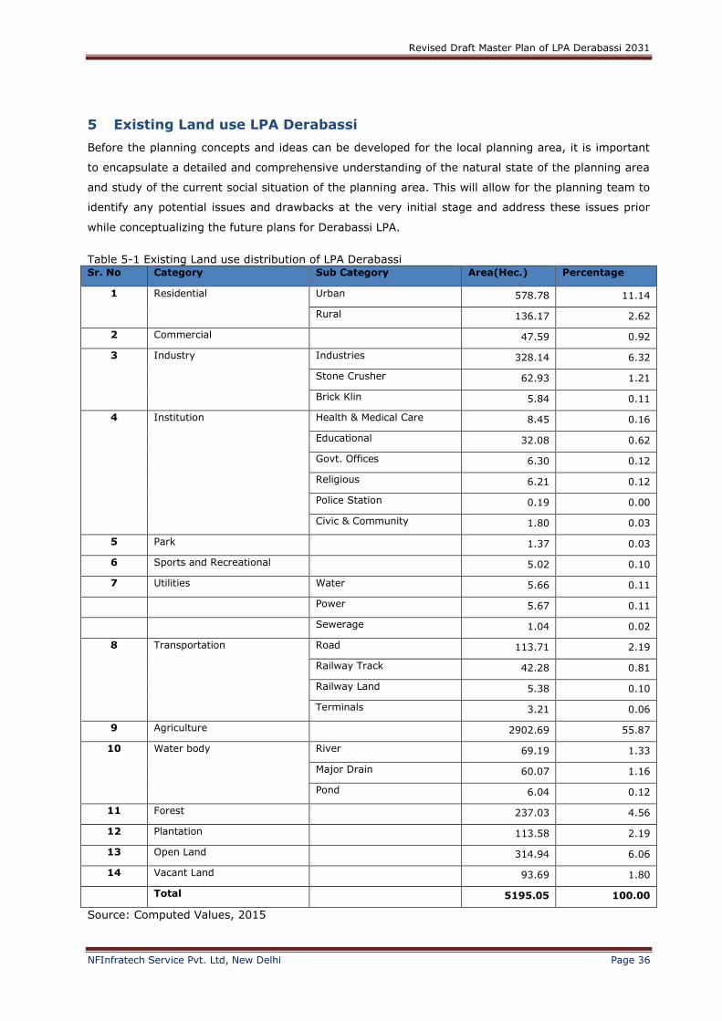
5 Existing Land use LPA Derabassi
Before the planning concepts and ideas can be developed for the local planning area, it is important
to encapsulate a detailed and comprehensive understanding of the natural state of the planning area
and study of the current social situation of the planning area. This will allow for the planning team to
identify any potential issues and drawbacks at the very initial stage and address these issues prior
while conceptualizing the future plans for Derabassi LPA.
Table 5-1 Existing Land use distribution of LPA Derabassi Sr. No Category Sub Category Area(Hec.) Percentage
1 Residential Urban 578.78 11.14
Rural 136.17 2.62
2 Commercial 47.59 0.92
3 Industry Industries 328.14 6.32
Stone Crusher 62.93 1.21
Brick Klin 5.84 0.11
4 Institution Health & Medical Care 8.45 0.16
Educational 32.08 0.62
Govt. Offices 6.30 0.12
Religious 6.21 0.12
Police Station 0.19 0.00
Civic & Community 1.80 0.03
5 Park 1.37 0.03
6 Sports and Recreational 5.02 0.10
7 Utilities Water 5.66 0.11
Power 5.67 0.11
Sewerage 1.04 0.02
8 Transportation Road 113.71 2.19
Railway Track 42.28 0.81
Railway Land 5.38 0.10
Terminals 3.21 0.06
9 Agriculture 2902.69 55.87
10 Water body River 69.19 1.33
Major Drain 60.07 1.16
Pond 6.04 0.12
11 Forest 237.03 4.56
12 Plantation 113.58 2.19
13 Open Land 314.94 6.06
14 Vacant Land 93.69 1.80
Total 5195.05 100.00
Source: Computed Values, 2015
Revised Draft Master Plan of LPA Derabassi 2031
NFInfratech Service Pvt. Ltd, New Delhi Page 37
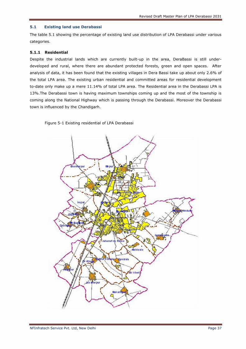
5.1 Existing land use Derabassi
The table 5.1 showing the percentage of existing land use distribution of LPA Derabassi under various
categories.
5.1.1 Residential
Despite the industrial lands which are currently built-up in the area, DeraBassi is still under-
developed and rural, where there are abundant protected forests, green and open spaces. After
analysis of data, it has been found that the existing villages in Dera Bassi take up about only 2.6% of
the total LPA area. The existing urban residential and committed areas for residential development
to-date only make up a mere 11.14% of total LPA area. The Residential area in the Derabassi LPA is
13%.The Derabassi town is having maximum townships coming up and the most of the township is
coming along the National Highway which is passing through the Derabassi. Moreover the Derabassi
town is influenced by the Chandigarh.
Figure 5-1 Existing residential of LPA Derabassi

Revised Draft Master Plan of LPA Derabassi 2031
NFInfratech Service Pvt. Ltd, New Delhi Page 38
5.1.2 Commercial
Figure 5-2 Commercial areas of LPA Derabassi
The total area covered under commercial use is 0.9% out of the total area. The total commercial area
consists of retail and wholesale shops and one of the major commercial area is old Bazaar. Derabassi
old settlement area has commercial land use along at Barwala road, Rampur road and NH-22.

Revised Draft Master Plan of LPA Derabassi 2031
NFInfratech Service Pvt. Ltd, New Delhi Page 39
5.1.3 Industrial
The existing industrial lands are mostly located in the northern part of Dera Bassi and amounts to
about 7.64 % of the overall land use distribution; some 397 ha of land. These comprise of industries,
brick kilns and stone crushers, which are located mainly in the north and east of the local planning
area. The industrial focal point of Dera Bassi starts at the northern part of Dera Bassi, bounded by
the Mubarikpur & Mirpur villages, along the Old Kalka Road.
Figure 5-3 Industrial distribution in LPA Derbassi

Revised Draft Master Plan of LPA Derabassi 2031
NFInfratech Service Pvt. Ltd, New Delhi Page 40
5.1.4 Institutional
The above figure shows that out of total planning area, Derabassi has 1.06% of Institutional area
which predominantly comprises school, colleges, engineering and dental colleges. Derabassi have
major road connectivity with National Highway which encourages private institutions as well as
government institutions i.e. senior secondary schools and engineering colleges. The predominantly
institutes are Government College of Commerce & Arts, religious institutions, primary & secondary
schools e.g. D.A.V Public School and an engineering college named SSIET; Sri Sukhamani Institute of
Engineering & Technology.
Figure 5-4 Institutions in LPA Derabassi
Revised Draft Master Plan of LPA Derabassi 2031
NFInfratech Service Pvt. Ltd, New Delhi Page 41
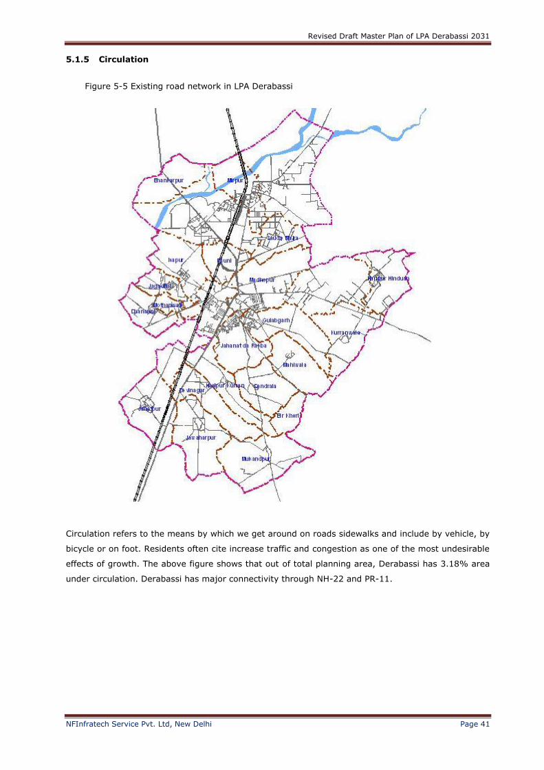
5.1.5 Circulation
Circulation refers to the means by which we get around on roads sidewalks and include by vehicle, by
bicycle or on foot. Residents often cite increase traffic and congestion as one of the most undesirable
effects of growth. The above figure shows that out of total planning area, Derabassi has 3.18% area
under circulation. Derabassi has major connectivity through NH-22 and PR-11.
Figure 5-5 Existing road network in LPA Derabassi

Revised Draft Master Plan of LPA Derabassi 2031
NFInfratech Service Pvt. Ltd, New Delhi Page 42
5.1.6 Utilities
Public utilities such as water and sewer system are essential to ensure public health and safety by
providing safe drinking water and lessening the discharge of pollutants to the environment. The
community facilities, utilities and public services chapter of master plan is a useful tool for the
community leaders to use for the planning feature, needs of its population. The area under utilities is
0.2% out of the total planning.
Figure 5-6 Existing Utilities in LPA Derabassi
Revised Draft Master Plan of LPA Derabassi 2031
NFInfratech Service Pvt. Ltd, New Delhi Page 43
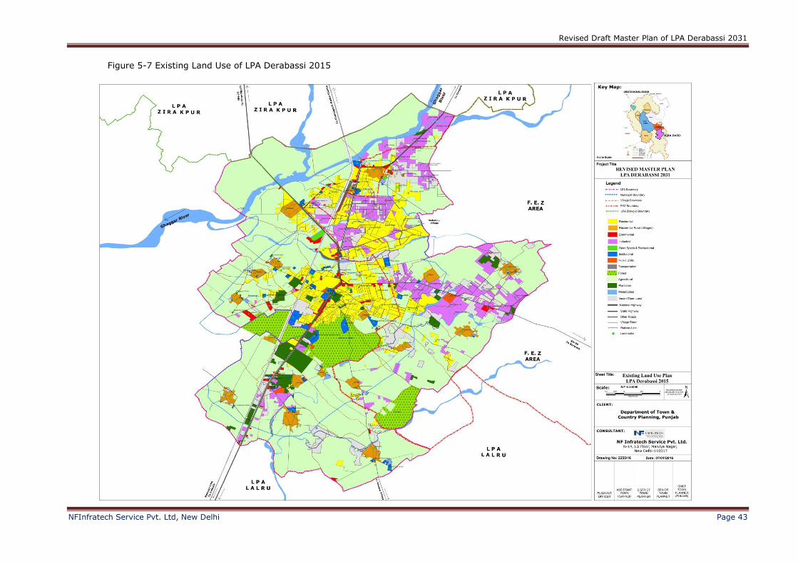
Figure 5-7 Existing Land Use of LPA Derabassi 2015
Revised Draft Master Plan of LPA Derabassi 2031
NFInfratech Service Pvt. Ltd, New Delhi Page 44
5.2 Existing Urban & Rural Area
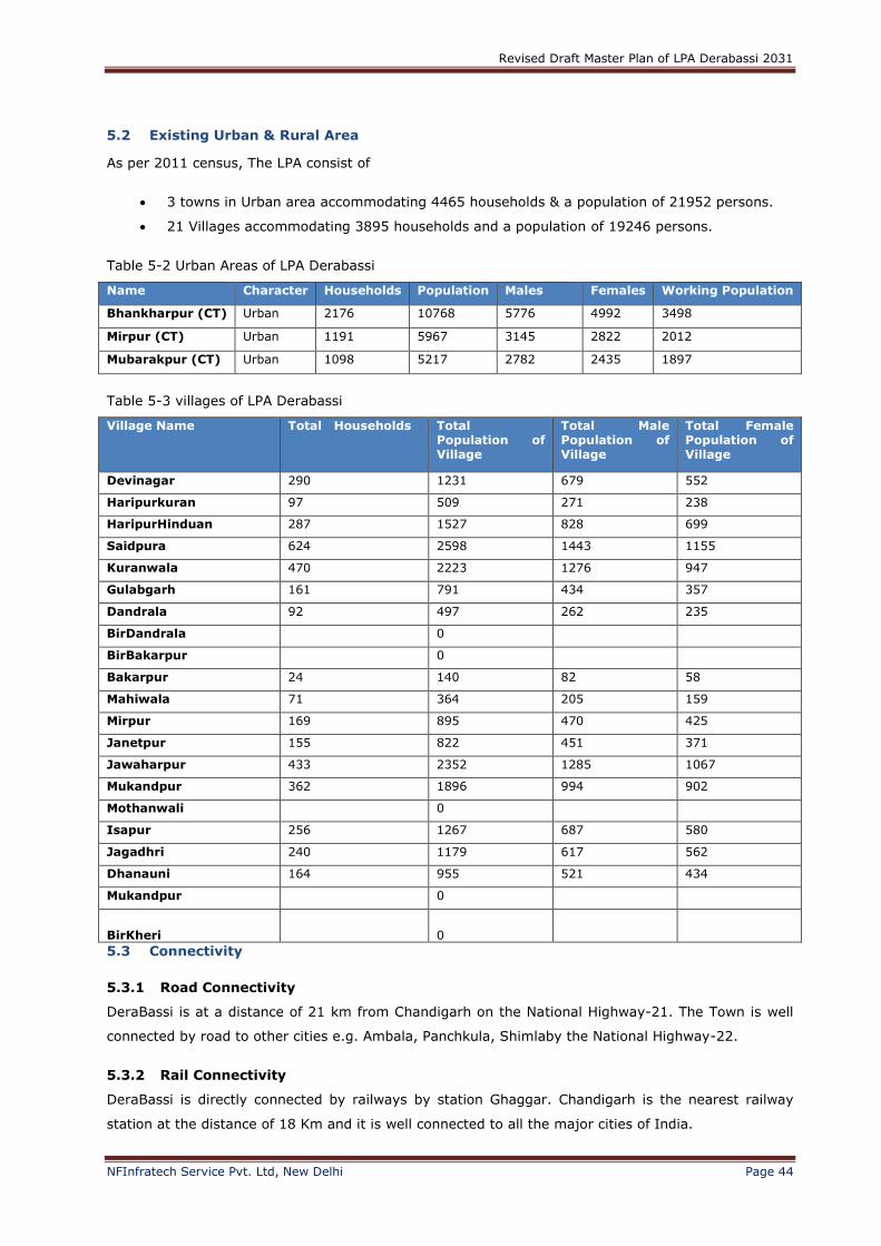
As per 2011 census, The LPA consist of
3 towns in Urban area accommodating 4465 households & a population of 21952 persons.
21 Villages accommodating 3895 households and a population of 19246 persons.
Table 5-2 Urban Areas of LPA Derabassi
Name Character Households Population Males Females Working Population
Bhankharpur (CT) Urban 2176 10768 5776 4992 3498
Mirpur (CT) Urban 1191 5967 3145 2822 2012
Mubarakpur (CT) Urban 1098 5217 2782 2435 1897
Table 5-3 villages of LPA Derabassi
Village Name Total Households Total Population of Village
Total Male Population of Village
Total Female Population of Village
Devinagar 290 1231 679 552
Haripurkuran 97 509 271 238
HaripurHinduan 287 1527 828 699
Saidpura 624 2598 1443 1155
Kuranwala 470 2223 1276 947
Gulabgarh 161 791 434 357
Dandrala 92 497 262 235
BirDandrala 0
BirBakarpur 0
Bakarpur 24 140 82 58
Mahiwala 71 364 205 159
Mirpur 169 895 470 425
Janetpur 155 822 451 371
Jawaharpur 433 2352 1285 1067
Mukandpur 362 1896 994 902
Mothanwali 0
Isapur 256 1267 687 580
Jagadhri 240 1179 617 562
Dhanauni 164 955 521 434
Mukandpur 0
BirKheri 0
5.3 Connectivity
5.3.1 Road Connectivity
DeraBassi is at a distance of 21 km from Chandigarh on the National Highway-21. The Town is well
connected by road to other cities e.g. Ambala, Panchkula, Shimlaby the National Highway-22.
5.3.2 Rail Connectivity
DeraBassi is directly connected by railways by station Ghaggar. Chandigarh is the nearest railway
station at the distance of 18 Km and it is well connected to all the major cities of India.

Revised Draft Master Plan of LPA Derabassi 2031
NFInfratech Service Pvt. Ltd, New Delhi Page 45
5.3.3 Air Connectivity
The nearest airport is Chandigarh airport, which is about 13 kilometres from the town. Chandigarh
has direct flights to Srinagar, Delhi, Leh, Mumbai and Bengaluru (Erstwhile Bangalore).
5.4 Characteristics of Derabassi
5.4.1 Climate and Physiographic
The town has a sub-tropical continental monsoon climate having, hot summers, cool winters, good
monsoon rainfall. It has great variation in temperature (4 °C to 43 °C). Sometimes winter frost
occurs during December and January. The town also receives winter rains from the western
disturbance. The rainfall is mostly received in the monsoon. The Ghaggar river flows from the north
of the town.
5.4.2 Demography
5.4.2.1 Population
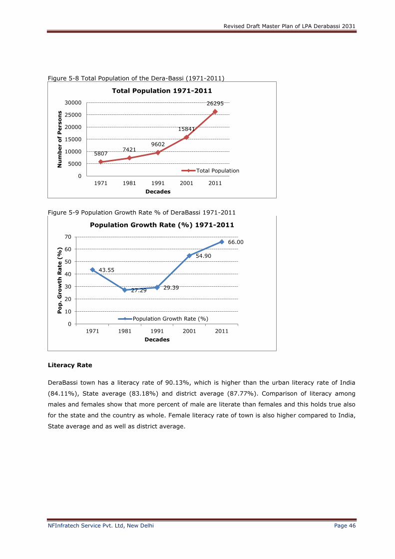
According to Census of India 2011, DeraBassi Town has a population of 26,295. It is governed by the
Municipal Council of DeraBassi. Males constitute 54% and females constitute 46% of the population.
Average household size of the town is less than India, Punjab and same as district average. The town
has witnessed 66% growth from 2001 to 2011 census.
Table 5-4: Urban population analysis Particulars Total urban
population
% to total population Male Female
India 377,106,125 31.15 195,489,200 181,616,925
Punjab State 10,399,146 37.38 5,545,989 4,853,157
SAS Nagar 544,611 54.76 288,269 256,342
DeraBassi Town 26,295 4.83 % of District Urban
Pop.
14,102 12,193
Table 5-5: Comparative household size analysis- India, State, District and Town Particulars Urban households Average household size
India 808,88,766 4.6
Punjab State 2,154,958 4.8
SAS Nagar 120,288 4.5
DeraBassi Town 20,587 4.5
The town of DeraBassi has faced a steep growth for last five decades.
Table 5-6 Decadal Growth Rate 1971-2011 of DeraBassi town
Population Decadal Growth Rate 1971-2011
Year Total Population Population Growth Rate (%) Pop. Density (Persons/Sq.km.)
1971 5807 43.55 290
1981 7421 27.29 371
1991 9602 29.39 480
2001 15841 54.90 792
2011 26295 66.00 1315
Revised Draft Master Plan of LPA Derabassi 2031
NFInfratech Service Pvt. Ltd, New Delhi Page 46
Figure 5-8 Total Population of the Dera-Bassi (1971-2011)
Figure 5-9 Population Growth Rate % of DeraBassi 1971-2011
Literacy Rate
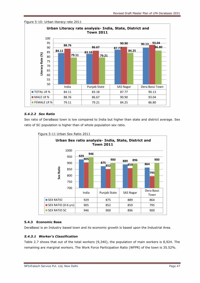
DeraBassi town has a literacy rate of 90.13%, which is higher than the urban literacy rate of India
(84.11%), State average (83.18%) and district average (87.77%). Comparison of literacy among
males and females show that more percent of male are literate than females and this holds true also
for the state and the country as whole. Female literacy rate of town is also higher compared to India,
State average and as well as district average.
58077421
9602
15841
26295
0
5000
10000
15000
20000
25000
30000
1971 1981 1991 2001 2011
Nu
mb
er o
f P
erso
ns
Decades
Total Population 1971-2011
Total Population
43.55
27.2929.39
54.90
66.00
0
10
20
30
40
50
60
70
1971 1981 1991 2001 2011
Po
p.
Gro
wth
Rate
(%
)
Decades
Population Growth Rate (%) 1971-2011
Population Growth Rate (%)
Revised Draft Master Plan of LPA Derabassi 2031
NFInfratech Service Pvt. Ltd, New Delhi Page 47
Figure 5-10: Urban literacy rate 2011
5.4.2.2 Sex Ratio
Sex ratio of DeraBassi town is low compared to India but higher than state and district average. Sex
ratio of SC population is higher than of whole population sex ratio.
Figure 5-11 Urban Sex Ratio 2011
5.4.3 Economic Base
DeraBassi is an Industry based town and its economic growth is based upon the Industrial Area.
5.4.3.1 Worker's Classification
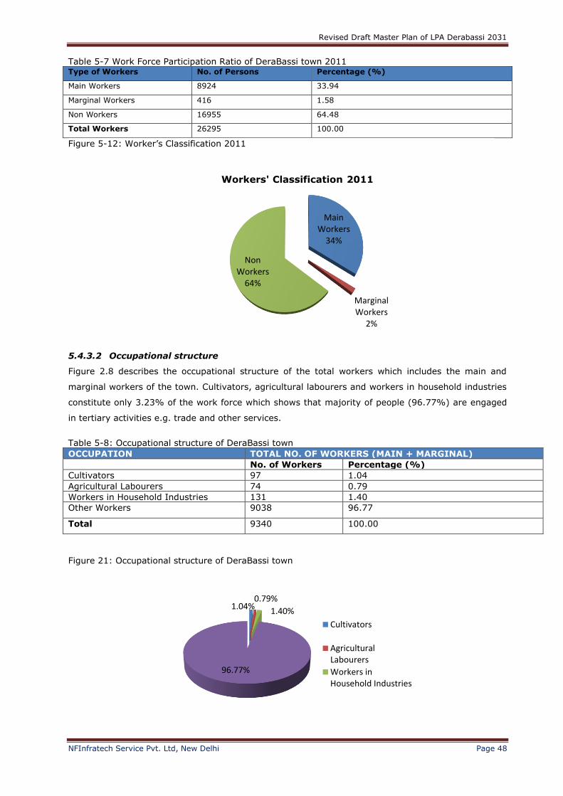
Table 2.7 shows that out of the total workers (9,340), the population of main workers is 8,924. The
remaining are marginal workers. The Work Force Participation Ratio (WFPR) of the town is 35.52%.
India Punjab State SAS Nagar Dera Bassi Town
TOTAL LR % 84.11 83.18 87.77 90.13
MALE LR % 88.76 86.67 90.90 93.04
FEMALE LR % 79.11 79.21 84.25 86.80
84.11 83.18
87.7790.1388.76
86.6790.90 93.04
79.11 79.21
84.2586.80
50
55
60
65
70
75
80
85
90
95
100Li
tera
cy R
ate
(%
)
Urban Literacy rate analysis- India, State, District and
Town 2011
India Punjab State SAS NagarDera Bassi
Town
SEX RATIO 929 875 889 864
SEX RATIO (0-6 yrs) 905 852 859 795
SEX RATIO SC 946 900 896 900
929
875889
864
905
852 859
795
946
900 896 900
700
750
800
850
900
950
1000
Sex
Rat
io
Urban Sex ratio analysis- India, State, District and
Town 2011
Revised Draft Master Plan of LPA Derabassi 2031
NFInfratech Service Pvt. Ltd, New Delhi Page 48
Table 5-7 Work Force Participation Ratio of DeraBassi town 2011 Type of Workers No. of Persons Percentage (%)
Main Workers 8924 33.94
Marginal Workers 416 1.58
Non Workers 16955 64.48
Total Workers 26295 100.00
5.4.3.2 Occupational structure
Figure 2.8 describes the occupational structure of the total workers which includes the main and
marginal workers of the town. Cultivators, agricultural labourers and workers in household industries
constitute only 3.23% of the work force which shows that majority of people (96.77%) are engaged
in tertiary activities e.g. trade and other services.
Table 5-8: Occupational structure of DeraBassi town
OCCUPATION TOTAL NO. OF WORKERS (MAIN + MARGINAL)
No. of Workers Percentage (%)
Cultivators 97 1.04
Agricultural Labourers 74 0.79
Workers in Household Industries 131 1.40
Other Workers 9038 96.77
Total 9340 100.00
Figure 21: Occupational structure of DeraBassi town
Main Workers
34%
Marginal Workers
2%
Non Workers
64%
Workers' Classification 2011
1.04%0.79%
1.40%
96.77%
Cultivators
AgriculturalLabourers
Workers inHousehold Industries
Figure 5-12: Worker’s Classification 2011
Revised Draft Master Plan of LPA Derabassi 2031
NFInfratech Service Pvt. Ltd, New Delhi Page 49
6 Existing Social and Physical Infrastructure & Projections
6.1 Social Infrastructure
Social infrastructure refers to the facilities and the process involved to ensure education, health
facilities and community development in any town. The social infrastructure includes the education
system, health care, social and cultural facilities, parks and open spaces, etc. The different
components of social infrastructure will help to know how well a town is equipped with facilities. The
provision of education, health, etc. defines the quality of life. As the town expands and population
increases, the gap between demand and supply of these essential services widens, which deteriorates
the quality of life in urban areas.
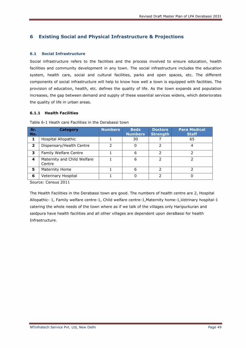
6.1.1 Health Facilities
Table 6-1 Heath care Facilities in the Derabassi town
Sr. No.
Category Numbers Beds Numbers
Doctors Strength
Para Medical Staff
1 Hospital Allopathic 1 30 7 65
2 Dispensary/Health Centre 2 0 2 4
3 Family Welfare Centre 1 6 2 2
4 Maternity and Child Welfare Centre
1 6 2 2
5 Maternity Home 1 6 2 2
6 Veterinary Hospital 1 0 2 0
Source: Census 2011
The Health Facilities in the Derabassi town are good. The numbers of health centre are 2, Hospital
Allopathic- 1, Family welfare centre-1, Child welfare centre-1,Maternity home-1,Vetrinary hospital-1
catering the whole needs of the town where as if we talk of the villages only Haripurkuran and
saidpura have health facilities and all other villages are dependent upon deraBassi for health
Infrastructure.
Revised Draft Master Plan of LPA Derabassi 2031
NFInfratech Service Pvt. Ltd, New Delhi Page 50
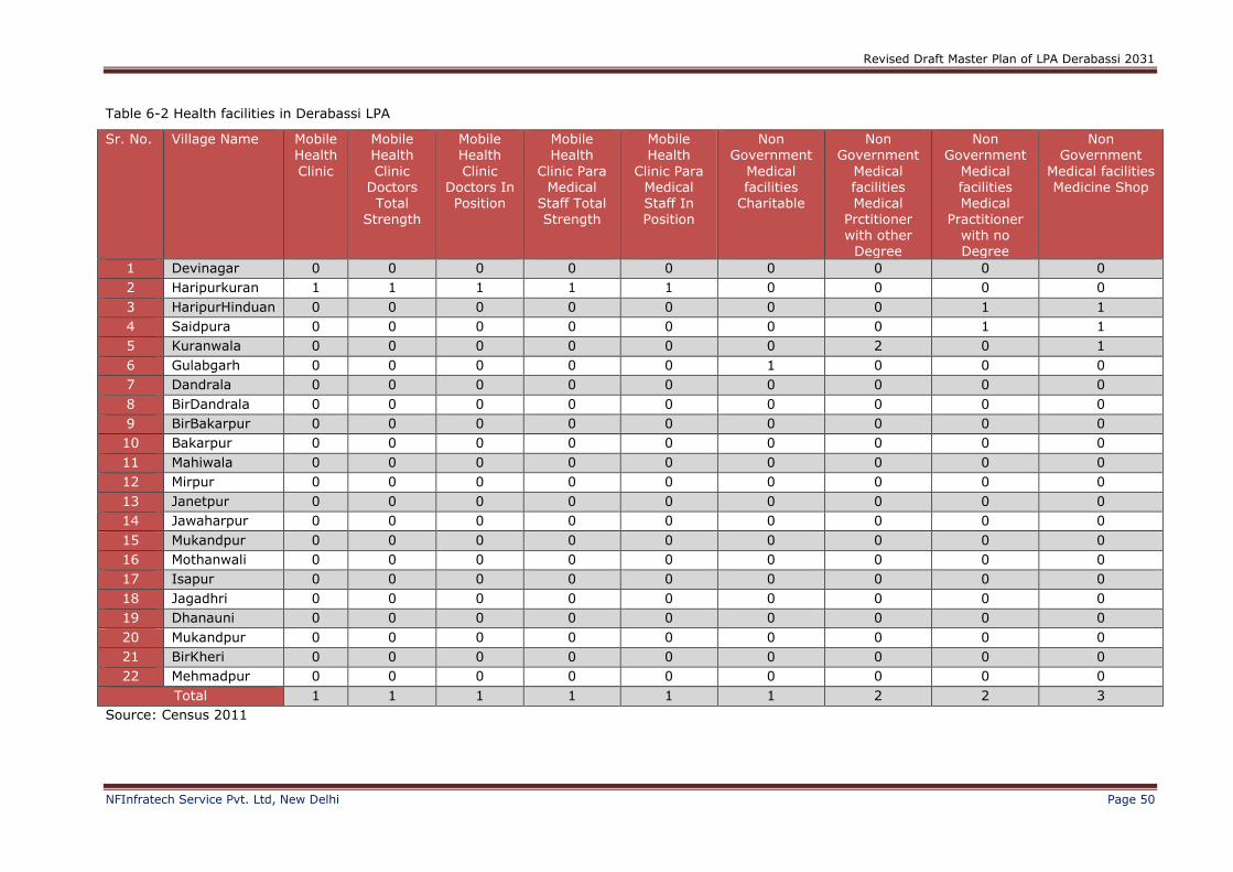
Table 6-2 Health facilities in Derabassi LPA
Sr. No. Village Name Mobile Health
Clinic
Mobile Health
Clinic Doctors Total
Strength
Mobile Health
Clinic Doctors In Position
Mobile Health
Clinic Para Medical
Staff Total Strength
Mobile Health
Clinic Para Medical Staff In Position
Non Government
Medical facilities
Charitable
Non Government
Medical facilities Medical
Prctitioner with other
Degree
Non Government
Medical facilities Medical
Practitioner with no Degree
Non Government
Medical facilities Medicine Shop
1 Devinagar 0 0 0 0 0 0 0 0 0
2 Haripurkuran 1 1 1 1 1 0 0 0 0
3 HaripurHinduan 0 0 0 0 0 0 0 1 1
4 Saidpura 0 0 0 0 0 0 0 1 1
5 Kuranwala 0 0 0 0 0 0 2 0 1
6 Gulabgarh 0 0 0 0 0 1 0 0 0
7 Dandrala 0 0 0 0 0 0 0 0 0
8 BirDandrala 0 0 0 0 0 0 0 0 0
9 BirBakarpur 0 0 0 0 0 0 0 0 0
10 Bakarpur 0 0 0 0 0 0 0 0 0
11 Mahiwala 0 0 0 0 0 0 0 0 0
12 Mirpur 0 0 0 0 0 0 0 0 0
13 Janetpur 0 0 0 0 0 0 0 0 0
14 Jawaharpur 0 0 0 0 0 0 0 0 0
15 Mukandpur 0 0 0 0 0 0 0 0 0
16 Mothanwali 0 0 0 0 0 0 0 0 0
17 Isapur 0 0 0 0 0 0 0 0 0
18 Jagadhri 0 0 0 0 0 0 0 0 0
19 Dhanauni 0 0 0 0 0 0 0 0 0
20 Mukandpur 0 0 0 0 0 0 0 0 0
21 BirKheri 0 0 0 0 0 0 0 0 0
22 Mehmadpur 0 0 0 0 0 0 0 0 0
Total 1 1 1 1 1 1 2 2 3
Source: Census 2011

Revised Draft Master Plan of LPA Derabassi 2031
NFInfratech Service Pvt. Ltd, New Delhi Page 51
6.1.2 Education
Educational facilities play an important role in the overall development of a Town. These facilities enhance the economic growth and employment. At
present, Derabassi have 1 government primary schools, 3 private primary schools, 1 government senior secondary schools,7 private secondary,1 govt.senior
secondary and 5 private senior secondary. Moreover Derabassi also have degree colleges both government and Private. Private engineering college,
polytechnic and vocational
Table 6-3 Category wise number of schools in Derabassi
Sr. No.
Category Sub-Category
1
School
Govt. Primary School
Private Primary School
Govt. Secondary
School
Private Secondary
School
Govt. Senior
Secondary School
Private Senior
Secondary School
1 3 1 7 1 5
2
Degree College
Govt. Degree
College-Art
Private Degree
College-Art
Govt. Degree College-Science
Private Degree College-Science
Private Degree College-
Commerce
Govt. Degree College-Art and Science
Private Degree College-Art and Science
Govt. Degree College-
Art, Commerce
Private Degree College-
Art, Commerce
Govt. Degree College-
Art, Science,
Commerce
Private Degree College-
Art, Science,
Commerce
1 1 1 1 1 1 1 1 1 1 1
3 Engineering
College
Private-Engineering
College
Private-Management
Institute
Private-Polytechnic
Private-Vocational
1 1 1 1
Source: Census 2011
Revised Draft Master Plan of LPA Derabassi 2031
NFInfratech Service Pvt. Ltd, New Delhi Page 52
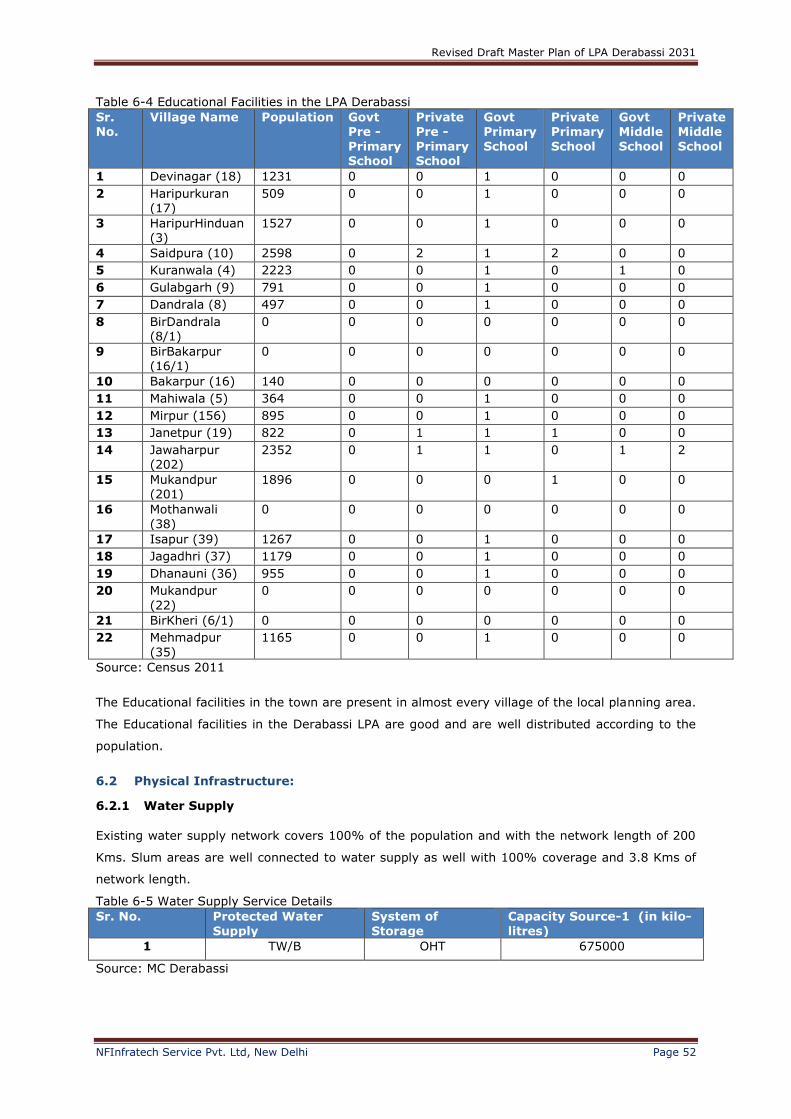
Table 6-4 Educational Facilities in the LPA Derabassi
Sr. No.
Village Name Population Govt Pre -
Primary School
Private Pre -
Primary School
Govt Primary
School
Private Primary
School
Govt Middle
School
Private Middle
School
1 Devinagar (18) 1231 0 0 1 0 0 0
2 Haripurkuran (17)
509 0 0 1 0 0 0
3 HaripurHinduan (3)
1527 0 0 1 0 0 0
4 Saidpura (10) 2598 0 2 1 2 0 0
5 Kuranwala (4) 2223 0 0 1 0 1 0
6 Gulabgarh (9) 791 0 0 1 0 0 0
7 Dandrala (8) 497 0 0 1 0 0 0
8 BirDandrala (8/1)
0 0 0 0 0 0 0
9 BirBakarpur (16/1)
0 0 0 0 0 0 0
10 Bakarpur (16) 140 0 0 0 0 0 0
11 Mahiwala (5) 364 0 0 1 0 0 0
12 Mirpur (156) 895 0 0 1 0 0 0
13 Janetpur (19) 822 0 1 1 1 0 0
14 Jawaharpur (202)
2352 0 1 1 0 1 2
15 Mukandpur (201)
1896 0 0 0 1 0 0
16 Mothanwali
(38)
0 0 0 0 0 0 0
17 Isapur (39) 1267 0 0 1 0 0 0
18 Jagadhri (37) 1179 0 0 1 0 0 0
19 Dhanauni (36) 955 0 0 1 0 0 0
20 Mukandpur
(22)
0 0 0 0 0 0 0
21 BirKheri (6/1) 0 0 0 0 0 0 0
22 Mehmadpur
(35)
1165 0 0 1 0 0 0
Source: Census 2011
The Educational facilities in the town are present in almost every village of the local planning area.
The Educational facilities in the Derabassi LPA are good and are well distributed according to the
population.
6.2 Physical Infrastructure:
6.2.1 Water Supply
Existing water supply network covers 100% of the population and with the network length of 200
Kms. Slum areas are well connected to water supply as well with 100% coverage and 3.8 Kms of
network length.
Table 6-5 Water Supply Service Details
Sr. No. Protected Water
Supply
System of
Storage
Capacity Source-1 (in kilo-
litres)
1 TW/B OHT 675000
Source: MC Derabassi
Revised Draft Master Plan of LPA Derabassi 2031
NFInfratech Service Pvt. Ltd, New Delhi Page 53
The source of water is underground. The water level depth is upto 400 feet and the potable water
is upto 200 feet. The quality of the drinking water is good therefore there is no need for the water
treatment plant. There is one OHT tank of capacity 675000 kilolitres of water is supplied to the
town
Key issues: According to the Municipal Council of Derabassi wastage of water is a huge problem
in the town.
6.2.2 Drainage
There is no storm water drainage network laid in the Derabassi town. The storm water is catered
by the seasonal nallahs and natural drains.
6.2.3 Solid waste
Solid waste comprises of waste generated from different sources. Major sources of generation are
individual households, industries, trade and commerce, hotels and restaurants, healthcare
institutions including dispensaries and hospitals, animals and floating populations in terms of
tourists, hawkers, etc.
In MC Derabassi, there are 14 wards and the method of collection of solid waste is door to door.
The total solid waste generation is 450 tons. In Derabassi industrial Solid waste form the much
quantity of solid waste. The work is done under Solid waste Management Rules 2000.
6.2.4 Power Supply
The town is provided with 21341 power supply which includes domestic, industrial, commercial and street lighting.
The numbers of electricity connections in Derabassi are 21341.Out of the total number of
connections 16418 are domestic connections, 604 are industrial connections, 2455 are commercial
connections and 1684 are road lighting connections. The Derabassi area is 100% electrified with
24*7 electricity supply. The street lights coverage is 100% and are in good working condition
Table 6-6 Number of Electricity connections in Derabassi
Sr. No. Electricity-Domestic Connection
Electricity-Industrial Connection
Electricity-Commercial Connection
Electricity-Road Lighting Connection
Total Connections
1 16418 604 2455 1864 21341
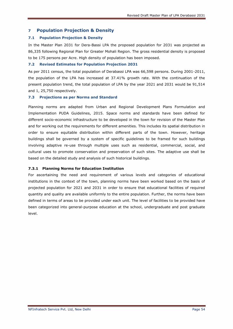
Revised Draft Master Plan of LPA Derabassi 2031
NFInfratech Service Pvt. Ltd, New Delhi Page 54
7 Population Projection & Density
7.1 Population Projection & Density
In the Master Plan 2031 for Dera-Bassi LPA the proposed population for 2031 was projected as
86,335 following Regional Plan for Greater Mohali Region. The gross residential density is proposed
to be 175 persons per Acre. High density of population has been imposed.
7.2 Revised Estimates for Population Projection 2031
As per 2011 census, the total population of Derabassi LPA was 66,598 persons. During 2001-2011,
the population of the LPA has increased at 37.41% growth rate. With the continuation of the
present population trend, the total population of LPA by the year 2021 and 2031 would be 91,514
and 1, 25,750 respectively.
7.3 Projections as per Norms and Standard
Planning norms are adapted from Urban and Regional Development Plans Formulation and
Implementation PUDA Guidelines, 2015. Space norms and standards have been defined for
different socio-economic infrastructure to be developed in the town for revision of the Master Plan
and for working out the requirements for different amenities. This includes its spatial distribution in
order to ensure equitable distribution within different parts of the town. However, heritage
buildings shall be governed by a system of specific guidelines to be framed for such buildings
involving adaptive re-use through multiple uses such as residential, commercial, social, and
cultural uses to promote conservation and preservation of such sites. The adaptive use shall be
based on the detailed study and analysis of such historical buildings.
7.3.1 Planning Norms for Education Institution
For ascertaining the need and requirement of various levels and categories of educational
institutions in the context of the town, planning norms have been worked based on the basis of
projected population for 2021 and 2031 in order to ensure that educational facilities of required
quantity and quality are available uniformly to the entire population. Further, the norms have been
defined in terms of areas to be provided under each unit. The level of facilities to be provided have
been categorized into general-purpose education at the school, undergraduate and post graduate
level.
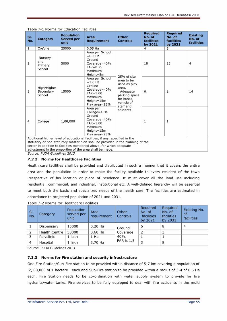
Revised Draft Master Plan of LPA Derabassi 2031
NFInfratech Service Pvt. Ltd, New Delhi Page 55
Table 7-1 Norms for Education Facilities
Sl. No.
Category Population Served per unit
Area Requirement
Other Controls
Required No. of facilities by 2021
Required No. of facilities by 2031
Existing No. of facilities
1 Cre'che 25000 0.05 Ha 4 5
2
Nursery and Primary School
5000
Area per School =0.3 Ha Ground Coverage=40% FAR=0.75 Maximum Height=8m
25% of site area to be used as play area, Adequate parking space for buses, vehicle of staff and students
18 25 4
3 High/Higher Secondary School
15000
Area per School =1.6 Ha Ground Coverage=40% FAR=1.00 Maximum Height=15m Play area=25%
6 8 14
4 College 1,00,000
Area per College=4 Ha Ground Coverage=40%
FAR=1.00 Maximum Height=15m Play area=25%
1 1
Additional higher level of educational facilities, if any, specified in the statutory or non-statutory master plan shall be provided in the planning of the sector in addition to facilities mentioned above, for which adequate adjustment in the proportion of the area shall be made.
Source: PUDA Guidelines 2013
7.3.2 Norms for Healthcare Facilities
Health care facilities shall be provided and distributed in such a manner that it covers the entire
area and the population in order to make the facility available to every resident of the town
irrespective of his location or place of residence. It must cover all the land use including
residential, commercial, and industrial, institutional etc. A well-defined hierarchy will be essential
to meet both the basic and specialized needs of the health care. The facilities are estimated in
accordance to projected population of 2021 and 2031.
Table 7-2 Norms for Healthcare Facilities
Sl. No.
Category Population served per
unit
Area requirement
Other Controls
Required No. of facilities
by 2021
Required No. of facilities
by 2031
Existing No. of
facilities
1 Dispensary 15000 0.20 Ha Ground
Coverage 40%, FAR is 1.5
6 8 4
2 Health Centre 50000 0.60 Ha 2 3
3 Polyclinic 1 lakh 1 Ha 1 1
4 Hospital 1 lakh 3.70 Ha 3 8
Source: PUDA Guidelines 2013
7.3.3 Norms for Fire station and security infrastructure
One Fire Station/Sub-Fire station to be provided within distance of 5-7 km covering a population of
2, 00,000 of 1 hectare each and Sub-Fire station to be provided within a radius of 3-4 of 0.6 Ha
each. Fire Station needs to be co-ordination with water supply system to provide for fire
hydrants/water tanks. Fire services to be fully equipped to deal with fire accidents in the multi
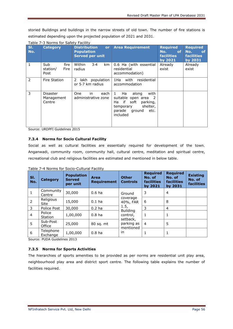
Revised Draft Master Plan of LPA Derabassi 2031
NFInfratech Service Pvt. Ltd, New Delhi Page 56
storied Buildings and buildings in the narrow streets of old town. The number of fire stations is
estimated depending upon the projected population of 2021 and 2031.
Table 7-3 Norms for Safety Facility
Sl. No.
Category Distribution or Population Served per unit
Area Requirement Required No. of facilities by 2021
Required No. of facilities by 2031
1 Sub fire station/ Fire Post
Within 3‐4 km
radius
0.6 Ha (with essential residential accommodation)
Already exist
Already exist
2 Fire Station 2 lakh population or 5‐7 km radius
1Ha with residential accommodation
3 Disaster
Management Centre
One in each
administrative zone
1 Ha along with
suitable open area 2 Ha if soft parking, temporary shelter, parade ground etc. included
Source: URDPFI Guidelines 2015
7.3.4 Norms for Socio Cultural Facility
Social as well as cultural facilities are essentially required for development of the town.
Anganwadi, community room, community hall, cultural centre, meditation and spiritual centre,
recreational club and religious facilities are estimated and mentioned in below table.
Table 7-4 Norms for Socio-Cultural Facility
Sl. No.
Category Population Served per unit
Area Requirement
Other Controls
Required
No. of facilities by 2021
Required
No. of facilities by 2031
Existing No. of facilities
1 Community Centre
30,000 0.6 ha Ground coverage
40%, FAR 1.5, Building control, setback,
parking as
mentioned in
3 4
2 Religious Site
15,000 0.1 ha 6 8
3 Police Post 30,000 0.2 ha 3 4
4 Police Station
1,00,000 0.8 ha 1 1
5 Sub-Post
Office 25,000 80 sq. mt 4 5
6 Telephone Exchange
1,00,000 0.8 ha 1 1
Source: PUDA Guidelines 2013
7.3.5 Norms for Sports Activities
The hierarchies of sports amenities to be provided as per norms are residential unit play area,
neighbourhood play area and district sport centre. The following table explains the number of
facilities required.
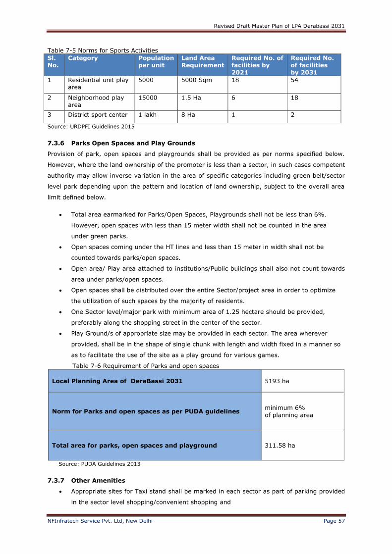
Revised Draft Master Plan of LPA Derabassi 2031
NFInfratech Service Pvt. Ltd, New Delhi Page 57
Table 7-5 Norms for Sports Activities
Sl. No.
Category Population per unit
Land Area Requirement
Required No. of facilities by
2021
Required No. of facilities
by 2031
1 Residential unit play area
5000 5000 Sqm 18 54
2 Neighborhood play area
15000 1.5 Ha 6 18
3 District sport center 1 lakh 8 Ha 1 2
Source: URDPFI Guidelines 2015
7.3.6 Parks Open Spaces and Play Grounds
Provision of park, open spaces and playgrounds shall be provided as per norms specified below.
However, where the land ownership of the promoter is less than a sector, in such cases competent
authority may allow inverse variation in the area of specific categories including green belt/sector
level park depending upon the pattern and location of land ownership, subject to the overall area
limit defined below.
Total area earmarked for Parks/Open Spaces, Playgrounds shall not be less than 6%.
However, open spaces with less than 15 meter width shall not be counted in the area
under green parks.
Open spaces coming under the HT lines and less than 15 meter in width shall not be
counted towards parks/open spaces.
Open area/ Play area attached to institutions/Public buildings shall also not count towards
area under parks/open spaces.
Open spaces shall be distributed over the entire Sector/project area in order to optimize
the utilization of such spaces by the majority of residents.
One Sector level/major park with minimum area of 1.25 hectare should be provided,
preferably along the shopping street in the center of the sector.
Play Ground/s of appropriate size may be provided in each sector. The area wherever
provided, shall be in the shape of single chunk with length and width fixed in a manner so
as to facilitate the use of the site as a play ground for various games.
Table 7-6 Requirement of Parks and open spaces
Local Planning Area of DeraBassi 2031 5193 ha
Norm for Parks and open spaces as per PUDA guidelines minimum 6%
of planning area
Total area for parks, open spaces and playground 311.58 ha
Source: PUDA Guidelines 2013
7.3.7 Other Amenities
Appropriate sites for Taxi stand shall be marked in each sector as part of parking provided
in the sector level shopping/convenient shopping and
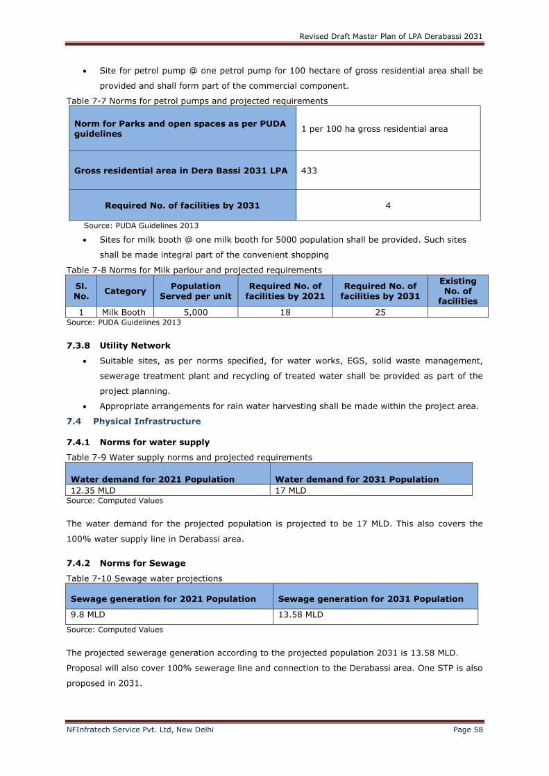
Revised Draft Master Plan of LPA Derabassi 2031
NFInfratech Service Pvt. Ltd, New Delhi Page 58
Site for petrol pump @ one petrol pump for 100 hectare of gross residential area shall be
provided and shall form part of the commercial component.
Table 7-7 Norms for petrol pumps and projected requirements
Norm for Parks and open spaces as per PUDA guidelines
1 per 100 ha gross residential area
Gross residential area in Dera Bassi 2031 LPA 433
Required No. of facilities by 2031 4
Source: PUDA Guidelines 2013
Sites for milk booth @ one milk booth for 5000 population shall be provided. Such sites
shall be made integral part of the convenient shopping
Table 7-8 Norms for Milk parlour and projected requirements
Sl. No.
Category Population
Served per unit Required No. of
facilities by 2021 Required No. of
facilities by 2031
Existing No. of
facilities
1 Milk Booth 5,000 18 25 Source: PUDA Guidelines 2013
7.3.8 Utility Network
Suitable sites, as per norms specified, for water works, EGS, solid waste management,
sewerage treatment plant and recycling of treated water shall be provided as part of the
project planning.
Appropriate arrangements for rain water harvesting shall be made within the project area.
7.4 Physical Infrastructure
7.4.1 Norms for water supply
Table 7-9 Water supply norms and projected requirements
Water demand for 2021 Population Water demand for 2031 Population
12.35 MLD 17 MLD Source: Computed Values
The water demand for the projected population is projected to be 17 MLD. This also covers the
100% water supply line in Derabassi area.
7.4.2 Norms for Sewage
Table 7-10 Sewage water projections
Sewage generation for 2021 Population Sewage generation for 2031 Population
9.8 MLD 13.58 MLD
Source: Computed Values
The projected sewerage generation according to the projected population 2031 is 13.58 MLD.
Proposal will also cover 100% sewerage line and connection to the Derabassi area. One STP is also
proposed in 2031.
Revised Draft Master Plan of LPA Derabassi 2031
NFInfratech Service Pvt. Ltd, New Delhi Page 59
7.4.3 Norms for solid waste
Table 7-11 Solid waste projections
Solid waste generation for
2021 Population
Solid waste generation
for 2031 Population
41.20 ton per day 56.58 ton per day
Source: Computed Values
The solid waste collection is calculated on the basis of standards set by municipal Solid Waste
(MSW) Generation in India. The average solid waste generation taken is .48kg per person.
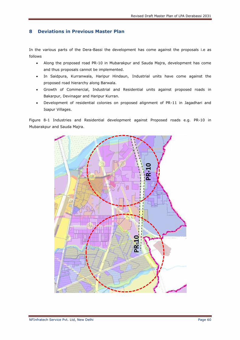
Revised Draft Master Plan of LPA Derabassi 2031
NFInfratech Service Pvt. Ltd, New Delhi Page 60
8 Deviations in Previous Master Plan
In the various parts of the Dera-Bassi the development has come against the proposals i.e as
follows
Along the proposed road PR-10 in Mubarakpur and Sauda Majra, development has come
and thus proposals cannot be implemented.
In Saidpura, Kurranwala, Haripur Hindaun, Industrial units have come against the
proposed road hierarchy along Barwala.
Growth of Commercial, Industrial and Residential units against proposed roads in
Bakarpur, Devinagar and Haripur Kurran.
Development of residential colonies on proposed alignment of PR-11 in Jagadhari and
Isapur Villages.
Figure 8-1 Industries and Residential development against Proposed roads e.g. PR-10 in
Mubarakpur and Sauda Majra.
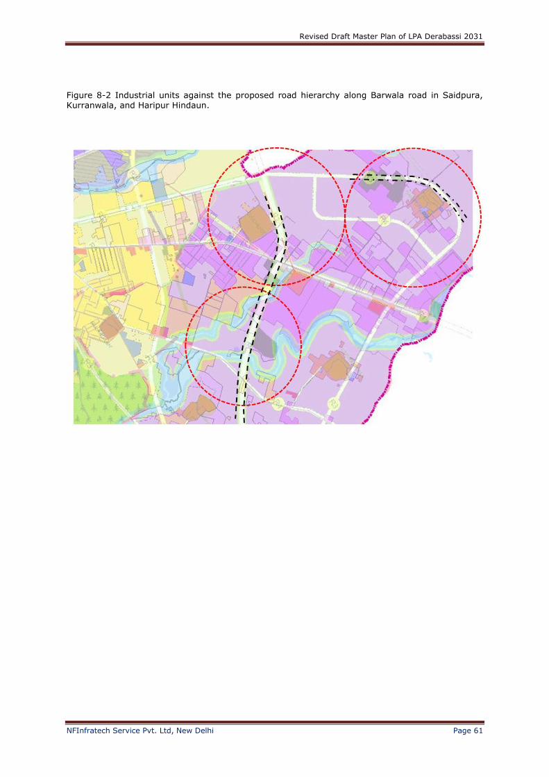
Revised Draft Master Plan of LPA Derabassi 2031
NFInfratech Service Pvt. Ltd, New Delhi Page 61
Figure 8-2 Industrial units against the proposed road hierarchy along Barwala road in Saidpura, Kurranwala, and Haripur Hindaun.

Revised Draft Master Plan of LPA Derabassi 2031
NFInfratech Service Pvt. Ltd, New Delhi Page 62
Figure 8-3 Growth of Commercial, Industrial and Residential units against proposed roads in
Bakarpur, Devinagar and Haripur Kurran.

Revised Draft Master Plan of LPA Derabassi 2031
NFInfratech Service Pvt. Ltd, New Delhi Page 63
Figure 8-4 Development of residential colonies on proposed alignment of PR-11 in Jagadhari and
Isapur Villages
In the Master Plan 2031 for Derabassi LPA the proposed population for 2031 was projected as
86,335 following Regional Plan for Greater Mohali Region but as per 2011 census, the total
population of DeraBassi LPA was 66,598 persons and with the present growth rate it will cross the
projected population within one decade so to cater the population high residential areas has been
proposed.

Revised Draft Master Plan of LPA Derabassi 2031
NFInfratech Service Pvt. Ltd, New Delhi Page 64
9 Proposed Land use
In the course of planning the LPA for Dera Bassi, planning issues were surfaced and clarified with
GMADA prior to the conceptualizing the final plan for Dera Bassi. The planning proposals for Dera
Bassi will outline the development objectives of the town. The focus of the land use proposal is to
ensure adequate and balanced spread of residential and industrial land so that sustainability can
be achieved. Active allocation of complementing land uses is displayed through seamless
integration of land uses, transport and economic activities. The proposed land use plan for LPA
Derabassi has prepared for the year 2035.
Table 9-1 Proposed Land use Distribution of LPA DeraBassi 2031
Proposed Land Use, Derabassi LPA 2031
Sr. No. Land Use Categories Area in Hectare Percentage(%)
1 Existing Built-Up (Residential, Industries, Recreational,
Institutions, Utilities etc.)
1106.59 21.30
2 Residential 966.07 18.60
3 Existing Villages 128.05 2.46
4 Mixed Land Use 172.74 3.33
5 Industry ( Heavy, General, Mixed) 723.20 14.20
6 Industry Mix 655.74 12.33
7 Sports and Recreational 18.86 0.36
8 Utilities 14.53 0.28
9 Transport 52.54 1.01
10 Proposed Roads 347.45 6.69
11 Restricted/No Construction Zone 119.21 2.29
12 Forest 211.18 4.07
13 Waterbody 138.89 2.67
14 Green Buffer 184.33 3.55
15 Agriculture 355.67 6.85
Total 5195.05 100.00
Source: Computed Values
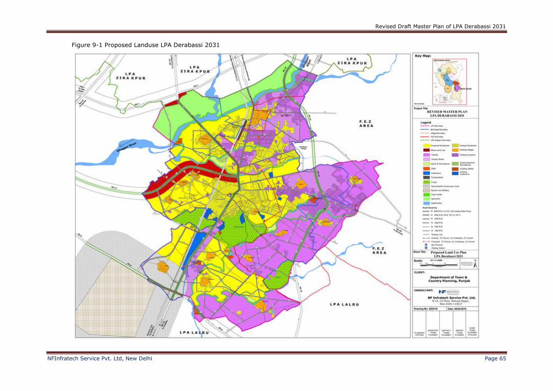
Revised Draft Master Plan of LPA Derabassi 2031
NFInfratech Service Pvt. Ltd, New Delhi Page 65
Figure 9-1 Proposed Landuse LPA Derabassi 2031
Revised Draft Master Plan of LPA Derabassi 2031
NFInfratech Service Pvt. Ltd, New Delhi Page 66
9.1 Residential
The Residential area has been kept high as to cater the projected population of the revised master
Plan 2031.The residential area has been proposed to 18.6% from 13%.The projected population of
Derabassi Town for the year 2031 works to be about 1,25,750 persons therefore the demand
for residential areas would be quite more. The land required for residential use to accommodate
projected population of 1, 25, and 750 of Derabassi works out to be 966.07 hectares for urban
residential purpose. The potential areas all around municipal limits of Derabassi , and area along
existing linkages having trend of residential growth and thus have been earmarked for residential
purpose. Besides this the areas around new proposed roads would also become potential with the
proposals of new accessibilities. Assessing the future trend of development, the areas like
Bankarpur, Isapur, Jagadhari, Dhanauni, Janetpur, Bakarpur, Madhopur, Devinagar and
Jawaharpur have been proposed for the Residential development. The various types of
developments which can take place in Residential use are Commercial, Group Housing,
Apartments, Township, Semi-detached house, Detached House, Serviced Apartment, Institution
and Hostel (e.g. for working women, students & youths).
9.2 Industrial
The Industrial land use has been raised to 26.54% from 8%. DeraBassi is one of the industrial
promotive town in whole of the Punjab and the Punjab is also providing incentives to the industries
as mentioned in the Punjab Industrial Promotion Policy 2013.Moreover the Derabassi is having a
good connectivity and thus it gives a good attractive point to Industrial growth. The industries will
consist of General, mix and heavy industries. The total area proposed for the Industrial use is
1378 hectares out of which 991.11 hectares is for industrial development where as 387.83
hectares has been proposed for the mixed industrial use. The mixed industrial use shall be
permissible for Industry (green and orange), Residential, Commercial, Institutions.
Free Enterprise Zone
In the early stage of the project, it was discovered that the boundary of Dera Bassi LPA overlapped
a substantial portion of an existing Free Enterprise Zone. There was uncertainty as to the extent of
allowable planning boundary in view of the presence of the overlapping FEZ area in Dera Bassi.
The adopted approach is to study the regulating Acts which are pertinent to the FEZ guidelines and
to propose the planning approach by abiding to these Acts.
(a) “Report of the State level Committee for policy framework for Chandigarh Periphery Controlled
Area and regulating constructions therein”, Point 4e (i):
“The area declared as Free Enterprise Zone (FEZ) near Dera Bassi should continue to be used for
industries outside Municipal Limits or otherwise planned for industry, although institutions could
also be permitted in accordance with the prescribed guidelines issued vide notification
17/17/1/5Hg2/311 dated 11.1.2008 of the Housing and Urban Development Department, Punjab.
In order to ensure rational development and provision of basic infrastructure and services in the
area, a broad developmental framework needs to be prepared along with a development plan
indicating roads/ trunk infrastructure, including areas reserved for residential and institutional
needs.”
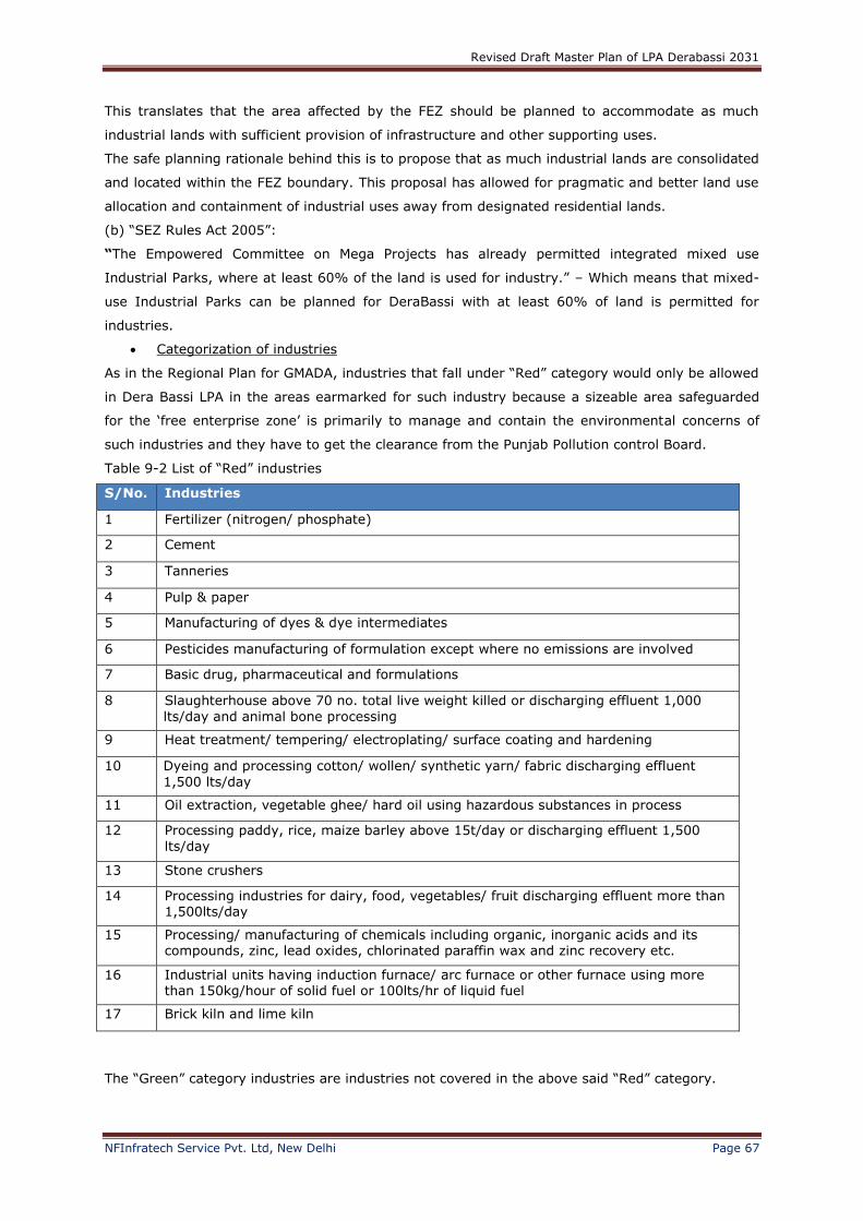
Revised Draft Master Plan of LPA Derabassi 2031
NFInfratech Service Pvt. Ltd, New Delhi Page 67
This translates that the area affected by the FEZ should be planned to accommodate as much
industrial lands with sufficient provision of infrastructure and other supporting uses.
The safe planning rationale behind this is to propose that as much industrial lands are consolidated
and located within the FEZ boundary. This proposal has allowed for pragmatic and better land use
allocation and containment of industrial uses away from designated residential lands.
(b) “SEZ Rules Act 2005”:
“The Empowered Committee on Mega Projects has already permitted integrated mixed use
Industrial Parks, where at least 60% of the land is used for industry.” – Which means that mixed-
use Industrial Parks can be planned for DeraBassi with at least 60% of land is permitted for
industries.
Categorization of industries
As in the Regional Plan for GMADA, industries that fall under “Red” category would only be allowed
in Dera Bassi LPA in the areas earmarked for such industry because a sizeable area safeguarded
for the ‘free enterprise zone’ is primarily to manage and contain the environmental concerns of
such industries and they have to get the clearance from the Punjab Pollution control Board.
Table 9-2 List of “Red” industries
S/No. Industries
1 Fertilizer (nitrogen/ phosphate)
2 Cement
3 Tanneries
4 Pulp & paper
5 Manufacturing of dyes & dye intermediates
6 Pesticides manufacturing of formulation except where no emissions are involved
7 Basic drug, pharmaceutical and formulations
8 Slaughterhouse above 70 no. total live weight killed or discharging effluent 1,000
lts/day and animal bone processing
9 Heat treatment/ tempering/ electroplating/ surface coating and hardening
10 Dyeing and processing cotton/ wollen/ synthetic yarn/ fabric discharging effluent
1,500 lts/day
11 Oil extraction, vegetable ghee/ hard oil using hazardous substances in process
12 Processing paddy, rice, maize barley above 15t/day or discharging effluent 1,500
lts/day
13 Stone crushers
14 Processing industries for dairy, food, vegetables/ fruit discharging effluent more than 1,500lts/day
15 Processing/ manufacturing of chemicals including organic, inorganic acids and its compounds, zinc, lead oxides, chlorinated paraffin wax and zinc recovery etc.
16 Industrial units having induction furnace/ arc furnace or other furnace using more than 150kg/hour of solid fuel or 100lts/hr of liquid fuel
17 Brick kiln and lime kiln
The “Green” category industries are industries not covered in the above said “Red” category.
Revised Draft Master Plan of LPA Derabassi 2031
NFInfratech Service Pvt. Ltd, New Delhi Page 68
From the list of “Red” industries already existing, it became apparent that such industries
occupying future residential lands would have to be phased out in the future as per in provisions of
the Punjab Regional Town Development Act. In the meantime, some environmental controls have
to be introduced and regulated in Dera Bassi considering that these existing industries are
generally pollutive, hence preventive measures through use of green and physical buffers around
such industries has to be stressed and enforced.
9.3 Mixed land use
The mixed land use is proposed along both sides of PR-11 and NH-22 upto 200 metres (from
restricted area of Janetpur to the forest area of Bakarpur). On Devinagar, Haripur kuran and
Jawaharpur along the NH-22, mixed industries landuse is proposed. From the existing land use it
has been clear that the various types of activities are coming along the roads.e.g. Residential,
Commercial, Industrial and Institutional so keeping in mind the existing trend mixed and industrial
mix land use has been proposed along the Proposed Roads.
9.4 Transportation
The Road network is proposed in such a way that there is maximum connectivity to all the villages.
Existing roads have been reshaped and connected to the high Hierarchy of Roads. Ghaggar
Railway station is the Major railway station in Derabassi and is now going to be converted into
double Broad Guage. The Existing Bus stand, Derabassi needs to be upgraded with improved
infrastructure. Three overbridge has proposed on Ghaggar river-Old Ambala Panchkula Road, PR-
10 and R4 Road behind Bankarpur Village. The proposed Railway Over bridges are as follows:
On R2 road near Bakarpur village.
On PR-11.
On PR-8 and NH-22.
The area under the proposed roads is 347.45 hectares. The major focus in this road network is to
widen and strengthening of existing roads. The proposed road hierarchy in the revised master plan
is as follows:
R0 indicates the R/W-60m of the existing roads N.H-22 and Old Ambala- Kalka Road.
R1 has R/W-60m and roads under this category are like PR-8,PR-10 and PR-11
R2- R/W-45m
R3- R/W-30m
R4- R/W-24m
R5- R/W-18m
9.5 Sports and Recreational
The area to be developed under this landuse is 18.86 hectares at verious locations and is kept
near the choes and nallahas. Various activities shall come under this use Sports complex, Indoor
stadium, Swimming complex, Golf course, Golf driving range, Recreation club, Camp site, Water
sports centre, Adventure camp, Theme park, Turf club, Cricket club, Handicraft-thematic fair.

Revised Draft Master Plan of LPA Derabassi 2031
NFInfratech Service Pvt. Ltd, New Delhi Page 69
9.6 Green Buffer
The green belt of 15 metres is proposed along the NH-22, PR-10 and PR-11. Green buffer has
been proposed along the river and the Nallahs so that natural features do not get encroached. 30
m buffer has been proposed along the rivers where as 15 m buffer has been proposed along the
nallahs. A Green belt of 15 meters also proposed around STP/ETP in the residential areas.
9.7 Agriculture
The land of 355.67 hectares has kept reserved for agriculture purpose in the north of the Ghaggar
River. The permissible activities under this category shall be Agro-technology park Aquaculture
farm (e.g. aquarium fish), Plant nursery, Hydroponics farm, Agriculture research/experimental
station, Floral mile (i.e., nursery cum wholesale centre) and Utilities.
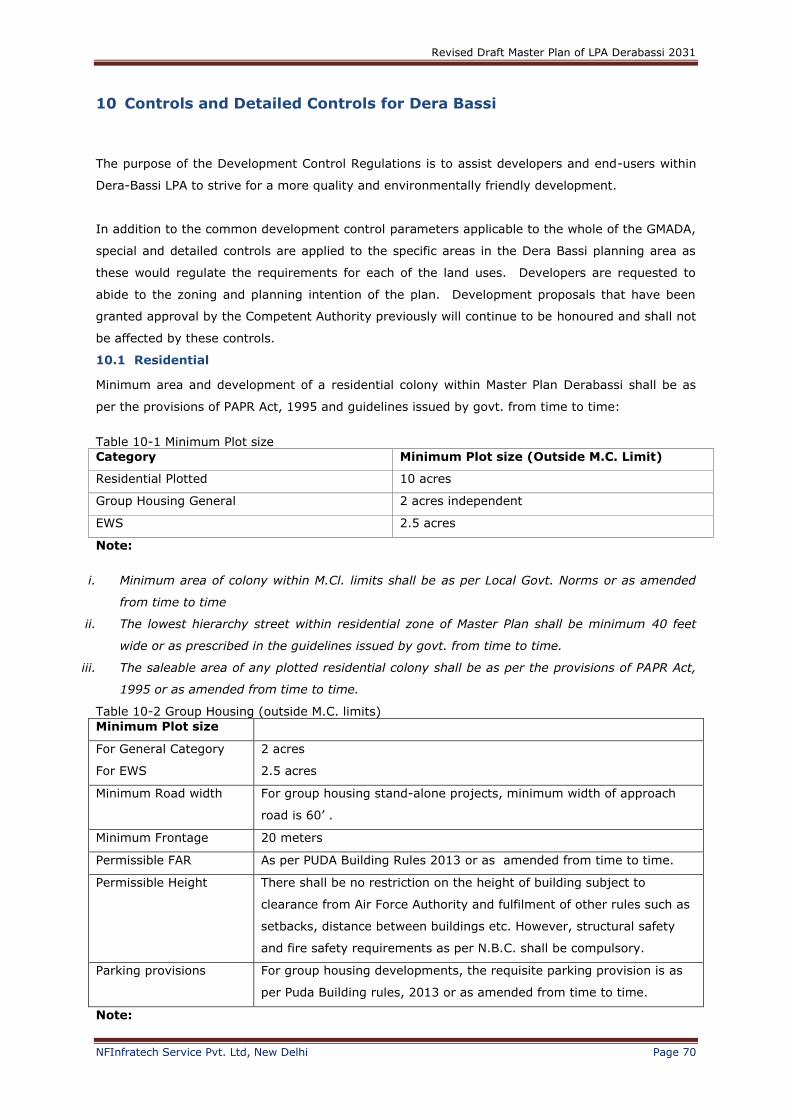
Revised Draft Master Plan of LPA Derabassi 2031
NFInfratech Service Pvt. Ltd, New Delhi Page 70
10 Controls and Detailed Controls for Dera Bassi
The purpose of the Development Control Regulations is to assist developers and end-users within
Dera-Bassi LPA to strive for a more quality and environmentally friendly development.
In addition to the common development control parameters applicable to the whole of the GMADA,
special and detailed controls are applied to the specific areas in the Dera Bassi planning area as
these would regulate the requirements for each of the land uses. Developers are requested to
abide to the zoning and planning intention of the plan. Development proposals that have been
granted approval by the Competent Authority previously will continue to be honoured and shall not
be affected by these controls.
10.1 Residential
Minimum area and development of a residential colony within Master Plan Derabassi shall be as
per the provisions of PAPR Act, 1995 and guidelines issued by govt. from time to time:
Table 10-1 Minimum Plot size
Category Minimum Plot size (Outside M.C. Limit)
Residential Plotted 10 acres
Group Housing General 2 acres independent
EWS 2.5 acres
Note:
i. Minimum area of colony within M.Cl. limits shall be as per Local Govt. Norms or as amended
from time to time
ii. The lowest hierarchy street within residential zone of Master Plan shall be minimum 40 feet
wide or as prescribed in the guidelines issued by govt. from time to time.
iii. The saleable area of any plotted residential colony shall be as per the provisions of PAPR Act,
1995 or as amended from time to time.
Table 10-2 Group Housing (outside M.C. limits)
Minimum Plot size
For General Category
For EWS
2 acres
2.5 acres
Minimum Road width For group housing stand-alone projects, minimum width of approach
road is 60’ .
Minimum Frontage 20 meters
Permissible FAR As per PUDA Building Rules 2013 or as amended from time to time.
Permissible Height There shall be no restriction on the height of building subject to
clearance from Air Force Authority and fulfilment of other rules such as
setbacks, distance between buildings etc. However, structural safety
and fire safety requirements as per N.B.C. shall be compulsory.
Parking provisions For group housing developments, the requisite parking provision is as
per Puda Building rules, 2013 or as amended from time to time.
Note:

Revised Draft Master Plan of LPA Derabassi 2031
NFInfratech Service Pvt. Ltd, New Delhi Page 71
1. Construction of residential houses sold by promoters on floor basis shall also be considered as
Group / Flatted housing developments and parking requirements shall be as per the norms
governed by PUDA Building rules 2013 or as per amended from time to time.
2. For group housing within M.C. limits norms of local government shall be applicable.
Table 10-3 Farm House
Minimum agricultural land holding 2.5 acres*
FAR 0.04
Ground Coverage 2%
Number of storey’s 2
Height Single Storey 18’-0”
Double Storey 28’-0”
Hard Surface 10%
*Area other than under the built up farm house shall be exclusively used for agricultural and its
allied activities
Note: The Development controls/Guidelines/Norms & Standards revised from time to time by the
Government shall have overriding effect on the Development controls mentioned in the
master plan.
10.2 Commercial
At local level
There shall be provisions for small scale, double storey commercial subject to the condition that
abutting road shall have a minimum width of 60 feet with minimum 20 feet front setback from
road for parking purposes. However the norms for low rise commercial developments within M.C.
limits shall be as per the local body/Municipal council’s rules and regulations.
Stand-Alone Commercial Complexes
For stand-alone commercial complexes with height more than double storeys, the additional
criteria listed in following table shall apply.
Table 10-4 Criteria for stand – alone commercial complexes (more than double storey’s)
Item Permissible Norms / Standards
Minimum Plot size 1000 sq. m
Minimum Road width 80 feet
Minimum Frontage 20 m
FAR As per PUDA Building Rules 2013 or as amended from time to time.
Maximum Ground coverage
40%
Parking
As per PUDA Building Rules 2013 or as amended from time to time.
Landscaping If the site area is one acre or above, minimum 15% of the total area is to be reserved for landscaping purposes
Note:
1. The ground coverage, F.A.R., Height of the building and parking norms shall be as provided in
the local body/municipal building byelaws, if the project is located within M.C. limit of the
town.

Revised Draft Master Plan of LPA Derabassi 2031
NFInfratech Service Pvt. Ltd, New Delhi Page 72
2. The ECS shall be counted as below:
23 square meters for open parking
28 square meters for parking under stilts on ground floor
32 square meters for parking in the basement.
3. The Development controls/Guidelines/Norms & Standards revised from time to time by the
Government shall have overriding effect on the Development controls mentioned in the master
plan.
4. Commercial facilities are intended to serve the needs of local residents only and will not be
shown separately on the Master Plan. Instead, they are subsumed under the predominant
residential land use.
a) Development Controls around the Designated Industrial Use Zones
The industrial development regulations and controls prepared for Dera Bassi LPA are meant to
guide development and to facilitate the industries to design and implement their developments
successfully. Relevant legislative and regulatory guidelines for compliance of Environmental
Laws under Punjab Pollution Control Board are duly incorporated in this chapter. However the
industries prior to the final notification no. 8355-CTP(PB)/SD-46, dated 13.11.2009 of Master plan
Derabassi u/s 70(5) of the Punjab Regional and Town planning and Development Act,1995, which
have come under non confirming land use in this master plan may continue to operate and expand
within the existing premises only provided that the industry has valid requisite permission of the
Punjab Pollution Control Board.
Presently, the Dera Bassi area is heavily regarded as one of Punjab’s key industrial towns as
many industrial developments have been allowed to reside and operate in this town. There is a
crucial need to enforce vital environmental provisions around these industrial developments so
as to preserve the quality of life for the surrounding land uses such as the existing villages,
schools and agricultural lands. Environmental impact can be mitigated by ensuring that the
different types of industrial development are sited in designated areas and pollution control
measures are incorporated in their design.
As explained in the land use chapter, Dera Bassi will consider the following special uses for
industrial land:
1. General & Heavy Industries
2. High-Technology/ IT Park
General and Heavy Industries development regulations
The classification of industries is defined as follows:
Light & clean industries = Green industry
General industries = Non-Red/Green industry
Heavy industries – Red industries
The following lists down the typical uses under light and general industries: Manufacture of
made-up textile goods (except wearing apparel) without dyeing, bleaching and/ or other finishing
operations).
Servicing and refilling of fire extinguishers.
Packing and bottling of medicinal herbs and medicated oil.
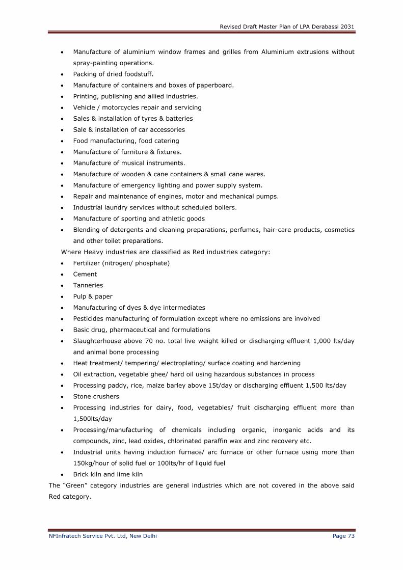
Revised Draft Master Plan of LPA Derabassi 2031
NFInfratech Service Pvt. Ltd, New Delhi Page 73
Manufacture of aluminium window frames and grilles from Aluminium extrusions without
spray-painting operations.
Packing of dried foodstuff.
Manufacture of containers and boxes of paperboard.
Printing, publishing and allied industries.
Vehicle / motorcycles repair and servicing
Sales & installation of tyres & batteries
Sale & installation of car accessories
Food manufacturing, food catering
Manufacture of furniture & fixtures.
Manufacture of musical instruments.
Manufacture of wooden & cane containers & small cane wares.
Manufacture of emergency lighting and power supply system.
Repair and maintenance of engines, motor and mechanical pumps.
Industrial laundry services without scheduled boilers.
Manufacture of sporting and athletic goods
Blending of detergents and cleaning preparations, perfumes, hair-care products, cosmetics
and other toilet preparations.
Where Heavy industries are classified as Red industries category:
Fertilizer (nitrogen/ phosphate)
Cement
Tanneries
Pulp & paper
Manufacturing of dyes & dye intermediates
Pesticides manufacturing of formulation except where no emissions are involved
Basic drug, pharmaceutical and formulations
Slaughterhouse above 70 no. total live weight killed or discharging effluent 1,000 lts/day
and animal bone processing
Heat treatment/ tempering/ electroplating/ surface coating and hardening
Oil extraction, vegetable ghee/ hard oil using hazardous substances in process
Processing paddy, rice, maize barley above 15t/day or discharging effluent 1,500 lts/day
Stone crushers
Processing industries for dairy, food, vegetables/ fruit discharging effluent more than
1,500lts/day
Processing/manufacturing of chemicals including organic, inorganic acids and its
compounds, zinc, lead oxides, chlorinated paraffin wax and zinc recovery etc.
Industrial units having induction furnace/ arc furnace or other furnace using more than
150kg/hour of solid fuel or 100lts/hr of liquid fuel
Brick kiln and lime kiln
The “Green” category industries are general industries which are not covered in the above said
Red category.
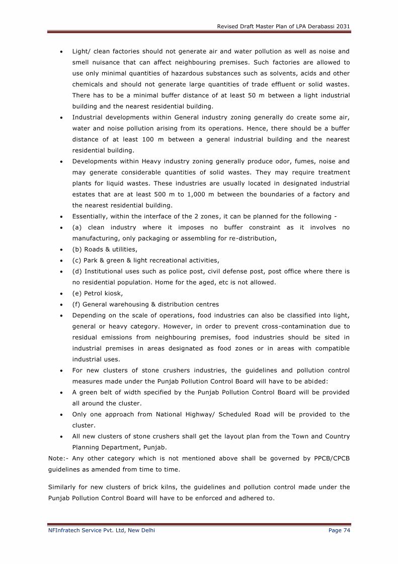
Revised Draft Master Plan of LPA Derabassi 2031
NFInfratech Service Pvt. Ltd, New Delhi Page 74
Light/ clean factories should not generate air and water pollution as well as noise and
smell nuisance that can affect neighbouring premises. Such factories are allowed to
use only minimal quantities of hazardous substances such as solvents, acids and other
chemicals and should not generate large quantities of trade effluent or solid wastes.
There has to be a minimal buffer distance of at least 50 m between a light industrial
building and the nearest residential building.
Industrial developments within General industry zoning generally do create some air,
water and noise pollution arising from its operations. Hence, there should be a buffer
distance of at least 100 m between a general industrial building and the nearest
residential building.
Developments within Heavy industry zoning generally produce odor, fumes, noise and
may generate considerable quantities of solid wastes. They may require treatment
plants for liquid wastes. These industries are usually located in designated industrial
estates that are at least 500 m to 1,000 m between the boundaries of a factory and
the nearest residential building.
Essentially, within the interface of the 2 zones, it can be planned for the following -
(a) clean industry where it imposes no buffer constraint as it involves no
manufacturing, only packaging or assembling for re-distribution,
(b) Roads & utilities,
(c) Park & green & light recreational activities,
(d) Institutional uses such as police post, civil defense post, post office where there is
no residential population. Home for the aged, etc is not allowed.
(e) Petrol kiosk,
(f) General warehousing & distribution centres
Depending on the scale of operations, food industries can also be classified into light,
general or heavy category. However, in order to prevent cross-contamination due to
residual emissions from neighbouring premises, food industries should be sited in
industrial premises in areas designated as food zones or in areas with compatible
industrial uses.
For new clusters of stone crushers industries, the guidelines and pollution control
measures made under the Punjab Pollution Control Board will have to be abided:
A green belt of width specified by the Punjab Pollution Control Board will be provided
all around the cluster.
Only one approach from National Highway/ Scheduled Road will be provided to the
cluster.
All new clusters of stone crushers shall get the layout plan from the Town and Country
Planning Department, Punjab.
Note:- Any other category which is not mentioned above shall be governed by PPCB/CPCB
guidelines as amended from time to time.
Similarly for new clusters of brick kilns, the guidelines and pollution control made under the
Punjab Pollution Control Board will have to be enforced and adhered to.
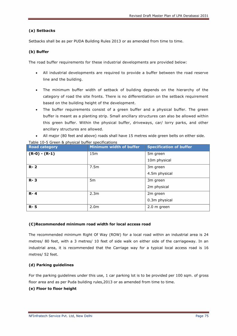
Revised Draft Master Plan of LPA Derabassi 2031
NFInfratech Service Pvt. Ltd, New Delhi Page 75
(a) Setbacks
Setbacks shall be as per PUDA Building Rules 2013 or as amended from time to time.
(b) Buffer
The road buffer requirements for these industrial developments are provided below:
All industrial developments are required to provide a buffer between the road reserve
line and the building.
The minimum buffer width of setback of building depends on the hierarchy of the
category of road the site fronts. There is no differentiation on the setback requirement
based on the building height of the development.
The buffer requirements consist of a green buffer and a physical buffer. The green
buffer is meant as a planting strip. Small ancillary structures can also be allowed within
this green buffer. Within the physical buffer, driveways, car/ lorry parks, and other
ancillary structures are allowed.
All major (80 feet and above) roads shall have 15 metres wide green belts on either side.
Table 10-5 Green & physical buffer specifications
Road category Minimum width of buffer Specification of buffer
(R-0) - (R-1) 15m 5m green
10m physical
R- 2 7.5m 3m green
4.5m physical
R- 3 5m 3m green
2m physical
R- 4 2.3m 2m green
0.3m physical
R- 5 2.0m 2.0 m green
(C)Recommended minimum road width for local access road
The recommended minimum Right Of Way (ROW) for a local road within an industrial area is 24
metres/ 80 feet, with a 3 metres/ 10 feet of side walk on either side of the carriageway. In an
industrial area, it is recommended that the Carriage way for a typical local access road is 16
metres/ 52 feet.
(d) Parking guidelines
For the parking guidelines under this use, 1 car parking lot is to be provided per 100 sqm. of gross
floor area and as per Puda building rules,2013 or as amended from time to time.
(e) Floor to floor height
Revised Draft Master Plan of LPA Derabassi 2031
NFInfratech Service Pvt. Ltd, New Delhi Page 76
Generally, the floor to floor height for industrial developments should not exceed 6.0m.
However, this control can be varied due to the operational needs of industrial machinery. The
1st storey of industrial development can be raised by 1.2 metres (maximum) for loading and
unloading purposes.
(f) Quantum of use
The predominant industrial use quantum shall be at least 60% of the total FAR on a global
basis and the ancillary use within the entire development must not exceed 40%. Ancillary use
supports the predominant industrial or warehouse operations and conducted within the same
development or within the individual unit. The following lists down the typical allowable
ancillary use in an industrial unit.
Ancillary offices
Ancillary showrooms
Meeting rooms
Toilets
Mechanical & electrical services
Sick bay room/ 1st aid room
Childcare centre
Independent media activities (treated as secondary use under 40% ancillary
components)
The non-allowable within this 40% ancillary quantum uses include:
Restaurant
Medical clinic
Mini-mart
Supermarket
Clubhouse
Independent office, bank & other commercial use.Single-user development
This refers to a purpose-built development for a single occupier. Any sub-leasing of space within
the building(s) is subject to the approval of Competent Authority.
FAR Quantum Use Type Allowable Use under each Use Type
> 50% of the total Covered Area - CA (MINIMUM)
Predominant Use Manufacturing, Assembly, Servicing/ repair workshop, storage
<50% of the total Covered
Area - CA (MAXIMUM)
Ancillary Use
supporting the Predominant Use within a Unit
Ancillary office, Ancillary showroom (own
products), Meeting room, Sick room/ first aid room, Toilets, M&E services, Canteen, Child care centre
Within each leased space, the unit shall comply with the >5
Multiple-User Developments
This is usually a flatted factory that can be subdivided to different spaces for lease by an industrial
developer and thus could be used by multiple users. Any sub-leasing of space within the
Revised Draft Master Plan of LPA Derabassi 2031
NFInfratech Service Pvt. Ltd, New Delhi Page 77
building(s) is subject to the approval of the GMADA. The users of the individual units are
independent of one another.
Table 10-6 Quantum control for uses within each leased space by each individual unit in multiple-
user development
FAR Quantum Use Type Allowable Use under each Use Type
>50% of the total Covered
Area - CA (MINIMUM)
Predominant Use Manufacturing, Assembly, Servicing/
repair workshop, storage
<50% of the total Covered
Area - CA (MAXIMUM)
Ancillary Use
supporting the
Predominant Use
within a Unit
Ancillary office, Ancillary showroom (own
products), Meeting room, ancillary
warehouse
Within each leased space, the unit shall comply with the >50% of the Covered Area - CA as
predominant industrial/ warehouse use quantum and <50% of their CA for their own ancillary
uses.
Common use for the benefit for all units in a Multiple-User development include Management
office, Corridor, Staircase, Lifts, Sick room/ First aid room, Communal toilets, M & E services,
Canteen, Child care centre is not calculated as part of the <50% Ancillary Use.
Secondary uses are compatible but independent uses that can be considered within the 40%
use quantum are canteen, childcare centre, secondary showroom and secondary warehouse.
Secondary showrooms are allowed only for warehouse/ factories facing main thoroughfare and
shall be confined only to the 1st storey. The intention is to allow the secondary showroom to
spruce up the streetscape of industrial developments.
Revised Draft Master Plan of LPA Derabassi 2031
NFInfratech Service Pvt. Ltd, New Delhi Page 78
10.2.1 Intensity of Development
The following table stipulates the controlled intensity of the overall development in Dera Bassi
LPA.
Table 10-7 Intensity of development (overall)
Land use FAR Permitted uses
Industry a) Industry & warehouse use
b) Technology & R&D
FAR for general Industries as per Puda Building Rules 2013 or as amended from time to time
FAR for technology and R & D as per Puda Building Rules 2013 or as amended from time to time
a) Industrial and warehousing use – Only clean and light industries and logistics use are permitted. General industries are permitted in locations furthest from the residential areas. Heavy/ Chemical industries must be sited at
least 1km away from any residential lands.
b) High-technology/ IT park – minimum site area = 10 acres. The permitted uses will include IT parks; Science and research parks; Business Parks; Laboratories, media hubs and
bio-technology parks. c) Individual industrial plots irrespective of the category shall have FAR of 1.0 only.
Institution FAR =1.0 Permitted uses include : Secondary and Tertiary educational institutions; Health Clinic, Medical Facility,
Police or Fire Station, Post Office, Religious Facility, Museum/Archives, Secondary School, Medical & Engineering Colleges, Technical training institutes, international schools, sports.
Residential
As per Building rules Dwelling uses:
a) Detached dwelling units, cluster housing, plotted housing, Single family residences, townhouses, garden apartments and apartments, villas b) Worker dormitories and EWS housing Permitted Ancillary Uses: a) Cultural and recreational uses - parks and
sports field b) Nursery school c) Parking area d) Service uses like barber shop, beauty saloon, clinic, Laundromat etc e) Police or Fire Station, Post Office
f) Utility and communication uses
Mega Residential Township As per approved project
EWS: One room and two room flats minimum 80 Units per acres. The allowable FAR is up to
Revised Draft Master Plan of LPA Derabassi 2031
NFInfratech Service Pvt. Ltd, New Delhi Page 79
1.2
Group Housing FAR = 2.0 As part of the overall sector plan/ layout plans.
Plotted Housing As per PUDA Building Rules 2013 or as
amended from time to time.
Up to 3 storeys (Max 11.75 metres)
Densities
E.W.S. - NA
< DU 1200 sq ft. - 450 pp acre
1200 – 3000 sq ft. - 300 pp acre
> 3000 sq ft. - 250 PP acre
10.2.2 High-Technology/ It Park Development Regulations
This use is specifically set aside for non-pollutive industries and businesses that engage in high-
technology, research and development, high value-added and knowledge-intensive activities.
These modern businesses are seeking premises which can accommodate a variety of activities,
ranging from light manufacturing to other “office-like” functions. The “park-like” working
environment, both within and surrounding the building, is also important to attract and retain
professionals and highly-skilled technical staff.
Sizeable large area of land is accommodated for High-Technology/ IT Parks to allow for
comprehensive landscaping in creating a park-like business environment for work and play. The
allowable uses within this use are listed as follows:
Table 10-8 Permitted activities in High Technology/ IT park No. Type of activities
1 Development/ production of software, maintenance of software and user training and sales
2 Upgrading of software
3 Computer system integration
4 Computer-related services
5 Plastic Product design & development
6 Fashion, furniture, Jewellery design & exhibition design
7 Oil rig design
8 Offshore structure design
9 Ships design
10 Computer systems design
11 Communication equipment design
12 Electronic instruments & device design
13 Audio/ video product design
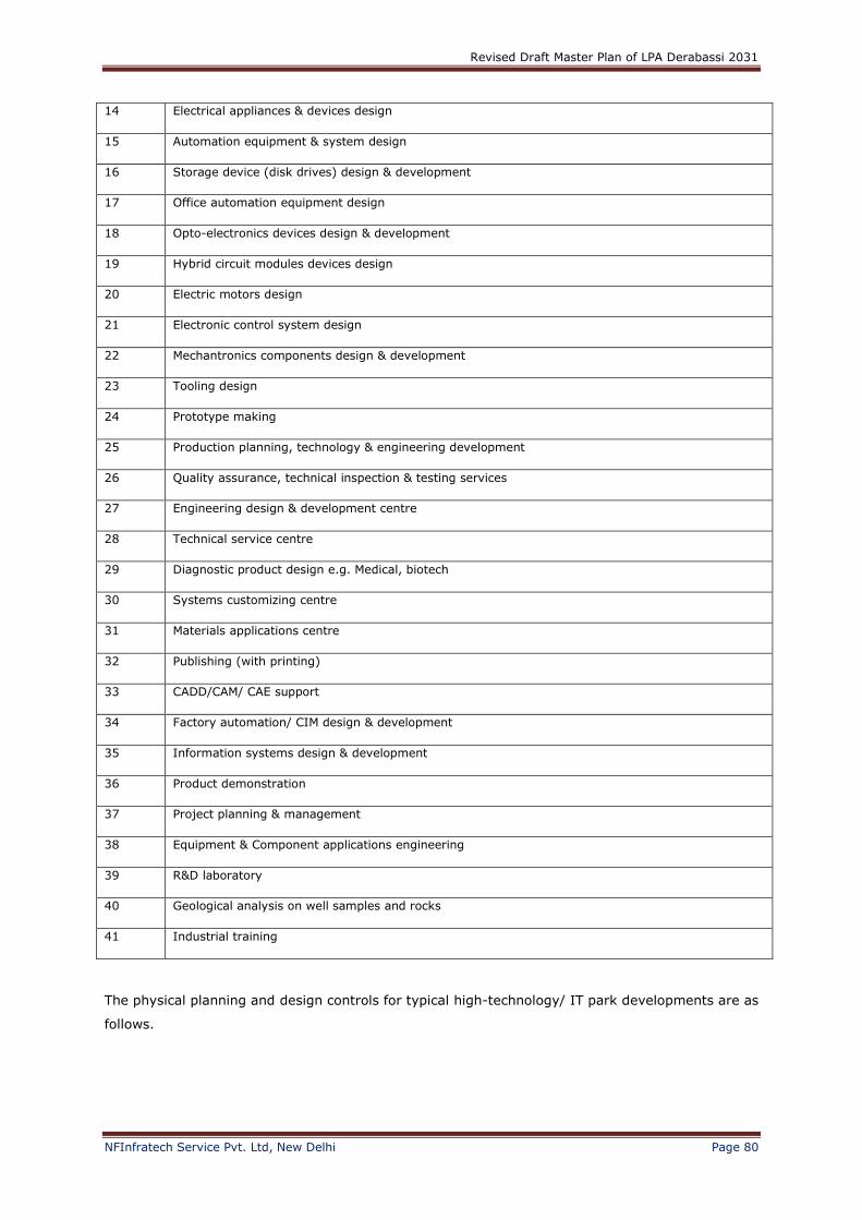
Revised Draft Master Plan of LPA Derabassi 2031
NFInfratech Service Pvt. Ltd, New Delhi Page 80
14 Electrical appliances & devices design
15 Automation equipment & system design
16 Storage device (disk drives) design & development
17 Office automation equipment design
18 Opto-electronics devices design & development
19 Hybrid circuit modules devices design
20 Electric motors design
21 Electronic control system design
22 Mechantronics components design & development
23 Tooling design
24 Prototype making
25 Production planning, technology & engineering development
26 Quality assurance, technical inspection & testing services
27 Engineering design & development centre
28 Technical service centre
29 Diagnostic product design e.g. Medical, biotech
30 Systems customizing centre
31 Materials applications centre
32 Publishing (with printing)
33 CADD/CAM/ CAE support
34 Factory automation/ CIM design & development
35 Information systems design & development
36 Product demonstration
37 Project planning & management
38 Equipment & Component applications engineering
39 R&D laboratory
40 Geological analysis on well samples and rocks
41 Industrial training
The physical planning and design controls for typical high-technology/ IT park developments are as
follows.
Revised Draft Master Plan of LPA Derabassi 2031
NFInfratech Service Pvt. Ltd, New Delhi Page 81
10.2.2.1 Intensity
High-Technology/ IT Parks in Dera Bassi LPA will be grouped under 2 intensity types in terms of
overall FAR:
i. Medium Intensity area : FAR 3.0 (max)
ii. Low Intensity area : FAR 3.0 (max)
Or as per PUDA Building Rules 2013 or as amended from time to time.
10.2.2.2 Building heights
The number of storeys for High-Technology/ IT Park building is controlled to preserve the park-like
image. The maximum floor-to-floor height is not to exceed 5 metres, unless for some operational
needs, waiver is to be sought from the relevant authority i.e. GMADA to allow exceeding this
height limit. The maximum number of storeys permissible is as follows:
i. Medium intensity area - 5 storeys
ii. Low intensity area - 3 storeys
For IT Parks, minimum area shall be 10 acres, out of which 60% shall be used for IT, 30% for
Residential and 10% for commercial purpose. FAR shall be governed by PUDA Building Rules 2013
or as amended from time to time .
10.3 Parking guidelines
As the ownership of cars is presumably higher than other development, 2 car parking lots are to
be provided per 100 sqm. of covered area.
10.4 Landscaping
The minimum landscaped area (including water features) for overall development, including public
and private green is 20%. Public green refers to the landscaped common open space area
(excluding car park areas) that would form a central feature of the High-Technology/ IT Park. A
minimum of 10% of the total development area should be set aside as private green. The green
boundary buffer along all sides of each individual lot will be provided.
10.5 Other development controls and guidelines required
Regulation for village abadi: Special building regulation shall be prepared for the development
and regulation of an area falling within the Lal Dora or phirini of the villages falling in the LPA.
The existing HT-lines shall be shifted along the road but outside the Right of Way to ensure
unhindered R.O.W. for traffic and other services for all times.
The minor ‘choes’ shall have minimum 15 metres wide green strips on each side. Other major
‘choes’ shall have minimum 30 metres green strips on each side. Realignment of ‘choes’ shall
be permissible, wherever feasible, subject to the certification by Engineering Department to
ensure free flow of storm water. After any such realignment, the river mouth, the river bed
and the green strip on either side shall be maintained at least to the minimum prescribed level
for this choe before realignment. In these green strips, golf course, sports and recreational
Revised Draft Master Plan of LPA Derabassi 2031
NFInfratech Service Pvt. Ltd, New Delhi Page 82
activities shall be permissible but no construction would be allowed. The support facilities for
these activities shall be constructed outside the green strips.
Note:- Any other notification order issued by Department/Government, which is not
covered above shall be governed by the notifications/guidlines issued from time to
time.
10.6 Pollution Control Requirements
Industrial developments shall be designed and incorporated with pollution control facilities to
reduce and control pollution so as to minimize any adverse pollution impact on surrounding
developments.
Water (Prevention & Control of Pollution) Act, 1974 & Air (Prevention & Control of
Pollution) Act, 1981 – (Punjab Pollution Control Board 2005)
As per the provisions of the Water (Prevention & Control of Pollution) Act, 1974 and
(Prevention & Control of Pollution) Act, 1981, any entrepreneur desirous of establishing a new
industry expansion of its existing unit is required to obtain “consent to establish” (NOC) from
the board before taking any steps for establishment/ expansion of industry.
The Board has categorized the small scale industrial units into 2 categories, namely Green
category and Red Category industries, taking into consideration their pollution potential loads.
For small scale green category industry, the Board has devised a very simplified
application form for obtaining “consent to establish” (NOC) of the Board for Green
Category of industries. Applications are to be enclosed with consent fee which is 50% of
the prescribed for Red category of industries. Applications for NOC for Green Category of
industries are decided at Regional Office level by the concerned Environmental Engineer.
For small scale red category industry, the applications for consent to operate is decided at
Zonal Office level by the concerned Senior Environmental Engineer. However some cases
like brick kilns, dry rice shelter cupola furnaces (with air pollution control devices designed
by Punjab State Council for Science and Technology, Chandigarh), heat treatment units
(without discharge of any effluent) are decided by concerned Regional Office.
For large/ medium scale industries, the procedure is the same as the small scale red
category industries. But such applications are decided at the Head Office level.
Environmental clearances from Government of India - (Punjab Pollution Control Board
2005)
As per notification No. SO (60) dated 27 January 1994 as emended on 4 May 1994
issued by Ministry of Environment & Forests, Government of India, New Delhi, any person,
who desires to undertake any new project or expansion or modernization of any existing
industry which is listed in schedule-I (Annexure-III) shall be required to obtain environmental
clearance from the Ministry of Environment & Forests, Government of India, New Delhi. He

Revised Draft Master Plan of LPA Derabassi 2031
NFInfratech Service Pvt. Ltd, New Delhi Page 83
will submit an application with the Secretary, Ministry of Environment & Forests, Government
of India, New Delhi for this purpose. The application made shall be accompanies with EIA/
Environment Management Plants etc, prepared in accordance with guidelines issued by the
Ministry of Environment & Forests from time to time.
Revalidation of “Consent to establish” (NOC) – (Punjab Pollution Control Board 2005)
Every entrepreneur is expected to complete construction of the industrial unit and the
installation of the pollution control equipments within the validity period of one year of the
NOC. However, in case the industry fails to implement its proposed project within the
validity period of NOC, it will be required to get its NOC revalidated.
Hazardous Substances Control
(Code of Practice on Pollution Control 200l, National Environmental Agency, Singapore
and Punjab Pollution Control Board 2005)
Companies that import, store and use hazardous substances are required to obtain licenses/
permits from Pollution Control Department. Approval for transportation of hazardous substances
exceeding specified quantities have to be sought. The controls are to ensure that preventive
measures are taken to minimize accidental releases of hazardous substances into the environment
and emergency responses are to put in place to deal with all credible accident scenarios of release
of hazardous substances. The preventive measures can include:
Containers constructed and inspected in accordance with internationally acceptable
standards are uses for the storage of hazardous substances and affixed with approved
labels;
Storage areas are equipped with containment as well as disposal facilities to deal with any
accidental release of hazardous substances;
Route and time of transportation are specified for the transportation of hazardous
substances exceeding specified quantities;
Drivers of road tankers and tankers carrying hazardous substances are required to
undergo special training course on safety requirements and precautions, first aid and fire
fighting and a refresher course once every three years;
The owner or consignor of any consignment of any hazardous substance shall notify
immediately of any accidental release, leakage or spill or hazardous substances during
transport.
Under the obligations on the part of entrepreneurs under the Public Liability Insurance Act, 1991,
Punjab Pollution Control Board, it has been enacted to provide an insurance cover to the persons
affected by the accident occurring while handling any hazardous substance and for matters
connected therewith or incidental thereto.
Every owner shall take out insurance policy providing for contracts of insurance and renewed from
time to time whosoever is engaged in the handling of any hazardous substances. The
responsibilities of the owner as stated under this act will be enforced to apply.
Revised Draft Master Plan of LPA Derabassi 2031
NFInfratech Service Pvt. Ltd, New Delhi Page 84
10.7 Toxic Industrial Waste Control
(Code of Practice on Pollution Control 200l, National Environmental Agency, Singapore)
Factories involved in the manufacture of chemicals will be required to install in-house treatment
facilities to recycle and reuse their toxic waste or to treat their toxic wastes before they can be
safely disposed.
Pathogenic wastes are listed as toxic industrial wastes. Hospitals and polyclinics are required to
segregate pathogenic wastes and put in colored-coded plastic bags. These wastes are then stored
in special containers for collection by licensed toxic industrial waste collectors for disposal in high
temperature incinerators.
Operators of specialized toxic waste recycling, treatment and disposal plants would require
obtaining licenses to collect and treat and dispose toxic industrial wastes from industries. They will
also be required to obtain the necessary approval to transport the toxic industrial wastes which are
exceeding the specified quantities.
10.8 Control of Land Pollution and Remediation of Contaminated Sites
(Source: Code of Practice on Pollution Control 2004, National Environmental Agency, Singapore)
When a site that is used for pollutive activities is to be redeveloped, rezoned or reuse for a
non-pollutive activity, a study shall be conducted on the site to assess the extent of land
contamination. If the site assessment study shows that the site is contaminated, the
contaminated site shall be cleaned up to standards acceptable for the intended use.
Owners/ occupiers or the prospective buyers/ lessees may carry out the site assessment study
and clean up suing in-house or second party experts, subject to the approval from the
Pollution Control Department.
When a site used for a pollutive activity to be leased, transferred or sold to another party for
the same or other pollutive activity, it is advisable that a site assessment study be conducted
to allow parties involved to ascertain extent of existing contamination.
When a site is to be developed for a pollutive activity, it is advisable that a site assessment
study be conducted to establish the baseline soil conditions for future assessment of land
contamination. A report of the site assessment and a clean-up plan will be submitted to the
Punjab Pollution Control Board.
10.9 Transferable Development Rights
It is necessary to speed up the process of development. For that, the development of public
utilities such as roads, parks, green belts etc., should be done on top priority which will encourage
the urbanization. To make it realistic, it is necessary that the land falling under roads, parks and
green belts should be transferred to Urban Development Authorities. To acquire this land, the
prevalent way adopted till date, is the cash payment of land acquired and 2nd option is to get the
land through land pooling scheme which has been approved by the Government. To speed up the
development process and to protect the interest of land owners, the land owners may be given 3rd
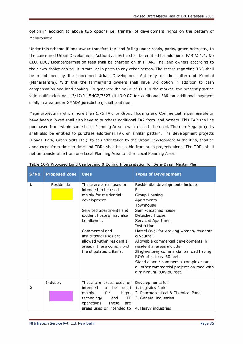
Revised Draft Master Plan of LPA Derabassi 2031
NFInfratech Service Pvt. Ltd, New Delhi Page 85
option in addition to above two options i.e. transfer of development rights on the pattern of
Maharashtra.
Under this scheme if land owner transfers the land falling under roads, parks, green belts etc., to
the concerned Urban Development Authority, he/she shall be entitled for additional FAR @ 1:1. No
CLU, EDC, Licence/permission fees shall be charged on this FAR. The land owners according to
their own choice can sell it in total or in parts to any other person. The record regarding TDR shall
be maintained by the concerned Urban Development Authority on the pattern of Mumbai
(Maharashtra). With this the farmer/land owners shall have 3rd option in addition to cash
compensation and land pooling. To generate the value of TDR in the market, the present practice
vide notification no. 17/17/01-5HG2/7623 dt.19.9.07 for additional FAR on additional payment
shall, in area under GMADA jurisdiction, shall continue.
Mega projects in which more than 1.75 FAR for Group Housing and Commercial is permissible or
have been allowed shall also have to purchase additional FAR from land owners. This FAR shall be
purchased from within same Local Planning Area in which it is to be used. The non Mega projects
shall also be entitled to purchase additional FAR on similar pattern. The development projects
(Roads, Park, Green belts etc.), to be under taken by the Urban Development Authorities, shall be
announced from time to time and TDRs shall be usable from such projects alone. The TDRs shall
not be transferable from one Local Planning Area to other Local Planning Area.
Table 10-9 Proposed Land Use Legend & Zoning Interpretation for Dera-Bassi Master Plan
S/No.
Proposed Zone
Uses
Types of Development
1 Residential
These are areas used or
intended to be used
mainly for residential
development.
Serviced apartments and
student hostels may also
be allowed.
Commercial and
institutional uses are
allowed within residential
areas if these comply with
the stipulated criteria.
Residential developments include:
Flat
Group Housing
Apartments
Townhouse
Semi-detached house
Detached House
Serviced Apartment
Institution
Hostel (e.g. for working women, students
& youths )
Allowable commercial developments in
residential areas include:
Single-storey commercial on road having
ROW of at least 60 feet.
Stand alone / commercial complexes and
all other commercial projects on road with
a minimum ROW 80 feet.
2
Industry
These are areas used or
intended to be used
mainly for high-
technology and IT
operations. These are
areas used or intended to
Developments for:
1. Logistics Park
2. Pharmaceutical & Chemical Park
3. General industries
4. Heavy industries
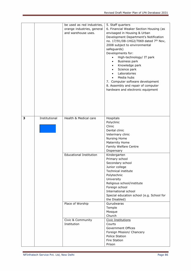
Revised Draft Master Plan of LPA Derabassi 2031
NFInfratech Service Pvt. Ltd, New Delhi Page 86
be used as red industries,
orange industries, general
and warehouse uses.
5. Staff quarters
6. Financial Weaker Section Housing (as
envisaged in Housing & Urban
Development Department’s Notification
no. 17/91/08-1HG2/7069 dated 7th Nov,
2008 subject to environmental
safeguards)
Developments for:
High-technology/ IT park
Business park
Knowledge park
Science park
Laboratories
Media hubs
7. Computer software development
8. Assembly and repair of computer
hardware and electronic equipment
3 Institutional
Health & Medical care Hospitals
Polyclinic
Clinic
Dental clinic
Veterinary clinic
Nursing Home
Maternity Home
Family Welfare Centre
Dispensary
Educational Institution
Kindergarten
Primary school
Secondary school
Junior college
Technical institute
Polytechnic
University
Religious school/institute
Foreign school
International school
Special education school (e.g. School for
the Disabled)
Place of Worship Gurudwaras
Temple
Mosque
Church
Civic & Community
Institution
Civic Institutions
Courts
Government Offices
Foreign Mission/ Chancery
Police Station
Fire Station
Prison
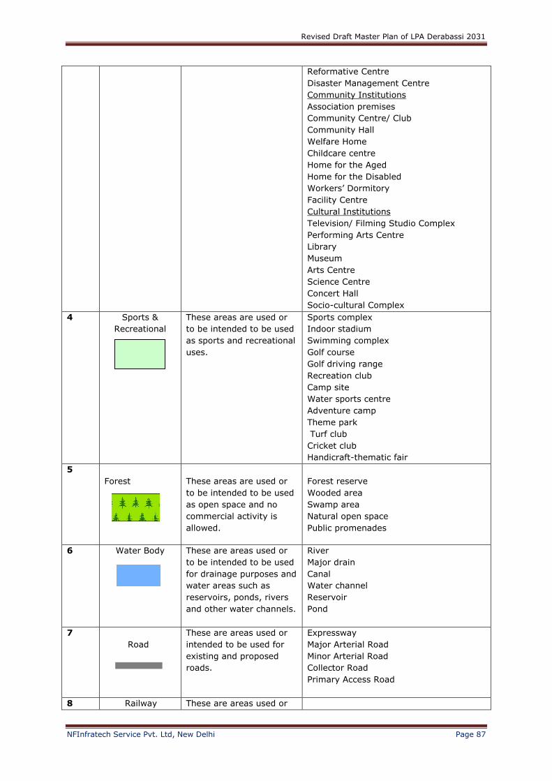
Revised Draft Master Plan of LPA Derabassi 2031
NFInfratech Service Pvt. Ltd, New Delhi Page 87
Reformative Centre
Disaster Management Centre
Community Institutions
Association premises
Community Centre/ Club
Community Hall
Welfare Home
Childcare centre
Home for the Aged
Home for the Disabled
Workers’ Dormitory
Facility Centre
Cultural Institutions
Television/ Filming Studio Complex
Performing Arts Centre
Library
Museum
Arts Centre
Science Centre
Concert Hall
Socio-cultural Complex
4 Sports &
Recreational
These areas are used or
to be intended to be used
as sports and recreational
uses.
Sports complex
Indoor stadium
Swimming complex
Golf course
Golf driving range
Recreation club
Camp site
Water sports centre
Adventure camp
Theme park
Turf club
Cricket club
Handicraft-thematic fair
5
Forest
These areas are used or
to be intended to be used
as open space and no
commercial activity is
allowed.
Forest reserve
Wooded area
Swamp area
Natural open space
Public promenades
6 Water Body
These are areas used or
to be intended to be used
for drainage purposes and
water areas such as
reservoirs, ponds, rivers
and other water channels.
River
Major drain
Canal
Water channel
Reservoir
Pond
7
Road
These are areas used or
intended to be used for
existing and proposed
roads.
Expressway
Major Arterial Road
Minor Arterial Road
Collector Road
Primary Access Road
8 Railway These are areas used or

Revised Draft Master Plan of LPA Derabassi 2031
NFInfratech Service Pvt. Ltd, New Delhi Page 88
intended to be used for
existing and proposed
railway
9 Utility
These are areas used or
intended to be used
mainly for public utilities
and telecommunication
infrastructure, including
water works, sewage
disposal works and other
public installations such
as electric substations.
Electric sub- & grid station
Gas-fired power station
Raw & local water treatment works
Sewage treatment plant
Sewage pumping station
Sewage disposal work
Incineration plant
Landfill site
Treatment storage & disposal facility
Telecommunications station
10 Mixed Land use For Educational,
Institutional and
Residential.
Uses defined in land use zone of
residential and green category
industry.
Commercial
11 Existing Villages
These are the existing
village-abadi areas.
Farm house
Rural settlement
Pond
12 Industry Mix
Green category Industry
Residential (Plotted and Group Housing)
Commercial
Institutions
Hotel
13 Agriculture
These are areas used or
intended to be used
mainly for agriculture
purposes and includes
plant nursery. Also for
areas to be left rural and
not needed by 2031
Agro-technology park Aquaculture farm (e.g. aquarium fish) Plant nursery Hydroponics farm Agriculture research/experimental station Floral mile (i.e., nursery cum wholesale
centre)
Utilities
Note: Any other activity which is not mentioned in table 10-9 , but is compatible to landuse shall
be allowed with the permission of the Competent Authority subject to fulfillment of all
planning norms.


