
.
US Department of Transportation Research and Special Programs Administration
Roosevelt-Vanderbilt NHS Alternative Transportation System
Planning Study
Final Report August 2001
Prepared for Prepared by: National Park Service John A. Volpe Northeast Region National Transportation Systems Center Kendall Square Cambridge, MA 02142
Standard Form 298 (Rev. 8/98)
REPORT DOCUMENTATION PAGE
Prescribed by ANSI Std. Z39.18
Form Approved OMB No. 0704-0188
The public reporting burden for this collection of information is estimated to average 1 hour per response, including the time for reviewing instructions, searching existing data sources, gathering and maintaining the data needed, and completing and reviewing the collection of information. Send comments regarding this burden estimate or any other aspect of this collection of information, including suggestions for reducing the burden, to Department of Defense, Washington Headquarters Services, Directorate for Information Operations and Reports (0704-0188), 1215 Jefferson Davis Highway, Suite 1204, Arlington, VA 22202-4302. Respondents should be aware that notwithstanding any other provision of law, no person shall be subject to any penalty for failing to comply with a collection of information if it does not display a currently valid OMB control number. PLEASE DO NOT RETURN YOUR FORM TO THE ABOVE ADDRESS. 1. REPORT DATE (DD-MM-YYYY) 2. REPORT TYPE 3. DATES COVERED (From - To)
4. TITLE AND SUBTITLE 5a. CONTRACT NUMBER
5b. GRANT NUMBER
5c. PROGRAM ELEMENT NUMBER
5d. PROJECT NUMBER
5e. TASK NUMBER
5f. WORK UNIT NUMBER
6. AUTHOR(S)
7. PERFORMING ORGANIZATION NAME(S) AND ADDRESS(ES) 8. PERFORMING ORGANIZATION REPORT NUMBER
9. SPONSORING/MONITORING AGENCY NAME(S) AND ADDRESS(ES) 10. SPONSOR/MONITOR'S ACRONYM(S)
11. SPONSOR/MONITOR'S REPORT NUMBER(S)
12. DISTRIBUTION/AVAILABILITY STATEMENT
13. SUPPLEMENTARY NOTES
14. ABSTRACT
15. SUBJECT TERMS
16. SECURITY CLASSIFICATION OF: a. REPORT b. ABSTRACT c. THIS PAGE
17. LIMITATION OF ABSTRACT
18. NUMBER OF PAGES
19a. NAME OF RESPONSIBLE PERSON
19b. TELEPHONE NUMBER (Include area code)

Roosevelt-Vanderbilt Alternative Transportation System Planning Study
Volpe National Transportation Systems Center i
Table of Contents
1. Introduction ............................................................................................................................................ 1 2. Planning Context: Overview of Local Conditions.................................................................................. 3
2.1. Region and Study Area................................................................................................................... 3 2.2. National Historic Sites.................................................................................................................... 3 2.3. Transportation Overview................................................................................................................ 5
3. Transportation Alternatives .................................................................................................................... 8 3.1. ATS Route Configuration............................................................................................................. 10
3.1.1. Route Configuration Options................................................................................................ 11 3.2. ATS Operating Characteristics ..................................................................................................... 14 3.3. Intermediate-Range and Long-Range Operational Options.......................................................... 16 3.4. Parking Requirements................................................................................................................... 18
4. Site Facility and Design Options .......................................................................................................... 20 4.1. FDR NHS ..................................................................................................................................... 23 4.2. Vanderbilt NHS ............................................................................................................................ 25 4.3. Val-Kill NHS................................................................................................................................ 28 4.4. Top Cottage .................................................................................................................................. 31
5. Long-Range Plan Concept: ‘Intercept’ Parking Facility and Central Transportation Hub.................. 33 5.1. Alternative Site Locations ............................................................................................................ 33
5.1.1. Site A – North of Vanderbilt NHS, west side of Route 9 ..................................................... 35 5.1.2. Site B – North of Bellefield Mansion, west side of Route 9................................................. 35 5.1.3. Site C – East of Route 9, Town Center................................................................................. 36 5.1.4. Site D – Drive-In .................................................................................................................. 36 5.1.5. Site E – Intersection of St. Andrew Road and Route 9......................................................... 36
5.2. Concept Elements and Parking Requirements.............................................................................. 37 6. ATS Vehicle Selection Options and Recommendation ........................................................................ 43 7. Phased Implementation Plan ................................................................................................................ 47

Roosevelt-Vanderbilt Alternative Transportation System Planning Study
Volpe National Transportation Systems Center ii
List of Tables and Figures
Figure 2.1 Four NPS Property Study Areas................................................................................................... 3 Table 3.1 Visitor Access Modes, NHS Properties .......................................................................................... 8 Figure 3.1 Option A Configuration .............................................................................................................. 11 Figure 3.2 Option B Configuration .............................................................................................................. 12 Figure 3.3 Three Shuttle Routes ................................................................................................................... 13 Table 3.2 ATS Ridership Estimates .............................................................................................................. 15 Table 3.3 Operating Characteristics ............................................................................................................ 16 Figure 3.5 Route 9 Crossings ....................................................................................................................... 18 Figure 4.1 ATS Station Elements.................................................................................................................. 20 Figure 4.2 ATS Station Concept with Tour Bus Turnaround ...................................................................... 22 Figure 4.3b ATS Station at Home of FDR, Option 1.................................................................................... 23 Figure 4.3a Current Parking Lot ................................................................................................................. 23 at Home of FDR ........................................................................................................................................... 23 Figure 4.4 ATS Station at Bellefield, Option 2 ............................................................................................. 24 Figure 4.5 Short-range Option..................................................................................................................... 25 Figure 4.6 Vanderbilt “Subway” ................................................................................................................. 27 Figure 4.7 ATS with Pedestrian Spur........................................................................................................... 27 Figure 4.8 ATS Station ................................................................................................................................. 29 Figure 4.9 ATS Circulation Plan.................................................................................................................. 30 Figure 4.10 Central Island Parking ............................................................................................................. 30 Figure 4.11 Top Cottage Roadway Treatment ............................................................................................. 31 Figure 5.1 Transportation Hub Locations.................................................................................................... 34 Figure 5.2 Hub Design ................................................................................................................................. 38 Figure 5.3 Partitioned Berths....................................................................................................................... 40 Figure 5.4 Dual Entrances ........................................................................................................................... 40 Figure 5.6 Single Access Drive 2 ................................................................................................................. 41 Figure 5.5 Single Access Drive 1 ................................................................................................................. 41 Figure 6. 1 Tram power car with trailer(s) .................................................................................................. 43 Figure 6. 2 ADA-Compliant tram power car with trailer(s) ........................................................................ 44 Figure 6. 3 Tram power car without trailer(s) attached ............................................................................. 44 Figure 6. 4 Heavy-duty tram power car ...................................................................................................... 45 Figure 6. 5 Heavy-duty tram with trailer(s) ................................................................................................ 45 Figure 6.6 Tug and Trailer Configuration ................................................................................................... 46 Figure 6. 7 Classic trolley design................................................................................................................. 46

Roosevelt-Vanderbilt Alternative Transportation System Planning Study
Volpe National Transportation Systems Center iii
Glossary of Terms
Arterial Route Signalized roadway that primarily serves through traffic and provides access to abutting properties as a secondary function
ATS Alternative Transportation System ATS Station Transit station with physical features, such as bus turnarounds,
pedestrian pathways, and shelters, which facilitate vehicle operations and passenger use
Collector Roadway that provides both land access and traffic circulation
within residential and commercial areas Cross-Section Representation of physical facilities showing relationship of
constituent elements in single spatial plane Cycle Time Total time required by a single vehicle to complete a round trip of
a transit route Earth Berm Mound or wall of earth used for screening, separating, or
integrating physical features or facilities within a site Headway Interval between successive arrivals of transit vehicles at an
individual stop or station; service frequency Load Factor Number of passengers carried on a transit vehicle or system
relative to physical capacity of equipment in service Pathway Apron Space dedicated to a particular mode of circulation around a
physical facility or within a site (e.g. pedestrian pathway apron) Right-of-Way Public land over which a roadway is built Tram Transit vehicle having features in common with a streetcar VHT Vehicle hours traveled; measure of total time transit vehicles are in
active service VMT Vehicle miles traveled; measure of total distance traveled by
vehicles in active service

Roosevelt-Vanderbilt Alternative Transportation System Planning Study
Volpe National Transportation Systems Center 1
1. Introduction
The National Park Service’s four historic Roosevelt-Vanderbilt sites provide a unique opportunity for visitors to enter into the life and times of people whose profound influence on American society helped to define the epochs in which they lived. The Home of Franklin Delano Roosevelt (FDR) National Historic Site (NHS), the Eleanor Roosevelt NHS, the Vanderbilt Mansion NHS, and Top Cottage are incomparable resources bringing to life the enduring legacies of Franklin and Eleanor Roosevelt and the social history embodied in the splendor of the Vanderbilt Mansion. The sites attract approximately 500,000 to 600,000 visitors annually, but lack a sustainable transportation system that supports efficient and effective use of the resources available to visitors. The four sites are located two to six miles apart from one another on congested suburban roadways. Circuitous routing over the surface roadway network will be a further impediment to visiting Top Cottage, the retirement home planned by FDR, when it is restored and opened to the public. Moreover, the heavy reliance on private automobiles for site access is problematic not only from the standpoint of traffic and access conditions, but also due to the site constraints that limit the provision of adequate parking, particularly at the Eleanor Roosevelt NHS and Top Cottage. Creation or expansion of on-site parking facilities would cause unacceptable degradation of the landscapes and historical character of the sites. Encouraging travel among the sites would provide visitors with an expanded and enriched perspective on the Roosevelt’s roots in Hyde Park and the importance of the geographic context for all four sites. An Alternative Transportation System (ATS) can serve as a means not only of transporting visitors among the sites in Hyde Park, but also of providing the opportunity to deliver interpretive narration or other informational media that link the sites thematically. The expansion of interpretative programs is identified as an objective in the General Management Plans for the Home of FDR NHS, Eleanor Roosevelt NHS, and Vanderbilt Mansion NHS. All three General Management Plans call for reducing the intrusion of private vehicles at the sites and the implementation of minibus services. In addition, the use of minibuses or other ATS high-occupancy modes for travel among the sites would reduce air pollution, noise, and traffic safety problems, thus contributing to the sustainability of park operations. These potential advantages potentially can be increased by developing convenient and practical connections between the ATS and regional transit services, thus providing a practical alternative to the automobile for travel to the Roosevelt-Vanderbilt sites and other destinations in Hyde Park. A further consideration addressed in this study is the relationship of an ATS to the broader transportation needs of the Town of Hyde Park and the larger mid-Hudson River Valley region. The area is host to a wide range of visitor attractions in addition to the Roosevelt-Vanderbilt sites, including a number of historic homes, the Culinary Institute of America, Vassar College, Marist College, and the Hudson River School of Painting.

Roosevelt-Vanderbilt Alternative Transportation System Planning Study
Volpe National Transportation Systems Center 2
Another relevant aspect of this wider context is the need for integration with concurrent master planning efforts for the Town of Hyde Park, local and regional economic development initiatives, and development of a Greenway Compact Plan. The Volpe National Transportation Systems Center has prepared this study for the National Park Service to address the following objectives:
• Improve connections among the sites, to foster greater continuity in visitors’ experience of the area’s rich history and unique character
• Provide new sustainable transportation alternatives that will allow visitors to avoid the stress and inconvenience associated with driving in traffic, while preserving the natural and cultural resources of the sites and the mid-Hudson River Valley region
• Reduce the impacts of vehicle traffic on the sites, enhancing their historic character and scenic landscapes
• Identify opportunities to integrate ATS with local and regional transit service • Support the new visitor center at the Home of FDR NHS as an
educational/informational focal point of the park experience • Provide a shorter, more convenient connection between Val-Kill and Top
Cottage • Provide a connection to the rail stations at Poughkeepsie and Rhinecliff that will
create a high-quality transit option for visitors traveling to the sites from Manhattan and possibly other metropolitan areas.
While the focus of the current study is on transportation needs specific to the Roosevelt-Vanderbilt sites, the potential for integration within a broader network of local and regional public transportation services is considered as appropriate to the early phase of ATS planning. The relationship of an ATS to the area’s larger transportation needs could be addressed in more detail as part of a subsequent NPS study or regional planning effort. Subsequent sections of this report present the study findings, following a summary in Chapter 2 of background conditions relevant to the planning of an ATS. Chapter 3 identifies potential transportation service options, in terms of the configuration of potential routes and service operating characteristics, such as headways and vehicle fleet size. Options for incorporating ATS facilities and access on-site at the NPS properties are presented in Chapter 4. A long-range proposal for creation of a regional Transportation Hub, as presented in Chapter 5, addresses the need for off-site intercept parking and eventual integration of the ATS with local and regional transportation services. Chapter 6 addresses the selection of vehicles appropriate for the ATS. In conclusion, Chapter 7 presents the basic framework of a plan identifying the major recommended elements of the ATS and the sequence according to which they could be implemented.

Roosevelt-Vanderbilt Alternative Transportation System Planning Study
Volpe National Transportation Systems Center 3
Planning Context: Overview of Local Conditions 2.1. Region and Study Area The three National Historic Sites and Top Cottage are located in the Town of Hyde Park, which borders the Hudson River in Dutchess County, New York, approximately 80 miles from New York City and 70 miles from Albany. To the north of Hyde Park is the Town of Rhinebeck and to the south, the City of Poughkeepsie, the county seat. Hyde Park’s first settlements date back to the colonial period in the mid-18th Century. From that time through the middle of the 20th Century, development of the area was confined almost exclusively to farms and country estates, forming a graceful rural landscape flanked by natural woodlands and the river. In the period since World War II, Hyde Park and Dutchess County have experienced rapid suburban growth, beginning with the construction of IBM facilities in Poughkeepsie and Kingston and the housing and commercial development that soon followed. Currently, residential land use occupies 42 percent of the acreage within Hyde Park, predominantly in a dispersed, single-use pattern characteristic of auto-oriented suburban
development. Agricultural use and open space, however, including wooded areas, still account for nearly 40 percent of the Town’s land use. Commercial strips composed of retail stores, motels, restaurants, and various service-oriented enterprises line segments of Routes 9 and 9G, catering to both residents and tourists. The study area, which is shown in Figure 2.1, encompasses all of the four Roosevelt-Vanderbilt (ROVA) NPS properties in Hyde Park, extending from West Dorsey Street on the south to South Cross Street on the north and the Hudson River on the west to Cream Street (Route 39) on the east.
Figure 2.1 Four NPS Property Study Areas 2.2. National Historic Sites Home of FDR NHS. The Home of FDR NHS occupies 264.5 acres of the original 1,200-acre estate that also included Val-Kill and Top Cottage during the lifetimes of Franklin and Eleanor Roosevelt. The FDR residence, named “Springwood,” is situated

Roosevelt-Vanderbilt Alternative Transportation System Planning Study
Volpe National Transportation Systems Center 4
on a bluff overlooking the Hudson River. In addition to Springwood, the site includes 17 outbuildings contemporaneous with the Roosevelt’s residency at the estate, the Bellefield Mansion (housing NPS administrative offices), and the Roosevelt Library, which is administered by the National Archives and Records Administration. A tree-lined roadway entrance from Route 9 bisects the site, leading to a visitor parking area at the northwest corner of the Library. Visitors walk from the parking lot past the Roosevelt graves and rose garden to Springwood, a distance of about 600 feet. Visitation has declined in recent years from peak levels of 371,000 in 1977 to 135,000 in 1999. Plans have been developed for the construction of a visitor and education/conference center between the Library and Bellefield mansion. The visitor parking area would be shifted under these plans approximately 300 feet farther to the north and away from Springwood and the Library. The new parking area would be directly adjacent to the new center on its west side. In addition, vehicular access will be shifted to the northern edge of the site and the current tree-lined road would be reduced to a single lane, as in the original historic configuration of the grounds, and landscaping would be restored. Vanderbilt Mansion NHS The 50-room Beaux Arts Vanderbilt Mansion sits on a bluff overlooking the Hudson River. Additional important features of the site, comprising nearly 212 acres, are the Formal Gardens, lawns, specimen trees and Crum Elbow Creek with its dams and waterfalls, set amidst the seclusion of a wooded section of the estate grounds. Panoramic views of the Hudson River, and in the distance, the Shawangunk and Catskill Mountains, provide a spectacular scenic backdrop for the elegant landscape of the mansion. Vehicles enter the grounds via the Main Gate on U.S. Route 9. The on-site access road leads to a circular drive in front of the mansion. A small parking area and large open field used for overflow parking accommodate visitors who arrive by automobile. In 1999, 313,000 visitors came to the site. This represented a substantial drop in visitation from previous years, which ranged from 355,000 in 1995 to 383,000 in 1998. Eleanor Roosevelt NHS. Val-Kill, as the home of Eleanor Roosevelt is known, is set on 180 acres, including a 23-acre historical core area. The building referred to as Mrs. Roosevelt’s home was constructed in 1926 as a furniture “factory” building operated through Val-Kill Industries as a source of employment for local workers. The building was later remodeled to serve as a residence, including an apartment and guest rooms. The second principal structure within the historic core is the Stone Cottage, the first building constructed at Val-Kill, which was originally built for Mrs. Roosevelt, who used it as a residence for herself and two Roosevelt friends. Following the rehabilitation of the factory building to serve as Mrs. Roosevelt’s residence, Stone Cottage was used as a guest house, and later as a home for Eleanor and Franklin’s son, John. The buildings in the historic core of the property cluster around an 8-acre pond. Additional features of the site close to the structures are a swimming pool adjacent to the Stone Cottage, a rose garden, several outbuildings and a cutting garden adjacent to the outbuilding known as the Playhouse. As with the Home of FDR NHS, annual visitation to the site has

Roosevelt-Vanderbilt Alternative Transportation System Planning Study
Volpe National Transportation Systems Center 5
followed a declining trend, falling to 65,000 in 1999 from a recent high of 95,000 in 1996. A tree-lined 0.43-mile single-lane access road leads from Route 9G to the main entrance of the site. Stonewalls border the road. The approach to the core area is via an historic bridge over the Fall Kill stream, which drains the site. A small on-site parking area across the stream from the historic core can accommodate up to 15 vehicles. Top Cottage. Top Cottage was the planned retirement home of FDR and the site of historic meetings of FDR and other world leaders in the last years of the Roosevelt presidency. The site is less than a mile from Val-Kill via a trail that dates back to the Roosevelt era. FDR drove on the secluded trail, which during that period was a gravel road that could accommodate limited vehicle use. The trail currently is unmarked and cannot be used for vehicular access. Visitors can reach Top Cottage from Val-Kill over County and local collector roads. The distance over this route is greater than 3 miles. Loop driveways at the front and south side of the house serve the site, although site constraints preclude the provision of visitor parking. As part of the restoration project under way in advance of the opening of Top Cottage to the public, the driveway to the south of the structure will be removed. Top Cottage will be open to the public for organized interpretative programs oriented to the history of the site, such as the architecture of the structure, which was designed by FDR, and its features that accommodate use by a person with a physical disability. Visitors will be admitted to the programs by reservation only. It is anticipated that the programs will be conducted 3 times a day, 5 days a week. 2.3. Transportation Overview Highways. U.S. Route 9 (the Albany Post Road) and New York State Route 9G run the length of the study corridor in a north-south direction and roughly parallel each other about 1 mile apart. These highways, which are both two-lane rural arterials, provide the primary roadway access through the Hyde Park area. The Home of FDR NHS/Library and the Vanderbilt Mansion are located less than 2 miles apart on Route 9. The Hyde Park town center is situated between the two NHS properties, FDR to the south and Vanderbilt to the north. A 2.3-mile segment of Route 9 extending northward from the southerly border of the Vanderbilt NHS is designated a Scenic Road by the State of New York. Access to Val-Kill is via an entry roadway connecting to Route 9G, approximately two miles from the Home of FDR and nearly three miles from the Vanderbilt Mansion along the most direct routings. Top Cottage is close to 3 miles to the east of Val-Kill via a circuitous route that includes County Routes 40 (East Dorsey Lane) and 39 (Cream Street), connecting to local connector roads, including Potter’s Bend and Val-Kill Road, which terminates at the site. In addition to the long distance, the relatively steep grade and narrow width of the roadway are detrimental from the standpoint of safety. The land use along the route,

Roosevelt-Vanderbilt Alternative Transportation System Planning Study
Volpe National Transportation Systems Center 6
which is low-density suburban, does not provide a strong visual approach to the site nor is it conducive to linking the sites thematically. Routes 9 and 9G are both heavily congested. Daily traffic volumes average nearly 20,000 on Route 9 near the FDR NHS/Library and the Vanderbilt Mansion, and 13,000 on Route 9G near Val-Kill. Traffic conditions on the segment of Route 9 serving the FDR and Vanderbilt sites are among the worst in Dutchess County. Peak hour traffic volumes equal or exceed capacity along these sections of both Routes 9 and 9G, resulting in congestion at the intersections with East Market Street and Pines Wood Road, the east-west cross-streets through Hyde Park town center. Traffic back-ups from the intersections produce delays, traffic conflicts, and safety problems at exits from the Roosevelt–Vanderbilt (ROVA) NHS properties and commercial developments. The Town of Hyde Park has proposed the construction of a new bypass road between Routes 9 and 9G that would allow through traffic to avoid the town center. Public Transportation. The Hudson Line of MetroNorth commuter rail and AMTRAK runs along the western edge of the Hyde Park corridor. MetroNorth operates on frequent headways between Poughkeepsie and Grand Central Station in Manhattan and AMTRAK provides multiple daily trips connecting both Poughkeepsie and Rhinecliff with Albany and Manhattan’s Penn Station. There are no active rail stations within the Town of Hyde Park. Dutchess County operates the “LOOP, ” a public bus service that includes routes operating several times a day along the section of Routes 9 and 9G where the ROVA sites are located. One route provides service between the Poughkeepsie rail station and points along the segments of the Route 9 and 9G corridors where the Home of FDR NHS/Library and Val-Kill are located, but this service is limited to only two trips per day, in each of the morning and evening peak commuter hours. The Hudson River remains a significant commercial freight transport link between New York City and Albany, although the waterway no longer serves its historic function as a passenger transportation route. Recreational boating and commercial sightseeing cruises are popular in the scenic half-mile wide mid-Hudson River Valley corridor. The rail line, which supplanted most passenger ferry services over a century ago, acts as a physical barrier separating most of Hyde Park, including ROVA sites and the town center, from the river. While there are several small boat marinas within a few miles of the town center, they cannot accommodate commercial passenger vessels. Pedestrian and Bicycle Routes The Hyde Park Trail is a 3 ½ -mile walk extending from the Mills/Norrie State Park near the northern boundary of the town southward through the Vanderbilt Mansion NHS to the Home of FDR NHS, a distance of approximately 2 ½ miles along the Hudson River, and eastward from the Home of FDR NHS to Val-Kill. This walking trail is envisioned as a link in a planned regional-scale Hudson River Greenway extending from Troy through the northern suburbs of New York City.
Roosevelt-Vanderbilt Alternative Transportation System Planning Study
Volpe National Transportation Systems Center 7
Sidewalks have recently been constructed between the town center and the Vanderbilt Mansion NHS. Previously, the only sidewalks in Hyde Park were in the town center. There are plans to extend this sidewalk to the rail station. Routes 9 and 9G are designated State bicycle routes. Accordingly, any future roadway improvements must include bicycle lanes, lane widening, shoulders, or other provisions that support bicycle use.

Roosevelt-Vanderbilt Alternative Transportation System Planning Study
Volpe National Transportation Systems Center 8
3. Transportation Alternatives
The ROVA sites depend heavily on access by private automobile. The percentages of visitors arriving by car, tour bus and school bus in 1999 are shown in Table 3.1. The percentage of auto users for all three sites combined is over 92 percent. These vehicles carry an average of 2.7 occupants.
Table 3.1 Visitor Access Modes, NHS Properties Automobile Tour Bus School Bus FDR Home 82.7% 12.3% 5.0% Vanderbilt Mansion 95.7% 3.0% 1.3% Val-Kill 94.7% 5.2% 0.1% Potential ATS options have been reviewed in this study to reduce the overwhelming reliance on the use of cars for travel to and among the ROVA sites. Increased use of higher-occupancy modes has the potential to decrease the intrusive and adverse environmental impacts of automobiles, both on-site and throughout the larger Hyde Park area. The operation of a transit system connecting the individual ROVA properties also can be expected to encourage more frequent visitation of multiple sites. Overall, implementation of new transportation options is intended to create a more sustainable transportation system, supporting the preservation of natural and cultural resources and enhancing the experience of visiting the sites. There are a number of variables that have been considered in developing the alternatives identified in this report:
• Sites to be served • Routing among the sites and location of transfer points or ATS stations • Configuration of routes on-site at the ROVA properties and compatibility with
preservation of natural and cultural resources • ATS circulation at the NHS properties and on local roadways • Site improvements • Impacts on parking requirements and locations • Local or regional transportation conditions and needs
The characteristics of a basic ATS linking the four ROVA sites are straightforward. Addressing the broader context of environmental and cultural resource preservation objectives, however, as well as local and regional transportation needs, significantly expands the potential complexity of transportation options. The alternatives developed in this study respond to both the immediate need for improved access to the sites and the wider range of interests and impacts associated with development of an ATS in this setting.
Roosevelt-Vanderbilt Alternative Transportation System Planning Study
Volpe National Transportation Systems Center 9
To address the multiple objectives and levels of complexity inherent in planning an ATS for the ROVA properties, a conceptual framework has been adopted for this study corresponding to three different planning time horizons: short-range; intermediate-range; and long-range. Short-Range Alternatives focus on the immediate transportation needs of the NPS properties, subject to on-site conditions and constraints. These alternatives are designed to keep costs relatively low and to avoid significant institutional hurdles, such as may be involved in changing the operation of roadways or land use beyond the boundaries of NPS property. There are three principal attributes distinguishing short-term alternatives:
• Low capital investment • Transit service focused on ROVA properties; limited service to other locations
and connections with existing public transit service • Existing property ownership, i.e., no purchase or transfer of real estate required.
Distinguishing features of Intermediate-Range Alternatives consist of one or more of the following:
• Significant capital investment in fixed facilities and site improvements • Changes in operation of roadways beyond park boundaries • Coordination with local development plans • Significant integration with local bus service
Long-Range Alternatives involve the development of transit facilities that serve both ROVA and the local community, with significant integration of ATS with local and possibly regional transit services. Thus, the benefits and impacts of the alternatives would not be confined primarily to the ROVA properties, but would be town- or region-wide in scope. These concepts would be substantially more expensive to implement and would require extensive coordination with local agencies and public review. Characteristics of long-range alternatives include:
• Utilization of property beyond current ROVA property boundaries for construction of new facilities
• Integration with local economic, land use, and community development plans The alternatives identified in this section address the basic elements of ATS service: What type of service is to be provided? What will be the route configuration? What will be the service frequency? What type of vehicles and how many will be needed? The basic ATS alternatives presented correspond to the short- and intermediate-range timeframes. Potential long-range ATS concepts are integrally related to facility development options that are presented later in the report. These options provide for consolidated ATS, regional transit, and inter-city connections based at a centralized transportation center or hub.
Roosevelt-Vanderbilt Alternative Transportation System Planning Study
Volpe National Transportation Systems Center 10
3.1 ATS Route Configuration A number of factors determine a ‘good’ route configuration:
• Connectivity between main activity centers
• Modal and inter-modal transfer opportunities
• Ridership attraction
• Operational considerations (e.g., road and vehicle compatibility, cycle times, provisions for layover, controllability of the route operation)
There also is a tradeoff between operating cost and passenger level-of-service. Passengers prefer direct connections, with no intermediate stops. This type of direct point-to-point service is most competitive with the private vehicle, from the standpoint of travel time and convenience. Operational costs rise, however, with a dispersed, multiple-route configuration designed to avoid transfers. Fleet size must increase with this form of service, with many vehicles operating with very low load factors, compared to a more centralized route structure.
In addition to the customary quality standards, circumstances unique to ROVA add another set of factors contributing to the design of a ‘good’ route ATS route configuration:
• Opportunities for integration of interpretative programs
The ATS is potentially more than a transit system. It offers the opportunity to provide on-board interpretative programs that can introduce visitors to the sites and relate the sites to a broader historical and or/regional context. This argues against route structures that incorporate many intermediate stops, which would be disruptive to the flow of an informational narrative. It argues in favor of simple shuttle routes between pairs of sites.
Compatibility with visitor management objectives. Several of the sites have overloads of visitation during peak season (Home of FDR NHS and Vanderbilt NHS), while other sites tend to be underutilized (Val-Kill; Top Cottage is being restored and is not yet ready for visitation). An ATS design can help manage peak loads of visitation to levels compatible with preserving structures and the condition of grounds and at the same time preventing excessive crowding. Connecting several sites can better distribute the level of visitation in time and space. Since the duration of visitation of both the buildings and grounds can take up to 2-3 hours per site, the ‘endurance’ factor for visitors also argues for a simple pairing of sites via a shuttle route.
• Site constraints
A new visitor and education/conference center is scheduled for development at the Home of FDR NHS. As the first point of contact for many visitors, the

Roosevelt-Vanderbilt Alternative Transportation System Planning Study
Volpe National Transportation Systems Center 11
Home of FDR NHS provides a choice location for the convergence of multiple ATS routes.
• Natural and historic linkages between sites
Home of FDR NHS and Vanderbilt NHS are in very close proximity to each other, along the same linear transportation corridor. Among the four ROVA properties, these two sites attract the most visitors and it is possible to visit both sites within the same touring day, with a well-designed ATS. This is another factor in favor of a simple shuttle route that links the two sites at a high level-of-service (high frequency of service and short travel times).
There are historical linkages between Home of FDR NHS and Val-Kill, and between Home of FDR NHS and Top Cottage. This factor too argues for simple shuttle routes that pair the respective sites.
3.1.1. Route Configuration Options
Short-to-Intermediate Timeframe
Two route configuration options have been identified for the short-to-intermediate planning horizon. These options, described below, are illustrated in Figures 3.1 and 3.2. Option A: This option consists of three simple shuttle routes:
1. FDR - Vanderbilt; 2. FDR – Val-Kill - Hyde Park Town Center 3. FDR - Top Cottage.
Several advantages accrue to this option: It preserves natural linkages between the sites and achieves a good distribution of visitation. The routes are kept short deliberately, which improves operational control and travel time reliability. Locating a transit stop at the Hyde Park town center provides limited integration with local transit services and the opportunity
Figure 3.1 Option A Configuration

Roosevelt-Vanderbilt Alternative Transportation System Planning Study
Volpe National Transportation Systems Center 12
to encourage joint visitation of the ROVA sites and points of interest or tourist-oriented businesses in the town center. An obvious disadvantage of this route configuration option, however, is that connections between Vanderbilt and Val-Kill require a transfer. The transfers can be viewed as advantageous, however, in that many visitors will enjoy having the opportunity to explore the grounds at FDR as an intermediate destination. In any case, the demand for travel between Vanderbilt and Val-Kill can be expected to be much lower than for the FDR-Vanderbilt connection. The Top Cottage service will be operated on a limited basis in conjunction with scheduled programs and will be dispatched from FDR, which is better suited in terms of facilities and layout to accommodate the logistics of assembling visitor groups and dispatching vehicles. In the short run, ATS vehicles will likely operate in mixed traffic on Route 9, without any change in existing traffic operations. Pre-emptive signalization at the FDR and Vanderbilt should be considered for the intermediate-to-long range timeframe. Another possibility that may merit further investigation would be reservation of the shoulder on Route 9 for exclusive use of ATS vehicles, as described in Section 3.3. This concept would require more detailed study in terms of its impacts on traffic operations and acceptability to the Town of Hyde Park and area residents and business owners. Option B: This option provides for two simple shuttle routes. A circuit route is proposed to link Vanderbilt – FDR – Val-kill - Hyde Park town center. A second shuttle route would link FDR with Top Cottage, as in Option A. In contrast to Option A, the chief advantage of Option B is that the need to transfer is eliminated for trips between the Vanderbilt Mansion and Val-Kill. The disadvantages are the mirror image of the advantages associated with Option A—headways would be increased (i.e. the frequency of service would be decreased) for travel between Vanderbilt and FDR, which can be expected to be the most popular of the connections. Val-Kill – Top Cottage Connection: While the above options are considered as both short- and intermediate-range routings, a significant intermediate-range sub-option would involve establishing a roadway connection (probably one-way) between Val-Kill and Top Cottage. While the roadway would probably be limited to a single lane, the ATS would operate on the
Figure 3.2 Option B Configuration

Roosevelt-Vanderbilt Alternative Transportation System Planning Study
Volpe National Transportation Systems Center 13
roadway in both directions. The alignment of the roadway would be along the existing (unmarked) trail through the woods between the two sites. Some minor realignment of the on-site circular roadway at Top Cottage would be necessary to provide a connection to the Val-Kill connector. Connection to Regional Rail System: Improving the connection between the ROVA sites and the rail stations at Poughkeepsie and Rhinecliff is a conceptually appealing idea for alternative regional access to the ROVA sites. Within the short-to-intermediate timeframe of this study, the most practical approach to providing this service would be the extension of County “Loop” bus routes to serve the rail stations more frequently. Information on the availability of this service could be provided through NPS website and other informational sources. In the absence of a more fully developed public transportation network within the mid-Hudson River Valley region and the Town of Hyde Park, it is unlikely that ATS connections to the rail stations would attract significant ridership. Tour buses will remain a more practical alternative for most visitors to the ROVA sites, pending a broader expansion of local and regional transit services, such as that entailed in the long-range option, described below. Long-Range Timeframe Another possible ATS configuration is a long-range option. This final option would involve creation of a Regional Visitation Center (RVC)/Transportation Hub, which could be sited at an optimal location outside the ROVA properties. (Several potential locations for this facility are identified in Section 5.0). The RVC/Transportation hub would include a regional intercept parking facility and would serve local/regional public transit and private tour bus operators, as well as the ROVA ATS. At least three shuttle routes are envisioned (as shown in Figure 3.3): 1) Transportation Hub – FDR – Vanderbilt - FDR- Hub; 2) Hub –Val-Kill - Top Cottage –Val-Kill-Hub; and 3) Poughkeepsie Train Station - Hub. No parameters are estimated at this time due to uncertainty regarding the location for the co-RVC/Transportation Hub. Shuttle route #2 above (Hub – Val-Kill - Top Cottage – Val-Kill - Hub) would initially use surface streets. Ultimately, the long-run preferred routing would use the easement that runs
Figure 3.3 Three Shuttle Routes

Roosevelt-Vanderbilt Alternative Transportation System Planning Study
Volpe National Transportation Systems Center 14
through the original Roosevelt Estate, and a new path that would be developed between Val -Kill and Top Cottage. This would provide a more historically significant visitor’s experience, and operationally, improve the service by reducing the cycle time for the assigned ATS vehicles. 3.2. ATS Operating Characteristics Operating characteristics, including vehicle headways (i.e. service frequency at each stop), travel times, the number of vehicles required to provide service at the specified headways, and passengers per vehicle trip have been estimated for the short-range ATS routing options. These factors are critical determinants of the quality of service and the type of vehicles that will be suited to the ATS. One of the first considerations taken into account in this analysis was potential usage or ridership levels. Two alternative ridership scenarios were considered. The first was based on counts of visitation for the peak months of 1999. Under this scenario, the system would be designed to accommodate current peak levels of visitation, assuming that a significant share of visitors to both the FDR and Vanderbilt sites would visit a second site, in response to the availability of a convenient shuttle connection. The assumed levels of joint site visitation were as follows: Vanderbilt – FDR: 30% of current FDR visitation + 20% of Vanderbilt visitation; FDR – Val-Kill: 130 % of current peak Val-Kill visitation; Top Cottage: 45 visitors per day. The second scenario considered was designed to represent an upper bound on potential ridership. In the upper bound or maximum ridership scenario, it is assumed that all Vanderbilt visitors also visit Home of FDR NHS, that a small percentage visits both FDR and Val-Kill, and that all FDR visitors also visit either Vanderbilt or Val-Kill. A maximum visitation level at Val-Kill of 900 passengers per day was assumed, based on capacity constraints cited in the General Management Plan. While the upper bound estimate probably has a low probability of actually occurring, it helps to establish the range of conditions that may actually be experienced and serves the purpose of providing a substantial margin of extra capacity to accommodate future growth and unforeseen contingencies. As Table 3.2 shows, a relatively small vehicle with a 25-passenger capacity would be adequate to meet demand under Option A, for the FDR – Val-Kill route, for both demand scenarios. The small vehicle also would be adequate for Option B under the “moderate-growth” demand scenario, but not under the upper-bound scenario, in which there would be an estimated average of nearly 70 passengers per trip, with 4 vehicles in service. To meet upper bound or maximum demand with 25-passenger vehicles would require 8 vehicles to be in service. Route Option B, which would entail operation of a consolidated FDR – Val-Kill – Vanderbilt loop route, is likely to require deployment of six 25-passenger vehicles to accommodate demand, even under the moderate-growth scenario. Under the maximum or upper-bound demand scenario, there would be an average of 67 passengers per vehicle with 6 vehicles in operation. With eight vehicles in operation, there would be an average of 50 passengers per
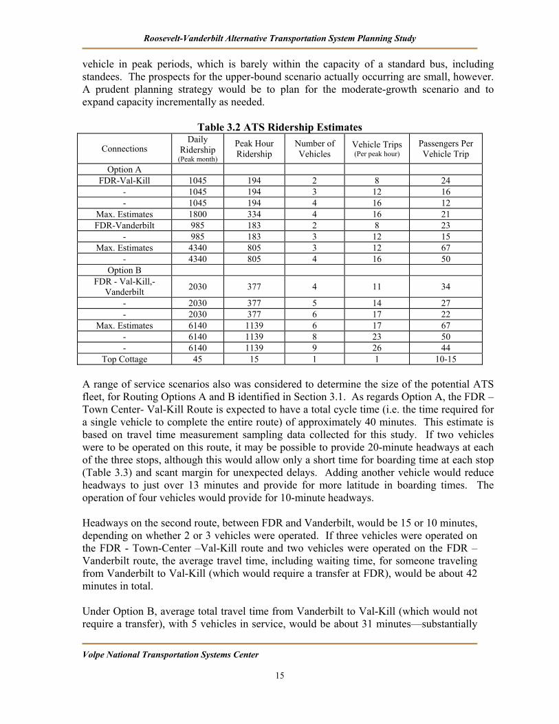
Roosevelt-Vanderbilt Alternative Transportation System Planning Study
Volpe National Transportation Systems Center 15
vehicle in peak periods, which is barely within the capacity of a standard bus, including standees. The prospects for the upper-bound scenario actually occurring are small, however. A prudent planning strategy would be to plan for the moderate-growth scenario and to expand capacity incrementally as needed.
Table 3.2 ATS Ridership Estimates
Connections Daily
Ridership (Peak month)
Peak Hour Ridership
Number of Vehicles
Vehicle Trips (Per peak hour)
Passengers Per Vehicle Trip
Option A FDR-Val-Kill 1045 194 2 8 24
- 1045 194 3 12 16 - 1045 194 4 16 12
Max. Estimates 1800 334 4 16 21 FDR-Vanderbilt 985 183 2 8 23
- 985 183 3 12 15 Max. Estimates 4340 805 3 12 67
- 4340 805 4 16 50 Option B
FDR - Val-Kill,-Vanderbilt 2030 377 4 11 34
- 2030 377 5 14 27 - 2030 377 6 17 22
Max. Estimates 6140 1139 6 17 67 - 6140 1139 8 23 50 - 6140 1139 9 26 44
Top Cottage 45 15 1 1 10-15 A range of service scenarios also was considered to determine the size of the potential ATS fleet, for Routing Options A and B identified in Section 3.1. As regards Option A, the FDR – Town Center- Val-Kill Route is expected to have a total cycle time (i.e. the time required for a single vehicle to complete the entire route) of approximately 40 minutes. This estimate is based on travel time measurement sampling data collected for this study. If two vehicles were to be operated on this route, it may be possible to provide 20-minute headways at each of the three stops, although this would allow only a short time for boarding time at each stop (Table 3.3) and scant margin for unexpected delays. Adding another vehicle would reduce headways to just over 13 minutes and provide for more latitude in boarding times. The operation of four vehicles would provide for 10-minute headways. Headways on the second route, between FDR and Vanderbilt, would be 15 or 10 minutes, depending on whether 2 or 3 vehicles were operated. If three vehicles were operated on the FDR - Town-Center –Val-Kill route and two vehicles were operated on the FDR – Vanderbilt route, the average travel time, including waiting time, for someone traveling from Vanderbilt to Val-Kill (which would require a transfer at FDR), would be about 42 minutes in total. Under Option B, average total travel time from Vanderbilt to Val-Kill (which would not require a transfer), with 5 vehicles in service, would be about 31 minutes—substantially

Roosevelt-Vanderbilt Alternative Transportation System Planning Study
Volpe National Transportation Systems Center 16
shorter than under Option A. Travel times from FDR to Vanderbilt with this loop route configuration would be over 30 minutes, however, and the link between FDR and Vanderbilt can be expected to attract many more passengers than service between Vanderbilt and Val-Kill. Considering the various service scenarios, the total size of the active fleet, excluding spares, would range from 5 to 10 vehicles for both Option A and B, depending on the service headways.
Table 3.3 Operating Characteristics Option 1: Two Primary Routes
Route A: FDR – Town Center – Val-Kill Headway (minutes)
Departing trips per hour Cycle Time Cycle Miles Number of
Vehicles Daily VMT Daily VHT
20 6 40 3.3 2 88 18 13.3 9 40 3.3 3 132 27 10 12 40 3.3 4 177 36
Route B: FDR – Vanderbilt 15 8 30 3.6 2 130 18 10 12 30 3.6 3 194 27
Option 2: Single Primary Route FDR – Val-Kill – Town Center – Vanderbilt
10.5 11 42 3.8 4 388 36 8.4 14 42 3.8 5 489 45 7 17 42 3.8 6 586 54 3 26 42 3.8 9 879 81
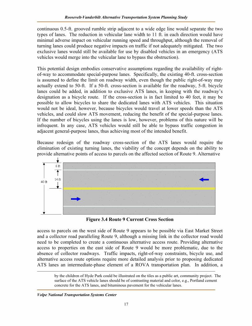
3.3. Intermediate-Range and Long-Range Operational Options ATS services will be delayed by the same traffic congestion on Route 9 that brings general-purpose traffic to a crawl. As a means of providing superior ATS service that bypasses the gridlock conditions faced by private vehicle drivers, a possible long-range option that may merit consideration would involve designation of an exclusive right-of-way for ATS vehicles on Route 9. Service under these conditions would be safe, fast, and reliable. While the entirety of the Vanderbilt – FDR ATS route would operate in the exclusive lanes and the operational benefit would be greatest on this route, the lanes also could be used over a portion of the FDR-Val-Kill - Hyde Park town center shuttle route. A review of available engineering drawings indicates that the Route 9 cross-section could be redesigned to provide an exclusive vehicle lane for the ATS system in both directions. The current cross-section includes two 6-ft shoulder lanes and two 14-ft. vehicular lanes. (40-ft. total cross-section width) (Figure 3.4). Redesign of the cross-section is possible to provide an 8.5-ft. ATS vehicle lane in each direction1, each adjacent to an 11-ft. vehicular lane. A
1 In keeping with the desire for a unique identity for the ATS, paint pavement markings would not be the preferred means of designating that use of the lanes is restricted to ATS vehicles. Rather, embedding the word ‘BUS’ and the international transit-vehicle symbol in the pavement, with tiles placed at appropriate intervals, would create a stronger and more attractive system image. Artwork
Roosevelt-Vanderbilt Alternative Transportation System Planning Study
Volpe National Transportation Systems Center 17
continuous 0.5-ft. grooved rumble strip adjacent to a wide edge line would separate the two types of lanes. The reduction in vehicular lane width to 11 ft. in each direction would have minimal adverse impact on vehicular running speed and throughput, although the removal of turning lanes could produce negative impacts on traffic if not adequately mitigated. The two exclusive lanes would still be available for use by disabled vehicles in an emergency (ATS vehicles would merge into the vehicular lane to bypass the obstruction). This potential design embodies conservative assumptions regarding the availability of right-of-way to accommodate special-purpose lanes. Specifically, the existing 40-ft. cross-section is assumed to define the limit on roadway width, even though the public right-of-way may actually extend to 50-ft. If a 50-ft. cross-section is available for the roadway, 5-ft. bicycle lanes could be added, in addition to exclusive ATS lanes, in keeping with the roadway’s designation as a bicycle route. If the cross-section is in fact limited to 40 feet, it may be possible to allow bicycles to share the dedicated lanes with ATS vehicles. This situation would not be ideal, however, because bicycles would travel at lower speeds than the ATS vehicles, and could slow ATS movement, reducing the benefit of the special-purpose lanes. If the number of bicycles using the lanes is low, however, problems of this nature will be infrequent. In any case, ATS vehicles would still be able to bypass traffic congestion in adjacent general-purpose lanes, thus achieving most of the intended benefit. Because redesign of the roadway cross-section of the ATS lanes would require the elimination of existing turning lanes, the viability of the concept depends on the ability to provide alternative points of access to parcels on the affected section of Route 9. Alternative
Figure 3.4 Route 9 Current Cross Section access to parcels on the west side of Route 9 appears to be possible via East Market Street and a collector road paralleling Route 9, although a missing link in the collector road would need to be completed to create a continuous alternative access route. Providing alternative access to properties on the east side of Route 9 would be more problematic, due to the absence of collector roadways. Traffic impacts, right-of-way constraints, bicycle use, and alternative access route options require more detailed analysis prior to proposing dedicated ATS lanes an intermediate-phase element of a ROVA transportation plan. In addition, a
by the children of Hyde Park could be illustrated on the tiles as a public art, community project. The surface of the ATS vehicle lanes should be of contrasting material and color, e.g., Portland cement concrete for the ATS lanes, and bituminous pavement for the vehicular lanes.
Roosevelt-Vanderbilt Alternative Transportation System Planning Study
Volpe National Transportation Systems Center 18
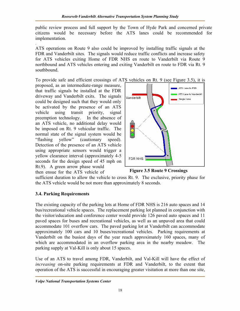
public review process and full support by the Town of Hyde Park and concerned private citizens would be necessary before the ATS lanes could be recommended for implementation. . ATS operations on Route 9 also could be improved by installing traffic signals at the FDR and Vanderbilt sites. The signals would reduce traffic conflicts and increase safety for ATS vehicles exiting Home of FDR NHS en route to Vanderbilt via Route 9 northbound and ATS vehicles entering and exiting Vanderbilt en route to FDR via Rt. 9 southbound. To provide safe and efficient crossings of ATS vehicles on Rt. 9 (see Figure 3.5), it is proposed, as an intermediate-range measure, that traffic signals be installed at the FDR driveway and Vanderbilt exits. The signals could be designed such that they would only be activated by the presence of an ATS vehicle using transit priority, signal preemption technology. In the absence of an ATS vehicle, no additional delay would be imposed on Rt. 9 vehicular traffic. The normal state of the signal system would be “flashing yellow” (cautionary speed). Detection of the presence of an ATS vehicle using appropriate sensors would trigger a yellow clearance interval (approximately 4-5 seconds for the design speed of 45 mph on Rt.9). A green arrow phase would then ensue for the ATS vehicle of sufficient duration to allow the vehicle to cross Rt. 9. The exclusive, priority phase for the ATS vehicle would be not more than approximately 8 seconds. 3.4. Parking Requirements The existing capacity of the parking lots at Home of FDR NHS is 216 auto spaces and 14 bus/recreational vehicle spaces. The replacement parking lot planned in conjunction with the visitor/education and conference center would provide 126 paved auto spaces and 11 paved spaces for buses and recreational vehicles, as well as an unpaved area that could accommodate 101 overflow cars. The paved parking lot at Vanderbilt can accommodate approximately 100 cars and 10 buses/recreational vehicles. Parking requirements at Vanderbilt on the busiest days of the year reach approximately 160 spaces, many of which are accommodated in an overflow parking area in the nearby meadow. The parking supply at Val-Kill is only about 15 spaces. Use of an ATS to travel among FDR, Vanderbilt, and Val-Kill will have the effect of increasing on-site parking requirements at FDR and Vanderbilt, to the extent that operation of the ATS is successful in encouraging greater visitation at more than one site,
Figure 3.5 Route 9 Crossings
Roosevelt-Vanderbilt Alternative Transportation System Planning Study
Volpe National Transportation Systems Center 19
as is expected. With the “moderate-growth” scenario presented in Section 3.2 (i.e. 30 % of FDR visitors also visit Vanderbilt; 20% of Vanderbilt visitors also visit FDR; Val-Kill visitation rises to 130% of current levels), peak day parking requirements would increase to approximately the following levels:
• FDR: 310 spaces • Vanderbilt: 200 spaces
Parking requirements will rise as a result of visitors going to more than one site, because cars will be parked for a greater length of time. In addition, it is assumed that most visitors to Val-Kill will park at FDR. The above estimates are based on the assumption that visitation time will double from a current average of 2 hours to an average of 4 hours after ATS implementation (including travel time for using the ATS), due to joint visitation. It is important to note that on the overwhelming majority of days, even during the peak season, parking requirements will be lower. Nevertheless, the estimated increase in parking requirements is a factor in favor of providing off-site parking, at least on the small number of days when visitation levels are at their peak. The proposed ATS routes could be extended to serve an off-site overflow parking area at times when additional parking spaces are needed. With the upper-bound visitation scenario presented in Section 3.2, parking demand would soar on peak days to over 600 spaces at both FDR and Vanderbilt. Again, the prospects for this scenario actually occurring appear to be small and limits on the parking supply could be used to manage visitation to the desired target levels at each site. (A long-range proposal is presented in Section 5.0 for an off-site Transportation Hub, with intercept parking serving ATS as well as local and regional transit providers.)
Roosevelt-Vanderbilt Alternative Transportation System Planning Study
Volpe National Transportation Systems Center 20
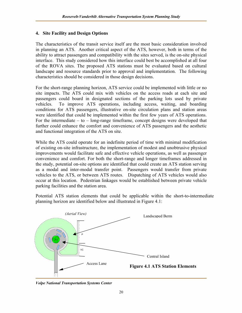
4. Site Facility and Design Options The characteristics of the transit service itself are the most basic consideration involved in planning an ATS. Another critical aspect of the ATS, however, both in terms of the ability to attract passengers and compatibility with the sites served, is the on-site physical interface. This study considered how this interface could best be accomplished at all four of the ROVA sites. The proposed ATS stations must be evaluated based on cultural landscape and resource standards prior to approval and implementation. The following characteristics should be considered in those design decisions. For the short-range planning horizon, ATS service could be implemented with little or no site impacts. The ATS could mix with vehicles on the access roads at each site and passengers could board in designated sections of the parking lots used by private vehicles. To improve ATS operations, including access, waiting, and boarding conditions for ATS passengers, illustrative on-site circulation plans and station areas were identified that could be implemented within the first few years of ATS operations. For the intermediate – to – long-range timeframe, concept designs were developed that further could enhance the comfort and convenience of ATS passengers and the aesthetic and functional integration of the ATS on site. While the ATS could operate for an indefinite period of time with minimal modification of existing on-site infrastructure, the implementation of modest and unobtrusive physical improvements would facilitate safe and effective vehicle operations, as well as passenger convenience and comfort. For both the short-range and longer timeframes addressed in the study, potential on-site options are identified that could create an ATS station serving as a modal and inter-modal transfer point. Passengers would transfer from private vehicles to the ATS, or between ATS routes. Dispatching of ATS vehicles would also occur at this location. Pedestrian linkages would be established between private vehicle parking facilities and the station area. Potential ATS station elements that could be applicable within the short-to-intermediate planning horizon are identified below and illustrated in Figure 4.1:
Figure 4.1 ATS Station Elements
VC
P
Central Island
Landscaped Berm
Access Lane
(Aerial View)

Roosevelt-Vanderbilt Alternative Transportation System Planning Study
Volpe National Transportation Systems Center 21
• Two-way, narrow access lane (e.g., two 10’ travel lanes) restricted to ATS vehicles only.
It may be feasible to use alternative, less intrusive materials (e.g., stabilized soils on a well-graded, well-drained and compacted base) because of the low-volume of ATS vehicle-use only traffic.
• Circular turn-around roadway at the terminus of the access lane.
The surface elevation of the circular roadway could be slightly below that of the access lane, but with easily negotiable transition grades. The minor change in grade would permit level loading/unloading of shuttle vehicles adjacent to the passenger/pedestrian pathway apron and assist in the screening of circulating and stationary vehicles and associated passenger activities.
• Central landscaped island within the turnaround.
Appropriate landscaping could serve as a focal point for pedestrian sightlines at locations on the grounds outside of the immediate area. Each site’s landscape treatment would have to be compatible with the historic site context.
• Circular passenger/pedestrian pathway apron with curb.
Relative elevation to the circular turn-around roadway should be approximately 8” to permit level boarding/alighting to/from low-floor shuttle vehicles.
• Shelter over passenger waiting area.
A shelter, such as a protective canopy, is recommended to shield passengers from the weather in ATS vehicle waiting areas.
• Separation of alighting and boarding berths along the circumference of the circular turn-around roadway.
The preferred mode of operation is for shuttle vehicles to dock at one of the alighting berths (right-hand side of the circumference) and then to proceed to a berth on the other side of the turn-around for boarding (see Figure 4.1). Vehicles then would exit via the access lane.
• Signage at entrance access lane indicating ‘Bus Use Only’.
• Linkage of the pedestrian pathway system on-site with the passenger/pedestrian pathway apron servicing the ATS station (see Figure 4.1).
• Option for separation of tour bus operation from the ATS system operation (see Figure 4.2) by reconfiguring the turn-around, if sufficient on-site space is available.

Roosevelt-Vanderbilt Alternative Transportation System Planning Study
Volpe National Transportation Systems Center 22
Central Island (2)
Access Lane
ATS Vehicle
Tour Vehicle LoopATS Vehicle Loop
Figure 4.2 ATS Station Concept with Tour Bus Turnaround There are a number of critical advantages associated with the ATS facility concept described above: • The circular roadway/central island concept is space-efficient and allows for proper
landscape treatment (specific to each site) and minimum impervious surface coverage; the ATS vehicle access roadway is kept short to minimize disturbance to the historic landscape.
• Physical separation of the loading and unloading of passengers enhances the safety,
efficiency and order of the vehicle boarding process.
• The concept accommodates barrier-free design, with level boarding and alighting, which also reduces vehicle dwell time
• The circumferential pedestrian apron eliminates crowding. Good linkage to pedestrian
paths and vehicular parking areas provides for safe, convenient and attractive pedestrian circulation conditions.
• Few structural items and minimum ‘footprint’ result in low capital costs. The basic features incorporated in this “generic” station design model could be adapted to each of the four ROVA properties, with site-specific modifications and landscape treatments. The use of consistent design elements would have the further advantage of providing a common identity to the ATS system.
Roosevelt-Vanderbilt Alternative Transportation System Planning Study
Volpe National Transportation Systems Center 23
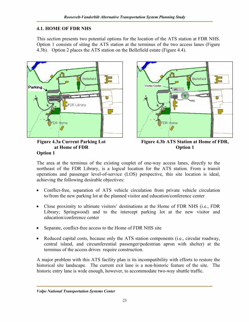
4.1. HOME OF FDR NHS This section presents two potential options for the location of the ATS station at FDR NHS. Option 1 consists of siting the ATS station at the terminus of the two access lanes (Figure 4.3b). Option 2 places the ATS station on the Bellefield estate (Figure 4.4).
Option 1
The area at the terminus of the existing couplet of one-way access lanes, directly to the northeast of the FDR Library, is a logical location for the ATS station. From a transit operations and passenger level-of-service (LOS) perspective, this site location is ideal, achieving the following desirable objectives:
• Conflict-free, separation of ATS vehicle circulation from private vehicle circulation to/from the new parking lot at the planned visitor and education/conference center
• Close proximity to ultimate visitors’ destinations at the Home of FDR NHS (i.e., FDR Library; Springwood) and to the intercept parking lot at the new visitor and education/conference center
• Separate, conflict-free access to the Home of FDR NHS site
• Reduced capital costs, because only the ATS station components (i.e., circular roadway, central island, and circumferential passenger/pedestrian apron with shelter) at the terminus of the access drives require construction.
A major problem with this ATS facility plan is its incompatibility with efforts to restore the historical site landscape. The current exit lane is a non-historic feature of the site. The historic entry lane is wide enough, however, to accommodate two-way shuttle traffic.
Figure 4.3b ATS Station at Home of FDR, Option 1
Figure 4.3a Current Parking Lot at Home of FDR
Roosevelt-Vanderbilt Alternative Transportation System Planning Study
Volpe National Transportation Systems Center 24
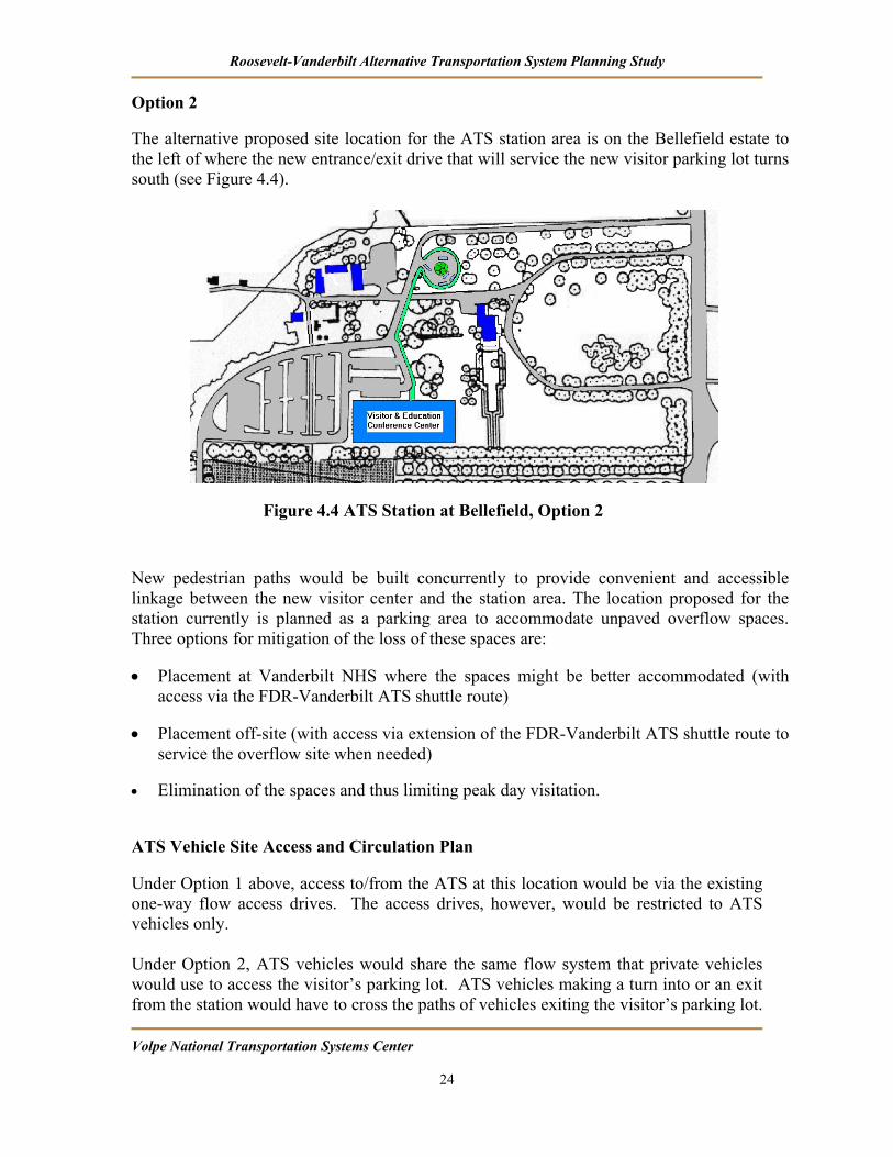
Option 2
The alternative proposed site location for the ATS station area is on the Bellefield estate to the left of where the new entrance/exit drive that will service the new visitor parking lot turns south (see Figure 4.4).
New pedestrian paths would be built concurrently to provide convenient and accessible linkage between the new visitor center and the station area. The location proposed for the station currently is planned as a parking area to accommodate unpaved overflow spaces. Three options for mitigation of the loss of these spaces are:
• Placement at Vanderbilt NHS where the spaces might be better accommodated (with access via the FDR-Vanderbilt ATS shuttle route)
• Placement off-site (with access via extension of the FDR-Vanderbilt ATS shuttle route to service the overflow site when needed)
• Elimination of the spaces and thus limiting peak day visitation.
ATS Vehicle Site Access and Circulation Plan Under Option 1 above, access to/from the ATS at this location would be via the existing one-way flow access drives. The access drives, however, would be restricted to ATS vehicles only. Under Option 2, ATS vehicles would share the same flow system that private vehicles would use to access the visitor’s parking lot. ATS vehicles making a turn into or an exit from the station would have to cross the paths of vehicles exiting the visitor’s parking lot.
Figure 4.4 ATS Station at Bellefield, Option 2

Roosevelt-Vanderbilt Alternative Transportation System Planning Study
Volpe National Transportation Systems Center 25
In general, the volume of traffic using the entrance/exit drive even during a peak hour would be low enough, however, that there should be no adverse delay or safety impact on ATS vehicle operations. The paved visitor’s parking lot would have a capacity of 137 spaces and would be supplemented by 101 unpaved overflow spaces. A worst-case scenario, assuming all visitors arrive or leave during one hour, implies average headways between vehicles of 15 seconds. Even with some bunching of vehicle arrivals and departures2, shuttles should still have sufficient gaps to cross the access roadway and enter or exit from the ATS station area. In the event the conflict point needs to be managed, a signal with preemption capability could provide an exclusive turn phase for ATS vehicles to/from the station area. A pedestrian path would be required linking the visitor’s parking lot, the new visitor and education/conference center, and the ATS station (i.e., circumferential passenger/pedestrian apron). 4.2. Vanderbilt NHS
A single short-range option has been developed for the Vanderbilt ATS station and vehicle access. The option incorporates the following key features (Figure 4.5):
• Use of the existing Main Entrance
• Vehicular access drives skirting the Great Loop (shown in red),
• Loading and unloading zones located within the existing parking lot,
• Exit via the North Gate.
Loading and unloading zones for the ATS vehicles would be sited to minimize interference with private vehicle circulation and parking maneuvers. Some
restructuring of the existing parking lot layout may be advantageous to provide improved and safer
2 Assuming that an ATS vehicle requires a minimum, average time interval of t seconds to cross a stream of traffic. The time interval for a 90% probability that no more than one private vehicle will arrive in the average time interval is 2.0 times the average time interval or 2t. The maximum one-hour traffic threshold opposing the ATS vehicle stream but without obstructing it or imposing undue delay is 3600 seconds per hour / 2t. For an assumed gap duration needed by the ATS vehicle to cross the roadway and access the hub of 9 seconds, the maximum traffic threshold at the 90% probability level is 200 vehicles per hour (vph). This is within the limit imposed by the capacity of the visitor’s parking lot and parking occupancy duration.
Figure 4.5 Short-range Option
Roosevelt-Vanderbilt Alternative Transportation System Planning Study
Volpe National Transportation Systems Center 26
pedestrian connections to and from the ATS zones. Signage and passenger amenities (e.g., shelters and benches) would also be provided. An intermediate-range access plan for Vanderbilt NHS could provide for the creation of an ATS station with the constituent elements of circular roadway, pedestrian apron, and central island, as at the other ROVA sites. The ATS area would be joined by a spur to the pedestrian path east of the existing parking lots. While a landscape treatment plan would be needed for the central island, it probably would consist of closely cropped grass, echoing the Great Lawn and Upper Meadow spaces adjacent to the transportation hub. Long-Range Access Concept One of the difficulties of establishing a suitable location for an ATS station area and access road is that a non-historical feature is being inserted into a historical landscape that has high integrity and significance3. Based on an exhaustive analysis of text, photographic and mapping records (back to the Bard ownership of the property, 1764-1821), the Cultural Landscape Report for Vanderbilt NHS concludes that the site has a continuity of topography, vegetation, and natural systems that should be retained. The systems to be preserved include circulation, landscape structures, some site furnishings and objects, water features, spatial relationships, siting of major buildings and the scenic vistas to the surroundings.4 Identifiable components stemming from the original landscape design (Hosacker-Parmentier period, 1828-1830) are still intact, augmented and modified but without substantial disturbance by the Langdon period (1835-1898) and the Vanderbilt period (1898-1938). By the early Vanderbilt period (1898-1905), the upper portion of the Great Loop in front of the Mansion was in place. The bridge over Crum Elbow Creek was in place, but not the access drive from the Albany Post Road (Rt. 9). By the 1938-1941 period, the Great Loop was completed, as was the access drive. Crum Elbow Creek, north and south of the bridge crossing, also was widened. Both the road circulation pattern and the tree vegetation remain virtually unchanged between the 1938-1941 time frame when the NPS took possession of the estate, and the 1990-1991 snapshot. In 1906, under the early Vanderbilt period, an unusual circulation feature was added to the landscape (see Figure 4.6). Referred to as the “subway”, it was a road (probably unpaved but stabilized and graded) that connected the upper loop road at the Mansion5 to the Vanderbilt farm. The ‘subway’ connected the Mansion to the Vanderbilt Farm,
3 In accordance with criteria set forth in National Register Bulletin #18: How to Evaluate and Nominate Designed Historic Landscapes, J. Timothy Keller, ASLA and Genevieve P. Keller, US DOI/NPS, Interagency Resource Division. 4 Patricia M. O’Donnell, Charles Birnbaum, and Cynthia Zaitzevsky, Cultural Landscape Report for Vanderbilt Mansion National Historic Site, Cultural Landscape Publication No.1, National Park Service, North Atlantic Region, Division of Cultural Resources Management, Cultural Landscape Program, 1992 Boston, MA., pp. 303-349. 5 The lower loop road that completed the Great Loop was not completed to 1918.

Roosevelt-Vanderbilt Alternative Transportation System Planning Study
Volpe National Transportation Systems Center 27
which was on the east side of the Albany Post Road (Rt. 9), via a subterranean tunnel. The embankment wing walls are extant, though not the road itself6. Although no precise information is readily available on its design and width, it can reasonably be assumed to be in the range of 12-14 ft. One idea for improving ATS access at Vanderbilt NHS in the long-range future would involve restoration of the ‘subway’ access road on its historic alignment, for the exclusive use of ATS vehicles, with the tunnel component under Rt. 9, and the ramp connection to Rt. 9. The ‘subway’ access road would terminate on the Vanderbilt site at the ATS station. There is a pedestrian path east of the existing parking lots, and a spur would be developed to link with the western edge of the pedestrian apron (see Figure 4.7). While a landscape treatment plan would have to be developed for the central island, it probably would consist of closely cropped grass. This would echo the Great Lawn and Upper Meadow spaces adjacent to the transportation hub. There are a number of potential sources that may provide funds for the roadway improvements proposed in support of the ATS: 1. Loop ramp, tunnel section, and “subway”
access road (but not the ATS station components, i.e., circular roadway, central island, and pedestrian apron and canopy) – the New York State Department of Transportation (NYS DOT) can program with the use of Federal transportation funds available for this type of improvement, i.e. transportation enhancement funds.
2. Access point signalization, and redesign and implementation of revised cross-section permitting ATS vehicle exclusive lanes – NYS DOT can program using Federal Congestion Mitigation and Air Quality (CMAQ) funds.
3. ATS vehicles and station components – Either loop shuttle system, as a Federal Transit Administration (FTA) grantee, or NYS DOT can use FTA capital formula funds (Section 5309, Capital Investment Grants and Loans, or Section 5311, Formula Grants for Other than Urbanized Areas)
6 Discussion with Patricia M. O’Donnell, Principal of Landscapes, Inc.
Figure 4.6 Vanderbilt “Subway”
Figure 4.7 ATS with Pedestrian Spur

Roosevelt-Vanderbilt Alternative Transportation System Planning Study
Volpe National Transportation Systems Center 28
ATS Vehicle Site Access and Circulation Plan Restoration of the ‘subway’ access road, tunnel component, and loop ramp connection would require only minor engineering changes to accommodate the proposed ATS circulation concept:
• Elevation of the roadway would be lowered within the tunnel section from its
historical alignment to provide adequate and safe vertical clearance for the type of ATS vehicles selected.
• The ramp connection to Rt. 9 on the eastern edge of Rt. 9 would be looped and properly super-elevated to provide a safer and easier turn to/from the tunnel section. The historical connection was a sharper Y intersection.
• Road surface would be paved and well drained.
The revised design is ideal from a transit operations and passenger level-of-service (LOS) perspective. Grade separation for ATS vehicles crossing Rt. 9 is provided in one direction (access to the Vanderbilt NHS site). The access road and ATS station are in close proximity to Rt. 9, reducing ATS vehicle cycle time, and in particular the access time to penetrate on-site for passenger loading and unloading. The station also is in excellent proximity to the existing parking lots where visitors first arrive. Development of a relatively short spur from an already existing pedestrian path would facilitate the pedestrian connection between the parking lots and the ATS station for modal transfer. Issues that need to be resolved before further consideration of this concept include: • Transfer of subgrade development rights to the NPS/ROVA to permit tunneling under
Rt. 9. • ROW issues with private landowner on the eastern edge of Rt. 9 for placement of the
loop ramp to connect to the tunnel section • Operational control procedures to permit safe, single lane operations via the ‘subway’
access road, tunnel section and loop ramp. Restoration of the historic alignment (approximately 12-14 ft. cross-sectional width) with retention of the extant wing walls precludes concurrent two-way flow.
4.3. Eleanor Roosevelt NHS Short Range: The short-range option for the station and ATS vehicle circulation at Val-Kill incorporates use of the existing single-lane access drive and parking lot. ATS vehicles would load and unload in the existing parking lot (Figure 4.8), from where visitors have a short walk over the Fall-Kill stream bridge to the buildings in the historic

Roosevelt-Vanderbilt Alternative Transportation System Planning Study
Volpe National Transportation Systems Center 29
core of the site. Signage and passenger amenities (e.g., shelters and benches) could be provided to orient visitors and enhance their comfort. Intermediate – Long-Range: The Denver Service Center (DSC) in 1984 developed several suggestions for roadway and site improvements to support a shuttle route between FDR and Val-Kill. DSC suggested that the intersection at the main entrance and Rt. 9G be improved. Limited sight distance currently makes it hazardous for turning vehicles exiting the access road at Val-Kill. The width of the access road ranges from 12 to 20 ft. From the intersection with Rt. 9G to the western edge of the pond, the access road is one lane and is bordered by trees and stonewalls dating back to original site improvements. The access roadway is approximately 0.426 miles (2249 ft.), relatively long for single lane operations. According to the DSC, several potential pullouts could be constructed for passing, but two lanes could not be constructed along this section without relocating the stonewalls and removing some trees. There are no trees or stone fences along the road from the western edge of the pond area along the south shore. The roadway from just before the sharp curve to the bridge over Fall Kill (the major stream that drains the site) into the core area, however, is bordered with trees. This roadway section is 10-12 ft. wide, and the bridge surface is 12 ft. wide. Although the bridge is historically significant and has been rehabilitated over the years, it does not meet contemporary design standards for accommodating trucks or full-size buses. A stonewall with stone gateposts is north of the apple orchard and south of the sharp curve. DSC proposed use of the access road with development of a bus turnaround just south of the sharp curve and stone gateposts. The existing visitor parking lot could be converted more easily into an ATS station and turnaround, however, with less impact to the site. This option would be viable as an intermediate-to-long-range element of the ROVA ATS (Figure 4.9). Judicious use of pullouts and tight dispatching control of ATS vehicles can ensure safe operations on the access road.
Figure 4.8 ATS Station

Roosevelt-Vanderbilt Alternative Transportation System Planning Study
Volpe National Transportation Systems Center 30
Prohibiting general-purpose traffic from the northern access road provides some relief to the residential district that abuts the site to the north. With its intended use and very low volume of authorized vehicles, the road could be kept in a graded and stabilized, but unpaved state. The proposed ATS station design concept could be designed to incorporate features that account for site requirements and constraints, as follows:
The central island could be split, with most of the interior space of the central island devoted to parking spaces for authorized vehicles.
The interior parking could be screened via a landscaped pair of collar
islands (Figure 4.10).
Figure 4.10 Central Island Parking
The proposed ATS circulation plan addresses an objective identified in the General Management Plan for the Eleanor Roosevelt NHS, which is that visitor access to Val-Kill be provided via a shuttle transit service. Site constraints severely limit the availability of parking and dictate that transit serve as the primary mode of access to the site.
Figure 4.9 ATS Circulation Plan
Access Lanes
ATS Vehicles
Authorized Vehicles
Pedestrian Walkway

Roosevelt-Vanderbilt Alternative Transportation System Planning Study
Volpe National Transportation Systems Center 31
4.4. Top Cottage The substantial development activity underway to restore Top Cottage provides an opportunity to implement site improvements supporting ATS operations. Thus, the proposed on-site circulation and facility options for Top Cottage are largely the same for the short-, intermediate-, and long-range options time periods.
Because of Top Cottage’s rustic feel and its historical association as a retirement retreat, passenger amenity in the form of weather protection would be limited to the shade effects from existing tree plantings.. The canopy for the circumferential pedestrian/passenger apron—a common feature at the other three Roosevelt-Vanderbilt sites--would not be used. Porous pavement and/or a stabilized soil base are also recommended for the circular roadway and on-site access drive. The restoration plans for Top Cottage already call for a circular roadway and central area landscape treatment. The circular roadway passes the front entrance to Top Cottage. This study recommends a minor design modification that lowers the elevation of the roadway, with transitional down and up grades, to provide level loading for ATS vehicles at this location. A stone embankment wall (approximate 9” height, 60’ extension) would provide ground retention at this location between the clear zone for passenger loading/unloading at the entrance to Top Cottage and the circular roadway (see Figure 4.11). These design modifications would have minimal adverse impact in terms of meeting restoration objectives, yet the impact on ATS vehicle operations would be strongly beneficial. Compatibility with the Americans for Disabilities Act (ADA) would also be enhanced.
Intermediate-Time Frame Concept: Val-Kill – Top Cottage Access Road
While an ATS can be operated over local surface roadways between Top Cottage and the other ROVA sites, service would be vastly improved with implementation of a much shorter access roadway between Top Cottage and Val-Kill. The proposed connection would probably be a single lane road and would be on an historic alignment within the confines of the original Roosevelt estate. The road would run along the alignment of the existing trail that links the two sites. The level of investment required, and the absence of any impacts on public roadways, suggests that implementation of this roadway is a realistic intermediate-range option. Some minor reconfiguration of the circular roadway
Figure 4.11 Top Cottage Roadway Treatment

Roosevelt-Vanderbilt Alternative Transportation System Planning Study
Volpe National Transportation Systems Center 32
at the Top Cottage entrance would be necessary to connect to the new road (i.e., new opening and closure of the current opening). Loading and unloading would still take place opposite the front entrance to Top Cottage.

Roosevelt-Vanderbilt Alternative Transportation System Planning Study
Volpe National Transportation Systems Center 33
5. Long-Range Plan Concept: ‘Intercept’ Parking Facility and Central
Transportation Hub This section presents an illustrative concept-design for a long-range plan element. This element consists of a mixed-use development, including co-located Regional Visitation Center (RVC) and Central Transportation Hub with ‘intercept’ parking, and a commercial center with parking that would serve a shared parking function. The Transportation Hub would provide a consolidated intercept parking facility on a strategically-located site outside the NPS properties and could serve the ATS routes linking all four NHS sites, tour bus operators, and regional transit services, including shuttle connections to the Poughkeepsie and Rhinecliff rail stations.
This long-range plan concept would satisfy several NPS and regional objectives:
• Reduce traffic congestion on local roads by providing a well-designed and adequate ‘intercept’ parking facility
• Expand the tourist industry and visitation to the mid-Hudson Valley by providing new visitor services (i.e., RVC with new interpretative programs and tourist informational materials, etc.; new commercial properties), creating a physical focus for marketing efforts
• Provide adequate facilities for improvement of and expansion of mid-Hudson Valley transit services, including the ATS, and provide for integration with inter-city connections (e.g., commuter and inter-city rail, and new Hudson River ferry services)
• Support historic restoration objectives for the NPS properties by reducing the amount of the historic landform devoted to on-site parking for private vehicles (limiting on-site parking to staff and possibly a small amount of off-season public parking)
• Improve the quality of the visitor’s experience and expand visitation opportunities to those who cannot or choose not to use a private vehicle
5.1. Alternative Site Locations
Figure 5.1 identifies five (5) potential sites for the Transportation Hub:
• A – vacant land north of Vanderbilt NHS, west of Route 9
• B - vacant land adjacent to Bellefield on the north, between the Hudson River and Route 9
• C – vacant land to the east of Route 9 and the town center, surrounded by residential development
• D – former drive-in movie theater site to the northeast of Home of FDR NHS across Route 9

Roosevelt-Vanderbilt Alternative Transportation System Planning Study
Volpe National Transportation Systems Center 34
• E – Dutchess County 300+ acre site at the southeast corner of Route 9 and St. Andrews Road
Three criteria dictated the selection of the five location options as potential sites for the Transportation Hub:
• Undeveloped parcel7
• Acreage of site exceeds minimum acreage needed (i.e., 23 acres)
• Close proximity to the ROVA sites, and to the main transportation corridor serving Hyde Park (Rt. 9)
Within an intermediate-range time horizon, these sites could be considered for the location of an intercept parking facility serving the ATS and additional public transportation routes, while the commercial development could be added in the future.
7 As indicated on the Town of Hyde Park Land Use Map, Parcel/Land Use Data, Dutchess County Real Property Tax Service Agency, produced by ROVA GIS Lab, 13 June 2000; sites shown may actually be more than one contiguous parcel since actual parcel boundaries are not shown. Site D (the “Drive-in Theatre” site) is shown as a commercial use, but our understanding is that it is now vacant. Site E is the Dutchess County 300+ acre site.
Figure 5.1 Transportation Hub Locations
Roosevelt-Vanderbilt Alternative Transportation System Planning Study
Volpe National Transportation Systems Center 35
5.1.1. Site A – North of Vanderbilt NHS, west side of Route 9
Advantages include:
• Adjacent to the Hudson River, with the possibility of developing a connection between the Transportation Hub and new docks serving ferry services (e.g., off-shore docks with an aerial walkway system that could bridge the railroad ROW along the shore, and tie directly into the visitation center)
• Good interception of private vehicular traffic southbound on the main transportation corridor (Rt. 9)
• excellent proximity to Vanderbilt NHS and Home of FDR NHS, supporting a very efficient FDR-Vanderbilt ATS route
• large enough parcel to provide substantial buffer zones to protect adjacent land-uses
• excellent view-shed of the Hudson River Valley for visitors/users.
Disadvantages include:
• only one on-site access drive to the main transportation corridor (Rt.9)
• most private vehicular traffic arrives from the south (metropolitan NY) or east and proceeds north on Rt. 9; interception of vehicles at this site would not provide as much congestion relief as interception prior to the historic Route 9 corridor
• steep bluff area could be difficult and costly to develop
5.1.2. Site B – North of Bellefield Mansion, west side of Route 9 Advantages include:
• adjacent to the Hudson River, with the possibility of developing a connection between new docks serving ferries and the Transportation Hub (e.g., off-shore docks with an aerial walkway system that could bridge the railroad ROW along the shore and tie directly into the RVC)
• very good proximity to Vanderbilt NHS and Home of FDR NHS, supporting a very efficient FDR-Vanderbilt ATS route
• large enough parcel to provide substantial buffer zones to protect adjacent land-uses
• excellent view-shed of the Hudson River Valley for visitors/users.
Disadvantages include:
• only one on-site access drive to the main transportation corridor (Rt. 9)

Roosevelt-Vanderbilt Alternative Transportation System Planning Study
Volpe National Transportation Systems Center 36
• access to the site would traverse a residential neighborhood
• steep bluff area could be difficult and costly to develop
5.1.3. Site C – East of Route 9, Town Center Advantages include:
• very good proximity to Vanderbilt NHS and Home of FDR NHS, supporting a very efficient FDR-Vanderbilt ATS route
• multiple, on-site access drives, one to Rt. 9 supporting an FDR-Vanderbilt ATS route; other access drive could lead to residential collector that feeds Rt. 9G, supporting efficient routing to Val-Kill.
• large enough parcel to provide substantial buffer zones to protect adjacent land-uses
Disadvantages include:
• development may be out of scale and character to adjacent land-uses
• second on-site access drive would intersect with residential collector
• access to the site would traverse a residential section, which may be objectionable (e.g., environmental objections such a noise, visual intrusion, vehicle flow and congestion, safety of pedestrian crossings, etc.)
5.1.4. Site D – Drive-In Advantages include:
• Very good proximity to Vanderbilt NHS and Home of FDR NHS, supporting a very efficient FDR-Vanderbilt ATS route
• Located adjacent to other parcels that can be used for intercept parking
Disadvantages include:
• Only one on-site access drive to the main transportation corridor (Rt.9)
• Unusual parcel configuration may prevent efficient site layout
• Smallest of potential sites, with possibly insufficient buffer zones
5.1.5. Site E – Intersection of St. Andrews Road and Route 9 Advantages include:
• Multiple on-site access drives, one to Rt.9; the other, to St. Andrews Road

Roosevelt-Vanderbilt Alternative Transportation System Planning Study
Volpe National Transportation Systems Center 37
• Largest of potential sites, with possibility to have very large buffer zones and ‘hide’ development in the interior of the parcel. This would help preserve the rural and historic character of the corridor.
• Very good proximity to Vanderbilt NHS and Home of FDR NHS, supporting a very efficient FDR-Vanderbilt ATS route
• Very good proximity to Eleanor Roosevelt NHS, supporting a very efficient Val-Kill-Top Cottage ATS shuttle route
• No conflicts with adjacent land-uses
• Good interception of private vehicular traffic northbound on the main transportation corridor (Rt. 9); most of the current private vehicular traffic, and the expected growth in that traffic, arrives from the south (metropolitan NY) or east and proceeds north on Rt. 9. Interception at this site would relieve congestion on Rt.9 before travel within the historic Route 9 corridor.
• Good proximity to inter-city rail and commuter traffic arriving south at Poughkeepsie, thereby supporting efficient shuttle route service.
Disadvantages include:
• Steep slopes may make development more difficult and expensive
• No direct access to Hudson River; potential connections to new ferry services would have to be made via shuttle routes.
5.2 Concept Elements and Parking Requirements A central component of the mixed-use Transportation Hub would be shared-parking serving both transit users and patrons of commercial development that could be constructed on-site. Shared-use of the parking facility would minimize surface parking lot space requirements and yet provide adequate interception parking capacity to serve public transportation routes, including the ATS. A general schematic of a possible design for the Transportation Hub/mixed-use development is shown in Figure 5.2. This option illustrates the ways in which complementary uses and circulation features can work together. The total approximate area required for the complex envisioned would be 22-23 acres.

Roosevelt-Vanderbilt Alternative Transportation System Planning Study
Volpe National Transportation Systems Center 38
Approximate Space Requirements for Transportation Hub/Mixed Use Development
1. Main Transportation Hub – 240’ x 625’= 3.44 acres
a. Outside aisle cross-section width (one-way): 20’ (12’ lane, 8’ shoulder)
b. Central platform island width: 50’ (8.5’ width of each bay, 30’ for passenger loading8, 3’ for canopy supports and benches)
c. Central aisle width: 100’
Total width: 2(20’) + 2(8.5’+30’ +3’ +8.5’) + 100’= 240’
a. vehicle bay: 120’9
b.clear zones at corners: 20’
c. clear zones between interior bays: 15’
d. end aisle cross-section width: 20’ (one-way) and 40’ (two-way)
Total length: 40’ + (2(20’) + 3(15’) + 4(120’) + 20’ = 625’
2. Surface Parking Lots and Tour Bus long-term parking – 3.48 acres
a. 300 sq. ft. per private vehicle space x 430 spaces = 2.96 acres
b. 750 sq. ft per tour bus space x 30 spaces = 0.52 acres
8 Calculations are based on a general rule of thumb formula: 1.3 meters of sidewalk width for loading a bus, and 0.8 meters of additional sidewalk width for circulating pedestrians. This assumes a flow rate of 35 pedestrians per minute. The calculations yield: 1.3 + (0.8)(3.6) = 4.18 meters (13.6 ft), assuming the first 40 passengers load at the first vehicle bay, and the other 120 passengers must flow past to the other three berths. Rounding to the nearest 5’ increment yields a 15’ dimension of clear space for passenger loading, unloading and circulation. Since the layout has vehicle bays on both sides of a central island, total clear space for passengers is 30’. The design vehicle for the vehicle bays and the dimensioning of the platform is a standard 40’ bus. The actual size of the vehicle for the ATS and for regional transit routes serving the mid-Hudson Valley is, very likely, smaller. 9 Minimum design recommendation for a vehicle turnout is L+25 meters, where L is the length of the design vehicle. This allows easy entry and exit via a forward-flow movement to/from the bay at 5 mph. See Evaluation of Bus Management Options for Independence National Historic Park, Final Report, May 18, 2000, US Department of Transportation, Volpe National Transportation Systems Center.
Figure 5.2 Hub Design

Roosevelt-Vanderbilt Alternative Transportation System Planning Study
Volpe National Transportation Systems Center 39
3. Commercial Development – 3.77 acres assuming 30 percent ground ‘footprint’ (actual ‘footprint’ = 1.13 acres)
4. Parking – 1.83 acres assuming 30 percent ground ‘footprint’ (actual ‘footprint’ = 0.55 acres)
5. RVC– 2 acres
6. Access drives and internal circulation drives – 4.85 acres
a. assume 40’ cross-section x 5280 lineal feet
7. Buffer Zones – 3 acres
A commercial/ground floor retail complex with a ground footprint of 1.14 acres is feasible while still complying with the size and bulk regulations of the Hyde Park Zoning Ordinance10.
Approximate Estimate of ‘Intercept’ Parking Requirements
1. NPS visitation of 600, 000 per year.
2. Assume net growth of tourists to the mid-Hudson Valley of 600,000 visitors.
3. Total visitation of 1.2 million per year.
4. Assume 85 percent of visitation occurs in seven-month peak season (April through October).
5. Peak-season visitation to mid-Hudson Valley equals 1,020,000
6. Assume vehicle occupancy of 2.7 persons per vehicle
7. Estimate of number of vehicles is 377,778
8. Average peak-season day number of vehicles is 1800
9. Assumed parking turnover ratio of 2.0 implies a minimum parking requirement of 900 spaces.
The design principles incorporated in the site plan provide for efficient and safe operation of all transportation modes and the diverse uses accommodated on site, as described below:
10 Hyde Park Zoning Ordinance limits building coverage ratio to 30 percent of ground lot, and height limitation for a planned or tourist business district to 35 feet. Calculations have used reference data provided by Cambridge Redevelopment Authority for the Marriott Hotel and the North Garage, part of the Cambridge Center Development Project within the Kendall Square Urban Renewal Zone, Cambridge, MA. Data for the Marriott Hotel are: 330,400 sq. ft hotel/retail space, 25 stories, 431 rooms, complying with 6:1 FAR and having a minimum required ground footprint of 55,066 sq. ft.
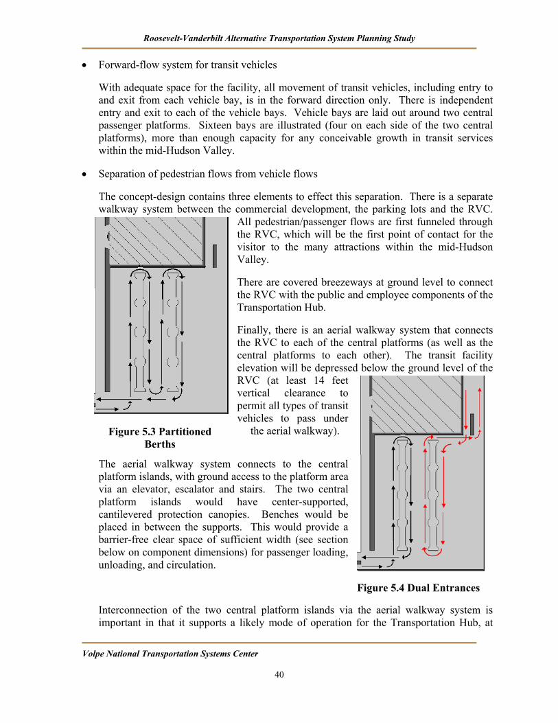
Roosevelt-Vanderbilt Alternative Transportation System Planning Study
Volpe National Transportation Systems Center 40
• Forward-flow system for transit vehicles
With adequate space for the facility, all movement of transit vehicles, including entry to and exit from each vehicle bay, is in the forward direction only. There is independent entry and exit to each of the vehicle bays. Vehicle bays are laid out around two central passenger platforms. Sixteen bays are illustrated (four on each side of the two central platforms), more than enough capacity for any conceivable growth in transit services within the mid-Hudson Valley.
• Separation of pedestrian flows from vehicle flows
The concept-design contains three elements to effect this separation. There is a separate walkway system between the commercial development, the parking lots and the RVC.
All pedestrian/passenger flows are first funneled through the RVC, which will be the first point of contact for the visitor to the many attractions within the mid-Hudson Valley.
There are covered breezeways at ground level to connect the RVC with the public and employee components of the Transportation Hub.
Finally, there is an aerial walkway system that connects the RVC to each of the central platforms (as well as the central platforms to each other). The transit facility elevation will be depressed below the ground level of the RVC (at least 14 feet vertical clearance to permit all types of transit vehicles to pass under
the aerial walkway).
The aerial walkway system connects to the central platform islands, with ground access to the platform area via an elevator, escalator and stairs. The two central platform islands would have center-supported, cantilevered protection canopies. Benches would be placed in between the supports. This would provide a barrier-free clear space of sufficient width (see section below on component dimensions) for passenger loading, unloading, and circulation.
Interconnection of the two central platform islands via the aerial walkway system is important in that it supports a likely mode of operation for the Transportation Hub, at
Figure 5.3 Partitioned Berths
Figure 5.4 Dual Entrances

Roosevelt-Vanderbilt Alternative Transportation System Planning Study
Volpe National Transportation Systems Center 41
least with respect to the regional transit services. The Transportation Hub may operate as a timed-transfer system, in which transit vehicles assigned to the various routes are synchronized to arrive and depart concurrently at the Hub. This facilitates zero-delay transfers between and among the several routes. This is particularly critical if the routes are relatively low frequency. This is likely to be the case until transit is well developed within the mid-Hudson Valley, and demand is sufficient to support high-frequency transit services.
• Multiple access points to the Transportation Hub for transit vehicles
The concept-design envisions two points of access to the Main Transportation Hub for transit vehicles. At least one of the access drives would be for the exclusive use of transit vehicles. This reduces congestion on-site, and provides for a safer and smoother flow.
Most importantly, it also provides great flexibility of operations. One mode of operation is to partition the fleet of transit vehicles into two groups. Each group would use only the vehicle bays at the central platform island that is closest to its assigned access drive. This is the drive that each vehicle within its group would use for entry and exit (see Figure 5.3). Another mode of operation is for each transit vehicle to enter via one of the access drives, use a vehicle bay, and exit via the other access drive (see Figure 5.4). A particularly important feature is that under a third mode of operation each of the vehicle bays is accessible to a transit vehicle that uses only a single access drive (either one) (see Figures 5.5 and 5.6). The wide central aisle between the two central platform islands (width equal to 100 ft.) permits this possibility via a U-turn of the transit vehicle. All modes of operation use a forward-flow system of movement.
• Provision for Tour Bus use of the facility, including long-term parking
Tour bus operators would make use of the exclusive access drive for transit vehicles to enter and exit the facility. After drop-off at one of the vehicle bays, a tour bus would
Figure 5.6 Single Access Drive 2
Figure 5.5 Single Access Drive 1

Roosevelt-Vanderbilt Alternative Transportation System Planning Study
Volpe National Transportation Systems Center 42
proceed on the internal circulation drives to its long-term parking location. The tour bus would reverse this circulation pattern for pickup.
• Separation of on-site private vehicle circulation from on-site transit and tour bus circulation to the maximum extent feasible.
One of the two access drives could be assigned for exclusive use by transit and tour bus vehicles. Depending on mode of operation, all transit and tour bus vehicles can potentially enter and exit the Transportation Hub via this drive. Tour bus operators would share the internal circulation drive. Under an operational circulation mode that distributes the flow between both access drives, transit vehicles would share the other access drive with private vehicles. This access drive would be shared only until the private vehicles turn left onto the internal circulation drive that services the parking lots.
• Provision for safe and adequate bicycle and pedestrian access via the internal circulation drives
The design cross-section for the shared access drive envisions two 12-ft. lanes, and two 8-ft. combined shoulder/bicycle lanes, with curbed 5-ft width sidewalks (Total cross-section width of 50-ft

Roosevelt-Vanderbilt Alternative Transportation System Planning Study
Volpe National Transportation Systems Center 43
6. ATS Vehicle Selection Options and Recommendation The type of vehicles that could be considered at ROVA depends on the final shuttle routes selected. Shown below are several different options for the type(s) of vehicles that could be implemented on the routes described in Section 3.1.1.
While these vehicles most commonly are powered by gasoline and diesel engines, they also can operate on alternate fuels (e.g. propane, electric and natural gas). Selection of alternate
fuel versions of the vehicles will increase capital cost at the time of purchase and also result in higher operating costs. Fueling infrastructure cost increases will be depend on the choice of fuel chosen.
The following examples show the range of potential vehicle types that may suitable for deployment at ROVA.11
Figure 6. 1 Tram power car with trailer(s)
Figure 6.1 depicts a tram power car/trailer configuration. This type of vehicle has been successful in several different applications, with the primary deployment being at theme parks. This model seats 18 passengers in the power tram and an additional 32 passengers in each trailer. The number of trailers that can be added is dependent on the final route(s) chosen, gradability, turning radius and other route characteristics.
One advantage to this configuration is that the power car can be operated with or without trailers. This allows the operator to quickly connect and disconnect trailers as needed to respond to different ridership conditions throughout the day. (Figure 6.3 shows a tram power car without trailers attached.) A disadvantage of operating with relatively high-capacity trailer connections is that headway times will increase along the route, as fewer vehicles will be operating at any given time. If this configuration is chosen, wayside stops should be designed to accommodate passengers who are waiting for the tram.
11 The images and specifications for these vehicles are taken from the Specialty Vehicles, Inc. website. Their inclusion in this report is for illustrative purposes and does not constitute endorsement or indication of preference among available models or manufacturers.

Roosevelt-Vanderbilt Alternative Transportation System Planning Study
Volpe National Transportation Systems Center 44
Figure 6.2 shows the same tram configuration as Figure 6.1 with the addition of wheelchair accommodation as required by the Americans with Disabilities Act (ADA). Regardless of the configuration chosen, ADA compliance needs to be a primary concern.
Figure 6. 2 ADA-Compliant tram power car with trailer(s)
Figure 6. 3 Tram power car without trailer(s) attached

Roosevelt-Vanderbilt Alternative Transportation System Planning Study
Volpe National Transportation Systems Center 45
Another type of tram power car is shown in Figure 6.4. This type of power car carries 35 - 40 seated passengers and can be obtained in a variety of configurations, including fully open, half open, fully enclosed and removable side wall designs.
Figure 6. 4 Heavy-duty tram power car
This type of tram is widely used by airports, tour groups and other operators who want to provide passengers with more protection from inclement weather than is provided by the open tram configuration of Figure 6.3. This model seats 35-40 passengers in a variety of seating arrangements, such as forward-facing, perimeter and back-to-back.
Figure 6. 5 Heavy-duty tram with trailer(s) Increased passenger loading can be quickly realized by connecting a trailer to the heavy-duty tram power car, similar to the open-air tram of Figure 6.2. Each trailer seats 35-40 passengers and is available in the same configurations described above for the power car alone. The same wayside considerations apply to this “train” configuration, as passengers will be waiting longer along the route for the next tram.
Another possible vehicle for the proposed routes is a tug and trailer configuration, shown in Figure 6.6. This type of tram was very successful at the Olympics in Atlanta, shuttling athletes, coaches and Olympic officials to the various venues. The trailer seats 35 passengers and multiple trailers can be added, depending on the capacity requirements and route characteristics. The trailer can also be ordered with options, including roll-down sides for weather protection.
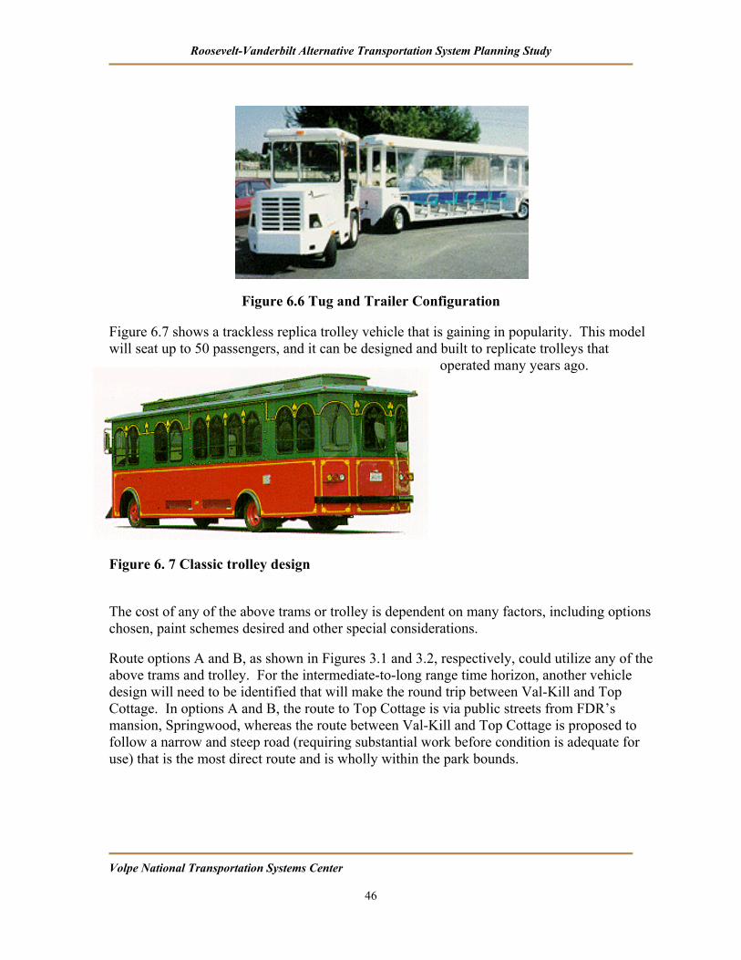
Roosevelt-Vanderbilt Alternative Transportation System Planning Study
Volpe National Transportation Systems Center 46
Figure 6.6 Tug and Trailer Configuration Figure 6.7 shows a trackless replica trolley vehicle that is gaining in popularity. This model will seat up to 50 passengers, and it can be designed and built to replicate trolleys that
operated many years ago.
Figure 6. 7 Classic trolley design The cost of any of the above trams or trolley is dependent on many factors, including options chosen, paint schemes desired and other special considerations.
Route options A and B, as shown in Figures 3.1 and 3.2, respectively, could utilize any of the above trams and trolley. For the intermediate-to-long range time horizon, another vehicle design will need to be identified that will make the round trip between Val-Kill and Top Cottage. In options A and B, the route to Top Cottage is via public streets from FDR’s mansion, Springwood, whereas the route between Val-Kill and Top Cottage is proposed to follow a narrow and steep road (requiring substantial work before condition is adequate for use) that is the most direct route and is wholly within the park bounds.
Roosevelt-Vanderbilt Alternative Transportation System Planning Study
Volpe National Transportation Systems Center 47
7. Phased Implementation Plan This section presents a preliminary implementation plan for the ROVA ATS. A variety of factors, such as the availability of funding from particular sources, institutional constraints, and community preferences, could affect the implementation sequence. The options presented in this study, their prioritization, and phasing require development at a more detailed level as part of an integrated ATS plan and implementation program.
Phase I (Short-run timeframe)
• Procurement of ATS vehicles, clean-diesel technology or alternative fueled
• Implementation of Option A or Option B route configuration, mixed traffic operation
• Site improvementsfor ATS station are put in place at Home of FDR NHS in conjunction with construction activity for the joint NPS/NARA visitor and education/ conference Center, new parking facilities and access drives
• Site improvements for ATS station at Vanderbilt NHS and at Val-Kill NHS
• Site improvements for local ATS station at Top Cottage
Phase II (Intermediate timeframe)
• Construction of on-site Val-Kill - to - Top Cottage road and pedestrian pathway
• Upgrade of service on the FDR-Vanderbilt shuttle route, with implementation of signalization at the access drives to Home of FDR NHS and Vanderbilt NHS. Signalization provides preemptive transit priority for ATS vehicles by providing an exclusive turn phase for ATS vehicles crossing Rt. 9
• Evaluate the cross-section of Route 9 to consider through traffic needs and dedicated ATS lanes. Exclusive right-of-way (ROW) is available to improve service on other ATS routes sharing this segment
• Replacement procurement of ATS vehicles, electric-hybrid technology. This is an option that requires more detailed study before it can be recommended as an element of an ATS circulation plan
• Removal of some private parking facilities at Eleanor Roosevelt NHS and Vanderbilt NHS and restoration of the landform
• Creation of off-site intercept parking facility serving ATS and other public transportation routes, possibly with shuttle connections to rail stations

Roosevelt-Vanderbilt Alternative Transportation System Planning Study
Volpe National Transportation Systems Center 48
Phase III (Long-range timeframe)
• Site improvements for ATS station and access at Vanderbilt NHS, including possible restoration of the ‘subway’ access road, tunnel section under Rt. 9, and loop site improvements for local ATS station and access roadways at Eleanor Roosevelt NHS
• Construction of ‘intercept’ parking facility and central Transportation Hub serving mid-Hudson Valley at optimal site location. New commercial development and new Regional Visitor’s Center co-located on-site
• Replacement procurement of ATS vehicles, fuel cell technology14
• Restructuring of local/regional transit services (routes and schedules), with convergence of all routes at the central Transportation Hub. Coordination of schedules
• Restructuring of ATS vehicle route configuration, implementing Option C route configuration
• New Hudson River ferry facilities and services implemented
• Removal of some private parking facilities at Eleanor Roosevelt NHS and Vanderbilt NHS and restoration of the landform
• Development and restoration of needed parcels, and development and restoration of original Roosevelt Estate easement ‘path’ connecting Home of FDR NHS to Val-Kill
• Replacement procurement of ATS vehicles, second-generation fuel cells technology
14 Commercially viable fuel cell transit vehicles are likely to become available in the 2015-2020 timeframe.

Volpe Center DRAFT Guide to NPS Document Design Standards, November 17, 2004 1
As the nation’s principal conservation agency, the Department of the Interior has the responsibility for most of our nationally owned public lands and natural resources. This includes fostering sound use of our land and water resources; protecting our fish, wildlife, and biological diversity; preserving the environmental and cultural values of our parks and historic places; and providing for the enjoyment of life through outdoor recreation. The department assesses our energy and mineral resources and works to ensure that their development is in the best interests of all our people by encouraging stewardship and citizen participation in their care. The department also has a major responsibility for American Indian reservation communities and for people who live in island territories under U.S. administration. NPS D-51 / July 2005


