RURAL HIGHWAY SHOULDERS THAT ACCOMMODATE BICYCLE AND
PEDESTRIAN USE(TxDOT Project 0-6840)
June 7, 2016
Presented by: Karen Dixon, Ph.D., P.E., TTI
Team: Kay Fitzpatrick, Raul Avelar, & Subasish Das

Project Objectives• Define roadway shoulder
suitability criteria for pedestrians and bicycles
• Apply criteria to Texas highways to determine candidate locations that merit shoulder improvements
• Identify high use or high demand locations
• Develop a list of target locations, coupled with the suitability criteria
2

Outline of Presentation
• Background• Data Collection• Analysis• Recommendations• Questions / Discussion
3

Background:Literature Review /
State of Practice
4
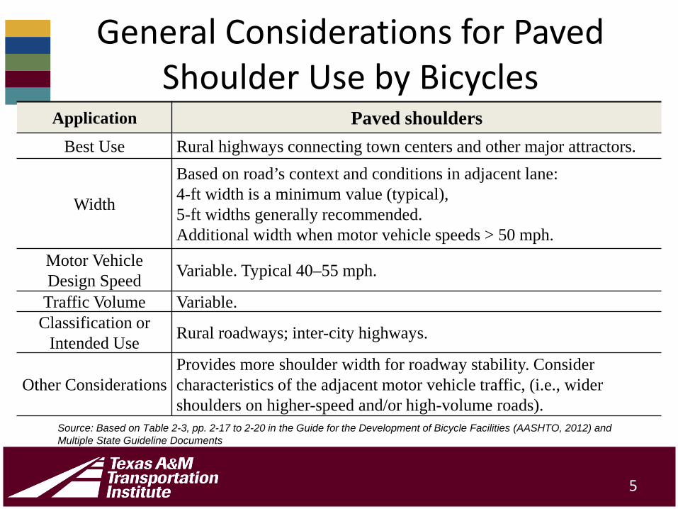
General Considerations for Paved Shoulder Use by Bicycles
Application Paved shouldersBest Use Rural highways connecting town centers and other major attractors.
Width
Based on road’s context and conditions in adjacent lane:4-ft width is a minimum value (typical),5-ft widths generally recommended.Additional width when motor vehicle speeds > 50 mph.
Motor Vehicle Design Speed Variable. Typical 40–55 mph.
Traffic Volume Variable.Classification or
Intended Use Rural roadways; inter-city highways.
Other ConsiderationsProvides more shoulder width for roadway stability. Consider characteristics of the adjacent motor vehicle traffic, (i.e., wider shoulders on higher-speed and/or high-volume roads).
5
Source: Based on Table 2-3, pp. 2-17 to 2-20 in the Guide for the Development of Bicycle Facilities (AASHTO, 2012) and Multiple State Guideline Documents

Most Common Considerations for Shoulder Width Selection
• Traffic Operations (volume, speed, vehicle type, facility type)
• Connectivity• Land Use• Vertical Grade (> 5%)• Presence and configuration of rumble strips
6
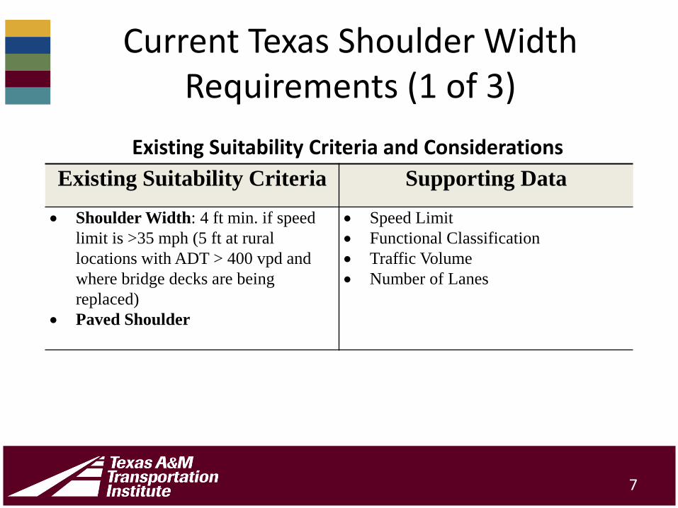
Current Texas Shoulder Width Requirements (1 of 3)
Existing Suitability Criteria Supporting Data
• Shoulder Width: 4 ft min. if speed limit is >35 mph (5 ft at rural locations with ADT > 400 vpd and where bridge decks are being replaced)
• Paved Shoulder
• Speed Limit• Functional Classification• Traffic Volume• Number of Lanes
7
Existing Suitability Criteria and Considerations
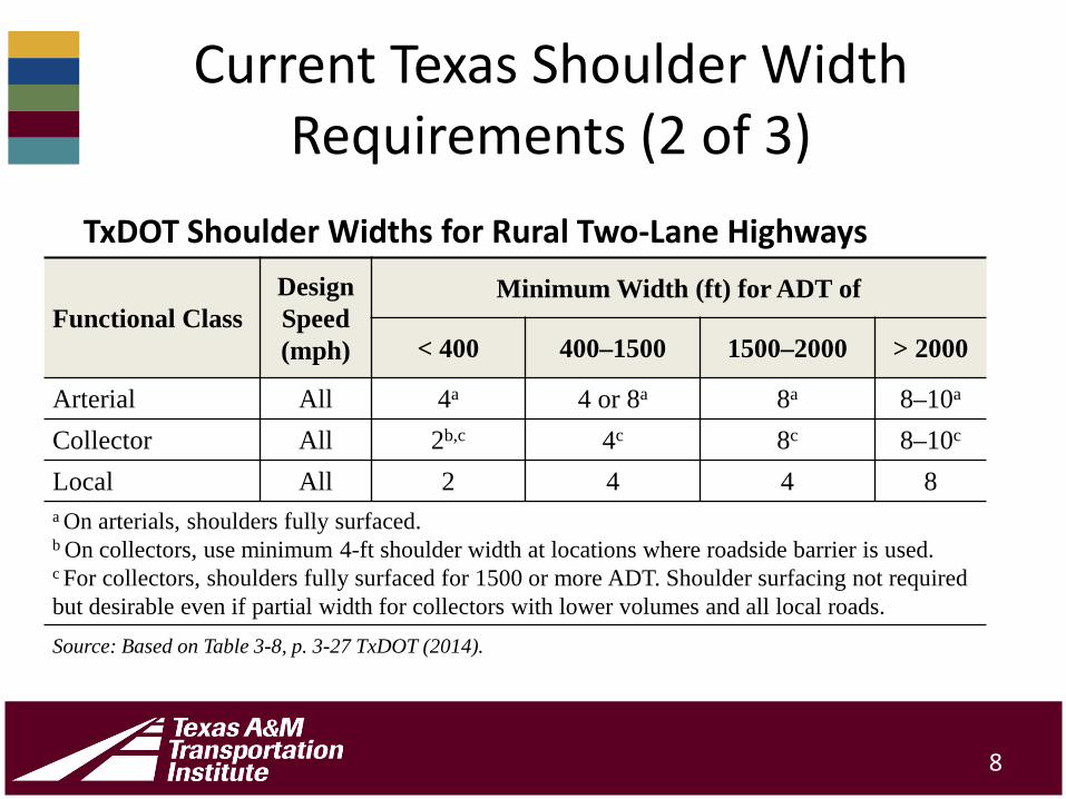
Current Texas Shoulder Width Requirements (2 of 3)
Functional ClassDesign Speed(mph)
Minimum Width (ft) for ADT of
< 400 400–1500 1500–2000 > 2000
Arterial All 4a 4 or 8a 8a 8–10a
Collector All 2b,c 4c 8c 8–10c
Local All 2 4 4 8a On arterials, shoulders fully surfaced.b On collectors, use minimum 4-ft shoulder width at locations where roadside barrier is used.c For collectors, shoulders fully surfaced for 1500 or more ADT. Shoulder surfacing not required but desirable even if partial width for collectors with lower volumes and all local roads. Source: Based on Table 3-8, p. 3-27 TxDOT (2014).
8
TxDOT Shoulder Widths for Rural Two-Lane Highways

Current Texas Shoulder Width Requirements (3 of 3)
Type of Facility Four-Lane Undivided
Four-Lane Divided
Six-Lane Divided
Shoulder Width (ft) 8a to 10 8a to 10 8a to 10
a Applies to collector roads only. On four-lane undivided highways, outside surfaced shoulder width may be decreased to 4 ft where flat (1V:10H), sodded front slopes are provided for a minimum distance of 4 ft from the shoulder edge.
Source: TxDOT (2014)
9
TxDOT Shoulder Width Requirements for Multilane Highways

Overview of Data Collected/Acquired for
Analysis
10

Summary of Data
• Roadway Inventory Data (RHiNo)• Crash Data for Pedestrian and Bicycle Involved
Crashes (CRIS)• US Census Data (Household Information)• National Households Travel Survey Data (Bicycle
and Pedestrian Trips)• Sample Data for Shoulder Conditions (Video Data
for Two Districts)• Field Observational Data
11
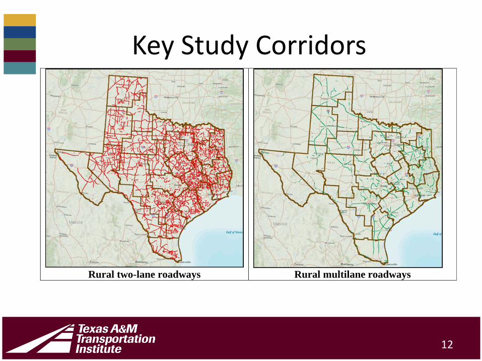
Key Study Corridors
12
Rural two-lane roadways Rural multilane roadways

Inspecting the Data
13
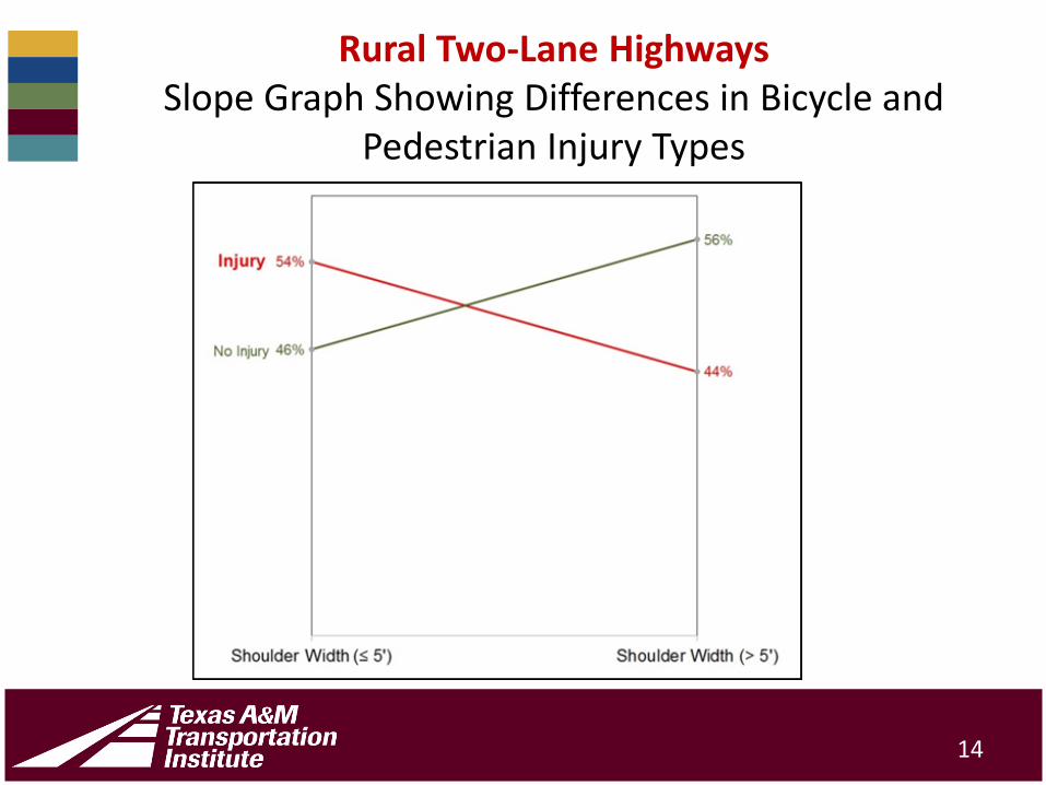
Rural Two-Lane HighwaysSlope Graph Showing Differences in Bicycle and
Pedestrian Injury Types
14
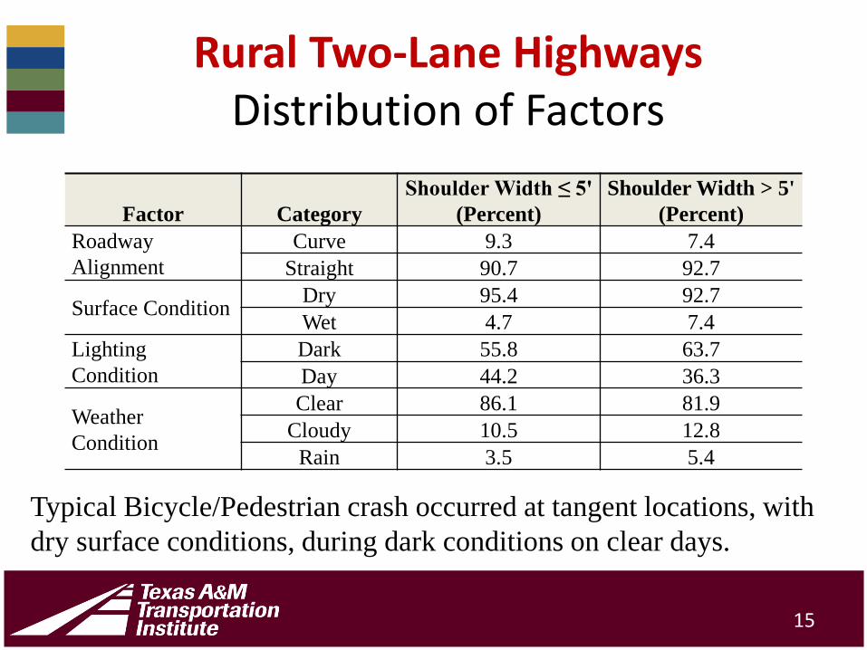
Rural Two-Lane HighwaysDistribution of Factors
Factor CategoryShoulder Width ≤ 5'
(Percent)Shoulder Width > 5'
(Percent)Roadway Alignment
Curve 9.3 7.4Straight 90.7 92.7
Surface Condition Dry 95.4 92.7Wet 4.7 7.4
Lighting Condition
Dark 55.8 63.7Day 44.2 36.3
Weather Condition
Clear 86.1 81.9Cloudy 10.5 12.8
Rain 3.5 5.4
15
Typical Bicycle/Pedestrian crash occurred at tangent locations, with dry surface conditions, during dark conditions on clear days.
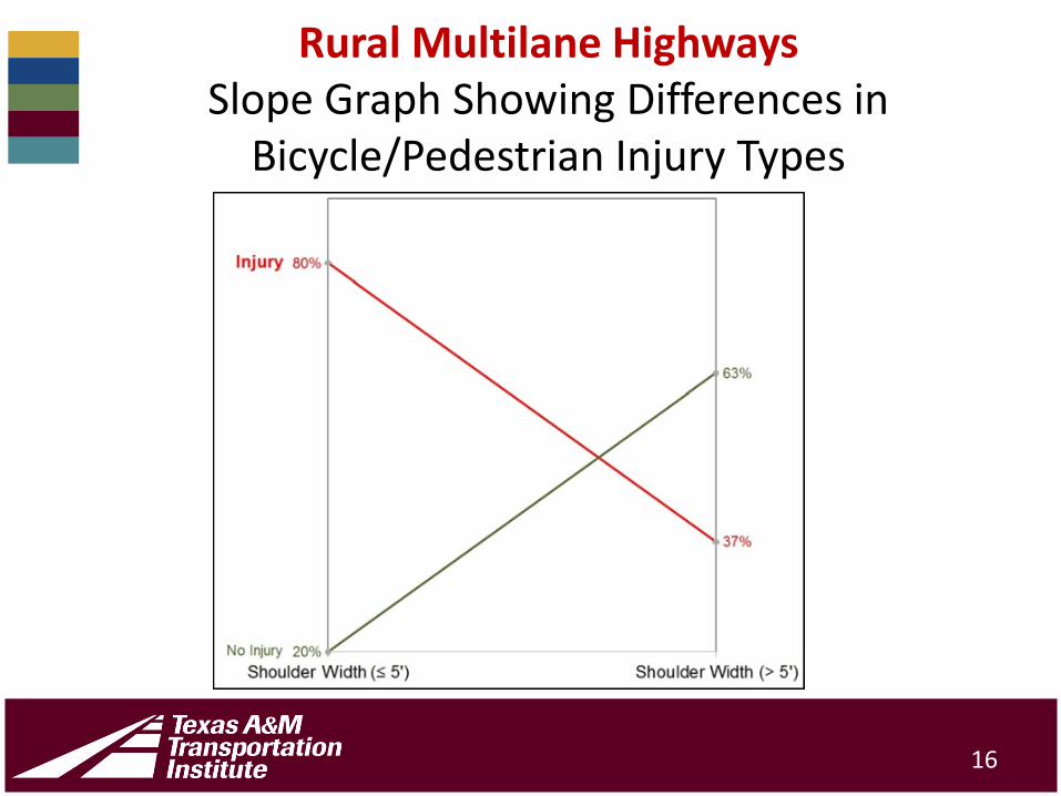
Rural Multilane HighwaysSlope Graph Showing Differences in
Bicycle/Pedestrian Injury Types
16

Rural Multilane HighwaysDistribution of Factors
17
Factor CategoryShoulder Width ≤ 5'
(Percent)Shoulder Width > 5'
(Percent)Roadway Alignment
Curve 0.0 3.5Straight 100.0 96.6
Surface Condition
Dry 85.7 89.7Wet 14.3 10.4
Lighting Condition
Dark 57.1 55.2Day 42.9 44.8
Weather Condition
Clear 85.7 82.8Cloudy 0.0 13.8
Rain 14.3 3.5

Descriptive StatisticsFactors Statistics Rural Two-Lane Rural Multilane
Annual Average Daily Traffic (vpd)
Minimum 404 2814Mean (Average) 5448 11,767
Maximum 23,416 29,957
Speed Limit(mph)
Minimum 40 40Mean (Average) 59.78 61.53
Maximum 75 75
Shoulder Width (ft)
Minimum 1.0 1.0Mean (Average) 6.6 6.8
Maximum 10.0 10.0
18

Analysis and Findings
19
Probability (Statistical) Findings
• As the speed limit increases and shoulder widths remain constant, crashes involving bicycles and pedestrians can be expected to increase.
• As shoulder widths are increased and speed limits are held constant, crashes involving bicycles and pedestrians can be expected to decrease.
20
Quantitative Effects for Rural Two-Lane Highways
For each 5 mph increase in speed limit, the shoulder width should be increased by approximately 1.68 ft to offset safety issues introduced from the increased speed limit.
21

Mosaic Plot for Rural Two-Lane Shoulder
22
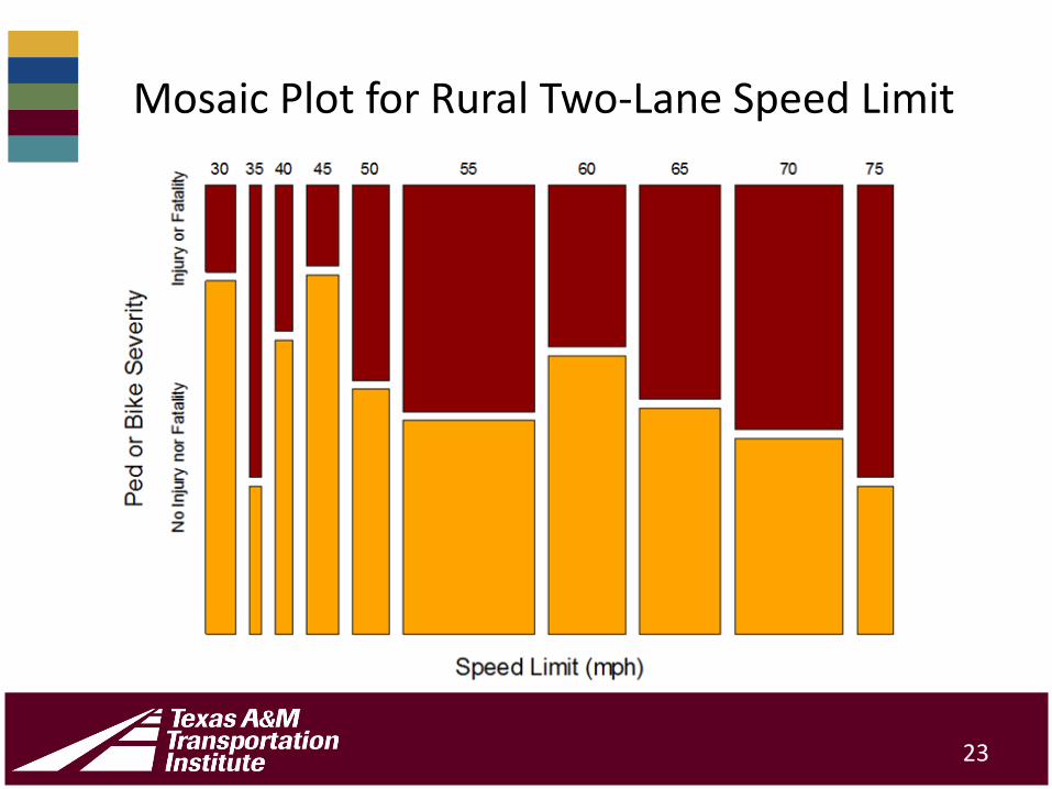
Mosaic Plot for Rural Two-Lane Speed Limit
23

Quantitative Effects for Rural Multilane Highways
For each 5 mph increase in speed limit, the shoulder width should be increased by approximately 1.0 ft to offset safety issues introduced from the increased speed limit.
24
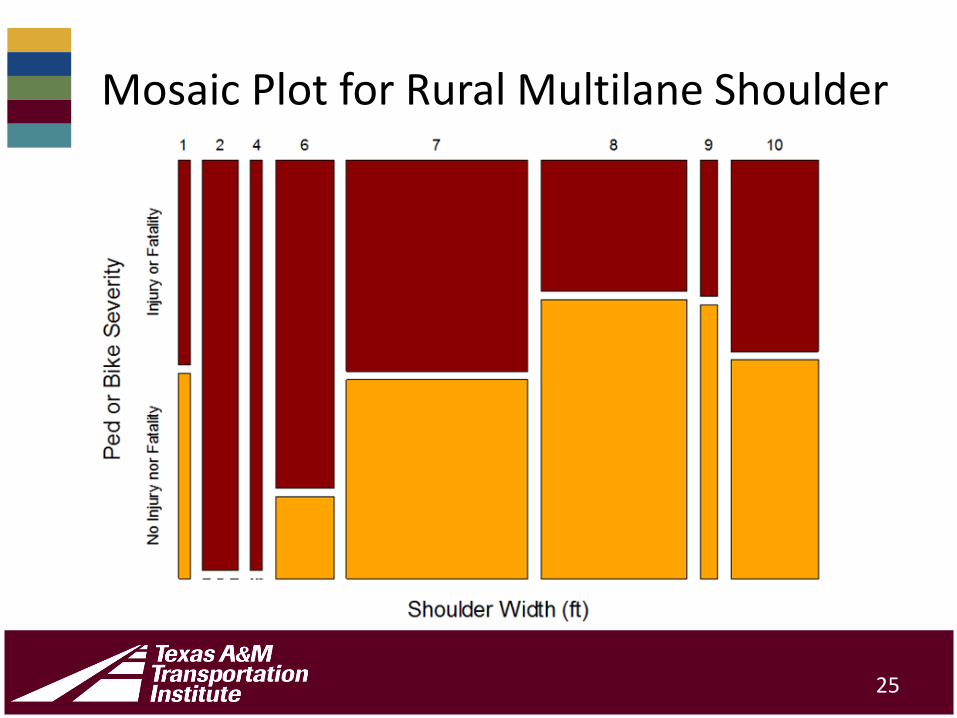
Mosaic Plot for Rural Multilane Shoulder
25

Mosaic Plot for Rural Multilane Speed Limit
26

Determining Bicycle/Pedestrian Demand
• Conducted an analysis using land use and household information from the US Census
• Supplemented Census data with information from the National Households Travel Survey Based on the following explanatory variables:– Population density per square mile– Housing units per square mile– Percent renter-occupants– Household size (number of people per household)
27

Estimating Demand for Rural Bicycle and Pedestrian Trips
28

Field Observation Findings
• Individual bicyclists rarely travel along rural corridors with very narrow shoulders
• Bicycle groups do use these facilities but often take the entire lane
29
• When a vehicle does pass a bicycle, the cyclist tends to shift to the right and the vehicle to the left (as expected)
• Sample size too small to use for any computational analysis
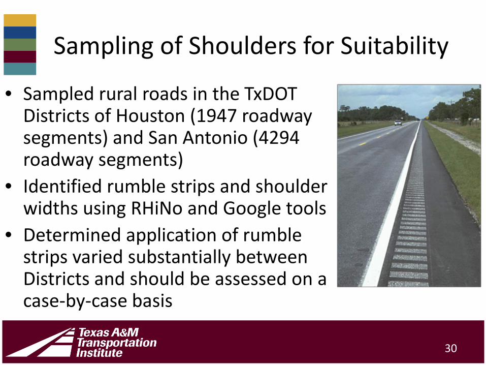
Sampling of Shoulders for Suitability
• Sampled rural roads in the TxDOTDistricts of Houston (1947 roadway segments) and San Antonio (4294 roadway segments)
• Identified rumble strips and shoulder widths using RHiNo and Google tools
• Determined application of rumble strips varied substantially between Districts and should be assessed on a case-by-case basis
30
General Conclusions
• Shoulders must be paved, well maintained, and of a type that facilitates use by bicycles or pedestrians.
• Locations where longitudinal rumble strips are present should allow additional lateral separation on the shoulder and the rumble strips should provide spaces to permit bicycles to safely enter and exit the shoulder region.
• As the risk to non-motorized users increases due to high speeds or volumes, the shoulder widths should increase to accommodate additional space.
31

Recommended Shoulder Widths at Locations with Bicycle and Pedestrian Activity
32
Facility Speed Limit (mph)
Calculated Shoulder Width –No Rumble Strips
(ft)
Rounded Shoulder
Width – No Rumble Strips
(ft)
Shoulder Width for
Locations with Rumble Strips
(ft)
Rural Two-Lane Highway (1.68' shoulder width increase for each 5 mph increase)
≤ 55 6* 6
Add at least 1’60 6 + 1.68 = 7.68 8
65 6 + 2(1.68) = 9.36 10≥ 70 6 + 3(1.68) = 11.04 11
Rural Multilane Highway (1.00' shoulder width increase for each 5 mph increase)
≤ 55 8 (minimum)* 8 960 8 + 1.00 = 9.00 9 1065 8 + 2(1.00) = 10.00 10 10 to 11**
≥ 70 8 + 3(1.00) = 11.00 10 to 11** 10 to 12*** Based on TxDOT (2014), Table 3-8, p. 3-27 and companion content** A range of shoulder widths is presented because shoulders wider that 10 ft often will be used by motor vehicles as secondary lanes (particularly at intersection locations) and create additional problems

Recommended Shoulder Suitability Criteria
33
Description Speed Limit (mph)
Rural Two-Lane Roadway*
Rural Multilane Roadway*
Shoulder Width (No Rumble Strips Present) (ft)
≤ 55 6 860 8 965 10 10
≥ 70 10 to 11** 10 to 11**
Shoulder Width (Rumble Strips Present and/or Vertical Grades ≥ 5%) (ft)
≤ 55 May add 1' at locations with these
features**
960 1065 10 to 11**
≥ 70 10 to 12**
Adjacent Motor Vehicle Travel Lane (ft) All 11 to 12 11 to 12
Rumble Strip Configuration All Where present, rumble strips should have 12' periodic gaps at intervals of 40 to 60'
Shoulder Surface Type and Quality All Fully paved with surface similar to that of adjacent motor vehicle lane
Pavement Maintenance All Routine maintenance required to maintain debris free riding surface
*Add an additional 1' shoulder width at locations where roadside obstacles such as guardrails or barrier are present. ** A range of shoulder widths is presented because shoulders wider that 10 ft often will be used by motor vehicles as secondary lanes (particularly at intersection locations) and create additional problems
Procedure to Prioritize Shoulder Widening (1 or 2)
Step 1: Select type of road and study area. Determine the household population density or future expected land use density to use for predicting the number of non-motorized trips (by using the graphic shown in Figure 19).Step 2: Determine the lane and shoulder width and shoulder pavement type.Step 3: Narrow down the list of candidate corridors to those with paved shoulder widths that are less than the recommended widths. Note that rumble strip and barrier information may not be known at this stage.
34
Procedure to Prioritize Shoulder Widening (2 or 2)
Step 4: Sort the corridors identified in Step 3 based on total number of non-motorized trips.Step 5: Examine and prioritize the remaining corridors by performing an examination of the individual locations to determine conditions including rumble strips, guardrail or barrier, and steep vertical grades.Also, examine locations with gaps where shoulders do not meet the criteria for sections of the road. This connectivity evaluation should focus on short connections between communities of up to 3 miles. Step 6: Rank the resulting corridors.
35

Questions?
Discussion?
36
Extra SlideStrategic Corridor Development Plan
• Introduces the ranking procedure including the trip estimation calculation and the recommended suitability criteria
• Provides ranked list of two-lane highway sites (28 locations)
• Provides ranked list of multilane highway sites (13 locations)
• Includes maps for individual districts
37


