South Somerset District Council Strategic Flood Risk Assessment Level 1 SFRA - Final Report August 2008 Volume I Halcrow Group Limited

Halcrow Group Limited Burderop Park, Swindon, Wiltshire, SN4 0QD Tel +44 (0)1793 812479 Fax +44 (0)1793 812089 www.halcrow.com Halcrow Group Limited has prepared this report in accordance with the brief from South Somerset District Council, for their sole and specific use. Any other persons who use any information contained herein do so at their own risk. © Halcrow Group Limited 2008
South Somerset District Council Strategic Flood Risk Assessment Level 1 SFRA - Final Report August 2008 Volume I Halcrow Group Limited

Halcrow Group Limited Burderop Park, Swindon, Wiltshire, SN4 0QD Tel +44 (0)1793 812479 Fax +44 (0)1793 812089 www.halcrow.com
Halcrow Group Limited Burderop Park, Swindon, Wiltshire, SN4 0QD Tel +44 (0)1793 812479 Fax +44 (0)1793 812089 www.halcrow.com
South Somerset District Council Strategic Flood Risk Assessment Level 1 SFRA - Final Report
Contents Amendment Record This report has been issued and amended as follows: Issue Revision Description Date Signed 1 0 Final report - draft 29 February 2008 2 3
1 2
Final report– draft Final report - draft
22 May 2008 11 July 2008
4 3 Final report 27 August 2008
D Kensett A Corner A McConkey M Barker P Crozier D Wilson PS Rayner

South Somerset District Council Strategic Flood Risk Assessment
Table of Contents
Executive Summary (separate document) Abbreviations
1 Introduction.................................................................................................... 1
2 The South Somerset SFRA Area .................................................................. 2 2.1 Overview....................................................................................................................... 2 2.2 South Somerset .............................................................................................................. 2 2.3 South Somerset Rivers..................................................................................................... 3 2.4 Flood Risks.................................................................................................................... 4 2.5 Geology ........................................................................................................................ 4
3 SFRA Approach & Methodology .................................................................. 6 3.1 Overview....................................................................................................................... 6 3.2 Purpose of this SFRA...................................................................................................... 6 3.3 Outcomes of the SFRA Process........................................................................................ 6 3.4 The Sequential Test......................................................................................................... 8 3.5 The Exception Test ........................................................................................................ 8 3.6 Planning response matrix ............................................................................................... 10 3.7 Level 1 SFRA methodology ........................................................................................... 10 3.8 The need for Level 2 SFRA............................................................................................ 11 3.9 SFRA User Guide......................................................................................................... 12
4 Planning policy framework......................................................................... 14 4.1 Overview..................................................................................................................... 14 4.2 Planning Policy Framework............................................................................................ 14 4.3 National Planning Policy................................................................................................ 14 4.4 Regional Planning Policy................................................................................................ 16 4.5 Local planning policy .................................................................................................... 18 4.6 Summary ..................................................................................................................... 18
5 Data sources ................................................................................................ 19 5.1 Overview..................................................................................................................... 19 5.2 Consultation process ..................................................................................................... 19 5.3 Environment Agency Flood Zone maps .......................................................................... 20 5.4 Detailed hydraulic modelling .......................................................................................... 20 5.5 Localised flooding......................................................................................................... 20
6 Assessment of potential causes of flooding............................................. 21 6.1 Overview..................................................................................................................... 21 6.2 Sources of flooding ....................................................................................................... 21 6.3 Probability of flooding................................................................................................... 21 6.4 SFRA flood maps ......................................................................................................... 22 6.5 River flooding – fluvial .................................................................................................. 23 6.6 Groundwater flooding ................................................................................................... 27 6.7 Surface water flooding - land drainage ............................................................................. 32 6.8 Sewer flooding ............................................................................................................. 33 6.9 Reservoirs.................................................................................................................... 36 6.10 Other artificial water retaining structures.......................................................................... 38 6.11 Critical services/infrastructure within Flood Zones ........................................................... 38
South Somerset District Council Strategic Flood Risk Assessment
7 Assessment of flood risk management practices .................................... 39 7.1 Overview..................................................................................................................... 39 7.2 Flood risk management responsibilities............................................................................ 39 7.3 Existing flood defences ................................................................................................. 39 7.4 Flood warning areas ...................................................................................................... 43
8 Assessment of the capacity for the use of SUDS..................................... 45 8.1 Overview..................................................................................................................... 45 8.2 Types of SUDS systems................................................................................................. 46 8.3 SUDS at the planning stage ............................................................................................ 46 8.4 Application of SUDS within South Somerset .................................................................... 46 8.5 Effective application of SUDS techniques ........................................................................ 48 8.6 Constraints on discharges to ground................................................................................ 48 8.7 The role of groundwater & aquifer bodies in sustainable drainage........................................ 48
9 Flood risk & climate change....................................................................... 50 9.1 Overview..................................................................................................................... 50 9.2 Flood risk & climate change ........................................................................................... 50 9.3 Integrated urban drainage .............................................................................................. 51 9.4 Potential increase in flood risk caused by future development ............................................. 51
10 Strategic Land-Use Planning...................................................................... 53 10.1 Overview..................................................................................................................... 53 10.2 Flood risk management policy ........................................................................................ 53 10.3 Strategic flood risk management studies ........................................................................... 53 10.4 Growth areas for development ....................................................................................... 57 10.5 Policy recommendations ................................................................................................ 61 10.6 Development within areas affected by surface water and sewer flooding............................... 63 10.7 Recommendations for reducing existing flood risks ........................................................... 63 10.8 Key messages for development control ............................................................................ 64 10.9 The need for flood risk assessments ................................................................................ 64
11 Conclusions & Recommendations ............................................................ 67
References …………………………………………………………………………….71
Glossary …………………………………………………………………………….73
Appendix A Audit trail database....................................................................... 75
Appendix B Geology & soils ............................................................................. 77
Appendix C Sewer flooding .............................................................................. 81
Appendix D Sustainable land uses and PPS25 flood risk vulnerability classification ................................................................................. 83
Appendix E Developer guidance for FRA’s ..................................................... 85
Appendix F Flood Warning ............................................................................... 89
Appendix G Localised Flooding Database....................................................... 91
South Somerset District Council Strategic Flood Risk Assessment
Figures Figure 2.1 South Somerset SFRA area Figure 2.2 South Somerset rivers Figure 3.1 How the SFRA is used to inform site allocations Figure 3.2 Application of the Sequential Test Figure 3.3 SFRA User guide Figure 6.1 Layout of SFRA flood maps Figure 6.2 Services & infrastructure location
Figure 7.1 Flood defences at Landport/Huish Episcopi
Figure 7.2 Flood defences at Martock
Figure 7.3 Flood defences at Illminster
Figure 7.4 Flood defences at South Peterton
Figure 8.1 Diagram of how SUDS can be used at a local scale
Figure 10.1 CFMP area boundaries in the South West Region
Figure 10.2 Policy units & selected policies for Parrett CFMP (2007)
Figure 10.3 Policy units & selected policies for the Dorset Stour CFMP (2007)
Figure 10.4 West Dorset SFRA Flood Maps – draft
Figure 10.5 Flood Zones 3b (light blue), 3a (purple) and 2 (dark blue) with climate change for Yeovil, Chard, Crewkerne, Illminster, Wincanton and Bruton
Figure 10.6 Flood Zones 3b (light blue), 3a (purple) and 2 (dark blue) with climate change for Castle Cary / Ansford, Langport / Huish Episcopi, Martock, Milborne Port, Somerton, South Peterton, Templecombe
Figure 10.7 Flood Zones 3b (light blue), 3a (purple) and 2 (dark blue) with climate change for Templecombe
Figure 10.8 Guidance for developers for individual planning applications
Tables Table 3.3 Appropriate planning responses when seeking to develop within Flood Zones
Table 6.1 Historical fluvial flood events
Table 6.2 Types, Characteristics and Associated Risks from Groundwater Flooding
Table 6.3 Recorded Groundwater Flooding Events
Table 6.4 Recorded Groundwater Flooding Events
Table 6.5 South Somerset Reservoirs/Lakes
Table 6.6 Services & infrastructure details
Table 7.1 Indicative flood defence cost rates
Table 9.1 Climate change guidance (from PPS25)
Table 9.2 Climate change mapping (Future = 2025 to 2115, Present = 2007)
Table 10.1 Flood Zone classification for existing urban areas
South Somerset District Council Strategic Flood Risk Assessment
Abbreviations AEP Annual Exceedance Probability
AOD Above Ordnance Datum
AONB Areas of Outstanding Natural Beauty
BGS British Geological Society
CFMP Catchment Flood Management Plan Defra The Department for the Environment, Food and Rural Affairs DCLG Department for Communities and Local Government DPD Development Plan Documents DTM Digital Terrain Model EiP Examination in Public EU European Union FRA Flood Risk Assessment FRM Flood risk management FRIS Flood reconnaissance information system (Environment Agency database) FWAG Farming and Wildlife Advisory Group
FZ Flood Zone (Environment Agency classification for published mapping) GIS Geographic Information System IUD Integrated Urban Drainage LDF Local Development Framework LiDAR Light Detection and Ranging (aerial survey) LDD Local Development Documents LPA Local Planning Authority
NFCDD National Flood and Coastal Defence Database (Environment Agency) NGR National grid reference OS Ordnance Survey PPS25 Planning Policy Statement 25 RFRA Regional Flood Risk Appraisal RSS Regional Spatial Strategy SA Sustainability Appraisal SEA Strategic Environmental Assessment SFRA Strategic Flood Risk Assessment SPS Sewage Pumping Stations SSCT Strategically Significant City or Town SSDC South Somerset District Council SSSI Site of Special Scientific Interest STW Sewage Treatment Works SUDS Sustainable Drainage Systems TTWA Travel To Work Area WHS World Heritage Sites
South Somerset District Council Strategic Flood Risk Assessment
1
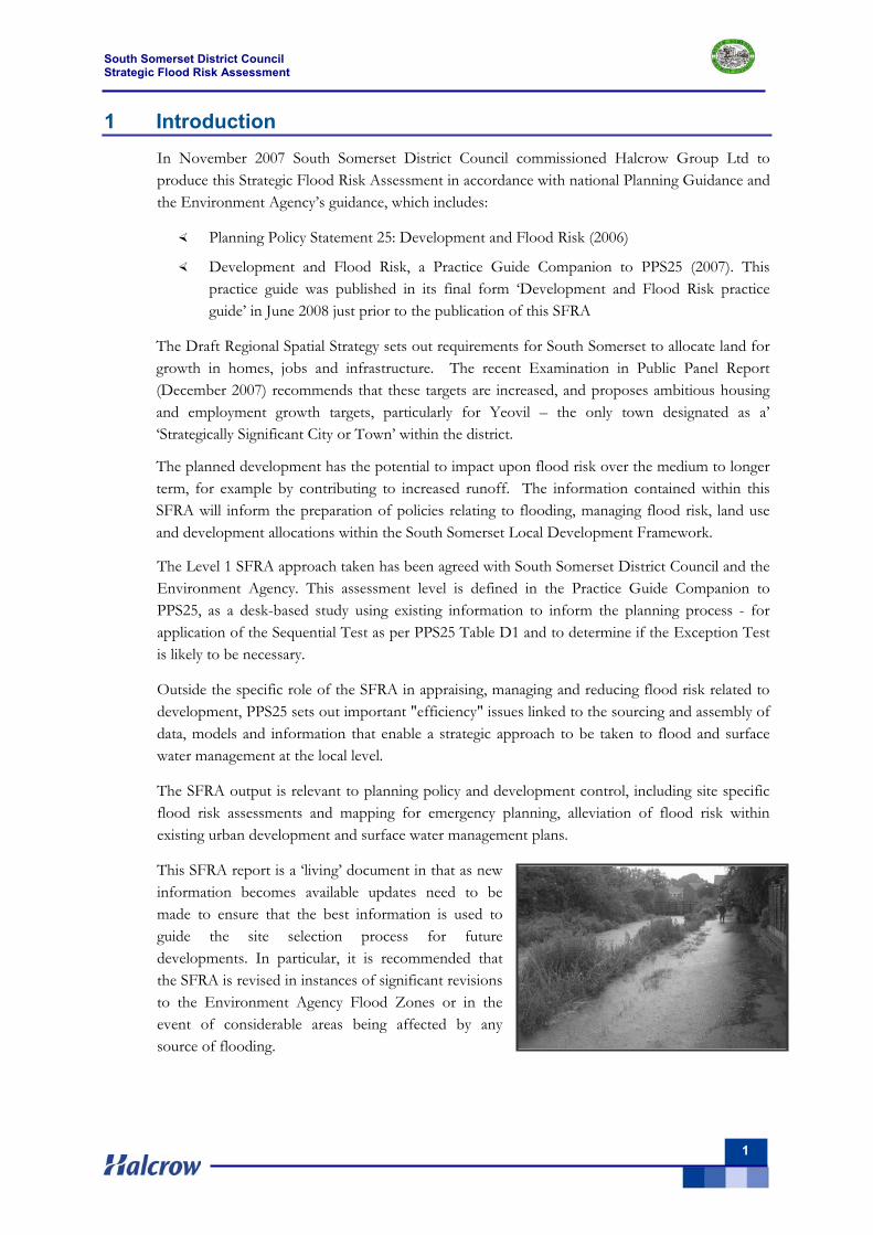
1 Introduction In November 2007 South Somerset District Council commissioned Halcrow Group Ltd to produce this Strategic Flood Risk Assessment in accordance with national Planning Guidance and the Environment Agency’s guidance, which includes:
Planning Policy Statement 25: Development and Flood Risk (2006)
Development and Flood Risk, a Practice Guide Companion to PPS25 (2007). This practice guide was published in its final form ‘Development and Flood Risk practice guide’ in June 2008 just prior to the publication of this SFRA
The Draft Regional Spatial Strategy sets out requirements for South Somerset to allocate land for growth in homes, jobs and infrastructure. The recent Examination in Public Panel Report (December 2007) recommends that these targets are increased, and proposes ambitious housing and employment growth targets, particularly for Yeovil – the only town designated as a’ ‘Strategically Significant City or Town’ within the district.
The planned development has the potential to impact upon flood risk over the medium to longer term, for example by contributing to increased runoff. The information contained within this SFRA will inform the preparation of policies relating to flooding, managing flood risk, land use and development allocations within the South Somerset Local Development Framework.
The Level 1 SFRA approach taken has been agreed with South Somerset District Council and the Environment Agency. This assessment level is defined in the Practice Guide Companion to PPS25, as a desk-based study using existing information to inform the planning process - for application of the Sequential Test as per PPS25 Table D1 and to determine if the Exception Test is likely to be necessary.
Outside the specific role of the SFRA in appraising, managing and reducing flood risk related to development, PPS25 sets out important "efficiency" issues linked to the sourcing and assembly of data, models and information that enable a strategic approach to be taken to flood and surface water management at the local level.
The SFRA output is relevant to planning policy and development control, including site specific flood risk assessments and mapping for emergency planning, alleviation of flood risk within existing urban development and surface water management plans.
This SFRA report is a ‘living’ document in that as new information becomes available updates need to be made to ensure that the best information is used to guide the site selection process for future developments. In particular, it is recommended that the SFRA is revised in instances of significant revisions to the Environment Agency Flood Zones or in the event of considerable areas being affected by any source of flooding.
South Somerset District Council Strategic Flood Risk Assessment
2
2 The South Somerset SFRA Area 2.1 Overview
This chapter gives a profile of the South Somerset SFRA area, and considers the flood risk issues related to the main river catchments. With the River Parrett catchment covering most of South Somerset, reference is made to the River Parrett Catchment Flood Management Plan (CFMP) published by the Environment Agency.
2.2 South Somerset
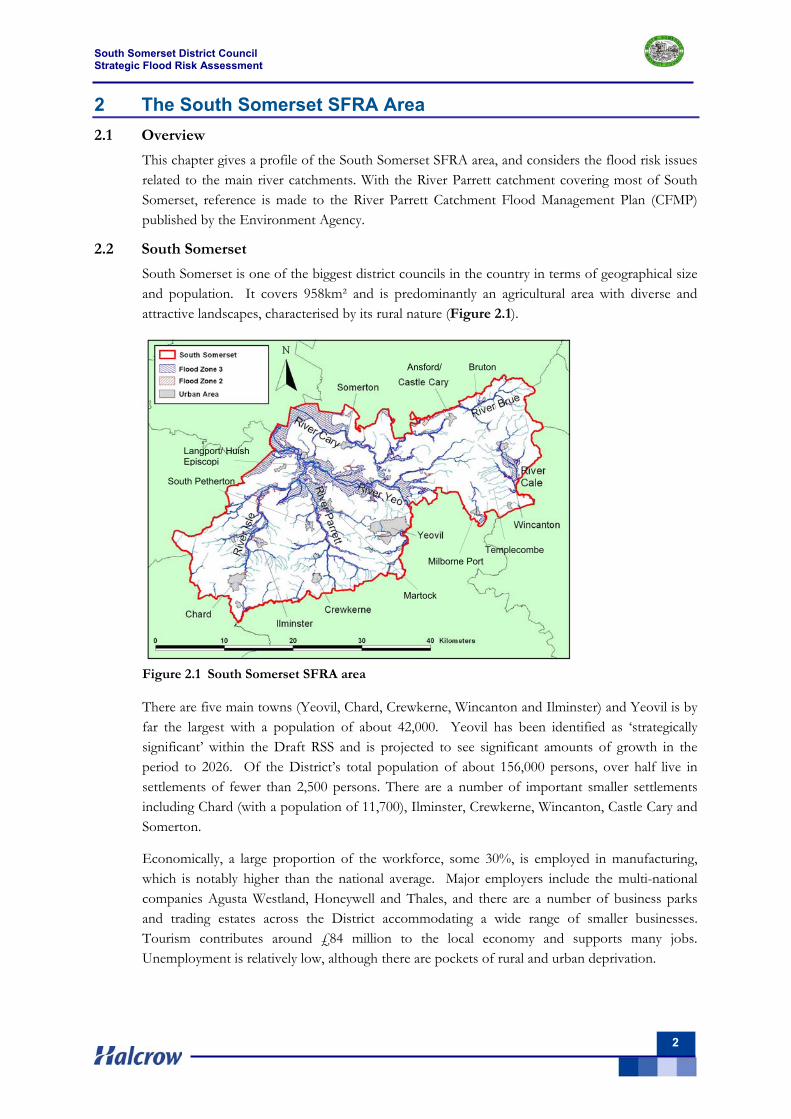
South Somerset is one of the biggest district councils in the country in terms of geographical size and population. It covers 958km² and is predominantly an agricultural area with diverse and attractive landscapes, characterised by its rural nature (Figure 2.1).
Figure 2.1 South Somerset SFRA area
There are five main towns (Yeovil, Chard, Crewkerne, Wincanton and Ilminster) and Yeovil is by far the largest with a population of about 42,000. Yeovil has been identified as ‘strategically significant’ within the Draft RSS and is projected to see significant amounts of growth in the period to 2026. Of the District’s total population of about 156,000 persons, over half live in settlements of fewer than 2,500 persons. There are a number of important smaller settlements including Chard (with a population of 11,700), Ilminster, Crewkerne, Wincanton, Castle Cary and Somerton.
Economically, a large proportion of the workforce, some 30%, is employed in manufacturing, which is notably higher than the national average. Major employers include the multi-national companies Agusta Westland, Honeywell and Thales, and there are a number of business parks and trading estates across the District accommodating a wide range of smaller businesses. Tourism contributes around £84 million to the local economy and supports many jobs. Unemployment is relatively low, although there are pockets of rural and urban deprivation.
Bruton
Templecombe
Langport/ Huish Episcopi
Martock
Milborne Port
South Petherton
Ansford/
South Somerset District Council Strategic Flood Risk Assessment
3
South Somerset is characterised by high environmental quality in both its urban and rural areas. The District is rich in terms of its historic environment, containing about 6,000 listed buildings and over 80 conservation areas.
There is a wealth of wildlife habitats and sites, including part of the internationally protected Somerset Levels and Moors Ramsar / Special Protection Area and 39 SSSIs. Its rural areas include Areas of Outstanding Natural Beauty to its western (the Blackdown Hills) and eastern (Cranborne Chase & West Wiltshire Downs) boundaries. It also includes escarpments to the north and distinctive Somerset Levels and Moors areas further south, which have importance in both landscape and habitat terms.
2.3 South Somerset Rivers
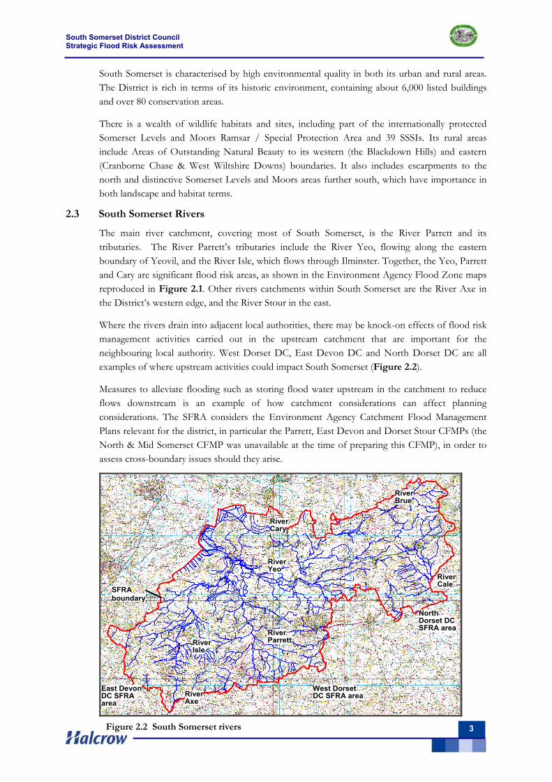
The main river catchment, covering most of South Somerset, is the River Parrett and its tributaries. The River Parrett’s tributaries include the River Yeo, flowing along the eastern boundary of Yeovil, and the River Isle, which flows through Ilminster. Together, the Yeo, Parrett and Cary are significant flood risk areas, as shown in the Environment Agency Flood Zone maps reproduced in Figure 2.1. Other rivers catchments within South Somerset are the River Axe in the District’s western edge, and the River Stour in the east.
Where the rivers drain into adjacent local authorities, there may be knock-on effects of flood risk management activities carried out in the upstream catchment that are important for the neighbouring local authority. West Dorset DC, East Devon DC and North Dorset DC are all examples of where upstream activities could impact South Somerset (Figure 2.2).
Measures to alleviate flooding such as storing flood water upstream in the catchment to reduce flows downstream is an example of how catchment considerations can affect planning considerations. The SFRA considers the Environment Agency Catchment Flood Management Plans relevant for the district, in particular the Parrett, East Devon and Dorset Stour CFMPs (the North & Mid Somerset CFMP was unavailable at the time of preparing this CFMP), in order to assess cross-boundary issues should they arise.
River Parrett
River Brue
River Cale
SFRA boundary
River Yeo
River Cary
River Isle
West Dorset DC SFRA areaRiver
Axe
North Dorset DC SFRA area
East Devon DC SFRA area
Figure 2.2 South Somerset rivers
South Somerset District Council Strategic Flood Risk Assessment
4
2.4 Flood Risks
In the River Parrett catchment the rivers and streams flow from their source in the hills in the southwest and east of the catchment; they flow in a north and westerly direction down into an extensive lowland floodplain before flowing out into the Bristol Channel through the Parrett Estuary (outside the SFRA area).
Watercourses are typically steep, narrow and unconstrained in the uplands; while further downstream they are slower moving and more heavily constrained by flood embankments, particularly through the low-lying, flat floodplain characteristic of the Somerset Levels and Moors. Many of the key environmental features are within the Somerset Levels and Moors which rely on effective water management. This management includes numerous drainage ditches which are used to drain water away from these low-lying areas.
The Environment Agency Catchment Flood Management Plan (CFMP) for the River Parrett catchment identifies that many areas flood regularly but without significant risk to life or property. In fact high water tables and frequent small scale flooding is an important feature of the low-lying areas, as it benefits the local ecology and agriculture.
The CFMP identifies areas where flooding from rivers is a problem are Taunton and Bridgwater, outside the South Somerset SFRA area. Surface water flooding is also identified as a problem in the catchment; often caused by runoff from agricultural land, and exacerbated when the capacity of drainage systems is too small or when blockages occur. This flood problem is particularly evident further up the catchment, in towns such as Yeovil and also in parts of the catchment that are particularly vulnerable to soil erosion during heavy rainfall.
A combination of different approaches are used to manage flood risk by the Environment Agency. This includes a flood mapping programme which aims to improve the understanding of flood risks within the catchment, and the flood warning service for the main areas at risk of flooding. There has also been considerable investment in river defences, particularly within the lowlands. These works include flood defence embankments and pumping stations.
2.5 Geology
The geological and hydrogeological setting provides an indication of the potential for groundwater flooding and for an understanding of the role of infiltration drainage either within the overall natural water cycle, or as part of sustainable drainage systems. The geology of the SFRA study area is reviewed by reference to the BGS 1:50,000 Scale Geological Map Sheets (listed in Appendix B).
The geological and hydrogeological setting provides a background both for an evaluation of the potential for groundwater flooding and for an understanding of the role of infiltration drainage either as part of Sustainable Drainage Systems (SUDS), or within the overall natural water cycle.
The geology of the study area range in age from recent drift deposits such as alluvium (poor infiltration potential) and plateau gravels (good infiltration potential) to a significant succession of Jurassic strata, comprising mudstones, clays and limestone (poor to good infiltration potential). The oldest strata within the study area are the Triassic Penarth Group Formation, found as minor outcrop only in the faulted valley of the River Yarly (west of Chard). This strata comprises shales and thin limestones, with poor infiltration potential.
South Somerset District Council Strategic Flood Risk Assessment
5
The geology of the area is variable and complex, with a wide range of lithological units and significant faulting – including the Mere fault through Wincanton and numerous fault systems between Yeovil and Crewkerne.
Soil type also provides a generic understanding of the drainage characteristics of soils. This will dictate, for example, the susceptibility of soils to water logging or the capacity of a soil to freely drain to allow infiltration to groundwater. Soil type may only be fully determined after suitable ground investigations, although the mapped soil types (soil association) found beneath the study area may be used as an indicator of permeability and infiltration potential. These mapped soil types illustrate the diversity of soil types across the district which includes loams, sands, peats and clays some of which are waterlogged while others are free draining.
A simplification of the main geological strata present beneath the study area, identifying both their key hydrogeological properties and their potential for infiltration drainage is provided in Appendix B and in Section 8.4.
South Somerset District Council Strategic Flood Risk Assessment
6
3 SFRA Approach & Methodology 3.1 Overview
The Strategic Flood Risk Assessment looks at flood risk at a strategic level on a local planning authority scale. It is the responsibility of South Somerset District Council, as they are responsible for allocating land for development, to demonstrate that the flood risk to and from development will be acceptably safe throughout the lifetime of the proposed development, taking account of climate change. The SFRA is prepared in consultation with the Environment Agency and other stakeholders to determine flood risk across the area.
3.2 Purpose of this SFRA
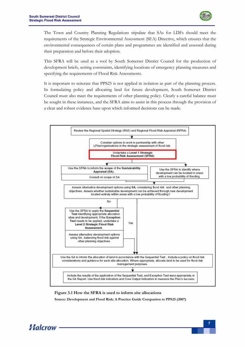
This SFRA provides an evidence base to inform the preparation of Local Development Documents, including the Core Strategy and Site Allocation DPDs (see Figure 3.1). In addition, the SFRA allows South Somerset District Council to:
Apply the PPS25 Sequential Test on a consistent and auditable basis, using a sound evidence base.
Prepare appropriate policies for the management of flood risk; Inform the sustainability appraisal so that flood risk is taken account of, when
considering options and in the preparation of strategic land use policies; Identify the level of detail required for site-specific Flood Risk Assessments; Determine the acceptability of flood risk in relation to emergency planning capability.
The SFRA is consistent with the aims of PPS25 planning policy on development and flood risk, namely, to ensure that flood risk is taken into account at all stages of the planning process to avoid inappropriate development in areas at risk of flooding, and to direct development away from areas at highest risk.
Where new development is necessary in areas at highest risk, the policy aims to make it safe without increasing flood risk elsewhere and where possible, reducing flood risk overall. Safe in the context of this study means that the development can be used/occupied without flood risk to the occupants and that dry pedestrian egress is possible to the site, with access for emergency service vehicles available at all times of flood.
Where development cannot be located in Flood Zone 1 South Somerset District Council will need to apply the Sequential Test to land use allocations and, where necessary, the Exception Test.
3.3 Outcomes of the SFRA Process
This SFRA provides sufficient data and information to enable South Somerset District Council to apply the Sequential Test to land use allocations and, where necessary, the Exception Test (Sections 3.4 and 3.5).
PPS25 also indicates that Sustainability Appraisals should be informed by the SFRA for their area. Sustainability Appraisals are required for all LDFs under the Town and Country Planning (Local Development - England) Regulations 2004. The purpose is to promote sustainable development through better integration of sustainability considerations in the preparation and adoption of plans.
South Somerset District Council Strategic Flood Risk Assessment
7
The Town and Country Planning Regulations stipulate that SAs for LDFs should meet the requirements of the Strategic Environmental Assessment (SEA) Directive, which ensures that the environmental consequences of certain plans and programmes are identified and assessed during their preparation and before their adoption.
This SFRA will be used as a tool by South Somerset District Council for the production of development briefs, setting constraints, identifying locations of emergency planning measures and specifying the requirements of Flood Risk Assessments.
It is important to reiterate that PPS25 is not applied in isolation as part of the planning process. In formulating policy and allocating land for future development, South Somerset District Council must also meet the requirements of other planning policy. Clearly a careful balance must be sought in these instances, and the SFRA aims to assist in this process through the provision of a clear and robust evidence base upon which informed decisions can be made.
Figure 3.1 How the SFRA is used to inform site allocations
Source: Development and Flood Risk: A Practice Guide Companion to PPS25 (2007)
South Somerset District Council Strategic Flood Risk Assessment
8
3.4 The Sequential Test
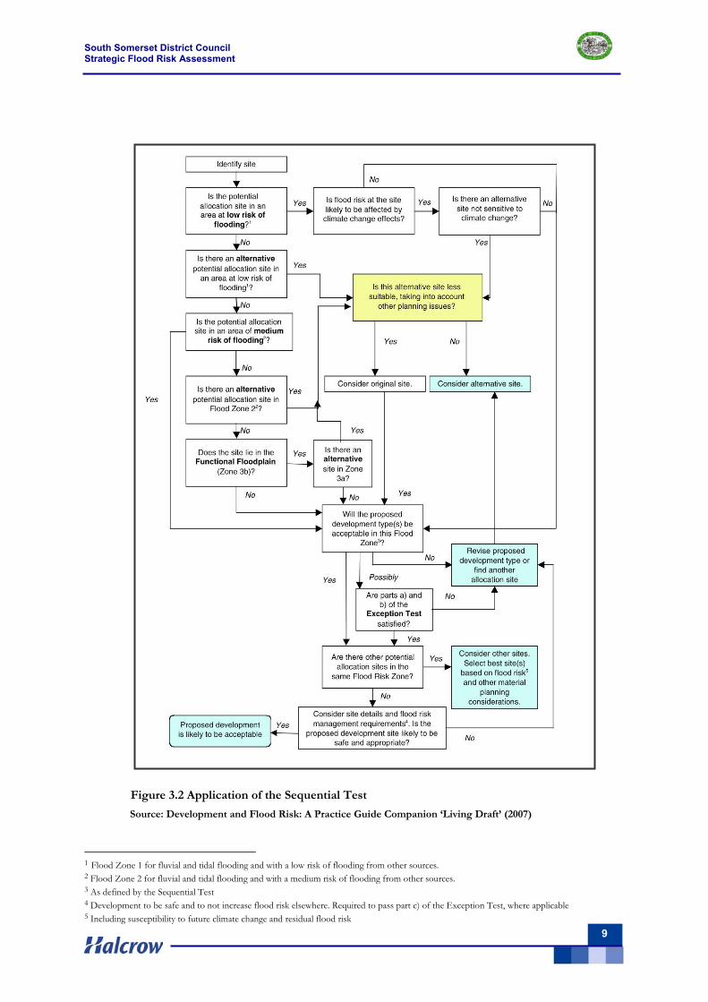
The overall aim of decision makers is to steer new development to Flood Zone 1. If there is no reasonably available site in Flood Zone 1, the flood vulnerability (see PPS25 Table D.2) of the proposed development can be taken into account in locating development in Flood Zone 2 (Medium Probability) and then Flood Zone 3 (High Probability).
South Somerset District Council will apply the Sequential Test to demonstrate that there are no reasonably available sites in areas with less risk of flooding that would be appropriate to the type of development or land use proposed. Figure 3.2 shows the Sequential Test process as advocated in PPS25.
Within each Flood Zone new development should be directed to sites with lower flood risk (towards the adjacent zone of lower probability of flooding) from all sources as indicated by the SFRA.
3.5 The Exception Test
The Exception Test is only appropriate for use when there are large areas in Flood Zones 2 and 3, where the Sequential Test alone cannot deliver acceptable sites, but where some continuing development is necessary for wider sustainable development reasons (the need to avoid social or economic blight and the need for essential civil infrastructure to remain operational during floods). The Exception Test should only be applied following application of the Sequential Test. There are only four circumstances within the Flood Risk Vulnerability classification when the Exception Test is required (see Section 3.6 below). The purpose of the Exception Test is to provide a method of managing flood risk while still allowing necessary development to occur.
The Exception Test may also be appropriate to use where restrictive national designations such as landscape, heritage and nature conservation designations, e.g. Areas of Outstanding Natural Beauty (AONBs), Sites of Special Scientific Interest (SSSIs) and World Heritage Sites (WHS), prevent the availability of unconstrained sites in lower risk areas.
For the Exception Test to be passed:
a) It must be demonstrated that the development provides wider sustainability benefits to the community which outweigh flood risk, informed by SFRA where prepared.
If the Development Plan Document has reached the ‘submission’ stage (see Figure 4 of PPS12: Local Development Frameworks) the benefits of the development should contribute to the Core Strategy’s Sustainability Appraisal;
b) The development should be on developable previously-developed land or, if it is not on previously developed land, that there are no reasonable alternative sites on developable previously-developed land; and,
c) A flood risk assessment must demonstrate that the development will be safe, without increasing flood risk elsewhere, and, where possible, will reduce flood risk overall.
South Somerset District Council Strategic Flood Risk Assessment
9
1Figure 3.2 Application of the Sequential Test
Source: Development and Flood Risk: A Practice Guide Companion ‘Living Draft’ (2007)
1 Flood Zone 1 for fluvial and tidal flooding and with a low risk of flooding from other sources. 2 Flood Zone 2 for fluvial and tidal flooding and with a medium risk of flooding from other sources. 3 As defined by the Sequential Test 4 Development to be safe and to not increase flood risk elsewhere. Required to pass part c) of the Exception Test, where applicable 5 Including susceptibility to future climate change and residual flood risk
South Somerset District Council Strategic Flood Risk Assessment
10
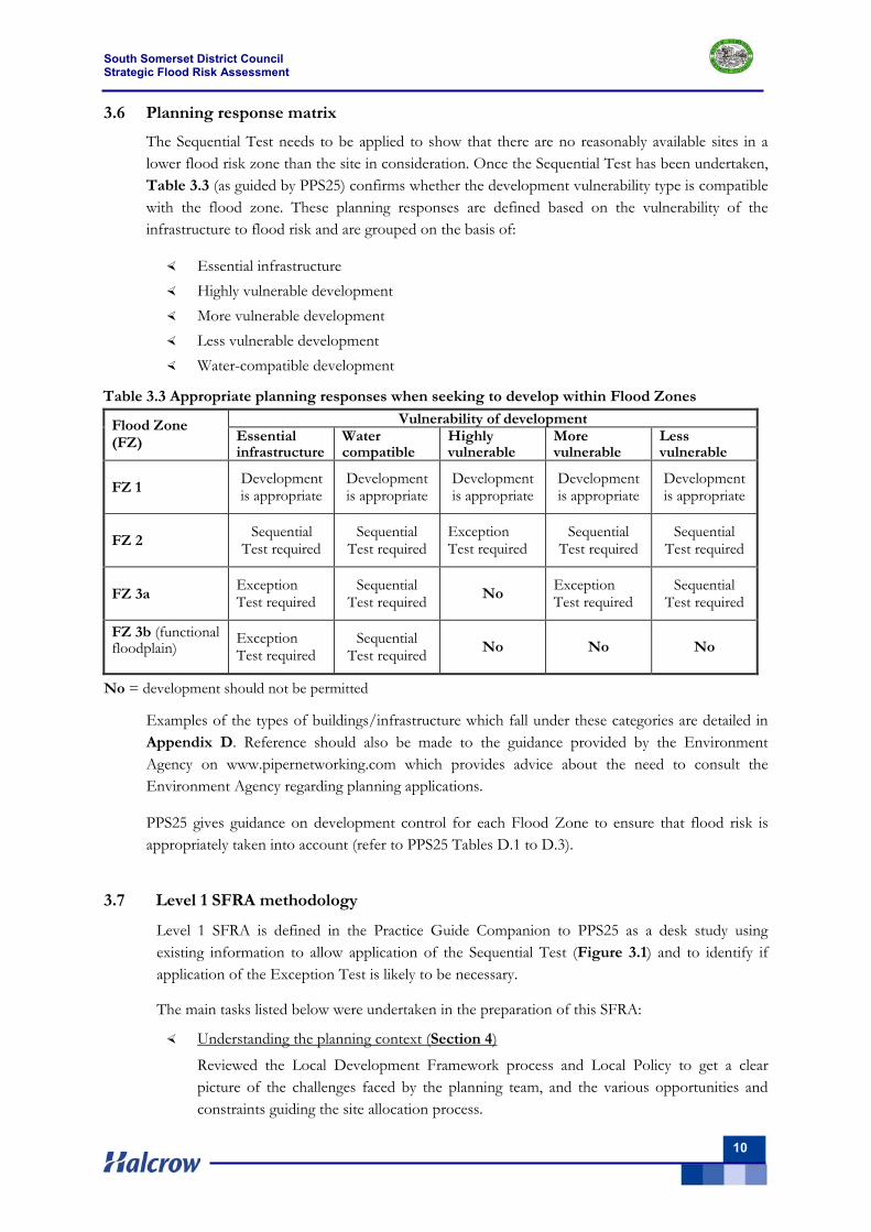
3.6 Planning response matrix
The Sequential Test needs to be applied to show that there are no reasonably available sites in a lower flood risk zone than the site in consideration. Once the Sequential Test has been undertaken, Table 3.3 (as guided by PPS25) confirms whether the development vulnerability type is compatible with the flood zone. These planning responses are defined based on the vulnerability of the infrastructure to flood risk and are grouped on the basis of:
Essential infrastructure Highly vulnerable development More vulnerable development Less vulnerable development Water-compatible development
Table 3.3 Appropriate planning responses when seeking to develop within Flood Zones
Vulnerability of development Flood Zone (FZ) Essential
infrastructure Water compatible
Highly vulnerable
More vulnerable
Less vulnerable
FZ 1 Development is appropriate
Development is appropriate
Development is appropriate
Development is appropriate
Development is appropriate
FZ 2 Sequential
Test required Sequential
Test required Exception Test required
Sequential Test required
Sequential Test required
FZ 3a Exception Test required
Sequential Test required
No Exception Test required
Sequential Test required
FZ 3b (functional floodplain)
Exception Test required
Sequential Test required
No No No
No = development should not be permitted
Examples of the types of buildings/infrastructure which fall under these categories are detailed in Appendix D. Reference should also be made to the guidance provided by the Environment Agency on www.pipernetworking.com which provides advice about the need to consult the Environment Agency regarding planning applications.
PPS25 gives guidance on development control for each Flood Zone to ensure that flood risk is appropriately taken into account (refer to PPS25 Tables D.1 to D.3).
3.7 Level 1 SFRA methodology
Level 1 SFRA is defined in the Practice Guide Companion to PPS25 as a desk study using existing information to allow application of the Sequential Test (Figure 3.1) and to identify if application of the Exception Test is likely to be necessary.
The main tasks listed below were undertaken in the preparation of this SFRA:
Understanding the planning context (Section 4)
Reviewed the Local Development Framework process and Local Policy to get a clear picture of the challenges faced by the planning team, and the various opportunities and constraints guiding the site allocation process.
South Somerset District Council Strategic Flood Risk Assessment
11
Data collection (Section 5)
Reviewed and collated the available data regarding flood risk within SFRA area.
Assessment of potential causes of flooding (Section 6)
Produced a series of GIS maps using the data gathered. The main outputs are PPS25 Flood Maps for the entire study area taking into account flooding from all sources, including climate change impacts up to the year 2115. Other maps contain information on flood defences, flood storage and flood warning areas.
Hardcopy maps are provided in Volume II of the SFRA report.
Assessment of flood risk management practices (Section 7)
Reviewed the existing flood defences, flood warning areas and emergency planning procedures, together with the Environment Agency’s planned future improvements to their flood warning service.
Assessment of the capacity for the use of SUDS (Section 8)
Reviewed the types of Sustainable Drainage Systems (SUDS) available and their applicability within the South Somerset SFRA area.
Flood risk and climate change (Section 9)
Reviewed the potential impact of climate change on the current flood zones and other sources of flooding, together with the potential increase in flood risk caused by future development and the failure of flood defences. Sustainable land uses for medium and high risk flood areas are detailed.
Strategic land use planning (Section 10)
Advised planning recommendations to enable appropriate planning responses with regards to flood risk.
3.8 The need for Level 2 SFRA
South Somerset DC need to consider the findings of this SFRA to inform the future development and growth of the district. Where the application of the Exception Test is necessary, due to there being an insufficient number of suitably available sites for development within zones of lower flood risk or due to possible increases in flood risk arising from climate change, the scope of the SFRA may need to be widened to a Level 2 assessment.
This increased scope involves a more detailed review of flood hazard (flood probability, flood depth, flood velocity, rate of onset of flooding) taking into account the presence of flood risk management measures such as flood defences.
A Level 2 SFRA often includes 2D modelling and breach/overtopping analysis for certain locations. There are limited formal flood defences that provide flood protection up to the 1 in 100-year return period flood (Section 7), based on information from the National Flood and Coastal Defence Database - NFCDD., and the SoP as assessed using the Environment Agency’s crest defence levels, LiDAR data and flood depths for the 1%AEP flood event.
South Somerset District Council Strategic Flood Risk Assessment
12
As a result, Level 2 SFRA may be required if infill development is proposed behind any flood defences or downstream of the reservoirs (Section 6.9). However, this cannot be fully determined until the Sequential Test has been undertaken on all possible site allocations.
Level 2 SFRA, where required, involves the following:
Appraisal of any likely future policy for flood risk management;
Appraisal of the probability and consequence of breach or overtopping of defences and water retaining structures;
Preparation of maps showing the distribution of flood risk across Flood Zones;
Provision of guidance on appropriate policies for making sites which satisfy parts a) and b) of the Exception Test safe; and the requirements for satisfying part c) of the Exception Test;
Guidance on preparation of FRAs for sites with varying flood risk across Flood Zones.
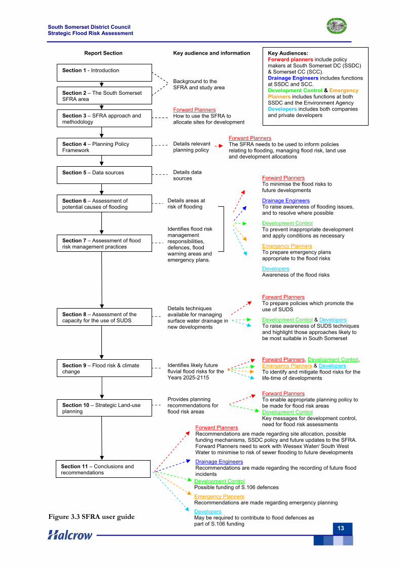
3.9 SFRA User Guide
The SFRA should be read as a whole, but in order to assist the reader, the SFRA User Guide (Figure 3.3) illustrates how the SFRA should be used by forward planners, drainage engineers, development control, emergency planners and developers to minimise the risks posed by flooding.
South Somerset District Council Strategic Flood Risk Assessment
13
Key audience and information
Section 1 - Introduction
Section 2 – The South Somerset SFRA area
Section 3 – SFRA approach and methodology
Section 4 – Planning Policy Framework
Section 5 – Data sources
Section 6 – Assessment of potential causes of flooding
Section 7 – Assessment of flood risk management practices
Section 8 – Assessment of the capacity for the use of SUDS
Section 9 – Flood risk & climate change
Section 10 – Strategic Land-use planning
Section 11 – Conclusions and recommendations
Background to the SFRA and study area
Details relevant planning policy
Details areas at risk of flooding
Forward Planners The SFRA needs to be used to inform policies relating to flooding, managing flood risk, land use and development allocations
Forward Planners How to use the SFRA to allocate sites for development
Forward Planners To minimise the flood risks to future developments
Drainage Engineers To raise awareness of flooding issues, and to resolve where possible
Development Control To prevent inappropriate development and apply conditions as necessary
Emergency Planners To prepare emergency plans appropriate to the flood risks
Developers Awareness of the flood risks
Report Section Key Audiences: Forward planners include policy makers at South Somerset DC (SSDC) & Somerset CC (SCC). Drainage Engineers includes functions at SSDC and SCC. Development Control & Emergency Planners includes functions at both SSDC and the Environment Agency Developers includes both companies and private developers
Identifies flood risk management responsibilities, defences, flood warning areas and emergency plans.
Details techniques available for managing surface water drainage in new developments
Forward Planners To prepare policies which promote the use of SUDS
Development Control & Developers To raise awareness of SUDS techniques and highlight those approaches likely to be most suitable in South Somerset
Forward Planners, Development Control, Emergency Planners & Developers To identify and mitigate flood risks for the life-time of developments
Identifies likely future fluvial flood risks for the Years 2025-2115
Provides planning recommendations for flood risk areas
Forward Planners Recommendations are made regarding site allocation, possible funding mechanisms, SSDC policy and future updates to the SFRA. Forward Planners need to work with Wessex Water/ South West Water to minimise to risk of sewer flooding to future developments
Drainage Engineers Recommendations are made regarding the recording of future flood incidents
Emergency Planners Recommendations are made regarding emergency planning
Details data sources
Forward Planners To enable appropriate planning policy to be made for flood risk areas Development Control Key messages for development control, need for flood risk assessments
Development Control Possible funding of S.106 defences
Developers May be required to contribute to flood defences as part of S.106 funding
Figure 3.3 SFRA user guide
South Somerset District Council Strategic Flood Risk Assessment
14
4 Planning policy framework 4.1 Overview
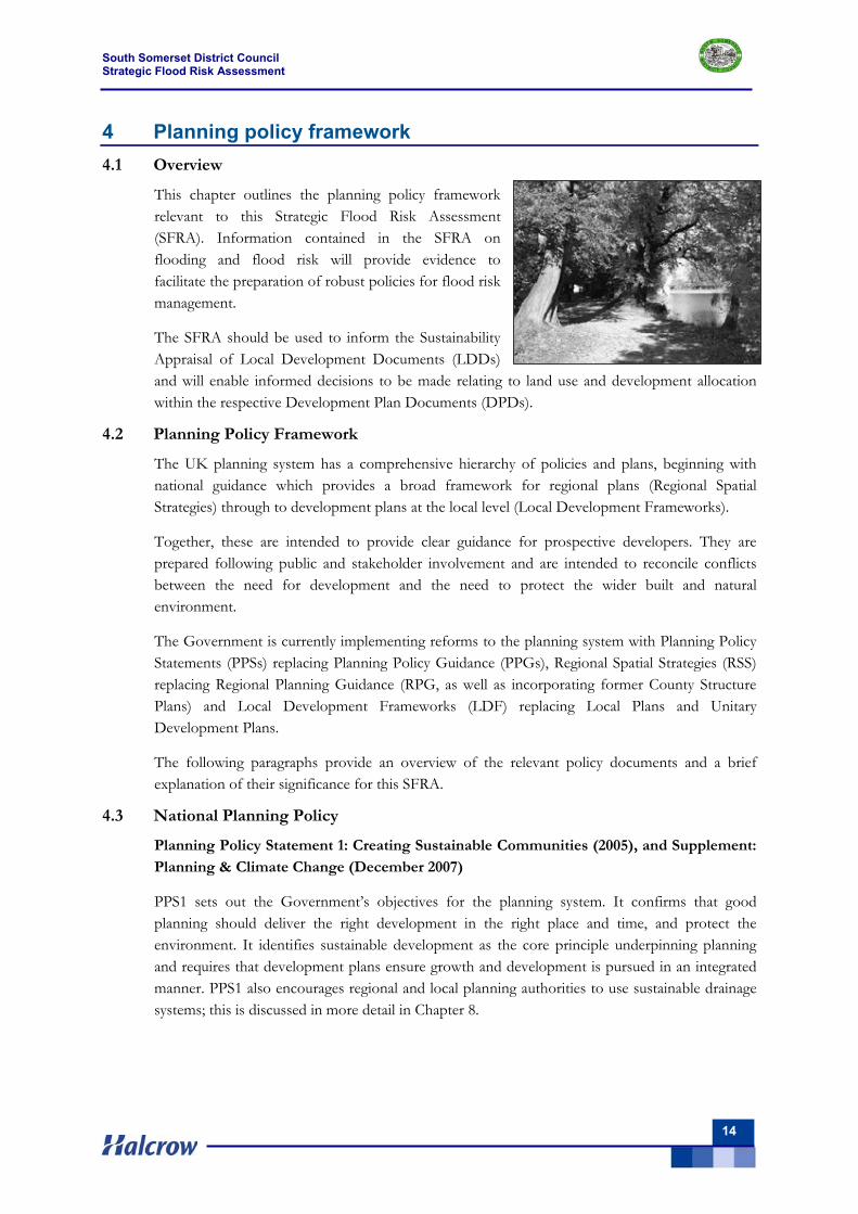
This chapter outlines the planning policy framework relevant to this Strategic Flood Risk Assessment (SFRA). Information contained in the SFRA on flooding and flood risk will provide evidence to facilitate the preparation of robust policies for flood risk management.
The SFRA should be used to inform the Sustainability Appraisal of Local Development Documents (LDDs) and will enable informed decisions to be made relating to land use and development allocation within the respective Development Plan Documents (DPDs).
4.2 Planning Policy Framework
The UK planning system has a comprehensive hierarchy of policies and plans, beginning with national guidance which provides a broad framework for regional plans (Regional Spatial Strategies) through to development plans at the local level (Local Development Frameworks).
Together, these are intended to provide clear guidance for prospective developers. They are prepared following public and stakeholder involvement and are intended to reconcile conflicts between the need for development and the need to protect the wider built and natural environment.
The Government is currently implementing reforms to the planning system with Planning Policy Statements (PPSs) replacing Planning Policy Guidance (PPGs), Regional Spatial Strategies (RSS) replacing Regional Planning Guidance (RPG, as well as incorporating former County Structure Plans) and Local Development Frameworks (LDF) replacing Local Plans and Unitary Development Plans.
The following paragraphs provide an overview of the relevant policy documents and a brief explanation of their significance for this SFRA.
4.3 National Planning Policy
Planning Policy Statement 1: Creating Sustainable Communities (2005), and Supplement: Planning & Climate Change (December 2007)
PPS1 sets out the Government’s objectives for the planning system. It confirms that good planning should deliver the right development in the right place and time, and protect the environment. It identifies sustainable development as the core principle underpinning planning and requires that development plans ensure growth and development is pursued in an integrated manner. PPS1 also encourages regional and local planning authorities to use sustainable drainage systems; this is discussed in more detail in Chapter 8.
South Somerset District Council Strategic Flood Risk Assessment
15
In December 2007, the Department for Communities and Local Government (DCLG) published a Supplement to PPS1, titled 'Planning and Climate Change'. This formerly enshrines issues and implications related to climate change into planning policy. Whilst its focus is generally towards climate change mitigation (reducing CO2 emissions for example), it also covers issues of climate change adaptation.
Planning Policy Statement 3: Housing (2006) PPS3 has been developed in response to recommendations in the Barker Review of Housing Supply (March 2004). Its principal aim is to underpin the necessary step change in housing delivery, improving the supply and affordability of housing in all communities including rural areas. PPS3 states that the Government’s key housing policy goal is to ensure that everyone has the opportunity of living in a decent home, which they can afford, in a community where they want to live. The specific outcomes that the planning system should deliver are:
well designed, high quality housing that is built to a high standard;
a mix of market and affordable housing for all households in all areas;
a sufficient quantity of housing, taking into account need and demand and seeking to improve choice;
housing developments in suitable locations offering a good range of community facilities and with good access to jobs, key services and infrastructure;
a flexible, responsive supply of land; which is used efficiently and effectively, including the use of previously developed land.
Housing policies should help to deliver sustainable development objectives, in particular seeking to minimise environmental impact taking account of climate change and flood risk, and take into account market information, in particular housing need and demand.
Planning Policy Statement 9: Biodiversity & Geological Conservation (2005) PPS9 sets out policies on protection of biodiversity and geological conservation through the planning system. The broad aim is that development should have minimal impact on biodiversity and geological conservation interests and enhance them where possible. Appropriate weight should be attached to the need to protect international and national designated sites in areas at risk of flooding.
Planning Policy Guidance 15: Planning & the Historic Environment (1994) PPG15 sets out policies on the protection of the historic environment and recognises that planning plays an important role in preserving built and natural heritage. Appropriate weight should be attached to the need to protect the historic environment in areas at risk of flooding.
Planning Policy Guidance 17: Planning for Open Space, Sport & Recreation (2002) PPG17 recognises the importance that public open spaces, green areas and recreational rights of way can play in supporting regeneration and contributing to local quality of life. Public open spaces and recreational areas provide important environmental assets that do not necessarily conflict with flood zones.
South Somerset District Council Strategic Flood Risk Assessment
16
Planning Policy Statement 25: Development and Flood Risk (2006) PPS25 sets out a plan led approach to flood risk. It confirms that all forms of flooding and their impact on the natural and built environment are material planning considerations. It clarifies the Sequential Test that matches types of development to degrees of flood risk and strengthens the requirement to include flood risk assessments at all levels of the planning process.
Regional planning bodies and local planning authorities (LPA) should, inter alia, reduce flood risk by safeguarding land from development that is required for current and future flood management e.g. conveyance and storage of flood water and flood defences.
PPS25 is considered in more detail elsewhere within this SFRA, as appropriate.
PPS25: Companion Guide (2008) This practice guide is complementary to PPS25 and provides guidance on how to implement the policies detailed in PPS25. The guide also includes a series of case study examples.
4.3.1 Recent Changes to Town & Country Planning
Amendments to the Town and Country Planning (General Development Procedure) Order 1995 came into force in 2006 introducing further requirements for LPA to consult the Environment Agency before determining applications for development in flood risk areas.
The Town and Country Planning (Flooding) (England) Direction 2007 was published in December 2006. To safeguard against inappropriate development in flood risk areas, it introduces a requirement for LPA to notify the Secretary of State of any application for major development (e.g. 10 or more dwellings) in a flood risk area which it proposes to approve against Environment Agency advice. The Direction came into force on 1 January 2007.
4.4 Regional Planning Policy
4.4.1 Housing & employment growth
Regional Planning Guidance for the South West (RPG10) covers the period up to 2016 and sets the regional planning policy framework for the area. RPG10 has assumed the status of RSS pending its review, and is considered as part of the statutory Development Plan for South Somerset.
RPG10 is now being reviewed and will be taken forward as the Regional Spatial Strategy for the South West (RSS) covering the period up to 2026. The Draft RSS was the subject of an Examination in Public between April and July 2007, with the Panel Report published in December 2007. Proposed Changes have recently (July 2008) been published; publication of the adopted RSS is expected at the end of 2008.
Due to the generally rural nature of the South Somerset district, Yeovil is the only town to be classified as a Strategically Significant City or Town (SSCT); to which Development Policy A refers. Development Policies B (Development at Market Towns) and C (Development in Small Towns and Villages) are applicable to various smaller centres within the South Somerset district.
Overall within South Somerset, the Draft RSS average annual net dwelling requirement is 680 for the period 2006 to 2026, totalling 13,600 (730 dwellings per annum (d.p.a.) for 2006 to 2016, and
South Somerset District Council Strategic Flood Risk Assessment
17
630 d.p.a from 2016 to 2026). The majority of this growth is to be focussed at Yeovil, and Policy SR24 of the draft RSS states that Yeovil is designated to accommodate some 320 d.p.a. (i.e. just under half of the total), coupled with some 9,100 jobs in the Travel to Work Area (TTWA).
However, these figures have been increased through the Examination in Public (EiP) Panel Report, which concludes that the Draft figures are insufficient, based on DCLG estimates. Accordingly, the Panel Report recommends a revised total housing requirement for South Somerset of some 19,700 (i.e. some 985d.p.a), of which Yeovil would be required to accommodate some 11,400 (i.e. a greater proportion at just under 60%). The Secretary of State’s Proposed Changes (July 2008) concurs with those housing figures set out in the Panel Report.
4.4.2 Flooding
In respect of flood risk, the Draft RSS states that: “The risk of coastal and river floods will increase significantly over the plan period … due to the predicted effects of climate change, including rising sea levels and increased winter rainfall” (paragraph 7.2.19). Policy F1 prioritises the defence of existing properties from flooding and the location of new development in areas that have little or no risk from flooding.
In taking into account the risk of climate change and the increasing risk of flooding, Policy F1 seeks to:
defend existing properties and, where possible, locate new development in places with little or no risk of flooding;
protect flood plains and land liable to tidal or coastal flooding from development;
follow a sequential approach to development in flood risk areas;
use development to reduce the risk of flooding through location, layout and design;
relocate existing development from areas of the coast at risk, which cannot be realistically defended;
identify areas of opportunity for managed realignment to reduce the risk of flooding and create new wildlife areas; and
in preparing their LDDs local authorities should have regard to the Regional Flood Risk Appraisal2.
The section continues on to provide advice as to how LDDs should implement Policy F1:
to require strategic flood risk assessments to guide development away from floodplains;
to ensure that the location of new development is compatible with other existing relevant strategies;
seek to reduce the causes of flooding;
require all development on the perimeter of towns and villages to take account of local flooding.
Policy SD2 (Climate Change) seeks to prepare the region for the effects of global warming by avoiding the need for development in flood risk areas and incorporating measures in design and construction to reduce the effects of flooding.
2 This last bullet point is as recommended in the EiP Panel Report
South Somerset District Council Strategic Flood Risk Assessment
18
4.5 Local planning policy
The growth targets set at the regional level through the RSS process will be taken forward in the emerging Local Development Framework for South Somerset. As part of that review process, it will also be necessary to consider the appropriateness of existing Local Plan policy regarding flood risk, in light of the above review of draft RSS policy.
The sub-text to this Policy states that: “The Government expects planning authorities to guide development away from areas that may be affected by flooding, and to restrict development which would increase the risk of flooding or interfere with the carrying out of flood control works and maintenance. Development permitted without regard to such considerations can lead to danger to life, damage to property, and wasteful expenditure on remedial works. In the event of mitigation measures being necessary, "soft" engineering solutions should be used rather than "hard" defences which are harmful to wildlife.”
It also acknowledges that the flood plain areas as shown on the Proposals Maps are based on Environment Agency flood risk mapping plans.
There is a need to review existing Policy to ensure that it adequately reflects more recent guidance and technical evidence. In particular, any revised policy should reflect the sequential test, and the need for Flood Risk Assessments to guide new development away from flood risk areas. This SFRA can help inform this process, and this will need to be reflected in any updating of the supporting text.
4.6 Summary
The Draft Regional Spatial Strategy sets out requirements for South Somerset to allocate land for growth in homes, jobs and infrastructure. The recent Examination in Public Panel Report (December 2007) recommends that these targets are increased, and proposes ambitious housing and employment growth targets, particularly for Yeovil – the only town designated as a ‘Strategically Significant City or Town’ within the district.
This development has the potential to impact upon flood risk over the medium to longer term, for example by contributing to increased runoff. The information contained within this SFRA should inform the preparation of policies relating to flooding, managing flood risk, land use and development allocations within the South Somerset Local Development Framework.
South Somerset Local Plan Adopted in April 2006, and within that, Policy EU5 relates to flooding. This states: Development, including the substantial extension of existing properties and the raising of
the level of the land, will not be permitted:
1. Within the floodplain of any river or watercourse where flood flows or floodplain storage are adversely affected;
2. Where the run-off from the development would result in, or increase the risk of, unacceptable flooding of watercourses, ditches, land or property;
3. Where development would prevent the effective and economic maintenance of watercourse channels;
4. Where the existing land drainage systems on the site are adversely affected or if the land drainage of the site, when developed, is considered inadequate;
Unless adequate environmentally acceptable mitigation measures are provided at the developer’s expense.
South Somerset District Council Strategic Flood Risk Assessment
19
5 Data sources 5.1 Overview
The SFRA makes the best use of the significant amount of information that exists with respect to flood risk - held by South Somerset District Council, Somerset County Council, the Environment Agency, Wessex Water, Somerset Drainage Boards Consortium and other key consultees. The key data sources are:
Environment Agency Flood Zone Maps.
Localised flooding information from South Somerset District Council, Somerset County Council, the Environment Agency and Wessex Water.
Detailed information on the major flood defences and flow control structures - from the National Fluvial and Coastal Defence Database (NFCDD) held by the Environment Agency.
Detailed information about drainage ditches and control structures owned by the Somerset Drainage Boards Consortium.
River Parrett, East Devon and Dorset Stour Catchment Flood Management Plans (CFMPs). The North and Mid-Somerset CFMP was not available at the time of preparing this SFRA.
A full data register is provided in Appendix A.
5.2 Consultation process
Consultation focussed on data collection, with the following key stakeholders consulted:
South Somerset District Council: - Planners advised on potential growth areas (indicated on SFRA maps)
- Drainage Engineers advised on localised flooding (Section 6) - Emergency Planners advised on flood incidents and emergency procedures (Sections 6 & 7.5)
Somerset County Council: Engineers in the Roads and Transport Services advised on past flooding on all roads
within South Somerset except for the A303 (Section 6)
Environment Agency: Advised on data availability/suitability, historical fluvial, groundwater and surface water
flooding, modelling studies, flood risk assessments, flood defences, flood warning procedures and reservoirs (Sections 6 & 7)
Wessex Water: Advised of foul sewer flooding incidents as recorded on their database in December
2007. This database records those sewer flooding incidents where remedial works have not yet been undertaken to eliminate the source of flooding (Section 6)
South West Water: South West Water were consulted and they advised that they have no known properties at risk of sewer flooding within South Somerset.
South Somerset District Council Strategic Flood Risk Assessment
20
Somerset Drainage Boards Consortium Advised on the location of drainage ditches (indicated on SFRA maps) and areas affected by flooding (these incidents are shown on the Environment Agency’s database).
Highways Agency: Advised of flooding incidents on the A303 since 1 July 2007. However, these incidents could not be mapped due to a lack of information about the location of the incidents
The Environment Agency Development Control, and Flood Risk Mapping and Data Management teams from Wessex Area office (Bridgwater) provided invaluable guidance and support for this SFRA. This has been essential given the role of the Environment Agency as a Statutory Consultee under PPS25, and the need for their agreement of the scope, key findings and recommendations of the SFRA.
As part of the consultation process, key stakeholders within South Somerset District Council and the Environment Agency attended progress meetings (January 2008, March 2008) to review the draft flood maps and provide feedback on the initial findings of the SFRA.
5.3 Environment Agency Flood Zone maps
The Environment Agency Flood Zone maps show the areas at risk of flooding from rivers and the sea, ignoring the presence of flood defences. The original maps were produced from a National generalised computer model (JFlow), and are continuously being improved as new studies are undertaken, such as detailed hydraulic modelling, and more flood data and information becomes available.
5.4 Detailed hydraulic modelling
The detailed hydraulic modelling studies available for the SFRA area include:
River Cale modelling study for Wincanton (2005)
River Isle modelling study (2002)
Somerset and Mendips modelling study (1999)
These flood risk modelling and mapping studies were all commissioned by the Environment Agency. The current published Environment Agency Flood Map is a mixture of these modelled flood outlines and JFLOW extents produced by running their national generalised computer model onto Lidar. The SFRA flood extents are equivalent to the current Environment Agency flood map.
These outlines are subject to continual update, and the SFRA will take account of these updates as they become available. Only results approved by the Environment Agency should be used in future SFRA updates.
5.5 Localised flooding
Evidence of flooding within the SFRA area was derived through consultation with key stakeholders. In accordance with PPS25 guidance, this has included a review of flooding from all sources, i.e. fluvial, groundwater, surface water, drainage and sewerage infrastructure and other artificial water bodies, e.g. reservoirs (Section 6).
South Somerset District Council Strategic Flood Risk Assessment
21
6 Assessment of potential causes of flooding 6.1 Overview
This chapter details the SFRA maps produced for the South Somerset area in accordance with emerging best practice and PPS25 guidance. These maps provide the information required for South Somerset District Council to carry out the Sequential Test on possible site allocations.
This chapter presents the assessment of potential causes of flooding based on historical incidents, including the flooding in July 2007, and by reference to the Flood Zone maps. Later chapters cover the assessment of the flood management infrastructure (Section 7) and the potential implications of climate change (Section 9).
6.2 Sources of flooding
There are a number of different ways that flooding can occur. These different ways reflect the source of the floodwater and how it moves across the landscape. These different types of flooding can happen on their own or together. For example, an intense storm may cause a river to rise and overtop flood defences, and may, at the same time, exceed the capacity of a sewer system in an urban area.
The different types of flooding considered in the SFRA are:
River (fluvial) flooding: Occurs when high water levels in rivers cause floodwater to spread out across the floodplain and in some cases overtop flood defences along river banks. High water levels may be caused by large flows in the river (due to a big storm), and/or from under-sized or blocked, culverts or bridges.
Surface water flooding: Can happen throughout the catchment and is caused by certain topographical, geological and hydrological conditions. For example, water may collect alongside a road that does not have a drainage gully, flow across a field causing soil erosion, or flow down a road into properties.
Sewer flooding: Flooding from urban sewer systems depends on a number of factors, such as network capacity, system blockages and water levels at their outlets. Sewer flooding can be made worse by combined sewers (foul and surface water).
Groundwater flooding: Happens when groundwater levels are very near to the surface.
Reservoir flooding: Occurs when there is overtopping or breach of a reservoir.
Tidal flooding: Tidal flooding has been considered by the SFRA, but discounted as a significant risk in the SSDC area. There are some situations where there could be a very light influence of tidal flooding on the River Parrett at Langport if Oath Lock is open, since the tidal flow will be able to travel further up the river.
6.3 Probability of flooding
Flood risk is made up of two parts: the chance (or probability) of a particular flood event and the impact (or consequence) that the event would cause if it happened. The probability of a flood event occurring is presented as the percentage chance of a flood of that size happening in any one year, i.e. the probability of occurrence or annual exceedance probability (AEP).
Flood risk management can reduce the chance of flooding happening by managing land, river systems and flood defences. It can also reduce the impact of flooding by influencing development
South Somerset District Council Strategic Flood Risk Assessment
22
in flood risk areas, implementing flood warning systems, and developing flood emergency response procedures.
For river flooding, the one per cent AEP flood is considered for planning purposes, which means that there is a one per cent chance that a river flood of that size will occur in any one year. The 0.1 per cent AEP flood represents an extreme event.
The 1% AEP flood is sometimes referred to as the 1 in 100 year return period flood. This means that on average the flood of this magnitude would occur every 100 years. However there is evidence that severe flood events tend to cluster, so it is quite possible to get two ’1 in 100 year return period’ floods in say a five year period.
The 0.1% AEP flood is sometimes referred to as the 1 in 1000 year return period. We prefer using the percentage chance rather than return period method of describing floods to avoid the possible misunderstanding that 1 in 100 year events occur reliably every 100 years.
The SFRA presents flood risk maps (referred to as the SFRA flood maps) that show the extent of land with a high chance of flooding (Flood Zone 3) and land with a medium chance of flooding (Flood Zone 2). Land outside of these areas is considered to have a low chance of flooding. Flood Zone 3 is defined as the land with a one per cent or higher annual probability of flooding from rivers or a 0.5 per cent or higher annual probability of flooding from the sea. Flood Zone 2 is defined as land with a 0.1 per cent or higher annual probability of flooding from rivers or the sea.
The SFRA flood maps show flooding from rivers and include information about localised flooding from surface water (water collecting on or flowing over the surface before infiltrating into the ground or entering a watercourse). It is reasonable to assume that flooding from a river or the sea outside of Flood Zone 2 is extreme. However, flooding may still happen beyond Flood Zone 2 from other types, such as surface water.
It is easy to be misled by the apparent accuracy of the flood maps and data produced. Flooding is generated by a complex and continuingly changing interaction between meteorological and hydrological processes. Natural systems are inherently difficult to model, and the science which underpins the analysis continues to evolve.
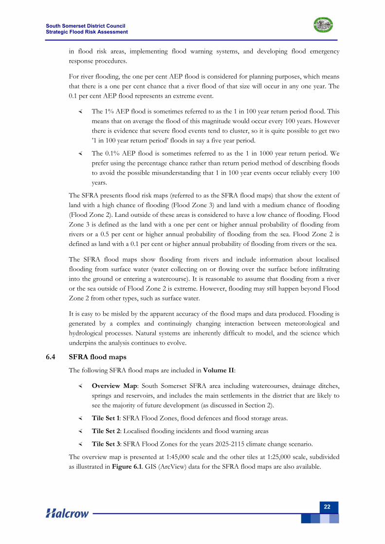
6.4 SFRA flood maps
The following SFRA flood maps are included in Volume II:
Overview Map: South Somerset SFRA area including watercourses, drainage ditches, springs and reservoirs, and includes the main settlements in the district that are likely to see the majority of future development (as discussed in Section 2).
Tile Set 1: SFRA Flood Zones, flood defences and flood storage areas.
Tile Set 2: Localised flooding incidents and flood warning areas
Tile Set 3: SFRA Flood Zones for the years 2025-2115 climate change scenario.
The overview map is presented at 1:45,000 scale and the other tiles at 1:25,000 scale, subdivided as illustrated in Figure 6.1. GIS (ArcView) data for the SFRA flood maps are also available.
South Somerset District Council Strategic Flood Risk Assessment
23
Figure 6.1 Layout of SFRA flood maps
The localised flooding from all sources indicated on the SFRA flood maps - Tile Set 2 details the flood risk from fluvial, groundwater, surface water and sewer flooding. This combines the historical flood information obtained from various sources. This information presented on these maps is to be used together with the Flood Zones mapped on Tile Set 2 to guide the Sequential Test.
6.5 River flooding – fluvial
6.5.1 Background to fluvial flooding
The extents, depths, duration, velocities and frequency of river flooding are a function of topography, geology and hydrology as follows:
The extent of flooding is related to flow and the shape of the river valley, with the greatest extents in the lowlands area, particularly the Somerset Levels and Moors.
The depth of flooding is related to the flood flows in the channel, the shape of the river valley and any structures that may cause water to back-up.
The velocity of floodwater is controlled by the channel and floodplain slope, shape and roughness. Local variations in velocity occur where flow paths encounter natural or artificial features that either constrict or expand areas of flow.
Flood depths and velocities vary across the floodplain, with deeper, fast-flowing waters in the river channel and shallower, slower waters towards the outer edge.
6.5.2 Background to fluvial flooding
The extents, depths, duration, velocities and frequency of river flooding are a function of topography, geology and hydrology as follows:
A
C
B
D
Bruton
Templecombe
Langport/ Huish Episcopi
Martock
Milborne Port
South Petherton
Ansford/
South Somerset District Council Strategic Flood Risk Assessment
24
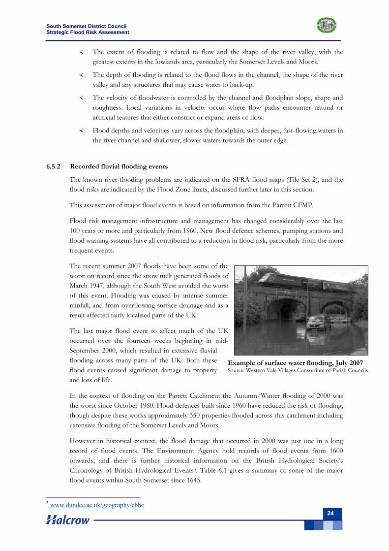
Example of surface water flooding, July 2007 Source: Western Vale Villages Consortium of Parish Councils
The extent of flooding is related to flow and the shape of the river valley, with the greatest extents in the lowlands area, particularly the Somerset Levels and Moors.
The depth of flooding is related to the flood flows in the channel, the shape of the river valley and any structures that may cause water to back-up.
The velocity of floodwater is controlled by the channel and floodplain slope, shape and roughness. Local variations in velocity occur where flow paths encounter natural or artificial features that either constrict or expand areas of flow.
Flood depths and velocities vary across the floodplain, with deeper, fast-flowing waters in the river channel and shallower, slower waters towards the outer edge.
6.5.2 Recorded fluvial flooding events
The known river flooding problems are indicated on the SFRA flood maps (Tile Set 2), and the flood risks are indicated by the Flood Zone limits, discussed further later in this section.
This assessment of major flood events is based on information from the Parrett CFMP.
Flood risk management infrastructure and management has changed considerably over the last 100 years or more and particularly from 1960. New flood defence schemes, pumping stations and flood warning systems have all contributed to a reduction in flood risk, particularly from the more frequent events.
The recent summer 2007 floods have been some of the worst on record since the snow melt generated floods of March 1947, although the South West avoided the worst of this event. Flooding was caused by intense summer rainfall, and from overflowing surface drainage and as a result affected fairly localised parts of the UK.
The last major flood event to affect much of the UK occurred over the fourteen weeks beginning in mid-September 2000, which resulted in extensive fluvial flooding across many parts of the UK. Both these flood events caused significant damage to property and loss of life.
In the context of flooding on the Parrett Catchment the Autumn/Winter flooding of 2000 was the worst since October 1960. Flood defences built since 1960 have reduced the risk of flooding, though despite these works approximately 350 properties flooded across this catchment including extensive flooding of the Somerset Levels and Moors.
However in historical context, the flood damage that occurred in 2000 was just one in a long record of flood events. The Environment Agency hold records of flood events from 1600 onwards, and there is further historical information on the British Hydrological Society’s Chronology of British Hydrological Events3. Table 6.1 gives a summary of some of the major flood events within South Somerset since 1645.
3 www.dundee.ac.uk/geography/cbhe
South Somerset District Council Strategic Flood Risk Assessment
25
Flood Zone classification
Table 6.1. Historical fluvial flood events Flood event Area affected
1645 Fluvial event on the River Yeo at Queen Camel. 1768 Fluvial event on the River Brue at Bruton. Household goods, walls and bridges were washed
away 1872 Fluvial flooding of low-lying land from the River Isle 1872-1873 Fluvial event (many of the issues raised in 1873 are still relevant today).
“…are well aware that very great difficulties have arisen in dealing, on a general plan, with the arterial drainage in the valley of the River Parrett….” (Report on the Flooding, Somersetshire in 1872-73 [Presented to the House of Commons, July 16th 1873] )
1889 Fluvial event 12 March 1894 Flooding of the railways in the Parrett Catchment used to be relatively common.
“A train going to…Yeovil….. the line was under water …. engine being derailed and tumbling into the ditch. The passengers and stoker were not badly hurt, but the driver was scalded.” (British Rainfall for 1894, p[146])
1910 Continuous rain caused the flooding of Langport train station to a maximum depth of 22 inches. The magnitude of this flood event was similar to that in 1894. In the interim “the banks of the River Parrett have been raised some 3 feet for a considerable way north of the town, and the permanent way of the railway has also been raised. Notwithstanding these works of protection it was only by constant pumping at three places that the water of the catchment was prevented from reaching the main street”
7 December 1929 Fluvial event 27 October 1960 Fluvial event July 1982 Fluvial flooding of the River Cale at Wincanton. It is estimated the magnitude of this flood
event was greater than 1% AEP. August 1997 Summer flooding causing serious pollution on the Somerset Levels and Moors 30 October 2000 Most severe fluvial flooding since 1960
The history of flooding is crucial to understanding the future risks within the catchment. Of particular concern are records of bank failures in the Somerset Levels and Moors, which can cause rapid and dangerous floods. Flooding of the railways within the catchment are now less common than in the past, although some particular lines are still at risk. People getting caught in a flood during journeys probably pose the greatest risk to life today.
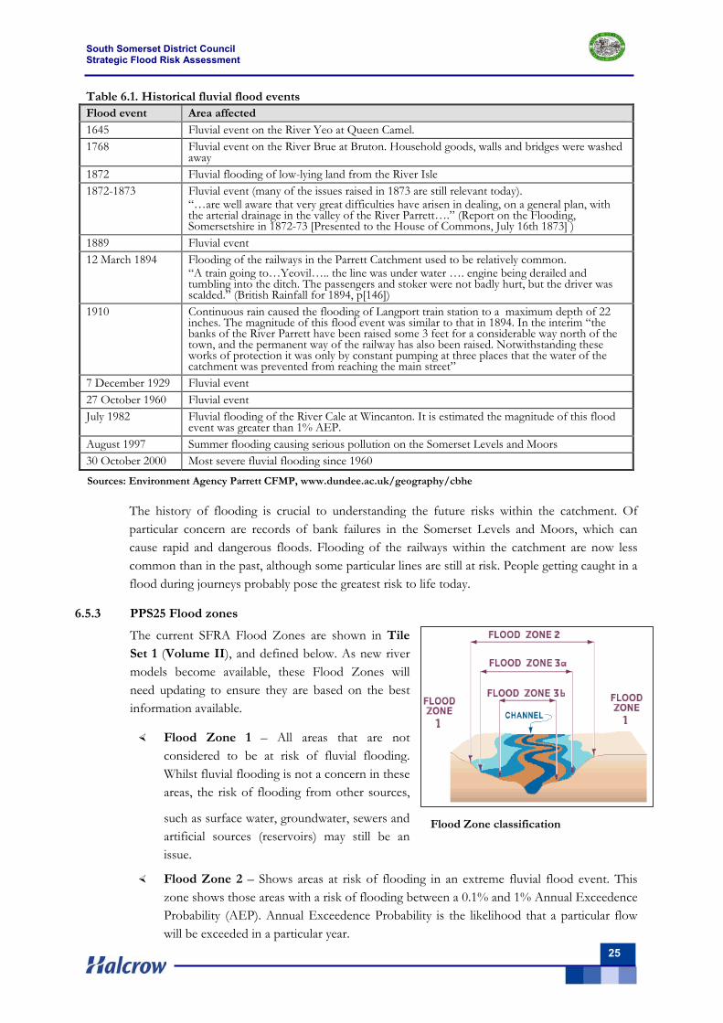
6.5.3 PPS25 Flood zones
The current SFRA Flood Zones are shown in Tile Set 1 (Volume II), and defined below. As new river models become available, these Flood Zones will need updating to ensure they are based on the best information available.
Flood Zone 1 – All areas that are not considered to be at risk of fluvial flooding. Whilst fluvial flooding is not a concern in these areas, the risk of flooding from other sources,
such as surface water, groundwater, sewers and artificial sources (reservoirs) may still be an issue.
Flood Zone 2 – Shows areas at risk of flooding in an extreme fluvial flood event. This zone shows those areas with a risk of flooding between a 0.1% and 1% Annual Exceedence Probability (AEP). Annual Exceedence Probability is the likelihood that a particular flow will be exceeded in a particular year.
Sources: Environment Agency Parrett CFMP, www.dundee.ac.uk/geography/cbhe
South Somerset District Council Strategic Flood Risk Assessment
26
Flood Zone 3a – This represents the area that is part of Flood Zone 3, but outside Flood Zone 3b (Functional Floodplain). This zone identifies the areas at risk from a 1% AEP fluvial flood event or a 0.5% AEP flood event caused by flooding from the sea.
Flood Zone 3b (Functional Floodplain) – The functional floodplain shows areas of land which are frequently flooded. For all areas it has been necessary to make conservative assumptions about the extent of the functional floodplain in the absence of historical flood outlines and detailed models. As such, the functional floodplain has been assumed to be equivalent to Flood Zone 3a, unless there is evidence to the contrary e.g. west of Ilminster.
Further discussion of Flood Zone classifications is given below - in order of flood risk.
Flood Zone 3b – functional floodplain
The Functional Floodplain (Zone 3b) is defined as those areas in which water has to flow or be stored in times of flood. For this SFRA, the functional floodplain has been defined by the following criteria:
Land which provides a function of flood conveyance or flood storage, through natural processes or by design (e.g. washlands, flood storage areas);
The PPS25 Companion Guide recommends that all areas within Zone 3 should be considered as Zone 3b Functional Floodplain unless, or until, an appropriate FRA shows to the satisfaction of the Environment Agency that it can be considered as falling within Zone 3a (High Probability).
Historical information and detailed river/floodplain modelling can be used to define the functional floodplain, but in the absence of such datasets it has been necessary to make conservative assumptions about the extent of the functional floodplain. Detailed modelling is appropriate if a Level 2 SFRA is required when seeking to allocate sites for development, or as part of site specific FRAs.
Flood Zone 3a – High probability
High Probability Zone 3a is defined as those areas situated within the undefended 1 in 100-year (or 1% AEP) flood extent and not shown as Zone 3b (Functional Floodplain). The Zone 3a extent is defined from Environment Agency Flood Map outlines based on coarse national computer modelling (using the 2-dimensional model J-Flow) and detailed modelling. There is a 'low to medium' confidence in the J-Flow flood extents, and a high confidence in the flood extents derived using detailed modelling. For areas of low-medium confidence in the flood limits the onus should be on developers to provide more refined information in site-specific FRAs (Section 10).
In Ilminster the land to the north of Station Road on the left and right banks of the River Isle has been classified as Flood Zone 3a due to allocation specific flood risk assessments that have been undertaken in the past.. In other locations, which include parts of Langport, Ilchester and Stoford areas of Flood Zone 3a have also been identified due to the presence of defences.
Flood Zone 2 – Medium probability
The Medium Probability Zone 2 is defined as those areas within the study area which are situated between the undefended 1 in 1000-year (0.1% AEP) and 1 in 100-year (1% AEP) flood extents. The Environment Agency’s Flood Map includes a 1 in 1000-year flood outline and this has been adopted for all areas based on the same modelling as Zone 3a.
South Somerset District Council Strategic Flood Risk Assessment
27
Given the rarity of the Zone 2 event, it is very difficult to attach a high level of confidence in delineation of this zone. With such low confidence it is recommended that detailed modelling is undertaken as part of a FRA when seeking to allocate sites for development.
Flood Zone 1 – Low probability
The Low Probability Zone 1 is defined as those areas within the study area which are situated outside of the undefended 1 in 1000-year flood extent. For the purpose of the SFRA maps, this includes all land that is outside of Zone 2 and Zone 3 flood risk areas. It is important to note however that for sites greater than one hectare it will still be necessary for a developer to produce a site-specific FRA which takes account of all sources of flooding (Section 10).
6.6 Groundwater flooding
6.6.1 Causes and impacts of groundwater flooding
The occurrence of groundwater flooding as an identifiable phenomenon has really only been recognised in the last decade, primarily as a result of the extensive groundwater flooding in the Chalk areas of Southern England (including significant parts of the study area) that occurred in the Winter of 2000/2001.
PPS25 states that “groundwater flooding occurs when water levels in the ground rise above surface elevations,” however groundwater may also cause harm in other ways, for example when it enters sub-surface structures (such as basements etc).
Research currently being carried out for Defra (in preparation), identifies seven types of groundwater flooding event. These flood types and their characteristics are summarised on Table 6.2, together with the source pathway receptor model as identified in PPS25.
The Defra research also identifies the following impacts observed as a direct result of excess groundwater at or close to surface:
Flooding of basements of buildings below ground level;
Flooding of buried services or other assets below ground level;
Inundation of farmland, roads, commercial, residential and amenity areas;
Flooding of ground floors of buildings above ground level; and
Overflowing (surcharging) of sewers and drains- leading to foul water flooding.
Often, effects of groundwater flooding are indistinguishable from effects of fluvial flooding, or are not obviously attributable to groundwater (e.g. surcharge of sewers). As a result the recording of groundwater flooding is often inconsistent.
However, groundwater flooding, especially from the Chalk, can be particularly onerous, as the flooding event may persist over a number of weeks (or even months) causing significant disruption to residents, commercial activities, transport networks and other infrastructure.
Of these types of flooding (i.e. those in Table 6.2) 1, 4, 5 and 7 are the most likely to apply in the study area. The responsibility for actions to address some types of flood occurrence may be readily identified, particularly for types 5 and 7.
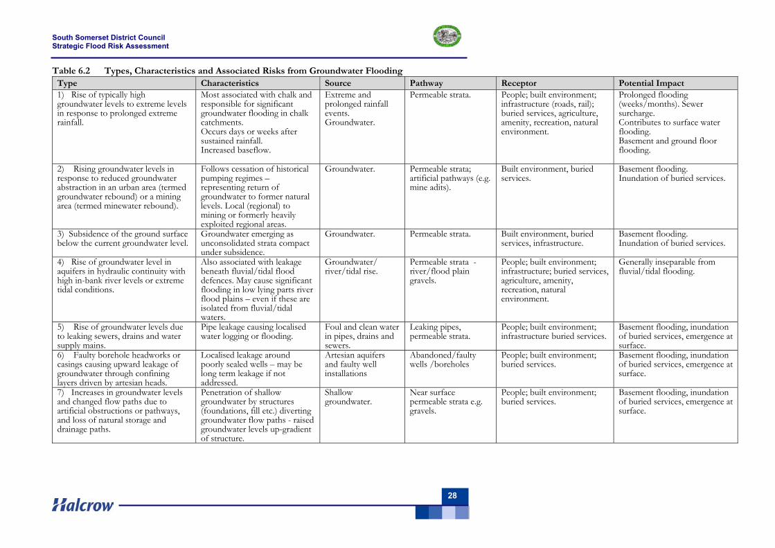
South Somerset District Council Strategic Flood Risk Assessment
28
Table 6.2 Types, Characteristics and Associated Risks from Groundwater Flooding Type Characteristics Source Pathway Receptor Potential Impact 1) Rise of typically high groundwater levels to extreme levels in response to prolonged extreme rainfall.
Most associated with chalk and responsible for significant groundwater flooding in chalk catchments. Occurs days or weeks after sustained rainfall. Increased baseflow.
Extreme and prolonged rainfall events. Groundwater.
Permeable strata. People; built environment; infrastructure (roads, rail); buried services, agriculture, amenity, recreation, natural environment.
Prolonged flooding (weeks/months). Sewer surcharge. Contributes to surface water flooding. Basement and ground floor flooding.
2) Rising groundwater levels in response to reduced groundwater abstraction in an urban area (termed groundwater rebound) or a mining area (termed minewater rebound).
Follows cessation of historical pumping regimes – representing return of groundwater to former natural levels. Local (regional) to mining or formerly heavily exploited regional areas.
Groundwater. Permeable strata; artificial pathways (e.g. mine adits).
Built environment, buried services.
Basement flooding. Inundation of buried services.
3) Subsidence of the ground surface below the current groundwater level.
Groundwater emerging as unconsolidated strata compact under subsidence.
Groundwater. Permeable strata. Built environment, buried services, infrastructure.
Basement flooding. Inundation of buried services.
4) Rise of groundwater level in aquifers in hydraulic continuity with high in-bank river levels or extreme tidal conditions.
Also associated with leakage beneath fluvial/tidal flood defences. May cause significant flooding in low lying parts river flood plains – even if these are isolated from fluvial/tidal waters.
Groundwater/ river/tidal rise.
Permeable strata - river/flood plain gravels.
People; built environment; infrastructure; buried services, agriculture, amenity, recreation, natural environment.
Generally inseparable from fluvial/tidal flooding.
5) Rise of groundwater levels due to leaking sewers, drains and water supply mains.
Pipe leakage causing localised water logging or flooding.
Foul and clean water in pipes, drains and sewers.
Leaking pipes, permeable strata.
People; built environment; infrastructure buried services.
Basement flooding, inundation of buried services, emergence at surface.
6) Faulty borehole headworks or casings causing upward leakage of groundwater through confining layers driven by artesian heads.
Localised leakage around poorly sealed wells – may be long term leakage if not addressed.
Artesian aquifers and faulty well installations
Abandoned/faulty wells /boreholes
People; built environment; buried services.
Basement flooding, inundation of buried services, emergence at surface.
7) Increases in groundwater levels and changed flow paths due to artificial obstructions or pathways, and loss of natural storage and drainage paths.
Penetration of shallow groundwater by structures (foundations, fill etc.) diverting groundwater flow paths - raised groundwater levels up-gradient of structure.
Shallow groundwater.
Near surface permeable strata e.g. gravels.
People; built environment; buried services.
Basement flooding, inundation of buried services, emergence at surface.
South Somerset District Council Strategic Flood Risk Assessment
29
6.6.2 Recorded groundwater flooding events
The Environment Agency South West Region retains records of flooding events on the FRIS (Flood Reconnaissance Information System) database. Groundwater events identified on this database are provided on Tables 6.3 and 6.4 below, and are shown on the SFRA flood maps (Tile Set 2, Volume II). No other information (e.g. parish council records) has been accessed for this SFRA.
Although FRIS identifies, for example, the “cause” as groundwater flooding, the source (e.g. aquifer) of the flooding is not identified – although this may generally be determined from mapped flooding locations and geological/hydrogeological mapping.
Tables 6.3 and 6.4 are annotated (in italics) with the source of flooding where possible – including reference to the (probable) type of flooding as indicated on Table 6.2. Note that these are only indicative, based on geological mapping. None of the marked flooding incidents appear to coincide with springs mapped on the OS 1:10,000 sheets (see further below).
The available records appear to indicate emerging groundwater (i.e. in excess of the norm) in response to extreme rainfall. These appear to be localised and may in part relate to poor “land” drainage. None of the recorded occurrences appear to be widespread and do not therefore appear to be a reflection of regional rises in groundwater level.
There is no clear relationship with specific aquifer bodies, or with known points of groundwater emergence. One occurrence in Yeovil does however appear to be related to the source of a small water course. Some of the events are recorded from areas which are mapped as non aquifers.
The basis for the recording of the frequency of occurrence of flooding events (Table 6.4), as provided by the Environment Agency, is not known and is reproduced here for information only.
6.6.3 Natural emergence of groundwater
Springs are recorded (on OS 1:10,000 scale maps) throughout the study area and represent the natural emergence of groundwater at the surface. These are located on the SFRA flood maps (Overview map, Volume II).
Springs generally flow to drains or small watercourses, joining fluvial drainage systems. There are also mapped a large number of “issues” and drains which may represent (respectively) slow discharge and drainage of shallow or emergent groundwater.
Under conditions of extreme rainfall, these areas of natural emergence may flow with greater discharge and represent a flooding hazard, although there is no historical record of any such problems. Many such spring flows are in rural areas where increased flows represent no real threat to potential receptors. None of the recorded flood incidents appear to be related to springs marked on the 1:10,000 scale OS map.
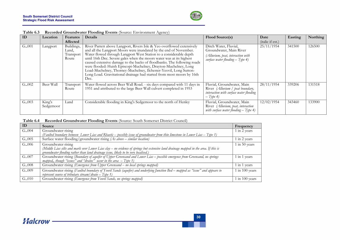
South Somerset District Council Strategic Flood Risk Assessment
30
Table 6.3 Recorded Groundwater Flooding Events (Source: Environment Agency) ID Location Features
Affected Details Flood Source(s) Date
(italic if est.) Easting Northing
G_001 Langport Buildings, Land, Transport Route
River Parrett above Langport, Rivers Isle & Yeo overflowed extensively and all the Langport Moors were inundated by the end of November. Water flowed through Langport West Station to a considerable depth until 16th Dec. Severe gales when the moors water was at its highest caused extensive damage to the backs of floodbanks. The following roads were flooded: Huish Episcopi-Muchelney, Drayton-Muchelney, Long Load-Muchelney, Thorney-Muchelney, Ilchester-Yeovil, Long Sutton-Long Load. Gravitational drainage had started from most moors by 16th Dec.
Ditch Water, Fluvial, Groundwater, Main River (Alluvium, peat, interaction with surface water flooding – Type 4)
25/11/1954 341500 126500
G_002 Beer Wall Transport Route
Water flowed across Beer Wall Road. - six days compared with 11 days in 1951 and attributed to the large Beer Wall culvert completed in 1953
Fluvial, Groundwater, Main River (Alluvium / peat boundary, interaction with surface water flooding – Type 4)
28/11/1954 339206 131518
G_003 King's Sedgemoor
Land Considerable flooding in King's Sedgemoor to the north of Henley Fluvial, Groundwater, Main River (Alluvium, peat, interaction with surface water flooding – Type 4)
12/02/1954 343460 133900
Table 6.4 Recorded Groundwater Flooding Events (Source: South Somerset District Council) ID Source Frequency G_004 Groundwater rising
(Faulted boundary between Lower Lias and Rhaetic – possibly issue of groundwater from thin limestone in Lower Lias – Type 1) 1 in 2 years
G_005 Surface water flooding/groundwater rising (As above – similar location) 1 in 2 years G_006 Groundwater rising
(Middle Lias silts and marls over Lower Lias clay – no evidence of springs but extensive land drainage mapped in the area. If this is groundwater flooding rather than land drainage issue, likely to be very localised.)
1 in 50 years
G_007 Groundwater rising (Boundary of aquifer of Upper Greensand and Lower Lias – possible emergence from Greensand, no springs mapped,, though “issues” and “drains” occur in the area – Type 1)
1 in 1 years
G_008 Groundwater rising (Emergence from Upper Greensand – no local springs mapped) 1 in 1 years G_009 Groundwater rising (Faulted boundary of Yeovil Sands (aquifer) and underlying Junction Bed – mapped as “issue” and appears to
represent source of tributary stream/drain – Type 1) 1 in 100 years
G_010 Groundwater rising (Emergence from Yeovil Sands, no springs mapped) 1 in 100 years
South Somerset District Council Strategic Flood Risk Assessment
31
6.6.4 Groundwater Flood Risk Assessment - Defining the Problem
The existing Environment Agency flood zones do not indicate susceptibility to groundwater flooding. To date, there is no formalised approach to the undertaking of a risk assessment for groundwater flooding. This relates to the large number of (often independent) variables (or drivers) that may contribute to a groundwater flood event. Factors include:
Length and duration of rainfall;
Antecedent groundwater levels (depth to water);
Properties (geological /hydrogeological) of soil and underlying strata, both solid and drift;
Rate of natural drainage and discharge to surface waters.
A Defra Study (Defra 2004) provides maps of groundwater flooding recorded during the most severe recent groundwater flooding episodes (winter 2000/2001 and winter 2003). This study records no groundwater flooding incidents in the study area.
In addition the Defra Study identifies zones of potential “groundwater emergence” based on a digital terrain model (DTM) and using known groundwater levels, potential groundwater rise in response to recharge events, as well as a number of more local factors (e.g. actual reports of groundwater flooding, spring emergence, headwaters response etc). No such emergence zones are located in the study area.
Within the limits of data collection for the study, the assessment of flood risk has been based largely on the characteristics of the mapped geological strata and their distribution through the study area, as summarised on Table 6.2.
There are a number of aquifer units that occur wherein groundwater flooding may occur, however, based on the current reporting, it is considered that groundwater flooding will be limited in extent and localised and the overall risk will be low. Some local incidents may warrant further investigation and local solutions (see below) may be possible.
Although this study is very broad based it does suggest that there is no “generic” predilection toward large scale groundwater flooding from the main groundwater bearing strata in the catchment.
6.6.5 Managing Groundwater Flood Risk
Potential actions
Within the UK there is currently no designated organisation with the responsibility of managing groundwater flooding. Whilst the Environment Agency is a statutory consultee on all issues relating to river and coastal flooding, a similar body does not exist for groundwater.
Following Defra’s (2005) Making Space for Water consultation the EA assumed, in spring 2006, a strategic overview for monitoring groundwater flooding. There is however currently no clear cut responsibility for actions to address the occurrence, effects or management of groundwater flood risk. The EA role, and the legislative details necessary to define this role, is currently under review.
As groundwater flooding is often localised, response to and management of that risk will depend upon the specific characteristics of the flood event. Response to groundwater flooding may be reactive or pro-active and may include:
South Somerset District Council Strategic Flood Risk Assessment
32
do nothing
traffic diversion and calming
groundwater pumping
evacuation of land and property
controlling development in inappropriate locations
protection of land and property against the effects of groundwater flooding
surface and sub-surface drainage maintenance and improvement (i.e. improving conveyance)
managing public perception
flood warning
Specific issues (e.g. leaking pipes, obstruction by structures) have specific solutions that must be addressed either through appropriate maintenance and repair or through development control during planning (see below).
Planning and Development Control
PPS 25 requires that other forms of flooding risk, including groundwater flooding, are a material consideration in the preparation of planning and development proposals. With the current levels of understanding and data, probabilistic groundwater risk assessment is not presently possible. Site specific flood risk assessments will therefore be required based on a more qualitative approach. Typically these FRAs may include:
detailed evaluation of site history;
consultation with local residents;
evaluation of areas liable to groundwater flooding (based on geology, groundwater level record etc.);
existing drainage and flood defence;
possible rates of water level rise and critical “trigger levels” indicative of groundwater emergence;
likely depth, quantity and flow rate of emergent flooding flow;
potential impacts to receptors;
an evaluation of the effects of climate change. 6.7 Surface water flooding - land drainage
Known areas of surface water flooding, caused mainly by local drainage problems, were advised by South Somerset District Council, South Somerset County Council and the Environment Agency. The following growth areas are known to have been affected by surface water flooding in the past:
Yeovil Chard Crewkerne Ilminster Wincanton Bruton
Castle Cary/Ansford Langport/ Huish Episcopi Martock Milborne Port Somerton
South Petherton
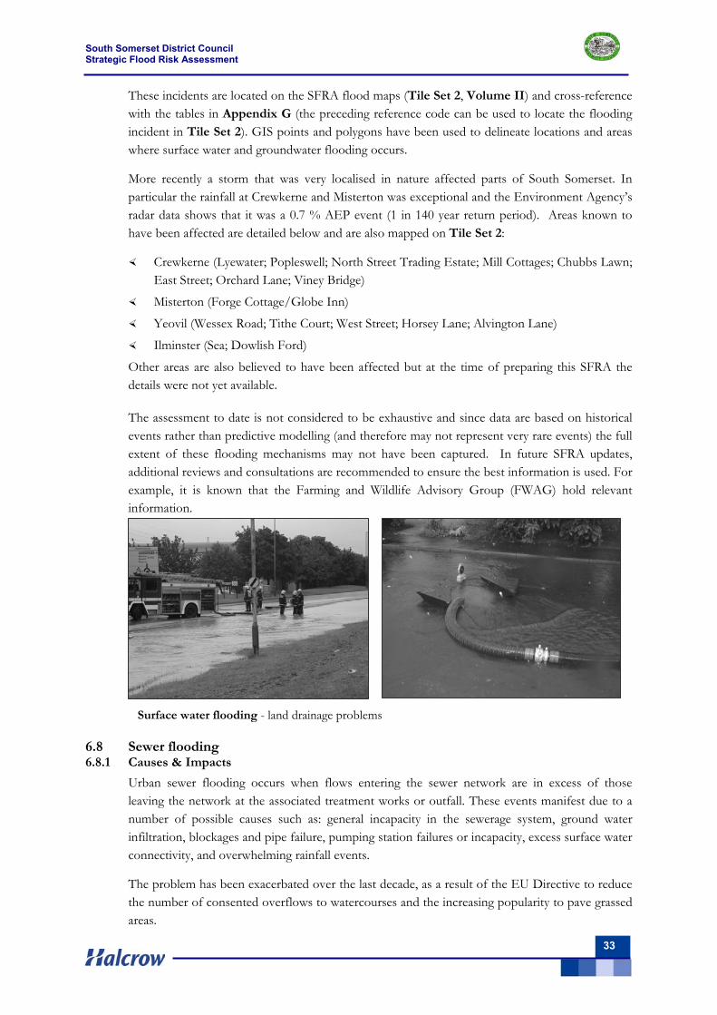
South Somerset District Council Strategic Flood Risk Assessment
33
Surface water flooding - land drainage problems
These incidents are located on the SFRA flood maps (Tile Set 2, Volume II) and cross-reference with the tables in Appendix G (the preceding reference code can be used to locate the flooding incident in Tile Set 2). GIS points and polygons have been used to delineate locations and areas where surface water and groundwater flooding occurs.
More recently a storm that was very localised in nature affected parts of South Somerset. In particular the rainfall at Crewkerne and Misterton was exceptional and the Environment Agency’s radar data shows that it was a 0.7 % AEP event (1 in 140 year return period). Areas known to have been affected are detailed below and are also mapped on Tile Set 2:
Crewkerne (Lyewater; Popleswell; North Street Trading Estate; Mill Cottages; Chubbs Lawn; East Street; Orchard Lane; Viney Bridge)
Misterton (Forge Cottage/Globe Inn)
Yeovil (Wessex Road; Tithe Court; West Street; Horsey Lane; Alvington Lane)
Ilminster (Sea; Dowlish Ford)
Other areas are also believed to have been affected but at the time of preparing this SFRA the details were not yet available.
The assessment to date is not considered to be exhaustive and since data are based on historical events rather than predictive modelling (and therefore may not represent very rare events) the full extent of these flooding mechanisms may not have been captured. In future SFRA updates, additional reviews and consultations are recommended to ensure the best information is used. For example, it is known that the Farming and Wildlife Advisory Group (FWAG) hold relevant information.
6.8 Sewer flooding 6.8.1 Causes & Impacts
Urban sewer flooding occurs when flows entering the sewer network are in excess of those leaving the network at the associated treatment works or outfall. These events manifest due to a number of possible causes such as: general incapacity in the sewerage system, ground water infiltration, blockages and pipe failure, pumping station failures or incapacity, excess surface water connectivity, and overwhelming rainfall events.
The problem has been exacerbated over the last decade, as a result of the EU Directive to reduce the number of consented overflows to watercourses and the increasing popularity to pave grassed areas.
South Somerset District Council Strategic Flood Risk Assessment
34
Sewer flooding occurs when the volume of flow entering the sewerage network is in excess of the volume of sewage that is able to be conveyed through the pipe under gravity. The pipes and associated manholes then surcharge and flooding may be witnessed at manholes or property connections depending on the gradient of the sewer and local topography.
Blockages and pipe failures such as collapsed sewers prevent the egress of flows, which will then build upstream of the problem before surcharging from the system in the manner above.
Infiltration of groundwater into a sewerage system will reduce the capacity of the system and can thus cause surcharging during periods of increased flows. Infiltration may occur at poorly sealed joints and cracked or broken pipes to both the public sewer and private drainage systems. Areas with a high ground water level where pipes are continuously submerged are at most risk and result in a consistent base flow rather than periodic rainfall induced infiltration.
Pumping stations are utilised to transport flows to higher elevations, usually outside of local sub-catchments. Pumping stations comprise varying well configurations with which to store incoming water from a catchment, pumps to overcome the required head, and one or more rising mains to transport the flows. Problems can occur if there is a failure in any of the above and/or if either has insufficient storage capacity to deal with the incoming flows.
Older networks often consist of combined sewers, where surface water and foul flows utilise the same pipework. During heavy rainfall events the excess surface water entering the system may overwhelm it causing foul flooding. Some surface water connectivity is expected in most systems and currently solutions are designed for 1 in 15 year rainfall events at a minimum with consideration made for 1 in 30 year events.
In order to relieve foul flooding within an area, investigations are undertaken to determine the extent of the flooding, identify the causes and develop possible solutions. Where required, any engineering detailed design is then progressed to provide information for the Water Company and its contractors to enable the flooding to be alleviated. The investigation often requires a complete urban catchment review to ensure that flooding associated with fluvial and highway drainage discharges are mitigated appropriately.
6.8.2 Sewer flooding in the study area
The South Somerset Area is operated largely by Wessex Water, but South West Water operate in the south-west of South Somerset with their area spanning several villages including Buckland St Mary, Wincham and Tatworth. Both water companies are responsible for the performance and maintenance of the network in their area.
There are two large sewage treatment works (STW) within the study area, one at Chard the other at Yeovil, which are supported by a number of smaller sewage treatment works serving the surrounding towns and villages. The topography is relatively flat, particularly in the northwest of the district, which is served by a series of drains that feed the Kings Sedgemoor Drain; as such the area is supported by an extensive number of Sewage Pumping Stations (SPS).
Wessex Water and South West Water have undertaken extensive investigations to determine the cause of flooding, as recorded on the DG5 Flooding Register of properties at risk of sewer flooding, and where appropriate have built hydraulic models to replicate the performance of the networks. Wessex Water have developed a Macro-model of the network serving the larger conurbations of Yeovil and Chard, and this macro-model has been used to assess the
South Somerset District Council Strategic Flood Risk Assessment
35
performance of the network in areas of known flooding and to assess the impact of accommodating growth.
Wessex Water have modelled some, but not all, of the many independent networks serving the rural towns and villages within South Somerset. Models have been built as the need arises, to investigate the cause of existing flooding problems and to develop solutions for accommodating future growth.
Wessex Water intend to implement solutions, where appropriate, to remove all properties in the towns of Yeovil, Chard, Crewkerne, Ilminster and Wincanton; the rural centres of Bruton, Castle/Ansford, Langport/Huish Episcopi, Martock, Milborne Port, Somerton and South Petherton; and the village of Templecombe from the DG5 Register through an ongoing programme of flood alleviation works. The solutions to be implemented are to be the appraised. It is hoped that the majority will be removed by the end of AMP4 (March 2010), but some may have to be delayed to the following AMP period, due to the limited funding available.
6.8.3 Recorded sewer flooding events
Wessex Water has advised that the DG5 Register current lists 21 properties at risk of sewer flooding and that the number of properties has been reduced through implementation of an extensive programme of alleviation works undertaken to prevent further flooding and to remove the properties from the register. There are:
8 properties in Yeovil
1 property in West Coker
1 property in East Chinnock
1 property in Dancing Cross
3 properties in Chard
1 property in Lopen
1 property in Crewkerne
1 property in Norton sub Hamdon
2 properties in West Chinnock
2 properties in Crewkerne
The data has been collated over a number of years and within a wide variety of operational conditions. The extent of the flooding, as indicated on Tile Set 2, Volume II, is only representative of the date at which these data were supplied – December 2007.
South West Water have advised that they have no known properties at risk of sewer flooding within South Somerset.
The maps detailing the properties at risk show that the majority of flooding is located in Yeovil, the remainder of the incidents being isolated incidents in the southwest of the District between Yeovil and Chard. These incidents are associated with network incapacity as a result of development, particularly to the north of Yeovil and/or through poor performance of either one of the many sewage treatment works or pumping stations located throughout the District.
The networks serving the established towns of Yeovil, Chard, Crewkerne, Ilminster and Wincanton are combined. Overflows are in place to protect properties from flooding, but the overflows are increasingly utilised and the system is found to be increasingly under capacity as a result of greater surface water connectivity and/or storm intensity.
The number of properties affected by sewer flooding incidents within South Somerset comprise:
1 DG5AI’s (DG5A = a property flooded by 2 internal incidents in 10 years)
17 DG5BI’s (DG5B = a property flooded by 1 internal incident in 10 years)
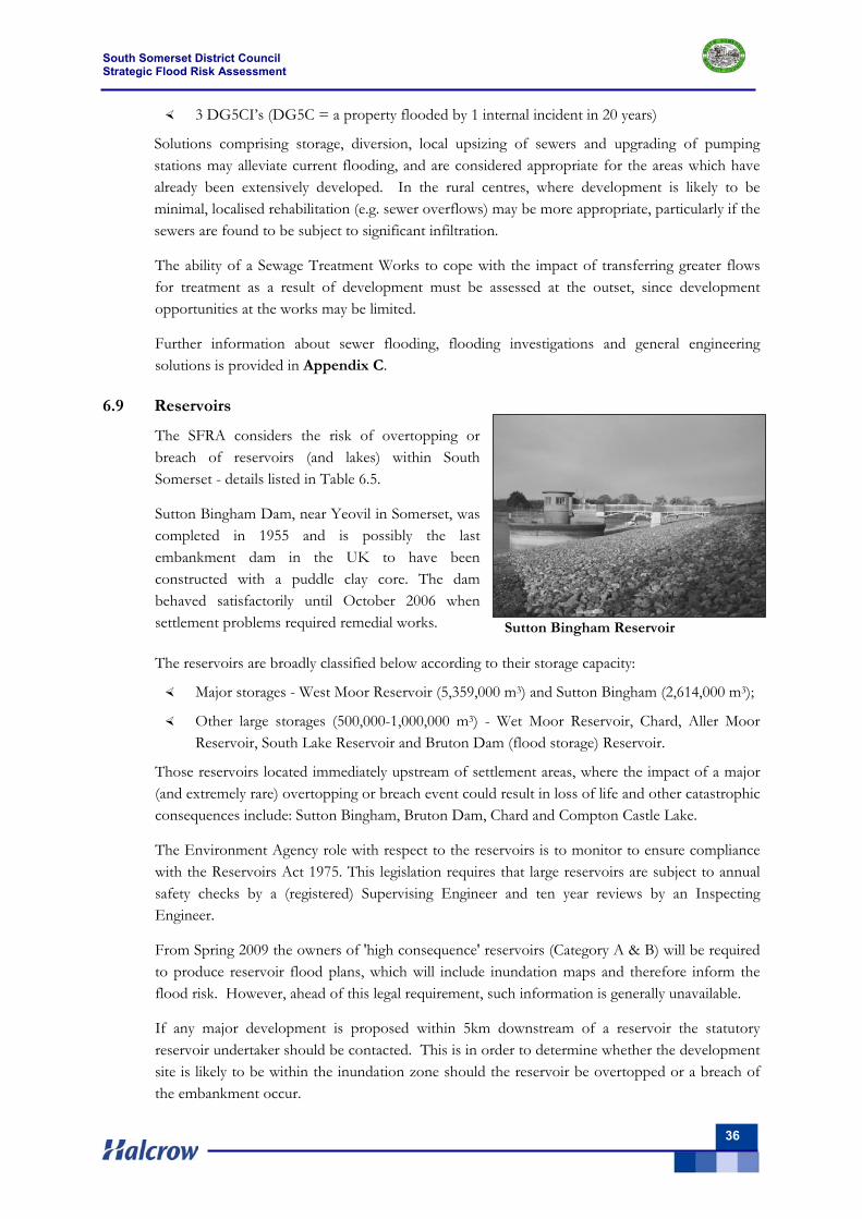
South Somerset District Council Strategic Flood Risk Assessment
36
Sutton Bingham Reservoir
3 DG5CI’s (DG5C = a property flooded by 1 internal incident in 20 years)
Solutions comprising storage, diversion, local upsizing of sewers and upgrading of pumping stations may alleviate current flooding, and are considered appropriate for the areas which have already been extensively developed. In the rural centres, where development is likely to be minimal, localised rehabilitation (e.g. sewer overflows) may be more appropriate, particularly if the sewers are found to be subject to significant infiltration.
The ability of a Sewage Treatment Works to cope with the impact of transferring greater flows for treatment as a result of development must be assessed at the outset, since development opportunities at the works may be limited.
Further information about sewer flooding, flooding investigations and general engineering solutions is provided in Appendix C.
6.9 Reservoirs
The SFRA considers the risk of overtopping or breach of reservoirs (and lakes) within South Somerset - details listed in Table 6.5.
Sutton Bingham Dam, near Yeovil in Somerset, was completed in 1955 and is possibly the last embankment dam in the UK to have been constructed with a puddle clay core. The dam behaved satisfactorily until October 2006 when settlement problems required remedial works. The reservoirs are broadly classified below according to their storage capacity:
Major storages - West Moor Reservoir (5,359,000 m3) and Sutton Bingham (2,614,000 m3);
Other large storages (500,000-1,000,000 m3) - Wet Moor Reservoir, Chard, Aller Moor Reservoir, South Lake Reservoir and Bruton Dam (flood storage) Reservoir.
Those reservoirs located immediately upstream of settlement areas, where the impact of a major (and extremely rare) overtopping or breach event could result in loss of life and other catastrophic consequences include: Sutton Bingham, Bruton Dam, Chard and Compton Castle Lake.
The Environment Agency role with respect to the reservoirs is to monitor to ensure compliance with the Reservoirs Act 1975. This legislation requires that large reservoirs are subject to annual safety checks by a (registered) Supervising Engineer and ten year reviews by an Inspecting Engineer.
From Spring 2009 the owners of 'high consequence' reservoirs (Category A & B) will be required to produce reservoir flood plans, which will include inundation maps and therefore inform the flood risk. However, ahead of this legal requirement, such information is generally unavailable.
If any major development is proposed within 5km downstream of a reservoir the statutory reservoir undertaker should be contacted. This is in order to determine whether the development site is likely to be within the inundation zone should the reservoir be overtopped or a breach of the embankment occur.
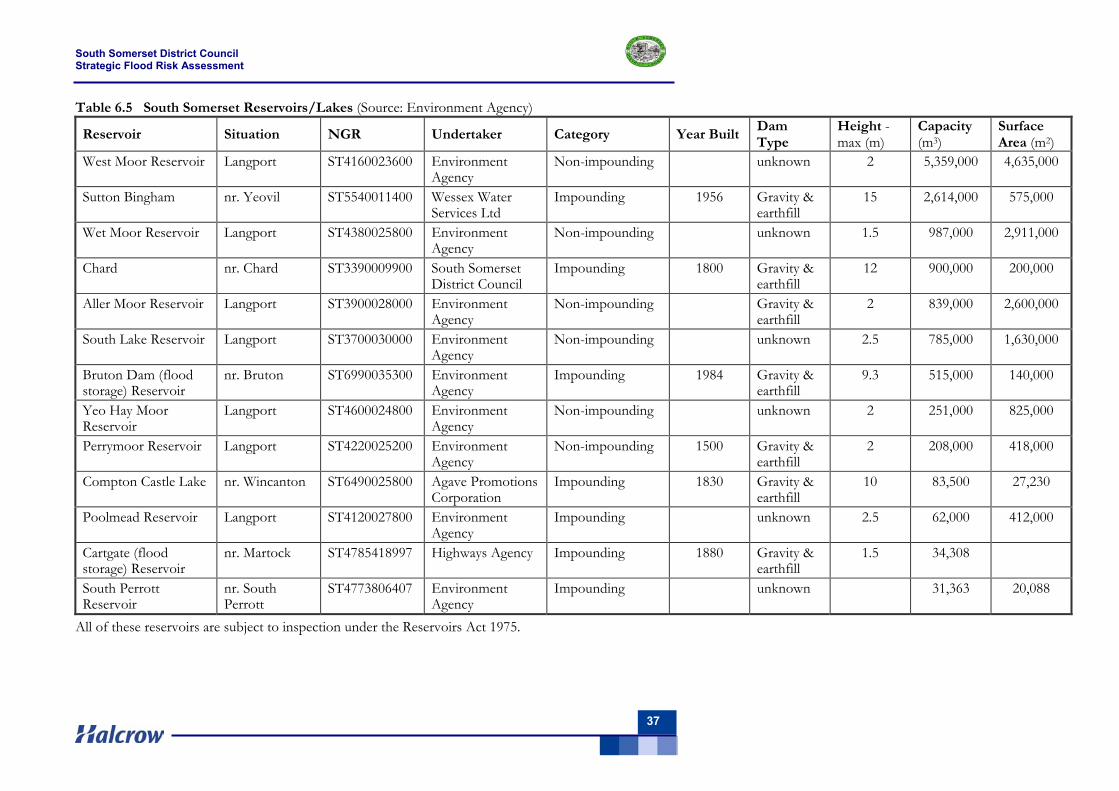
South Somerset District Council Strategic Flood Risk Assessment
37
Table 6.5 South Somerset Reservoirs/Lakes (Source: Environment Agency)
Reservoir Situation NGR Undertaker Category Year Built Dam Type
Height - max (m)
Capacity (m3)
Surface Area (m2)
West Moor Reservoir Langport ST4160023600 Environment Agency
Non-impounding unknown 2 5,359,000 4,635,000
Sutton Bingham nr. Yeovil ST5540011400 Wessex Water Services Ltd
Impounding 1956 Gravity & earthfill
15 2,614,000 575,000
Wet Moor Reservoir Langport ST4380025800 Environment Agency
Non-impounding unknown 1.5 987,000 2,911,000
Chard nr. Chard ST3390009900 South Somerset District Council
Impounding 1800 Gravity & earthfill
12 900,000 200,000
Aller Moor Reservoir Langport ST3900028000 Environment Agency
Non-impounding Gravity & earthfill
2 839,000 2,600,000
South Lake Reservoir Langport ST3700030000 Environment Agency
Non-impounding unknown 2.5 785,000 1,630,000
Bruton Dam (flood storage) Reservoir
nr. Bruton ST6990035300 Environment Agency
Impounding 1984 Gravity & earthfill
9.3 515,000 140,000
Yeo Hay Moor Reservoir
Langport ST4600024800 Environment Agency
Non-impounding unknown 2 251,000 825,000
Perrymoor Reservoir Langport ST4220025200 Environment Agency
Non-impounding 1500 Gravity & earthfill
2 208,000 418,000
Compton Castle Lake nr. Wincanton ST6490025800 Agave Promotions Corporation
Impounding 1830 Gravity & earthfill
10 83,500 27,230
Poolmead Reservoir Langport ST4120027800 Environment Agency
Impounding unknown 2.5 62,000 412,000
Cartgate (flood storage) Reservoir
nr. Martock ST4785418997 Highways Agency Impounding 1880 Gravity & earthfill
1.5 34,308
South Perrott Reservoir
nr. South Perrott
ST4773806407 Environment Agency
Impounding unknown 31,363 20,088
All of these reservoirs are subject to inspection under the Reservoirs Act 1975.
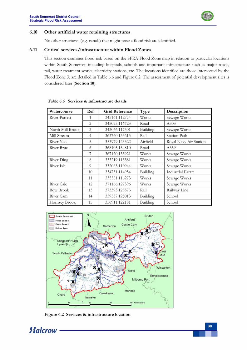
South Somerset District Council Strategic Flood Risk Assessment
38
6.10 Other artificial water retaining structures
No other structures (e.g. canals) that might pose a flood risk are identified.
6.11 Critical services/infrastructure within Flood Zones
This section examines flood risk based on the SFRA Flood Zone map in relation to particular locations within South Somerset, including hospitals, schools and important infrastructure such as major roads, rail, water treatment works, electricity stations, etc. The locations identified are those intersected by the Flood Zone 3, are detailed in Table 6.6 and Figure 6.2. The assessment of potential development sites is considered later (Section 10).
Table 6.6 Services & infrastructure details
Figure 6.2 Services & infrastructure location
Watercourse Ref Grid Reference Type Description
1 345161,112774 Works Sewage Works River Parrett 2 345095,116723 Road A303
North Mill Brook 3 343066,117501 Building Sewage Works Mill Stream 4 363760,133613 Rail Station Path River Yeo 5 353979,123322 Airfield Royal Navy Air Station
6 368405,134810 Road A359 River Brue 7 367120,133921 Works Sewage Works
River Ding 8 333219,115581 Works Sewage Works 9 332063,110944 Works Sewage Works 10 334731,114954 Building Industrial Estate
River Isle
11 335581,116273 Works Sewage Works River Cale 12 371166,127396 Works Sewage Works Bow Brook 13 373395,123573 Rail Railway Line River Cam 14 359557,125013 Building School Hornsey Brook 15 356911,122181 Building School
1 X
X X
X
X
X X
X
X
X X
X
X X
X
2
4
6
7
8
9
10
5
11
1213
14
Bruton
Templecombe
Langport/ Huish Episcopi
Martock
Milborne Port
South Petherton
Ansford/
15
3
South Somerset District Council Strategic Flood Risk Assessment
39
7 Assessment of flood risk management practices 7.1 Overview
This Chapter presents the assessment of flood risk management practices and reviews the riparian responsibilities, flood defences, flood warning areas and emergency planning procedures within the South Somerset SFRA area.
7.2 Flood risk management responsibilities 7.2.1 Environment Agency
The Environment Agency has a duty to supervise all matters relating to flood defence, and aims to reduce the likelihood of flooding through flood risk management. The Environment Agency also seeks to reduce the risk of flooding by influencing land use planning and through improved flood warning and emergency responses.
7.2.2 Riparian responsibilities
Anyone owning land next to a watercourse has responsibilities as a ‘riparian owner’. These responsibilities are explained in the Environment Agency document ‘Living on the edge, 2007’ (available from their website) together with the responsibilities of other organisations.
Land owners have the right to protect their property from flooding, but in most cases the Environment Agency must agree plans before any work commences. Land owners must also accept flood flows through their land even if flooding is caused by inadequate capacity down stream. There is no duty for a landowner to improve the drainage capacity of a watercourse, but the maintenance of any defences should be discussed with the Environment Agency.
7.2.3 Local Authority responsibilities
During a flood a Local Authority provides emergency aid to householders and any works on a watercourse may require planning permission from the Local Authority.
7.3 Existing flood defences
Flood defences are structures which affect flow in times of flooding. They generally fall into one of two categories: ‘formal’ or ‘defacto’. A ‘formal’ defence is a structure which has been specifically built to control floodwater. It is maintained by its owner (not necessarily the Environment Agency) so that it remains in the necessary condition to function.
A ‘defacto’ defence includes road and rail embankments and other linear infrastructure (buildings and boundary walls) which may act as water retaining structures or create enclosures to form flood storage areas in addition to their primary function. Other structures are identified on the Environment Agency database, but these have not necessarily been built to control floodwater and are not maintained for this purpose.
In accordance with the scope of a Level 1 SFRA, a high level review of formal flood defences has been carried out using data from the National Flood and Coastal Defence Database (NFCDD) and site visits. The NFCDD is a good starting point for identifying significant flood defences and potential areas benefiting from defence, but the quantity and quality of information provided differs considerably between structures.
The NFCDD is intended to give a reasonable indication of the condition of an asset, though may not contain consistently detailed and accurate data (this would be undertaken as part of Level 2 SFRA where the need arises).
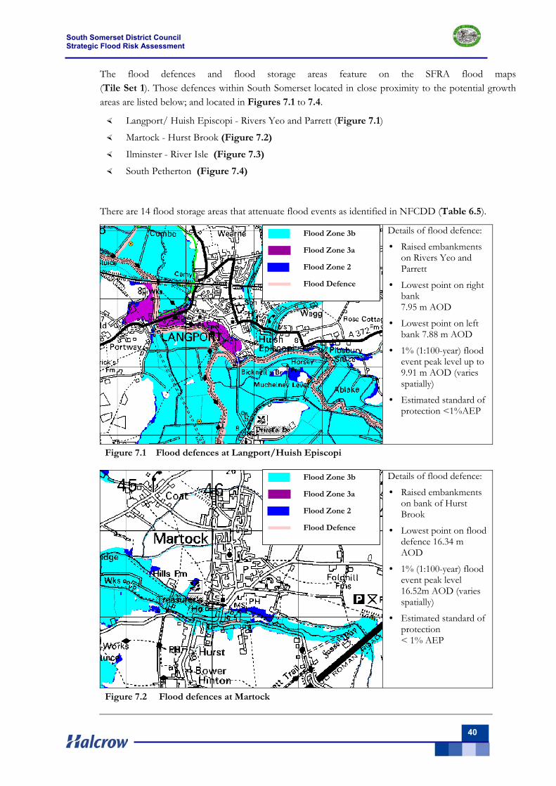
South Somerset District Council Strategic Flood Risk Assessment
40
The flood defences and flood storage areas feature on the SFRA flood maps (Tile Set 1). Those defences within South Somerset located in close proximity to the potential growth areas are listed below; and located in Figures 7.1 to 7.4.
Langport/ Huish Episcopi - Rivers Yeo and Parrett (Figure 7.1)
Martock - Hurst Brook (Figure 7.2)
Ilminster - River Isle (Figure 7.3)
South Petherton (Figure 7.4)
There are 14 flood storage areas that attenuate flood events as identified in NFCDD (Table 6.5).
Details of flood defence:
• Raised embankments on Rivers Yeo and Parrett
• Lowest point on right bank 7.95 m AOD
• Lowest point on left bank 7.88 m AOD
• 1% (1:100-year) flood event peak level up to 9.91 m AOD (varies spatially)
• Estimated standard of protection <1%AEP
Figure 7.1 Flood defences at Langport/Huish Episcopi
Details of flood defence:
• Raised embankments on bank of Hurst Brook
• Lowest point on flood defence 16.34 m AOD
• 1% (1:100-year) flood event peak level 16.52m AOD (varies spatially)
• Estimated standard of protection < 1% AEP
Figure 7.2 Flood defences at Martock
Flood Zone 3b Flood Zone 3a Flood Zone 2 Flood Defence
Flood Zone 3b Flood Zone 3a Flood Zone 2 Flood Defence
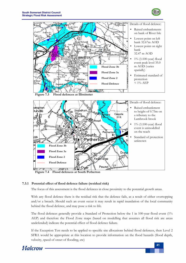
South Somerset District Council Strategic Flood Risk Assessment
41
Details of flood defence:
• Raised embankments on bank of River Isle
• Lowest point on left bank 32.67m AOD
• Lowest point on right bank 32.47 m AOD
• 1% (1:100-year) flood event peak level 35.0 m AOD (varies spatially)
• Estimated standard of protection < 1% AEP
Figure 7.3 Flood defences at Illminster
Details of flood defence:
• Raised embankment to height of 0.75m on a tributary to the Lambrook brook
• 1% (1:100-year) flood event is unmodelled on the reach
• Standard of protection unknown
Figure 7.4 Flood defences at South Petherton
7.3.1 Potential effect of flood defence failure (residual risk)
The focus of this assessment is the flood defences in close proximity to the potential growth areas.
With any flood defence there is the residual risk that the defence fails, as a result of either overtopping and/or a breach. Should such an event occur it may result in rapid inundation of the local community behind the flood defence, and may pose a risk to life.
The flood defences generally provide a Standard of Protection below the 1 in 100-year flood event (1% AEP) and therefore the Flood Zone maps (based on modelling that assumes all flood risk are areas undefended) indicate the potential effect of flood defence failure.
If the Exception Test needs to be applied to specific site allocations behind flood defences, then Level 2 SFRA would be appropriate at this location to provide information on the flood hazards (flood depth, velocity, speed of onset of flooding, etc)
Flood Zone 3b Flood Zone 3a Flood Zone 2 Flood Defence
Flood Zone 3b Flood Zone 3a Flood Zone 2 Flood Defence
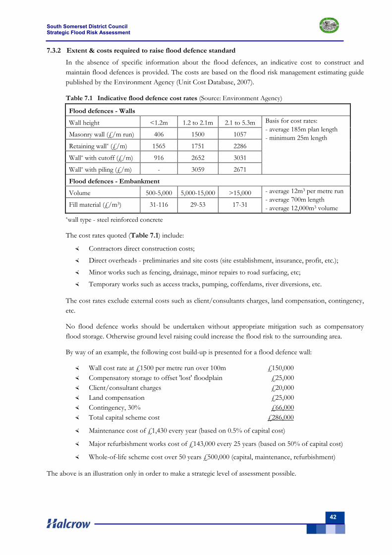
South Somerset District Council Strategic Flood Risk Assessment
42
7.3.2 Extent & costs required to raise flood defence standard
In the absence of specific information about the flood defences, an indicative cost to construct and maintain flood defences is provided. The costs are based on the flood risk management estimating guide published by the Environment Agency (Unit Cost Database, 2007).
Table 7.1 Indicative flood defence cost rates (Source: Environment Agency)
Flood defences - Walls
Wall height <1.2m 1.2 to 2.1m 2.1 to 5.3m
Masonry wall (£/m run) 406 1500 1057
Retaining wall* (£/m) 1565 1751 2286
Wall* with cutoff (£/m) 916 2652 3031
Wall* with piling (£/m) - 3059 2671
Basis for cost rates: - average 185m plan length - minimum 25m length
Flood defences - Embankment
Volume 500-5,000 5,000-15,000 >15,000
Fill material (£/m3) 31-116 29-53 17-31
- average 12m3 per metre run - average 700m length - average 12,000m3 volume
*wall type - steel reinforced concrete
The cost rates quoted (Table 7.1) include:
Contractors direct construction costs;
Direct overheads - preliminaries and site costs (site establishment, insurance, profit, etc.);
Minor works such as fencing, drainage, minor repairs to road surfacing, etc;
Temporary works such as access tracks, pumping, cofferdams, river diversions, etc.
The cost rates exclude external costs such as client/consultants charges, land compensation, contingency, etc.
No flood defence works should be undertaken without appropriate mitigation such as compensatory flood storage. Otherwise ground level raising could increase the flood risk to the surrounding area.
By way of an example, the following cost build-up is presented for a flood defence wall:
Wall cost rate at £1500 per metre run over 100m £150,000 Compensatory storage to offset 'lost' floodplain £25,000 Client/consultant charges £20,000 Land compensation £25,000 Contingency, 30% £66,000 Total capital scheme cost £286,000
Maintenance cost of £1,430 every year (based on 0.5% of capital cost)
Major refurbishment works cost of £143,000 every 25 years (based on 50% of capital cost)
Whole-of-life scheme cost over 50 years £500,000 (capital, maintenance, refurbishment)
The above is an illustration only in order to make a strategic level of assessment possible.
South Somerset District Council Strategic Flood Risk Assessment
43
7.4 Flood warning areas
7.4.1 Existing flood warnings
The Environment Agency operate the current flood warning service in the SFRA area. They monitor rainfall and river levels 24 hours a day at six Flood Warning telemetry stations (Donyatt, Ashford Mill, Chiselborough, Gawbridge, Sherborne Lake, and Weston Bampfylde) and use this information to forecast the probability of flooding across South Somerset.
Flood warnings are issued using a set of four codes, each indicating the level of risk with respect to flooding. The warnings issued are Flood Watch, Flood Warning, Severe Flood Warning and All Clear - further details are given in Appendix F.
Within the study area approximately 2602 properties (1043 in Flood Zone 3 and 1559 in Flood Zone 2) known to be at risk of flooding. A Flood Warning is issued if property is expected to flood and a Severe Flood Warning if there are over 1000 properties expected to flood and/or major infrastructure could be affected. The ‘All Clear’ is issued when river levels are back within banks.
The Flood Warning Areas span much of the SFRA area (located on Tile Set 2 - Volume II):
River Brue (upper) from Bruton Dam to Lovington River Isle from Ilminster to Hambridge Lower Parrett, Yeo, Tone, their tributaries and King’s Sedgmoor Drain Low lying properties on the River Brue from Lovington to Highbridge Rivers Brue, Sheppey, North and South Drain Upper Yeo, Rivers Cam and Wriggle Rivers Parrett, Isle and tributaries River Cam from Weston Bampflyde to Bridgehampton River Isle from Chard Reservoir to Hambridge River Parrett (lower) at Langport Westover Trading Estate River Yeo at Ilchester River Yeo at Yeovilton River Yeo at Mudford River Parrett (upper) at Thorney and Kingsbury Episcopi River Yeo (upper) from Sherborne to Yeovil River Yeo from Yeovil to Langport Stoford and Barwick Streams at Stoford and Barwick River Parrett (upper) from South Perrott to Thorney River Brue at Bruton Town River Axe (upper) from Winsham to Axminster
The Environment Agency is only able to offer a flood warning service where they have flood warning capabilities on a Main River. Where a flood warning service is available, the Environment Agency encourages people at flood risk to register for the service.
Flood warnings are issued via Floodline Warnings Direct which enables individuals, emergency services, local authority emergency planners and response teams to be effectively warned by delivering warnings simultaneously via telephone, mobile, pager, fax, email, SMS text messaging, digital TV and radio.
South Somerset District Council Strategic Flood Risk Assessment
44
7.4.2 Future improvements to flood warnings
The on-going National Flood Risk Area/Flood Warning Area Project being undertaken by the Environment Agency is working towards refining the flood risk areas in order to provide a more targeted flood warning service to local communities. The flood risk areas represent areas of similar land-use, floods from the same scenario and floods of similar return period.
The flood risk areas will form flood warning areas based on communities in the floodplain; a flood warning area will consist of one or more flood risk areas. The Environment Agency flood Incident Management Team are also looking at improving river level gauging to deliver a more accurate flood warning service.
7.4.3 Emergency planning
Emergency planning is set out in the Flood Warning and Response Plan of the Somerset Local Authorities Civil Contingencies Unit (October 2006). This Plan is designed so that multi-agencies can work in an effective and coordinated manner to deal with main river, surface and groundwater flooding. It details role and responsibilities before, during and after a flood event and provides local information useful to those responding to flooding.
The Flood Warning and Response Plan is activated when the Environment Agency issue a Flood Warning Pre-Major Incident Plan or Severe Flood Warning. The Plan is generic with site specific plans for Bruton and Ilchester in South Somerset. The Plan is presented in five parts:
General tasks for all involved agencies Roles and responsibilities Checklist of actions Specific plan for selected sites Supporting information
The Plan recognises that: "…In large scale flooding there is likely to be an impact on homes, essential services, major utilities, transportation, communications and supplies of essential food, heating and drinking water. Some of the effects and therefore the likely impact of flooding can be predicted. Where possible these are covered in the Plan; however, liaison with affected communities and service/utility providers will be required to ascertain the actual effects of each flooding event…"
An update to this Plan is expected following the Government's "Pitt review", which was published in June 2008. The interim report on the causes and consequences of floods was published in December 2007. The final report is due to be published in summer 2008. This report is the culmination of year long inquiry which examined the emergency response to the flooding and investigated how we can reduce the risk and impact of floods in the future.
The Environment Agency continually seek to improve multi-agency responses to flooding.
Further details and recommendations in respect of developments are included in Appendix F.
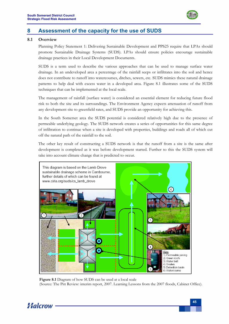
South Somerset District Council Strategic Flood Risk Assessment
45
8 Assessment of the capacity for the use of SUDS 8.1 Overview
Planning Policy Statement 1: Delivering Sustainable Development and PPS25 require that LPAs should promote Sustainable Drainage Systems (SUDS). LPAs should ensure policies encourage sustainable drainage practices in their Local Development Documents.
SUDS is a term used to describe the various approaches that can be used to manage surface water drainage. In an undeveloped area a percentage of the rainfall seeps or infiltrates into the soil and hence does not contribute to runoff into watercourses, ditches, sewers, etc. SUDS mimics these natural drainage patterns to help deal with excess water in a developed area. Figure 8.1 illustrates some of the SUDS techniques that can be implemented at the local scale.
The management of rainfall (surface water) is considered an essential element for reducing future flood risk to both the site and its surroundings. The Environment Agency expects attenuation of runoff from any development site to greenfield rates, and SUDS provide an opportunity for achieving this.
In the South Somerset area the SUDS potential is considered relatively high due to the presence of permeable underlying geology. The SUDS network creates a series of opportunities for this same degree of infiltration to continue when a site is developed with properties, buildings and roads all of which cut off the natural path of the rainfall to the soil.
The other key result of constructing a SUDS network is that the runoff from a site is the same after development is completed as it was before development started. Further to this the SUDS system will take into account climate change that is predicted to occur.
Figure 8.1 Diagram of how SUDS can be used at a local scale (Source: The Pitt Review: interim report, 2007. Learning Lessons from the 2007 floods, Cabinet Office).
South Somerset District Council Strategic Flood Risk Assessment
46
8.2 Types of SUDS systems
SUDS may improve the sustainable management of water for a site by:
Reducing peak flows to watercourses or sewers and potentially reducing the risk of flooding downstream;
Reducing volumes of water flowing into watercourses or sewers from developed sites; Improving water quality, compared with conventional surface water sewers, by removing
pollutants from diffuse pollutant sources; Reducing potable water demand through rainwater harvesting; Improving amenity through the provision of public open space and wildlife habitat; Replicating natural drainage patterns, including the recharge of groundwater so that base flows
are maintained.
Any reduction in the amount of water that originates from a given site is likely to be small, but the cumulative affect from a number of sites on the flow in a watercourse could be significant.
8.3 SUDS at the planning stage
At the drainage design concept stage an assessment can be made of the superficial and underlying geology as this has a fundamental impact on the approach to be followed for the SUDS system.
The two main variations in SUDS systems (listed below) both balance the increase in runoff due to climate change and hence minimises the effect of any development work on the receiving watercourses.
Use of infiltration within the attenuation facilities to partly or fully dispose of runoff;
Not using any infiltration techniques but providing attenuation facilities that maintain the discharges at pre-development levels.
For any significant site the Environment Agency will be consulted by the Planning Authority during the outline planning process. However, the Environment Agency encourage pre-planning discussions in order to resolve issues early and to avoid “abortive” change costs. They will want assurances that the requirements of PPS25 are being implemented and will be followed during the detailed planning stage and through to construction.
To achieve this, a Zone 1 Flood Risk Assessment is required that demonstrates an achievable layout and details the methodology for the construction of SUDS within the boundary of the development site. The FRA must comply with PPS25 requirements and for the South Somerset area should also accord with Defra/Environment Agency publication “Preliminary Rainfall Runoff for Developments Revision D”.
8.4 Application of SUDS within South Somerset
There are a number of SUDS elements that could be used within development sites in the South Somerset area. The Environment Agency would expect that the initial assumption of any drainage designer would be to include infiltration where possible and in the South Somerset area this assumption looks well founded given the underlying geology. The key benefit from utilising infiltration is that these SUDS systems will attenuate peak flows and may also significantly reduce flood volumes in watercourses.
The provision of significant infiltration should be utilised wherever possible as a disposal option to reduce flows into watercourses. An indication of infiltration potential based upon underlying geological strata of the study area is provided in Appendix B (Table B.2). In general terms major aquifers have good
South Somerset District Council Strategic Flood Risk Assessment
47
potential for infiltration, minor aquifers have moderate potential for infiltration and non-aquifers have poor potential.
Thus infiltration should be used unless ground investigation and in particular infiltration tests determine that it is not practicable. Investigations into the potential of infiltration drainage to increase the risk of groundwater flooding must also be undertaken.
It should also be noted that the Building Regulations Part H state that preferred option for the disposal of property runoff should be via a soakaway. This is because water is dealt with at the source and this helps to replenish groundwater.
If this preferred approach is not viable (due to a high water table, local impermeable soils, contamination issues including source protection zones etc), then the next option of preference is for the runoff to be discharged into a watercourse. Only if neither of these options are possible should the water be discharged into the public sewer system.
Specific attenuation and infiltration elements for the South Somerset area could comprise of:
Swales – these are vegetated long shallow channels that can be constructed alongside roads and within green areas to transfer runoff to storage facilities. They can also be used for limited storage. An infiltration swale is the preferred type as this will keep the channel dry between rainfall events and prevents it from becoming marshy. It will also allow as much infiltration as the surrounding ground can accommodate.
Pond / dry basin – these are areas for the storage of surface runoff that are free from water under dry weather flow conditions and are able to provide the majority of the volume required to attenuate surface water runoff. Dry basins usually allow some infiltration from the base, often as a measure to prevent marshy conditions developing between rainfall events.
Permeable or porous paving – these are paving methods that allow water to move through the paving material. They can be used within development areas to attenuate runoff at source as it will collect the rainfall below the surface and discharge it after a significant delay. For roadways the use of these will be subject to consideration of the adoption issues with the highway department. On all sites that are suitable for infiltration, unlined systems are to be encouraged as these pavements can infiltrate large amounts of water due to the significant contact area with the ground.
Green roofs – these are vegetated roofs that reduce volume and rate of runoff and remove pollution.
Filter drains – these are linear drains consisting of trenches filled with a permeable material, often with a perforated pipe in the base of the trench to assist drainage, to store and conduct water; they may also permit infiltration.
Filter strips – these are vegetated areas of gently sloping ground designed to drain water evenly off impermeable areas and to filter out silt and other particulates.
Infiltration Devices – these are sub-surface structures to promote the infiltration of surface water to ground. They can be trenches, basins or soakaways.
Bio-retention areas – these are vegetated areas designed to collect and treat water before discharge via a piped system or infiltration to the ground.
South Somerset District Council Strategic Flood Risk Assessment
48
8.5 Effective application of SUDS techniques
Large increases in impermeable areas contribute to significant increases in surface runoff volumes and peak flows and could increase flood risk elsewhere unless adequate SUDS techniques are implemented. It is relatively simple to avoid the increase in peak flows by providing attenuation or detention storage that temporarily store the required amounts of runoff within the site boundary.
SUDS elements may also be able to prevent increases in surface runoff volumes where significant infiltration is practicable. The use of water recycling and permeable paving, that can allow evapotranspiration of up to 20% of the water attenuated, have limited impact on the volume ultimately discharged, but are also a positive benefit overall.
SUDS techniques will be required for all proposed land allocations unless suitable facilities can be provided at a suitable adjacent downstream location. The attenuation of flows to the undeveloped condition discharge, less a minimum betterment of 5%, should be the norm. The techniques employed will depend on the individual circumstances.
Developers should consult with the Environment Agency at an early stage about their SUDS proposals, to ensure that they are adopting the most affective methods for their site.
8.6 Constraints on discharges to ground
The nature of an aquifer body and the groundwater within it provide significant constraints when considering the potential of SUDS that rely on infiltration to the ground to provide the means of (storm water) drainage, storage and flow attenuation.
Constraints on discharges include:
Groundwater will be a receptor of man-made drainage – whether this be deliberately (e.g. through soakaways, infiltration drainage) or incidentally (e.g. through mains water pipe or sewer leakage)
In an urban/ semi urban environment groundwater is under considerable pressure with respect to quality, for example from contaminants on brownfield sites; from uncontrolled drainage; leachates from uncontrolled landfill; leakage from sewers, agro chemicals in field drainage; drainage from roads and other hard surfaces; and seepage from poor quality surface water bodies (channels, ditches, streams, rivers).
Even though locally groundwater may not have value as a major drinking water resource, it may have value in supporting local water and have a role in determining the water quality of these water bodies and any dependant ecosystems.
UK groundwater policy has just been revised (Environment Agency, 2006a) and the EA have recently released their first report on the state of groundwater in England and Wales (Environment Agency, 2006b). These documents stress the need to protect groundwater.
A daughter directive of the European Water Framework Directive (Directive 2000/60/EC) which will replace current groundwater specific legislation provides for more stringent protection of groundwater.
8.7 The role of groundwater & aquifer bodies in sustainable drainage
Drainage to groundwater is a significant component for the discharge of sustainable drainage systems, for example through:
Soakaways;
Infiltration ponds;
South Somerset District Council Strategic Flood Risk Assessment
49
Leaky swales and grassed ditches;
Infiltration drainage beneath permeable pavement and similar porous surfaces.
Aquifers provide for both storage and transmission of collected drainage water and provide the opportunity to attenuate flow from stormwater discharges. In addition, the unsaturated zone of aquifers may provide for the attenuation of contaminants introduced at the surface.
Other than those described above, constraints on groundwater as a receptor of drainage include:
Hydrogeological – requires permeable “free draining” strata, providing means to store and transmit water.
Groundwater occurrence – near surface water tables limit potential drainage.
Potential to cause waterlogging or groundwater flooding down-gradient or down-slope.
Topographic setting - infiltration drainage at higher elevations may re-emerge downslope.
The infiltration drainage potential of specific geological formations found in the study area is identified in Table B.2 (Appendix B).
The benefits of using infiltration as part of a sustainable drainage system include:
Infiltration of (good quality) drainage discharges recharge the aquifer and may benefit local groundwater use (or groundwater dependent ecosystems);
In naturally permeable soil locations, infiltration may mimic the natural water cycle otherwise lost under the development process;
Significant flow attenuation may be provided.
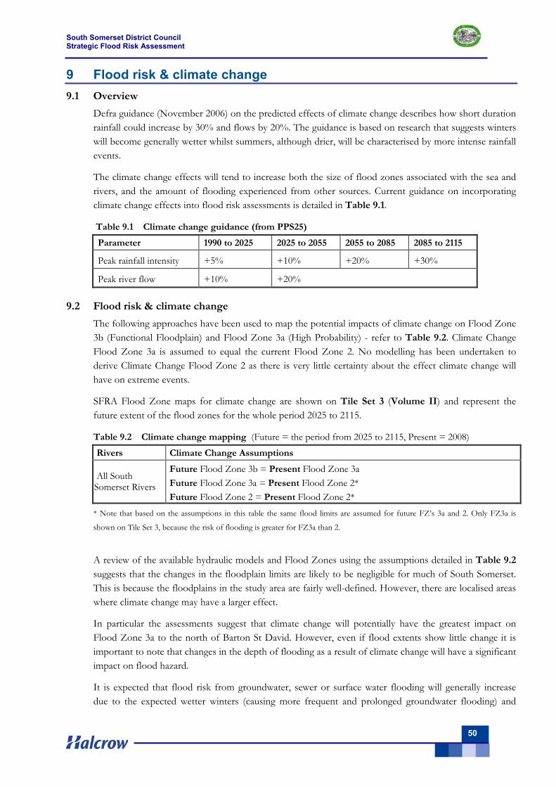
South Somerset District Council Strategic Flood Risk Assessment
50
9 Flood risk & climate change 9.1 Overview
Defra guidance (November 2006) on the predicted effects of climate change describes how short duration rainfall could increase by 30% and flows by 20%. The guidance is based on research that suggests winters will become generally wetter whilst summers, although drier, will be characterised by more intense rainfall events.
The climate change effects will tend to increase both the size of flood zones associated with the sea and rivers, and the amount of flooding experienced from other sources. Current guidance on incorporating climate change effects into flood risk assessments is detailed in Table 9.1.
Table 9.1 Climate change guidance (from PPS25) Parameter 1990 to 2025 2025 to 2055 2055 to 2085 2085 to 2115
Peak rainfall intensity +5% +10% +20% +30%
Peak river flow +10% +20% 9.2 Flood risk & climate change
The following approaches have been used to map the potential impacts of climate change on Flood Zone 3b (Functional Floodplain) and Flood Zone 3a (High Probability) - refer to Table 9.2. Climate Change Flood Zone 3a is assumed to equal the current Flood Zone 2. No modelling has been undertaken to derive Climate Change Flood Zone 2 as there is very little certainty about the effect climate change will have on extreme events.
SFRA Flood Zone maps for climate change are shown on Tile Set 3 (Volume II) and represent the future extent of the flood zones for the whole period 2025 to 2115.
Table 9.2 Climate change mapping (Future = the period from 2025 to 2115, Present = 2008)
Rivers Climate Change Assumptions
All South Somerset Rivers
Future Flood Zone 3b = Present Flood Zone 3a Future Flood Zone 3a = Present Flood Zone 2* Future Flood Zone 2 = Present Flood Zone 2*
* Note that based on the assumptions in this table the same flood limits are assumed for future FZ’s 3a and 2. Only FZ3a is
shown on Tile Set 3, because the risk of flooding is greater for FZ3a than 2.
A review of the available hydraulic models and Flood Zones using the assumptions detailed in Table 9.2 suggests that the changes in the floodplain limits are likely to be negligible for much of South Somerset. This is because the floodplains in the study area are fairly well-defined. However, there are localised areas where climate change may have a larger effect.
In particular the assessments suggest that climate change will potentially have the greatest impact on Flood Zone 3a to the north of Barton St David. However, even if flood extents show little change it is important to note that changes in the depth of flooding as a result of climate change will have a significant impact on flood hazard.
It is expected that flood risk from groundwater, sewer or surface water flooding will generally increase due to the expected wetter winters (causing more frequent and prolonged groundwater flooding) and
South Somerset District Council Strategic Flood Risk Assessment
51
incidence of short-duration high intensity rainfall events associated with summer convective storms (causing more frequent surface water and sewer flooding).
Further guidance on how planning should secure new development to the effects of climate change is available in the new Planning Policy Statement: Planning and Climate Change (a supplement to PPS1) released in December 2007.
9.3 Integrated urban drainage
Defra commissioned a series of ‘Integrated Urban Drainage Pilot Studies’ (project coordinated by Halcrow). The 15 projects will test new approaches to reduce the impact of urban drainage flooding, so that towns and cities across the country are better prepared for the impacts of climate change. The pilots were set up primarily to "plug the gap" between the well studied pathways of flooding, fluvial and coastal flooding; and the lesser understood 'other causes' of flooding.
The Government's Foresight and Making Space for Water projects identified that these other sources of flooding can make up a large proportion of the damage caused, and cost incurred, by flooding, and this proportion is likely to increase as the impacts of climate change start to become more frequent.
The impact of climate change on integrated urban drainage flooding is not currently being assessed by any party. There is currently no model of the surface water sewer system and its links to the foul, highway and river system.
Development will not have an impact on the drainage system provided that it is well designed to current SUDS best practice, including PPS25 climate change allowances. However, there are, as recent flood events (e.g. January 1995 and April 1998) have identified, existing deficiencies in these systems that may result in urban flooding.
Options for strategic flood risk management in new development areas should be further explored in order to identify any high level opportunities for reducing flood risk in existing urban areas.
9.4 Potential increase in flood risk caused by future development
The Flood Zones and localised flood incidents (Tiles Sets 1 & 2) require careful consideration before sites for development are allocated, but once allocated a SUDS network can be constructed to ensure runoff from the site is the same after development is completed as it was before development started.
In an undeveloped area a percentage of the rainfall seeps or infiltrates into the soil and so does not contribute to runoff into watercourses, ditches or sewers. A SUDS network creates a series of opportunities for this same degree of infiltration to continue when a site is developed with properties, buildings and roads all of which cut off the natural path of the rainfall to the soil.
The SUDS system must take into account climate change that is predicted to occur. It should be noted that existing sites could discharge up to 30% greater runoff in the future even if there was no change at all made to the site, purely as a result of increased rainfall landing on the ground within the site.
To achieve this equivalency or slight betterment the site drainage and SUDS network should be designed to meet the requirements set out in PPS25. To determine the actual design one approach that can be used is set out in the Defra/Environment Agency publication “Preliminary Rainfall Runoff for Developments Revision D”.
South Somerset District Council Strategic Flood Risk Assessment
52
A SUDS network will accommodate all rainfall, including the extra as a result of climate change, falling onto the site for all storm events up to and including 1% AEP. However with all probabilities it is possible that this event could occur more frequently.
For the storm events within the design parameter of up to 1 in 100-year the outflow from the site will be equal to or slightly better than the existing arrangement. The storage can be within formal elements, e.g. a pond, but during extreme events (in excess of 1 in 50-year), informal storage areas such as car parks, playing fields and public open space can be used.
The drainage and SUDS networks on a site will collect and transfer all of the rainfall to attenuation or storage areas without any surface flooding affecting properties or key infrastructure. In extreme events sites should be designed to meet the requirements of “Designing for exceedance in urban drainage – good practice” by CIRIA reference C635.
The CIRIA document defines an approach that minimises damage caused when the flow carrying capacity of the piped drainage system or SUDS network is exceeded. The key outcome is that excess flow is managed. It can be designed to be carried as overland flow along road surfaces, cycleways or along depressions in public open space.
South Somerset District Council Strategic Flood Risk Assessment
53
10 Strategic Land-Use Planning 10.1 Overview
This Chapter provides planning recommendations to enable appropriate planning responses for low, medium and high risk areas as regards flood risk. Appropriate policy set by South Somerset District Council is essential to ensure that the recommended development control conditions can be imposed consistently at the planning application stage.
10.2 Flood risk management policy
The policy recommendations provided of this Level 1 SFRA are not exhaustive and it is therefore recommended that South Somerset District Council refer to the following key flood risk management documents in order to fully inform their flood risk management policy.
Planning Policy Statement 25: Development and Flood Risk (PPS25) – sets out national policy for development and flood risk and supports the Government’s objectives for sustainable communities.
Planning Policy Statement 25: Development and Flood Risk Practice Guide – this guide offers guidance and good practice case studies of how to implement PPS25.
South West Regional Flood Risk Appraisal – provides a broad overview of flood risks within the south-west. At the regional level, the Somerset Levels and Moors are identified as a significant flood risk area.
Parrett, North & Mid Somerset, East Devon and Dorset Stour Catchment Flood Management Plans – these are four strategic planning documents through which the Environment Agency will work with other stakeholders to identify and agree policies for long-term flood risk management in South Somerset over the next 50 to 100 years.
Making Space for Water - outlines the Government’s proposals for forward planning of flood management over the next 20 years advocating a holistic approach to achieve sustainable development. The protection of the functional floodplain and creation of blue corridors are central to the strategy.
Water Framework Directive - this European Union water legislation requires all inland and coastal waters to reach good ecological status by 2015.
The Pitt Review – this report reviews the summer floods in 2007. It is important that South Somerset DC carefully consider the recommendations made in this report
10.3 Strategic flood risk management studies
The Environment Agency advocates a strategic approach to flood risk management on a ‘whole catchment’ basis. In line with this thinking, the Parrett, North & Mid Somerset, East Devon and Dorset Stour Catchment Flood Management Plans are being developed by the Environment Agency working in partnership with stakeholders. The CFMP areas within the south west region are illustrated in Figure 10.1, with the boundary of South Somerset overlain for reference (indicative only).
As strategic planning documents, each CFMP takes into account the likely impacts of climate change and future development across the region. The plans do not propose specific or detailed measures but identify where further work is needed. Each CFMP sets out the proposed flood risk management policies. CFMP guidance defines six policies to manage flood risk within CFMPs. The policies relevant to each of the CFMP areas are detailed in the sub-sections below.
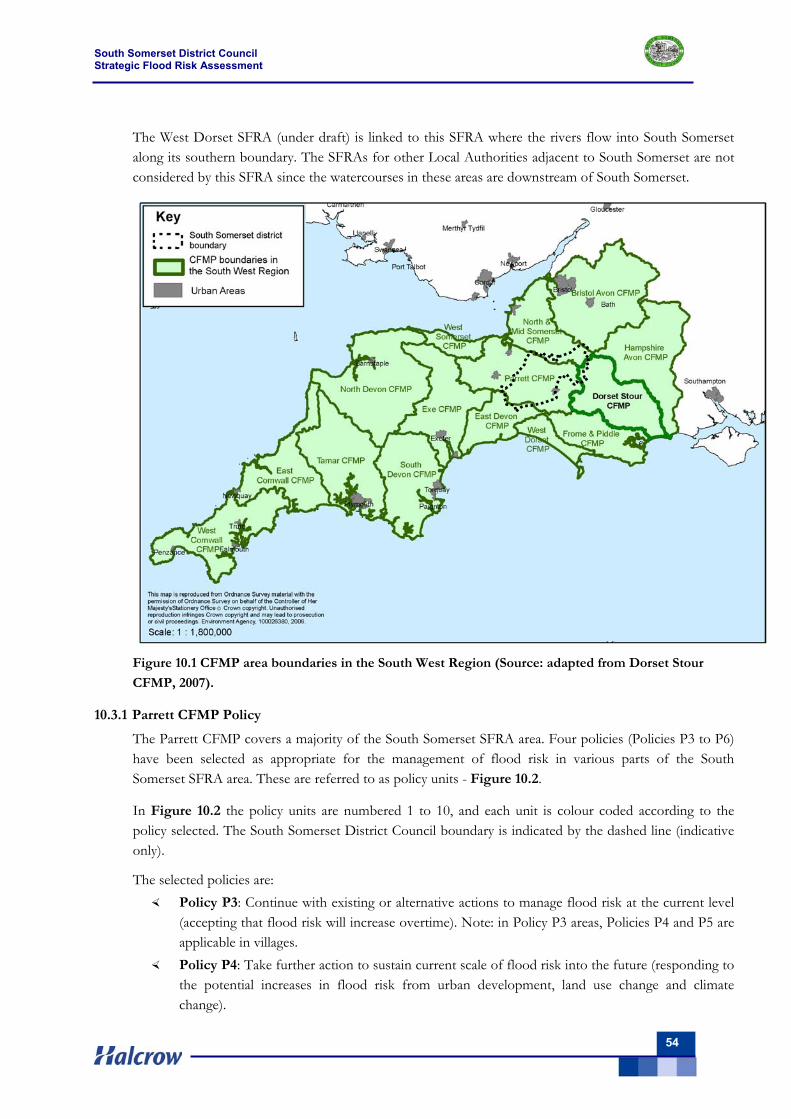
South Somerset District Council Strategic Flood Risk Assessment
54
The West Dorset SFRA (under draft) is linked to this SFRA where the rivers flow into South Somerset along its southern boundary. The SFRAs for other Local Authorities adjacent to South Somerset are not considered by this SFRA since the watercourses in these areas are downstream of South Somerset.
Figure 10.1 CFMP area boundaries in the South West Region (Source: adapted from Dorset Stour
CFMP, 2007).
10.3.1 Parrett CFMP Policy
The Parrett CFMP covers a majority of the South Somerset SFRA area. Four policies (Policies P3 to P6) have been selected as appropriate for the management of flood risk in various parts of the South Somerset SFRA area. These are referred to as policy units - Figure 10.2.
In Figure 10.2 the policy units are numbered 1 to 10, and each unit is colour coded according to the policy selected. The South Somerset District Council boundary is indicated by the dashed line (indicative only).
The selected policies are: Policy P3: Continue with existing or alternative actions to manage flood risk at the current level
(accepting that flood risk will increase overtime). Note: in Policy P3 areas, Policies P4 and P5 are applicable in villages.
Policy P4: Take further action to sustain current scale of flood risk into the future (responding to the potential increases in flood risk from urban development, land use change and climate change).
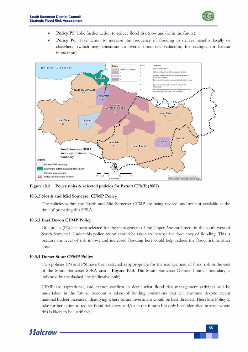
South Somerset District Council Strategic Flood Risk Assessment
55
Policy P5: Take further action to reduce flood risk (now and/or in the future). Policy P6: Take action to increase the frequency of flooding to deliver benefits locally or
elsewhere, (which may constitute an overall flood risk reduction, for example for habitat inundation).
Figure 10.2 Policy units & selected policies for Parrett CFMP (2007)
10.3.2 North and Mid Somerset CFMP Policy
The policies within the North and Mid Somerset CFMP are being revised, and are not available at the time of preparing this SFRA.
10.3.3 East Devon CFMP Policy
One policy (P6) has been selected for the management of the Upper Axe catchment in the south-west of South Somerset. Under this policy action should be taken to increase the frequency of flooding. This is because the level of risk is low, and increased flooding here could help reduce the flood risk in other areas.
10.3.4 Dorset Stour CFMP Policy
Two policies (P3 and P6) have been selected as appropriate for the management of flood risk in the east of the South Somerset SFRA area - Figure 10.3. The South Somerset District Council boundary is indicated by the dashed line (indicative only).
CFMP are aspirational, and cannot confirm in detail what flood risk management activities will be undertaken in the future. Account is taken of funding constraints that will continue despite recent national budget increases, identifying where future investment would be best directed. Therefore Policy 5, take further action to reduce flood risk (now and/or in the future) has only been identified in areas where this is likely to be justifiable.
South Somerset SFRA area - approximate boundary

South Somerset District Council Strategic Flood Risk Assessment
56
Figure 10.3 Policy units and Selected Policies for the Dorset Stour CFMP (2007)
10.3.5 West Dorset Level 1 SFRA (draft)
The West Dorset SFRA includes the headwaters of the Rivers Yeo and Parrett. The relative steepness of the topography particularly in the headwaters of these river catchments, can lead to ‘flashy’ river flooding caused by intense, often localised rainfall that may be relatively short lasting. Such events are predicted to increase in severity in the future under climate change projections.
The SFRA flood maps (draft) for West Dorset within the headwaters that feed into South Somerset are shown in Figure 10.4. The West Dorset areas advised by South Somerset District Council for consideration are to the east of Yeovil. At all locations there are localised flooding problems identified. Development to the east of Yeovil will need to be considered in relation to the flood zones, just across the border in West Dorset.
It should be noted that the West Dorset SFRA supports the same aims as this Level 1 SFRA in respect of SUDS, making development permissible without increasing flood risk to other areas, setting out clear requirements for site specific FRAs, etc.
South Somerset SFRA area - approximate boundary
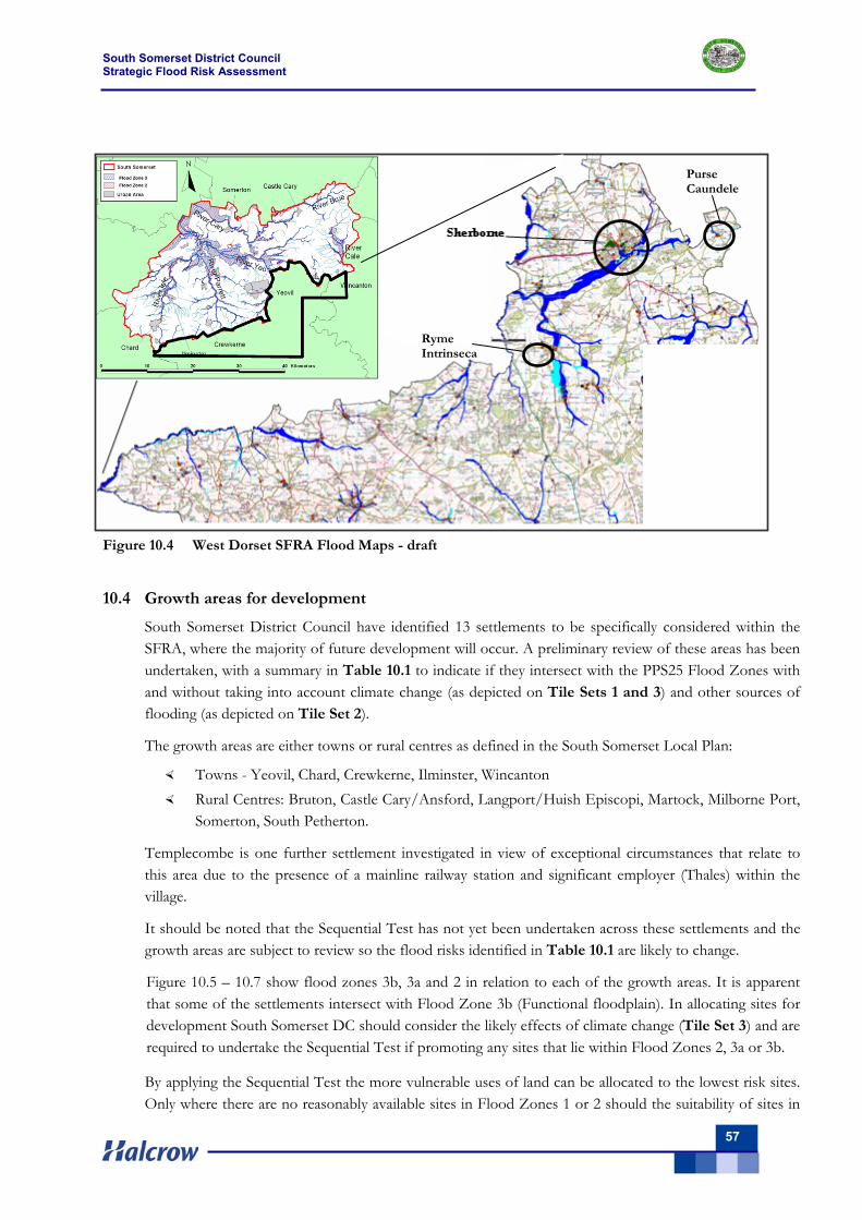
South Somerset District Council Strategic Flood Risk Assessment
57
Figure 10.4 West Dorset SFRA Flood Maps - draft
10.4 Growth areas for development
South Somerset District Council have identified 13 settlements to be specifically considered within the SFRA, where the majority of future development will occur. A preliminary review of these areas has been undertaken, with a summary in Table 10.1 to indicate if they intersect with the PPS25 Flood Zones with and without taking into account climate change (as depicted on Tile Sets 1 and 3) and other sources of flooding (as depicted on Tile Set 2).
The growth areas are either towns or rural centres as defined in the South Somerset Local Plan:
Towns - Yeovil, Chard, Crewkerne, Ilminster, Wincanton Rural Centres: Bruton, Castle Cary/Ansford, Langport/Huish Episcopi, Martock, Milborne Port,
Somerton, South Petherton.
Templecombe is one further settlement investigated in view of exceptional circumstances that relate to this area due to the presence of a mainline railway station and significant employer (Thales) within the village.
It should be noted that the Sequential Test has not yet been undertaken across these settlements and the growth areas are subject to review so the flood risks identified in Table 10.1 are likely to change.
Figure 10.5 – 10.7 show flood zones 3b, 3a and 2 in relation to each of the growth areas. It is apparent that some of the settlements intersect with Flood Zone 3b (Functional floodplain). In allocating sites for development South Somerset DC should consider the likely effects of climate change (Tile Set 3) and are required to undertake the Sequential Test if promoting any sites that lie within Flood Zones 2, 3a or 3b.
By applying the Sequential Test the more vulnerable uses of land can be allocated to the lowest risk sites. Only where there are no reasonably available sites in Flood Zones 1 or 2 should the suitability of sites in
Ryme Intrinseca
Purse Caundele
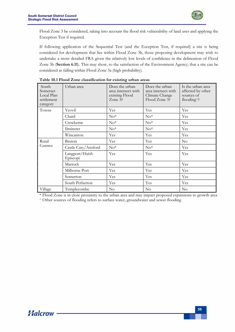
South Somerset District Council Strategic Flood Risk Assessment
58
Flood Zone 3 be considered, taking into account the flood risk vulnerability of land uses and applying the Exception Test if required.
If following application of the Sequential Test (and the Exception Test, if required) a site is being considered for development that lies within Flood Zone 3b, those proposing development may wish to undertake a more detailed FRA given the relatively low levels of confidence in the delineation of Flood Zone 3b (Section 6.11). This may show, to the satisfaction of the Environment Agency, that a site can be considered as falling within Flood Zone 3a (high probability).
Table 10.1 Flood Zone classification for existing urban areas
South Somerset Local Plan settlement category
Urban area Does the urban area intersect with existing Flood Zone 3?
Does the urban area intersect with Climate Change Flood Zone 3?
Is the urban area affected by other sources of flooding+?
Yeovil Yes Yes Yes Chard No* No* Yes Crewkerne No* No* Yes Ilminster No* No* Yes
Towns
Wincanton Yes Yes Yes Bruton Yes Yes No Castle Cary/Ansford No* No* Yes Langport/Huish Episcopi
Yes Yes Yes
Martock Yes Yes Yes Milborne Port Yes Yes Yes Somerton Yes Yes Yes
Rural Centres
South Petherton Yes Yes Yes Village Templecombe No No No * Flood Zone is in close proximity to the urban area and may impact proposed expansions to growth area + Other sources of flooding refers to surface water, groundwater and sewer flooding
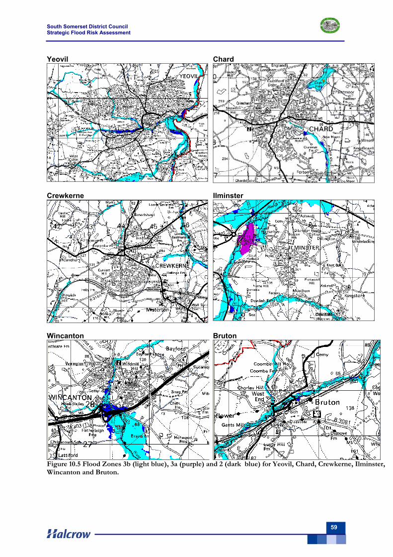
South Somerset District Council Strategic Flood Risk Assessment
59
Yeovil Chard
Crewkerne
Ilminster
Wincanton
Bruton
Figure 10.5 Flood Zones 3b (light blue), 3a (purple) and 2 (dark blue) for Yeovil, Chard, Crewkerne, Ilminster, Wincanton and Bruton.
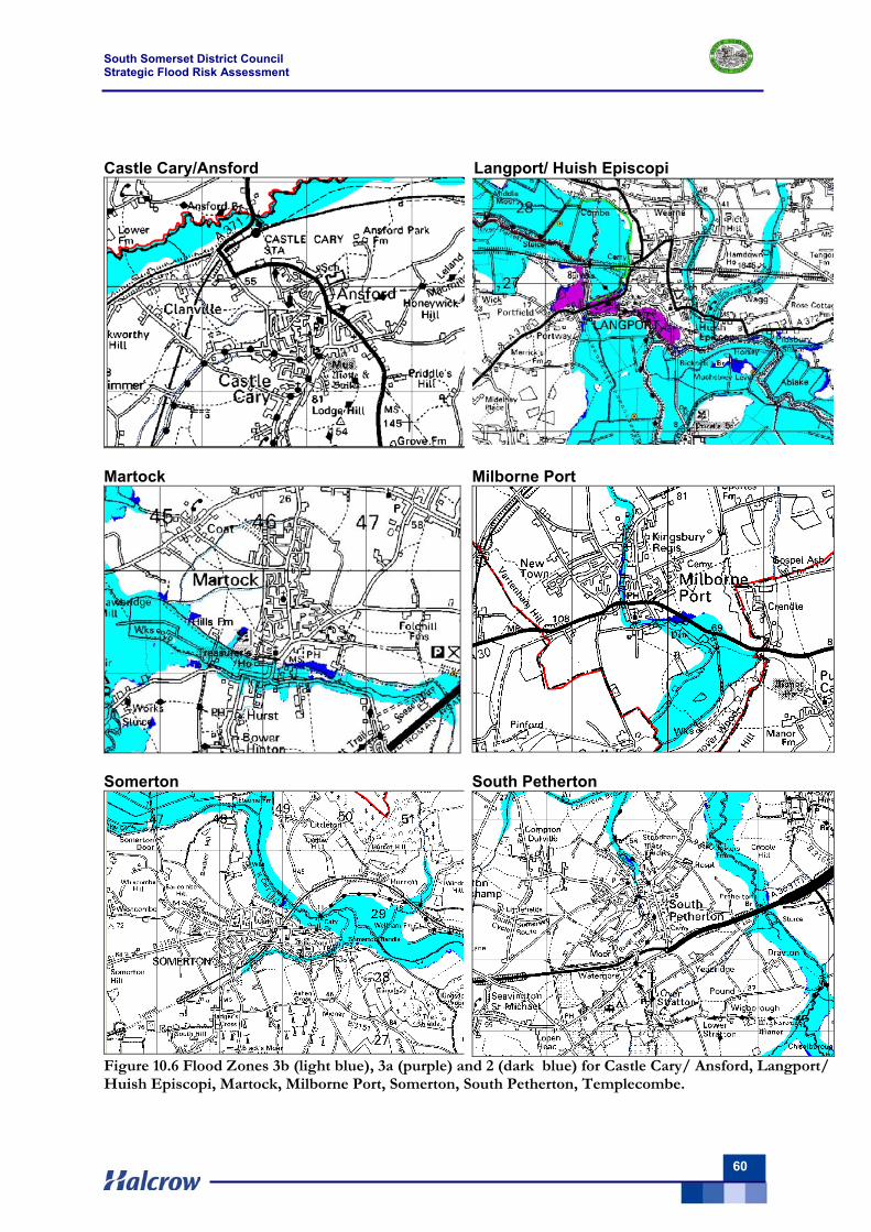
South Somerset District Council Strategic Flood Risk Assessment
60
Castle Cary/Ansford Langport/ Huish Episcopi
Martock
Milborne Port
Somerton
South Petherton
Figure 10.6 Flood Zones 3b (light blue), 3a (purple) and 2 (dark blue) for Castle Cary/ Ansford, Langport/ Huish Episcopi, Martock, Milborne Port, Somerton, South Petherton, Templecombe.
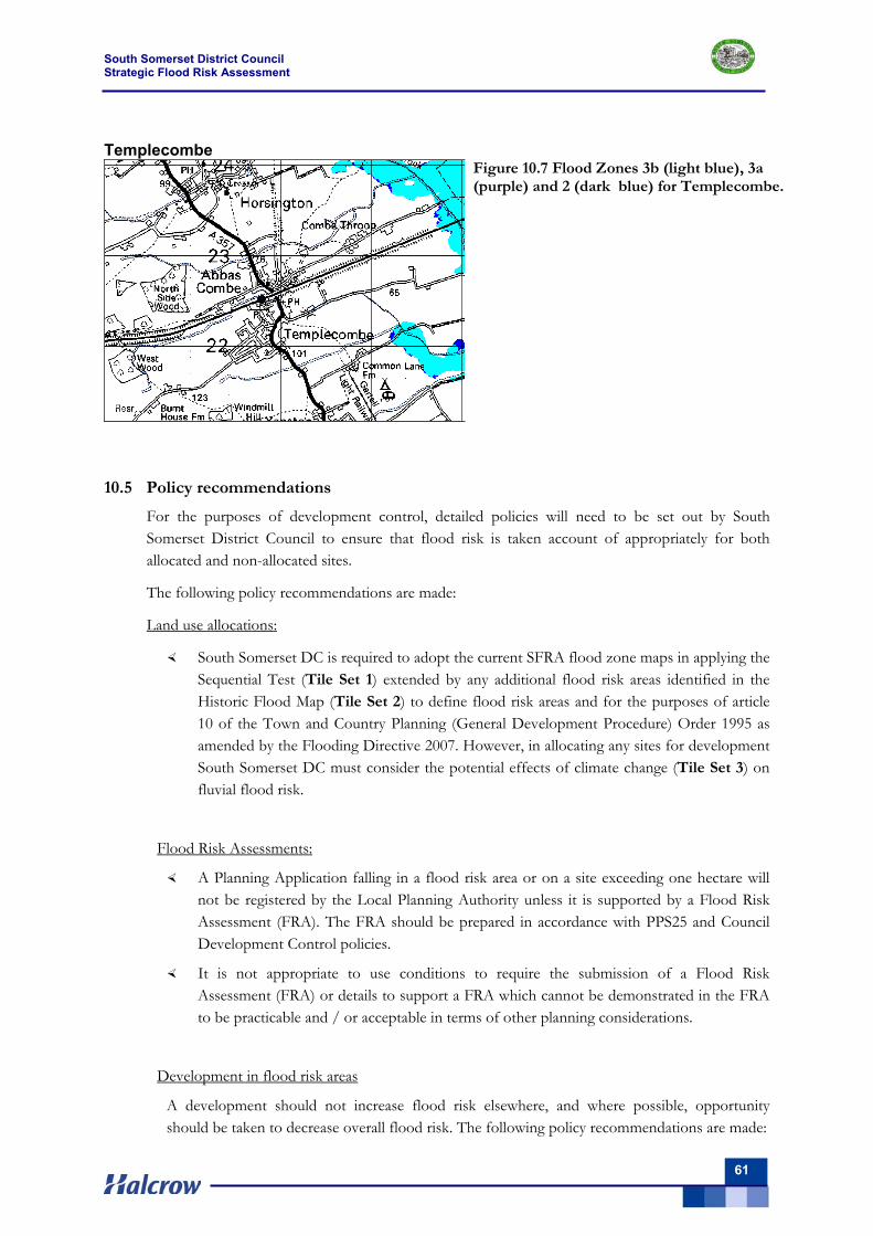
South Somerset District Council Strategic Flood Risk Assessment
61
Templecombe
Figure 10.7 Flood Zones 3b (light blue), 3a (purple) and 2 (dark blue) for Templecombe.
10.5 Policy recommendations
For the purposes of development control, detailed policies will need to be set out by South Somerset District Council to ensure that flood risk is taken account of appropriately for both allocated and non-allocated sites.
The following policy recommendations are made:
Land use allocations:
South Somerset DC is required to adopt the current SFRA flood zone maps in applying the Sequential Test (Tile Set 1) extended by any additional flood risk areas identified in the Historic Flood Map (Tile Set 2) to define flood risk areas and for the purposes of article 10 of the Town and Country Planning (General Development Procedure) Order 1995 as amended by the Flooding Directive 2007. However, in allocating any sites for development South Somerset DC must consider the potential effects of climate change (Tile Set 3) on fluvial flood risk.
Flood Risk Assessments:
A Planning Application falling in a flood risk area or on a site exceeding one hectare will not be registered by the Local Planning Authority unless it is supported by a Flood Risk Assessment (FRA). The FRA should be prepared in accordance with PPS25 and Council Development Control policies.
It is not appropriate to use conditions to require the submission of a Flood Risk Assessment (FRA) or details to support a FRA which cannot be demonstrated in the FRA to be practicable and / or acceptable in terms of other planning considerations.
Development in flood risk areas
A development should not increase flood risk elsewhere, and where possible, opportunity should be taken to decrease overall flood risk. The following policy recommendations are made:
South Somerset District Council Strategic Flood Risk Assessment
62
In areas protected to an appropriate standard by flood defences or down slope of water retaining structures (reservoirs) a detailed breach and overtopping assessment shall be carried out to inform the Sequential test and to ensure that the potential risk to life can be safely managed throughout the lifetime of the development.
For critical drainage problem areas the finished floor levels for a development should be based on the 1% AEP flood levels (or other flood level where the flood risk is identified due to other sources of flooding) with an allowance for climate change for the life of the development, plus a minimum freeboard of 600mm.
Basements should not be used for habitable purposes. Where basements are permitted for commercial and ancillary use, it is necessary to ensure that the basement access points and any venting or other penetrations are situated 600mm above the 1% fluvial level plus the climate change predicted maximum level for the life of the development.
Development should not propose culverting or the building over of watercourses. Development should be set-back from watercourses to allow appropriate access for routine maintenance and emergency clearance, if necessary. Any works or structures in, under, over or within 8 metres of the top of the bank of a main river is controlled under the terms of the Water Resources Act and the Land Drainage Byelaws - this requires a separate consent which is administered by the Environment Agency.
The use of SUDS
SUDS should be implemented to ensure that runoff from the site (post development) is reduced, with space set-aside within the confines of the site to allow its implementation. The use of SUDS techniques and attenuation should take into account the local geological and groundwater conditions.
The design peak rainfall intensity for drainage system design shall include the climate change allowances set out in Table B.2 of PPS 25 appropriate to the design life of the development. Should the surface water drainage system be designed to current standards for adoption, then; the surface water generated by peak rainfall intensities, for all events up to that with an annual probability of 1% shall be contained on site without causing a risk to property.
Flood Defences
Unless absolutely necessary, flood defences should not be used as an option to make development within higher flood risk areas permissible due to the risks of flood defence failure.
Emergency Planning
The development should be safe throughout its life - to achieve this, dry pedestrian egress should be possible above the 1% fluvial flood level and emergency vehicular access should be possible during times of flood. Should this not be possible an evacuation plan should be prepared and the advice from the Local Authorities emergency planning officer and the emergency services must be sought.
South Somerset District Council Strategic Flood Risk Assessment
63
10.6 Development within areas affected by surface water and sewer flooding
Areas outside the Flood Zones should not always be viewed as areas best placed to accommodate new development. What is essential is that all development locations are checked to ensure capacity exists within the network. Where capacity does not exist it is vital that upgrades are provided ahead of development. Failure to do so will increase the risk of internal / external flooding of properties and pollution of the wider environment.
South Somerset District Council can ensure all future development is sustainable through close collaboration with Wessex Water and/or South West Water (as applicable). The best way is to ensure capacity exists in the network or can be accommodated through additional infrastructure is to model the existing sewer network (Wessex Water have built hydraulic models of the sewer network within South Somerset) and then add in additional flows where development sizes and locations are known.
Wessex Water expect to have resolved many of the existing sewer flooding problems as shown on the historical flood maps (Tile Set 2 - Volume II) by 2010. Where Wessex Water has identified potential sewer flooding sites through computer modelling, these issues will be addressed as part of their ongoing programme of flood alleviation works. As South West Water have not identified any areas at risk of sewer flooding within South Somerset, they do not have the need to implement any flood alleviation works within this area.
10.7 Recommendations for reducing existing flood risks
The following recommendations are made for reducing existing flood risks:
Where possible, identify long-term opportunities to remove development from the functional floodplain through land swapping.
Build resilience into a site’s design (e.g. flood resistant or resilient design, raised floor levels).
Enhancement opportunities should be sought when renewing assets (e.g. deculverting, the use of bioengineered river walls, raising bridge soffits to take into account climate change)
Avoid further culverting and building over of culverts. All new developments with culverts running through their site should seek to deculvert rivers for flood risk management and conservation benefit.
Seek to protect Greenfield functional floodplain from future development and where possible reinstate areas of functional floodplain which have been developed (e.g. reduce building footprints or relocate to lower flood risk zones).
Seek to improve the emergency planning process using the outputs from the SFRA. It is further recommended that South Somerset DC work with the Environment Agency promote awareness of flood risk to maximise the number of people signed up for the Flood Warning Direct service.
Encourage all those within Flood Zone 3a and 3b (residential and commercial occupiers) to sign-up to Flood Warnings Direct service operated by the Environment Agency.
The following opportunities for flood risk reduction are identified within South Somerset:
Chard – existing flood risk at Tatworth/Forton (south of Chard) could be alleviated by creation of a new flood attenuation facility within the natural valley area to the south-west of Chard. Flood risk at Donyatt (north of Chard) and, to a certain
South Somerset District Council Strategic Flood Risk Assessment
64
degree, Ilminster could be alleviated by installation of level sensors and automatic sluice controls at Chard Reservoir.
Langport - The town of Langport is currently protected by flood defences. The standard of these defences could be improved by developer contributions
Yeovil – development, particularly to the northeast, could assist with flooding problems downstream at Mudford.. The northern end of Mudford, adjacent to the River Yeo is protected by raised embankments and walls. The standard of these defences could be improved and/or extended in order to offset increased risk of flooding due to development upstream at Yeovil.
Yeovil - future growth could assist with reduction of flood risk downstream as far as Langport. Existing raised flood defences alongside the River Yeo between Ilchester and Langport could be improved.
Yeovil - development at Bunford Lane (nr council offices) with future betterment potential to the west (upstream), if growth area promoted here, could address flooding issues related to the open and culverted lengths of watercourse through the Lynx Trading Estate. Improvements would be likely to entail creation of an attenuation facility.
10.8 Key messages for development control
It is essential that South Somerset District Council and the Environment Agency ensure flood risk is managed appropriately within the within the river catchments by applying PPS25 and the findings of this SFRA. The following are key messages on development control related to flood risk:
Flood defences are not sustainable and cannot be built to protect everything.
Climate change will be the major cause of increased flood risk in the future.
The floodplain is our most important asset in managing flood risk.
Development and regeneration provide a crucial opportunity to manage the risk.
The location, layout and design of developments – in that order – are the most vital factors in managing flood risk.
Development should only be permitted in areas of flood risk when there are no reasonably available sites in areas of lower flood risk and the benefits of the development outweigh the risks from flooding.
Effective ways of managing the risk must be incorporated into planning and design to prevent the need for future intervention. This is dependent on the location and layout of development.
Development should avoid flood risk to people and property where possible. It should manage any residual risk, taking into account the impacts of climate change.
Flood risk, water resources and water quality need to be balanced through management of waste water, surface water and sewers.
10.9 The need for flood risk assessments
This SFRA is a strategic document that provides an overview of flood risk throughout the South Somerset SFRA area. Site-specific Flood Risk Assessments (FRAs) will be required for development proposals on sites comprising 1 hectare or above in Flood Zone 1, and all
South Somerset District Council Strategic Flood Risk Assessment
65
development proposals in Flood Zones 2 and 3. The level of detail will depend on the level of flood risk at the site. The onus is on the developer to provide this information in support of a planning application.
PPS25 Annex E sets out a recommended process for undertaking FRA as part of an individual planning application (Figure 10.8).
Since the release of PPS25 in December 2006, the Environment Agency has power of direction over the determination of planning applications, which can be refused on the grounds of flood risk.
Should South Somerset District Council wish to disregard the advice of the Environment Agency then in exceptional circumstances the planning application could be put before the Secretary of State - this relates to ‘major sites’ as defined in the Flooding Direction/PPS25. It is therefore imperative that developers hold discussions over the need for Flood Risk Assessment (FRA) early on within the planning process.
Consultation should be undertaken with the Environment Agency and the relevant Council to ensure that the Council’s policies on flood risk management are respected and taken account of, and that the scope of the FRA is commensurate with the level of flood risk. Those proposing development should also be directed towards Annex E of PPS25.
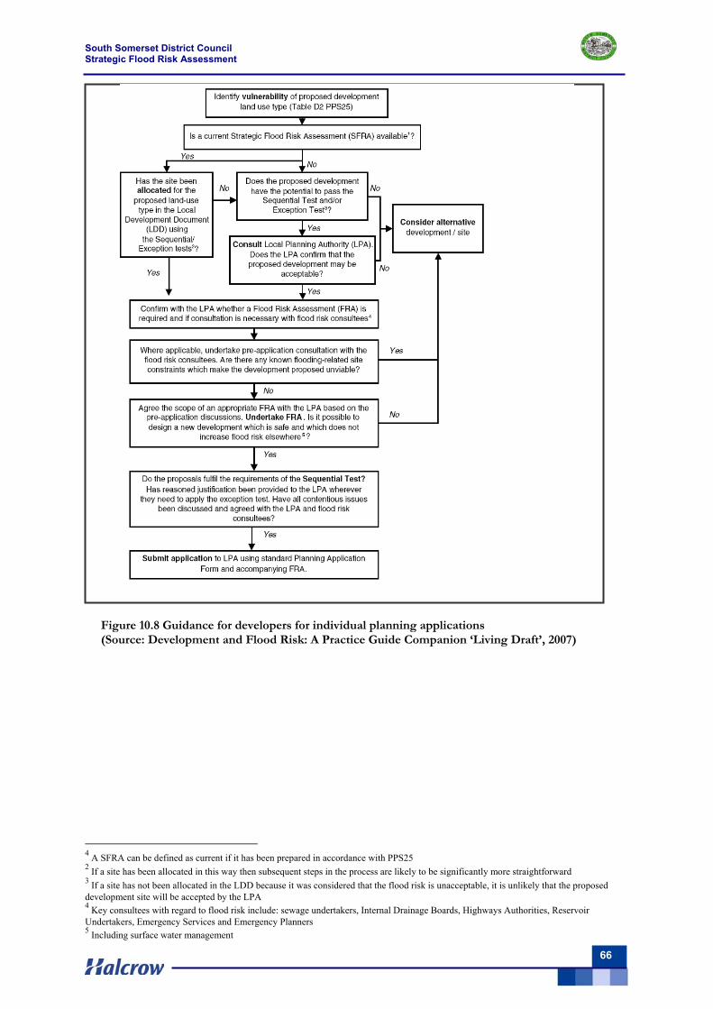
South Somerset District Council Strategic Flood Risk Assessment
66
4
4 A SFRA can be defined as current if it has been prepared in accordance with PPS25 2 If a site has been allocated in this way then subsequent steps in the process are likely to be significantly more straightforward 3 If a site has not been allocated in the LDD because it was considered that the flood risk is unacceptable, it is unlikely that the proposed development site will be accepted by the LPA 4 Key consultees with regard to flood risk include: sewage undertakers, Internal Drainage Boards, Highways Authorities, Reservoir Undertakers, Emergency Services and Emergency Planners 5 Including surface water management
Figure 10.8 Guidance for developers for individual planning applications (Source: Development and Flood Risk: A Practice Guide Companion ‘Living Draft’, 2007)
South Somerset District Council Strategic Flood Risk Assessment
67
11 Conclusions & Recommendations In November 2007, South Somerset District Council commissioned Halcrow to produce this Level 1 SFRA in accordance with PPS25 and Environment Agency guidance. The SFRA output is relevant not only to planning and development control, but also other related assessment such as site-specific FRAs, mapping for emergency planning, flood alleviation studies and surface water management plans.
The flood risk within the SFRA area largely arises from river and surface water flooding, with a limited amount of sewer and groundwater flooding. Limited urban areas of South Somerset are currently at risk of flooding from a 1 in 100-year flood event, with some risk to particular locations and key infrastructure identified (Table 6.6).
The SFRA Flood Zone maps (Volume II) and Table 10.1 show that eight of the 13 growth areas lie within Flood Zone 3 (although in many cases the area affected is small). The Sequential Test should be applied to direct any development away from these higher flood risk areas, but where this is not possible the Exception Test must be passed.
The risk of flooding within the study area arises from river, surface water, groundwater and sewer flooding. The SFRA flood maps with an allowance for climate change (Tile Set 3) show that many urban areas within the study area are at risk of flooding from a 1% fluvial probability flood event (Flood Zone 3).
Table 10.1 also shows that parts of the potential growth areas lie within Climate Change Flood Zone 3, although in many cases the area affected is small. The Sequential Test should be applied to any such areas to direct any development away from these higher flood risk areas. Where this is not possible a Level 2 SFRA will be required to inform flood risk and the Exception Test must be passed.
Based on this SFRA the following recommendations are made.
Site allocation process
It is recommended the SFRA outputs are used as an evidence base from which to direct new development where possible to areas of low flood risk (Flood Zone 1).
Where development cannot be located in Flood Zone 1, the SFRA flood maps should be used to apply the Sequential Test to the remaining land use allocations.
Where the need to apply the Exception Test is identified, due to there being an insufficient number of suitable sites for development within zones of lower flood risk, the scope of the SFRA will need to be widened to Level 2 SFRA.
The need for a Level 2 SFRA cannot be fully determined until the Sequential Test has been applied.
As soon the need for the Exception Test is established, Level 2 SFRA is undertaken by a suitably qualified engineer so as to provide timely input to the overall LDF process.
South Somerset District Council Strategic Flood Risk Assessment
68
Possible Funding Mechanisms - Planning Obligations & Statutory Planning Changes The funding mechanism to implement flood risk reduction measures and other facilities is
likely to be an important policy consideration. Circular 05/2005 provides for S106 planning obligations to be sought where they meet the tests set out in the Circular.
Such obligations are intended to secure contributions from developers to address the impact of new development, without which such development should not be permitted. Such impacts can include flood water conveyance/storage and flood defences.
There have been a number of recent initiatives to achieve enhanced contributions via S106 planning obligations. One of the most advanced schemes involves a tariff-based funding system covering development in the Expansion Areas in Milton Keynes.
The objective of the approach is to ensure that Expansion Area development is supported by appropriate facilities, amenities and infrastructure. Milton Keynes’ tariff includes flood risk management and drainage provision.
South Somerset District Council may wish to consider the potential of S106 planning obligation contributions to fund (or part fund) strategic flood risk management facilities.
In some cases it may be reasonable for the developer to contribute to the up-grade or replacement of existing flood defences and surface water infrastructure, or to flood alleviation schemes which provide benefit to the wider community.
South Somerset District Council planning policy South Somerset District Council planning policy is essential to ensure that the
recommended development control is imposed consistently and ultimately leads to sustainability with respect to flood risk management.
Current South Somerset District Council planning policy should be reviewed in light of PPS25 and this SFRA to ensure a consistent policy is being promoted with regard to flood risk, and the following key considerations are adhered.
Key considerations for South Somerset District Council policy: - Directing vulnerable development away from flood affected areas - Where possible, identify long-term opportunities to remove development from the
functional floodplain through land swapping. - Seeking to protect the functional floodplain from development - Where possible reinstate areas of Functional Floodplain previously developed (e.g.
reduce building footprints or relocate to lower flood risk zones). - Ensuring all new development is ‘Safe’, meaning that dry pedestrian egress through
the floodplain and emergency vehicular access is possible - Promote the application of SUDS for all new development - Support flood alleviation measures under consideration by the Environment Agency
by safeguarding possible sites for flood storage and channel works. - Seek developer contributions via S106 planning obligation to fund (or part fund)
strategic flood risk management facilities to benefit the wider community - Build resilience into design, eg. flood resistant or resilient design, raised floors - Seek enhancement opportunities when renewing assets. - Avoid further culverting and building over of culverts. - Seek to improve the emergency planning process using the SFRA outputs.
South Somerset District Council Strategic Flood Risk Assessment
69
Sewer flooding Storage, diversions, local upsizing of sewers and upgrading of pumping stations may
alleviate current flooding, though alternative solutions should be sought for future developments.
Other future developments (in all areas) should by-pass the older town systems in a similar fashion or be directed to a dedicated treatment works, as there is no spare capacity in the existing sewage system.
Emergency planning South Somerset District Council’s emergency planning should be reviewed and updated in
light of the findings of the SFRA to ensure that safe evacuation and access for emergency services is possible during times of flood both for existing developments and those being promoted as possible sites within the LDF process.
South Somerset District Council should work with the Environment Agency to promote awareness of flood risk to maximise the number of people signed up for the Flood Warning Direct service.
South Somerset District Council should work with the Environment Agency to encourage flood risk communities to develop a community flood plan to improve community awareness and resilience to flooding.
Encourage all those living/in flood risk areas where a flood warning is available to sign up to Flood Warnings Direct service operated by the Environment Agency.
Future updates to the SFRA The SFRA should be retained as a ‘living’ document and reviewed on a regular basis in light
of better flood risk information and emerging policy guidance. In particular, it is recommended that the SFRA is revised in instances of significant revisions to the Environment Agency Flood Zones or in the event of considerable areas being affected by any source of flooding.
Planning Policy Statement: Planning and Climate Change (supplement to PPS 1) (DCLG, December 2007) provides further guidance on how planning should secure new development to be resilient to the effects of climate change.
Recording flood incidents It is recommended that South Somerset District Council collate information regarding flood incidents in GIS format - suggested data format is GIS (polygon) to show the spatial extent of the flood. Information recorded about a flood incident should be stored in the GIS database (as a table) and include details of the following:
National Grid Reference Date of flood incident House number, road Community Source of flooding
(e.g. heavy rain, blockage etc.)
Whether properties flooded internally Time the property flooded Maximum depth of flooding Whether property was flooded externally Any preventative measures taken to stop flooding Source of information Any additional comments
South Somerset District Council Strategic Flood Risk Assessment
70
It is suggested that information is collated on each of the above parameters to be compatible with the information collated by the Environment Agency on flood incidents on their FRIS database. As good practice, it is further recommended that information on flood incidents is readily shared between the Environment Agency and South Somerset District Council.
A national web-based FRIS database may be the easiest and best way to facilitate this process so that all flood incident information is collated in a single database. However, should this recommendation be progressed further it will be vital that access to the database is controlled (e.g. via a password) and that amendments and updates made to the database can be traced to the user who has made them.
South Somerset District Council Strategic Flood Risk Assessment
71
References
BGS, 2000. The Physical Properties of Minor Aquifers in England and Wales. BGS Technical Report WD/00/04.
CIRIA. SUDS – Best practice manual (C523)
CIRIA; The SUDS Manual (C697)
CIRIA. SUDS –Design manual for England & Wales (C522)
CIRIA. SUDS – Hydraulic, structural and water quality advice (C609)
DCLG, 1994. Planning Policy Guidance 15: Planning & the Historic Environment
DCLG, 2002. Planning Policy Guidance 17: Planning for Open Space, Sport & Recreation
DCLG, 2005a. Planning policy Statement 1: Creating Sustainable Communities
DCLG, 2005b. Planning policy Statement 9: Biodiversity & Geological Conservation
DCLG, 2006a. Planning Policy Statement 3: Housing
DCLG, 2006b. Planning Policy Statement 25: Development and Flood Risk
DCLG, 2007a. Development and Flood Risk, a Practice Guide Companion to PPS25
DCLG, 2007b. Planning Policy Statement: Planning and Climate Change (supplement to PPS 1).
DCLG, 2008. Development and Flood Risk practice guide
Defra, 2004. Strategy for Flood and Coastal Erosion Risk Management: Groundwater Flooding Scoping Study (LDS 23) Final Report.
Defra. 2006. United Kingdom Impacts Program (UKCIP) Supplementary Guidance on Climate Change Impacts for Appraisal and Decision making.
Defra. 2007. EU Floods Directive.
Defra (in preparation); Making Space for Water; Groundwater flooding records collation, monitoring and risk assessment (reference HA5); Draft Consolidated Report Main Summary Report
Defta (in preparation). Making Space for Water.
Defra/ Environment Agency. 2007. Preliminary rainfall-runoff for developments, Revision D.
Environment Agency, 2006a. Groundwater Protection: policy and practice; Underground, under threat; The state of groundwater in England and Wales.
South Somerset District Council Strategic Flood Risk Assessment
72
Environment Agency, 2006b. Underground, under threat. The state of groundwater in England and Wales.
Environment Agency, 2007a. East Devon Catchment Flood Management Plan
Environment Agency, 2007b. Dorset Stour Catchment Flood Management Plan
Environment Agency, 2007c. River Parrett Catchment Flood Management Plan
Environment Agency, 2007. Living on the edge.
Environment Agency, 2007. Unit cost database.
European Union. 2000. Water Framework Directive.
National SUDS Working Group, 2004. Interim Code of Practice for Sustainable Drainage Systems
Somerset Local Authorities Civil Contingencies Unit, 2006. Flood Warning and Response Plan
South Somerset District Council, 2006. Adopted South Somerset Local Plan
South West Regional Assembly. 2006. The draft Regional Spatial Strategy for the South West 2006-2026 and subsequent Examination in Public Panel Report (December 2007)
South West Regional Assembly. 2007. South West Regional Flood Risk Appraisal
The Groundwater Regulations 1998; Statutory Instrument 1998; No 2746 Environmental Protection
The Pitt Review, 2007. Learning Lessons from the 2007 floods, Cabinet Office
West Dorset District Council (in preparation), West Dorset Strategic Flood Risk Assessment.
South Somerset District Council Strategic Flood Risk Assessment
73
Glossary
Annual Exceedence Probability (AEP) The estimated probability of a flood of given magnitude occurring or being exceeded in any year. Expressed as, for example, 1 in 100 chance or 1 per cent. Catchment Flood Management Plans (CFMP) A strategic planning tool through which the Environment Agency will seek to work with other key decision-makers within a river catchment to identify and agree policies for sustainable flood risk management. Climate change Long-term variations in global temperatures and weather patterns, both natural and as a result of human activity. Flood defence Flood defence infrastructure, such as flood walls and embankments, intended to protect an area against flooding to a specified standard of protection. Flood Map A map produced by the Environment Agency providing an indication of the likelihood of flooding within all areas of England and Wales, assuming there are no flood defences. Only covers river and sea flooding. Floodplain Area of land that borders a watercourse, an estuary or the sea, over which water flows in time of flood, or would flow but for the presence of flood defences where they exist. Flood risk assessment A study to assess the risk to an area or site from flooding, now and in the future, and to assess the impact that any changes or development on the site or area will have on flood risk to the site and elsewhere. It may also identify, particularly at more local levels, how to manage those changes to ensure that flood risk is not increased. PPS25 differentiates between regional, subregional/ strategic and site- specific flood risk assessments. Flood Zone A geographic area within which the flood risk is in a particular range, as defined within PPS25. Fluvial flooding Flooding caused by rivers. Local development framework (LDF) A non-statutory term used to describe a folder of documents which includes all the local planning authority’s Local Development Documents (LDDs). The local development framework will also comprise the statement of community involvement, the local development scheme and the annual monitoring report. Local Development Documents (LDDs) All development plan documents which will form part of the statutory development plan, as well as supplementary planning documents which do not form part of the statutory development plan. Main River A watercourse designated on a statutory map of Main Rivers, maintained by Defra, on which the Environment Agency has permissive powers to construct and maintain flood defences. Planning Policy Statement (PPS) A statement of policy issued by central Government to replace Planning Policy Guidance notes. Regional Spatial Strategy (RSS) A broad development strategy for a region for a 15 to 20 year period prepared by the Regional Planning Body. Resilience Constructing the building in such a way that although flood water may enter the building, its impact is minimised, structural integrity is maintained and repair, drying & cleaning are facilitated.
South Somerset District Council Strategic Flood Risk Assessment
74
Resistance Constructing a building in such a way as to prevent flood water entering the building or damaging its fabric. This has the same meaning as flood proof. Return period The long-term average period between events of a given magnitude which have the same annual exceedence probability of occurring. Residual risk The risk which remains after all risk avoidance, reduction and mitigation measures have been implemented. Runoff The flow of water from an area caused by rainfall. Section 106 Agreement Section 106 of the Town and Country Planning Act 1990 (as amended) allowing local planning authorities to negotiate arrangements whereby the developer makes some undertaking if he/she obtains planning permission. These are known interchangeably as planning agreements, planning obligations or planning gain. Standard of protection The design event or standard to which a building, asset or area is protected against flooding, generally expressed as an annual exceedence probability. Sustainable Drainage Systems (SUDS) A sequence of management practices and control structures, often referred to as SUDS, designed to drain water in a more sustainable manner than some conventional techniques. Typically these are used to attenuate run-off from development sites. Vulnerability Classes PPS25 provides a vulnerability classification to assess which uses of land maybe appropriate in each flood risk zone.
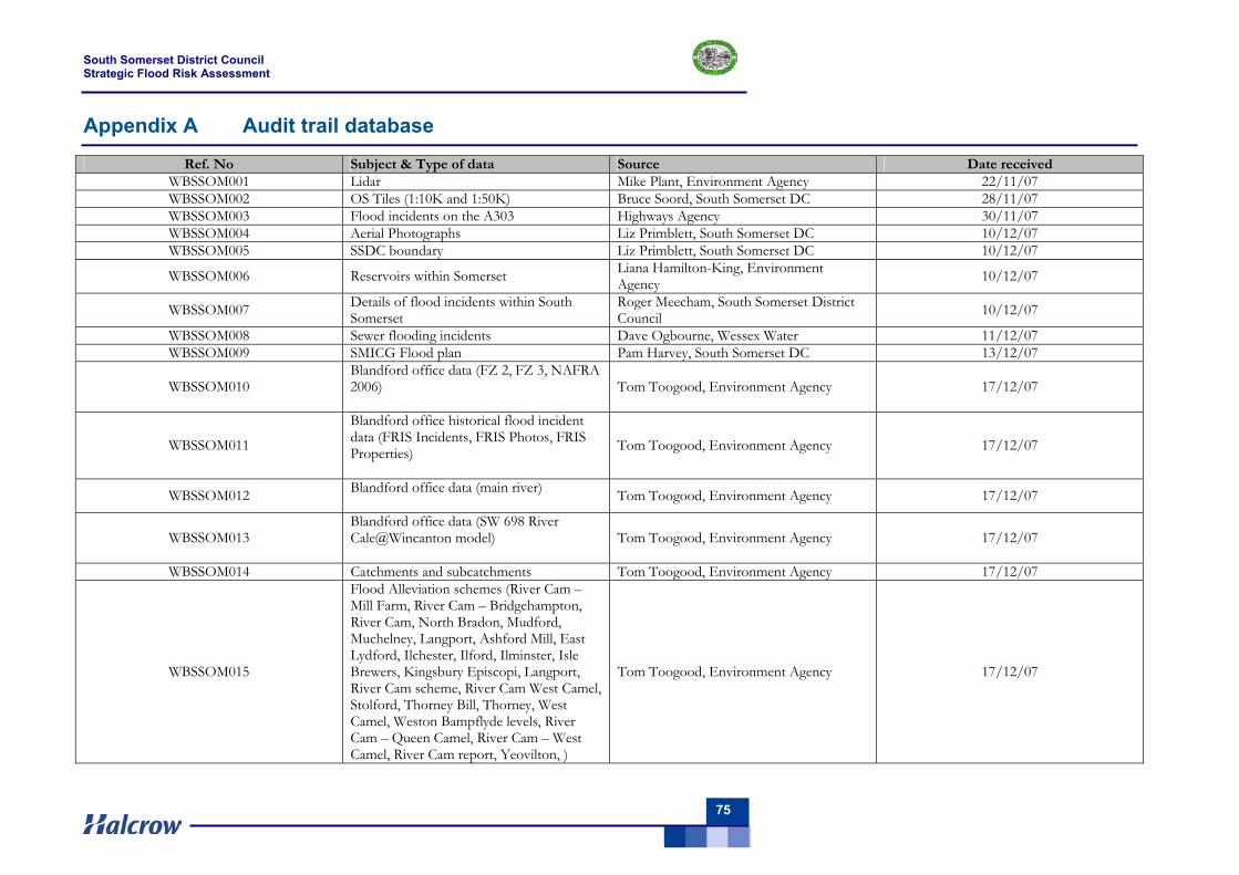
South Somerset District Council Strategic Flood Risk Assessment
75
Appendix A Audit trail database
Ref. No Subject & Type of data Source Date received WBSSOM001 Lidar Mike Plant, Environment Agency 22/11/07 WBSSOM002 OS Tiles (1:10K and 1:50K) Bruce Soord, South Somerset DC 28/11/07 WBSSOM003 Flood incidents on the A303 Highways Agency 30/11/07 WBSSOM004 Aerial Photographs Liz Primblett, South Somerset DC 10/12/07 WBSSOM005 SSDC boundary Liz Primblett, South Somerset DC 10/12/07
WBSSOM006 Reservoirs within Somerset Liana Hamilton-King, Environment Agency 10/12/07
WBSSOM007 Details of flood incidents within South Somerset
Roger Meecham, South Somerset District Council 10/12/07
WBSSOM008 Sewer flooding incidents Dave Ogbourne, Wessex Water 11/12/07 WBSSOM009 SMICG Flood plan Pam Harvey, South Somerset DC 13/12/07
WBSSOM010 Blandford office data (FZ 2, FZ 3, NAFRA 2006)
Tom Toogood, Environment Agency 17/12/07
WBSSOM011
Blandford office historical flood incident data (FRIS Incidents, FRIS Photos, FRIS Properties)
Tom Toogood, Environment Agency 17/12/07
WBSSOM012 Blandford office data (main river) Tom Toogood, Environment Agency 17/12/07
WBSSOM013 Blandford office data (SW 698 River Cale@Wincanton model)
Tom Toogood, Environment Agency 17/12/07
WBSSOM014 Catchments and subcatchments Tom Toogood, Environment Agency 17/12/07
WBSSOM015
Flood Alleviation schemes (River Cam – Mill Farm, River Cam – Bridgehampton, River Cam, North Bradon, Mudford, Muchelney, Langport, Ashford Mill, East Lydford, Ilchester, Ilford, Ilminster, Isle Brewers, Kingsbury Episcopi, Langport, River Cam scheme, River Cam West Camel, Stolford, Thorney Bill, Thorney, West Camel, Weston Bampflyde levels, River Cam – Queen Camel, River Cam – West Camel, River Cam report, Yeovilton, )
Tom Toogood, Environment Agency 17/12/07
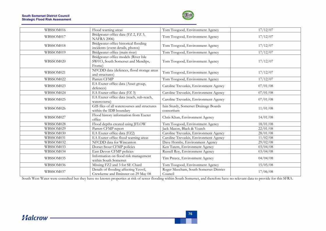
South Somerset District Council Strategic Flood Risk Assessment
76
WBSSOM016 Flood warning areas Tom Toogood, Environment Agency 17/12/07
WBSSOM017 Bridgwater office data (FZ 2, FZ 3, NAFRA 2006) Tom Toogood, Environment Agency 17/12/07
WBSSOM018 Bridgwater office historical flooding incidents (event details, photos) Tom Toogood, Environment Agency 17/12/07
WBSSOM019 Bridgwater office (main river) Tom Toogood, Environment Agency 17/12/07
WBSSOM020 Bridgwater office models (River Isle SW013, South Somerset and Mendips, Frome)
Tom Toogood, Environment Agency 17/12/07
WBSSOM021 NFCDD data (defences, flood storage areas and structures) Tom Toogood, Environment Agency 17/12/07
WBSSOM022 Parrett CFMP Tom Toogood, Environment Agency 17/12/07
WBSSOM023 EA Exeter office data (Asset group, defences) Caroline Trevaskis, Environment Agency 07/01/08
WBSSOM024 EA Exeter office data (FZ 3) Caroline Trevaskis, Environment Agency 07/01/08
WBSSOM025 EA Exeter office data (reach, sub-reach, watercourse) Caroline Trevaskis, Environment Agency 07/01/08
WBSSOM026 GIS files of all watercourses and structures within the IDB boundary
Iain Sturdy, Somerset Drainage Boards consortium 11/01/08
WBSSOM027 Flood history information from Exeter office Chris Khan, Environment Agency 14/01/08
WBSSOM028 Flood depths created using JFLOW Tom Toogood, Environment Agency 18/01/08 WBSSOM029 Parrett CFMP report Jack Mason, Black & Veatch 22/01/08 WBSSOM030 EA Exeter office data (FZ2) Caroline Trevaskis, Environment Agency 28/01/08 WBSSOM031 EA Exeter office flood warning areas Caroline Trevaskis, Environment Agency 11/02/08 WBSSOM032 NFCDD data for Wincanton Dave Hornby, Environment Agency 29/02/08 WBSSOM033 Dorset Stour CFMP policies Ken Tatem, Environment Agency 03/04/08 WBSSOM034 East Devon CFMP policies Russell Roy, Environment Agency 03/04/08
WBSSOM035 Information on flood risk management within South Somerset Tim Preece, Environment Agency 04/04/08
WBSSOM036 Missing FZ2 and 3 for SE Chard Tom Toogood, Environment Agency 15/05/08
WBSSOM037 Details of flooding affecting Yeovil, Crewkerne and Ilminster on 29 May 08
Roger Meecham, South Somerset District Council 17/06/08
South West Water were consulted but they have no known properties at risk of sewer flooding within South Somerset, and therefore have no relevant data to provide for this SFRA.
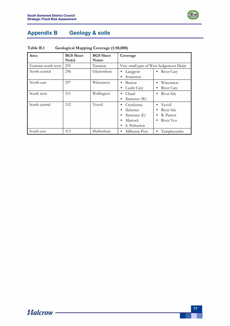
South Somerset District Council Strategic Flood Risk Assessment
77
Appendix B Geology & soils
Table B.1 Geological Mapping Coverage (1:50,000)
Area BGS Sheet No(s)
BGS Sheet Name
Coverage
Extreme north west 295 Taunton Very small part of West Sedgemoor Drain North central 296 Glastonbury • Langport
• Somerton • River Cary
North east 297 Wincanton • Bruton • Castle Cary
• Wincanton • River Cary
South west 311 Wellington • Chard • Ilminster (W)
• River Isle
South central 312 Yeovil • Crewkerne • Ilchester • Ilminster (E) • Martock • S. Petherton
• Yeovil • River Isle • R. Parrett • River Yeo
South east 313 Shaftesbury • Milborne Port • Templecombe
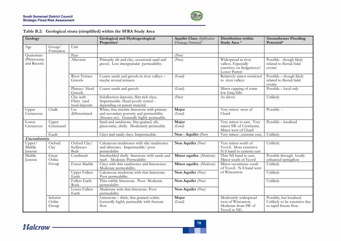
South Somerset District Council Strategic Flood Risk Assessment
78
Table B.2: Geological strata (simplified) within the SFRA Study Area
Geology Geological and Hydrogeological Properties1
Aquifer Class (Infiltration Drainage Potential)2
Distribution within Study Area 3
Groundwater Flooding Potential4
Age Group/ Formation
Unit
Peat (Poor) Alluvium Primarily silt and clay, occasional sand and
gravel. Low intergranular permeability. (Poor). Widespread in river
valleys. Especially extensive on Sedgemoor/ Lower Parrett
Possible - though likely related to fluvial/tidal events
River Terrace Gravels
Coarse sands and gravels in river valleys – maybe several terraces
(Good) Relatively minor restricted to river valleys
Possible – though likely related to fluvial/tidal events
Plateau/ Head Gravels
Coarse sands and gravels (Good) Minor capping of some low lying hills
Possible – local only
Quaternary (Pleistocene and Recent)
Clay with Flints (and head deposits
Solufluction deposits, flint rich clays. Impermeable. Head poorly sorted – depending on parent material
(Poor) As above Unlikely
Upper Cretaceous
Chalk Un- differentiated
White, fine micritic limestone with primary and secondary porosity and permeability (fissures etc). Generally highly permeable.
Major (Good)
Very minor -west of Chard
Possible -
Upper Greensand
Sand and sandstone, fine-grained, silt, glauconitic, shelly. Moderately permeable.
Major (Good)
Very minor to east. Very minor SW of Crewkerne. Minor west of Chard
Possible – localised Lower Cretaceous
Gault Clays and sandy clays. Impermeable. Non - Aquifer (Poor) Very minor , extreme east, Unlikely Unconformity Upper/ Middle Jurassic
Oxford Clay
Oxford Clay/ Kellaways Beds
Calcareous mudstones with silty mudstones and siltstones. Impermeable/ poor permeability
Non Aquifer (Poor) Very minor south of Yeovil. More extensive N-S band to extreme east
Unlikely
Cornbrash Interbedded shelly limestone with sands and marl . Moderate Permeability
Minor aquifer. (Moderate) Thin NS band to east. Minor south of Yeovil
Possible through locally enhanced springflow
Forest Marble Clays with thin sandstones and limestones. Moderate permeability.
Minor aquifer. (Moderate) Unlikely
Upper Fullers Earth
Calcareous mudstone with thin limestone. Poor permeability
Non Aquifer (Poor) Unlikely
Fullers Earth Rock
Thin rubbly limestone. Poor- Moderate permeability
Non Aquifer (Poor) Unlikely
Great Oolite Group
Lower Fullers Earth
Mudstone with thin limestone. Poor permeability
Non Aquifer (Poor)
Minor occurrence south of Yeovil. N-S band west of Wincanton.
Middle Jurassic
Inferior Oolite Group
Limestone – thick, fine grained oolitic. Generally highly permeable with fracture flow.
Major (Good)
Moderately widespread west of Wincanton. Moderate from SW of Yeovil to NE.
Possible, but localised. Unlikely to be extensive due to rapid fissure flow.
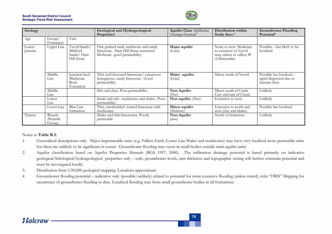
South Somerset District Council Strategic Flood Risk Assessment
79
Geology Geological and Hydrogeological Properties1
Aquifer Class (Infiltration Drainage Potential)2
Distribution within Study Area 3
Groundwater Flooding Potential4
Age Group/ Formation
Unit
Upper Lias Yeovil Sands/ Midford Sands/ Ham Hill Stone
Fine grained sand, sandstone and sandy limestone. Ham Hill Stone cemented. Moderate- good permeability.
Major aquifer (Good)
None to west. Moderate to extensive in Yeovil area, minor in valleys W of Butcombe.
Possible – but likely to be localised
Middle Lias
Junction bed/ Marlstone Rock Formation
Thin well fractured limestone/ calcareous ferruginous, sandy limestone. Good permeability
Major aquifer. (Good)
Minor north of Yeovil Possible but localised – rapid dispersion due to fracture flow
Lower Jurassic
Middle Lias
Silts and clays. Poor permeability. Non Aquifer (Poor)
Minor south of Castle Cary and east of Chard
Unlikely
Lower Lias
Sands and silty mudstones and shales. Poor permeability.
Non aquifer. (Poor) Extensive to west. Unlikely
Lower Lias Blue Lias formation
Thin, interbedded jointed limestone with mudstones
Minor aquifer (Moderate)
Extensive to north and west (clay and shales)
Possible but localised
Triassic Rhaetic (Penarth Group)
Shales and thin limestones. Poorly permeable.
Non Aquifer (poor)
North of Somerton Unlikely
Notes to Table B.2: 1. Generalised descriptions only. Major impermeable units (e.g. Fullers Earth, Lower Lias Shales and mudstones) may have very localised more permeable units
but these are unlikely to be significant in extent. Groundwater flooding may occur in small bodies outside main aquifer units 2. Aquifer classification based on Aquifer Properties Manuals (BGS 1997; 2000). The infiltration drainage potential is based primarily on indicative
geological/lithological/hydrogeological properties only – soils, groundwater levels, unit thickness and topographic setting will further constrain potential and must be investigated locally.
3. Distribution from 1:50,000 geological mapping. Locations approximate. 4 Groundwater flooding potential – indicative only (possible/unlikely) related to potential for more extensive flooding (unless stated), refer “FRIS” Mapping for
occurrence of groundwater flooding to date. Localised flooding may from small groundwater bodies in all formations.

South Somerset District Council Strategic Flood Risk Assessment
80
South Somerset District Council Strategic Flood Risk Assessment
81
Appendix C Sewer flooding
C.1 Sewer Flooding Investigations
Urban investigations are driven by the Water Company’s Sewer Flooding History Database, which lists areas and properties affected. Questionnaires are then issued in a strategic spread targeting known and possible areas affected, to discern more in-depth information such as flooding dates, flooding extents and useful information residents may have which is not already held.
Site visits are undertaken to investigate the flooding areas, to determine local topography and note features such as nearby rivers, highway drainage, manholes and general lay of the area. At this time interviews may be held with residents to gain further information or discuss returned questionnaires.
Lift and look surveys may be used to give a general overview of network condition, previous surcharge evidence, flow rates, and the cover and invert levels of the sewers, which can be utilised during hydraulic modelling. CCTV surveys will also be undertaken on known or suspect sections of sewer to establish condition and connectivity. This may be aided by dye testing to ascertain surface water connections to the foul system – Impermeable Area Surveys.
To create an accurate picture of the sewerage network in the area, a hydraulic model will be used or built if required. The model may be either calibrated or fully verified utilising data obtained from rain gauges and flow monitors placed in strategic locations around the catchment; together with current clamps and depth monitors placed within pumping stations.
The flow surveys are often supported by draw down tests undertaken at the pumping station to determine actual pumping rates and identify any deficiencies in either the pumping station and/or associated pumping main.
The information gathered from the above surveys is analysed, and with the aid of the calibrated or verified hydraulic model possible solutions are developed, if required. A number of different solutions will be developed where possible. Any solution must take into account known future developments in the area. These flows will be added into the hydraulic model and used to ensure an effective design in derived.
C.2 Sewer Flooding - General Engineering Solutions
Where engineering solutions are required they invariably relate to the problems listed earlier.
Common solutions are as listed below:
Upsizing of sewer pipes to increase capacity. If the solution does not include for upsizing to the point of discharge, an impact assessment must be undertaken to ensure flooding is not transferred to an adjacent sub-catchment.
Transfer of flows from the system under capacity to a system with ample capacity or new dedicated system. This may be achieved by severing flows and creating a full diversion or commonly by using a weir chamber design. The weir is set at an appropriated level at which increased flows previously causing flooding are diverted once this level is reached.
South Somerset District Council Strategic Flood Risk Assessment
82
Storage may be used to create a buffer for peak flows during storm conditions. Excess flows which cannot be held within the existing system are stored on or off-line and throttled back into the system. The buffer storage may be in the form of gravity culverts and tanks capable of holding excess flows for the event required.
Pumped storage may be used where gravity storage is not practical and involves the discharge of excess flows into a shaft or chamber, which are then pumped back into the system once full or the design event is over.
Blockages and pipe failures must be cleared or replaced when found, to ensure flow continuity. Infiltration found depending on severity may be mediated using lining or patching techniques to stem the ingress of ground water. In severe cases pipe replacement may be required.
Manholes and chamber covers can be sealed to prevent the ingress of surface water or fluvial water into the foul network during flood conditions. Unfortunately, infiltration is also known to emanate from private drainage system and although CCTV surveys can be undertaken from the public sewer using bespoke satellite cameras, difficulties arise in satisfactorily rectifying the problem.
The issue of blockages and pipe failures may be improved once the responsibility of such drains is transferred to the Water Companies, in a similar manner that Section 24 Sewers were transferred in 1936 to the Sewerage Agency.
Possible remediation of pumping stations may consist of replacing or adding pumps to increase flow rates to cope with incoming flows, increasing the volume of the wet well to cope with peak flow and replacing or upsizing fittings and outgoing rising mains to allow greater throughput. These options all aim to increase the flows able to be stored or passed at the pumping station, which should reduce surcharging in the upstream network.
As previously mentioned impact assessments on the receiving catchment must be undertaken to ensure that flooding isn’t just transferred downstream. Other civil, mechanical and electrical works may be required at pumping stations depending upon individual cases. It is unlikely that the Environment Agency will consent to a CSO in either the short or long term.
South Somerset District Council Strategic Flood Risk Assessment
83
Appendix D Sustainable land uses and PPS25 flood risk vulnerability classification
D.1 Sustainability of land use in medium and high risk flood areas
The following types of land uses are suitable for medium and high risk flood areas:
Zone 1 – Low probability All uses of land are appropriate in this zone. In this zone, developers and local authorities should seek opportunities to reduce the overall level of flood risk in the area and beyond through the layout and form of the development, and the appropriate application of sustainable drainage techniques.
Zone 2 – Medium probability of flooding The highly vulnerable, water-compatible, less vulnerable and more vulnerable uses of land and essential infrastructure as detailed in Appendix D are appropriate for this Flood Zone. All land uses are subject to the Sequential Test (footnote 22 of PPS25). Highly vulnerable uses are only appropriate in this zone if the Exception Test (Section 3.4) is passed.
In this zone, developers and local authorities should seek opportunities to reduce the overall level of flood risk in the area through the layout and form of the development, and the appropriate application of sustainable drainage techniques.
Zone 3a High Probability The water-compatible and less vulnerable uses of land in Appendix D are appropriate in this zone. The highly vulnerable uses should not be permitted.
The application of the Sequential Test is described in Section 3.3 and the more vulnerable and essential infrastructure uses should only be permitted in this zone if the Exception Test (Section 3.4) is passed. Essential infrastructure permitted in this zone should be designed and constructed to remain operational and safe for users in times of flood.
In this zone, developers and local authorities should seek opportunities to:
reduce the overall level of flood risk in the area through the layout and form of the development and appropriate application of sustainable drainage techniques;
relocate existing development to land in zones with lower probability of flooding; create space for flooding to occur by restoring functional floodplain and flood flow paths
and by identifying, allocating and safeguarding open space for flood storage.
Zone 3b The Functional Floodplain Only the water-compatible uses and the essential infrastructure listed in Appendix D that has to be there should be permitted in this zone. It should be designed and constructed to:
remain operational and safe for users in times of flood; result in no net loss of floodplain storage; not impede water flows; not increase flood risk elsewhere.
The application of the Sequential Test is described in Section 3.3, and essential infrastructure in this zone should pass the Exception Test as described in Section 3.4.
In this zone, developers and local authorities should seek opportunities to:
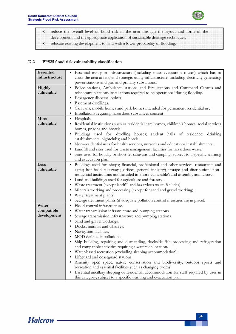
South Somerset District Council Strategic Flood Risk Assessment
84
reduce the overall level of flood risk in the area through the layout and form of the development and the appropriate application of sustainable drainage techniques;
relocate existing development to land with a lower probability of flooding.
D.2 PPS25 flood risk vulnerability classification
Essential infrastructure
• Essential transport infrastructure (including mass evacuation routes) which has to cross the area at risk, and strategic utility infrastructure, including electricity generating power stations and grid and primary substations.
Highly vulnerable
• Police stations, Ambulance stations and Fire stations and Command Centres and telecommunications installations required to be operational during flooding.
• Emergency dispersal points. • Basement dwellings. • Caravans, mobile homes and park homes intended for permanent residential use. • Installations requiring hazardous substances consent
More vulnerable
• Hospitals. • Residential institutions such as residential care homes, children’s homes, social services
homes, prisons and hostels. • Buildings used for: dwelling houses; student halls of residence; drinking
establishments; nightclubs; and hotels. • Non–residential uses for health services, nurseries and educational establishments. • Landfill and sites used for waste management facilities for hazardous waste. • Sites used for holiday or short-let caravans and camping, subject to a specific warning
and evacuation plan. Less vulnerable
• Buildings used for: shops; financial, professional and other services; restaurants and cafes; hot food takeaways; offices; general industry; storage and distribution; non–residential institutions not included in ‘more vulnerable’; and assembly and leisure.
• Land and buildings used for agriculture and forestry. • Waste treatment (except landfill and hazardous waste facilities). • Minerals working and processing (except for sand and gravel working). • Water treatment plants. • Sewage treatment plants (if adequate pollution control measures are in place).
Water-compatible development
• Flood control infrastructure. • Water transmission infrastructure and pumping stations. • Sewage transmission infrastructure and pumping stations. • Sand and gravel workings. • Docks, marinas and wharves. • Navigation facilities. • MOD defence installations. • Ship building, repairing and dismantling, dockside fish processing and refrigeration
and compatible activities requiring a waterside location. • Water-based recreation (excluding sleeping accommodation). • Lifeguard and coastguard stations. • Amenity open space, nature conservation and biodiversity, outdoor sports and
recreation and essential facilities such as changing rooms. • Essential ancillary sleeping or residential accommodation for staff required by uses in
this category, subject to a specific warning and evacuation plan.
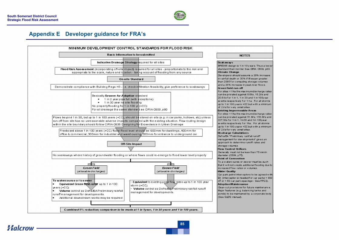
South Somerset District Council Strategic Flood Risk Assessment
85
Appendix E Developer guidance for FRA’s

South Somerset District Council Strategic Flood Risk Assessment
86
The FRA pro-forma contained in Appendix C of the Planning Policy Statement 25: Development and Flood Risk Developer Guide (2008) should be completed and submitted with the planning application for developments for which a FRA is required. Further guidance on completing this form is provided in both Appendix C of the developer guide and below. SURFACE WATER MANAGEMENT – CALCULATION & DRAWING REQUIREMENTS Purpose: The following calculations and drawings should be submitted to help developers demonstrate that they are complying with latest guidance on managing surface water run-off: 1) General Drainage Information A summary sheet (1 page max) showing the global variables which have been used in the design of the surface water sewerage system. For South Somerset, the following values are typical: M5_60 = 18.6mm, Ratio_R = 0.353, Cv (Summer) = 0.750, Cv (Winter) = 0.840. Note: The values of Cv may be increased by 20% or 30%, as appropriate, to model the effects of climate change, if there is not other provision in the developer’s software. Pipe roughness: As per Sewers for Adoption guideline values. The Following Key Data must be provided: (a) The total impermeable area of the whole development (b) The existing impermeable area and the allowable peak discharge from the site. (See page 1) (c) The total volume of attenuation storage which will be provided both above and below ground. Provide a drawing showing a schematic of the drainage layout, with all pipes, manholes, ponds, etc clearly numbered or referenced to the model output.
On-site standards
2) No surcharge up to 1 in 2 year return period Provide a summary sheet demonstrating compliance 3) No flooding up to 1 in 30 year return period Provide a summary sheet demonstrating compliance
Off-site standards
4) Maximum discharge Provide results of peak flow from site, which must be < allowable discharge 5) No additional run-off from site up to 1 in 100 years + climate change Provide results showing the peak water level in any ponds, or tank (and hence volume). Provide a drawing showing the size and location of all the attenuation storage provided. Where attenuation storage is located above ground, provide details of finished ground levels and demonstrate flood pathways to the storage areas.
Note: There is no need to provide reams of hydraulic calculations. There is a need to demonstrate compliance with the parameters given in Minimum Development Control Standards for Flood Risk, which are based on the provisions of PPS25.
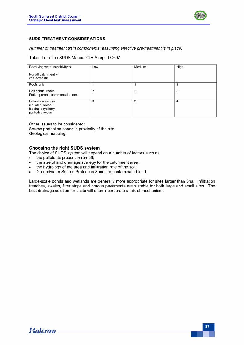
South Somerset District Council Strategic Flood Risk Assessment
87
SUDS TREATMENT CONSIDERATIONS Number of treatment train components (assuming effective pre-treatment is in place) Taken from The SUDS Manual CIRIA report C697 Receiving water sensitivity Runoff catchment characteristic
Low Medium High
Roofs only 1 1 1
Residential roads, Parking areas, commercial zones
2 2 3
Refuse collection/ industrial areas/ loading bays/lorry parks/highways
3 3 4
Other issues to be considered: Source protection zones in proximity of the site Geological mapping Choosing the right SUDS system The choice of SUDS system will depend on a number of factors such as: • the pollutants present in run-off; • the size of and drainage strategy for the catchment area; • the hydrology of the area and infiltration rate of the soil; • Groundwater Source Protection Zones or contaminated land. Large-scale ponds and wetlands are generally more appropriate for sites larger than 5ha. Infiltration trenches, swales, filter strips and porous pavements are suitable for both large and small sites. The best drainage solution for a site will often incorporate a mix of mechanisms.

South Somerset District Council Strategic Flood Risk Assessment
88
South Somerset District Council Strategic Flood Risk Assessment
89
Appendix F Flood Warning
The Environment Agency is the lead organisation on flood warning and its key responsibilities include direct remedial action to prevent and mitigate the effects of an incident, to provide specialist advice, to give warnings to those likely to be affected, to monitor the effects of an incident and to investigate its causes. Effective flood warning requires that the Environment Agency, local authorities and the emergency serves to work together to protect people and properties.
It is the responsibility of the Environment Agency to issue flood warnings to the Police, Fire and Rescue Service, to the relevant local authorities, to the public and to the flood wardens. The primary method of warning dissemination to the public is via Floodline Warnings Direct (FWD), which uses various means of communication (telephone, mobile, fax or pager) to inform people of warnings.
A flood warning system is in operation for the majority of main rivers within the District. There are four levels of warnings, as outlined below.
Flood Watch Flooding of low lying land and roads is expected. Be aware, be prepared, watch out! The following actions are recommended: - Watch water levels - Stay tuned to local radio or TV - Ring Floodline on 0845 988 1188 - Make sure you have what you need to put your flood plan into action - Alert your neighbours, particularly the elderly - Check pets and livestock - Reconsider travel plans
Flood Watch Areas cover all main rivers within the District. Flood Watches are issued for expected flooding, which could occur anywhere within the Flood Watch Area but with low or minor impact. The trigger for Flood Watch is a forecast that flooding of low impact land is expected.
Flood Warning Flooding of homes and businesses is expected. Act now! The following actions, in addition to those associated with Flood Watch, are recommended: - Move pets, vehicles, food, valuables and other items to safety - Put sandbags or floodboards in place - Prepare to turn off gas and electricity - Be prepared to evacuate your home - Protect yourself, your family and others that need your help
The Flood Warning Areas are shown in the Overview Map (Volume II).
Severe Flood Warning Severe flooding is expected. There is extreme danger to life and property. Act now! The following actions, in addition to those associated with Flood Warning, are recommended:
- Be prepared to lose power supplies - gas, electricity, water, telephone - Try to keep calm, and to reassure others, especially children - Co-operate with emergency services and local authorities - You may be evacuated
Severe flood warnings are issued for the areas defined by the Flood Warning Areas.
South Somerset District Council Strategic Flood Risk Assessment
90
All Clear Flood Watches or Warnings are no longer in force. The following is recommended
- Flood water levels receding - Check all is safe to return - Seek advice
Flood response plan
Emergency planning is set out in the Flood Warning and Response Plan of the Somerset Local Authorities Civil Contingencies Unit (October 2006). The Major Incident Plan (MIP), as it is known, details measures that should be taken by the various organisations involved. The most vulnerable areas within South Somerset are covered by MIPs.
When a flood warning is issued for these areas, preliminary preparations are made for activation of the MIP. If this warning is upgraded to a severe flood warning, a major incident will be declared and the MIP will be activated. All responding organisations will be required to send a representative to the Incident Control Centre to assist with the management of the event.
It is recommended that the Major Incident Plan is reviewed and updated if necessary in light of the findings of the SFRA to ensure both the safe evacuation of people at risk and access for emergency services during flood events. This should be done for existing developments and those being promoted as possible sites within the LDF process.
It is further recommended that the local authorities work with the Environment Agency to promote the awareness of flood risk to maximise the number of people signed up to the FWD service (previously this has involved targeted mail shots to those identified as living within Flood Zone 3a). Particular attention should be given to vulnerable people including those with impaired hearing or sight and those with restricted mobility.
With respect to new developments, those proposing the development should take advice from the LPAs emergency planning officer and for large-scale developments, the emergency services, when producing an evacuation plan as part of a FRA. As a minimum, these plans should include information on:
How flood warning is to be provided - Availability of existing warning systems - Rate of onset of flooding and available warning time - Method of dissemination of flood warning
What will be done to protect the infrastructure and contents - How more easily damaged items could be relocated - The potential time taken to respond to a flood warning - Ensuring safe occupancy and access to and from the development - Occupant awareness of the potential frequency and duration of flood events - Provision of safe (i.e. dry) access to and from the development - Ability to maintain key services during an event - Vulnerability of occupants and whether rescue by emergency services is necessary and feasible - Expected time taken to re-establish normal practices following a flood event
In some areas, particularly for existing properties and proposed developments behind defences, it may be necessary to extend the scope of the SFRA to Level 2. The outputs from detailed overtopping and breach analysis of the key defences will provide refined hazard information on flood depths, velocities and flow paths, which could be used by the LPA emergency planning teams to define new or refine existing emergency plans for these areas.
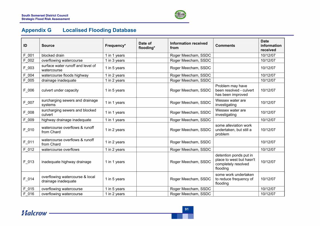
South Somerset District Council Strategic Flood Risk Assessment
91
Appendix G Localised Flooding Database
ID Source Frequency* Date of flooding*
Information received from Comments
Date information received
F_001 blocked drain 1 in 1 years Roger Meecham, SSDC 10/12/07 F_002 overflowing watercourse 1 in 3 years Roger Meecham, SSDC 10/12/07
F_003 surface water runoff and level of watercourse 1 in 5 years Roger Meecham, SSDC 10/12/07
F_004 watercourse floods highway 1 in 2 years Roger Meecham, SSDC 10/12/07 F_005 drainage inadequate 1 in 2 years Roger Meecham, SSDC 10/12/07
F_006 culvert under capacity 1 in 5 years Roger Meecham, SSDC Problem may have been resolved - culvert has been improved
10/12/07
F_007 surcharging sewers and drainage systems 1 in 1 years Roger Meecham, SSDC Wessex water are
investigating 10/12/07
F_008 surcharging sewers and blocked culvert 1 in 1 years Roger Meecham, SSDC Wessex water are
investigating 10/12/07
F_009 highway drainage inadequate 1 in 1 years Roger Meecham, SSDC 10/12/07
F_010 watercourse overflows & runoff from Chard 1 in 2 years Roger Meecham, SSDC
some alleviation work undertaken, but still a problem
10/12/07
F_011 watercourse overflows & runoff from Chard 1 in 2 years Roger Meecham, SSDC 10/12/07
F_012 watercourse overflows 1 in 2 years Roger Meecham, SSDC 10/12/07
F_013 inadequate highway drainage 1 in 1 years Roger Meecham, SSDC
detention ponds put in place to west but hasn't completely resolved flooding
10/12/07
F_014 overflowing watercourse & local drainage inadequate 1 in 5 years Roger Meecham, SSDC
some work undertaken to reduce frequency of flooding
10/12/07
F_015 overflowing watercourse 1 in 5 years Roger Meecham, SSDC 10/12/07 F_016 overflowing watercourse 1 in 2 years Roger Meecham, SSDC 10/12/07
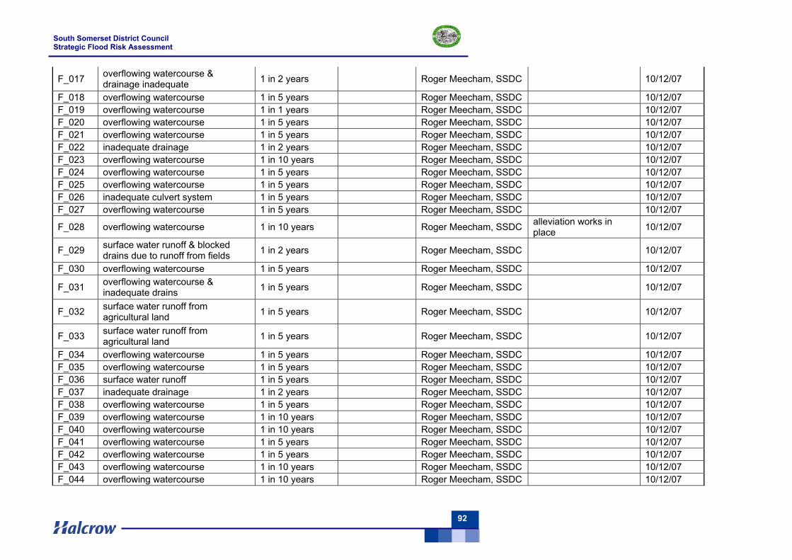
South Somerset District Council Strategic Flood Risk Assessment
92
F_017 overflowing watercourse & drainage inadequate 1 in 2 years Roger Meecham, SSDC 10/12/07
F_018 overflowing watercourse 1 in 5 years Roger Meecham, SSDC 10/12/07 F_019 overflowing watercourse 1 in 1 years Roger Meecham, SSDC 10/12/07 F_020 overflowing watercourse 1 in 5 years Roger Meecham, SSDC 10/12/07 F_021 overflowing watercourse 1 in 5 years Roger Meecham, SSDC 10/12/07 F_022 inadequate drainage 1 in 2 years Roger Meecham, SSDC 10/12/07 F_023 overflowing watercourse 1 in 10 years Roger Meecham, SSDC 10/12/07 F_024 overflowing watercourse 1 in 5 years Roger Meecham, SSDC 10/12/07 F_025 overflowing watercourse 1 in 5 years Roger Meecham, SSDC 10/12/07 F_026 inadequate culvert system 1 in 5 years Roger Meecham, SSDC 10/12/07 F_027 overflowing watercourse 1 in 5 years Roger Meecham, SSDC 10/12/07
F_028 overflowing watercourse 1 in 10 years Roger Meecham, SSDC alleviation works in place 10/12/07
F_029 surface water runoff & blocked drains due to runoff from fields 1 in 2 years Roger Meecham, SSDC 10/12/07
F_030 overflowing watercourse 1 in 5 years Roger Meecham, SSDC 10/12/07
F_031 overflowing watercourse & inadequate drains 1 in 5 years Roger Meecham, SSDC 10/12/07
F_032 surface water runoff from agricultural land 1 in 5 years Roger Meecham, SSDC 10/12/07
F_033 surface water runoff from agricultural land 1 in 5 years Roger Meecham, SSDC 10/12/07
F_034 overflowing watercourse 1 in 5 years Roger Meecham, SSDC 10/12/07 F_035 overflowing watercourse 1 in 5 years Roger Meecham, SSDC 10/12/07 F_036 surface water runoff 1 in 5 years Roger Meecham, SSDC 10/12/07 F_037 inadequate drainage 1 in 2 years Roger Meecham, SSDC 10/12/07 F_038 overflowing watercourse 1 in 5 years Roger Meecham, SSDC 10/12/07 F_039 overflowing watercourse 1 in 10 years Roger Meecham, SSDC 10/12/07 F_040 overflowing watercourse 1 in 10 years Roger Meecham, SSDC 10/12/07 F_041 overflowing watercourse 1 in 5 years Roger Meecham, SSDC 10/12/07 F_042 overflowing watercourse 1 in 5 years Roger Meecham, SSDC 10/12/07 F_043 overflowing watercourse 1 in 10 years Roger Meecham, SSDC 10/12/07 F_044 overflowing watercourse 1 in 10 years Roger Meecham, SSDC 10/12/07
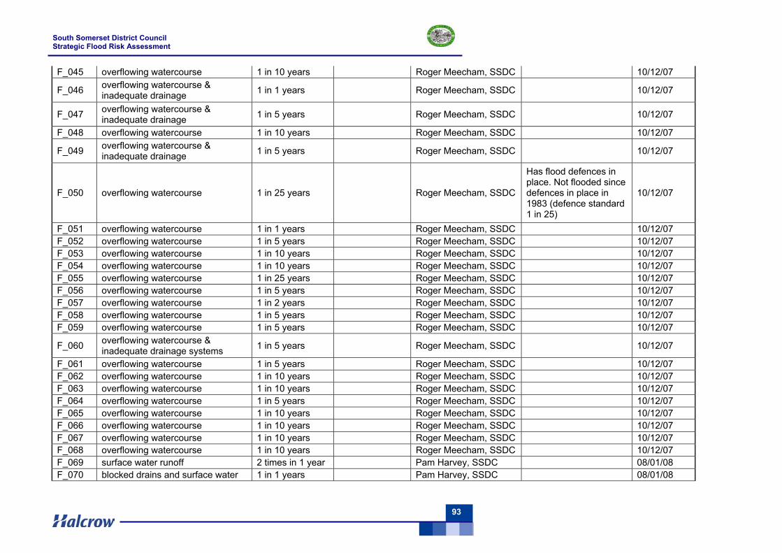
South Somerset District Council Strategic Flood Risk Assessment
93
F_045 overflowing watercourse 1 in 10 years Roger Meecham, SSDC 10/12/07
F_046 overflowing watercourse & inadequate drainage 1 in 1 years Roger Meecham, SSDC 10/12/07
F_047 overflowing watercourse & inadequate drainage 1 in 5 years Roger Meecham, SSDC 10/12/07
F_048 overflowing watercourse 1 in 10 years Roger Meecham, SSDC 10/12/07
F_049 overflowing watercourse & inadequate drainage 1 in 5 years Roger Meecham, SSDC 10/12/07
F_050 overflowing watercourse 1 in 25 years Roger Meecham, SSDC
Has flood defences in place. Not flooded since defences in place in 1983 (defence standard 1 in 25)
10/12/07
F_051 overflowing watercourse 1 in 1 years Roger Meecham, SSDC 10/12/07 F_052 overflowing watercourse 1 in 5 years Roger Meecham, SSDC 10/12/07 F_053 overflowing watercourse 1 in 10 years Roger Meecham, SSDC 10/12/07 F_054 overflowing watercourse 1 in 10 years Roger Meecham, SSDC 10/12/07 F_055 overflowing watercourse 1 in 25 years Roger Meecham, SSDC 10/12/07 F_056 overflowing watercourse 1 in 5 years Roger Meecham, SSDC 10/12/07 F_057 overflowing watercourse 1 in 2 years Roger Meecham, SSDC 10/12/07 F_058 overflowing watercourse 1 in 5 years Roger Meecham, SSDC 10/12/07 F_059 overflowing watercourse 1 in 5 years Roger Meecham, SSDC 10/12/07
F_060 overflowing watercourse & inadequate drainage systems 1 in 5 years Roger Meecham, SSDC 10/12/07
F_061 overflowing watercourse 1 in 5 years Roger Meecham, SSDC 10/12/07 F_062 overflowing watercourse 1 in 10 years Roger Meecham, SSDC 10/12/07 F_063 overflowing watercourse 1 in 10 years Roger Meecham, SSDC 10/12/07 F_064 overflowing watercourse 1 in 5 years Roger Meecham, SSDC 10/12/07 F_065 overflowing watercourse 1 in 10 years Roger Meecham, SSDC 10/12/07 F_066 overflowing watercourse 1 in 10 years Roger Meecham, SSDC 10/12/07 F_067 overflowing watercourse 1 in 10 years Roger Meecham, SSDC 10/12/07 F_068 overflowing watercourse 1 in 10 years Roger Meecham, SSDC 10/12/07 F_069 surface water runoff 2 times in 1 year Pam Harvey, SSDC 08/01/08 F_070 blocked drains and surface water 1 in 1 years Pam Harvey, SSDC 08/01/08
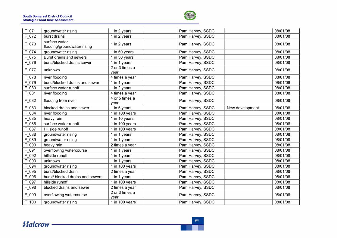
South Somerset District Council Strategic Flood Risk Assessment
94
F_071 groundwater rising 1 in 2 years Pam Harvey, SSDC 08/01/08 F_072 burst drains 1 in 2 years Pam Harvey, SSDC 08/01/08
F_073 surface water flooding/groundwater rising 1 in 2 years Pam Harvey, SSDC 08/01/08
F_074 groundwater rising 1 in 50 years Pam Harvey, SSDC 08/01/08 F_075 Burst drains and sewers 1 in 50 years Pam Harvey, SSDC 08/01/08 F_076 burst/blocked drains sewer 1 in 1 years Pam Harvey, SSDC 08/01/08
F_077 unknown 2 or 3 times a year Pam Harvey, SSDC 08/01/08
F_078 river flooding 4 times a year Pam Harvey, SSDC 08/01/08 F_079 burst/blocked drains and sewer 1 in 1 years Pam Harvey, SSDC 08/01/08 F_080 surface water runoff 1 in 2 years Pam Harvey, SSDC 08/01/08 F_081 river flooding 4 times a year Pam Harvey, SSDC 08/01/08
F_082 flooding from river 4 or 5 times a year Pam Harvey, SSDC 08/01/08
F_083 blocked drains and sewer 1 in 5 years Pam Harvey, SSDC New development 08/01/08 F_084 river flooding 1 in 100 years Pam Harvey, SSDC 08/01/08 F_085 heavy rain 1 in 10 years Pam Harvey, SSDC 08/01/08 F_086 surface water runoff 1 in 100 years Pam Harvey, SSDC 08/01/08 F_087 Hillside runoff 1 in 100 years Pam Harvey, SSDC 08/01/08 F_088 groundwater rising 1 in 1 years Pam Harvey, SSDC 08/01/08 F_089 groundwater rising 1 in 1 years Pam Harvey, SSDC 08/01/08 F_090 heavy rain 2 times a year Pam Harvey, SSDC 08/01/08 F_091 overflowing watercourse 1 in 1 years Pam Harvey, SSDC 08/01/08 F_092 hillside runoff 1 in 1 years Pam Harvey, SSDC 08/01/08 F_093 unknown 1 in 1 years Pam Harvey, SSDC 08/01/08 F_094 groundwater rising 1 in 100 years Pam Harvey, SSDC 08/01/08 F_095 burst/blocked drain 2 times a year Pam Harvey, SSDC 08/01/08 F_096 burst/ blocked drains and sewers 1 in 1 years Pam Harvey, SSDC 08/01/08 F_097 hillside runoff 1 in 100 years Pam Harvey, SSDC 08/01/08 F_098 blocked drains and sewer 2 times a year Pam Harvey, SSDC 08/01/08
F_099 overflowing watercourse 2 or 3 times a year Pam Harvey, SSDC 08/01/08
F_100 groundwater rising 1 in 100 years Pam Harvey, SSDC 08/01/08
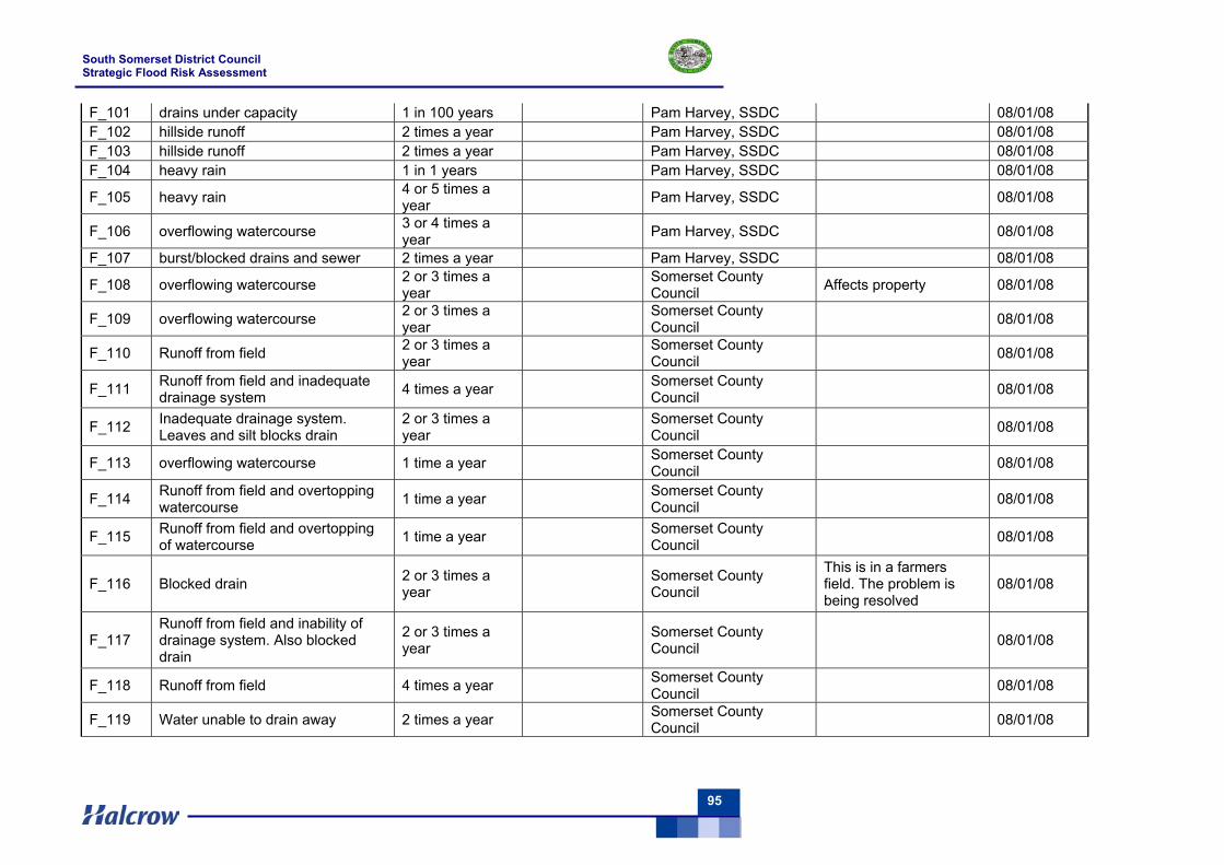
South Somerset District Council Strategic Flood Risk Assessment
95
F_101 drains under capacity 1 in 100 years Pam Harvey, SSDC 08/01/08 F_102 hillside runoff 2 times a year Pam Harvey, SSDC 08/01/08 F_103 hillside runoff 2 times a year Pam Harvey, SSDC 08/01/08 F_104 heavy rain 1 in 1 years Pam Harvey, SSDC 08/01/08
F_105 heavy rain 4 or 5 times a year Pam Harvey, SSDC 08/01/08
F_106 overflowing watercourse 3 or 4 times a year Pam Harvey, SSDC 08/01/08
F_107 burst/blocked drains and sewer 2 times a year Pam Harvey, SSDC 08/01/08
F_108 overflowing watercourse 2 or 3 times a year Somerset County
Council Affects property 08/01/08
F_109 overflowing watercourse 2 or 3 times a year Somerset County
Council 08/01/08
F_110 Runoff from field 2 or 3 times a year Somerset County
Council 08/01/08
F_111 Runoff from field and inadequate drainage system 4 times a year Somerset County
Council 08/01/08
F_112 Inadequate drainage system. Leaves and silt blocks drain
2 or 3 times a year Somerset County
Council 08/01/08
F_113 overflowing watercourse 1 time a year Somerset County Council 08/01/08
F_114 Runoff from field and overtopping watercourse 1 time a year Somerset County
Council 08/01/08
F_115 Runoff from field and overtopping of watercourse 1 time a year Somerset County
Council 08/01/08
F_116 Blocked drain 2 or 3 times a year Somerset County
Council
This is in a farmers field. The problem is being resolved
08/01/08
F_117 Runoff from field and inability of drainage system. Also blocked drain
2 or 3 times a year Somerset County
Council 08/01/08
F_118 Runoff from field 4 times a year Somerset County Council 08/01/08
F_119 Water unable to drain away 2 times a year Somerset County Council 08/01/08
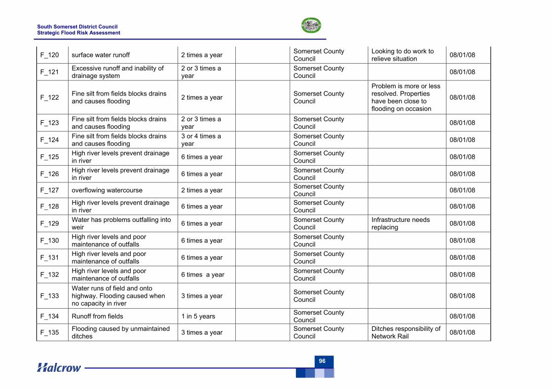
South Somerset District Council Strategic Flood Risk Assessment
96
F_120 surface water runoff 2 times a year Somerset County Council
Looking to do work to relieve situation 08/01/08
F_121 Excessive runoff and inability of drainage system
2 or 3 times a year Somerset County
Council 08/01/08
F_122 Fine silt from fields blocks drains and causes flooding 2 times a year Somerset County
Council
Problem is more or less resolved. Properties have been close to flooding on occasion
08/01/08
F_123 Fine silt from fields blocks drains and causes flooding
2 or 3 times a year Somerset County
Council 08/01/08
F_124 Fine silt from fields blocks drains and causes flooding
3 or 4 times a year Somerset County
Council 08/01/08
F_125 High river levels prevent drainage in river 6 times a year Somerset County
Council 08/01/08
F_126 High river levels prevent drainage in river 6 times a year Somerset County
Council 08/01/08
F_127 overflowing watercourse 2 times a year Somerset County Council 08/01/08
F_128 High river levels prevent drainage in river 6 times a year Somerset County
Council 08/01/08
F_129 Water has problems outfalling into weir 6 times a year Somerset County
Council Infrastructure needs replacing 08/01/08
F_130 High river levels and poor maintenance of outfalls 6 times a year Somerset County
Council 08/01/08
F_131 High river levels and poor maintenance of outfalls 6 times a year Somerset County
Council 08/01/08
F_132 High river levels and poor maintenance of outfalls 6 times a year Somerset County
Council 08/01/08
F_133 Water runs of field and onto highway. Flooding caused when no capacity in river
3 times a year Somerset County Council 08/01/08
F_134 Runoff from fields 1 in 5 years Somerset County Council 08/01/08
F_135 Flooding caused by unmaintained ditches 3 times a year Somerset County
Council Ditches responsibility of Network Rail 08/01/08
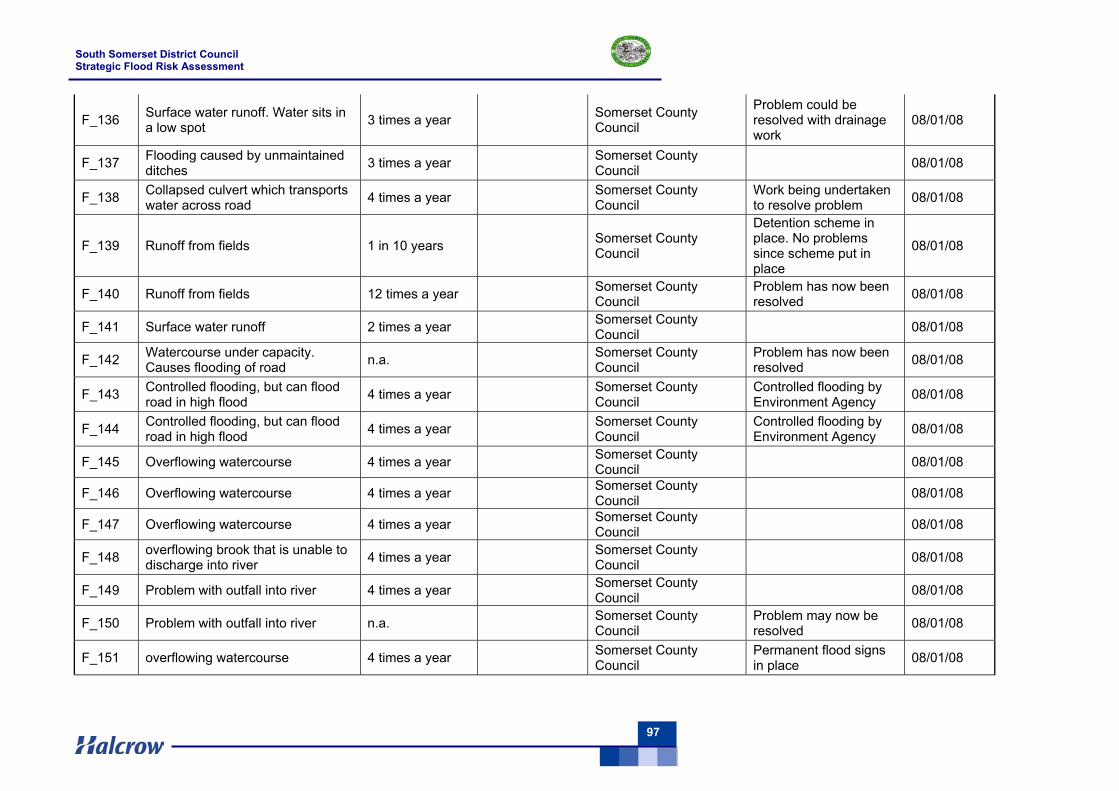
South Somerset District Council Strategic Flood Risk Assessment
97
F_136 Surface water runoff. Water sits in a low spot 3 times a year Somerset County
Council
Problem could be resolved with drainage work
08/01/08
F_137 Flooding caused by unmaintained ditches 3 times a year Somerset County
Council 08/01/08
F_138 Collapsed culvert which transports water across road 4 times a year Somerset County
Council Work being undertaken to resolve problem 08/01/08
F_139 Runoff from fields 1 in 10 years Somerset County Council
Detention scheme in place. No problems since scheme put in place
08/01/08
F_140 Runoff from fields 12 times a year Somerset County Council
Problem has now been resolved 08/01/08
F_141 Surface water runoff 2 times a year Somerset County Council 08/01/08
F_142 Watercourse under capacity. Causes flooding of road n.a. Somerset County
Council Problem has now been resolved 08/01/08
F_143 Controlled flooding, but can flood road in high flood 4 times a year Somerset County
Council Controlled flooding by Environment Agency 08/01/08
F_144 Controlled flooding, but can flood road in high flood 4 times a year Somerset County
Council Controlled flooding by Environment Agency 08/01/08
F_145 Overflowing watercourse 4 times a year Somerset County Council 08/01/08
F_146 Overflowing watercourse 4 times a year Somerset County Council 08/01/08
F_147 Overflowing watercourse 4 times a year Somerset County Council 08/01/08
F_148 overflowing brook that is unable to discharge into river 4 times a year Somerset County
Council 08/01/08
F_149 Problem with outfall into river 4 times a year Somerset County Council 08/01/08
F_150 Problem with outfall into river n.a. Somerset County Council
Problem may now be resolved 08/01/08
F_151 overflowing watercourse 4 times a year Somerset County Council
Permanent flood signs in place 08/01/08
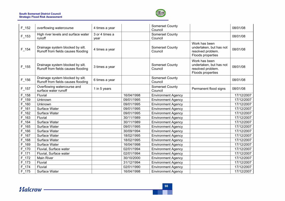
South Somerset District Council Strategic Flood Risk Assessment
98
F_152 overflowing watercourse 4 times a year Somerset County Council 08/01/08
F_153 High river levels and surface water runoff
3 or 4 times a year Somerset County
Council 08/01/08
F_154 Drainage system blocked by silt. Runoff from fields causes flooding 4 times a year Somerset County
Council
Work has been undertaken, but has not resolved problem. Floods properties
08/01/08
F_155 Drainage system blocked by silt. Runoff from fields causes flooding 3 times a year Somerset County
Council
Work has been undertaken, but has not resolved problem. Floods properties
08/01/08
F_156 Drainage system blocked by silt. Runoff from fields causes flooding 6 times a year Somerset County
Council 08/01/08
F_157 Overflowing watercourse and surface water runoff 1 in 5 years Somerset County
Council Permanent flood signs 08/01/08
F_158 Fluvial 16/04/1998 Environment Agency 17/12/2007 F_159 Unknown 09/01/1995 Environment Agency 17/12/2007 F_160 Unknown 09/01/1995 Environment Agency 17/12/2007 F_161 Surface Water 09/01/1995 Environment Agency 17/12/2007 F_162 Surface Water 09/01/1995 Environment Agency 17/12/2007 F_163 Fluvial 30/11/1989 Environment Agency 17/12/2007 F_164 Surface Water 30/11/1989 Environment Agency 17/12/2007 F_165 Surface Water 09/01/1995 Environment Agency 17/12/2007 F_166 Surface Water 30/09/1994 Environment Agency 17/12/2007 F_167 Surface Water 18/02/1995 Environment Agency 17/12/2007 F_168 Surface Water 18/02/1995 Environment Agency 17/12/2007 F_169 Surface Water 16/04/1998 Environment Agency 17/12/2007 F_170 Fluvial, Surface water 02/01/1994 Environment Agency 17/12/2007 F_171 Fluvial, Surface water 02/01/1994 Environment Agency 17/12/2007 F_172 Main River 30/10/2000 Environment Agency 17/12/2007 F_173 Fluvial 31/12/1994 Environment Agency 17/12/2007 F_174 Fluvial 02/01/1990 Environment Agency 17/12/2007 F_175 Surface Water 16/04/1998 Environment Agency 17/12/2007
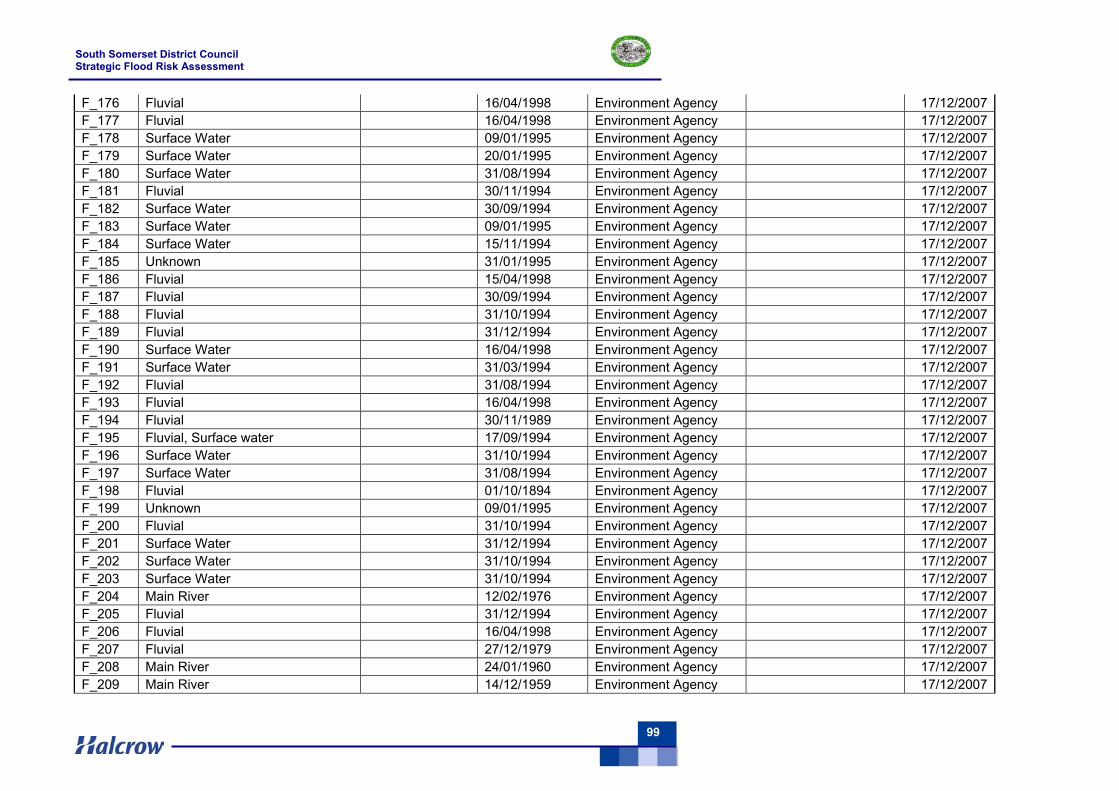
South Somerset District Council Strategic Flood Risk Assessment
99
F_176 Fluvial 16/04/1998 Environment Agency 17/12/2007 F_177 Fluvial 16/04/1998 Environment Agency 17/12/2007 F_178 Surface Water 09/01/1995 Environment Agency 17/12/2007 F_179 Surface Water 20/01/1995 Environment Agency 17/12/2007 F_180 Surface Water 31/08/1994 Environment Agency 17/12/2007 F_181 Fluvial 30/11/1994 Environment Agency 17/12/2007 F_182 Surface Water 30/09/1994 Environment Agency 17/12/2007 F_183 Surface Water 09/01/1995 Environment Agency 17/12/2007 F_184 Surface Water 15/11/1994 Environment Agency 17/12/2007 F_185 Unknown 31/01/1995 Environment Agency 17/12/2007 F_186 Fluvial 15/04/1998 Environment Agency 17/12/2007 F_187 Fluvial 30/09/1994 Environment Agency 17/12/2007 F_188 Fluvial 31/10/1994 Environment Agency 17/12/2007 F_189 Fluvial 31/12/1994 Environment Agency 17/12/2007 F_190 Surface Water 16/04/1998 Environment Agency 17/12/2007 F_191 Surface Water 31/03/1994 Environment Agency 17/12/2007 F_192 Fluvial 31/08/1994 Environment Agency 17/12/2007 F_193 Fluvial 16/04/1998 Environment Agency 17/12/2007 F_194 Fluvial 30/11/1989 Environment Agency 17/12/2007 F_195 Fluvial, Surface water 17/09/1994 Environment Agency 17/12/2007 F_196 Surface Water 31/10/1994 Environment Agency 17/12/2007 F_197 Surface Water 31/08/1994 Environment Agency 17/12/2007 F_198 Fluvial 01/10/1894 Environment Agency 17/12/2007 F_199 Unknown 09/01/1995 Environment Agency 17/12/2007 F_200 Fluvial 31/10/1994 Environment Agency 17/12/2007 F_201 Surface Water 31/12/1994 Environment Agency 17/12/2007 F_202 Surface Water 31/10/1994 Environment Agency 17/12/2007 F_203 Surface Water 31/10/1994 Environment Agency 17/12/2007 F_204 Main River 12/02/1976 Environment Agency 17/12/2007 F_205 Fluvial 31/12/1994 Environment Agency 17/12/2007 F_206 Fluvial 16/04/1998 Environment Agency 17/12/2007 F_207 Fluvial 27/12/1979 Environment Agency 17/12/2007 F_208 Main River 24/01/1960 Environment Agency 17/12/2007 F_209 Main River 14/12/1959 Environment Agency 17/12/2007
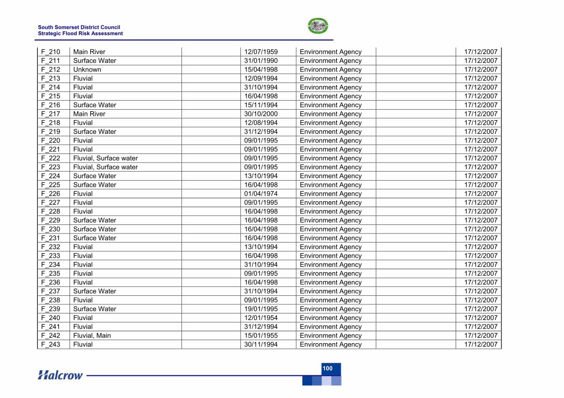
South Somerset District Council Strategic Flood Risk Assessment
100
F_210 Main River 12/07/1959 Environment Agency 17/12/2007 F_211 Surface Water 31/01/1990 Environment Agency 17/12/2007 F_212 Unknown 15/04/1998 Environment Agency 17/12/2007 F_213 Fluvial 12/09/1994 Environment Agency 17/12/2007 F_214 Fluvial 31/10/1994 Environment Agency 17/12/2007 F_215 Fluvial 16/04/1998 Environment Agency 17/12/2007 F_216 Surface Water 15/11/1994 Environment Agency 17/12/2007 F_217 Main River 30/10/2000 Environment Agency 17/12/2007 F_218 Fluvial 12/08/1994 Environment Agency 17/12/2007 F_219 Surface Water 31/12/1994 Environment Agency 17/12/2007 F_220 Fluvial 09/01/1995 Environment Agency 17/12/2007 F_221 Fluvial 09/01/1995 Environment Agency 17/12/2007 F_222 Fluvial, Surface water 09/01/1995 Environment Agency 17/12/2007 F_223 Fluvial, Surface water 09/01/1995 Environment Agency 17/12/2007 F_224 Surface Water 13/10/1994 Environment Agency 17/12/2007 F_225 Surface Water 16/04/1998 Environment Agency 17/12/2007 F_226 Fluvial 01/04/1974 Environment Agency 17/12/2007 F_227 Fluvial 09/01/1995 Environment Agency 17/12/2007 F_228 Fluvial 16/04/1998 Environment Agency 17/12/2007 F_229 Surface Water 16/04/1998 Environment Agency 17/12/2007 F_230 Surface Water 16/04/1998 Environment Agency 17/12/2007 F_231 Surface Water 16/04/1998 Environment Agency 17/12/2007 F_232 Fluvial 13/10/1994 Environment Agency 17/12/2007 F_233 Fluvial 16/04/1998 Environment Agency 17/12/2007 F_234 Fluvial 31/10/1994 Environment Agency 17/12/2007 F_235 Fluvial 09/01/1995 Environment Agency 17/12/2007 F_236 Fluvial 16/04/1998 Environment Agency 17/12/2007 F_237 Surface Water 31/10/1994 Environment Agency 17/12/2007 F_238 Fluvial 09/01/1995 Environment Agency 17/12/2007 F_239 Surface Water 19/01/1995 Environment Agency 17/12/2007 F_240 Fluvial 12/01/1954 Environment Agency 17/12/2007 F_241 Fluvial 31/12/1994 Environment Agency 17/12/2007 F_242 Fluvial, Main 15/01/1955 Environment Agency 17/12/2007 F_243 Fluvial 30/11/1994 Environment Agency 17/12/2007
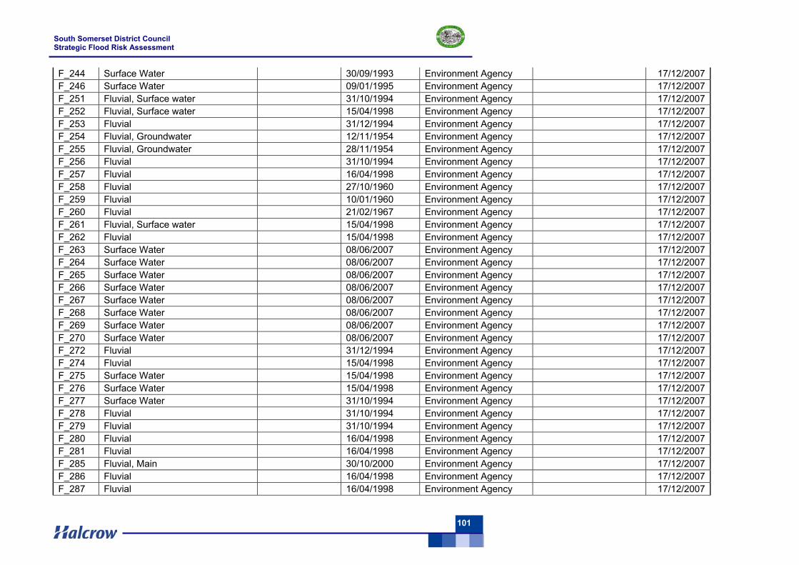
South Somerset District Council Strategic Flood Risk Assessment
101
F_244 Surface Water 30/09/1993 Environment Agency 17/12/2007 F_246 Surface Water 09/01/1995 Environment Agency 17/12/2007 F_251 Fluvial, Surface water 31/10/1994 Environment Agency 17/12/2007 F_252 Fluvial, Surface water 15/04/1998 Environment Agency 17/12/2007 F_253 Fluvial 31/12/1994 Environment Agency 17/12/2007 F_254 Fluvial, Groundwater 12/11/1954 Environment Agency 17/12/2007 F_255 Fluvial, Groundwater 28/11/1954 Environment Agency 17/12/2007 F_256 Fluvial 31/10/1994 Environment Agency 17/12/2007 F_257 Fluvial 16/04/1998 Environment Agency 17/12/2007 F_258 Fluvial 27/10/1960 Environment Agency 17/12/2007 F_259 Fluvial 10/01/1960 Environment Agency 17/12/2007 F_260 Fluvial 21/02/1967 Environment Agency 17/12/2007 F_261 Fluvial, Surface water 15/04/1998 Environment Agency 17/12/2007 F_262 Fluvial 15/04/1998 Environment Agency 17/12/2007 F_263 Surface Water 08/06/2007 Environment Agency 17/12/2007 F_264 Surface Water 08/06/2007 Environment Agency 17/12/2007 F_265 Surface Water 08/06/2007 Environment Agency 17/12/2007 F_266 Surface Water 08/06/2007 Environment Agency 17/12/2007 F_267 Surface Water 08/06/2007 Environment Agency 17/12/2007 F_268 Surface Water 08/06/2007 Environment Agency 17/12/2007 F_269 Surface Water 08/06/2007 Environment Agency 17/12/2007 F_270 Surface Water 08/06/2007 Environment Agency 17/12/2007 F_272 Fluvial 31/12/1994 Environment Agency 17/12/2007 F_274 Fluvial 15/04/1998 Environment Agency 17/12/2007 F_275 Surface Water 15/04/1998 Environment Agency 17/12/2007 F_276 Surface Water 15/04/1998 Environment Agency 17/12/2007 F_277 Surface Water 31/10/1994 Environment Agency 17/12/2007 F_278 Fluvial 31/10/1994 Environment Agency 17/12/2007 F_279 Fluvial 31/10/1994 Environment Agency 17/12/2007 F_280 Fluvial 16/04/1998 Environment Agency 17/12/2007 F_281 Fluvial 16/04/1998 Environment Agency 17/12/2007 F_285 Fluvial, Main 30/10/2000 Environment Agency 17/12/2007 F_286 Fluvial 16/04/1998 Environment Agency 17/12/2007 F_287 Fluvial 16/04/1998 Environment Agency 17/12/2007
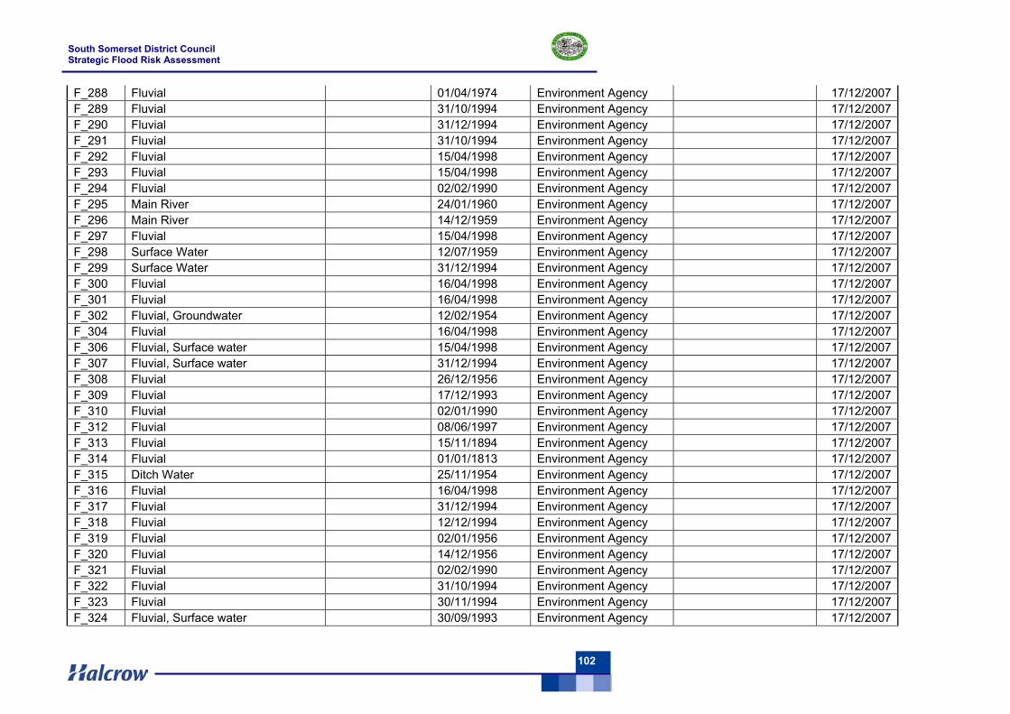
South Somerset District Council Strategic Flood Risk Assessment
102
F_288 Fluvial 01/04/1974 Environment Agency 17/12/2007 F_289 Fluvial 31/10/1994 Environment Agency 17/12/2007 F_290 Fluvial 31/12/1994 Environment Agency 17/12/2007 F_291 Fluvial 31/10/1994 Environment Agency 17/12/2007 F_292 Fluvial 15/04/1998 Environment Agency 17/12/2007 F_293 Fluvial 15/04/1998 Environment Agency 17/12/2007 F_294 Fluvial 02/02/1990 Environment Agency 17/12/2007 F_295 Main River 24/01/1960 Environment Agency 17/12/2007 F_296 Main River 14/12/1959 Environment Agency 17/12/2007 F_297 Fluvial 15/04/1998 Environment Agency 17/12/2007 F_298 Surface Water 12/07/1959 Environment Agency 17/12/2007 F_299 Surface Water 31/12/1994 Environment Agency 17/12/2007 F_300 Fluvial 16/04/1998 Environment Agency 17/12/2007 F_301 Fluvial 16/04/1998 Environment Agency 17/12/2007 F_302 Fluvial, Groundwater 12/02/1954 Environment Agency 17/12/2007 F_304 Fluvial 16/04/1998 Environment Agency 17/12/2007 F_306 Fluvial, Surface water 15/04/1998 Environment Agency 17/12/2007 F_307 Fluvial, Surface water 31/12/1994 Environment Agency 17/12/2007 F_308 Fluvial 26/12/1956 Environment Agency 17/12/2007 F_309 Fluvial 17/12/1993 Environment Agency 17/12/2007 F_310 Fluvial 02/01/1990 Environment Agency 17/12/2007 F_312 Fluvial 08/06/1997 Environment Agency 17/12/2007 F_313 Fluvial 15/11/1894 Environment Agency 17/12/2007 F_314 Fluvial 01/01/1813 Environment Agency 17/12/2007 F_315 Ditch Water 25/11/1954 Environment Agency 17/12/2007 F_316 Fluvial 16/04/1998 Environment Agency 17/12/2007 F_317 Fluvial 31/12/1994 Environment Agency 17/12/2007 F_318 Fluvial 12/12/1994 Environment Agency 17/12/2007 F_319 Fluvial 02/01/1956 Environment Agency 17/12/2007 F_320 Fluvial 14/12/1956 Environment Agency 17/12/2007 F_321 Fluvial 02/02/1990 Environment Agency 17/12/2007 F_322 Fluvial 31/10/1994 Environment Agency 17/12/2007 F_323 Fluvial 30/11/1994 Environment Agency 17/12/2007 F_324 Fluvial, Surface water 30/09/1993 Environment Agency 17/12/2007
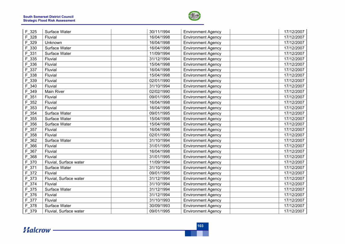
South Somerset District Council Strategic Flood Risk Assessment
103
F_325 Surface Water 30/11/1994 Environment Agency 17/12/2007 F_328 Fluvial 16/04/1998 Environment Agency 17/12/2007 F_329 Unknown 16/04/1998 Environment Agency 17/12/2007 F_330 Surface Water 16/04/1998 Environment Agency 17/12/2007 F_331 Surface Water 11/09/1994 Environment Agency 17/12/2007 F_335 Fluvial 31/12/1994 Environment Agency 17/12/2007 F_336 Fluvial 15/04/1998 Environment Agency 17/12/2007 F_337 Fluvial 16/04/1998 Environment Agency 17/12/2007 F_338 Fluvial 15/04/1998 Environment Agency 17/12/2007 F_339 Fluvial 02/01/1990 Environment Agency 17/12/2007 F_340 Fluvial 31/10/1994 Environment Agency 17/12/2007 F_349 Main River 02/02/1990 Environment Agency 17/12/2007 F_351 Fluvial 09/01/1995 Environment Agency 17/12/2007 F_352 Fluvial 16/04/1998 Environment Agency 17/12/2007 F_353 Fluvial 16/04/1998 Environment Agency 17/12/2007 F_354 Surface Water 09/01/1995 Environment Agency 17/12/2007 F_355 Surface Water 15/04/1998 Environment Agency 17/12/2007 F_356 Surface Water 15/04/1998 Environment Agency 17/12/2007 F_357 Fluvial 16/04/1998 Environment Agency 17/12/2007 F_358 Fluvial 02/01/1990 Environment Agency 17/12/2007 F_362 Surface Water 31/10/1994 Environment Agency 17/12/2007 F_366 Fluvial 31/01/1995 Environment Agency 17/12/2007 F_367 Fluvial 16/04/1998 Environment Agency 17/12/2007 F_368 Fluvial 31/01/1995 Environment Agency 17/12/2007 F_370 Fluvial, Surface water 11/09/1994 Environment Agency 17/12/2007 F_371 Surface Water 31/10/1994 Environment Agency 17/12/2007 F_372 Fluvial 09/01/1995 Environment Agency 17/12/2007 F_373 Fluvial, Surface water 31/12/1994 Environment Agency 17/12/2007 F_374 Fluvial 31/10/1994 Environment Agency 17/12/2007 F_375 Surface Water 31/12/1994 Environment Agency 17/12/2007 F_376 Fluvial 31/12/1994 Environment Agency 17/12/2007 F_377 Fluvial 31/10/1993 Environment Agency 17/12/2007 F_378 Surface Water 30/09/1993 Environment Agency 17/12/2007 F_379 Fluvial, Surface water 09/01/1995 Environment Agency 17/12/2007
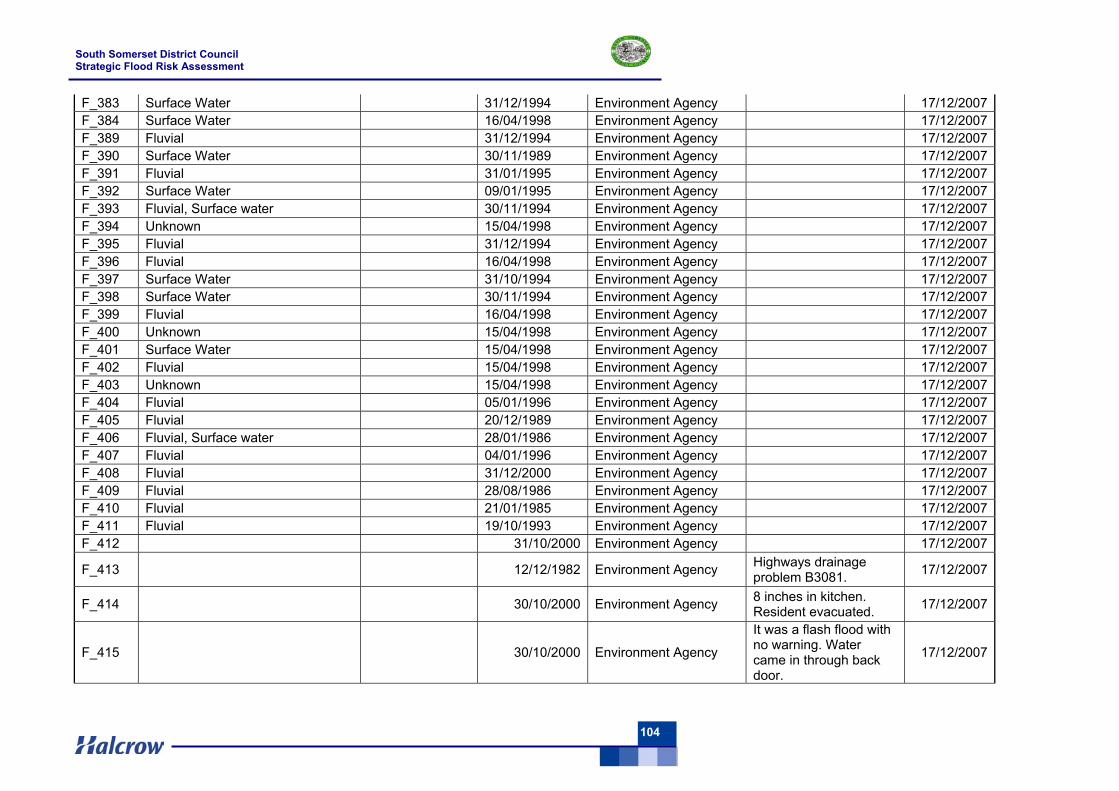
South Somerset District Council Strategic Flood Risk Assessment
104
F_383 Surface Water 31/12/1994 Environment Agency 17/12/2007 F_384 Surface Water 16/04/1998 Environment Agency 17/12/2007 F_389 Fluvial 31/12/1994 Environment Agency 17/12/2007 F_390 Surface Water 30/11/1989 Environment Agency 17/12/2007 F_391 Fluvial 31/01/1995 Environment Agency 17/12/2007 F_392 Surface Water 09/01/1995 Environment Agency 17/12/2007 F_393 Fluvial, Surface water 30/11/1994 Environment Agency 17/12/2007 F_394 Unknown 15/04/1998 Environment Agency 17/12/2007 F_395 Fluvial 31/12/1994 Environment Agency 17/12/2007 F_396 Fluvial 16/04/1998 Environment Agency 17/12/2007 F_397 Surface Water 31/10/1994 Environment Agency 17/12/2007 F_398 Surface Water 30/11/1994 Environment Agency 17/12/2007 F_399 Fluvial 16/04/1998 Environment Agency 17/12/2007 F_400 Unknown 15/04/1998 Environment Agency 17/12/2007 F_401 Surface Water 15/04/1998 Environment Agency 17/12/2007 F_402 Fluvial 15/04/1998 Environment Agency 17/12/2007 F_403 Unknown 15/04/1998 Environment Agency 17/12/2007 F_404 Fluvial 05/01/1996 Environment Agency 17/12/2007 F_405 Fluvial 20/12/1989 Environment Agency 17/12/2007 F_406 Fluvial, Surface water 28/01/1986 Environment Agency 17/12/2007 F_407 Fluvial 04/01/1996 Environment Agency 17/12/2007 F_408 Fluvial 31/12/2000 Environment Agency 17/12/2007 F_409 Fluvial 28/08/1986 Environment Agency 17/12/2007 F_410 Fluvial 21/01/1985 Environment Agency 17/12/2007 F_411 Fluvial 19/10/1993 Environment Agency 17/12/2007 F_412 31/10/2000 Environment Agency 17/12/2007
F_413 12/12/1982 Environment Agency Highways drainage problem B3081. 17/12/2007
F_414 30/10/2000 Environment Agency 8 inches in kitchen. Resident evacuated. 17/12/2007
F_415 30/10/2000 Environment Agency
It was a flash flood with no warning. Water came in through back door.
17/12/2007
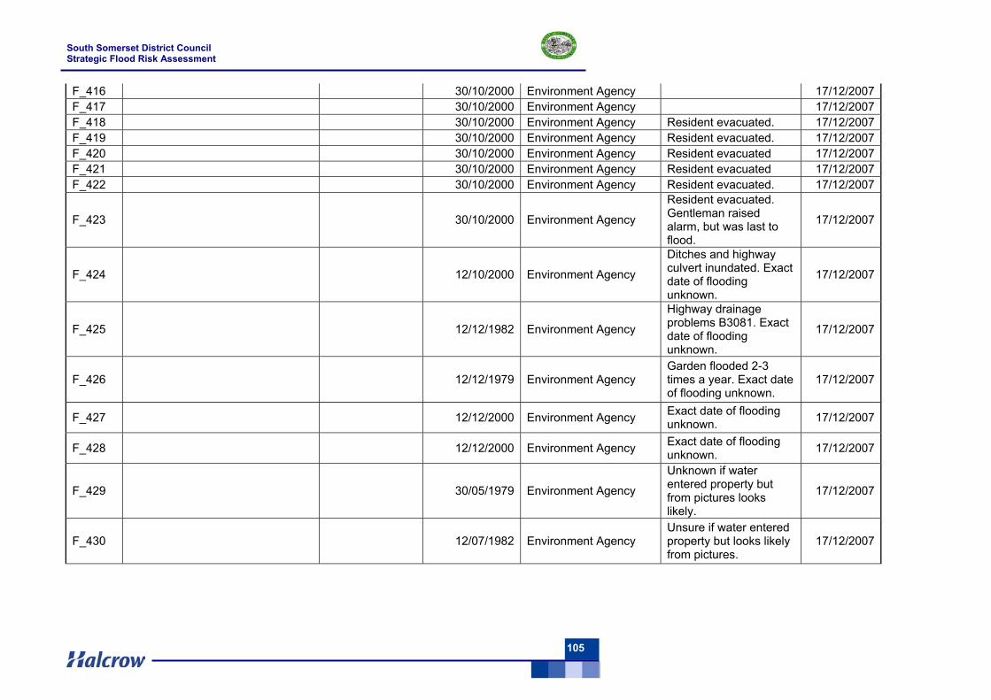
South Somerset District Council Strategic Flood Risk Assessment
105
F_416 30/10/2000 Environment Agency 17/12/2007 F_417 30/10/2000 Environment Agency 17/12/2007 F_418 30/10/2000 Environment Agency Resident evacuated. 17/12/2007 F_419 30/10/2000 Environment Agency Resident evacuated. 17/12/2007 F_420 30/10/2000 Environment Agency Resident evacuated 17/12/2007 F_421 30/10/2000 Environment Agency Resident evacuated 17/12/2007 F_422 30/10/2000 Environment Agency Resident evacuated. 17/12/2007
F_423 30/10/2000 Environment Agency
Resident evacuated. Gentleman raised alarm, but was last to flood.
17/12/2007
F_424 12/10/2000 Environment Agency
Ditches and highway culvert inundated. Exact date of flooding unknown.
17/12/2007
F_425 12/12/1982 Environment Agency
Highway drainage problems B3081. Exact date of flooding unknown.
17/12/2007
F_426 12/12/1979 Environment Agency Garden flooded 2-3 times a year. Exact date of flooding unknown.
17/12/2007
F_427 12/12/2000 Environment Agency Exact date of flooding unknown. 17/12/2007
F_428 12/12/2000 Environment Agency Exact date of flooding unknown. 17/12/2007
F_429 30/05/1979 Environment Agency
Unknown if water entered property but from pictures looks likely.
17/12/2007
F_430 12/07/1982 Environment Agency Unsure if water entered property but looks likely from pictures.
17/12/2007
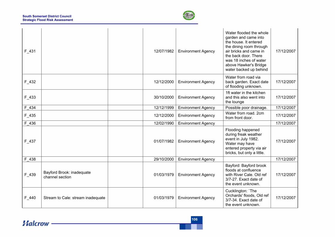
South Somerset District Council Strategic Flood Risk Assessment
106
F_431 12/07/1982 Environment Agency
Water flooded the whole garden and came into the house. It entered the dining room through air bricks and came in the back door. There was 18 inches of water above Hawker's Bridge water backed up behind
17/12/2007
F_432 12/12/2000 Environment Agency Water from road via back garden. Exact date of flooding unknown.
17/12/2007
F_433 30/10/2000 Environment Agency 1ft water in the kitchen and this also went into the lounge
17/12/2007
F_434 12/12/1999 Environment Agency Possible poor drainage. 17/12/2007
F_435 12/12/2000 Environment Agency Water from road. 2cm from front door. 17/12/2007
F_436 12/02/1990 Environment Agency 17/12/2007
F_437 01/07/1982 Environment Agency
Flooding happened during freak weather event in July 1982. Water may have entered property via air bricks, but only a little.
17/12/2007
F_438 29/10/2000 Environment Agency 17/12/2007
F_439 Bayford Brook: inadequate channel section 01/03/1979 Environment Agency
Bayford: Bayford brook floods at confluence with River Cale. Old ref 3/7-27. Exact date of the event unknown.
17/12/2007
F_440 Stream to Cale: stream inadequate 01/03/1979 Environment Agency
Cucklington: `The Orchards' floods, Old ref 3/7-34. Exact date of the event unknown.
17/12/2007
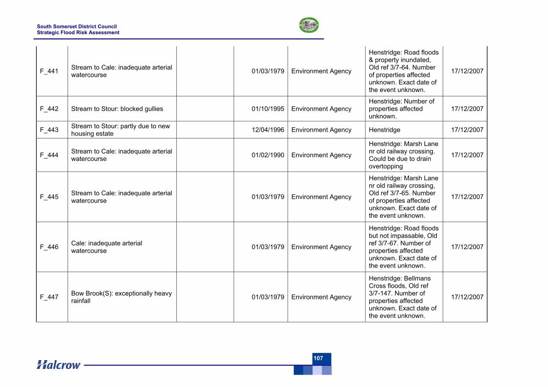
South Somerset District Council Strategic Flood Risk Assessment
107
F_441 Stream to Cale: inadequate arterial watercourse 01/03/1979 Environment Agency
Henstridge: Road floods & property inundated, Old ref 3/7-64. Number of properties affected unknown. Exact date of the event unknown.
17/12/2007
F_442 Stream to Stour: blocked gullies 01/10/1995 Environment Agency Henstridge: Number of properties affected unknown.
17/12/2007
F_443 Stream to Stour: partly due to new housing estate 12/04/1996 Environment Agency Henstridge 17/12/2007
F_444 Stream to Cale: inadequate arterial watercourse 01/02/1990 Environment Agency
Henstridge: Marsh Lane nr old railway crossing. Could be due to drain overtopping
17/12/2007
F_445 Stream to Cale: inadequate arterial watercourse 01/03/1979 Environment Agency
Henstridge: Marsh Lane nr old railway crossing, Old ref 3/7-65. Number of properties affected unknown. Exact date of the event unknown.
17/12/2007
F_446 Cale: inadequate arterial watercourse 01/03/1979 Environment Agency
Henstridge: Road floods but not impassable, Old ref 3/7-67. Number of properties affected unknown. Exact date of the event unknown.
17/12/2007
F_447 Bow Brook(S): exceptionally heavy rainfall 01/03/1979 Environment Agency
Henstridge: Bellmans Cross floods, Old ref 3/7-147. Number of properties affected unknown. Exact date of the event unknown.
17/12/2007
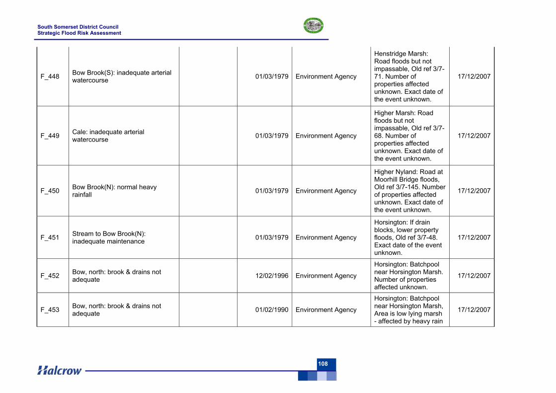
South Somerset District Council Strategic Flood Risk Assessment
108
F_448 Bow Brook(S): inadequate arterial watercourse 01/03/1979 Environment Agency
Henstridge Marsh: Road floods but not impassable, Old ref 3/7-71. Number of properties affected unknown. Exact date of the event unknown.
17/12/2007
F_449 Cale: inadequate arterial watercourse 01/03/1979 Environment Agency
Higher Marsh: Road floods but not impassable, Old ref 3/7-68. Number of properties affected unknown. Exact date of the event unknown.
17/12/2007
F_450 Bow Brook(N): normal heavy rainfall 01/03/1979 Environment Agency
Higher Nyland: Road at Moorhill Bridge floods, Old ref 3/7-145. Number of properties affected unknown. Exact date of the event unknown.
17/12/2007
F_451 Stream to Bow Brook(N): inadequate maintenance 01/03/1979 Environment Agency
Horsington: If drain blocks, lower property floods, Old ref 3/7-48. Exact date of the event unknown.
17/12/2007
F_452 Bow, north: brook & drains not adequate 12/02/1996 Environment Agency
Horsington: Batchpool near Horsington Marsh. Number of properties affected unknown.
17/12/2007
F_453 Bow, north: brook & drains not adequate 01/02/1990 Environment Agency
Horsington: Batchpool near Horsington Marsh, Area is low lying marsh - affected by heavy rain
17/12/2007
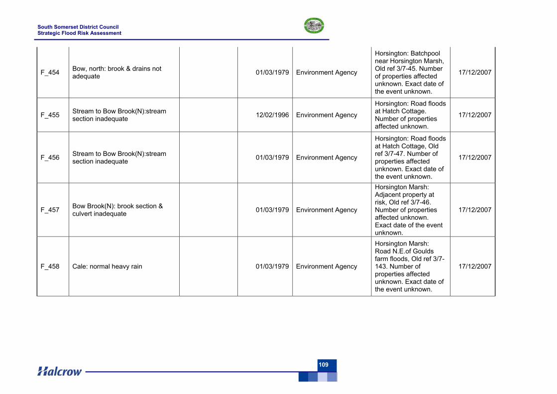
South Somerset District Council Strategic Flood Risk Assessment
109
F_454 Bow, north: brook & drains not adequate 01/03/1979 Environment Agency
Horsington: Batchpool near Horsington Marsh, Old ref 3/7-45. Number of properties affected unknown. Exact date of the event unknown.
17/12/2007
F_455 Stream to Bow Brook(N):stream section inadequate 12/02/1996 Environment Agency
Horsington: Road floods at Hatch Cottage. Number of properties affected unknown.
17/12/2007
F_456 Stream to Bow Brook(N):stream section inadequate 01/03/1979 Environment Agency
Horsington: Road floods at Hatch Cottage, Old ref 3/7-47. Number of properties affected unknown. Exact date of the event unknown.
17/12/2007
F_457 Bow Brook(N): brook section & culvert inadequate 01/03/1979 Environment Agency
Horsington Marsh: Adjacent property at risk, Old ref 3/7-46. Number of properties affected unknown. Exact date of the event unknown.
17/12/2007
F_458 Cale: normal heavy rain 01/03/1979 Environment Agency
Horsington Marsh: Road N.E.of Goulds farm floods, Old ref 3/7-143. Number of properties affected unknown. Exact date of the event unknown.
17/12/2007
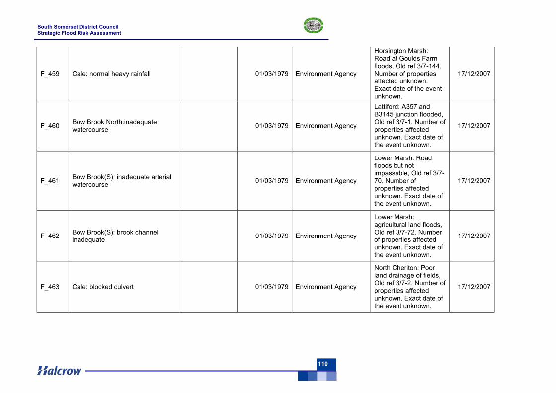
South Somerset District Council Strategic Flood Risk Assessment
110
F_459 Cale: normal heavy rainfall 01/03/1979 Environment Agency
Horsington Marsh: Road at Goulds Farm floods, Old ref 3/7-144. Number of properties affected unknown. Exact date of the event unknown.
17/12/2007
F_460 Bow Brook North:inadequate watercourse 01/03/1979 Environment Agency
Lattiford: A357 and B3145 junction flooded, Old ref 3/7-1. Number of properties affected unknown. Exact date of the event unknown.
17/12/2007
F_461 Bow Brook(S): inadequate arterial watercourse 01/03/1979 Environment Agency
Lower Marsh: Road floods but not impassable, Old ref 3/7-70. Number of properties affected unknown. Exact date of the event unknown.
17/12/2007
F_462 Bow Brook(S): brook channel inadequate 01/03/1979 Environment Agency
Lower Marsh: agricultural land floods, Old ref 3/7-72. Number of properties affected unknown. Exact date of the event unknown.
17/12/2007
F_463 Cale: blocked culvert 01/03/1979 Environment Agency
North Cheriton: Poor land drainage of fields, Old ref 3/7-2. Number of properties affected unknown. Exact date of the event unknown.
17/12/2007
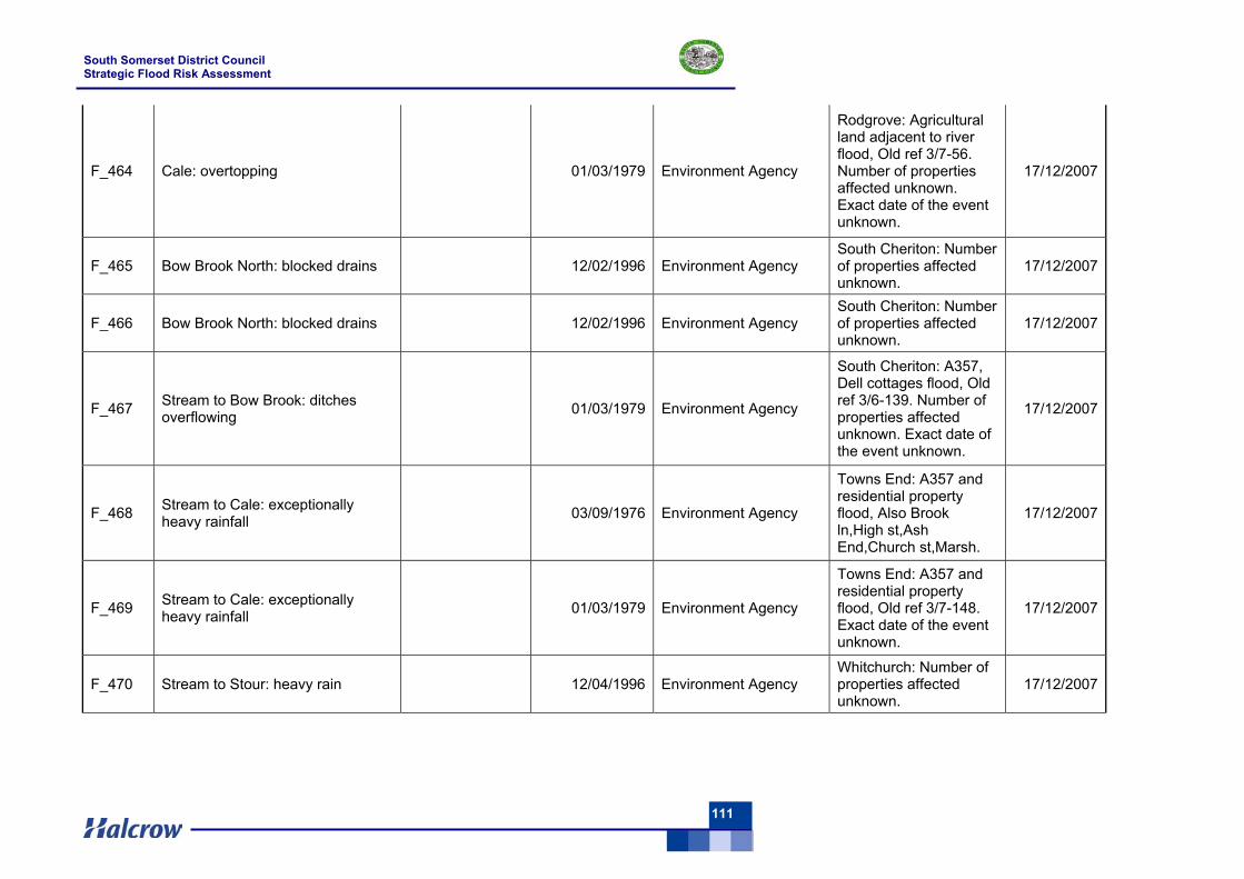
South Somerset District Council Strategic Flood Risk Assessment
111
F_464 Cale: overtopping 01/03/1979 Environment Agency
Rodgrove: Agricultural land adjacent to river flood, Old ref 3/7-56. Number of properties affected unknown. Exact date of the event unknown.
17/12/2007
F_465 Bow Brook North: blocked drains 12/02/1996 Environment Agency South Cheriton: Number of properties affected unknown.
17/12/2007
F_466 Bow Brook North: blocked drains 12/02/1996 Environment Agency South Cheriton: Number of properties affected unknown.
17/12/2007
F_467 Stream to Bow Brook: ditches overflowing 01/03/1979 Environment Agency
South Cheriton: A357, Dell cottages flood, Old ref 3/6-139. Number of properties affected unknown. Exact date of the event unknown.
17/12/2007
F_468 Stream to Cale: exceptionally heavy rainfall 03/09/1976 Environment Agency
Towns End: A357 and residential property flood, Also Brook ln,High st,Ash End,Church st,Marsh.
17/12/2007
F_469 Stream to Cale: exceptionally heavy rainfall 01/03/1979 Environment Agency
Towns End: A357 and residential property flood, Old ref 3/7-148. Exact date of the event unknown.
17/12/2007
F_470 Stream to Stour: heavy rain 12/04/1996 Environment Agency Whitchurch: Number of properties affected unknown.
17/12/2007
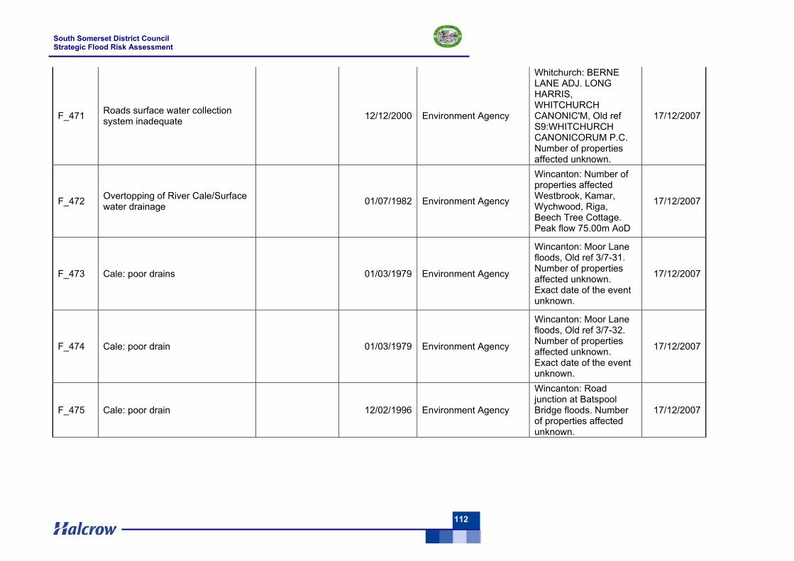
South Somerset District Council Strategic Flood Risk Assessment
112
F_471 Roads surface water collection system inadequate 12/12/2000 Environment Agency
Whitchurch: BERNE LANE ADJ. LONG HARRIS, WHITCHURCH CANONIC'M, Old ref S9:WHITCHURCH CANONICORUM P.C. Number of properties affected unknown.
17/12/2007
F_472 Overtopping of River Cale/Surface water drainage 01/07/1982 Environment Agency
Wincanton: Number of properties affected Westbrook, Kamar, Wychwood, Riga, Beech Tree Cottage. Peak flow 75.00m AoD
17/12/2007
F_473 Cale: poor drains 01/03/1979 Environment Agency
Wincanton: Moor Lane floods, Old ref 3/7-31. Number of properties affected unknown. Exact date of the event unknown.
17/12/2007
F_474 Cale: poor drain 01/03/1979 Environment Agency
Wincanton: Moor Lane floods, Old ref 3/7-32. Number of properties affected unknown. Exact date of the event unknown.
17/12/2007
F_475 Cale: poor drain 12/02/1996 Environment Agency
Wincanton: Road junction at Batspool Bridge floods. Number of properties affected unknown.
17/12/2007
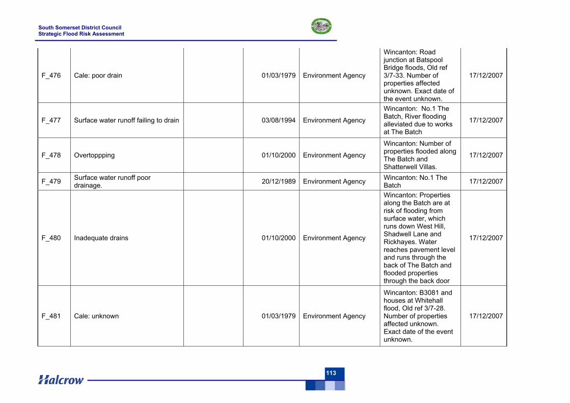
South Somerset District Council Strategic Flood Risk Assessment
113
F_476 Cale: poor drain 01/03/1979 Environment Agency
Wincanton: Road junction at Batspool Bridge floods, Old ref 3/7-33. Number of properties affected unknown. Exact date of the event unknown.
17/12/2007
F_477 Surface water runoff failing to drain 03/08/1994 Environment Agency
Wincanton: No.1 The Batch, River flooding alleviated due to works at The Batch
17/12/2007
F_478 Overtoppping 01/10/2000 Environment Agency
Wincanton: Number of properties flooded along The Batch and Shatterwell Villas.
17/12/2007
F_479 Surface water runoff poor drainage. 20/12/1989 Environment Agency Wincanton: No.1 The
Batch 17/12/2007
F_480 Inadequate drains 01/10/2000 Environment Agency
Wincanton: Properties along the Batch are at risk of flooding from surface water, which runs down West Hill, Shadwell Lane and Rickhayes. Water reaches pavement level and runs through the back of The Batch and flooded properties through the back door
17/12/2007
F_481 Cale: unknown 01/03/1979 Environment Agency
Wincanton: B3081 and houses at Whitehall flood, Old ref 3/7-28. Number of properties affected unknown. Exact date of the event unknown.
17/12/2007
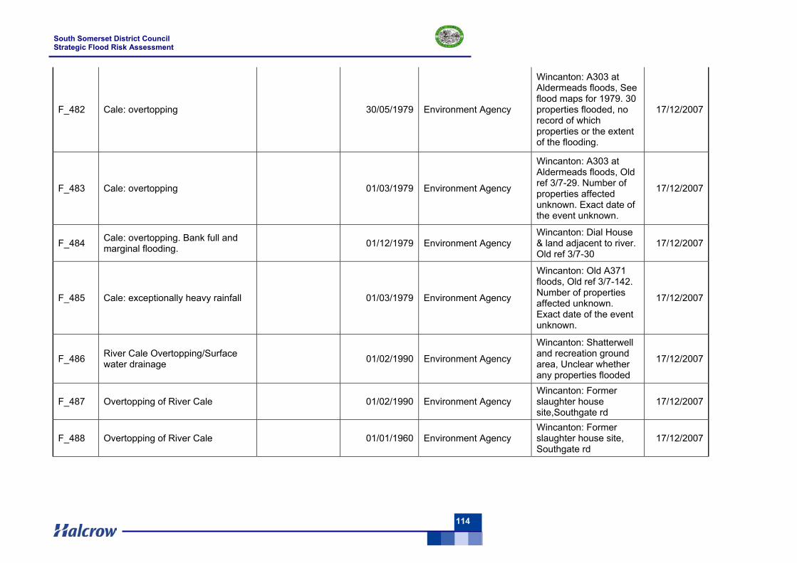
South Somerset District Council Strategic Flood Risk Assessment
114
F_482 Cale: overtopping 30/05/1979 Environment Agency
Wincanton: A303 at Aldermeads floods, See flood maps for 1979. 30 properties flooded, no record of which properties or the extent of the flooding.
17/12/2007
F_483 Cale: overtopping 01/03/1979 Environment Agency
Wincanton: A303 at Aldermeads floods, Old ref 3/7-29. Number of properties affected unknown. Exact date of the event unknown.
17/12/2007
F_484 Cale: overtopping. Bank full and marginal flooding. 01/12/1979 Environment Agency
Wincanton: Dial House & land adjacent to river. Old ref 3/7-30
17/12/2007
F_485 Cale: exceptionally heavy rainfall 01/03/1979 Environment Agency
Wincanton: Old A371 floods, Old ref 3/7-142. Number of properties affected unknown. Exact date of the event unknown.
17/12/2007
F_486 River Cale Overtopping/Surface water drainage 01/02/1990 Environment Agency
Wincanton: Shatterwell and recreation ground area, Unclear whether any properties flooded
17/12/2007
F_487 Overtopping of River Cale 01/02/1990 Environment Agency Wincanton: Former slaughter house site,Southgate rd
17/12/2007
F_488 Overtopping of River Cale 01/01/1960 Environment Agency Wincanton: Former slaughter house site, Southgate rd
17/12/2007
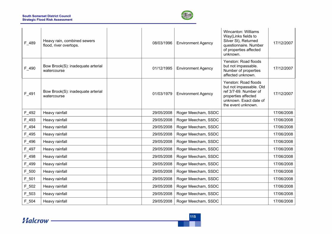
South Somerset District Council Strategic Flood Risk Assessment
115
F_489 Heavy rain, combined sewers flood, river overtops. 08/03/1996 Environment Agency
Wincanton: Williams Way(Links fields to Silver St), Returned questionnaire. Number of properties affected unknown.
17/12/2007
F_490 Bow Brook(S): inadequate arterial watercourse 01/12/1995 Environment Agency
Yenston: Road floods but not impassable. Number of properties affected unknown.
17/12/2007
F_491 Bow Brook(S): inadequate arterial watercourse 01/03/1979 Environment Agency
Yenston: Road floods but not impassable. Old ref 3/7-69. Number of properties affected unknown. Exact date of the event unknown.
17/12/2007
F_492 Heavy rainfall 29/05/2008 Roger Meecham, SSDC 17/06/2008
F_493 Heavy rainfall 29/05/2008 Roger Meecham, SSDC 17/06/2008
F_494 Heavy rainfall 29/05/2008 Roger Meecham, SSDC 17/06/2008
F_495 Heavy rainfall 29/05/2008 Roger Meecham, SSDC 17/06/2008
F_496 Heavy rainfall 29/05/2008 Roger Meecham, SSDC 17/06/2008
F_497 Heavy rainfall 29/05/2008 Roger Meecham, SSDC 17/06/2008
F_498 Heavy rainfall 29/05/2008 Roger Meecham, SSDC 17/06/2008
F_499 Heavy rainfall 29/05/2008 Roger Meecham, SSDC 17/06/2008
F_500 Heavy rainfall 29/05/2008 Roger Meecham, SSDC 17/06/2008
F_501 Heavy rainfall 29/05/2008 Roger Meecham, SSDC 17/06/2008
F_502 Heavy rainfall 29/05/2008 Roger Meecham, SSDC 17/06/2008
F_503 Heavy rainfall 29/05/2008 Roger Meecham, SSDC 17/06/2008
F_504 Heavy rainfall 29/05/2008 Roger Meecham, SSDC 17/06/2008
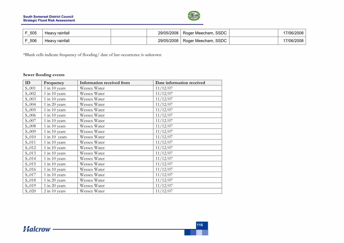
South Somerset District Council Strategic Flood Risk Assessment
116
F_505 Heavy rainfall 29/05/2008 Roger Meecham, SSDC 17/06/2008
F_506 Heavy rainfall 29/05/2008 Roger Meecham, SSDC 17/06/2008
*Blank cells indicate frequency of flooding/ date of last occurrence is unknown
Sewer flooding events
ID Frequency Information received from Date information received S_001 1 in 10 years Wessex Water 11/12/07 S_002 1 in 10 years Wessex Water 11/12/07 S_003 1 in 10 years Wessex Water 11/12/07 S_004 1 in 20 years Wessex Water 11/12/07 S_005 1 in 10 years Wessex Water 11/12/07 S_006 1 in 10 years Wessex Water 11/12/07 S_007 1 in 10 years Wessex Water 11/12/07 S_008 1 in 10 years Wessex Water 11/12/07 S_009 1 in 10 years Wessex Water 11/12/07 S_010 1 in 10 years Wessex Water 11/12/07 S_011 1 in 10 years Wessex Water 11/12/07 S_012 1 in 10 years Wessex Water 11/12/07 S_013 1 in 10 years Wessex Water 11/12/07 S_014 1 in 10 years Wessex Water 11/12/07 S_015 1 in 10 years Wessex Water 11/12/07 S_016 1 in 10 years Wessex Water 11/12/07 S_017 1 in 10 years Wessex Water 11/12/07 S_018 1 in 20 years Wessex Water 11/12/07 S_019 1 in 20 years Wessex Water 11/12/07 S_020 2 in 10 years Wessex Water 11/12/07
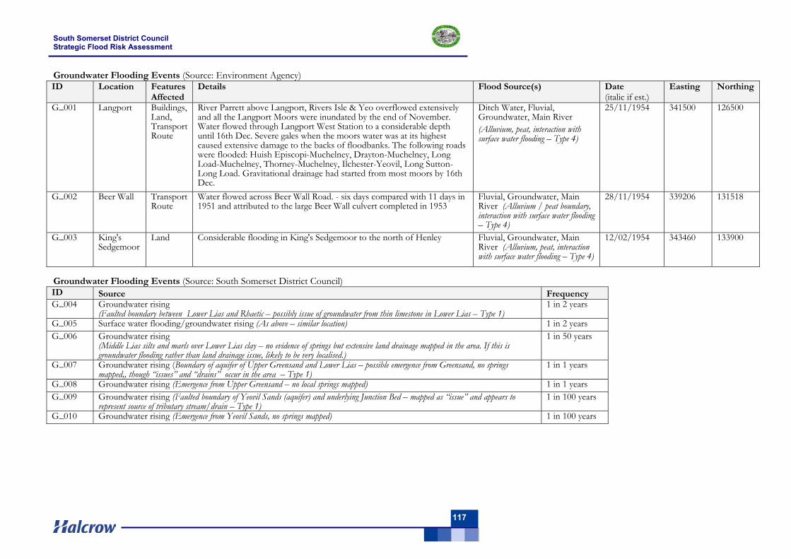
South Somerset District Council Strategic Flood Risk Assessment
117
Groundwater Flooding Events (Source: Environment Agency) ID Location Features
Affected Details Flood Source(s) Date
(italic if est.) Easting Northing
G_001 Langport Buildings, Land, Transport Route
River Parrett above Langport, Rivers Isle & Yeo overflowed extensively and all the Langport Moors were inundated by the end of November. Water flowed through Langport West Station to a considerable depth until 16th Dec. Severe gales when the moors water was at its highest caused extensive damage to the backs of floodbanks. The following roads were flooded: Huish Episcopi-Muchelney, Drayton-Muchelney, Long Load-Muchelney, Thorney-Muchelney, Ilchester-Yeovil, Long Sutton-Long Load. Gravitational drainage had started from most moors by 16th Dec.
Ditch Water, Fluvial, Groundwater, Main River (Alluvium, peat, interaction with surface water flooding – Type 4)
25/11/1954 341500 126500
G_002 Beer Wall Transport Route
Water flowed across Beer Wall Road. - six days compared with 11 days in 1951 and attributed to the large Beer Wall culvert completed in 1953
Fluvial, Groundwater, Main River (Alluvium / peat boundary, interaction with surface water flooding – Type 4)
28/11/1954 339206 131518
G_003 King's Sedgemoor
Land Considerable flooding in King's Sedgemoor to the north of Henley Fluvial, Groundwater, Main River (Alluvium, peat, interaction with surface water flooding – Type 4)
12/02/1954 343460 133900
Groundwater Flooding Events (Source: South Somerset District Council) ID Source Frequency G_004 Groundwater rising
(Faulted boundary between Lower Lias and Rhaetic – possibly issue of groundwater from thin limestone in Lower Lias – Type 1) 1 in 2 years
G_005 Surface water flooding/groundwater rising (As above – similar location) 1 in 2 years G_006 Groundwater rising
(Middle Lias silts and marls over Lower Lias clay – no evidence of springs but extensive land drainage mapped in the area. If this is groundwater flooding rather than land drainage issue, likely to be very localised.)
1 in 50 years
G_007 Groundwater rising (Boundary of aquifer of Upper Greensand and Lower Lias – possible emergence from Greensand, no springs mapped,, though “issues” and “drains” occur in the area – Type 1)
1 in 1 years
G_008 Groundwater rising (Emergence from Upper Greensand – no local springs mapped) 1 in 1 years G_009 Groundwater rising (Faulted boundary of Yeovil Sands (aquifer) and underlying Junction Bed – mapped as “issue” and appears to
represent source of tributary stream/drain – Type 1) 1 in 100 years
G_010 Groundwater rising (Emergence from Yeovil Sands, no springs mapped) 1 in 100 years


