Au
st
ra
lia
n A
ND
Ne
w Z
ea
la
nd
E
nv
iro
nm
en
t A
ND
Co
ns
er
va
tio
n C
ou
nc
il
ANZECC
Strategic Plan of Action for the National Representative System of Marine Protected Areas:
A Guide for Action by Australian Governments
ANZECC Task Force on Marine Protected Areas
July 1999

ANZECC
AUSTRALIAN AND NEW ZEALANDENVIRONMENT AND CONSERVATION COUNCIL
Strategic Plan of Action for the National Representative System
of Marine Protected Areas:
A Guide for Action by Australian Governments
Including the Guidelines For Establishing the National Representative
System of Marine Protected Areas(Appendix 2)
ANZECC Task Force on Marine Protected Areas
July 1999

ii July 1999
Strategic Plan of Action for the NRSMPA
This report may be cited as:
Australian and New Zealand Environment and Conservation
Council Task Force on Marine Protected Areas 1999,
Strategic Plan of Action for the National Representative
System of Marine Protected Areas: A Guide for Action
by Australian Governments. Environment Australia, Canberra.
ISBN 0 642 21428 X
The views and opinions expressed in this document
are not necessarily those of the publisher,
Environment Australia, Canberra.
Copies of this document are available from:
Community Information Unit
Environment Australia
GPO Box 787
CANBERRA ACT 2601
Toll-free phone: 1800 803 772
(9.00 a.m.–12.30 p.m. and 2.00 p.m.–4.00 p.m.)
Fax: 02 6274 1970
email: [email protected]
This document is available on the Internet at:
http://www.environment.gov.au/net/marine/spa.html
Cover photo courtesy of GBRMPA.

July 1999 iii
Strategic Plan of Action for the NRSMPA
This Strategic Plan of Action (the Plan) is oneof a suite of documents developed cooperativelyby the Australian and New Zealand Environmentand Conservation Council (ANZECC) Task Forceon Marine Protected Areas (TFMPA) to assistand promote the development of the NationalRepresentative System of Marine Protected Areas(NRSMPA). The other documents are the InterimMarine and Coastal Regionalisation for Australia(IMCRA Technical Group 1998) and theGuidelines for Establishing the NationalRepresentative System of Marine Protected Areas(ANZECC TFMPA 1998). These two documentsare referred to as IMCRA and the Guidelines.
The Guidelines, included in full in Appendix 2,deal with key aspects of the establishment ofmarine protected areas, including the roles andresponsibilities for the NRSMPA and use of criteriafor identification and selection of marineprotected areas.
This Plan sets out actions to achieve the goalsof the NRSMPA. It also provides a guide tounderstanding the NRSMPA by defining it in thecontext of the array of existing mechanisms andagreements that promote the conservation ofAustralia’s marine biodiversity.
The Plan concentrates on the establishment ofthe NRSMPA, including performance assessmentfor the System, and a set of actions that reflectboth national intention and government priorities.The Plan does not provide a comprehensivediscussion of management issues but recognisesthat appropriate management is essential to theachievement of the goals. Further considerationof management issues for the NRSMPA isidentified as an ongoing role for TFMPA.
There was a public comment period on a draftPlan from 1 November 1998 to 18 December 1998.Relevant comments and suggestions that werereceived were incorporated into this version of thePlan. The Plan will remain current until reviewed.
Progress will be reviewed each year againstannual work programs, with a major review of thePlan to be held after three years. Under ANZECCdirection, the TFMPA will have carriage of thework programs and the review of the Plan.
The benefits of the Plan include:
• confirmation of the goals and principles thatapply to the NRSMPA;
• prioritisation of different aspects of protectedarea development;
• assistance in meeting obligations underinternational treaties;
• encouragement of cross-jurisdictionalcooperation and collaboration;
• facilitation of integration with other relevantnational strategies; and
• confirmation of political commitments toresourcing the NRSMPA.
Unless otherwise stated, the use of the term‘marine protected area’ (MPA) in the Plan refersto the MPAs that comprise the NRSMPA.
PREFACE

iv July 1999
Strategic Plan of Action for the NRSMPA
USING THE PLAN
PART ONE PLAN OF ACTION
– sets out the prioritised actions derived throughthe planning process. It identifies responsibilityand establishes a timetable for delivery of the actions.The background to the actions is in Part Four.
PART TWO UNDERSTANDING THE NRSMPA
– explains some of the history and theinternational and national context of the NRSMPA.It lists goals and principles and discusses anumber of related marine management issues.
PART THREE CURRENT STATUS OF THE NRSMPA
– explains the established bioregional planningframework, provides an analysis of existing MPAsby IMCRA bioregion and describes how theStates, Northern Territory and Commonwealth arebuilding the NRSMPA.
PART FOUR DELIVERING THE NRSMPA
– analyses the main issues in delivering thesystem and lists the actions under these issues.

July 1999 v
Strategic Plan of Action for the NRSMPA
Preface iii
Using the Plan iv
Summary 1
Acronyms 2
PART ONE – PLAN OF ACTION 3
1.1 Deciding priorities 3
Table 1: Staging of Actions 4
1.2 Implementation and review of the Strategic Plan of Action 5
1.3 Actions to implement the National Representative System of Marine Protected Areas 6
PART TWO – UNDERSTANDING THE NRSMPA 13
2.1 How the NRSMPA is being established 13
2.2 International and national context 14
2.3 Australia’s Oceans Policy 14
2.4 Other biodiversity conservation mechanisms 14
2.5 Goals of the NRSMPA 15
2.6 Characteristics of the NRSMPA 15
2.7 Principles for developing the NRSMPA 15
PART THREE – CURRENT STATUS OF THE NRSMPA 17
3.1 Interim Marine and Coastal Regionalisation for Australia 17
3.2 Marine protected areas by bioregions 17
Map 1: IMCRA meso-scale regionalisation 18
Map 2: Percentage coverage of MPAs within IMCRA meso-scale regions 19
3.3 State, Northern Territory and Commonwealth components 20
Commonwealth 20
New South Wales 21
Northern Territory 21
Queensland 21
South Australia 21
Tasmania 21
Victoria 22
Western Australia 22
PART FOUR – DELIVERING THE NRSMPA 23
4.1 Establishing a comprehensive, adequate and representative system 23
4.2 Information requirements and management 25
4.2.1 Information requirements 25
4.2.2 Information management 27
CONTENTS

vi July 1999
Strategic Plan of Action for the NRSMPA
4.3 Involvement of Stakeholders 28
4.3.1 Identifying stakeholders and their issues 29
4.3.2 Principles for consultation and negotiation with stakeholders 29
4.3.3 Education, training and development 29
4.4 Classifying marine protected areas 30
4.4.1 IUCN protected area management categories 30
4.4.2 Nomenclature 31
4.5 Managing the NRSMPA 31
4.5.1 Ecologically sustainable development 32
4.5.2 Ecosystem approach to management 32
4.5.3 Managing uses 33
4.5.4 Joint arrangements 33
4.5.5 Management planning 34
4.6 Performance assessment 35
4.6.1 Performance assessment elements 35
4.6.2 Performance indicators 35
4.6.3 Level of performance assessment 36
4.6.4 Reporting frequency and format 38
4.6.5 Monitoring programs 38
APPENDICES
APPENDIX 1
Membership of the ANZECC Task Force on Marine Protected Areas (alphabetical, as at April 1999) 39
APPENDIX 2
Guidelines for Establishing the National Representative System of Marine Protected Areas 43
APPENDIX 3
Summary and objectives of IUCN protected area management categories 60
APPENDIX 4
Occurrence of marine protected areas in IMCRA regions 63
APPENDIX 5
Organisational arrangements, planning processes and relevant legislation for each jurisdiction 65
GLOSSARY 77
REFERENCES 79
Other reports that inform this plan 80

July 1999 1
Strategic Plan of Action for the NRSMPA
The conservation of marine biodiversity andthe maintenance of ecological processes arerecognised nationally and internationally as beingbest achieved through strategic regional planningthat provides for the establishment and effectivemanagement of a representative system of MPAsand the complementary sustainable managementof adjoining waters. In Australia, as a keycomponent of this approach, the Commonwealth,State and Northern Territory Governments arecooperatively developing the NRSMPA.
The primary goal of the NRSMPA is toestablish and manage a comprehensive, adequateand representative system of MPAs to contributeto the long-term ecological viability of marine andestuarine systems, maintain ecological processesand systems, and protect Australia’s biologicaldiversity at all levels.
The NRSMPA also has secondary goals: topromote integrated ecosystem management;to manage human activities; to provide for theneeds of species and ecological communities; andto provide for the recreational, aesthetic, culturaland economic needs of indigenous and non-indigenous people, where these are compatiblewith the primary goal.
This Plan sets out the actions required toachieve the goals of the NRSMPA and providesbackground information to assist in theunderstanding of the system and the processesrequired for its development. The Plan isorganised into four parts.
Part One – Plan of action lists the priorityactions required to develop the NRSMPA and thestaging of the actions over the three-year life ofthe Plan. The actions reflect both national andjurisdictional priorities, and are organised undersix major headings: Establishing a comprehensive,adequate and representative system; Informationrequirements; Involvement of stakeholders;Classifying marine protected areas; Managing theNRSMPA; and Performance assessment. For eachaction, details of implementation arrangementsand an indicative timetable have been proposed.
Part Two – Understanding the NRSMPAintroduces the NRSMPA through a discussionof the existing cooperative mechanisms and theinternational and national contexts for the MPAsystem. Appendix 2 reproduces the Goals ofthe NRSMPA, Characteristics of the NRSMPA,and Principles for developing the NRSMPA in theGuidelines for Establishing the NRSMPA (ANZECCTFMPA 1998), a companion document to this Plan.The final text for these sections was agreedfollowing a period of public comment on theGuidelines in May–July 1998.
Part Three – Current status of the NRSMPAprovides important background information onthe Interim Marine and Coastal Regionalisationfor Australia (IMCRA) framework. IMCRA isthe bioregional framework for the planning andmanagement of the NRSMPA. It is an ecosystem-based regionalisation that provides the first layerin a broad ecological planning framework, withpotential to identify gaps and set priorities for thedelivery and evaluation of programs to enhancethe NRSMPA. A preliminary gap analysis has beencarried out at the national level to illustrate theprocess that may be used. The resultant map(Map 2) showing the percentage coverage ofMPAs within IMCRA regions, highlights the lackof MPAs in many regions.
Part Three also includes a summary of the currentand future strategies for development of MPAs foreach jurisdiction. More detailed information onorganisational arrangements, planning processesand relevant legislation for each jurisdiction isincluded in Appendix 5.
Part Four – Delivering the NRSMPA is adiscussion of priority issues in the developmentof the NRSMPA. It provides the context for theactions described in detail in Part One - Plan ofAction, under the same six major headings.
SUMMARY
2 July 1999
Strategic Plan of Action for the NRSMPA
ANZECC Australian and New Zealand Environment and Conservation Council
ANZLIC Australia New Zealand Land Information Council
CALM Department of Conservation and Land Management (WA)
CAMBA China-Australia Migratory Bird Agreement
CAPAD Collaborative Australian Protected Areas Dataset
CSIRO Commonwealth Scientific and Industrial Research Organisation
DNRE Department of Natural Resources and Environment (Vic)
DUAP Department of Urban Affairs and Planning (NSW)
EA Environment Australia (Commonwealth Department of the Environment and Heritage)
ECC Environment Conservation Council (Victoria)
ESD Ecologically sustainable development
GBRMP Great Barrier Reef Marine Park
GBRMPA Great Barrier Reef Marine Park Authority
IGAE Intergovernmental Agreement on the Environment
IMCRA Interim Marine and Coastal Regionalisation for Australia
IUCN World Conservation Union (formerly known as the International Union for the Conservation of Nature)
JAMBA Japan-Australia Migratory Bird Agreement
MCFFA Ministerial Council on Forestry, Fisheries and Aquaculture
MPA Marine protected area
NPWS National Parks and Wildlife Service (NSW)
NRSMPA National Representative System of Marine Protected Areas
PWCNT Parks and Wildlife Commission of the Northern Territory
SoE State of Environment
SOMER State of Marine Environment Reporting
TFMPA Task Force on Marine Protected Areas
UNEP United Nations Environment Program
UNESCO United Nations Educational, Scientific and Cultural Organisation
ACRONYMS
July 1999 3
Strategic Plan of Action for the NRSMPA
1.1 DECIDING PRIORITIES
Thirty-four actions have been identified asimportant in the current three-year program toestablish the NRSMPA. The actions that haveemerged through the strategic planning processfor the NRSMPA reflect both national andjurisdictional priorities. Background informationon the development and further explanations ofthe actions are provided in Part Four of the Plan,which should be read in conjunction with theactions. In addition to the actions identified in thePlan, each jurisdiction will continue to carry outcore functions related to the development andmanagement of MPAs.
Where possible, actions will be carried out usingexisting resources. Jurisdictions may choose toprovide additional funding for specific action/swhere the action is a high priority. There will befunding opportunities for national projectsthrough the Marine Protected Areas Program,a Commonwealth funding program. Wherepossible, delivery or completion dates andmilestones are identified for the actions.Actions may be specific to the NRSMPA, oressential to the NRSMPA and also supportiveof national programs. They include ecosystemmapping, stakeholder understanding andindigenous interests.
A staged approach has been adopted to theinitiation of actions and to the inclusion of theresults of ongoing tasks in the NRSMPA. Thestaged approach is based on:
• completion of current activities;
• gap analysis, followed by activities leadingto the filling of gaps in the bioregional coverage;
• priorities established within jurisdictionalstrategies; and
• resource availability.
Table 1 presents ongoing actions in italics acrossthe three stages. The stage where the actionsappear in bold identifies when the results orproducts of these actions will be incorporated intothe strategic plan process. First-stage actions formthe first year’s work program under the Plan.Milestones for the first year are shaded in theaction list in section 1.3, Actions.
Yearly reviews will be undertaken to assessprogress. Progress between stages will bedependent on the success of actions and thelevel of resources provided by the jurisdictionsresponsible for implementing the actions. Wherethere are overlapping or consequential actions,these will be managed accordingly. A number ofactions will be ongoing beyond the three-yearperiod dealt with in detail by this Plan.
PART ONEPLAN OF ACTION
DELIVER ING THE NATIONAL REPRESENTATIVE SYSTEM OF MARINE PROTECTED AREAS – A COMPREHENSIVE, ADEQUATE AND REPRESENTATIVE SYSTEM

4 July 1999
Strategic Plan of Action for the NRSMPA
TAB
LE 1
:STA
GIN
G O
F A
CTI
ON
S
A N N U A L R E V I E W
A N N U A L R E V I E W
Num
bers
in b
rack
ets
refe
r to
the
num
ber o
f the
act
ion
in s
ectio
n 1.
3 an
d Pa
rt Fo
ur o
f the
text
.
Italic
s in
dica
te a
n on
goin
g ac
tion.
The
sta
ge w
here
the
actio
ns a
ppea
r in
bold
iden
tifies
whe
n th
e re
sults
or p
rodu
cts
of th
ese
actio
nsw
ill be
inco
rpor
ated
into
the
strat
egic
pla
n pr
oces
s.
Firs
t st
age
Seco
nd s
tage
Thir
d s
tage
Under
standin
g c
om
pre
hen
sive
nes
s (1
)H
arn
ess
com
munity k
now
ledge
(12
)D
ata
colle
ctio
n s
tandard
s (7
)
Base
line
data
col
lect
ion
(16)
Base
line
data
col
lect
ion
(16)
Base
line
data
colle
ctio
n (
16)
Under
standin
g a
deq
uacy
(2
)H
arn
ess
indust
ry k
now
ledge
(13
)Com
para
ble
data
base
s (1
9)
Under
standin
g r
epre
senta
tive
nes
s (3
)Pro
vinci
al l
evel
reg
ionalis
ation (
15
)Res
ourc
e nee
ds
for
data
base
esta
blis
hm
ent/
managem
ent
(20)
Vuln
erable
eco
syst
ems
(4)
Enhanci
ng t
ax
onom
ic c
apaci
ty (
17
)A
naly
sis
of
info
rmation p
rogra
ms
(21)
Mai
ntai
ning
cor
e da
tase
ts (1
8)M
ain
tain
ing c
ore
data
sets
(1
8)
Mai
ntai
ning
cor
e da
tase
ts (1
8)
Stak
ehol
der u
nder
stand
ing
(22)
Stak
ehold
er u
nder
standin
g (
22
)St
akeh
olde
r und
ersta
ndin
g (2
2)
Info
rmat
ion
avai
labi
lity (2
3)In
form
ation a
vaila
bili
ty (
23
)In
form
atio
n av
aila
bility
(23)
Iden
tify
ing p
riori
ties
for
candid
ate
MPA
s (5
)Jo
int
managem
ent
arr
angem
ents
(2
8)
Analy
sis
of
IUCN
cate
gori
es (
24)
Ecosy
stem
mappin
g (
6)
Ecos
yste
m m
appi
ng (6
)Ec
osys
tem
map
ping
(6)
Indi
geno
us in
tere
sts (2
9)In
dig
enous
inte
rest
s (2
9)
Indi
geno
us in
tere
sts (2
9)
Rev
iew
met
hods
for
ecosy
stem
mappin
g (
8)
Mod
els
of in
dust
ry c
oope
rativ
e m
anag
emen
t (30
)A
pplic
ation o
f IU
CN
cate
gori
es (
25
)
Rapid
ass
essm
ents
(9
)IU
CN
cate
gory
rep
ort
ing (
26)
Thre
at
analy
sis
rese
arc
h (
10
)N
ationally
consi
sten
t nom
encl
atu
re (
27)
Apply
thre
ate
nin
g p
roce
sses
analy
sis
(11
)Bes
t pra
ctic
e m
anagem
ent
pla
nnin
g (
31)
Oce
ans
Polic
y (
14
)O
cean
s Po
licy
(14)
Oce
ans
Polic
y (1
4)
MPA
per
form
ance
ass
essm
ent
(32
)M
PA p
erfo
rman
ce a
sses
smen
t (32
)M
PA p
erfo
rman
ce a
sses
smen
t (32
)
Bio
regio
n p
erfo
rmance
rep
ort
ing (
33
)Bi
oreg
ion
perfo
rman
ce re
porti
ng (3
3)Bi
oreg
ion
perfo
rman
ce re
porti
ng (3
3)
NRSM
PA p
erfo
rmance
ass
essm
ent
(34)
NRS
MPA
per
form
ance
ass
essm
ent (
34)
NRS
MPA
per
form
ance
ass
essm
ent (
34)
14 a
ctio
ns
10
act
ions
10 a
ctio
ns
July 1999 5
Strategic Plan of Action for the NRSMPA
1.2 IMPLEMENTATION AND REVIEWOF THE STRATEGIC PLAN OF ACTION
The Plan will be implemented following agreement
by State, Territory and Commonwealth agencies, and
approval by ANZECC. Annual work programs to
reflect the stages are being developed by the Task
Force on Marine Protected Areas (TFMPA). TFMPA
will provide annual reports to ANZECC and will
review and report to ANZECC on the progress
of the Plan as a whole after three years.
The actions are complex and interrelated. In
addition, the jurisdictions are at varying stages of
development and progress for components of the
NRSMPA. Consequently, implementation of actions
for the NRSMPA will vary across the jurisdictions
depending on capacity and stage of development.
Action groups will be formed by TFMPA to undertake
the actions as required. The progress of the individual
actions, and time-lines for subsequent actions, will
be reviewed and assessed by TFMPA against each
year’s workplan. Progress across jurisdictions will
be contingent on available resources.
6 July 1999
Strategic Plan of Action for the NRSMPA
Act
ion
Impl
emen
tatio
nTi
met
able
ESTA
BLI
SH
ING
A C
OM
PR
EHEN
SIV
E, A
DEQ
UA
TE A
ND
REP
RES
ENTA
TIV
E SY
STE
M [
SEC
TIO
N 4
.1]
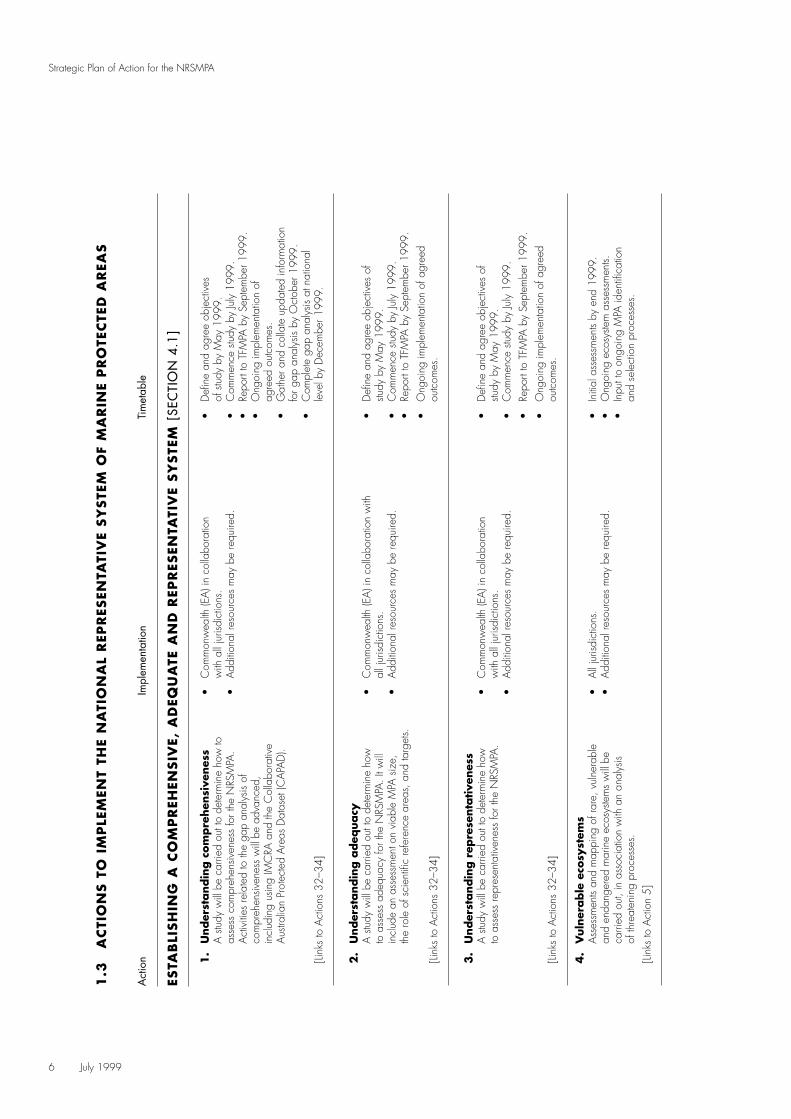
1.
Under
standin
g c
om
pre
hen
sive
nes
s•
Com
mon
wea
lth (E
A) i
n co
llabo
ratio
n•
Defi
ne a
nd a
gree
obj
ectiv
es
A s
tudy
will
be c
arrie
d ou
t to
dete
rmin
e ho
w to
with
all
juris
dict
ions
.of
stu
dy b
y M
ay 1
999.
asse
ss c
ompr
ehen
siven
ess
for t
he N
RSM
PA.
•A
dditi
onal
reso
urce
s m
ay b
e re
quire
d.•
Com
men
ce s
tudy
by
July
199
9.A
ctiv
ities
rela
ted
to th
e ga
p an
alys
is of
•Re
port
to T
FMPA
by
Sept
embe
r 199
9.co
mpr
ehen
siven
ess
will
be a
dvan
ced,
•
Ong
oing
impl
emen
tatio
n of
incl
udin
g us
ing
IMC
RA a
nd th
e C
olla
bora
tive
agre
ed o
utco
mes
.A
ustra
lian
Prot
ecte
d A
reas
Dat
aset
(CA
PAD
).•
Gat
her a
nd c
olla
te u
pdat
ed in
form
atio
nfo
r gap
ana
lysis
by
Oct
ober
199
9.•
Com
plet
e ga
p an
alys
is at
nat
iona
l[Li
nks
to A
ctio
ns 3
2–34
]le
vel b
y D
ecem
ber 1
999.
2.
Under
standin
g a
deq
uacy
A s
tudy
will
be c
arrie
d ou
t to
dete
rmin
e ho
w
•C
omm
onw
ealth
(EA
) in
colla
bora
tion
with
•
Defi
ne a
nd a
gree
obj
ectiv
es o
fto
ass
ess
adeq
uacy
for t
he N
RSM
PA. I
t will
all j
urisd
ictio
ns.
study
by
May
199
9.in
clud
e an
ass
essm
ent o
n vi
able
MPA
siz
e,
•A
dditi
onal
reso
urce
s m
ay b
e re
quire
d.•
Com
men
ce s
tudy
by
July
199
9.th
e ro
le o
f sci
entifi
c re
fere
nce
area
s, a
nd ta
rget
s.•
Repo
rt to
TFM
PA b
y Se
ptem
ber 1
999.
•O
ngoi
ng im
plem
enta
tion
of a
gree
d[Li
nks
to A
ctio
ns 3
2–34
]ou
tcom
es.
3.
Under
standin
g r
epre
senta
tive
nes
sA
stu
dy w
ill be
car
ried
out t
o de
term
ine
how
•
Com
mon
wea
lth (E
A) i
n co
llabo
ratio
n•
Defi
ne a
nd a
gree
obj
ectiv
es o
fto
ass
ess
repr
esen
tativ
enes
s fo
r the
NRS
MPA
.w
ith a
ll ju
risdi
ctio
ns.
study
by
May
199
9.•
Add
ition
al re
sour
ces
may
be
requ
ired.
•C
omm
ence
stu
dy b
y Ju
ly 1
999.
•Re
port
to T
FMPA
by
Sept
embe
r 199
9.•
Ong
oing
impl
emen
tatio
n of
agr
eed
[Link
s to
Act
ions
32–
34]
outc
omes
.
4.
Vuln
erable
eco
syst
ems
Ass
essm
ents
and
map
ping
of r
are,
vul
nera
ble
•A
ll ju
risdi
ctio
ns.
•In
itial
ass
essm
ents
by e
nd 1
999.
and
enda
nger
ed m
arin
e ec
osys
tem
s w
ill be
•
Add
ition
al re
sour
ces
may
be
requ
ired.
•O
ngoi
ng e
cosy
stem
ass
essm
ents.
carri
ed o
ut, i
n as
soci
atio
n w
ith a
n an
alys
is •
Inpu
t to
ongo
ing
MPA
iden
tifica
tion
of th
reat
enin
g pr
oces
ses.
and
sele
ctio
n pr
oces
ses.
[Link
s to
Act
ion
5]
1.3
AC
TIO
NS T
O I
MP
LEM
ENT
THE
NA
TIO
NA
L R
EPR
ESEN
TATI
VE
SY
STE
M O
F M
AR
INE
PR
OTE
CTE
D A
REA
S

July 1999 7
Strategic Plan of Action for the NRSMPA
Act
ion
Impl
emen
tatio
nTi
met
able
5.
Iden
tify
ing p
riori
ties
for
candid
ate
MPA
sId
entif
y na
tiona
l and
regi
onal
can
dida
te
•C
omm
onw
ealth
(EA
) in
colla
bora
tion
•Lis
t of n
atio
nal p
riorit
y IM
CRA
regi
ons
area
s fo
r esta
blish
ing
MPA
s ba
sed
on in
form
atio
nw
ith a
ll ju
risdi
ctio
ns.
to T
FMPA
by
Dec
embe
r 199
9.fro
m A
ctio
ns 1
–4 a
nd 1
0–11
.•
Add
ition
al re
sour
ces
may
be
requ
ired.
•In
terim
lists
of r
egio
nal p
riorit
ies
for M
PAde
clar
atio
n to
TFM
PA b
y m
id-2
000.
•O
ngoi
ng a
nnua
l rep
ortin
g of
prio
rity
MPA
lists
.•
Ong
oing
inpu
t of n
atio
nal a
nd
regi
onal
prio
ritie
s to
the
MPA
[Link
s to
Act
ions
1–4
and
10–
11]
iden
tifica
tion
and
sele
ctio
n pr
oces
s.
INFO
RM
ATI
ON
REQ
UIR
EMEN
TS A
ND
MA
NA
GEM
ENT
[SEC
TIO
N 4
.2]
INFO
RM
ATI
ON
REQ
UIR
EMEN
TS
6.
Ecosy
stem
mappin
gC
ontin
ue e
cosy
stem
map
ping
and
bio
dive
rsity
•
All
juris
dict
ions
.•
Ong
oing
sys
tem
atic
sur
veys
.as
sess
men
t wor
k. T
hese
dat
a w
ill al
so b
e us
ed
•A
dditi
onal
reso
urce
s m
ay b
e re
quire
d.•
Prog
ress
on
loca
l-sca
le e
cosy
stem
map
ping
,in
futu
re re
finem
ent o
f IM
CRA
.in
clud
ing
natio
nal o
verv
iew
, by
end
2000
.•
Subs
tant
ial p
rogr
ess
on s
ite-sc
ale
map
ping
by
end
2001
.
7.
Dev
elopin
g d
ata
colle
ctio
n s
tandard
sC
ross
-juris
dict
iona
l coo
pera
tion
to d
evel
op
•C
omm
onw
ealth
(EA
) in
colla
bora
tion
•Re
view
and
ana
lyse
cur
rent
com
para
ble
stand
ards
for d
ata
colle
ctio
n.w
ith a
ll ju
risdi
ctio
ns.
met
hodo
logi
es b
y ea
rly 2
001.
•A
dditi
onal
reso
urce
s m
ay b
e re
quire
d.•
Repo
rt to
TFM
PA b
y m
id-2
001.
•A
gree
d sta
ndar
ds b
y la
te 2
001.
•O
ngoi
ng im
plem
enta
tion
of a
gree
d [Li
nks
to A
ctio
ns 1
6 an
d 19
]sta
ndar
ds.
8.
Rev
iew
met
hods
for
ecosy
stem
mappin
gRe
view
met
hods
for m
appi
ng e
cosy
stem
s fo
r the
•
Com
mon
wea
lth (E
A) i
n co
llabo
ratio
n•
Defi
ne a
nd a
gree
obj
ectiv
es o
f stu
dyN
RSM
PA a
nd d
evel
op a
n op
erat
iona
l defi
nitio
n w
ith a
ll ju
risdi
ctio
ns.
by M
ay 1
999.
of e
cosy
stem
.•
Add
ition
al re
sour
ces
may
be
requ
ired.
•C
omm
ence
stu
dy b
y Ju
ly 1
999.
•Re
port
to T
FMPA
by
Sept
embe
r 199
9.•
Agr
eem
ent o
n an
ope
ratio
nal
[Link
s to
Act
ions
1–3
]de
finiti
on o
f eco
syste
m b
y en
d 19
99.
9.
Rapid
ass
essm
ent
met
hodolo
gy
To id
entif
y th
e ar
eas
of h
ighe
st pr
iorit
y fo
r add
ition
•
Com
mon
wea
lth (E
A) i
n co
llabo
ratio
n•
Revi
ew a
nd a
sses
s ex
istin
g to
the
NRS
MPA
, sui
tabl
e ra
pid
asse
ssm
ent m
etho
ds
with
all
juris
dict
ions
.m
etho
dolo
gies
by
end
1999
.w
ill be
ana
lyse
d.•
Add
ition
al re
sour
ces
may
be
requ
ired.
•C
ondu
ct c
ase
study
and
ana
lyse
by m
id-2
000.
•Ra
pid
asse
ssm
ent m
etho
d/s
will
be
pres
ente
d by
end
200
0.
8 July 1999
Strategic Plan of Action for the NRSMPA
Act
ion
Impl
emen
tatio
nTi
met
able
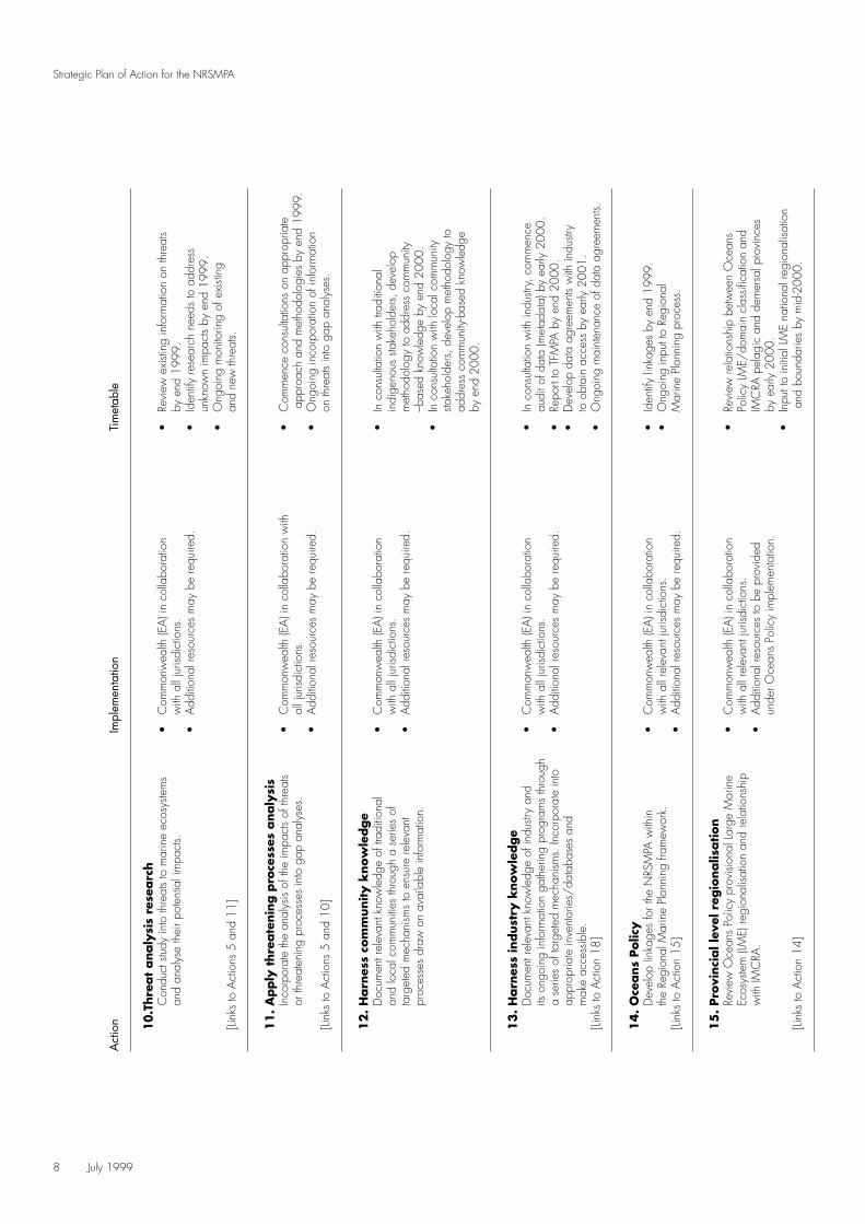
10.T
hre
at
analy
sis
rese
arc
hC
ondu
ct s
tudy
into
thre
ats
to m
arin
e ec
osys
tem
s •
Com
mon
wea
lth (E
A) i
n co
llabo
ratio
n•
Revi
ew e
xisti
ng in
form
atio
n on
thre
ats
and
anal
yse
thei
r pot
entia
l im
pact
s.w
ith a
ll ju
risdi
ctio
ns.
by e
nd 1
999.
•A
dditi
onal
reso
urce
s m
ay b
e re
quire
d.•
Iden
tify
rese
arch
nee
ds to
add
ress
unkn
own
impa
cts
by e
nd 1
999.
•O
ngoi
ng m
onito
ring
of e
xisti
ng[Li
nks
to A
ctio
ns 5
and
11]
and
new
thre
ats.
11
. A
pply
thre
ate
nin
g p
roce
sses
analy
sis
Inco
rpor
ate
the
anal
ysis
of th
e im
pact
s of
thre
ats
•C
omm
onw
ealth
(EA
) in
colla
bora
tion
with
•C
omm
ence
con
sulta
tions
on
appr
opria
teor
thre
aten
ing
proc
esse
s in
to g
ap a
naly
ses.
all j
urisd
ictio
ns.
appr
oach
and
met
hodo
logi
es b
y en
d 19
99.
•A
dditi
onal
reso
urce
s m
ay b
e re
quire
d.•
Ong
oing
inco
rpor
atio
n of
info
rmat
ion
[Link
s to
Act
ions
5 a
nd 1
0]on
thre
ats
into
gap
ana
lyse
s.
12
. H
arn
ess
com
munity k
now
ledge
Doc
umen
t rel
evan
t kno
wle
dge
of tr
aditi
onal
•
Com
mon
wea
lth (E
A) i
n co
llabo
ratio
n•
In c
onsu
ltatio
n w
ith tr
aditi
onal
an
d lo
cal c
omm
uniti
es th
roug
h a
serie
s of
w
ith a
ll ju
risdi
ctio
ns.
indi
geno
us s
take
hold
ers,
dev
elop
targ
eted
mec
hani
sms
to e
nsur
e re
leva
nt
•A
dditi
onal
reso
urce
s m
ay b
e re
quire
d.m
etho
dolo
gy to
add
ress
com
mun
itypr
oces
ses
draw
on
avai
labl
e in
form
atio
n.–b
ased
kno
wle
dge
by e
nd 2
000.
•In
con
sulta
tion
with
loca
l com
mun
itysta
keho
lder
s, d
evel
op m
etho
dolo
gy to
ad
dres
s co
mm
unity
-bas
ed k
now
ledg
e by
end
200
0.
13
. H
arn
ess
indust
ry k
now
ledge
Doc
umen
t rel
evan
t kno
wle
dge
of in
dustr
y an
d•
Com
mon
wea
lth (E
A) i
n co
llabo
ratio
n•
In c
onsu
ltatio
n w
ith in
dustr
y, c
omm
ence
its o
ngoi
ng in
form
atio
n ga
ther
ing
prog
ram
s th
roug
h w
ith a
ll ju
risdi
ctio
ns.
audi
t of d
ata
(met
adat
a) b
y ea
rly 2
000.
a se
ries
of ta
rget
ed m
echa
nism
s. In
corp
orat
e in
to
•A
dditi
onal
reso
urce
s m
ay b
e re
quire
d.•
Repo
rt to
TFM
PA b
y en
d 20
00.
appr
opria
te in
vent
orie
s/da
taba
ses
and
•D
evel
op d
ata
agre
emen
ts w
ith in
dustr
ym
ake
acce
ssib
le.
to o
btai
n ac
cess
by
early
200
1.[Li
nks
to A
ctio
n 18
]•
Ong
oing
mai
nten
ance
of d
ata
agre
emen
ts.
14
. O
ceans
Polic
yD
evel
op li
nkag
es fo
r the
NRS
MPA
with
in
•C
omm
onw
ealth
(EA
) in
colla
bora
tion
•Id
entif
y lin
kage
s by
end
199
9.th
e Re
gion
al M
arin
e Pl
anni
ng fr
amew
ork.
with
all
rele
vant
juris
dict
ions
.•
Ong
oing
inpu
t to
Regi
onal
[Link
s to
Act
ion
15]
•A
dditi
onal
reso
urce
s m
ay b
e re
quire
d.M
arin
e Pl
anni
ng p
roce
ss.
15
. Pro
vinci
al l
evel
reg
ionalis
ation
Revi
ew O
cean
s Po
licy
prov
ision
al L
arge
Mar
ine
•C
omm
onw
ealth
(EA
) in
colla
bora
tion
•Re
view
rela
tions
hip
betw
een
Oce
ans
Ecos
yste
m (L
ME)
regi
onal
isatio
n an
d re
latio
nshi
p w
ith a
ll re
leva
nt ju
risdi
ctio
ns.
Polic
y LM
E/do
mai
n cl
assifi
catio
n an
dw
ith IM
CRA
.•
Add
ition
al re
sour
ces
to b
e pr
ovid
edIM
CRA
pel
agic
and
dem
ersa
l pro
vinc
esun
der O
cean
s Po
licy
impl
emen
tatio
n.by
ear
ly 2
000.
•In
put t
o in
itial
LM
E na
tiona
l reg
iona
lisat
ion
[Link
s to
Act
ion
14]
and
boun
darie
s by
mid
-200
0.
July 1999 9
Strategic Plan of Action for the NRSMPA
Act
ion
Impl
emen
tatio
nTi
met
able
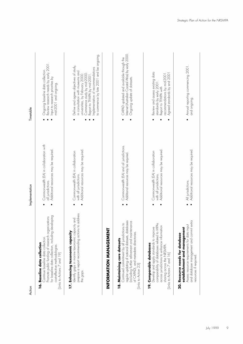
16
. Base
line
data
colle
ctio
nC
ontin
ue b
asel
ine
data
col
lect
ion.
•
Com
mon
wea
lth (E
A) i
n co
llabo
ratio
n w
ith•
Ong
oing
bas
elin
e da
ta c
olle
ctio
n.Pr
omot
e pu
blic
fund
ing
of re
sear
ch o
rgan
isatio
ns
all j
urisd
ictio
ns.
•Re
view
rese
arch
nee
ds b
y ea
rly 2
001.
for b
asel
ine
data
col
lect
ion,
incl
udin
g de
velo
ping
•A
dditi
onal
reso
urce
s m
ay b
e re
quire
d.•
Inpu
t to
rese
arch
prio
ritie
s by
cost-
effe
ctiv
e m
etho
dolo
gies
.m
id-2
001
and
ongo
ing.
[Link
s to
Act
ions
7 a
nd 1
9]
17
. En
hanci
ng t
ax
onom
ic c
apaci
tyId
entif
y ga
ps in
mar
ine
taxo
nom
ic c
apac
ity a
nd
•C
omm
onw
ealth
(EA
) in
colla
bora
tion
•D
efine
and
agr
ee o
bjec
tives
of s
tudy
,pr
epar
e a
repo
rt re
com
men
ding
act
ions
to a
ddre
ss
with
all
juris
dict
ions
.in
con
sulta
tion
with
mus
eum
s an
dth
e ga
ps.
•A
dditi
onal
reso
urce
s m
ay b
e re
quire
d.un
iver
sitie
s, b
y Fe
brua
ry 2
000.
•C
omm
ence
stu
dy b
y m
id-2
000.
•Re
port
to T
FMPA
by
mid
-200
1.•
Impl
emen
tatio
n of
reco
mm
enda
tions
to
com
men
ce b
y la
te 2
001
and
be o
ngoi
ng.
INFO
RM
ATI
ON
MA
NA
GEM
ENT
18
. M
ain
tain
ing c
ore
data
sets
Con
tinue
d co
mm
itmen
t by
all j
urisd
ictio
ns to
•
Com
mon
wea
lth (E
A) a
nd a
ll ju
risdi
ctio
ns.
•C
APA
D u
pdat
ed a
nd a
vaila
ble
thro
ugh
the
regu
lar u
pdat
ing
of n
atio
nal d
atas
ets,
data
base
s •
Addi
tiona
l res
ourc
es m
ay b
e re
quire
d.In
tern
et (A
ustra
lian
Coa
stal A
tlas)
by e
arly
2000
.(in
clud
ing
furth
er re
finem
ent a
nd m
aint
enan
ce
•O
ngoi
ng u
pdat
e of
dat
aset
s.of
CA
PAD
), an
d m
etad
ata
dire
ctor
ies.
[Link
s to
Act
ion
23]
19
. Com
para
ble
data
base
sD
evel
op a
nd a
pply
sta
ndar
ds to
impr
ove
•C
omm
onw
ealth
(EA
) in
colla
bora
tion
•Re
view
and
ass
ess
exist
ing
data
com
para
bilit
y of
dat
abas
es re
late
d to
MPA
s w
ith a
ll ju
risdi
ctio
ns.
stand
ards
by
early
200
1.ac
ross
juris
dict
ions
to e
nhan
ce in
form
atio
n•
Add
ition
al re
sour
ces
may
be
requ
ired.
•Re
port
to T
FMPA
with
shar
ing
acro
ss th
e N
RSM
PA.
reco
mm
enda
tions
by
mid
-200
1.[Li
nks
to A
ctio
ns 7
and
16]
•A
gree
d sta
ndar
ds b
y en
d 20
01
20
. Res
ourc
e nee
ds
for
data
base
es
tablis
hm
ent
and m
anagem
ent
Ass
ess
reso
urce
requ
irem
ents
for d
ata
inpu
t •
All
juris
dict
ions
.•
Ann
ual r
epor
ting
com
men
cing
200
1.
and
data
base
man
agem
ent a
nd c
omm
it ex
tra
•A
dditi
onal
reso
urce
s m
ay b
e re
quire
d.an
d on
goin
g.re
sour
ces
if re
quire
d.

10 July 1999
Strategic Plan of Action for the NRSMPA
Act
ion
Impl
emen
tatio
nTi
met
able
INV
OLV
EMEN
T O
F ST
AK
EHO
LDER
S [S
ECTI
ON
4.3
]
21
. A
naly
sis
of
info
rmation p
rogra
ms
Con
duct
an
anal
ysis
of ju
risdi
ctio
ns’ e
xisti
ng
•C
omm
onw
ealth
(EA
) in
colla
bora
tion
•Re
view
and
ass
ess
exist
ing
info
rmat
ion
and
educ
atio
n pr
ogra
ms
to p
rom
ote
with
all
juris
dict
ions
.m
etho
dolo
gies
by
early
200
1.in
form
atio
n sh
arin
g an
d be
st pr
actic
e.•
Add
ition
al re
sour
ces
may
be
requ
ired.
•A
naly
sis c
ompl
eted
and
repo
rtto
TFM
PA b
y m
id-2
001.
•O
ngoi
ng fa
cilit
atio
n of
in
form
atio
n sh
arin
g.
22
. St
ak
ehold
er u
nder
standin
gD
evel
op a
dia
logu
e w
ith s
take
hold
ers,
•
Com
mon
wea
lth (E
A) i
n co
llabo
ratio
n•
Dev
elop
pro
cess
with
sta
keho
lder
rega
rdin
g ec
olog
ical
and
soc
io-e
cono
mic
val
ues,
w
ith a
ll ju
risdi
ctio
ns.
cons
ulta
tion
by e
arly
200
0.an
d str
ateg
ic a
nd p
oliti
cal p
roce
sses
invo
lved
•A
dditi
onal
reso
urce
s m
ay b
e re
quire
d.•
Repo
rt to
TFM
PA re
com
men
ding
in th
e se
lect
ion
and
decl
arat
ion
of M
PAs.
proc
ess
by m
id-2
000.
•C
omm
ence
impl
emen
tatio
n of
pro
cess
by la
te 2
000.
23
. In
form
ation a
vaila
bili
tyW
here
nat
iona
l dire
ctor
ies
and
data
base
s ex
ist,
•C
omm
onw
ealth
(EA
).•
Iden
tify
stake
hold
ers
and
distr
ibut
ion
ensu
re th
at a
dvic
e of
thei
r exi
stenc
e an
d av
aila
bilit
y •
Add
ition
al re
sour
ces
may
be
requ
ired.
mec
hani
sms
by e
arly
200
0.is
distr
ibut
ed w
idel
y (in
clud
ing
thro
ugh
the
Inte
rnet
, •
Initi
al d
istrib
utio
n by
mid
-200
0.A
ustra
lian
Coa
stal A
tlas,
Blu
e Pa
ges).
•O
ngoi
ng d
istrib
utio
n of
info
rmat
ion.
[Link
s to
Act
ion
18]
CLA
SSIF
YIN
G M
AR
INE
PR
OTE
CTE
D A
REA
S [
SEC
TIO
N 4
.4]
IUC
N P
RO
TEC
TED
AR
EA M
AN
AG
EMEN
T C
ATE
GO
RIE
S
24
. A
naly
sis
of
IUCN
pro
tect
ed a
rea m
anagem
ent
cate
gori
esA
naly
se th
e ap
plic
atio
n of
the
IUC
N p
rote
cted
•
Com
mon
wea
lth (E
A) i
n co
llabo
ratio
n•
Defi
ne a
nd a
gree
sco
pe o
far
ea m
anag
emen
t cat
egor
ies
in th
e A
ustra
lian
with
all
juris
dict
ions
.A
ctio
n by
ear
ly 2
001.
mar
ine
cont
ext.
•A
dditi
onal
reso
urce
s m
ay b
e re
quire
d.•
Repo
rt to
TFM
PA b
y m
id-2
001.
[Link
s to
Act
ion
25]
25
. A
pplic
ation o
f IU
CN
pro
tect
ed a
rea m
anagem
ent
cate
gori
es
Dev
elop
TFM
PA p
roce
ss fo
r con
siste
nt a
pplic
atio
n •
Com
mon
wea
lth (E
A) i
n co
llabo
ratio
n•
Ass
ess
the
exist
ing
appl
icat
ion
of c
ateg
orie
s fo
r inc
lusio
n in
CA
PAD
.w
ith a
ll ju
risdi
ctio
ns.
of c
ateg
orie
s ac
ross
juris
dict
ions
•A
dditi
onal
reso
urce
s m
ay b
e re
quire
d.
by m
id-2
001.
•Re
port
to T
FMPA
reco
mm
endi
ngco
nsist
ent a
ppro
ach
by e
nd 2
001.
•Im
plem
ent c
onsis
tent
app
licat
ion
[Link
s to
Act
ions
24
and
26]
proc
ess
from
200
2.

July 1999 11
Strategic Plan of Action for the NRSMPAA
ctio
nIm
plem
enta
tion
Tim
etab
le
26
. IU
CN
pro
tect
ed a
rea m
anagem
ent
cate
gory
rep
ort
ing
Ann
ual r
epor
ting
of IU
CN
cat
egor
ies,
incl
udin
g •
Com
mon
wea
lth (E
A) i
n co
llabo
ratio
n•
Ann
ual r
epor
ting
ongo
ing.
for i
nter
nal z
onin
gs fo
r rel
evan
t MPA
s.w
ith a
ll ju
risdi
ctio
ns.
[Link
s to
Act
ion
25]
•A
dditi
onal
reso
urce
s m
ay b
e re
quire
d.
NO
MEN
CLA
TURE
27
. N
ationally
consi
sten
t nom
encl
atu
reD
evel
op n
atio
nally
con
siste
nt d
efini
tions
for
•C
omm
onw
ealth
(EA
) in
colla
bora
tion
•Re
view
of n
atio
nal a
nd in
tern
atio
nal
MPA
s to
refle
ct th
eir o
bjec
tive,
man
agem
ent
with
all
juris
dict
ions
.no
men
clat
ure
by e
arly
200
1.in
tent
and
ratio
nale
for p
erm
issib
le a
ctiv
ities
, •
Add
ition
al re
sour
ces
may
be
requ
ired.
•Re
port
to T
FMPA
by
mid
-200
1.w
hich
can
pro
gres
sivel
y le
ad to
con
siste
nt
•Re
port
on c
onsis
tent
nom
encl
atur
eno
men
clat
ure.
by e
nd 2
001.
[Link
s to
Act
ions
24
and
25]
MA
NA
GIN
G T
HE
NRSM
PA [S
ECTI
ON
4.5
]
28
. Jo
int
managem
ent
arr
angem
ents
Exam
ine
curre
nt jo
int c
ross
-juris
dict
iona
l man
agem
ent
•C
omm
onw
ealth
(EA
) in
colla
bora
tion
•Re
view
and
ass
ess
exist
ing
arra
ngem
ents
to id
entif
y be
st pr
actic
e el
emen
ts.w
ith a
ll ju
risdi
ctio
ns.
arra
ngem
ents
by m
id-2
000.
•A
dditi
onal
reso
urce
s m
ay b
e re
quire
d.•
Repo
rt to
TFM
PA b
y en
d 20
00.
29
. In
dig
enous
inte
rest
sD
evel
op s
trate
gies
in a
ssoc
iatio
n w
ith
•C
omm
onw
ealth
(EA
) in
colla
bora
tion
•D
evel
op m
etho
dolo
gy to
add
ress
indi
geno
us p
eopl
es to
enh
ance
thei
r par
ticip
atio
n w
ith a
ll ju
risdi
ctio
ns.
indi
geno
us in
tere
sts b
y ea
rly 2
000.
in th
e N
RSM
PA.
•A
dditi
onal
reso
urce
s m
ay b
e re
quire
d.•
Dra
ft str
ateg
ies
deve
lope
d by
en
d 20
00.
•TF
MPA
end
orse
men
t by
mid
-200
1.•
Ong
oing
impl
emen
tatio
n of
stra
tegi
es.
30
. M
odel
s of
indust
ry c
ooper
ative
managem
ent
Dev
elop
mod
els
for i
ndus
try in
volve
men
t in,
•
Com
mon
wea
lth (E
A) i
n co
llabo
ratio
n•
Fram
ewor
k de
velo
ped
in c
oope
ratio
nan
d co
ntrib
utio
n to
, the
mon
itorin
g an
d
with
all
juris
dict
ions
.w
ith in
dustr
y by
mid
-200
0.m
anag
emen
t of M
PAs.
•A
dditi
onal
reso
urce
s m
ay b
e re
quire
d.•
App
licat
ion
of m
odel
with
in s
elec
ted
MPA
s by
ear
ly 2
001.
12 July 1999
Strategic Plan of Action for the NRSMPA
Act
ion
Impl
emen
tatio
nTi
met
able
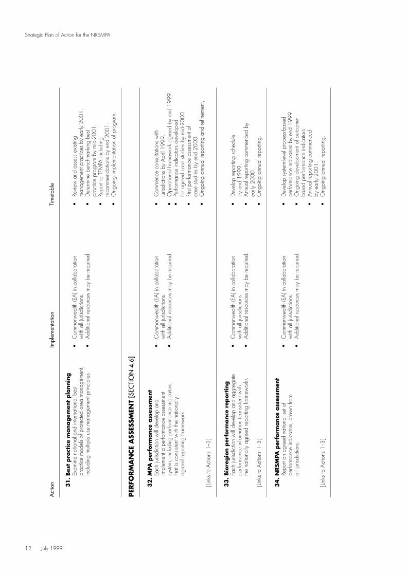
31
. Bes
t pra
ctic
e m
anagem
ent
pla
nnin
gEx
amin
e na
tiona
l and
inte
rnat
iona
l bes
t •
Com
mon
wea
lth (E
A) i
n co
llabo
ratio
n•
Revi
ew a
nd a
sses
s ex
istin
gpr
actic
e m
odel
s of
pro
tect
ed a
rea
man
agem
ent,
with
all
juris
dict
ions
.m
anag
emen
t pra
ctic
es b
y ea
rly 2
001.
incl
udin
g m
ultip
le u
se m
anag
emen
t prin
cipl
es.
•A
dditi
onal
reso
urce
s m
ay b
e re
quire
d.•
Det
erm
ine
benc
hmar
king
bes
t pr
actic
e pr
ogra
m b
y m
id-2
001.
•Re
port
to T
FMPA
incl
udin
gre
com
men
datio
ns b
y en
d 20
01.
•O
ngoi
ng im
plem
enta
tion
of p
rogr
am.
PER
FORM
AN
CE
ASS
ESSM
ENT
[SEC
TIO
N 4
.6]
32
. M
PA p
erfo
rmance
ass
essm
ent
Each
juris
dict
ion
will
deve
lop
and
•C
omm
onw
ealth
(EA
) in
colla
bora
tion
•C
omm
ence
con
sulta
tions
with
impl
emen
t a p
erfo
rman
ce a
sses
smen
t w
ith a
ll ju
risdi
ctio
ns.
juris
dict
ions
by
Apr
il 19
99.
syste
m, i
nclu
ding
per
form
ance
indi
cato
rs,
•A
dditi
onal
reso
urce
s m
ay b
e re
quire
d.•
Ope
ratio
nal f
ram
ewor
k ag
reed
by
end
1999
.th
at is
con
siste
nt w
ith th
e na
tiona
lly
•Pe
rform
ance
indi
cato
rs d
evel
oped
agre
ed re
porti
ng fr
amew
ork.
for a
gree
d ca
se s
tudi
es b
y m
id-2
000.
•Fi
rst p
erfo
rman
ce a
sses
smen
t of
case
stu
dies
by
end
2000
.•
Ong
oing
ann
ual r
epor
ting
and
refin
emen
t.[Li
nks
to A
ctio
ns 1
–3]
33
.Bio
regio
n p
erfo
rmance
rep
ort
ing
Each
juris
dict
ion
will
deve
lop
and
aggr
egat
e •
Com
mon
wea
lth (E
A) i
n co
llabo
ratio
n•
Dev
elop
repo
rting
sch
edul
epe
rform
ance
info
rmat
ion
(con
siste
nt w
ith
with
all
juris
dict
ions
.by
end
199
9.th
e na
tiona
lly a
gree
d re
porti
ng fr
amew
ork)
.•
Add
ition
al re
sour
ces
may
be
requ
ired.
•A
nnua
l rep
ortin
g co
mm
ence
d by
early
200
0.[Li
nks
to A
ctio
ns 1
–3]
•O
ngoi
ng a
nnua
l rep
ortin
g.
34
. N
RSM
PA p
erfo
rmance
ass
essm
ent
Repo
rt on
agr
eed
natio
nal s
et o
f •
Com
mon
wea
lth (E
A) i
n co
llabo
ratio
n•
Dev
elop
sys
tem
-leve
l pro
cess
-bas
edpe
rform
ance
indi
cato
rs, d
raw
n fro
m
with
all
juris
dict
ions
.pe
rform
ance
indi
cato
rs b
y en
d 19
99.
all j
urisd
ictio
ns.
•A
dditi
onal
reso
urce
s m
ay b
e re
quire
d.•
Ong
oing
dev
elop
men
t of o
utco
me-
base
d pe
rform
ance
indi
cato
rs.
•A
nnua
l rep
ortin
g co
mm
ence
dby
ear
ly 2
001.
[Link
s to
Act
ions
1–3
]•
Ong
oing
ann
ual r
epor
ting.
July 1999 13
Strategic Plan of Action for the NRSMPA
Australia is the world’s largest island. It has someof the most diverse, unique and spectacularmarine life in the world. Its marine environmentincludes extensive coral reefs in the tropical north,rocky shores in the temperate south, sandybeaches, seagrass beds, mangrove forests, theopen ocean, seamounts, and the habitats of thecontinental shelf and slope.
Biological diversity is the variety of all life forms –the different plants, animals and micro-organisms,the genes they contain, and the ecosystems ofwhich they form a part. The conservation ofmarine biodiversity and the maintenance ofecological processes are recognised nationallyand internationally as being best achieved throughstrategic regional planning that provides for theestablishment and effective management of arepresentative system of MPAs, and thecomplementary sustainable management ofadjoining waters. This Plan deals with theprotected areas system component of suchan approach.
The NRSMPA is being established within abioregional framework that identifies marineregions across jurisdictional boundaries. Theframework recognises the interconnectivity ofmarine systems, allowing for the marineenvironment to be understood and plannedfor on an ecosystem basis.
2.1 HOW THE NRSMPA IS BEINGESTABLISHED
The NRSMPA is a national system of MPAs thatcontains representative samples of Australia’smarine ecosystems. The NRSMPA consists of MPAsin Commonwealth, State and Northern Territorywaters and some associated coastal and intertidalareas. The NRSMPA is being developedcooperatively by government agencies responsible
for conservation, protection and managementof the marine environment. Individual MPAs aredeclared under the appropriate legislation foreach jurisdiction.
ANZECC/TFMPA
The ANZECC Task Force on Marine ProtectedAreas (TFMPA) provides the mechanism for States,the Northern Territory, the Commonwealth andrelevant scientific organisations to coordinateactivities and collaborate on policy developmentand projects for the NRSMPA. Details ofmembership by organisations are provided inAppendix 1.
The current membership of TFMPA includesdirect representation of conservation managementagencies from all relevant Australian governmentsand of resource management agencies from mostjurisdictions. The role of each of the TFMPAmembers is to act as a two-way informationconduit for the stakeholders that they represent,including other interested government agencies,industry, and community groups, indigenousand non-government groups.
Jurisdictions
Cross-jurisdictional cooperation is anessential element in achieving the NRSMPA.The Commonwealth Government and theGovernments of each of the States and theNorthern Territory are the principal administrativeplayers involved in the establishment of MPAs.Within some jurisdictions, local government maybe involved in coastal planning for, andmanagement of, MPAs. Ultimately, the decisionto declare an MPA is made by the responsibleMinister, or Ministers, in each jurisdiction.
PART TWO UNDERSTANDING THE NRSMPA
14 July 1999
Strategic Plan of Action for the NRSMPA
Guidelines for Establishing the NRSMPA
A process for establishing the NRSMPA isset out in the Guidelines for Establishing theNational Representative System of MarineProtected Areas (ANZECC TFMPA 1998). Theroles of the different jurisdictions and broadcriteria for the identification and selection ofMPAs are presented. The Guidelines documentis complementary to the Plan and is includedin full in Appendix 2.
2.2 INTERNATIONAL ANDNATIONAL CONTEXT
Development of an NRSMPA fulfils Australia’sinternational responsibilities and obligations asa signatory to the Convention on BiologicalDiversity (UNEP 1994) and the major componentsof the Jakarta Mandate developed under thatConvention. The NRSMPA also provides a meansof meeting obligations under the Convention onMigratory Species (Bonn Convention) andresponsibilities under bilateral agreements formigratory birds (JAMBA and CAMBA). It alsosupports the World Conservation Union (IUCN)World Commission on Protected Areas programof promoting the establishment and managementof a global representative system of MPAs(Kelleher et al. 1995).
Australia’s commitment to the protection of marinebiodiversity and ecological processes, and thesustainable use of marine resources is addressedat a national level under the IntergovernmentalAgreement on the Environment (Commonwealthof Australia 1992a). It is implemented through theactions developed under national strategies suchas the National Strategy for EcologicallySustainable Development (Commonwealth ofAustralia 1992b) and the National Strategy for theConservation of Australia’s Biological Diversity(Commonwealth of Australia 1996). Theestablishment of a national system of protectedareas is a key responsibility and obligation underthese conventions and strategies.
2.3 AUSTRALIA’S OCEANS POLICY
Australia’s Oceans Policy (Commonwealthof Australia 1998) was launched by theCommonwealth in December 1998 and providesa framework for the integration of environmental,economic, social and cultural ocean uses. TheOceans Policy established the broad principlesand management approaches necessary to achieveecologically sustainable development of Australia’soceans. At the core of the Oceans Policy is amove to integrated and ecosystem-based planningand management which will be binding on allCommonwealth agencies and will be deliveredthrough development of Regional Marine Plansbased on large marine ecosystems.
Identification of priorities and measures to meetconservation requirements will be included undereach Regional Marine Plan. As far as possible,future representative marine protected areaproposals under the Commonwealth componentof the NRSMPA will be developed as part of theRegional Marine Planning process. Areas ofknown outstanding conservation significance will,however, continue to be assessed for protectionin accordance with existing processes.
The Oceans Policy proposes the primary vehiclefor Commonwealth–State consultation on theimplementation of the Oceans Policy is ANZECC,in consultation with a range of other ministerialcouncils. The development of the Regional MarinePlanning process will require integration with othernational oceans-related initiatives such as the NRSMPA.
2.4 OTHER BIODIVERSITYCONSERVATION MECHANISMS
The NRSMPA exists in the context of a rangeof national and State/Territory mechanisms toachieve biodiversity conservation. The broaderrange of conservation mechanisms includes:
• species-specific conservation of marine biota;
• regulation and management of marineresource use;
• promotion of the principles and practiceof ecologically sustainable development;
• reduction and management of pollution;

July 1999 15
Strategic Plan of Action for the NRSMPA
• management of the impacts of developmentsthat affect the marine environment; and
• other marine managed areas operatingat a range of scales across the marineenvironment for a variety of primary purposes.
2.6 CHARACTERISTICS OF THE NRSMPA
ANZECC has adopted the IUCN definition(IUCN 1994) of ‘protected area’ to apply tomarine protected areas as follows:
An area of land and/or sea especiallydedicated to the protection and maintenanceof biological diversity, and of natural andassociated cultural resources, and managedthrough legal or other effective means.
Key characteristics distinguish the MPAs that formthe NRSMPA from other marine managed areas.They are that each MPA:
• has been established especially for theconservation of biodiversity (consistentwith the primary goal);
• can be classified into one or more of the sixIUCN protected area management categories(Appendix 3), reflecting the values andobjectives of the MPA;
• must have secure status which can only berevoked by a Parliamentary process; and
• contributes to the representativeness,comprehensiveness or adequacy of thenational system.
The MPA may incorporate areas ranging from highlyprotected areas to sustainable multiple-use areasaccommodating a wide spectrum of human activities.
2.7 PRINCIPLES FOR DEVELOPINGTHE NRSMPA
Development of the NRSMPA is based on thefollowing principles:
• Regional framework: The Interim Marineand Coastal Regionalisation for Australia(IMCRA) provides the national and regionalplanning framework for developing theNRSMPA, with ecosystems used as the basisfor determining representativeness.
• Comprehensiveness: The NRSMPA willinclude the full range of ecosystems recognisedat an appropriate scale within and acrosseach bioregion.
The primary goal of the NRSMPA is toestablish and manage a comprehensive,adequate and representative system ofMPAs to contribute to the long-termecological viability of marine andestuarine systems, to maintain ecologicalprocesses and systems, and to protectAustralia’s biological diversity at all levels.
The following secondary goals are designedto be compatible with the primary goal:
• To promote the development of MPAswithin the framework of integratedecosystem management;
• To provide a formal management frameworkfor a broad spectrum of human activities,including recreation, tourism, shipping andthe use or extraction of resources;
• To provide scientific reference sites;
• To provide for the special needs of rare,threatened or depleted species andthreatened ecological communities;
• To provide for the conservation of specialgroups of organisms – for example,species with complex habitat requirementsor mobile or migratory species, or speciesvulnerable to disturbance and which maydepend on reservation for their conservation;
• To protect areas of high conservation value including those containing highspecies diversity, natural refugia for floraand fauna and centres of endemism;
• To provide for the recreational, aestheticand cultural needs of indigenous and non-indigenous people.
2.5 GOALS OF THE NRSMPA
• Adequacy: The NRSMPA will have the requiredlevel of reservation to ensure the ecologicalviability and integrity of populations, speciesand communities.
• Representativeness: Those marine areas thatare selected for inclusion in MPAs shouldreasonably reflect the biotic diversity of themarine ecosystems from which they derive.
• Highly protected areas: The NRSMPA willaim to include some highly protected areas(IUCN Categories I and II) in each bioregion.
• Precautionary principle: The absence ofscientific certainty should not be a reason forpostponing measures to establish MPAs toprotect representative ecosystems. If an activityis assessed to have a low risk of causingserious or irreversible adverse effects, or ifthere is insufficient information with which toassess fully and with certainty the magnitude
and nature of the effects, decision makingshould proceed in a conservative andcautious manner.
• Consultation: The processes of identificationand selection of MPAs will include effectiveand high-quality public consultation withappropriate community and interest groups,to address current and future social, economicand cultural issues.
• Indigenous involvement: The interestsof Australia’s indigenous peoples should berecognised and incorporated in decisionmaking.
• Decision making: Decision-making processesshould effectively integrate both long-term andshort-term environmental, economic, social andequity considerations.
(Text in sections 2.5, 2.6 and 2.7 is reproducedfrom the Guidelines, refer to Appendix 2).
16 July 1999
Strategic Plan of Action for the NRSMPA

3.1 INTERIM MARINE ANDCOASTAL REGIONALISATIONFOR AUSTRALIA
The Interim Marine and Coastal Regionalisationfor Australia (IMCRA Technical Group 1998) hasestablished the bioregional framework for theplanning and management of the NRSMPA. IMCRAis a series of maps and descriptions that identifyregions with biological and physical characteristicsdistinct from those elsewhere in Australia. IMCRAmaps regions at two different scales: at a regionalscale (or meso-scale referring to distances of 100sto 1000s of kilometres, refer to Map 1), and at aprovincial scale (greater than 1000s of kilometres).
IMCRA is an ecosystem-based regionalisationthat provides the first layer in a broad ecologicalplanning framework. Within this framework, moredetailed information on ecosystems, communitiesand/or species distributions can be used to assistdecision making across or within a bioregion. Thesedecision-making processes are carried out by State,Northern Territory and Commonwealth agenciesfor their respective jurisdictions and require somecross-jurisdictional consultation where proposedMPAs cross jurisdictional boundaries.
An understanding of the patterns of biodiversity,particularly habitat biodiversity, is essential foridentifying an ecologically or biogeographicallyrepresentative system of protected areas. It is alsoessential in defining scaled ecological units forholistic, integrated ecosystem management.IMCRA will help identify gaps and set priorities forthe delivery and evaluation of programs toenhance the NRSMPA. Biological variation at thehabitat scale or micro-scale is also important inselecting candidate areas for MPAs.
IMCRA was developed through the collaborativeefforts of State, Northern Territory andCommonwealth marine conservation and research
agencies. It was endorsed by ANZECC in June1998 to be a key element of the Strategic Plan ofAction for NRSMPA. IMCRA is recognised as aninterim regionalisation as it will be further refinedover time.
Jurisdictions are using the IMCRA frameworkfor a variety of marine and coastal programs andissues, for example, national state of environmentreporting, environmental indicators, criteria forenvironmental impact assessment, and criteriafor selecting MPAs.
3.2 MARINE PROTECTEDAREAS BY BIOREGIONS
To assist in determining national and regionalpriorities in the development of the NRSMPA,a preliminary gap analysis has been carriedout at the national level. The analysis comparesinformation on the distribution of IMCRA meso-scale regions and the distribution of marineprotected areas, drawn from the CollaborativeAustralian Protected Areas Database (Cresswelland Thomas 1997) and supplementary informationprovided by the State and Northern TerritoryGovernments. A summary of the results of theanalysis is presented in Map 2. The data used forthe analysis are presented by IMCRA regions inAppendix 4. Note that due to the paucity of somedata, the results should be considered asillustrative.
The shading in Map 2 represents the percentagecoverage of MPAs within the IMCRA meso-scaleregions. The five distinct categories range from noprotected areas in a specific IMCRA bioregion toa category representing ≥50% coverage. The totalIMCRA meso-scale bioregionalisation encompassessome 2.2 million sq km. The shaded areas containMPAs with a total area of about 0.28 million sqkm, or 12.5% of the total area.
July 1999 17
Strategic Plan of Action for the NRSMPA
PART THREE CURRENT STATUS OF THE NRSMPA

18 July 1999
Strategic Plan of Action for the NRSMPA
MAP 1: IMCRA MESO-SCALE REGIONALISATION
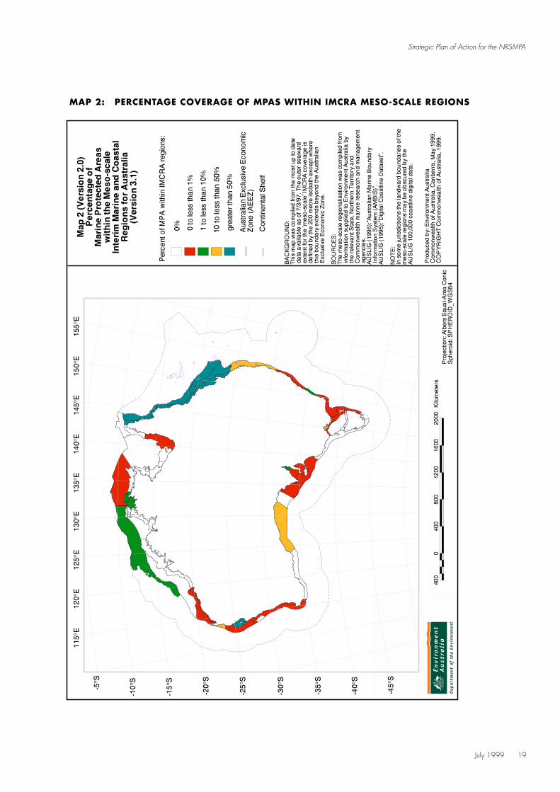
July 1999 19
Strategic Plan of Action for the NRSMPA
MAP 2: PERCENTAGE COVERAGE OF MPAS WITHIN IMCRA MESO-SCALE REGIONS
20 July 1999
Strategic Plan of Action for the NRSMPA
In general, Map 2 demonstrates that there areimbalances that need to be addressed in thepresent distribution of MPAs across Australia’smarine environment. For example, 21 bioregionshave no marine protected areas, 21 bioregionshave protected areas with a coverage of less than1% and five bioregions have MPAs with acoverage of more than 1% but less than 10%. Twoof these bioregions, Cobourg and Van DiemenGulf, have protected areas with a coverage ofslightly less than 10%.
There are also 11 bioregions that contain verylarge MPAs, with a total area of approximately0.26 million sq km, which make up over 92% of the total area of MPAs. These are found in a narrow band on the north-east tropical coast (the Great Barrier Reef Marine Park) the GreatAustralian Bight (State and Commonwealthcomponents of the Great Australian Bight MarinePark), and the Western Australian coast (SharkBay Marine Park and Ningaloo Marine Park). TheGreat Barrier Reef Marine Park is unique in thatit encloses eight bioregions and extends beyondthe meso-scale regionalisation. The Shark Bay andNingaloo Marine Parks cover about 50% of theirrespective bioregions. The Tweed–Moreton,Victorian Embayments and Eucla bioregions eachhave protected areas that cover more than 10%of their bioregion.
While many bioregions contain MPAs, mostprotected areas are very small and the few largeMPAs contribute disproportionately to the totalprotected area (Appendix 4).
The 60 IMCRA bioregions (2.2 million sq km)(Map 1) cover a small proportion of Australia’sExclusive Economic Zone. The area of the zone,which includes External and Antarctic Territories,is approximately 11 million sq km (the Territoriesaccount for approximately 4.5 million sq km).Details of the MPAs outside the IMCRA meso-scaleregions are presented in Appendix 4. Theyinclude portions of the Great Barrier Reef MarinePark and MPAs within the External Territories.Again these MPAs are found mostly in the tropicalzones of Australia’s marine environment.
3.3 STATE, NORTHERN TERRITORYAND COMMONWEALTHCOMPONENTS
The roles and responsibilities of the Commonwealth, State and Northern Territoryjurisdictions are described in the Guidelines(Appendix 2). While the planning and reportingframework for the NRSMPA is based onbiogeographical regions, the delivery mechanismsfor MPAs are provided at the jurisdictional level.
The following sections summarise current andfuture strategies for the development of MPAsfor each jurisdiction. Jurisdictions are presentedin alphabetical order. Appendix 5 containsmore detailed information on organisationalarrangements, planning processes andrelevant legislation for each jurisdiction.
Commonwealth
The Commonwealth Government has given a commitment to expand Australia’s existingsystem of marine protected areas inCommonwealth waters. In September 1997,the Minister for the Environment and Heritageannounced the Government’s intention todevelop an accelerated program, pursuing anumber of new parks. This commitment wasreaffirmed through Australia’s Oceans Policy(Commonwealth of Australia 1998) whichidentified the need to protect marine biodiversitythrough Regional Marine Planning, includingthrough MPAs in a multiple-use framework.
Environment Australia is currently undertakingthe development of MPAs through a Commonwealth-endorsed strategy. A comprehensive and long-termMarine Protected Areas Strategy for Commonwealthwaters, which links to the development of theNRSMPA, is being developed. Focus is beingplaced not only on the establishment of new MPAs,but on ensuring that a representative system ofreserves is developed. Existing CommonwealthMPAs are concentrated in Australia’s tropicalwaters. The Commonwealth is looking to broadenthe agenda to include areas in Australia’stemperate and sub-Antarctic waters.

July 1999 21
Strategic Plan of Action for the NRSMPA
New South Wales
The enactment of the Marine Parks Act 1997established a Marine Parks Authority that comprisesthe heads of New South Wales Fisheries, NSWNational Parks and Wildlife Service and the NSWPremier’s Department. On behalf of the MarineParks Authority, NSW Fisheries and the NSWNPWS are cooperatively developing a Frameworkfor the Establishment of a Representative Systemof Marine Protected Areas for NSW.
The Marine Parks Authority has proposed thatprogressive bioregional assessments investigateand map ecosystem units over the next threeyears. These assessments will form the basis forchoosing potential marine parks and other MPAs.Regional and local assessment will be basedon the Guidelines.
Northern Territory
The Northern Territory Parks Masterplan(PWCNT 1997) calls for the formulation andprogressive establishment of an optimal marinepark system. A proposal for development of aNorthern Territory MPA strategy is currently beingprepared. The Northern Territory MPA strategywill, among other things, identify candidate MPAsand threatening processes. At present, rapidassessment techniques (including sonar, benthicgrabs, and remote sensing) are being developedto assist in the collection of baseline data.
As 84% of the Northern Territory coastline isadjacent to Aboriginal land, development ofmarine park proposals will require extensiveconsultation with the Land Councils andAboriginal communities and resolution ofclaims made under the Aboriginal Land Rights(Northern Territory) Act 1976 (Commonwealth).It is proposed that two consultative committeesbe established: the Marine Parks CommunityAdvisory Committee, and the Marine ParksScientific Advisory Committee.
Queensland
Queensland is currently developing a strategyfor MPAs that will complement and enhance theexisting reserve system. The strategy will include
a framework for the identification and declarationof future MPAs, representative of the range ofmarine ecosystems within Queensland. Theframework will have regard to conservation ofmarine biodiversity and protection of rare andendemic species and communities, as well asbroad-scale habitat and ecosystem protection.
In the short term, declarations of marine parkson eastern Cape York Peninsula and at TrinityInlet near Cairns will be completed. Subsequently,proposals will be prepared for the Gulf ofCarpentaria and for areas on the east coast notadequately protected in the current system ofmarine parks.
Concepts for the protection of marine areas in TorresStrait will be investigated in cooperation with TorresStrait Islander representative bodies, with a viewto the implementation of marine conservationmeasures in a culturally relevant context.
South Australia
Existing MPAs in South Australia are not theoutcome of a deliberate strategy to representmarine biodiversity. Each MPA was created fora specific purpose, mainly in relation to singlespecies protection, fisheries habitat protectionand fisheries management. Our Seas and Coasts:a marine and estuarine strategy for South Australia(South Australian Government 1998) endorses arepresentative system of MPAs, based on IMCRAmethodology in South Australian waters, includinga target of an MPA system by 2003. South Australiarecognises the commitments made under otherprotocols and agreements and will continue towork towards its contribution to the NRSMPA.
Tasmania
The existing MPA strategy for Tasmania isthe Joint Policy for the Establishment andManagement of Marine Reserves in Tasmania(Tasmanian Government 1990). The strategyrepresented a major government initiative inthis area, and has formed the backbone of theTasmanian marine reserves strategy up to thepresent time. The 1990 strategy is being updated.

22 July 1999
Strategic Plan of Action for the NRSMPA
MPA proposals currently under developmentfollow the objectives of the existing strategy.
Various interest groups have proposed sevenadditional sites for MPAs around the Tasmaniancoast. These are currently awaiting assessment.
Victoria
Victoria is committed to the establishment ofa representative system of MPAs, which is apriority action of the Victorian Coastal Strategy(Victorian Coastal Council 1997). The processbeing used by the Victorian Government todeliver a representative system of MPAs is theMarine, Coastal and Estuarine Investigation beingundertaken by the Environment ConservationCouncil. By June 2000, the Council willrecommend to Government: priorities for theestablishment of a representative system of MPAs;protection options for significant environmentalvalues; and options for the sustainable use ofmarine, coastal and estuarine areas. The systemwill be based on the consideration of biological,social and economic criteria.
The Marine, Coastal and Estuarine Investigationis concurrent with development of the NRSMPA.In particular, Victoria has adopted the IMCRAbioregional approach to delineating the hierarchy
of ecosystems. IMCRA is recognised inVictoria’s biodiversity strategy (DNRE 1997)as a fundamental bioregional planning tool forthe establishment of a representative system ofMPAs, and as a framework for setting bioregionalpriorities for biodiversity management in general.
Western Australia
The Western Australian Government has releasedits strategy, New Horizons – the way ahead inmarine conservation and management (CALM1998). The principal thrust of the marineconservation effort is to have one comprehensivemarine reserve system under the Conservationand Land Management Act 1984.
There are five key elements in the strategy:a statewide report in 1994 identifying about70 areas as candidates for reservation;establishment of the Marine Parks and ReservesAuthority, supported by a specialist ScientificAdvisory Committee; adoption of a three-tieredapproach to marine conservation reservecategories (Marine Nature Reserves, MarineParks and Marine Management Areas); extensiveassessment, consultation and planning prior toreserve establishment; and specific guidelinesfor fishing, aquaculture, pearling, mining andpetroleum interests and their access to reserves.

July 1999 23
Strategic Plan of Action for the NRSMPA
The issues discussed here represent currentpriorities for developing the NRSMPA.
4.1 ESTABLISHING A COMPREHENSIVE, ADEQUATE AND REPRESENTATIVE SYSTEM
Consistent with the National Strategy forthe Conservation of Australia’s Biodiversity(Commonwealth of Australia 1996), theNRSMPA will be based on the principlesof comprehensiveness, adequacy andrepresentativeness. These principles arediscussed below and build on the forestreserve criteria (Commonwealth of Australia1997) and the National Reserve Systemscientific guidelines (Commonwealth ofAustralia 1999b) for terrestrial areas.
Comprehensiveness
This principle requires that the NRSMPA samplesthe full range of marine ecosystems across themarine environment. However, the wide variationin marine ecosystems in Australian waters makeseffective consideration of comprehensiveness ona national scale difficult.
Marine ecosystems and marine communities,together with their environmental descriptors, arecommonly used as surrogates for biodiversity andas a basis for planning a comprehensive reservesystem, for example, the National Reserve System.For the purposes of the NRSMPA, an ecosystemclassification should use a mappable unit derivedby spatial classification of abiotic and biotic data.
In order to achieve the most rapid and significantimprovements in the NRSMPA the main priorityaim should be to address comprehensiveness, thatis, to ensure that adequate samples of the fullrange of nationally recognised marine ecosystemsare represented in the system of MPAs.
This is best done in the first instance byaddressing the key gaps in comprehensivenessat the national scale using the Interim Marineand Coastal Regionalisation of Australia (IMCRATechnical Group 1998) as the national and regionalplanning framework (refer to section 3.2, Marineprotected areas by bioregions).
ACTION
1. Understanding comprehensiveness
A study will be carried out to determine howto assess comprehensiveness for the NRSMPA.Activities related to the gap analysis ofcomprehensiveness will be advanced, includingusing IMCRA and the Collaborative AustralianProtected Areas Dataset (CAPAD).
[Links to Actions 32–34]
Adequacy
This principle addresses the question of whatlevel of reservation will ensure viability andintegrity of populations, species and communities.Where data on the viability of populations areavailable they should be incorporated indetermining the adequacy of a reserve proposaland in assessing the reserve system.
No precise data exist for determining criteriafor adequacy, although recent work in Tasmania(Barret and Edgar 1998) and overseas may beuseful. The understanding is that the chancesof long-term survival increase with increasedproportions of marine populations or ecosystemsreserved and appropriately managed. The degreeof risk varies with different species and with thedegree of modification or degradation beyondthe reserve.
PART FOURDELIVERING THE NRSMPA

24 July 1999
Strategic Plan of Action for the NRSMPA
Replication of ecosystems across the range ofgeographic, environmental and biotic domainsmust also be considered. Replication is essentiallyinsurance against the loss of natural values due toevents outside the control of managers (such as amajor marine pollution event, severe invasion ofexotic species or even negative affects of climatechange) which may significantly reduce or negatethe usefulness of a particular reserve for its specifiedpurposes. Implicit in the maintenance of biodiversityis the need to sustain ecological processes andfunctions and provide for the maintenance ofnatural patterns of speciation and extinction.This factor also needs consideration indetermining adequacy.
Other important adequacy considerations includethe degree of sympathetic management of adjacentmarine areas and land areas where relevant.Factors operating in surrounding areas that areparticularly relevant to determining the adequacyof the reserve system are threatening processessuch as pollution, introduced pests and diseases.
ACTION
2. Understanding adequacy
A study will be carried out to determine how toassess adequacy for the NRSMPA. It will includean assessment on viable MPA size, the role ofscientific reference areas, and targets.
[Links to Actions 32–34]
Representativeness
This principle is designed to ensure that thediversity within each marine ecosystem is sampledwithin the NRSMPA.
By reserving representative ecosystems within theNRSMPA, it is assumed that many marine specieswill be protected within the MPAs. However, somemarine species, particularly marine fauna, havehabitats that cover large areas that may not beclosely related to ecosystem boundaries definedfor other purposes. Information on species
distribution, as well as information on ecosystems,should be used in reserve design.
It is also not necessary to ensure that every speciesthat occurs within a marine ecosystem is reservedwithin that ecosystem. Many species may be wellrepresented in several regions and it may not benecessary to distort reserve boundaries to ensurethat they are reserved in each ecosystem occurrence.
The principle of representativeness implicitlyrequires that the MPA system also include thosemarine ecosystems that are rare, vulnerable orendangered. A representative approach, whichwill identify areas ‘typical’ of their surroundingsat a chosen scale, may also encompass unique,distinct or ‘atypical’ areas (for example, spawningareas, nursery sites or breeding locations). However,a representative approach will not specificallyidentify these important or unique sites; suchaspects must also be considered in the NRSMPA.Under the adequacy principle it was also identifiedthat the degree of risk increases with the degreeof degradation or modification of the ecosystem.
ACTION
3. Understanding representativeness
A study will be carried out to determine howto assess representativeness for the NRSMPA.
[Links to Actions 32–34].
4. Vulnerable ecosystems
Assessments and mapping of rare, vulnerableand endangered marine ecosystems will becarried out, in association with an analysis ofthreatening processes.
[Links to Action 5]
5. Identifying priorities for candidate MPAs
Identify national and regional candidate areasfor establishing MPAs based on information fromActions 1–4 and 11–12.
[Links to Actions 1–4 and 10–11]
4.2 INFORMATION REQUIREMENTSAND MANAGEMENT
Adequate, accessible information is requiredfor sound decision making. Across the NRSMPA,information is required for the purposes ofestablishing, managing and assessing theperformance of MPAs and the system as a whole.This section concentrates on the informationrequired to establish MPAs and management ofthat information. The nature of the informationneeded for performance assessment and reportingis discussed under section 4.6, Performanceassessment. Often the same baseline data willbe used for decision making for the establishmentof new MPAs, management of existing MPAsand performance assessment.
4.2.1 Information requirements
The assessment of an area proposed for an MPArequires information on biodiversity (includingecosystem mapping), ecological processes,conservation status, biogeographic characteristics,social interests (including data relating toindigenous and non-indigenous values), economicinterests (including existing and potential uses),and threatening processes.
This information is used in applying the followingcriteria for identification and selection of MPAs:
Ident i f i cat ion Selec t ion
representativeness economic interests
naturalness indigenous interests
biogeographic importance social interests
comprehensiveness scientific interests
ecological importance practicality/feasibility
international or national importance adequacy
uniqueness – vulnerability assessment
productivity – replication
The above criteria are extracted from theGuidelines (Appendix 2). The list is notexhaustive. For the NRSMPA, biodiversity andenvironmental criteria are the primary criteria foridentifying national and regional priorities andcandidate areas. Social, cultural and economiccriteria are applied primarily in the selection ofMPA sites from the candidate areas. In practice,criteria from each list may be used at any stagein the processes of identification and selection,as appropriate.
As it is not always possible to collect the optimallevel of information required for decision making,it is necessary to prioritise information collectionand analysis. A number of the actions address thisissue by seeking a commitment to extra resources,developing cost-effective methodologies such asrapid assessment, and harnessing existinginformation from alternative sources.
While generally the collection of data for theestablishment of the NRSMPA is the responsibilityof jurisdictions, a better understanding ofrequirements across the NRSMPA and the sharingof available data and data collection methodologywill assist in developing the system.
As ecosystems form the basis of planning andmanagement for the NRSMPA, it is important todevelop agreed standards for ecosystem mappingfor the NRSMPA within the IMCRA framework.This will assist in assessing the comprehensiveness,adequacy and representativeness of the NRSMPA.
Under the Oceans Policy, integrated andecosystem-based planning and management willbe delivered through development of RegionalMarine Plans, based on large marine ecosystemsfor Australia’s oceanic areas. Linkages between theNRSMPA and IMCRA and the Oceans Policy needto be established.
July 1999 25
Strategic Plan of Action for the NRSMPA
26 July 1999
Strategic Plan of Action for the NRSMPA
ACTION
6. Ecosystem mapping
Continue ecosystem mapping and biodiversityassessment work. This data will also be used infuture refinement of IMCRA.
7. Developing data collection standards
Cross-jurisdictional cooperation to developcomparable standards for data collection.
[Links to Actions 16 and 19]
8. Review methods for ecosystem mapping
Review methods for mapping ecosystems for theNRSMPA and develop an operational definition ofecosystem.
[Links to Actions 1–3]
9. Rapid assessment methodology
To identify the areas of highest priority foraddition to the NRSMPA, suitable rapid assessmentmethods will be analysed.
10. Threat analysis research
Conduct study into threats to marine ecosystemsand analyse their potential impacts.
[Links to Actions 5 and 11]
11. Apply threatening processes analysis
Incorporate the analysis of the impacts of threatsor threatening processes into gap analyses.
[Links to Actions 5 and 10]
12. Harness community knowledge
Document relevant knowledge of traditionaland local communities through a series of targetedmechanisms to ensure relevant processes drawon available information.
13. Harness industry knowledge
Document relevant knowledge of industry and itsongoing information gathering programs througha series of targeted mechanisms. Incorporate intoappropriate inventories/databases and makeaccessible.
[Links to Action 18]
14. Oceans Policy
Develop linkages for the NRSMPA within theRegional Marine Planning framework.
[Links to Action 15]
15. Provincial level regionalisation
Review Oceans Policy provisional Large MarineEcosystem (LME) regionalisation and relationshipwith IMCRA.
[Links to Action 14]
16. Baseline data collection
Continue baseline data collection. Promote publicfunding of research organisations for baseline datacollection, including developing cost-effectivemethodologies.
[Links to Actions 7 and 19]
Biodiversity assessment
To aid a better understanding of the informationrequirements for the NRSMPA, this section ispresented as an illustration of some major issues.
As the conservation of biodiversity is the primarygoal of the NRSMPA, the assessment of biodiversityis an essential component in the development ofthe NRSMPA and applies to the identification andselection processes, management planning andperformance assessment. There is a wide variationin the biodiversity information currently availableto jurisdictions. Issues of resourcing and accessibilityof areas influence the priorities for informationgathering and therefore the capacity of jurisdictionsto address issues of comprehensiveness,representativeness and adequacy.
IMCRA can be used in the systematic assessmentof whether regions have available adequate dataand information for biodiversity assessment. Thisassessment might show, for example, that someregions have adequate physical data butinadequate biological data. Such informationcould be used to schedule a program of regionalsurveys to fill these data and information gaps.
While the collection of biodiversity data in themarine environment is generally labour andresource intensive, all jurisdictions have existingprograms to address data deficiencies. It isimportant that data needs are identified andprioritised following assessment of existing dataand that collection is carried out through carefullytargeted and designed research or surveys. In thecontext of the NRSMPA, to maximise the usefulnessof biodiversity data, it is important that there besome consistency in the collection, analysis andutilisation of these data.
There are some difficulties affecting theinterpretation of biodiversity data that need tobe addressed. These include the poor knowledgeof the taxonomy of many species and the lackof knowledge of the conservation status ofmost species.
ACTION
17. Enhancing taxonomic capacity
Identify gaps in marine taxonomic capacityand prepare a report recommending actionsto address the gaps.
4.2.2 Information management
The coordinated compilation, maintenanceand appropriate dissemination of information isessential for the development and management ofthe NRSMPA. Relevant information on existing andproposed MPAs must be included in any nationalmarine data program. In particular, spatial orgeographic information, such as the data thatunderpin marine resource management, mustbe included in any system developed for thecollection and management of data for theNRSMPA. The importance of the coordinationof marine data management is identified inAustralia’s Marine Science and TechnologyPlan (Commonwealth of Australia 1999a).
The Marine Science and Technology Plan wasdeveloped to improve knowledge of Australia’smarine jurisdictions. The Plan identifies needsand priorities in marine science, technology andengineering. Commonwealth, State and Territoryagencies involved in the development of theNRSMPA are key users of this knowledge baseand are identifying ways to improve collaborationbetween research agencies and users of research.
Aspects of marine data management which needto be addressed across the NRSMPA include:
• an agreed definition of standards for collection;
• quality issues;
• storage;
• accessibility;
• adoption of established data-managementprotocols as appropriate;
• transfer compatibility for exchange acrossjurisdictions; and
• mechanisms to coordinate and further the above.
July 1999 27
Strategic Plan of Action for the NRSMPA
28 July 1999
Strategic Plan of Action for the NRSMPA
Recently, the Australia New Zealand LandInformation Council (ANZLIC) endorsed a PolicyStatement on Spatial Data Management (ANZLIC1999), which sets out principles for the responsiblemanagement of data. The policy further developsthose objectives of the IntergovernmentalAgreement on the Environment which requiredthat ANZLIC make environmental data moreaccessible and improve arrangements to avoidduplication and overlap. Processes for the NRSMPAshould be consistent with the ANZLIC principles.
As a starting point, many existing marine datamanagement systems operating at the State levelcan provide useful input to the development ofthe NRSMPA. The Commonwealth EnvironmentalResources Information Network manages anumber of national initiatives. The National MarineInformation System, the Australian Coastal Atlas,the Marine and Coastal Data Directory of Australia(the Blue Pages) and the Collaborative AustralianProtected Areas Dataset (CAPAD), are all managedto improve the organisation and accessibility ofmarine data.
Recently, the National Land and Water ResourcesAudit instigated the development of a NationalVegetation Information System, which will providefor easily accessible and nationally consistent dataon the extent, type and condition of Australia’sterrestrial vegetation. To complement the NationalVegetation Information System, marine vegetationinformation is being compiled by EnvironmentAustralia. All relevant data will be made accessiblethrough the Australian Coastal Atlas and metadataavailable through the Blue Pages.
CAPAD, the nationally coordinated dataset ofinformation on marine and terrestrial protectedareas, aims to provide information on all Australianprotected areas including location, size and IUCNprotected area management categories. The datasetuses a set of core attributes that was agreed byagencies involved and is designed to be updatedas new spatial data are made available. There isan agreed process in place for jurisdictions toreport on protected area establishment to updateCAPAD. It is intended that CAPAD will be accessiblevia the Internet as a distributed dataset.
ACTION
18. Maintaining core datasets
Continued commitment by all jurisdictions toregular updating of national datasets, databases(including further refinement and maintenance ofCAPAD), and metadata directories.
[Links to Action 23]
19. Comparable databases
Develop and apply standards to improvecomparability of databases related to MPAs acrossjurisdictions to enhance information sharing acrossthe NRSMPA.
[Links to Actions 7 and 16]
20. Resource needs for database establishmentand management
Assess resource requirements for data input anddatabase management and commit extra resourcesif required.
4.3 INVOLVEMENT OF STAKEHOLDERS
For the purposes of the Plan a ‘stakeholder orstakeholder group is any individual or group whomay be involved in, affected by, or expresses astrong interest in, the management of a particularresource or area’ (Claridge and Claridge 1997).
The early involvement and active participation ofdirect and indirect users of the marine environmentis crucial to the successful development,implementation and management of MPAs.All jurisdictions are committed to appropriateconsultation with stakeholder groups throughoutthe development and implementation of the NRSMPA.Stakeholder groups include a variety of governmentagencies or authorities, commercial users (includingthe fishing, mining and tourism industries, shippingand ports), non-commercial users (such asrecreational fishers, divers, and researchers),community groups, including indigenous and non-government groups, and residents of adjoining

population centres. To facilitate the continuedinvolvement of stakeholders from MPA developmentstages through to implementation and management,effective and efficient consultative processes needto be developed and adopted.
4.3.1 Identifying stakeholders and their issues
The Marine Industry Development Strategy(AMISC 1997) identified that, in the case of allmarine industries, there are common users of themarine environment Australia-wide. This is alsothe case for many non-industry stakeholder groups.
A smaller subset of the identified stakeholders willbe involved where a proposed MPA is located awayfrom the coast and associated populations; forexample, some distance offshore in Commonwealthwaters. Although some of the specific stakeholderswill vary from case to case, there are commonalitiesin the types of stakeholders and the types of issuesand concerns. There are benefits for stakeholdersin sharing information across the jurisdictions.There may be potential gains for agencies in thevarious jurisdictions in sharing experiences anddeveloping consistent methods for consultation.
The roles of the different stakeholder groups inMPA development and subsequent managementwill vary. Those who have some level ofdependence on a resource or a long associationwith an area, for example, may know and valuean area differently to those who do not, but whostill have an interest in the way an area is usedand managed (Claridge and Claridge 1997).
Identifying all stakeholders who may be involvedin or affected by MPA development and/ormanagement, and the suite of issues that relateto them, is an essential process for all jurisdictionsin the development of the NRSMPA.
4.3.2 Principles for consultationand negotiation with stakeholders
There are differences in the processes thevarious jurisdictions follow during stakeholderconsultation, due in part to statutory requirements.
Despite the differences, commonalities instakeholder consultation have been identified:
• recognition of the importance of stakeholderengagement throughout the MPA process frompre-declaration to management;
• commitment to the provision of sufficientinformation to all stakeholders to allowinformed input on MPA proposals;
• provision of opportunities for face to facediscussion with stakeholders in a mutuallyacceptable location (this is particularlyimportant for indigenous stakeholders);
• acceptance of the value of expertiseand knowledge within the stakeholdercommunity, for example, customary andhistoric use of an area by indigenous andindustry stakeholders; and
• representation of key stakeholders oncommunity advisory committees (whereestablished) to facilitate local involvementin MPA development.
4.3.3 Education, trainingand development
Education, training and development canprovide all parties, stakeholders and managerswith an awareness of environmental andethical values, and with desirable skills.Other benefits include engendering a senseof stewardship and increasing the ability ofstakeholders to provide informed contributions.Equally important is the need for managersto have a good understanding of the concernsand values of stakeholders.
Prior to the identification of the training,education and development requirementsof individual stakeholders, it is necessary toidentify the existing knowledge base andviews of those stakeholders. Historically, somestakeholders have experienced barriers to theirinvolvement in the MPA development process.A common problem experienced by manystakeholder groups is access to information.
July 1999 29
Strategic Plan of Action for the NRSMPA

30 July 1999
Strategic Plan of Action for the NRSMPA
ACTION
21. Analysis of information programs
Conduct an analysis of jurisdictions’ existinginformation and education programs to promoteinformation sharing and best practice.
22. Stakeholder understanding
Develop a dialogue with stakeholders, regarding ecological and socio-economic values,and strategic and political processes involved inthe selection and declaration of MPAs.
23. Information availability
Where national directories and databases exist,ensure that advice of their existence and availabilityis distributed widely (including through theInternet, Australian Coastal Atlas, Blue Pages).
[Links to Action 18]
4.4 CLASSIFYING MARINEPROTECTED AREAS
Consistent classification of MPAs would assist inbetter understanding of the NRSMPA forstakeholders and managers.
4.4.1 IUCN protected area management categories
The World Conservation Union (IUCN) developed,and in 1994 adopted, a set of six protected areamanagement categories which are applied to bothterrestrial and MPAs (IUCN 1994). Definitions andobjectives for each category, ranging from strictnature reserve to managed resource protectedareas, are included in Appendix 3. The categoriesimply a gradation of human intervention but arenot an hierarchical structure as they all contributeto biodiversity conservation. Consistent with theIUCN definition of protected areas as adopted bythe NRSMPA, MPAs across all managementcategories must be formally established primarilyfor biodiversity conservation.
The categories are not designed to drive thedevelopment of protected area systems, but toprovide an international system of categorisationto facilitate understanding. They are not acommentary on management effectiveness andshould be interpreted with flexibility at nationaland regional levels. MPAs should be established tomeet objectives consistent with national orregional goals and needs and only then beassigned an IUCN category according to theagreed management objectives.
Each MPA in the NRSMPA has an IUCN categorynominated by the jurisdiction that established theMPA. Under zoning arrangements within MPAs,separate categories can be assigned to each zone,while the MPA as a whole will be listed in CAPADunder the category relating to its primarymanagement objective. In accordance with theinternational requirements of the IUCN, Australiawill continue to report only one category for eachMPA. For domestic purposes, annual reportingof individual categories for zones within an MPAis appropriate to give a more comprehensiveassessment of the management arrangements.
It is intended that TFMPA and the Commonwealthplay a coordinating role in ensuring consistency ininterpretation and application of IUCN categoriesat the stage that the MPA is nominated forinclusion in CAPAD.
A draft handbook (ANCA 1996) was producedto provide interpretation of the categories for theparticular circumstances that apply in Australia.While an attempt has been made in the drafthandbook to consider the application of thecategories in the marine environment, furtherwork is necessary to increase understanding ofhow IUCN categories apply to Australian MPAs.

July 1999 31
Strategic Plan of Action for the NRSMPA
ACTION
24. Analysis of IUCN protected areamanagement categories
Analyse the application of the IUCN protectedarea management categories in the Australianmarine context.
[Links to Action 25]
25. Application of IUCN protectedarea management categories
Develop TFMPA process for consistentapplication of categories for inclusion in CAPAD.
[Links to Actions 24 and 26]
26. IUCN protected area managementcategory reporting
Annual reporting of IUCN categories, includingfor internal zonings for relevant MPAs.
[Links to Action 25]
4.4.2 Nomenclature
Agencies responsible for protected areas have avariety of names for MPAs and these are not appliedconsistently across jurisdictions. Terrestrial andMarine Protected Areas in Australia (Cresswelland Thomas 1997) lists 11 different names forMPAs. Names used include Marine National Park,Marine Reserve, and Marine and Coastal Park.
The fact that the same name may mean differentthings in different states and countries, and that adifferent name may be used to describe the samecategory of protected area, has led to confusionand a lack of clarity about the basis for reservationand management intent. It is for this reason thatthe National Strategy for the Conservation ofAustralia’s Biological Diversity (Commonwealthof Australia 1996) proposed an action to:
ensure that the range of protected areatypes has consistent nomenclature andassociated management requirements,in keeping with the World ConservationUnion’s (IUCN) classification ofprotected areas.
Jurisdictions are required to use the IUCN’scategories for national reporting on the NRSMPAfor CAPAD. The use of the IUCN categories acrossjurisdictions allows consistent reporting irrespectiveof the names of the MPAs. Realistically, jurisdictionsare unlikely to change to a consistent nomenclaturein the short term, given that existing names areenshrined in legislation. The most achievableoutcome in the short term is to seek agreement onnationally consistent definitions for MPAs, with along-term aim to achieve consistent nomenclature.
ACTION
27. Nationally consistent nomenclature
Develop nationally consistent definitions for MPAsto reflect their objective, management intent andrationale for permissible activities, which canprogressively lead to consistent nomenclature.
[Links to Actions 24 and 25]
4.5 MANAGING THE NRSMPA
The Plan does not deal in detail with managementissues for the NRSMPA. Management of MPAs isprimarily the concern of the jurisdictions, butTFMPA recognises that there is an ongoing needto share information and develop performanceassessment for management of the NRSMPA.Management of marine areas within Australia’sjurisdictions is often challenging and is mademore difficult by factors such as the unpopulatednature of much of Australia’s coastline, thedifficulties and costs of managing a large andremote area, and the need for specialistequipment and trained field staff.
Australia’s marine environment is economicallyvery important. Access for resource users, whethercommercial or recreational, extractive or non-extractive, needs to be considered andappropriately managed. For the NRSMPA, accessto the resources of an MPA should be consideredin the context of the potential impact of all usesand potential uses on the defined biodiversityconservation values of the MPA and themanagement objectives. Allowable uses should be

32 July 1999
Strategic Plan of Action for the NRSMPA
confined to those that do not compromise thedefined biodiversity values and managementobjectives. The potential exists for partnershipsand co-management arrangements consistent withprinciples for ecologically sustainable developmentand multiple-use management. The application ofthese concepts to marine areas has been refinedduring the development of Australia’s Oceans Policy.
As discussed in section 3.1, Interim Marine andCoastal Regionalisation of Australia, IMCRAbioregions are used as the planning basis forachieving a representative, comprehensive andadequate system of MPAs. The distribution andclassification of MPAs across bioregions will beconsistent with the primary goal of the NRSMPAand will be determined by a full and transparentassessment of biodiversity conservation, economic,social and cultural values and managementobjectives as outlined in the Guidelines.
Ongoing management of the NRSMPA needsto ensure that, as far as practicable, all theessential elements of ecological diversity ofmarine communities remain adequately protectedin perpetuity. However, marine planning andthe nature of human activities are never static.A wide variety of changes can and do occur,such as changes in: technology, communityexpectations, environmental and naturalprocesses, and management or politicalarrangements. Adaptive management istherefore essential to cope with such changes.
4.5.1 Ecologically sustainabledevelopment
The National Strategy for Ecologically SustainableDevelopment (Commonwealth of Australia 1992b)defines ecologically sustainable development as‘using, conserving and enhancing the community’sresources so that ecological processes, on whichlife depends, are maintained and the total qualityof life, now and in the future, can be increased’.
If the decision is made to allow resource usewithin an MPA on the basis that the biodiversityconservation values will not be compromised, theprinciples of ecological sustainability must apply.The management arrangements developed forindividual MPAs may require higher standards of
management of resource use than may otherwiseapply to the use or activity. This may be requiredso the activity does not compromise the primarygoal of the MPA. A commercial fishery that ismanaged generally in accordance with ecologicallysustainable development principles could be allowedwithin the MPA but may be subject to morecomprehensive management arrangements; forexample, arrangements relating to gear type orcatch limits.
4.5.2 Ecosystem approachto management
An ecosystem approach to management providesfor a consistent management framework for themaintenance of ecological integrity. It provides fora variety of uses while maintaining a focus on thecondition of an ecosystem as a whole as thebenchmark for management decision making.IMCRA is the ecosystem-based regionalisationthat provides the first layer in a broad ecologicalplanning framework for the NRSMPA.
In an oceans context, an ecosystem approachto management differs from species-basedmanagement in that the combined effectsof all uses of an area are examined, and theiracceptability evaluated using a full range ofecological indicators, not just a single speciesindicator. Different levels of change to theecosystem elements and processes will beacceptable in specific areas of ocean, dependingon the likely effects of permitted uses and otherpressures such as land-based pollution.
Ecosystem management should specificallyaddress the fluid or ‘connected’ nature of themarine environment, that is, the wide dispersalof organisms and pollutants by currents.Consideration of the likely effects on an MPA,and the implementation of mechanisms to copewith those effects, is the responsibility of theplanning agencies at the time of selection ofan MPA and is an ongoing requirement formanagement agencies.
An ecosystem-based management framework canbe used both inside and outside MPAs. It willpermit the broad principles embodied in

July 1999 33
Strategic Plan of Action for the NRSMPA
ecologically sustainable development to beconsistently applied in all ocean areas, regardlessof the uses. Across the NRSMPA, uses of marineresources, other than conservation, are likely to bemore constrained than in other areas. The focusfor the NRSMPA will be on how a variety of usescan be accommodated within an individual MPA.
4.5.3 Managing uses
Four fundamental principles for multiple-usemanagement have been developed for generalapplication to the marine environment and theselection and management of MPAs. They are:
• maintenance of ecosystem integrity;
• wealth generation and resource use;
• equity; and
• participatory framework for decision making(Sainsbury et al. 1997).
In consultations with stakeholders, the applicationof these principles can assist in reaching anegotiated outcome. For an MPA, once it isascertained that resource use is compatible withthe primary objective of the MPA, the multiple-usemanagement principle ‘maintenance of ecosystemintegrity’ is considered to have greater weight inthe consideration process, reflecting the primarygoal of the NRSMPA.
There is a range of human activities that maypotentially occur within an MPA. Uses within MPAscan range from relatively low-impact activities, suchas swimming, to extractive resource use, such asfishing. For these activities to continue, it must bedemonstrated that they are consistent with theprimary objective of an MPA. Highly protected areas(that is, ‘no take’ areas) within MPAs are increasinglybeing recognised by the community and resourceusers as means to contribute to the ecologicallysustainable use of Australia’s marine environment.
Given the range of processes for dealing withmanagement issues, stakeholders have a right toknow what principles and processes will apply indiscussions relating to MPAs, and that they will be
involved in any process involving areas of interestto them. This way, clear and robust processes canbe carried out and community involvement canbe maximised. Any proposal for an MPA shouldinvolve consultation with stakeholders at theearliest stages of consideration (refer to section4.3, Involvement of stakeholders).
Any system of protected areas needs to beaccepted and supported by the stakeholders if itis to succeed in its primary purpose of biodiversityconservation. The recognition of social, culturaland economic considerations relating to proposedprotected areas is fundamental to the process ofdetermining a system. Resources need to beallocated to appropriate assessment processesto understand current and potential uses of anynominated area. Then processes dealing explicitlywith those uses and any related costs or benefitsneed to be agreed with stakeholders.
4.5.4 Joint arrangements
Currently within the NRSMPA there are jointmanagement arrangements between theCommonwealth and some States where MPAshave been declared across jurisdictional boundaries.Further development of the NRSMPA is likely toresult in additional MPAs with joint managementarrangements involving various jurisdictions.Developing elements of a best practice model tobe applied in different circumstances would assistin ongoing management and evaluation.
ACTION
28. Joint management arrangements
Examine current joint cross-jurisdictionalmanagement arrangements to identify bestpractice elements.
Cooperation with indigenous communities
Historically, there has been little or no formalinvolvement of Aboriginal people in MPAmanagement. However, many Aboriginal peoplesand Torres Strait Islanders around Australia
34 July 1999
Strategic Plan of Action for the NRSMPA
continue to have a strong affiliation with andattachment to coastal and marine environments(Smyth 1996). Planning for and management ofMPAs should acknowledge these links andaccount for them where possible.
There are a number of initiatives emerging,particularly across Northern Australia, which areproviding opportunities to explore the developmentof cooperative management arrangements whichtake account of indigenous interests and involveAboriginal peoples and Torres Strait Islanders in themanagement of marine areas. In the Torres Strait,indigenous communities have been managingterrestrial and marine resources and are activelyengaged in consultation processes in developingstrategies for co-management of traditionalmarine estates.
The Cobourg Peninsula Marine Park in theNorthern Territory is the first Australian MPA to beformally managed jointly by Aboriginal people orcustodians and a government conservation agency.Recent Commonwealth and Queensland discussionsconcerning multiple-use strategic planning for thesouthern Gulf of Carpentaria provide an exampleof a bioregion in which to consider developing acase study with indigenous communities.
Aboriginal peoples and Torres Strait Islandersform the local community across much ofAustralia’s northern and north-western coastlines.This situation provides particular opportunityto share knowledge and resources for effectivemarine management, including surveillanceand enforcement.
These circumstances, and indigenous interestselsewhere in Australia, also provide opportunitiesto develop innovative and effective ways tomanage the marine environment generally andMPAs in particular. The existing enforcementcapacity of government agencies is often over-extended in remote areas. In these and otherareas there may be potential employmentopportunities for indigenous communitiesinvolving formal management responsibility forcoastal and marine protection.
ACTION
29. Indigenous interests
Develop strategies in association with indigenouspeoples to enhance their participation in the NRSMPA.
Cooperation with industry
Many Commonwealth MPAs are remote, yet subjectto threatening processes, such as illegal fishing andcollecting, and potential pollution events.Environment Australia has developed effectivecooperative arrangements with some otherCommonwealth government departments for themanagement and monitoring of remote MPAs.
The potential exists for arrangements withindustries, such as the fishing and petroleumindustries and commercial tour operators, to assistin surveillance and some other managementactivities.
ACTION
30. Models of industry cooperative management
Develop models for industry involvement in, andcontribution to, the monitoring and management of MPAs.
4.5.5 Management planning
The ANZECC Working Group on National Parksand Protected Areas Management has undertakensubstantial work on best practice management ofprotected areas (ANZECC 1997). A review of thisand other relevant national and international workwill aid the better understanding of managementissues for the NRSMPA.
ACTION
31. Best practice management planning
Examine national and international best practicemodels of protected area management, includingmultiple use management principles.

July 1999 35
Strategic Plan of Action for the NRSMPA
4.6 PERFORMANCE ASSESSMENT
Performance assessment of any system is requiredto evaluate its effectiveness in meeting goals andobjectives and, if necessary, to assist in theidentification of ways to increase its effectiveness.Performance assessment of the NRSMPA is a toolto report on the system to both managers andstakeholders. Effective performance assessmentwill help to focus activities on the goals that havebeen agreed for the NRSMPA.
In Australia, there are a range of environmentalreporting frameworks that use indicators. Theyinclude Australia: State of the Environment 1996(State of Environment Advisory Council 1996),Our Sea, Our Future: Major findings of the stateof the marine environment report (SOMER) (Zann1995), Organisation for Economic Cooperationand Development (OECD) reports, AustralianHeritage Commission audits, and the MontrealProcess reporting for forests.
The State of the Environment (SoE) reportingmodel uses a variety of physical, chemical,biological and socioeconomic indicators thatdescribe the state or condition of the environment,the pressures on the environment and theinstitutional response to these pressures. Recently,Ward et al (1998) and Saunders et al (1998)identified core marine and estuarine environmentalindicators for SoE reporting which may be alsosuitable as NRSMPA performance indicators.
To achieve effective performance assessment ofthe NRSMPA, the Best Practice Model, identifiedby the ANZECC Working Group on NationalParks and Protected Area Management in itsBenchmarking and Best Practice Program(ANZECC 1997), has been adopted. This modelfocuses on the development of outcome-basedperformance indicators which are strongly linkedto the goals and objectives sought by managersand stakeholders.
4.6.1 Performance assessment elements
Nationally consistent performance assessment of the NRSMPA will do the following:
• identify key targets (for example, usingcomprehensiveness, adequacy andrepresentativeness) to reflect goals (both forprocess and outcome based assessments);
• determine appropriate information needsnecessary at appropriate spatial levels (that is,at MPA, bioregional or national levels) andtemporal scales;
• assess the suitability of indicators developedunder other reporting models, and establishappropriate links to performance assessmentinitiatives in SoE reporting, Oceans Policy, andMarine, Science and Technology Plan, and so on;
• develop and apply suitable performanceindicators;
• develop cost-effective monitoring programs;
• determine reporting responsibilities (agencies,reporting frequency, format, audience anddissemination medium); and
• develop a feedback mechanism to improveperformance of the NRSMPA.
In identifying the key targets it will be importantto use nationally agreed and harmonisedinterpretations of comprehensiveness, adequacy andrepresentativeness for the NRSMPA. The targets willneed to be determined and progressively refinedthrough assessments of the environmental values,including in relation to the relative impact or riskof threatening processes. To underpin this,research will be needed inside and outside MPAs.
To provide information on long-term trends aswell as existing conditions, the performanceassessment framework must be adaptive andflexible enough to cater for changing conditions,goals and evolving delivery mechanisms.
4.6.2 Performance indicators
Performance assessment requires the developmentof performance indicators, which are quantitativeor qualitative measures and which can demonstratetrends over time. Performance indicators aremeasures to gauge the extent to which targets(that is, desired outcomes) are achieved. Thechoice and application of performance indicatorsrequire careful consideration. In particular, theperformance indicators and the development ofassociated monitoring programs to report againstthe indicators (that is, frequency and scale), mustbe cost-effective. There are limits to what can bedone through indicators. To avoid unrealisticexpectations, these limits need to be identifiedand articulated.

36 July 1999
Strategic Plan of Action for the NRSMPA
Performance indicators may be based on eitherprocesses or outcomes. The process-based indicatorsrelate to assessing the organisational efficiency ofprocesses that achieve the results; for example,the degree of compliance to the Guidelines.Outcome-based indicators measure results or thedegree to which an environmental goal has beenmet and could include whether a bioregioncontains representative samples of majorecosystems within MPAs.
4.6.3 Level of performance assessment
For the NRSMPA, performance assessmentreporting is required at three interrelated spatialscales. These are at the individual MPA level, thebioregion level, and at the level of the system as awhole. The responsibility for reporting is differentfor each level.
The assessment of individual MPAs is theresponsibility of the jurisdiction in which theMPA is declared. Bioregional reporting requiresjurisdictional and cross-jurisdictional reporting.The responsibility for performance assessment ofthe whole NRSMPA concerns all jurisdictions, andis coordinated by TFMPA.
It is important to note that several performanceassessment and performance indicator elementsare generic across all three levels. These elementsare nested, with the greatest degree of detailfound at the individual MPA level.
Consistent processes developed for performanceassessment at the individual MPA level will allowfor the collection, analysis and reporting ofperformance assessment for the system at anylevel through appropriate aggregation, that is, forthe system as a whole or at the bioregional level.
Individual MPA level
Each MPA is declared against a legislativeframework. Specific aims and managementintentions or objectives are described in the plan ofmanagement for the MPA. Plans of managementare derived through processes of public
participation that should assist in determiningthe performance indicators and audience forperformance assessment of individual MPAs.
Each MPA is unique in size and in thecomposition of its ecosystem(s) and species. Also,the management intentions and approaches differbetween jurisdictions. Recognising these factors,the following process describes the developmentof a performance assessment framework withperformance indicators at the MPA level. Theperformance indicators developed will be for thepurpose of managing and reporting on each MPA.The methodology to report nationally on theseindicators is presented under section 4.6.4,Reporting frequency and format.
Note that the components may be conductedconcurrently. The collection of baseline data mayhave been carried out, in part, as a component ofthe selection process and may precede the othercomponents listed.
Framework for developing performance indicators at MPA level
Each jurisdiction will develop and implement aperformance assessment system that is consistentwith the nationally agreed reporting framework.The framework would include a number ofsteps, such as:
• Derive strategic objectives and goals for theMPA which reflect management intentions andenabling legislation.
• Translate goals and objectives into sets ofdistinct MPA standards, targets or thresholds.
• Assess and monitor the condition of theenvironmental values in relation to the impactof threatening processes inside and outsidethe MPAs.
• Select appropriate indicators to measure thedegree to which individual MPA targets arebeing achieved.
• Collate and assess existing biological, physicaland socioeconomic baseline information forindividual MPAs and identify gaps in thisinformation.
July 1999 37
Strategic Plan of Action for the NRSMPA
• Design and implement a baseline datagathering exercise to sufficiently fill in the gaps.
• Design and implement a monitoring programin tandem with the choice of performanceindicators.
• Develop a reporting mechanism on each MPA’s performance, using existing processesestablished by marine management agencieswhere possible.
ACTION
32. MPA performance assessment
Each jurisdiction will develop and implementa performance assessment system, includingperformance indicators, that is consistent withthe nationally agreed reporting framework.
[Links to Actions 1–3]
Bioregional level
ANZECC has adopted IMCRA as the bioregionalframework for planning and reporting on theNRSMPA. The development and use ofperformance indicators is an integral aspect of thisframework. The effectiveness and progress of theNRSMPA will need to be reported at the bioregionallevel. To enable national reporting, a core ofconsistent performance indicators will be agreedby TFMPA and applied across the System at thebioregional level.
Actions to initiate performance assessment for useat the bioregional level would focus on preparingreports on the type of information indicated below.
Performance reporting at bioregional level
Each jurisdiction will develop and aggregateperformance information (consistent with thenationally agreed reporting framework). Indicatorsfor the bioregional level will include:
• the number of MPAs present in a bioregion;
• the area covered by the MPAs;
• the IUCN protected area managementcategories;
• the degree to which comprehensiveness,adequacy and representativeness have beenachieved; and
• the degree of effectiveness of cross-jurisdictional planning and managementarrangements within bioregions.
ACTION
33. Bioregion performance reporting
Each jurisdiction will develop and aggregateperformance information (consistent with thenationally agreed reporting framework).
[Links to Actions 1–3]
NRSMPA level
The performance assessment of the NRSMPA mustmeasure the degree to which the agreed system-level goals have been achieved.
In process-based indicator terms, realistic stagesand time frames should be set, considering thecomplexity of the objectives and the resourcesavailable to each jurisdiction and to TFMPA. Thiswould allow performance to be measured againsttime frames. Outcome-based indicators are crucialat the system level. These will be developed orderived by aggregating MPA-level and bioregion-level indicators to create system-level indicators.The Commonwealth will conduct this elementof the process for TFMPA with the inputof jurisdictions.
Performance reporting at NRSMPA level
TFMPA will report on the agreed nationalset of performance indicators, drawn fromall jurisdictions. Specific actions include:
• Develop a framework for adapting andanalysing MPA-level indicators for use atthe NRSMPA level.
• Develop and agree on minimum standardsfor monitoring programs relating to agreedperformance indicators.
38 July 1999
Strategic Plan of Action for the NRSMPA
• Assess whether these processes lead tosufficient information to assess performancenationally and identify deficiencies.
• Further develop elements of performanceassessment as necessary by tracking nationaland international developments.
• Expand and maintain policy links with othernational processes, for example, Oceans Policy,the Australia’s Marine Science & TechnologyPlan and the Marine Industry DevelopmentStrategy.
ACTION
34. NRSMPA performance assessment
Report on agreed national set of performanceindicators, drawn from all jurisdictions.
[Links to Actions 1–3]
4.6.4 Reporting frequency and format
To facilitate the adoption of performanceassessment into agency planning cycles, it isenvisaged that performance reporting will beconducted on an annual basis (against annualwork plans) through TFMPA.
Each jurisdiction will provide informationon performance indicators developed andimplemented for each MPA for the purposesof analysis and reporting for the NRSMPA. Thisreporting should group performance indicatorswithin the framework described above.
Audience
The audience for reporting includes thecommunity, stakeholders, governments, MPAmanagers and ANZECC. A process needs tobe developed that links appropriate sets ofperformance indicators to each audience group.
Key elements in reporting performanceassessment to audience groups include:
• Identify the needs of each audience group.
• Identify suitable media to disseminateinformation and linking into informationmanagement and education training anddevelopment actions.
4.6.5 Monitoring programs
Monitoring programs designed to provide datafor the assessment of performance measures candiffer from more traditional monitoring programs.The indicators must first be determined and testedto establish whether they are cost-effective,achievable and appropriate.
Long-term monitoring programs should bedeveloped, where possible, in conjunction withexisting data gathering efforts established withinagencies for SoE-type reporting, Oceans Policy,Australia’s Marine Science & Technology Planand other relevant purposes.
The key elements in developing monitoringprograms for performance indicators are:
• Identify appropriate operational standardsthat define the scale aspects of measurement,including sampling designs, equipment needed,and data reduction approaches.
• Identify necessity and the type of baselinemonitoring within and outside MPAs.
• Identify where further research isrequired before indicators can reasonablybe reported against.

July 1999 39
Strategic Plan of Action for the NRSMPA
NAME ADDRESS PHONE/FAX
Mr Peter Bosworth Conservation Strategies Branch � (03) 6233 6218Parks and Wildlife Service � (03) 6224 0884Department of Primary Industries, Water and EnvironmentGPO Box 44AHOBART TAS 7001
Mr Ian Brown Environmental Policy Division � (02) 9585 6545NSW National Parks and Wildlife Service � (02) 9585 6635PO Box 1967HURSTVILLE NSW 2220
Mr Milani Chaloupka Planning and Research Division � (07) 3227 8217Conservation Strategies � (07) 3225 1909Department of Environment and HeritagePO Box 155BRISBANE ALBERT STREET QLD 4002
Mr Jon Day Conservation, Biodiversity and � (07) 4750 0803World Heritage � (07) 4772 6093Great Barrier Reef Marine Park AuthorityGPO Box 1379TOWNSVILLE QLD 4810
Ms Sue English Australian Institute of Marine Science � (07) 4753 4254Private Mail Bag 3, Mail Centre � (07) 4753 4386TOWNSVILLE QLD 4810
Mr Doug Fotheringham Coastal Management Section � (08) 8204 1384Environment Protection Authority � (08) 8204 1806Department for Environment, Heritage and Aboriginal AffairsGPO Box 1047ADELAIDE SA 5001
Mr John Garnham Fisheries Victoria � (03) 9637 8521Department of Natural Resources � (03) 9637 8119and EnvironmentPO Box 500EAST MELBOURNE VIC 3002
Mr Stuart Gold Parks and Wildlife Commission � (08) 8999 4487of the Northern Territory � (08) 8999 4558PO Box 496PALMERSTON NT 0831
APPENDIX 1MEMBERSHIP OF THE ANZECC TASK FORCE ON MARINE PROTECTED AREAS
(ALPHABETICAL, AS AT APRIL 1999)

40 July 1999
Strategic Plan of Action for the NRSMPA
Mr Rod Gowans Parks and Reserves � (03) 9637 8557Parks, Flora and Fauna � (03) 9637 8117Department of Natural Resources and EnvironmentPO Box 500EAST MELBOURNE VIC 3002
Mr Glenn Hurry Fisheries and Aquaculture Branch � (02) 6272 3933Agriculture, Fisheries and � (02) 6272 5161Forestry - AustraliaGPO Box 858CANBERRA ACT 2601
Mr Vic Neverauskas Habitat and Biodiversity � (08) 8226 0302Primary Industries and Resources, � (08) 8226 2320South AustraliaGPO Box 1625ADELAIDE SA 5001
Mr Douglas Nicol Marine Resources Division � (03) 6233 6717Department of Primary Industries, � (03) 6223 1539Water and EnvironmentGPO Box 192BHOBART TAS 7000
Dr Conall O’Connell (Chair) Marine Group � (02) 6274 1967Environment Australia � (02) 6274 1006GPO Box 787CANBERRA ACT 2601
Mr Paul O’Connor Office of Conservation � (02) 9566 7847NSW Fisheries � (02) 9552 6629Locked Bag 9PYRMONT NSW 2009
Ms Bernadette O’Neil Marine Conservation Section � (02) 6274 1796Marine Group � (02) 6274 1771Environment Australia GPO Box 787CANBERRA ACT 2601
Ms Sharon Pretty (Secretary) Marine Conservation Section � (02) 6274 1702Marine Group � (02) 6274 1771Environment Australia GPO Box 787CANBERRA ACT 2601
Dr Nick Rayns Aquatic Resources Management � (08) 8999 4319Department of Primary Industry � (08) 8981 1475and FisheriesGPO Box 990DARWIN NT 0801

July 1999 41
Strategic Plan of Action for the NRSMPA
Dr Keith Sainsbury Division of Marine Research � (03) 6232 5456CSIRO � (03) 6232 5199GPO Box 1538HOBART TAS 7001
Dr Chris Simpson Marine Conservation Branch � (08) 9432 5100Department of Conservation and � (08) 9430 5408Land Management47 Henry StreetFREMANTLE WA 6160
Mr Peter Taylor Marine Conservation Section � (02) 6274 1759Marine Group � (02) 6274 1771Environment Australia GPO Box 787CANBERRA ACT 2601
Ms Kathy Walls Marine Protection � 0011+647+ 8580000Department of Conservation � 0011+647+ 8580001Northern Regional OfficePO Box 112HAMILTONNEW ZEALAND
Ms Leanne Wilks Petroleum and Fisheries Division � (02) 6272 3547Department of Industry, Science � (02) 6272 4137and ResourcesGPO Box 9839CANBERRA ACT 2601

42 July 1999
Strategic Plan of Action for the NRSMPA

July 1999 43
Au
st
ra
lia
n A
ND
Ne
w Z
ea
la
nd
E
nv
iro
nm
en
t A
ND
Co
ns
er
va
tio
n C
ou
nc
il
Guidelines for Establishing theNational Representative System of Marine Protected Areas
ANZECC Task Force on Marine Protected Areas
December 1998
ANZECCAPPENDIX 2

Guidelines for Establishing the NRSMPA
The Guidelines have been developed by the following agencies for the Australian and New Zealand
Environment and Conservation Council (ANZECC):
New South Wales National Parks and Wildlife Service
NSW Fisheries
Northern Territory Parks and Wildlife Commission
Queensland Department of Environment and Heritage
South Australia Department of Environment, Heritage and Aboriginal Affairs
Primary Industries and Resources, South Australia
Tasmania Department of Primary Industries, Water and Environment
Victoria Department of Natural Resources and Environment
Western Australia Department of Conservation and Land Management
Commonwealth Environment Australia
Commonwealth Scientific and Industrial Research Organisation
Great Barrier Reef Marine Park Authority
Department of Agriculture, Fisheries and Forestry
Department of Industry, Science and Resources
Australian Institute of Marine Science.
The views and opinions expressed in this document are not necessarily those of the publisher, Environment
Australia, Canberra.
Published by Environment Australia for the Australian and New Zealand Environment and
Conservation Council.
ANZECC TFMPA 1998. Guidelines for Establishing the National Representative System of Marine Protected Areas.
Australian and New Zealand Environment and Conservation Council, Task Force
on Marine Protected Areas. Environment Australia, Canberra.
Copies of the document are available from:
Community Information Unit
Environment Australia
email:[email protected]
Toll free phone: 1800 803 772
(9.00am-12.30 and 2.00-4.00pm)
fax: (02) 6274 1970
This document is available on the Internet at:
http://www.erin.gov.au/marine/or2000/mpa/mpa.html
ISBN: 0 642 54601 0
Cover photograph: Trevally by G.Calef, courtesy of the Great Barrier Reef Marine Park Authority
Guidelines for Establishing the NRSMPA
CONTENTS
Foreword 46
Using the Guidelines 46
Part One – Understanding the NRSMPA 47
1.1 Introduction 47
1.2 What is the National Representative System of Marine Protected Areas? 48
1.3 Goals of the NRSMPA 49
1.4 Which MPAs are included in the NRSMPA? 49
1.5 Principles for Developing the NRSMPA 50
1.6 Outcomes of the NRSMPA 50
Part Two – Establishing the NRSMPA 51
2.1 The Development of the NRSMPA 51
2.2 Criteria for the Identification and Selection of Marine Protected Areas 53
2.3 Implementation & Evaluation of the Guidelines 53
Part Three – Evaluating the NRSMPA 55
3.1 Evaluation 55
Glossary 56
Appendix 58Summary of IUCN Guidelines for Protected Area Management Categories 58
References 59
45December 1998

Guidelines for Establishing the NRSMPA
46
The Guidelines for Establishing the NationalRepresentative System of Marine Protected Areas(NRSMPA) have been prepared to assistgovernment agencies in the development of theNRSMPA and to assist stakeholders in theunderstanding of this process. The Guidelines isone of a suite of documents which have beendeveloped cooperatively by the Task Force onMarine Protected Areas of the Australia and NewZealand Environment and Conservation Council(ANZECC) to assist in and promote thedevelopment of the NRSMPA. The otherdocuments are the Strategic Plan of Action for theNRSMPA (ANZECC TFMPA 1998) and the InterimMarine and Coastal Regionalisation for Australia(IMCRA Technical Group 1998) otherwise knownas IMCRA.
It is recognised that State, Territory andCommonwealth agencies have existing processeswhich, when applied in the context of aconsistent national approach as set out in theGuidelines, will assist in the progressivedevelopment and understanding of a nationalsystem of marine protected areas.
A public comment period on an earlier draftversion of the Guidelines was held from 20 May1998 to 17 July 1998. Relevant comments andsuggestions received have been incorporated intothis version of the Guidelines. This version of theGuidelines will remain current until reviewed.
Unless otherwise stated, the use of the termmarine protected area (MPA) in the Guidelinesrefers to the MPAs that comprise the NRSMPA.
Using the Guidelines
Part One – Understanding the NRSMPA sets outthe goals, principles and outcomes of the NRSMPAincluding a discussion of which MPAs are includedin this national system.
Part Two – Establishing the NRSMPA outlines aprocess for the collaborative development of theNRSMPA, the roles of the different jurisdictions,and the criteria for identification and selection ofMPAs, for inclusion in the NRSMPA.
Part Three – Evaluating the NRSMPA discussesthe evaluation process for the NRSMPA.
Foreword
December 1998
Guidelines for Establishing the NRSMPA
47
1.1 Introduction
Australia is the world’s largest island. It has someof the most diverse, unique and spectacularmarine life in the world. Its marine environmentincludes extensive coral reefs in the tropicalnorth, rocky shores in the temperate south, sandybeaches, seagrass beds, and mangrove forests, theopen ocean, seamounts and the habitats of thecontinental shelf and slope. The diversity andproductivity of Australia’s seas provide vital socialand economic benefits. Australians depend onmarine resources for income, employment, food,recreation and many other uses. Continuation ofthese benefits over the long term will require thatmarine biodiversity is conserved and resourcesused sustainably.
Australia is committed to the protection of marinebiodiversity and ecological integrity, and thesustainable use of marine resources, through thegoals and principles of ecological sustainabledevelopment (ESD). This commitment has beenratified through Australia’s internationalresponsibilities and obligations under theConvention on Biological Diversity (UNEP 1994),and addressed at a national level by the States andTerritories under the Intergovernmental Agreementon the Environment (IGAE) (Commonwealth ofAustralia 1992a). It is implemented through theactions of national strategies such as the NationalStrategy for Ecologically Sustainable Development(Commonwealth of Australia 1992) and theNational Strategy for the Conservation ofAustralia’s Biological Diversity (Commonwealth ofAustralia 1996). The establishment of the NationalRepresentative System of Marine Protected Areas(NRSMPA) also supports the program of the WorldConservation Union (IUCN) World Commission onProtected Areas (WCPA) to promote theestablishment of a global representative system ofmarine protected areas (MPAs).
Australia’s Oceans Policy – An Issues Paper(Commonwealth of Australia 1998a) emphasisesthe need to employ an integrated approach tomarine management employing a range ofmechanisms for the best protection of Australia’smarine environment. These Guidelines refer toone part of this approach which is theestablishment of a representative system ofmarine protected areas. This approach is widely
regarded, both nationally and internationally, asone of the most effective mechanisms forprotecting biodiversity but should be seen in thecontext of a set of complementary and integratedconservation mechanisms. Some of the othermechanisms for marine biodiversity conservationinclude legislation and management for theconservation of individual marine species,reduction and management of marine pollutionand the declaration and management of othermarine managed areas.
While protected areas have assisted in theprotection of Australia’s terrestrial ecosystems forover a century, the formal conservation ofAustralia’s marine environments and theirresources is a relatively recent phenomenon.
In 1991 the Commonwealth Government initiateda long term marine conservation program toensure the conservation and sustainable use ofAustralia’s marine and estuarine environments. Akey component of this initiative was acommitment to expand Australia’s existing marinereserve system through the establishment of aNRSMPA. The establishment of a national systemis a key responsibility and obligation under theconventions and strategies listed above.
In 1998 the Commonwealth Government, throughthe Oceans Policy process, provided strongsupport for the development of the NRSMPA.
While utilisation decisions made over the last twohundred years have foreclosed some options forthe inclusion of many ecological communities inthe reserve system, especially in the terrestrialreserve system, Australia still has the opportunityfor a truly representative system of MPAs. TheNRSMPA represents an exciting opportunity toprogressively develop a reserve system, based onthe best available scientific information, for theconservation of Australia’s biodiversity and thewise use of marine resources.
The NRSMPA is being developed cooperatively bythe Commonwealth, State and Northern Territoryagencies responsible for conservation, protectionand management of the marine environments.
Part One – Understanding the NRSMPA
December 1998
Guidelines for Establishing the NRSMPA
Definition of a Marine Protected Area
ANZECC has adopted the IUCN definition of a‘protected area’ to apply to MPAs as follows:
“An area of land and/or sea especially dedicatedto the protection and maintenance of biologicaldiversity, and of natural and associated culturalresources, and managed through legal or othereffective means.” (IUCN 1994)
This definition has been recently endorsed by theCommonwealth Government, ANZECC and theMinisterial Council on Forestry, Fisheries andAquaculture for use in a variety of protected areacontexts. It is the definition used for a protectedarea in the Interim Scientific Guidelines forEstablishing the National Reserve System(Commonwealth of Australia 1997).
For the purposes of the NRSMPA, the term‘marine protected area’ (MPA) has been adoptedin preference to other terminology such as‘Marine and Estuarine Protected Area’ tostandardise the terminology across jurisdictions.
1.2 What is the National RepresentativeSystem of Marine Protected Areas?
The NRSMPA forms part of an integrated strategyfor marine conservation and management. TheNRSMPA is a national system of MPAs which aimsto contain a comprehensive, adequate andrepresentative sample of Australia’s marineecosystems. The NRSMPA consists of MPAs inCommonwealth, State and Territory waters andsome associated intertidal areas.
Within the broad framework of integratedmanagement of ocean uses, there are a numberof ways to manage marine areas that benefitbiodiversity conservation. Area managementoperates at a range of scales across the marineenvironment for a variety of primary purposes.Included in these managed marine areas are theMPAs that together form the NRSMPA and themany marine managed areas that are not includedin the NRSMPA. Examples of the types of marinemanaged areas that are not included in theNRSMPA are some indigenous protected areas,some areas established to protect fish habitats,and some areas under cooperative managementarrangements with industry. Biosphere Reserves,established under the UNESCO Man and theBiosphere Program, contribute to biodiversity
conservation and core areas could be included inthe NRSMPA as protected areas.
The commitment to the primary goal ofbiodiversity conservation means that MPAs withinthe NRSMPA provide a higher level of protectionthan is generally achieved in surrounding waters.
By considering the different forms of marinemanaged areas together, the valuable contributionsto biodiversity conservation made by all thesemechanisms can be recognised and validated. Theother major advantage of this grouping is thepotential for performance indicators for marinebiodiversity to be developed and applied acrossthe range of marine managed areas. The lack ofdetailed knowledge of the marine environmentmakes it difficult to quantify the benefits thatdifferent forms of area management may achieve.The establishment of good baseline data for allmarine managed areas, and the development ofperformance indicators that relate to that data, willassist in improving the conservation of biodiversityand ecologically sustainable management of themarine environment.
While recognising the importance of other marinemanaged areas and other mechanisms for theconservation of Australia’s marine biodiversity,these Guidelines relate specifically to the NRSMPA.
48 December 1998

Guidelines for Establishing the NRSMPA
1.3 Goals of the NRSMPA
The primary goal of the NRSMPA isto establish and manage acomprehensive, adequate andrepresentative system of MPAs tocontribute to the long-termecological viability of marine andestuarine systems, to maintainecological processes and systems,and to protect Australia’s biological diversity at all levels.
The following secondary goals aredesigned to be compatible with theprimary goal:• To promote the development of
MPAs within the framework ofintegrated ecosystem management;
• To provide a formal managementframework for a broad spectrum of human activities, includingrecreation, tourism, shipping andthe use or extraction of resources,the impacts of which are compatiblewith the primary goal;
• To provide scientific reference sites;
• To provide for the special needs of rare, threatened or depletedspecies and threatened ecological communities;
• To provide for the conservation of special groups of organisms, eg species with complex habitatrequirements or mobile or migratoryspecies, or species vulnerable todisturbance which may depend onreservation for their conservation;
• To protect areas of highconservation value including thosecontaining high species diversity,natural refugia for flora and faunaand centres of endemism;
• To provide for the recreational, aestheticand cultural needs of indigenous andnon-indigenous people.
1.4 Which MPAs are included in theNRSMPA?
Key characteristics define the MPAs that form theNRSMPA, as compared to the other marinemanaged areas. They are that the MPA:• has been established especially for the
conservation of biodiversity (consistent withthe primary goal);
• is able to be classified into one or more of thesix IUCN Protected Area ManagementCategories (see Appendix) reflecting the valuesand objectives of the MPA;
• must have secure status which can only berevoked by a Parliamentary process; and
• contributes to the representativeness,comprehensiveness or adequacy of the nationalsystem.
The MPA may incorporate areas ranging fromhighly protected areas to sustainable multiple useareas accommodating a wide spectrum of humanactivities. MPAs are declared under appropriateCommonwealth, State and Territory legislation.Broadly speaking, in Australian waters the Statesand Northern Territory have responsibility for themanagement of the waters three nautical milesseaward from the territorial sea baseline. Formuch of the Australian coast the territorial seabaseline equates to the low water mark but canbe up to 60 nautical miles offshore in some areas.The Commonwealth generally is responsible fromthree nautical miles to 200 nautical miles or thelimit of the Australian Exclusive Economic Zone.
It is the role of the relevant State, Territory orCommonwealth agency to determine the IUCNcategory (or categories) for MPAs in theirjurisdiction. The Commonwealth will play acoordinating role, with the ANZECC Task Forceon Marine Protected Areas, in ensuring consistentinterpretation and application of IUCN categoriesat the stage that information is provided forinclusion in the Collaborative AustralianProtected Areas Dataset (CAPAD). If there isuncertainty as to whether an MPA meets therequirements for inclusion in the NRSMPA, asimilar process will apply.
49December 1998

Guidelines for Establishing the NRSMPA
50
1.5 Principles for Developing the NRSMPA
Development of the NRSMPA is based on thefollowing principles:
Regional framework: The Interim Marine andCoastal Regionalisation for Australia (IMCRA)provides the national and regional planningframework for developing the NRSMPA, withecosystems used as the basis for determiningrepresentativeness.
Comprehensiveness: The NRSMPA will include the full range of ecosystems recognised at an appropriate scale within and across each bioregion.
Adequacy: The NRSMPA will have the requiredlevel of reservation to ensure the ecologicalviability and integrity of populations, species and communities.
Representativeness: Those marine areas that areselected for inclusion in MPAs should reasonablyreflect the biotic diversity of the marineecosystems from which they derive.
Highly protected areas: The NRSMPA will aimto include some highly protected areas (IUCNCategories I and II) in each bioregion.
Precautionary principle: The absence ofscientific certainty should not be a reason forpostponing measures to establish MPAs to protectrepresentative ecosystems. If an activity isassessed as having a low risk of causing seriousor irreversible adverse impacts, or if there isinsufficient information with which to assess fullyand with certainty the magnitude and nature ofimpacts, decision making should proceed in aconservative and cautious manner.
Consultation: The processes of identification andselection of MPAs will include effective and high-quality public consultation with appropriatecommunity and interest groups, to address currentand future social, economic and cultural issues.
Indigenous involvement: The interests ofAustralia’s indigenous people should berecognised and incorporated in decision making.
Decision making: Decision making processesshould effectively integrate both long term andshort term environmental, economic, social andequity considerations.
1.6 Outcomes of the NRSMPA
The goals of the NRSMPA relate primarily to theconservation of biodiversity and sustainable andequitable management of human usage. However,the MPAs that make up the NRSMPA may alsoprotect and manage many other importantgeological, archaeological, historical and culturalattributes. The outcomes listed apply to the nationalsystem of MPAs as a whole and not necessarily toeach individual MPA within the system.
The outcomes of the NRSMPA will include:
• protection for Australia’s marine biologicaldiversity and marine ecological processes;
• protection and management of significantgeological, archaeological, historical andcultural sites;
• recognition and protection of indigenouscultural and heritage values;
• management of certain marine areas andspecies by indigenous communities inaccordance with traditional cultural practicesand affiliations;
• a focus for research and training;
• monitoring the environmental effects of humanactivities, including the direct and indirecteffects of development and adjacent land usepractices;
• establishment of reference sites for scientificstudies, including sites for long-termenvironmental monitoring;
• education of the community about theenvironment, attributes and appropriate uses ofMPAs to develop a sense of stewardship andassociated responsibility;
• protection of the natural aesthetic values ofmarine protected areas for the educational,recreational and spiritual benefit of thecommunity;
• facilitation of the restoration of degradedmarine ecosystems; and
• protection and management of habitats ofsignificance to the life cycles of economicallyimportant species including propagation areas.
December 1998

Guidelines for Establishing the NRSMPA
51
2.1 The Development of the NRSMPA
The agreed approach to developing the NRSMPAemphasises the use of scientific data in theclassification and identification of areas. It isrecognised that information on a range ofattributes for many areas is not complete. In thesecases the best available information will be used.
The process for the establishment of theindividual MPAs which comprise the NRSMPA isoutlined below. Some of these steps may becarried out concurrently. Appropriate consultationwith stakeholders will be carried out at variousstages of the process. Broadly, an initial processof identification of candidate areas is carried outwhich is then followed by selection of MPA sitesfrom these candidate areas.Step 1 Gather baseline data, including ecosystem
mapping.
Step 2 Identify a list of candidate areas withinIMCRA regions to represent majorecosystems, using identification criteria(Table 1).
Step 3 Identify threatening processes.
Step 4 Identify gaps in the representation ofecosystems in existing MPAs within eachIMCRA region.
Step 5 Develop national and regional priorities.
Step 6 Develop additional criteria foridentification and selection of MPAs if required.
Step 7 Select sites for MPAs from the candidateareas, using selection criteria (Table 1)and any other additional criteriadeveloped in Step 6.
Step 8 Assess feasibility of potential MPAs andnegotiate new protected areas.
Step 9 Establish MPAs and initiate management,including evaluation and review.
Developing national priorities
The development of national priorities fordeclaration of new MPAs will be based on theassessment of gaps in the comprehensiveness ofthe NRSMPA using IMCRA and CAPAD. TheCommonwealth will coordinate the national gapanalysis using IMCRA regions, and based oninformation provided by the jurisdictions.Following the gap analysis national priorities willbe developed with cross-jurisdictional cooperationand agreement.
Developing regional priorities
The development of regional priorities is beingpredominantly carried out by State and Territoryagencies for their waters and the Commonwealthfor Commonwealth waters. This process will usegap analysis as well as analysis of values,threatening processes and other factors includingsocio-economic considerations and other criterialisted as selection criteria in Table 1.
As appropriate biodiversity information becomesavailable, agencies will identify conservationpriorities and candidate areas within regions.Cross-jurisdictional cooperation will be requiredwhere IMCRA regions cross State, Territory andCommonwealth boundaries. Data exchange willbe facilitated and coordinated by theCommonwealth.
Part Two – Establishing the NRSMPA
December 1998
Guidelines for Establishing the NRSMPA
52
The roles of the jurisdictions in theestablishment of the NRSMPA
State, Northern Territory and Commonwealth Agencies
The roles of the Commonwealth, States andNorthern Territory for the declaration of MPAs forwaters under their jurisdiction, are outlined below.
For the NRSMPA each jurisdiction will:• provide input to national gap analysis by
conducting gap analyses based on MPAcoverage within IMCRA regions;
• carry out regional gap analyses to developregional priorities relating to MPA selection;
• contribute to the marine component of CAPAD;
• identify areas and select MPAs for addition tothe NRSMPA;
• report on implementation of the NRSMPA toANZECC, through the Task Force on MarineProtected Areas; and
• review and further develop IMCRA, asappropriate.
For each MPA each jurisdiction will:• assess relative ecological and socio-economic
values;
• assess threatening processes;
• identify management objectives and intentions;
• consult with adjacent and other relevantjurisdictions;
• consult with stakeholders, includingconsideration of industry, displacement andcompensation issues;
• declare MPAs for addition to the NRSMPA;
• manage MPAs under their jurisdiction;
• determine IUCN protected area managementcategories for MPAs proposed for addition tothe NRSMPA; and
• ensure proposals for declaration andmanagement of MPAs are consistent with thefull range of Australia’s internationalobligations.
Additional Commonwealth actions
To facilitate the progress of the NRSMPA, theCommonwealth will also:• contribute to funding to State and Territory
agencies for projects leading to the declarationof MPAs;
• coordinate the future development of IMCRA;
• coordinate other technical products which arerequired to underpin the development of theNRSMPA, eg the marine component of CAPAD;
• assist with the development of nationalpriorities through gap analysis;
• facilitate cross-jurisdictional cooperation andexchange of information;
• coordinate strategic planning for the NRSMPAincluding establishment guidelines; and
• ensure national consistency in theinterpretation of the application of the IUCNprotected area management categories to theNRSMPA, using the ANZECC Task Force onMarine Protected Areas in an advisory role.
December 1998
Guidelines for Establishing the NRSMPA
53
2.2 Criteria for the Identification andSelection of Marine Protected Areas
Criteria for identification and selection of MPAs arepresented in Table 1. The list is not exhaustive.
The criteria listed refer to the identification ofcandidate areas for the NRSMPA and selection ofsites for MPAs. For the NRSMPA, biodiversity andenvironmental criteria are the primary criteria forthe identification of candidate areas. Soundbiodiversity and other baseline data are essentialto ensure that decision making is underpinnedby good science. Social, cultural and/oreconomic criteria are applied primarily in theselection of MPA sites from the candidate areas.In practice, jurisdictions may apply some of theselection criteria at an earlier stage in theidentification phase, eg socio-economicconsiderations. Environmental criteria and social,cultural and economic criteria should beconsidered as layers in the decision makingprocess, with criteria from each list able to beused at any stage in the processes ofidentification and selection as appropriate.
Vulnerability assessment is part of both theidentification and selection processes. In theidentification phase, vulnerability can be relatedto natural processes. In the selection phasevulnerability to human actions and threateningprocesses should be used to prioritise theselection of sites for MPAs.
The selection and declaration processes arecarried out by State, Territory and Commonwealthagencies for their jurisdictions. Some cross-jurisdiction consultation will be required whereproposed MPAs cross jurisdication boundaries.Flexibility of application of the criteria will berequired due to the variety of legislative andmanagement frameworks within the States,Northern Territory and the Commonwealth, andthe individual circumstances relating to specificsites. A potential MPA site may meet one or manyof the listed criteria. Depending on the objectivesfor the site, one or more criteria may beconsidered to have greater ‘weight’ in theconsideration process.
The criteria are generally derived from Kelleherand Kenchington (1992) and Thackway (1996).
2.3 Implementation and Evaluation ofthe Guidelines
These Guidelines will be implemented followingagreement by State, Territory and Commonwealthagencies, and approval by ANZECC.
There will be an ongoing process of feedback fromagencies and stakeholders which will be used todetermine when a revision of the Guidelines isnecessary. The revision process will be closelylinked to the review process for the Strategic Planof Action for the NRSMPA, a companion documentto the Guidelines.
December 1998

Guidelines for Establishing the NRSMPA
54
IDENTIFICATION
RepresentativenessWill the area:• represent one or more ecosystems within an
IMCRA bioregion, and to what degree;• add to the representativeness of the
NRSMPA, and to what degree.
ComprehensivenessDoes the area:• add to the coverage of the full range of
ecosystems recognised at an appropriatescale within and across each bioregion;
• add to the comprehensiveness of theNRSMPA.
Ecological importanceDoes the area:• contribute to the maintenance of essential
ecological processes or life-support systems;• contain habitat for rare or endangered species;• preserve genetic diversity ie is diverse or
abundant in species;• contain areas on which species or other
systems are dependent, eg contain nurseryor juvenile areas or feeding, breeding orresting areas for migratory species;
• contain one or more areas which are abiologically functional, self-sustainingecological unit.
International or national importance• Is the area rated, or have the potential to be
listed, on the world or a national heritagelist or declared as a Biosphere Reserve orsubject to an international or nationalconservation agreement.
UniquenessDoes the area:• contain unique species, populations,
communities or ecosystems;• contain unique or unusual geographic features.
Productivity• Do the species, populations, or
communities of the area have a highnatural biological productivity.
Vulnerability assessment• Are the ecosystems and/or communities
vulnerable to natural processes.
Biogeographic importance• Does the area capture important
biogeographic qualities.
Naturalness• How much has the area been protected
from, or not been subjected to, humaninduced change.
December 1998
Table 1 Criteria to be used as a basis for the identification and selection of MPAs

Guidelines for Establishing the NRSMPA
55
3.1 Evaluation
The effectiveness of the NRSMPA will bemonitored by the Commonwealth withassistance from the States and the NorthernTerritory. The processes for monitoring andreporting for the NRSMPA, including details ofperformance assessment, are presented in theStrategic Plan of Action for the NRSMPA. Thisis a collaborative process involving theCommonwealth, the States and the NorthernTerritory through ANZECC.
Part Three – Evaluating the NRSMPA
December 1998
SELECTION
Economic interestsDoes the site:• make an existing or potential contribution to
economic value by virtue of its protection,eg for recreation or tourism, or as a refugeor nursery area, or source of supply foreconomically important species;
• have current or potential use for theextraction of or exploration for resources;
• have importance for shipping and/or trade;• have usage by traditional users including
commercial fishers;• have value due to its contribution to
local or regional employment and economic development.
Indigenous interestsDoes the site:• have traditional usage and/or current
economic value;• contain indigenous cultural values;• have native title considerations.
Social interests• Does the site have existing or potential value
to the local, national or internationalcommunities because of its heritage, cultural,traditional aesthetic, educational, recreational,or economic values.
Scientific interests• Does the site have existing or potential value
for research or monitoring.
Practicality/feasibilityDoes the site:• have a degree of insulation from external
destructive influences;• have social and political acceptability, and a
degree of community support;• have access for recreation, tourism,
education;• have compatibility between an MPA
declaration generally and existing uses;• have relative ease of management, and
compatibility with existing managementregimes.
Vulnerability assessment• Is the site vulnerable and susceptible to human
induced changes and threatening processes.
Replication• Will the site provide replication of
ecosystems within the bioregion.
Table 1 Criteria to be used as a basis for the identification and selection of MPAs

Guidelines for Establishing the NRSMPA
56
Adequacy The maintenance of theecological viability andintegrity of populations,species and communities.
ANZECC Australian and New ZealandEnvironment and ConservationCouncil, a Ministerial Councilrepresenting all jurisdictions.
Baseline The territorial sea baseline isthe line from which theseaward limits of Australia’smaritime zones are measured.
Biodiversity The variety of life forms: thedifferent plants, animals andmicro-organisms, the genesthey contain, and theecosystems they form. It isusually considered at threelevels: genetic diversity,species diversity andecosystem diversity.
CAR reserve A system of protected areassystem that addresses the
comprehensiveness, adequacyand representativeness (CAR)of all its componentecosystems.
CAPAD Collaborative AustralianProtected Areas Dataset
Comprehensiveness Includes the full range ofecosystems recognised at anappropriate scale within andacross each bioregion.
Condition The current state ofecosystems compared to whatwould be considered pristine.
Conservation The protection, maintenance,management, sustainable use,restoration and enhancementof the natural environment.
Ecosystem A dynamic complex of plant,animal and microorganismcommunities and their non-living environment interactingas a functional unit(Convention on BiologicalDiversity, 1992).
Endemic Restricted to a specified regionor site.
Exclusive The area between the lines Economic 12 nautical miles and 200Zone (EEZ) nautical miles seaward of the
territorial sea baselines. In thisarea, Australia has the right toexplore and exploit living andnon-living resources, and theconcomitant obligation toprotect and conserve themarine environment.
IMCRA The Interim Marine andCoastal Regionalisation forAustralia is an ecosystembased classification for marineand coastal environments. Itprovides ecologically basedregionalisations at the meso-scale (100-1000 km) and at aprovincial scale (greater than1000s km).
Inshore The near coastal watersextending from the coastlineand estuaries out to 3 n miles,which is the boundary of theState and Territory waters.
IUCN The World ConservationUnion (formerly known as theInternational Union for theConservation of Nature).
Naturalness The extent to which an areahas been protected from, orhas not been subjected tohuman induced change.
Glossary
December 1998

Guidelines for Establishing the NRSMPA
57
Protected Area, An area of land and/or seaMarine Protected especially dedicated to theArea protection and maintenance of
biological diversity, and ofnatural and associated culturalresources, and managedthrough legal or othereffective means (IUCN 1994).
Replication The principle that if morethan one sample of anecosystem is reserved acrossits geographic range this willdecrease the likelihood thatchance events will cause theecosystem to decline.
Representativeness Those marine areas that areselected for inclusion inreserves should reasonablyreflect the biotic diversity ofthe marine ecosystems fromwhich they derive.
State waters Australia’s OffshoreConstitutional Settlementestablished Commonwealth,State and Territory jurisdictionsover marine areas. Statesgenerally have primaryjurisdiction over marine areasto 3 n miles from thebaseline. These waters aretermed State waters for thepurpose of this report.
Territorial sea The area of sea adjacent toAustralia which extendsbeyond its land territory andinternal waters. Australia’sterritorial sea extends 12 nmiles from the baseline.
Threatened species A species or ecologicaland/or ecological community that is vulnerablecommunities or endangered.
Threatening The dominant limiting factorsprocesses and constraints to the on-
going conservation ofbiodiversity.
Viability The likelihood of long-termsurvival of theexample/population of theparticular ecosystem orspecies under consideration.
Vulnerability The predisposition of an areato a threatening process.
December 1998

Guidelines for Establishing the NRSMPA
58
Summary of IUCN Guidelines forProtected Area Management Categories
Category Ia Strict Nature Reserve: ProtectedArea managed mainly for science
Area of land and/or sea possessing someoutstanding or representative ecosystems,geological or physiological features and/orspecies, available primarily for scientific researchand/or environmental monitoring.
Category Ib Wilderness Area: Protected Areamanaged mainly for wildernessprotection
Large area of unmodified or slightly modifiedland and/or sea, retaining its natural characterand influence, without permanent or significanthabitation, which is protected and managed so asto preserve its natural condition.
Category II National Park: Protected Areamanaged mainly for ecosystemconservation and recreation
Natural area of land and/or sea, designated to (a)protect the ecological integrity of one or moreecosystems for this and future generations, (b)exclude exploitation or occupation inimical to thepurposes of designation of the area and (c)provide a foundation for spiritual, scientific,educational, recreational and visitor opportunities,all of which must be environmentally andculturally compatible.
Category III Natural Monument: ProtectedArea managed for conservationof specific natural features
Area containing one or more specific natural ornatural/cultural feature which is of outstandingvalue because of its inherent rarity, representativeor aesthetic qualities or cultural significance.
Category IV Habitat/Species ManagementArea: Protected Area managedmainly for conservation throughmanagement intervention
Area of land and/or sea subject to activeintervention for management purposes so as toensure the maintenance of habitats and/or tomeet the requirements of specific species.
Category V Protected Landscape/Seascape:Protected Areas managed mainlyfor landscape/seascapeconservation and recreation
Area of land, with coast and seas as appropriate,where the interaction of people and nature overtime has produced an area of distinct characterwith significant aesthetic, cultural and/orecological value, and often with high biologicaldiversity. Safeguarding the integrity of thistraditional interaction is vital to the protection,maintenance and evolution of such an area.
Category VI Managed Resource ProtectedAreas: Protected Area managedmainly for the sustainable use ofnatural ecosystems
Area containing predominantly unmodifiednatural systems, managed to ensure long termprotection and maintenance of biologicaldiversity, while providing at the same time asustainable flow of natural products and servicesto meet community needs.
Appendix
December 1998

Guidelines for Establishing the NRSMPA
59
Commonwealth of Australia (1992a).Intergovernmental Agreement on theEnvironment. Department of the Arts,Environment, Sport and Territories, Canberra.
Commonwealth of Australia (1992b). NationalStrategy for Ecologically SustainableDevelopment. Australian GovernmentPublishing Service, Canberra.
Commonwealth of Australia (1996). NationalStrategy for the Conservation of Australia’sBiological Diversity. Department of theEnvironment, Sport and Territories, Canberra.
Commonwealth of Australia (1997). InterimScientific Guidelines for Establishing theNational Reserve System. Environment Australia,Biodiversity Group.
Commonwealth of Australia (1998). Australia’sOceans Policy – An Issues Paper. EnvironmentAustralia, Canberra.
ANZECC TFMPA (1998). Strategic Plan of Actionfor the National Representative System ofMarine Protected Areas. Draft for publiccomment. Australian and New ZealandEnvironment and Conservation Council, Task Force on Marine Protected Areas.Environment Australia, Canberra.
IMCRA Technical Group (1998). Interim Marineand Coastal Regionalisation for Australia:an ecosystem-based classification for marineand coastal environments. Version 3.3.Environment Australia, CommonwealthDepartment of the Environment, Canberra.
IUCN (1994). Guidelines for Protected AreaManagement Categories. Commission onNational Parks and Protected Areas with theassistance of the World ConservationMonitoring Centre, Gland, Switzerland.
Kelleher, G. and Kenchington, R. (1992).Guidelines for Establishing Marine Protected Areas. A Marine Conservation and Development Report. IUCN, Gland, Switzerland.
Thackway R. (ed), (1996). Developing Australia’srepresentative system of marine protected areas:Criteria and guidelines for identification andselection. Proceedings of a technical meetingheld at the South Australian Aquatic SciencesCentre, West Beach, Adelaide, 22-23 April 1996.Department of the Environment Sport andTerritories, Canberra.
UNEP (United Nations Environment Program)(1994). Convention on Biological Diversity –Text and Annexes, Switzerland.
References
December 1998
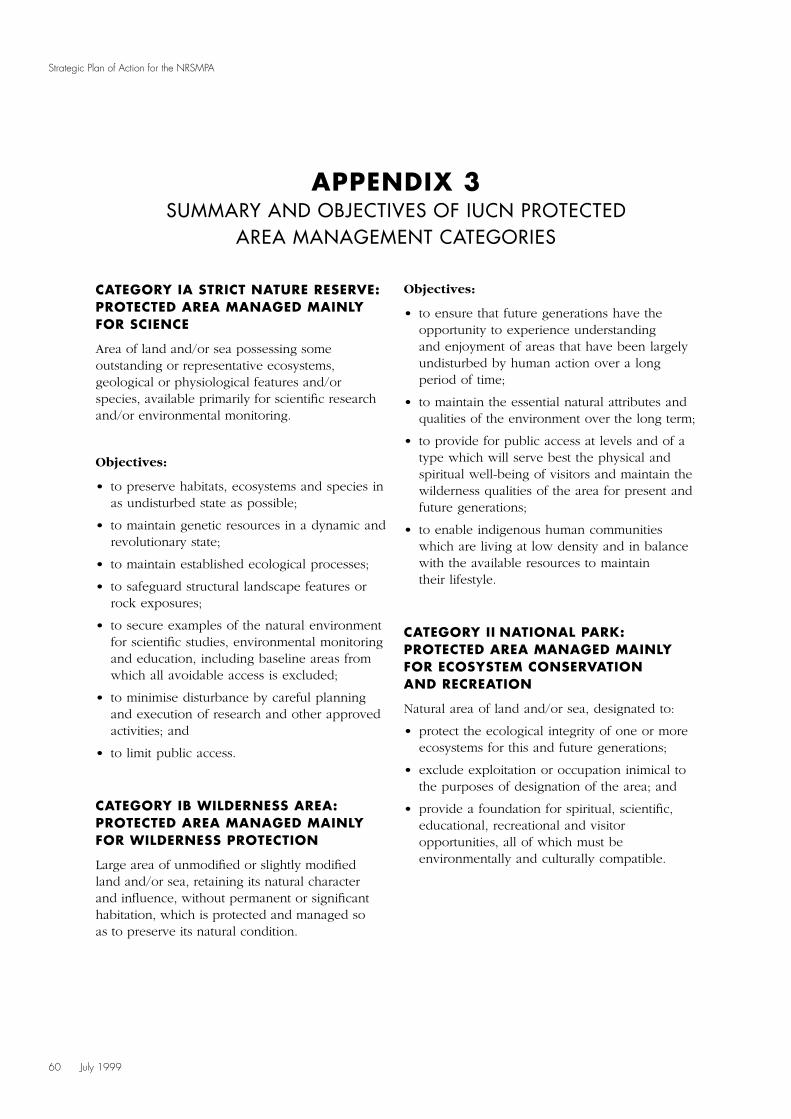
60 July 1999
Strategic Plan of Action for the NRSMPA
CATEGORY IA STRICT NATURE RESERVE:PROTECTED AREA MANAGED MAINLYFOR SCIENCE
Area of land and/or sea possessing someoutstanding or representative ecosystems,geological or physiological features and/orspecies, available primarily for scientific researchand/or environmental monitoring.
Objectives:
• to preserve habitats, ecosystems and species inas undisturbed state as possible;
• to maintain genetic resources in a dynamic andrevolutionary state;
• to maintain established ecological processes;
• to safeguard structural landscape features orrock exposures;
• to secure examples of the natural environmentfor scientific studies, environmental monitoringand education, including baseline areas fromwhich all avoidable access is excluded;
• to minimise disturbance by careful planningand execution of research and other approvedactivities; and
• to limit public access.
CATEGORY IB WILDERNESS AREA:PROTECTED AREA MANAGED MAINLYFOR WILDERNESS PROTECTION
Large area of unmodified or slightly modifiedland and/or sea, retaining its natural characterand influence, without permanent or significanthabitation, which is protected and managed soas to preserve its natural condition.
Objectives:
• to ensure that future generations have theopportunity to experience understandingand enjoyment of areas that have been largelyundisturbed by human action over a longperiod of time;
• to maintain the essential natural attributes andqualities of the environment over the long term;
• to provide for public access at levels and of atype which will serve best the physical andspiritual well-being of visitors and maintain thewilderness qualities of the area for present andfuture generations;
• to enable indigenous human communitieswhich are living at low density and in balancewith the available resources to maintaintheir lifestyle.
CATEGORY II NATIONAL PARK:PROTECTED AREA MANAGED MAINLYFOR ECOSYSTEM CONSERVATIONAND RECREATION
Natural area of land and/or sea, designated to:
• protect the ecological integrity of one or moreecosystems for this and future generations;
• exclude exploitation or occupation inimical tothe purposes of designation of the area; and
• provide a foundation for spiritual, scientific,educational, recreational and visitoropportunities, all of which must beenvironmentally and culturally compatible.
APPENDIX 3SUMMARY AND OBJECTIVES OF IUCN PROTECTED
AREA MANAGEMENT CATEGORIES
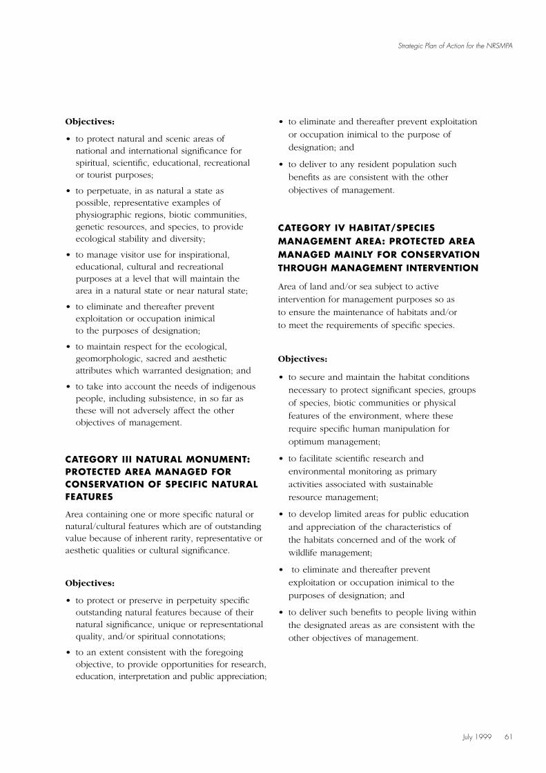
July 1999 61
Strategic Plan of Action for the NRSMPA
Objectives:
• to protect natural and scenic areas ofnational and international significance forspiritual, scientific, educational, recreationalor tourist purposes;
• to perpetuate, in as natural a state aspossible, representative examples ofphysiographic regions, biotic communities,genetic resources, and species, to provideecological stability and diversity;
• to manage visitor use for inspirational,educational, cultural and recreationalpurposes at a level that will maintain thearea in a natural state or near natural state;
• to eliminate and thereafter preventexploitation or occupation inimicalto the purposes of designation;
• to maintain respect for the ecological,geomorphologic, sacred and aestheticattributes which warranted designation; and
• to take into account the needs of indigenouspeople, including subsistence, in so far asthese will not adversely affect the otherobjectives of management.
CATEGORY III NATURAL MONUMENT:PROTECTED AREA MANAGED FORCONSERVATION OF SPECIFIC NATURALFEATURES
Area containing one or more specific natural ornatural/cultural features which are of outstandingvalue because of inherent rarity, representative oraesthetic qualities or cultural significance.
Objectives:
• to protect or preserve in perpetuity specificoutstanding natural features because of theirnatural significance, unique or representationalquality, and/or spiritual connotations;
• to an extent consistent with the foregoingobjective, to provide opportunities for research,education, interpretation and public appreciation;
• to eliminate and thereafter prevent exploitation
or occupation inimical to the purpose of
designation; and
• to deliver to any resident population such
benefits as are consistent with the other
objectives of management.
CATEGORY IV HABITAT/SPECIESMANAGEMENT AREA: PROTECTED AREAMANAGED MAINLY FOR CONSERVATIONTHROUGH MANAGEMENT INTERVENTION
Area of land and/or sea subject to active
intervention for management purposes so as
to ensure the maintenance of habitats and/or
to meet the requirements of specific species.
Objectives:
• to secure and maintain the habitat conditions
necessary to protect significant species, groups
of species, biotic communities or physical
features of the environment, where these
require specific human manipulation for
optimum management;
• to facilitate scientific research and
environmental monitoring as primary
activities associated with sustainable
resource management;
• to develop limited areas for public education
and appreciation of the characteristics of
the habitats concerned and of the work of
wildlife management;
• to eliminate and thereafter prevent
exploitation or occupation inimical to the
purposes of designation; and
• to deliver such benefits to people living within
the designated areas as are consistent with the
other objectives of management.
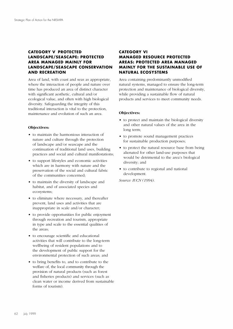
CATEGORY V PROTECTEDLANDSCAPE/SEASCAPE: PROTECTEDAREA MANAGED MAINLY FORLANDSCAPE/SEASCAPE CONSERVATIONAND RECREATION
Area of land, with coast and seas as appropriate,where the interaction of people and nature overtime has produced an area of distinct characterwith significant aesthetic, cultural and/orecological value, and often with high biologicaldiversity. Safeguarding the integrity of thistraditional interaction is vital to the protection,maintenance and evolution of such an area.
Objectives:
• to maintain the harmonious interaction ofnature and culture through the protectionof landscape and/or seascape and thecontinuation of traditional land uses, buildingpractices and social and cultural manifestations;
• to support lifestyles and economic activitieswhich are in harmony with nature and thepreservation of the social and cultural fabricof the communities concerned;
• to maintain the diversity of landscape andhabitat, and of associated species andecosystems;
• to eliminate where necessary, and thereafterprevent, land uses and activities that areinappropriate in scale and/or character;
• to provide opportunities for public enjoymentthrough recreation and tourism, appropriatein type and scale to the essential qualities ofthe areas;
• to encourage scientific and educationalactivities that will contribute to the long-termwellbeing of resident populations and tothe development of public support for theenvironmental protection of such areas; and
• to bring benefits to, and to contribute to thewelfare of, the local community through theprovision of natural products (such as forestand fisheries products) and services (such asclean water or income derived from sustainableforms of tourism).
CATEGORY VIMANAGED RESOURCE PROTECTEDAREAS: PROTECTED AREA MANAGEDMAINLY FOR THE SUSTAINABLE USE OFNATURAL ECOSYSTEMS
Area containing predominantly unmodifiednatural systems, managed to ensure the long-termprotection and maintenance of biological diversity,while providing a sustainable flow of naturalproducts and services to meet community needs.
Objectives:
• to protect and maintain the biological diversityand other natural values of the area in thelong term;
• to promote sound management practicesfor sustainable production purposes;
• to protect the natural resource base from beingalienated for other land-use purposes thatwould be detrimental to the area’s biologicaldiversity; and
• to contribute to regional and nationaldevelopment.
Source: IUCN (1994).
62 July 1999
Strategic Plan of Action for the NRSMPA

July 1999 63
Strategic Plan of Action for the NRSMPA
IMCRA meso-scale Area Area of MPAs % of bioregionbioregion Code (sq km) (sq km) as MPA
Abrolhos Islands ABR 6,645 0 0
Anson Beagle ANB 20,499 2.79 < 0.01
Arafura ARA 154,999 0.91 < 0.01
Arnhem Wessel AWS 27,439 0 0
Batemans Shelf BAT 6,175 222.03 3.60
Boags BGS 8,271 0 0
Bonaparte Gulf BON 41,656 0 0
Bruny BRU 7,288 1.12 0.02
Cambridge–Bonaparte CAB 14,962 0 0
Canning CAN 20,015 0 0
Carpentaria CAR 228,965 0 0
Central Bass Strait CBS 50,331 0 0
Central Reef CRF 31,389 31,370 99.94
Central Victoria CVA 4,378 17 0.38
Central West Coast CWC 26,186 94 0.36
Cobourg COB 10,294 999 9.70
Coorong COR 31,972 0.65 <0.01
Davey DAV 6,794 0 0
Eyre EYR 72,165 36 0.05
East Cape York ECY 14,535 12,189 83.85
Eighty Mile Beach EMB 9,724 0 0
Eucla EUC 111,115 11,545 10.39
Flinders FLI 16,916 119 0.70
Franklin FRA 10,364 0 0
Freycinet FRT 8,079 19.38 0.24
Groote GRO 19,440 0 0
Hawkesbury Shelf HAW 11,424 6.45 0.06
Karumba–Nassau KAN 55,998 335 0.60
Kimberley KIM 76,977 0 0
King Sound KSD 4,200 0 0
Leeuwin–Naturaliste LNE 26,575 64 0.24
Lucinda–Mackay Coast LMC 15,634 14,954 95.65
Mackay–Capricorn MCN 54,967 54,967 100.00
Manning Shelf MAN 7,682 0.75 0.01
Murat MUR 35,587 0 0
Ningaloo NIN 7,339 3,497 47.65
North Spencer Gulf NSG 4,448 78 1.76
North West Shelf NWS 153,970 0 0
APPENDIX 4OCCURRENCE OF MARINE PROTECTED AREAS
IN IMCRA REGIONS

64 July 1999
Strategic Plan of Action for the NRSMPA
Oceanic Shoals OSS 246,404 7,404 3.00Otway OTW 37,331 0 0Pellew PEL 25,506 0 0Pilbara (nearshore) PIN 13,861 68 0.49Pilbara (offshore) PIO 41,492 240 0.58Pompey–Swains PSS 56,374 56,374 100.00Ribbons RBN 47,830 42,592 89.05Spencer Gulf SGF 11,875 0.54 < 0.01St Vincent Gulf SVG 12,838 58 0.45Shark Bay SBY 14,071 8,730 62.04Shoalwater Coast SCT 20,655 18,224 88.23Tiwi TWI 5,105 0 0Torres Strait TST 36,233 0 0Tweed–Moreton TMN 42,713 6,321 14.80Twofold Shelf TWO 32,198 0.98 < 0.01Victorian Embayments VES 3,370 365 10.83Van Diemen Gulf VDG 17,011 1,268 7.45WA South Coast WSC 47,311 0 0Wellesley WLY 27,274 57 0.21West Cape York WCY 21,664 0 0Wet Tropic Coast WTC 6,000 4,539 75.65Zuytdorp ZUY 38,954 1.15 < 0.01
Totals 2,221,469 276,757 12.46
IMCRA PROVINCES (PROPOSED)
Australian Antarctic Province AAP 11,795,552 0 0Sunda Province (a) Christmas Island SunP (a) 416,572 0 0Sunda Province (b) Cocos (Keeling) Islands SunP (b) 475,054 2 0Kerguelen Province KergP NA 0 NAMacquarie Province MacP 0 0 0Norfolk Province (a) Norfolk Island NorfP (a) 2,119,278 0 0Norfolk Province (b) Lord Howe NorfP (b) NA 0 NANorfolk Province (c) Elizabeth and Middleton Reefs NorfP (c) NA 188 NA
Totals NA 190 NA
OTHER COMMONWEALTH MPAS
Great Barrier Reef (not in meso-scale regions) NA 3,424,479 NA NACoringa–Herald NA NA 885 NALihou Reef NA NA 843 NA
Totals NA 1728 NA
Note: NA = Not available.Due to paucity of some data the results should be considered as illustrative.
IMCRA meso-scale Area Area of MPAs % of bioregionbioregion Code (sq km) (sq km) as MPA
July 1999 65
Strategic Plan of Action for the NRSMPA
The information included in the following sectionsis based on the current uncertain situation withregard to what MPAs are included in the NRSMPA.Some MPAs referred to may not be a part of theNRSMPA once the set of characteristics of anMPA (refer to section 2.6, Characteristics of theNRSMPA) is applied. Jurisdictions are listed inalphabetical order.
COMMONWEALTH
Background
The Commonwealth Government hasgiven a commitment to expand Australia’sexisting system of marine protected areas inCommonwealth waters. In September 1997,the Minister for the Environment and Heritageannounced the Government’s intention todevelop an accelerated program, pursuing anumber of new parks. This commitment wasreaffirmed through Australia’s Oceans Policy(Commonwealth of Australia 1998), whichidentifies the need to protect marine biodiversity,through Regional Marine Planning includingthrough MPAs in a multiple-use framework.
Environment Australia is currently undertakingthe development of MPAs through a Commonwealth-endorsed strategy. A comprehensive and long-term Marine Protected Areas Strategy forCommonwealth waters, which links to thedevelopment of the NRSMPA, is being developed.Focus is being placed not only on the establishmentof new MPAs, but on ensuring that a representativesystem of reserves is developed. ExistingCommonwealth MPAs are concentrated inAustralia’s tropical waters. The Commonwealthis looking to broaden the agenda to include areasin Australia’s temperate and sub-Antarctic waters.
Organisational arrangements for MPAs in Commonwealth waters
Commonwealth MPAs are established under theNational Parks and Wildlife Conservation Act1975. The National Parks and WildlifeConservation Act provides for the establishment ofparks and reserves over areas of land or sea wherethere is a constitutional basis for Commonwealthinterest. These areas may be named as NationalParks or given some other designation and mayonly be revoked by a resolution of both Houses ofParliament. Management plans must be preparedand subjected to public comment and scrutiny byboth Houses of Parliament.
The legislative mandate supporting theCommonwealth component of the NRSMPAalso includes the Whale Protection Act 1982,Endangered Species Protection Act 1992, GreatBarrier Reef Marine Park Act 1975, AntarcticTreaty (Environment Protection) Act 1980, HeardIsland and McDonald Island Act 1953, and theHistoric Shipwrecks Act 1976.
The Director of National Parks and Wildlife isresponsible for parks and reserves proclaimedunder the National Parks and WildlifeConservation Act. The Australian National Parksand Wildlife Service is responsible for themanagement of Commonwealth MPAs, excludingthe Great Barrier Reef Marine Park (GBRMP),which is managed by the Great Barrier Reef MarinePark Authority, established under the GreatBarrier Reef Marine Park Act 1975. The AntarcticDivision of the Department of the Environmentand Heritage is responsible for administration ofthe Australian Antarctic Territory and the Territoryof Heard Island and the McDonald Islands. TheAustralian and World Heritage Group ofEnvironment Australia administers the HistoricShipwrecks Act 1976.
APPENDIX 5ORGANISATIONAL ARRANGEMENTS, PLANNING PROCESSES
AND RELEVANT LEGISLATION FOR EACH JURISDICTION
The Great Barrier Reef Marine Park Act createdthe GBRMP and includes provisions that:
• enable the control, care and developmentof the GBRMP (through, for example, zoningplans and plans of management);
• recognise that the GBRMP should allow ‘multiple-use’ management (note that ‘reasonable use’ ofthe GBRMP is a statutory right);
• prohibit drilling and mining, except for research(note that the Act also takes precedence overmost other legislation in that area);
• established a single independent Federalagency for management (the GBRMPA);
• established a three-person ‘board’ (theAuthority), which has since been amendedto four persons; and
• set out the process for regulations, publicinvolvement in zoning, a ConsultativeCommittee, and so on.
The GBRMP is the world’s largest marineprotected area (339,750 sq km and over 2000 kmlong). It extends from Low Water Mark (in mostareas) seaward but does not include the intertidalareas or islands (they are under State jurisdiction);it also extends up to 3000 feet above sea level.Management of the GBRMP relies heavily on:
• strong cooperation with the State (that is,Queensland) Government through formalagreements, and with various otherdepartments, industry, research institutions anduniversities (especially through the Co-operative Research Centre);
• complementary legislation for most adjoiningState waters; and
• strategic plans, zoning plans and site-specificmanagement plans.
Processes for identification, selection,declaration and management planning
The current candidate areas were selected froman established indicative list of potential MPAs.The areas were selected on the basis of existinginformation indicating high biodiversity values andtheir representativeness. The IMCRA coverage for
Commonwealth waters is at a broad scale.IMCRA is being used as a planning frameworkto determine representativeness at this broadscale. It is intended that, as the CommonwealthMPA strategy develops, the indicative list will beexpanded in accordance with the Guidelines.The development of priorities will utiliseinformation from the gap analysis, biodiversityvalues analysis, as well as information aboutthreatening processes and other attributes.
There are three stages which outline the processfor the declaration of MPAs: the pre-declarationprocess, the process for declaration and the post-declaration process. The CommonwealthGovernment acknowledges that the involvementand active participation of all users of the marineenvironment is critical to the successfuldevelopment, implementation and management ofMPAs. There are opportunities for consultationwith stakeholders throughout each process.
Pre-declaration process
• Environment Australia (EA) investigates theconservation attributes of the relevant area.
• Informal consultation is initiated with keystakeholders to develop a scope for the proposal.
• A Commonwealth steering committee seeks toagree on a broad set of MPA options for theregion, and the consultation process.
• Targeted consultation occurs with stakeholdersto negotiate MPA options for the area.
• The Commonwealth steering committeeconsiders options for an MPA.
• A final report is prepared outlining a detailedMPA proposal with management options andzoning arrangements, and is submitted to theMinister for the Environment and Heritage.
• The Minister for the Environment and Heritageconsults with relevant Commonwealth ministers.
Process for declaration
• The Director of National Parks and Wildlife(the Director) issues a public notice indicatingan intention to recommend the declaration ofthe protected area.
66 July 1999
Strategic Plan of Action for the NRSMPA

July 1999 67
Strategic Plan of Action for the NRSMPA
• The public comment period is open for aminimum of 60 days following publication ofthe notice.
• The Director submits a report to the ExecutiveCouncil recommending proclamation throughthe Minister for the Environment and Heritage.
• The area is proclaimed by the Governor-General in Council.
• The proclamation is Gazetted.
Post-declaration process
• The Director issues a public notice of intentionto prepare a plan of management for the areaand invites interested persons to makerepresentations on the proposed plan.
• A draft management plan is prepared.
• The draft plan is made public andrepresentations invited from interested people.
• The final plan, together with the publicrepresentations and the Director’s commentson the representations, is submitted to theMinister for the Environment and Heritage.
• The Minister for the Environment and Heritageaccepts the plan (or it is referred back toEnvironment Australia for refinement).
• The plan of management is laid before bothHouses of Parliament; if neither House passes amotion disallowing the plan within 20 sittingdays, the plan comes into effect.
• The Minister for the Environment and Heritageissues a public notice as soon as practicablestating that the plan of management has comeinto operation.
Planning for the GBRMP is not dissimilar to theabove process, with only minor differences forthe agency involved (GBRMPA) and the statutoryobligations. The Great Barrier Reef Marine ParkAct provides for statutory plans of managementfor the following:
• one or more areas of the marine park;
• one or more species within the marine park orwithin an area or areas of the marine park; or
• one or more ecological communities within themarine park or within an area or areas of themarine park.
NEW SOUTH WALES
Background
The National Strategy for the Conservation ofAustralia’s Biological Diversity (Commonwealth ofAustralia 1996) commits NSW to establishing andmanaging ‘a comprehensive, adequate andrepresentative system of protected areas coveringAustralia’s biological diversity’. This commitmenthas been incorporated into Biodiversity – Life’sVariety: Draft New South Wales BiodiversityStrategy (NPWS 1997). The strategy sets aperformance target of ‘a comprehensive, adequateand representative reserve system established forterrestrial (other than forest reserves) and marineecosystems by 2010’.
On behalf of the Marine Parks Authority, NSWFisheries and the NSW National Parks and WildlifeService (NPWS) are cooperatively developing aFramework for the Establishment of a RepresentativeSystem of Marine Protected Areas for NSW.
The New South Wales Coastal Policy (DUAP 1997)calls for the addition of the intertidal zoneadjacent to National Parks and other landsreserved under the National Parks and WildlifeAct 1974. The NPWS and NSW Fisheries arecurrently examining the most effective means ofachieving the reservation of these lands.
New South Wales currently has three marine parks– the Solitary Islands Marine Park, Jervis Bay MarinePark and Lord Howe Island Marine Park – whichare declared under the Marine Parks Act 1997.The Solitary Islands Marine Park has replaced theformer Solitary Islands Aquatic Reserve declaredunder the Fisheries Management Act 1994.
There are seven aquatic reserves declared underthe Fisheries Management Act. Another aquaticreserve (Cook Island) has been proposed and islikely to be declared in the near future.
There are nearly 70 MPAs reserved under theNational Parks and Wildlife Act within 35 nationalparks, historic sites or nature reserves. Theyconsist principally of estuarine and intertidal landsbut include some marine waters.
68 July 1999
Strategic Plan of Action for the NRSMPA
Organisational arrangements for MPAs in New South Wales
MPAs can be declared under a number of Actsin New South Wales. The Marine Parks Act hasestablished a Marine Parks Authority thatcomprises the heads of NSW Fisheries, NPWS andthe Premier’s Department. The Marine Parks Actrequires the Authority to investigate marine areasto develop a comprehensive system of marineparks in New South Wales. Aquatic reserves canbe declared under the Fisheries Management Act.MPAs have also been reserved under the NationalParks and Wildlife Act.
The National Parks and Wildlife Act providesfor the protection of plants and fauna (withfauna defined as mammals, birds, reptiles andamphibians). The Act excludes fish and otheraquatic animals (other than fauna) which arecovered by the Fisheries Management Act,administered by NSW Fisheries. The NPWS isresponsible for protecting cultural heritage,including Aboriginal sites and places.
The Wilderness Act 1987 provides for thedeclaration of wilderness areas. There is currentlyone coastal wilderness area, the Nadgeewilderness area, which includes estuarine lands inits boundaries. There are no marine wildernessareas in NSW, but the Wilderness Act does notpreclude them.
Processes for identification, selection,declaration and management planning
The Marine Parks Authority has proposed thatprogressive bioregional assessments investigateand map ecosystem units over the next threeyears. These will form the basis for deciding onpotential marine parks and other MPAs. Regionaland local assessment will be based on theGuidelines. The development of methodologyto implement these Guidelines is the subject ofa 1998 Natural Heritage Trust funding proposal.
The pre-declaration and declaration processesunder the National Parks and Wildlife Act and theFisheries Management Act are well established.These include non-statutory processes forconsultation with government departments and/or
the public. The pre-declaration and declarationprocesses for marine parks declared by the MarinePark Authority have not been finalised. The MarineParks Act sets out the legal declaration process,including reference to the role of the Authorityand an Advisory Council in the declarationprocess. No formal nomination process is requiredbefore an assessment may be undertaken.
Marine park zoning planning and operationalplanning must commence as soon as practicableafter the declaration of a marine park. A statutorythree-month period of public consultation and public exhibition is required for both zoningand operational plans.
NORTHERN TERRITORY
Background
Little is known about the Northern Territory’smarine habitats. Existing databases on marinefish, corals and shellfish are too scant to allow foranalysis of the comprehensiveness, adequacy andrepresentativeness of the marine component ofthe Northern Territory park system. While muchhas been done to monitor fish stocks and tocollect specimens for museums, very few surveyshave attempted to document the range of habitatsin the seas of the Northern Territory.
The Parks and Wildlife Commission of theNorthern Territory (PWCNT) has recently begunto rectify this situation, undertaking surveys in theDarwin region in collaboration with museums andart galleries of the Northern Territory. The deeperwaters of the Gulf of Carpentaria have beenmapped by the CSIRO.
The Northern Territory currently has a singlemarine park, Cobourg Marine Park, and twoaquatic reserves, Doctors Gully Aquatic Reserveand East Point Aquatic Reserve. A number ofterrestrial parks provide significant protection forassociated marine elements within their intertidaland estuarine portions. These include KakaduNational Park, Djukbinj National Park, CasuarinaCoastal Reserve and the proposed Mary RiverNational Park.
July 1999 69
Strategic Plan of Action for the NRSMPA
The recently developed Northern Territory ParksMasterplan (PWCNT 1997) sets the direction forthe future establishment of a comprehensive,adequate and representative system of bothterrestrial and marine parks. IMCRA identifies60 individual regions, including 12 for theNorthern Territory. Of the 12 regions in NorthernTerritory waters, eight are located exclusivelywithin its borders.
Organisational arrangements for MPAs in the Northern Territory
The PWCNT has the powers to declare marineparks or reserves under the Territory Parks andWildlife Conservation Act. The Department ofPrimary Industries and Fisheries (DPIF) is ableto declare aquatic reserves under the FisheriesAct. A Memorandum of Understanding has beendeveloped between the PWCNT and DPIFoutlining management responsibilities betweenthe two agencies in respect of MPAs. In general,PWCNT is responsible for the management ofbirds, reptiles and mammals, whilst DPIF isresponsible for management of all other aquaticlife within MPAs.
Cobourg Marine Park was declared under theTerritory Parks and Wildlife Conservation Act.The Park is managed by a board establishedunder the Cobourg Peninsula Aboriginal Land,Sanctuary and Marine Park Act 1996 withinthe auspices of the Territory Parks and WildlifeConservation Act and the Fisheries Act. Aplan of management is currently beingprepared for this park.
Processes for identification, selection,declaration and management planning
The PWCNT in collaboration with DPIF willcommence the development of a Northern TerritoryMarine Conservation Strategy in 1999. The strategywill identify gaps in the knowledge base concerningthe marine environment, assess marine ecologicalvalues, assess existing and potential threats to thosevalues, and identify candidate MPAs. At present,the PWCNT is developing techniques to enablerapid assessment of the marine environment.
These techniques include the use of sonar,remote sensing and benthic grab techniques.The techniques will be initially trialed atCobourg Marine Park, then used extensivelyacross Northern Territory waters to obtain dataon habitat types within IMCRA regions.
Development of the Northern Territory MarineConservation Strategy will involve consultationwith those government departments with aninterest in the marine environment, industrygroups such as the fishing and mining industries,Aboriginal groups and other key stakeholders,such as environmental and recreational groups.At present, 84% of the Northern Territorycoastline is in Aboriginal ownership.
To facilitate community involvement in theestablishment of MPAs and to bring scientific rigourto the selection of MPAs and associated research,two stakeholder committees will be established:
• The Marine Parks Community AdvisoryCommittee will comprise representation fromgovernment, the Aboriginal community, majorrecreational and commercial user groups andcommunity environmental interests. The role ofthe Community Advisory Committee will be toreview the broad processes and procedures ofestablishment of marine parks and reserves.
• The Marine Parks Scientific Advisory Committeewill include representatives of scientific, andmanagement agencies with expertise in marinescience and marine resource management. Thiscommittee will provide advice concerning themanagement of MPAs and will be involved inthe design and implementation of research andmonitoring programs.
QUEENSLAND
Background
Queensland has six marine parks declared underthe Marine Parks Act 1982. In addition to thesemarine parks, the Great Barrier Reef Marine Park,declared under the Commonwealth Great BarrierReef Marine Park Act 1975, extends intoQueensland coastal waters.

70 July 1999
Strategic Plan of Action for the NRSMPA
The Queensland Government’s approach todeclaration of marine parks has been to givehighest priority to the implementation ofcomplementary State and Commonwealth zoningfor effective protection of the Great Barrier ReefRegion. Declaration of the Cape York Marine Parkwill be the final step in this process. Queenslandcurrently has three marine parks in the GreatBarrier Reef Region, namely the Cairns,Townsville–Whitsunday and Mackay–CapricornMarine Parks.
Other marine parks have been established atHervey Bay, to facilitate management of whalewatching activities, at Woongarra, to protect thenesting habitat of loggerhead turtles and areasof fringing reef, and at Moreton Bay, which isa Ramsar site and is the most intensively usedmarine area in the State.
Several of Queensland’s national parks declaredunder the Nature Conservation Act 1992 alsoextend into the marine environment. There isan extensive system of fish habitat areas, declaredunder the Fisheries Act 1994, which provide forthe protection of important fish habitat andnursery grounds.
Queensland is currently developing a Strategyfor Marine Protected Areas that will complementand enhance the existing reserve system. Thestrategy will include a framework for identificationand declaration of future MPAs, representativeof the range of marine ecosystems withinQueensland’s waters.
In the short term, declaration of marine parkson eastern Cape York Peninsula and at TrinityInlet near Cairns will be brought to completion.Subsequently, proposals will be prepared for theGulf of Carpentaria and for areas on the eastcoast not adequately protected in the currentsystem of marine parks. Concepts for protectionof marine areas in Torres Strait will be investigatedin cooperation with Torres Strait Islanderrepresentative bodies, with a view to thepotential consideration of MPAs in a culturallyrelevant context.
Organisational arrangements forMPAs in Queensland
The Department of Environment and Heritage isresponsible for administration of the QueenslandMarine Parks Act, which provides for theestablishment of marine parks over tidal lands andwaters. The Act also provides for the preparationof zoning plans, which identify appropriate formsof use in different zones within a marine park. Inthe Great Barrier Reef Region, Queensland marineparks are zoned to complement the zoning of theGreat Barrier Reef Marine Park, and the Queenslandand Commonwealth Governments haveimplemented joint management arrangements.
The Queensland Department of Primary Industriesis the management authority for fish habitat areas.
Processes for identification, selection,declaration and management planning
The Queensland Strategy for MarineProtected Areas will provide the frameworkfor the identification and selection of candidateareas for MPAs. The framework will have regardto conservation of marine biodiversity andprotection of rare and endemic species andcommunities, as well as broad-scale habitatand ecosystem protection.
The planning of a representative system of MPAswill involve the identification of gaps in the currentsystem and the identification of a list of candidateMPAs. This will involve analysis of the existingsystem of MPAs within the jurisdictionalresponsibilities of Queensland having regardto IMCRA.
Identification of a list of candidate MPAs
The Queensland Strategy for Marine ProtectedAreas will define goals and objectives for thedevelopment of a classification system of habitatsand ecosystems below the bioregional level asidentified in IMCRA. The classification of ecosystemsand habitats will involve preliminary habitatmapping in selected bioregions along the coast.
During the planning of an MPA, threateningprocesses will be evaluated to ensure that theintegrity of the marine park is not compromised.

July 1999 71
Strategic Plan of Action for the NRSMPA
The Queensland Marine Parks Act 1982 and theMarine Parks Regulation 1990 outline the statutoryrequirements for the declaration of marine parksand the development of zoning plans andmanagement plans. The following steps outlinethe usual process for gazettal of a marine parkand approval of a zoning plan:
• Notification by Minister of an ‘area of interest’
• Public input (first round)
• Review of submissions
• Drafting of formal marine park proposal
• Public input (second round)
• Review of submissions
• Formal recommendation to Minister withanalysis of submissions
• Legislative drafting
• Cabinet and Governor in Council approval
• Gazettal.
SOUTH AUSTRALIA
Background
Existing MPAs in South Australia are not the outcome of a deliberate strategy to representmarine biodiversity. Each MPA was created fora specific purpose, mainly in relation to singlespecies protection, fisheries habitat protection andfisheries management. The Marine and EstuarineStrategy for South Australia (South AustralianGovernment 1998) endorses a representativesystem of MPAs in South Australian waters. SouthAustralia recognises the commitments made underother protocols and agreements to work towardsits contribution to the NRSMPA.
Organisational arrangements for MPAs in South Australia
The Department for Environment, Heritage andAboriginal Affairs and the Department of PrimaryIndustries and Resources both have the abilityto create MPAs with existing legislation. Bothagencies work cooperatively in respect to thedevelopment of MPAs. The Department for
Environment, Heritage and Aboriginal Affairs hasresponsibility for the National Parks and WildlifeAct 1972, while the Department of Primary Industriesand Resources administers the Fisheries Act 1982.
Processes for identification, selection,declaration and management planning
A current project is using the IMCRA bioregionsand also smaller biounits to identify marine areasof conservation importance for biodiversityprotection. These areas will be used as the basisfor identifying candidate areas for a representativesystem of MPAs in SA waters.
The following steps were applied in relation tothe establishment of the Great Australian BightMarine Park. This includes both the GreatAustralian Bight Marine Park Whale Sanctuary,proclaimed under the Fisheries Act, and the GreatAustralian Bight Marine Park, proclaimed underthe National Parks and Wildlife Act.
• Pre-declaration consultation with communityand industry concerning location, intent, sizeand management of the park through a seriesof workshops and the formation of aconsultative committee.
• Proclamation, initially under the Fisheries Act,to establish a sanctuary at the Head of theBight and subsequently, under the NationalParks and Wildlife Act, to establish a multiple-use marine park with a series of sanctuaries forprotection of the Australian Sea Lion.
• Draft management plan prepared.
• Public consultation for a period of three months.
• Drafting of final management plan andresource information document, incorporatingpublic comment.
TASMANIA
Background
The existing MPA strategy for Tasmania isthe Joint Policy for the Establishment andManagement of Marine Reserves in Tasmania(Tasmanian Government 1990). The 1990 jointpolicy represented a major government initiative

72 July 1999
Strategic Plan of Action for the NRSMPA
in this area, and has formed the backbone of theTasmanian marine reserves strategy up to thepresent time. The 1990 joint policy is currentlyin the process of being updated.
In September 1991, the first four marine reserveswere proclaimed under the existing joint policy,all on the east coast of Tasmania and totalling2,050 ha (Maria Island, Governor Island, Tinderboxand Ninepin Point). Two new MPA proposalscurrently under development for Port Davey/Bathurst Harbour and the Kent Group of islandsalso follow the objectives of the 1990 joint policy.
Priorities for consideration as part of Tasmania'sMPA strategy include:
• preparation of proposals for representativeMPAs in those bioregions which are as yet notrepresented in the marine reserve system;
• evaluation of MPA proposals received by thepeak fishing bodies (the Tasmanian FishingIndustry Council and the Tasmanian AmateurSea Fishermen’s Association), other stakeholderbodies and the public;
• ongoing consultation with stakeholder groups,particularly fishing groups, and the organisationof workshops and seminars to exchange ideasand information on issues such asbioregionalisation and fish propagation;
• declaration of the waters around MacquarieIsland as a marine reserve, covering theInsulantarctic biogeographic region;
• reviewing the reserve boundaries of theMaria Island Marine Reserve to make it afully representative marine reserve for theFreycinet bioregion;
• more detailed mapping of nearshore andoffshore marine habitats, following on from thealmost-completed 1:100,000 nearshore habitatmapping project; and
• continuation of the monitoring programs in theexisting marine reserves, to assess biologicalchanges resulting from reserve declaration andprotection from fishing.
Organisational arrangements for MPAs in Tasmania
Marine reserves are managed jointly by theParks and Wildlife Service of the Department ofEnvironment and Land Management, under the
National Parks and Wildlife Act 1970, and theMarine Resources Division of the Department ofPrimary Industry and Fisheries, under the LivingMarine Resources Management Act 1995.
The Department of Environment and LandManagement is responsible for the protectionof marine creatures such as seals and seabirds,reservation, interpretation, enforcement and day-to-day management. Day-to-day managementresponsibility rests with rangers on adjacentterrestrial national parks. The Department ofPrimary Industries and Fisheries is responsiblefor the conservation of fish, fishing regulationsand enforcement, and also undertakes monitoringand research. The Marine Police, together withFisheries officers, are responsible for theenforcement of prohibitions regarding the takingof fish from marine reserves. The duties areundertaken as part of the general functions of theMarine Police and are not identified separately.
Processes for identification, selection,declaration and management planning
Tasmanian nearshore waters have been dividedinto eight major marine bioregions in IMCRA.Diving surveys of all the major shallow reef areasare conducted to identify bioregions based ondifferences between the communities of reefplants and animals. Surveys of other marinehabitats and communities have also beenundertaken or are underway. For example,estuaries around Tasmania have been recentlysurveyed and comprehensive surveys of seabirdsand seals have been undertaken.
Selection of representative areas
Within each bioregion, the survey results areexamined to identify the most suitable sites forrepresentative MPAs. Ideally, representativeareas should:
• include a large range of habitats;
• if adjacent to land, have their surroundingshorelines and watersheds already protectedfrom human impacts;
• have a total coastal length of at least 10 km;

July 1999 73
Strategic Plan of Action for the NRSMPA
• have a history of minimal commercial andrecreational fishing; and
• lack other human impacts.
These criteria have been proposed for adoption asthe basis for selecting the two currentrepresentative MPAs in Tasmania. The first threecriteria (which are biological and environmentalcriteria) are basic to the requirements of arepresentative MPA. In reality, it is unlikely that aproposed site will fit all five criteria. Social andeconomic factors also need to be considered andincorporated. Decisions on actual boundaries andmanagement policies for a reserve will be madeafter, and with consideration of, publicconsultation on the reserve proposal.
Pre-declaration process
The pre-declaration process involves extensiveconsultation with stakeholders before the proposalis released for public consultation.
Declaration process
Under the Living Marine Resources ManagementAct, all draft proposals allow 30 to 90 days for publicconsultation, then they are declared by the Minister.Under the National Parks and Wildlife Act, proposalshave to be approved by both Houses of Parliament.MPAs may be declared under both Acts and it isproposed that, where relevant, future MPAs willbe declared under both Acts.
Management Planning
Under the National Parks and Wildlife Act, amanagement plan is prepared after declaration, witha minimum of 30 days allowed for public consultationfollowing the placement of advertisements inrelevant newspapers. The Minister makes thefinal decision. Under the Living Marine ResourcesManagement Act, the management planningprocess is the declaration process.
VICTORIA
Background
The Victorian Coastal Strategy (Victorian CoastalCouncil 1997) includes as a priority ‘to establishand manage a representative system of MPAs and
coastal parks and reserves’. Victoria’s biodiversitystrategy (DNRE 1997) includes a key managementapproach ‘to establish a comprehensive, adequateand representative reserve system of marine parks’.
The development of Victoria’s existing MPAsystem has taken place over the past 20 years,beginning with the establishment of five smallmarine reserves in southern Port Phillip Bay in1979. Since then, seven additional MPAs havebeen established, one in northern Port PhillipBay and the remainder in south Gippsland.
In 1991, the Land Conservation Council commencedan investigation of Victoria’s marine, coastal andestuarine environment. A descriptive report waspublished in 1993, followed by proposedrecommendations in 1995 and draft finalrecommendations in 1996. In 1997, theEnvironment Conservation Council, establishedunder new legislation, replaced the LandConservation Council. New terms of referencerequired the Environment Conservation Councilto, among other things, make recommendationson a preferred approach and priorities for theprogressive establishment of a representativesystem of marine parks in Victoria.
The Council’s February 1998 interim report(Environment Conservation Council 1998)recommended the establishment of a marine parkof 17,453 ha at the southern end of Port PhillipBay, and sought comment on managementguidelines and recommendations for marine,coastal and estuarine areas, and principles for theselection and management of marine parks. A fullreport will be finalised by June 2000, makingrecommendations for the whole of Victoria’smarine, coastal and estuarine areas.
Organisational arrangements for MPAs in Victoria
The Department of Natural Resources andEnvironment manages MPAs in Victoria underlegislation including the National Parks Act 1975,the Fisheries Act 1995 and the Crown Land(Reserves) Act 1978. The Department’s ParksProgram has responsibility for development ofa representative protected area network andthe provision of natural and cultural resource

74 July 1999
Strategic Plan of Action for the NRSMPA
management, and visitor and tourism services.Park management services are delivered acrossVictoria through an agreement with Parks Victoria,the State’s primary provider of such services. TheFisheries Program is responsible for the managementof commercial, recreational and aquaculture usewithin the context of ecologically sustainabledevelopment. Where such activities continuewithin MPAs, the Parks and Fisheries Programswill develop cross-program arrangements formanagement.
Following the Victorian Government's responseto the Environment Conservation Council report(see above), the Department of Natural Resourcesand Environment Parks Program will beresponsible for implementation of therecommendations relating to MPAs.
Processes for identification, selection,declaration and management planning
The Environment Conservation Council hasresponsibility for the identification and selectionof MPAs. Potential areas will be identified on thebasis of representation of both the IMCRA regionsand the habitats and substrate types within theseregions. Victoria is carrying out a systematicprocess to collect baseline data through theEnvironmental Inventory of Victoria’s MarineEcosystems project. The completion of theecological classification of soft benthic habitatsalong the open coast is a priority.
The pre-declaration process for additions to theexisting MPA system in Victoria occurs throughthe Environment Conservation Council’s Marine,Coastal and Estuarine Investigation. The processis highly consultative, with four reports to datewidely available as a basis for public comment.The Victorian Government will respond to theCouncil’s recommendations, and implementationwill be through legislation. Declaration of newareas will generally occur either by amendingprimary legislation or through subordinateinstruments such as Orders of the Governor inCouncil. The management planning processwill include a period of public comment beforefinalisation of an approved plan for
implementation. Interim Management Statementsmay be prepared to guide park management untila management plan is prepared; in this case,public comment would not usually be sought.
WESTERN AUSTRALIA
Background
In 1998, the Western Australian Governmentreleased the strategy: New Horizons – The wayahead in marine conservation and management(CALM 1998). The principal thrust of the marineconservation effort is to have one comprehensivemarine reserve system under the Conservationand Land Management Act 1984 (CALM Act).Amendments to the CALM Act and other Acts viathe Acts Amendment (Marine Reserves) Act 1997provide a mechanism to create a world classmultiple-use MPA system.
The key elements of the strategy are:
• a Marine Parks and Reserves Authority, inwhich marine conservation reserves are vested,supported by a specialist Scientific AdvisoryCommittee;
• the adoption of a three-tiered approachto marine conservation reserve categories –Marine Nature Reserves, Marine Parks andMarine Management Areas;
• extensive assessment, community consultationand management planning before a newmarine conservation reserve is established;
• specific guidelines for access by industry tothe various categories of marine conservationreserves and the zones within those reserves; and
• specific guidelines for fishing, aquaculture andpearling interests in marine conservation reserves.
Western Australia has seven existing marineconservation reserves declared under the CALMAct: Rowley Shoals Marine Park, Ningaloo MarinePark, Shark Bay Marine Park, Hamelin PoolMarine Nature Reserve, Marmion Marine Park,Shoalwater Islands Marine Park and Swan EstuaryMarine Park. Currently, a marine conservation

July 1999 75
Strategic Plan of Action for the NRSMPA
reserve proposal is being developed for theJurien Bay area on the central west coast.
In December 1997, the State Governmentannounced three new high priority areas forimplementation of marine conservation reservesafter considering the advice of the Marine Parksand Reserves Authority. The three areas are theMontebello Islands–Barrow Island group, theDampier Archipelago on the North West Shelf,and the Geographe Bay–Capes–Hardy Inlet regionin the south-west of the State.
Organisational arrangements for MPAs in Western Australia
The Department of Conservation and LandManagement manages all marine conservationreserves vested in the Marine Parks and ReservesAuthority. The Department is also responsible forpreparing and implementing management plansfor each reserve. Marine conservation reservesmay also be established under special legislation,such as the Rottnest Island Authority Act 1987.
Fish Habitat Protection Areas can be createdunder the Fish Resources Management Act 1994and are developed and managed by FisheriesWestern Australia. In addition, Fisheries WesternAustralia protects marine resources using anumber of instruments which prohibit or limitfishing activities in defined areas to protectvaluable marine resources. Fishing, aquacultureand pearling in marine conservation reserves arealso under the jurisdiction of Fisheries WA. TheDepartment of Transport is responsible for allboating regulations but mooring controls can bedelegated to other agencies.
Mineral and petroleum exploration andproduction are carried out under several actsadministered by the Department of Minerals andEnergy. The Environmental Protection Authorityassesses, reports and makes recommendations onproposals that may significantly affect the marineenvironment, including marine conservationreserves. The Department of EnvironmentalProtection assists the Environmental ProtectionAuthority in this process and, in addition,administers pollution control legislation.
Processes for identification, selection,declaration and management planning
A statewide review of the marine environmentof Western Australia, entitled A RepresentativeMarine Reserve System for Western Australia(CALM 1994, known as the Wilson Report),identified a total of about 70 areas, representingthe range of marine ecosystems, as candidates forreservation. The priority areas were identified forfurther investigation as potential marine conservationreserves. These areas were selected because of theneed for conservation management, the increasingpressures of use, and public interest in expandingthe marine conservation reserve system.
The Marine Parks and Reserves Authority is in theprocess of adopting a strategic approach to theestablishment of a statewide system of multiple-use reserves. This approach is being developedin a Marine Parks and Reserves Scientific AdvisoryCommittee position paper, which describes theprioritising framework, identifies and brieflyoutlines the rationale for each criterion, andapplies the framework to 20 areas identifiedin the Wilson Report as a working example.
The processes for pre-declaration, declarationand management planning for marineconservation reserves are set out in the CALMAct. These are summarised below:
• The area is identified and its proposedboundaries determined.
• A comprehensive assessment of the area’sbiological and economic resources and socialvalues is conducted.
• Community liaison and advisory committeesare normally set up to assist in the process,including preparation of an indicativemanagement plan and determination of thevarious management zones proposed.
• The Marine Parks and Reserves Authorityprepares a report on a reservation proposalfor the Minister for the Environment.
• An indicative management plan outlining thereserve’s proposed management objectives andzones is prepared.
• The Ministers for Fisheries and Mines areprovided with a reservation proposal for theirconsideration and agreement before a noticeof intent to reserve the area is published.
• When these steps have been completed,the Minister for the Environment formallypublishes a notice of intent to declare a marineconservation reserve and releases the indicativemanagement plan for public comment.(All marine conservation reserve proposalswill be subject to a minimum three-monthpublic comment period before a finaldecision by Government.)
• The Marine Parks and Reserves Authorityprovides the Minister for the Environment witha report on the public submissions received inresponse to the reservation proposal and theindicative management plan for the proposedmarine conservation reserve.
• The concurrence of the Ministers for Fisheriesand Mines is obtained.
• The reserve is created by an Order ofthe Governor.
• The Minister for the Environment tables in eachHouse of Parliament the order to reserve thenew marine reserve. Either House can resolveto disallow a reservation order.
76 July 1999
Strategic Plan of Action for the NRSMPA

July 1999 77
Strategic Plan of Action for the NRSMPA
Adequacy The maintenance of the ecological viability and integrity of populations,species and communities.
Biodiversity The variability among living organisms from all sources, including terrestrial,Biological diversity marine and other aquatic ecosystems and the ecological complexes of which
they are a part; this includes the diversity within species, between species and of ecosystems (UNEP 1994).
Bioregion An area defined by a combination of biological, social and geographicBiogeographic region criteria, rather than by geopolitical considerations. Generally, a system of
related, interconnected ecosystems (Commonwealth of Australia 1996).
Blue Pages Marine and Coastal Data Directory of Australia
CAMBA Agreement for the Protection of Migratory Birds and Birds in Danger of Extinction and their Environment between the Government of Australia and the Government of The People’s Republic of China (1986).
Comprehensiveness Includes the full range of ecosystems recognised at an appropriate scale within and across each bioregion.
Community A group of organisms, both animals and plants, living together in an ecologically related fashion in a defined area or habitat.
Ecologically sustainable Using, conserving and enhancing the community’s resources so thatdevelopment (ESD) ecological processes, on which life depends, are maintained and the total
quality of life, now and in the future, can be increased (Commonwealth of Australia 1992b).
Ecosystem A dynamic complex of plant, animal and micro-organism communities and their non-living environment interacting as a functional unit (UNEP 1994).
Ecosystem-based Management, usually of human activities and their effects, which seeks tomanagement identify and address direct and indirect effects on ecosystem components and
to integrate planning and management activities across sectors within ecosystem-defined units or areas.
Exclusive Economic The area between the lines 12 nautical miles and 200 nautical miles seawardZone (EEZ) of the territorial sea baselines. In this area, Australia has the right to explore
and exploit living and non-living resources, and the concomitant obligation to protect and conserve the marine environment.
Guidelines The Guidelines for Establishing the National Representative System of Marine Protected Areas (ANZECC TFMPA 1998).
Habitat The place or type of site where an organism or population naturally occurs(UNEP 1994).
GLOSSARY
78 July 1999
Strategic Plan of Action for the NRSMPA
Highly protected areas IUCN Protected Area Management Categories I and II (refer to Appendix 3); also known as ‘no take’ areas.
Indicators Physical, chemical, biological or socioeconomic measures that can be used to assess natural resources and environmental quality, and that are fundamental to the SoE reporting process.
Interim Marine and An ecosystem-based classification for marine and coastal environments.Coastal Regionalisation It provides ecologically based regionalisations at the meso-scale (100–1000 km)for Australia (IMCRA) and at a provincial scale (greater than 1000 km).
IMCRA is the bioregional framework for the planning and management of the NRSMPA.
JAMBA Agreement for the Protection of Migratory Birds and Birds in Danger of Extinction and their Environment between the Government of Australia and the Government of Japan (1974).
Multiple use management An approach that aims to achieve integration of an acceptable balance of outcomes across the full range of marine uses.
‘No take’ areas IUCN Protected Area Management Categories I and II (refer to Appendix 3); referred to in text as highly protected areas.
Protected area/marine An area of land and/or sea especially dedicated to the protection andprotected area (MPA) maintenance of biological diversity, and of natural and associated cultural
resources, and managed through legal or other effective means (IUCN 1994).
Ramsar site A site included in the List of Wetlands of International Importance (the “Ramsar List”). The Convention on Wetlands was signed in Ramsar, Iran, in 1971.
Representativeness Those marine areas that are selected for inclusion in reserves should reasonably reflect the biotic diversity of the marine ecosystems from whichthey derive.
SoE (State of A tool for providing information on the pressures influencing environmentalEnvironment) reporting attributes, the state or condition of these and the responses initiated to
counter identified pressures.
State waters Australia’s Offshore Constitutional Settlement established Commonwealth, State and Territory jurisdictions over marine areas. States generally have primary jurisdiction over marine areas to 3 nautical miles from the baseline. These waters are termed State waters for the purpose of this report.
Surrogate A surrogate is (usually) an element of biodiversity that is used in management to represent, or substitute for, a more complex element of biodiversity that is more difficult to define or measure. Surrogates may also be indicators when they are used for performance assessment purposes.
Territorial sea The area of sea adjacent to Australia which extends beyond its land territory and internal waters. Australia’s territorial sea extends 12 nautical miles from the baseline.

July 1999 79
Strategic Plan of Action for the NRSMPA
AMISC (1997). Marine Industry Development Strategy.Australian Marine Industries and Sciences Council.Department of Industry, Science and Tourism, Canberra.
ANZECC TFMPA (1998). Guidelines for Establishing theNational Representative System of Marine ProtectedAreas. Australian and New Zealand Environment andConservation Council Task Force on Marine ProtectedAreas. Environment Australia, Canberra. On line: http://www.environment.gov.au/marine/frameset/involve/fs_involve_protect_glines_main.html
ANZECC Working Group on National Parks and ProtectedArea Management (1997). Best Practice in PerformanceReporting in Natural Resource Management.Benchmarking and Best Practice Program. On line: http://www.biodiversity.environment.gov.au/protecte/anzecc/reports/bpprof-index.htm
ANZLIC (1999). Policy Statement on Spatial DataManagement: Towards the Australian Spatial DataInfrastructure. Australia New Zealand Land InformationCouncil, Canberra.
ANCA (1996). Application of IUCN Protected AreasManagement Categories for Australia: Draft Australianhandbook. Australian Nature Conservation Agency,Canberra.
Barret, N. and Edgar, G. (1998). ‘How marine reserveswork for the fish’, Fishing Today, 11(2), April–May 1998.
CALM (1994). A Representative Marine Reserve System forWestern Australia. Report of the Marine Parks andReserves Selection Working Group, Department ofConservation and Land Management, Western Australia.
CALM (1998). New Horizons: The way ahead in marineconservation and management. Department ofConservation and Land Management, Western Australia.
Claridge, G. and Claridge, C. L. (1997). Expanding the Roleof Collaborative Management and Stewardship in theConservation Management of Australia’s Marine andCoastal Resources. Oceans Policy Issues Paper 5,Department of the Environment, Canberra.
Commonwealth of Australia (1992a). IntergovernmentalAgreement on the Environment. Department of the Arts,Environment, Sport and Territories. AustralianGovernment Publishing Service, Canberra.
Commonwealth of Australia (1992b). National Strategyfor Ecologically Sustainable Development. AustralianGovernment Publishing Service, Canberra.
Commonwealth of Australia (1996). National Strategyfor the Conservation of Australia’s Biological Diversity.Department of the Environment, Sport and Territories,Canberra.
Commonwealth of Australia (1997). Nationally AgreedCriteria for the Establishment of a Comprehensive,Adequate and Representative Reserve System for Forestsin Australia. Report by the Joint ANZECC–MCFFANational Forest Policy Statement Implementation Sub-committee, Canberra.
Commonwealth of Australia (1998). Australia’sOceans Policy. Environment Australia, Canberra.
Commonwealth of Australia (1999a). Australia’s MarineScience and Technology Plan. Marine Science andTechnology Plan Working Group, Department ofIndustry, Science and Resources, Canberra.
Commonwealth of Australia (1999b). Scientific Guidelinesfor Establishing the National Reserve System.Environment Australia, Canberra.
Cresswell, I. D. and Thomas, G. M. (1997). Terrestrialand Marine Protected Areas in Australia (1997).Environment Australia, Biodiversity Group, Canberra.
DNRE (1997). Victoria’s Biodiversity: Directions inmanagement. Victorian Department of NaturalResources and Environment, East Melbourne.
DUAP (1997). New South Wales Coastal Policy:A sustainable future for the New South Wales coast.New South Wales Government, Department of UrbanAffairs and Planning, Sydney.
Environment Conservation Council (1998). Marine,Coastal and Estuarine Investigation – Interim Report.Government of Victoria.
IMCRA Technical Group (1998). Interim Marine andCoastal Regionalisation for Australia: An ecosystem-based classification for marine and coastalenvironments. Version 3.3. Environment Australia forthe Australian and New Zealand Environment andConservation Council.On line: http://www.environment.gov.au/marine/frameset/involve/fs_involve_protect_imcra_main.html
REFERENCES

80 July 1999
Strategic Plan of Action for the NRSMPA
IUCN (1994). Guidelines for Protected Area ManagementCategories. Commission on National Parks and ProtectedAreas with the assistance of the World ConservationMonitoring Centre, Gland, Switzerland.
Kelleher, G., Bleakley, C. and Wells, S. (1995). A GlobalRepresentative System of Marine Protected Areas. Vol.I–IV. The Great Barrier Reef Marine Park Authority, TheWorld Bank, IUCN, Washington D.C., USA.
NPWS (1997). Biodiversity – Life’s Variety: Draft New SouthWales Biodiversity Strategy. New South WalesGovernment, New South Wales National Parks andWildlife Service, February 1997.
PWCNT (1997). Northern Territory Parks Masterplan:Towards a future secured. Parks and WildlifeCommission of the Northern Territory.
Sainsbury, K., Haward, M., Kriwoken, L., Tsamenyi, M.and Ward, T. (1997). Multiple Use Management in theAustralian Marine Environment: Principles, definitionsand elements. Oceans Policy Issues Paper 1.Department of the Environment, Canberra.
Saunders, D., Margules, C. and Hill, B. (1998).Environmental Indicators for National State of theEnvironment Reporting – Biodiversity, Australia: Stateof the Environment (Environmental Indicator Reports),Department of the Environment, Canberra.
Smyth, D. (1996). ‘Establishing marine protected areas inindigenous environments’, in R. Thackway (ed) (1996).Developing Australia’s Representative System of MarineProtected Areas.
South Australian Government (1998). Our Seas and Coasts:A Marine and Estuarine Strategy for South Australia.Government of South Australia.
State of Environment Advisory Council (1996). Australia:State of the Environment 1996. An independent reportto the Commonwealth Minister for the Environment.CSIRO Publishing, Melbourne.
Tasmanian Government (1990). Joint Policy for theEstablishment and Management of Marine Reservesin Tasmania. Department of Environment andPlanning, Department of Parks, Wildlife and Heritage,and Department of Primary Industry, Division ofSea Fisheries.
UNEP (1994). Convention on Biological Diversity.United Nations Environment Program, Switzerland.
Victorian Coastal Council (1997). Victorian Coastal Strategy.Victorian Government, Melbourne.
Ward, T. J., Butler, E. and Hill, B. J. (1998). EnvironmentalIndicators for National State of the EnvironmentReporting - Estuaries and the Sea, Australia: State ofthe Environment (Environmental Indicator Reports),Department of the Environment, Canberra.
Zann, L. P. (1995). Our Sea, Our Future. Major findings ofthe State of the Marine Environment Report for Australia.Department of the Environment, Sport and Territories,Ocean Rescue 2000 Program, Canberra.
OTHER REPORTS THAT INFORM THIS PLAN
Brunckhorst, D.J. (ed) (1994). Marine protected areas andbiosphere reserves: Towards a new paradigm.Proceedings of the first International Workshop onMarine and Coastal Protected Areas, Canberra, Australia.
Commonwealth of Australia (1986). Australia’s Marine andEstuarine Areas – A policy for protection. OccasionalPaper No. 1, Australian Committee for IUCN.
Commonwealth of Australia (1995). Development of aStrategic Approach for the Conservation and SustainableUse of Australia's Marine Biodiversity and the Role ofMarine Protected Areas. Joint paper prepared by theAustralian Nature Conservation Agency, the GreatBarrier Reef Marine Park Authority and the Departmentof Environment, Sport and Territories, Canberra, Australia.
Ivanovici, A.M., Tarte, D. and Olson, M. (eds) (1993).Protection of marine and estuarine areas – A challengefor Australians. Proceedings of the Fourth FennerConference on the Environment, Canberra, 9–11October 1991. Occasional Paper No. 4. AustralianCommittee for IUCN, Sydney, Australia.
Kelleher, G. and Kenchington, R. (1992). Guidelinesfor Establishing Marine Protected Areas. A MarineConservation and Development Report. The WorldConservation Union (IUCN), Gland, Switzerland.
Kelleher, G., Bleakley, C. and Wells, S. (eds) (1995).A global representative system of marine protected areas.The Great Barrier Reef Marine Park Authority, TheWorld Bank and The World Conservation Union (IUCN).
Muldoon, J. (ed) (1995). Towards a marine regionalisationfor Australia. Proceedings of a workshop held inSydney, 4–6 March 1994. Ocean Rescue 2000 workshopseries, Publication No. 1. Canberra, Australia.
Ray G.C. and McCormick–Ray, M.C. (1992). Marine andestuarine protected areas: a strategy for a nationalrepresentative system within Australian coastal andmarine environments. Australian National Parks andWildlife Service, Canberra, Australia.
Thackway, R. (ed) (1996). Developing Australia’sRepresentative System of Marine Protected Areas.Proceedings of a workshop held in West Beach,South Australia, 22–23 April 1996. Ocean Rescue 2000workshop series, Publication No. 2. Canberra, Australia.


