Download - SURPRISE - Maricopa County, Arizona

CAPITAL INVESTMENTSCost-sharing partnerships of approximately $2 million in capital investments over the last 15 years for flood control structures benefiting area residents (excludes funding for hazard identification studies, maintenance, ALERT stations and other programs).
SMALL PROJECT ASSISTANCE PROGRAM
3 Projects Completed ~ $444,037
SPAP Projects Protect 24 Structures
CUSTOMER INQUIRIES(In the last 5 years)
631 Floodplain Determinations
212 General Information
1 Public Records Requests
143 Community Permits Processed
STEM CURRICULUM OUTREACHSTEM Curriculum distributed to 1 school
Historically, floods have caused millions of dollars worth of damage to homes, businesses, roads and farmland. Although considerable strides have been made in identifying flood hazards, building flood control structures and establishing programs and regulations, there is still work to be done. Flooding during more recent monsoon storms demonstrated that regional structures are still needed in areas to protect existing development.
In partnership with the City of Surprise, the Flood Control District (FCD) of Maricopa County reduces risk from flooding so property damage and loss of life is minimized, economic development is supported in a safe and responsible manner and stormwater is recognized as a resource for long-term benefit to the community and environment. Many of the completed structural flood control projects protecting the public also enhance the community as multi-use opportunities such as recreational features, trails and open spaces.
FCD is responsible for managing the floodplain permitting for the City of Surprise. Additionally, FCD provides other services for the City such as: area drainage studies, cost share on flood control projects, flood warning (ALERT) and educational outreach.
FCD continues to reduce risk through new structures (Capital Improvement Program), purchase of homes and floodproofing to help homeowners in floodprone areas (Floodprone Properties Assistance Program) and partially funding small/local projects through the Small Project Assistance Program (SPAP). Ongoing collaboration with citizens, municipalities, agencies and developers is essential to ensure that people and property remain safe during floods as the county continues to grow and responsible economic growth is supported.
PARTNERSHIPS AT A GLANCE
175th Ave & Bell Road Project Improvement
SURPRISECOLLABORATION PARTNERSHIPS&
FCD was created in 1959 to reduce the risk of flooding to people and property. Flood control structural projects and programs that have occurred since the creation of the District provide ongoing opportunities for economic vitality, alternative water management and long-term benefits for the community and environment.
The District is a political subdivision of the State of Arizona and is governed by a Board of Directors who also serve as the Maricopa County Board of Supervisors. It is advised by the citizen Flood Control Advisory Board. As a special taxing district, FCD has authority to levy a secondary property tax on parcels within the county to fund flood control efforts. The District’s jurisdiction encompasses more than 9,200 square miles. It has partnered on over 151 flood control structures and operates 397 ALERT Stations covering 11,820 square miles.
The District strives to stay ahead of development, which opens up continued opportunities for collaboration. Flood education and tools such as GIS and drone technology, Flo-2D modeling and online permitting help FCD continue to improve, protect and facilitate interaction with stakeholders and citizens.
• Develop 5-year Floodplain Management Plans, which set goals and actions to address the county’s vulnerability
• Identify flood hazards through Studies
• Cost share with communities to build, maintain and operate flood control structures (dams, levees, basins, channels & storm drains)
• Issue Floodplain Use Permits and conduct inspection
• Provide flood related technical support to communities
• Oversee county-wide Flood Warning & Response System
• Implement water quality best management practices
• Educate public on flood safety, risk reduction and flood insurance
WHO WE ARE
WHAT WE DO
fcd.maricopa.gov 2801 West Durango Street; Phoenix, AZ 85009 (602) 506-1501
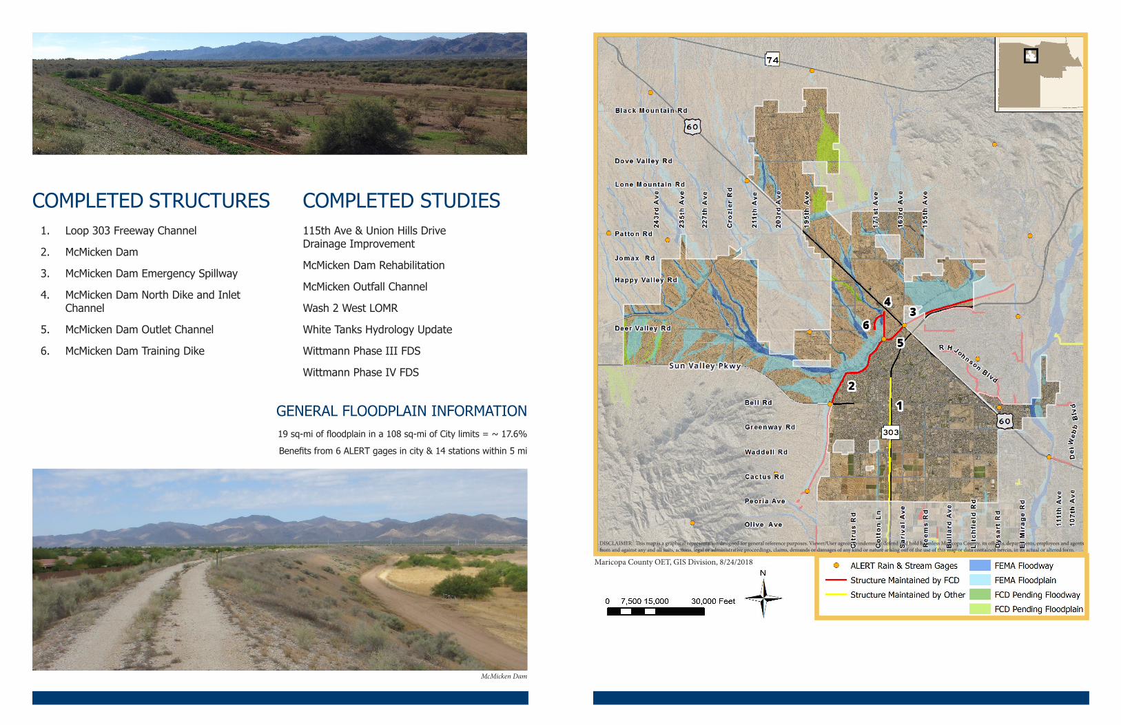
1. Loop 303 Freeway Channel
2. McMicken Dam
3. McMicken Dam Emergency Spillway
4. McMicken Dam North Dike and Inlet Channel
5. McMicken Dam Outlet Channel
6. McMicken Dam Training Dike
COMPLETED STRUCTURES COMPLETED STUDIES115th Ave & Union Hills Drive Drainage Improvement
McMicken Dam Rehabilitation
McMicken Outfall Channel
Wash 2 West LOMR
White Tanks Hydrology Update
Wittmann Phase III FDS
Wittmann Phase IV FDS
McMicken Dam
GENERAL FLOODPLAIN INFORMATION19 sq-mi of floodplain in a 108 sq-mi of City limits = ~ 17.6%
Benefits from 6 ALERT gages in city & 14 stations within 5 mi
DISCLAIMER: This map is a graphical representation designed for general reference purposes. Viewer/User agrees to indemnify, defend and hold harmless Maricopa County, its officers, departments, employees and agents from and against any and all suits, actions, legal or administrative proceedings, claims, demands or damages of any kind or nature arising ouf of the use of this map or data contained herein, in its actual or altered form.
Maricopa County OET, GIS Division, 8/24/2018


